
Histogram of Oriented Cameras - A New Descriptor for...
12
PIRKER ET AL.: HISTOGRAM OF ORIENTED CAMERAS 1 Histogram of Oriented Cameras - A New Descriptor for Visual SLAM in Dynamic Environments Katrin Pirker [email protected] Matthias Rüther [email protected] Horst Bischof [email protected] Institute for Computer Graphics and Vision Graz University of Technology Graz, Austria Abstract Simultaneous localization and mapping (SLAM) is a basic prerequisite in autonomous mobile robotics. Most existing visual SLAM approaches either assume a static environ- ment, or simply ’forget’ old parts of the map to cope with map size constraints and scene dynamics. We present a novel map representation for sparse visual features. A new 3D point descriptor called Histogram of Oriented Cameras (HOC) encodes anisotropic spa- tial visibility information and the importance of each three-dimensional landmark. Each feature holds and updates a histogram of the poses of observing cameras. It is hereby able to estimate its probability of occlusion and importance for localization from a given viewpoint. In a series of simulated and real-world experiments we prove that the pro- posed descriptor allows to cope with dynamic changes in the map, improves localization accuracy and enables reasonable control of the map size. 1 Introduction Simultaneous Localization and Mapping (SLAM) is the problem of position estimation in a previously unknown environment, and simultaneously and incrementally building an en- vironmental map. It is an essential prerequisite for many high level applications such as autonomous navigation, path planning or obstacle avoidance (e.g. [26, 31]). Currently there exists an abundance of proposed solutions, using a variety of different sensors in indoor, outdoor, underwater or airspace environments. Most existing solutions assume a static environment containing only stationary objects. The map is either continuously updated, or constructed once and used for localization afterwards. Rapid environmental changes like moving persons are usually filtered out, while changes with longer duration distort the map. SLAM approaches, which are based on dense range readings or higher level object representations, might be able to detect and handle such changes [6, 29], but approaches based on sparse local features can not. The key problem thereby is how to handle map features which should be visible from a certain viewpoint, but are actually not observed. Most existing SLAM approaches simply add all incoming sensor c 2010. The copyright of this document resides with its authors. It may be distributed unchanged freely in print or electronic forms. BMVC 2010 doi:10.5244/C.24.76
Transcript of Histogram of Oriented Cameras - A New Descriptor for...
PIRKER ET AL.: HISTOGRAM OF ORIENTED CAMERAS 1
Histogram of Oriented Cameras - A NewDescriptor for Visual SLAM in DynamicEnvironmentsKatrin [email protected]
Matthias Rü[email protected]
Horst [email protected]
Institute for Computer Graphics andVisionGraz University of TechnologyGraz, Austria
Abstract
Simultaneous localization and mapping (SLAM) is a basic prerequisite in autonomousmobile robotics. Most existing visual SLAM approaches either assume a static environ-ment, or simply ’forget’ old parts of the map to cope with map size constraints and scenedynamics. We present a novel map representation for sparse visual features. A new 3Dpoint descriptor called Histogram of Oriented Cameras (HOC) encodes anisotropic spa-tial visibility information and the importance of each three-dimensional landmark. Eachfeature holds and updates a histogram of the poses of observing cameras. It is herebyable to estimate its probability of occlusion and importance for localization from a givenviewpoint. In a series of simulated and real-world experiments we prove that the pro-posed descriptor allows to cope with dynamic changes in the map, improves localizationaccuracy and enables reasonable control of the map size.
1 IntroductionSimultaneous Localization and Mapping (SLAM) is the problem of position estimation ina previously unknown environment, and simultaneously and incrementally building an en-vironmental map. It is an essential prerequisite for many high level applications such asautonomous navigation, path planning or obstacle avoidance (e.g. [26, 31]). Currently thereexists an abundance of proposed solutions, using a variety of different sensors in indoor,outdoor, underwater or airspace environments.Most existing solutions assume a static environment containing only stationary objects. Themap is either continuously updated, or constructed once and used for localization afterwards.Rapid environmental changes like moving persons are usually filtered out, while changeswith longer duration distort the map. SLAM approaches, which are based on dense rangereadings or higher level object representations, might be able to detect and handle suchchanges [6, 29], but approaches based on sparse local features can not. The key problemthereby is how to handle map features which should be visible from a certain viewpoint, butare actually not observed. Most existing SLAM approaches simply add all incoming sensor
c© 2010. The copyright of this document resides with its authors.It may be distributed unchanged freely in print or electronic forms.
BMVC 2010 doi:10.5244/C.24.76
Citation
Citation
{Shojaeipour, Haris, Khalili, and Shojaeipour} 2010
Citation
Citation
{Yang, Qu, Wang, and Conrad} 2010
Citation
Citation
{Dong, Wijesoma, and Shacklock} 2007
Citation
Citation
{Vu, Burlet, and Aycard} 2008
2 PIRKER ET AL.: HISTOGRAM OF ORIENTED CAMERAS
readings over time but do not reject existing features anymore. This results in ever growingmaps and may also lead to data association problems.In this work we address the SLAM problem based on local features within a Structure fromMotion (SFM) framework. Our sensor is a stereo camera, producing a set of local featurepoints at each time step, and associated local descriptors. We address the following prob-lems:
• How to handle short- and long-term environmental changes.
• How to balance the map size.
• How to improve data association in a dynamic environment.
We developed a new 3D descriptor to incorporate visibility information and feature impor-tance through a three-dimensional histogram centered around each landmark. Each descrip-tor bin tracks how often its associated landmark has been observed from a specific location.Hence, short- and long-term dynamics do not affect localization and the constructed mapimplicitly adapts to dynamic changes during mapping.
2 Related WorkWhile SLAM approaches based on sparse local features exist for a number of sensor modal-ities, we mainly concentrate on vision systems, subdivided into two categories: those fol-lowing a probabilistic approach by recursively updating the probability of feature locationand camera pose, and geometric approaches incorporating SFM techniques to refine mapgeometry.Davison et al. [4] and Eade and Drummond [7] developed monocular SLAM systems usingan extended Kalman filter (EKF) and a particle filter respectively. Using EKF, the size of thefilter matrix is cubic in the number of features and filter updates become very costly. Theparticle filter approach requires lots of particles to track the robot pose. Recently, authorsproposed to split the mapping procedure to local submaps, followed by a routine to mergethem (e.g. [24, 25]). Chli et al. [2] propose a tree-like hierarchy where 3D point features aregrouped into clusters from coarse (independent) to fine (all grouped together) to speed upmonocular Kalman Filter SLAM. In order to reduce the size of the EKF filter matrix Gee etal. [10] fit planes to pointcloud data.Klein and Murray [16, 17] use sparse bundle adjustment over selected keyframes to refinecamera pose and map structure. They successfully mapped a small office environment witha single hand-held camera only. They also fused their Parallel Tracking and Mapping frame-work [15] with a bundle adjustment approach proposed by Sibley et al. [27] using a relativerepresentation of camera poses and 3D points to reduce computational effort. Similarly,Konolige and Agrawal [18] developed FrameSLAM, a stereo mapping approach. They re-duced computational effort of bundle adjustment on large feature maps through a nonlinearreduction of frames and image measurements.All mentioned approaches assume a static environment and perform mapping in a single runonly. Research focusing on dynamic environments is sparse and can be categorized in twofields: those focusing on short-term changes only, such as moving people or cars within anotherwise static environment, and others concentrating on less frequent changes within life-long operations. Wang et al. [30] proposed to maintain a stationary and a dynamic occupancy
Citation
Citation
{Davison, Reid, Molton, and Stasse} 2007
Citation
Citation
{Eade and Drummond} 2007
Citation
Citation
{Paz, Pinies, Tardos, and Neira} 2008
Citation
Citation
{Schleicher, Bergasa, Barea, Lopez, Ocaa, Nuevo, and Fernandez} 2007
Citation
Citation
{Chli and Davison} 2009
Citation
Citation
{Gee, Chekhlov, Mayol, and Calway} 2007
Citation
Citation
{Klein and Murray} 2007
Citation
Citation
{Klein and Murray} 2008
Citation
Citation
{Holmes, Sibley, Klein, and Murray} 2009
Citation
Citation
{Sibley, Mei, Reid, and Newman} 2009
Citation
Citation
{Konolige and Agrawal} 2008
Citation
Citation
{Wang and Thorpe} 2002
PIRKER ET AL.: HISTOGRAM OF ORIENTED CAMERAS 3
grid map, constructed out of laser data. Lidoris et al. [20] combined a Rao-Blackwellizedparticle filter for robot pose estimation with a person tracker for moving object detection.Other authors try to filter out false measurements from 2D laser data before incorporatingthem into an occupancy grid map [6], or use map matching between the current scan and thealready generated map for moving object detection [29]. There also exist purely statisticalapproaches to retrieve the most likely map within highly dynamic scenes as proposed byHähnel et al. [11].In dynamic visual map building the main research focus lies in rejecting independently mov-ing objects. An approach using stereo-cameras to estimate the robot position, the static mapand the trajectory of moving objects is proposed by Sola et al. [28]. They use a Kalman filterfor each moving object to keep track of its pose within the map. Migliore et al. [22] use twoseparate EKFs for the static and dynamic parts in the scene to keep the state vector (pose andlandmarks) small, and to track the dynamic scene elements. They propose to use uncertainprojective geometry to detect dynamic elements. Results are provided only within a smalloffice scene using a few features.Little work has addressed the problem of long-term mapping. Dissanayake et al. [5] reducedthe computational effort within an EKF-based SLAM algorithm by erasing laser range land-marks with low information. The information content is estimated through the diagonalelements of the covariance matrix. They showed that localization errors within the reducedmap are relatively small compared to standard EKF approaches. Biber and Duckett [1] createoccupancy maps from laser data at different timescales to incorporate new elements whilepreserving the old and stable ones. They evaluated their method based on localization ac-curacy over several weeks. Recently, Hochdorfer and Schlegel [14] addressed the problemof ever growing number of landmarks within a feature based map, especially in life-longoperations. To avoid extensive growing of the EKF state-vector, they limit the number ofallowed landmarks in a two stage process: First, k-means clustering combines points whichare observed from neighboring robot poses. Second, landmarks with the lowest localiza-tion benefit within each cluster, estimated out of their covariances, are removed. Similarly,Konolige and Bowman [19] adapted FrameSLAM [18] to update a given map in case of newor removed features and to recover from localization failure. They first build a connectivitygraph between keyframes, based on the number of successful SIFT features, and delete thosekeyframes with a very high SIFT matching percentage to the neighbors. They evaluated theirsystem in a dynamic indoor environment of about 50×50m2, including moving people andvarious lighting conditions. They successfully managed to update a map after removed andadded furniture and kept the number of keyframes relatively small.To summarize, all vision based methods use either object detection and tracking to separatemoving objects from the static map, or make use of spatial clustering in combination withheuristics to discard weak features. They require prior knowledge of the scene and the type ofmoving objects to track them adequately. In contrast, our approach encodes feature visibilityduring mapping and constructed map automatically adapts within a changing environment.
3 Feature DescriptorTo implicitly handle the ambiguity between scene dynamics and occlusion, we propose toadd spatial visibility information to local map features. To encode the visibility and impor-tance of each three-dimensional landmark in a map, we develop the Histogram of OrientedCameras (HOC) descriptor.
Citation
Citation
{Lidoris, Wollherr, and Buss} 2008
Citation
Citation
{Dong, Wijesoma, and Shacklock} 2007
Citation
Citation
{Vu, Burlet, and Aycard} 2008
Citation
Citation
{Hähnel, Triebel, Burgard, and Thrun} 2003
Citation
Citation
{Sola} 2007
Citation
Citation
{Migliore, Rigamonti, Marzorati, Matteucci, and Sorrenti} 2009
Citation
Citation
{Dissanayake, Durrant-Whyte, and Bailey} 2000
Citation
Citation
{Biber and Duckett} 2005
Citation
Citation
{Hochdorfer and Schlegel} 2009
Citation
Citation
{Konolige and Bowman} 2009
Citation
Citation
{Konolige and Agrawal} 2008
4 PIRKER ET AL.: HISTOGRAM OF ORIENTED CAMERAS
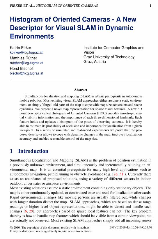
(a) (b)Figure 1: Proposed HOC-descriptor. (a) An uninitialized HOC-descriptor around a featurepoint consisting of three depth layers. (b) Update of the descriptor with three sensor posi-tions. Darker colors indicate a higher weighted bin.
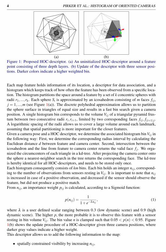
Each map feature holds information of its location, a descriptor for data association, and ahistogram which keeps track of how often the feature has been observed from a specific loca-tion. The histogram partitions the space around a feature by a set of k concentric spheres withradii r1, ...,rk. Each sphere Si is approximated by an icosahedron consisting of m faces fi j,j = 1, ...,m (see Figure 1(a)). The discrete polyhedral approximation allows us to partitionthe sphere surface in triangles of equal size and results in a fast bin search given a cameraposition. A single histogram bin corresponds to the volume Vi j of a triangular pyramid frus-tum between two consecutive radii ri,ri+1, limited by two corresponding faces fi j, f(i+1) j.A logarithmic spacing of the radii allows us to cover a large volume around each landmark,assuming that spatial partitioning is more important for the closer features.Given a camera pose and a HOC descriptor, we determine the associated histogram bin Vi j inthe following way: First, we determine the corresponding radius interval by calculating theEuclidean distance d between feature and camera center. Second, intersection between theicosahedron and the line from feature to camera center returns the valid face f j. We orga-nized the circumcenters of each triangle in a kd-tree. After projecting the camera center ontothe sphere a nearest-neighbor search in the tree returns the corresponding face. The kd-treeis hereby identical for all HOC-descriptors, and needs to be stored only once.Each histogram consequently consists of km bins. Each bin holds an integer ni j, correspond-ing to the number of observations from sensors resting in Vi j. It is important to note that ni jis increased in case of a positive observation, and decreased if the sensor should observe thefeature, but did not produce a positive match.From ni j, an importance weight pi j is calculated, according to a Sigmoid function:
p(ni j) =1
1+ e−λni j, (1)
where λ is a user defined scalar ranging between 0.3 (low dynamic scene) and 0.9 (highdynamic scene). The higher p, the more probable it is to observe this feature with a sensorresting in bin volume Vi j. The bin value n is clamped such that 0.05 < p(n)< 0.95. Figure1(b) shows the update procedure of a HOC-descriptor given three camera positions, wheredarker gray values indicate a higher weight.This descriptor allows us to add the following information to the map:
• spatially constrained visibility by increasing ni j,
PIRKER ET AL.: HISTOGRAM OF ORIENTED CAMERAS 5
• probable occlusion/dynamics by decreasing ni j,
• probably vanished features by looking at the histogram maximum.
Additionally, different feature descriptors may be added to the histogram bins to model view-dependent appearance.How this descriptor can be embedded in a SLAM framework, especially in dynamic envi-ronments, is addressed in the following section.
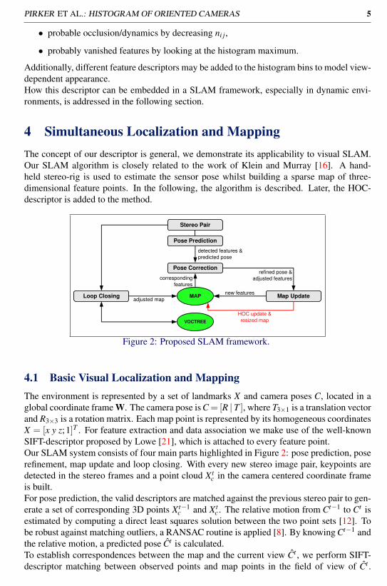
4 Simultaneous Localization and MappingThe concept of our descriptor is general, we demonstrate its applicability to visual SLAM.Our SLAM algorithm is closely related to the work of Klein and Murray [16]. A hand-held stereo-rig is used to estimate the sensor pose whilst building a sparse map of three-dimensional feature points. In the following, the algorithm is described. Later, the HOC-descriptor is added to the method.
Stereo Pair
MAP
VOCTREE
detected features & predicted pose
correspondingfeatures
refined pose &adjusted features
new features
HOC update &resized map
adjusted map
Pose Prediction
Pose Correction
Loop Closing Map Update
Figure 2: Proposed SLAM framework.
4.1 Basic Visual Localization and MappingThe environment is represented by a set of landmarks X and camera poses C, located in aglobal coordinate frame W. The camera pose is C = [R | T ], where T3×1 is a translation vectorand R3×3 is a rotation matrix. Each map point is represented by its homogeneous coordinatesX = [x y z;1]T . For feature extraction and data association we make use of the well-knownSIFT-descriptor proposed by Lowe [21], which is attached to every feature point.Our SLAM system consists of four main parts highlighted in Figure 2: pose prediction, poserefinement, map update and loop closing. With every new stereo image pair, keypoints aredetected in the stereo frames and a point cloud X t
c in the camera centered coordinate frameis built.For pose prediction, the valid descriptors are matched against the previous stereo pair to gen-erate a set of corresponding 3D points X t−1
c and X tc . The relative motion from Ct−1 to Ct is
estimated by computing a direct least squares solution between the two point sets [12]. Tobe robust against matching outliers, a RANSAC routine is applied [8]. By knowing Ct−1 andthe relative motion, a predicted pose Ct is calculated.To establish correspondences between the map and the current view Ct , we perform SIFT-descriptor matching between observed points and map points in the field of view of Ct .
Citation
Citation
{Klein and Murray} 2007
Citation
Citation
{Lowe} 2004
Citation
Citation
{Haralick, Joo, Lee, Zhuang, Vaidya, and Kim} 1989
Citation
Citation
{Fischler and Bolles} 1981
6 PIRKER ET AL.: HISTOGRAM OF ORIENTED CAMERAS
Again, a RANSAC routine is applied to robustly estimate the Ct relative to the map.Sparse bundle adjustment (see Appendix 6 of [13]) over the last N frames is used to refinecamera pose and map points through minimizing reprojection errors. To update the map, allunmatched features are added.For loop closure detection, we use the vocabulary tree proposed by Nister et al. [23], whichhas been successfully applied before [9] [3]. Once a loop is detected, sparse bundle adjust-ment is applied over the entire map.If global re-localization is required, we perform exhaustive SIFT-matching of the currentlyobserved features against all features of the map. Camera pose is then estimated through a3-point RANSAC algorithm as used for pose estimation.A schematic of the mapping procedure is shown in Figure 2. Adaptations of this standardSLAM procedure to incorporate the HOC-descriptor are described in the subsequent section.
4.2 Extension to dynamic map buildingA SLAM framework which simply adds every valid feature to the map will fail in a dynamicenvironment. Either the map becomes too large to handle, or data association will fail be-cause of ambiguities.We hereby augment the SLAM framework described in the previous section by the HOC-descriptor to address these problems. In this case, the pose correction makes use of visibilityinformation from the HOCs, and the map update includes a HOC update with a map thinningroutine (see red highlighted step in Figure 2).During pose correction, we are able to perform more effective prefiltering by selecting allmap points in the view cone with an importance weight exceeding a predefined threshold.Every time a new feature is added, its HOC-descriptor is created and updated according tothe refined camera pose. The remaining bins are marked unseen. HOC-descriptors whichsuccessfully matched during the pose correction, are upweighted, including those with a lowimportance weight. Map points which are in the view cone, but did not produce a match, aredownweighted.To keep a constant map size we apply a simple thresholding operation to the reweighted bins.If the maximum of all bins of a descriptor drops below a threshold, the associated landmarkis removed from the map. In all of our experiments this threshold was set to pmin = 0.2.
5 ExperimentsWe performed a series of synthetic and real-world experiments using a stereo-camera witha baseline of 12cm and a resolution of 640× 480. We compared the performance of thestandard SLAM algorithm with its extension using the HOC-descriptor. In both scenarioswe evaluated the map growth over time and the pose estimation error, where groundtruthwas available. Regarding parametrization, we always chose 24 histogram bins in our exper-iments, and adapted parameter λ manually, according to the scene dynamics.
5.1 Synthetic ExperimentsWe simulated both a static and a moving stereo-camera with a resolution of 640×480 pixelssurrounded by static and dynamic objects. Objects are hereby represented as 3D point cloudsof variable size covering approximately 10% of the image.
Citation
Citation
{Hartley and Zisserman} 2004
Citation
Citation
{Nister and Stewenius} 2006
Citation
Citation
{Fraundorfer, Wu, Frahm, and Pollefeys} 2008
Citation
Citation
{Cummins and Newman} 2008
PIRKER ET AL.: HISTOGRAM OF ORIENTED CAMERAS 7
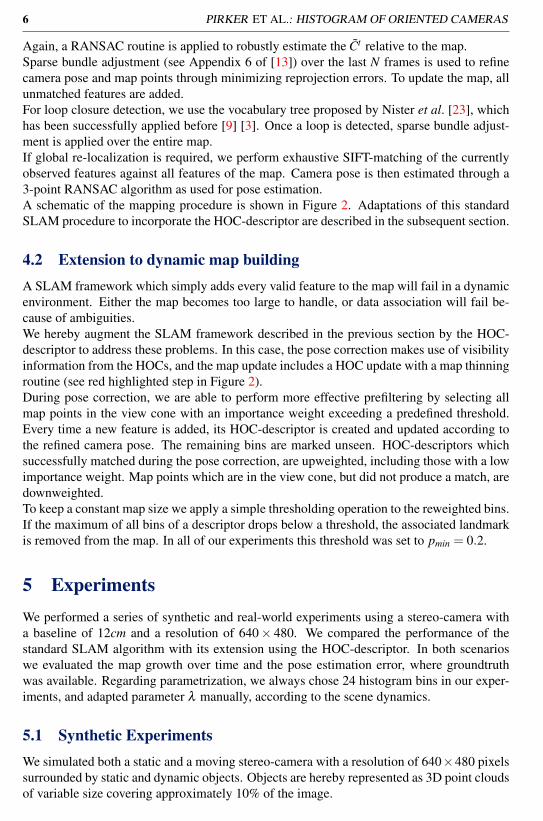
The static camera allows to quickly evaluate localization accuracy and easy visualization.
translational error [mm] rotational error [deg] map sizetestcase standard HOC standard HOC standard HOCSimulation 1 12.1/179.1 0.9/41.5 0.46/6.10 0.05/2.41 1526 435Simulation 2 8.6/79.8 0.2/0.4 0.33/2.80 0.00/0.01 1670 441Simulation 3 113.5/352.5 0.4/2.1 2.78/8.66 0.00/0.01 3425 825Simulation 4 12.2/97.2 1.2/3.1 0.15/4.36 0.06/0.13 1024 295
Table 1: Synthetic experiments. Mean/maximal translational and rotational errors were eval-uated. The map size after the last frame is also given. Simulations 1, 2, 3 included a staticcamera with differently moving objects, while Simulation 4 included a moving camera.
(a)
(b)
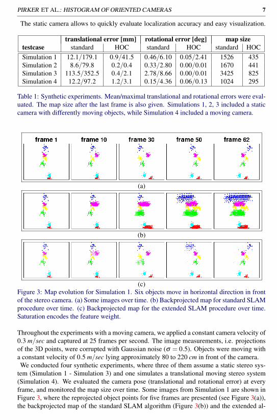
(c)Figure 3: Map evolution for Simulation 1. Six objects move in horizontal direction in frontof the stereo camera. (a) Some images over time. (b) Backprojected map for standard SLAMprocedure over time. (c) Backprojected map for the extended SLAM procedure over time.Saturation encodes the feature weight.
Throughout the experiments with a moving camera, we applied a constant camera velocity of0.3 m/sec and captured at 25 frames per second. The image measurements, i.e. projectionsof the 3D points, were corrupted with Gaussian noise (σ = 0.5). Objects were moving witha constant velocity of 0.5 m/sec lying approximately 80 to 220 cm in front of the camera.We conducted four synthetic experiments, where three of them assume a static stereo sys-
tem (Simulation 1 - Simulation 3) and one simulates a translational moving stereo system(Simulation 4). We evaluated the camera pose (translational and rotational error) at everyframe, and monitored the map size over time. Some images from Simulation 1 are shown inFigure 3, where the reprojected object points for five frames are presented (see Figure 3(a)),the backprojected map of the standard SLAM algorithm (Figure 3(b)) and the extended al-
8 PIRKER ET AL.: HISTOGRAM OF ORIENTED CAMERAS
(a) (b)Figure 4: Localization error (a) and map size (b) over time for Simulation 1. Standard SLAMapproach (light gray) compared to the extended approach (black).
gorithm (Figure 3(c)). The weight of each landmark is visualized by the saturation of eachfeature point in Figure 3(c). Using the HOC descriptor, old positions disappear after a fewframes. More recent positions of the moving objects are given a higher weight and assistlocalization. Pose estimation stability and map growing for Simulation 1 over time are pre-sented in Figure 4. The results for all synthetic experiments are summarized in Table 1.
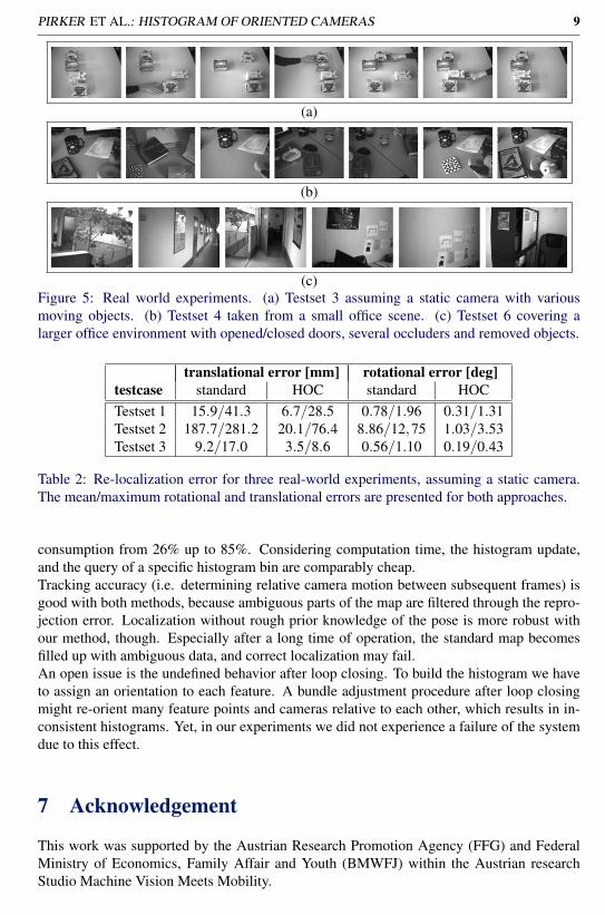
5.2 Real-world ExperimentsTests (named Testset 1 - Testset 3) have been made with the stereo-rig mounted staticallyon a tripod to get groundtruth data for camera pose and relocalization performance in highdynamic scenes. Objects in front of the camera have been moved or deleted (see Figure5(a)) over a duration of 570, 490 and 276 frames respectively. Table 3 gives the mean andmaximum translational and rotational errors for all test sets.In addition, we evaluated re-localization performance at every 30-th frame with the methoddescribed in Section 4. The mean and maximal pose errors are summarized in Table 2 (videosof two localization experiments are shown in the supplementary material named Testset1.avi- Testset2.avi).Finally, we moved the camera multiple times over an office-table denoted as Testset 4 (seeFigure 5(b)) while manipulating dominant objects (remove, occlude or re-appear after sometime). A comparison of resulting maps and camera trajectories for the standard and HOCapproach can be found in the supplementary material (Testset4Map.jpg). We also acquiredlarger sequences named Testset 5 and 6 (904 and 1024 frames respectively), covering a11× 7m2 flat and a 14× 17m2 office scene (see Figure 5(c)). In both cases, standard andHOC approach produced comparable camera trajectories although the extended algorithmproduced a smaller feature map. Results for the final map size are given in Table 3. The finalmaps and camera trajectories for Testsets 5 and 6 are shown in the supplementary material(Testset5(6)HoC.avi and Testset5(6)std.avi).
6 ConclusionThe histogram of oriented cameras allows to encode spatial visibility information on a featurebasis. In contrast to most existing approaches, which encode visibility in a camera-centeredway (e.g. using keyframes), we propose to add a per-feature spatial histogram of the numberof observations. Although the amount of saved data per feature is larger, we finally savememory by keeping the overall map size small. In our experiments we reduced memory
PIRKER ET AL.: HISTOGRAM OF ORIENTED CAMERAS 9
(a)
(b)
(c)Figure 5: Real world experiments. (a) Testset 3 assuming a static camera with variousmoving objects. (b) Testset 4 taken from a small office scene. (c) Testset 6 covering alarger office environment with opened/closed doors, several occluders and removed objects.
translational error [mm] rotational error [deg]testcase standard HOC standard HOCTestset 1 15.9/41.3 6.7/28.5 0.78/1.96 0.31/1.31Testset 2 187.7/281.2 20.1/76.4 8.86/12,75 1.03/3.53Testset 3 9.2/17.0 3.5/8.6 0.56/1.10 0.19/0.43
Table 2: Re-localization error for three real-world experiments, assuming a static camera.The mean/maximum rotational and translational errors are presented for both approaches.
consumption from 26% up to 85%. Considering computation time, the histogram update,and the query of a specific histogram bin are comparably cheap.Tracking accuracy (i.e. determining relative camera motion between subsequent frames) isgood with both methods, because ambiguous parts of the map are filtered through the repro-jection error. Localization without rough prior knowledge of the pose is more robust withour method, though. Especially after a long time of operation, the standard map becomesfilled up with ambiguous data, and correct localization may fail.An open issue is the undefined behavior after loop closing. To build the histogram we haveto assign an orientation to each feature. A bundle adjustment procedure after loop closingmight re-orient many feature points and cameras relative to each other, which results in in-consistent histograms. Yet, in our experiments we did not experience a failure of the systemdue to this effect.
7 Acknowledgement
This work was supported by the Austrian Research Promotion Agency (FFG) and FederalMinistry of Economics, Family Affair and Youth (BMWFJ) within the Austrian researchStudio Machine Vision Meets Mobility.
10 PIRKER ET AL.: HISTOGRAM OF ORIENTED CAMERAS
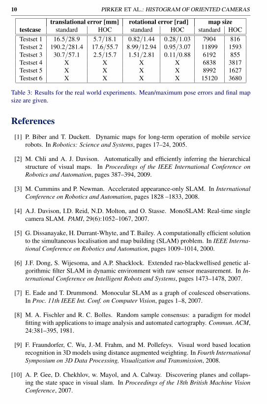
translational error [mm] rotational error [rad] map sizetestcase standard HOC standard HOC standard HOCTestset 1 16.5/28.9 5.7/18.1 0.82/1.44 0.28/1.03 7904 816Testset 2 190.2/281.4 17.6/55.7 8.99/12.94 0.95/3.07 11899 1593Testset 3 30.7/57.1 2.5/15.7 1.51/2.81 0.11/0.88 6192 855Testset 4 X X X X 6838 3817Testset 5 X X X X 8992 1627Testset 6 X X X X 15120 3680
Table 3: Results for the real world experiments. Mean/maximum pose errors and final mapsize are given.
References[1] P. Biber and T. Duckett. Dynamic maps for long-term operation of mobile service
robots. In Robotics: Science and Systems, pages 17–24, 2005.
[2] M. Chli and A. J. Davison. Automatically and efficiently inferring the hierarchicalstructure of visual maps. In Proceedings of the IEEE International Conference onRobotics and Automation, pages 387–394, 2009.
[3] M. Cummins and P. Newman. Accelerated appearance-only SLAM. In InternationalConference on Robotics and Automation, pages 1828 –1833, 2008.
[4] A.J. Davison, I.D. Reid, N.D. Molton, and O. Stasse. MonoSLAM: Real-time singlecamera SLAM. PAMI, 29(6):1052–1067, 2007.
[5] G. Dissanayake, H. Durrant-Whyte, and T. Bailey. A computationally efficient solutionto the simultaneous localisation and map building (SLAM) problem. In IEEE Interna-tional Conference on Robotics and Automation, pages 1009–1014, 2000.
[6] J.F. Dong, S. Wijesoma, and A.P. Shacklock. Extended rao-blackwellised genetic al-gorithmic filter SLAM in dynamic environment with raw sensor measurement. In In-ternational Conference on Intelligent Robots and Systems, pages 1473–1478, 2007.
[7] E. Eade and T. Drummond. Monocular SLAM as a graph of coalesced observations.In Proc. 11th IEEE Int. Conf. on Computer Vision, pages 1–8, 2007.
[8] M. A. Fischler and R. C. Bolles. Random sample consensus: a paradigm for modelfitting with applications to image analysis and automated cartography. Commun. ACM,24:381–395, 1981.
[9] F. Fraundorfer, C. Wu, J.-M. Frahm, and M. Pollefeys. Visual word based locationrecognition in 3D models using distance augmented weighting. In Fourth InternationalSymposium on 3D Data Processing, Visualization and Transmission, 2008.
[10] A. P. Gee, D. Chekhlov, w. Mayol, and A. Calway. Discovering planes and collaps-ing the state space in visual slam. In Proceedings of the 18th British Machine VisionConference, 2007.
PIRKER ET AL.: HISTOGRAM OF ORIENTED CAMERAS 11
[11] D. Hähnel, R. Triebel, W. Burgard, and S. Thrun. Map building with mobile robots indynamic environments. In IEEE International Conference on Robotics and Automa-tion, pages 1557–1563, 2003.
[12] R.M. Haralick, H. Joo, C. Lee, X. Zhuang, V.G. Vaidya, and M.B. Kim. Pose estimationfrom corresponding point data. IEEE Transactions on Systems, Man and Cybernetics,19(6):1426–1446, 1989.
[13] R. I. Hartley and A. Zisserman. Multiple View Geometry in Computer Vision. Cam-bridge University Press, ISBN: 0521540518, second edition, 2004.
[14] S. Hochdorfer and C. Schlegel. Towards a robust visual SLAM approach: Address-ing the challenge of life-long operation. In International Conference on AdvancedRobotics, pages 1–6, 2009.
[15] S. Holmes, G. Sibley, G. Klein, and D. W. Murray. A relative frame representation forfixed-time bundle adjustment in SFM. In IEEE international Conference on Roboticsand Automation, pages 2631–2636, 2009.
[16] G. Klein and D. Murray. Parallel tracking and mapping for small AR workspaces. In6th International Symposium on Mixed and Augmented Reality, pages 225–234, 2007.
[17] G. Klein and D. Murray. Improving the agility of keyframe-based SLAM. In 10thEuropean Conference on Computer Vision, pages 802–815, 2008.
[18] K. Konolige and M. Agrawal. FrameSLAM: From bundle adjustment to real-timevisual mapping. IEEE Transactions on Robotics, 24(5):1066–1077, 2008.
[19] K. Konolige and J. Bowman. Towards lifelong visual maps. In International Confer-ence on Intelligent Robots and Systems, pages 1156–1163, 2009.
[20] G. Lidoris, D. Wollherr, and M. Buss. Bayesian state estimation and behavior selec-tion for autonomous robotic exploration in dynamic environments. In InternationalConference on Intelligent Robots and Systems, pages 1299–1306, 2008.
[21] D.G. Lowe. Distinctive image features from scale-invariant keypoints. InternationalJournal of Computer Vision, 60(2):91–110, 2004.
[22] D. Migliore, R. Rigamonti, D. Marzorati, M. Matteucci, and D. G. Sorrenti. Use asingle camera for simultaneous localization and mapping with mobile object trackingin dynamic environments. In ICRA Workshop on Safe navigation in open and dynamicenvironments Application to autonomous vehicles, pages 27–32, 2009.
[23] D. Nister and H. Stewenius. Scalable recognition with a vocabulary tree. In IEEE Com-puter Society Conference on Computer Vision and Pattern Recognition, pages 2161–2168, 2006.
[24] L.M. Paz, P. Pinies, J.D. Tardos, and J. Neira. Large-scale 6-DOF SLAM with stereo-in-hand. IEEE Transactions on Robotics, 24(5):946–957, 2008.
[25] D. Schleicher, L.M. Bergasa, R. Barea, E. Lopez, M. Ocaa, J. Nuevo, and P. Fernandez.Real-time stereo visual SLAM in large-scale environments based on SIFT fingerprints.In IEEE International Symposium on Intelligent Signal Processing, pages 1–6, 2007.
12 PIRKER ET AL.: HISTOGRAM OF ORIENTED CAMERAS
[26] S. Shojaeipour, S. M. Haris, K. Khalili, and A. Shojaeipour. Motion planning formobile robot navigation using combine quad-tree decomposition and voronoi diagrams.In International Conference on Computer and Automation Engineering, pages 90–93,2010.
[27] G. Sibley, C. Mei, I. Reid, and P. Newman. Adaptive relative bundle adjustment. InRobotics Science and Systems, 2009.
[28] J. Sola. Towards Visual Localization, Mapping and Moving Objects Tracking by aMobile Robot: a Geometric and Probabilistic Approach. PhD thesis, Institut NationalPolitechnique de Toulouse, 2007.
[29] T.-D. Vu, J. Burlet, and O. Aycard. Grid-based localization and online mapping withmoving objects detection and tracking: new results. In IEEE Intelligent Vehicles Sym-posium, pages 684–689, 2008.
[30] C.-C. Wang and C. Thorpe. Simultaneous localization and mapping with detectionand tracking of moving objects. In IEEE International Conference on Robotics andAutomation, pages 2918–2924, 2002.
[31] J. Yang, Z. Qu, J. Wang, and K. Conrad. Comparison of optimal solutions to real-time path planning for a mobile vehicle. IEEE Transactions on Systems, Man andCybernetics, Part A: Systems and Humans, pages 1–11, 2010.


![Histogram [Www.nikonians.org]](https://static.fdocuments.net/doc/165x107/577cd8911a28ab9e78a17d60/histogram-wwwnikoniansorg.jpg)

