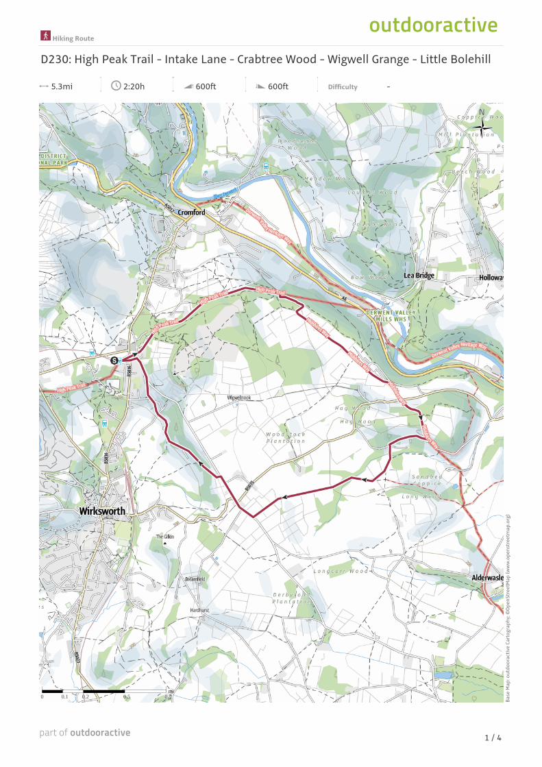
Hiking Route D230: High Peak Trail - Intake Lane ...
4
mi 0.7 0.5 0.2 0.1 0 5.3mi 2:20h 600ft 600ft Difficulty - Base Map: outdooractive Cartography; ©OpenStreetMap (www.openstreetmap.org) Hiking Route D230: High Peak Trail - Intake Lane - Crabtree Wood - Wigwell Grange - Little Bolehill 1 / 4
Transcript of Hiking Route D230: High Peak Trail - Intake Lane ...
mi0.70.50.20.10
5.3mi 2:20h 600ft 600ft Difficulty -
Base
Map
: out
door
activ
e Ca
rtog
raph
y; ©
Open
Stre
etM
ap (w
ww
.ope
nstr
eetm
ap.o
rg)
Hiking Route
D230: High Peak Trail - Intake Lane - Crabtree Wood - Wigwell Grange - Little Bolehill
1 / 4
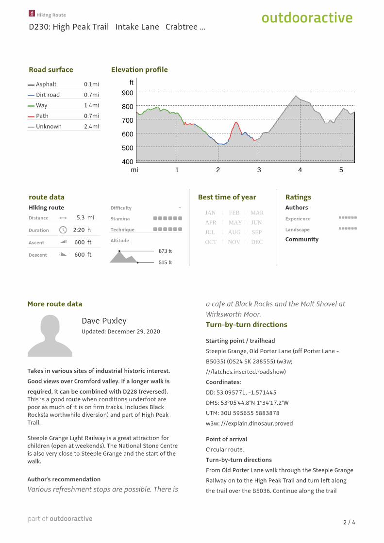
Road surface Elevation profile
Asphalt 0.1mi
Dirt road 0.7mi
Way 1.4mi
Path 0.7mi
Unknown 2.4mi
ft
900
800
700
600
500
40054321mi
route dataHiking routeDistance 5.3 mi
Duration 2:20 h
Ascent 600 ft
Descent 600 ft
Difficulty -
Stamina
Technique
Altitude
515 ft
873 ft
Best time of year
DECNOVOCT
SEPAUGJUL
JUNMAYAPR
MARFEBJAN
RatingsAuthors
Experience
Landscape
Community
More route data
Dave PuxleyUpdated: December 29, 2020
Takes in various sites of industrial historic interest.
Good views over Cromford valley. If a longer walk is
required, it can be combined with D228 (reversed).This is a good route when conditions underfoot arepoor as much of it is on firm tracks. Includes BlackRocks(a worthwhile diversion) and part of High PeakTrail.
Steeple Grange Light Railway is a great attraction forchildren (open at weekends). The National Stone Centreis also very close to Steeple Grange and the start of thewalk.
Author’s recommendation
Various refreshment stops are possible. There is
a cafe at Black Rocks and the Malt Shovel atWirksworth Moor.Turn-by-turn directions
Starting point / trailhead
Steeple Grange, Old Porter Lane (off Porter Lane -
B5035) (OS24 SK 288555) (w3w;
///latches.inserted.roadshow)
Coordinates:
DD: 53.095771, -1.571445
DMS: 53°05'44.8"N 1°34'17.2"W
UTM: 30U 595655 5883878
w3w: ///explain.dinosaur.proved
Point of arrival
Circular route.
Turn-by-turn directions
From Old Porter Lane walk through the Steeple Grange
Railway on to the High Peak Trail and turn left along
the trail over the B5036. Continue along the trail
Hiking Route
D230: High Peak Trail Intake Lane Crabtree ...
2 / 4

passing Sheep Pasture Engine House. The track veers
right here and starts to descend the incline to High
Peak Junction. After about 400 m, a bridge passes over
Intake Lane with an old quarry crane on the right. Just
before the bridge fork right down a path that descends
to meet Intake Lane. Follow the Intake Lane track for
about 300 m until you meet a path junction where it
meets a field on your right. Turn sharp right (SW) with
the field on your left and the wood on your right. After
about 100 m, the track turns back sharply left (SE).
Follow Intake Lane for about 500 m, passing camping
grounds on your left. Ignore any tracks off to the left
until the lane veers right and rises up to meet the
B5035 with cottages on your right. Cross the road and
take the footpath opposite up through a field and into
Crabtree Wood. Derbyshire Wildlife Trust plus some
volunteers have a major conservation project there.
Follow the waymarked path (Midshires Way) avoiding
any side paths created for the work in hand. The path
descends to join a driveway. Turn very sharply right and
follow the track with a wood immediately to your left
(ignore the one rising to the right which is a private
drive). Follow this track for about 400 m until you reach
a house on the left. Here you will see a footpath on the
left, alongside a wood and at right angles to the track.
Follow this path uphill until it meets a crossing farm
track. Take the farm track SW across a couple of fields,
guided by circular yellow markers. Descend to meet
stream again at bottom corner of field. Enter the wood,
cross the stream and turn left WSW through the woods.
The path emerges into fields and rises through fields
containing some impressive trees. On the right you get
glimpses of Wigwell Grange. The path joins a farm
drive. Follow this uphill to meet a minor road. Turn
right down the road to a junction and a pub (Malt
Shovel Inn). Go straight across the junction and about
300 m after the pub, a narrow road (Stoney Hill) leads
down off to the left to Little Bolehill. The road ends in a
turning circle. Take the path onwards at the end. This
finishes at another road. Follow the road NNW through
the interesting houses of Little Bolehill until it reaches
the B5036 at Steeple Grange. Go under the bridge (High
Peak Trail) and immediately turn left back to the car
park.
Takeaway route for iPhone and Android
Scan QR code, save this routeoffline, share with friends andmore...Websitehttps://out.ac/xX9He
Hiking Route
D230: High Peak Trail Intake Lane Crabtree ...
3 / 4

Legend
Topography
Wood, forest
Moor, swamp, marsh
Residential building areawith single building
Industrial real estatewith single building
Cemetery
Golf course
Sportsfield, stadium
Stadium
Vineyard
Moorland
Open air pool
Petrograph
Country border
State border
District border
Nature reserve
Contour line
Special use area
900900
Topographic single signs
Summit cross
Elevation spot
Rock
Cave
Church
Chapel
Cemetery
Palace/Castle
Abbey
Monument
Ruin
Mine
Cairn
Broadcasting tower
Windwheel
Water-/windmill
Viewpoint
Streets and ways
Freeway with number
Highway with number
State-, country-, districtstreet
Village road
Main agricultural road
Agricultural road
Via Ferrata
Trail
Lifts, Railway
Ropeway lift
Gondola lift
Chairlift
Ski-, draglift
Aerial ropeways
Railway
Suburban train
Subway
Tram
Railway station
Hiking Route
D230: High Peak Trail Intake Lane Crabtree ...
4 / 4