Hikes in Conifer Country · Conifer Country 131 Section 1 Hikes G etting there: From the hamlet of...
7
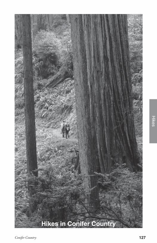
Conifer Country 127 Section 1 Hikes Hikes in Conifer Country
Transcript of Hikes in Conifer Country · Conifer Country 131 Section 1 Hikes G etting there: From the hamlet of...
Conifer Country 127
Section 1
Hikes
Hikes in Conifer Country

Download route descriptions: www.conifercountry.com128
Sec
tion
1H
ikes
Eureka
CrescentCity
Hayfork
WildernessNational/State Park
Ferndale
Region1: The North Coast
Hike 1: King PeakHike 2: Russ ParkHike 3: Patricks PointHike 4: Prairie CreekHike 5: Damnation CreekHike 6: Little Bald Hills
1
2
3
4
5
6
SiskiyouWilderness
Trinity AlpsWilderness
Yolla Bolly-Middle EelWilderness
ChanchelullaWilderness
North ForkWilderness
MarbleMountain
Wilderness
Mount LassicWilderness
King RangeWilderness
RedwoodNational
and State Park
Humboldt RedwoodsState Park

Conifer Country 129
Section 1
Hikes
Region 1: The North Coast
A land whimsically wavering between bays, lagoons, rocky shorelines, and open grasslands, the North Coast supports the most visually humbling
coniferous forests in the region—if not the world. From the Eel River north, redwood forests have historically dominated the landscape, and walking among the old-growth giants is an inimitable affair. Also, unexpectedly scattered in isolated sandy pockets, dune forests are equally curious. Both offer old-growth discoveries in a wildly wet land.
The majority of this coastal region is built upon a conglomeration of rock referred to as the Franciscan Complex—distinct from the rock of the Klam-ath Mountains. In conjunction with moisture, the nutrient rich terranes fatten redwood, Douglas-firs, Sitka spruce, and western hemlock of the North Coast into happy specimens. The conifer associations witnessed here arise nowhere else on Earth. This is because several conifers common in the Pacific Northwest reach their southern limit in the region—overlapping with the range of the redwood for a mere 100 miles or so. This is a complex meeting ground.
While wet and nutrient rich, redwood forests are the least species-rich of any of the forest types in the region. Redwoods dominate the sky and, because of that, limit the number of plants that succeed beneath them. A keen botanist might hope to find 100 species of plants along the coast—including up to seven conifers. In contrast inland, 400 plant species and 17 conifers exist in parts of the drier Russian Wilderness (hikes 14 and 15). Despite this relatively low rich-ness, redwood forests contain the largest above-ground biomass loading of any forests on earth.
The rainfall along the North Coast ranges from 40’’-100’’ per year and, in the summer, fog settles in to help maintain moisture. The variation in rainfall can be witnessed in vegetation proliferation along the series of hikes presented herein. King Peak and Russ Park offers experiences in transitional forests where the temperate rainforest gives way to drier coastal fir forests. Hikes further to the north explore verdant rainforests where one might suffer through misty dew in the morning and afternoon temperatures in the 60’s—a pleasant con-trast to 15 miles inland where it may be in the 100’s. In the winter, conditions are wetter and cooler, but rarely below freezing. Travel the Coast Highway north and enjoy these hikes (and more) in progression.
Light pierces the redwood curtain in Prairie Creek Redwoods State Park
Download route descriptions: www.conifercountry.com130
Sec
tion
1H
ikes
King Range National Conservation Area
sugar pine range
Big Flat Creek
Shipm
an C
reek
Buck
Cre
ek
North
0
0
1 Kilometer
1 Mile
King Peak4087ft1246m
Miller Camp
Big Flat
King Crest
RattlesnakeRidge Tr.
BuckCreek Tr.
KingCrest Tr.
SaddleMtn.
LightningTrail
Caution athigh tide
Hike 1: King Peak
Honeydew
Pacific Ocean
Wilder R
idge Road
Etter Jeep Rd
King R
ange Rd
Mat
tole
Road
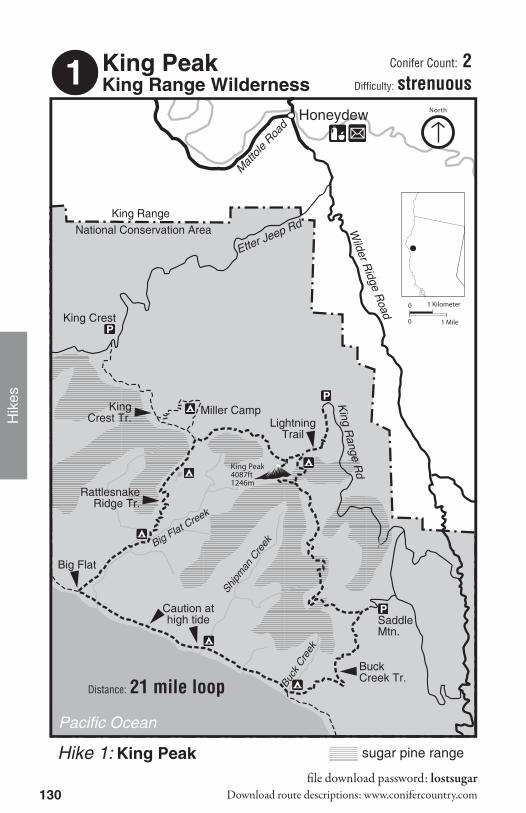
King PeakKing Range Wilderness 1 Conifer Count: 2
Difficulty: strenuous
Distance: 21 mile loop
file download password: lostsugar

Conifer Country 131
Section 1
Hikes
Getting there: From the hamlet of Honeydew travel south on Wilder Ridge Road for about 10 miles. Look for a right on King Peak Road and follow
this route for 2.8 miles on an extremely windy and slow going road. Take a right on King Range Road and follow it for 2 more miles to the junction with Saddle Mountain trailhead and then continue straight another 4.4 to the Lightning Trailhead. Begin the hike at road’s end, below the peak.
Why go? This hike offers an incredible experience without the botanical diversity found in the remainder of the hikes in the book. One will find
dramatic coastal scenery at nearly every turn in the trail. The route meanders, drops, and climbs through interesting mixed-evergreen forest and coastal chap-arral that has experienced varied fire intensities and return intervals over the past several thousand years. This is such an inaccessible region that fire can-not be managed; therefore what is witnessed is, to a large degree, what nature intended. The hike is an ecological study in the balance between rising moun-tains by tectonic movement, an eroding landscapes because of 100+ inches of rain per year, fire, and forests sculpted by these factors. Douglas-fir epitomizes survivorship in this environment. The plants tell stories of imperiled lives and Douglas-fir, the most ubiquitous conifer in the region, is there throughout to share its experiences. Sugar pine, the only other conifer, survives as a Holocene holdout on only the steepest of ridges where fire cannot, and has not, spread. Clearly, if one is to understand the entirety of the region, and the biogeography of its conifers, this is the perfect beginner’s hike. With only two species, it is a gentle introduction (but a grueling hike) to a few key conifers before diving headfirst into diverse and confounding forests proposed for other hikes.
ElevationProfile
Trailhead2600 ft.
1100 ft.
2200 ft.
3300 ft.
0 7.3 mi. 14.6 mi. 22 mi.
King Peak
Buck Creek
Sugar pine and Douglas-fir dangle from steep cliffs adjacent to the Pacific Ocean

Download route descriptions: www.conifercountry.com132
Sec
tion
1H
ikes
Russ ParkFerndale, California2 Conifer Count: 5
Difficulty: Easy
Lytel Ridge
Trail
Francis Creek Loop
Bunker Hill View
Daddy Bush Trail
Village Trail
Eucalyptus Trail
Ferndale Viewpoint
PrivateDrive
Skunk Cabbage Trail
Zipporah’s Pond
Bluff St.
Hike 2: Russ Park in Ferndale, Ca
Ferndale
North
0
0
0.5 Kilometers
0.5 Miles
Distance: 3 mile loopno password required for web download

Conifer Country 133
Section 1
Hikes
Getting there: From Highway 101, 2 miles north of Fortuna, take either exit 691 or 692 to Fernbridge-Ferndale. From Fernbridge travel 5 miles,
crossing the Eel River and its delta, to downtown Ferndale. Take a left on Ocean Ave. which soon changes to Bluff Street. After .5 mile the parking lot is on the right.
Why go? To see the southern extent of the Pacific Northwest temperate rainforest. In the hills above Ferndale a noticeable transition begins—
the dense forests of the Pacific Northwest give way to the drier forests com-mon in central coastal California. The Eel River delta is where western redcedar reaches the southern extent of its range. Grand fir begins to flourish here, south of the dense redwood curtain. Russ Park holds some of the most beautiful and accessible groves of this fir in northwest California. There are also some elusive western redcedar specimens that are “common” on the North Coast in only a few places.
The Victorian Village of Ferndale is also at your fingertips both before and after the hike. Ferndale is on the National Register of Historic Places and has several restaurants to satiate one’s hunger or wet one’s whistle. Russ Park is a city park that was donated to Ferndale by Zipporah Russ in 1920. Totaling 105 acres, the park is well preserved by volunteers from the community. The majority of it was originally logged in the 1850’s so the forest today is “new” old-growth so to speak—the trees are surprisingly large.
Ferndale and the Eel River Valley delta viewed from Russ Park
ElevationProfile
Trailhead100 ft.
200 ft.
400 ft.
600 ft.
0 1 mi. 2 mi. 3 mi.