Highway 101 Digby to Weymouth North Road Safety … Road Safety... · Nearly 40% of study area...
28
Highway 101 Digby to Weymouth North Road Safety Review April 2015
Transcript of Highway 101 Digby to Weymouth North Road Safety … Road Safety... · Nearly 40% of study area...

Highway 101 Digby to Weymouth NorthRoad Safety Review
April 2015

1 Highway 101 Digby to Weymouth North Road Safety Review
April 2015
Table of Contents 1 Introduction ........................................................................................................................ 3 1.1 Background ............................................................................................................................. 3
1.2 Review Scope .......................................................................................................................... 3 1.3 Basis of Review ....................................................................................................................... 3 1.4 Review Team .......................................................................................................................... 3
2 Site Description ................................................................................................................... 4
2.1 Study Area .............................................................................................................................. 5 3 Collisions Data Analysis ....................................................................................................... 6 4 Community Input ................................................................................................................ 7
4.1 Background ............................................................................................................................. 7 4.2 Operational Concerns ............................................................................................................ 7 4.3 Winter Maintenance .............................................................................................................. 7
5 Field Observations............................................................................................................... 8 5.1 Background ............................................................................................................................. 8 5.2 Roadside ................................................................................................................................. 8
5.2.1 General ............................................................................................................................ 8 5.2.2 Observations .................................................................................................................... 8
5.3 Shoulder Maintenance ........................................................................................................... 8 5.3.1 General ............................................................................................................................ 8 5.3.2 Observations .................................................................................................................... 9
5.4 Accesses .................................................................................................................................. 9 5.4.1 General ............................................................................................................................ 9 5.4.2 Observations .................................................................................................................... 9
5.5 Barriers and Guideposts ......................................................................................................... 9 5.6 Visibility/Sight Lines .............................................................................................................. 10
5.6.1 General .......................................................................................................................... 10 5.6.2 Observations .................................................................................................................. 10
5.7 Signs, Markings, Lighting, Delineation .................................................................................. 10 5.8 Driver Behaviour ................................................................................................................... 10
5.8.1 Background .................................................................................................................... 10 5.8.2 Observations .................................................................................................................. 10
6 Speed Survey .................................................................................................................... 11
6.1 Background ........................................................................................................................... 11 6.2 The Speed Study ................................................................................................................... 11 6.3 Analysis ................................................................................................................................. 11
7 Identifying and Rating Safety Issues ................................................................................... 11 8 Evaluating Countermeasures and Determining Priorities .................................................... 13

2 Highway 101 Digby to Weymouth North Road Safety Review
April 2015
9 Recommendations ............................................................................................................ 16 10 Summary and Conclusion ................................................................................................ 16 Appendix A – Photos of Safety Issues ................................................................................... 17
List of Figures Figure 1 Typical Section ................................................................................................................ 4 Figure 2 Study Area ....................................................................................................................... 5 Figure 3 Collision History .............................................................................................................. 6
List of Tables Table 1 NSTIR Sections in Study Area ........................................................................................... 5 Table 2 Safety Issues Ratings ...................................................................................................... 11 Table 3 Safety Issues ................................................................................................................... 12 Table 4 Determining Priorities .................................................................................................... 13 Table 5 Countermeasures Evaluation ......................................................................................... 14

3 Highway 101 Digby to Weymouth North Road Safety Review
April 2015
1 Introduction
1.1 Background This Road Safety Review was conducted by the Department of Transportation and Infrastructure Renewal in response to concerns expressed by the Highway 101 Joint Task Force regarding road safety performance along Highway 101 from Digby to Weymouth North. The Highway 101 Joint Task Force is made up of representation from the Town and Municipality of Digby and the Municipality of Clare. Members of the Task Force have brought forward concerns regarding dangerous driving conditions resulting in many “close calls” between passenger vehicles, school buses, garbage trucks, commercial truck traffic and pedestrians. Traffic is thought to often travel at speeds well above the posted limit. A new Highway 101 controlled access corridor is planned for this section, however until that becomes a reality, the Task Force is interested in seeing an acceptable level of service and safety performance along the existing road through their communities.
1.2 Review Scope The purpose of this Road Safety review is to assess the safety performance of the Highway 101 between Digby and Weymouth North and recommend appropriate and cost effective improvements for the study area that will reduce road safety risk. This review will aid in the development of a safety improvement plan aimed at improving safety performance levels in the existing two-lane corridor until a new Highway 101 corridor is built. As such, the mitigating measures presented in this report are focused on the short to medium term time frame.
1.3 Basis of Review A Road Safety Review is a formal safety performance examination of an existing or future road or intersection by a Road Safety Review team. It recognizes and reports on potential road safety issues and identifies opportunities for improvements in safety for all road users. Unless otherwise stated the information in this report is based on:
Photographs and video recorded on October 28th, 2014.
Observations of the review team from October 28th, 2014.
Collision records from 2007-2012
Safety concerns received by the Department from the public and recorded in the media.
1.4 Review Team Deborah MacInnis, Road Safety Engineering Technologist Paul Smith, P.Eng, Road Safety Engineer Joe Crowell, District Traffic Supervisor (Western District) Jamie Copeland, P.Eng, GRIFFIN transportation group inc.
4 Highway 101 Digby to Weymouth North Road Safety Review
April 2015
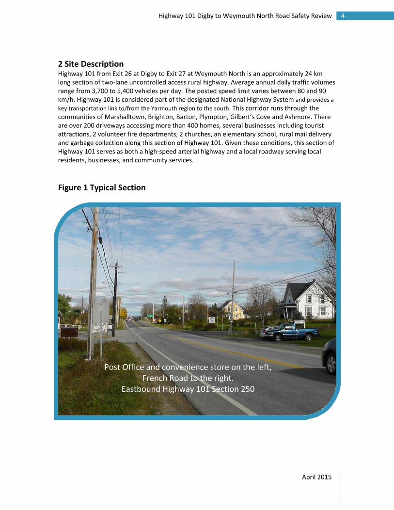
2 Site Description Highway 101 from Exit 26 at Digby to Exit 27 at Weymouth North is an approximately 24 km long section of two-lane uncontrolled access rural highway. Average annual daily traffic volumes range from 3,700 to 5,400 vehicles per day. The posted speed limit varies between 80 and 90 km/h. Highway 101 is considered part of the designated National Highway System and provides a
key transportation link to/from the Yarmouth region to the south. This corridor runs through the communities of Marshalltown, Brighton, Barton, Plympton, Gilbert’s Cove and Ashmore. There are over 200 driveways accessing more than 400 homes, several businesses including tourist attractions, 2 volunteer fire departments, 2 churches, an elementary school, rural mail delivery and garbage collection along this section of Highway 101. Given these conditions, this section of Highway 101 serves as both a high-speed arterial highway and a local roadway serving local residents, businesses, and community services.
Figure 1 Typical Section
Post Office and convenience store on the left, French Road to the right.
Eastbound Highway 101 Section 250
5 Highway 101 Digby to Weymouth North Road Safety Review
April 2015
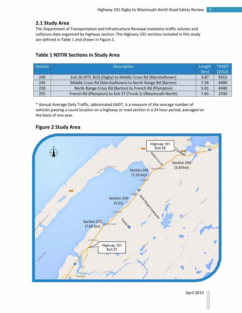
2.1 Study Area The Department of Transportation and Infrastructure Renewal maintains traffic volume and collisions data organized by highway section. The Highway 101 sections included in this study are defined in Table 1 and shown in Figure 2.
Table 1 NSTIR Sections in Study Area
Section Description Length (km)
*AADT (2012)
240 Exit 26 (RTE 303) (Digby) to Middle Cross Rd (Marshalltown) 3.87 5410
245 Middle Cross Rd (Marshalltown) to North Range Rd (Barton) 7.26 4400
250 North Range Cross Rd (Barton) to French Rd (Plympton) 5.01 4040
255 French Rd (Plympton) to Exit 27 (Trunk 1) (Weymouth North) 7.65 3700
* Annual Average Daily Traffic, abbreviated AADT, is a measure of the average number of vehicles passing a count location on a highway or road section in a 24 hour period, averaged on the basis of one year.
Figure 2 Study Area
6 Highway 101 Digby to Weymouth North Road Safety Review
April 2015
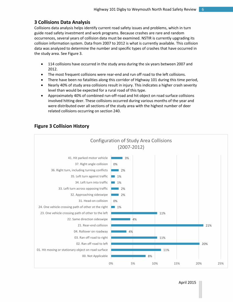
3 Collisions Data Analysis Collisions data analysis helps identify current road safety issues and problems, which in turn guide road safety investment and work programs. Because crashes are rare and random occurrences, several years of collision data must be examined. NSTIR is currently upgrading its collision information system. Data from 2007 to 2012 is what is currently available. This collision data was analyzed to determine the number and specific types of crashes that have occurred in the study area. See Figure 3.
114 collisions have occurred in the study area during the six years between 2007 and 2012.
The most frequent collisions were rear-end and run off road to the left collisions.
There have been no fatalities along this corridor of Highway 101 during this time period,
Nearly 40% of study area collisions result in injury. This indicates a higher crash severity level than would be expected for a rural road of this type.
Approximately 40% of combined run-off-road and hit object on road surface collisions involved hitting deer. These collisions occurred during various months of the year and were distributed over all sections of the study area with the highest number of deer related collisions occurring on section 240.
Figure 3 Collision History
8%
11%
20%
11%
4%
21%
4%
11%
1%
0%
2%
2%
1%
1%
2%
0%
3%
0% 5% 10% 15% 20% 25%
00. Not Applicable
01. Hit moving or stationary object on road surface
02. Ran off road to left
03. Ran off road to right
04. Rollover on roadway
21. Rear-end collision
22. Same direction sideswipe
23. One vehicle crossing path of other to the left
24. One vehicle crossing path of other ot the right
31. Head-on collision
32. Approaching sideswipe
33. Left turn across opposing traffic
34. Left turn into traffic
35. Left turn against traffic
36. Right turn, including turning conflicts
37. Right angle collision
41. Hit parked motor vehicle
Configuration of Study Area Collisions(2007-2012)

7 Highway 101 Digby to Weymouth North Road Safety Review
April 2015
4 Community Input
4.1 Background The Review Team solicited input from community members through the Highway 101 Task Force by distributing contact information and requesting it be disseminated to anyone who wished to express their safety concerns via telephone or email discussion. After receiving numerous submissions, the review team noted a number of common concerns.
4.2 Operational Concerns Residents along the study corridor reported excessive speed and an increase in vehicle traffic, particularly commercial transport and logging trucks, over the past 20 years. They also highlighted the conflict between local use of the roadway i.e. children traveling to school, motorists accessing driveways and local services with commercial truck traffic traveling through their communities. There is a perception that the Department’s plan for a future controlled access Highway 101 corridor has lessened the priority for maintenance and upgrades along the study area roadway. In addition, the fact that this uncontrolled section of road exists between two sections of controlled access highway which funnel high speed traffic through a corridor that continues to function as a local road was raised as a safety concern. This section of Highway 101 is currently serving two functions. It is used as a residential, local road by the residents of the area and is also a throughway for commercial traffic traveling to and from the southwest end of the Province. Among local residents, it is widely believed that lowering the 90 km speed limit that currently exists on most of the Digby to Weymouth North corridor would improve safety. Residents also expressed that current enforcement of existing speed limits is less than rigorous.
4.3 Winter Maintenance There is a perceived difference in levels of service for snow and ice control along the study area corridor as compared to the adjacent controlled access sections of Highway 101. District staff have advised that this perception may result from the location of winter maintenance crews and the availability of equipment during a particular snow or ice event. The Department of Transportation and Infrastructure Renewal’s maintenance levels of service for snow and ice control are based on road classification and traffic volumes. Winter maintenance level of service is the same for all 100 series highways and dictates that roads be cleared to essentially bare pavement within 8 hours. There is no difference in winter maintenance levels of service assigned to this road section and the adjacent Highway 101 sections.

8 Highway 101 Digby to Weymouth North Road Safety Review
April 2015
5 Field Observations (see Appendix A for photos) 5.1 Background The study team identified 16 safety issues along the Digby to Weymouth North section of Highway 101. The field review was conducted on a clear day with no notable weather impacts. Traffic was observed to be relatively heavy for mid-day on a rural roadway with a significant amount of commercial truck traffic. The study team also observed the roadway at night. The safety issues noted should not be considered deficiencies but could present an increased risk of collision and a higher level severity should a collision occur. While many issues are inter-related and carry over into multiple areas of concern, field observations were generally categorized into the following areas of investigation:
5.2 Roadside
5.2.1 General The clear zone is considered to be the total, fixed-object-free roadside border area at the edge of the roadway available for safe use by vehicles that may travel outside of the travel way. The wider the clear zone, the less the frequency and severity of collisions with fixed objects. This clear zone distance varies based on travel speed and the classification of a roadway. The travel way is the portion of the roadway for the movement of vehicles, exclusive of shoulders. In order to provide for adequate safety in roadside conditions, hazardous elements such as fixed obstacles or steep slopes should be placed outside of the clear zone in order to reduce or eliminate the need for roadside protection. If this is not possible, steep slopes or fixed obstacles should be protected by barriers, removed, or delineated.
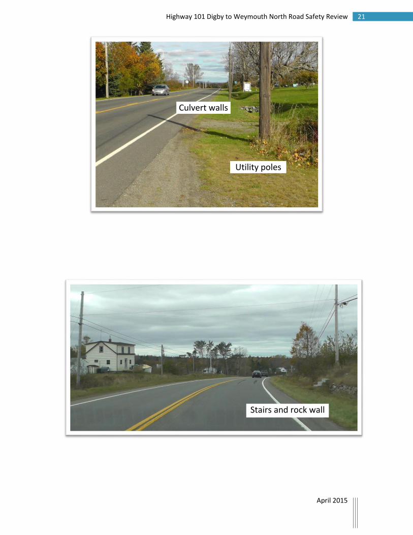
5.2.2 Observations Of particular note is the unforgiving nature of the roadside in the study area with critical side slopes and hazards including utility poles, large trees, numerous other fixed objects and driveway culverts (steeper than 3:1) within the clear zone that could present a hazard if struck by a vehicle.
5.3 Shoulder Maintenance 5.3.1 General A non-paved shoulder is that portion of the roadway which is adjacent to and runs parallel to the pavement or traveled portion of the road. Shoulders give lateral support to the road structure, allow run-off of the surface water, and may provide an area for emergency refuge off the traveled portion of the roadway. Roadway departure crashes that are most likely to be severe are those involving large pavement edge drop offs that exceed the desirable threshold of 100mm. These crashes may occur as the result of a vehicle leaving the paved surface and encroaching on an unpaved surface lower than the roadway. Low gravel shoulders can lead to a loss of control should a vehicle leave the roadway transitioning from a high friction surface to a low friction surface. Shoulder maintenance is an important factor along the sections of the road where there are increased numbers of driveways, accesses and intersections. In these locations drivers are likely to use the shoulder as a refuge to either slow down to make a turn or accelerate to get up to speed. Shoulder maintenance is intended to ensure an acceptable shoulder surface, proper slope, and to provide a smooth transition from the edge of pavement

9 Highway 101 Digby to Weymouth North Road Safety Review
April 2015
to the gravel shoulder. Shoulder maintenance also includes repairing or restoring washouts and low shoulders on non-paved shoulders by adding new gravel or recycled asphalt or using existing material.
5.3.2 Observations While it was observed that the pavement along this corridor was in good condition without any observable wheel rutting, polished surfaces, transverse cracks across the lanes or alligator cracking, there are many locations where the condition of the shoulder is an issue. Throughout the corridor there are gravel shoulders with pavement edge drop-offs, troughs that would hold water and furrows around barriers that don't allow water to run off the shoulder which present a significant hazard. In some locations along this corridor there isn’t a full 2.0 meter shoulder width. If not properly and regularly maintained, gravel shoulders have a tendency to rut, slump or erode as was observed along this section of roadway.
5.4 Accesses
5.4.1 Background It is important to provide drivers with clear clues about what is expected of them on a particular roadway. Unexpected turning movements impact safety due to incorrect decisions or delayed reaction times of drivers. This is of concern at both ends of the study area because the adjoining sections of Highway 101 are a different highway class (i.e. 2-lane undivided with full access control compared to 2-lane undivided with no access control). These transitions can lead to increased speed along the 2-lane section for drivers who have become accustomed to driving at the higher speed for a long distance and take longer to reduce their speed.
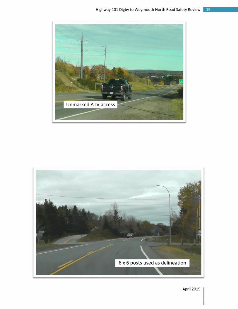
5.4.2 Observations The study area has a large number of driveways and intersections which cause conflict with traffic traveling along the corridor and can lead to angle type collisions that can be of a higher severity in terms of injury. Collision data shows a high percentage of crashes along study area sections involve turning movements or rear end collisions which indicate drivers not anticipating turning traffic or vehicles stopped on the roadway to make a turn into a driveway or intersecting road. The study team observed parking along the roadside, cars pulling in at different angles to access community mail boxes, parking areas immediately adjacent to the road for stowing and turning cars at the Post Office, churches and local businesses and buses turning at the school. There is an unmarked ATV trail near Exit 26.
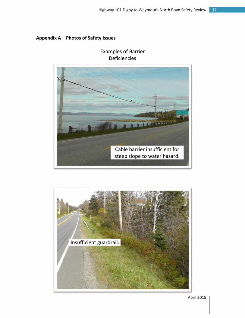
5.5 Barriers and Guideposts There are numerous locations throughout the study area where 6 x 6 wooden posts serve as roadside or intersection delineators. These posts present a hazard to off tracking vehicles and should be replaced with flexible guide posts in areas where additional road-edge delineation is found to be required or with guardrail where it is warranted. There are several low-tension cable barrier installations along the corridor as well. At these locations, cable barrier deflection distance extends to or beyond the hazard it is meant to protect and does not properly shield the driver from the hazard. Some roadside hazards located in the area do not appear to be protected by barriers.

10 Highway 101 Digby to Weymouth North Road Safety Review
April 2015
5.6 Visibility/Sight Lines 5.6.1 General Insufficient sight distance and limited forward visibility can adversely affect safety and increases the risk of a collision by reducing reaction times and stopping distances. Adequate sight distance provides drivers with sufficient time to identify and appropriately react to all elements of the road environment, including other road users and hazards. Improved sight distances on the approaches to intersections and through curves can reduce crashes at these high-risk locations. Rear end collisions can be reduced with improved forward visibility.
5.6.2 Observations In several locations along the Digby to Weymouth North corridor stopping sight distances appear to be insufficient. Some of these locations are on horizontal curves, on crests, on sites with poor sight distance and are in close proximity to intersections. Parking on the roadside near accesses was observed at the scrap yard just west of Exit 26, the Barton and Plympton Post Offices as well as on both sides of the roadway at the convenience store opposite French Road. Sight lines are also restricted by roadside vegetation in some areas. There are several skew intersections along the corridor. Skew intersections may present a hazard to vehicles turning onto Highway 101.
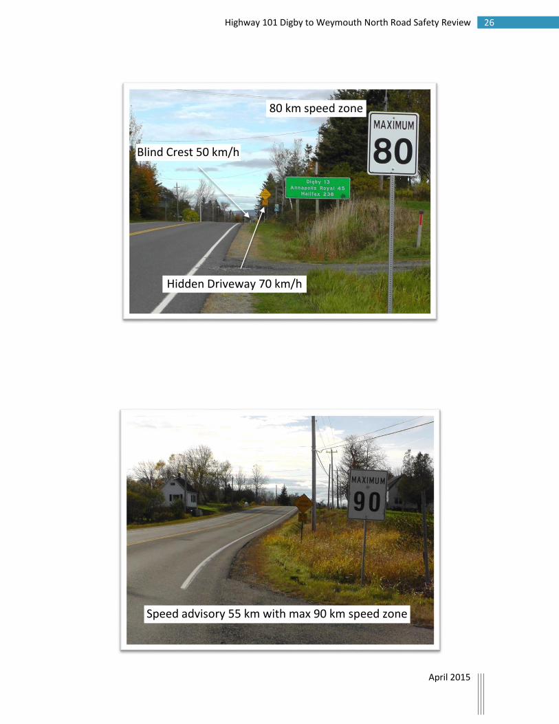
5.7 Signs, Markings, Lighting, Delineation There are several intersections in the study area that lack advance signage. Some intersections lack delineation to indicate to the driver that a road intersects the highway. Some sections of the corridor have insufficient lighting and where lighting does exist several lights were not working. Proper illumination provides the driver with guidance regarding the alignment of the roadway. Regulatory and warning signs are inconsistent throughout the corridor. Guide signing at Exit 27, Weymouth North will be renewed in 2015 as part of a paving project. There were no observed deficiencies in pavement markings throughout the corridor.
5.8 Driver Behaviour
5.8.1 Background Drivers performing unpredictable maneuvers particularly those that occur at high speed traveling along a challenging roadway create dangerous conditions. Collisions data for the study area show that 14% of collisions involved vehicles crossing the path of another vehicle or involved turning conflicts.
5.8.2 Observations During the field review, irregular turning movements were observed with some motorists crossing the centerline and traveling for significant distances in the opposing lane before turning left into a business or service location.
11 Highway 101 Digby to Weymouth North Road Safety Review
April 2015
6 Speed Survey
6.1 Background A key indicator of potential collision risk is the speed at which vehicles travel through the study area. Research shows that as speed increases, the severity of collisions increases and that as the variability of speeds increase, the likelihood of a collision increases. Prior to this review, several speed studies had been conducted along this corridor between Weymouth North and Conway. These studies recommended that the existing speed zones be maintained. For this safety study, the review team conducted spot speed investigations at two locations along the corridor; at the west end of Marshalltown Road in a 90 km/h zone (section 240) and at the Baptist church in the 80 km/h zone (section 245).
6.2 The speed study The study area is a 23.3 kilometer long section of Highway 101 with uncontrolled access. Most of the roadway is posted 90 km/h except for the 2.4 kilometers posted at 80 km/h through the community of Barton. The speed study conducted for this review shows that the 85th percentile speed, at 97 km/h in the 80 km zone, is almost 20 km over the posted speed limit.
6.3 Analysis In cases where compliance with posted speed limits is low, studies show that lowering posted speed limits does not reduce vehicle speeds or collisions. Also, lowering speed limits well below the 85th percentile speed can increase speed variability and the likelihood and severity of collisions. Some drivers will obey the new lower posted speed limit while others will continue traveling at a speed much higher than the posted speed limit. This greater speed differential increases the likelihood of collision. Lowering the speed limit in the study area would not be an effective countermeasure and could actually increase the safety risk.
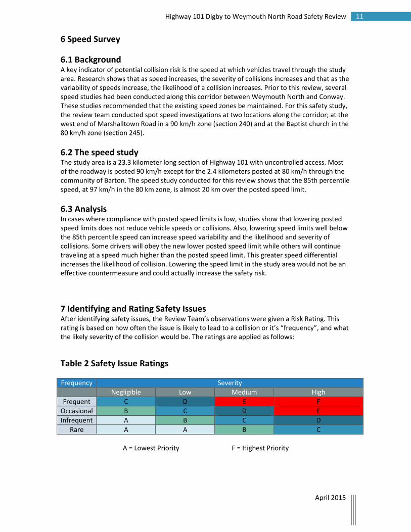
7 Identifying and Rating Safety Issues After identifying safety issues, the Review Team’s observations were given a Risk Rating. This rating is based on how often the issue is likely to lead to a collision or it’s “frequency”, and what the likely severity of the collision would be. The ratings are applied as follows:
Table 2 Safety Issue Ratings
Frequency Severity
Negligible Low Medium High
Frequent C D E F
Occasional B C D E
Infrequent A B C D
Rare A A B C
A = Lowest Priority F = Highest Priority

12 Highway 101 Digby to Weymouth North Road Safety Review
April 2015
Table 3 Safety Issues
Issue Location Frequency Severity Rating
1 Trees, utility poles and rigid obstacles in clear zone. Hazards not sufficiently protected.
Throughout Occasional High E
2 Unforgiving roadside: Steep side slopes with large drop in elevation. Hazards not sufficiently protected.
Throughout Frequent High F
3 Existing 6 x 6 guideposts present a hazard to vehicles leaving the road.
Various locations
Occasional Medium D
4 Insufficient shoulder width, edge drop off greater than the desirable threshold of 100mm.
Throughout Frequent Medium E
5 Washouts along roadway preventing water from getting into ditch.
Various locations
Occasional Medium D
6 Debris build up along roadside may cause ponding of water in the road.
Various locations
Occasional Medium D
7 Numerous access locations on horizontal curves, on crests, on sites with poor sight distances and close to intersections.
Various locations
Frequent High F
8 Driveways a hazard to off tracking vehicles. i.e. vertical culvert walls.
Various locations
Frequent Medium E
9 Parking on roadside near accesses. Various locations
Infrequent Medium C
10 Skew intersections may present a hazard to vehicles turning to/from Highway 101.
Lewiston Road, Marshalltown Rd, Beaver Lane
Infrequent Medium C
11 Markings and signage to delineate intersections not present.
Various locations
Infrequent Low B
12 Insufficient lighting at French Road. Convenience store lights obscure intersection at night.
Various locations
Infrequent Low B

13 Highway 101 Digby to Weymouth North Road Safety Review
April 2015
Issue Location Frequency Severity Rating
13 Numerous warning and advisory speed signs appeared to be inconsistent. (see photos)
Various locations
Frequent Low D
14 Low compliance with posted speed limit
Various locations
Frequent High F
15 Presence of wildlife (deer) Various locations
Occasional Medium D
16 Irregular turning movements by motorists leaving the highway to access services or driveways.
Various locations
Infrequent Medium C
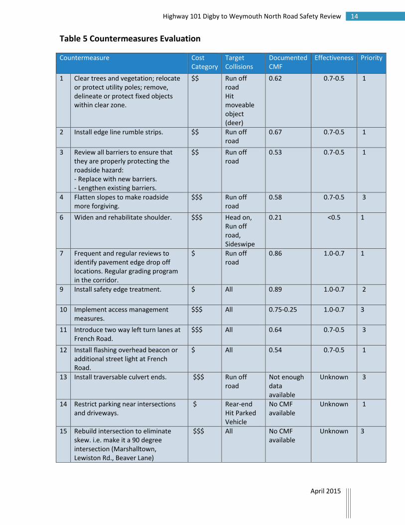
8 Evaluating Countermeasures and Determining Priorities Once these safety issues were rated, the study team looked at safety countermeasures and their potential effectiveness if implemented along this corridor. One of the descriptors of a countermeasure's effectiveness is called a collision modification factor (CMF) and these have been developed through before-and-after research projects. Crash modification factor (CMF) is a multiplicative factor used to compute the expected number of crashes after implementing a given countermeasure at a specific site. Mathematically stated, CMF = 1 - (CRF/100). For example, if a particular countermeasure is expected to reduce the number of crashes by 23% (i.e., the CRF is 23), the CMF will be 1 - (23/100) = 0.77. On the other hand, if the treatment is expected to increase the number of crashes by 23% (i.e., the CRF is -23), the CMF will be = 1 - (-23/100) = 1.23. Countermeasures were prioritized using both the estimated cost of implementation and the effectiveness rating for each countermeasure.
Table 4 Determining Priorities Cost Effectiveness
Low Moderate High
$ - Low 2 1 1
$$- Mid 3 2 1
$$$- High 3 3 2
* Effectiveness is a ranking based on the documented CMF for a particular countermeasure.
Effectiveness: <0.5 = Low 0.7-0.5 = Moderate 1.0-0.7 = High
$ - $0-$50,000 $$ - $50,000 - $250,000 $$$ - 250,000+
14 Highway 101 Digby to Weymouth North Road Safety Review
April 2015
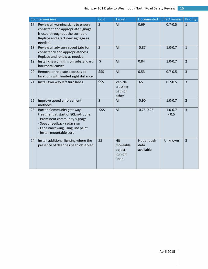
Table 5 Countermeasures Evaluation
Countermeasure Cost Category
Target Collisions
Documented CMF
Effectiveness Priority
1 Clear trees and vegetation; relocate or protect utility poles; remove, delineate or protect fixed objects within clear zone.
$$ Run off road Hit moveable object (deer)
0.62 0.7-0.5 1
2 Install edge line rumble strips. $$ Run off road
0.67 0.7-0.5 1
3 Review all barriers to ensure that they are properly protecting the roadside hazard: - Replace with new barriers. - Lengthen existing barriers.
$$ Run off road
0.53 0.7-0.5 1
4 Flatten slopes to make roadside more forgiving.
$$$ Run off road
0.58 0.7-0.5 3
6 Widen and rehabilitate shoulder.
$$$ Head on, Run off road, Sideswipe
0.21 <0.5 1
7 Frequent and regular reviews to identify pavement edge drop off locations. Regular grading program in the corridor.
$ Run off road
0.86 1.0-0.7 1
9 Install safety edge treatment. $ All 0.89 1.0-0.7 2
10 Implement access management measures.
$$$ All 0.75-0.25 1.0-0.7 3
11 Introduce two way left turn lanes at French Road.
$$$ All 0.64 0.7-0.5 3
12 Install flashing overhead beacon or additional street light at French Road.
$ All 0.54 0.7-0.5 1
13 Install traversable culvert ends. $$$ Run off road
Not enough data available
Unknown 3
14 Restrict parking near intersections and driveways.
$ Rear-end Hit Parked Vehicle
No CMF available
Unknown 1
15 Rebuild intersection to eliminate skew. i.e. make it a 90 degree intersection (Marshalltown, Lewiston Rd., Beaver Lane)
$$$ All No CMF available
Unknown 3
15 Highway 101 Digby to Weymouth North Road Safety Review
April 2015
Countermeasure Cost Category
Target Collisions
Documented CMF
Effectiveness Priority
17 Review all warning signs to ensure consistent and appropriate signage is used throughout the corridor. Replace and erect new signage as needed.
$ All 0.69 0.7-0.5 1
18 Review all advisory speed tabs for consistency and appropriateness. Replace and renew as needed.
$ All 0.87 1.0-0.7 1
19 Install chevron signs on substandard horizontal curves.
$ All 0.84 1.0-0.7 2
20 Remove or relocate accesses at locations with limited sight distance.
$$$ All 0.53 0.7-0.5 3
21 Install two way left turn lanes. $$$ Vehicle crossing path of other
.65 0.7-0.5 3
22 Improve speed enforcement methods.
$ All 0.90 1.0-0.7 2
23 Barton Community gateway treatment at start of 80km/h zone: - Prominent community signage - Speed feedback radar sign - Lane narrowing using line paint - Install mountable curb
$$$ All 0.75-0.25 1.0-0.7 <0.5
3
24 Install additional lighting where the presence of deer has been observed.
$$ Hit moveable object Run off Road
Not enough data available
Unknown 3

16 Highway 101 Digby to Weymouth North Road Safety Review
April 2015
9 Recommendations Using this report as a guide, the Department should prepare a detailed Road Safety Improvement Plan developing a time frame for short term (1-2 years), mid-term (2-4 years) and long term (4-6 years) implementation schedule of appropriate countermeasures keeping in mind that planning for a 4 km section of the new divided controlled access corridor of Highway 101 from Exit 26 to Marshalltown Rd is underway and construction is expected to begin in 2017. Because fully implementing all safety countermeasures is likely to exceed the Government’s fiscal constraints and some countermeasures will not provide sufficient improvements in road safety to warrant funding, the plan should assess which countermeasures would be most easily implemented and be most cost effective. This report recommends keeping the existing speed zones for the present time. Because of the number of accesses, the challenging geometric conditions and collision characteristics of this roadway it is recommended that inconsistent curve warning, hidden driveway and speed advisory signs be reviewed. Requirements for barriers should be reviewed along the entire length of the corridor. This should include a review of need where no barrier exists, the proper
barrier technology application, and the existing barrier length of need. Winter maintenance should be reviewed to ensure the level of service is being met. Brush cutting is necessary to preserve driver sight distances and visibility of signage, control roadside growth to deter wildlife,
and ensure proper drainage. Planning for roadway shoulder rehabilitation should begin immediately.
10 Summary and Conclusion This review identified numerous countermeasures which are expected to provide improvements in safety performance for this roadway. These recommendations are meant to provide value regardless of the long term plan for this section of Highway 101. While it is unrealistic to expect the Department to implement all of the countermeasures immediately, many can be completed in the short term at a relatively low cost. It is also recommended that in an effort to lower the number of collisions and lessen collision severity along this route, the Department invest in medium and long term countermeasures.
17 Highway 101 Digby to Weymouth North Road Safety Review
April 2015
Appendix A – Photos of Safety Issues
Examples of Barrier Deficiencies
Cable barrier insufficient for steep slope to water hazard.
Insufficient guardrail.

18 Highway 101 Digby to Weymouth North Road Safety Review
April 2015
Examples of Lack of Access Delineation
French Road
Review reflectors, blocking, signage for Kinney Bridge
19 Highway 101 Digby to Weymouth North Road Safety Review
April 2015
Unmarked ATV access
6 x 6 posts used as delineation

20 Highway 101 Digby to Weymouth North Road Safety Review
April 2015
Examples of Roadside Hazards in Clear Zone
Power utility box
Wooden, non-breakaway sign posts
21 Highway 101 Digby to Weymouth North Road Safety Review
April 2015
Stairs and rock wall
Utility poles
Culvert walls

22 Highway 101 Digby to Weymouth North Road Safety Review
April 2015
Pavement edge drop off
Examples of Shoulder Deterioration
Shoulder rutting

23 Highway 101 Digby to Weymouth North Road Safety Review
April 2015
Examples of Insufficient Sightlines
North Range Cross Road
West end Beaver Lane

24 Highway 101 Digby to Weymouth North Road Safety Review
April 2015
St. Mary's Bay Baptist Church
St. Mary's Bay Baptist Church

25 Highway 101 Digby to Weymouth North Road Safety Review
April 2015
Examples of speed advisory sign issues
Missing warning sign
East end Marshalltown Road
26 Highway 101 Digby to Weymouth North Road Safety Review
April 2015
Speed advisory 55 km with max 90 km speed zone
Hidden Driveway 70 km/h
80 km speed zone
Blind Crest 50 km/h

27 Highway 101 Digby to Weymouth North Road Safety Review
April 2015
Curve warning speed advisory 70 km
followed by hidden driveway speed advisory 65 km