High Resolution Multispectral And Hyperspectral Data ... · (MSI) with lower spatial resolution,...
12
High Resolution Multispectral And Hyperspectral Data Fusion For Advanced Geospatial Information Products - Final Report W. Paul Bissett Florida Environmental Research Institute 10500 University Center Drive Suite 140 Tampa, FL 33612 phone: (813) 866-3374 x102 fax: (813) 977-8057 email: pbissett(dferiweb.org David D. R. Kohler Florida Environmental Research Institute 10500 University Center Drive Suite 140 Tampa, FL 33612 Award Number: N00014-05-1-0416 phone: (813) 866-3374 x1 14 fax: (813) 977-8057 email: dkohleraferiweb.org http://www.feriweb.org LONG-TERM GOALS This project seeks to develop the technology to fuse high spatial resolution MultiSpectral Imagery (MSI) with lower spatial resolution, but higher spectral resolution, HyperSpectral Imagery (HSI) to provided enhanced target detection and battlespace characterization. It seeks to push beyond traditional PAN sharpening techniques to develop applications that will increase the accuracy and fidelity of the sharpened spectral imagery. OBJECTIVES 1) Co-register high resolution MSI data with HSI data collected during the Fall of 2004. 2) Correct the MSI data for illumination and atmospheric interference to derive a broadband remote sensing reflectance, Rrs, measurement from the MSI data. 3) Develop methodologies to fuse the HSI data with the higher spatial resolution MSI data, using the spectral characterization of the MSI Rrs data stream. APPROACH The fusion of remote sensing data from different sensors has a long history of success in the terrestrial environment (Pohl and Genderen, 1998). Its application in ocean remote sensing has accelerated in recent years with the use of multiple resolution, multiple frequency optical and microwave imaging. The optical imagers include both active (e.g. LIDAR) and passive (e.g. HyperSpectral Imagers, HSI). DISTRIBUTION STATEMENT A Approved for Public Release Distribution Unlimited
Transcript of High Resolution Multispectral And Hyperspectral Data ... · (MSI) with lower spatial resolution,...
High Resolution Multispectral And Hyperspectral Data Fusion For AdvancedGeospatial Information Products - Final Report
W. Paul BissettFlorida Environmental Research Institute
10500 University Center DriveSuite 140
Tampa, FL 33612
phone: (813) 866-3374 x102 fax: (813) 977-8057 email: pbissett(dferiweb.org
David D. R. KohlerFlorida Environmental Research Institute
10500 University Center DriveSuite 140
Tampa, FL 33612
Award Number: N00014-05-1-0416
phone: (813) 866-3374 x1 14 fax: (813) 977-8057 email: dkohleraferiweb.org
http://www.feriweb.org
LONG-TERM GOALS
This project seeks to develop the technology to fuse high spatial resolution MultiSpectral Imagery(MSI) with lower spatial resolution, but higher spectral resolution, HyperSpectral Imagery (HSI) toprovided enhanced target detection and battlespace characterization. It seeks to push beyondtraditional PAN sharpening techniques to develop applications that will increase the accuracy andfidelity of the sharpened spectral imagery.
OBJECTIVES
1) Co-register high resolution MSI data with HSI data collected during the Fall of 2004.
2) Correct the MSI data for illumination and atmospheric interference to derive a broadband remotesensing reflectance, Rrs, measurement from the MSI data.
3) Develop methodologies to fuse the HSI data with the higher spatial resolution MSI data, using thespectral characterization of the MSI Rrs data stream.
APPROACH
The fusion of remote sensing data from different sensors has a long history of success in the terrestrialenvironment (Pohl and Genderen, 1998). Its application in ocean remote sensing has accelerated inrecent years with the use of multiple resolution, multiple frequency optical and microwave imaging.The optical imagers include both active (e.g. LIDAR) and passive (e.g. HyperSpectral Imagers, HSI).
DISTRIBUTION STATEMENT AApproved for Public Release
Distribution Unlimited

REPORT DOCUMENTATION PAGE Form ApprovedOMB No. 0704-0188
The public reporting burden for this collection of information is estimated to average 1 hour per response, including the time for reviewing instructions, searching existing data sources,gathering and maintaining the data needed, and completing and reviewing the collection of information. Send comments regarding this burden estimate or any other aspect of this collection ofinformation, including suggestions for reducing the burden, to Department of Defense, Washington Headquarters Services, Directorate for Information Operations and Reports (0704-0188),1215 Jefferson Davis Highway, Suite 1204, Arlington, VA 22202-4302. Respondents should be aware that notwithstanding any other provision of law, no person shall be subject to anypenalty for failing to comply with a collection of information if it does not display a currently valid OMB control number.PLEASE DO NOT RETURN YOUR FORM TO THE ABOVE ADDRESS.1. REPORT DATE (DD-MM-YYYY) 2. REPORT TYPE 3. DATES COVERED (From - To)
30-03-2007 Final Mar 15, 2005--Dec 31, 20064. TITLE AND SUBTITLE 5a. CONTRACT NUMBER
High Resolution Multispectral and Hyperspectral Data Fusion for AdvancedGeospatial Information Products 5b. GRANT NUMBER
N00014-05-1-0416
5c. PROGRAM ELEMENT NUMBER
6. AUTHOR(S) 5d. PROJECT NUMBER
W. Paul Bissett59. TASK NUMBER
5f. WORK UNIT NUMBER
7. PERFORMING ORGANIZATION NAME(S) AND ADDRESS(ES) 8. PERFORMING ORGANIZATIONREPORT NUMBER
Florida Envoronmental Research Institute10500 University Center Drive, Suite 140Tampa, Florida 33612
9. SPONSORING/MONITORING AGENCY NAME(S) AND ADDRESS(ES) 10. SPONSOR/MONITOR'S ACRONYM(S)
ONROffice of Naval Research100 Alabama St SW 11. SPONSOR/MONITOR'S REPORTSuite 4R 15 NUMBER(S)Atlanta, GA 30303-3104
12. DISTRIBUTION/AVAILABILITY STATEMENT
Approved for Public Release; Distribution is Unlimited
13. SUPPLEMENTARY NOTES
N/A
14. ABSTRACT
See Attached
15. SUBJECT TERMSHyperspectral Imagery (HSI), MultiSpectral Imagery (MSI),remote sensing, geo-positioning, panchromatic (PAN) imagery, RGBinager
16. SECURITY CLASSIFICATION OF: 17. LIMITATION OF 18. NUMBER 19a. NAME OF RESPONSIBLE PERSONa. REPORT b. ABSTRACT c. THIS PAGE ABSTRACT OF Beverly Walters
PAGES19b. TELEPHONE NUMBER (Include area code)
2 813-866-3374, ext. 101
Standard Form 298 (Rev. 8/98)Prescribed by ANSI Std. Z39.18
IMPACTS/APPLICATIONS
The abilities to detect targets and characterize the environment in the Very ShallowWater (VSW) and beach zone are critical to MIW, MCM, and NSW operations. Theimage fusion techniques here will provide enhanced abilities to detect and characterizetarget in access denied areas using both geomorphology (shape) and spectral (color)signatures. In addition, the successful development of these techniques will feed backinto the development of new imaging systems for space and aircraft platforms, includingUnmanned Aircraft Systems (UAS).
This work demonstrated the ability to fuse high resolution multispectral imagery withlower resolution hyperspectral imagery using a new method of color tinting fusion. Onsimulated multispectral imagery we achieved a -6% reconstruction error across theVNIR spectrum; on actual multispectral imagery we achieved -20% reconstruction error.The difference between the simulated and actual was mostly attributed to the inability tocalibrate and atmospherically correct the multispectral imagery.
Microwave imagers are typically Synthetic Aperture Radar (SAR). While the field has been generallyconfined to airborne and space-based platforms, imagery data fusion may also include somecombination of data from these platforms with data from in-water systems such as multibeam and side-scan sonar imagery. In short, data fusion is the process by which two or more streams of data ofdifferent temporal and spatial resolution are combined to produce synthesized products which areunattainable from a discrete image.
The advantages of data fusion are fairly clear. In the temporal domain, data fusion allows for the morecomplete imaging of an area intermittently covered by clouds. It may also provide better analysis ofmovement or time-dependent change in targets and/or environmental conditions. In theelectromagnetic frequency domain, targets which are visible in one image type may be less than visiblein another, and vice versa. SAR imagery may illuminate target elevations or directional wave spectra,whereas optical imagery may identify targets by shape and color. Combining the targeting andidentification of these different data types provides target recognition and environmentalcharacterization with high confidence and lower false alarm rates than may be found from singlesource imagery. In the spatial domain, objects that are identifiable on the basis of size and shape inpanchromatic (PAN) imagery are often unidentifiable by their geometric dimensions in lowerresolution multispectral or hyperspectral imagery. The converse is that the spectral imagery providesthe ability to identify targets or characterize the environment based on unique spectral signatures,which is unavailable in the panchromatic imagery, but may not be able to resolve the shape ordimensions of small targets.
This project seeks to co-locate simultaneously collected MSI/HSI data streams to develop enhancedimagery sharpening capabilities for use in target detection and environmental characterization. It seeksto build upon PAN sharpening techniques by using the full spectral information provided by MSI datastreams. We hypothesize that the best way to attempt this image fusion is at the level of remotesensing reflectance, so the MSI data must be corrected for illumination and atmospheric interference.The spectral information from the co-registered MSI/HSI Rrs data will then be fused to provide moreaccurately sharpened HSI data for spectral target algorithms.
WORK COMPLETED - Year 1
This project began in April of 2005, and started with data previously collected by FERI. FERI, incollaboration with the California State University System, under the NOAA-funded California Centerfor Integrative Coastal Observation, Research and Education (CICORE) Program(http://www.feriweb.org/projects/ci-core/) recently (Fall 2004) collected over 5,000 square kilometersof 0.3 meter MSI and 3 meter HSI data over a wide variety of coastal environments along theCalifornia coast (http://www.feriweb.org/projects/ci-core/arcims/). The survey sites include HumboltBay, San Francisco Bay, Monterey Bay, the Big Sur coast, San Luis Bay, Santa Barbara, Newport, andSan Diego Harbor. The MSI instrumentation was provided under a cooperative agreement with theApplanix Systems Integration Group (ASIG), a subsidiary of the Trimble Corporation. This MSIsystem (Digital Sensor System; http://www.applanix.com/products/dss index.php) was provided aspart of the Applanix Position and Orientation System (POS AV;http://www.applanix.com/products/posav__index.php), which was being evaluated as a replacement forthe current POS system on the NRL PHILLS 2 airborne hyperspectral imager.
The raw DSS imagery (MSI imagery) and POS data was provided to FERI by ASIG after the flights.The processing and geo-positioning of the MSI data was completed by FERI under this ONR project.
2
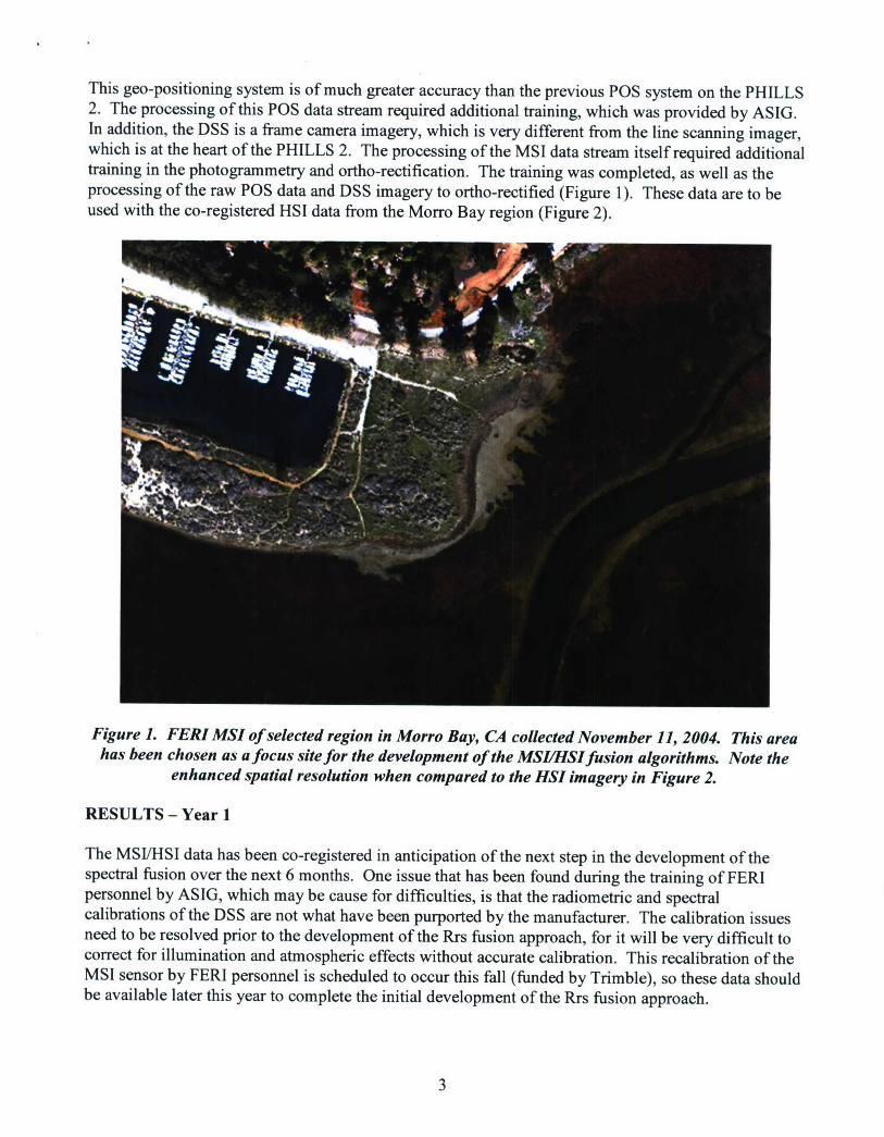
This geo-positioning system is of much greater accuracy than the previous POS system on the PHILLS2. The processing of this POS data stream required additional training, which was provided by ASIG.In addition, the DSS is a frame camera imagery, which is very different from the line scanning imager,which is at the heart of the PHILLS 2. The processing of the MSI data stream itself required additionaltraining in the photogrammetry and ortho-rectification. The training was completed, as well as theprocessing of the raw POS data and DSS imagery to ortho-rectified (Figure 1). These data are to beused with the co-registered HSI data from the Morro Bay region (Figure 2).q
i
Figure 1. FERI MSI of selected region in Morro Bay, CA collected November 11, 2004. This areahas been chosen as a focus site for the development of the MSI/ItSI fusion algorithms. Note the
enhanced spatial resolution when compared to the HSI imagery in Figure 2.
RESULTS - Year 1
The MSI/HSI data has been co-registered in anticipation of the next step in the development of thespectral fusion over the next 6 months. One issue that has been found during the training of FERIpersonnel by ASIG, which may be cause for difficulties, is that the radiometric and spectralcalibrations of the DSS are not what have been purported by the manufacturer. The calibration issuesneed to be resolved prior to the development of the Rrs fusion approach, for it will be very difficult tocorrect for illumination and atmospheric effects without accurate calibration. This recalibration of theMSI sensor by FERI personnel is scheduled to occur this fall (funded by Trimble), so these data shouldbe available later this year to complete the initial development of the Rrs fusion approach.
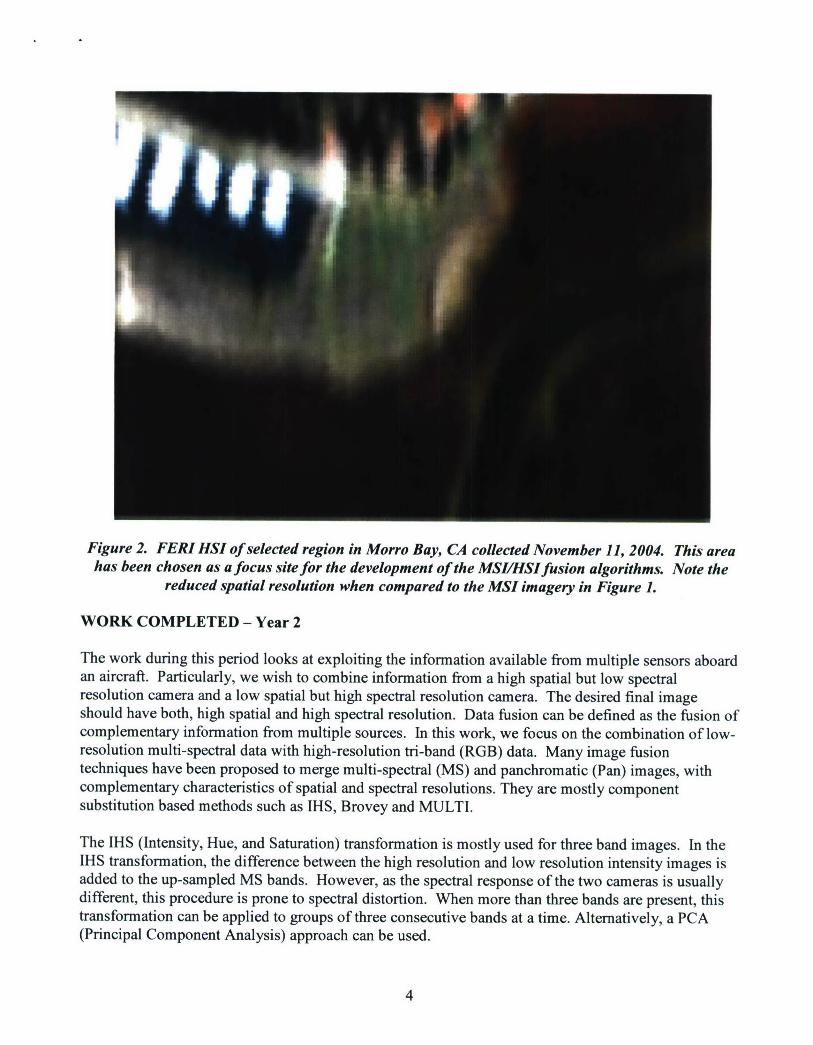
Figure 2. FERI HSI of selected region in Morro Bay, CA collected November 11, 2004. This areahas been chosen as a focus site for the development of the MSL/HSI fusion algorithms. Note the
reduced spatial resolution when compared to the MSI imagery in Figure 1.
WORK COMPLETED - Year 2
The work during this period looks at exploiting the information available from multiple sensors aboardan aircraft. Particularly, we wish to combine information from a high spatial but low spectralresolution camera and a low spatial but high spectral resolution camera. The desired final imageshould have both, high spatial and high spectral resolution. Data fusion can be defined as the fusion ofcomplementary information from multiple sources. In this work, we focus on the combination of low-resolution multi-spectral data with high-resolution tri-band (RGB) data. Many image fusiontechniques have been proposed to merge multi-spectral (MS) and panchromatic (Pan) images, withcomplementary characteristics of spatial and spectral resolutions. They are mostly componentsubstitution based methods such as IHS, Brovey and MULTI.
The IHS (Intensity, Hue, and Saturation) transformation is mostly used for three band images. In theIHS transformation, the difference between the high resolution and low resolution intensity images isadded to the up-sampled MS bands. However, as the spectral response of the two cameras is usuallydifferent, this procedure is prone to spectral distortion. When more than three bands are present, thistransformation can be applied to groups of three consecutive bands at a time. Alternatively, a PCA(Principal Component Analysis) approach can be used.
4
The Brovey fusion method computes the ratio between a panchromatic cell value and the average ofthe corresponding multi-spectral cell values and uses that ratio to compute the final color componentvalues for the pan-sharpened image. The Gram-Schmidt (GS) technique is another componentsubstitution technique for spectral sharpening. In the GS method, the low-resolution version of thePAN image is obtained as the pixel average of the MS bands. However, as discussed earlier, becauseof the radiometric differences between the two sensors, the reconstructed image is prone to suffer fromspectral distortion. The purpose of this work is to mitigate this distortion by reconciling the twosensors radiometrically, prior to performing the GS fusion. A similar approach is taken in Aiazzi et al,2006 where regression coefficients are determined to reconcile the two sensors prior to GS sharpening.In our case, however, the sensor response is known a priori, obviating the need for determiningcoefficients.
RESULTS - Year 2
The purpose of this work is to construct a high spatial and high spectral resolution image using imagesfrom two sensors. One sensor is a high spatial resolution frame camera - the DSS-322. The other is ahigh spectral resolution camera, FERI's SAMSON. The Gram Schmidt procedure described abovewas used to combine information from the two cameras to obtain a high spectral, high spatialresolution image.
To evaluate the validity of the reconstructed image, the hyper-spectral and multi-spectral images had tobe down-sampled spatially and then used to reconstruct the original hyper-spectral image. The errorbetween the reconstructed and original hyper-spectral image is a quantitative indicator of the proposedprocedure's validity.
Image fusion was studied under two conditions - practical and ideal. In the practical scenario, actualhyper-spectral and multi-spectral images were used. For the ideal scenario, an actual hyper-spectraland a simulated multi-spectral image (simulated using the hyper-spectral image) were used. By usinghyper-spectral and multi-spectral images derived from the same sensor, many error sources such asregistration, calibration and atmosphere are eliminated. Comparing results from these two scenarioshelps quantify the error contribution from these sources.
The simulated DSS image was obtained from the hyper-spectral image using the spectral responsefunction of the DSS camera. Each band of the DSS camera was simulated by taking a dot productbetween that band's spectral response function with the actual wavelength responses from the hyper-spectral signal as shown in Equation 1.
DSS(i, j, k) = HYP(i, j, A) x SRFk(A-) (1)
Here, k indicates the DSS's band, k= {1,2,3}, (ij) indicate the pixel location, SRFk (2) is the kth band'sresponse at wavelength 2.
5
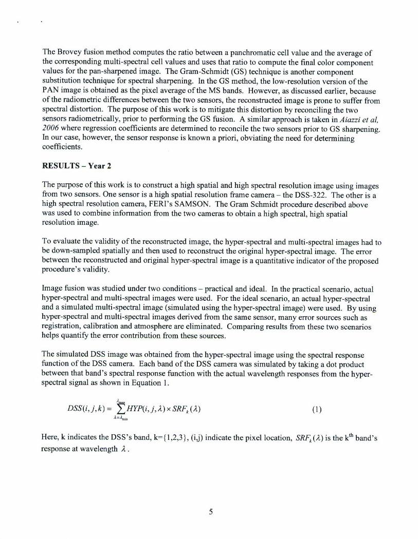
Two approaches to image fusion were compared. In the first approach, GS was run using the hyper-spectral image and one of the DSS bands to obtain the reconstructed hyper-spectral image as shown inFigure 3.
Hyper-spectral Multispectral
IHigh Spatial resolutionhyper-spectral
Figure 3. In the traditional Gram-Schmidt approach a single PAN channel is used to fuse the highspatial resolution with the lower spatial, but high spectral resolution image.
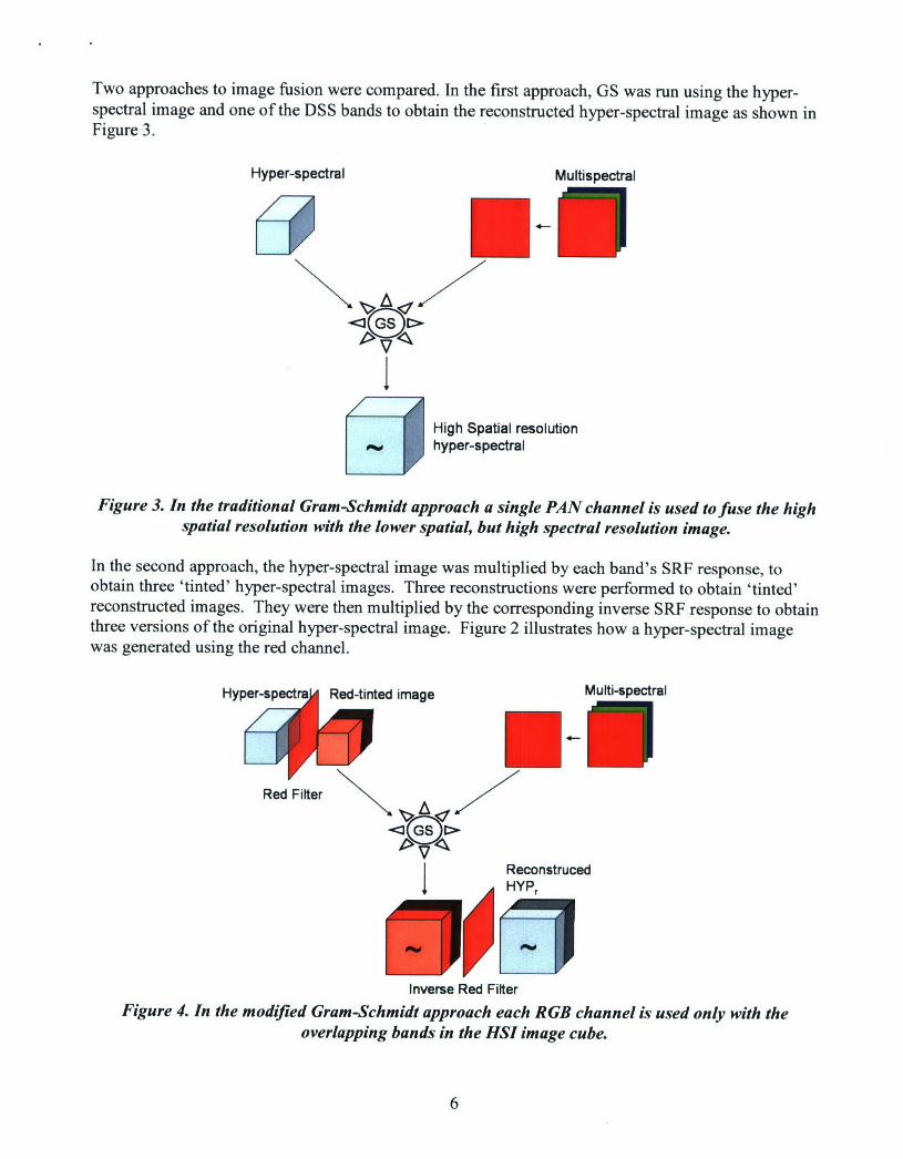
In the second approach, the hyper-spectral image was multiplied by each band's SRF response, toobtain three 'tinted' hyper-spectral images. Three reconstructions were performed to obtain 'tinted'reconstructed images. They were then multiplied by the corresponding inverse SRF response to obtainthree versions of the original hyper-spectral image. Figure 2 illustrates how a hyper-spectral imagewas generated using the red channel.
Hyper-sp image Multi-spectrl
Red Filterz
I Reconstruced
4 JHYP,
Inverse Red FilterFigure 4. In the modified Gram-Schmidt approach each RGB channel is used only with the
overlapping bands in the HSI image cube.
6
Tinting the image prior to using the GS, ensures that the hyper-spectral and multi-spectral images havesimilar spectral content leading to better reconstruction. Once three versions of the reconstructedhyper-spectral image are obtained, they can be averaged to obtain a final reconstructed version. In thiswork, a more elegant fusion scheme was used as shown in Equation 2.
HYPavg( 2 )=Wr( 2 )HYPr( 2 )+Wg( 2 )HYPg( 2 )+Wb( 2 )HYPb( 2) (2)
Where Wr( 2) = SRFr( 2)/ (SRFr( 2) + SRFg( 2) + SRFb( 2 )). This means that instead of weightingthe three images equally (as you would in an average), they are now weighted in proportion to theirdominance at each wavelength.
DISCUSSION - Year 2
In this section, we compare the performance of the modified method to that of the original method inthe ideal scenario. Then, we compare our method's performance in the two scenarios (ideal andpractical). This is followed by a detailed discussion of the results.
First we evaluate the efficacies of the proposed modified method and the original method in the idealscenario. Figure 3 and Figure 4 described the workings of the two methods. A three band multi-spectral image was simulated from the hyper-spectral image as described by Equation 1. The originalhyperspectral image was reconstructed using both methods and the errors were evaluated.
To characterize the nature of the reconstruction error, we studied its distribution along wavelengthsand magnitudes. The error is expressed as a fraction of the original hyper-spectral image.
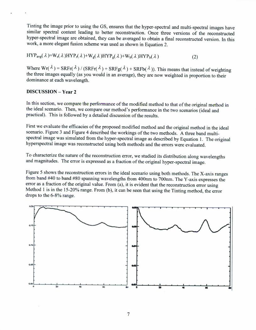
Figure 5 shows the reconstruction errors in the ideal scenario using both methods. The X-axis rangesfrom band #40 to band #80 spanning wavelengths from 400nm to 700nm. The Y-axis expresses theerror as a fraction of the original value. From (a), it is evident that the reconstruction error usingMethod 1 is in the 15-20% range. From (b), it can be seen that using the Tinting method, the errordrops to the 6-8% range.
407
7
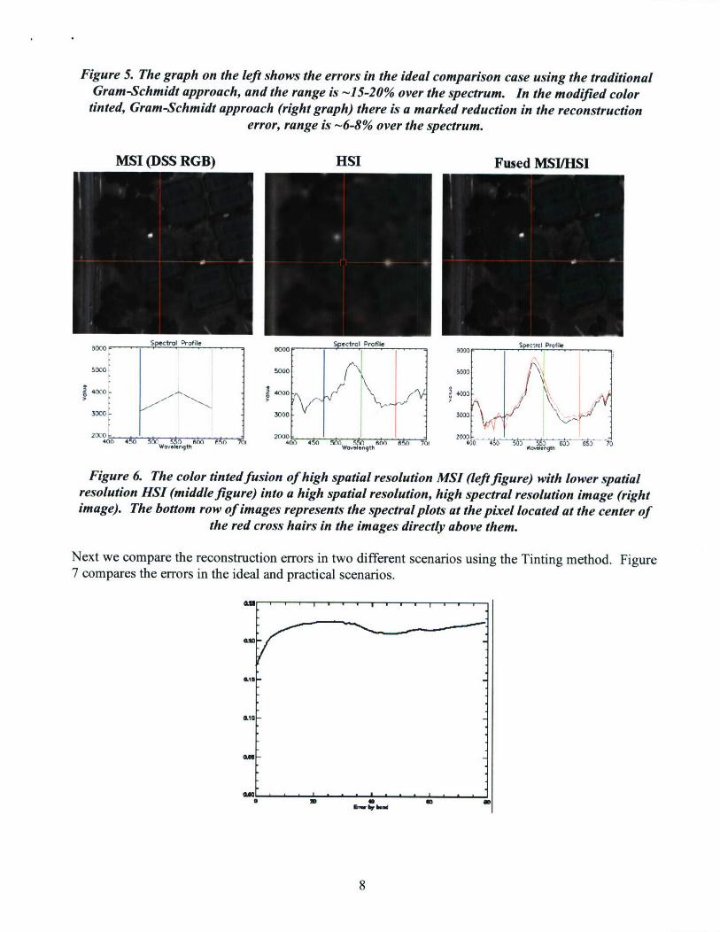
Figure 5. The graph on the left shows the errors in the ideal comparison case using the traditionalGram-Schmidt approach, and the range is -15-20% over the spectrum. In the modified colortinted, Gram-Schmidt approach (right graph) there is a marked reduction in the reconstruction
error, range is -6-8% over the spectrum.
MSI (DSS RGB) HSI Fused MSI/HSI
Spe. l Profile Spectira Profile -• F - - Profile
3000 woo0
500 40000 6Mv
30 0:0 30005 ~
4M V200- .EM 4000 - 3 3naeer th Onth'A eo
Figure 6. The color tinted fusion of high spatial resolution MSI (left figure) with lower spatialresolution HSI (middle figure) into a high spatial resolution, high spectral resolution image (rightimage). The bottom row of images represents the spectral plots at the pixel located at the center of
the red cross hairs in the images directly above them.
Next we compare the reconstruction errors in two different scenarios using the Tinting method. Figure7 compares the errors in the ideal and practical scenarios.
W11-
110I I " . . t
IF I0
8n• e
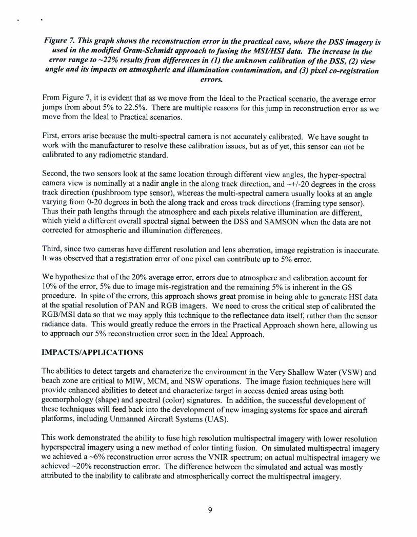
Figure 7. This graph shows the reconstruction error in the practical case, where the DSS imagery isused in the modified Gram-Schmidt approach to fusing the MSL/HSI data. The increase in the
error range to -22% results from differences in (1) the unknown calibration of the DSS, (2) viewangle and its impacts on atmospheric and illumination contamination, and (3) pixel co-registration
errors.
From Figure 7, it is evident that as we move from the Ideal to the Practical scenario, the average errorjumps from about 5% to 22.5%. There are multiple reasons for this jump in reconstruction error as wemove from the Ideal to Practical scenarios.
First, errors arise because the multi-spectral camera is not accurately calibrated. We have sought towork with the manufacturer to resolve these calibration issues, but as of yet, this sensor can not becalibrated to any radiometric standard.
Second, the two sensors look at the same location through different view angles, the hyper-spectralcamera view is nominally at a nadir angle in the along track direction, and -+/-20 degrees in the crosstrack direction (pushbroom type sensor), whereas the multi-spectral camera usually looks at an anglevarying from 0-20 degrees in both the along track and cross track directions (framing type sensor).Thus their path lengths through the atmosphere and each pixels relative illumination are different,which yield a different overall spectral signal between the DSS and SAMSON when the data are notcorrected for atmospheric and illumination differences.
Third, since two cameras have different resolution and lens aberration, image registration is inaccurate.It was observed that a registration error of one pixel can contribute up to 5% error.
We hypothesize that of the 20% average error, errors due to atmosphere and calibration account for10% of the error, 5% due to image mis-registration and the remaining 5% is inherent in the GSprocedure. In spite of the errors, this approach shows great promise in being able to generate HSI dataat the spatial resolution of PAN and RGB imagers. We need to cross the critical step of calibrated theRGB/MSI data so that we may apply this technique to the reflectance data itself, rather than the sensorradiance data. This would greatly reduce the errors in the Practical Approach shown here, allowing usto approach our 5% reconstruction error seen in the Ideal Approach.
IMPACTS/APPLICATIONS
The abilities to detect targets and characterize the environment in the Very Shallow Water (VSW) andbeach zone are critical to MIW, MCM, and NSW operations. The image fusion techniques here willprovide enhanced abilities to detect and characterize target in access denied areas using bothgeomorphology (shape) and spectral (color) signatures. In addition, the successful development ofthese techniques will feed back into the development of new imaging systems for space and aircraftplatforms, including Unmanned Aircraft Systems (UAS).
This work demonstrated the ability to fuse high resolution multispectral imagery with lower resolutionhyperspectral imagery using a new method of color tinting fusion. On simulated multispectral imagerywe achieved a -6% reconstruction error across the VNIR spectrum; on actual multispectral imagery weachieved -20% reconstruction error. The difference between the simulated and actual was mostlyattributed to the inability to calibrate and atmospherically correct the multispectral imagery.
9

RELATED PROJECTS
This project works closely with those of PIs Bissett and Kohler, including N000140110201,N000140310626, and N000140410297
REFERENCES
Aiazzi, B., Alparone, L., Baronti, S. and Selva, M., 2006. MS + Pan Image Fusion by an EnhancedGram-Schmidt Spectral Sharpening, 26th Symposium of the European Association of Remote SensingLaboratories (EARLSeL), Warsaw, Poland.
Pohl, C. and Genderen, J.L.V., 1998. Multisensor image fusion in remote sensing: concepts, methodsand applications. International Journal of Remote Sensing, 19(5): 823-854.
10