Heron Quay West 1 - IEMA · Heron Quay West 1 South Quay Properties Ltd HQW1 ... Introduction ......
29
Heron Quay West 1 South Quay Properties Ltd HQW1 – P.09. Environmental Statement: Non-Technical Summary Waterman Group
Transcript of Heron Quay West 1 - IEMA · Heron Quay West 1 South Quay Properties Ltd HQW1 ... Introduction ......

Heron Quay West 1South Quay Properties Ltd
HQW1 – P.09. Environmental Statement: Non-Technical Summary
Waterman Group
Environmental Statement: Non-Technical Summary
Heron Quays West 1 (HQW1)
May 2013
Waterman Energy, Environment & Design Limited
Pickfords Wharf, Clink Street, London SE1 9DG, www.watermangroup.com \\Nt_server\transfer\WEED - Reformatted Reports\EED Report - Preliminary Environmental Risk sment.dotm

Environmental Statement: Non-Technical Summary
Heron Quays West 1 (HQW1)
Client Name: South Quay Properties Ltd
Document Reference: E13207.R.3.2.1.TC
Project Number: EED13207
Our Markets
Property & Buildings Transport & Infrastructure Energy & Utilities Environment
Quality Assurance – Approval Status
This document has been prepared and checked in accordance with Waterman Group’s IMS (BS EN ISO 9001: 2008, BS EN ISO 14001: 2004 and BS OHSAS 18001:2007)
Issue Date Prepared by Checked by Approved by
First Issue 16 May 2013 Thea Cox
Graduate Consultant
Suzanne Roberts
Principal Consultant
Hannah Fiszpan
Technical Director
Comments
Comments

Disclaimer
This report has been prepared by Waterman Energy, Environment & Design Limited, with all reasonable skill, care and diligence within the terms of the Contract with the client, incorporation of our General Terms and Condition of Business and taking account of the resources devoted to us by agreement with the client.
We disclaim any responsibility to the client and others in respect of any matters outside the scope of the above.
This report is confidential to the client and we accept no responsibility of whatsoever nature to third parties to whom this report, or any part thereof, is made known. Any such party relies on the report at its own risk.
Environmental Statement: Non-Technical Summary
Contents
Heron Quays West 1 (HQW 1)
N:\Projects\EED13207\Reports\03 Environmental Statement\Non-Technical Summary\EED13207.R.3.2.1.TC
Contents
1. Introduction .......................................................................................................................................... 1
2. The Existing Site and Its Surrounding Context ................................................................................ 2
3. Alternatives .......................................................................................................................................... 3
4. What are the Proposals? .................................................................................................................... 4
5. Approach and Environmental Impact Assessment Methodology .................................................. 6
6. What Are the Likely Environmental Impacts and How Would They Be Minimised? .................... 7
6 What Will Happen Next? ................................................................................................................... 15
Environmental Statement: Non-Technical Summary
Page 1
Heron Quays West 1 (HQW 1)
N:\Projects\EED13207\Reports\03 Environmental Statement\Non-Technical Summary\EED13207.R.3.2.1.TC
1. Introduction
1.1. South Quay Properties Ltd (the ‘Applicant’), part of Canary Wharf Group, is seeking to obtain
outline planning permission from London Borough of Tower Hamlets (LBTH) for a commercial-led
development on land within the Canary Wharf Estate (the ‘Site’). The Site is located on the Isle of
Dogs within the administrative boundary of the (LBTH). The Site occupies an area of approximately
1.0 hectares (ha) and currently largely comprises of two office units and temporary landscaping.
1.2. The development proposals (the ‘Development’) include for the demolition of all buildings and
structures on the Site and construction of between 82,761m2 and 134,772m
2 Gross External Area
(GEA) of office floorspace, together with the potential for providing up to 834m2 (GEA) retail
floorspace.
1.3. As part of the outline planning application an Environmental Impact Assessment (EIA) has been
undertaken by Waterman Energy, Environment and Design Ltd (‘Waterman EED’). EIA is a formal
procedure that must be followed for certain types and scales of development, where the likely
significant environmental effects of the development are systematically assessed and reported.
The purpose is to ensure that appropriate information about the likely environmental effects of the
Development is available for consideration by the relevant Local Planning Authority (LPA),
consultees and the public, and that it is before the LPA when they come to determine an
application. The EIA process can also identify ways in which the project can be modified or likely
significant adverse effects mitigated, so as to reduce or avoid potential significant adverse effects
and to optimise beneficial effects. The relevant legislation pertaining to EIA is the Town and
Country Planning (Environmental Impact Assessment) (England and Wales) Regulations, 2011
(the EIA Regulations).
1.4. From an early stage the Applicant recognised that the Development would require an EIA and
hence instructed Waterman EED to undertake an EIA for the Development. The findings of the EIA
are reported in an Environmental Statement (ES), which has been prepared to accompany the
outline planning application. The likely significant environmental effects of the Development, both
during the demolition and construction stage, and once completed and operational, have been
considered. This document provides a summary of the findings of the EIA in non-technical
language.

Environmental Statement: Non-Technical Summary
Page 2
Heron Quays West 1 (HQW 1)
N:\Projects\EED13207\Reports\03 Environmental Statement\Non-Technical Summary\EED13207.R.3.2.1.TC
2. The Existing Site and Its Surrounding Context
2.1. The Site is currently occupied by two office units (Heron Quays 7 and Heron Quays 8) (where
current tenants are on short term tenancy agreements) together with temporary landscaping. The
southern half of the Site extends into West India South Dock.
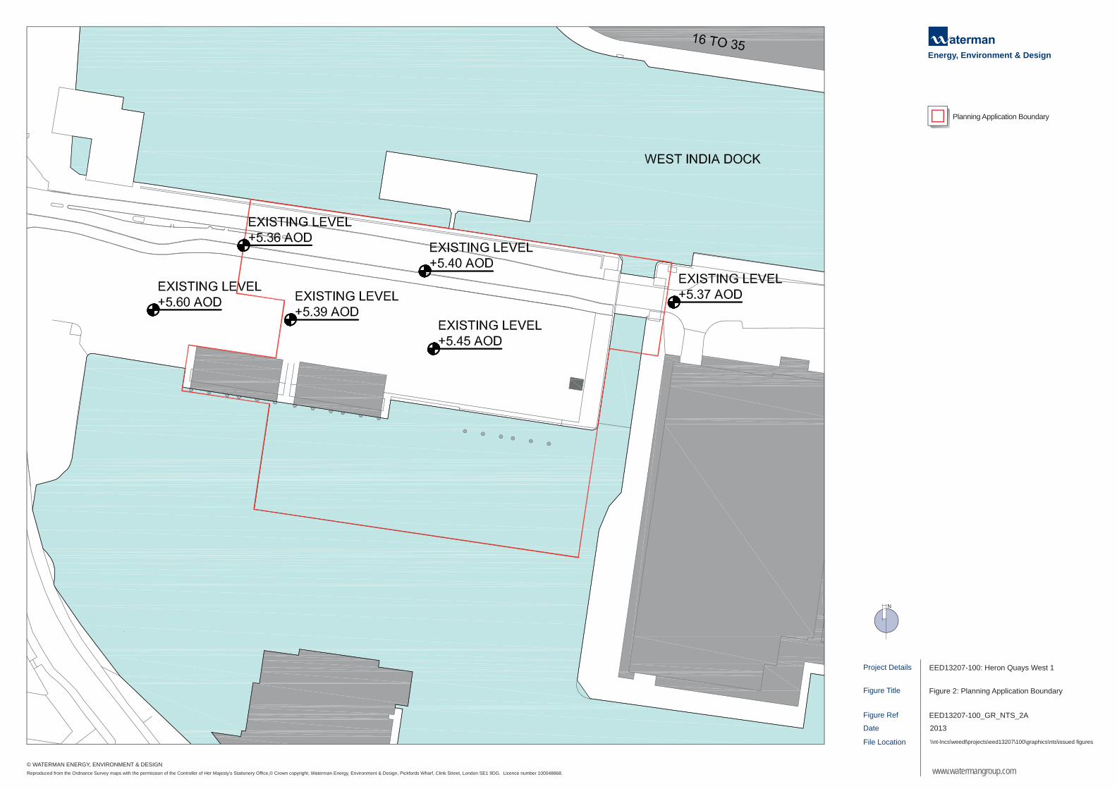
2.2. A plan showing the location of the Site is presented as Figure 1. The planning application
boundary of the Site is shown in Figure 2. The Site is broadly bounded by the following:
Bank Street and land on Bank Street to the west;
West India South Dock to the south;
Bank Street and West India Middle Dock to the north; and
20 Bank Street to the east.
2.3. Land use surrounding the Site is dominated by commercial uses, namely offices and retail. In
addition, there are a number of residential properties and two hotels in the locality of the Site.
2.4. To the east and northeast of the Site are the public transport hubs of three Docklands Light
Railway (DLR) stations: Heron Quays; West India Quay; and Canary Wharf, and Canary Wharf
London Underground Limited (LUL) Station.
2.5. The Site is located within the Isle of Dogs Opportunity Area as defined in the London Plan. The Isle
of Dogs Opportunity Area is identified as an area for intensive land use and seeks opportunities for
mixed-use development. The Site is also located within the Canary Wharf Preferred Office Location
(POL) as defined in the LBTH Core Strategy.

Project Details
Figure Ref
Date
Figure Title
File Location
Figure 1: Site Location
\\nt-lncs\weedl\projects\eed13207\100\graphics\nts\issued figures
EED13207-100_GR_NTS_1A
2013
EED13207-100: Heron Quays West 1
www.watermangroup.com
Energy, Environment & Design
N
Reproduced from the Ordnance Survey maps with the permission of the Controller of Her Majesty’s Stationery Office,© Crown copyright, Waterman Energy, Environment & Design, Pickfords Wharf, Clink Street, London SE1 9DG. Licence number 100048868.
© WATERMAN ENERGY, ENVIRONMENT & DESIGN
SITE LOCATION
Project Details
Figure Ref
Date
Figure Title
File Location
Figure 2: Planning Application Boundary
\\nt-lncs\weedl\projects\eed13207\100\graphics\nts\issued figures
EED13207-100_GR_NTS_2A
2013
EED13207-100: Heron Quays West 1
www.watermangroup.com
Energy, Environment & Design
Planning Application Boundary
N
Reproduced from the Ordnance Survey maps with the permission of the Controller of Her Majesty’s Stationery Office,© Crown copyright, Waterman Energy, Environment & Design, Pickfords Wharf, Clink Street, London SE1 9DG. Licence number 100048868.
© WATERMAN ENERGY, ENVIRONMENT & DESIGN
Environmental Statement: Non-Technical Summary
Page 3
Heron Quays West 1 (HQW 1)
N:\Projects\EED13207\Reports\03 Environmental Statement\Non-Technical Summary\EED13207.R.3.2.1.TC
3. Alternatives
3.1. In line with the EIA Regulations, the ES provides a description of the main alternatives to the
Development, considered by the Applicant. These include:
The ‘No Development’ alternative;
Alternative land uses; and
Alternative designs.
3.2. The ‘No Development’ scenario is based on leaving the Site in its current state. ‘No Development’
at the Site was not considered to be a viable option by the Applicant. Without redevelopment, the
Site would be likely to remain under-used and result in a number of missed opportunities for the
Site and Isle of Dogs, including:
No job creation as a result of the provision of significant office floorspace;
No provision of an active ground floor across the Site; and
No provision of a pedestrian walkway to facilitate improved public amenity around the Site,
including the enjoyment of the West India South Dock.
3.3. The Applicant has not considered fundamentally different alternative uses, or mix of uses, for the
Site. The key principles of the proposed Development in terms of its key objectives and the
principles of its layout have remained the same from the outset.
3.4. However, during the process of developing the Development Parameters, a degree of design
evolution has occurred in response to environmental constraints and opportunities and these
changes are reflected in the final Development Parameters which have been applied for. The
changes made as part of the design evolution of the proposed Development include:
The addition of a zone for a potential canopy on the Bank Street side of the building which
would enable to provision of a canopy structure or structures at the detailed design stage for
either pedestrian comfort and/or architectural design reasons;
Canal overhang developed to maximize efficiency of site usage but then later removed
completely in response to LBTH comments;
Cofferdam structure added to support potentially large deck spans.
The setting of the height of the public realm (including the deck structure and Bank Street) at
between +6.00m AOD and +7.00m AOD to allow for the potential raising of Bank Street, should
this be required;
Providing the potential for increasing the existing width of the pedestrian route along the south
side of Bank street as part of the public realm design; and
Cycle routes around the building limited to the Bank Street side in response to LBTH comments.
Environmental Statement: Non-Technical Summary
Page 4
Heron Quays West 1 (HQW 1)
N:\Projects\EED13207\Reports\03 Environmental Statement\Non-Technical Summary\EED13207.R.3.2.1.TC
4. What are the Proposals?
4.1. The planning application takes the form of an outline application. This means that the following
matters are reserved for future approval: access, scale, appearance, layout and landscaping.
4.2. Where an EIA is required for an outline planning application, the description of the Development
within the ES must be sufficient to enable the requirements of the EIA Regulations to be fulfilled,
and in particular, to enable the likely significant effects of the Development to be identified. A
series of Development parameters have therefore been used to provide the context for the
subsequent detailed design. These parameters are shown on a series of plans which define the
extent of the Development proposed, in effect, providing the maximum ‘envelope’ within which the
Development would be built. These plans are accompanied by a Development Specification which
details the uses and amount of Development being applied for and a Design Guidelines Document
which sets out the guiding principles setting out how the detailed design of the Development would
come forward. The relevant details from these pertinent to this ES are presented and discussed
within Chapter 5: The Proposed Development of the ES and summarised below.
4.3. The total floorspace proposed for the Development is between 82,761m2 and 135,606m
2 GEA.
This would comprise the following:
A minimum of 82,761m2 to a maximum of 134,772m
2 GEA of office use; and
A minimum of 0m2 to a maximum of 834m
2 GEA of retail uses.
4.4. The main components of the Development are shown on a series of parameter plans that are
included in Chapter 5: The Proposed Development of the ES, and a selection of which are
presented in Parameter Plans SK002 to SK006. The parameter plans show the existing buildings
and structures to be demolished, together with the maximum above ground development zone, the
maximum basement development zone, maximum extent of water displacement and the main
access points into the Site.
4.5. To facilitate the Development all existing buildings and structures within the Site (comprising Heron
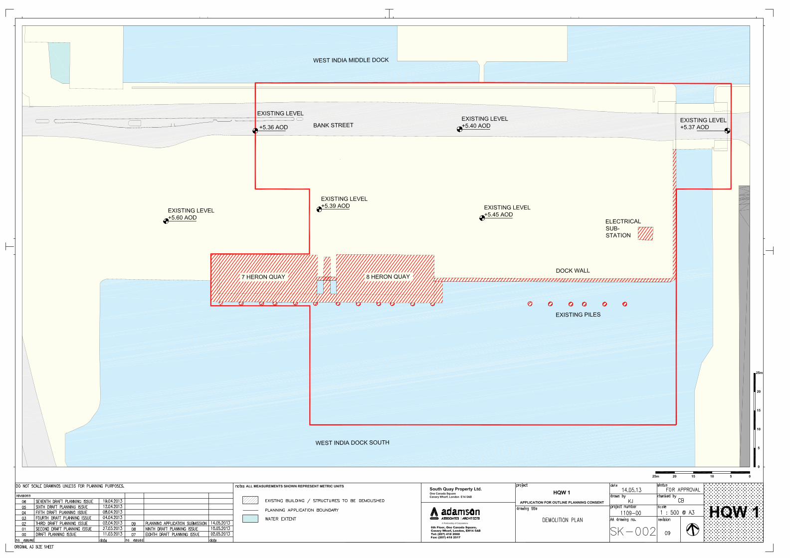
Quays 7 and Heron Quays 8, the electricity substation and the dock wall and existing piles within
West India South Dock) would be demolished (refer to Parameter Plan SK002).
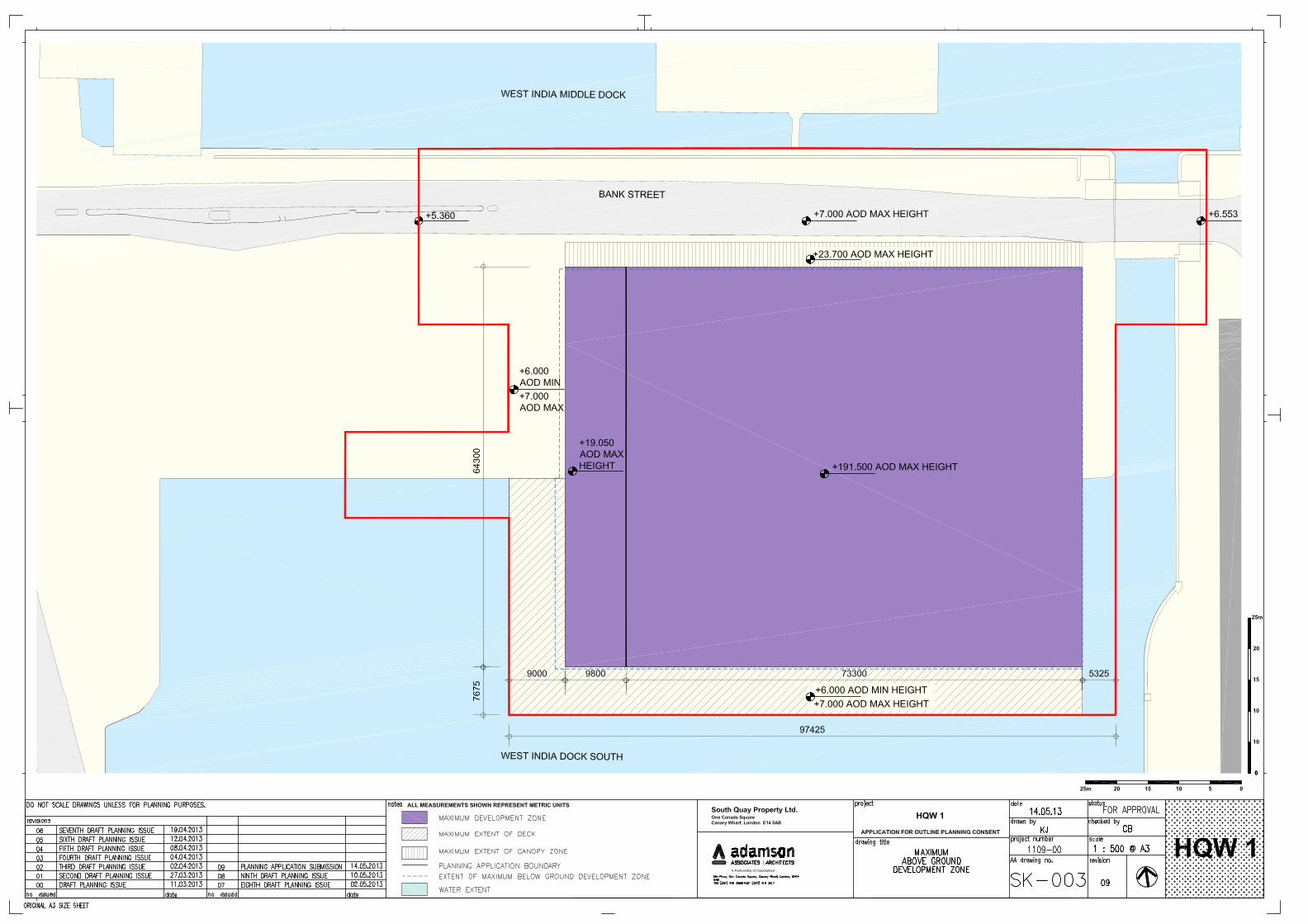
4.6. The Development would comprise the construction of one building fronting Bank Street with the
potential for a canopy structure or structures to be provided and a ground level deck structure
extending around the building and south over West India South Dock. Parameter Plan SK003 and
Parameter Plan SK005 shows the location of this building as well as the maximum extents of the
zones within which all built form would be provided. The deck structure would provide pedestrian
circulation space, spill-out area related to ground floor retail uses and landscaping. The existing
canal width at the bascule bridge would be maintained between the deck and the existing east
canal dock edge.
4.7. The allowable heights of the building, potential canopy zone and deck structure are shown in
Parameter Plan SK003. The maximum height for the proposed building is set at 191.5m Above
Ordnance Datum (AOD). The potential canopy structure or structures to be provided would have a
minimum height of 10.5m AOD and a maximum height of 23.7m AOD. The deck structure would
be set at ground floor level which may vary between 6.00m and 7.00m AOD. Bank Street itself
would be raised slightly and may vary between 6.00m and 6.720m AOD.
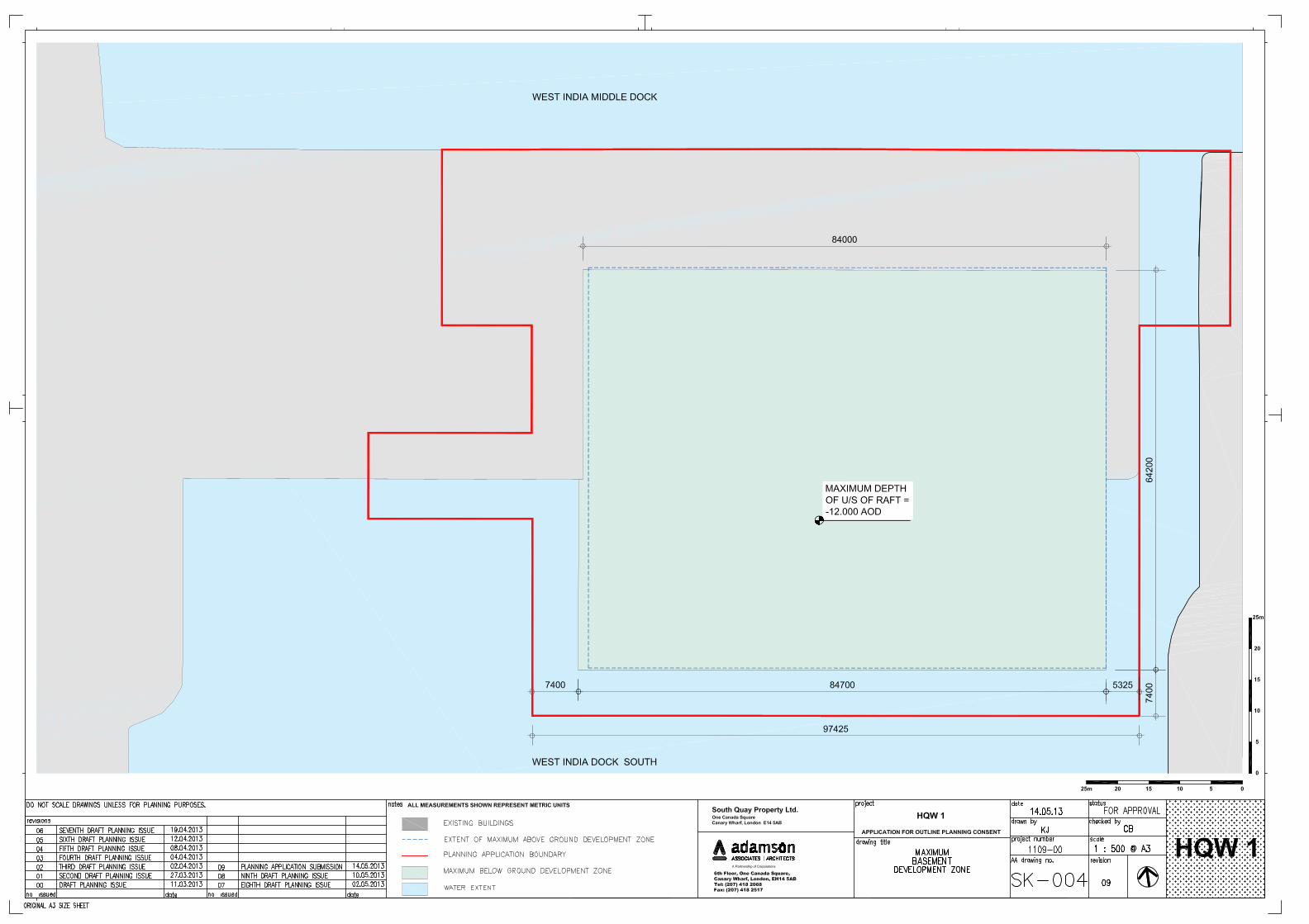
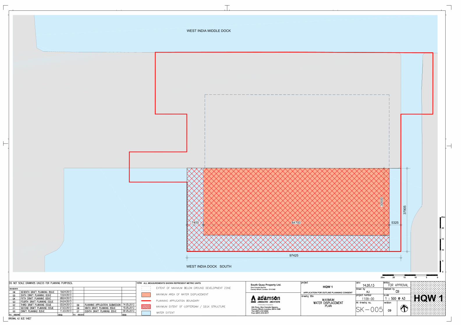
4.8. Basements could be provided as part of the Development to a maximum depth of -12m AOD.
Parameter Plan SK004 shows the location of the basement as well as its maximum depth below
ground level. As the maximum parameters allow for the basement to be built into the West India

Environmental Statement: Non-Technical Summary
Page 5
Heron Quays West 1 (HQW 1)
N:\Projects\EED13207\Reports\03 Environmental Statement\Non-Technical Summary\EED13207.R.3.2.1.TC
Dock South, the ‘Maximum Area of Water Displacement’ is shown on Parameter Plan SK005. The
basement would be used for car, motorcycle and cycle parking; plant; and ancillary uses.
4.9. The vehicular access point to the Site would be from the frontage of the building on Bank Street to
the north of the Site as shown in Parameter Plan SK006. The Development would provide a
maximum of 107 car parking spaces and 1,123 cycle parking spaces for workers and visitors to the
Development based on the relevant standards.
4.10. Primary pedestrian access to the Development for office use would be provided at footway level
from Bank Street in the north of the Site. As well as access to the frontage of the building on Bank
Street, pedestrian access and circulation would be provided at ground level around the entire
building. This includes the use of the deck structure where a minimum pedestrian route of 4.0m in
width on the waterside of the deck would be maintained.
4.11. The Development would also provide areas of public realm around the proposed building, including
the deck structure, as shown on Parameter Plan SK003. As well as the area immediately around
the building, the public realm includes Bank Street and the bascule bridge.
4.12. The Development will provide ecological enhancements which include the creation of new habitat,
including green roofs and the provision of artificial nesting and roosting opportunities for birds and
bats.
4.13. The demolition and construction programme for the Development is assumed to take 46 months to
complete. Construction is expected to commence in January 2014 and be completed in November
2017. For the purposes of the ES the year of completion and full operation of the Development is
therefore considered to be 2017.
4.14. It is proposed that a Construction Environmental Management Plan (CEMP) would be prepared for
the Development which would include all details of relevant environmental management controls
necessary for environmental protection during the demolition and construction works. This would
be discussed and agreed with the relevant planning officers at LBTH following the approval of the
outline planning application. It is envisaged that the CEMP would address the following:
The appointment of an experienced Project Environmental Manager, responsible for the
preparation and implementation of the CEMP;
Details of the phasing of the works;
Details of construction activities and plant to be used including any operations likely to result in
adverse environmental effects, with an indication of the mitigation measures to be employed;
The framework within which legislation would be complied with;
Relevant requirements for monitoring and record-keeping e.g. audits of CEMP control
measures;
Complaints procedure;
Processes for reporting, public liaison, prior notification etc., especially where dispensations
may be required;
Details of proposed routes for heavy goods vehicles travelling to and from the Site; and
Details of all construction works affecting the docks and public highways.

Environmental Statement: Non-Technical Summary
Page 6
Heron Quays West 1 (HQW 1)
N:\Projects\EED13207\Reports\03 Environmental Statement\Non-Technical Summary\EED13207.R.3.2.1.TC
5. Approach and Environmental Impact Assessment Methodology
5.1. The EIA was undertaken in accordance with the EIA Regulations and best practice guidance using
established methods such as site surveys, reviews of available reports and data, computer
modelling, consultations with relevant organisations and specialist assessments.
5.2. The first stage of the EIA process involved undertaking a ‘Scoping Study’. The purpose of the
‘Scoping Study’ was to identify the likely significant environmental effects that could arise from the
Development and therefore provide the focus of the EIA. The findings of the scoping exercise,
along with details of the proposed methods for the specialist assessments, were presented in a
Scoping Study report.
5.3. The Scoping Study confirmed that the Development would likely give rise to a number of issues
which need to be considered in the EIA. These would comprise: socio-economics; transportation
and access; air quality; noise and vibration; ground conditions and contamination; water resources
and flood risk; ecology; archaeology; townscape, visual and built heritage; wind; daylight, sunlight
and overshadowing; and cumulative impacts.
5.4. Each of the above issues are addressed in the ES, with a chapter dedicated to each of these
issues. In each chapter, a description of the assessment methodology is given together with
current Site conditions. This is followed by an assessment of the likely significant effects of the
Development (both beneficial and adverse) and any measures that should be adopted to reduce or
offset any significant adverse effects identified during the assessment. The ES also provides an
assessment of the residual effects that would remain after mitigation measures have been
implemented, as well as the cumulative effects of the Development.
Environmental Statement: Non-Technical Summary
Page 7
Heron Quays West 1 (HQW 1)
N:\Projects\EED13207\Reports\03 Environmental Statement\Non-Technical Summary\EED13207.R.3.2.1.TC
6. What Are the Likely Environmental Impacts and How Would They
Be Minimised?
Socio-Economics
6.1. A socio-economic assessment has been undertaken using a wide range of nationally recognised
research and survey information and previous professional experience of similar schemes.
6.2. Although it is acknowledged that existing on-Site employment would be displaced as a result of the
demolition and construction works, the Applicant would work with the occupants of Skillsmatch,
East London Business Place and UCATT (or the George Brumwell Learning Centre) to find
suitable relocation options in the local area, where possible.
6.3. The creation of a new publically accessible water fronted promenade around the Site and the
building allowable within the parameter sought for approval would positively contribute to the
surrounding public realm and enhance pedestrian connectivity.
6.4. The demolition and construction works associated with the Development would generate
approximately 265 permanent FTE jobs. Additional on-Site demolition and construction
employment would give rise to additional spending in the local area, estimated to be in the region
of £456,000 per year.
6.5. It has been estimated that the commercial elements of the Development would generate between
5,565 and 9,130 net additional FTE jobs. Such jobs would also give rise to additional local
expenditure, estimated to be in the region of £7.4 million to £12.1 million per year.
6.6. The Development would provide new commercial floorspace and a new publicly accessible
waterfront promenade which would positively contribute to the surrounding public realm and
enhance pedestrian connectivity. The new occupants of the Development would create activity and
increase levels of natural surveillance and perceptions of safety.
Transportation
6.7. An assessment of transportation and access has been undertaken which involved using quantified
modelling to predict the effects of the Development.
6.8. During the demolition and construction period Bank Street would need to be closed to vehicles,
buses, pedestrians and cyclists. The existing bus services would be affected by this closure and
discussions would need to be undertaken with London Buses with regards to any possible
diversions. During demolition and construction there would also be traffic flow, particularly Heavy
Goods Vehicles (HGVs), associated with general plant and material deliveries and the removal of
waste from the Site. To effectively manage this, a Construction Logistics Plan (CLP) has been
developed and would be implemented during demolition and construction. The CLP includes
proposals for hours of working, wheel-washing facilities and measures to deal with contractors
vehicles, especially to prevent on-Site parking and to avoid construction vehicles parking or waiting
on the public highway.
6.9. Overall, once the Development is completed and occupied, the Development is predicted to result
in only marginal increases in traffic flows on the local road network.
6.10. A Framework Travel Plan Framework for the Development has been developed in support of the
outline planning application. This is in accordance with the existing Canary Wharf Travel Plan
which is already in operation. This is intended to promote good travel plan practice and to
encourage employers to introduce workplace travel plans that contribute towards its objectives.
Environmental Statement: Non-Technical Summary
Page 8
Heron Quays West 1 (HQW 1)
N:\Projects\EED13207\Reports\03 Environmental Statement\Non-Technical Summary\EED13207.R.3.2.1.TC
6.11. A Delivery and Servicing Plan (DSP) has also been produced for the Development. The DSP
provides a management framework to improve safety, efficiency and reliability of deliveries and
servicing at the Site. The benefits of the DSP include improved reliability of deliveries and
servicing, less noise and disruption and time-savings through the identification of unnecessary
deliveries.
6.12. The Development would result in a minimal increase in passenger journeys on the LUL relative to
the existing situation. However, the cumulative increase with other developments proposed at
Canary Wharf are significant. Despite this, Crossrail services are scheduled to start in 2018 and
would provide a third rail route to Canary Wharf (in addition to the JL and DLR). The station would
be located within the North Dock of West India Quay approximately 800m from the Development.
Crossrail would significantly increase the public transport capacity for Canary Wharf and would
mitigate any public transport effects arising from the cumulative schemes and the Development.
6.13. In addition, the Framework Travel Plan for the Development would actively promote walking and
cycling as viable alternatives to road and public transport, as detailed above. The Development
would provide sufficient pedestrian and cyclist facilities to encourage travel by this mode.
Air Quality
6.14. An assessment of the likely significant effects for air quality has been undertaken for the
Development. This has considered both the construction and operational phases of the
Development.
6.15. A qualitative assessment of the construction phase effects has been undertaken following guidance
published by the Institute of Air Quality Management. The main effect on local air quality during
demolition and construction relates to dust, which is most likely to be generated from demolition
activities and earthworks. Nuisance caused from dust, however, is only likely to be experienced by
the people nearest to the Site. A range of measures to minimise or prevent dust would be
implemented through the adoption of the CEMP. Effects on local air quality associated with an
increase in traffic during demolition and construction are not anticipated to be significant.
6.16. Computer modelling was carried out to predict the impact of future traffic-related emissions and the
likely changes in local air quality following the completion of the Development. The impact of the
Development on air quality was predicted for a number of existing sensitive locations surrounding
the Site and also future sensitive locations within the Site.
6.17. Changes to pollutant concentrations were predicted to be well below levels which would be
deemed as significant. Given that the assessment of operational road traffic effects from the
Development was found to be insignificant, no mitigation measures are proposed.
Noise and Vibration
6.18. The effects of demolition and construction noise and vibration on the nearest noise sensitive
receptors has been assessed during three construction phases: removal of dock structures,
excavation and piling.
6.19. Demolition and construction works are likely to include activities that would be likely to increase
noise levels. Vibration effects at commercial buildings in the immediate vicinity are expected to be
low but would need to be confirmed by on-Site monitoring during demolition and construction of the
Development. In addition, construction traffic is predicted to result in negligible noise increases on
local roads.
6.20. The implementation of noise and vibration control and management measures through a CEMP
would help to reduce noise disturbance to occupants of nearby properties. The CEMP should

Environmental Statement: Non-Technical Summary
Page 9
Heron Quays West 1 (HQW 1)
N:\Projects\EED13207\Reports\03 Environmental Statement\Non-Technical Summary\EED13207.R.3.2.1.TC
include measures such as using low-noise machinery and equipment, enclosing and screening
machinery and using low-vibratory foundation methods.
6.21. Computer modelling of the likely effects of future increases in road traffic noise once the
Development is completed and operational has been undertaken and the results indicate that the
effects would be negligible.
6.22. Any items of fixed building services plant installed as part of the Development would have the
potential to generate noise. Suitable noise level limits have therefore been proposed to ensure that
noise from plant is controlled such that it is line with the requirements of LBTH and does not cause
disturbance.
Ground Conditions and Contamination
6.23. A desk-based study of ground contamination at the Site has established that owing to historical
activities on the Site, there is the potential for localised contamination to exist on the Site. These
historical activities have included dock construction and use, railway sidings, crane sidings and an
existing electricity substation. Due to the historical redevelopment of the Site, the most likely source
of contamination is likely to relate to the presence of Made Ground on the Site. However, the
potential for significant contamination to be present on the Site is considered to be generally low.
6.24. During the demolition and construction works, any existing contamination on the Site could be
exposed and disturbed, potentially resulting in harm to human health and the underlying
groundwater. However, all demolition and construction works would be undertaken in accordance
with measures set out in the CEMP. In addition, in line with mandatory legislative requirements
and best practice guidance, redevelopment of the Site would take place in a manner that would not
cause any unacceptable contamination risk to human health and the wider environment.
6.25. The construction of the basement would provide a barrier to water and ground gas movement on
and off-site once the Development is completed. All construction works would be undertaken in
accordance with an approved CEMP.
Water Resources and Flood Risk
6.26. Although the Site is located within a high risk flood zone, the Site is protected by the River Thames
Tidal Defences and the Thames Barrier, and as such, the tidal and fluvial flood risk at the Site is
considered to be low.
6.27. During demolition and construction, the relocation of the West India Dock South wall in order to
construct the basement structure could leave the Site and surrounding areas open to flood risk.
However, temporary flood defences in the form of a cofferdam would be installed to maintain the
integrity of the flood defences. There would be a temporary loss of flood storage as a result of the
proposed cofferdam. However, this would be of a temporary nature for the duration of the
construction phase only.
6.28. Changes in Site conditions during the demolition and construction works have the potential to result
in a temporary risk of surface water flooding. However, measures would be put in place to control
surface water runoff from the Site in line with industry standards.
6.29. The design intent for storm water is that, where possible, storm water should be discharged via a
number of new outfalls into the docks. This is consistent with the existing situation at the Site and is
considered the most sustainable approach when considering the Development.
6.30. Thames Water has confirmed that the estimated surface water and foul water discharges could be
accommodated by the existing sewer network within the vicinity of the Site, without the need for
Environmental Statement: Non-Technical Summary
Page 10
Heron Quays West 1 (HQW 1)
N:\Projects\EED13207\Reports\03 Environmental Statement\Non-Technical Summary\EED13207.R.3.2.1.TC
any reinforcement works to the current infrastructure. Similarly Thames Water has also confirmed
that the increased demand for water supply resulting from the Development could be
accommodated within the existing infrastructure, subject to minor reinforcements in Bank Street.
6.31. Once the Development has been completed, the new dock walls would result in a higher standard
of flood protection in the long term as a result of the modern-day design standards of construction.
Ecology
6.32. The assessment of likely significant ecological effects has been informed by desk-based research,
Site surveys, field surveys, consultation with LBTH and relevant best practice guidance including
the IEEM Guidelines for Ecological Impact Assessment.
6.33. The majority of the Site currently contains limited ecological interest, with the exception of West
India Dock South which forms part of the non-statutorily designated Millwall and West India Docks
Site of Importance for Nature Conservation (SINC). The buildings, areas of hardstanding and
amenity grassland on the Site are of no ecological interest and have no potential to support
protected species. However, ornamental planting and some of the more mature trees on the Site
may provide limited opportunities to nesting and foraging birds and invertebrates. In addition, it is
recognised that the Millwall and West India Docks SINC has the potential to support a range of
species, including birds and fish.
6.34. The demolition and construction works would have the potential to directly and indirectly adversely
affect the Millwall and West India Docks SINC, particularly given that the Development would
require physical works within West India Dock South, and River Thames and Tidal Tributaries
SINC. However, a CEMP would be implemented to ensure that appropriate environmental controls
are used to protect retained habitats at the Site and surrounding areas, during demolition and
construction. With respect to any direct works which would be required within West India South
Dock, these would be agreed in advance with the Canals and Rivers Trust, LBTH and the
Environment Agency to ensure that any intrusive works would have minimal effects upon West
India South Dock and its associated ecology.
6.35. In addition, wherever possible, the removal of existing on-site trees would be undertaken outside of
the bird breeding season (March to August inclusive). Where this is not possible, an experienced
ecologist would be deployed to carry out an inspection immediately prior to the clearance. If birds
are found to be breeding the area would be left until the birds have fledged. This would avoid any
significant adverse effects to breeding birds.
6.36. The ecological value of the Site would be enhanced as a result of the completed and operational
Development due to the provision of ecological enhancement measures including the installation of
an ecologically beneficial wall within West India Dock South; the provision of native trees and
shrubs; and the installation of bird boxes suitable for local priority species such as the House
Sparrow. Provision of native trees and shrub planting would enhance the on-site foraging and
nesting habitat for birds and bats.
Archaeology
6.37. The likely effects of the Development on buried archaeological assets within the Site have been
assessed. The assessment has been carried out in accordance with the standards specified by the
Institute for Archaeologists and Greater London Archaeological Advisory Service.
6.38. The archaeological assessment undertaken as part of the EIA identified low to moderate
archaeological potential for remains of the Neolithic and Bronze Age periods and a moderate
archaeological potential for remains of the 19th - 20th Century industrial era on the Site.

Environmental Statement: Non-Technical Summary
Page 11
Heron Quays West 1 (HQW 1)
N:\Projects\EED13207\Reports\03 Environmental Statement\Non-Technical Summary\EED13207.R.3.2.1.TC
6.39. During demolition and construction damage to, or destruction of, buried heritage assets may result
due to works associated with the construction of basements and foundations. A programme of
archaeological trial trenching should be undertaken during ground works to mitigate this risk. If
significant archaeological remains are recorded than further archaeological mitigation measures
may be required comprising of either archaeological excavation or an archaeological watching brief
(programme of monitoring and recording). There would be no archaeological impacts resulting from
the operation of the Development.
Wind
6.40. An assessment of the likely wind conditions as a result of the Development and the suitability of
these in terms of pedestrian comfort has been undertaken. The assessment has been informed by
appropriate meteorological data and testing of a physical model within a wind tunnel.
6.41. Owing to the few low rise buildings and structures on the existing Site to be demolished, the
demolition and construction works would not be expected to have a significant effect on the wind
conditions within, and immediately surrounding, the Site. As construction of the Development
proceeds, the wind conditions of the Site would gradually adjust to the conditions of the completed
Development.
6.42. In the absence of any mitigation, the Development would give rise to a full range of wind effects.
Depending on the location within and surrounding the Site, the season and the type of pedestrian
activity taking place, wind conditions are found to be both suitable for the intended pedestrian use
in some locations and windier than desired in others.
6.43. Further detailed design of the building allowable within the ‘Maximum Development Zone’ (to
include building form and articulation and entrance locations) detailed landscape planting within the
Site, and the implementation of possible wind screens would allow an opportunity to improve wind
conditions, where required. As such, further detailed design would be informed by an appropriate
wind microclimate expert and further assessment would be undertaken at the Reserved Matters
Application stage to ensure, validate and demonstrate that the wind impacts of the Development
can be minimised as far as practically possible in relation to pedestrian comfort and that acceptable
wind conditions can be achieved.
Daylight, Sunlight and Overshadowing
6.44. Construction of the Development would have a gradually increasing impact on the levels of
daylight, sunlight and overshadowing to residential properties and amenity spaces surrounding the
Site as the construction progresses. Those impacts that are perceptible as the superstructure
progresses would be similar to those of the completed Development. Negligible light pollution is
considered likely during demolition and construction.
6.45. Although the Development is of a significant scale, it located approximately 115m from the closest
existing residential properties, and as such the potential for adverse daylight and sunlight effects is
minimal. The results indicate this to be the case with the isolated technical breaches of the
guidance for daylight being driven by self-light limiting features within the existing residential
properties (usually balconies). The Development is likely to have a negligible effect on sunlight to
surrounding residential properties.
6.46. Overshadowing has been assessed to West India Middle Dock to the north of the Site, the canal to
the east of the Site and proposed deck structure within the Development. All areas have been
found to achieve sunlight amenity in excess of levels considered to be sufficient.
Environmental Statement: Non-Technical Summary
Page 12
Heron Quays West 1 (HQW 1)
N:\Projects\EED13207\Reports\03 Environmental Statement\Non-Technical Summary\EED13207.R.3.2.1.TC
6.47. As this is an outline application a full external lighting scheme has not yet been designed. In order
to prove it is possible to light the area surrounding the Site sufficiently whilst avoid light trespass to
ecologically sensitive areas (West India Middle and South Docks) some examples of fittings which
can achieve this have been provided.
Townscape, Visual and Built Heritage
6.48. The Development would have a number of significant benefits compared to the existing state of the
Site. It would redevelop the Site with a building that would be comparable in terms of height, scale
and form with existing buildings nearby within the Canary Wharf tall buildings cluster. The Design
Guidelines would help to ensure that the detailed appearance of the Development would be
consistent with that of existing buildings in the Canary Wharf Estate. The Development would
reinforce the existing townscape character of the Canary Wharf area.
6.49. The Development would provide definition of Bank Street and enclosure of the Middle Dock and
South Dock, similar to that provided by other developments nearby.
6.50. The Development would provide public routes around the Site and the Design Guidelines state that
these routes would be lined to a significant extent by active frontages. The appearance of the
Development in views where it would form a coherent arrangement of built form together with other
tall buildings on Heron Quays would suggest the alignment of the docks in Canary Wharf,
enhancing legibility.
6.51. The Development would form a part of the townscape setting of the Grade I listed Middle Dock
wall, part of which falls within the Site boundary, in a similar manner to that formed by existing tall
and large scale buildings which already line most of the listed Docks in Canary Wharf. The Design
Guidelines would ensure that the top and face of the coping stones on top of the Dock wall would
remain visible as part of any design solution to raise Bank Street. The appearance of the
Development with regard to other Listed Buildings, Conservation Areas and Locally Listed
Buildings would be consistent with their existing townscape setting.
6.52. The Development would appear in some views from the Maritime Greenwich World Heritage Site.
In such views, the established cluster of tall buildings on the Isle of Dogs appears as a background
layer beyond the WHS in the foreground; the Development would be seen as a coherent part of the
existing cluster, and would not detract from the recognition or appreciation of the WHS and its
constituent elements. In terms of the axis through the Queen’s House evident in the LVMF view
5A.1 from the WHS, while the Development would appear in the background, the Island Gardens
trees form a natural backdrop to the axis and buildings beyond on the Isle of Dogs can be
appreciated as forming a distinct background element which does not detract from the axial view.
6.53. In local and medium range views, the Development would appear consistent with its surroundings,
would provide definition to Bank Street and enclosure to the Middle Dock and South Dock, and
would be seen to continue the line of built form along Heron Quays in a coherent manner. In longer
range views, including LVMF views, the Development would consolidate the cluster of tall buildings
on the Isle of Dogs.
6.54. The Development would form a coherent part of an expanded cluster of tall buildings on the Isle of
Dogs in combination with other cumulative schemes. It would work well with other commercial
schemes, particularly at Riverside South and Park Place, to reinforce the prevailing pattern of
development in which large scale and tall commercial buildings are arranged on an east-west
alignment suggested by the alignment of the Docks. A number of those cumulative schemes,
including Riverside South, City Pride and the Columbus Tower, would appear taller than the
Development in some key views, and in some cases would partially obscure it from sight.
Environmental Statement: Non-Technical Summary
Page 13
Heron Quays West 1 (HQW 1)
N:\Projects\EED13207\Reports\03 Environmental Statement\Non-Technical Summary\EED13207.R.3.2.1.TC
6.55. In terms of national, London-wide and regional policy, the Development would be consistent with
relevant design guidance and policies, and would not adversely affect strategic and local views, in
line with the London Plan and LVMF.
6.56. The consideration in this section of the effect of the Development leads to the conclusion that it
would have a beneficial effect on the townscape character area within which it is located and on
other townscape character areas. It would have a neutral or beneficial effect in relation to heritage
assets. It would be a coherent addition to the Canary Wharf cluster which would enhance local,
medium and long range views. The Development’s scale and form, and its appearance as far as
this is governed by the Design Guidelines, are such that it would take the opportunities provided by
the Site’s location to successfully address the Middle Dock and South Dock, and it would be
consistent with the scale, form and general appearance of existing buildings within the Canary
Wharf cluster, as is appropriate for a building in this location. The Development would positively
reinforce the character of Canary Wharf.
Cumulative Effects
6.57. Two types of cumulative effects have been considered:
Effect interactions: the combination of individual effects arising from the Development on a
particular receptor, for example noise and vibration, dust and visual effects; and
Cumulative effects: effects from reasonably foreseeable developments, which in isolation may
be insignificant, but when considered together could result in a significant cumulative effect.
6.58. During the construction phase, a combination of nuisance effects from noise and dust together with
visual and traffic effects could be experienced. The implementation of environmental control
measures through the CEMP would minimise the nuisance effects on residents, occupiers of
nearby offices and pedestrians and other road users during demolition and construction.
6.59. The cumulative effects of the Development together with other planned (or committed)
developments have been assessed. The other planned developments that have been considered
comprise schemes that are presently reasonably foreseeable to come forward and were agreed
with LBTH. During demolition and construction of the Development, similar works on the other
committed developments would be likely to result in temporarily increased traffic, noise, emissions
and visual effects on the local townscape. Again, the implementation of environmental control
measures, such as CEMPs for the Development and the other planned developments, would
minimise the nuisance effects on residents, occupiers of nearby offices and pedestrians and other
road users during demolition and construction.
6.60. The key cumulative effects of the Development, once completed, in conjunction with the planned
developments were generally found to be minimal. Exceptions comprise the following beneficial
cumulative effects as follows:
The Development would generate between 5,565 and 9,130 FTE jobs. Owing to the mixed-use
nature of many of the cumulative schemes, further additional jobs would be generated. This has
been estimated to be in the region of 40,400 jobs. This level of employment generation would
make a substantial contribution towards LBTH’s employment targets and support the objectives
for the Opportunity Area and the London Plan as a whole;
Potential additional employees could generate up to approximately £65.4 million in spending
locally;
The Development and planned developments together would make a positive contribution
towards the quality of the public realm in the local area. Modern design principles aim to
increase sense of security and reduce opportunities for crime; and
Environmental Statement: Non-Technical Summary
Page 14
Heron Quays West 1 (HQW 1)
N:\Projects\EED13207\Reports\03 Environmental Statement\Non-Technical Summary\EED13207.R.3.2.1.TC
Wildlife benefits as a result of the ecological enhancements included within the proposals for the
Development and the other planned developments.

Environmental Statement: Non-Technical Summary
Page 15
Heron Quays West 1 (HQW 1)
N:\Projects\EED13207\Reports\03 Environmental Statement\Non-Technical Summary\EED13207.R.3.2.1.TC
7. What Will Happen Next?
7.1. Following the submission of the outline planning application, there would be an opportunity for any
interested parties to comment on the proposals. The ES and a set of documents supporting the
outline planning application can be viewed on LBTH’s website:
LBTH Website: http://www.towerhamlets.gov.uk/
7.2. Additional copies of the ES can be purchased from Waterman on request (contact details below).
Additional copies of the Non-Technical Summary can be obtained free of charge. A CD version of
the Environmental Statement can be purchased at a cost of £20.
Waterman Energy, Environment & Design Ltd
Pickfords Wharf
Clink Street
London
SE1 9DG
Tel: 020 7928 7888
Fax: 020 7928 3033
Email: [email protected]
Environmental Statement: Non-Technical Summary
Page 16
Heron Quays West 1 (HQW 1)
N:\Projects\EED13207\Reports\03 Environmental Statement\Non-Technical Summary\EED13207.R.3.2.1.TC