Herndon Metro Station Area Study - VHBprojects.vhb.com/herndonmetrorail/pdf/Herndon Metro Station...
134
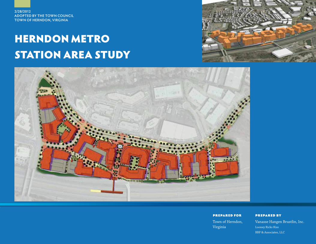
prepared for Town of Herndon, Virginia prepared by Vanasse Hangen Brustlin, Inc. Looney Ricks Kiss BBP & Associates, LLC 2/28/2012 ADOPTED BY THE TOWN COUNCIL TOWN OF HERNDON, VIRGINIA HERNDON METRO STATION AREA STUDY
Transcript of Herndon Metro Station Area Study - VHBprojects.vhb.com/herndonmetrorail/pdf/Herndon Metro Station...
prepared forTown of Herndon, Virginia
prepared byVanasse Hangen Brustlin, Inc.Looney Ricks Kiss
BBP & Associates, LLC
2/28/2012ADOPTED BY THE TOWN COUNCILTOWN OF HERNDON, VIRGINIA
HERNDON METROSTATION AREA STUDY

Th is page intentionally left blank
3
2/28/2012 - HERNDON METRO STATION AREA STUDYTOWN of HERNDON, VIRGINIA
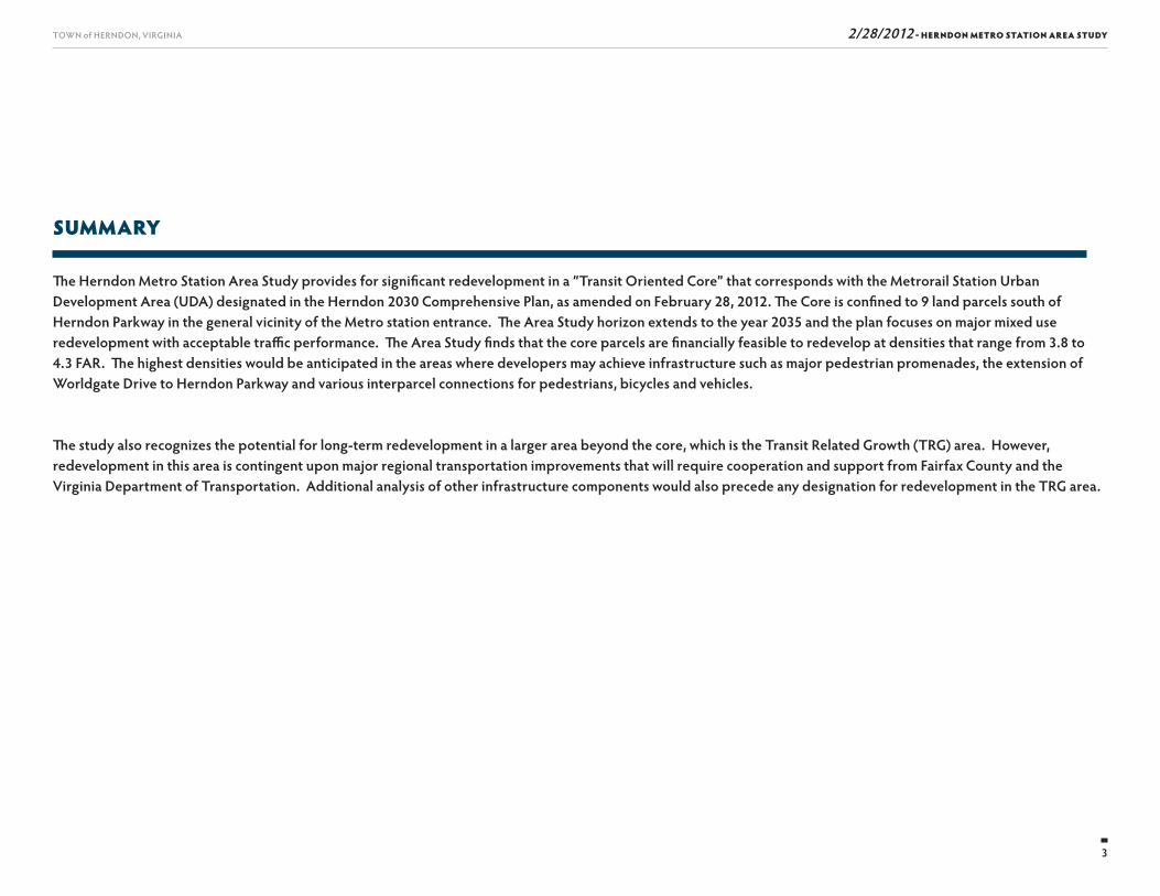
SUMMARY
Th e Herndon Metro Station Area Study provides for signifi cant redevelopment in a “Transit Oriented Core” that corresponds with the Metrorail Station Urban Development Area (UDA) designated in the Herndon 2030 Comprehensive Plan, as amended on February 28, 2012. Th e Core is confi ned to 9 land parcels south of Herndon Parkway in the general vicinity of the Metro station entrance. Th e Area Study horizon extends to the year 2035 and the plan focuses on major mixed use redevelopment with acceptable traffi c performance. Th e Area Study fi nds that the core parcels are fi nancially feasible to redevelop at densities that range from 3.8 to 4.3 FAR. Th e highest densities would be anticipated in the areas where developers may achieve infrastructure such as major pedestrian promenades, the extension of Worldgate Drive to Herndon Parkway and various interparcel connections for pedestrians, bicycles and vehicles.
Th e study also recognizes the potential for long-term redevelopment in a larger area beyond the core, which is the Transit Related Growth (TRG) area. However, redevelopment in this area is contingent upon major regional transportation improvements that will require cooperation and support from Fairfax County and the Virginia Department of Transportation. Additional analysis of other infrastructure components would also precede any designation for redevelopment in the TRG area.
4
TOWN of HERNDON, VIRGINIA 2/28/2012 - HERNDON METRO STATION AREA STUDY
TABLE OF CONTENTS
Es. Executive Summary ■ Introduction
■ Area Plan Background and Planning Process Overview
■ A Vision for the Area Plan
■ Existing Conditions and Development Opportunities
■ Area Plan Alternatives
■ Herndon Transit-Oriented Core Plan
■ Report Overview
1. Project Background and Goals ■ Introduction
■ Background
■ Initiating the Area Plan Planning Process
■ What is Transit-Oriented Development (TOD)?
■ Area Plan Goals and Objectives
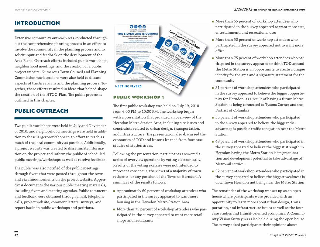
2. Public Process ■ Introduction
■ Public Outreach
■ Town Meetings
■ Conclusion
3. Existing Conditions ■ Introduction
■ Existing Zoning
■ Urban Design
■ Environmental Conditions
■ Existing Utilities
■ Traffi c and Transportation
4. Development Opportunities ■ Introduction
■ Transit-Orientated Development Economics
■ Evaluation of Case Studies
■ Property Owner Interviews
■ Conclusion
5. Alternative Area Plans ■ Introduction
■ Area Plan 1–Framework Diagram
■ Area Plan 2–Framework Diagram
■ Area Plans 1 and 2
■ Financial and Fiscal Impact Analysis
6. Herndon Transit-Oriented Core Plan ■ Introduction
■ Herndon Transit-Oriented Core–Framework Diagram
■ Herndon Transit-Oriented Core Plan
■ Principles and Guidelines for the Herndon Transit-Oriented Core Plan
■ Long-Term Vision
7. Capital Improvements ■ Introduction
■ Capital Improvements and Costs
■ Transportation Improvements
APPENDICES ■ Appendix A Community-Wide Workshops Led by VHB
■ Appendix B Study of TOD and Redevelopment Feasibility for Herndon
■ Appendix C Financial and Fiscal Analysis Support Documentation
■ Appendix D Traffi c Analysis Support Documentation
5
2/28/2012 - HERNDON METRO STATION AREA STUDYTOWN of HERNDON, VIRGINIA
LIST OF ACRONYMS AND TERMINOLOGY
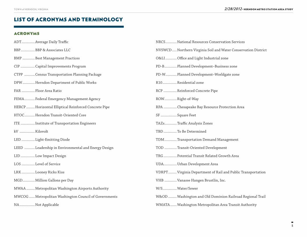
AcronymsADT .............. Average Daily Traffi c
BBP ............... BBP & Associates LLC
BMP ............. Best Management Practices
CIP ............... Capital Improvements Program
CTPP ........... Census Transportation Planning Package
DPW ............. Herndon Department of Public Works
FAR .............. Floor Area Ratio
FEMA ........... Federal Emergency Management Agency
HERCP ......... Horizontal Elliptical Reinforced Concrete Pipe
HTOC ........... Herndon Transit-Oriented Core
ITE ............... Institute of Transportation Engineers
kV ................ Kilovolt
LED .............. Light-Emitting Diode
LEED ........... Leadership in Environmental and Energy Design
LID ............... Low Impact Design
LOS .............. Level of Service
LRK .............. Looney Ricks Kiss
MGD.............Million Gallons per Day
MWAA ......... Metropolitan Washington Airports Authority
MWCOG ...... Metropolitan Washington Council of Governments
NA ................ Not Applicable
NRCS ............ National Resources Conservation Services
NVSWCD ..... Northern Virginia Soil and Water Conservation District
O&LI ............ Offi ce and Light Industrial zone
PD-B ............. Planned Development–Business zone
PD-W............Planned Development–Worldgate zone
R10 ............... Residential zone
RCP .............. Reinforced Concrete Pipe
ROW ............. Right-of-Way
RPA .............. Chesapeake Bay Resource Protection Area
SF ................. Square Feet
TAZs.............Traffi c Analysis Zones
TBD .............. To Be Determined
TDM ............. Transportation Demand Management
TOD ............. Transit-Oriented Development
TRG .............. Potential Transit Related Growth Area
UDA..............Urban Development Area
VDRPT ......... Virginia Department of Rail and Public Transportation
VHB ............. Vanasse Hangen Brustlin, Inc.
W/S ............... Water/Sewer
W&OD ......... Washington and Old Dominion Railroad Regional Trail
WMATA ....... Washington Metropolitan Area Transit Authority

Th is page intentionally left blank

7
2/28/2012 - HERNDON METRO STATION AREA STUDYTOWN of HERNDON, VIRGINIA
EXECUTIVE SUMMARY
ES
8
TOWN of HERNDON, VIRGINIA
Executive Summary
2/28/2012 - HERNDON METRO STATION AREA STUDY
outlines recommendations for future development and public improvements.
AREA PLAN BACKGROUND AND PLANNING PROCESS OVERVIEW
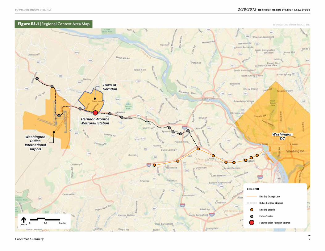
Th e Dulles Corridor Metrorail Project is one of the key initiatives that spurred interest for the Town to con-sider potential TOD within Herndon. Th e Metro Station is one of 11 new stations planned as part of this project (Figure ES.1). Th e Town recognized this opportunity and incorporated goals and objectives for TOD as part of its 2030 Comprehensive Plan adopted in August of 2008. Th is lead to the identifi cation of this study.
What is Transit-Oriented Development?TOD creates mixed-use, higher density communities that encourage people to live, work, and shop near transit; thereby, decreasing their dependence on driv-ing. Th ere are certain characteristics that successful TOD projects have in common. A key characteristic is that there must be a mix of uses, generally at high densities, that includes retail, offi ce, and housing with those land uses arranged to concentrate activity in close proximity to the transit station. Th e land use mix falls into two categories: (i) housing and employment – uses that generate transit ridership; (ii) and conve-nience retail and service – uses that support the riders and area residents.
TOD promotes and supports transit use, which has the eff ect of reducing automobile dependence. TOD promotes a more effi cient use of land and infra-structure through its compact design, and encour-ages infi ll and redevelopment opportunities that can
INTRODUCTION
Beginning in May 2010, the Town of Herndon em-barked on a comprehensive planning eff ort aimed at developing a long-range plan that will guide future redevelopment in the area north of the proposed Herndon-Monroe Metro station scheduled to begin operating in 2017 (the “Metro Station”). Th e intro-duction of Metrorail service in Herndon off ers a unique opportunity to not only connect the town to the broad-er metropolitan Washington DC region, but to also consider the next generation of land uses and develop-ment patterns for land in close proximity to the Metro Station. Across the country, towns, and municipalities like Herndon have led “smart growth” planning eff orts, such as Transit-Oriented Development (TOD) around their transportation centers or hubs. TOD best utilizes existing and/or planned infrastructure by encouraging a mix of land uses at high densities, such as residential, offi ce, support retail, and restaurants within walking distance of a transit hub. Th e Town had the foresight to plan ahead and to set the vision for this important part of its community in order to capture the unique oppor-tunities that transit and TOD will bring to Herndon.
Th e result of these eff orts is a plan that will encourage and guide new development as a means of trans-lating the community’s and Town’s vision for the Metro Station area (the “Area Plan”). Th e planning process included an evaluation of existing conditions, research of other TOD projects, development and evaluation of potential development alternatives, traffi c, infra-structure, fi nancial and fi scal impact analyses, and an extensive public outreach eff ort, including interviews with property owners and public workshops. Th e Area Plan identifi es new prospects for economic growth and
revitalize a community. TOD fosters a sense of place through the creation of mixed-use centers that combine residential uses with economic activity. By requiring high quality urban design and safe, attractive pedes-trian connections between uses, TOD creates a vibrant sense of place. TOD that combines a variety of housing alternatives with diverse economic activity provides both employment and living options for a wide range of people.1
Initiating the Area Plan Planning ProcessConsistent with the 2030 Comprehensive Plan, the Town was proactive in establishing a planning study area and a process to set a vision for development north of the new Metro Station. Th e following sections identify the Area Plan study area and describe the three-phased planning process.
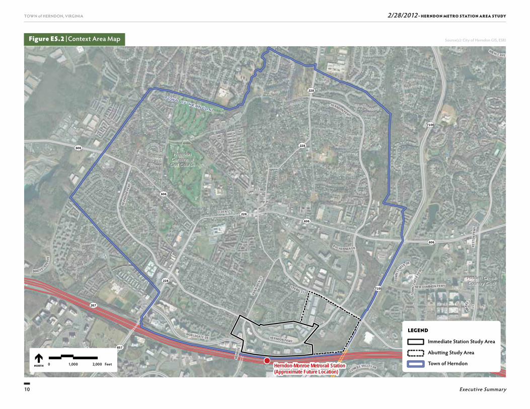
Study Area
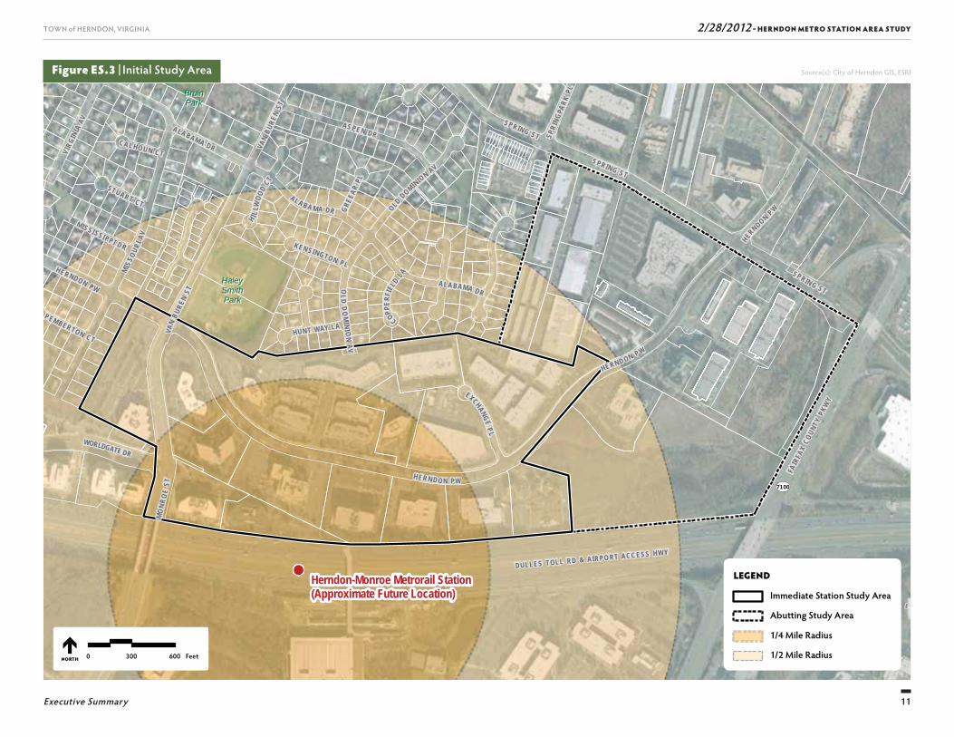
Th e study area changed during the course of the plan-ning process. Initially, it consisted of 183 acres and was divided into two sub-areas, in part due to the goals and objectives that were identifi ed in the 2030 Compre-hensive Plan for the Herndon Metro Station Area (the “Initial Study Area”). With that in mind, the Initial Study Area included: the Immediate Station Study Area; and the Abutting Study Area. Refer to Figure ES.2 for the context area map and Figure ES.3 for the two-part Initial Study Area in relation to the Metro Station. As part of the planning process, it was determined that the Herndon Metro Station Area would be reduced to focus eff orts on the land that is in close proximity to the Metro Station. Th e Initial Study Area was eventually reduced from 183 to 110 acres (referred to herein as the
1. htt p://www.mass.gov/envir/smart_growth_toolkit/pages/mod-tod.html
9
TOWN of HERNDON, VIRGINIA
Executive Summary
2/28/2012 - HERNDON METRO STATION AREA STUDY
WashingtonDulles
InternationalAirport
WashingtonDC
Town of Herndon
Herndon-MonroeMetrorail Station
LEGEND
NORTH
Figure ES.1 | Regional Context Area Map Source(s): City of Herndon GIS, ESRI
Existing Orange Line
Dulles Corridor Metrorail
Existing Station
Future Station
Future Station Herndon-Monroe0 1.5 3 Miles
10
TOWN of HERNDON, VIRGINIA
Executive Summary
2/28/2012 - HERNDON METRO STATION AREA STUDY
Figure ES.2 | Context Area Map Source(s): City of Herndon GIS, ESRI
T O W N O F H E R N D O N
7100
7100
657
606
606
228
228
228606
228
606
267
267
267
MARKE
T ST
WIEHLE AVE
SUNRISE VALLEY DR
SUNRISE VALLEY DR
BUCHANNAN DR
SPRING ST
SUNSET HILLS RD
NEW DOMINION PKWY
WORLDGATE DR
REST
ON PK
WY
ORACLE
W A Y
VAN
BURE
N ST
MONR
OE ST
T OW
N CEN
TER DR
INNOVATION
AVE
HERNDON PKWY
HERN
DON
PKW
Y
TOW
N CE
NTER
PKWY
HERNDON PKWY
ELDEN ST
HerndonHerndonCentennialCentennialGolf CourseGolf Course
Hidden CreekHidden CreekCountry ClubCountry Club
Herndon-Monroe Metrorail Station(Approximate Future Location)
LEGEND
Immediate Station Study Area
Abutting Study Area
Town of Herndon0 1,000 2,000 FeetNORTH
11
TOWN of HERNDON, VIRGINIA
Executive Summary
2/28/2012 - HERNDON METRO STATION AREA STUDY
SU
NR I S E
V A L L E
7100
SUNRISE VALLEY DR
WORLDGATE DR
FAIR
FAX
COUN
TY P
KWY
DULLES TOLL RD & AIRPO RT ACC ESS HWY
BruinBruinParkPark
HaleyHaleySmithSmithParkPark
Herndon-Monroe Metrorail Station(Approximate Future Location)
VAN
BURE
N ST
MO
NRO
E ST
EXCHANGE P L
SPRIN G ST
VAN
BURE
N ST
HUNT WAY LA
SPRING STMIS
SOUR
I AV
AL A BA M A DR OLD DOMINION AV
OLD
DO
MINI O
N A V
SPRING ST
CAL HOUN CT
ALABAMA DR
GREE
AR PL
H I LLW
OOD
CT
PEMBERTON CT
STUART CT
COPPER
FIEL
D LA
KEN SINGTON PL
SPRI
NGPA
RK PL
HERN DO N PW
MISSI SSI PP I DR
HE RNDON PW
ALABAMA DR
HERND ON P W
VIRG
INIA
AV AS PE N DR
HERNDON PW
LEGEND
Immediate Station Study Area
Abutting Study Area
1/4 Mile Radius
1/2 Mile Radius0 300 600 FeetNORTH
Figure ES.3 | Initial Study Area Source(s): City of Herndon GIS, ESRI
12
TOWN of HERNDON, VIRGINIA
Executive Summary
2/28/2012 - HERNDON METRO STATION AREA STUDY
“Refi ned Study Area”) and then again to approximately 38 acres to include properties closest to the Metro Sta-tion –the Herndon Transit-Oriented Core (referred to herein as the “HTOC” or “Core”).
The Area Plan Planning Process
Preparation of the Plan was done in three key phases:
■ Th e “Discovery” phase, which included an analysis of the regulatory context (i.e., zoning) and existing physical conditions to identify potential constraints or challenges to development in the Initial Study Area. Another component of the Discovery phase entailed gaining a comprehensive understanding of TOD from an economic standpoint to determine the densities and land uses appropriate to support transit rider-ship, promote a sense of place, and provide synergies between land uses;
■ Th e “Options” phase, which included the develop-ment of two preliminary Area Plan alternatives based on the fi ndings from the “Discovery” phase as well as input received from the Planning Commission and participants at the fi rst public workshop; and
■ Th e “Decision” phase, which involved the process of selecting, refi ning, documenting, and analyzing the fi nal Area Plan which evolved from the alternatives developed as part of the “Options” phase (the “Hern-don Transit-Oriented Core Plan”, or “HTOC Plan”).
Integral to all three key phases was the public outreach eff ort. Th is eff ort was critical in understanding the key issues and opportunities as well as gaining acceptance of the Area Plan from local residents and business owners.
Public Process
Extensive community outreach was conducted through-out the comprehensive planning process in an eff ort to involve the community in the planning process and to solicit input and feedback on the development of the Area Plans. Outreach eff orts included public workshops held in July and November of 2010, numerous neigh-borhood meetings, and the creation of a project website. Additionally, numerous Town Council and Planning Commission meetings and work sessions were held to discuss aspects of the Area Plans and the planning process. Together, these eff orts resulted in ideas that helped shape the creation of the HTOC Plan.
A VISION FOR THE AREA PLAN
During the course of the planning process, the town and Planning Commission met to establish a Vision Statement, guiding principles as well as specifi c goals and objectives to guide development in the Herndon Metro Station Area. Associated goals and objectives are presented in Chapter 1, Project Background and Goals while additional principles and guidelines are included in Chapter 6, Herndon Transit-Oriented Core Plan.
Vision StatementTh e Herndon Transit-Oriented Core is a distinctive potential employment center and residential neighborhood characterized by concentrated development that is vibrant, mixed use, transit-oriented and pedestrian friendly. Emerg-ing development is interwoven with and strengthens the town’s cultural fabric and sense of identity.
Guiding Principles■ Th ere should be no decrease in employment, value
of development, or commercial fl oor area existing in 2011.2
■ Concentrated development in the HTOC should reinforce the quality of life, sense of community, engagement of citizens, economic prosperity of other commercial areas, and other features that comprise the character and fabric of the town.
■ Redevelopment to create TOD must be facilitated over the long term and is likely to involve phases of devel-opment and capital improvements.
■ Th e HTOC should complement reinvestment in the Downtown and other parts of town.
■ Future redevelopment in the HTOC should be viewed as a means to support the existing comprehensive plan goals to enable Herndon to be a leader in envi-ronmental stewardship for the region.
Goals for the Herndon Transit-Oriented CoreTh e HTOC should:
■ Refl ect Herndon’s unique identity and be distinct from other Metro stations.
■ Enable land uses that will help optimize for the town the investment in transit.
■ Balance protection of surrounding neighborhoods with the need for mobility connections from the HTOC to the rest of Herndon and the region.
■ Enhance and encourage use of non-auto modes of travel within the town.
■ Enable the town’s internal system of sidewalks, streets, and trails to connect to mass transit.2. Pertains to Dulles Corridor Metrorail Phase Two Transportation Improvement District,
as adopted by the Town of Herndon and Fairfax County.
13
TOWN of HERNDON, VIRGINIA
Executive Summary
2/28/2012 - HERNDON METRO STATION AREA STUDY
■ Forge collaborative relationships between representa-tives of the town and aff ected properties including adjacent neighborhoods to help achieve the vision for the Metro Station Area.
■ Establish a system in which prospective developers within the Metro Station Area provide an evaluation of community benefi ts to reveal how proposed devel-opment will aid other commercial areas in town (such as by a multiplier eff ect), improve the quality of life in the town, and create more revenue than expenses to the local jurisdictions.
■ Develop a classifi cation of features and public ameni-ties required for redevelopment to achieve densities approaching the maximum Floor Area Ratio (FAR) permitted within the HTOC.
EXISTING CONDITIONS AND DEVELOPMENT OPPORTUNITIES
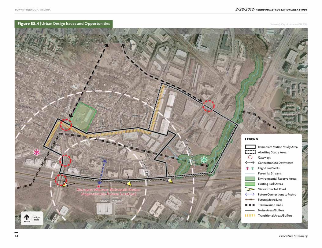
As part of the “Discovery” phase, an analysis of the regulatory context and existing physical conditions was undertaken to identify potential constraints or chal-lenges to development in the Herndon Metro Station Area. Existing physical conditions evaluated included: soil types and stormwater runoff conditions; natural resources; water and sewer infrastructure; utilities; transportation system and traffi c conditions; and urban design conditions. Existing zoning and other land use regulations were also evaluated and documented. Fig-ure ES.4 illustrates the urban design issues and oppor-tunities, such as gateways, connections to Downtown Herndon, land elevation, environmental resources, views, future connections to the Metro Station, and noise and transitional areas/residential buff ers.
■ Participate in multi-jurisdictional Transportation Demand Management (TDM) program to monitor the achievement of regional and individual TDM mea-sures.
■ Link the Metro Station Area to other parts of Herndon by:
❚ Encouraging Fairfax County to provide enhanced local bus and trolley service.
❚ Enhancing the pedestrian and bicycle environment.
❚ Providing direct trail linkages to the Metro Station.
■ Distinguish the Metro Station Area with unique architecture, streetscape and landscape of the highest caliber and conforming to the design criteria, such as:
❚ Avoid uniformity of building mass, style, and appearance.
❚ Establish an urban street edge with wide multi-pur-pose sidewalks for core streetscapes.
❚ Require multi-story parking structures otherwise visible at street level to enhance the pedestrian street experience, by such methods as being wrapped with buildings.
❚ Present a pedestrian friendly and inviting image with no unadorned parking structures or vehicle areas clearly visible from streets or pathways.
■ Create active streetscapes and storefronts, including incorporation of storefronts and building entrances on the ground fl oor of podium parking decks and other parking facilities.
■ Incorporate street level landscaping, green roofs, and improved storm water management systems to assist the town’s goals of achieving increased tree canopy and meeting Chesapeake Bay stormwater manage-ment requirements.
■ Provide housing choices within the TOD for those attracted to compact, mixed-use, walkable neighbor-hoods with nearby transit availability.
■ Recognize the need for interjurisdictional collabora-tion as the HTOC is predicted to serve a community larger than the Town of Herndon alone.
■ Promote redevelopment and design that will enhance the aesthetic qualities of the town.
Objectives for the Herndon Transit-Oriented Core■ Enable only the amount of development that can be
served by street improvements that are (a) within the type of street features currently used by town (exclud-ing grade-separated interchanges, displaced left turn lanes, triple left turn lanes, or fl yovers) and (b) of a cost reasonable for funding in the foreseeable future when development is anticipated to occur. Th is objec-tive is not intended to restrict the Mayor and Town Council in requesting any type of street improvement through the regioanl transportation planning precess.
■ Minimize traffi c impacts of TOD development on nearby neighborhoods. Elicit restricted parking (residential permit parking) requests from neighbor-hoods in an eff ort to preclude commuter parking in those neighborhoods.
■ Provide access improvements to the HTOC with prior-ity given to: (i) pedestrians; (ii) bicyclists; (iii) transit users (buses); and (iv) private vehicles (single occu-pancy vehicles and carpools).
■ Improve bus, bicycle, and pedestrian connectivity for those using the Metro Station; include links to Herndon neighborhoods as well as to areas outside the town limits.
14
TOWN of HERNDON, VIRGINIA
Executive Summary
2/28/2012 - HERNDON METRO STATION AREA STUDY
Figure ES.4 | Urban Design Issues and Opportunities
LEGEND
Immediate Station Study Area Abutt ing Study Area
Gateways Connections to Downtown
High/Low Points Perennial Streams Environmental Reserve Areas Existing Park Areas Views from Toll Road Future Connections to Metro Future Metro Line Transmission Lines Noise Areas/Buff ers Transitional Areas/Buff ersnot to
scaleNORTH
Source(s): City of Herndon GIS, ESRI
15
TOWN of HERNDON, VIRGINIA
Executive Summary
2/28/2012 - HERNDON METRO STATION AREA STUDY
■ A mix of land uses is recommended, including residential, retail and offi ce. Th is mix could be expand-ed with related uses such as hotel or civic uses.
■ A specifi c percentage mix of uses is not prescribed based upon the assumption that the future market will dictate that mix. (Note: No market study was conducted as part of the economic analysis.)
■ Herndon will likely continue to maintain the Herndon Metro Station Area’s identity as a strong choice for offi ce-based companies with offi ce spaces, but will expand to off er housing, retail shops, and restaurants.
■ Herndon’s position for retail and restaurant devel-opment will be best met through development of neighborhood-oriented rather than regionally-orient-ed retail and restaurant uses. Th e minimum square feet of retail and restaurant uses typically found in a neighborhood shopping center is 30,000 square feet, although most are between 30,000 to 100,000 square feet.
■ No minimum thresholds for housing or offi ce develop-ment are recommended to create critical mass.
AREA PLAN ALTERNATIVES
Th e “Options” phase entailed the creation of two preliminary alternative Area Plans. Th ese alternatives (Area Plan 1 and Area Plan 2) were based on the fi nd-ings from the existing conditions and development opportunities identifi ed during the “Discovery” phase as well as input received from the Planning Commission and participants at the fi rst public workshop. A Frame-work Diagram was prepared to establish the “frame-work” of what was to be included in each alternative. Each Framework Diagram identifi es goals for densities, or FAR, throughout the Herndon Metro Station Area.
Based upon the review of industry literature, case study evaluations, and property owner interviews, observa-tions and recommendations were identifi ed that helped guide the formulation of the Area Plan. Th e obser-vations and recommendations for which the alternative area plans are based are as follows:
■ It is important that densities and land uses allowed in the Herndon Metro Station Area support transit rider-ship, promote a sense of place, and provide synergies in that each additional use supports other uses in the vicinity.
■ Densities should be considerably higher than current average densities (a minimum average FAR of 3.0 to 4.0 was recommended prior to fi nancial and fi scal testing of the viability of redevelopment given such densities).
Th e “Discovery” phase also included the identifi cation of development opportunities and recommendations for TOD in Herndon. Best practices from TOD industry literature, the lessons learned from the case studies, and input received from the property owners were con-sidered along with the project team’s general experience with TOD to provide observations about future densi-ties and land uses in the station area. Th e four existing station area case studies that were evaluated included: Clarendon, Virginia; Silver Spring, Maryland; Prince George’s Plaza, Maryland; and Wheaton, Maryland. Eight major commercial property owners or their repre-sentatives were interviewed in an eff ort to understand the likelihood of redevelopment of commercial proper-ties in the area closest to the Metro Station.
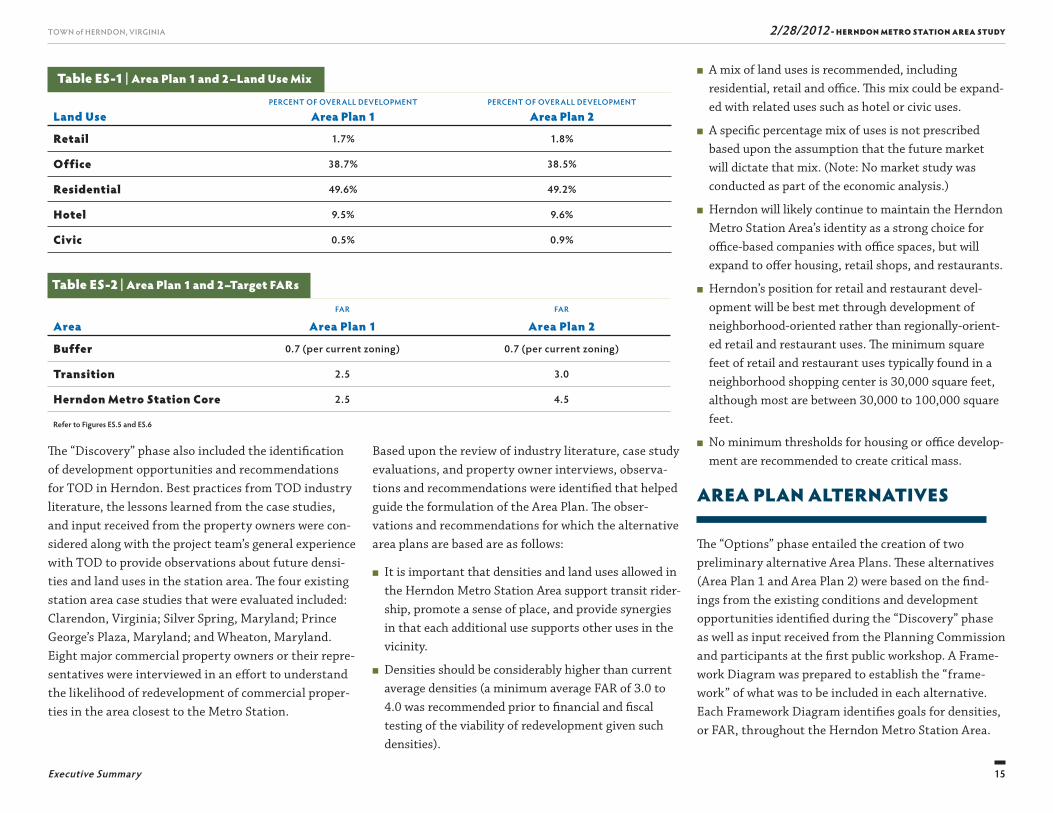
Table ES-1 | Area Plan 1 and 2 –Land Use Mix
Land UsePERCENT OF OVERALL DEVELOPMENT
Area Plan 1PERCENT OF OVERALL DEVELOPMENT
Area Plan 2
Retail 1.7% 1.8%
Office 38.7% 38.5%
Residential 49.6% 49.2%
Hotel 9.5% 9.6%
Civic 0.5% 0.9%
Table ES-2 | Area Plan 1 and 2–Target FARs
AreaFAR
Area Plan 1FAR
Area Plan 2
Buffer 0.7 (per current zoning) 0.7 (per current zoning)
Transition 2.5 3.0
Herndon Metro Station Core 2.5 4.5
Refer to Figures ES.5 and ES.6
16
TOWN of HERNDON, VIRGINIA
Executive Summary
2/28/2012 - HERNDON METRO STATION AREA STUDY
could potentially cover 20 percent of estimated infra-structure costs.
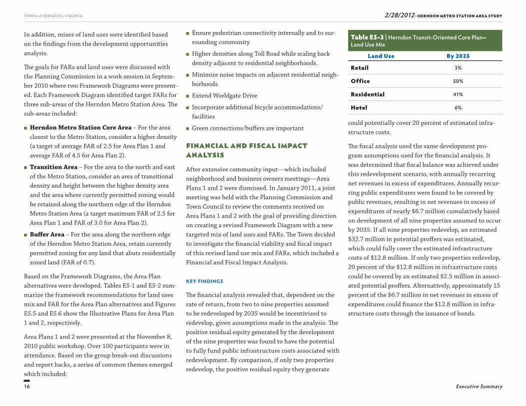
Th e fi scal analysis used the same development pro-gram assumptions used for the fi nancial analysis. It was determined that fi scal balance was achieved under this redevelopment scenario, with annually recurring net revenues in excess of expenditures. Annually recur-ring public expenditures were found to be covered by public revenues, resulting in net revenues in excess of expenditures of nearly $6.7 million cumulatively based on development of all nine properties assumed to occur by 2035. If all nine properties redevelop, an estimated $32.7 million in potential proff ers was estimated, which could fully cover the estimated infrastructure costs of $12.8 million. If only two properties redevelop, 20 percent of the $12.8 million in infrastructure costs could be covered by an estimated $2.5 million in associ-ated potential proff ers. Alternatively, approximately 15 percent of the $6.7 million in net revenues in excess of expenditures could fi nance the $12.8 million in infra-structure costs through the issuance of bonds.
■ Ensure pedestrian connectivity internally and to sur-rounding community
■ Higher densities along Toll Road while scaling back density adjacent to residential neighborhoods.
■ Minimize noise impacts on adjacent residential neigh-borhoods
■ Extend Worldgate Drive
■ Incorporate additional bicycle accommodations/facilities
■ Green connections/buff ers are important
Financial and Fiscal Impact Analysis After extensive community input—which included neighborhood and business owners meetings—Area Plans 1 and 2 were dismissed. In January 2011, a joint meeting was held with the Planning Commission and Town Council to review the comments received on Area Plans 1 and 2 with the goal of providing direction on creating a revised Framework Diagram with a new targeted mix of land uses and FARs. Th e Town decided to investigate the fi nancial viability and fi scal impact of this revised land use mix and FARs, which included a Financial and Fiscal Impact Analysis.
Key Findings
Th e fi nancial analysis revealed that, dependent on the rate of return, from two to nine properties assumed to be redeveloped by 2035 would be incentivized to redevelop, given assumptions made in the analysis. Th e positive residual equity generated by the development of the nine properties was found to have the potential to fully fund public infrastructure costs associated with redevelopment. By comparison, if only two properties redevelop, the positive residual equity they generate
In addition, mixes of land uses were identifi ed based on the fi ndings from the development opportunities analysis.
Th e goals for FARs and land uses were discussed with the Planning Commission in a work session in Septem-ber 2010 where two Framework Diagrams were present-ed. Each Framework Diagram identifi ed target FARs for three sub-areas of the Herndon Metro Station Area. Th e sub-areas included:
■ Herndon Metro Station Core Area – For the area closest to the Metro Station, consider a higher density (a target of average FAR of 2.5 for Area Plan 1 and average FAR of 4.5 for Area Plan 2).
■ Transition Area – For the area to the north and east of the Metro Station, consider an area of transitional density and height between the higher density area and the area where currently permitted zoning would be retained along the northern edge of the Herndon Metro Station Area (a target maximum FAR of 2.5 for Area Plan 1 and FAR of 3.0 for Area Plan 2).
■ Buff er Area – For the area along the northern edge of the Herndon Metro Station Area, retain currently permitted zoning for any land that abuts residentially zoned land (FAR of 0.7).
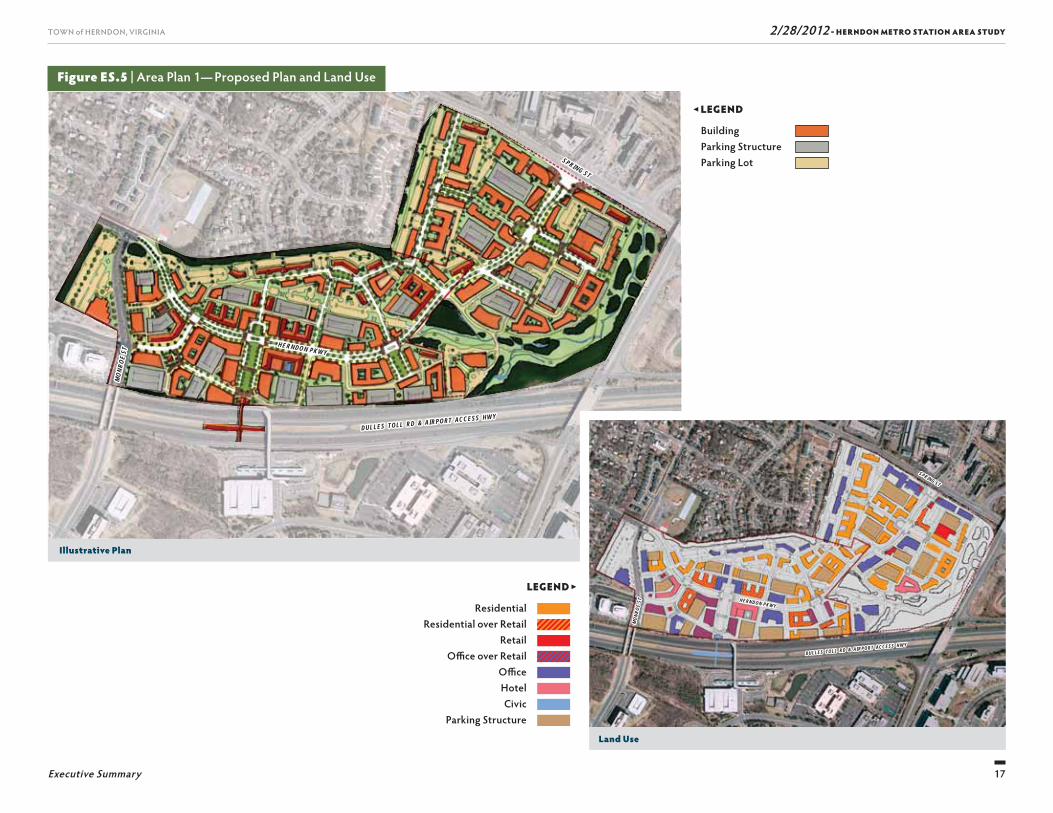
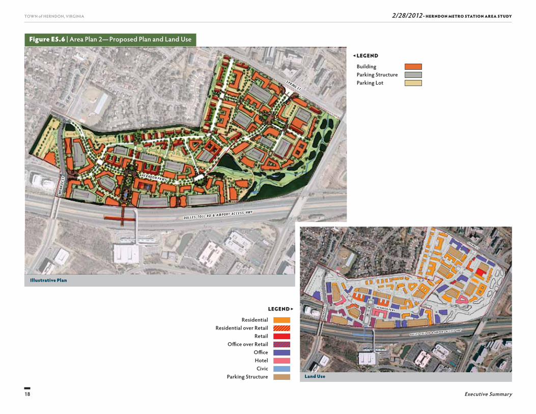
Based on the Framework Diagrams, the Area Plan alternatives were developed. Tables ES-1 and ES-2 sum-marize the framework recommendations for land uses mix and FAR for the Area Plan alternatives and Figures ES.5 and ES.6 show the Illustrative Plans for Area Plan 1 and 2, respectively.
Area Plans 1 and 2 were presented at the November 8, 2010 public workshop. Over 100 participants were in attendance. Based on the group break-out discussions and report backs, a series of common themes emerged which included:
Table ES-3 | Herndon Transit-Oriented Core Plan–Land Use Mix
Land Use By 2035
Retail 3%
Office 50%
Residential 41%
Hotel 6%
17
TOWN of HERNDON, VIRGINIA
Executive Summary
2/28/2012 - HERNDON METRO STATION AREA STUDY
Figure ES.5 | Area Plan 1— Proposed Plan and Land Use
LEGEND ▶
Residential Residential over Retail
Retail Offi ce over Retail
Offi ce Hotel Civic
Parking Structure
◀ LEGEND
Building Parking Structure Parking Lot
Illustrative Plan
Land Use
DULLES TOLL RD & AIRPORT ACCESS HWYDULLES TOLL RD & AIRPORT ACCESS HWY
HERNDON PKWYHERNDON PKWY
SPRING ST
SPRING ST
MON
ROE
STM
ONRO
E ST
DULLES TOLL RD & AIRPORT ACCESS HWYDULLES TOLL RD & AIRPORT ACCESS HWY
HERNDON PKWYHERNDON PKWY
SPRING ST
SPRING ST
MON
ROE
STM
ONRO
E ST
18
TOWN of HERNDON, VIRGINIA
Executive Summary
2/28/2012 - HERNDON METRO STATION AREA STUDY
Figure ES.6 | Area Plan 2— Proposed Plan and Land Use
Illustrative Plan
Land Use
DULLES TOLL RD & AIRPORT ACCESS HWYDULLES TOLL RD & AIRPORT ACCESS HWY
HERNDON PKWYHERNDON PKWY
SPRING ST
SPRING ST
MON
ROE
STM
ONRO
E ST
DULLES TOLL RD & AIRPORT ACCESS HWYDULLES TOLL RD & AIRPORT ACCESS HWY
HERNDON PKWYHERNDON PKWY
SPRING ST
SPRING ST
MON
ROE
STM
ONRO
E ST
◀ LEGEND
Building Parking Structure Parking Lot
LEGEND ▶
Residential Residential over Retail
Retail Offi ce over Retail
Offi ce Hotel Civic
Parking Structure
19
TOWN of HERNDON, VIRGINIA
Executive Summary
2/28/2012 - HERNDON METRO STATION AREA STUDY
purposes is presented in Table ES-3. Th is mix is not intended to be required of individual projects. Based on the target FAR range, in 2035, the average FAR will be 4.1 resulting in potentially 3.7 million square feet of commercial fl oor area and 2,357 mid-rise or high-rise dwelling units.
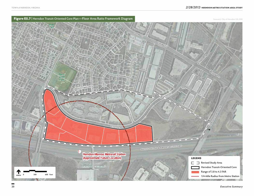
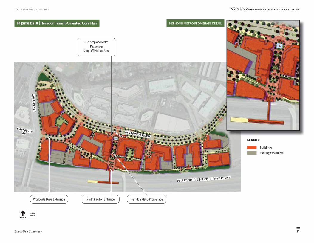
Th is potential development program was then analyzed in terms of fi nancial feasibility and fi scal impact. Th e fi nancial and fi scal analysis considered infrastructure needs and transportation improvements based on infrastructure demand and traffi c impact analyses, respectively. While this plan accepts the infl uence of market demand on the mix of uses, the area should have a balance of uses to ensure its vibrancy. Neither 100 percent residential nor 100 percent non-residential uses would be appropriate in the area as it transforms from its current development pattern. Th e HTOC Plan, as shown in Figure ES.8, represents a conceptual vision for TOD in the Herndon Metro Station Area. Specifi -cally, the plan depicts the broad goals for the Herndon Transit-Oriented Core. A three-dimensional computer massing model was also created for the HTOC land is presented as Figure ES.9. Th e illustration is based on the urban design concepts and density assumptions in the plan, focusing on the HTOC (a range of FAR 3.8 to 4.3). Figure ES.9 shows how the buildings of the HTOC Plan could be accommodated within 12 to 15 stories throughout the HTOC (based on the assumption that lot coverage could be as high as 70 percent, or more). Th e frontage along the south side of the Herndon Parkway is urbanized with a street wall and bicycle and pedestrian improvements. Th e building massing shows how each building will have a lower tier that frames the public space and how they generally utilize setbacks at the at the four- and eight-story levels to give a more open feel to the streets and public areas.
HERNDON TRANSIT-ORIENTED CORE PLAN
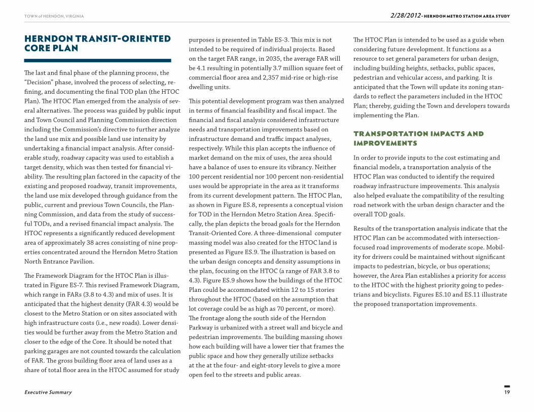
Th e last and fi nal phase of the planning process, the “Decision” phase, involved the process of selecting, re-fi ning, and documenting the fi nal TOD plan (the HTOC Plan). Th e HTOC Plan emerged from the analysis of sev-eral alternatives. Th e process was guided by public input and Town Council and Planning Commission direction including the Commission’s directive to further analyze the land use mix and possible land use intensity by undertaking a fi nancial impact analysis. After consid-erable study, roadway capacity was used to establish a target density, which was then tested for fi nancial vi-ability. Th e resulting plan factored in the capacity of the existing and proposed roadway, transit improvements, the land use mix developed through guidance from the public, current and previous Town Councils, the Plan-ning Commission, and data from the study of success-ful TODs, and a revised fi nancial impact analysis. Th e HTOC represents a signifi cantly reduced development area of approximately 38 acres consisting of nine prop-erties concentrated around the Herndon Metro Station North Entrance Pavilion.
Th e Framework Diagram for the HTOC Plan is illus-trated in Figure ES-7. Th is revised Framework Diagram, which range in FARs (3.8 to 4.3) and mix of uses. It is anticipated that the highest density (FAR 4.3) would be closest to the Metro Station or on sites associated with high infrastructure costs (i.e., new roads). Lower densi-ties would be further away from the Metro Station and closer to the edge of the Core. It should be noted that parking garages are not counted towards the calculation of FAR. Th e gross building fl oor area of land uses as a share of total fl oor area in the HTOC assumed for study
Th e HTOC Plan is intended to be used as a guide when considering future development. It functions as a resource to set general parameters for urban design, including building heights, setbacks, public spaces, pedestrian and vehicular access, and parking. It is anticipated that the Town will update its zoning stan-dards to refl ect the parameters included in the HTOC Plan; thereby, guiding the Town and developers towards implementing the Plan.
Transportation Impacts and ImprovementsIn order to provide inputs to the cost estimating and fi nancial models, a transportation analysis of the HTOC Plan was conducted to identify the required roadway infrastructure improvements. Th is analysis also helped evaluate the compatibility of the resulting road network with the urban design character and the overall TOD goals.
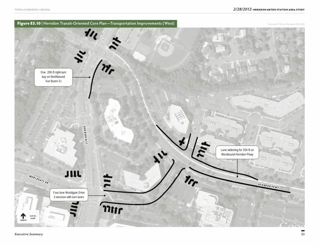
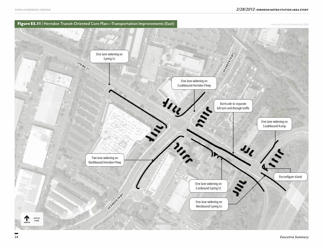
Results of the transportation analysis indicate that the HTOC Plan can be accommodated with intersection-focused road improvements of moderate scope. Mobil-ity for drivers could be maintained without signifi cant impacts to pedestrian, bicycle, or bus operations; however, the Area Plan establishes a priority for access to the HTOC with the highest priority going to pedes-trians and bicyclists. Figures ES.10 and ES.11 illustrate the proposed transportation improvements.
20
TOWN of HERNDON, VIRGINIA
Executive Summary
2/28/2012 - HERNDON METRO STATION AREA STUDY
Figure ES.7 | Herndon Transit-Oriented Core Plan—Floor Area Ratio Framework Diagram Source(s): City of Herndon GIS, ESRI
!
SU
NR I S E
V A L L E
UV7100
SUNRISE VALLEY DR
WORLDGATE DR
FAIR
FAX
COUN
TY P
KWY
D U L L E S T OL L R D & A IR P O R T A C C E S S H W Y
BruinBruinParkPark
HaleyHaleySmithSmithParkPark
Herndon-Monroe Metrorail Station(Approximate Future Location)
VAN
BURE
N ST
MO
NR
OE
ST
EXCHANG E P L
S P RIN G ST
VAN
B URE
N ST
HU N T WAY L A
S P R IN G S T
MIS
S OUR
I AV
AL A B A M A DR OLD DOM INIO
N AV
OLD
DO
MIN
I ON
A V
S P R IN G S T
CA L HO U N C T
A L A B A MA DR
GRE
EAR
PL
H I LLW
OOD
C T
P EM BER TON C T
ST UAR T CT
COPPER
FIEL
D LA
KEN S I NGTO N P L
SPRI
NGPA
RK PL
H E R N D O N P W
MIS SI SSI PP I D R
HE R NDON PW
A LA BAM A DR
HE RND ON P W
VIRG
INIA
AV AS PE N DR
HERNDO N P W
0 300 600 FeetNORTH
VVVVVVVVVUUUUUUUUUUUUUUUUUUUUUUUUUUUUUU
F
P OO R T AA C C E S S H W YY
VVVVVVVVVAAAAAAAAAAAAAANNNNNNNNNNN
MO
N
HU N TT WAYY LL AA
MIN
I O
CO
RRRRRRRRRRRRRNNNNNND ON PP W
HEEEEEEEEEEEEE RRRRRR
V
V
E R
VAN
VV
EXXCHAANG EPP LL
VVVVVVVVVVVVV
HHHHHHHHHHH EEEEEEEEEE RRRRRRRRRRR NNNNNNNNN DDDDDDDDDDD OOOOOOOOOOO NNNNNNNNN PPPPPP WWWWWWWWWWWWW
MMMMMMMMMMMOOOOOOOOOOO
NNNNNNNNNNNNRRRRRRRRRR
OOOOOOOOOOEEEEEEEEE
SSSSSSSSSSSSTTTTTTTTTTTTTTT
HU N TT ON
AAAAAAAAAAAAA
VVVV
VLEGEND
Revised Study Area
Herndon Transit-Oriented Core
Range of 3.8 to 4.3 FAR
1/4-Mile Radius from Metro Station
21
TOWN of HERNDON, VIRGINIA
Executive Summary
2/28/2012 - HERNDON METRO STATION AREA STUDY
Figure ES.8 | Herndon Transit-Oriented Core Plan
not to scale
NORTH
Herndon Metro PromenadeWorldgate Drive Extension North Pavilion Entrance
HERNDON PARKWAYHERNDON PARKWAY
WORLDGATE WORLDGATE DRDR
DULLES TOLL RD & AIRPORT ACCESS HWYDULLES TOLL RD & AIRPORT ACCESS HWY
VAN BUREN STVAN BUREN ST
LEGEND
Buildings Parking Structures
Bus Stop and Metro Passenger
Drop-off/Pick-up Area
HERNDON METRO PROMENADE DETAIL
22
TOWN of HERNDON, VIRGINIA
Executive Summary
2/28/2012 - HERNDON METRO STATION AREA STUDY
Figure ES.9 | Herndon Transit-Oriented Core Plan—Conceptual Massing
Looking north along Herndon Metro Promenade
The Herndon Metro Promenade
Future Development
Parking Garage
Existing Development
1
1
Looking east along Worldgate Drive
23
TOWN of HERNDON, VIRGINIA
Executive Summary
2/28/2012 - HERNDON METRO STATION AREA STUDY
Figure ES.10 | Herndon Transit-Oriented Core Plan— Transportation Improvements (West)
One 200-ft right-turn bay on Northbound
Van Buren St
Four lane Worldgate Drive Extension with turn lanes
Lane widening for 350-ft on Westbound Herndon Pkwy
HERNDON PKWYHERNDON PKWY
WORLDGATE DR
WORLDGATE DR
VAN BUREN STVAN BUREN ST
Source(s): City of Herndon GIS, ESRI
not to scale
NORTH
24
TOWN of HERNDON, VIRGINIA
Executive Summary
2/28/2012 - HERNDON METRO STATION AREA STUDY
Figure ES.11 | Herndon Transit-Oriented Core Plan— Transportation Improvements (East)
One lane widening on Eastbound Spring St
One lane widening on Spring St
Barricade to separate left-turn and through traffi c
One lane widening on Southbound Ramp
One lane widening on Westbound Spring St
Reconfi gure island
Two lane widening on Northbound Herndon Pkwy
SPRING ST
SPRING ST
HERNDON PKWY
HERNDON PKWY
HERN
DON
PKW
Y
HERN
DON
PKW
Y
Source(s): City of Herndon GIS, ESRI
not to scale
NORTH
One lane widening on Southbound Herndon Pkwy
25
TOWN of HERNDON, VIRGINIA
Executive Summary
2/28/2012 - HERNDON METRO STATION AREA STUDY
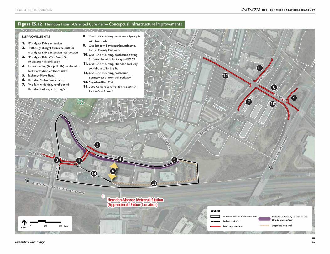
Figure ES.12 | Herndon Transit-Oriented Core Plan— Conceptual Infrastructure Improvements
!
SU
NR I S E
V A L L E
UV7100
SUNRISE VALLEY DR
WORLDGATE DR
FAIR
FAX
COUN
TY P
KWY
DULLES TOLL RD & AIRPO RT ACC ESS HWY
UV267
BruinBruinParkPark
HaleyHaleySmithSmithParkPark
Herndon-Monroe Metrorail Station(Approximate Future Location)
VAN
BURE
N ST
MO
NRO
E ST
EXCHANGE P L
SPRIN G ST
VAN
BURE
N ST
HUNT WAY LA
SPRING STMIS
SOUR
I AV
AL A BA M A DR OLD DOMINION AV
OLD
DO
MINI O
N A V
SPRING ST
CAL HOUN CT
ALABAMA DR
GREE
AR PL
H I LLW
OOD
CT
PEMBERTON CT
STUART CT
COPPER
FIEL
D LA
KEN SINGTON PL
SPRI
NGPA
RK PL
HERNDON PW
MISSI SSI PP I DR
HE RNDON PW
HERNDON PW
ALABAMA DR
VIRG
INIA
AV AS PE N DR
HERNDON PW
LEGEND
Herndon Tranist-Oriented Core
Pedestrian Path
Road Improvement
Pedestrian Amenity Improvements (Inside Station Area)
! ! ! ! ! ! Sugarland Run Trail0 300 600 FeetNORTH
13
910
11
12
7
8
14
54
6
3
2
1
IMPROVEMENTS
1. Worldgate Drive extension2. Traffi c signal, right-turn lane shift for
Worldgate Drive extension intersection3. Worldgate Drive/Van Buren St.
Intersection modifi cation4. Lane widening (bus pull off s) on Herndon
Parkway at drop off (both sides)5. Exchange Place Signal6. Herndon Metro Promenade7. Two-lane widening, northbound
Herndon Parkway at Spring St.
8. One-lane widening westbound Spring St. with barricade
9. One left turn bay (southbound ramp, Farifax County Parkway)
10. One-lane widening, eastbound Spring St. from Herndon Parkway to FFX CP
11. One-lane widening, Herndon Parkway southbound/Spring St.
12. One-lane widening, eastbound Spring/west of Herndon Parkway
13. Sugarland Run Trail14. 2008 Comprehensive Plan Pedestrian
Path to Van Buren St.
26
TOWN of HERNDON, VIRGINIA
Executive Summary
2/28/2012 - HERNDON METRO STATION AREA STUDY
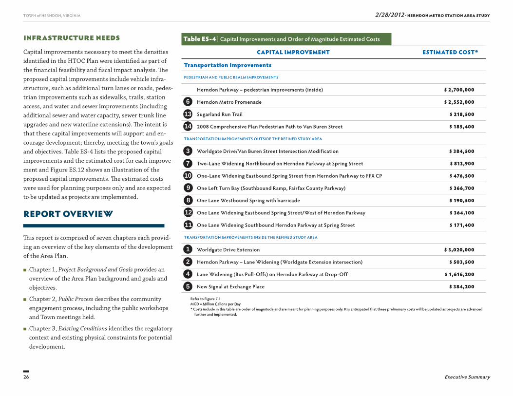
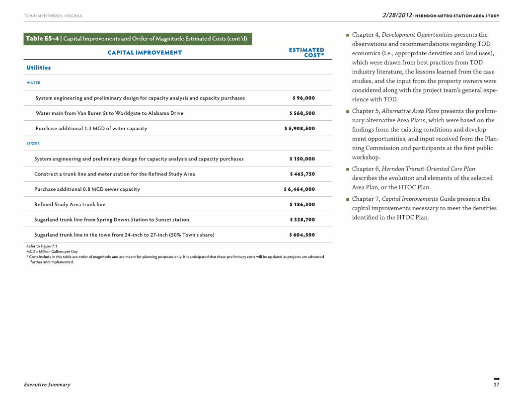
Infrastructure NeedsCapital improvements necessary to meet the densities identifi ed in the HTOC Plan were identifi ed as part of the fi nancial feasibility and fi scal impact analysis. Th e proposed capital improvements include vehicle infra-structure, such as additional turn lanes or roads, pedes-trian improvements such as sidewalks, trails, station access, and water and sewer improvements (including additional sewer and water capacity, sewer trunk line upgrades and new waterline extensions). Th e intent is that these capital improvements will support and en-courage development; thereby, meeting the town’s goals and objectives. Table ES-4 lists the proposed capital improvements and the estimated cost for each improve-ment and Figure ES.12 shows an illustration of the proposed capital improvements. Th e estimated costs were used for planning purposes only and are expected to be updated as projects are implemented.
REPORT OVERVIEW
Th is report is comprised of seven chapters each provid-ing an overview of the key elements of the development of the Area Plan.
■ Chapter 1, Project Background and Goals provides an overview of the Area Plan background and goals and objectives.
■ Chapter 2, Public Process describes the community engagement process, including the public workshops and Town meetings held.
■ Chapter 3, Existing Conditions identifi es the regulatory context and existing physical constraints for potential development.
Table ES-4 | Capital Improvements and Order of Magnitude Estimated Costs
CAPITAL IMPROVEMENT ESTIMATED COST*
Transportation Improvements
PEDESTRIAN AND PUBLIC REALM IMPROVEMENTS
Herndon Parkway – pedestrian improvements (inside) $ 2,700,000
Herndon Metro Promenade $ 2,552,000
Sugarland Run Trail $ 218,500
2008 Comprehensive Plan Pedestrian Path to Van Buren Street $ 185,400
TRANSPORTATION IMPROVEMENTS OUTSIDE THE REFINED STUDY AREA
Worldgate Drive/Van Buren Street Intersection Modification $ 384,500
Two-Lane Widening Northbound on Herndon Parkway at Spring Street $ 813,900
One-Lane Widening Eastbound Spring Street from Herndon Parkway to FFX CP $ 476,500
One Left Turn Bay (Southbound Ramp, Fairfax County Parkway) $ 366,700
One Lane Westbound Spring with barricade $ 190,500
One Lane Widening Eastbound Spring Street/West of Herndon Parkway $ 364,100
One Lane Widening Southbound Herndon Parkway at Spring Street $ 171,400
TRANSPORTATION IMPROVEMENTS INSIDE THE REFINED STUDY AREA
Worldgate Drive Extension $ 3,020,000
Herndon Parkway – Lane Widening (Worldgate Extension intersection) $ 503,500
Lane Widening (Bus Pull-Offs) on Herndon Parkway at Drop-Off $ 1,616,200
New Signal at Exchange Place $ 384,200
Refer to Figure 7.1MGD = Million Gallons per Day* Costs include in this table are order of magnitude and are meant for planning purposes only. It is anticipated that these preliminary costs will be updated as projects are advanced
further and implemented.
3
7
10
6
13
14
9
8
12
1
2
4
11
5
27
TOWN of HERNDON, VIRGINIA
Executive Summary
2/28/2012 - HERNDON METRO STATION AREA STUDY
■ Chapter 4, Development Opportunities presents the observations and recommendations regarding TOD economics (i.e., appropriate densities and land uses), which were drawn from best practices from TOD industry literature, the lessons learned from the case studies, and the input from the property owners were considered along with the project team’s general expe-rience with TOD.
■ Chapter 5, Alternative Area Plans presents the prelimi-nary alternative Area Plans, which were based on the fi ndings from the existing conditions and develop-ment opportunities, and input received from the Plan-ning Commission and participants at the fi rst public workshop.
■ Chapter 6, Herndon Transit-Oriented Core Plan describes the evolution and elements of the selected Area Plan, or the HTOC Plan.
■ Chapter 7, Capital Improvements Guide presents the capital improvements necessary to meet the densities identifi ed in the HTOC Plan.
Table ES-4 | Capital Improvements and Order of Magnitude Estimated Costs (cont’d)
CAPITAL IMPROVEMENT ESTIMATED COST*
Utilities
WATER
System engineering and preliminary design for capacity analysis and capacity purchases $ 96,000
Water main from Van Buren St to Worldgate to Alabama Drive $ 568,500
Purchase additional 1.3 MGD of water capacity $ 5,908,500
SEWER
System engineering and preliminary design for capacity analysis and capacity purchases $ 150,000
Construct a trunk line and meter station for the Refined Study Area $ 465,750
Purchase additional 0.8 MGD sewer capacity $ 6,464,000
Refined Study Area trunk line $ 186,300
Sugarland trunk line from Spring Downs Station to Sunset station $ 338,700
Sugarland trunk line in the town from 24-inch to 27-inch (50% Town’s share) $ 604,500
Refer to Figure 7.1MGD = Million Gallons per Day* Costs include in this table are order of magnitude and are meant for planning purposes only. It is anticipated that these preliminary costs will be updated as projects are advanced
further and implemented.

Th is page intentionally left blank

29
2/28/2012 - HERNDON METRO STATION AREA STUDYTOWN of HERNDON, VIRGINIA
PROJECT BACKGROUND AND GOALS
1
30
TOWN of HERNDON, VIRGINIA 2/28/2012 - HERNDON METRO STATION AREA STUDY
Chapter 1 Project Background and Goals
views with property owners and public workshops. Th e Area Plan identifi es new prospects for economic growth and outlines recommendations for future development and public improvements.
BACKGROUND
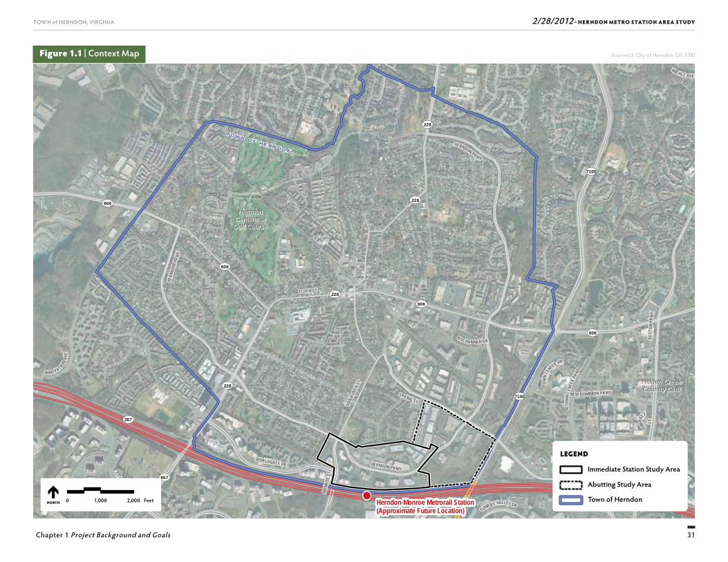
Th e Dulles Corridor Metrorail Project is one of the key initiatives that spurred interest for potential TOD within Herndon. Th e Town recognized this opportu-nity and incorporated goals and objectives for TOD as part of its 2030 Comprehensive Plan adopted in August of 2008. Th is lead to the identifi cation of the need for this study. Th e following sections describe these actions as background for the Area Plan. Figure 1.1 shows the context map of Herndon, the study area, and the Metro Station.
Dulles Corridor Metrorail ProjectTh e Metropolitan Washington Airports Authority (MWAA), in cooperation with the Virginia Department of Rail and Public Transportation (DRPT), Washington Metropolitan Transit Authority (WMATA), and the counties of Fairfax and Loudoun, is working to con-struct a 23.1-mile extension of the Metrorail system. Th e extension will originate from a point located along the Orange Line between the existing East and West Falls Church Metro stations and will pass through the Tysons Corner area, Reston, Herndon, Dulles Airport and into Loudoun County. Eleven new stations are planned as part of the project. Once completed, Hern-don will be linked by transit to both Dulles International Airport and the Metrorail system serving the greater metropolitan Washington DC area.
INTRODUCTION
Beginning in May 2010, the Town of Herndon em-barked on a comprehensive planning eff ort to develop a long-range plan to guide future redevelopment in the area north of the proposed Herndon-Monroe Metro Station (the “Metro Station”). Th e introduction of Me-trorail service in Herndon off ers a unique opportunity to not only connect the town to the broader metropoli-tan Washington DC region, but to also consider the next generation of land uses and development patterns for portions of the town that are in close proximity to the future Metro Station. Across the country, towns and municipalities like Herndon have led eff orts to plan for Transit-Oriented Development (TOD) around their transportation centers or hubs. It is anticipated that the Metro Station will be operating in 2017. Th e Town had the foresight to plan ahead and to set the vision for this important part of its community in order to capture the unique opportunities that transit and TOD will bring to Herndon.
To assist in preparing a plan for the area surround-ing the Metro Station (the “Area Plan”), the Town of Herndon engaged a team of planning and engineering consultants. Vanasse Hangen Brustlin, Inc. (VHB), working with Looney Ricks Kiss (LRK), led the com-munity outreach and master planning eff orts as well as considered the traffi c impacts and infrastructure needs. BBP & Associates LLC (BBP) conducted the economic and fi nancial feasibility analyses.
Th e planning process included an evaluation of existing conditions, research on other TOD projects, develop-ment and evaluation of potential development alterna-tives, traffi c, infrastructure, fi nancial impact analyses, and an extensive public outreach eff ort, including inter-
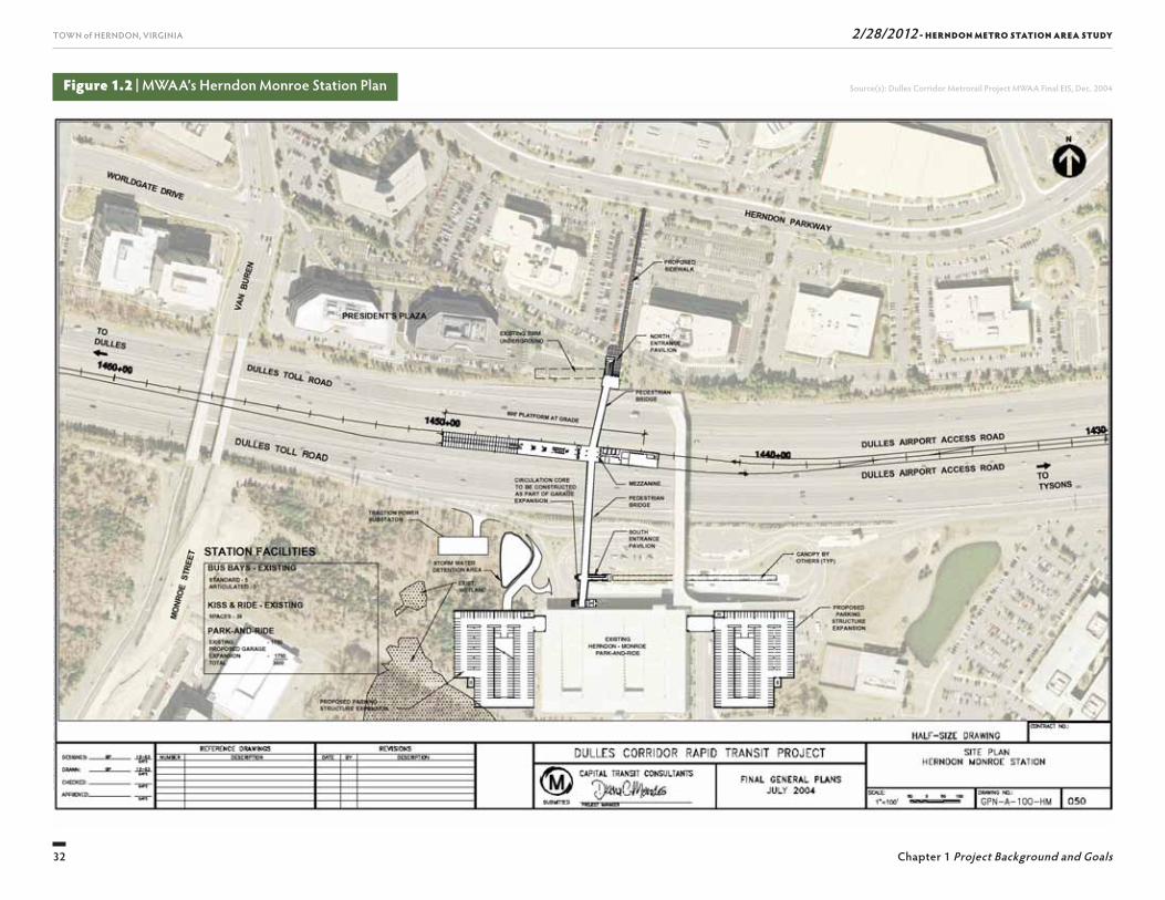
Th e Metro Station is planned to be built in the median of the Dulles Airport Access and Toll Road, adjacent to the existing Herndon-Monroe park and ride garage, with an entrance pavilion (the “North Entrance Pavil-ion”) and pedestrian bridge connecting the new Metro Station to Herndon. Figure 1.2 shows MWAA’s pro-posed station site plan for the new Metro Station.
Town of HerndonTh e Town of Herndon is located in Fairfax County in Northern Virginia roughly 22 miles from downtown Washington, DC. Th e town is located less than fi ve miles from Washington Dulles International Airport and has direct access to the Dulles Airport Access and Toll Road. More than 23,000 people live in Herndon, making it the third largest town in Virginia. Th e town boundaries are shown on Figure 1.1.
Herndon is unique in that it is the only incorporated and historic town along the Dulles Corridor. It has an established identity as a location for offi ces, and companies have enjoyed the visibility and access to the region aff orded by the area’s location along the Dulles Toll Road. Th e town’s access to the regional base of com-panies and labor pool will support the Metro Station; thereby, strengthening its position as a destination for offi ce-based companies.
Town’s 2030 Comprehensive Plan
Based on the MWAA’s Metro expansion project, the Town recognized the opportunities for TOD based on its proximity to existing and planned transportation infrastructure. Th e Town’s 2030 Comprehensive Plan was updated in August 2008 (and amended in February 2011) and sets policy for TOD by establishing two new land use designations within the vicinity of the Metro
31
TOWN of HERNDON, VIRGINIA 2/28/2012 - HERNDON METRO STATION AREA STUDY
Chapter 1 Project Background and Goals
Figure 1.1 | Context Map
T O W N O F H E R N D O N
7100
7100
657
606
606
228
228
228606
228
606
267
267
267
MARKE
T ST
WIEHLE AVE
SUNRISE VALLEY DR
SUNRISE VALLEY DR
BUCHANNAN DR
SPRING ST
SUNSET HILLS RD
NEW DOMINION PKWY
WORLDGATE DR
REST
ON PK
WY
ORACLE
W A Y
VAN
BURE
N ST
MONR
OE ST
T OW
N CEN
TER DR
INNOVATION
AVE
HERNDON PKWY
HERN
DON
PKW
Y
TOW
N CE
NTER
PKWY
HERNDON PKWY
ELDEN ST
HerndonHerndonCentennialCentennialGolf CourseGolf Course
Hidden CreekHidden CreekCountry ClubCountry Club
Herndon-Monroe Metrorail Station(Approximate Future Location)
LEGEND
Immediate Station Study Area
Abutting Study Area
Town of Herndon0 1,000 2,000 FeetNORTH
Source(s): City of Herndon GIS, ESRI
32
TOWN of HERNDON, VIRGINIA 2/28/2012 - HERNDON METRO STATION AREA STUDY
Chapter 1 Project Background and Goals
Figure 1.2 | MWAA’s Herndon Monroe Station Plan Source(s): Dulles Corridor Metrorail Project MWAA Final EIS, Dec. 2004
33
TOWN of HERNDON, VIRGINIA 2/28/2012 - HERNDON METRO STATION AREA STUDY
Chapter 1 Project Background and Goals
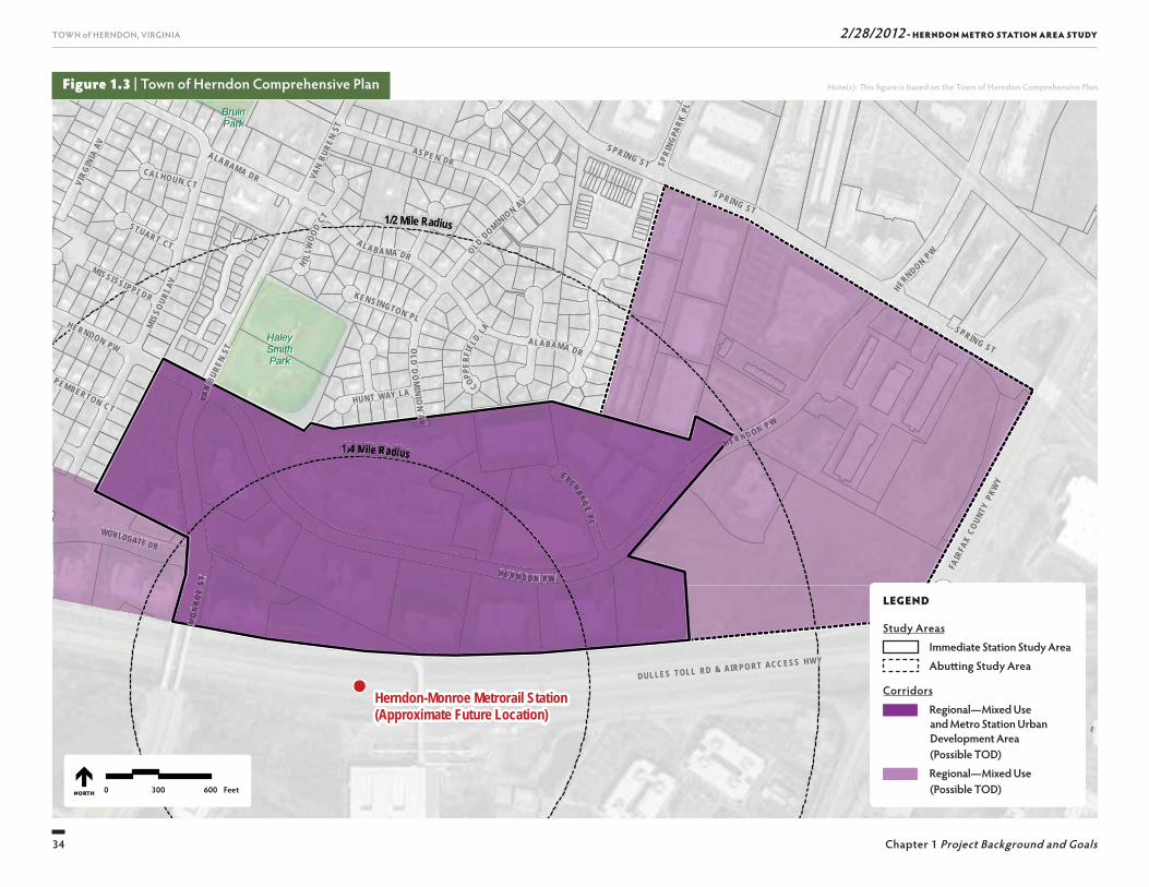
Station: the Regional Corridor Mixed Use area; and the Metrorail Station Urban Development Area. Th e Comprehensive Plan calls for the consideration of such issues as pedestrian and vehicular access to the Metro Station and identifi es the potential for increased densi-ties in portions of the Metrorail Station Urban Develop-ment Area as well as protection of nearby residential areas. Refer to Figure 1.3 for the 2030 Comprehensive Plan goals for the area surrounding the future Metro Station.
INITIATING THE AREA PLAN PLANNING PROCESS
Consistent with the 2030 Comprehensive Plan, the Town was proactive in establishing a planning study area and a process to set a vision for development north of the new Metro Station. Th e following sections identify the study area and describe the three-phased planning process.
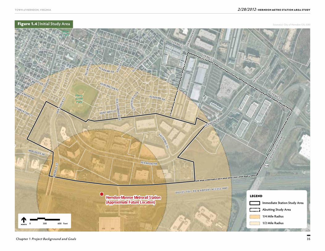
Study AreaTh e study area changed during the course of the plan-ning process. Initially, the study area consisted of 183 acres and was divided into two sub-areas, in part due to the goals and objectives that were identifi ed in the 2030 Comprehensive Plan for the Herndon Metro Station Area (the “Initial Study Area”). With that in mind, the Initial Study Area included: the Immediate Station Study Area; and the Abutting Study Area. Refer to Figure 1.4 for an illustration of the Initial Study Area and its proximity to the Metro Station.
During the planning process, the Town opted to reduce the Initial Study Area (183 acres) to 110 acres—an area more confi ned to the Metro Station (the “Refi ned Study Area”). Th e Refi ned Study Area consists of 17 privately
held real estate parcels, 11 parcels of which lie partially or entirely within the ¼-mile radius of the Metro Sta-tion. Currently, the average FAR in the Refi ned Study Area is approximately 0.34. In the later stages of the planning process the study area was reduced further to focus on parcels south of Herndon Parkway – Herndon Transit-Oriented Core (referred herein as the “HTOC” or “Core”).
Th e Herndon Metro Station Area itself lies in a highly visible location at the northwest quadrant of the Dulles Toll Road and the Fairfax County Parkway. It has tra-ditionally hosted a major share of the town’s economic engine and has been a prosperous location for the development that occurred immediately after the open-ing of the Dulles Toll Road in the mid-1980s. Th rough this study, the Town seeks to mold the development anticipated in response to the advent of the Dulles Metrorail extension project into a more intense employ-ment destination within a vibrant mixed use neighbor-hood.
The Planning ProcessPreparation of the Area Plan was done in three key phases:
■ Th e “Discovery” phase;
■ Th e “Options” phase; and
■ Th e “Decision” phase.
Integral to all three key phases of this study was the public outreach eff ort. Th is eff ort was critical in under-standing the issues and opportunities as well as gaining participation from local residents and business owners to help shape the Area Plan. Th e outreach eff ort included two public workshops and the creation of a project website to disseminate information about the project as well as neighborhood meetings with residents
and local business owners. Additionally, numerous Planning Commission work sessions and other town department meetings were held throughout the plan-ning process. Chapter 2, Public Process provides more information about public outreach.
“Discovery” Phase
Th e “Discovery” phase included an analysis of the regu-latory context (i.e., zoning) and existing physical condi-tions to identify potential constraints or challenges to development in the Initial Study Area. Existing physi-cal conditions that were evaluated include: soil types and stormwater runoff conditions; natural resources; water and sewer infrastructure; utilities; transporta-tion system and traffi c conditions; and urban design conditions. Th is phase also included the identifi cation of development opportunities for TOD in Herndon.
Another component of the “Discovery” phase entailed gaining a comprehensive understanding of TOD from an economic standpoint to determine the densities and land uses allowed in the Herndon Metro Station Area are appropriate to support transit ridership, promote a sense of place, and provide synergies between land uses. Th e project team conducted a literary review, evaluated case studies, and interviewed local property owners. Best practices from TOD industry literature were considered along with the project team’s extensive experience with TOD to provide observations about fu-ture densities and land uses in the station area. Th e case studies included four existing station areas: Clarendon, Virginia; Silver Spring, Maryland; Prince George’s Plaza, Maryland; and Wheaton, Maryland. Eight major commercial property owners (or their representatives) were interviewed in an eff ort to understand the likeli-hood of redevelopment of commercial properties in the area closest to the Metro Station.
34
TOWN of HERNDON, VIRGINIA 2/28/2012 - HERNDON METRO STATION AREA STUDY
Chapter 1 Project Background and Goals
Figure 1.3 | Town of Herndon Comprehensive Plan
SU
NR I S E
V A L L E
7100
SUNRISE VALLEY DR
WORLDGATE DR
FAIR
FAX
COUN
TY P
KWY
DULLES TOLL RD & AIRPO RT ACC ESS HWY
1/4 Mile Radius
1/2 Mile Radius
BruinBruinParkPark
HaleyHaleySmithSmithParkPark
Herndon-Monroe Metrorail Station(Approximate Future Location)
VAN
BURE
N ST
MO
NRO
E ST
EXCHANGE P L
SPRIN G ST
VAN
BURE
N ST
HUNT WAY LA
SPRING STMIS
SOUR
I AV
A LA BA MA DR OLD DOMINION AV
OLD
DO
MINI O
N A V
SPRING ST
CAL HOUN CT
ALABAMA DR
H I LLW
OOD
CT
PEMBERTON CT
STUART CT
COPPER
FIEL
D LA
KEN SINGTON PL
SPRI
NGPA
RK PL
HERN DO N PW
MISSI SSI PP I DR
HE RNDON PW
ALABAMA DR
HERND ON P W
VIRG
INIA
AV AS PE N DR
HERNDON PW
LEGEND
Immediate Station Study Area
Abutting Study Area0 300 600 FeetNORTH
Note(s): Th is fi gure is based on the Town of Herndon Comprehensive Plan.
HERND ON PP W
1/4// Mile Radius
VVAAN
B
MOO
NROO
ESTT
EXXCHAANGEPP LL
AVV
HERN DO N PPW
HE
WORLLDGAATTE DR
LEGEND
Study Areas Immediate Station Study Area Abutt ing Study Area
Corridors Regional—Mixed Use
and Metro Station Urban Development Area (Possible TOD)
Regional—Mixed Use (Possible TOD)
35
TOWN of HERNDON, VIRGINIA 2/28/2012 - HERNDON METRO STATION AREA STUDY
Chapter 1 Project Background and Goals
Figure 1.4 | Initial Study Area
SU
NR I S E
V A L L E
7100
SUNRISE VALLEY DR
WORLDGATE DR
FAIR
FAX
COUN
TY P
KWY
DULLES TOLL RD & AIRPO RT ACC ESS HWY
BruinBruinParkPark
HaleyHaleySmithSmithParkPark
Herndon-Monroe Metrorail Station(Approximate Future Location)
VAN
BURE
N ST
MO
NRO
E ST
EXCHANGE P L
SPRIN G ST
VAN
BURE
N ST
HUNT WAY LA
SPRING STMIS
SOUR
I AV
AL A BA M A DR OLD DOMINION AV
OLD
DO
MINI O
N A V
SPRING ST
CAL HOUN CT
ALABAMA DR
GREE
AR PL
H I LLW
OOD
CT
PEMBERTON CT
STUART CT
COPPER
FIEL
D LA
KEN SINGTON PL
SPRI
NGPA
RK PL
HERN DO N PW
MISSI SSI PP I DR
HE RNDON PW
ALABAMA DR
HERND ON P W
VIRG
INIA
AV AS PE N DR
HERNDON PW
LEGEND
Immediate Station Study Area
Abutting Study Area
1/4 Mile Radius
1/2 Mile Radius0 300 600 FeetNORTH
Source(s): City of Herndon GIS, ESRI
36
TOWN of HERNDON, VIRGINIA 2/28/2012 - HERNDON METRO STATION AREA STUDY
Chapter 1 Project Background and Goals
ridership; and (ii) convenience retail and service—uses that support the riders and area residents.
TOD promotes and supports transit use, which has the eff ect of reducing automobile dependence. TOD promotes a more effi cient use of land and infrastruc-ture through its compact design, and encourages infi ll and redevelopment opportunities that can revitalize a community. TOD fosters a sense of place through the creation of mixed-use centers that combine residential uses with economic activity. By requiring high-quality urban design and safe, attractive pedestrian connec-tions between uses, TODs create a vibrant sense of place. TODs that combine a variety of housing alterna-tives with diverse economic activity provide both employment and living options for a wide range of people.1
Th e HTOC Plan envisions TOD with an increase in density above current levels. Th e addition of the Metro Station will provide a new form of access to the regional jobs market. A choice location for offi ce-based compa-nies, the Town is able to promote uses (such as services, retail shops, restaurants and housing) that support offi ce development. Th rough re-zoning, the Town has the opportunity to allow for greater density and encourage a mix of uses, including residential, retail, and offi ce as well as related uses, such as hotels or civic uses.
station location. Th e HTOC Plan represents a concep-tual vision and depicts the broad goals for TOD at the future Metro Station. It functions as a resource to set general parameters for urban design including build-ing heights, setbacks, public spaces, pedestrian and vehicular access, and parking. Th e Town plans to update its zoning provisions to refl ect the parameters included in the HTOC; thereby, guiding the Town and develop-ers towards implementing the HTOC. A vision, guiding principles, goals and objectives and a list of principles, guidelines were developed by the Town and are shown in this report:
■ Vision, Guiding Principles, Goals and Objectives (refer to Chapter 1, Project Background and Goals); and
■ Principles and Guidelines (refer to Chapter 6, Herndon Transit-Oriented Core Plan).
Refer to Chapter 6, Herndon Transit-Oriented Core Plan for a detailed description of the Plan and Chapter 7, Capital Improvement Guide for a summary of the pro-posed capital improvements and cost estimates needed to support the Plan.
WHAT IS TRANSIT-ORIENTEDDEVELOPMENT (TOD)?
TOD creates mixed-use, higher density communities that encourage people to live, work, and shop near tran-sit; thereby, decreasing their dependence on driving. Generally, there are certain characteristics that success-ful TOD projects have in common. A key characteristic is that there must be a mix of uses that includes retail, offi ce, and housing with those land uses arranged to concentrate activity in close proximity to the transit station. Th e land use mix falls into two categories: (i) housing and employment—uses that generate transit
Chapter 3, Existing Conditions, and Chapter 4, Develop-ment Opportunities of this report present the fi ndings of the “Discovery” phase.
“Options” Phase
Th e next step in the planning process was the “Options” phase, which entailed creating two alternatives for the Herndon Metro Station Area. Th ese alternatives (Area Plan 1 and Area Plan 2) were based on fi ndings from the existing conditions and development opportuni-ties identifi ed as part of the “Discovery” phase as well as input received from the Planning Commission and participants at the fi rst public workshop. A Framework Diagram was prepared to establish the “framework” of what was to be included in each alternative. Each Framework Diagram identifi es goals for densities (Floor Area Ratios, or FAR) for the Herndon Metro Station Area. In addition, mixes of land uses (offi ce, retail, resi-dential, etc.) were identifi ed based on the fi ndings from the development opportunities analysis. Th e process for developing the planning frameworks and preliminary Area Plans (Area Plans 1 and 2) is discussed in further detail in Chapter 5, Alternative Area Plans.
“Decision” Phase
Th e “Decision” phase involved the process of select-ing and documenting the Herndon Transit-Oriented Core Plan (the “HTOC Plan”). Area Plans 1 and 2 were presented to the community as part of the second public workshop. Following extensive community input, those plans were dismissed. In addition, a pre-liminary evaluation of feasibility revealed numerous constraints to redevelopment. A revised Framework Diagram was developed with the goal of reducing the size of the Herndon Metro Station Area to focus on the areas that are in closest proximity to the future Metro
1. htt p://www.mass.gov/envir/smart_growth_toolkit/pages/mod-tod.html
37
TOWN of HERNDON, VIRGINIA 2/28/2012 - HERNDON METRO STATION AREA STUDY
Chapter 1 Project Background and Goals
Objectives for the Herndon Transit-Oriented Core■ Enable only the amount of development that can be
served by street improvements that are (a) within the type of street features currently used by town (exclud-ing grade-separated interchanges, displaced left turn lanes, triple left turn lanes, or fl yovers) and (b) of a cost reasonable for funding in the foreseeable future when development is anticipated to occur. Th is objec-tive is not intended to restrict the Mayor and Town Council in requesting any type of street improvement through the regional transportation planning precess.
■ Minimize traffi c impacts of TOD development on nearby neighborhoods. Elicit restricted parking (residential permit parking) requests from neighbor-hoods in an eff ort to preclude commuter parking in those neighborhoods.
■ Provide access improvements to the HTOC with prior-ity given to: (i) pedestrians; (ii) bicyclists; (iii) transit users (buses); and (iv) private vehicles (single occu-pancy vehicles and carpools).
■ Improve bus, bicycle, and pedestrian connectivity for those using the Metro Station; include links to Herndon neighborhoods as well as to areas outside the town limits.
■ Participate in multi-jurisdictional Transportation Demand Management (TDM) program to monitor the achievement of regional and individual TDM mea-sures.
■ Future redevelopment in the HTOC should be viewed as a means to support the existing comprehensive plan goals to enable Herndon to be a leader in envi-ronmental stewardship for the region.
Goals for the Herndon Transit-Oriented CoreTh e HTOC should:
■ Refl ect Herndon’s unique identity and be distinct from other Metro stations.
■ Enable land uses that will help optimize for the town the investment in transit.
■ Balance protection of surrounding neighborhoods with the need for mobility connections from the HTOC to the rest of Herndon and the region.
■ Enhance and encourage use of non-auto modes of travel within the town.
■ Enable the town’s internal system of sidewalks, streets, and trails to connect to mass transit.
■ Provide housing choices within the TOD for those attracted to compact, mixed-use, walkable neighbor-hoods with nearby transit availability.
■ Recognize the need for interjurisdictional collabora-tion as the HTOC is predicted to serve a community larger than the Town of Herndon alone.
■ Promote redevelopment and design that will enhance the aesthetic qualities of the town.
AREA PLAN GOALS AND OBJECTIVES
During the course of the planning process, the Town Council and Planning Commission met to establish a vision statement and guiding principles as well as identify specifi c goals and objectives to guide redevel-opment north of the Metro Station.
The 2035 Vision StatementTh e Herndon Transit-Oriented Core is a distinctive potential employment center and residential neighborhood characterized by concentrated development that is vibrant, mixed use, transit-oriented and pedestrian friendly. Emerg-ing development is interwoven with and strengthens the town’s cultural fabric and sense of identity.
Guiding Principles■ Th ere should be no decrease in employment, value
of development, or commercial fl oor area existing in 2011.
■ Concentrated development in the HTOC should reinforce the quality of life, sense of community, engagement of citizens, economic prosperity of other commercial areas, and other features that comprise the character and fabric of the town.
■ Redevelopment to create TOD must be facilitated over the long term and is likely to involve phases of devel-opment and capital improvements.
■ Th e HTOC should complement reinvestment in the Downtown and other parts of town.
38
TOWN of HERNDON, VIRGINIA 2/28/2012 - HERNDON METRO STATION AREA STUDY
Chapter 1 Project Background and Goals
■ Establish a system in which prospective developers within the HTOC explain how proposed development will reinforce the quality of life, sense of community, engagement of citizens, economic prosperity of other commercial areas, and other features that comprise the fabric of the town.
■ Develop a classifi cation of features and public ameni-ties required for redevelopment to achieve densities approaching the maximum Floor Area Ratio (FAR) permitted within the HTOC.
■ Link the HTOC to other parts of Herndon by:
❚ Encouraging Fairfax County to provide enhanced local bus and trolley service.
❚ Enhancing the pedestrian and bicycle environment.
❚ Providing direct trail linkages to the Metro Station.
■ Distinguish the TOD with unique architecture, streetscape and landscape of the highest caliber and conforming to the design criteria, such as:
❚ Avoid uniformity of building mass, style, and appearance.
❚ Establish an urban street edge with wide multi-pur-pose sidewalks for core streetscapes.
❚ Require multi-story parking structures otherwise visible at street level to enhance the pedestrian street experience, by such methods as being wrapped with buildings.
❚ Present a pedestrian friendly and inviting image with no unadorned parking structures or vehicle areas clearly visible from streets or pathways.
■ Create active streetscapes and storefronts, including incorporation of storefronts and building entrances on the ground fl oor of podium parking decks and other parking facilities.
■ Incorporate street level landscaping, green roofs, and improved storm water management systems to assist the town’s goals of achieving increased tree canopy and meeting Chesapeake Bay stormwater manage-ment requirements.
■ Forge collaborative relationships between representa-tives of the town and aff ected properties including adjacent neighborhoods to help achieve the vision for the TOD.
39
TOWN of HERNDON, VIRGINIA 2/28/2012 - HERNDON METRO STATION AREA STUDY
Chapter 1 Project Background and Goals
Th is page intentionally left blank

Th is page intentionally left blank
41
2/28/2012 - HERNDON METRO STATION AREA STUDYTOWN of HERNDON, VIRGINIA
PUBLIC PROCESS
2
2/28/2012 - HERNDON METRO STATION AREA STUDY
42
TOWN of HERNDON, VIRGINIA
Chapter 2 Public Process
■ More than 65 percent of workshop attendees who participated in the survey appeared to want more arts, entertainment, and recreational uses
■ More than 50 percent of workshop attendees who participated in the survey appeared not to want more offi ce
■ More than 75 percent of workshop attendees who par-ticipated in the survey appeared to think TOD around the Metro Station is an opportunity to create a unique identity for the area and a signature statement for the community
■ 31 percent of workshop attendees who participated in the survey appeared to believe the biggest opportu-nity for Herndon, as a result of having a future Metro Station, is being connected to Tysons Corner and the District of Columbia
■ 55 percent of workshop attendees who participated in the survey appeared to believe the biggest dis-advantage is possible traffi c congestion near the Metro Station
■ 48 percent of workshop attendees who participated in the survey appeared to believe the biggest strength in Herndon having the Metro Station is its great loca-tion and development potential to take advantage of Metrorail service
■ 32 percent of workshop attendees who participated in the survey appeared to believe the biggest weakness is downtown Herndon not being near the Metro Station
Th e remainder of the workshop was set up as an open house where participants were provided with an opportunity to learn more about urban design, trans-portation, and infrastructure issues as well as the four case studies and transit-oriented economics. A Commu-nity Vision Survey was also held during the open house. Th e survey asked participants their opinions about
INTRODUCTION
Extensive community outreach was conducted through-out the comprehensive planning process in an eff ort to involve the community in the planning process and to solicit input and feedback on the development of the Area Plans. Outreach eff orts included public workshops, neighborhood meetings, and the creation of a public project website. Numerous Town Council and Planning Commission work sessions were also held to discuss aspects of the Area Plans and the planning process. To-gether, these eff orts resulted in ideas that helped shape the creation of the HTOC Plan. Th e public process is outlined in this chapter.
PUBLIC OUTREACH
Two public workshops were held in July and November of 2010, and neighborhood meetings were held in addi-tion to these larger workshops in an eff ort to reach as much of the local community as possible. Additionally, a project website was created to disseminate informa-tion on the project and inform the public of scheduled public meetings/workshops as well as receive feedback.
Th e public was also notifi ed of the public meetings through fl yers that were posted throughout the town and via announcements on the project website. Appen-dix A documents the various public meeting materials, including fl yers and meeting agendas. Public comments and feedback were obtained through email, telephone calls, project website, comment letters, surveys, and report backs in public workshops and petitions.
Public Workshop 1Th e fi rst public workshop was held on July 19, 2010 from 6:00 PM to 10:00 PM. Th e workshop began with a presentation that provided an overview of the Herndon Metro Station Area, including site issues and constraints related to urban design, transportation, and infrastructure. Th e presentation also discussed the economics of TOD and lessons learned from four case studies of station areas.
Following the presentation, participants answered a series of overview questions by voting electronically. Results of the voting exercise were not intended to represent consensus, the views of a majority of town residents, or any position of the Town of Herndon. A summary of the results follows:
■ Approximately 60 percent of workshop attendees who participated in the survey appeared to want more housing in the Herndon Metro Station Area
■ More than 75 percent of workshop attendees who par-ticipated in the survey appeared to want more retail shops and restaurants
orkshop 1
Please join us as we plan for the coming of Metrorail’s Silver Line
to the Town of Herndon!
The Town of Herndon’s Metro Area Study consultants will:
• Showcase two possible scenarios for land use north of the Herndon-Monroe
Metrorail station
• Provide traffic impact information for each scenario
• Facilitate discussion about the plans for vibrant, welcoming Metro area development
www.vhb.com/herndonmetrorail • (703) 787-7380
Insights from this workshop will be used to formulate
a final, community-wide vision for the coming of
Metrorail to Herndon in 2016.
Herndon Metro Area Study
Community Workshop
Monday, November 8, 2010, 7 p.m.
Herndon Senior Center - 873 Grace St., Herndon
meeting flyers
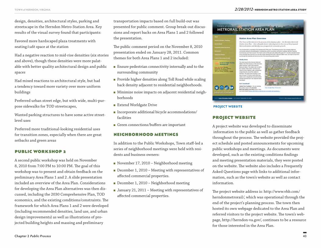
2/28/2012 - HERNDON METRO STATION AREA STUDY
43
TOWN of HERNDON, VIRGINIA
Chapter 2 Public Process
design, densities, architectural styles, parking and streetscape in the Herndon Metro Station Area. Key results of the visual survey found that participants:
Favored more hardscaped plaza treatments with seating/café space at the station
Had a negative reaction to mid-rise densities (six stories and above), though these densities were more palat-able with better quality architectural design and public spaces
Had mixed reactions to architectural style, but had a tendency toward more variety over more uniform buildings
Preferred urban street edge, but with wide, multi-pur-pose sidewalks for TOD streetscapes,
Wanted parking structures to have some active street-level uses
Preferred more traditional-looking residential uses for transition zones, especially when there are great setbacks and green areas
Public Workshop 2A second public workshop was held on November 8, 2010 from 7:00 PM to 10:00 PM. Th e goal of this workshop was to present and obtain feedback on the preliminary Area Plans 1 and 2. A slide presentation included an overview of the Area Plan. Considerations for developing the Area Plan alternatives was then dis-cussed, including the 2030 Comprehensive Plan, TOD economics, and the existing conditions/constraints. Th e framework for which Area Plans 1 and 2 were developed (including recommended densities, land use, and urban design improvements) as well as illustrations of pro-jected building heights and massing and preliminary
transportation impacts based on full build-out was presented for public comment. Group break-out discus-sions and report backs on Area Plans 1 and 2 followed the presentation.
Th e public comment period on the November 8, 2010 presentation ended on January 28, 2011. Common themes for both Area Plans 1 and 2 included:
■ Ensure pedestrian connectivity internally and to the surrounding community
■ Provide higher densities along Toll Road while scaling back density adjacent to residential neighborhoods.
■ Minimize noise impacts on adjacent residential neigh-borhoods
■ Extend Worldgate Drive
■ Incorporate additional bicycle accommodations/facilities
■ Green connections/buff ers are important
Neighborhood MeetingsIn addition to the Public Workshops, Town staff -led a series of neighborhood meetings were held with resi-dents and business owners:
■ November 17, 2010 – Neighborhood meeting
■ December 1, 2010 – Meeting with representatives of aff ected commercial properties.
■ December 1, 2010 – Neighborhood meeting
■ January 21, 2011 – Meeting with representatives of aff ected commercial properties.
Project WebsiteA project website was developed to disseminate information to the public as well as gather feedback throughout the process. Th e website provided the proj-ect schedule and posted announcements for upcoming public workshops and meetings. As documents were developed, such as the existing conditions fi ndings and meeting presentation materials, they were posted on the website. Th e website also includes a Frequently Asked Questions page with links to additional infor-mation, such as the town’s website as well as contact information.
Th e project website address is: http://www.vhb.com/herndonmetrorail/, which was operational through the end of the project’s planning process. Th e town then hosted its own webpage dedicated to the Area Plan and referred visitors to the project website. Th e town’s web-page, http://herndon-va.gov/, continues to be a resource for those interested in the Area Plan.
project website
2/28/2012 - HERNDON METRO STATION AREA STUDY
44
TOWN of HERNDON, VIRGINIA
Chapter 2 Public Process
CONCLUSION
Th rough the various meetings and outreach methods listed above, the Town was able to receive a great deal of public input throughout the planning process. Public comments were reviewed by the Town, which in part lead to the creation of Area Plan alternatives (Area Plans 1 and 2), described in Chapter 5, Alternative Area Plans and the HTOC, described in Chapter 6, Herndon Transit-Oriented Core Plan.
TOWN MEETINGS
Th e Area Plan alternatives were discussed at numerous Planning Commission and Town Council public meet-ings held throughout the planning process between April 2010 and December 2011. Numerous Planning Commission technical work sessions were held. Th ese work sessions were open to the public and discussed the project schedule and scope, goals and objectives, public workshops, alternative area plans, potential impacts and required improvements (i.e., transportation), and fi ndings of the fi nancial analysis.
Four Public Hearings have been held to present the draft Preferred Area Plan. Th ese hearings were held during the months of September, October, and November, 2011. Additional Public Hearings were held in January and February 2012.
A joint work session of the Planning Commission and Town Council was held on January 21, 2011. Based on the results from this joint meeting and related adjust-ments to the Area Plan, the Town Council and Planning Commission decided to reduce the size of the Initial Study Area under study to focus on the areas that are in closest proximity to the future train station loca-tion (discussed further in Chapter 6, Herndon Transit-Oriented Core Plan of this report). Th e planning eff ort was expanded to include a fi nancial and fi scal impact analysis. Th rough further analysis after initial Planning Commission and Town Council reviews, the redevelop-ment focus area was reduced to the HTOC.
Th is page intentionally left blank

2/28/2012 - HERNDON METRO STATION AREA STUDY
45
TOWN of HERNDON, VIRGINIA
Chapter 2 Public Process
Th is page intentionally left blank

Th is page intentionally left blank
47
2/28/2012 - HERNDON METRO STATION AREA STUDYTOWN of HERNDON, VIRGINIA
EXISTINGCONDITIONS
3
2/28/2012 - HERNDON METRO STATION AREA STUDY
48
TOWN of HERNDON, VIRGINIA
Chapter 3 Existing Conditions
PD-B District
Dimensional Requirements
■ Maximum height is 45 feet.
■ Maximum FAR is 0.4.
■ Th e Town Council may permit an increase in height by up to 50 percent and in the FAR by up to 100 percent if the development includes several provisions such as additional open space and structured/underground parking.
■ Th ere is no setback requirement in the PD-B district.
■ A minimum of 20 percent of the gross land area must be open space.
In Herndon, planned development zoning constitutes conditional zoning, as authorized by Code of Virginia, § 15.2-2303, involving the proff er of a predetermined plan of development in return for more fl exible devel-opment regulations in certain instances.
Permitted Uses
A variety of uses are allowed in the PD-B district, including government facilities, institutional uses, res-taurants, offi ces, personal services, pet/animal services, retail sales, scientifi c research and industrial services.
INTRODUCTION
An initial step in preparing this study, as part of the “Discovery” phase, was to identify existing regula-tory context and physical constraints that may aff ect redevelopment of the Herndon Metro Station Area. Consideration of existing conditions (i.e., traffi c conges-tion, natural resources, etc.) allowed the project team to identify the opportunities and challenges for redevelop-ment, and provide recommendations for improvements that may be required in order to support the Area Plan.
Th e summaries of existing conditions contained in this chapter were developed early in the planning process, and as such, are summarized in consideration of the Initial Study Area.
EXISTING ZONING
Th e majority of the Initial Study Area is zoned Offi ce and Light Industrial (O&LI). Part of the Abutting Study Area is zoned Planned Development–Business (PD-B). Th e western edge of the Immediate Station Study Area (west of Monroe Street) is zoned Residential (R10) and Planned Development–Worldgate (PD-W); halfway through the planning process the area west of Van Buren Street was eliminated from the Initial Study Area.
No residential uses exist in the Herndon Metro Station Area. For the planning process of this study , it was assumed that the entire Herndon Metro Station Area would be rezoned to accommodate the uses and vision depicted in the Area Plan. Refer to Figure 3.1 for the existing zoning of the Initial Study Area.
O&LI District
Dimensional Requirements
■ Maximum height is 75 feet or fi ve stories, which-ever is less. For any development within 1,500 feet of the northern boundary of the Dulles Toll Road, a maximum height of 100 feet is permitted by special exception.
■ Minimum setback is 35 feet or building height (height of the tallest building where the setback is required), whichever is greater.
■ Maximum FAR is 0.7. For any development within 1,500 feet of the northern boundary of the Dulles Toll Road, a maximum FAR of 1.0 is permitted by special exception.
■ Minimum open space is 20 percent. For sites using a 1.0 FAR and lying within 1,500 feet of the northern boundary of the Dulles Toll Road, the minimum open space requirement is 50 percent.
Permitted Uses
Permitted uses include offi ces, fi nancial institutions, health care facilities and laboratories, schools of special instruction, product repair and services, artists’ studios, mailing and packaging services, drycleaning pickup and drop-off , electronic warehousing, scientifi c research and development, and other light manufac-turing uses. Many other uses are permitted by special exception such as childcare centers, restaurants, indoor entertainment, animal hospitals and vehicle sales.
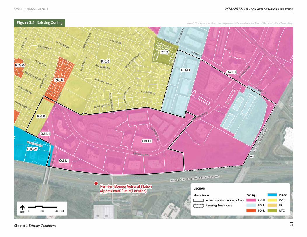
2/28/2012 - HERNDON METRO STATION AREA STUDY
49
TOWN of HERNDON, VIRGINIA
Chapter 3 Existing Conditions
Note(s): Th is fi gure is for illustrative purposes only. Please refer to the Town of Herndon’s offi cial Zoning Map.
SU
NR I S E
V A L L E
7100
SUNRISE VALLEY DR
WORLDGATE DR
FAIR
FAX
COUN
TY P
KWY
DULLES TOLL RD & AIRPO RT ACC ESS HWY
O&LI
O&LI
O&LI
PD-W
PD-BPD-R
PD-R
R-10
RTC
O&LI
R-10
Herndon-Monroe Metrorail Station(Approximate Future Location)
VAN
BURE
N ST
MO
NRO
E ST
EXCHANGE P L
SPRIN G ST
VAN
BURE
N ST
HUNT WAY LA
SPRING STMIS
SOUR
I AV
A LA BA MA DR OLD DOMINION AV
OLD
DO
MINI O
N A V
SPRING ST
CAL HOUN CT
ALABAMA DR
H I LLW
OOD
CT
PEMBERTON CT
STUART CT
COPPER
FIEL
D LA
KEN SINGTON PL
SPRI
NGPA
RK PL
HERN DO N PW
MISSI SSI PP I DR
HE RNDON PW
ALABAMA DR
HERND ON P W
VIRG
INIA
AV AS PE N DR
HERNDON PW
LEGEND
Study Areas
Immediate Station Study Area
Abutting Study Area
Zoning
O&LI
PD-B
PD-R
PD-W
R-10
RM
RTC0 300 600 FeetNORTH
Figure 3.1 | Existing Zoning

2/28/2012 - HERNDON METRO STATION AREA STUDY
50
TOWN of HERNDON, VIRGINIA
Chapter 3 Existing Conditions
Figure 3.2 | Urban Design Issues and Opportunities
not to scale
NORTH
Source(s): City of Herndon GIS, ESRI
LEGEND
Immediate Station Study Area Abutt ing Study Area
Gateways Connections to Downtown
High/Low Points Perennial Streams Environmental Reserve Areas Existing Park Areas Views from Toll Road Future Connections to Metro Future Metro Line Transmission Lines Noise Areas/Buff ers Transitional Areas/Buff ers
2/28/2012 - HERNDON METRO STATION AREA STUDY
51
TOWN of HERNDON, VIRGINIA
Chapter 3 Existing Conditions
URBAN DESIGN
Site design opportunities and challenges for TOD were identifi ed in a series of over-arching themes. Th ese themes are illustrated in Figure 3.2 and were presented at the July 19th, 2010 workshop.
Urban design refers to the way in which the built environment relates to people and the natural environ-ment, rather than the design of specifi c buildings. Th e scale and arrangement of streets, parking lots, utility areas and buildings contribute to a local community’s sense of harmony and identity.
Th e Initial Study Area is divided into two sections. Th e 95-acre Immediate Station Study Area primarily consists of the offi ce park parcels on either side of Herndon Park-way from Van Buren Street east toward Exchange Place. It is bounded by the Dulles Toll Road to the south. Th is area would include the connection point for the Metro Station and would be the primary location for any TOD in the Herndon Metro Station Area. Virtually all of the area on the north side of the toll road within a ¼-mile radius (roughly a fi ve minute walk) is in the Immediate Station Study Area, and all points are within ½-mile (roughly a ten minute walk) of the Metro Station.
Th e 88-acre Abutting Study Area includes properties to the northeast of the Immediate Station Study Area. Th ese are less intense offi ce park uses and include the proposed Fairbrook Business Park, as well as some environmentally-constrained lands. Th is area has some possible TOD development potential as a later phase of redevelopment, but most improvements will be limited to the Immediate Station Study Area.
Herndon Parkway makes a loop around the entire town and runs through the Herndon Metro Station Area. It is a suburban-style parkway with varying median, sidewalk and landscape/streetscape conditions. Within the Initial Study Area, buildings are primarily one- to fi ve-story offi ces setback from the parkway with a consistent 25-foot green area and surface parking. Th e buildings have a range of architectural character and most were built in the last 25 years.
Transmission LinesHigh-tension electrical transmission lines run across the Herndon Metro Station Area east to west, which requires a series of six stanchions. From a functional standpoint, land around the stanchions is needed and uses directly under the wires themselves are limited to parking. Careful consideration will need to be paid to the uses located around these wires and the views and visibility to them from other parts of the Herndon Metro Station Area and surroundings. More informa-tion about the transmission lines is provided below under “Environmental Conditions.”
Haley M. Smith ParkHaley M. Smith Park is located north west of the Herndon Metro Station Area and is a valuable commu-nity amenity. Any master planning for the station area should build upon this park space as part of open space and trail planning. Connections to the park from the Herndon Metro Station Area and the neighborhood will need to be included in the plan alternatives.
Transition Areas/BuffersGiven the proximity of the new Metro Rail Station to the surrounding neighborhoods, there needs to be consideration given to what occurs along the perimeter of the Initial Study Area. A transitional zone contain-ing development, as indicated in Figure 3.2, might have some more signifi cant landscaping and reduced building heights. Th e challenge is providing enough of a buff er to transition, but still maintaining the develop-ment density needed to generate an active and success-ful TOD.
Site VisibilityVisibility is important in establishing an identity for a place. Th e Initial Study Area’s frontage along the Toll Road and proposed rail line has a signifi cant grade change, which gives the Immediate Station Study Area high visibility and prominence. Buildings in this loca-tion will have an opportunity to make an architectural statement and landmark of the Metro Station.
Noise AreasTh e Dulles Toll Road provides excellent access and vis-ibility to the Herndon Metro Station Area; however, the highway is a signifi cant generator of noise. Future buildings and uses located along the Toll Road front-age, specifi cally residential will need to take this into consideration. Strategies for addressing noise impacts on future development include: locating residential uses in upper fl oors and in buildings north of Herndon Parkway; using heavy buff ering and enhanced land-scaping for sound attenuation; and positioning lower tier/podium parking decks of mixed-use buildings along the highway frontage. Sound barrier walls are not envisioned as a noise mitigation measure as part of any future development.
2/28/2012 - HERNDON METRO STATION AREA STUDY
52
TOWN of HERNDON, VIRGINIA
Chapter 3 Existing Conditions
Iredell-Mecklenburg (Soil Number 148) is equally distributed within the Initial Study Area, but is located in the area where the Herndon Metro Promenade would touch down in the Herndon Metro Station Area. Th is soil is highly plastic and poses considerable foundation challenges because footings must extend below the soft sticky plastic clays, generally to bedrock to ensure competent building support. Th is soil type also pre-sents the challenge of perched seasonal high water table and shallow depth to bedrock. Excavations may require blasting in hard bedrock.
Elbert /Iredell Group (Soil Number 52) is generally located in the center of the Initial Study Area, Herndon Parkway generally follows this soil. Elbert is wet plastic clay with seasonal high water table and depth to bed-rock from three to 15 feet. Foundations and footings must extend below the soft plastic clay layer to bedrock. Similar to Iredell-Mecklenburg, Elbert is challenged by the presence of perched seasonal high water table and shallow depth to bedrock and excavations my require blasting. Th is soil can be hydric (containing water) and has the potential for non-tidal wetlands.
Kelly Silt Loam (Soil Number 79) is found mainly in the western part of the Initial Study Area. As with the other predominate soils, Kelly Silt Loam is has a thin plastic clay layer overlying bedrock, seasonally high water table and a rather shallow depth to bedrock of two to eight feet. Its foundation support is rather poor because the bedrock disintegrates rapidly if used in engineered fi ll.
Th e Town of Herndon and the Herndon Metro Station Area are located in what is called the Triassic (Culpeper) Basin. Th e geology consists largely of red sedimentary (sandstone, siltstone, shale and conglomerate) rocks. Th e hilltops are wide and gently rolling, with long gen-tly sloping side slopes and nearly level areas. Th e soils over the red sedimentary rocks are often shallow (2 to 10 feet deep to bedrock). Large fl at areas are often slowly permeable and poorly drained. Soils forming over the igneous bedrock have a distinct plastic clay layer.
Approximately 80 percent of the Initial Study Area soils are categorized as Iredell-Mecklenburg, Elbert and Kelly Silt Loam. Small amounts of other soils exist, in-cluding: Croton, Mixed Alluvial, and Very Rock Iredell complex. While the information presented below is not based on soil borings on potential sites, the issues iden-tifi ed should be considered in the planning and even-tual construction of higher density uses and structures such as parking garages or structure over three stories.
■ Excavation for underground parking will be impacted by potential shallow bedrock within most of the Herndon Metro Station Area especially between the Herndon Parkway and Dulles Toll Road. Construction of such structures will result in premium construction cost.
■ Foundations for multi-story structures may require piles or other structural premiums necessary to overcome the poor foundation characteristics of the underlying soils. Development of high rise structures within the Herndon Metro Station Area should antici-pate construction cost above what may be typical.
■ Development must accommodate the need for a premium construction cost for drainage control espe-cially in excavations.
Gateways and AccessTh ere are several key locations on the perimeter of the Herndon Metro Station Area that serve as primary ac-cess points to the new Metro Station. Gateways include: the entrance to Herndon Parkway at Van Buren Street, the intersection of Van Buren Street and Worldgate Drive, and the intersection of Herndon Parkway and Spring Street to the east. Th ese are places to establish gateways to the Metro Station, marking the Herndon Metro Station Area to passers-by. Th ese are also loca-tions where pedestrian access and transit connections will need to be improved to help to service a truly walkable TOD and give commuters other options to get to the station. Pedestrian safety is a key issue at these access points, particularly the challenges with crossing Monroe Street.
ENVIRONMENTAL CONDITIONS
Figure 3.3 highlights the existing environmental conditions and constraints, which are described in the following sections.
Soil Types and ConditionsSoil conditions within the Initial Study Area were evaluated by reviewing existing data sources including Fairfax County, National Resources Soil Conservation Services (NRCS), and the Northern Virginia Soil and Water Conservation District (NVSWCD). In addition, as-built plans and site plans for existing development were reviewed for soil information that may impact future development potential.
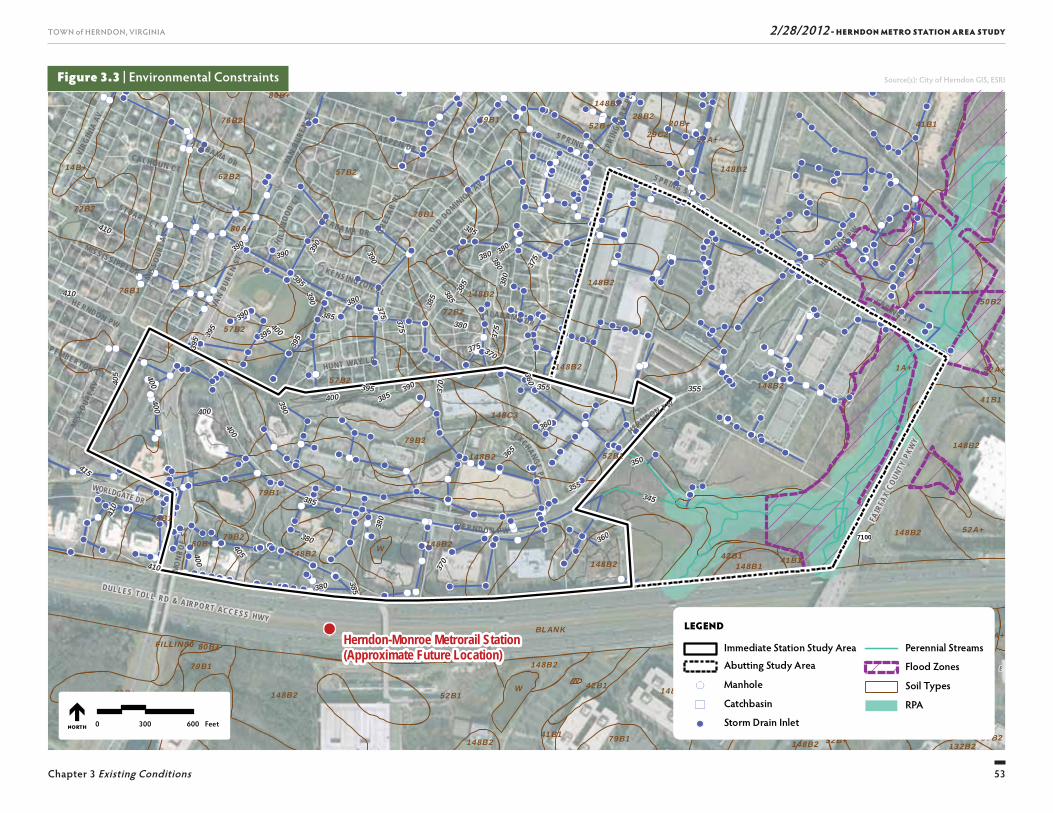
2/28/2012 - HERNDON METRO STATION AREA STUDY
53
TOWN of HERNDON, VIRGINIA
Chapter 3 Existing Conditions
Source(s): City of Herndon GIS, ESRI
SU
NR I S E
V A L L E
7100
SUNRISE VALLEY DR
WORLDGATE DR
FAIR
FAX
COUN
TY P
KWY
DULLES TOLL RD & AIRPO RT ACC ESS HWY
Herndon-Monroe Metrorail Station(Approximate Future Location)
VAN
BURE
N ST
MO
NRO
E ST
EXCHANGE P L
SPRIN G ST
VAN
BURE
N ST
HUNT WAY LA
SPRING STM
ISSO
URI A
V
AL A BA M A DR OLD DOMINION AV
SPRING ST
CAL HOUN CT
ALABAMA DR
GREE
AR PL
MISSO
URI A
V
H I LLW
OOD
CT
PEMBERTON CT
STUART CT
KEN SINGTON PL
SPRI
NGPA
RK PL
HERN DO N PW
MISSI SSI PP I DR
HERNDO N PW
ALABAMA DR
HERNDON PW
VIRG
INIA
AV
AS PE N DR
HERNDON PW
410 385
390
410
370
385380
380
360
390
385
390 375
380
400
400
405
360
390
390
370
355
385
375
380
375
400
380
385
410
355
380
400
400
355
385
375
380
385
380
365
395
405
370
360
395
385
395
395
400
390
390
380
375
400
390
385
415
395
350
410
345
80A+
76B1
52A+
72B2
79B1
148B2
148B2
80B+
20B+29C2
28B276B2 52B+
14B+62B2 57B2
50B2
148B2148B2
148B2
72B2
57B2
148B257B2
41B1
52A+
79B2
148C3
148B2148B2
79B2W
52B+148B1
W80B+
78A+
W
148B2
79B152B+
52B+41B1
148B2148B2 132B2
1A+
76B1
52B1
80B+
76B1
42B1 41B1148B1
57B2
148B2FILLIN80
79B1
52A+76B1
148B2
148B2148B2
148B2
1A+
41B1
148B1
80B+
148B242B1
52B1
148B2
BLANK
41B1
79B1
52A+
79B1
LEGEND
Immediate Station Study Area
Abutting Study Area
Manhole
Catchbasin
Storm Drain Inlet
Perennial Streams
Flood Zones
Soil Types
RPA
0 300 600 FeetNORTH
Figure 3.3 | Environmental Constraints
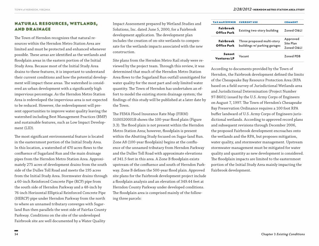
2/28/2012 - HERNDON METRO STATION AREA STUDY
54
TOWN of HERNDON, VIRGINIA
Chapter 3 Existing Conditions
Tax Map/Owner Current Use Comment
Fairbrook Office Park Existing two-story building Zoned O&LI
Fairbrook Office Park
Three proposed multi-story buildings w/ parking garages
Approved Site PlanZoned O&LI
Sunset Ventures LP Vacant Zoned PDB
According to documents provided by the Town of Herndon, the Fairbrook development defi ned the limits of the Chesapeake Bay Resource Protection Area (RPA based on a fi eld survey of Jurisdictional Wetlands area and Jurisdictional Determination (Project Number 97-B601) issued by the U.S. Army Corps of Engineers on August 7, 1997. Th e Town of Herndon’s Chesapeake Bay Preservation Ordinance requires a 100 foot RPA buff er landward of U.S. Army Corps of Engineers juris-dictional wetlands. According to approved record plans and subsequent revisions through December 2006, the proposed Fairbrook development encroaches onto the wetlands and the RPA, but proposes mitigation, water quality, and stormwater management. Upstream stormwater management must be mitigated for water quality and quantity as new development is considered. Th e fl oodplain impacts are limited to the easternmost portion of the Initial Study Area mainly impacting the Fairbrook development.
Impact Assessment prepared by Wetland Studies and Solutions, Inc. dated June 5, 2000, for a Fairbrook development application. Th e development plan includes the creation of on-site wetlands to compen-sate for the wetlands impacts associated with the new construction.
Site plans from the Herndon Metro Rail study were re-viewed by the project team. Th rough this review, it was determined that much of the Herndon Metro Station Area fl ows to the Sugarland Run outfall unmitigated for water quality for the most part and only limited water quantity. Th e Town of Herndon has undertaken an ef-fort to model the existing storm drainage system; the fi ndings of this study will be published at a later date by the Town.
Th e FEMA Flood Insurance Rate Map (FIRM) 5100520001B shows the 100-year fl ood plain (Figure 3.3). Th e fl ood plain is not present within the Herndon Metro Station Area; however, fl oodplain is present within the Abutting Study focused on Sugar-land Run. Zone A8 (100-year fl oodplain) begins at the confl u-ence of the unnamed tributary from Herndon Parkway and the Dulles Toll Road with approximate elevations of 341.5 feet in this area. A Zone B fl oodplain exists upstream of the confl uence and south of Herndon Park-way. Zone B defi nes the 500-year fl ood plain. Approved site plans for the Fairbrook development project include a fl oodplain analysis and an elevation of 349.44 feet at Herndon County Parkway under developed conditions. Th e fl oodplain area is comprised mainly of the follow-ing three parcels:
Natural Resources, Wetlands, and DrainageTh e Town of Herndon recognizes that natural re-sources within the Herndon Metro Station Area are limited and must be protected and enhanced whenever possible. Th ese areas are identifi ed as the wetlands and fl oodplain areas in the eastern portion of the Initial Study Area. Because most of the Initial Study Area drains to these features, it is important to understand their current conditions and how the potential develop-ment will impact these areas. Th e watershed is consid-ered an urban development with a signifi cantly high impervious percentage. As the Herndon Metro Station Area is redeveloped the impervious area is not expected to be reduced. However, the redevelopment will pre-sent opportunities to improve water quality leaving the watershed including Best Management Practices (BMP) and sustainable features, such as Low Impact Develop-ment (LID).
Th e most signifi cant environmental feature is located in the easternmost portion of the Initial Study Area. In this location, a watershed of 470 acres fl ows to the confl uence of Sugarland Run and the main drainage pipes from the Herndon Metro Station Area. Approxi-mately 275 acres of development drains from the south side of the Dulles Toll Road and meets the 195 acres from the Initial Study Area. Stormwater drains through a 60-inch Reinforced Concrete Pipe (RCP) pipe from the south side of Herndon Parkway and a 48-inch by 76-inch Horizontal Elliptical Reinforced Concrete Pipe (HERCP) pipe under Herndon Parkway from the north to where an unnamed tributary converges with Sugar-land Run then parallels the west side of Fairfax County Parkway. Conditions on the site of the undeveloped Fairbrook site are well documented by a Water Quality
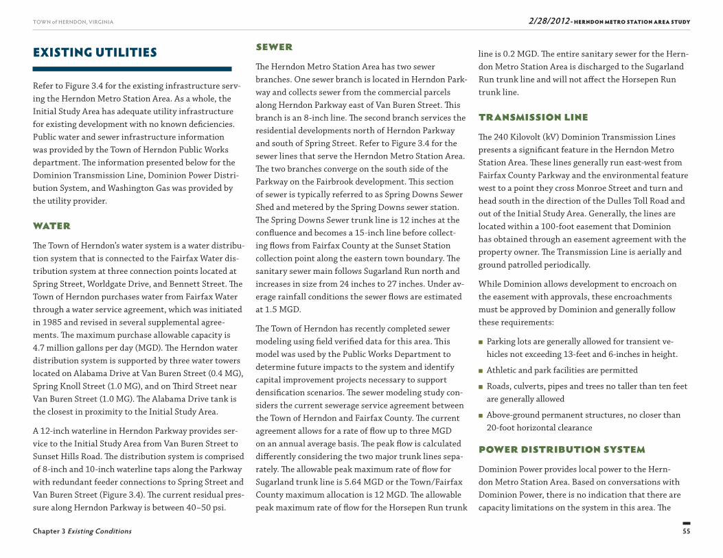
2/28/2012 - HERNDON METRO STATION AREA STUDY
55
TOWN of HERNDON, VIRGINIA
Chapter 3 Existing Conditions
line is 0.2 MGD. Th e entire sanitary sewer for the Hern-don Metro Station Area is discharged to the Sugarland Run trunk line and will not aff ect the Horsepen Run trunk line.
Transmission LineTh e 240 Kilovolt (kV) Dominion Transmission Lines presents a signifi cant feature in the Herndon Metro Station Area. Th ese lines generally run east-west from Fairfax County Parkway and the environmental feature west to a point they cross Monroe Street and turn and head south in the direction of the Dulles Toll Road and out of the Initial Study Area. Generally, the lines are located within a 100-foot easement that Dominion has obtained through an easement agreement with the property owner. Th e Transmission Line is aerially and ground patrolled periodically.
While Dominion allows development to encroach on the easement with approvals, these encroachments must be approved by Dominion and generally follow these requirements:
■ Parking lots are generally allowed for transient ve-hicles not exceeding 13-feet and 6-inches in height.
■ Athletic and park facilities are permitted
■ Roads, culverts, pipes and trees no taller than ten feet are generally allowed
■ Above-ground permanent structures, no closer than 20-foot horizontal clearance
Power Distribution SystemDominion Power provides local power to the Hern-don Metro Station Area. Based on conversations with Dominion Power, there is no indication that there are capacity limitations on the system in this area. Th e
SewerTh e Herndon Metro Station Area has two sewer branches. One sewer branch is located in Herndon Park-way and collects sewer from the commercial parcels along Herndon Parkway east of Van Buren Street. Th is branch is an 8-inch line. Th e second branch services the residential developments north of Herndon Parkway and south of Spring Street. Refer to Figure 3.4 for the sewer lines that serve the Herndon Metro Station Area. Th e two branches converge on the south side of the Parkway on the Fairbrook development. Th is section of sewer is typically referred to as Spring Downs Sewer Shed and metered by the Spring Downs sewer station. Th e Spring Downs Sewer trunk line is 12 inches at the confl uence and becomes a 15-inch line before collect-ing fl ows from Fairfax County at the Sunset Station collection point along the eastern town boundary. Th e sanitary sewer main follows Sugarland Run north and increases in size from 24 inches to 27 inches. Under av-erage rainfall conditions the sewer fl ows are estimated at 1.5 MGD.
Th e Town of Herndon has recently completed sewer modeling using fi eld verifi ed data for this area. Th is model was used by the Public Works Department to determine future impacts to the system and identify capital improvement projects necessary to support densifi cation scenarios. Th e sewer modeling study con-siders the current sewerage service agreement between the Town of Herndon and Fairfax County. Th e current agreement allows for a rate of fl ow up to three MGD on an annual average basis. Th e peak fl ow is calculated diff erently considering the two major trunk lines sepa-rately. Th e allowable peak maximum rate of fl ow for Sugarland trunk line is 5.64 MGD or the Town/Fairfax County maximum allocation is 12 MGD. Th e allowable peak maximum rate of fl ow for the Horsepen Run trunk
EXISTING UTILITIES
Refer to Figure 3.4 for the existing infrastructure serv-ing the Herndon Metro Station Area. As a whole, the Initial Study Area has adequate utility infrastructure for existing development with no known defi ciencies. Public water and sewer infrastructure information was provided by the Town of Herndon Public Works department. Th e information presented below for the Dominion Transmission Line, Dominion Power Distri-bution System, and Washington Gas was provided by the utility provider.
WaterTh e Town of Herndon’s water system is a water distribu-tion system that is connected to the Fairfax Water dis-tribution system at three connection points located at Spring Street, Worldgate Drive, and Bennett Street. Th e Town of Herndon purchases water from Fairfax Water through a water service agreement, which was initiated in 1985 and revised in several supplemental agree-ments. Th e maximum purchase allowable capacity is 4.7 million gallons per day (MGD). Th e Herndon water distribution system is supported by three water towers located on Alabama Drive at Van Buren Street (0.4 MG), Spring Knoll Street (1.0 MG), and on Th ird Street near Van Buren Street (1.0 MG). Th e Alabama Drive tank is the closest in proximity to the Initial Study Area.
A 12-inch waterline in Herndon Parkway provides ser-vice to the Initial Study Area from Van Buren Street to Sunset Hills Road. Th e distribution system is comprised of 8-inch and 10-inch waterline taps along the Parkway with redundant feeder connections to Spring Street and Van Buren Street (Figure 3.4). Th e current residual pres-sure along Herndon Parkway is between 40–50 psi.
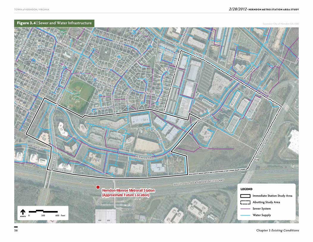
2/28/2012 - HERNDON METRO STATION AREA STUDY
56
TOWN of HERNDON, VIRGINIA
Chapter 3 Existing Conditions
SU
NR I S E
V A L L E
7100
SUNRISE VALLEY DR
WORLDGATE DR
FAIR
FAX
COUN
TY P
KWY
DULLES TOLL RD & AIRPO RT ACC ESS HWY
BruinBruinParkPark
HaleyHaleySmithSmithParkPark
Herndon-Monroe Metrorail Station(Approximate Future Location)
VAN
BURE
N ST
MO
NRO
E ST
EXCHANGE P L
SPRIN G ST
VAN
BURE
N ST
HUNT WAY LA
SPRING STMIS
SOUR
I AV
AL A BA M A DR OLD DOMINION AV
OLD
DO
MINI O
N A V
SPRING ST
CAL HOUN CT
ALABAMA DR
GREE
AR PL
H I LLW
OOD
CT
PEMBERTON CT
STUART CT
COPPER
FIEL
D LA
KEN SINGTON PL
SPRI
NGPA
RK PL
HERN DO N PW
MISSI SSI PP I DR
HE RNDON PW
ALABAMA DR
HERND ON P W
VIRG
INIA
AV AS PE N DR
HERNDON PW
LEGEND
Immediate Station Study Area
Abutting Study Area
Sewer System
Water Supply0 300 600 FeetNORTH
Figure 3.4 | Sewer and Water Infrastructure Source(s): City of Herndon GIS, ESRI
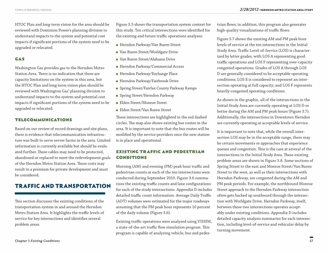
2/28/2012 - HERNDON METRO STATION AREA STUDY
57
TOWN of HERNDON, VIRGINIA
Chapter 3 Existing Conditions
trian fl ows; in addition, this program also generates high-quality visualizations of traffi c fl ows.
Figure 3.7 shows the existing AM and PM peak hour levels of service at the ten intersections in the Initial Study Area. Traffi c Level-of-Service (LOS) is character-ized by letter grades, with LOS A representing good traffi c operations and LOS F representing over-capacity congested operations. Grades of LOS A through LOS D are generally considered to be acceptable operating conditions; LOS E is considered to represent an inter-section operating at full capacity; and LOS F represents heavily-congested operating conditions.
As shown in the graphic, all of the intersections in the Initial Study Area are currently operating at LOS D or better during the AM and PM peak hours (Figure 3.7). Additionally, the intersections in Downtown Herndon are currently operating at acceptable levels of service.
It is important to note that, while the overall inter-section LOS may be in the acceptable range, there may be certain movements or approaches that experience queues and congestion. Th is is the case at several of the intersections in the Initial Study Area. Th ese existing problem areas are shown in Figure 3.8. Some sections of Spring Street to the east and Monroe Street/Van Buren Street to the west, as well as their intersections with Herndon Parkway, are congested during the AM and PM peak periods. For example, the northbound Monroe Street approach to the Herndon Parkway intersection often gets backed up southward through the intersec-tion with Worldgate Drive. Herndon Parkway, itself, between these two intersections operates accept-ably under existing conditions. Appendix D includes detailed capacity analysis summaries for each intersec-tion, including level-of-service and vehicular delay by turning movement.
Figure 3.5 shows the transportation system context for this study. Ten critical intersections were identifi ed for the existing and future traffi c operations analyses:
■ Herndon Parkway/Van Buren Street
■ Van Buren Street/Worldgate Drive
■ Van Buren Street/Alabama Drive
■ Herndon Parkway/Commercial Access
■ Herndon Parkway/Exchange Place
■ Herndon Parkway/Fairbrook Drive
■ Spring Street/Fairfax County Parkway Ramps
■ Spring Street/Herndon Parkway
■ Elden Street/Monroe Street
■ Elden Street/Van Buren Street
Th ese intersections are highlighted in the red dashed circles. Th e map also shows existing bus routes in the area. It is important to note that the bus routes will be modifi ed by the service providers once the new station is in place and operational.
Existing Traffic and Pedestrian ConditionsMorning (AM) and evening (PM) peak hour traffi c and pedestrian counts at each of the ten intersections were conducted during September 2010. Figure 3.6 summa-rizes the existing traffi c counts and lane confi gurations for each of the study intersections. Appendix D includes detailed traffi c count information. Average Daily Traffi c (ADT) volumes were estimated for the major roadways assuming that the PM peak hour represents 10 percent of the daily volume (Figure 3.6).
Existing traffi c operations were analyzed using VISSIM, a state-of-the-art traffi c fl ow simulation program. Th is program is capable of analyzing vehicle, bus and pedes-
HTOC Plan and long-term vision for the area should be reviewed with Dominion Power’s planning division to understand impacts to the system and potential cost impacts if signifi cant portions of the system need to be upgraded or relocated.
GasWashington Gas provides gas to the Herndon Metro Station Area. Th ere is no indication that there are capacity limitations on the system in this area, but the HTOC Plan and long-term vision plan should be reviewed with Washington Gas’ planning division to understand impacts to the system and potential cost impacts if signifi cant portions of the system need to be upgraded or relocated.
TelecommunicationsBased on our review of record drawings and site plans, there is evidence that telecommunication infrastruc-ture was built to serve server farms in the area. Limited information is currently available but should be evalu-ated further. Th ese cables may need to be protected, abandoned or replaced to meet the redevelopment goals of the Herndon Metro Station Area. Th ese costs may result in a premium for private development and must be considered.
TRAFFIC AND TRANSPORTATION
Th is section discusses the existing conditions of the transportation system in and around the Herndon Metro Station Area. It highlights the traffi c levels of service for key intersections and identifi es several problem areas.
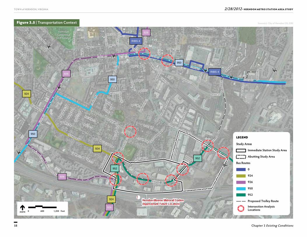
2/28/2012 - HERNDON METRO STATION AREA STUDY
58
TOWN of HERNDON, VIRGINIA
Chapter 3 Existing Conditions
!
926
926
952
952
RIBS 4
950
924
924
950
RIBS 4
926
924
950
926HerndonHerndonCentennialCentennialGolf CourseGolf Course
Herndon-Monroe Metrorail Station(Approximate Future Location)
EL DE N ST
VAN
B UREN
ST
GRA
NT
ST
L EO N A L A
L O CU ST ST
MAGNOL IA LA
PALM ER D R
NA SH S T
E LD EN ST
HUN T WAY LA
S P R ING S T
E LD EN S T
MO
N RO
E ST
MI S
SOU R
I AV
C A MPB ELL W YVA
N BU
REN
ST
N AS H S T
A L A B AMA DR
MONRO E S T
OLD DOM INI ON
AVJA
CKSO
N S T
V AN
B UREN
ST
SPR ING S T
V I R GINIA AV
ALA B A MA D R
M AD I SON ST
LY NN
ST
MI S
SOUR
I AV
AD AM S S T
HAL E Y P L
FLORI
D A AV
V I NE S T
ER IC C T
FAIRFA
X LA
O AK S T
AUTUM N P L
MAI
N D
RFI
FTH
ST
B R U C E C T
A R C H ER C T
SUMMERF IELD D R
P EARL ST
CENT
ER ST
SPRING S T
GRA
CE
ST
L O CUS T ST
VI NE S T
LAUR
EL W
Y
MI SS ISS IPP I D R
H E R ND O N PW
AUSTIN L A
E L D E N S T
DAK
OT A D R
ELDEN
S T
HER NDO N P W
W O O D ST
WO RLDGATE D R
A LA B A MA DR
CORAL RDHER
ND
ON
PW
CA R
L IS L
E D
R
C ENT
ER S T
H ERN DON PW
POST
D R
M A D I SO N FO RES T DR
SPR I
NGPA
RK P LH U NT
MAR
PARK
DR
PICK
ETT
LA
PAT R
ICK
L AFE
RND
ALE
A V
STE RL ING RD
E L D E N S T
G ROV E ST
ARKANS AS
AV
W ILSH IRE DR
A S PE N D R
G ROVE S T
WOR L DGAT E DR
H ERNDON PW
H ER N D O N P W
UV7100
UV7100
UV606
UV228
UV606
UV606
UV228
UV228
0 600 1,200 FeetNORTH
LEGEND
Study Areas
Immediate Station Study Area
Abutting Study Area
Bus Routes
0
924
926
952
Proposed Trolley Route
Intersection Analysis Locations
950
Figure 3.5 | Transportation Context Source(s): City of Herndon GIS, ESRI
2/28/2012 - HERNDON METRO STATION AREA STUDY
59
TOWN of HERNDON, VIRGINIA
Chapter 3 Existing Conditions
Herndon-Monroe Metrorail Station(Approximate Future Location)
CENT
ER S T
VAN
BURE
N ST
GR
ANT
ST
LO C UST S T
PALMER D R
NAS H ST
E LD EN ST
HUN T WAY LA
SP RIN G ST
EL DE N STM
ISS O
URI A
V
MO
NR O
E ST
FL
ORIDA AV
C AM PB ELL W Y
VAN
BUR EN
S T
GRA
CE ST
NA SH S T
STAT
I ON
ST
A L A B AMA D R
MONR O E ST
OLD DOM IN IO N
AVJ A
CK S
ON
S T
VAN
B UREN
ST
CEN TER ST
S PRING ST
V I R GINIA AV
EL DE N ST
AL AB A M A D R
FLORI
DA AV
MISSO
URI A
V
ADA M S ST
H AL EY PL M AD IS O N ST
V IN E ST
HE R N D ON PW
ER I C C T
PI NE ST
JONQ
U IL
L A
FAI RF AX
L A
O AK ST
MAI
N DR
HERN DON P W
FIFT
H ST
B RU C E C T
A R C H ER CT
PEARL
ST
E L DE N S T
SPR IN G S T
LO C UST S T
V IN E ST
LAUR
EL W
Y
M ISS ISS IPP I D R
AUSTIN LA
GRA
NT S T
E L D E N S T
DAK
OT A D R
LE
O N A LA
HERN DO N PW
W O O D S T
W O R L DG AT E D R
A LA B A M A DR
LYNN
ST
CO RAL RD
HE R N DO N PW
HERN
DO
N PW
C AR L
I SL E
DR
HE RN DO N PW
POS T
DR
FERN
D ALE
AV
SPR I
NGPA
RK PLH UN
TMAR
PARK
DR
STE RL ING R D
PICK
ETT
L A
PATR
ICK
LA
E L D E N S T
G ROV E ST
ARKANSA
S AV
AS P E N D R
G ROV E ST
M ADI S ON ST
H ER ND ON PW
606
7100
7100228
228
606
606
0 600 1,200 FeetNORTH
LEGEND
Immediate Station Study Area
Abutting Study Area
Intersection Analysis Locations
Figure 3.6 | Existing Traffic Counts and Lane Configurations Source(s): City of Herndon GIS, ESRI
10
11 33 44 55
22 66 77
99
88
80 (32)
8 (36)3 (22)
300 (87)6 (58)
87 (116)
138 (74)8 (9)
269 (323)
42 (6)
665 (382)
9 (26)4 (22)
6 (36)16 (15)
60 (56)21 (35)
662 (552)
87 (17)
15 (106)3 (7)
28 (2)126 (448)
45 (9)
10 (63) 4 (25)
18 (11)
208 (282)
4 (54)
46 (49)127 (67)
26 (3) 77 (251)
110 (31)
72 (121) 9 (11)
21 (8)
22 (75)220 (291)
335 (452)
292 (418)0 (0) 0 (0)
0 (0)94 (87)
207 (111)0 (0)
273 (188)
478 (895)
187 (294)
229 (331)0 (0)
0 (0)41 (110)
97 (229)0 (0)
258 (257)
877 (660)
150 (645)6 (14)
656 (875)384 (987)
431 (1,075)
385 (578) 358 (561)
607 (867)
515 (503)
2 (37)
646 (225)6 (17)
1,095 (881) 1,080 (654)
1,190 (708)
580 (468) 594 (629)
1,083 (854)
495 (442)47 (7)
34 (38)
31 (79)1 (13)
911 (458)3 (71)
60 (91)
21 (18)4 (7)
33 (37)
205 (221)
249 (359)
8 (91)5 (29)
1 (26)47 (129)
38 (110)22 (26)
62 (55)
296 (237)
248 (484)26 (20)
43 (8)0 (0)
41 (3)
8 (20) 131 (123)
34 (20)
534 (645)
4 (70)
192 (188)131 (84)
26 (5) 232 (445)
11 (1)
95 (35) 55 (53)
8 (12)
34 (72)92 (428)
Herndon PkwyHerndon Pkwy
Worldgate DrWorldgate Dr
Alabama DrAlabama Dr Herndon PkwyHerndon Pkwy Herndon PkwyHerndon Pkwy
Spring StSpring St
Elden StElden StElden StElden St
Spring StSpring St
Van
Bure
n St
Van
Bure
n St
Van
Bure
n St
Van
Bure
n St
Van
Bure
n St
Van
Bure
n St
Exch
ange
Pl
Exch
ange
Pl
Mon
roe S
tM
onro
e St
Fairf
ax C
ount
y Pkw
ay R
amps
Fairf
ax C
ount
y Pkw
ay R
amps
9
3
1
2 4 5
6
7
8
1010
Fairb
rook
Dr
Fairb
rook
Dr
Driv
eway
Driv
eway
Hern
don
Pkwy
Hern
don
Pkwy
Van
Bure
n St
Van
Bure
n St
Herndon PkwyHerndon Pkwy
21,590 vpd21,590 vpd
18,890 vpd18,890 vpd
27,470 vpd27,470 vpd
AM(PM) Peak Hour Traffi c
Daily Traffi c (Vehicles Per Day)#,####,###XX (XX)
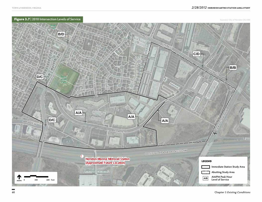
2/28/2012 - HERNDON METRO STATION AREA STUDY
60
TOWN of HERNDON, VIRGINIA
Chapter 3 Existing Conditions
Figure 3.7 | 2010 Intersection Levels of Service
!
SU
NR I S E
V A L L E
UV7100
SUNRISE VALLEY DR
WORLDGATE DR
FAIR
FAX
COUN
TY P
KWY
DULLES TO LL R D & AIR PORT ACC ESS H WY
!
B/B
!
C/D
!
A/A!
A/A
!
A/A
!
D/C
!
D/C
!
B/D
BruinBruinParkPark
HaleyHaleySmithSmithParkPark
Herndon-Monroe Metrorail Station(Approximate Future Location)
VAN
BURE
N ST
MO
NRO
E ST
SP RING STVA
N BU
REN
ST
HUNT WAY LA
SPRING STMIS
SOUR
I AV
AL A BA M A DR OLD DOMINION AV
OLD
DO
MINI O
N A V
SPRING ST
CAL HOUN CT
ALABAMA DR
GREE
AR PL
H I LLW
OOD
CT
PEMBERTON CT
STUART CT
COPPER
FIEL
D LA
KEN SINGTON PL
SPRI
NGPA
RK PL
HERN DO N PW
MISSI SSI PP I DR
HE RNDON PW
ALABAMA DR
HERND ON P W
VIRG
INIA
AV AS PE N DR
HERNDON PW
0 300 600 Feet
LEGEND
Immediate Station Study Area
Abutting Study Area
AM/PM Peak Hour Level of ServiceA/B
NORTH
Source(s): City of Herndon GIS, ESRI
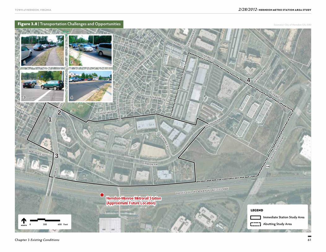
2/28/2012 - HERNDON METRO STATION AREA STUDY
61
TOWN of HERNDON, VIRGINIA
Chapter 3 Existing Conditions
SU
NR I S E
V A L L E
7100
SUNRISE VALLEY DR
WORLDGATE DR
FAIR
FAX
COUN
TY P
KWY
DULLES TOLL RD & AIRPO RT ACC ESS HWY
BruinBruinParkPark
HaleyHaleySmithSmithParkPark
Herndon-Monroe Metrorail Station(Approximate Future Location)
VAN
BURE
N ST
MO
NRO
E ST
EXCHANGE P L
SPRIN G ST
VAN
BURE
N ST
HUNT WAY LA
SPRING STMIS
SOUR
I AV
AL A BA M A DR OLD DOMINION AV
OLD
DO
MINI O
N A V
SPRING ST
CAL HOUN CT
ALABAMA DR
GREE
AR PL
H I LLW
OOD
CT
PEMBERTON CT
STUART CT
COPPER
FIEL
D LA
KEN SINGTON PL
SPRI
NGPA
RK PL
HERN DO N PW
MISSI SSI PP I DR
HE RNDON PW
ALABAMA DR
HERND ON P W
VIRG
INIA
AV AS PE N DR
HERNDON PW
LEGEND
Immediate Station Study Area
Abutting Study Area0 300 600 FeetNORTH
Figure 3.8 | Transportation Challenges and Opportunities
11
11
22
22
33
33 44
44
Source(s): City of Herndon GIS, ESRI

Th is page intentionally left blank

63
2/28/2012 - HERNDON METRO STATION AREA STUDYTOWN of HERNDON, VIRGINIA
DEVELOPMENT OPPORTUNITIES
4
2/28/2012 - HERNDON METRO STATION AREA STUDY
64
TOWN of HERNDON, VIRGINIA
Chapter 4 Development Opportunities
TRANSIT-ORIENTATEDDEVELOPMENT ECONOMICS
Literary Search and GeneralExperienceFrom an economic standpoint, it is important that the densities and land uses allowed in the Herndon Metro Station Area generate transit riders, contribute to a sense of place, and synergistically support one another. To provide observations about future densities and land uses in the station area, the project team reviewed guid-ance from leading TOD organizations as well as utilized its past experience.
Top Sources Consulted
Th e following industry leaders in real estate devel-opment and TOD were consulted:
■ Urban Land Institute
■ Transportation Research Board
■ Center for Transit-Oriented Development
■ Federal Transit Administration
■ American Public Transportation Association
Th e project team’s institutional knowledge of TOD, gained from experience in the fi eld, was also utilized in order to provide recommendations to the Town.1
INTRODUCTION
An important component of the “Discovery” phase was gaining an understanding of TOD from an economic standpoint. Th e densities and land uses allowed in a TOD help in setting the framework for development, supporting transit ridership, promoting a sense of place, and providing synergies that supports the development of other uses in the area.
Observations that informed the identifi cation of development opportunities and, thus, the evolution of the HTOC Plan were drawn from multiple sources, including:
■ An industry literature review;
■ Case study evaluations; and
■ Interviews with existing property owners.
Best practices from TOD industry literature, the lessons learned from the case studies, and the input from the property owners were considered along with the project team’s general experience with TOD to provide ob-servations about future densities and land uses in the Herndon Metro Station Area. Four existing station area case studies were evaluated. Th ese included: Clarendon, Arlington, Virginia; Silver Spring, Maryland; Prince George’s Plaza, Maryland; and Wheaton, Maryland. Eight major commercial property owners or their repre-sentatives were interviewed in an eff ort to understand the likelihood of redevelopment of commercial proper-ties in the area closet to the Metro Station. An overview of the process related to each of these tasks is provided below. Th e technical memoranda prepared as part of these tasks are provided in Appendix B.
Density
TOD industry literature suggests a range of threshold densities to support transit ridership. Such threshold densities include 12 to 30 dwelling units per acre and a FAR of 1.0 to 3.0. Th e range of TOD densities docu-mented in the case study evaluation (discussed further below) includes FARs of 0.5 to 6.5 (with the 0.5 FAR equal to approximately 15 dwelling units per acre).
While threshold densities can be achieved through by-right zoning, they can also be reached through bonus density provisions. Local governments often provide bonus density in exchange for the provision of uses in the public benefi t. For example, several jurisdictions of-fer density bonuses in exchange for aff ordable housing; these density bonuses generally range from 25 to 35 percent above base allowable density.
Land Uses and Critical MassHaving diff erent uses – especially residential, retail, and offi ce – will result in more activity at diff er-ent times of the day as well as more activity on both weekdays and weekends. Th e synergies of a mix of uses can also result in opportunities for shared parking; for example, an offi ce use that is busy during weekdays but not on nights and weekends might share parking with a retail use that is mainly patronized in the evenings and weekends.
A mix of uses can also contribute to a sense of place and the creation of a destination more readily than an area dominated by a single use. Th e presence of retail shops and restaurants can serve as an amenity for offi ce uses, making an area more attractive for employers and their employees. Such amenities are also important to attracting residents to a transit area.
1. BBP is a recognized leader in TOD investment. Th e fi rm has conducted economic and market evaluation on behalf of the public sector, and facilitated retail-oriented TOD throughout the nation.
2/28/2012 - HERNDON METRO STATION AREA STUDY
65
TOWN of HERNDON, VIRGINIA
Chapter 4 Development Opportunities
Observations and RecommendationsRelevant to Herndon (Prior to theFinancial and Fiscal Impact Analysis)
Th e following discusses lessons drawn and recommen-dations for Herndon based on industry literature, case study research, and discussions with property owners.
Density Based on the industry literature, the case study re-search, and a general review of existing conditions in the station area, it was recommended that the Town consider a minimum average for the area between 3.0 to 4.0 FAR and refi ne these FARs through fi nancial and fi scal testing. Th is range of densities represented an in-crease of approximately ten times higher than current average densities.
As discussed in Chapter 3, Existing Conditions, cur-rently two zoning districts apply to the Initial Study Area: O & LI; and PD. Th e maximum FAR permitted in these districts is 0.7 in the O & LI district and 0.4 in the PD-B district. Actual densities are generally less dense than those allowed in these districts, though a range of densities is apparent in the Initial Study Area.
Th is range (3.0 to 4.0 FAR) was specifi ed prior to a fi -nancial feasibility evaluation for the Initial Study Area. Th is range of densities was identifi ed as a starting point prior to such analysis, providing the following general observations about future densities along with this recommended range:
■ Densities will have to increase at least above their cur-rent levels for redevelopment to occur.
■ Properties with more intense existing development will require higher densities to redevelop than those with less intense existing development.
■ Actions that reduce developable acreage – such as public plazas, public parking, public right-of-ways, etc. – will require allowance for even more intense devel-opment to account for the lost development potential.
It was recommended that the Town also consider density bonuses for public amenities such as public plazas, public parking, etc., and may consider modeling such density bonuses after local governments that have successfully off ered such bonuses for another type of public amenity (for example, aff ordable housing) with a bonus from 25 to 35 percent.
Land UseIn terms of land uses, it is recommended that a mix of uses that includes residential, retail, and offi ce be sought (although this mix could be expanded with re-lated uses such as hotels or civic uses). Herndon should continue to maintain its identity as a strong choice for offi ce-based companies with offi ce spaces but will expand to off er housing, retail shops, and restaurants.
ResidentialTh e addition of the Metro Station will provide a new form of access to the regional jobs market. As such, adding housing to the Herndon Metro Station Area can tap into existing regional labor pools and attract house-holds seeking a place to live within walking distance of transit. Th ere is no critical mass requirements of a minimum number of residential developments needed to make an area marketable.
Offi ceTh e Herndon Metro Station Area has already estab-lished an identity as a location for offi ces, and compa-nies have enjoyed the visibility and access to the region aff orded by the area’s location along the Dulles Toll Road. Th e Herndon Metro Station Area’s access to the regional base of companies and labor pool will increase
with the new Metro Station; thereby, strengthening its position as a destination for offi ce-based companies. Th erefore, the Herndon Metro Station Area should continue to serve as an area with many spaces for such companies, although these offi ce spaces would be joined with retail, restaurant, and residential uses. Th ere is no minimum critical mass level of space for offi ce develop-ment.
Retail & RestaurantHerndon off ers strong demographics supportive of retail and restaurant development. Nearly 16,000 resi-dents live within one mile of the proposed station with an average household income of over $90,000. Within three miles, over 120,000 residents with a median household income of nearly $110,000 reside. Herndon is also a job center with nearly 17,000 employees work-ing within one mile of the proposed station and nearly 84,000 employees with-in three miles. Th ese residents and employees, as well as future residents and employ-ees of the TOD, could off er support for retail goods and services in the transit area.
Herndon’s position for retail and restaurant develop-ment will be best met through developing with neigh-borhood-oriented rather than regionally-oriented retail and restaurant uses due to the competition with other established regionally-serving destinations nearby (i.e., Reston Town Center). Th ough there is no critical mass requirement of a minimum number of housing units or offi ce square feet in a transit district, there is evidence that there are minimum sizes for retail clusters. For example, according to the Urban Land Institute, the minimum size of a neighborhood shopping center (a center providing locally-oriented goods and services) is 30,000 square feet. Most neighborhood centers are between 30,000 and 100,000 square feet.
2/28/2012 - HERNDON METRO STATION AREA STUDY
66
TOWN of HERNDON, VIRGINIA
Chapter 4 Development Opportunities
Selection CriteriaEach station area meets most, but not all, of the set of selection criteria developed by the Town of Herndon and the project team. Table 4-1 lists the selection cri-teria used.
Th e matrix presented in Table 4-2 provides an illustra-tion of how the case studies meet some of the criteria identifi ed above. As the matrix shows, each of these case studies meets the majority of criteria listed, but no case study is a perfect match.
Th e case studies include at least one that is partially built and has been the subject of recent planning eff orts (Wheaton). With respect to the ‘town-scale setting’ criteria, many of the case studies include a range of heights, including towers taller than eight stories, but also lower-density properties (such as one-story retail centers and three-story town homes). In response to another criterion – commercial orientation – while each of the areas contained primarily commercial uses prior to redevelopment, many now include a mix of uses that includes residential. Each of the station areas contain completed TODs that are considered success stories, although some station areas as a whole have been more successful than others. For Wheaton’s case, the station area is being master planned and still emerging.
Clarendon, Arlington, VAPart of the Rosslyn-Ballston Corridor (the orange line), the Clarendon Metro Station area has certainly contrib-uted to the corridor’s status as a TOD success story with a history of redevelopment and infi ll spanning the past forty years. In the 1970s, when Metrorail service began operating in Arlington, the Clarendon station area was characterized by low-density, automobile oriented uses, including used automobile lots, automotive parts stores, and department stores. Surrounding the station area
HotelTo support commercial development as well as guests of residents at the new Metro Station, a mix of additional hotel rooms should be considered. Th e mix should in-clude typical properties used by short-term commercial travelers, extended stay hotels for longer-term com-mercial use, and rooms for short-term stays by visitors. Meeting space should be built as well to accommodate business, social, military, educational, religious, and fraternal events that would also support retail space and restaurants in Herndon.
EVALUATION OF CASE STUDIES
As input to the TOD observations provided above, the project team reviewed case studies of TOD areas. Communities in the Washington, DC metropolitan area and beyond have experienced redevelopment in their Metrorail or other heavy rail station areas. For some communities, station areas are largely “built-out” and redevelopment achieved, while in others, redevelop-ment is underway but is being guided by recent plan-ning eff orts.
Th e following four station areas, all within the DC met-ropolitan area, have been selected as models in TOD planning for Herndon:
■ Clarendon in Arlington, Virginia;
■ Silver Spring, Maryland;
■ Prince George’s Plaza, Maryland; and
■ Wheaton, Maryland.
Refer to Figure 4.1 for the locations of these stations.
were single-family neighborhoods which remain intact today. Clarendon has since been transformed with new retail, restaurants, housing, offi ce and civic space, and has become the type of livable, walkable community termed an “Urban Village” by Arlington County plan-ners.
Lessons Learned
Many lessons can be taken from the Clarendon experi-ence, including:
■ Master planning can provide developers with the clar-ity and certainty to move forward with development proposals that reinforce the local vision for TOD. By-right zoning of 3.5 FAR, with density bonuses up to 6.0 FAR, gave developers clarity regarding the poten-tial density of their projects – and enabled lending to make projects a reality.
■ Updates to plans and policies are often needed over time to address unforeseen challenges that emerge over time.
■ TOD – particularly redevelopment – is a long term prospect. Th ough Metrorail service was introduced to Clarendon in the 1970s, forty years later TOD is still being added to the community.
Silver Spring, MDSituated on the Red Line in eastern Montgomery County, Silver Spring was a low-density suburban com-mercial area until catalytic developments ten years ago ushered in TOD that is still being added in the station area. Originally developed in the 1920s and 1930s, Sil-ver Spring was home to many one-story, Art Deco style commercial buildings and garden apartments (many of which are still present in the community), and is sur-rounded by single-family residential neighborhoods.
2/28/2012 - HERNDON METRO STATION AREA STUDY
67
TOWN of HERNDON, VIRGINIA
Chapter 4 Development Opportunities
Figure 4.1 | Case Studies
Wheaton
Clarendon
Herndon
Silver Spring
Prince George’s
Plaza
Source(s): City of Herndon GIS, ESRI
not to scale
NORTH
2/28/2012 - HERNDON METRO STATION AREA STUDY
68
TOWN of HERNDON, VIRGINIA
Chapter 4 Development Opportunities
Table 4-1 | Case Study Selection Criteria
Criteria Category Criteria Description
Town-Scale Setting• A commercial floor area ratio (FAR) with an average of between 1.0 to 2.5
• Roughly corresponding to 4 to 8 stories in development (with the recognition that some developments may be more dense or taller, and some less dense and shorter, particularly as one moves further from the station)
Suburban Context Town setting situated in a populated suburban County, with lower-density residential areas nearby
Commercially-Oriented Primarily non-residential uses (although multi-family residential may be a minor component of the overall mix of uses)
Redevelopment and Infill Existing lower-intensity properties or parking lots were redeveloped or experienced infill development
Major Transit Corridor Station area located along major corridor (especially those with a destination similar to Dulles International Airport)
Major Vehicular Artery
Transit line coincides with a major vehicular artery between two landmark destination points (and competes with the use of the cars on the artery):• Perpendicular commuter flows: principal commuter flows are not necessarily in the direction of the transit line, but also
perpendicular to it
• On a single corridor: station should be along a single corridor rather than at the intersection of two or more lines
• Outside of downtown or town center
Source: Town of Herndon, in collaboration with consultant team.
Table 4-2 | Case Study Evaluation Findings
Station Clarendon Silver Spring Prince George’s Plaza Wheaton
State Virginia Maryland Maryland Maryland
Town-Scale Setting 1.0 to 6.0 FAR 0.5 to 6.5 FAR 1.0 to 4.0 FAR0.4 to 1.5 FAR
(up to 6.0 planned)
Suburban Context × × ×
Commercially-Oriented Mixed Mixed Mixed Mixed
Redevelopment and Infill × × × ×
Major Transit Corridor × × × ×
Major Vehicular Artery × × ×
Perpendicular Commuter Flows × × ×
On a Single Corridor × × × ×
Outside of Downtown/Town Center × × × ×
Built Still Underway Still Underway × Beginning
2/28/2012 - HERNDON METRO STATION AREA STUDY
69
TOWN of HERNDON, VIRGINIA
Chapter 4 Development Opportunities
■ Pedestrian access is a particularly important consider-ation for station areas like Prince George’s Plaza and Herndon, which include major arterial roadways.
Wheaton, MDTwo Metro stops north of Silver Spring on the Red Line, Wheaton is another area targeted for transit-friendly redevelopment by Montgomery County. Currently, Wheaton primarily contains suburban-style, lower-den-sity retail and commercial buildings, including Whea-ton Plaza (a suburban shopping mall) and many single-story strip-style retail centers. Th e area also includes a few lower-intensity suburban offi ce buildings, and is known for its diverse and internationally-inspired restaurants and shops. Higher-intensity, pedestrian-friendly redevelopment has begun in Wheaton with the introduction of several residential developments. More TOD is proposed.
Unlike the other case study communities profi led, Wheaton is still very much in the planning stages. Montgomery County has published a draft sector plan for the community that envisions a higher-density central business district and a transition of less-intense (yet still transit-oriented) developments surrounding this district towards surrounding single-family neigh-borhoods. Th e plan is similar to that of Silver Spring, with its emphasis on a core higher-intensity CBD and less-intense transitional uses, but diff erent in that the County is embracing a more residentially-led rede-velopment in Wheaton as compared to the arts-and-entertainment and more corporate-led redevelopment of Silver Spring. Th e County is also taking proactive steps to preserve Wheaton’s unique collection of small, diverse restaurants and shops.
Th e area faced challenges in the 1970s, when develop-ment of new shopping malls such as Wheaton Plaza drew customers away from older retail centers. De-spite the addition of Metrorail service, Silver Spring remained in decline until the development of a few catalytic projects – most notably Downtown Silver Spring and the headquarters for Discovery Communica-tions – which brought new vibrancy to the community. Today, Silver Spring has emerged as an Arts and Enter-tainment district with a cluster of theaters as well as regionally-oriented retail and restaurants, offi ce uses, and residential uses.
Lessons Learned
Lessons from Silver Spring’s experience with TOD include:
■ Anchors can be crucial to setting the tone for the area, as Silver Spring’s experience with AFI Silver Th eater and Discovery Communications demonstrates.
■ Public involvement in facilitating TOD can include a broad range of activities, from streamlined permit-ting to parking district creation and operation to land assemblage.
■ Identifying the right mix of uses and vision for critical sites like the Downtown Silver Spring redevelopment area can take time and signifi cant community involve-ment.
Prince George’s Plaza, MDPrince George’s Plaza is one of Prince George’s County’s fi rst Metro station areas to experience TOD. Th e latest developments, which include mixed-use as well as resi-dential multi-family uses, add a new form of develop-ment to a previously suburban, automobile-oriented re-tail and offi ce area. First developed in the 1960s, Prince
George’s Plaza was developed with a suburban mall (for which the area was named), offi ce towers surrounded by large surface parking lots, and garden apartments. Sur-rounding neighborhoods contain low-density, single-family homes.
Notable projects, including University Town Center and Mosaic at Metro, are changing the landscape of the sta-tion area and spurring other proposed higher-density, pedestrian-friendly developments. However, these recent projects come after some challenges in achiev-ing the type of development envisioned in the County’s 1992 Transit District Development Plan. In response to the requests of developers, the county loosened its re-quirements for the area, eliminating mixed-use require-ments and allowing for suburban retail development. As a result, in the late 1990s Prince George’s Plaza developed not with mixed-use, higher-density TOD, but with suburban retail uses (including big box stores and neighborhood shopping centers). Prince George’s Plaza’s moderate success through the years in achieving TOD provides lessons in terms of establishing and maintain-ing a strong vision for TOD.
Lessons Learned
Several lessons can be drawn from Prince George’s Plaza’s ongoing experience with TOD. Th ese include les-sons related to the following points:
■ Establishing and maintaining a vision with associated development requirements is critical to avoiding the introduction of non-TOD forms of development with a long lifespan. Preventing inappropriate uses (such as the natural gas facility that was at one time proposed in Prince George’s Plaza) is an activity for public sector involvement.
2/28/2012 - HERNDON METRO STATION AREA STUDY
70
TOWN of HERNDON, VIRGINIA
Chapter 4 Development Opportunities
■ Perpendicular commuter fl ows: in the cases of Silver Spring and Wheaton, while the transit line runs north-south, commuter traffi c in these areas also runs east-west. In Prince George’s Plaza, the transit line follows a northeast-southwest route while East-West Highway follows an east-west alignment.
■ On a single corridor: like Herndon’s future Metro Station, each of the case study stations is located on a single corridor rather than at the intersection of multiple lines.
■ Outside of a downtown or town center: in Herndon, the Metro Station will be located outside of Hern-don’s historic downtown area. Each of the case study communities profi led is not situated in a historic downtown or existing center of town though some of the areas did (and still do) contain older, in some cases historic, properties (i.e. Clarendon and Silver Spring).
Even though no case study is a perfect fi t, lessons learned from the group of case studies still provide insight to TOD planning. Summary observations by theme are provided below.
Planning and Timing of Development
■ Master planning is a critical part of facilitating TOD. Some important elements of the process—all relat-ing to a strong, publicly supported vision for the area —include: defi ning the types of uses and densities, identifying transitional uses and densities, planning for interim uses, planning for open space and plan-ning for access.
■ Planning doesn’t stop with the publication of the master plan. Updates and amendments are often needed to address unforeseen challenges over time.
■ Scales of uses: each station area includes at least a few developments that are of ‘town-scale’ (1.0 to 2.5 FAR, or four to eight stories, generally speaking). Some no-table developments that meet this defi nition in terms of FAR include: Clarendon’s Market Common; Silver Spring’s Downtown Silver Spring, Lofts 24, Cameron Hills and 8045 Newell Street; and all of the TODs that have occurred to date in both Prince George’s Plaza and Wheaton.
■ Suburban context: each station area is surrounded at least in part by older, lower-density residential neigh-borhoods. Silver Spring, Wheaton and Prince George’s Plaza are all part of suburban counties analogous to Fairfax; only Clarendon is part of an urban county.
■ Commercially-oriented: while the station areas all now contain a broader mix of uses, each was dominated by commercial uses prior to TOD, similar to Herndon.
■ Redevelopment and infi ll: since Herndon is largely built out, redevelopment is the likely route for TOD to occur in the station area. Clarendon, Silver Spring, Prince George’s Plaza and Wheaton have all experi-enced redevelopment and infi ll, and in each station area additional redevelopment projects are proposed.
■ Major transit corridor: each station area is located on a major Metro line, but none contains a major destina-tion quite like Dulles International Airport – which is an asset unique to the Silver Line.
■ Major vehicular artery: Silver Spring, Prince George’s Plaza, and Wheaton are all located along major state highways, which are somewhat analogous to Hern-don’s location on the Dulles Toll Road, but diff erent given the larger scale of the Toll Road and its more limited access nature.
Lessons Learned
Th ough Wheaton is still in the planning stages, some of the topics addressed in Montgomery County’s planning serve as lessons for TOD. Th ese lessons include those related to:
■ Interim uses are often desirable to activate a property after a business is closed or relocated prior to re-development. Interim uses can include fl ea markets, festivals, outdoor movies, and many other activities.
■ Defi ning a use mix vis-à-vis surrounding communities can be helpful to diff erentiate areas from one another. Whereas Silver Spring has fl ourished as an arts and entertainment destination, Wheaton’s redevelopment will likely be driven by new residents.
■ Property assemblage is often diffi cult in areas that are already built out like Wheaton, and requirements for assemblage as a pre-condition to redevelopment may dissuade developers from development.
Summary of Observations/Lessons LearnedTh e case studies illustrate a range of potential uses and densities, public sector activities, outcomes and chal-lenges related to TOD. Th ey also provide a variety of les-sons for Herndon as it undertakes its planning process for the Herndon Metro Station Area. While no station area represents a perfectly analogous situation to Hern-don, each station area meets (or partially meets) many of the criteria considered important in their selection. For example, in terms of:
2/28/2012 - HERNDON METRO STATION AREA STUDY
71
TOWN of HERNDON, VIRGINIA
Chapter 4 Development Opportunities
Additionally, representatives of 533 Herndon Parkway and 544 Herndon Parkway were contacted several times but did not participate in the interview process.
Appendix B provides the specifi c survey questions and actual responses provided by the participants.
Themes from Interviews
Overall Understanding of Transit-Oriented Development
Property owners defi ned TOD in many terms. Th e most commonly repeated defi nitions included: higher densi-ties, a mix of uses, and pedestrian orientation/walk-ability. Several also noted that to property owners, TOD means enhanced marketability/value of their proper-ties given the expanded attractiveness aff orded by rail access to the regional market. In addition, several com-ments related to TOD’s promise of reducing car usage (i.e. promoting alternative means of transportation and reducing/managing parking).
All of the property owners suggested there was not a better option than TOD in the Herndon Metro Station Area. Several respondents noted that if TOD does not occur, the alternative will be continuation of the status quo, which was not generally viewed as a good alternative.
Challenges/Obstacles to Development
In general, most property owners suggested the Hern-don Metro Station Area has been moderately successful. Th ey noted several challenges that have constrained its success, including: oversupply of offi ce space, limited aesthetic appeal of existing buildings, lack of retail and restaurant amenities, and limited access to and from the Toll Road.
PROPERTY OWNER INTERVIEWS
Since Herndon, like the case study communities pro-fi led above, faces the prospect of redevelopment rather than greenfi eld TOD, an important element of the de-velopment opportunities analysis was discussion with Herndon property owners to understand their thoughts on TOD redevelopment. At the Town’s request, eight major commercial property owners or their representa-tives were interviewed in an eff ort to understand the likelihood of redevelopment of commercial properties in the area closet to the Metro Station. In general, prop-erty owners’ responses were positive but guarded about redevelopment, and a summary fi nding is that full redevelopment of the future TOD area is likely to take decades, even in generally good economic conditions. Th e following describes the interview process, includ-ing questions asked and observations/themes from the interviews.
Interview Process
Th e property owners and/or representatives were inter-viewed for the following properties:
■ 196 and 198 Van Buren Street
■ 466 Herndon Parkway
■ 535 Herndon Parkway
■ 555 Herndon Parkway
■ 560 to 620 Herndon Parkway
■ 575 Herndon Parkway
■ 593 Herndon Parkway
■ 607 Herndon Parkway
■ TOD takes time. It may take decades from the estab-lishment of a plan to realize TOD.
■ Property assemblage is often diffi cult in areas that are already built out, and requirements for assemblage could dissuade TOD from occurring.
Uses
■ Identifying the right mix of uses and vision requires signifi cant community involvement, understanding of market conditions, and awareness of how an area should be diff erentiated from nearby areas.
■ Anchors can be crucial to setting the tone for an area.
■ Uses in addition to density can serve as buff ers to lower-density areas nearby. For example, confi ning “edge” uses to residential and limited retail may be a way to buff er residential communities from higher-density core areas.
■ Preventing inappropriate uses may be just as impor-tant as encouraging desired uses.
■ Interim uses are often desirable to activate redevelop-ment sites between their prior and future uses. In-terim uses can include such uses as festivals, outdoor movies, dances, performances, art exhibits, etc.
Public Sector RolesTh e public sector can take many roles in encourag-ing TOD, from more indirect actions such as off ering streamlined permitting, to more active involvement such as operating a parking district, to even stronger direct involvement in public-private partnerships.
2/28/2012 - HERNDON METRO STATION AREA STUDY
72
TOWN of HERNDON, VIRGINIA
Chapter 4 Development Opportunities
Th ese respondents noted that key public sector actions will be needed to make the area more attractive for TOD, particularly related to increasing allowable densities and allowing a broader mix of uses. Other suggestions for public sector activities included master planning eff orts, providing public parking, providing strong access between the Initial Study Area and Metro Station, community outreach, streamlining the permit-ting process, and maintaining the visibility of proper-ties along the Toll Road. On the private sector side, it was suggested that property owners with frontage along the Toll Road make the area attractive by invest-ing in high-quality architecture.
While some respondents suggested public and private actions could be taken to make the area more of a destination, others cautioned that they did not believe the area could become a destination (or at least not a destination in the sense of a regional attraction like Reston Town Center). Individuals that suggested ac-tions could be taken to make the area more of a destina-tion provided the following recommendations: adding a mix of uses (especially including retail and restaurants), allowing for higher-density development, providing public outdoor spaces and fountains, linking to walking and biking trails, linking downtown and the Herndon Metro Station Area, making the area more walkable, and providing incentives for development.
Density
Many respondents suggested high rises would be most suited for transit-friendly development. However, one respondent recommended low- to mid-rise over high-rises for the area. Another respondent cautioned that taller buildings are not necessarily more attractive than
■ Proximity of Reston Town Center;
■ Proximity of downtown Herndon;
■ Secure dark fi ber cables along the Toll Road;
■ Quality schools; and
■ Business-friendly governments.
■ Property owners raised a number of factors that would make redevelopment more feasible. Th e most common responses related to increasing allowable densities. Other factors noted included:
■ Zoning and allowable land uses (including allowing mixed use development);
■ Infrastructure improvements linking people between the Initial Study Area and Metro Station (i.e., a pedes-trian footbridge);
■ Incentives and/or fl exibility regarding height (i.e., bonus density), green space, and open space;
■ A lack of requirements to consolidate parcels/lack of minimum site size; and
■ Streamlined/expedited permitting.
Several property owners suggested they would be willing to work together to make the area more tran-sit-friendly, but a few noted that they would probably not be interested if that involvement meant property assemblage.
Public Actions
Many suggested the new station will stimulate TOD, and several noted other areas in the region and nation where the introduction of a new station has led to TOD. However, several others commented that the station alone would not be enough to stimulate development.
A variety of least attractive attributes were noted in the Herndon Metro Station Area. Several of these attributes related to a lack of off erings – particularly lack of retail, restaurant, residential and full-service hotels. One respondent noted the lack of an inviting place to gather and socialize as a drawback. Th ough the area’s general access to the airport and other regional destinations was noted as an attractive attribute, some respondents suggested access is limited getting to the Herndon Metro Station Area from the Toll Road, and others noted the area’s traffi c congestion was a weak-ness. Th e unattractiveness of existing buildings and power lines was noted. Finally, though some prop-erty owners noted local residents as a top strength in response to the prior question, some property owners suggested local residents could be a challenge in terms of those residents that may oppose higher-density and taller developments. Another property owner suggested crime was a weakness in the Herndon Metro Station Area.
Opportunities for Future Development
Generally speaking, property owners suggested they had no immediate plans for expanding/enhancing properties that would confl ict with future redevelop-ment. Th ey also by and large suggested they would consider redevelopment if the Metro Station is built.
Many of the most attractive attributes noted by respon-dents related to location, transportation, and access, particularly as they relate to Dulles International Air-port. Other strengths noted include:
■ Visibility of the Herndon Metro Station Area to the Toll Road;
■ Higher-income and educated residents;
2/28/2012 - HERNDON METRO STATION AREA STUDY
73
TOWN of HERNDON, VIRGINIA
Chapter 4 Development Opportunities
Densities should be considerably higher than current average densities (a minimum average FAR of 3.0 to 4.0 was recommended prior to fi nancial testing).
A mix of land uses is recommended, including residen-tial, retail, and offi ce. Th is mix could be expanded with related uses such as hotel or civic uses.
A specifi c percentage mix of uses is not prescribed based upon the assumption that the future market will dictate that mix. (Note: No market study was conducted as part of the economic analysis.)
Herndon will likely continue to maintain the Herndon Metro Station Area’s identity as a strong choice for offi ce-based companies with offi ce spaces but will expand to off er housing, retail shops, and restaurants.
Herndon’s position for retail and restaurant develop-ment will be best met through development of neigh-borhood-oriented rather than regionally-oriented retail and restaurant uses. Th e minimum square feet of retail and restaurant uses typically found in a neighborhood shopping center is 30,000 square feet, although most are between 30,000 to 100,000 square feet.
No minimum thresholds for housing or offi ce develop-ment are recommended to create critical mass.
ing ten years for an almost complete transformation over a 20 year timeframe. Others felt that most of the transformation would occur between 10 to 20 years—or even later, as one respondent felt it would take 30 years for a true transformation. Respondents noted that various factors would attribute to the timing of redevelopment, including the health of the economy, regulatory changes (increasing density and expanding allowable land uses), providing good access between the Metro Station and the Initial Study Area, and providing bonus density incentives for redeveloping earlier. One respondent noted that if the federal government were to decide to relocate an agency to Herndon, such a move would help accelerate redevelopment.
CONCLUSION
Based upon the review of industry literature, case study evaluations, and property owner interviews, observa-tions and recommendations were identifi ed that helped guide the formulation of the HTOC Plan. Chapter 5, Al-ternative Area Plans of this report describes the evolu-tion of the Area Plan alternatives. Chapter 6, Herndon Transit-Oriented Core Plan describes and evaluates the HTOC Plan. Th e observations and recommendations for which the alternative area plans are based included:
It is important that densities and land uses allowed in the Herndon Metro Station Area support transit rider-ship, promote a sense of place, and provide synergies in that each additional use supports other uses in the vicinity.
shorter buildings (and this latter respondent empha-sized higher density as the most important element of development rather than height). One respondent suggested that high-rises be located at the center of the area and mid-rise residential in the area closer to exist-ing lower-density housing.
Proposed Uses
Consistent with previous comments suggesting a mix of uses would be required for TOD, many property owners suggested they would like to see the Herndon Metro Station Area develop with multiple uses. Th e types and scale of uses suggested varied by respondent. Some sug-gested a mix of mostly offi ce with retail and hotel uses (particularly along the Toll Road); others favored a mix with more residential uses suggesting that the area al-ready has a substantial level of offi ce space. Th e scale of retail was a point of contention for some respondents, who cautioned that a large-scale, regionally-serving retail center would not be a good fi t for the area. Several noted that industrial development was not appropriate for the area. First fl oor retail was a common sugges-tion as was structured parking. In terms of parking, a few respondents noted that parking should be wrapped with retail or somehow made to seamlessly blend in with its surroundings.
Timeframe for Redevelopment
Diff erent opinions were expressed on how and when the area may change in the future. Some respondents felt that redevelopment will begin occurring within the next ten years, particularly with the redevelop-ment of properties closer to the Metro Station, and that additional redevelopment would occur in the follow-

Th is page intentionally left blank
75
2/28/2012 - HERNDON METRO STATION AREA STUDYTOWN of HERNDON, VIRGINIA
ALTERNATIVE AREA PLANS
5
2/28/2012 - HERNDON METRO STATION AREA STUDY
76
TOWN of HERNDON, VIRGINIA
Chapter 5 Alternative Area Plans76
TOWN of HERNDON, VIRGINIA
AREA PLAN 1 – FRAMEWORK DIAGRAM
Th e Framework Diagram for Area Plan 1 identifi es three areas with ‘Targeted Floor Area Ratios.’ Th e locations of these three areas are identifi ed in Figure 5.1. Th e spe-cifi c boundaries for each area are meant to be fl exible, such that their location could be adjusted slightly dur-ing subsequent steps of the planning process. Th e goals for these three areas were discussed with the Planning Commission in a work session in September 2010, and include:
■ Herndon Metro Station Core Area – For the area closest to the Metro Station, consider a higher density, targeting an average 2.5 FAR for the gross land area.
■ Transition Area – For the area to the north and east of the Metro Station, consider an area of transitional density and height between the higher density area and the area where currently permitted zoning would be retained along the northern edge of the Initial Study Area. Target a maximum FAR of 2.5.
■ Buff er Area – For the area along the northern edge of the Initial Study Area, retain currently permitted zon-ing for any land that abuts residentially zoned land.
In addition to the target FARs, a mix of land uses was assigned to the total Initial Study Area, based on the fi ndings from the development opportunities in Chap-ter 4, Development Opportunities. Tables 5-1 and 5-2 summarize the framework recommendations for land uses mix and FAR.
INTRODUCTION
Th e “Options” phase entailed the creation of two alter-natives for the Herndon Metro Station Area. Th e alter-natives were based on the fi ndings from the existing conditions and development opportunities (as identi-fi ed in Chapters 3 and 4 of this study), and input re-ceived from the Planning Commission and participants at the fi rst public workshop. To establish the “frame-work” of what was to be included in each alternative, a Framework Diagram was prepared for each Area Plan alternative. Each Framework Diagram identifi es goals for densities (or FARs) throughout the Herndon Metro Station Area.1 In addition, mixes of land uses (offi ce, retail, residential, etc.) were identifi ed based on general guidance from the development opportunities analysis.
Th e Framework Diagrams set the stage for the creation of illustrative concept plans for Area Plan 1 and Area Plan 2. Th e illustrative plans show the potential char-acter of future redevelopment by indicating conceptual building footprints, locations for parking, streetscape, urban plazas and other amenities. Th e illustrative plans were supplemented with conceptual computer mass-ing models that illustrate the scale of redevelopment and how it would fi t within the Herndon Metro Station Area’s surrounding context. In addition, both Area Plan alternatives were analyzed in terms of the transpor-tation network that would be needed to support the densities and land uses depicted in each Plan. Th ese items were presented at the second public workshop in November 2010 and at subsequent meetings for af-fected neighborhoods and property owners.
Th e framework diagrams, Area Plan alternatives, and transportation analysis are summarized in this chap-ter.
AREA PLAN 2 – FRAMEWORK DIAGRAM
Similar to the fi rst Framework Diagram, the Frame-work Diagram for Area Plan 2 identifi es three areas with ‘Targeted Floor Area Ratios.’ Th e locations of these three areas are identifi ed in Figure 5.2. Th e specifi c boundaries for each area are meant to have fl exibility so that their location could be adjusted slightly dur-ing subsequent steps of the planning process. Th is Framework Diagram increases the amount of FAR in two of the three areas and suggests that the FAR in the “Transition Area” be based on a gross land area average. Th e goals for these three areas were discussed with the Planning Commission in a work session in September 2010, and include:
■ Herndon Metro Station Core Area – For the area closest to the Metro Station, consider a higher density, targeting an average 4.5 FAR for the gross land area.
■ Transition Area – For the area to the north and east of the Metro Station, consider an area of transitional density and height between the higher density area and the area where currently permitted zoning would be retained along the northern edge of the Initial Study Area. Target a maximum FAR of 3.0 – gross land average.
■ Buff er Area – For the area along the northern edge of the Initial Study Area, retain currently permitted zon-ing for any land that abuts residentially zoned land.
In addition to the target FARs, a mix of land uses were assigned to the total Initial Study Area, based on the fi ndings from the development opportunities in Chap-ter 4, Development Opportunities. Tables 5-1 and 5-2 summarize the framework recommendations for land uses mix and target FARs.
1. A 0.5 FAR means that the fl oor area of that building equals one half the land area of the lot.
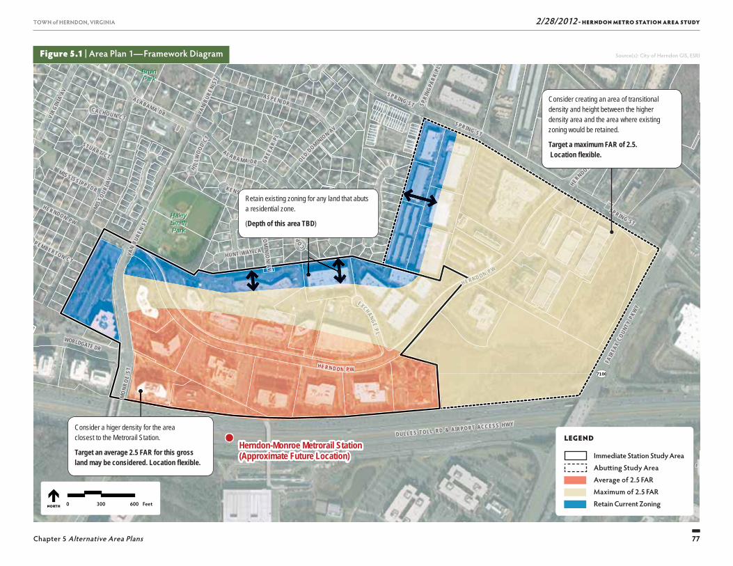
2/28/2012 - HERNDON METRO STATION AREA STUDY
77
TOWN of HERNDON, VIRGINIA
Chapter 5 Alternative Area Plans 77
TOWN of HERNDON, VIRGINIA
Figure 5.1 | Area Plan 1—Framework Diagram
SU
NR I S E
V A L L E
7100
SUNRISE VALLEY DR
WORLDGATE DR
FAIR
FAX
COUN
TY P
KWY
DULLES TOLL RD & AIRPO RT ACC ESS HWY
BruinBruinParkPark
HaleyHaleySmithSmithParkPark
Herndon-Monroe Metrorail Station(Approximate Future Location)
VAN
BURE
N ST
MO
NRO
E ST
EXCHANGE P L
SPRIN G ST
VAN
BURE
N ST
HUNT WAY LA
SPRING STMIS
SOUR
I AV
AL A BA M A DR OLD DOMINION AV
OLD
DO
MINI O
N A V
SPRING ST
CAL HOUN CT
ALABAMA DR
GREE
AR PL
H I LLW
OOD
CT
PEMBERTON CT
STUART CT
COPPER
FIEL
D LA
KEN SINGTON PL
SPRI
NGPA
RK PL
HERN DO N PW
MISSI SSI PP I DR
HE RNDON PW
ALABAMA DR
HERND ON P W
VIRG
INIA
AV AS PE N DR
HERNDON PW
LEGEND
Immediate Station Study Area
Abutting Study Area0 300 600 FeetNORTH
EXXCHAANGEPP LL
HERND ON PP W
Retain existing zoning for any land that abuts a residential zone.
(Depth of this area TBD)
Consider a higer density for the area closest to the Metrorail Station.
Target an average 2.5 FAR for this gross land may be considered. Location fl exible.
Consider creating an area of transitional density and height between the higher density area and the area where existing zoning would be retained.
Target a maximum FAR of 2.5. Location fl exible.
LEGEND
Immediate Station Study Area Abutt ing Study Area Average of 2.5 FAR Maximum of 2.5 FAR Retain Current Zoning
HERN DO N PPW
AVV
Source(s): City of Herndon GIS, ESRI
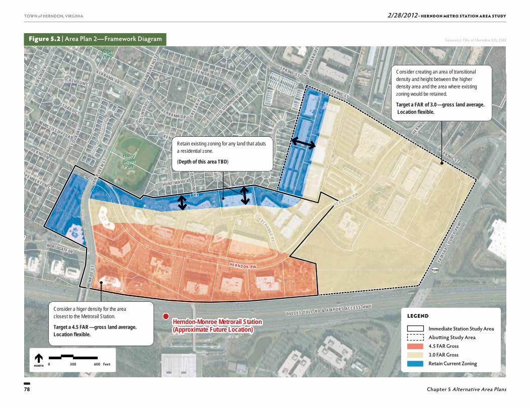
2/28/2012 - HERNDON METRO STATION AREA STUDY
78
TOWN of HERNDON, VIRGINIA
Chapter 5 Alternative Area Plans78
TOWN of HERNDON, VIRGINIA
Figure 5.2 | Area Plan 2—Framework Diagram
SU
NR I S E
V A L L E
7100
SUNRISE VALLEY DR
WORLDGATE DR
FAIR
FAX
COUN
TY P
KWY
DULLES TOLL RD & AIRPO RT ACC ESS HWY
BruinBruinParkPark
HaleyHaleySmithSmithParkPark
Herndon-Monroe Metrorail Station(Approximate Future Location)
VAN
BURE
N ST
MO
NRO
E ST
EXCHANGE P L
SPRIN G ST
VAN
BURE
N ST
HUNT WAY LA
SPRING STMIS
SOUR
I AV
AL A BA M A DR OLD DOMINION AV
OLD
DO
MINI O
N A V
SPRING ST
CAL HOUN CT
ALABAMA DR
GREE
AR PL
H I LLW
OOD
CT
PEMBERTON CT
STUART CT
COPPER
FIEL
D LA
KEN SINGTON PL
SPRI
NGPA
RK PL
HERN DO N PW
MISSI SSI PP I DR
HE RNDON PW
ALABAMA DR
HERND ON P W
VIRG
INIA
AV AS PE N DR
HERNDON PW
LEGEND
Immediate Station Study Area
Abutting Study Area0 300 600 FeetNORTH
Retain existing zoning for any land that abuts a residential zone.
(Depth of this area TBD)
Consider a higer density for the area closest to the Metrorail Station.
Target a 4.5 FAR — gross land average. Location fl exible.
Consider creating an area of transitional density and height between the higher density area and the area where existing zoning would be retained.
Target a FAR of 3.0 — gross land average. Location fl exible.
LEGEND
Immediate Station Study Area Abutt ing Study Area 4.5 FAR Gross 3.0 FAR Gross Retain Current Zoning
EXXCHAANGEPP LL
HERND ON PP W
HERN DO N PPW
AAVV
Source(s): City of Herndon GIS, ESRI
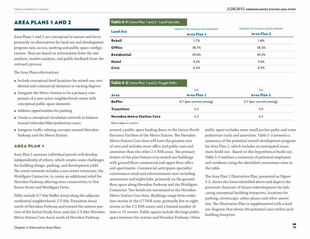
2/28/2012 - HERNDON METRO STATION AREA STUDY
79
TOWN of HERNDON, VIRGINIA
Chapter 5 Alternative Area Plans 79
TOWN of HERNDON, VIRGINIA
AREA PLANS 1 AND 2
Area Plans 1 and 2 are conceptual in nature and focus primarily on alternatives for land use and development program mix, access, parking and public space confi gu-rations. Th ey are based on information from the site analysis, market analysis, and public feedback from the outreach process.
Th e Area Plans alternatives:
■ Include conceptual-level locations for mixed-use, resi-dential and commercial elements in varying degrees
■ Integrate the Metro Station to be a primary com-ponent of a new active neighborhood center with conceptual public space elements
■ Address opportunities for parking
■ Create a conceptual circulation network to balance transit/vehicular/bike/pedestrian users
■ Integrate traffi c calming concepts around Herndon Parkway and the Metro Station
Area Plan 1Area Plan 1 assumes individual parcels will develop independently of others, which creates some challenges for building design, parking, and development yield. Th e street network includes a new street extension, the Worldgate Connector, to create an additional relief for Herndon Parkway off ering more connectivity to Van Buren Street and Worldgate Drive.
FARs include 0.7 (the Buff er Area) along the adjacent residential neighborhood; 2.5 (the Transition Area) north of Herndon Parkway and toward the eastern por-tion of the Initial Study Area; and also 2.5 (the Herndon Metro Station Core Area) south of Herndon Parkway
around a public space leading down to the future North Entrance Pavilion of the Metro Station. Th e Herndon Metro Station Core Area will have the greatest mix of uses and includes more offi ce and public uses and amenities than the other 2.5 FAR areas. Th e primary streets of the plan feature true mixed-use buildings with ground fl oor commercial and upper fl oor offi ce and apartments. Commercial anticipates specialty/convenience retail and entertainment uses including restaurants and nightclubs, primarily on the ground fl oor space along Herndon Parkway and the Worldgate Connector. Two hotels are envisioned in the Herndon Metro Station Core Area. Buildings range from under four stories in the 0.7 FAR zone; primarily fi ve to eight stories in the 2.5 FAR zones; and a limited number of nine to 15 stories. Public spaces include the large public space between the station and Herndon Parkway. Other
public space includes some small pocket parks and some pedestrian trails and amenities. Table 5-3 presents a summary of the potential overall development program for Area Plan 1, which includes an anticipated maxi-mum build-out. Based on this hypothetical build-out, Table 5-3 outlines a summary of potential employees and residents using the identifi ed conversions rates in the table.
Th e Area Plan 1 Illustrative Plan, presented as Figure 5.3, shows the items identifi ed above and depicts the potential character of future redevelopment by indi-cating conceptual building footprints, locations for parking, streetscape, urban plazas and other ameni-ties. Th e Illustrative Plan is supplemented with a land use diagram that shows the potential uses within each building footprint.
Table 5-1 | Area Plan 1 and 2 - Land Use Mix
Land UsePERCENT OF OVERALL DEVELOPMENT
Area Plan 1PERCENT OF OVERALL DEVELOPMENT
Area Plan 2
Retail 1.7% 1.8%
Office 38.7% 38.5%
Residential 49.6% 49.2%
Hotel 9.5% 9.6%
Civic 0.5% 0.9%
Table 5-2 | Area Plan 1 and 2–Target FARs
AreaFAR
Area Plan 1FAR
Area Plan 2
Buffer 0.7 (per current zoning) 0.7 (per current zoning)
Transition 2.5 3.0
Herndon Metro Station Core 2.5 4.5
Refer to Figures 5.1 and 5.2

2/28/2012 - HERNDON METRO STATION AREA STUDY
80
TOWN of HERNDON, VIRGINIA
Chapter 5 Alternative Area Plans80
TOWN of HERNDON, VIRGINIA
Figure 5.3 | Area Plan 1— Proposed Plan and Land Use
LEGEND ▶
Residential Residential over Retail
Retail Offi ce over Retail
Offi ce Hotel Civic
Parking Structure
◀ LEGEND
Building Parking Structure Parking Lot
Illustrative Plan
Land Use
DULLES TOLL RD & AIRPORT ACCESS HWY
HERNDON PKWYHERNDON PKWY
SPRING ST
MON
ROE
STM
ONRO
E ST
DULLES TOLL RD & AIRPORT ACCESS HWYDULLES TOLL RD & AIRPORT ACCESS HWY
HERNDON PKWYHERNDON PKWY
SPRING ST
SPRING ST
MON
ROE
STM
ONRO
E ST
LLLLLLLLLESESES T LLLLLLLOLL RD &RD &RD && AAAA PORTTTPORTPORTTPORT AAAAAA HWYHWYHWYHWYHWYDULLES TOLL RD & AIRPORT ACCESS HWY
PPPPG SG SG SSTTTTT
SPRING ST
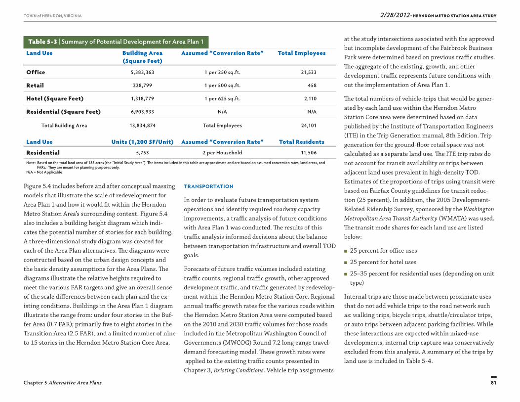
2/28/2012 - HERNDON METRO STATION AREA STUDY
81
TOWN of HERNDON, VIRGINIA
Chapter 5 Alternative Area Plans 81
TOWN of HERNDON, VIRGINIA
at the study intersections associated with the approved but incomplete development of the Fairbrook Business Park were determined based on previous traffi c studies. Th e aggregate of the existing, growth, and other development traffi c represents future conditions with-out the implementation of Area Plan 1.
Th e total numbers of vehicle-trips that would be gener-ated by each land use within the Herndon Metro Station Core area were determined based on data published by the Institute of Transportation Engineers (ITE) in the Trip Generation manual, 8th Edition. Trip generation for the ground-fl oor retail space was not calculated as a separate land use. Th e ITE trip rates do not account for transit availability or trips between adjacent land uses prevalent in high-density TOD. Estimates of the proportions of trips using transit were based on Fairfax County guidelines for transit reduc-tion (25 percent). In addition, the 2005 Development-Related Ridership Survey, sponsored by the Washington Metropolitan Area Transit Authority (WMATA) was used. Th e transit mode shares for each land use are listed below:
■ 25 percent for offi ce uses
■ 25 percent for hotel uses
■ 25–35 percent for residential uses (depending on unit type)
Internal trips are those made between proximate uses that do not add vehicle trips to the road network such as: walking trips, bicycle trips, shuttle/circulator trips, or auto trips between adjacent parking facilities. While these interactions are expected within mixed-use developments, internal trip capture was conservatively excluded from this analysis. A summary of the trips by land use is included in Table 5-4.
Transportation
In order to evaluate future transportation system operations and identify required roadway capacity improvements, a traffi c analysis of future conditions with Area Plan 1 was conducted. Th e results of this traffi c analysis informed decisions about the balance between transportation infrastructure and overall TOD goals.
Forecasts of future traffi c volumes included existing traffi c counts, regional traffi c growth, other approved development traffi c, and traffi c generated by redevelop-ment within the Herndon Metro Station Core. Regional annual traffi c growth rates for the various roads within the Herndon Metro Station Area were computed based on the 2010 and 2030 traffi c volumes for those roads included in the Metropolitan Washington Council of Governments (MWCOG) Round 7.2 long-range travel-demand forecasting model. Th ese growth rates were applied to the existing traffi c counts presented in Chapter 3, Existing Conditions. Vehicle trip assignments
Figure 5.4 includes before and after conceptual massing models that illustrate the scale of redevelopment for Area Plan 1 and how it would fi t within the Herndon Metro Station Area’s surrounding context. Figure 5.4 also includes a building height diagram which indi-cates the potential number of stories for each building. A three-dimensional study diagram was created for each of the Area Plan alternatives. Th e diagrams were constructed based on the urban design concepts and the basic density assumptions for the Area Plans. Th e diagrams illustrate the relative heights required to meet the various FAR targets and give an overall sense of the scale diff erences between each plan and the ex-isting conditions. Buildings in the Area Plan 1 diagram illustrate the range from: under four stories in the Buf-fer Area (0.7 FAR); primarily fi ve to eight stories in the Transition Area (2.5 FAR); and a limited number of nine to 15 stories in the Herndon Metro Station Core Area.
Land Use Building Area(Square Feet)
Assumed “Conversion Rate” Total Employees
Office 5,383,363 1 per 250 sq.ft. 21,533
Retail 228,799 1 per 500 sq.ft. 458
Hotel (Square Feet) 1,318,779 1 per 625 sq.ft. 2,110
Residential (Square Feet) 6,903,933 N/A N/A
Total Building Area 13,834,874 Total Employees 24,101
Land Use Units (1,200 SF/Unit) Assumed “Conversion Rate” Total Residents
Residential 5,753 2 per Household 11,506
Note: Based on the total land area of 183 acres (the “Initial Study Area”). Th e items included in this table are approximate and are based on assumed conversion rates, land areas, and FARs. Th ey are meant for planning purposes only.N/A = Not Applicable
Table 5-3 | Summary of Potential Development for Area Plan 1
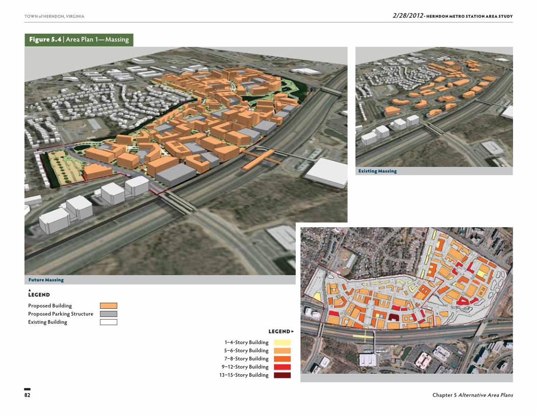
2/28/2012 - HERNDON METRO STATION AREA STUDY
82
TOWN of HERNDON, VIRGINIA
Chapter 5 Alternative Area Plans82
TOWN of HERNDON, VIRGINIA
▲LEGEND
Proposed Building Proposed Parking Structure Existing Building
Figure 5.4 | Area Plan 1— Massing
LEGEND ▶
1–4-Story Building 5–6-Story Building 7–8-Story Building
9–12-Story Building 13–15-Story Building
Future Massing
Existing Massing
Building Heights
DULLES TOLL RD & AIRPORT ACCESS HWYDULLES TOLL RD & AIRPORT ACCESS HWY
HERNDON PKWYHERNDON PKWY
SPRING ST
SPRING ST
MON
ROE
STM
ONRO
E ST
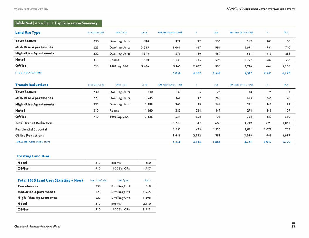
2/28/2012 - HERNDON METRO STATION AREA STUDY
83
TOWN of HERNDON, VIRGINIA
Chapter 5 Alternative Area Plans 83
TOWN of HERNDON, VIRGINIA
Table 5-4 | Area Plan 1 Trip Generation Summary
Land Use Type Land Use Code Unit Type Units AM Distribution Total In Out PM Distribution Total In Out
Townhomes 230 Dwelling Units 310 128 22 106 152 102 50
Mid-Rise Apartments 223 Dwelling Units 3,545 1,440 447 994 1,691 981 710
High-Rise Apartments 232 Dwelling Units 1,898 579 110 469 661 410 251
Hotel 310 Rooms 1,860 1,533 935 598 1,097 582 516
Office 710 1000 Sq. GFA 3,426 3,169 2,789 380 3,916 666 3,250
SITE GENERATED TRIPS 6,850 4,302 2,547 7,517 2,741 4,777
Transit Reductions Land Use Code Unit Type Units AM Distribution Total In Out PM Distribution Total In Out
Townhomes 230 Dwelling Units 310 32 5 26 38 25 13
Mid-Rise Apartments 223 Dwelling Units 3,545 360 112 248 423 245 178
High-Rise Apartments 232 Dwelling Units 1,898 203 39 164 231 143 88
Hotel 310 Rooms 1,860 383 234 149 274 145 129
Office 710 1000 Sq. GFA 3,426 634 558 76 783 133 650
Total Transit Reductions 1,612 947 665 1,749 693 1,057
Residential Subtotal 1,553 423 1,130 1,811 1,078 733
Office Reductions 3,685 2,932 753 3,956 969 2,987
TOTAL SITE GENERATED TRIPS 5,238 3,335 1,883 5,767 2,047 3,720
Existing Land Uses
Hotel 310 Rooms 250
Office 710 1000 Sq. GFA 1,957
Total 2035 Land Uses (Existing + New) Land Use Code Unit Type Units
Townhomes 230 Dwelling Units 310
Mid-Rise Apartments 223 Dwelling Units 3,545
High-Rise Apartments 232 Dwelling Units 1,898
Hotel 310 Rooms 2,110
Office 710 1000 Sq. GFA 5,383
2/28/2012 - HERNDON METRO STATION AREA STUDY
84
TOWN of HERNDON, VIRGINIA
Chapter 5 Alternative Area Plans84
TOWN of HERNDON, VIRGINIA
Th e results of the analysis indicate that Area Plan 1 could be accommodated with intersection-focused road improvements of moderate scope. Th e new access street linking Spring Street to the Herndon Metro Station Core Area is key to this fi nding. Mobility for drivers could be maintained without signifi cant impacts to pedestrian, bicycle, or bus operations.
Area Plan 2Area Plan 2 is a denser version of Area Plan 1 show-ing additional development, more connectivity, and greater public amenities. Th is plan assumes more parcel consolidation to allow for more effi cient building and site design, including larger parking structures shared among multiple buildings and parcels. Th e street network includes a further extension of the Worldgate Connector to create a new road to the north of Herndon Parkway off ering more connectivity to the east.
FARs include 0.7 (the Buff er Area) along the adjacent residential neighborhood; 3.0 (the Transition Area) north of Herndon Parkway and toward the eastern por-tion of the Herndon Metro Station Area; and 4.5 (the Herndon Metro Station Core Area) south of Herndon Parkway around the Herndon Metro Promenade and future North Entrance Pavilion of the Metro Station. Th e distributions of uses are similar to Area Plan 1, only with more development density/intensity and more multi-story parking structures. With these densities, buildings range from under four stories in the Buff er Area; primarily fi ve to eight stories in the Transition Area; and nine to 15 stories in the Herndon Metro Sta-tion Core Area.
In order to accommodate the Area Plan 1 traffi c forecasts, several roadway improvements would be required:
■ Th e addition of a northbound right turn lane on Van Buren Street at Herndon Parkway
■ Th e extension of Worldgate Drive from Van Buren Street to Herndon Parkway as a four-lane road
■ Th e one-lane widening along westbound Herndon Parkway at the Worldgate Drive extension to accom-modate dual left turn lanes
■ Th e one-lane widening of Spring Street in each direc-tion between the Fairfax County Parkway Ramps and Spring Park Place
■ Th e widening of the Fairfax County Parkway off -ramp at Spring Street to accommodate four southbound lanes
■ Th e channelization of westbound left turning traffi c on Spring Street at Herndon Parkway through a raised median
■ Th e addition of two northbound lanes on Herndon Parkway at Spring Street
■ Th e addition of a second southbound left turn lane on Herndon Parkway at Spring Street
■ Th e reconfi guration of the Spring Street/Herndon Parkway intersection and the reconstruction of the traffi c signal
■ Th e construction of a new four-lane access road on the south side of Spring Street, west of Herndon Parkway
Refer to Figures 5.5 and 5.6 for the proposed trans-portation improvements for Area Plan 1. Th e levels of service and vehicular delays at the critical intersections with these improvements are summarized in Table 5-5.
Th e vehicle trips for Area Plan 1 were distributed across the road network according to the following trip percentages, accounting for current traffi c trends and volumes in the area and workfl ow routes from the Cen-sus Transportation Planning Package (CTPP) data for the Traffi c Analysis Zones (TAZs) within the Herndon Metro Station Area:
■ 45 percent from the east on Spring Street (including Fairfax County Parkway)
■ 25 percent from the west on Herndon Parkway and Worldgate Drive
■ 10 percent from the north on Herndon Parkway
■ 10 percent from the north on Van Buren Street (through the downtown area)
■ 5 percent from the west on Alabama Drive
■ 5 percent from the south on Van Buren Street
Th e resulting traffi c assignments were added to the existing, regional growth, and other development traf-fi c volumes to yield the future traffi c forecasts with the implementation of Area Plan 1.
Future traffi c conditions at the following critical inter-sections were analyzed using Synchro capacity analysis software and the future traffi c forecasts:
■ Van Buren Street/Herndon Parkway
■ Van Buren Street/Worldgate Drive
■ Spring Street/Herndon Parkway
■ Spring Street/Fairfax County Parkway Ramps
Synchro was used for the analysis of plan options in order to minimize network coding and analysis time, while maintaining reliable results.
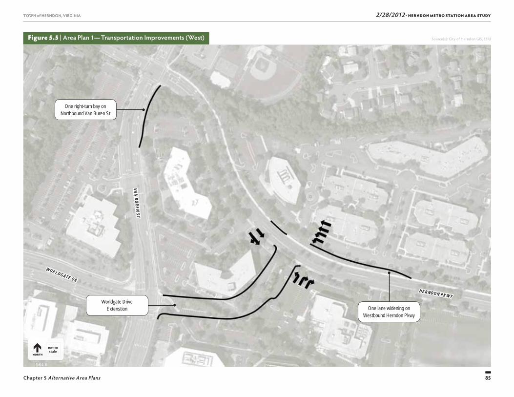
2/28/2012 - HERNDON METRO STATION AREA STUDY
85
TOWN of HERNDON, VIRGINIA
Chapter 5 Alternative Area Plans 85
TOWN of HERNDON, VIRGINIA
Figure 5.5 | Area Plan 1— Transportation Improvements (West)
One right-turn bay on Northbound Van Buren St
Worldgate Drive Extenstion One lane widening on
Westbound Herndon Pkwy
HERNDON PKWYHERNDON PKWY
WORLDGATE DR
WORLDGATE DR
VAN BUREN STVAN BUREN ST
not to scale
NORTH
Source(s): City of Herndon GIS, ESRI

2/28/2012 - HERNDON METRO STATION AREA STUDY
86
TOWN of HERNDON, VIRGINIA
Chapter 5 Alternative Area Plans86
TOWN of HERNDON, VIRGINIA
Figure 5.6 | Area Plan 1— Transportation Improvements (East)
Create a four lane wide Site Access Road
One lane widening on Eastbound Spring St
Two lane widening on Spring St
Barricade to separate left-turn and through traffi c
One left-turn bay on Southbound Ramp
One lane widening on Westbound Spring St Reconfi gure island
One lane widening on Southbound Fairfax County Pkwy Ramp
Two lane widening on Northbound Herndon Pkwy
SPRING ST
SPRING ST
HERNDON PKWY
HERNDON PKWY
HERN
DON
PKW
Y
HERN
DON
PKW
Y
not to scale
NORTH
Source(s): City of Herndon GIS, ESRI
2/28/2012 - HERNDON METRO STATION AREA STUDY
87
TOWN of HERNDON, VIRGINIA
Chapter 5 Alternative Area Plans 87
TOWN of HERNDON, VIRGINIA
Figure 5.7 | Area Plan 2— Proposed Plan and Land Use
Illustrative Plan
Land Use
DULLES TOLL RD & AIRPORT ACCESS HWY
HERNDON PKWYHERNDON PKWY
SPRING ST
MON
ROE
STM
ONRO
E ST
DULLES TOLL RD & AIRPORT ACCESS HWYDULLES TOLL RD & AIRPORT ACCESS HWY
HERNDON PKWYHERNDON PKWY
SPRING ST
SPRING ST
MON
ROE
STM
ONRO
E ST
◀ LEGEND
Building Parking Structure Parking Lot
LEGEND ▶
Residential Residential over Retail
Retail Offi ce over Retail
Offi ce Hotel Civic
Parking Structure
LLLLLLLLLES TES TES OLL LL LOLL LL &RD &RD &&RD AAAAA PORTPORTPORTTT AAAAA HWYHWYHWYHWYHWYWYYDULLES TOLL RD & AIRPORT ACCESS HWY
PPPPPPPG SG SG SSTTTTTT
SPRING ST
2/28/2012 - HERNDON METRO STATION AREA STUDY
88
TOWN of HERNDON, VIRGINIA
Chapter 5 Alternative Area Plans88
TOWN of HERNDON, VIRGINIA
Figure 5.8 | Area Plan 2— Massing
Future Massing
Existing Massing
Building Heights
DULLES TOLL RD & AIRPORT ACCESS HWYDULLES TOLL RD & AIRPORT ACCESS HWY
HERNDON PKWYHERNDON PKWY
SPRING ST
SPRING ST
MON
ROE
STM
ONRO
E ST
▲LEGEND
Proposed Building Proposed Parking Structure Existing Building
LEGEND ▶
1–4-Story Building 5–6-Story Building 7–8-Story Building
9–12-Story Building 13–15-Story Building
2/28/2012 - HERNDON METRO STATION AREA STUDY
89
TOWN of HERNDON, VIRGINIA
Chapter 5 Alternative Area Plans 89
TOWN of HERNDON, VIRGINIA
Metro Station Area’s surrounding context. Figure 5.8 also includes a building height diagram which indicates the potential number of stories for each building. Build-ings in the Area Plan 2 model, illustrate the range from: under four stories in the Buff er Area (0.7 FAR); primar-ily fi ve to eight stories in the Transition Area (3.0 FAR); and nine to fi fteen stories in the Herndon Metro Sta-tion Core Area (4.5 FAR).
Transportation
A traffi c analysis of future conditions with Area Plan 2 was also conducted to evaluate future operations and identify required roadway improvements for use in the fi scal and fi nancial models and decision making processes.
Similar to the Area Plan 1 analysis, forecasts of future traffi c volumes included existing traffi c counts, regional traffi c growth, other approved development traffi c, and traffi c generated by redevelopment within the Hern-don Metro Station Core. Forecasts of future conditions without the implementation of Area Plan 2 were identi-cal to those presented for Area Plan 1.
Th e same trip generation and transit mode share meth-odologies were utilized to determine the number of trips that would result from the redevelopment under Area Plan 2. A summary of the trips by land use is included in Table 5-7.
Th ese trips were assigned to the road network accord-ing to the same distributions used for Area Plan 1 and added to the existing, growth, and other development trips to yield the future traffi c forecasts with the imple-mentation of Area Plan 2.
Th e Area Plan 2 Illustrative Plan shows the items identifi ed above and depicts the potential character of future redevelopment by indicating conceptual build-ing footprints, locations for parking, streetscape, urban plazas and other amenities. Th e Illustrative Plan is included in Figure 5.7 and is supplemented with a land use diagram that shows the potential uses within each building footprint.
Figure 5.8 includes before and after conceptual massing models that illustrate the scale of redevelopment for Area Plan 2 and how it would fi t within the Herndon
Public spaces in Area Plan 2 are enhanced withadditional density. Th e main public space would include higher quality plaza treatments and textured pave-ment, streetscape amenities, and enhanced commu-nity gathering spaces. Other amenities could include additional pocket parks and smaller plaza spaces, textured paved crosswalks, and more pedestrian trails and amenities. Table 5-6 presents a summary of the potential overall development program for Area Plan 2, which includes an anticipated maximum build-out. Table 5-6 outlines a summary of potential employees and residents using the identifi ed conversions rates.
Land Use Building Area(Square Feet)
Assumed “Conversion Rate” Total Employees
Office 7,490,534 1 per 250 sq.ft. 29,962
Retail 361,788 1 per 500 sq.ft. 724
Hotel (Square Feet) 1,873,298 1 per 625 sq.ft. 2,997
Residential (Square Feet) 9,576,906 N/A N/A
Total Building Area 19,302,525 Total Employees 33,683
Land Use Units (1,200 SF/Unit) Assumed “Conversion Rate” Total Residents
Residential 7,981 2 per Household 15,962
Note: Based on the total land area of 183 acres (the “Initial Study Area”). Th e items included in this table are approximate and are based on assumed conversion rates, land areas, and FARs. Th ey are meant for planning purposes only.N/A = Not Applicable
Table 5-6 | Summary of Potential Development for Area Plan 2
Table 5-5 | Area Plan 1 Level of Service Summary
IntersectionAM Peak
DELAY LOS
PM PeakDELAY LOS
Spring St and Herndon Pkwy 47.0 D 76.0 E
Spring St and Fairfax County Pkwy Ramps 33.7 C 28.1 C
Herndon Pkwy and Van Buren St 35.2 D 46.5 D
Worldgate Dr and Van Buren St 38.8 D 44.0 D
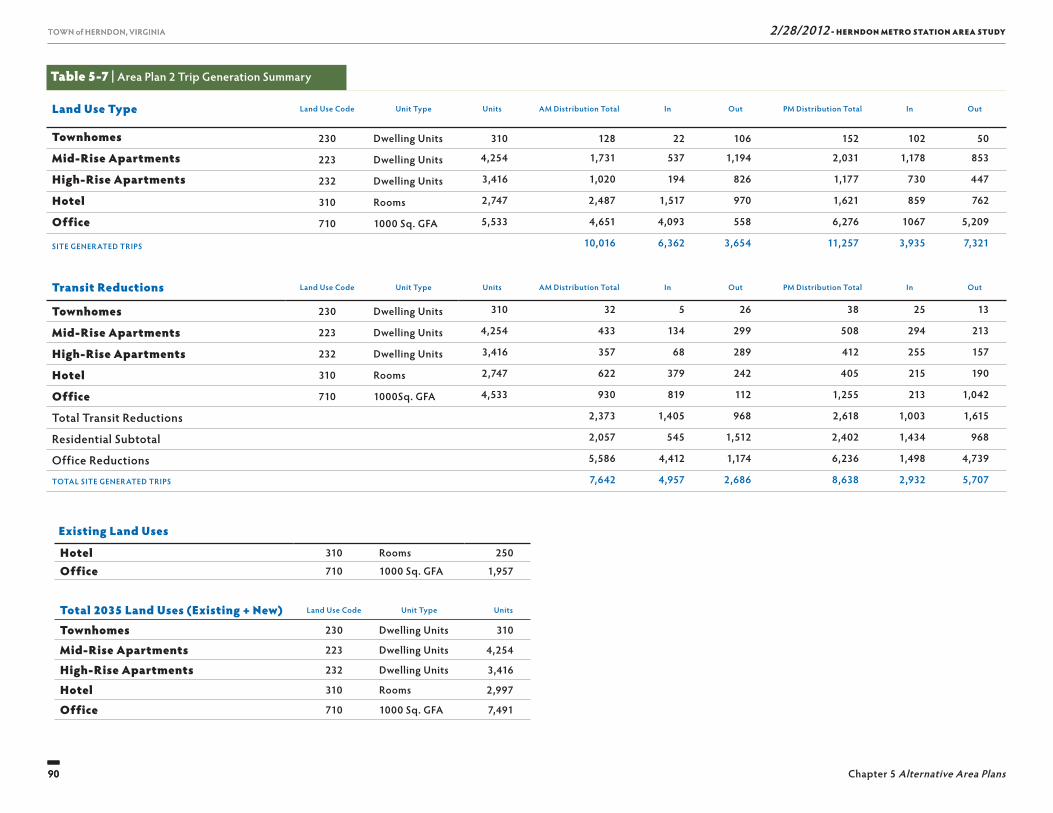
2/28/2012 - HERNDON METRO STATION AREA STUDY
90
TOWN of HERNDON, VIRGINIA
Chapter 5 Alternative Area Plans90
TOWN of HERNDON, VIRGINIA
Table 5-7 | Area Plan 2 Trip Generation Summary
Land Use Type Land Use Code Unit Type Units AM Distribution Total In Out PM Distribution Total In Out
Townhomes 230 Dwelling Units 310 128 22 106 152 102 50
Mid-Rise Apartments 223 Dwelling Units 4,254 1,731 537 1,194 2,031 1,178 853
High-Rise Apartments 232 Dwelling Units 3,416 1,020 194 826 1,177 730 447
Hotel 310 Rooms 2,747 2,487 1,517 970 1,621 859 762
Office 710 1000 Sq. GFA 5,533 4,651 4,093 558 6,276 1067 5,209
SITE GENERATED TRIPS 10,016 6,362 3,654 11,257 3,935 7,321
Transit Reductions Land Use Code Unit Type Units AM Distribution Total In Out PM Distribution Total In Out
Townhomes 230 Dwelling Units 310 32 5 26 38 25 13
Mid-Rise Apartments 223 Dwelling Units 4,254 433 134 299 508 294 213
High-Rise Apartments 232 Dwelling Units 3,416 357 68 289 412 255 157
Hotel 310 Rooms 2,747 622 379 242 405 215 190
Office 710 1000Sq. GFA 4,533 930 819 112 1,255 213 1,042
Total Transit Reductions 2,373 1,405 968 2,618 1,003 1,615
Residential Subtotal 2,057 545 1,512 2,402 1,434 968
Office Reductions 5,586 4,412 1,174 6,236 1,498 4,739
TOTAL SITE GENERATED TRIPS 7,642 4,957 2,686 8,638 2,932 5,707
Existing Land Uses
Hotel 310 Rooms 250
Office 710 1000 Sq. GFA 1,957
Total 2035 Land Uses (Existing + New) Land Use Code Unit Type Units
Townhomes 230 Dwelling Units 310
Mid-Rise Apartments 223 Dwelling Units 4,254
High-Rise Apartments 232 Dwelling Units 3,416
Hotel 310 Rooms 2,997
Office 710 1000 Sq. GFA 7,491
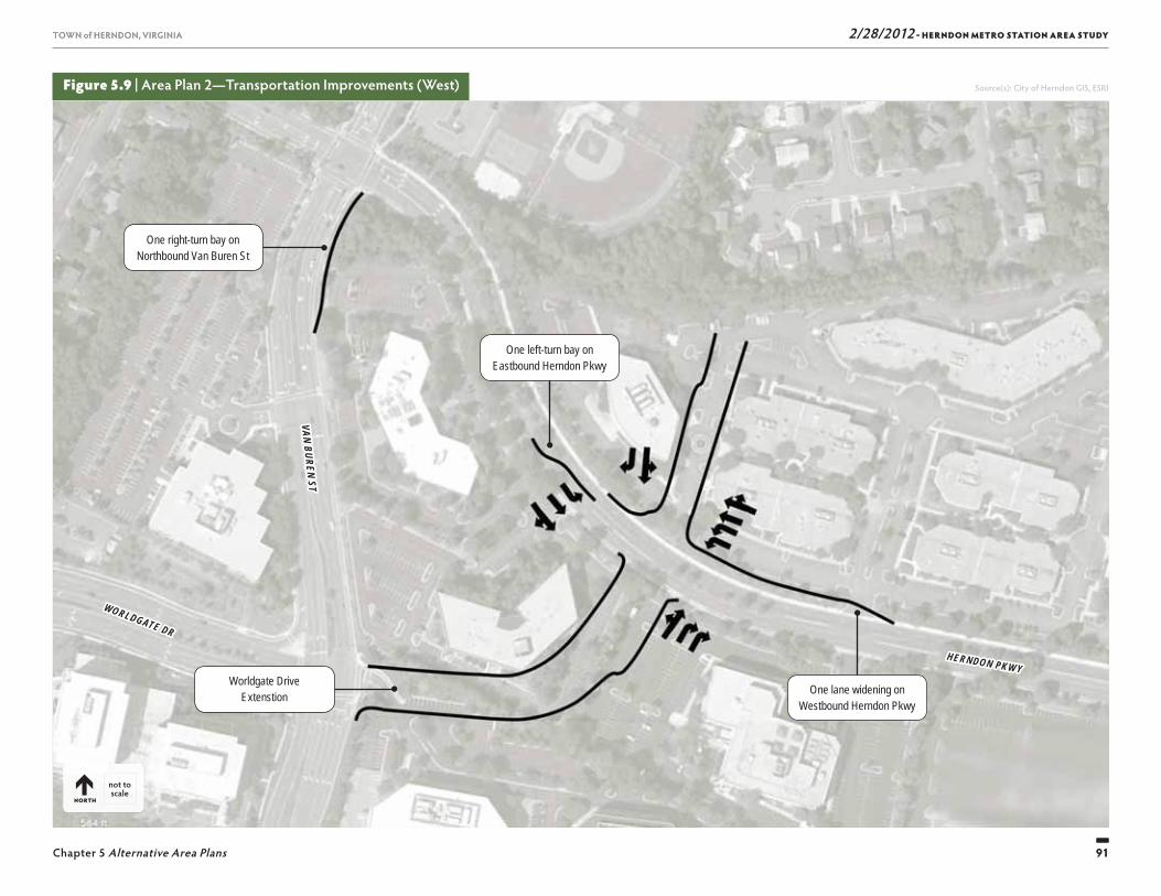
2/28/2012 - HERNDON METRO STATION AREA STUDY
91
TOWN of HERNDON, VIRGINIA
Chapter 5 Alternative Area Plans 91
TOWN of HERNDON, VIRGINIA
Figure 5.9 | Area Plan 2— Transportation Improvements (West)
One right-turn bay on Northbound Van Buren St
Worldgate Drive Extenstion One lane widening on
Westbound Herndon Pkwy
One left-turn bay on Eastbound Herndon Pkwy
HERNDON PKWYHERNDON PKWY
WORLDGATE DR
WORLDGATE DR
VAN BUREN STVAN BUREN ST
not to scale
NORTH
Source(s): City of Herndon GIS, ESRI
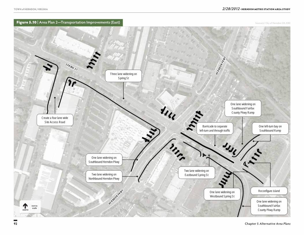
2/28/2012 - HERNDON METRO STATION AREA STUDY
92
TOWN of HERNDON, VIRGINIA
Chapter 5 Alternative Area Plans92
TOWN of HERNDON, VIRGINIA
Figure 5.10 | Area Plan 2—Transportation Improvements (East)
Create a four lane wide Site Access Road
Two lane widening on Eastbound Spring St
Three lane widening on Spring St
Barricade to separate left-turn and through traffi c
One left-turn bay on Southbound Ramp
One lane widening on Westbound Spring St
Reconfi gure island
One lane widening on Southbound Fairfax County Pkwy Ramp
Two lane widening on Northbound Herndon Pkwy
One lane widening on Southbound Fairfax County Pkwy Ramp
One lane widening on Southbound Herndon Pkwy
SPRING ST
SPRING ST
HERNDON PKWY
HERNDON PKWY
HERN
DON
PKW
Y
HERN
DON
PKW
Y
not to scale
NORTH
Source(s): City of Herndon GIS, ESRI
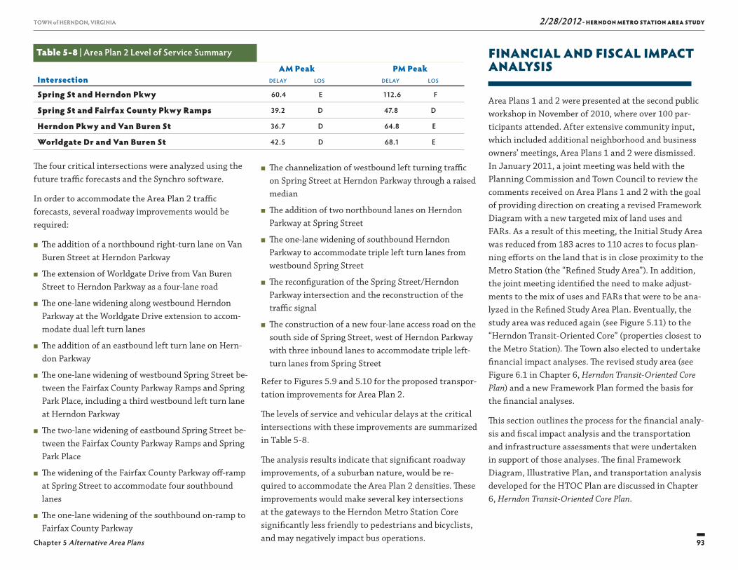
2/28/2012 - HERNDON METRO STATION AREA STUDY
93
TOWN of HERNDON, VIRGINIA
Chapter 5 Alternative Area Plans 93
TOWN of HERNDON, VIRGINIA
FINANCIAL AND FISCAL IMPACT ANALYSIS
Area Plans 1 and 2 were presented at the second public workshop in November of 2010, where over 100 par-ticipants attended. After extensive community input, which included additional neighborhood and business owners’ meetings, Area Plans 1 and 2 were dismissed. In January 2011, a joint meeting was held with the Planning Commission and Town Council to review the comments received on Area Plans 1 and 2 with the goal of providing direction on creating a revised Framework Diagram with a new targeted mix of land uses and FARs. As a result of this meeting, the Initial Study Area was reduced from 183 acres to 110 acres to focus plan-ning eff orts on the land that is in close proximity to the Metro Station (the “Refi ned Study Area”). In addition, the joint meeting identifi ed the need to make adjust-ments to the mix of uses and FARs that were to be ana-lyzed in the Refi ned Study Area Plan. Eventually, the study area was reduced again (see Figure 5.11) to the “Herndon Transit-Oriented Core” (properties closest to the Metro Station). Th e Town also elected to undertake fi nancial impact analyses. Th e revised study area (see Figure 6.1 in Chapter 6, Herndon Transit-Oriented Core Plan) and a new Framework Plan formed the basis for the fi nancial analyses.
Th is section outlines the process for the fi nancial analy-sis and fi scal impact analysis and the transportation and infrastructure assessments that were undertaken in support of those analyses. Th e fi nal Framework Diagram, Illustrative Plan, and transportation analysis developed for the HTOC Plan are discussed in Chapter 6, Herndon Transit-Oriented Core Plan.
■ Th e channelization of westbound left turning traffi c on Spring Street at Herndon Parkway through a raised median
■ Th e addition of two northbound lanes on Herndon Parkway at Spring Street
■ Th e one-lane widening of southbound Herndon Parkway to accommodate triple left turn lanes from westbound Spring Street
■ Th e reconfi guration of the Spring Street/Herndon Parkway intersection and the reconstruction of the traffi c signal
■ Th e construction of a new four-lane access road on the south side of Spring Street, west of Herndon Parkway with three inbound lanes to accommodate triple left-turn lanes from Spring Street
Refer to Figures 5.9 and 5.10 for the proposed transpor-tation improvements for Area Plan 2.
Th e levels of service and vehicular delays at the critical intersections with these improvements are summarized in Table 5-8.
Th e analysis results indicate that signifi cant roadway improvements, of a suburban nature, would be re-quired to accommodate the Area Plan 2 densities. Th ese improvements would make several key intersections at the gateways to the Herndon Metro Station Core signifi cantly less friendly to pedestrians and bicyclists, and may negatively impact bus operations.
Th e four critical intersections were analyzed using the future traffi c forecasts and the Synchro software.
In order to accommodate the Area Plan 2 traffi c forecasts, several roadway improvements would be required:
■ Th e addition of a northbound right-turn lane on Van Buren Street at Herndon Parkway
■ Th e extension of Worldgate Drive from Van Buren Street to Herndon Parkway as a four-lane road
■ Th e one-lane widening along westbound Herndon Parkway at the Worldgate Drive extension to accom-modate dual left turn lanes
■ Th e addition of an eastbound left turn lane on Hern-don Parkway
■ Th e one-lane widening of westbound Spring Street be-tween the Fairfax County Parkway Ramps and Spring Park Place, including a third westbound left turn lane at Herndon Parkway
■ Th e two-lane widening of eastbound Spring Street be-tween the Fairfax County Parkway Ramps and Spring Park Place
■ Th e widening of the Fairfax County Parkway off -ramp at Spring Street to accommodate four southbound lanes
■ Th e one-lane widening of the southbound on-ramp to Fairfax County Parkway
Table 5-8 | Area Plan 2 Level of Service Summary
IntersectionAM Peak
DELAY LOS
PM PeakDELAY LOS
Spring St and Herndon Pkwy 60.4 E 112.6 F
Spring St and Fairfax County Pkwy Ramps 39.2 D 47.8 D
Herndon Pkwy and Van Buren St 36.7 D 64.8 E
Worldgate Dr and Van Buren St 42.5 D 68.1 E
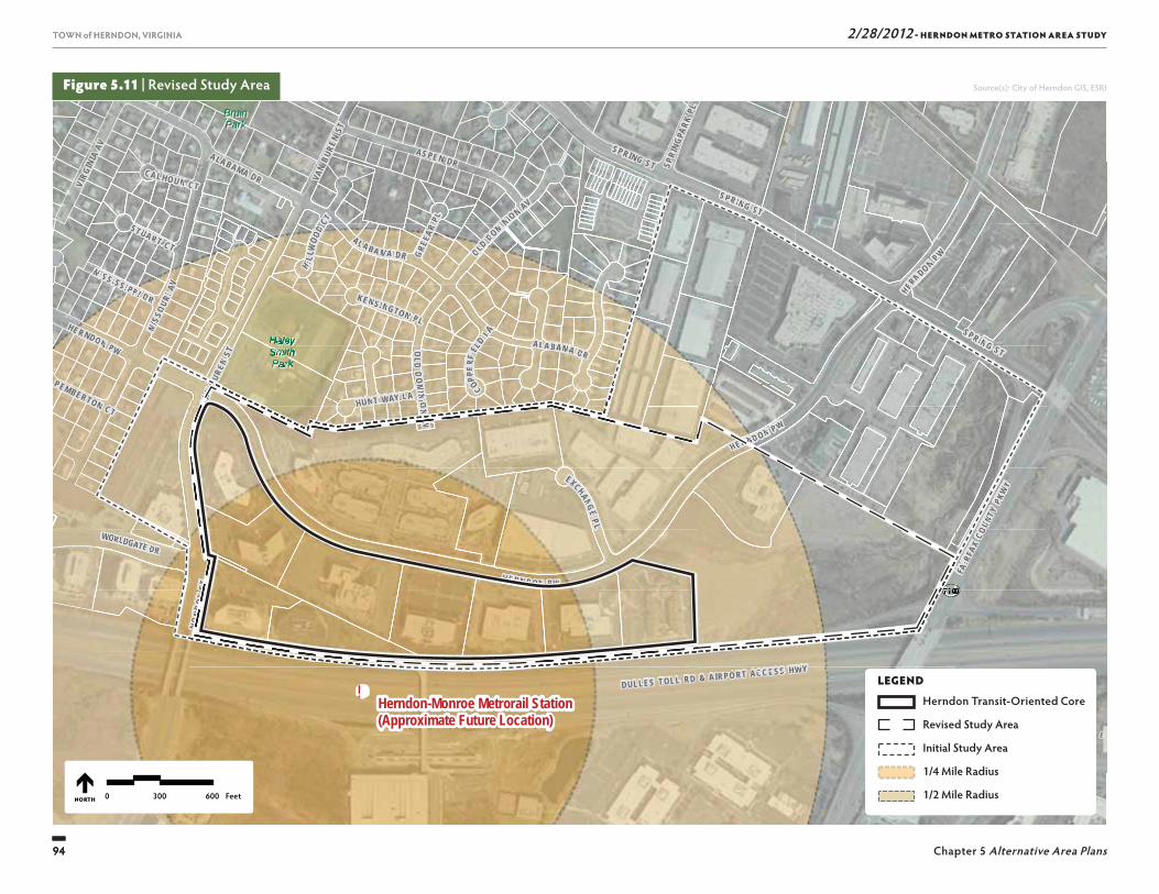
2/28/2012 - HERNDON METRO STATION AREA STUDY
94
TOWN of HERNDON, VIRGINIA
Chapter 5 Alternative Area Plans94
TOWN of HERNDON, VIRGINIA
Figure 5.11 | Revised Study Area Source(s): City of Herndon GIS, ESRI
!
SU
NR I S E
V A L L E
UV7100
SUNRISE VALLEY DR
WORLDGATE DR
FAIR
FAX
COUN
TY P
KWY
DULLES TOLL RD & AIRPO RT ACC ESS HWY
BruinBruinParkPark
HaleyHaleySmithSmithParkPark
Herndon-Monroe Metrorail Station(Approximate Future Location)
VAN
BURE
N ST
MO
NRO
E ST
EXCHANGE P L
SPRIN G ST
VAN
BURE
N ST
HUNT WAY LA
SPRING STMIS
SOUR
I AV
AL A BA M A DR OLD DOMINION AV
OLD
DO
MINI O
N A V
SPRING ST
CAL HOUN CT
ALABAMA DR
GREE
AR PL
H I LLW
OOD
CT
PEMBERTON CT
STUART CT
COPPER
FIEL
D LA
KEN SINGTON PL
SPRI
NGPA
RK PL
HERN DO N PW
MISSI SSI PP I DR
HE RNDON PW
ALABAMA DR
HERND ON P W
VIRG
INIA
AV AS PE N DR
HERNDON PW
1/4 Mile Radius
1/2 Mile Radius0 300 600 FeetNORTH
VVUUUUUUUUU
WORLLDGAATTE DR
FFAAIR
FFAAXX
COOUN
TTYYPPKK
WYY
T AACC ESS HWYY
Halel yyHHHaHHaalaallelleellllll yyeeyyyySSSmmmiiittthttSSSSSSSSSmmmSSSSSSmmmmmmiiimmmmmmiiiitiitthtthhttttttParkrrPPPaPPaaraarrkrrkkrrrrrr
BURE
NSTTTTT
SPPPRIN G STT
MISSOO
URI AA
VVV
AALLL AAAAA BAAAAA M AAA DR OLLDDOMINIOON AAVV
OLLD
DO
M
SPPRING STT
OUN CTT
AALLLAABAAAAAMAA DR
GREE
AARPPLL
H I LLLLW
OOOD
CCTT
ON CTT
STTTTTUAARTTTT CTTTTTT
OPPPPER
FFIELL
DLLAAA
KKEN SINGTTOON PPLL
MISSI SSI PPPP I DR
DON PPW
R
HERNDONPPW
BBBBBBB
VVVVVVVVUUUUUUUUUUUUUUUUUUUUUUUUUUUUUUUUUUUUUU
WY
V
RRRRRRRRRRRNNNNNNNNNNND ON PP W
VVVVVVVAAAAAAAAAAAAANNNNNNNNNNN
BBBBBBBBBBBBB
MO
HUNTT WAYY LLAA
MINI
CO
HEEEEEEEERRRRRRRRRRRR
VVVVVAAAAAAAAAAAAANNNNNNNNNNNN
R
ANANVVVVVVVVVVO
NRO
ESTT
EXXCHAANGEPP LL
AAAAAAAAAAAAA VVVVVVVVVV
HHHHHHHHHHHHEEEEEEEEEERRRRRRRRNNNNNNNN DDDDDDDDDDDOOOOOOOOO NNNNNNNNNN PPPPPPPWWWWWWWWWWWWW
MMMMMMMMMMOOOOOOOOOOOOOO
NNNNNNNNNNNRRRRRRRRRROOOOOOOOOOOO
EEEEEEEEEEEEESSSSSSSSSSSTTTTTTTTTTTTTTT
AAA
HUNTT WAY IONVVVV
MO
NRO
EST
AA
LEGEND
Herndon Transit-Oriented Core
Revised Study Area
Initial Study Area
1/4 Mile Radius
1/2 Mile Radius
2/28/2012 - HERNDON METRO STATION AREA STUDY
95
TOWN of HERNDON, VIRGINIA
Chapter 5 Alternative Area Plans 95
TOWN of HERNDON, VIRGINIA
Calculation of Residual Equity
A pro forma analysis of individual parcels was con-ducted to determine “residual equity,” the amount in excess of the amount of equity a project could support, based on a 30 percent equity baseline assumption and an anticipated return on equity rate ranging from 10 to 11 percent. In simpler terms, residual equity is the dollar amount leftover once the developer has met their equity requirement and target rate of return.
Determination of Financial Viability
Financial viability was based upon whether or not a project had positive residual equity. Th ose projects with positive equity were considered to show fi nancial viability for redevelopment.
Estimation of Assessment Value
For the fi scal impact analysis, offi ce, retail and hotel assessments were derived from the replacement value of the property improvements plus land, which equaled total development costs minus demolition costs. Resi-dential assessments were calculated using the replace-ment value as the basis plus an additional 20 percent to more accurately approximate market value. For the fi scal impact analysis, a Comprehensive Plan scenario was used as a baseline for comparison and actual assessed values were used for existing development under this scenario.
Calculation of Public Revenues and Public Expenditures
Revenues using prevailing tax rates and fees were esti-mated. Public expenditures were estimated using meth-ods contained in A Practitioners Guide to Fiscal Impact, a widely recognized reference source in the realm of fi scal
■ Height limits
■ Infrastructure costs
■ Sale of properties
■ Building asking rents and vacancies
■ Operating expenses
■ Capitalization rate
■ Building unit costs
■ Lease-up period
■ Offi ce and retail rents
■ Apartment rents
■ Parking requirements
■ Parking type
■ Parking construction cost
■ Hotel characteristics
■ Conversion factor of hotel square feet to rooms
■ Conversion factor of residential square feet to number of units
■ Rate of return
■ Financing terms
■ Associated infrastructure needs
Th e fi nancial viability and fi scal impact analysis used several key calculations, which are described below.
Calculation of Value
An income valuation method was used to estimate the potential value of existing properties. Th e income valuation is calculated using certain assumptions with regard to an existing building’s operating character-istics (rents, vacancies and expenses) and prevailing capitalization rates.
With the creation of a framework, the project team was tasked to investigate the fi nancial viability and fi scal impact of redevelopment and worked to address the following questions:
■ Are the densities and land uses identifi ed in the HTOC Plan enough to incentivize redevelopment?
■ How much of the cost of public infrastructure can be covered by fi nancially viable redevelopment projects?
■ Will redevelopment result in fi scal balance, such that the town’s public expenditures do not exceed public revenues?
■ Would any net revenues in excess of expenditures result from redevelopment?
■ How does the TOD redevelopment scenario compare to non-TOD development in the aff ected area under the Town’s 2030 Comprehensive Plan?
Given these questions, the project team undertook fi nancial pro forma analysis and fi scal impact analysis to test the HTOC Plan.
Key Assumptions UsedCertain assumptions were made to determine the fi nancial viability and the fi scal impacts of redevelop-ment. Assumptions were made in the following areas (the assumptions for estimating the capital improve-ment costs are described in detail in Chapter 7, Capital Improvements Guide of this report):
■ Lot size
■ Lot coverage
■ Building area by use
■ Floor plate per building
■ Timeframe for redevelopment
■ Timeframe for demolition of existing uses
2/28/2012 - HERNDON METRO STATION AREA STUDY
96
TOWN of HERNDON, VIRGINIA
Chapter 5 Alternative Area Plans96
TOWN of HERNDON, VIRGINIA
■ Minimal impact to water and sewer
■ Transportation Improvements (confi rmed through traffi c analysis using the methodologies described previously):
■ Herndon Parkway Intersection Modifi cations at Van Buren Street– right-turn lane
■ Spring Street from Herndon Parkway to southbound Fairfax County Parkway Ramp include a widening in the eastbound lanes and include the barricade to prevent left and right-turning traffi c from Sunset Business Park
■ One right lane from northbound Herndon Parkway to east Spring Street
■ Sugarland Run Trail
2008 Comprehensive Plan Pedestrian Path to Van Buren Street
Th e Town of Herndon Department Public Works (DPW)provided Capital Improvement Program (CIP) esti-mates, which are presented in Table 5-9. Water and sewer costs were considered “break even” by the town such that revenues are anticipated to cover costs. As a result, water and sewer costs were not included in the fi nancial modeling except for on-site development costs, which were attributed to the developer in the fi nancial model.
Estimates for private utility improvements (power, gas, and teledata/fi ber) were assumed to be only those nec-essary to accommodate road improvements. Estimates do not include ROW costs or relocation of existing Do-minion Virginia Power towers or impacts to easements.
Identifi cation of necessary road infrastructure.
■ Preparation of a water and sewer capacity study and preliminary planning document by Town of Herndon Department of Public Works engineers. Th is included demand projections and preliminary cost estimates.
■ Identifi cation of Metro Station-related infrastructure and amenities by the Town to be included.
Th e infrastructure items were identifi ed either as public or private; inside or outside the Refi ned Study Area for 2035. For the fi nancial model, frontage improvement costs were assumed to be shared at 25 percent public and 75 percent private. Additionally, for purpose of the fi nancial model, no costs for pedestrian improvements were included on Herndon Parkway outside the Refi ned Study Area unless required in conjunction with a road improvement, such as a turn lane or signal modifi ca-tion. Th e results of the infrastructure cost estimate were used in the fi nancial analyses presented below.
2008 Comprehensive Plan (Baseline) Infrastructure Costs
Th e cost estimate of the projected development that would occur as part of the 2030 Comprehensive Plan (no redevelopment anticipated) was prepared as a baseline to compare to the costs related to the revised Frame-work Diagram. Th e following assumptions were used to create this estimate:
■ Most of the Refi ned Study Area is built out and, there-fore, existing conditions represent future conditions because redevelopment is unlikely to occur under existing zoning.
■ Assumes that the passenger drop-off /pick-up facility will only be on Herndon Parkway.
analysis. Expenditures (cost of services) were estimated under this method using a range of percentages of prop-erty taxes paid by households and commercial property owners within a given area. Th ese methods assumed residential land uses require higher levels of govern-ment services than commercial uses.
Th ese methods are presented in greater detail in Appendix C.
Transportation In order to identify the required transportation infrastructure improvements, traffi c analysis was per-formed to support the conceptual cost estimating eff ort described below. Traffi c forecasts were developed according to the procedures outlined for Area Plans 1 and 2. Intersection capacity analysis was performed us-ing the Synchro software for the four critical locations:
■ Van Buren Street/Herndon Parkway
■ Van Buren Street/Worldgate Drive
■ Spring Street/Herndon Parkway
■ Spring Street/Fairfax County Parkway Ramps
Th e resulting roadway improvements are listed in the following infrastructure section and serve as inputs to the cost estimate models.
InfrastructureIn an eff ort to understand the general level of invest-ment needed for the development of the HTOC Plan and in support of the fi nancial analysis that was being undertaken, a conceptual cost estimate for infrastruc-ture was developed Th e formulation of the infrastruc-ture estimate was completed in concert with the traffi c analysis and fi nancial analysis and included:
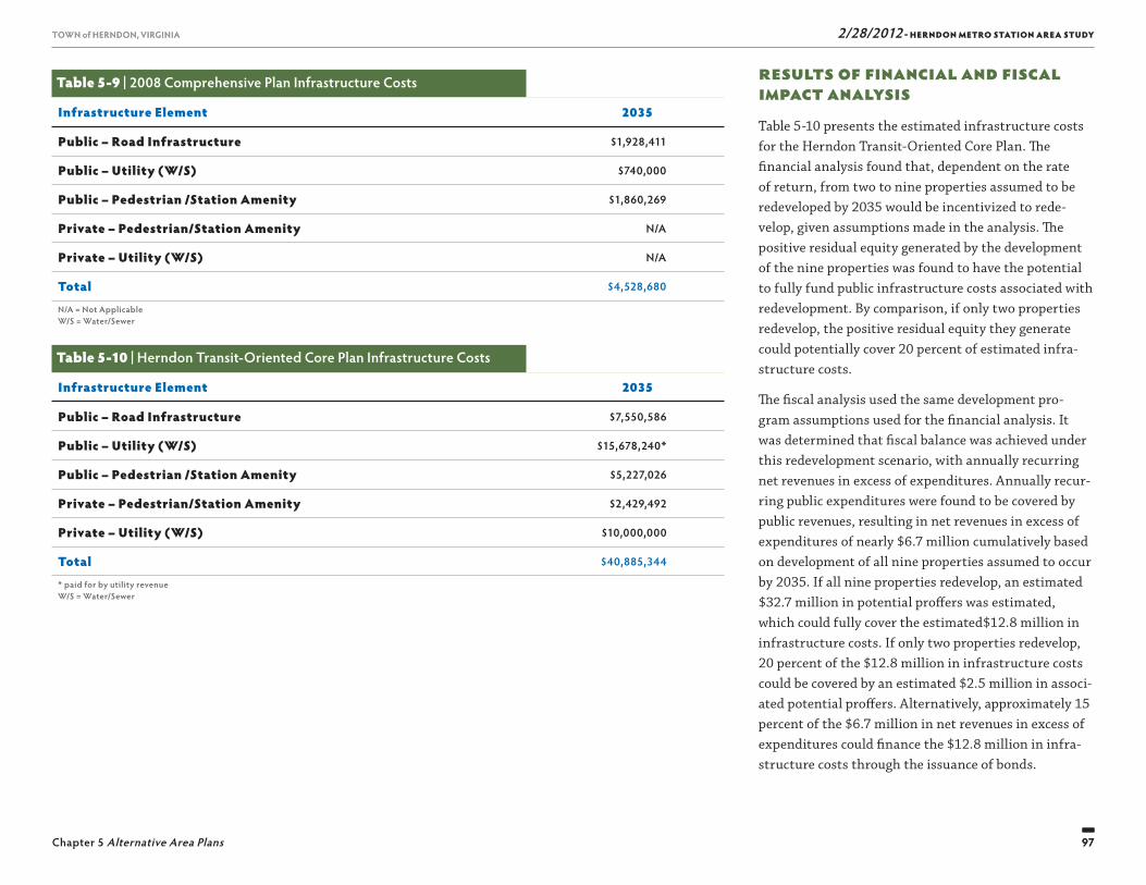
2/28/2012 - HERNDON METRO STATION AREA STUDY
97
TOWN of HERNDON, VIRGINIA
Chapter 5 Alternative Area Plans 97
TOWN of HERNDON, VIRGINIA
Results of Financial and Fiscal Impact AnalysisTable 5-10 presents the estimated infrastructure costs for the Herndon Transit-Oriented Core Plan. Th e fi nancial analysis found that, dependent on the rate of return, from two to nine properties assumed to be redeveloped by 2035 would be incentivized to rede-velop, given assumptions made in the analysis. Th e positive residual equity generated by the development of the nine properties was found to have the potential to fully fund public infrastructure costs associated with redevelopment. By comparison, if only two properties redevelop, the positive residual equity they generate could potentially cover 20 percent of estimated infra-structure costs.
Th e fi scal analysis used the same development pro-gram assumptions used for the fi nancial analysis. It was determined that fi scal balance was achieved under this redevelopment scenario, with annually recurring net revenues in excess of expenditures. Annually recur-ring public expenditures were found to be covered by public revenues, resulting in net revenues in excess of expenditures of nearly $6.7 million cumulatively based on development of all nine properties assumed to occur by 2035. If all nine properties redevelop, an estimated $32.7 million in potential proff ers was estimated, which could fully cover the estimated$12.8 million in infrastructure costs. If only two properties redevelop, 20 percent of the $12.8 million in infrastructure costs could be covered by an estimated $2.5 million in associ-ated potential proff ers. Alternatively, approximately 15 percent of the $6.7 million in net revenues in excess of expenditures could fi nance the $12.8 million in infra-structure costs through the issuance of bonds.
Table 5-9 | 2008 Comprehensive Plan Infrastructure Costs
Infrastructure Element 2035
Public – Road Infrastructure $1,928,411
Public – Utility (W/S) $740,000
Public – Pedestrian /Station Amenity $1,860,269
Private – Pedestrian/Station Amenity N/A
Private – Utility (W/S) N/A
Total $4,528,680
N/A = Not ApplicableW/S = Water/Sewer
Table 5-10 | Herndon Transit-Oriented Core Plan Infrastructure Costs
Infrastructure Element 2035
Public – Road Infrastructure $7,550,586
Public – Utility (W/S) $15,678,240*
Public – Pedestrian /Station Amenity $5,227,026
Private – Pedestrian/Station Amenity $2,429,492
Private – Utility (W/S) $10,000,000
Total $40,885,344
* paid for by utility revenueW/S = Water/Sewer

Th is page intentionally left blank
99
2/28/2012 - HERNDON METRO STATION AREA STUDYTOWN of HERNDON, VIRGINIA
HERNDON TRANSIT-ORIENTED CORE PLAN
6
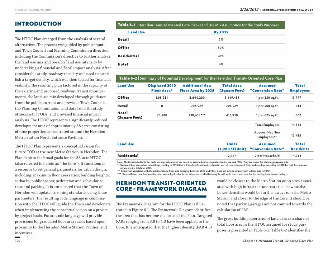
2/28/2012 - HERNDON METRO STATION AREA STUDY
100
TOWN of HERNDON, VIRGINIA
Chapter 6 Herndon Transit-Oriented Core Plan
HERNDON TRANSIT-ORIENTED CORE - FRAMEWORK DIAGRAM
Th e Framework Diagram for the HTOC Plan is illus-trated in Figure 6.1. Th e Framework Diagram identifi es the area that has become the focus of the Plan. Targeted FARs ranging from 3.8 to 4.3 have been applied to the Core. It is anticipated that the highest density (FAR 4.3)
INTRODUCTION
Th e HTOC Plan emerged from the analysis of several alternatives. Th e process was guided by public input and Town Council and Planning Commission direction including the Commission’s directive to further analyze the land use mix and possible land use intensity by undertaking a fi nancial and fi scal impact analysis. After considerable study, roadway capacity was used to estab-lish a target density, which was then tested for fi nancial viability. Th e resulting plan factored in the capacity of the existing and proposed roadway, transit improve-ments, the land use mix developed through guidance from the public, current and previous Town Councils, the Planning Commission, and data from the study of successful TODs, and a revised fi nancial impact analysis. Th e HTOC represents a signifi cantly reduced development area of approximately 38 acres consisting of nine properties concentrated around the Herndon Metro Station North Entrance Pavilion.
Th e HTOC Plan represents a conceptual vision for future TOD at the new Metro Station in Herndon. Th e Plan depicts the broad goals for the 38-acre HTOC (also referred to herein as “the Core”). It functions as a resource to set general parameters for urban design, including: maximum fl oor area ratios; building heights; setbacks; public spaces; pedestrian and vehicular ac-cess; and parking. It is anticipated that the Town of Herndon will update its zoning standards using these parameters. Th e resulting code language in combina-tion with the HTOC will guide the Town and developers when implementing the conceptual vision on a project-by-project basis. Future code language will provide provisions for graduated fl oor area ratios based upon proximity to the Herndon Metro Station Pavilion and incentives.
would be closest to the Metro Station or on sites associ-ated with high infrastructure costs (i.e., new roads). Lower densities would be further away from the Metro Station and closer to the edge of the Core. It should be noted that parking garages are not counted towards the calculation of FAR.
Th e gross building fl oor area of land uses as a share of total fl oor area in the HTOC assumed for study pur-poses is presented in Table 6-1. Table 6-2 identifi es the
Table 6-1 | Herndon Transit-Oriented Core Plan–Land Use Mix Assumption for the Study Purposes
Land Use By 2035
Retail 3%
Office 50%
Residential 41%
Hotel 6%
Land Use Displaced 2010Floor Area*
Additional NewFloor Area by 2035
Total Area(Square Feet)
Assumed“Conversion Rate”
TotalEmployees
Office 805,281 2,644,200 3,449,481 1 per 250 sq.ft. 13,797
Retail 0 206,969 206,969 1 per 500 sq.ft. 414
Hotel (Square Feet) 75,280 338,658*** 413,938 1 per 625 sq.ft. 662
Total Employees 14,833
Approx. Net New Employees** 13,425
Land Use Units (1,200 SF/Unit)
Assumed “Conversion Rate”
TotalResidents
Residential 2,357 2 per Household 4,714
Note: Th e items included in this table are approximate and are based on assumed conversion rates, land areas, and FARs. Th ey are meant for planning purposes only.* Displaced fl oor area refers to buildings (existing in 2010) that will be demolished and replaced as part of redevelopment. Trips and employees existing in 2010 for that fl oor area are
included in the totals for 2035.** Employees associated with the additional new fl oor area emerging between 2010 and 2035. Does not include employment in fl oor area in 2010.*** Th e additional new fl oor area for hotel varies slightly due to the diff erence created by using the 625 sq.ft . conversion ratio for the existing hotle square footage.
Table 6-2 | Summary of Potential Development for the Herndon Transit- Oriented Core Plan
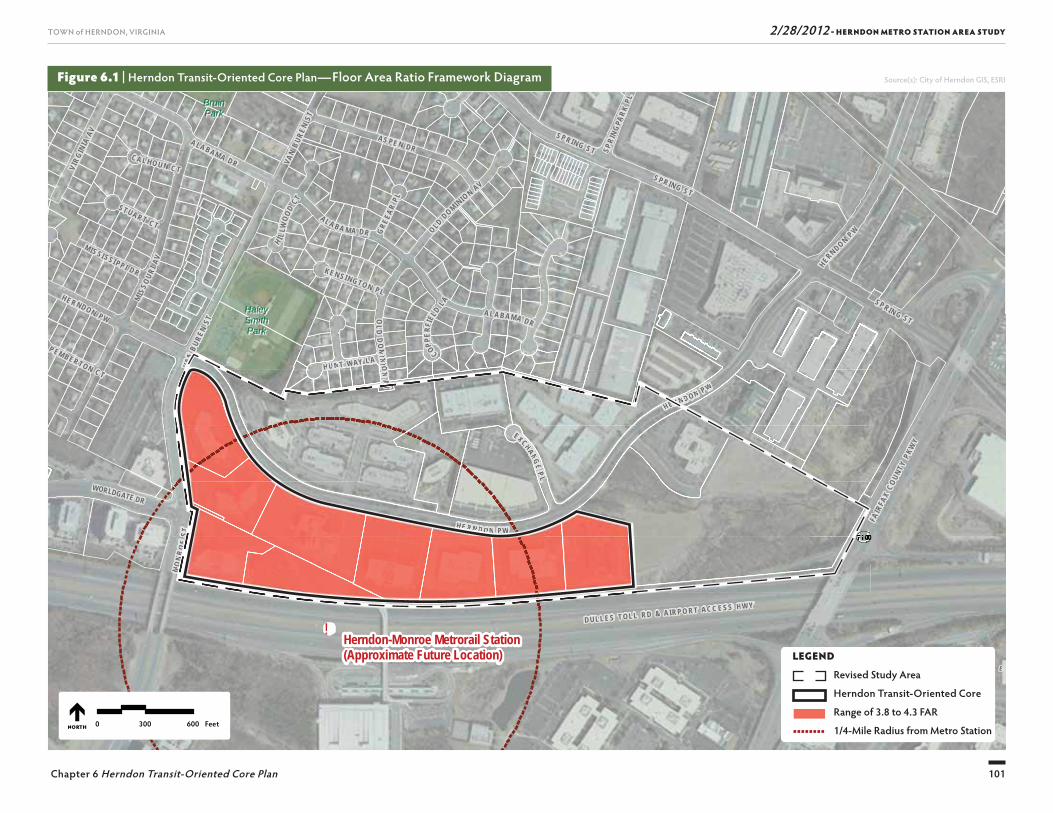
2/28/2012 - HERNDON METRO STATION AREA STUDY
101
TOWN of HERNDON, VIRGINIA
Chapter 6 Herndon Transit-Oriented Core Plan
!
SU
NR I S E
V A L L E
UV7100
SUNRISE VALLEY DR
WORLDGATE DR
FAIR
FAX
COUN
TY P
KWY
D U L L E S T OL L R D & A IR P O R T A C C E S S H W Y
BruinBruinParkPark
HaleyHaleySmithSmithParkPark
Herndon-Monroe Metrorail Station(Approximate Future Location)
VAN
BURE
N ST
MO
NR
OE
ST
EXCHANG E P L
S P RIN G ST
VAN
B URE
N ST
HU N T WAY L A
S P R IN G S T
MIS
S OUR
I AV
AL A B A M A DR OLD DOM INIO
N AV
OLD
DO
MIN
I ON
A V
S P R IN G S T
CA L HO U N C T
A L A B A MA DR
GRE
EAR
PL
H I LLW
OOD
C T
P EM BER TON C T
ST UAR T CT
COPPER
FIEL
D LA
KEN S I NGTO N P L
SPRI
NGPA
RK PL
H E R N D O N P W
MIS SI SSI PP I D R
HE R NDON PW
A LA BAM A DR
HE RND ON P W
VIRG
INIA
AV AS PE N DR
HERNDO N P W
0 300 600 FeetNORTH
Figure 6.1 | Herndon Transit-Oriented Core Plan—Floor Area Ratio Framework Diagram Source(s): City of Herndon GIS, ESRI
VVVVVVVVVUUUUUUUUUUUUUUUUUUUUUUUUUUUUUU
F
P OO R T AA C C E S S H W YY
VVVVVVVVVAAAAAAAAAAAAAANNNNNNNNNNN
MO
N
HU N TT WAYY LL AA
MIN
I O
CO
RRRRRRRRRRRRRNNNNNND ON PP W
HEEEEEEEEEEEEE RRRRRR
V
V
E R
VAN
VV
EXXCHAANG EPP LL
VVVVVVVVVVVVV
HHHHHHHHHHH EEEEEEEEEE RRRRRRRRRRR NNNNNNNNN DDDDDDDDDDDD OOOOOOOOO NNNNNNNNN PPPPPPPPPP WWWWWWWWWWWW
MMMMMMMMMMMOOOOOOOOOOO
NNNNNNNNNNNNRRRRRRRRRR
OOOOOOOOOOEEEEEEEEE
SSSSSSSSSSSSTTTTTTTTTTTTTTT
HU N TT ON
AAAAAAAAAAAAA
VVVV
VLEGEND
Revised Study Area
Herndon Transit-Oriented Core
Range of 3.8 to 4.3 FAR
1/4-Mile Radius from Metro Station

2/28/2012 - HERNDON METRO STATION AREA STUDY
102
TOWN of HERNDON, VIRGINIA
Chapter 6 Herndon Transit-Oriented Core Plan
Figure 6.2 | Herndon Transit-Oriented Core Plan
not to scale
NORTH
Herndon Metro PromenadeNorth Pavilion Entrance
HERNDON PARKWAYHERNDON PARKWAY
DULLES TOLL RD & AIRPORT ACCESS HWYDULLES TOLL RD & AIRPORT ACCESS HWY
LEGEND
Buildings Parking Structures
Bus Stop and Metro Passenger
Drop-off/Pick-up Area
HERNDON METRO PROMENADE DETAIL
2/28/2012 - HERNDON METRO STATION AREA STUDY
103
TOWN of HERNDON, VIRGINIA
Chapter 6 Herndon Transit-Oriented Core Plan
assumed gross building fl oor area as a share of the total fl oor area in the HTOC. Th is land use mix and poten-tial development program were assumed for analysis purposes.
HERNDON TRANSIT-ORIENTED CORE PLAN
Th e HTOC is depicted in the Illustrative Plan, shown in Figure 6.2, is described further in the sections below. Th e graphic shows the HTOC (with a FAR range of 3.8 to 4.3) in greater detail with buildings, parking struc-tures, public spaces, and streetscape amenities illustrat-ed. Based on the target FAR range, in 2035, the average FAR will be 4.17 resulting in potentially 4.1 million square feet of commercial fl oor area (retail/offi ce/hotel)and 2,357 dwelling units. Th e frontage along the south side of the Herndon Parkway is urbanized with a street wall and bicycle and pedestrian improvements.
Th e HTOC Plan, as illustrated in Figure 6.2, is to be used as a guide when considering future development and redevelopment. It is intended to set a standard for quality development and does not prescribe specifi c building shapes and locations. Th e Town welcomes inventive solutions by developers and encourages the use of new urbanist principles (especially avoidance of suburban-type offi ce buildings and superblocks) and an appealing street level environment oriented to pedes-trian activity.
Conceptual Design ApproachFor redevelopment closest to the new Metro Station, the HTOC Plan envisions a mixed use TOD. Th e TOD will give Herndon a new neighborhood and economic
engine providing employment, housing, shopping, din-ing and community activities. Future HTOC residents will be able to live in an active and lively neighbor-hood with a short walk to the Metro Station. Herndon residents will benefi t from new neighborhood retail and services as well as public space amenities. Workers will have the fl exibility of commuting by train or living near their place of employment.
Th e HTOC Plan follows principles of Smart Growth and best practices for TOD planning by:
■ Providing a mix of uses that reinforce each other, shops, services, employment, recreation and residenc-es, framing public spaces.
■ Promoting a walkable community where people have choices, and the opportunities to live, work, shop, and play without having to use a vehicle.
■ Supporting transportation alternatives, including walking, biking, and mass transit.
■ Incorporating higher-density housing that supports transit use, adds vitality to employment and commer-cial areas, and meets a need in the market.
■ Creating a variety of daytime and evening activities.
■ Integrating a comprehensive parking strategy that includes the sharing of peak and off -peak parking demand.
A three-dimensional massing diagram, presented as Figure 6.3, was also created to illustrate the HTOC Plan. Th e diagram is based on the urban design con-cepts and the basic density assumptions in the Plan focusing on the Core with a 3.8 to 4.3 FAR range. Th e model shows how the buildings of the HTOC could be accommodated within 12 to 15 stories throughout the Core (based on the assumption that lot coverage could
be as high as 70 percent, or more). Th e buildings will utilize setbacks on upper fl oors and cornice lines on lower fl oors to promote superior pedestrian scale, and increase light at the sidewalk level. Th e buildings will form the edges of public spaces designed for the public’s use and enjoyment.
North of Herndon Parkway
Th e HTOC involves only nine properties, all of which are south of the Herndon Parkway. For properties north of the Herndon Parkway and east of the Core refer to the section titled ‘Long-Term Vision’ at the end of this chapter. Th e Long-Term Vision envisions a time beyond 2035 when transit use and the full benefi ts of TOD have been realized and signifi cant regional transporta-tion infrastructure improvements have been made to facilities within and adjacent to the town.
Beyond 2035, when such improvements occur and additional capacity makes redevelopment north of the Herndon Parkway desirable, it is crucial that any rede-velopment is harmonious with the HTOC development south of the Herndon Parkway. Additional guidance concerning the form and substance of development beyond 2035 is found at the end of this chapter.
Public Spaces
Public spaces allowing for fl exible programming and variety in design are the key to creating an active com-munity. A series of public places should be connected throughout the Core to provide choices for traversing the TOD and to encourage residents, commuters, shop-pers, and offi ce workers to explore and experience the entire center. Elements such as park benches, street trees, courtyards, fountains and unique landscape fea-
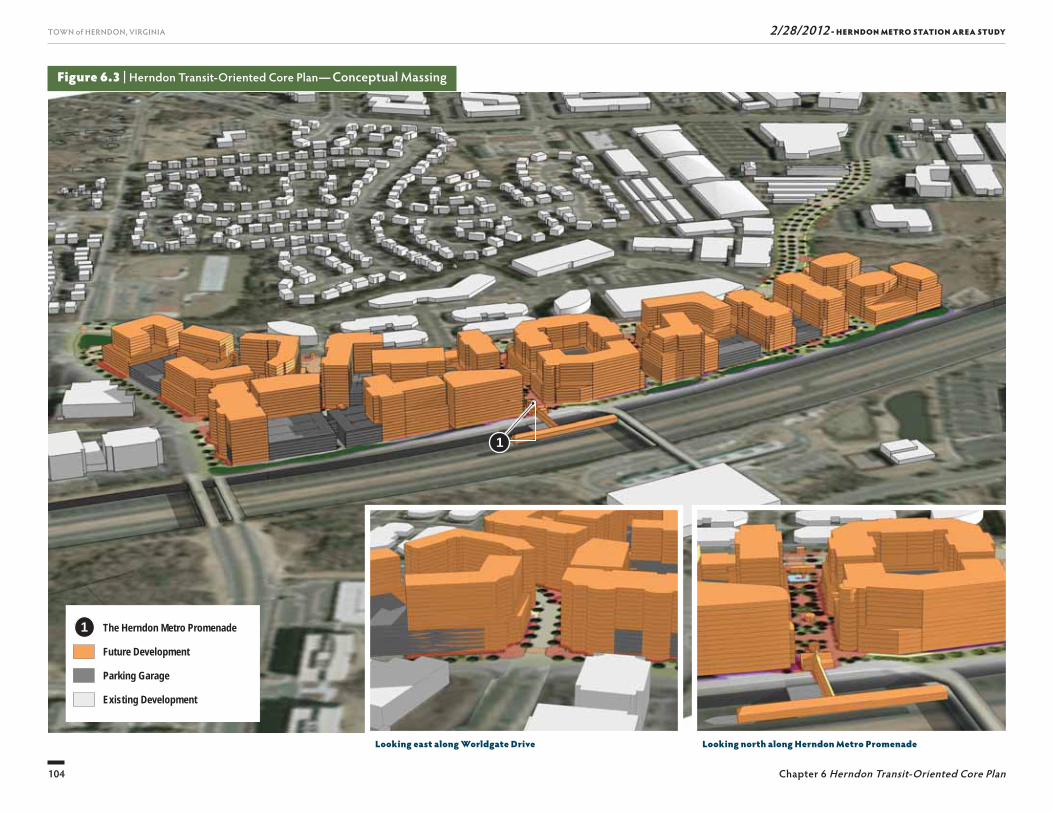
2/28/2012 - HERNDON METRO STATION AREA STUDY
104
TOWN of HERNDON, VIRGINIA
Chapter 6 Herndon Transit-Oriented Core Plan
Figure 6.3 | Herndon Transit-Oriented Core Plan— Conceptual Massing
Looking north along Herndon Metro PromenadeLooking east along Worldgate Drive
The Herndon Metro Promenade
Future Development
Parking Garage
Existing Development
1
1
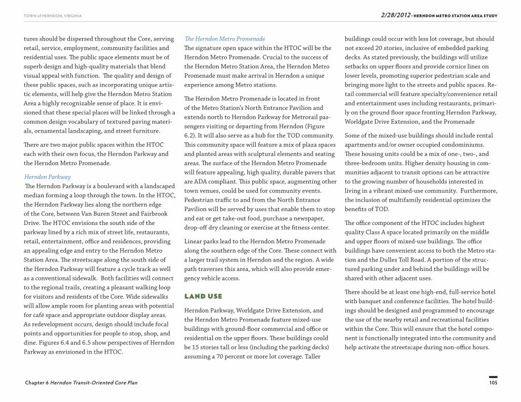
2/28/2012 - HERNDON METRO STATION AREA STUDY
105
TOWN of HERNDON, VIRGINIA
Chapter 6 Herndon Transit-Oriented Core Plan
buildings could occur with less lot coverage, but should not exceed 20 stories, inclusive of embedded parking decks. As stated previously, the buildings will utilize setbacks on upper fl oors and provide cornice lines on lower levels, promoting superior pedestrian scale and bringing more light to the streets and public spaces. Re-tail commercial will feature specialty/convenience retail and entertainment uses including restaurants, primari-ly on the ground fl oor space fronting Herndon Parkway, Worldgate Drive Extension, and the Promenade
Some of the mixed-use buildings should include rental apartments and/or owner occupied condominiums. Th ese housing units could be a mix of one-, two-, and three-bedroom units. Higher density housing in com-munities adjacent to transit options can be attractive to the growing number of households interested in living in a vibrant mixed-use community. Furthermore, the inclusion of multifamily residential optimizes the benefi ts of TOD.
Th e offi ce component of the HTOC includes highest quality Class A space located primarily on the middle and upper fl oors of mixed-use buildings. Th e offi ce buildings have convenient access to both the Metro sta-tion and the Dulles Toll Road. A portion of the struc-tured parking under and behind the buildings will be shared with other adjacent uses.
Th ere should be at least one high-end, full-service hotel with banquet and conference facilities. Th e hotel build-ings should be designed and programmed to encourage the use of the nearby retail and recreational facilities within the Core. Th is will ensure that the hotel compo-nent is functionally integrated into the community and help activate the streetscape during non-offi ce hours.
Th e Herndon Metro PromenadeTh e signature open space within the HTOC will be the Herndon Metro Promenade. Crucial to the success of the Herndon Metro Station Area, the Herndon Metro Promenade must make arrival in Herndon a unique experience among Metro stations.
Th e Herndon Metro Promenade is located in front of the Metro Station’s North Entrance Pavilion and extends north to Herndon Parkway for Metrorail pas-sengers visiting or departing from Herndon (Figure 6.2). It will also serve as a hub for the TOD community. Th is community space will feature a mix of plaza spaces and planted areas with sculptural elements and seating areas. Th e surface of the Herndon Metro Promenade will feature appealing, high quality, durable pavers that are ADA compliant. Th is public space, augmenting other town venues, could be used for community events. Pedestrian traffi c to and from the North Entrance Pavilion will be served by uses that enable them to stop and eat or get take-out food, purchase a newspaper, drop-off dry cleaning or exercise at the fi tness center.
Linear parks lead to the Herndon Metro Promenade along the southern edge of the Core. Th ese connect with a larger trail system in Herndon and the region. A wide path traverses this area, which will also provide emer-gency vehicle access.
Land UseHerndon Parkway, Worldgate Drive Extension, and the Herndon Metro Promenade feature mixed-use buildings with ground-fl oor commercial and offi ce or residential on the upper fl oors. Th ese buildings could be 15 stories tall or less (including the parking decks) assuming a 70 percent or more lot coverage. Taller
tures should be dispersed throughout the Core, serving retail, service, employment, community facilities and residential uses. Th e public space elements must be of superb design and high-quality materials that blend visual appeal with function. Th e quality and design of these public spaces, such as incorporating unique artis-tic elements, will help give the Herndon Metro Station Area a highly recognizable sense of place. It is envi-sioned that these special places will be linked through a common design vocabulary of textured paving materi-als, ornamental landscaping, and street furniture.
Th ere are two major public spaces within the HTOC each with their own focus, the Herndon Parkway and the Herndon Metro Promenade.
Herndon Parkway Th e Herndon Parkway is a boulevard with a landscaped median forming a loop through the town. In the HTOC, the Herndon Parkway lies along the northern edge of the Core, between Van Buren Street and Fairbrook Drive. Th e HTOC envisions the south side of the parkway lined by a rich mix of street life, restaurants, retail, entertainment, offi ce and residences, providing an appealing edge and entry to the Herndon Metro Station Area. Th e streetscape along the south side of the Herndon Parkway will feature a cycle track as well as a conventional sidewalk. Both facilities will connect to the regional trails, creating a pleasant walking loop for visitors and residents of the Core. Wide sidewalks will allow ample room for planting areas with potential for café space and appropriate outdoor display areas. As redevelopment occurs, design should include focal points and opportunities for people to stop, shop, and dine. Figures 6.4 and 6.5 show perspectives of Herndon Parkway as envisioned in the HTOC.
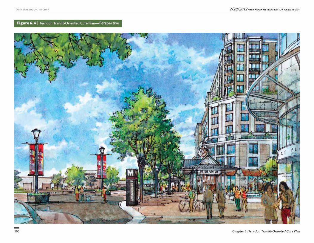
2/28/2012 - HERNDON METRO STATION AREA STUDY
106
TOWN of HERNDON, VIRGINIA
Chapter 6 Herndon Transit-Oriented Core Plan
Figure 6.4 | Herndon Transit-Oriented Core Plan—Perspective
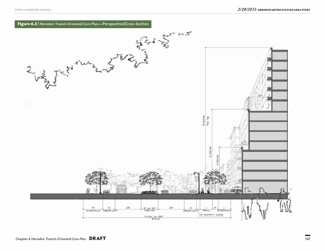
2/28/2012 - HERNDON METRO STATION AREA STUDY
107
TOWN of HERNDON, VIRGINIA
Chapter 6 Herndon Transit-Oriented Core Plan DRAFT
Figure 6.5 | Herndon Transit-Oriented Core Plan—Perspective/Cross-Section
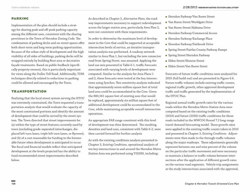
2/28/2012 - HERNDON METRO STATION AREA STUDY
108
TOWN of HERNDON, VIRGINIA
Chapter 6 Herndon Transit-Oriented Core Plan
■ Herndon Parkway/Van Buren Street
■ Van Buren Street/Worldgate Drive
■ Van Buren Street/Alabama Drive
■ Herndon Parkway/Commercial Access
■ Herndon Parkway/Exchange Place
■ Herndon Parkway/Fairbrook Drive
■ Spring Street/Fairfax County Parkway Ramps
■ Spring Street/Herndon Parkway
■ Elden Street/Monroe Street
■ Elden Street/Van Buren Street
Forecasts of future traffi c conditions were analyzed for 2035 (full build-out) and are presented in Figure 6.6. Future traffi c volumes include existing traffi c counts, regional traffi c growth, other approved development traffi c and traffi c generated by the implementation of the HTOC Plan.
Regional annual traffi c growth rates for the various roads within the Herndon Metro Station Area were computed based on the existing traffi c conditions (2010) and future (2030) traffi c conditions for those roads included in the MWCOG Round 7.2 long-range travel-demand forecasting model. Th ese growth rates were applied to the existing traffi c counts taken in 2010 and presented in Chapter 3, Existing Conditions. Adjust-ments were then made to the through traffi c volumes along the major roadways. Th ese adjustments generally represent between one and nine percent of the volume on the particular traffi c movement and were necessary to maintain a balance in traffi c volume between inter-sections after the application of diff erent growth rates on the various road segments. Vehicle trip assignments at the study intersections associated with the approved,
As described in Chapter 5, Alternative Plans, the road-way improvements necessary to support redevelopment across the larger station area, particularly Area Plan 2, were not consistent with these requirements.
In order to determine the maximum level of develop-ment in the Core that could be supported at acceptable intersection levels of service, an iterative transpor-tation analysis was performed. A roadway network similar to Area Plan 1, but excluding the new connector road from Spring Street, was assumed. Applying the land use mix presented in Table 6-1, traffi c forecasts associated with varying levels of development were computed. Similar to the analysis for Area Plans 1 and 2, these forecasts were tested at the key intersec-tions using Synchro. Th is sensitivity analysis indicated that approximately seven million square feet of total land area could be accommodated in the Core. Given the 880,561 square feet of existing uses that would be replaced, approximately six million square feet of additional development could be accommodated in the Core, while maintaining acceptable overall intersection operations.
An appropriate FAR range consistent with this level of development was then determined. Th e resulting densities and land uses, consistent with Table 6-2, were then carried forward for further analysis.
As with the existing conditions analysis presented in Chapter 3, Existing Conditions, operational analysis of ten key intersections in and around the Herndon Metro Station Area was performed using VISSIM, including:
ParkingImplementation of the plan should include a strat-egy for sharing peak and off -peak parking capacity among the diff erent uses, consistent with the sharing provisions in the Town of Herndon Zoning Code. Th e combination of parking decks and on-street spaces off er both short-term and long-term parking opportunities. Because of the urban style of development and the high visibility of all sides of buildings, parking decks will be wrapped entirely by building fl oor area or decorative façade treatments. Based on public feedback (specifi -cally property owners), this is particularly important for views along the Dulles Toll Road. Additionally, TDM techniques directly related to reductions in parking could be allowed and encouraged by the Town.
Transportation Realizing that the local street system serving the HTOC was extremely constrained, the Town requested a trans-portation analysis that would evaluate the capacity of the most constrained portions and identify the amount of development that could be served by the street sys-tem. Th e Town directed that street improvements be: (a) within the type of street features currently used by town (excluding grade-separated interchanges, dis-placed left turn lanes, triple left turn lanes, or fl yovers); and (b) of a cost reasonable for funding in the foresee-able future when development is anticipated to occur. Th e fi scal and fi nancial models refl ect that anticipated development at the levels projected has the ability to fund recommended street improvements described below.
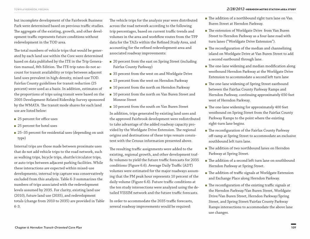
2/28/2012 - HERNDON METRO STATION AREA STUDY
109
TOWN of HERNDON, VIRGINIA
Chapter 6 Herndon Transit-Oriented Core Plan
but incomplete development of the Fairbrook Business Park were determined based on previous traffi c studies. Th e aggregate of the existing, growth, and other devel-opment traffi c represents future conditions without redevelopment in the TOD area.
Th e total numbers of vehicle trips that would be gener-ated by each land use within the Core were determined based on data published by the ITE in the Trip Genera-tion manual, 8th Edition. Th e ITE trip rates do not ac-count for transit availability or trips between adjacent land uses prevalent in high-density, mixed-use TOD. Fairfax County guidelines for transit reduction (25 percent) were used as a basis. In addition, estimates of the proportions of trips using transit were based on the 2005 Development-Related Ridership Survey sponsored by the WMATA. Th e transit mode shares for each land use are listed below:
■ 25 percent for offi ce uses
■ 25 percent for hotel uses
■ 25–35 percent for residential uses (depending on unit type)
Internal trips are those made between proximate uses that do not add vehicle trips to the road network, such as walking trips, bicycle trips, shuttle/circulator trips, or auto trips between adjacent parking facilities. While these interactions are expected within mixed-use developments, internal trip capture was conservatively excluded from this analysis. Table 6-3 summarizes the numbers of trips associated with the redevelopment levels assumed by 2035. For clarity, existing land use (2010), future land use (2035), and redevelopment totals (change from 2010 to 2035) are provided in Table 6-3.
Th e vehicle trips for the analysis year were distributed across the road network according to the following trip percentages, based on current traffi c trends and volumes in the area and workfl ow routes from the TPP data for the TAZs within the Refi ned Study Area, and accounting for the refi ned redevelopment area andassociated roadway improvements:
■ 20 percent from the east on Spring Street (including Fairfax County Parkway)
■ 35 percent from the west on and Worldgate Drive
■ 15 percent from the west on Herndon Parkway
■ 10 percent from the north on Herndon Parkway
■ 10 percent from the north on Van Buren Street and Monroe Street
■ 10 percent from the south on Van Buren Street
In addition, trips generated by existing land uses and the approved Fairbrook development were redistributed to take advantage of the added roadway capacity pro-vided by the Worldgate Drive Extension. Th e regional origins and destinations of these trips remain consis-tent with the Census information presented above.
Th e resulting traffi c assignments were added to the existing, regional growth, and other development traf-fi c volumes to yield the future traffi c forecasts for 2035 conditions (Figure 6.6). Average Daily Traffi c (ADT) volumes were estimated for the major roadways assum-ing that the PM peak hour represents 10 percent of the daily volume (Figure 6.6). Future traffi c conditions at the ten study intersections were analyzed using the de-tailed VISSIM network and the future traffi c forecasts.
In order to accommodate the 2035 traffi c forecasts, several roadway improvements would be required:
■ Th e addition of a northbound right turn lane on Van Buren Street at Herndon Parkway.
■ Th e extension of Worldgate Drive from Van Buren Street to Herndon Parkway as a four-lane road with turn lanes (“Worldgate Drive Extension”).
■ Th e reconfi guration of the median and channelizing island on Worldgate Drive at Van Buren Street to add a second eastbound through lane.
■ Th e one-lane widening and median modifi cation along westbound Herndon Parkway at the Worldgate Drive Extension to accommodate a second left turn lane
■ Th e one-lane widening of Spring Street eastbound between the Fairfax County Parkway Ramps and Herndon Parkway, continuing approximately 650 feet west of Herndon Parkway.
■ Th e one-lane widening for approximately 400 feet westbound on Spring Street from the Fairfax County Parkway Ramps to the point where the existingright-turn lane begins.
■ Th e reconfi guration of the Fairfax County Parkway off -ramp at Spring Street to accommodate an exclusive southbound left turn lane.
■ Th e addition of two northbound lanes on Herndon Parkway at Spring Street.
■ Th e addition of a second left turn lane on southbound Herndon Parkway at Spring Street.
■ Th e addition of traffi c signals at Worldgate Extension and Exchange Place along Herndon Parkway.
■ Th e reconfi guration of the existing traffi c signals at the Herndon Parkway/Van Buren Street, Worldgate Drive/Van Buren Street, Herndon Parkway/Spring Street, and Spring Street/Fairfax County Parkway Ramps intersections to accommodate the above lane use changes.
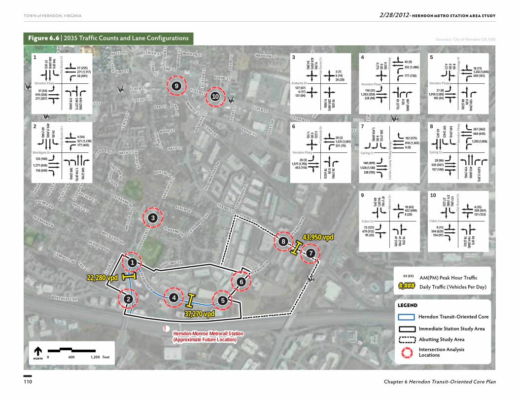
2/28/2012 - HERNDON METRO STATION AREA STUDY
110
TOWN of HERNDON, VIRGINIA
Chapter 6 Herndon Transit-Oriented Core Plan
Figure 6.6 | 2035 Traffic Counts and Lane Configurations Source(s): City of Herndon GIS, ESRI
!Herndon-Monroe Metrorail Station(Approximate Future Location)
CENT
ER S T
VAN
BURE
N ST
GR
ANT
ST
LO C UST S T
PALMER D R
NAS H ST
E LD EN ST
HUN T WAY LA
SP RIN G ST
EL DE N STM
ISS O
URI A
V
MO
NR O
E ST
FL
ORIDA AV
C AM PB ELL W Y
VAN
BUR EN
S T
GRA
CE ST
NA SH S T
STAT
I ON
ST
A L A B AMA D R
MONR O E ST
OLD DOM IN IO N
AVJ A
CK S
ON
S T
VAN
B UREN
ST
CEN TER ST
S PRING ST
V I R GINIA AV
EL DE N ST
AL AB A M A D R
FLORI
DA AV
MISSO
URI A
V
ADA M S ST
H AL EY PL M AD IS O N ST
V IN E ST
HE R N D ON PW
ER I C C T
PI NE ST
JONQ
U IL
L A
FAI RF AX
L A
O AK ST
MAI
N DR
HERN DON P W
FIFT
H ST
B RU C E C T
A R C H ER CT
PEARL
ST
E L DE N S T
SPR IN G S T
LO C UST S T
V IN E ST
LAUR
EL W
Y
M ISS ISS IPP I D R
AUSTIN LA
GRA
NT S T
E L D E N S T
DAK
OT A D R
LE
O N A LA
HERN DO N PW
W O O D S T
W O R L DG AT E D R
A LA B A M A DR
LYNN
ST
CO RAL RD
HE R N DO N PW
HERN
DO
N PW
C AR L
I SL E
DR
HE RN DO N PW
POS T
DR
FERN
D ALE
AV
SPR I
NGPA
RK PLH UN
TMAR
PARK
DR
STE RL ING R D
PICK
ETT
L A
PATR
ICK
LA
E L D E N S T
G ROV E ST
ARKANSA
S AV
AS P E N D R
G ROV E ST
M ADI S ON ST
H ER ND ON PW
UV606
UV7100
UV7100UV228
UV228
UV606
UV606
0 600 1,200 FeetNORTH
LEGEND
Immediate Station Study Area
Abutting Study Area
Intersection Analysis Locations
Herndon Transit-Oriented Core
10
11 33 44 55
22 66 77
99
88
194 (81)
9 (39)3 (22)
385 (112)6 (58)
87 (116)
177 (95)8 (9)
345 (414)
54 (8)
645 (200)
10 (28)36 (196)
867 (880)16 (15)
65 (61)138 (394)
1,031 (1,351)
509 (210)
57 (255)3 (7)
28 (2) 162 (575)
45 (9)
10 (63) 4 (25)
18 (11)
267 (362)
4 (54)
51 (54)127 (67)
26 (3)148 (499)
110 (31)
72 (121) 9 (11)
21 (8)
28 (96)133 (160)
366 (494)
424 (501)0 (0) 0 (0)
0 (0)94 (87)
371 (188)0 (0)
597 (342)
495 (1,058)
240 (377)
289 (481)0 (0)
0 (0)41 (110)
144 (368)0 (0)
413 (600)
1,110 (815)
271 (1,117)6 (14)
1,531 (1,581) 810 (1,365)
352 (1,486)
422 (690) 358 (561)
1,242 (1,845)
660 (645)
521 (1,238)
919 (358)6 (17)
1,577 (1,793)1,526 (1,130)
1,393 (559)
679 (512) 594 (629)
1,910 (1,503)
635 (567)1,271 (636)
37 (42)
34 (86)1 (13)
1,410 (698)3 (71)
60 (91)
27 (23)4 (7)
42 (47)
60 (148)
319 (460)
9 (100)78 (423)
82 (273)47 (129)
78 (232)88 (228)
119 (196)
380 (304)
58 (491)26 (20)
321 (76) 0 (0)
777 (736)
8 (20) 131 (123)
349 (161)
1,293 (1,056)177 (445)
211 (207)131 (84)
453 (110)338 (703)
228 (98)
95 (35) 154 (97)
185 (92)
157 (140)118 (549)
Herndon PkwyHerndon Pkwy
Worldgate DrWorldgate Dr
Alabama DrAlabama Dr Herndon PkwyHerndon Pkwy Herndon PkwyHerndon Pkwy
Spring StSpring St
Elden StElden StElden StElden St
Spring StSpring St
Fairb
rook
Dr
Fairb
rook
Dr
Van
Bure
n St
Van
Bure
n St
Van
Bure
n St
Van
Bure
n St
Van
Bure
n St
Van
Bure
n St
Driv
eway
Driv
eway
Exch
ange
Pl
Exch
ange
Pl
Hern
don
Pkwy
Hern
don
Pkwy
Van
Bure
n St
Van
Bure
n St
Mon
roe S
tM
onro
e St
Fairf
ax C
ount
y Pkw
ay R
amps
Fairf
ax C
ount
y Pkw
ay R
amps
Herndon PkwyHerndon Pkwy
9
1010
3
1
2 4 5
6
7
8
22,280 vpd22,280 vpd
37,270 vpd37,270 vpd
43,950 vpd43,950 vpd
AM(PM) Peak Hour Traffi c
Daily Traffi c (Vehicles Per Day)#,####,###XX (XX)
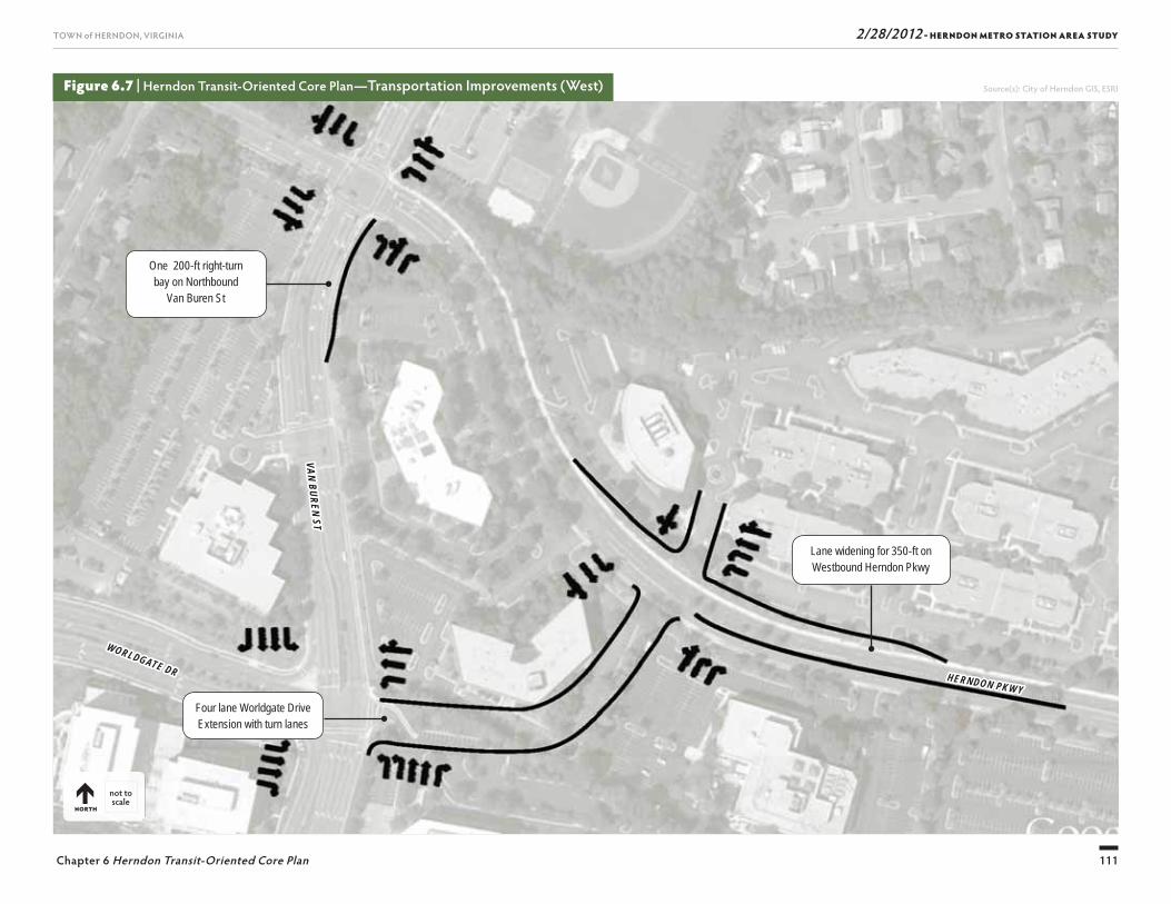
2/28/2012 - HERNDON METRO STATION AREA STUDY
111
TOWN of HERNDON, VIRGINIA
Chapter 6 Herndon Transit-Oriented Core Plan
Figure 6.7 | Herndon Transit-Oriented Core Plan— Transportation Improvements (West) Source(s): City of Herndon GIS, ESRI
One 200-ft right-turn bay on Northbound
Van Buren St
Four lane Worldgate Drive Extension with turn lanes
Lane widening for 350-ft on Westbound Herndon Pkwy
HERNDON PKWYHERNDON PKWY
WORLDGATE DR
WORLDGATE DR
VAN BUREN STVAN BUREN ST
not to scale
NORTH
2/28/2012 - HERNDON METRO STATION AREA STUDY
112
TOWN of HERNDON, VIRGINIA
Chapter 6 Herndon Transit-Oriented Core Plan
Figure 6.8 | Herndon Transit-Oriented Core Plan— Transportation Improvements (East) Source(s): City of Herndon GIS, ESRI
One lane widening on Eastbound Spring St
One lane widening on Spring St
Barricade to separate left-turn and through traffi c
One lane widening on Southbound Ramp
One lane widening on Westbound Spring St
Reconfi gure island
Two lane widening on Northbound Herndon Pkwy
SPRING ST
SPRING ST
HERNDON PKWY
HERNDON PKWY
HERN
DON
PKW
Y
HERN
DON
PKW
Y
not to scale
NORTH
One lane widening on Southbound Herndon Pkwy
2/28/2012 - HERNDON METRO STATION AREA STUDY
113
TOWN of HERNDON, VIRGINIA
Chapter 6 Herndon Transit-Oriented Core Plan
Table 6-3 | Herndon Transit-Oriented Core Plan Trip Generation Summary 2035
Part A Land Use Type Land Use Code Unit Type2010*Units
New Units 2035
AM Distribution Total
In OutPM Distribution
TotalIn Out
Townhomes 230 Dwelling Units 0 0 0 0 0 0 0 0
Mid-Rise Apartments 223 Dwelling Units 0 707 277 86 191 328 190 138
High-Rise Apartments 232 Dwelling Units 0 1,650 507 96 411 576 357 219
Hotel 310 Rooms 146 516 313 191 122 304 161 143
Office 710 1000Sq. GFA 805 2,644 2,576 2,267 309 3,040 517 2,523
SITE GENERATED TRIPS 3,673 2,640 1,033 4,249 1,226 3,023
Part B Transit Reductions Land Use Code Unit Type UnitsAM Distribution
ReductionsIn Out
PM Distribution Reductions
In Out
Townhomes 230 Dwelling Units 0 0 0 0 0 0 0
Mid-Rise Apartments 223 Dwelling Units 707 69 21 48 82 48 34
High-Rise Apartments 232 Dwelling Units 1,650 178 34 144 202 125 77
Hotel 310 Rooms 516 78 48 30 76 40 36
Office 710 1000Sq. GFA 2,644 644 567 77 760 129 631
Total Transit Reductions 969 670 299 1,120 342 778
Residential Subtotal 537 127 410 621 375 246
Office Reductions 2,167 1,843 323 2,508 509 2,000
TOTAL SITE GENERATED TRIPS (PART A MINUS PART B) 2,704 1,970 734 3,129 884 2,246
Existing Land Uses* Land Use Code Unit Type Units
Hotel 310 Rooms 146
Office 710 1000Sq. GFA 805
Total 2035 Land Uses (Existing + New) Land Use Code Unit Type Units
Townhomes 230 Dwelling Units 0
Mid-Rise Apartments 223 Dwelling Units 707
High-Rise Apartments 232 Dwelling Units 1,650
Hotel 310 Rooms 662
Office 710 1000Sq. GFA 3,449
Trips added as part of Redevelopment
2/28/2012 - HERNDON METRO STATION AREA STUDY
114
TOWN of HERNDON, VIRGINIA
Chapter 6 Herndon Transit-Oriented Core Plan
Cut-through Traffi c ■ Partial street closures
■ Full street closures
■ Diversions
Speeding ■ Speed humps/raised crosswalks/raised intersections
■ Roundabouts/neighborhood traffi c circles
■ Neck downs/chokers/chicanes
It is not anticipated that these measures would be re-quired, but they could be evaluated for implementation if the need arises.
Neighborhood Traffic and ParkingTh e street and block network has been designed to limit vehicular interaction between the Herndon Metro Sta-tion Area and the nearby residential communities. No new street connections are planned with the single-family neighborhoods to the north, and the majority of traffi c is focused on major corridors into and out of the Herndon Metro Station Area. However, if cut-through traffi c or speeding issues develop in residential areas in the future, traffi c calming measures could be consid-ered for implementation. Examples of eff ective traffi c calming methods to address specifi c issues include:
Refer to Figure 6.7 and 6.8 for the proposed transporta-tion improvements for 2035.
Th e levels of service and vehicular delays at the critical intersections with these improvements are summarized in Table 6-4. Each of the study intersections would operate at LOS D or better during both the AM and PM peak hours with the HTOC plan, with the exception of the Van Buren Street/Alabama Drive intersection. Dur-ing the PM peak hour, this intersection would experi-ence signifi cant delays, assuming the current intersec-tion confi guration and all-way stop sign control remain in place. Th e Town has identifi ed this segment of Van Buren Street for the potential application of measures to improve pedestrian and bicycle accommodations and reduce the priority of automobiles. Th e feasibility and appropriateness of modifi cations to Van Buren Street will be studied under a separate eff ort.
Transportation Analysis Findings
Th e results of the analysis indicate that the traffi c generated by the HTOC could be accommodated with intersection-focused road improvements of moderate scope. Mobility for drivers is projected to be main-tained without signifi cant impacts to pedestrian, bicycle, or bus operations. Furthermore, this plan establishes access to the Herndon Metro Station Area with the highest priority going to pedestrians, bicy-clists, and transit users.
Table 6-4 | Herndon Transit-Oriented Core Plan Level of Service Summary – 2035
IntersectionAM PEAK
Delay LOSPM PEAK
Delay LOS
Van Buren St & Worldgate Dr 54.7 D 42.8 D
Van Buren St & Herndon Pkwy 44.7 D 52.4 D
Van Buren St & Alabama Dr 28.3 D 165.7 F
Herndon Pkwy & Spring St 51.8 D 48.1 D
Spring St & Ramp to Fairfax County Pkwy 51.9 D 23.8 C
Elden St & Monroe St 20.8 C 27.1 C
Elden St & Van Buren St 32.3 C 34.0 C
Herndon Pkwy & Worldgate Extension/Driveway 32.5 C 29.4 C
Herndon Pkwy & Exchange Place/Courtyard Hotel 20.4 C 27.2 C
Herndon Pkwy & Van Buren Office Park/Fairbrook Drive 10.4 B 22.9 C
2/28/2012 - HERNDON METRO STATION AREA STUDY
115
TOWN of HERNDON, VIRGINIA
Chapter 6 Herndon Transit-Oriented Core Plan
■ Standing spaces (for drivers in vehicles to await pas-sengers disembarking from the Metro Station): 10-14 spaces. Th ese spaces should be accommodated with redevelopment near the Metro Station. Th e spaces do not need to be contiguous. For example, half of the spaces could be north of Herndon Parkway and half could be south of Herndon Park-way. As another example, the spaces could be shared among several properties close to the Metro Station. Th e principal point is that drivers picking up or drop-ping off passengers should not have to drive directly up to the North Entrance Pavilion, and do not need to be immediately adjacent to the station to wait.
■ Two bus bays minimum.
■ Off -site cell phone waiting area.
Development / Private Realm GuidelinesAs stated previously, the HTOC is conceptual and is meant to be used as a tool to understand the potential level of development intensity and to set broad goals that will be considered in greater detail when the Town advances new zoning for the Core. Th is section identi-fi es goals that pertain to future redevelopment and considerations for site layout, block structure, park-ing, building massing, defi ning the public realm, and sustainability. Th e public realm generally includes ele-ments such as squares, parks, the public right-of-way of streets, and other public spaces.
Given the proximity of existing residential communi-ties to the Herndon Metro Promenade, the potential exists for Metro riders to park in the adjacent neighbor-hoods. To preclude this, a Residential Permit Parking Zone may be designated by the Town Council. Such a zone could allow registered residents and short-term visitors to park, while prohibiting commuter parking.
InfrastructureTh e infrastructure and capital improvements that are associated with the HTOC are outlined in Chapter 7, Capital Improvements Guide.
PRINCIPLES AND GUIDELINES FOR THE HERNDON TRANSIT-ORIENTED CORE PLAN
As presented in Chapter 1, Goals and Objectives, dur-ing the course of the planning process, the Planning Commission established a Vision Statement, guiding principles, and goals and objectives for development in the Herndon Metro Station Area.
Th e Town also developed principles and guidelines to address specifi cally open space, public and semi-public space, and private development features.
Provisions for Passenger Drop-Off and Pick-Up at the North Entrance Pavilion of the Metro StationAt the onset of Metrorail service, a transit center pro-viding bus, taxi, and private vehicle drop-off along the Herndon Parkway will be in place. Access to the Metro Station via the North Entrance Pavilion will be pro-vided by a sidewalk with lighting.
During redevelopment, the Town will work with appli-cants in a cooperative design process using a list of de-sign criteria and objectives. Th e intent of this process is to ensure that developers can incorporate an enhanced transit center and a new Passenger Drop-Off /Pick-Up facility into their redevelopment site plans. Criteria for the facility include, but are not limited to:
■ A drop-off area of a size, style, and design that serves as an alternative to long-term parking at the Hern-don-Monroe Park and Ride facility.
■ Th e presence of a pedestrian-oriented public open space upon exiting the North Entrance Pavilion instead of just the immediate presence of a plain sidewalk leading to roadway pavement and vehicular activity.
■ A minimum size of the proposed open space should be determined. Th e open space should be adjacent to the North Entrance Pavilion landing.
■ Th e open space should be highly visible from both Herndon Parkway and the North Entrance Pavilion, and should not be enclosed on all sides.
Essential components of the passenger drop-off /pickup facility, regardless of confi guration or location, may include:
■ Drop-off lane (for the activity of driving up, drop-ping off , driving away; no standing): while a length of 180 feet is a standard recommended by the consultant, the Planning Commission believes a lane longer than 180 feet would be preferable.
2/28/2012 - HERNDON METRO STATION AREA STUDY
116
TOWN of HERNDON, VIRGINIA
Chapter 6 Herndon Transit-Oriented Core Plan
❚ Pedestrian Connections – Th e use of pedestrian connections, trails, and the inclusion of the Metro Promenade will provide linkages to and between block and buildings.
❚ Building Massing – Th e mass and scale of buildings should be articulated to mitigate the appearance of buildings so that each block does not appear too large to contribute to a sense of pedestrian scale.
■ Building Massing – Th e HTOC identifi es opportu-nities to articulate building massing in a way that contributes to creating a sense of scale at the street-level and for the overall development. By including upper-level setback requirements, the facades that front streets will create a “street wall” that helps to reduce the scale of the overall building height. Th is is particularly important given that buildings are likely to be up to fi fteen-stories tall. Th e perspective sketch and cross-section illustrate the upper-level setbacks at the four- and eight-story levels (Figures 6.4 and 6.5). In addition to the upper-level setbacks, building mass-ing could be further articulated along the horizontal length of building façades by including additional setbacks from the street wall.
■ Building Façades – Quality of façade treatments
❚ Facades should include high quality and durable materials.
❚ Facades should include open glazing on the ground fl oor for activity, marketing, and security.
❚ Facades should include the appropriate use of signal, awnings, canopies, belt courses, and water tables to scale buildings to the public realm.
■ Including “Focal Points”– Th e HTOC identifi es opportunities to include urban plazas and streetscape improvements that create “focal points” at forecourts to buildings or at “gateway” locations in the Core. Po-tential examples of focal points include the following:
❚ Forecourts to building entrances – Forecourts that include landscaped designed features and hardscape plazas that celebrate entry into buildings.
❚ Streetscape amenities – Amenities such as artwork and sculptures, special landscape features and plant-ing, water fountains, signage, and pavilions.
❚ Specialty lighting – Lighting can be used to accent the architectural features of a building or elements within the streetscape and public realm.
Th e use and placement of focal points should be care-fully considered so that there is consistency throughout the streetscape and public realm environment.
■ Block size – Th e HTOC (Figure 6.2) identifi es op-portunities to defi ne a “block structure” (i.e. size and location of blocks and streets) in the Study Area and includes suggestions for new streets, pedestrian connections, and trails. While the ultimate block structure could vary from what is depicted, the Plan identifi es key elements that will contribute towards creating a consistent block structure. One of the goals for the planning study is to encourage and promote walkability. Block size and pedestrian connections will play an important part in achieving this goal. Th e following is a list of elements that contribute towards defi ning block structure:
❚ New Streets and Access Driveways – Th e placement and use of new streets, access driveways, and park-ing will contribute to the block structure.
■ Defi ning the Public Realm (Building Form and Use) – Th e HTOC identifi es opportunities to cre-ate a unique public realm through wide sidewalks, a rich streetscape, and public gathering spaces such as the Herndon Metro Promenade. Th ese features are important, as they will provide places for residents, employees, and visitors to walk and navigate to and throughout the Core. Th ese areas could potentially be used for events and programmed activities. Th e public realm and other outdoor spaces will be defi ned by the buildings and structures that surround them. Th e placement of buildings and land uses (i.e., setbacks and ground fl oor uses) should be considered to deter-mine how they contribute to creating these spaces. Potential ways to utilize building placement to shape the public realm and outdoor spaces include:
❚ Set-to Lines - Building walls can be used to defi ne the shape and form of the public realm. Th is could include variations in the proximity of building walls to the public right-of-way to help create transitions between the streetscape and the building.
❚ Ground Floor Uses – Active interior ground fl oor uses should complement the adjacent public realm, especially along the length of the proposed Herndon Metro Promenade. In addition, building entrances should be placed in locations that relate to and sup-port the public realm.
❚ Awnings and Colonnades – Th e use of awning and/or colonnades are two ways of transitioning between the building envelope and the adjacent public realm. Th e design of colonnades should emphasize light and visibility of the abutting ground fl oor facades.
❚ Areas for outdoor activities – Buildings should be placed to create additional space for outdoor activi-ties such as seating for cafes and sidewalk display areas.
2/28/2012 - HERNDON METRO STATION AREA STUDY
117
TOWN of HERNDON, VIRGINIA
Chapter 6 Herndon Transit-Oriented Core Plan
Guiding Principles for Open Space and Public and Semi-Public SpaceTh e HTOC Plan will create a new and exciting entrance and economic engine for Herndon as a whole. It will also serve as a unique neighborhood for its residential and business inhabitants. Th e HTOC will be served by attractive and functional public and private exterior and interior spaces to ensure a balanced environment, provide adequate open space for the health and recre-ational needs of its residents, workforce and visitors, protect existing recreational resources in the town from over-use, and create attractive and inviting surround-ings. Th ese spaces will aff ord connectivity, relaxation, exercise, minor entertainment venues, civic pusuits and social engagement.
Th e design of an individual open space shall be gov-erned by its intended purpose. Shared qualities should include: superior materials incorporating visual appeal and durability; an appropriate balance of landscape and hardscape; state-of-the-art landscape practices; a dependence on native trees augmented by native and non-native shrubs, annuals and perennials; and unique features providing aesthetic appeal and a memorable sense of place, including but not limited to water fea-tures, statuary, mosaics, plaques, lighting, streetscape furnishings and accessory structures. General green space for both respite and active play will be provided in conjunction with, and available to, residential uses throughout the TOD. Coordination among multiple de-velopers may be necessary to create a consolidated open space area for recreational purposes.
Th e inventory of public and private spaces (exterior and interior) necessary to achieve the desired environment consists of the following:
❚ Such revised zoning and design standards can build on established redevelopment criteria for the Re-gional Corridor Mixed Use designation in the 2030 Comprehensive Plan, which calls for use of envi-ronmentally sound practices including: green roofs; natural (especially wooded) open space corridors/areas as transition zones, visual amenities and buf-fers; use of natural site amenities (e.g., quality trees, streams, etc.) through sensitive building placement, street and parking lot design/construction.
❚ Eff orts to minimize the amount of impervious sur-face and provision of stormwater management facili-ties which can be retained as open space amenities. Use of bioretention and best management practices for stormwater retention wherever possible.
Additional sustainable design guidelines could po-tentially include the use of rain gardens and rooftop gardens within development projects for improving stormwater quality in place of conventional storm-water management techniques. Building energy performance criteria or energy reduction goals for new buildings could be included as part of the develop-ment guidelines. Sustainable design features within the public realm could potentially include items, such as energy effi cient lighting (i.e., LED lighting) or other environmentally-friendly lighting technology, recycled materials, and utilization of Low Impact Design (LID) stormwater management techniques.
A number of guidance documents could be utilized in developing potential sustainable guidelines. Such guid-ance documents include:
Green Globes® building design and construction guid-ance and assessment program; and the U.S. Green Building Council’s Leadership in Environmental and Energy Design (LEED®) high-performance building rating systems, such as LEED for Neighborhood Development.
■ Parking garages and entrances – Th e HTOC identi-fi es opportunities to locate parking garages and their entrances in ways that support the public realm. While parking is an important element of future redevelop-ment, it should be placed in locations that minimize confl icts with the public realm. Th e following is a list that should be considered in locating parking and access driveways:
❚ Internal locations – Parking should be located in the middle of the development block to help mask the views of the parking structure.
❚ Façade treatments –Parking structures that are not located internal to the block should include decora-tive façade treatments to mask views of the parking structure, with the goal that the façade treatments are harmonious with the associated adjacent build-ings.
❚ Building fl oor area – Lower levels of parking struc-tures should include leasable building fl oor area at the perimeter of the parking structure where it abuts the public realm or streetscape.
❚ Locating Parking Entrances – Where possible, parking entrances should not be located directly on major streets. Entrances to parking structures should be placed on secondary streets or off of access drive-ways.
■ Sustainability – In support of 2030 Comprehensive Plan policies to “enable Herndon to be a leader in environmental stewardship in the region”, the Town should consider revised zoning and designs standards for future redevelopment to include sustainable de-sign, conservation of natural resources, such as water and energy, reduction of waste, and improvement of the human environment and health.
2/28/2012 - HERNDON METRO STATION AREA STUDY
118
TOWN of HERNDON, VIRGINIA
Chapter 6 Herndon Transit-Oriented Core Plan
WallsTh e Herndon Metro Promenade will be framed by the walls of the abutting buildings. Features along the edges of the Herndon Metro Promenade should consist of shops, cafes, signifi cant building entrances and other active building facades. Architectural elements such as appropriate canopies, banners, projecting signs, decorative storefronts and windows, and architectural art such as reliefs should be incorporated. Vertical and horizontal building step-backs and architectural fea-tures will be employed to provide an appropriate sense of scale, massing, and enclosure.
Commercial and Residential Open Space
It is the intent that all new construction and redevel-opment within the TOD achieve the highest quality in design, materials, convenience and livability. Open space should be distributed throughout the TOD for the enjoyment of various user groups. Whether providing residential condominiums or apartments, offi ces, retail and dining establishments, or a mix of several uses, it is obligatory that development within the HTOC provide adequate open space for use by the residents, employees and visitors.
Th e design and layout of structures in the TOD must relate to each other and the spaces they create in a har-monious manner. Th e creation of gracious and inviting plazas and landscape areas for numerous and varied purposes, each providing linkages to sidewalks, trails, and other open areas is necessary to the success of the TOD. In addition to passive use and trail linkages, development must provide active recreational opportu-nities for residents and employees.
■ Provide a prominent feature visible from Herndon Parkway approach to relay the sense of arrival.
■ Present a prominent feature visible at Herndon Sta-tion portal to relay the sense of arrival and provide an introduction to Herndon.
■ Provide attractive and adequate lighting for evening activity.
■ Provide areas for street entertainment.
In addition, the Herndon Metro Promenade shall be governed by the following design strategies:
LengthTh e length of the Herndon Metro Promenade will extend from the Herndon Parkway transit center to the North Entrance Pavilion of the Metro Station. Th e Promenade will be divided by a series of coordinated features to diminish the sense of distance and increase the appeal of the physical surroundings. Th e division of space should include such features as: seasonal plant-ing beds and planters, trees, awnings, street furni-ture, fountain(s) and art such as: sculptures, plaques, mosaics and stone etchings. Additional open spaces on axis to the Herndon Metro Promenade may be incorpo-rated. Such additional open spaces should diff er from the Herndon Metro Promenade to create variety and an appropriate succession of spaces. Public open space abutting the Herndon Metro Promenade should provide supplementary pedestrian connections to the larger TOD.
WidthTh e width of the Herndon Metro Promenade should be a minimum 70 feet and a maximum of 90 feet exclusive of café seating areas. To achieve a comfortable sense of enclosure the upper stories of abutting buildings should step back and provide lower cornice lines.
■ Commercial and Residential Open Space
■ Interior Recreation Facilities
■ Interior Community Facilities
■ Primary Streetscape (Herndon Parkway)
■ Secondary Streetscape
■ Multimodal Trails
■ Herndon Metro Promenade
Herndon Metro Promenade
As stated above, the signature open space within the HTOC will be the Herndon Metro Promenade. Cru-cial to the success of the Plan, the Herndon Metro Promenade must make arrival in Herndon a unique experience among Metro stations. Th e Herndon Metro Promenade must be designed successfully in order to:
■ Serve as the focal point of the TOD, but not supplant the role of the Herndon Downtown as the town’s cen-tral entertainment venue.
■ Connect the Metro Station portal visually and physi-cally with the larger transit-oriented neighborhood and the Herndon Parkway bus and vehicle transit center.
■ Create an appropriate sense of enclosure and comfort-able pedestrian scale through the arrangement and design of abutting buildings.
■ Provide a comfortable, safe, and practical walking en-vironment that incorporates areas of respite, sun and shade, visible shopping and dining opportunities and a sense of eyes on the street.
■ Serve the primary activities of transit user connectiv-ity, walking, observing, café seating, shopping and relaxing.
2/28/2012 - HERNDON METRO STATION AREA STUDY
119
TOWN of HERNDON, VIRGINIA
Chapter 6 Herndon Transit-Oriented Core Plan
General open space principles applying to all property within the TOD
■ Open spaces should use decorative enhancements such as architectural elements, lighting, site furnish-ings, pavement, substantial landscaping, trellises, screen walls, planters and other features to create a unique sense of place.
■ Trees should be limited to native species and selected on the basis of aesthetic attributes, wildlife benefi ts and drought tolerance.
■ Th e majority of shrubs should be native and selected on the basis of aesthetic attributes, wildlife benefi ts, and drought tolerance.
■ A mix of native and non-native annuals and perennials should be employed.
■ In-ground irrigation systems in conjunction with rainwater harvesting systems should be provided for landscaped and turf open spaces.
■ Open space should be laid out with solar orientation in mind and with the intent to provide a mix of sun and dappled shade to ensure comfort and optimum usability during various seasons.
■ Open spaces may be located at-grade, on platforms/podiums, or on rooftops.
■ Each building and site should be arranged to create attractive, functional, well-integrated open space that corresponds with on-site as well as the abutting devel-opment and right-of-way.
■ Paths or sidewalks and site furniture, such as benches, chairs, or seating walls and trees or architectural devices to provide dappled shade should be provided along the periphery of open spaces, such as lawns, patios, play areas and pools.
❚ Bicycle racks should be provided near entrances and adjacent to open spaces in close proximity to trails and sidewalks.
❚ Development should provide construction of abutting sidewalks, trails, and other right-of-way improvements per town design specifi cations and policies.
Principles for Open Space Associated with Mixed-Use with Residential Uses
■ A mix of active and passive open spaces should be provided on site.
■ Basic open spaces and activities to be provided on site include appropriately designed tot lots for climbing, sliding and imaginative play, dog walking areas with bag dispensers and receptacles, sitting areas, active rooftops, and swimming pools.
■ Additional open spaces appropriate for residential uses include gardening plots and basketball courts or half courts, and smaller multi-purpose lawn areas for various informal games such as Frisbee, bocce, and catch and for general relaxation.
■ Multifamily structures designed with ground fl oor retail space abutting public sidewalks or plazas should provide an additional ten feet of semi-public space along portions of the abutting facade to allow for café space.
■ Features to promote entertainment opportunities by and for residents such as outdoor kitchens located near patio and pool areas and conversation groupings are desired.
Principles for Open Space Associated with Mixed-Use and Single-Use Buildings
Th e following principles are applicable to buildings in-corporating one or more of the following: offi ce; hotel; retail; educational uses; and other non-residential uses.
■ Passive open space providing areas for “brown bag” eating, walking, and respite should be provided.
■ Site furniture, including small tables and chairs, benches, trash receptacles and recycling receptacles, the design of which should be coordinated and refl ect the architectural style of the building and other sur-rounding features should be provided.
Principles for Interior Recreation Facilities
Th e Town anticipates that future development and redevelopment within the Core will meet and exceed the general Dulles Corridor real estate market standard for interior amenities. To create a desirable environ-ment and provide added convenience and value, interior recreational amenities will be provided within future structures. Th e incorporation of these recreational amenities, in close proximity to those living, working or visiting within the Core will not only serve those in the TOD, but will reduce excessive demand upon existing town facilities and decrease reliance on motor vehicles. Examples of appropriate residential interior recreational space include:
■ Fully equipped fi tness center
■ Pub room
■ Media club room
■ Interior sports facilities
■ Conference room with electronic audio-visual equip-ment
2/28/2012 - HERNDON METRO STATION AREA STUDY
120
TOWN of HERNDON, VIRGINIA
Chapter 6 Herndon Transit-Oriented Core Plan
Examples of appropriate interior recreational space for development containing offi ce uses include:
■ Fully equipped fi tness center with showers accessible to employees and which is operated under private, commercial or, if provided as a public use, Town man-agement.
■ Examples of appropriate interior recreational space for hotels include:
■ State-of-the-art conference and banquet facilities
■ Fully equipped fi tness center with indoor pool and spa
Interior Community Facilities
Th e increase in multifamily units will place additional demands on existing Town of Herndon and Fairfax County facilities. To assist in defraying the cost of this increase in demand and for the convenience of TOD residents, development within the Core that contains multifamily units should dedicate interior fl oor area for community purposes. Such space should be located and designed to aff ord opportunities for Fairfax County Public Schools, County Senior Services, Town of Hern-don Community Policing and Town of Herndon Parks and Recreation programs. Types of community space or facilities may include: community rooms; a branch li-brary; exercise facility; community business/job center; game room; and meeting rooms.
Herndon Parkway Streetscape (Herndon Parkway)
Th e Parkway along the TOD will serve as the primary pedestrian, bicycle, bus and private vehicle pathway. To many, the parkway will serve as the principle visual im-age of the TOD neighborhood and will be an important multimodal transportation link, a venue for commerce, and an active public space. It is anticipated that the
❚ A parking lane protected by bump-outs.
■ Adjacent to the Metro Station Promenade, the Hern-don Station transit center will incorporate the follow-ing into the streetscape design along both sides of the Herndon Parkway:
❚ A fi lled crosswalk square denoted by pavers and pedestrian countdown signals.
❚ A twelve foot wide pick-up/drop-off lane segmented into auto, bus and taxi zones.
❚ Appropriately placed bus shelters of an attractive, unique, functional and durable design.
❚ An expanded sidewalk designed to readily accom-modate the concentrated multimodal traffi c, and provide safe access for those with disabilities and provide separation between functions.
■ Along the south side, adjacent to the Herndon Metro Promenade, a gateway feature visible in both direc-tions when approaching the transit center, which should include a structure, sculpture or fountain of appropriate design.
Secondary Streetscape
Directly or through linkages with other trails, side-walks and plazas, secondary streets should provide easy access for all forms of transportation. To ensure functionality and provide adequate room for all users, create an attractive inviting open space, and guarantee successful commercial and residential corridors, sec-ondary streets within the Core shall be governed by the following design strategies:
■ Secondary streets will provide high visibility paver crosswalks and pedestrian countdown signals at all signalized intersections.
Herndon Station transit center will be located along the Parkway and connected to the Metro Station pavilion by the Herndon Metro Promenade.
Directly or through linkages with other trails, side-walks and plazas, all open spaces, including sidewalks and trails in and around the Core should link with the Herndon Parkway. To ensure functionality and provide adequate room for all users, create an attractive invit-ing open space and guarantee a successful commercial corridor, the Herndon Parkway abutting the Core shall be governed by the following design strategies:
■ Th e Herndon Parkway will consist of a median of varying size providing landscaping and safe havens for pedestrians and bicycles.
■ Th e Herndon Parkway will provide high visibility paver crosswalks and pedestrian countdown signals at all signalized intersections.
■ Th e Herndon Parkway will provide two ten and a half to twelve foot wide lanes for both east-bound and west-bound motor vehicles with turn lane as appropriate.
■ Th e Herndon Parkway streetscape shall be designed to provide safe access for those with disabilities.
■ Along the south side of the Herndon Parkway the fol-lowing amenities shall be provided:
❚ A three-foot wide safety edge between the parking lane and an eleven-foot two-way cycle track.
❚ A fi ve-foot wide planting area, incorporating state-of-the-art landscape practices, for street trees and smaller plants for seasonal color.
❚ An eleven-foot wide pedestrian sidewalk.
❚ Additional space outside the right-of-way along por-tions of the abutting facades to allow for café space.
2/28/2012 - HERNDON METRO STATION AREA STUDY
121
TOWN of HERNDON, VIRGINIA
Chapter 6 Herndon Transit-Oriented Core Plan
LONG-TERM VISION
At this writing, development and redevelopment be-yond that envisioned by the HTOC cannot be accommodated due to physical constraints on the street system in and around the southeastern portion of the town. Once Metrorail service opens and redevelop-ment of the HTOC proceeds, a need may be identifi ed by future Town leaders to expand Herndon’s transit-oriented neighborhood into adjacent areas of existing commercial development. Th is area is described here as the “Potential Transit Related Growth Area” (TRG) and it encompasses approximately 130 acres along Herndon Parkway between Van Buren Street and Spring Street, incorporating land north of the Herndon Parkway and parcels east of the HTOC. While not envisioned to be as intensely developed as the Core, these locations could experience some additional development intensity and mixing of uses into a larger, more walkable district. Th e portion of the TRG north of the Herndon Parkway lies adjacent to single-family residential neighborhoods existing in 2011. Th ose parcels in the TRG east of the HTOC are bounded by the Dulles Toll Road, Fairfax County Parkway and Herndon Parkway. Th e TRG is separate from the HTOC. Both the Core and TRG are designated “Regional Corridor Mixed Use” as defi ned at this time by the 2030 Proposed Land Use Map in the 2030 Comprehensive Plan. Refer to Figure 6.9. It is anticipated that the area designated “Regional Corridor Mixed Use” will be redefi ned following the approval of the HTOC Plan to incorporate only the Core.
■ Th e facilities shall be designed to accommodate bi-cyclists and pedestrians and those with disabilities.
■ Directional signage shall be provided indicating direc-tions and distances to the pedestrian entrance facility of the Metro Station.
■ Multimodal trails shall be a minimum of eight feet in width.
Folly Lick TrailTh is trail begins below Sugarland Road with a con-nection to the Sugarland Run Trail north of town in Fairfax County. Th e trail continues along Folly Lick stream to Herndon Parkway. Th e Town has plans to further extend this trail through the center of town in a north-south direction, using a short section of the Washington and Old Dominion (W&OD) Trail as well as a combination of existing and proposed asphalt trails and sidewalks, to eventually connect with the North Entrance Pavilion.
Sugarland Run Stream Valley TrailTh is bike/pedestrian trail is part of the countywide trail system and runs from Sugarland Road to the town limits and continues through Runnymede Park to the W&OD Trail. Th e Town plans to extend the Sugarland Run Trail from the W&OD Trail to the Spring Street/Herndon Parkway intersection and to continue along or near the stream bed to eventually connect with the fu-ture North Entrance Pavilion of the Metro Station. Th is trail may require raised boardwalks in select areas to accommodate steep slopes, wetlands, streams or other environmental conditions.
■ Lane width and number shall be determined by ap-propriate engineering measures.
■ Where on-street parking is provided a parking lane protected by bump-outs will be standard.
■ To ensure adequate and safe multimodal passage, eight-foot sidewalks apart from landscaping and the curbside safety zone will be provided.
■ Landscaping along secondary streets shall rely upon tree grates and state-of-the-art landscape construc-tion techniques to ensure optimum tree health. Tree pits should not be less than fi ve feet wide.
■ Th e streetscapes shall be designed to provide safe access for those with disabilities.
Multimodal Trails
Th e Town is planning to extend two existing regional pedestrian/bike trails in order to connect to the North Entrance Pavilion of the Metro Station. Th ese trails in-clude the Folly Lick/Spring Branch Trail and the Sugar-land Run Trail (described further below). Both of these multimodal trails will be part of the Fairfax County’s regional trail network.
Th e two multimodal regional trails will connect pedestrians and bicyclists to areas within the Core. Multimodal trails diff er from the TOD streetscapes in their relationship to the street. Multimodal trails may or may not be adjacent to roadways. In addition, multimodal trails may use alternative surface treat-ments such as color asphalt or textured asphalt paving. Multimodal trails within and leading to the HTOC shall be governed by the following design strategies:
■ Multimodal trails shall link to the streetscape net-work within the TOD.
1. Proff er amendments and zoning map amendments under current zoning provisions that apply to TRG properties in 2011 are permitt ed.
2/28/2012 - HERNDON METRO STATION AREA STUDY
122
TOWN of HERNDON, VIRGINIA
Chapter 6 Herndon Transit-Oriented Core Plan
is envisioned, either free-standing or embedded in the occupied portion of the building.
Along the north side of the Herndon Parkway density may be arranged on larger development sites such that the density is concentrated along Herndon Parkway. Th e development should be in an urban form with building facades abutting the sidewalk, instead of spreading fl oor area evenly across the lot area. Th e fu-ture buildings, on the north side of Herndon Parkway, would complete the street wall enclosing the space at a scale that is similar to the lower tiers of the buildings in the Core to the south. Th e future plan should envision taller buildings along the north side of Herndon Park-way with building height stepping down as the distance narrows between new buildings and existing residential neighborhoods. Th ere should be a distinct transitional area abutting existing residential areas with more signifi cant landscaping and reduced building heights. Where new residential uses occur in this transitional area, their mass and appearance should be harmonious with nearby existing residential uses.
Physical ConstraintsLand in the TRG is constrained by a Dominion Virginia transmission line that crosses the area east-west. Con-sideration of the relocation or burial of the transmis-sion line as a public-private eff ort should be part of the future comprehensive plan amendment preparation. As stated previously the plan area north of Herndon Parkway borders existing neighborhoods of single-family homes representing a very real and important constraint. It is crucial that any redevelopment is har-monious with those neighborhoods.
Access In addition to superior transit service, sidewalks and regional trails, the TRG may be well served by internal
fax County Parkway and Dulles International Airport warrant excellent urban design and state-of-the-art planning principles. Th e Town will want to consider regional scale transportation improvements, the proper mix of uses, the proper scale of future development, the impact on the character of the town, and stakeholder views. Th e conclusions of that study should be incor-porated into the town’s comprehensive plan to guide future development. Th is plan recommends that the comprehensive plan amendment be considered after the opening of the Metro station at Herndon. Some concepts encountered in the study of the HTOC apply to the TRG and help the HTOC and TRG together create an appealing location for economic development in Herndon.
Urban DesignFigure 6.10 shows how the TRG and Core can relate well to each other and create a sense of place along Herndon Parkway. Th e features shown will help give identity to the area by concentrating a rich mix of street life, restaurants, retail, entertainment, offi ce and resi-dences along it. On the south side, Herndon Parkway in the HTOC Plan features a cycle track within the streetscape. On the north side (left side of drawing), Herndon Parkway provides a streetscape adequate in width to accommodate bicyclists and pedestrians. Th e streetscape connects to the regional trails and creates a pleasant walking loop for visitors to the restaurants, entertainment, and retail establishments.
If redevelopment occurs, design should include fo-cal points and opportunities for people to stop, shop, and dine. Like the HTOC, primary streets in the TRG should feature mixed-use buildings with ground fl oor commercial and upper fl oor offi ce or apartments. Suit-able building heights should be determined during the comprehensive planning study, and structured parking
POTENTIAL TRANSIT-RELATED GROWTH AREAProperties in the TRG are developed in 2011 with com-mercial uses zoned O&LI or PD-B. Th e area has been stable since the mid-1980’s when most of the existing buildings were constructed. Th e permitted density for most properties is 0.7 FAR and average existing FAR in the area is less. Th e Regional Corridor Mixed Use prop-erties have served as a principal source of revenue for the town helping fund many town services and defray-ing the tax burden on town residents. Allowing growth within the TRG could bring many benefi ts to the town. However, fi nancial studies conducted in 2011 for the HTOC showed no likelihood of redevelopment before 2035 under densities of 2.5 FAR or less. Furthermore, the need to protect stable residential neighborhoods abutting the TRG to the north in addition to roadway capacity limitations creates additional constraints. Redevelopment in the TRG cannot be enabled under new planning and zoning provisions until the town has addressed specifi c demands generated by the redevelop-ment, in cooperation with VDOT and Fairfax County. In the future, any development that is proposed in the TRG must mitigate adverse impacts to the abutting residential neighborhoods. Th ese constraints as well as additional concerns are discussed below in more detail.
Public Sector Requirements for the Potential Transit Related Growth Area
Comprehensive Plan AmendmentBefore enacting any new zoning provisions or associ-ated zoning map amendments1 for development or redevelopment in the TRG, this plan foresees a need for a studied comprehensive planning approach to the future of the area. Th ese highly visible properties with excellent proximity to the Dulles Toll Road, the Fair-
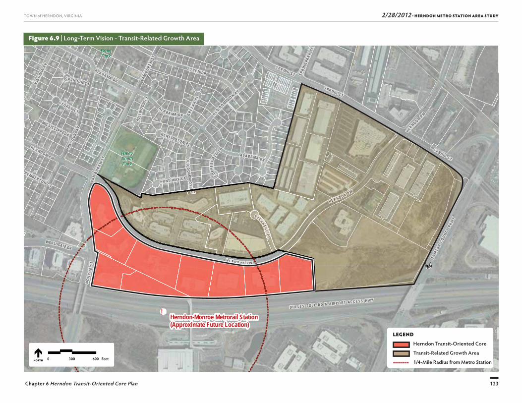
2/28/2012 - HERNDON METRO STATION AREA STUDY
123
TOWN of HERNDON, VIRGINIA
Chapter 6 Herndon Transit-Oriented Core Plan
Figure 6.9 | Long-Term Vision - Transit-Related Growth Area
!
SU
NR I S E
V A L L E
UV7100
SUNRISE VALLEY DR
WORLDGATE DR
FAIR
FAX
COUN
TY P
KWY
D U L L E S T OL L R D & A IR P O R T A C C E S S H W Y
BruinBruinParkPark
HaleyHaleySmithSmithParkPark
Herndon-Monroe Metrorail Station(Approximate Future Location)
VAN
BURE
N ST
MO
NR
OE
ST
EXCHANG E P L
S P RIN G ST
VAN
B URE
N ST
HU N T WAY L A
S P R IN G S T
MIS
S OUR
I AV
AL A B A M A DR OLD DOM INIO
N AV
OLD
DO
MIN
I ON
A V
S P R IN G S T
CA L HO U N C T
A L A B A MA DR
GRE
EAR
PL
H I LLW
OOD
C T
P EM BER TON C T
ST UAR T CT
COPPER
FIEL
D LA
KEN S I NGTO N P L
SPRI
NGPA
RK PL
H E R N D O N P W
MIS SI SSI PP I D R
HE R NDON PW
A LA BAM A DR
HE RND ON P W
VIRG
INIA
AV AS PE N DR
HERNDO N P W
0 300 600 FeetNORTH
HE RND ON PP W
VVM
ON
RO
ESTT
HHHHHHHHHHH EEEEEEEEEE RRRRRRRRRRR NNNNNNNNN DDDDDDDDDDDD OOOOOOOOO NNNNNNNNN PPPPPPPPPP WWWWWWWWWWWW
HU N TT ON
AA
EXXCHAANG EPP LL
VVAA VLEGEND
Herndon Transit-Oriented Core
Transit-Related Growth Area
1/4-Mile Radius from Metro Station
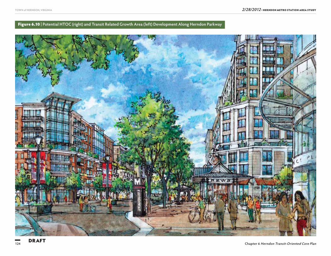
2/28/2012 - HERNDON METRO STATION AREA STUDY
124
TOWN of HERNDON, VIRGINIA
Chapter 6 Herndon Transit-Oriented Core PlanDRAFT
Figure 6.10 | Potential HTOC (right) and Transit Related Growth Area (left) Development Along Herndon Parkway
2/28/2012 - HERNDON METRO STATION AREA STUDY
125
TOWN of HERNDON, VIRGINIA
Chapter 6 Herndon Transit-Oriented Core Plan
streets to organize vehicular traffi c and contribute to a reasonable fl ow of vehicles on Herndon Parkway. Access points along the Herndon Parkway should be limited to Exchange Place, Fairbrook Drive, and a further exten-sion of Worldgate Drive north of Herndon Parkway (Figure 6.9). Single-site driveway access to Herndon Parkway should be prohibited unless it serves multiple buildings over acres of development. Site access and internal circulation should be studied more fully during the comprehensive planning amendment preparation.
Transportation System
As part of any future comprehensive plan amendment for the TRG, the local transportation system should be re-examined thoroughly. Build out of the Core means that some intersections will be operating near their maximum capacity. Before additional growth is enabled by the Town, the Town must establish a strategy to increase transportation access to the Core and TRG so that capacity improvements occur as growth proceeds.
Herndon Parkway at Spring StreetTh is intersection serves two four-lane streets and has movements in that operate poorly (based on the exist-ing traffi c conditions analysis). Development beyond that envisioned in the HTOC could exceed the maxi-mum capacity of the intersection. A text book traffi c engineering analysis could call for a grade separated interchange or other similar onerous improvements. While such improvements may not be appropriate for Herndon, the fact that they may be warranted indi-cates a need for the town to explore more sophisticated transportation solutions. Th is intersection poses the single most signifi cant physical constraint on develop-ment in the TRG.
Spring Street at Fairfax County ParkwayTh is interchange of a four-lane street with a six lane regional arterial suff ers from an ineffi cient design that impacts both the Fairfax County Parkway itself and Spring Street. Because it is part of a confi guration of two side-by-side interchanges on Fairfax County Park-way, at Spring Street and the Dulles Toll Road, solutions to improve the interchange pose challenges worthy of any major metropolitan area. Th e Town must press for resolution of operational issues at the interchange with cooperation from regional partners including Fairfax County, the Virginia Department of Transportation, the Northern Virginia Transportation Authority, and the MWCOG’s Transportation Planning Board. Regard-less of whether or not additional density is planned for the TRG, this transportation challenge must be solved and will involve time and intergovernmental coordina-tion. Th e Town should: (i) determine the appropriate level of improvement for the desired character of Hern-don; and (ii) establish a work program at its earliest convenience to engender regional cooperation for the desired enhancement of this interchange.
Alternative AccessPart of the transportation study should explore the benefi ts and any potential negative impacts of direct ac-cess to the Dulles Toll Road or the Fairfax County Park-way from the TRG. Since funding for such an improve-ment likely would not become available for decades, the Town should determine whether such access is desired and program funding accordingly.
Western Portal, Van Buren at Worldgate, and Van Buren at Herndon ParkwayDue to the close proximity of stable residential neigh-borhoods to the western portal of the TRG, transpor-tation improvements beyond those planned for the development of the Core should be kept to a minimum.

Th is page intentionally left blank
127
2/28/2012 - HERNDON METRO STATION AREA STUDYTOWN of HERNDON, VIRGINIA
CAPITALIMPROVEMENTS
7
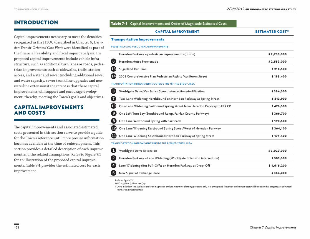
2/28/2012 - HERNDON METRO STATION AREA STUDY
128
TOWN of HERNDON, VIRGINIA
Chapter 7 Capitol Improvements
INTRODUCTION
Capital improvements necessary to meet the densities recognized in the HTOC (described in Chapter 6, Hern-don Transit-Oriented Core Plan) were identifi ed as part of the fi nancial feasibility and fi scal impact analysis. Th e proposed capital improvements include vehicle infra-structure, such as additional turn lanes or roads, pedes-trian improvements such as sidewalks, trails, station access, and water and sewer (including additional sewer and water capacity, sewer trunk line upgrades and new waterline extensions).Th e intent is that these capital improvements will support and encourage develop-ment; thereby, meeting the Town’s goals and objectives.
CAPITAL IMPROVEMENTSAND COSTS
Th e capital improvements and associated estimated costs presented in this section serve to provide a guide for the Town’s reference until more precise information becomes available at the time of redevelopment. Th is section provides a detailed description of each improve-ment and the related assumptions. Refer to Figure 7.1 for an illustration of the proposed capital improve-ments. Table 7-1 provides the estimated cost for each improvement.
Table 7-1 | Capital Improvements and Order of Magnitude Estimated Costs
CAPITAL IMPROVEMENT ESTIMATED COST*
Transportation Improvements
PEDESTRIAN AND PUBLIC REALM IMPROVEMENTS
Herndon Parkway – pedestrian improvements (inside) $ 2,700,000
Herndon Metro Promenade $ 2,552,000
Sugarland Run Trail $ 218,500
2008 Comprehensive Plan Pedestrian Path to Van Buren Street $ 185,400
TRANSPORTATION IMPROVEMENTS OUTSIDE THE REFINED STUDY AREA
Worldgate Drive/Van Buren Street Intersection Modification $ 384,500
Two-Lane Widening Northbound on Herndon Parkway at Spring Street $ 813,900
One-Lane Widening Eastbound Spring Street from Herndon Parkway to FFX CP $ 476,500
One Left Turn Bay (Southbound Ramp, Fairfax County Parkway) $ 366,700
One Lane Westbound Spring with barricade $ 190,500
One Lane Widening Eastbound Spring Street/West of Herndon Parkway $ 364,100
One Lane Widening Southbound Herndon Parkway at Spring Street $ 171,400
TRANSPORTATION IMPROVEMENTS INSIDE THE REFINED STUDY AREA
Worldgate Drive Extension $ 3,020,000
Herndon Parkway – Lane Widening (Worldgate Extension intersection) $ 503,500
Lane Widening (Bus Pull-Offs) on Herndon Parkway at Drop-Off $ 1,616,200
New Signal at Exchange Place $ 384,200
Refer to Figure 7.1MGD = Million Gallons per Day* Costs include in this table are order of magnitude and are meant for planning purposes only. It is anticipated that these preliminary costs will be updated as projects are advanced
further and implemented.
3
7
10
6
13
14
9
8
12
1
2
4
11
5
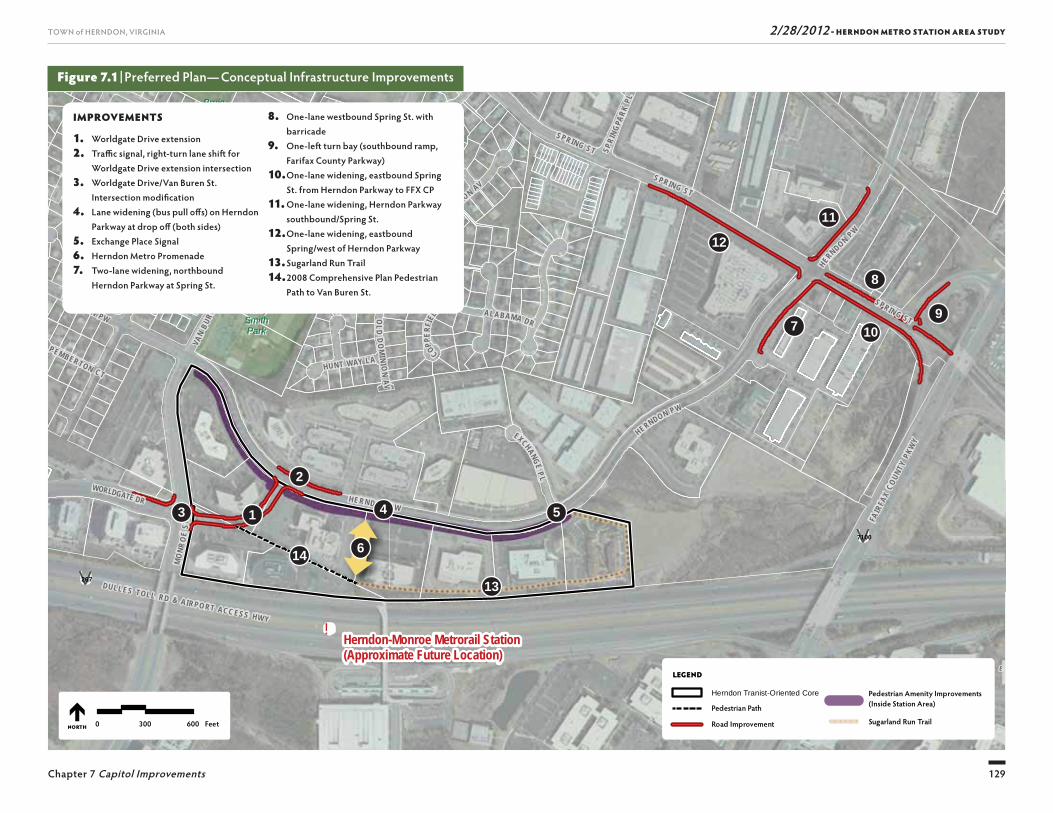
2/28/2012 - HERNDON METRO STATION AREA STUDY
129
TOWN of HERNDON, VIRGINIA
Chapter 7 Capitol Improvements
Figure 7.1 | Preferred Plan— Conceptual Infrastructure Improvements
!
SU
NR I S E
V A L L E
UV7100
SUNRISE VALLEY DR
WORLDGATE DR
FAIR
FAX
COUN
TY P
KWY
DULLES TOLL RD & AIRPO RT ACC ESS HWY
UV267
BruinBruinParkPark
HaleyHaleySmithSmithParkPark
Herndon-Monroe Metrorail Station(Approximate Future Location)
VAN
BURE
N ST
MO
NRO
E ST
EXCHANGE P L
SPRIN G ST
VAN
BURE
N ST
HUNT WAY LA
SPRING STMIS
SOUR
I AV
AL A BA M A DR OLD DOMINION AV
OLD
DO
MINI O
N A V
SPRING ST
CAL HOUN CT
ALABAMA DR
GREE
AR PL
H I LLW
OOD
CT
PEMBERTON CT
STUART CT
COPPER
FIEL
D LA
KEN SINGTON PL
SPRI
NGPA
RK PL
HERNDON PW
MISSI SSI PP I DR
HE RNDON PW
HERNDON PW
ALABAMA DR
VIRG
INIA
AV AS PE N DR
HERNDON PW
LEGEND
Herndon Tranist-Oriented Core
Pedestrian Path
Road Improvement
Pedestrian Amenity Improvements (Inside Station Area)
! ! ! ! ! ! Sugarland Run Trail0 300 600 FeetNORTH
13
910
11
12
7
8
14
54
6
3
2
1
IMPROVEMENTS
1. Worldgate Drive extension2. Traffi c signal, right-turn lane shift for
Worldgate Drive extension intersection3. Worldgate Drive/Van Buren St.
Intersection modifi cation4. Lane widening (bus pull off s) on Herndon
Parkway at drop off (both sides)5. Exchange Place Signal6. Herndon Metro Promenade7. Two-lane widening, northbound
Herndon Parkway at Spring St.
8. One-lane westbound Spring St. with barricade
9. One-left turn bay (southbound ramp, Farifax County Parkway)
10. One-lane widening, eastbound Spring St. from Herndon Parkway to FFX CP
11. One-lane widening, Herndon Parkway southbound/Spring St.
12. One-lane widening, eastbound Spring/west of Herndon Parkway
13. Sugarland Run Trail14. 2008 Comprehensive Plan Pedestrian
Path to Van Buren St.
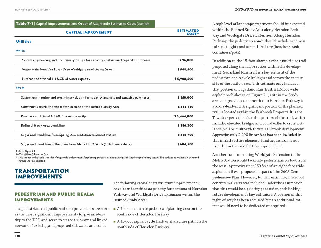
2/28/2012 - HERNDON METRO STATION AREA STUDY
130
TOWN of HERNDON, VIRGINIA
Chapter 7 Capitol Improvements
A high level of landscape treatment should be expected within the Refi ned Study Area along Herndon Park-way and Worldgate Drive Extension. Along Herndon Parkway, the pedestrian zones should include ornamen-tal street lights and street furniture (benches/trash containers/pots).
In addition to the 15-foot shared asphalt multi-use trail proposed along the major routes within the develop-ment, Sugarland Run Trail is a key element of the pedestrian and bicycle linkages and serves the eastern side of the station area. Th is estimate only includes that portion of Sugarland Run Trail, a 12-foot wide asphalt path shown on Figure 7.1, within the Study area and provides a connection to Herndon Parkway to avoid a dead-end. A signifi cant portion of the planned trail is located within the Fairbrook Property. It is the Town’s expectation that this portion of the trail, which includes elevated bridges and boardwalks to cross wet-lands, will be built with future Fairbrook development. Approximately 2,200 linear feet has been included in this infrastructure element. Land acquisition is not included in the cost for this improvement.
Another trail connecting Worldgate Extension to the Metro Station would facilitate pedestrians on foot from the west. Approximately 950 feet of an eight-foot wide asphalt trail was proposed as part of the 2008 Com-prehensive Plan. However, for this estimate, a ten-foot concrete walkway was included under the assumption that this would be a priority pedestrian path linking future development’s key entrances. A portion of this right-of-way has been acquired but an additional 750 feet would need to be dedicated or acquired.
TRANSPORTATION IMPROVEMENTS
Pedestrian and Public RealmImprovementsTh e pedestrian and public realm improvements are seen as the most signifi cant improvements to give an iden-tity to the TOD and serve to create a vibrant and linked network of existing and proposed sidewalks and trails.
Th e following capital infrastructure improvements have been identifi ed as priority for portions of Herndon Parkway and Worldgate Drive Extension within the Refi ned Study Area:
■ A 15-foot concrete pedestrian/planting area on the south side of Herndon Parkway.
■ A 15-foot asphalt cycle track or shared use path on the south side of Herndon Parkway.
Table 7-1 | Capital Improvements and Order of Magnitude Estimated Costs (cont’d)
CAPITAL IMPROVEMENT ESTIMATED COST*
Utilities
WATER
System engineering and preliminary design for capacity analysis and capacity purchases $ 96,000
Water main from Van Buren St to Worldgate to Alabama Drive $ 568,500
Purchase additional 1.3 MGD of water capacity $ 5,908,500
SEWER
System engineering and preliminary design for capacity analysis and capacity purchases $ 150,000
Construct a trunk line and meter station for the Refined Study Area $ 465,750
Purchase additional 0.8 MGD sewer capacity $ 6,464,000
Refined Study Area trunk line $ 186,300
Sugarland trunk line from Spring Downs Station to Sunset station $ 338,700
Sugarland trunk line in the town from 24-inch to 27-inch (50% Town’s share) $ 604,500
Refer to Figure 7.1MGD = Million Gallons per Day* Costs include in this table are order of magnitude and are meant for planning purposes only. It is anticipated that these preliminary costs will be updated as projects are advanced
further and implemented.
2/28/2012 - HERNDON METRO STATION AREA STUDY
131
TOWN of HERNDON, VIRGINIA
Chapter 7 Capitol Improvements
■ One lane widening eastbound on Spring Street west of Herndon Parkway for 650 feet;
■ One lane widening southbound on Herndon Parkway for 300 feet at Spring Street; and
■ Associated traffi c signal modifi cations.
Th e following road improvements are proposed inside the HTOC:
Worldgate Drive Extension
■ Construction of a four-lane connection from Van Buren Street to Herndon Parkway with a new signal at Herndon Parkway and a signal modifi cation at Van Buren Street. Th e road section will also include turn lanes at both intersections and a mid-block driveway, in addition to the four lanes;
■ Streetscape to include 15-foot concrete sidewalk/planting area on both sides;
■ No median
■ High level of streetscape landscape treatment;
■ A right-of-way width of 100–120 feet (ultimate right-of-way width will depend on fi nal road design consid-erations);
■ Land acquisition costs have not been included.
Herndon Parkway
One lane widening for approximately 350-feet in the westbound direction of Herndon Parkway at the new intersection with Worldgate Drive Extension;
Removal of a portion of the median to facilitate the lane shifts required for turn lane improvements at the intersection;
addressed under the current Town Capital Improve-ment Plan. Th ese improvements include:
■ Construction of a 350-foot right turn lane north-bound at Herndon Parkway;
■ Pedestrian improvements, which may include six-foot concrete sidewalk; and
■ Associated traffi c signal modifi cations
Th e construction of a new traffi c signal at the Herndon Parkway/Fairbrook Drive intersection is not included in this estimate, as it is proff ered with the Fairbrook development.
Worldgate Drive/Van Buren Street
■ Signal modifi cation to receive Worldgate Extension and improve pedestrian accommodations.
■ Median conversion to create a second eastbound through lane and removal of the channelizing island and converting the free-fl ow right to maintain two westbound through lanes within the existing road footprint.
Spring Street/Herndon Parkway/Fairfax county Parkway
Two lane widening on northbound Herndon Parkway at Spring Street;
■ One lane widening westbound on Spring Street from Fairfax County Parkway to Herndon Parkway. Th is segment will tie into the existing section where the road has already been widened. Improvements include a six-foot sidewalk and standard lighting;
■ One additional lane for a southbound left turn bay on the Fairfax County Parkway Ramp;
■ One lane widening eastbound on Spring Street from Herndon Parkway to Fairfax County Parkway;
A public amenity space has also been identifi ed within the Core—the Herndon Metro Promenade. A prelimi-nary budget of $45 per square foot was established for purposes of the fi nancial models. Final defi nition of this space will be dependent on the development plans of this area.
Traffic and Roadway ImprovementsHerndon has long planned for intersection improve-ments at Van Buren Street and Herndon Parkway, and on Spring Street between Herndon Parkway and Fairfax County Parkway. Th e intersections operate at or near capacity in 2011. Regional changes, even without TOD, could cause the intersections to operate consistently at a failing level of service and certain improvements are currently programmed for inclusion in the Northern Virginia Transportation Authority’s Transaction 2040 Plan. Th e HTOC Plan provides a means for the Town to coordinate the needed improvements in the context of a small area plan that identifi es very specifi c design op-portunities as well as a hierarchy of access.
Th e improvements proposed for outside the HTOC occur primarily at major entrances to the town’s “Re-gional Corridor Mixed Use” land use designation. Th ose entrances include: Worldgate Drive; Van Buren Street/Herndon Parkway; and Spring/Herndon Parkway, which are described below.
Van Buren Street/Herndon Parkway
Improvements at the Van Buren Street and Herndon Parkway intersection are described here because they are needed to meet the transportation needs of the Metro Station Area, but are not included in the fi nan-cial and fi scal model because they are already being
2/28/2012 - HERNDON METRO STATION AREA STUDY
132
TOWN of HERNDON, VIRGINIA
Chapter 7 Capitol Improvements
■ 12-inch Van Buren Street water main Worldgate Drive to Alabama Drive
■ Purchase additional 1.3 MGD of water capacity from Fairfax Water
Sewer
Th e following were identifi ed by Town of Herndon Department of Public Works CIP as Metrorail sewer infrastructure elements to support the development through 2035:
■ System engineering and preliminary design for capac-ity analysis and capacity purchases
■ Purchase additional 0.8 MGD sewer capacity
■ Construct a trunk line and meter station for the Re-fi ned Study Area
■ Sugarland trunk line from Spring Downs station to Sunset station
■ Upgrade Sugarland trunk line in the town from 24-inches to 27-inches (50 percent Town’s share)
PrivateNo signifi cant private utility relocation has been esti-mated as an individual capital infrastructure element. Any private utility relocation will be considered a part of individual infrastructure elements or as part of pri-vate development.
Stormwater/Drainage ImprovementsNo signifi cant public stormwater or drainage infra-structure improvements are included in the anticipated capital infrastructure necessary for the redevelopment of the Refi ned Study Area.
Land AcquisitionRight-of-way (ROW) for the road infrastructure will be necessary for many of the capital improvements outlined above. In some cases, ROW may be dedicated voluntarily to the Town of Herndon through the con-ditional zoning process with individual developments. However, that may not be the case and the town will need to acquire land. Land acquisition costs have not been included in the cost estimates.
UtilitiesPublic
Th e Town of Herndon DPW is responsible for planning and maintaining the water and sewer distribution and collection system within the Refi ned Study Area. For this report, DPW provided water and sewer projections for the HTOC Plan, capital infrastructure projects and costs. Th e following is based on a DPW analysis dated November 29, 2011.
Water and sewer costs were considered “break even” by the Town such that revenues are anticipated to cover costs. As a result, water and sewer costs were not included in the fi nancial and fi scal modeling except for on-site development costs, which were attributed to the developer in the fi nancial model.
Water
Th e following were identifi ed by Town of Herndon Department of Public Works CIP as Metrorail water infrastructure elements to support the development through 2035:
■ System engineering and preliminary design for capac-ity analysis and capacity purchases
Construction of bus pull off s, including one-lane widen-ing of 500 feet in length on both sides (additional de-scription of transit related facilities follows); and traffi c signals at Worldgate Extension and Exchange Place.
Transit CenterTh e integration of public transit into an existing built-out development comes with many challenges. Th e HTOC Plan establishes a “transit center” on Herndon Parkway closest to the Metro Station. Th e transit center will serve as a drop-off /pick-up point for Metrorail riders and for transfers from the Metro to bus or van service. Th e following items have been identifi ed as key features (minimum necessary) of the HTOC Plan.
■ Auxiliary lane for bus pull-off s with bus shelters will be provided on both sides of Herndon Parkway
■ Pedestrian barrier in the median of Herndon Parkway to mitigate pedestrian mid-block crossings
■ Herndon Metro Promenade from Herndon Parkway to the Metro Station.
Th e Town of Herndon has evaluated several options for feasible Passenger Drop-Off /Pick-Up solutions. Because the long-term solution may be signifi cantly diff erent, the Town selected the option that provided the most fl exibility. For purposes of infrastructure estimating a scenario was selected that allowed for a combination bus stop and Passenger Drop-Off /Pick-Up area to be located along Herndon Parkway. Short-term standing spaces to pick up or discharge metro riders would be provided on Herndon Parkway.

2/28/2012 - HERNDON METRO STATION AREA STUDY
133
TOWN of HERNDON, VIRGINIA
Chapter 7 Capitol Improvements
Th is page intentionally left blank

Vanasse Hangen Brustlin, Inc.