Hernani Mota de Lima and Fabiano Oliveira Mendanha Mining
8
667 REM, Int. Eng. J., Ouro Preto, 72(4), 667-674, oct. dec. | 2019 Abstract Waste rock dump reclamation includes re-grading the banks to flatten the overall slope followed by re-vegetation. These measures are required to reduce surface erosion, provide physical stability, and meet future use goals. In some cases, the presence of trees can cause localized shear zones in a waste rock dump by the load of the tree mass and the action of wind, the presence of roots in the soil and the death of some species. In geotechnical assessment, however, the influence of trees on slope stability of waste rock dumps is only qualitative. This article assesses the effects of trees on slope stabil- ity of a reclaimed waste rock dump of an iron ore mine. Historic data of construction, laboratory tests, and stability analysis were evaluated. Slope stability assessments were performed after an extensive geotechnical and forest campaign, considering two sce- narios - the final waste rock dump without the vegetational cover and the final waste rock with vegetational cover. Tree vegetation in slopes produces both positive and negative effects on slope stability. For scenario 1, the lowest factor of safety occurs for a potential failure surface near the bottom of the waste dump, passing by a layer 6 m depth from the surface. In scenario 2 the factor of safety is increased by 10%. For deeper failure surface, the smallest factor of safety occurs 30 m deep. However, very tall trees at the top of the waste dump are subject to wind action, which has a negative impact on slope stability. keywords: waste rock dump, slope stability, trees, wind force, mine closure. Hernani Mota de Lima 1,3 https://orcid.org/0000-0002-5595-4149 Fabiano Oliveira Mendanha 2,4 https://orcid.org/0000-0002-9206-7370 1 Universidade Federal de Ouro Preto – UFOP, Escola de Minas, Departamento de Engenharia de Minas, Ouro Preto - Minas Gerais – Brasil. 2 Vale – Gerencia de Fechamento de Mina, Itabirito - Minas Gerais – Brasil. E-mails: 3 [email protected], 4 [email protected] Assessment of the effects of vegetational cover on the long-term stability of a waste rock dump http://dx.doi.org/10.1590/0370-44672018720176 Mining Mineração 1. Introduction Waste rock is the unprocessed over- burden material that is excavated and disposed of in order to access valuable ore bodies. In the median and large Brazilian iron ore mines, waste rock dumps repre- sent large structures and, therefore, their construction, reclamation, and closure process have to be managed following the best practices available and the legal re- quirements. The practice shows that even after the closure is complete, waste rock dumps are subject to long-term changes due to the invasion of tree species, the growth of existing ones, soil densification, translocation of nutrients, etc (Zang et al . 2015). The Brazilian Norm NBR 13029 (ABNT, 2017) describes that an executive design of a waste rock dump must contain all the geometric characteristics, ranging from the design of the internal and surface drainage to the final protection of the berms and the landscape finish. However, the stability assessment of a dump is based on data obtained during the preliminary
Transcript of Hernani Mota de Lima and Fabiano Oliveira Mendanha Mining
667
Hernani Mota de Lima and Fabiano Oliveira Mendanha
REM, Int. Eng. J., Ouro Preto, 72(4), 667-674, oct. dec. | 2019
Abstract
Waste rock dump reclamation includes re-grading the banks to flatten the overall slope followed by re-vegetation. These measures are required to reduce surface erosion, provide physical stability, and meet future use goals. In some cases, the presence of trees can cause localized shear zones in a waste rock dump by the load of the tree mass and the action of wind, the presence of roots in the soil and the death of some species. In geotechnical assessment, however, the influence of trees on slope stability of waste rock dumps is only qualitative. This article assesses the effects of trees on slope stabil-ity of a reclaimed waste rock dump of an iron ore mine. Historic data of construction, laboratory tests, and stability analysis were evaluated. Slope stability assessments were performed after an extensive geotechnical and forest campaign, considering two sce-narios - the final waste rock dump without the vegetational cover and the final waste rock with vegetational cover. Tree vegetation in slopes produces both positive and negative effects on slope stability. For scenario 1, the lowest factor of safety occurs for a potential failure surface near the bottom of the waste dump, passing by a layer 6 m depth from the surface. In scenario 2 the factor of safety is increased by 10%. For deeper failure surface, the smallest factor of safety occurs 30 m deep. However, very tall trees at the top of the waste dump are subject to wind action, which has a negative impact on slope stability.
keywords: waste rock dump, slope stability, trees, wind force, mine closure.
Hernani Mota de Lima1,3
https://orcid.org/0000-0002-5595-4149
Fabiano Oliveira Mendanha2,4
https://orcid.org/0000-0002-9206-7370
1Universidade Federal de Ouro Preto – UFOP,
Escola de Minas, Departamento de Engenharia de
Minas, Ouro Preto - Minas Gerais – Brasil.
2Vale – Gerencia de Fechamento de Mina,
Itabirito - Minas Gerais – Brasil.
E-mails: [email protected], [email protected]
Assessment of the effects of vegetational cover on the long-term stability of a waste rock dumphttp://dx.doi.org/10.1590/0370-44672018720176
MiningMineração
1. Introduction
Waste rock is the unprocessed over-burden material that is excavated and disposed of in order to access valuable ore bodies. In the median and large Brazilian iron ore mines, waste rock dumps repre-sent large structures and, therefore, their construction, reclamation, and closure process have to be managed following the
best practices available and the legal re-quirements. The practice shows that even after the closure is complete, waste rock dumps are subject to long-term changes due to the invasion of tree species, the growth of existing ones, soil densification, translocation of nutrients, etc (Zang et al. 2015). The Brazilian Norm NBR 13029
(ABNT, 2017) describes that an executive design of a waste rock dump must contain all the geometric characteristics, ranging from the design of the internal and surface drainage to the final protection of the berms and the landscape finish. However, the stability assessment of a dump is based on data obtained during the preliminary
668
Assessment of the effects of vegetational cover on the long-term stability of a waste rock dump
REM, Int. Eng. J., Ouro Preto, 72(4), 667-674, oct. dec. | 2019
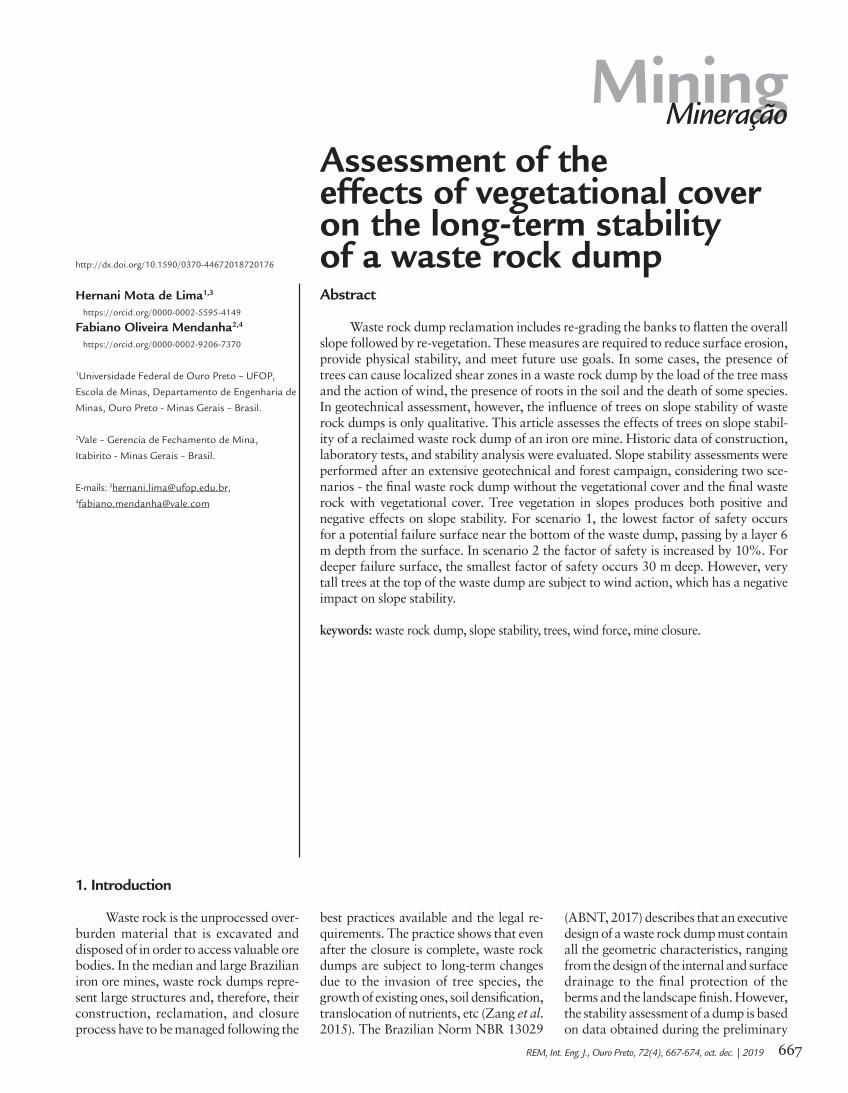
Figure 1The waste rock dump during the construction phase (a) and current (b).
2. Materials and methods
2.1 Geotechnical and forest characterization of the waste dumpThe waste rock dump object of this
study has no as-built information. There-fore, in order to know the geotechnical, drainage and vegetation characteristics,
a comprehensive investigation was con-ducted, including geophysical, installa-tion of instruments, boreholes tests, and the evaluation of arboreal behaviour,
from the aerial part to the rooting sys-tem. Figure 2 shows the drilling and the geotechnical instrument locations.
Although the top of the dump was
(a)
(b)
studies with freshly-mined waste rock. Several hypotheses of rupture are evalu-ated for different situations and under different hydrogeological conditions. Geo-technical stability of a waste rock dump is a major concern and must be ensured for long-term (Aragão and Filho, 2008; Hudson-Edwards et al., 2011).
Construction process of a waste rock dump occurs in the upward direc-tion (ABNT, 2017). And, after finalizing the first banks in their final geometric configuration, the vegetation process
should take place. In general, the vegeta-tion process is conducted, bank by bank at distinct times, by different people, with a distinct concept and in parallel, invasion of neighbouring species can occur, resulting in a quite heterogeneous reforestation along the waste dump.
In general, the overall geotechni-cal stability on a waste rock dump is assessed based upon the final geometric configuration planned and the geotech-nical parameters of the different types of waste rock that compose the dump.
However, the stability assessment con-sidering the final vegetation cover is, usually, not performed. This article presents the geotechnical stability as-sessment, conducted on a 20-year old reclaimed waste rock dump (Figure 1). The dump is 190 m in height, contains about 50 Mm3 of waste rock and occu-pies an area large than 270 ha. Historic data of construction, laboratory tests, and stability analysis were evaluated, as well as a more detailed characterization of the vegetation.

669
Hernani Mota de Lima and Fabiano Oliveira Mendanha
REM, Int. Eng. J., Ouro Preto, 72(4), 667-674, oct. dec. | 2019
Figure 2Drilling and the geotechnical instruments locations on the waste rock dump.
Figure 3Large direct shear test
equipment - UFOP Geotechnical Laboratory.
Disturbed and non-disturbed soil samples were taken in trenches and later sent to the UFOP laboratories, in order to conduct soil fertility analysis and
geotechnical characterization. In order to obtain the geotechnical parameters of the surface layer, large-scale shear tests were conducted (Figure 3), as indicated
by Paria et al. (2017) for granular waste rock. This experiment differs from conventional by the box of 20 cm wide and 5 cm high.
In general terms, the waste rock dump vegetation is divided into three areas, which generates the basis for consideration in the geotechnical assess-ment. The waste rock dump’s upper area presents an approximate average canopy of 5 m, with a predominant vegetative cover of native species with the low part well closed, formed by undergrowth and
shrub with the areas of clearances oc-cupied by exotic grasses. Exotic grasses with isolated shrubs and trees form the central area, approximately 50 m in length. The lower part vegetation is predominantly of Eucalyptus, with an average canopy of 20 m with a well-formed sub-forest of native species naturally regenerated.
To understand the root system, trenches 2 m in depth and 1 m in width, staged in a window, were opened on the face of the slope (Figure 4). The trenches were opened just in front of the tree’s trunk, with the purpose of assessing the substrate layers, the behavior of the root system and the development of the roots in different layers.
composed of waste rock, a very soft to a compact layer of non-plastic soil was identified in the first 6 meters depth. This layer is highlighted in this study because it is the place where the root system develops.
No internal drainage structures
were identified in the boreholes tests. The surface drainage system is composed of horizontal ditches along the berms, discharging in a peripheral ditch, which directs surface waters towards a sedi-ment containment basin.
The geophysical investigations
conducted on three cell counts suggest a preferential flow path for a tailings pond located above the waste rock dump, which functions as a large water box, reloaded every rainy season. The water flowing into the dump is traceable near the bottom of the waste dump.

670
Assessment of the effects of vegetational cover on the long-term stability of a waste rock dump
REM, Int. Eng. J., Ouro Preto, 72(4), 667-674, oct. dec. | 2019
Figure 4The trench for assessing substrate layers and the roots system.
2.2 Parameter characterizationGeotechnical and “vegetation”
parameters resulted of investigations and tests conducted were adopted to support the numerical model. Table
1 presents the geotechnical data. The superficial layer parameters were deter-mined by geotechnical characterization conducted in the undisturbed samples.
Additional boreholes tests, laboratory analysis, and correlation with SPT tests for deeper layers are described in VALE (2011).
Waste dump area Upper Middle Botton Comments
Average height of trees (m) 5.0 ___ 20.0
Wind speed (m/s) 30.0 ___ 30.0 Basic velocity isopleths from the map of Quadrilátero Ferrífero region, MG.
Topographic Factor (S1) 1.0 ___ 0.9 1 for trees at the top and cosine (30 °)
Roughness factor (S2) 0.8 ___ 1.0
Category III = flat or wavy terrain with obstacles, such as hedges and walls, few tree-fringes, low and sparse buildings. (Ex: farms and country houses (except parts with weeds), farms with hedges and / or walls, suburbs at considerable distance from the center, with low and sparse houses). The
average level of the top of the obstacles is considered equal to 3,0 m;
Class C = group of trees for which the horizontal or vertical dimension of the frontal surface exceeds 50 m
Statistical factor (S3) 1.0 ___ 1.0With significant environmental impact, restricted to the limit of the en-
terprise or locality, affecting anthropic and/or natural areas that requires project to mitigate and repair adverse effects to the environment.
Characteristic speed 23.4 ___ 23.8 Calculated Vk = VS1S2S3
Density of the barrier 0.7 ___ 0.4
Effective area (Ae) 3.5 ___ 8.0 Expected values according to medium canopy
Drag coefficient (Ca) 0.5 ___ 0.5 According to graph related to the effective area
Dynamic pressure (q) 34.1 ___ 35.4 Calculated q = Vk²/16
Wind force for trees at the top of the dump - Fve (kN/m²) 0.5 ___ 1.4 Calculated Fve = q.A.Ca
Vertical pressure (kN/m²) 3.0 0.0 5.0 Values between 2 and 5kPa, according to bibliography
Additional cohesion of the roots - C´r (kPa) 3.3 2.0 5.0 Estimated according to bibliography
Depth of roots (m) 1.0 0.5 2.0 Used 10% of the height of the tree, according to investigations
Table 1Geotechnical Parameters of the Waste Rock Dump
671
Hernani Mota de Lima and Fabiano Oliveira Mendanha
REM, Int. Eng. J., Ouro Preto, 72(4), 667-674, oct. dec. | 2019
Tree influence considered in this study include the tree’s load in each area of the waste rock dump, the depth of the rooting system and its contribution for
increasing the soil cohesion, as well as the wind force, horizontally applied, in the direction of the potential landslide. To calculate the wind strength (Fve), the au-
thors adopted the Brazilian Norm - NBR 6123 (ABNT, 1988) for geotechnical pur-poses. According to NBR 6123, the wind strength can be calculated by Equation 1.
The vegetational vertical permeabil-ity acts as a barrier of wind and transmits the load to the soil. Topographical and roughness parameters as well as the statisti-cal factors were established considering the characteristics of the surrounding areas.
Dense vegetation with an average height of 5 m covers the waste rock dump surface. At the top of the dump, there is an estimated 70% of the vertical area, followed by a low growing vegetation in the middle, and on the bottom, eucalyptus trees (about 20 m high) with a perme-ability of 40% considering the riparian woods. On the upper part of the waste
rock dump the vegetation distribution does not work as a windbreaker to the lower part of the dump.
A load of 3 kPa for the native vegeta-tion area and 5 kPa for the eucalyptus area were considered based on studies of Wolle (1986); Kozciak (2005); and Fiori and Car-mignani (2009). These authors consider the variation of 2 to 5.2 kPa, between capoeira and forests. A vertical load was not considered for the intermediary area.
Additional cohesions of 3.3 kPa for the native vegetation established on sur-face pebble soil to soils under varied forests of evergreen leaves; 4 kPa for the low
growing vegetation area, and 5 kPa for eucalyptus trees with the riparian woods areas were considered according to Norris and Greenwood (2006). These additional cohesions were assumed to the depths of 1 m, 0.5 m, and 2 m, respectively, according to field observations. Table 2 presents the wind force calculation, the parameters and associated factors as well as the com-ments according to the adapted NBR 6123 (ABNT, 1988) for the upper, middle and bottom areas, respectively.
For the numerical analysis, the Morgenstern & Price method was applied using SLIDE 7.0 software.
Where: q = Dynamic pressure in (N/m2); Ae = effective area in m2; and Ca = drag coefficient
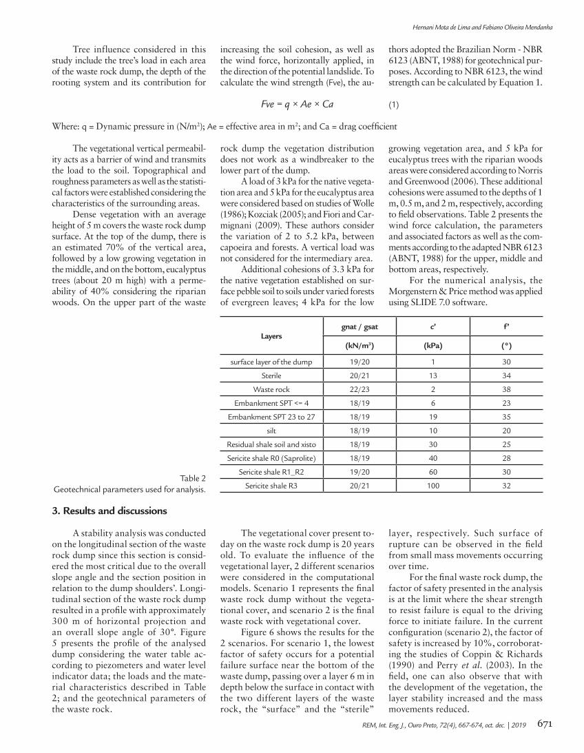
3. Results and discussions
Fve = q × Ae × Ca (1)
Layersgnat / gsat c’ f’
(kN/m3) (kPa) (°)
surface layer of the dump 19/20 1 30
Sterile 20/21 13 34
Waste rock 22/23 2 38
Embankment SPT <= 4 18/19 6 23
Embankment SPT 23 to 27 18/19 19 35
silt 18/19 10 20
Residual shale soil and xisto 18/19 30 25
Sericite shale R0 (Saprolite) 18/19 40 28
Sericite shale R1_R2 19/20 60 30
Sericite shale R3 20/21 100 32Table 2
Geotechnical parameters used for analysis.
A stability analysis was conducted on the longitudinal section of the waste rock dump since this section is consid-ered the most critical due to the overall slope angle and the section position in relation to the dump shoulders’. Longi-tudinal section of the waste rock dump resulted in a profile with approximately 300 m of horizontal projection and an overall slope angle of 30°. Figure 5 presents the profile of the analysed dump considering the water table ac-cording to piezometers and water level indicator data; the loads and the mate-rial characteristics described in Table 2; and the geotechnical parameters of the waste rock.
The vegetational cover present to-day on the waste rock dump is 20 years old. To evaluate the influence of the vegetational layer, 2 different scenarios were considered in the computational models. Scenario 1 represents the final waste rock dump without the vegeta-tional cover, and scenario 2 is the final waste rock with vegetational cover.
Figure 6 shows the results for the 2 scenarios. For scenario 1, the lowest factor of safety occurs for a potential failure surface near the bottom of the waste dump, passing over a layer 6 m in depth below the surface in contact with the two different layers of the waste rock, the “surface” and the “sterile”
layer, respectively. Such surface of rupture can be observed in the field from small mass movements occurring over time.
For the final waste rock dump, the factor of safety presented in the analysis is at the limit where the shear strength to resist failure is equal to the driving force to initiate failure. In the current configuration (scenario 2), the factor of safety is increased by 10%, corroborat-ing the studies of Coppin & Richards (1990) and Perry et al. (2003). In the field, one can also observe that with the development of the vegetation, the layer stability increased and the mass movements reduced.

672
Assessment of the effects of vegetational cover on the long-term stability of a waste rock dump
REM, Int. Eng. J., Ouro Preto, 72(4), 667-674, oct. dec. | 2019
By forcing the potential failure sur-face deeper, the smallest factor of safety
occurs in the contact with the sericite xisto layer, 30 m deep. However, for this
potential mass, the vegetation no longer has any influence as shown in Figure 7.
Figure 5 - The waste rock dump section for numerical analysis.
Figure 6 - Local Analysis – the base of the waste rock dump - Scenarios 1 (a) and 2 (b).
(a) (b)
Figure 7 - Local analysis - the base of the waste rock dump - Scenes 1 (a) and 2 (b) with deep failure surface.
The top of the waste rock dump was also locally evaluated for both scenarios.
In this case, vegetation development generated a small negative impact, below
1%, on the factor of safety as shown in Figure 8.
(a) (b)

673
Hernani Mota de Lima and Fabiano Oliveira Mendanha
REM, Int. Eng. J., Ouro Preto, 72(4), 667-674, oct. dec. | 2019
4. Conclusion
Acknowledgments
Tree vegetation in waste rock dump slopes can produce positive or negative ef-fects on the factor of safety. These effects depend on the type of arboreal vegetation, its location on the waste rock dump, and the age and level of the vegetation cover.
Tree root architecture tends to copy the shape of the treetops. Therefore, very high trees at the top of the waste rock can negatively impact the dump stability by the action of wind and by its own load.
On the other hand, this impact is posi-tive, if trees are located at the base of the dump. But for all cases, specific analyses are required.
For waste rock dump closure, stabil-ity analyses must consider a surface layer with specific parameters. In this study the dump zoning considered provided differ-ent slope influences that show the need for site-specific characterization and analysis. In this regard, it is important to highlight
the care with the final finishing of a waste rock dump during the closure process.
Finally, the article calls attention to the inclusion of new variables and the assessment of their influence in the long-term stability of waste rock dump stability. A careful observation of the environment and what can be developed by man or naturally gives greater clarity to the impacts that a waste rock dump is subject to.
The authors thank Vale S.A. and CNPq for the contribution of data and support for the research.
Figure 8 - Local analysis - the top of the waste rock dump - Scenario 1 (a) and 2 (b) with deep failure surface.
References
ABNT ASSOCIAÇÃO BRASILEIRA DE NORMAS TÉCNICAS. Mineração - Ela-boração e apresentação de projeto de disposição de esté ril em pilha. NBR 13029. Rio de Janeiro: ABNT, 2017. 11 p.
ARAGÃO, G. A. S., FILHO, W. L. O. Classificação de pilhas de estéril na mineração de ferro. Ouro Preto: Departamento de Engenharia de Minas da Universidade Fede-ral de Ouro Preto, 2008. (Dissertação de Mestrado - Programa de Pós-graduação).
COPPIN, R., RICHARDS, T. Use of vegetation in civil engineering. Sevenoaks, Kent: Butterworts, 1990. 305 p.
FIORI, A. P., CARMIGNANI, L. Fundamentos de mecânica dos solos e das rochas, aplicações na estabilidade de taludes. (2.ed.) Curitiba, Editora UFPR, 2009. 602 p.
HUDSON-EDWARDS K. A., JAMIESON H. E., LOTTERMOSER, B. G. Mine wa-stes: past, present, future. Elements. n. 7, p. 375-80, 2011.
KOZCIAK, S. Análise da estabilidade de vertentes na bacia do Rio Marumbi – Serra do Mar – Paraná. Curitiba: Universidade Federal do Paraná, 2005. 141 p. (Doutorado em Geologia - Tese).
NORRIS, J. E., GREENWOOD, J. R. Review of in situ shear tests on root reinforced soil. Nottingham NGI, UK: Departament os Civil and Structural Engeneering, Burton Street, 2006.
PARIA, C. J. B., PEREIRA, E. L., LIMA, H. M. Evaluation of the effect of particle size in shear resistance study of an iron mine waste rock pile. In: INTERNATIO-NAL CONFERENCE ON SOIL MECHANICS AND GEOTECHNICAL EN-GINEERING, 2017, Seoul. In: INTERNATIONAL CONFERENCE ON SOIL MECHANICS AND GEOTECHNICAL ENGINEERING, 19. Procedings...
(a) (b)

674
Assessment of the effects of vegetational cover on the long-term stability of a waste rock dump
REM, Int. Eng. J., Ouro Preto, 72(4), 667-674, oct. dec. | 2019
Received: 19 November 2018 - Accepted: 23 July 2019.
All content of the journal, except where identified, is licensed under a Creative Commons attribution-type BY.
ICSMGE 2017, 2017. v. 1. p. 407-410.PERRY, J., PEDLEY, M. REID, M. Infrastructure embankments - conditional ap-
praisal and remedial treatment. London: CIRIA, 2003. 242 p.VALE S.A. Reavaliação Crítica das Informações Técnicas Existentes. Belo Horizonte:
Vale S.A., setembro de 2011 (BVP Engenharia).VALE S.A. Como Construído da PDE 2. Belo Horizonte: Vale S.A., junho de 2015.
(Pimenta de Ávila Consultoria).WOLLE, C. M. Poluição e escorregamentos – causa e efeito na serra do Mar, em
Cubatão – SP. In: CONGRESSO BRASILEIRO DE MECÂNICA DOS SOLOS E ENGENHARIA DE FUNDAÇÕES, 8. 1986. Porto Alegre. Anais... Porto Alegre: ABMS, v. 7, p. 178-190.
ZHANG, L., WANG, J., BAI, Z., LV, C. Effects of vegetation on runoff and soil ero-sion on reclaimed land in an opencast coal-mine dump in a loess area. CATENA. n. 128, p. 44-53. 2015.