Havana to Tampa Bay
20
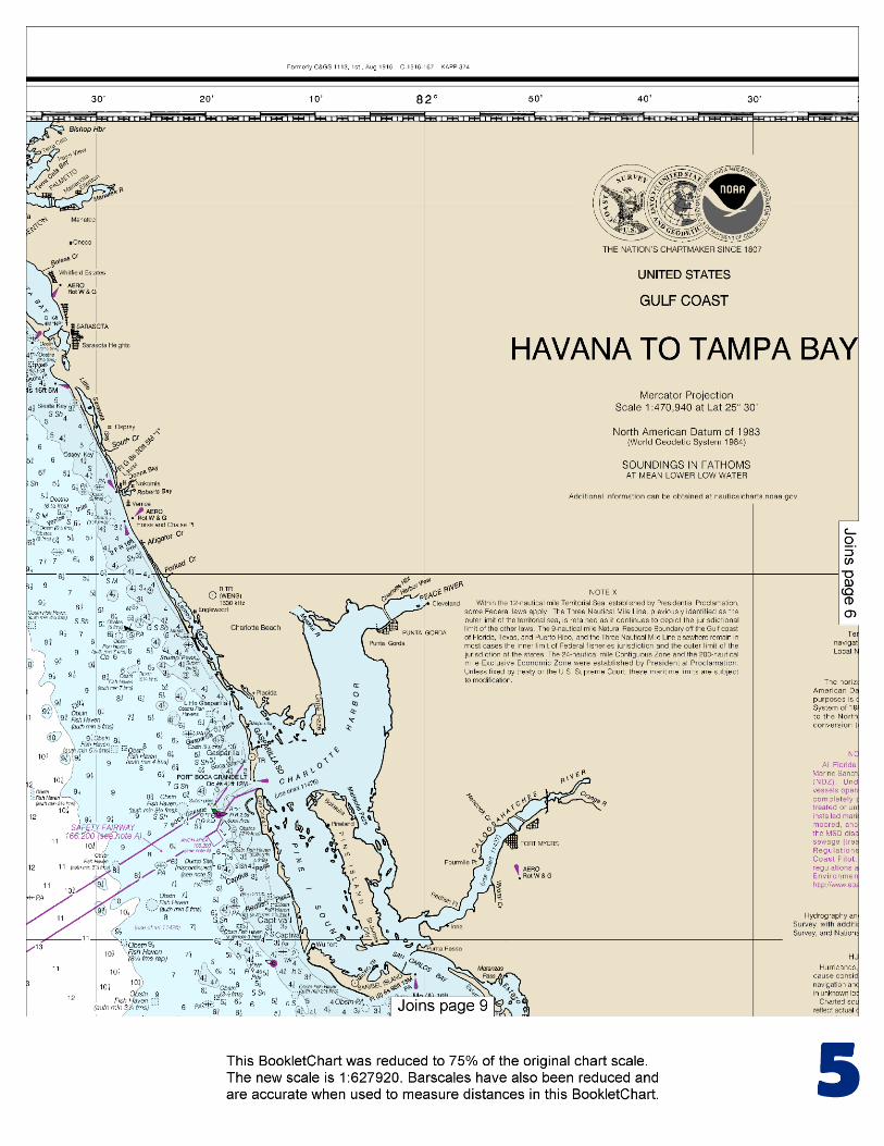
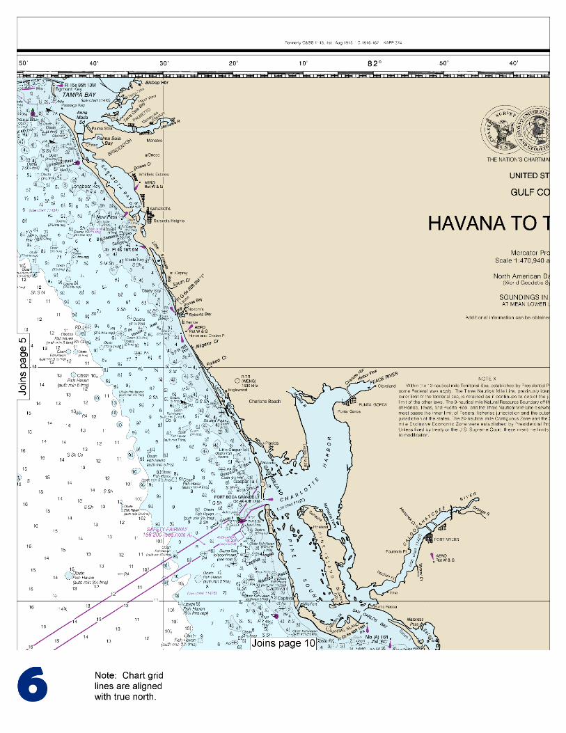
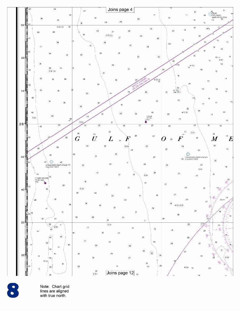
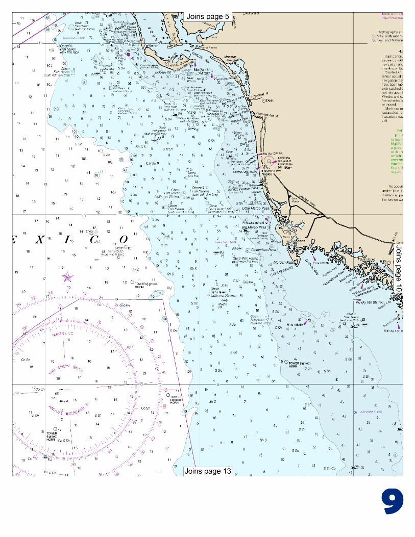
BookletChart ™ Havana to Tampa Bay NOAA Chart 11420 A reduced-scale NOAA nautical chart for small boaters When possible, use the full-size NOAA chart for navigation.
Transcript of Havana to Tampa Bay

BookletChart™ Havana to Tampa Bay NOAA Chart 11420
A reduced-scale NOAA nautical chart for small boaters When possible, use the full-size NOAA chart for navigation.

2
Published by the National Oceanic and Atmospheric Administration
National Ocean Service Office of Coast Survey
www.NauticalCharts.NOAA.gov 888-990-NOAA
What are Nautical Charts?
Nautical charts are a fundamental tool of marine navigation. They show water depths, obstructions, buoys, other aids to navigation, and much more. The information is shown in a way that promotes safe and efficient navigation. Chart carriage is mandatory on the commercial ships that carry America’s commerce. They are also used on every Navy and Coast Guard ship, fishing and passenger vessels, and are widely carried by recreational boaters.
What is a BookletChart?
This BookletChart is made to help recreational boaters locate themselves on the water. It has been reduced in scale for convenience, but otherwise contains all the information of the full-scale nautical chart. The bar scales have also been reduced, and are accurate when used to measure distances in this BookletChart. See the Note at the bottom of page 5 for the reduction in scale applied to this chart.
Whenever possible, use the official, full scale NOAA nautical chart for navigation. Nautical chart sales agents are listed on the Internet at http://www.NauticalCharts.NOAA.gov.
This BookletChart does NOT fulfill chart carriage requirements for regulated commercial vessels under Titles 33 and 44 of the Code of Federal Regulations.
Notice to Mariners Correction Status
This BookletChart has been updated for chart corrections published in the U.S. Coast Guard Local Notice to Mariners, the National Geospatial Intelligence Agency Weekly Notice to Mariners, and, where applicable, the Canadian Coast Guard Notice to Mariners. Additional chart corrections have been made by NOAA in advance of their publication in a Notice to Mariners. The last Notices to Mariners applied to this chart are listed in the Note at the bottom of page 7. Coast Pilot excerpts are not being corrected.
For latest Coast Pilot excerpt visit the Office of Coast Survey website at http://www.nauticalcharts.noaa.gov/nsd/searchbychart.php?chart=11420.
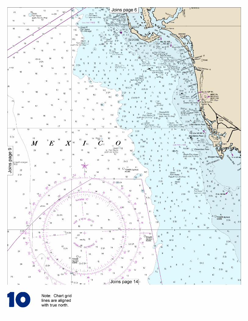
(Selected Excerpts from Coast Pilot) The coast, for nearly 115 miles, from Key West to San Carlos Bay is low, sandy, and generally wooded. Innumerable small islands and keys, interlaced by many small rivers and bayous, make up Everglades National Park and the Ten Thousand Islands. From San Carlos Bay N to Tampa Bay the coast is made up of nearly straight sandy beaches of the barrier islands. The Florida Keys comprise a chain of low islands along the SW coast of the Florida
Peninsula extending W in a wide arc to the Dry Tortugas. The keys are mostly of coral formation and are generally covered with dense mangrove, though some have stands of pine and a few have coconut
groves. Florida Keys National Marine Sanctuary, a Marine Protected Area (MPA), surrounds the keys from Biscayne Bay to Dry Tortugas. On the straits side of the keys, and at an average distance of 5 miles, are the Florida Reefs, a dangerous line of shoals which extend along the entire length of the chain. The reefs are particularly hazardous because they do not break in smooth weather and few of them are exposed. The water shoals abruptly between the reefs and along their outer edges. When approaching the reefs from seaward, their proximity usually is indicated by a change in color of the water from deep blue to light green or by the bank blink, described in chapter 3. However, too much reliance should not be placed on such indications. Lights and daybeacons facilitate navigation along the reefs in clear weather, but soundings should be resorted to in thick weather. Depths of 50 fathoms indicate a distance of 2 to 3 miles from the reefs, and great caution should be used in approaching closer. Fogs are infrequent in this area. The water always becomes milky following windy weather. The usual color is bluish green on the reefs, while the rock patches are dark, shading through brown to yellow as they approach the surface. Sand patches are bright green. Grass patches at depths of 10 to 15 feet have the appearance of rocks. The Florida Keys Particularly Sensitive Sea Area (PSSA) is an IMO-designated zone that encircles the sea area around all of the Florida Keys. The PSSA includes the entire Florida Keys National Marine Sanctuary as well as Biscayne National Park at the northeastern end of the keys. Domestic law and regulations adopted by the United States for the Sanctuary apply within the PSSA. Several of these concern shipping activities: Areas To Be Avoided (ATBAs).–There are four ATBAs in the Sanctuary: in the vicinity of the Florida Keys; in the vicinity of Key West Harbor; in an area surrounding the Marquesas Islands; and in an area surrounding the Dry Tortugas Islands. All tank vessels and vessels greater than 50 meters in registered length are prohibited from operating within the ATBAs. The ATBAs are described and the coordinates are provided in Chapter 3. Areas closed to anchoring.–All vessels are prohibited from anchoring in the Tortugas Ecological Reserve. Vessels that are 100 feet or less in length (30.48 meters) may request permission from the Sanctuary to use mooring buoys in the northern portion of the Reserve (Tortugas North). Vessels 50 meters or greater in registered length are prohibited from anchoring on the portion of Tortugas Bank west of Dry Tortugas National Park. (This area was modified in January 2001 by the establishment of the Tortugas Ecological Reserve.) Anchoring restriction.–In areas of the Sanctuary identified as Ecological Reserves and Sanctuary Preservation Areas all anchor apparatus (including the anchor, chain, or rope) must not touch any coral, living or dead, or any attached organism. In all other areas of the Sanctuary, vessels are prohibited from anchoring on living coral in water depths of less than 40 feet when visibility is such that the seabed can be seen. Restricted access.–Vessels are not allowed to stop in the southern portion of the Tortugas Ecological Reserve (Tortugas South) and must receive permission in advance in order to stop in the northern portion of the Reserve (Tortugas North). Discharge restriction.–In Ecological Reserves and Sanctuary Preservation Areas, all discharges and deposits are prohibited except cooling water or engine exhaust.
U.S. Coast Guard Rescue Coordination Center 24 hour Regional Contact for Emergencies
RCC New Orleans Commander
8th CG District (504) 589-6225 New Orleans, LA

G
Lateral System As Seen Entering From Seaward on navigable waters except Western Rivers
PORT SIDE ODD NUMBERED AIDS
GREEN LIGHT ONLY FLASHING (2)
PREFERRED CHANNEL NO NUMBERS – MAY BE LETTERED
PREFERRED CHANNEL TO STARBOARD
TOPMOST BAND GREEN
PREFERRED CHANNEL NO NUMBERS – MAY BE LETTERED
PREFERRED CHANNEL TO PORT
TOPMOST BAND RED
STARBOARD SIDE EVEN NUMBERED AIDS
RED LIGHT ONLY FLASHING (2)
FLASHING FLASHING OCCULTING GREEN LIGHT ONLY RED LIGHT ONLY OCCULTING QUICK FLASHING QUICK FLASHING ISO COMPOSITE GROUP FLASHING (2+1) COMPOSITE GROUP FLASHING (2+1) ISO
"1"
Fl G 6s
G "9"
Fl G 4s
GR "A"
Fl (2+1) G 6s
RG "B"
Fl (2+1) R 6s
"2"
Fl R 6s
8
R "8" Fl R 4s
LIGHT
G
C "1"
LIGHTED BUOY
G "5"
GR "U"
GR
C "S"
RG
N "C"
RG "G"
LIGHT
6
R
N "6"
LIGHTED BUOY
R
"2"
CAN DAYBEACON
CAN NUN NUN
DAYBEACON
For more information on aids to navigation, including those on Western Rivers, please consult the latest USCG Light List for your area. These volumes are available online at http://www.navcen.uscg.gov
2
2
C U 5
1


VHF Marine Radio channels for use on the waterways:Channel 6 – Inter-ship safety communications.Channel 9 – Communications between boats and ship-to-coast.Channel 13 – Navigation purposes at bridges, locks, and harbors.Channel 16 – Emergency, distress and safety calls to Coast Guard and others, and to initiate calls to other
vessels. Contact the other vessel, agree to another channel, and then switch.Channel 22A – Calls between the Coast Guard and the public. Severe weather warnings, hazards to navigation and safety warnings are broadcast here.Channels 68, 69, 71, 72 and 78A – Recreational boat channels.
Getting and Giving Help — Signal other boaters using visual distress signals (flares, orange flag, lights, arm signals); whistles; horns; and on your VHF radio. You are required by law to help boaters in trouble. Respond to distress signals, but do not endanger yourself.
EMERGENCY INFORMATION
Distress Call Procedures
• Make sure radio is on.• Select Channel 16.• Press/Hold the transmit button.• Clearly say: “MAYDAY, MAYDAY, MAYDAY.”• Also give: Vessel Name and/or Description;Position and/or Location; Nature of Emergency; Number of People on Board.• Release transmit button.• Wait for 10 seconds — If no responseRepeat MAYDAY call.
HAVE ALL PERSONS PUT ON LIFE JACKETS!
This Booklet chart has been designed for duplex printing (printed on front and back of one sheet). If a duplex option is not available on your printer, you may print each sheet and arrange them back-to-back to allow for the proper layout when viewing.
QR
Quick ReferencesNautical chart related products and information - http://www.nauticalcharts.noaa.gov
Interactive chart catalog - http://www.charts.noaa.gov/InteractiveCatalog/nrnc.shtmlReport a chart discrepancy - http://ocsdata.ncd.noaa.gov/idrs/discrepancy.aspx
Chart and chart related inquiries and comments - http://ocsdata.ncd.noaa.gov/idrs/inquiry.aspx?frompage=ContactUs
Chart updates (LNM and NM corrections) - http://www.nauticalcharts.noaa.gov/mcd/updates/LNM_NM.html
Coast Pilot online - http://www.nauticalcharts.noaa.gov/nsd/cpdownload.htm
Tides and Currents - http://tidesandcurrents.noaa.gov
Marine Forecasts - http://www.nws.noaa.gov/om/marine/home.htm
National Data Buoy Center - http://www.ndbc.noaa.gov/
NowCoast web portal for coastal conditions - http://www.nowcoast.noaa.gov/
National Weather Service - http://www.weather.gov/
National Hurrican Center - http://www.nhc.noaa.gov/
Pacific Tsunami Warning Center - http://ptwc.weather.gov/
Contact Us - http://www.nauticalcharts.noaa.gov/staff/contact.htm
NOAA’s Office of Coast Survey The Nation’s Chartmaker
For the latest news from Coast Survey, follow @NOAAcharts
NOAA Weather Radio All Hazards (NWR) is a nationwide network of radio stations broadcasting continuous weather information directly from the nearest National Weather Service office. NWR broadcasts official Weather Service warnings, watches, forecasts and other hazard information 24 hours a day, 7 days a week. http://www.nws.noaa.gov/nwr/