$HAPTER 1 INTRODUCTION -...
14
$HAPTER 1 INTRODUCTION
Transcript of $HAPTER 1 INTRODUCTION -...
$HAPTER 1 INTRODUCTION
Chapter 1 -~.1INTRODUCTION
passive margins, which constitute about half of the overall length of the
pesent day continental margins, represent the transition between simple tectonic setting
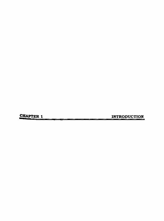
of ocean basins and the more complex continental regions (Figure 1.1) and are
considered to be major depocenters of sedimentation (Gallagher and Brown, 1997).
Passive margins have been assumed to form by extreme extension and thinning of
continentallithosphere (Le Pichon and Sibuet, 1981), ultimately leading to the initiation
of seafloor spreading at high stretching factor, where stretching has proceeded to
infinity (j3=oo) as well as shearing and other processes that are acting on
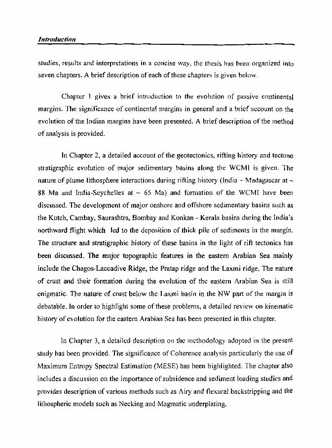
Abyssal Continental Plain Slope
--- -Continental Ris~ ----- Continental Shelf'----
Fie 1.1: Vertical cross section of generic passive continental margin. COBContinent oceanic boundary
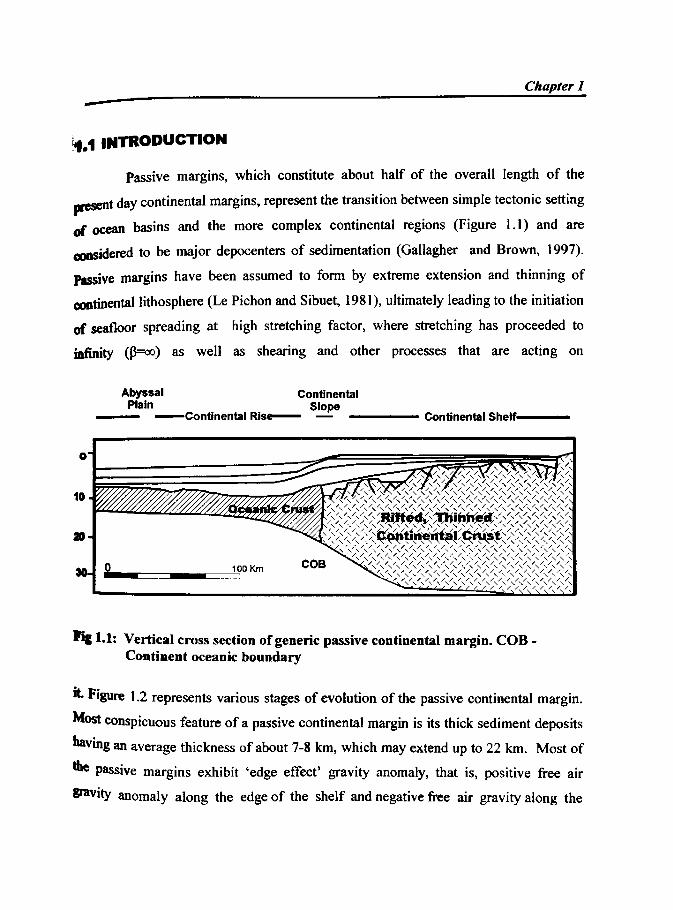
it. Figure 1.2 represents various stages of evolution of the passive continental margin.
Most conspicuous feature of a passive continental margin is its thick sediment deposits
having an average thickness of about 7-8 km, which may extend up to 22 km. Most of
the passive margins exhibit 'edge effect' gravity anomaly, that is, positive free air
gravity anomaly along the edge of the shelf and negative free air gravity along the
Introdllclion
.,.,yn. · riftsedlments
• .. Moho
Asthflnosphere
Pre..nrt configuration
syn • rift Mdknents "l. Rift flank
Nascent ocean basin
rifled margin
Fig 1.2: Va rious stages ofevolutioa of passive coatiaeatal margia
Chapter 1 -slope. The amplitude of these anomalies and the distance between the positive and
negative anomalies are representative of type of margin and sedimentation pattern
(Kamer and Watts, 1982; Watts, 1988). The evolution of a passive continental margin
occurs in two phases:
K5 Rift phase - which is prior to the breakup of the continent.
K5 Drift phase or post rift phase - which occurs with the onset of seafloor
spreading.
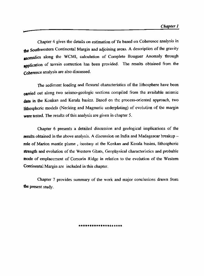
Rifted or passive margins have formerly been classified into non-volcanic and
volcanic margins (White, 1992), based on the volume of surficial volcanism or volcanic
outpourings imaged in seismic reflection profiles as seaward dipping reflections. A
number of recent studies have also addressed the role of upper mantle in the extension
process. The difference between volcanic (Fowler et aI., 1989; Morgan et aI., 1989)
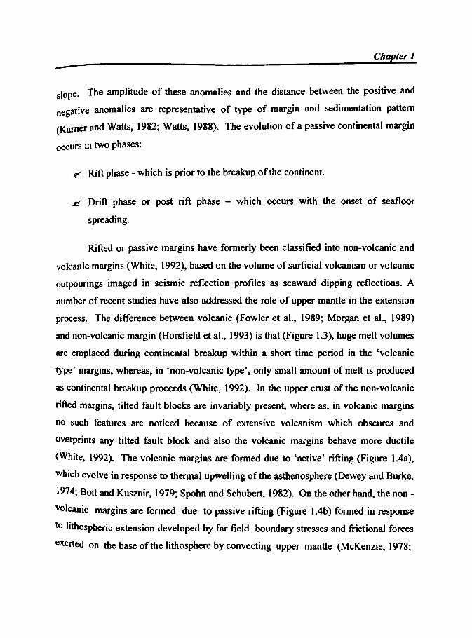
and non-volcanic margin (Hors field et aI., 1993) is that (Figure 1.3), huge melt volumes
are emplaced during continental breakup within a short time period in the 'volcanic
type' margins, whereas, in 'non-volcanic type', only small amount of melt is produced
as continental breakup proceeds (White, 1992). In the upper crust of the non-volcanic
rifted margins, tilted fault blocks are invariably present, where as, in volcanic margins
no such features are noticed because of extensive volcanism which obscures and
overprints any tilted fault block and also the volcanic margins behave more ductile
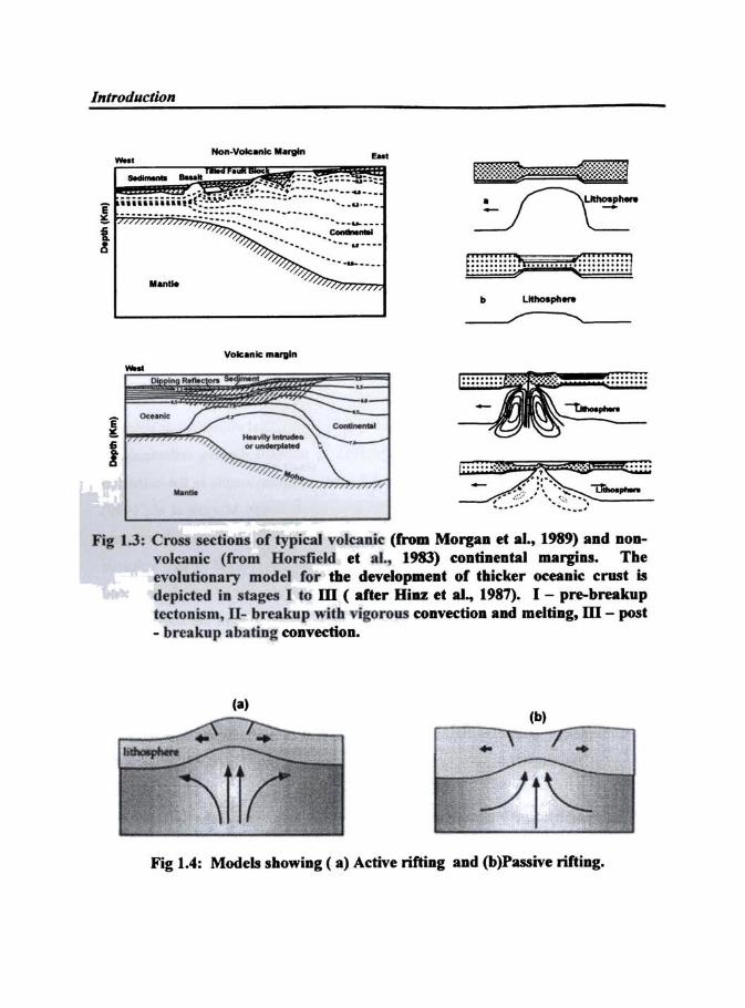
(White, 1992). The volcanic margins are formed due to 'active' rifting (Figure l.4a),
which evolve in response to thermal upwelling of the asthenosphere (Dewey and Burke,
1974; Bott and Kusznir, 1979; Spohn and Schubert, 1982). On the other hand, the non -
volcanic margins are formed due to passive rifting (Figure l.4b) formed in response
to lithospheric extension developed by far field boundary stresses and frictional forces
exerted on the base of the Iithospbere by convecting upper mantle (McKenzie, 1978;
Introduction
-... -----
. ..-..... -~/ ,~--
Fig 1.3: Cross sections of typical volcanic (from Morgan et aL~ 1989) and aODvolcanic (from Horsfield et aI., 1983) contineatal margins. Tbe evolutionary model for the developme.t of tbicker oceanic crust is depicted in stages 1 to m ( after Hiu et aI.,. 1987). 1 - pre-breakup tectooism. U- breakup with vigorous convection and meltiDg, ill - post - breakup abating CODVectiOD.
(0)
.. ..
Fig 1.4: Models showiag ( a) Active rifling and (b)Passive riftiDg.
Chapter 1 -McKenzie and Bickle, 1989; Khain, 1992). During early phase, the future zone of
crustal separation is affected by tensional stresses, giving rise to development of
complex graben system, and in time, the tectonic activity decreases and ultimately the
fonnation of the graben system ceases. Because of progressive Iithospheric attenuation
and crustal doming, local deviatoric tensional stresses play an important secondary role
in the evolution of margin. Upon crustal separation, the divergent continental margin
becomes tectonically inactive. However, subsequent tectonic cycles may activate the
aborted rifts and again cause volcanism. Mutter (1993) states that seismic studies along
the passive margins prove that the distinction between active and passive rifting is not
useful, because the magmatic input to the crust during continental ritting is
extraordinarily variable, both in time and space and hence is only conditionally
justified.
A detailed study of the passive continental margins is of prime importance, as
they are the sites of world's largest sedimentary accumulation, where, significant parts
of the World's hydrocarbon reserves are found. They are relatively shallow areas, and
accessible to offshore exploratory drilling as welt as oil and gas production wells.
Studies on evolution of the passive margins help us to have a clear picture on generic
link between geomorphic, tectonic and sedimentary aspects during its formation. The
sedimentation history needs to be studied in the context of entire margin system,
including tectonic influences and fluid flow circulation. The sea level fluctuations,
climatic changes, isostatic rebound and associated tectonics, sedimentation rate,
behaviour of fluids and gas hydrates are some of the dynamic activities that take place
along the margins.
The Continental Margins of India, evolved due to rift-drift events of the Indian
SUbcontinent, is an extensive Atlantic type passive continental margin. It extends on
Introduction
either side of the Indian Peninsular shield and is referred as Eastern Continental Margin
of India (ECMI) and Western Continental Margin of India (WCMI). The ECMI has
evolved during the breakup of India from East Antarctica in Early Cretaceous (Powell
et ai., 1988). It has a strike length extending to about 2000 km whose shelf width is
more in north due to the presence of Bengal fan. The present day continental margin of
East Antarctica agrees well with the ECMI and has been strongly supported by
magnetic lineations and structural lineaments traced into both continents (Johnson et aI.,
1976; Lawver et aI., 1991). The conjugate nature of these two continents has been
further supported by the presence of Mesozoic anomalies (Ramana et aI., 2001) and
admittance signatures (Chand et aI., 2001). The ECMI along the coast is characterised
by the presence of five major onshore-offshore sedimental)' basins, the Cauvel)', Palar,
Krishna - Godavari, Mahanadi and Bengal basins (Sastri et aI., 1973).
The WCMI has evolved through rifting and subsequent seatloor spreading
between India and Madagascar at 88 Ma. The rifting and seatloor spreading histol)' of
the WCMI and the adjoining Arabian Sea is known in general tenns (McKenzie and
Sclater, 1971; Whitmarsh, 1974; Norton and Sclater, 1979; Chaubey et aI., 1993). The
northern part of the WCMI is characterised by the presence of Deccan Continental
Flood Basalt province due to the interaction of ReUnion mantle plume during rifting
and breakup of Seychelles from India in Paleocene. The margin comprises of several
surface/sub-surface structural features that include the Chagos-Laccadive Ridge
(CLR), Laxmi Ridge (LR), Pratap Ridge (PR) and a belt of numerous horst graben
structures in the sediment filled basins bordering the West Coast of India. The WCMl
comprises of five major sedimental)' basins. These are Kutch, Saurashtra, Bombay,
Konkan and Kerala basins and are separated by southwesterly trending structures
namely, the Saurashtra Arch, Surat depression, Vengurla Arch and Tellicheny Arch
respectively.
Chapter 1
-1.2 DEFINITION OF THE PROBLEM
It is now well known that the passive continental margins of India have formed
by processes of litho spheric rifting, stretching and subsequent seafloor spreading.
However, we can expect significant variations in tenns of varying mechanical
properties, sedimentation, flexure and subsidence history in different segments of the
margin during their evolution. Previous studies indicate that gravity anomalies at rifted
continental margins give valuable information on flexural response to sediment loads,
the long-term mechanical properties of the lithosphere and influence of plumes, if they
are spatially related to the margin (Kamer and Watts, 1982; Watts, 1988; Watts and
Stewart, 1998). Estimate oflithospheric strength is also useful in modeling the rift flank
topography observed along most of the passive continental margins.
1.3 OB~ECTIVES
Lithospheric studies along the WCMI, throw light on the style of rifting,
flexural characteristics, role of ReUnion and Marion mantle plumes and their probable
interaction with the lithosphere and processes involved in the uplift of the Western
Ghats. A detailed and systematic gravity data analysis and interpretation integrated
with available seismic data has been carried out along the southern part of the WCMI
with the following major objectives:
g Estimation of effective elastic thickness (Te) of the Iithosphere in selected
segments of the margin, in order to understand the spatial variations in the
lithospheric strength based on Coherence analysis.
Introduction
.es To study the segmentation of the margin and geodynamic processes
operative in the region by analyzing strength during rifting and flexure due
to sedimentation through subsidence analysis .
.es To examine the uplifted rift-flank topography of West em Ghats.
2S To study the role played by mantle plumes during the rifting and
subsequent evolution ofthe margin.
1.4 PREVIOUS STUDIES
Our present knowledge of the origin and evolution of WCMI is based
on investigations carried out for more than three decades. Studies related to magnetic
anomaly identifications gave rise to valuable information on the seafloor spreading
history of the Arabian Sea and the evolution of the WCMl (Norton and Sclater, 1979;
Schlich, 1982; Masson, 1984; Karasik et aI., 1986; Royer et al., 1989; Miles and Roest,
1993; Chaubey et aI., 1993, 1995 and 1998; Bhattacharya et aI., 1994; Malod et aI.,
1997; Miles et aI., 1998; Talwani and Reif, 1998; among others). The crustal structure,
tectonics and rifting history of the WCMI was investigated by several workers (Naini
and Talwani, 1982; Biswas, 1982, 1987; Biswas and Singh, 1988; Ghosh and Zutshi,
1989; Miles and Roest, 1993; Miles et aI., 1998; Radhakrishna et aI., 2002; Chaubey et
aI., 2002; Mishra et al., 2004; Krishna et aI., 2006; among many others). Some workers
like Bhattacharya and Subrahmanyam (1986), Kolla and Coumes (1990),
Subrahmanyam et al. (1995), Mishra et al. (2004) proposed the extension of several
onshore structural features in to the offshore areas.
Detailed studies were made in the Arabian Sea, which is the oceanic extension
of the sediment filled WCMI. The Chagos - Laccadive ridge together with Laxmi
Ridge act as a barrier that separates the Arabian Sea into Eastern and Western basins
Chapter 1
(Naini and. Talwani, 1982). The geophysical chamcteristics of the Western basin
suggest that the crust below the basin is oceanic in nature (McKenzie and Sclater, 1971;
Wbibl1arsh, 1974; Naini and Talwani, 1982), while, the Eastern basin is underlain by
tranSitional rift stage crust (Harbinson and Bassinger, 1973; Naini and Talwani, 1982;
KoUa and Coumes, 1990; Subba Raju et aI., 1990).
The sediment thickness and nature of the basement of Indus Fan and the
adjacent Indian Continental margin (Neprochnov, 1961; Narain et aI., 1968; Ewing et
al., 1969; Closs et aI., 1969; Rao, 1970; Harbinson and Bassinger, 1973; Babenko et aI.,
1980; Bachman and Hamilton, 1980; Biswas and Singh, 1988; Ghosh and Zutshi, 1989;
Ramaswamy and Rai, 2000; Chaubey et aI., 2002; Krishna et aI., 2006) were discussed
based on seismic data. Again a detailed picture of the nature of sediment acoustics,
sediment thickness distribution and sedimentary processes in the Arabian Sea is given
by Naini and Kolla (1982) and Kolla and Coumes (1987). Through sonobuoy refraction
data, a detailed discussion on crustal structure variations and nature of the crust below
the WCMI was made by Naini and Talwani (1982).
The volcanic episode that occurred at the Cretaceous and Teritiary
transition plays an important role in the evolution of WCMI (Venkatesan et aI., 1993;
Pande et aI., 1988; Duncan and Pyle, 1988; Courtillot et aI., 1988). The intemction
between continental rifting and ReUnion plume generated huge volume of lava and
gave rise to sub aerial Deccan volcanism. The influence of plume and the related
thennal aspects have been studied by several workers (Morgan, 1981; Cox 1989;
Richards et al., 1989; White and McKenzie, 1989, 1995; Hooper, 1990; Kent et aI.,
1992). Gravity field of the WCMI and the eastern Ambian Sea has been analysed and
interpreted by many workers to delineate the crustal structure and rifting history (Naini
and Talwani, 1982; Subba Raju et aI., 1990; Miles and Roest, 1993; Subrahmanyam et
al., 1995; Pandey et aI., 1995, 1996; Miles et aI., 1998; Talwani and Reif, 1998; Todal
Introduction
and Eldholm, 1998; Singh, 1999; Radhakrishna et aI., 2002; Chaubey et aI., 2002,
Mishra et aI., 2004; Krishna et aI., 2006). The flank uplift topography and the evolution
of the Western Ghats has been studied through, lithospheric modeling (Gunnell and
Fleitout, 2000; Chand and Subrahmanyam, 2003), Apatite Fission Track data (Brown,
1991; Kalaswad et aI., 1993; Gallagher et aI., 1998) and denudation isostasy (Gallagher
et aI., 1994; Widdowson and Cox., 1996). Whiting et al. (1994) studied the 3D-flexural
loading and subsidence history of the northern part of the WCMI and adjoining Indus
Fan.
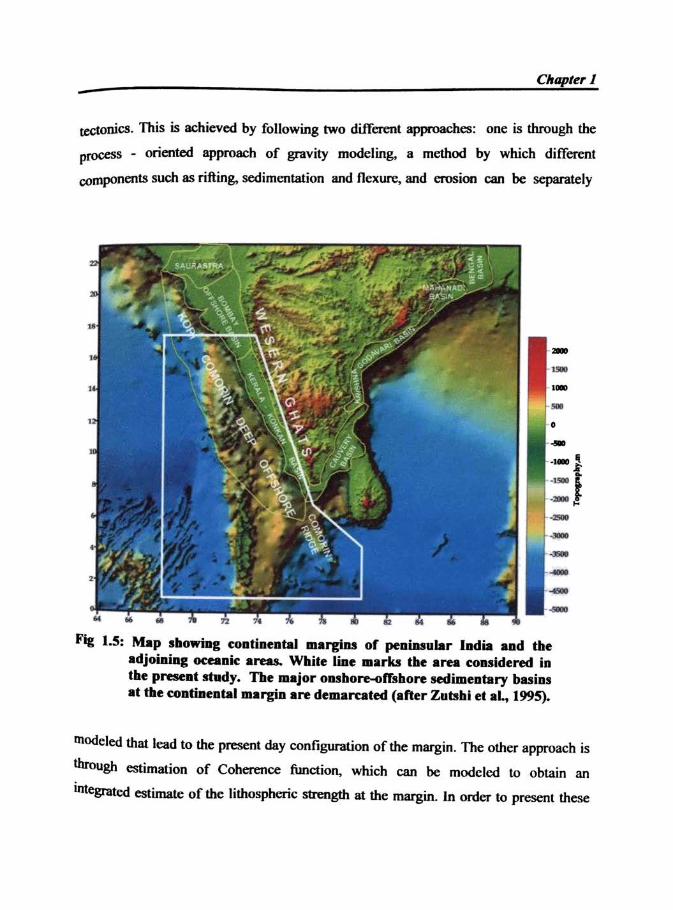
1.5 STUDY AREA
In the present study, the southern part of WCMI outside the Deccan Volcanic
Province (DVP) has been considered for detailed geophysical data analysis. The margin
consists of Konkan and KeraJa offshore basins and the study area include, the deep
oceanic parts of the Arabian Sea covering the Chagos Laccadive Ridge. South of the
WCMI and Southwest of Sri Lanka, the distinct topographic expression of the Comorin
Ridge can be seen aligned along the margin. Kahle et al. (1981) interpreted this ridge to
be a structural boundary between the continental and oceanic crust. Evolution or mode
offormation of this ridge is not yet known and therefore attains significance in terms of
understanding the reconstruction history and breakup of eastern Gondwanaland. In view
of its significance, the Comorin Ridge is also considered in the present study. The study
area lies between 63° E to 80° E longitude, 0 to 16° N latitude as shown in Figure 1.5.
1.6 SCOPE OF THE PRESENT STUDY
The main objective of the present study is to estimate the Effective Elastic
thickness (Te) of the lithosphere below different segments of the southwest continental
margin and the adjoining areas, to understand the dynamics of rifting and the attendant
C"ap/~' J -teCtoniCS. This is achieved by following two different approaches: one is through the
process - oriented approach of gravity modeling. a method by which different
components such as rifting. sedimentation and flexure, and erosion can be separately
Fig 1.5: Map stliowiDl cODtiDental .... rgins of ~alDlular ladia aad tbe adjoiDiag ocaaic areas. White lme ... rks tbe area cODsidered in tile preseal shtdy. Tbe major oubo~lrlbore sedimentary buiDS at tbe coatbteatallll"'gia are dem.ruted (after Zumbi et aL, 1995).
tnodeJed that lead to the: present day configuration of the margin. The other approach is
throUgh estimation of Coherence function. which can be modclcd to obtain an
integrated estimate of the Iithospheric strength at the margin. In order to present these
Introduction
studies, results and interpretations in a concise way, the thesis has been organized into
seven chapters. A brief description of each of these chapters is given below.
Chapter 1 gives a brief introduction to the evolution of passive continental
margins. The significance of continental margins in general and a brief account on the
evolution of the Indian margins have been presented. A brief description of the method
of analysis is provided.
In Chapter 2, a detailed account of the geotectonics, rifting history and tectono
stratigraphic evolution of major sedimentary basins along the WCMI is given. The
nature of plume lithosphere interactions during rifting history (India - Madagascar at ~
88 Ma and India-Seychelles at ~ 65 Ma) and formation of the WCMI have been
discussed. The development of major onshore and offshore sedimentary basins such as
the Kutch, Cambay, Saurashtra, Bombay and Konkan - Kerala basins during the India's
northward flight which led to the deposition of thick pile of sediments in the margin.
The structure and stratigraphic history of these basins in the light of rift tectonics has
been discussed. The major topographic features in the eastern Arabian Sea mainly
include the Chagos-Laccadive Ridge, the Pratap ridge and the Laxrni ridge. The nature
of crust and their formation during the evolution of the eastern Arabian Sea is still
enigmatic. The nature of crust below the Laxmi basin in the NW part of the margin is
debatable. In order to highlight some of these problems, a detailed review on kinematic
history of evolution for the eastern Arabian Sea has been presented in this chapter.
In Chapter 3, a detailed description on the methodology adopted in the present
study has been provided. The significance of Coherence analysis particularly the lIse of
Maximum Entropy Spectral Estimation (MESE) has been highlighted. The chapter also
includes a discussion on the importance of subsidence and sediment loading studies and
provides description of various methods such as Airy and flexural backstripping and the
lithospheric models such as Necking and Magmatic underplating.
ChapteT 1
Chapter 4 gives the details on estimation of Te based on Coherence analysis in
die Southwestern Continental Margin and adjoining areas. A description of the gravity
anomalies along the WCMI. calculation of Complete Bouguer Anomaly through
application of terrain correction has been provided. The results obtained from the
Coherence analysis are also discussed.
The sediment loading and flexural characteristics of the lithosphere have been
carried out along two seismo-geologic sections compiled from the available seismic
data in the Konkan and Kerala basins. Based on the process-oriented approach, two
lithospheric models (Necking and Magmatic underplating) of evolution of the margin
were tested. The results of this analysis are given in chapter 5.
Chapter 6 presents a detailed discussion and geological implications of the
results obtained in the above analysis. A discussion on India and Madagascar breakup -
role of Marion mantle plume. isostasy at the Konkan and Kerala basins. lithospheric
strength and evolution of the Western Ghats, Geophysical characteristics and probable
mode of emplacement of Comorin Ridge in relation to the evolution of the Western
Continental Margin are included in this chapter.
Chapter 7 provides summary of the work and major conclusions drawn from
the present study.
********************