Hani S. Mahmassani, Michael McNerney, Keisha...
53
RESEARCH REPORT 1849-1 SYNTHESIS OF LITERATURE AND APPLICATION TO TEXAS AIRPORTS Hani S. Mahmassani, Michael McNerney, Keisha Slaughter, and Hussein Chebli CENTER FOR TRANSPORTATION RESEARCH BUREAU OF ENGINEERING RESEARCH THE UNIVERSITY OF TEXAS AT AUSTIN FEBRUARY 2000
Transcript of Hani S. Mahmassani, Michael McNerney, Keisha...

RESEARCH REPORT 1849-1
SYNTHESIS OF LITERATURE AND
APPLICATION TO TEXAS AIRPORTS
Hani S. Mahmassani, Michael McNerney, Keisha Slaughter,and Hussein Chebli
CENTER FOR TRANSPORTATION RESEARCHBUREAU OF ENGINEERING RESEARCHTHE UNIVERSITY OF TEXAS AT AUSTIN
F E B R U A R Y 2 0 0 0
Technical Report Documentation Page
1. Report No.
FHWA/TX-00/1849-1
2. Government Accession No. 3. Recipient’s Catalog No.
5. Report Date
February 20000
4. Title and Subtitle
SYNTHESIS OF LITERATURE AND APPLICATIONTO TEXAS AIRPORTS
6. Performing Organization Code
7. Author(s)
Hani S. Mahmassani, Michael McNerney, Keisha Slaughter, andHussein Chebli
8. Performing Organization Report No.
1849-1
10. Work Unit No. (TRAIS)9. Performing Organization Name and Address
Center for Transportation ResearchThe University of Texas at Austin3208 Red River, Suite 200Austin, TX 78705-2650
11. Contract or Grant No.
0-1849
13. Type of Report and Period Covered
Interim Literature Review ReportSeptember 1999 - February 2000
12. Sponsoring Agency Name and Address
Texas Department of TransportationResearch and Technology Transfer Section/Construction DivisionP.O. Box 5080Austin, TX 78763-5080 14. Sponsoring Agency Code
15. Supplementary Notes
Project conducted in cooperation with the Federal Highway Administration.
16. Abstract
Air transportation plays a vital role in the Texas economy. Air passenger/cargo traffic isprojected to continue to increase considerably at many of the state’s large airports. Ground access toairports is an important function that must be provided for at the regional level as well as in theimmediate vicinity of the facility itself. Congestion problems affecting airport access are in someinstances reaching unacceptable proportions; there are also concerns regarding the negative impactssuch congestion is having on air quality and other environmental considerations. Accordingly, theseissues require concerted action to meet project needs.
To address the above challenges and current gaps, this project will take a comprehensive look atthe landside access issues associated with the major airports in the state. It will seek to improve onexisting planning procedures and processes to meet the unique needs of airport traffic demand, forboth people and goods. To be effective, planning for airport ground access must be multimodal andintermodal, consider both operational, regulatory and capital-intensive infrastructure provision issues,consider multiple levels of scale/resolution, and recognize the unique dynamic aspects of air trafficdemand, i.e., its temporal patterns.
This report presents an overview and synthesis of the literature reviewed under the first task.The research team concludes that the motivation and the need for the ground access study is high andthat existing approaches and documents are insufficient to meet the needs for strategic ground accessplanning of major airports in Texas.
17. Key Words
Airport ground access, air quality, congestion;multimodal, intermodal, and ITS technologies
18. Distribution Statement
No restrictions. This document is available to the publicthrough the National Technical Information Service,Springfield, Virginia 22161.
19. Security Classif. (of report)
Unclassified
20. Security Classif. (of this page)
Unclassified
21. No. of pages
52
22. Price
Form DOT F 1700.7 (8-72) Reproduction of completed page authorized


SYNTHESIS OF LITERATURE AND APPLICIBILITY
TO TEXAS AIRPORTS
by
Hani S. Mahmassani
Michael McNerney
Keisha Slaughter
Hussein Chebli
Research Report Number 1849-1
Research Project 0-1849Airport Access: Intermodal Strategies to Address Congestion at
Airport/Highway Interfaces
Conducted for the
TEXAS DEPARTMENT OF TRANSPORTATION
in cooperation with
U.S. DEPARTMENT OF TRANSPORTATIONFEDERAL HIGHWAY ADMINISTRATION
by the
CENTER FOR TRANSPORTATION RESEARCHBureau of Engineering Research
THE UNIVERSITY OF TEXAS AT AUSTIN
February 2000
Revised June 2000

iv

v
DISCLAIMERS
The contents of this report reflect the views of the authors, who are responsible forthe facts and the accuracy of the data presented herein. The contents do not necessarilyreflect the official views or policies of the Federal Highway Administration (FHWA) or theTexas Department of Transportation (TxDOT). This report does not constitute a standard,specification, or regulation.
There was no invention or discovery conceived or first actually reduced to practice inthe course of or under this contract, including any art, method, process, machine,manufacture, design or composition of matter, or any new and useful improvement thereof,or any variety of plant, which is or may be patentable under the patent laws of the UnitedStates of America or any foreign country.
Research performed in cooperation with the Texas Department of Transportation and theU.S. Department of Transportation, Federal highway Administration.
NOT INTENDED FOR CONSTRUCTION,BIDDING, OR PERMIT PURPOSES
Hani S. Mahmassani P.E. (Texas No. 57545 )Research Supervisor
ACKNOWLEDGMENTS
The authors acknowledge the support provided by Linda Howard (AVN), TxDOT projectdirector. Also appreciated is the assistance provided by Jay Nelson (DAL).

vi
vii
TABLE OF CONTENTS
CHAPTER 1. OVERVIEW OF PROBLEM AND APPROACH............................... 1
CHAPTER 2. LITERATURE REVIEW ....................................................................... 3
1. Highlights of Selected Articles ............................................................................... 3
2. Intermodal Ground Access to Airports: A Planning Guide ................................... 5
3. What the Planning Guide Does Not Cover ........................................................... 14
CHAPTER 3. APPLICABILITY TO TEXAS AIRPORTS....................................... 15
1. Dallas/Fort Worth International Airport ............................................................... 15
2. Houston George Bush Intercontinental Airport .................................................... 17
3. San Antonio International Airport........................................................................ 17
4. Austin Bergstrom International Airport ................................................................ 18
5. Implications for Present Study .............................................................................. 19
APPENDIX A RELATED WEBSITES ..................................................................... 21
APPENDIX B ANNOTATED BIBLIOGRAPHY ................................................... 23
REFERENCES ................................................................................................................ 39

viii

ix
EXECUTIVE SUMMARY
Air transportation plays a vital role in the Texas economy. Air passenger and aircargo traffic is projected to continue to increase considerably at many of the State’s largeairports. Ground access to airports is an important function that must be provided at theregional level as well as in the immediate vicinity of the facility itself. Congestion problemsaffecting airport access are in some instances reaching unacceptable proportions, withnegative impacts on air quality and other environmental considerations. Accordingly, theseissues require concerted action to meet project needs.
To address the above challenges and current gaps, this project adopts acomprehensive look at the land side access issues associated with the major airports in theState. It seeks to improve on existing planning procedures and processes to meet the uniqueneeds of airport traffic demand, for both people and goods. To be effective, planning forairport ground access must be multimodal and intermodal, consider both operational,regulatory and capital- intensive infrastructure provision issues, consider multiple levels ofscale/resolution, and recognize the unique dynamic aspects of air traffic demand, i.e. itstemporal patterns. It must also carefully consider the potential of emerging ITS technologiesin the airport environment.
This report summarizes the findings of the literature review and synthesis performedin the first task of the project. The review indicates that available procedures and guidelinesare of a very general and generic nature and are insufficient to address the strategic andtactical planning needs of major airport systems in their proper regional context. The FAA'sIntermodal Ground Access to Airports: A Planning Guide provides useful information and agood introduction to the scope and nature of the issues likely to be encountered at airports.However, it does not present specific operational tools that could be applied to specificsituations and specific airports.
The report concludes that the major airports in Texas present unique accesschallenges that require intervention beyond the generalities of the Planning Guide, or anyother available reference. The scope of these issues makes them inseparable from those ofgeneral transportation accessibility issues in the entire region of the airport. The scale andmagnitude of these problems are likely to increase with continuing growth in airport-relatedtraffic and activities. Institutional factors, involving cooperation and communication amongseveral governmental and quasi-governmental entities, play a substantial role in ensuring aneffective planning process that provides for the needs of air passenger and freight travel inthe overall mobility of the region.
The review and synthesis conducted in the first project task further reinforces themotivation and the need for this work and validates the basic premises of the work plandeveloped to address the research objectives.

x

1
CHAPTER 1
OVERVIEW OF PROBLEM AND APPROACH
Air transportation plays a vital role in the Texas economy. Air passengers and air
cargo traffic are projected to continue to increase considerably at many of the state’s
large airports. Ground access to airports is an important function that must be provided at
the regional level as well as in the immediate vicinity of the facility itself. Congestion
problems affecting airport access are in some instances reaching unacceptable
proportions, with negative impacts on air quality and other environmental considerations,
and hence require concerted action to meet projected needs.
To address the above challenges and current gaps, this project takes a
comprehensive look at the landside access issues associated with the major airports in
Texas. It seeks to improve on existing planning procedures and processes to meet the
unique needs of airport traffic demand, for both people and goods. Using as a starting
point the process outlined in the Federal Aviation Administration’s (FAA) Intermodal
Ground Access to Airports: A Planning Guide, the research expands the set of solution
options by including success stories at other airports around the country and customizes a
state-of-the-art methodological approach for Texas airports. As part of the process of
proposing and testing alternative solution strategies, the project also reviews current plans
and studies formulated by the airports’ planning departments as well as the respective
metropolitan planning organizations (MPOs) and assesses these against an evaluation
framework that recognizes the above factors. The results of this research will provide the
Texas Department of Transportation (TxDOT), airport authorities, and other concerned
entities with short- and long-term strategies for addressing landside access issues.
One concern at the outset of the project was the extent to which existing
procedures, particularly the above-noted Planning Guide, provided sufficient information
to meet the access planning needs of airport authorities and affected local, regional, and
state entities. Two observations were made at the proposal preparation stage. First, the
emphasis of the Planning Guide is principally on access considerations in the immediate
vicinity of airports; it is rather limited and generic in terms of strategic network-level and
regional access issues. Second, Texas airports, especially those in large metropolitan

2
areas, present certain unique features that would not be adequately addressed in a generic
document such as the Planning Guide. The review performed under the first project task,
along with the discussions held with various airport officials and other experts in this
community, has confirmed these observations, providing at the same time justification for
the intended focus of the current effort.
This report presents an overview of the literature reviewed under the first task and
the project team’s recommendations regarding a need for and focus of subsequent tasks
of the current research. The literature review in Chapter 2 consists of two main parts:
first, an overview of selected papers and reports, followed by a more detailed discussion
of the Planning Guide. Chapter 3 discusses applicability to Texas airports and
implications for the present research effort. To expand on the literature review of
Chapter 2, a description of relevant Web sites is provided in Appendix A. An annotated
bibliography is provided in Appendix B to better reflect the depth and breadth of the
review conducted to date for the project.

3
CHAPTER 2
LITERATURE REVIEW
A literature search produced several journal articles and/or papers relating to
ground access that detailed specific airport efforts, proposed HOV solutions, or expanded
upon the Planning Guide. However, none of these articles covered the specific issues
related to Texas airports, nor did the articles present a systematic process that could solve
ground access problems. A comprehensive annotated bibliography is included in
Appendix B. Only selected general articles are highlighted in this chapter, along with a
review of the Planing Guide contents.
Highlights of Selected Articles
Analysis of New Orleans Airport Ground Transportation System (Mundy, 1980)
details the steps taken by the New Orleans airport authority in developing the ground
transportation system. Significantly, Mundy addressed this problem as a facilities
management issue as opposed to a facility design problem. The article reiterates known
generalities, e.g., emphasizing the importance of establishing clear objectives for the
project. The congestion problems of interest to that airport include a poorly designed
roadway access system, lack of parking spaces, and curb prioritization issues. The
principal solution to the problems discussed in the paper was the addition of HOV lanes
for public transportation.
Effects of Road Access Pricing at the Los Angeles Airport: A Case Study (Lampe,
1993) describes the airport access charge imposed on commercial vehicles at that airport.
After evaluating available technologies and systems, LAX moved, in 1989, to install a
state-of-art automatic vehicle identification (AVI) system to reduce traffic congestion
and, at the same time, maximize revenues collected from ground transportation operation.
The AVI system consists of electronic tags and readers. Since implementing the AVI,
LAX claims that there has been a 20% reduction in congestion compared to the previous
system.
Ground Access to Singapore Changai Airport (Fan, 1990) emphasizes an
understanding of the traffic characteristics and utilization of access facilities. The

4
feasibility of applying typical ground access planning parameters recommended for
Western airports to Changai Airport is also investigated. Peak traffic levels are found to
be manageable. The curbside is the critical link of the access system, but congestion in
peak periods does not last very long at present. Although the two public car parks
together provide sufficient parking, the closer-in car park is always full in the evening
while the less expensive car park is usually half empty, though it is only 825 ft (250 m)
farther. This situation suggests that convenience is more important than cost to most
users.
Lessons for Rail Access to Airports (Kivett, 1996) summarizes the key planning,
design, and operational issues — vis-à-vis rail access — that must be addressed in the
ongoing expansion of existing airports, as well as in the development of new airports,
around the world. The focus is on those airports for which rail access (i.e., an effort to
link the city center of a major metropolitan area with its airport) is under consideration or
is in the formative stages of implementation.
Automated Guideway Transit to Provide Access to New York City Airports
(Tambi and Griebenow, 1993) describes the New York Port Authority’s efforts in
addressing airport access issues in a multi-faceted manner. In addition to reviewing
several transit system management measures, the Aviation Department is examining
several access improvements, one of which would involve connecting the existing rail
systems, both commuter and subway, with the airports. This connection would be
achieved with the construction of an Automated Guideway Transit (AGT) system linking
the airports to major transportation transfer facilities.
Improvements to Airports Ground Access and Behavior of Multiple Airport
System: BART Extension to San Francisco International Airport (Monteriro and Hansen,
1996) presents a case study of an extension of a Bay Area Rapid Transit rail link into the
San Francisco International Airport (SFO). Two choice models were developed. One is
a nested logit model in which the airport choice decision occurs at the higher level and
the mode choice decision at the lower level; the other is a multinomial logit model. The
results indicated that improvements to SFO ground access would modestly strengthen
SFO as the dominant airport in the San Francisco Bay Area, and that most of the
diversion of passengers would be from Oakland Airport.

5
Planning for Intermodal Access at American Airports (Shapiro, 1996) briefly
describes the contents of the Planning Guide, some of the relationships that were
developed, how they were derived, and their importance to airport access planning.
Shortly after the passage of the ISTEA legislation, the Federal Highway Administration
and Aviation Administration recognized that very limited guidance was available for
airport operators and MPOs to use for planning intermodal access to airports in the U.S.
The Planning Guide was developed as a result. This Guide is designed to provide
guidance to states, metropolitan planning organizations, and airport operators regarding
the types of analyses that should be performed when planning airport access.
Relationship between Airport Activity and Ground Transportation Needs (Shapiro
and Katzman, 1998) also presents highlights from the Planning Guide. The article
provides detailed discussion of vehicle trip relationships and airport trip generation,
curbside configurations, parking requirements, and mode access to U.S. airports. The
article identifies topics that the Guide does not cover and the areas that need to be
explored further.
Several articles dealing with rail access and access mode choice considerations
were reviewed (a discussion is included in Appendix B). The review was not confined to
domestic airports offering rail access, but also included international facilities, where rail
and transit usage for airport access is considerably higher. One conclusion drawn from
this review is that success (in rail and transit usage) at international airports is not readily
transferable to domestic airports. However, an alternative that does not appear to have
received sufficient attention at U.S. airports, yet possesses several desirable attributes and
much potential, is the use of off-airport check-in facilities in conjunction with privileged
transit access. Such configurations and facilities merit further study in light of not only
the potential of recent communication technologies on the supply side, but also the
advances in methods to better study related behavioral aspects of travelers.
Intermodal Ground Access to Airports: A Planning Guide
This guide is designed to provide policy guidance, rules of thumb, data, and
analytical techniques related to airport access. It has been prepared to help airport
operators, local governments, metropolitan planning organizations (MPOs), consultants,

6
and others identify airport access problems, find alternative solutions, and evaluate their
effectiveness. The guide focuses on providing passengers access to commercial airports
from primary origins or destinations. It deals with off-airport roads, transit, and high
occupancy vehicle (HOV) facilities up to the airport boundary and on-airport roads,
parking circulation elements, transit, and curb facilities up to terminal entrance.
Off-airport and some airport access plans and programs must frequently be
coordinated with other regional transportation plans and programs and must be consistent
with regional and state plans and programs, such as long-range transportation plans,
regional plans, and state air quality plans.
A technical approach to airport ground access planning provides a framework for
this planning guide. Chapter 2 describes airport access problems, the roles of state and
local agencies, and the relationship between airport access and the Clean Air Act.
Chapter 3 discusses the development of performance measures and their relationship to
goals and objectives. Chapter 4 details the types of data that may be collected to quantify
performance measures and determine access patterns and demand. It also describes
techniques for obtaining needed data and provides specific guidance for conducting
passenger origin-destination surveys. Chapter 5 provides an overview of how to estimate
existing and future airport access patterns and demands and how to identify potential
deficiencies. Chapter 6 describes alternative access improvements, including HOV
options, intermodal facilities, and improvements to airport infrastructure, such as access
roads, parking facilities, and terminal curbside. Chapter 7 describes how to evaluate
alternative improvements, while Chapter 8 describes how to implement such
improvements.
Chapter 2: A brief overview of the proposed airport ground access planning
process is presented. This overview establishes a seven-step planning process, each step
relating to succeeding chapters in this guide. The seven steps of the process can be
summarized as follows:
1. Define the problem.
2. Given the understanding of the policy issue, establish performance measures to be
used in the program of monitoring and evaluation.
3. Collect data needed to support the application of the performance measures.

7
4. Understand existing and future conditions and performance of the system.
5. Develop candidate strategies and actions.
6. Assess effectiveness of alternative strategies and actions and select cost-effective
actions.
7. Implement, monitor, and gather feedback using the established performance
measures.
The above steps are rather generic in nature and are standard fare in introductory
planning textbooks. As such, they are not likely to meet specific needs of an airport
authority or related agency. A review is presented of the various legal, regulatory, and
institutional considerations in the initial development of a work plan for an airport ground
access planning process. It is stressed that public transit system service ground access to
the airport, preferably the airport terminal area, should be considered. Easy direct access
to terminal buildings, as well as baggage transport and security, is essential in efforts to
encourage substantial passenger use.
The FAA documents make clear that airport ground access is an important part of
the airport’s master planning and design responsibilities and, at the same time, must
function within the context of the regional transportation system and the policies of
government agencies typically unrelated to an airport’s operation. A primary purpose of
this guide is to document the nature of the planning process and to aid practitioners in
building partnerships between on- and off-airport planning and activities. However,
practical tools and strategies to achieve such coordination and integration operationally
remain outside the scope of this chapter and of this document.
Chapter 3: The planning process mandated by ISTEA stipulates that monitoring
and evaluation should be established early in the cycle. Chapter 3 has been prepared to
help local planners and administrators develop goals, objectives, and performance
measurements that are relevant to the needs of the local community. Efforts at
developing performance measures in Oregon and Boston are summarized. The Planning
Guide also includes a proposed basic list of areas for performance evaluation by those
just starting the process of ISTEA-based planning for airport access improvements.
In regions having significant Clean Air attainment problems (e.g., Dallas,
Houston, Austin, and San Antonio), planners must expect to use a full calculation of
8
regional VMT change as a principal performance measure for the evaluation of projects,
strategies, and actions under consideration. The techniques available to obtain data
related to different airport ground access goals, objectives, and performance measures are
detailed in the Planning Guide. Airport access could include a base-year inventory
consisting of surveys of physical and operational characteristics of intermodal facilities
and systems based on performance measures.
It is important at this juncture to emphasize that both the science and the art of
performance measurement in a specialized field, such as airport access, are in their
infancy.
There are three principal factors to be considered in the selection of survey
techniques: (1) the type of study being conducted, which controls the types of
information and levels of accuracy required; (2) activity level at the airport under study,
which is measured by the size of the population or subgroups (such as air passengers
transit riders) to be surveyed; and (3) the configuration or spatial arrangement of
activities of the airport and region under study.
Chapter 4: This chapter describes techniques available to obtain data related to
different airport ground access goals, objectives, and performance measures. The usual
steps followed in the development of an airport access survey are:
1. Define study objectives.
2. Identify data requirements.
3. Select survey strategy.
4. Select data collection techniques.
5. Prepare survey specifications and conduct survey.
6. Summarize post-survey findings.
Three broad types of surveys and studies are typically conducted: traffic,
passenger, and special purpose. At larger airports, a mixed survey strategy is
recommended, one in which air passengers, airport employees, and users of the primary
visitor modes (e.g., short-term parking facilities and regularly scheduled bus and rapid
transit services) are sampled. The concepts and procedures discussed in this chapter are
again quite general and are insufficient for application to a specific context, especially to

9
major airport systems having unique characteristics, such as those in Dallas-Fort Worth
and Houston.
Chapter 5: This chapter provides an overview of concepts underlying the
approaches to estimating existing use and future demands for airport access facilities.
Airports generate large volumes of traffic and serve several different markets (e.g.,
passengers, employees, and visitors).
The inventory phase involves collecting and analyzing available data (e.g.,
roadway plans; previous studies; available traffic data; airline passenger, airport cargo,
airport employee, and vehicle survey data; and passenger forecasts). Forecasts of future
airport access patterns and travel demands are required to plan and assess the adequacy of
future airport and regional transportation facilities. To analyze the demand for ground
transportation facilities, such as roadways, parking lots, and curbsides, it is first necessary
to determine the “design period” that best represents the demand condition for which a
facility should be planned. Beyond conveying a broad general understanding of the
underlying concepts, the Planning Guide is of limited usefulness on this topic. Actual
challenges in application and implementation to specific contexts are not within the scope
of the presentation.
Chapter 6: Alternatives for Improving Airport Access. This chapter presents
alternative types of airport access improvements and provides examples. Each airport
could use either capital improvements, such as adding highway or rail transit links, or
operational improvements, such as improved bus or shuttle service. The chapter suggests
six different alternatives to consider:
1. Access roads
2. Parking
3. Terminal curbside facilities
4. Rubber-tired and rail transit options
5. Intermodal facilities
6. Demand management techniques, such as TDM strategies and application of ITS
technology
10
The chapter presents a fairly extensive catalogue of measures under each of these
improvement categories. This catalogue reflects existing best practice and is a useful
reference guide to a rich toolbox of principally operational improvements. The extent of
the measures catalogued is illustrated below by a listing of options corresponding to the
access roads element.
Three areas of discussion of access roads are included: off-airport, near-airport,
and on-airport. These are discussed in turn below.
Access Roads Off Airport
Three principal standard practice references are mentioned.
1. Manual on Uniform Traffic Control Devices 1 — Standard green airport sign.
2. ITE — Airport Roadway Guide Signs, A Proposed Recommended Practice 3
offers the following: All major roads intersecting the airport feeder roads with a
10–25 mile radius of the airport should carry the airport message as an integral
part of its highway designation signs.
3. FHWA — National Highway System, The Backbone of America’s Intermodal
Transportation Network 4 — Most airports have adequate access but face
increasing problems of peak-hour congestion. The NHS will provide resources to
improve existing access routes to tomorrow’s airports. The NHS will enable
plans for airport expansion and the required ground access to be much more
closely integrated. The NHS, passed in Congress November 1995, included roads
that served a total of 143 airports.
Needs related to emergency vehicle access to and from airports must not be
overlooked in the regional planning context. EMS and Fire shortest routes and alternate
routes mitigate impediments and bottlenecks and minimize response times.
• Geometric Design Alternatives for Improving Capacity to Off-Airport Roads
o Widening highways for provide additional travel lanes
o Constructing medians and median dividers
o Extending left-turn storage lanes
o Constructing additional turn lanes
o Widening paved shoulders
o Implementing minor geometric improvements

11
o Straightening sharp horizontal curves
o Lengthening short crest and sag vertical curves
o Realigning skewed intersections
o Reducing grade differentials at intersections
• Traffic Operations Alternatives
o Improvement in traffic signal operations on arterial roads that lead to airports
o Improvements in traffic surveillance systems
o Implementation of traffic management centers
o Implementation of improved traffic information dissemination systems
Access Roads Near Airports
NCHRP and ITE — Traffic and Transportation Planning Handbook 6 —
Airports are among the largest metropolitan trip generators, but their measurable impacts
on the highway network are within a few miles of the airport. Localized impact can be
quite severe. Far greater attention should be devoted to capacity of roads in the
immediate vicinity of airports.
• Geometric Design Alternatives
o Same as those listed for off-airport access roads
o Construction of new direct access roadways
o Controlled-access roadways dependent upon passenger demand
o Exclusive express lanes such as those at Dulles Airport
• Traffic Operation Alternatives
o Same as those listed for off-airport access roads
o Highway advisory radio
o Changeable message signs
On-Airport Roads Excluding Terminal Curbside Areas
There are many different vehicle destinations on the airport property.
• Airport Users
o Passengers:
- Local residents — business and nonbusiness travel
- Nonresidents — business and nonbusiness travel
12
o Meeters and greeters, visitors, spectators
o Employees and others:
- Airport employees
- Airline employees and air crew
- FAA employees
- Employees of tenants of the airport
- Non-airport employees working at airport
- Non-airport employees delivering goods and services
- Customers of airport and other services
• Airport Circulation
o Components of airport landside circulation:
- Airport roads
- Terminal curb areas
- Public parking facilities
- Restricted access parking areas
- Public transportation and rental car areas
o Classification of airport roads:
- Primary airport access roads
- Terminal area access roads
- Recirculation roads
- Terminal frontage roads
- Service roads (general and restricted use)
o Typical airport circulation systems:
- Centralized — Single building or continuous series of buildings — ORD,
SFO, LAX, ATL, DCA, FLL
- Decentralized — Divided terminal building (by airline or arriving/departing
PAX) — Orlando, Jacksonville, Cincinnati
- Segmented — Terminal access roads funnel traffic to separate terminal
facilities — JFK, Kansas City
- Unitized — Centrally located roadway to series of terminals — DFW,
George Bush
13
• Principles for Design and Operation of Airport Roads
o Sufficient length to permit smooth channeling of traffic
o Ample space between no more than two route choices
o Minimum four lanes adjacent to terminal curb
o Separate service-related and passenger-related traffic
o Large airports — grade separation between arriving and departing passengers
o Circulation in front of terminal — one-way counterclockwise — right-side
loading
o Separate traffic streams early with adequate signing to avoid confusion
o Needs of the pedestrian should be considered:
- Separate pedestrians and vehicular traffic
- Establish pedestrian/bicycle networks
- Consider special provisions for bicycles
- Maximize safety at pedestrian crossings
- Minimize the number of at-grade crossing points
o Traffic signal control justified only under MUTCD
o Design of airport roadway system includes provisions for:
- Satellite parking areas
- Access to on-airport intermodal stations including transit
- Rental car areas
- Safety considerations for parking access points
- Taxi and public transportation staging and parking areas
• Roadway Designs to Accommodate Taxis
o Geometric design alternatives
- Roadway network
- Interchanges
- At-grade intersections
- Driveways and other access points
o Traffic operations alternatives
- Improved signage to avoid confusion

14
- Improve pavement marking and delineation
- One-way CCW traffic
o Transportation enhancement alternatives
- Provide covered walkways
- Improve marking and lighting of pedestrian routes
- Install or improve bus stop shelters
- Improve visibility of shuttle stop signs
- Install bicycle racks
- Improve pedestrian and bicycle trails
o Management of Traffic during Construction
What the Planning Guide Does Not Cover
While this Guide provides a good single-source starting point for the key concepts
associated with providing access to airports, its scope and level of coverage make it
insufficient for the complex access needs of major airports seeking to meet their strategic
regional and international roles. Its generic nature does not allow engineers and planners
to address the complex web of factors and considerations associated with major airport
access provision in a large urban area. Consequently, the need for additional work
related to this subject is quite evident. Key areas that require additional development
include a need to:
• gather more data on airport travel characteristics, such as the number of groundaccess trips related to origination, employees, and cargo activity at differentairports;
• gather data on the number of passengers traveling in each vehicle that enters anairport (vehicle occupancy);
• collect and publish more information on peaking characteristics at different typesof airports;
• develop guidance comparable to the Guide for planning freight access to airports;and
• develop better access-related planning tools and models, especially in order toaddress the airport’s role in the context of its metropolitan area’s strategicmobility needs.
15
CHAPTER 3
APPLICABILITY TO TEXAS AIRPORTS
This chapter briefly discusses the applicability of ground access planning at four
of the major airports in Texas. The main point of this discussion is that each airport is
unique and has its own individual access issues. Therefore, the general planning rules
and guidelines for airport access espoused in the FHWA Intermodal Airport Access
Planning Guide do not necessarily precisely fit, nor entirely meet, the requirements and
special characteristics of these airports. The two largest and busiest of these airports,
DFW and Bush Intercontinental, maintain large planning staffs augmented by consultants
hired under contract. The two midsize airports, Austin and San Antonio, have very small
planning staffs. Other airports that have need of airport access planning include Alliance
Airport, Corpus Christi Airport, and El Paso International Airport. However, as a
generalization, these airports and others like them probably do not maintain a sizable full-
time planning staff. Therefore, their ground access planning would be addressed only
during the preparation of the airport master plan.
1. Dallas/Fort Worth International Airport
DFW International Airport is administered by the Dallas/Fort Worth International
Airport Board, an agency created by Texas legislation with board members from the two
member cities. Unlike most Texas airports, which are administered by city departments
of aviation, DFW airport is run by a professional airport staff reporting to the airport
board. Given the airport’s large size, this is an effective way to organize and respond to
the needs of the airport. With its more than 18,000 acres, DFW is the second largest
airport in the U.S., as measured in terms of land area. With more than 2,500 aircraft
operations a day, it is either the second or third busiest airport in the U.S., depending on
how the actual measurement of annual aircraft operations is made.
DFW has one unique ground access problem that does not appear to be found at
any other airport. Because of its large acreage and key location between the high
employment growth area of north Dallas and the high residential growth area of south
Fort Worth, DFW is ideal for a major transportation artery between the two areas. In
addition, the airport layout, with its central multilane divided thoroughfare oriented

16
north-south, attracts a large number of commuter vehicles that do not intend to use the
airport but merely pass through as a means of obtaining the shortest-time commute.
Anecdotal evidence reported by the airport staff has indicated that during rush hour, the
waiting queue to enter the airport parking gate can exceed 20 minutes with all lanes open.
As further evidence, DFW reported in the ACI airport parking survey that 16 million
vehicles exited their parking facility toll booths in 1996, compared to 17 million origin
and destination passengers. These figures are very high compared with those for other
airports for the same year; for example, Chicago’s O’Hare had 4 million vehicles exiting
parking for 27 million O&D passengers.
To attempt to mitigate this problem by curbing the demand, the airport recently
instituted a new parking rate of $2 for parking times between 0 and 8 minutes. The toll
remains “no charge” for times between 9 and 30 minutes. The purpose is not to become a
toll road authority but to reduce demand for the primary access roadway by charging a
pass-through toll for drivers having no intention of stopping at the airport. It will be
interesting to see what effect the new pricing schedule has on the demand for the ground
access roadway.
DFW is also currently studying the feasibility of adding light rail access to the
airport using the Dallas Area Rapid Transit (DART) authority system. Because of the
high number of airport employees and the need to replace the existing rubber-tired people
mover system within the airport, this project will most likely proceed to implementation.
This project will probably be decided by the airport authority and DART directly without
much, if any, input from either TxDOT or the local metropolitan planning organization
(MPO).
One problem that was identified by DFW Airport was the lack of communication
and coordination between DFW Airport and TxDOT on the placement of signage off-
airport. Although there exists an MPO (NCTCOG), as well as TxDOT district offices in
both Dallas and Fort Worth, communication between DFW Airport and these offices both
for long-range access planning and short-range coordination on closures appears to be
less than optimal for all entities concerned.
One of the other problem areas at DFW, a problem that is also shared with
Houston, is mitigation of air pollution problems. Houston is in severe nonattainment, and

17
Dallas is expecting to reach severe nonattainment levels in the near future. The severe
nonattainment designation by EPA will have considerable influence on the nature and
extent of the ground access planning that is expected to take place, and on the types of
access alternatives that must be considered. The airport needs to coordinate its actions
with those ongoing at the regional level to reduce low-occupancy private automobile trips
in order to reduce air pollution levels.
Houston George Bush Intercontinental Airport
The City of Houston Division of Aviation administers three airports in the
Houston metropolitan area: George Bush Intercontinental, William P. Hobby, and
Ellington Field. George Bush Intercontinental is a large hub airport with a large O&D
passenger demand. Compared to cities with similar population, Houston has a small
transit program, one that consists primarily of conventional bus service coupled with
aggressive construction of high-occupancy vehicle facilities along freeways.
The typical ground travel times to George Bush Intercontinental could be
problematic from some parts of the city during certain times of the day. It appears that
Houston traffic is at times so bad that commuter flights are being flown from Hobby and
Ellington to George Bush Intercontinental Airport, thereby providing intracity air shuttle
service. The Houston Aviation Division has professional airport planners on its staff to
handle the projected growth in passenger numbers; additional Houston information will
be obtained for subsequent tasks of this project.
San Antonio International Airport
Ground access problems for San Antonio International Airport, which is located
at the intersection of US 281 and IH-410, are relatively minor except for the crowded exit
ramps from a very busy Loop 410. San Antonio is a medium-sized airport with about 7
million annual passengers, nearly all of whom are O&D. San Antonio has no plans for
rail access but does provide some bus service to the airport.
Both Austin and San Antonio share a common problem in that they are likely to
be designated as nonattainment for ozone as soon as 3 years of data have been collected
under the new ozone limits. Accordingly, ground access plans that help reduce ozone
will be looked at more closely at these two airports.

18
Both Austin and San Antonio have MPO organizations that work closely with the
city planners. Both airports are administered by city departments of aviation, though the
full-time planning staffs are relatively small. They both have the advantage of being able
to draw upon traffic engineers from the city staff. Both airports have the good fortune to
have ground access by state-maintained divided highways directly outside their gates.
However, this also means that each airport needs to communicate with TxDOT district
offices for maintenance, signage, or improvements.
Although Austin and San Antonio airports are very similar in size and passengers,
there are some problems unique to each. San Antonio has a higher percentage of
international travel, and particularly international cargo, with two foreign trade zones on
the airport. International cargo is of high importance to the airport.
Continued growth at San Antonio International Airport is likely to be a problem
for its current site. The terminal complex has grown to twenty-eight gates in two
terminal buildings; in addition, parking space is relatively scarce. Growth in ground
transportation to the airport will be one of the biggest problems at the airport, given that
the site has exceeded its original design for ground access. The very limited acreage
between Loop 410 and the airport will make ground access a major problem in efforts to
accommodate passenger growth.
Austin Bergstrom International Airport
Like San Antonio Airport, Austin Bergstrom International Airport (ABIA) is a
medium-sized facility, one having about 6 million annual passengers (nearly all O&D)
and twenty-six aircraft gates. Moreover, like San Antonio, Austin will soon become
designated as a city in nonattainment for ozone. However, even with the similarities,
there are different ground access planning issues associated with the Austin facility.
Unlike San Antonio, Austin allowed the general aviation reliever airport in town
to close. However, Austin has an advantage (although some might argue an
inconvenience) in that general aviation has a separate ground access point to the airport.
Austin Bergstrom does not fit the mold of other Texas airports because it is
essentially the only new medium-sized commercial service airport constructed in the U.S.
in the last 20 years. The airport was built upon the site of Bergstrom Air Force Base after
19
the base’s closure. Significant planning and resources were devoted to planning ground
access to the airport. A complete ground access study was performed, although costs
were kept to a minimum because the airport already had two grade-separated freeway
entrances to the old Bergstrom Air Force Base. The study concluded that ground access
times to the airport would not be a problem because the peak-hour traffic loads were less
than those occurring when the base was an active military installation. Subsequent tasks
in the present study should include a review of the depth of the traffic study performed
for the 1993 airport master plan.
Because Austin Bergstrom was a new facility, planning included reserving space
near the terminal for future light rail access to the airport. Nonetheless, the planners did
not believe that there would be sufficient demand to justify a light rail access system to
the airport.
An important issue for ground access planning at Austin Bergstrom is
coordination and planning with TxDOT. Because of the lead times, TxDOT had
programmed a new highway leading from north Austin to an earlier proposed airport site
in Manor. However, in 1993 the city voted to discontinue plans for the Manor site and to
rebuild on the Bergstrom site. With different timelines for planning and construction,
major improvements to US 71 (the main access to the airport) were scheduled for
construction after the airport opened, with such improvements then continuing for
another 2 years. The lead times to schedule and program major infrastructure
improvements are far longer than the public realizes. Enhanced procedures for
coordination between airport, city, MPO, and TxDOT deserve study for potential
improvement.
Implications for Present Study
As noted at the end of the previous chapter, and as highlighted in the discussion in
this chapter, both the state of the art and the state of the practice pertaining to ground
access planning for major airports are lacking. The review of literature indicated that
procedures and guidelines currently available are of a very generic nature and are
insufficient to address the strategic and tactical planning needs of major airport systems
in their proper regional context. The Planning Guide, discussed in some detail in the
20
previous chapter, provides useful information and a good introduction to the scope and
nature of the issues likely to be encountered at airports. However, it does not present
specific operational tools that could be applied to specific situations and to specific
airports. From a methodological standpoint, considerable advances have taken place in
the analysis of the demand for access and in procedures for the design and evaluation of
intermodal network-level alternatives. The Planning Guide does not provide a
methodology; it presents concepts, all useful, but insufficient for the operational planning
needs of actual airports.
Also highlighted in the discussion of this chapter is the fact that the major airports
in Texas present unique access challenges that require intervention beyond the
generalities of the Planning Guide or any other available reference. The nature of these
issues is such that their scope is not separable from those of general transportation
accessibility issues within the entire region of the airport. Airports like DFW have
become major growth poles and hubs of economic activity in their respective regions.
This role will continue to increase in tandem with the growing importance of convenient
air travel for both passengers and goods in the much-touted New Economy, which is so
critical to the future economic well being of the state. Institutional factors, involving
cooperation and communication among several governmental and quasi-governmental
entities, play a considerable role in ensuring an effective planning process that provides
for the needs of air passenger and freight travel in the overall mobility of the region.
The conclusion of this review, conducted as an initial task of a 3-year project, is
to confirm the objectives and tasks laid out in the original research proposal. The review
and synthesis to date have further reinforced the motivation and the need for this work
and has validated the basic premises of the work plan developed to address the research
objectives.

21
APPENDIX A
RELATED WEB SITES
www.dfwairport.com/planning/transportation.htm
SummaryThe site describes the future ground transportation plans for DFW airport.
Currently, mass transit options are available via express and local service to the airport.However, future phases include a commuter rail service, a people-mover system, anautomated parking fee collection system, a park-and-ride facility, and possible roadwayimprovements.
www.ci.houston.tx.us/departme/aviation/iah.html
SummaryThis site presents general information for Houston travelers. Houston currently
has metro bus service located in several terminals throughout the airport. IAH offersspecial membership rates for IAH-Sure Park members. Members are guaranteed aparking space once they pay for membership.
www.ci.houston.tx.us/departme/aviation/hou.html
SummaryServices available at William P. Hobby airport do not differ much from those
provided at the Bush Intercontinental Airport; that is, metro bus service is also availablein addition to other ground transportation options, such as the Airport Express. Moreover,the various parking options existing at HOU are presented.
www.ci.sat.tx.us/aviation/index.html
SummarySan Antonio travelers are provided with sufficient information on the easiest way
to get to the airport from various activity centers in San Antonio and its vicinity. Inaddition, information about various ground transportation options is available, such ascity bus service. Finally, San Antonio International Airport has several parking options,which are categorized as short term, long term, and shuttle.
www.ci.austin.tx.us/newairport/default.html
SummaryAvailable on this Web page is a complete description of Capital Metro bus service
to the airport. Moreover, maps pertaining to best route options to and from the airport arealso available via a direct link.

22
23
APPENDIX B
ANNOTATED BIBLIOGRAPHY
The articles and reports summarized in this annotated bibliography are grouped intofive main categories:
1. At-Airport Issues2. Demand Side3. Entire Airport System4. Network5. Rail Access
1. At-Airport Issues
Adams, G., and Jackson, R. “Improving Ground Access to LAX.” TrafficCongestion and Traffic Safety in the 21st Century. June 8–11, 1997. pp. 160–166.
SummaryComprehensive master planning is well underway for major improvements to the
Los Angeles International Airport (LAX). The implemented master plan is expected toaccommodate a significant increase in annual air passengers, as well as the associatedincrease in ground access travel demand. With realization of the master planimprovements still at least a decade in the future, it was recognized that measures must betaken in the short term to address existing vehicular traffic congestion and toaccommodate increased travel demands into the 21st century. Barton-AschmanAssociates, Inc., was retained by the Los Angeles Department of Airports (LADOA) tohelp in identifying ground access problems and in formulating solutions. This paperdescribes one of several congestion problems studied and the solutions beingimplemented, including consideration of an on-airport traffic management center thatmay be installed in the old control tower.
Nakazawa, K. “Look Back on First Year’s Actual Result of Access Railway forNew Tokyo International Airport.” Japanese Railway Engineering. No. 125. September1993. pp. 23–26.
SummaryOpened in May 1978, New Tokyo International Airport at Narita City served
approximately 6 million annual passengers in the first year. By 1990 the number ofannual passengers had grown to approximately 20 million, of which 95 percent wereinternational travelers. The rate of growth of air cargo at the airport places it among theworld leaders; indeed, the Narita Airport is the most important port in Japan for trade

24
exchange with foreign nations. The access railway to the airport is an important part ofthe airport operation.
Lacomber, A. “Ground Access to Airports: Prospects from Intermodalism.”Transportation Quarterly. Vol. 48. No. 4. pp. 381–392.
SummaryThis paper examines the question of airport ground access in view of the
requirements and goals of the CAAA and ISTEA. The regulatory, funding, andinstitutional constraints of intermodal approaches to the ground access problem areconsidered. Some of the new opportunities for cooperation between airports andtransportation planners with respect to ground access solutions are integrated.
2. Demand Side
Blackhall, J., Brackenbury, S., and Ramsey, M. “London Luton Airport NewAccess Road: A Successful Construction Partnership.” Proceedings of the Institution ofCivil Engineers: Transport. Vol. 29. No. 4. November 1998. pp. 207–217.
SummaryStudies to assess the growth in future passenger traffic at London Luton Airport
have forecast that the current (1994) traffic of about 2 million passengers per year willincrease to 20 million passengers per year by 2015. In view of this future expansion,London Luton Airport Limited has formulated a long-term development strategy thatincludes innovative integrated and sustainable transport links. The new access road is animportant part of this development strategy. This paper describes the various stages of thenew access road construction, from its inception and planning through final completion;it outlines how the informal partnering process, instigated after tender award, helped toensure the project’s successful conclusion.
Cunningham, L., and Gerlach, J. “Transportation Agencies’ Experiences withDecision Support Systems for Airport Ground Access Planning.” Transportation. Vol.25. No. 1. Feb. 1998. pp. 37–53.
SummaryA field investigation was conducted that looked into the ways that transportation
agencies use quantitative and qualitative information for making strategic decisionsregarding airport ground access. The value of this information was analyzed for planningairport ground access improvements at seven major international airport sites. The majorfinding of the research is that quantitative modeling for strategic decision support is verydifficult, costly, and time consuming. While modelers are confident that the models areaccurate and reliable, executives generally lack confidence in the results. Transportation
25
officials believe that the information supplied is flawed by a number of defects thatminimize its value for strategic decision makers.
Higgins, T. Z. “California Airports: Ground Access Vehicle Trips, Emissions, andEmission Reduction Strategies.” 23rd Air Transport Conference, June 22–24, 1994. pp.102–106.
SummaryThe paper discusses the volume of trips and emissions associated with ground
access vehicles traveling to and from California airports, and potential ways to reducethese emissions. It provides a method for estimating the volume of ground access vehicletrips at airports and associated emissions based on annual passenger volumes, acommonly recorded and reported airport statistic. At the same time, the report providesthe best information available on the current volume of airport access vehicle trips, aswell as the range of VMTs and speeds associated with trips. An example is provided toshow how to calculate emissions from vehicle trips based on VMT, speeds, and emissionfactors or particular air basins. Finally, the paper investigates the potential of severalemployee and passenger strategies aimed at reducing trips and emissions.
Monteriro, A., and Hansen, M. “Improvements to Airport Ground Access andBehavior of Multiple Airport System: BART Extension to San Francisco InternationalAirport.” Transportation Research Record 1562, November 1996. pp. 38–47.
SummaryMetropolitan regions having more than one major airport — multiple airport
systems (MASs) — are important to the U.S. air transport system because of the largenumber of passengers they serve. Airport ground access factors strongly influence theallocation of traffic in MASs. The effects of improvements to airport ground access (bynonautomobile modes) on airport use in an MAS are analyzed. A case study of anextension of a Bay Area Rapid Transit rail link into the San Francisco InternationalAirport (SFO) is presented. Two airport choice models were developed. One is a nestedlogit model in which the airport choice decision occurs at the higher level and the modechoice decision at the lower level; the other is a multinomial logit model. The resultsindicated that improvements to SFO ground access would modestly strengthen SFO asthe dominant airport in the San Francisco Bay Area, and that most of the diversion ofpassengers would be from Oakland Airport.

26
3. Entire Airport System
Ellis, G. “Airport Ground Access — The Missing Link.” National ConferencePublication-Institution of Engineers. Vol. 1. No. 93. September 13–15, 1993. pp. 249–253.
SummaryFrom the perspective of a city’s overall transport network, a major airport’s trip
generation is usually second only to that of the city’s central business district. All majorAustralian airports are currently dependent on road-based ground transport modes, withprivate auto being used to carry out greater than 75% of all trips. The task of providingfor the total ground access trip is generally shared between authorities that often differ intheir primary operative objectives. Innovative ground transport planning will be requiredto effectively provide for this demand into the future. Measures such as the introductionof additional modes (especially rail), economic methods (such as road or parking usecharges), or the decentralization of the centers of demand by the introduction of off-airport terminals will all become more prevalent in the future. Timely ground transportplanning, enabled by cooperation between airport and external ground transportinfrastructure authorities, will be necessary if Australian airports are to operate optimallyinto the future.
Fabian, L. “Rationalizing Airport Ground Access.” Transportation Quarterly.Vol. 47. No. 4. October 1993. pp. 473–482.
SummaryAirports have evolved into expansive intermodal transportation complexes that
attract significant surrounding off-airport development and ground traffic. Landsidetraffic generates more airborne pollutants than airside activities. Together, airside andlandside air pollution have caused many airports to be identified as environmental “hotspots.” This article focuses on landside opportunities to reduce ground access traffic andthe resulting pollution through the use of automated people movers and personal rapidtransit systems.
Gosling, G. “Analysis of Changes in Airport Ground Access Mode Use.”Proceedings — International Air Transportation Conference. June 5–7, 1996.
SummaryIncreasing concern over the impacts of airport-generated traffic on the
surrounding street and highway system, as well as the emissions generated by thosevehicle trips, is forcing airports to pay more attention to strategies to reduce or mitigateground access traffic. However, airport ground access traffic covers many different typesof trips, and few airports currently have effective systems to collect and integrate theinformation to effectively manage this system. The introduction of automated vehicle

27
identification systems at a growing number of airports has created a significant dataresource, one that is largely used only for revenue accounting. This paper presents theresults of a comprehensive analysis of ground-access mode use patterns at sevenCalifornia airports over a 2-year period that integrated information from a wide range ofsources at each airport. It was found that use of the different modes varied significantlythroughout the year, even after allowing for changes in air traffic volumes. The fact thatair passenger surveys are typically conducted only for short periods of time at infrequentintervals could lead to significant errors if these data are used to predict airport groundaccess traffic. The paper explores the factors that contribute to these fluctuations anddiscusses how a more comprehensive integration of existing data could greatly improvethe ability of airports to predict short-term changes in demand for different modes andlonger-term impacts of ground access management strategies.
Shapiro, P. “Planning for Intermodal Access at American Airports.” InternationalAir Transportation Conference. June 5–7, 1996.
SummaryShortly after the passage of the ISTEA legislation, the Federal Highway
Administration and the Federal Aviation Administration recognized that there was verylittle guidance available for airport operators and MPOs to use for planning intermodalaccess to airports in the U.S. As a result, the Airport Access Planning Guide is beingdeveloped. The Guide is designed to provide guidance to states, metropolitan planningorganizations, and airport operators on the types of analyses that should be performedwhen planning airport access. It describes the airport access planning process and theprocedures for performing analyses. During the development of the Guide, relationshipswere developed between the level of originating passengers at American airports and thecharacteristics of airport access and landside facilities. The types of characteristics thatwere related to origination passengers include public parking terminal curbside designand mode of access. This paper describes the contents of the Guide, as well as some ofthe relationships that were developed, how these relationships were derived, and theirimportance to airport access planning.
Lampe, A. “Effects of Road Access Pricing at the Los Angeles Airport: A CaseStudy.” ITE Journal. Vol. 63. No. 12. December 1993. pp. 22–24.
SummaryLos Angeles International Airport (LAX) is one of the busiest airports in the
world in terms of numbers of airplane passengers served and the size of the groundtransportation necessary to serve those passengers. When LAX imposed an airport accesscharge for commercial vehicles, it was based on an honor system. But LAX officials wereconcerned that the system was not adequate. They needed a more effective system forreporting the commercial vehicle airport appearances and for assessing related charges.After evaluating available technologies and systems, LAX moved in 1989 to install a
28
state-of-the-art automatic vehicle identification (AVI) system to reduce traffic congestionand, at the same time, maximize revenues collected from its ground transportationoperation. The system installation was completed in September 1990. The AVI systemconsists of electronic tags and readers. The tags, sometimes called transponders, aremounted in or on the registered vehicles. Each tag is programmed with its own uniqueidentifier. The reader system includes a radio frequency transceiver, an antenna, digitallogic, and computer-based software that are all connected to antennas placed at strategiclocations. Since implementation of the AVI system, revenue collection has increasedmore than 250% and congestion has been reduced by 20%, compared to the honor systempreviously used by the airport.
4. Network
Bergener, J., and Javid, M. “Planning and Analysis of Airport Access using GIS:SLCIA Example.” International Air Transportation Conference. June 5–7, 1996.
SummaryGeographic information systems have been used in many transportation
engineering applications with varying degrees of success. At the present time, however,there are few cases of GIS being used for the sole purpose of airport access planning.This paper discusses ways in which GIS can meet the unique needs of airport plannersand managers with respect to airport access planning.
Fan, H. “Ground Access to Singapore Changai Airport.” Journal of AdvancedTransportation. Vol. 24. No.1. Spring 1990. pp. 9–30.
SummaryThis paper analyzes the ground access system at Singapore Changai Airport. The
emphasis is on understanding traffic characteristics and utilization of access facilities.The feasibility of applying to Changai Airport typical ground access planning parametersrecommended for western airports is also investigated. Peak traffic levels are found to bemanageable. The curbside is the critical link of the access system, but congestion in peakperiods does not last very long at present. Although the two public car parks togetherprovide enough parking spaces, the closer-in car park is always full in the evening, whilethe cheaper car park is usually half empty even though it is only 825 ft (250 m) farther.This situation suggests convenience is more important than cost to most users.
Kivett, H. “Lessons for Rail Access to Airports.” International Air TransportationConference. June 5–7, 1996. pp. 96–105.
SummaryThis paper summarizes the key planning, design, and operational issues that must
be addressed in the ongoing expansion of existing airports, as well as development of

29
new airports around the world, in conjunction with rail access consideration. The focus ison those airports considering rail access or that are in the formative stages ofimplementation that will link the city center of a major metropolitan area with its airport.
Ndoh, N., and Ashford, N. “Evaluation of Airport Access Level of Service.”Transportation Research Record 1423, October 1993. pp. 34–39.
SummaryResearch in level-of-service evaluation to airport access using psychometric
techniques is discussed. The raison d’etre of the methodology is to provide scale valuesof level of service and to then use the scales developed to investigate the effects of levelof service on mode choice. The method was applied to a case study of access at a Londonairport. Results are presented in terms of passengers’ satisfaction with various accessattributes. The scale deduced for access information indicates the need for betterdistribution of access information to air passengers.
Tambi, J., and Griebenow, Bob. “Automated Guideway Transit to Provide Accessto New York City Airports.” 4th International Conference on Automated People Movers.March 18–20, 1993. pp. 460–469.
SummaryThe Port Authority of New York and New Jersey is currently addressing the issue
of airport access in a multi-faceted manner. Besides looking at several transit systemmanagement measures, the Aviation Department is examining several accessimprovements, one of which would connect the existing rail systems, both commuter andsubway, with the airports. This connection would be achieved with the construction of anautomated guideway transit (AGT) system linking the airports to major transportationtransfer facilities.
5. Rail Access
Mandalapu, S., and Sproule, W. “Airport Ground Access: Rail TransitAlternatives.” Transportation Research Record 1503, 1995.
SummaryThis paper provides comparative evaluation of various schemes of rail access to
airports. These schemes are studied for three types of travel scenarios:
- More business passengers- Equal number of business passengers and vacationers- More vacationers

30
Three schemes are studied for their relative desirability for each of the threescenarios:
1. Dedicated service between airport and city center and, thus, an express non-stop service (airport station would be located in the terminal building).
2. Extension of an existing fixed rail-line to the airport (airport station would belocated in the terminal building).
3. Airport station on a rail-line near the airport. A bus service or automatedpeople mover (APM) would link the station with the airport.
Results provide respective levels (volume of passengers) at which each mightbecome attractive. The attractiveness of any of the options increases with increasingdemand and depends on the composition of the demand (e.g., business versusnonbusiness travelers).
The influence of baggage check-in facilities at stations is also studied. It is shownto be a key element in the selection of any access mode.
Idmerand, J. P. W., and Idber, C. H. “Effects of Rail Stations at Airports inEurope.” 79th Annual Meeting of the Transportation Research Record, Washington, D.C.,January 2000.
SummaryThis paper provides a discussion of rail stations at European airports, and how
well these stations are operating, as measured by a benefit/cost ratio for each system. Thehistory of several rail systems in Europe is presented. Service often started with (rail)shuttle service between the airport and the city center. This service was first adopted bythe Brussels airport, which operated a rail-link for the World Exhibition in 1958.Airports subsequently became better integrated in the overall regional rail network:Representing as they did a major station along the suburban and national railwaynetworks, the airports enabled service of long-distance trains, such as those operating inAmsterdam, Frankfurt, Geneva, and Zurich. In 1994, airports fully integrated into thenational high-speed rail systems were put into operation (e.g., CDG2 in Paris and LyonSatolas).
31
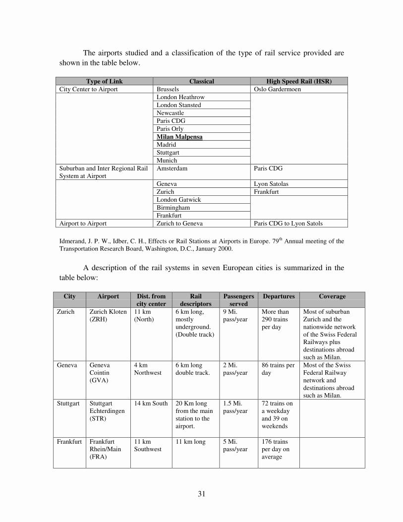
The airports studied and a classification of the type of rail service provided areshown in the table below.
Type of Link Classical High Speed Rail (HSR)City Center to Airport Brussels Oslo Gardermoen
London HeathrowLondon StanstedNewcastleParis CDGParis OrlyMilan MalpensaMadridStuttgartMunich
Suburban and Inter Regional RailSystem at Airport
Amsterdam Paris CDG
Geneva Lyon SatolasZurich FrankfurtLondon GatwickBirminghamFrankfurt
Airport to Airport Zurich to Geneva Paris CDG to Lyon Satols
Idmerand, J. P. W., Idber, C. H., Effects or Rail Stations at Airports in Europe. 79th Annual meeting of theTransportation Research Board, Washington, D.C., January 2000.
A description of the rail systems in seven European cities is summarized in thetable below:
City Airport Dist. fromcity center
Raildescriptors
Passengersserved
Departures Coverage
Zurich Zurich Kloten(ZRH)
11 km(North)
6 km long,mostlyunderground.(Double track)
9 Mi.pass/year
More than290 trainsper day
Most of suburbanZurich and thenationwide networkof the Swiss FederalRailways plusdestinations abroadsuch as Milan.
Geneva GenevaCointin(GVA)
4 kmNorthwest
6 km longdouble track.
2 Mi.pass/year
86 trains perday
Most of the SwissFederal Railwaynetwork anddestinations abroadsuch as Milan.
Stuttgart StuttgartEchterdingen(STR)
14 km South 20 Km longfrom the mainstation to theairport.
1.5 Mi.pass/year
72 trains ona weekdayand 39 onweekends
Frankfurt FrankfurtRhein/Main(FRA)
11 kmSouthwest
11 km long 5 Mi.pass/year
176 trainsper day onaverage
32
City Airport Dist. fromcity center
Raildescriptors
Passengersserved
Departures Coverage
Brussels BrusselsZaventem(BRU)
12 kmNortheast
18 km frommain station tothe airport
3 Mi.pass/year
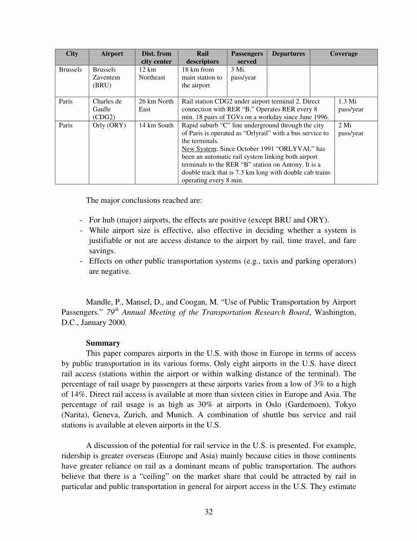
Paris Charles deGaulle(CDG2)
26 km NorthEast
Rail station CDG2 under airport terminal 2. Directconnection with RER “B.” Operates RER every 8min. 18 pairs of TGVs on a workday since June 1996.
1.3 Mipass/year
Paris Orly (ORY) 14 km South Rapid suburb “C” line underground through the cityof Paris is operated as “Orlyrail” with a bus service tothe terminals.New System: Since October 1991 “ORLYVAL” hasbeen an automatic rail system linking both airportterminals to the RER “B” station on Antony. It is adouble track that is 7.3 km long with double cab trainsoperating every 8 min.
2 Mipass/year
The major conclusions reached are:
- For hub (major) airports, the effects are positive (except BRU and ORY).- While airport size is effective, also effective in deciding whether a system is
justifiable or not are access distance to the airport by rail, time travel, and faresavings.
- Effects on other public transportation systems (e.g., taxis and parking operators)are negative.
Mandle, P., Mansel, D., and Coogan, M. “Use of Public Transportation by AirportPassengers.” 79th Annual Meeting of the Transportation Research Board, Washington,D.C., January 2000.
SummaryThis paper compares airports in the U.S. with those in Europe in terms of access
by public transportation in its various forms. Only eight airports in the U.S. have directrail access (stations within the airport or within walking distance of the terminal). Thepercentage of rail usage by passengers at these airports varies from a low of 3% to a highof 14%. Direct rail access is available at more than sixteen cities in Europe and Asia. Thepercentage of rail usage is as high as 30% at airports in Oslo (Gardemoen), Tokyo(Narita), Geneva, Zurich, and Munich. A combination of shuttle bus service and railstations is available at eleven airports in the U.S.
A discussion of the potential for rail service in the U.S. is presented. For example,ridership is greater overseas (Europe and Asia) mainly because cities in those continentshave greater reliance on rail as a dominant means of public transportation. The authorsbelieve that there is a “ceiling” on the market share that could be attracted by rail inparticular and public transportation in general for airport access in the U.S. They estimate
33
this “ceiling” at about 10 to 15%. The higher ceiling on public transportation usage inEurope and Asia (estimated at about 30%) can be attributed to the fact that these citieshave extensive network coverage, more limited highway access, higher regionaldensities, and greater use of rail as a feeder service.
The characteristics that need to be available to have a successful rail system are,in their order of importance:
1. Proportion of airline passengers with trip ends in downtown.2. Characteristics of the passenger market (e.g., whether traveling alone or not,
amount of luggage, familiarity with the regional transit system).3. Regional travel time.4. Ability to walk between station and destination.5. Extensive regional coverage.6. At-airport travel time: Passengers using rail would like to minimize the time
required to travel from the station to their gate.7. Frequency of service and associated waiting time.8. Availability of parking at non-airport stations.
Finally, the authors conclude that few U.S. cities, if any, possess these successcharacteristics.
Mansel, D., and Mandle, P. Review of Off-Airport Passenger Check-in Facilities(Satellite Terminals). 79th Annual Meeting of the Transportation Research Record,Washington, D.C., January 2000.
SummaryThe concept of off-airport check-in facilities is presented. Satellite terminals
would be linked to the airport via some mode of high occupancy transport. It is believedthat such a facility would relieve airport users from major sources of delay, namely,delays on access roads, insufficient parking, having to carry baggage on and off transportfacilities, delays at airline ticket counters, and crowded gate areas. Both domestic andinternational case studies of satellite terminals are presented, with Zurich considered toprovide the most elaborate such system. Key challenges to ensure a successful systeminclude:
- Security Requirements: It is required that all airports and airlines adapt andimplement the approved FAA Security Program (mainly addressing passengerand baggage screening).
- Close-out times: There is a minimum preflight time available to passengersarriving at the satellite terminal for transporting luggage after being checked in tothe airport; in addition, passengers must account for travel time between thestation and airport.

34
- Difficulty Providing Baggage Claim: For example, with such a system whowould be liable for lost or damaged baggage? In addition to customer serviceissues, such as if a passenger is unexpectedly met by a friend or relative,currently there is no way to stop checked baggage from going to the satelliteterminal.
- Travel Time Advantages: The mode of travel between the terminal and theairport must provide reliable and reduced travel times as compared to privateauto to be attractive (e.g., if bus can make use of HOV lanes or bus preemptionat traffic signals it would become highly competitive).
- Availability of Parking.- Airline Industry Cooperation and Support.
Schank and Wilson. “Airport Access Via Rail: What Works and What Doesn’t.”79th Annual Meeting of the Transportation Research Record, Washington, D.C., January2000.
SummaryThis paper tackles the issue of rail links as they relate to domestic airports.
Characteristics of airport rail links that affect rail modal share are discussed. Key factorsthat might affect the performance of an airport rail link are presented in the followingtable:
Fixed Factors Design Factors
Location of the airport relative to the city Speed and reliability relative to other access modes
Productions and attractions along link Location of airport train terminal
Local cultural factors Transit fare(s)
Airport characteristics Parking rates
Ease and availability of connections
State of local transit
Schank, Wilson. “Airport Access via Rail Transit: What Works and What Doesn’t.” 79th Annual meeting ofthe Transportation Research Board, Washington, D.C., January 2000.

35
Airport rail link performance for major airports in the U.S. is summarized in thefollowing table, in order of decreasing rail mode share.
Time to CBD Parking RatesAirport Fare
Rail Auto Diff
Rail peak
Headway
Km to
CBD Short Long
Terminal
in Airport
Speed
(km/hr)
Mode
Share
DCA $1.10 17 10 7 3 7 $4.00 $8.00 Yes 26 9.0%
MDW $1.50 29 19 10 7 18 $3.00 $10.00 Yes 37 8.1%
ATL $1.50 21 10 11 8 14 $1.00 $5.00 Yes 41 6.0%
BOS $0.85 14 8 6 4 5 $4.00 $12.00 No 21 5.7%
STL $3.00 39 30 9 7 16 $1.50 $5.00 Yes 25 5.0%
OAK $3.10 30 14 16 10 13 $2.00 $8.00 No 26 4.1%
OAK-to SF $4.75 40 29 11 10 30 $2.00 $8.00 No 46 4.1%
ORD $1.50 44 21 23 7 29 $3.00 $8.50 Yes 40 3.9%
CLE $1.50 34 20 14 12 16 $3.00 $11.00 Yes 28 3.0%
PHL $5.00 42 17 25 30 11 $5.00 $6.50 Yes 16 2.0%
JFK $1.50 65 25 40 10 26 $4.00 $6.00 No 24 1.7%
BWI-to DC $6.00 73 38 35 45 48 $4.00 $6.00 No 40 1.0%
MIA $3.25 75 12 63 60 11 $3.00 $10.00 No 9 1.0%
SJC $1.10 29 5 24 10 3 $1.50 $10.00 No 7 1.0%
BWI-to Balt $1.35 40 15 25 30 13 $4.00 $6.00 Yes 19 n/a
Schank, Wilson. “Airport Access via Rail Transit: What Works and What Doesn’t.” 79th Annual meeting ofthe Transportation Research Board, Washington, D.C., January 2000.
Schank and Wilson’s analysis found that only two factors exhibit a directcorrelation with mode shares: rail link travel time and rail/auto time difference. The tablebelow lists airports by increasing rail link travel time to the central city, illustrating thatthe mode share decreases with increasing rail travel time
Airport Time to Center Km to Center Speed (Km/hr) Mode Share
DCA 14 5 21 5.7%
MDW 17 7 26 9.0%
ATL 21 14 41 6.0%
BOS 29 18 37 8.1%
STL 29 3 7 1.0%
OAK 30 13 26 4.1%
OAK-to SF 34 16 28 3.0%
ORD 39 16 25 5.0%
CLE 40 30 46 4.1%
PHL 40 13 19 n/a
JFK 42 11 16 2.0%
BWI-to DC 44 29 40 3.9%

36
Airport Time to Center Km to Center Speed (Km/hr) Mode Share
MIA 65 26 24 1.7%
SJC 73 48 40 1.0%
BWI-to Balt 75 11 9 1.0%
Schank, Wilson. “Airport Access via Rail Transit: What Works and What Doesn’t.” 79th Annual meeting ofthe Transportation Research Board, Washington, D.C., January 2000.
A similar table was prepared for the access time differential between rail and autotravel times. The table also illustrates that modal share decreases as the differencebetween rail and auto travel times increases.
Airport Rail Auto Difference between Rail & Auto Mode Share
DCA 14 8 6 5.7%
MDW 17 10 7 9.0%
ATL 39 30 9 50%
BOS 29 19 10 8.1%
STL 21 10 11 6.0%
OAK 40 29 11 4.1%
OAK-to SF 34 20 14 3.0%
ORD 30 14 16 4.1%
CLE 44 21 23 3.9%
PHL 29 5 24 1.0%
JFK 40 15 25 n/a
BWI-to DC 42 17 25 2.0%
MIA 73 38 35 1.0%
SJC 65 25 40 1.7%
BWI-to Balt 75 12 63 1.0%
Schank, Wilson. “Airport Access via Rail Transit: What Works and What Doesn’t.” 79th Annual meeting ofthe Transportation Research Board, Washington, D.C., January 2000.
The following observations were reached on the basis of the authors’ analysis of the data:
a) As the rail/auto travel time difference increases the rail mode share is likely tosignificantly decrease and vice versa.
b) Airports operating off-airport rail stations are likely to attain lower rail modeshares.
c) The more elaborate the airport rail link is, the more likely it is to attract morepassengers. As a matter of fact most U.S. airport rail links do not serve themetropolitan areas efficiently and thus are incapable of attracting a large modalshare.

37
d) Airports that serve a large number of long-haul trips are most likely going tosuffer from low rail mode shares.
e) A high market of low-cost carriers at an airport is likely to increase rail modeshare.
f) Airports that have proximity to the downtown area and other major activitycenters are likely to capture higher rail mode shares.
g) A service frequency that is incompatible with passenger demand is likely to resultin an airport losing its rail mode share.
h) An airport rail link that is part of a modern well-designed rail system is likely toincrease the rail mode share.
i) Airport rail links that are dedicated to serving only the central business district arelikely to have low mode shares.
j) Airport workers are more likely than airport passengers to use airport rail links.

38
39
REFERENCES
1. Adams, G., and Jackson, R., “Improving Ground Access to LAX,” TrafficCongestion and Traffic Safety in the 21st Century, June 8–11, 1997, pp. 160–166.
2. Ashford, N., and Ndoh, N., “Level of Service Aspects of Provision of Access toAirports,” Airport Planning Issues, 1993.
3. Bergener, J., Javid, M., and Seneviratne, P., “Planning and Analysis of AirportAccess Using GIS: SLCIA Example,” International Air TransportationConference, June 5–7, 1996.
4. Blackhall, J., Brackenbury, S., and Ramsey, M., “London Luton Airport NewAccess Road: A Successful Construction Partnership,” Proceedings of theInstitution of Civil Engineers: Transport, Vol. 29, No. 4, November 1998, pp.207–217.
5. Boyd, M., “Airport Access: The Coming Crisis,” Commuter Air, May 1989.6. Bruggeman, J., “Study of Transit Alternatives in the Dulles Airport Access Road
Corridor,” Transportation Research Record 1283, 1990.7. Brush, D., “Logan 2000: A World Class Upgrade for the 21st Century,” ITE
Journal, June 1997.8. Coogan, M., “Airport Access: Case Study in Intermodalism,” ISTEA and
Intermodal Planning, 1993.9. Coogan, M., “Comparing Airport Ground Access: A Transatlantic Look at an
Intermodal Issue,” TR News, November 1995.10. Coogan, M., “European and U.S. Airports Push for Better Ground Access,” Mass
Transit, June 1996.11. Crampin, J., “Airport Access Strategies Required to Do More than Scratch the
Surface,” Local Transport Today, December 3, 1998.12. Cunningham, L., and Gerlach, J., “Ground Access Assessment of North American
Airport Locations,” Colorado University, Center for Urban TransportationStudies, September 1996.
13. Cunningham, L., and Gerlach, J., “Transportation Agencies’ Experiences withDecision Support Systems for Airport Ground Access Planning,” Transportation.Vol. 25, No. 1, February 1998, pp. 37–53.
14. Cunningham, L., Gerlach, J., Dunn, D., Hume, M., and Christensen, K., “AirportGround Access: The Marketing Perspective,” Transportation Research Forum,1995.
15. Ellis, G., “Airport Ground Access — The Missing Link,” National ConferencePublication-Institution of Engineers, Vol. 1, No. 93, September 13–15, 1993, pp.249–253.
16. Fabian, L., “Rationalizing Airport Ground Access,” Transportation Quarterly,Vol. 47, No. 4, October 1993, pp. 473–482.
17. Fan, H., “Ground Access to Singapore Changai Airport,” Journal of AdvancedTransportation, Vol. 24, No. 1, Spring 1990, pp. 9–30.

40
18. Flick, K., “Washington-Baltimore Regional Airport Ground Access Travel TimeStudy Update,” Metropolitan Washington Council of Government, 1995.
19. Foote, P., LaBelle, S., and Stuart, D., “Increasing Transit Access to Airports inChicago,” Transportation Research Record 1600, 1997.
20. Galis, P., “Rapid Growth Foreseen in Airport Research,” TR News, 1992.21. Gosling, G., “Airport Ground Access and Intermodal Interface,” Transportation
Research Record 1600, 1997.22. Gosling, G., “Analysis of Changes in Airport Ground Access Mode Use,”
Proceedings — International Air Transportation Conference, June 5–7, 1996.23. Hathaway, D., “Airport Access Model Data Requirements,” ITE Conference,
1995.24. Hathaway, D., “Effective Surveys for Airport Access Planning,” ITE Conference,
1994.25. Higgins, T., “California Airports: Ground Access Vehicle Trips, Emissions and
Emission Reduction Strategies,” 23rd Air Transport Conference, June 22–24,1994. pp. 102–106.
26. Hoel, L. A., and Shriner, H. W., “Evaluating Improvements in Landside Accessfor Airports,” Virginia Transportation Council, October 1998.
27. Idmerand, J. P. W., and Idber, C. H., “Effects of Rail Stations at Airports inEurope,” 79th Annual Meeting of the Transportation Research Record,Washington, D.C., January 2000.
28. “Kennedy International and LaGuardia Airport Access: An Evaluation of AirportAccess,” ULI-THE-URBAN-LAND-Institute, 1991.
29. Kivett, H., “Lessons for Rail Access to Airports,” International AirTransportation Conference. June 5–7, 1996. pp. 96–105.
30. Lacombe, A., “Ground Access to Airports: Prospects from Intermodalism,”Transportation Quarterly. Vol. 48. No. 4. pp. 381–392.
31. Lampe, A., “Effects of Road Access Pricing at the Los Angeles Airport. A CaseStudy,” ITE Journal. Vol. 63. No. 12. Dec. 1993. pp. 22–24.
32. Mandalapu, S., and Sproule, W., “Airport Ground Access: Rail TransitAlternatives,” Transportation Research Record 1503, 1995.
33. Mandle, P., Mansel, D., and Coogan, M., “Use of Public Transportation byAirport Passengers,” 79th Annual Meeting of the Transportation Research Board,Washington, D.C., January 2000.
34. Mansel, D., and Mandle, P., “Review of Off-Airport Passenger Check-inFacilities (Satellite Terminals),” 79th Annual Meeting of the TransportationResearch Record, Washington, D.C., January 2000.
35. Maring, G., Rodgers, J., Diaz, S., and Harllee, N., “U.S. Department ofTransportation Modal Administration Panel,” ISTEA and Intermodal Planning,1993.
36. Monteriro, A., and Hansen, M., “Improvements to Airport Ground Access andBehavior of Multiple Airport System: BART Extension to San Francisco
41
International Airport,” Transportation Research Record 1562, Nov. 1996. pp. 38–47.
37. Nakazawa, K., “Look Back on First Year’s Actual Result of Access Railway forNew Tokyo International Airport,” Japanese Railway Engineering. No. 125. Sep.1993. pp. 23–26.
38. Ndoh, N., “Managing Airport Access: A Level of Service Concept,” AirportForum, 1994.
39. Ndoh, N., and Ashford, N., “Evaluation of Airport Access Level of Service,”Transportation Research Record 1423, Oct. 1993. pp. 34–39.
40. Rhoades, K., Mehndiratta, S., and Hansen, M., “Airlines and Ground Access:Current Arrangements and Future Opportunities,” California University, Instituteof Transportation Studies, 1994.
41. Ruhl, T., and Trnavski, B., “Airport Trip Generation,” ITE Journal, May 1998.42. Saxena, K., and Carris, P., “JFK Airport Integrated Transportation System,” IVHS
America, 1994.43. Schank and Wilson, “Airport Access Via Rail: What Works and What Doesn’t,”
79th Annual Meeting of the Transportation Research Record, Washington, D.C.,January 2000.
44. Shapiro, P., “Planning for Intermodal Access at American Airports,”International Air Transportation Conference. June 5–7, 1996.
45. Shapiro, P. S., and Katzman, M., “Relationship between Airport Activity andGround Transportation Needs,” Transportation Research Record 1622, 1998.
46. Shapiro, P. S., Katzman, M., and Hughes, W., Intermodal Ground Access toAirports: A Planning Guide. FHWA, 1996.
47. Swanson, J., and Congdon, L., “Increasing the Use of Public Transport as anAirport Access Mode,” Airport Planning Issues, 1993.
48. Tambi, J., Changes in the Airport Access Mode of Air Travelers Resulting fromChanges in Airport Parking Policies. 1991.
49. Tambi, J., and Griebenow, B. “Automated Guideway Transit to Provide Access toNew York City Airports,” 4th International Conference on Automated PeopleMovers. March 18–20, 1993. pp. 460–469.
50. The Fair Airport Access Assurance Act of 1989. Hearing before theSubcommittee on Antitrust, Monopolies, and Business Rights. United StatesSenate, 1990.
51. Tokich, P., “Planning and Conceptual Design for Multimodal AccessTransportation Facility,” ITE Conference, 1992.
52. “U.S. Airport Access Problems Escalate,” Airports International, 1988.53. Wells, A., “Airport Planning and Management,” TAB Books, 1992.54. Wormser, L., and Schamess, G., “Just Get Me to the Plane on Time,” Planning,
1997.

42