Hanging Lake Management Plan Environmental Assessment
26
United States Department of Agriculture Forest Service Hanging Lake Management Plan Environmental Assessment Eagle-Holy Cross Ranger District White River National Forest, Garfield County, Colorado December 2017 For More Information Contact: Aaron Mayville Eagle-Holy Cross Ranger District White River National Forest 24727 US Hwy 24 PO Box 190 Minturn, CO 81645 970-827-5150 [email protected]
Transcript of Hanging Lake Management Plan Environmental Assessment

United States Department of Agriculture
Forest Service
Hanging Lake Management Plan Environmental Assessment
Eagle-Holy Cross Ranger District
White River National Forest, Garfield County, Colorado
December 2017
For More Information Contact:
Aaron Mayville
Eagle-Holy Cross Ranger District
White River National Forest
24727 US Hwy 24 PO Box 190
Minturn, CO 81645
970-827-5150

Hanging Lake Management Plan Environmental Assessment
2
In accordance with Federal civil rights law and U.S. Department of Agriculture (USDA) civil rights regulations and
policies, the USDA, its Agencies, offices, and employees and institutions participating in or administering USDA
programs are prohibited from discriminating based on race, color, national origin, religion, sex, gender identity
(including gender expression), sexual orientation, disability, age, marital status, family/parental status, income
derived from a public assistance program, political beliefs, or reprisal or retaliation for prior civil rights activity, in
any program or activity conducted or funded by USDA (not all bases apply to all programs). Remedies and
compliant filing deadlines vary by program or incident.
Persons with disabilities who require alternative means of communication for program information (e.g., Braille,
large print, audiotape, American Sign Language, etc.) should contact the responsible Agency or USDA’s TARGET
Center at (202) 720-2600 (voice and TTY) or contact USDA through the Federal Relay Service at (800) 877-8339.
Additionally, program information may be made available in languages other than English.
To file a program discrimination complaint, complete the USDA Program Discrimination Complaint Form, AD-
3027, found online at http;//www.ascr.usda.gov/complaint_filing_cust.html and at any USDA office or write a letter
addressed to the USDA and provide in the letter all of the information requested in the form. To request a copy of
the complaint form, call (866) 632-9992. Submit your completed form or letter to USDA by (1) mail: U.S.
Department of Agriculture, Office of the Assistant Secretary for Civil Rights, 1400 Independence Avenue, SW,
Washington, D.C. 20250-9410; (2) fax: (202) 690-7442; or (3) email: [email protected].
USDA is an equal opportunity provider, employer, and lender.

Hanging Lake Management Plan Environmental Assessment
3
CONTENTS
Chapter 1: Introduction ................................................................................................................................. 4
Background ............................................................................................................................................... 4
Chapter 2: Description of the Alternatives ................................................................................................. 11
Chapter 3: Environmental Effects of the Alternatives ................................................................................ 13
Recreation ............................................................................................................................................... 13
Socio-Economic...................................................................................................................................... 17
Wild and Scenic Rivers .......................................................................................................................... 18
Heritage .................................................................................................................................................. 20
Lands and Realty .................................................................................................................................... 21
Wildlife ................................................................................................................................................... 22
Aquatics .................................................................................................................................................. 23
Soils and Geology ................................................................................................................................... 24
Botany ..................................................................................................................................................... 25
Chapter 4: Agencies and Persons Consulted ............................................................................................... 26
Appendix 1-4: Volpe Transportation, Visitor Survey and Capacity Studies, Forest Plan Management
Appendix 5-6: Public Comment Analysis and Hanging Lake Special Order
Hanging Lake Management Plan Environmental Assessment
4
CHAPTER 1: INTRODUCTION
Hanging Lake (HL) is located off of Interstate 70, approximately 10 miles east of Glenwood Springs, in
Garfield County, Colorado. Hanging Lake is situated between the resort communities of Vail and
Glenwood Springs and is in close proximity to Aspen. Hanging Lake has become one of Colorado’s high
profile iconic tourism destinations and is marketed as a must-see and bucket list hike. Hanging Lake is
cited as being a unique example of a lake formed by travertine deposition, and supports one of the best
examples of a hanging garden plant community in the in the southern Rocky Mountains. The site is also
one of the larger and least altered travertine systems, where natural geologic and hydrologic processes
continue to operate as they have done throughout the history of the lake. With over 150,000 visitors
annually, the area is experiencing safety issues, and natural resource and facility degradation – all of
which are negatively impacting the visitor’s experience.
This Environmental Assessment (EA) was prepared to determine whether effects of the proposed
management plan and related activities may be significant enough to prepare an environmental impact
statement. By preparing this EA, we are fulfilling Forest Service policy and direction to comply with the
National Environmental Policy Act (NEPA) and other relevant federal and state laws and regulations.
This EA discloses the direct, indirect, and cumulative environmental effects that would result from the
proposed action and no-action (baseline) alternatives. Additional documentation, including more detailed
analyses of project area resources, may be found in the project planning record located at the Eagle-Holy
Cross District Office in Minturn, Colorado or online at https://www.fs.usda.gov/project/?project=50479.
Background
The Hanging Lake project area consists of 128 acres that includes: the trail, the lake itself, upper Spouting
Rock waterfall, Dead Horse Creek, and Colorado Department of Transportation’s (CDOT) infrastructure
(parking lot, I-70 on and off ramps, Colorado River recreation path, refuse containers, picnic sites,
parking area restroom, and a trailhead vault toilet). The HL project area has intermixed land ownership
between Xcel Energy, CDOT, and the U.S. Forest Service (USFS).
The mid-1980’s brought about the reconstruction of Interstate 70 through Glenwood Canyon along the
Colorado River. This construction project consolidated over thirty access sites down to four major points
of access along the highway with the Hanging Lake rest area being one of them.
At that time, CDOT and the USFS designed the parking area with approximately 110 spaces based on
projected use and future growth to the site (including the use of the trail). Several decades passed and use
slowly grew at the Hanging Lake site. In the late 2000’s, the Forest Service was successful in receiving a
Colorado GOCO grant to replace Hanging Lake’s aging boardwalk and railing system. The reconstruction
consisted of a newly designed articulating railing system along the steepest sections of trail, a composite
boardwalk at the lake with benches, interpretive signs, and a safety rockfall screen above the lake. The
trail was closed for most of 2009 and key times in 2010 to complete the work. In 2011, the National Park
Service designated Hanging Lake as a National Natural Landmark (NPS NNL).
In recent years, social media has further popularized the site and use has continued to increase. With the
growth in visitation, the rest area site became congested with vehicles during peak summer weekends, and
parking congestion became a reality seven days a week throughout the summers. This congestion has led
to parked vehicles on the sidewalks, recreation path, and grass areas. Traffic issues arose along Interstate
70 as visitors parked vehicles along the highway and the on- and off-ramps when the parking lot was
completely full.
Hanging Lake Management Plan Environmental Assessment
5
The White River National Forest and the Eagle-Holy Cross Ranger District convened a working group of
stakeholders in 2013 that included: CDOT, the City of Glenwood Springs Tourism Board, Garfield
County officials, Xcel Energy, U.S. Department of Transportation, and Colorado State Patrol. The goal of
this stakeholder group was to brainstorm short-, medium-, and long-term management actions for HL.
The White River National Forest hired the U. S. Department of Transportations’ John A. Volpe Center
(Volpe) in 2013 to assist with site capacity, transportation, and operation strategies.
The group of stakeholders also funded and managed the site during the interim high-use visitation seasons
from 2013 to 2017. The interim management solutions included using temporary USFS employees to
manage parking onsite. In addition, CDOT re-designed a traffic turn-around, designated parking, added a
temporary traffic gate, and updated interstate signage. These short-term management actions were
established as an intervention while preparing a long-term management plan.
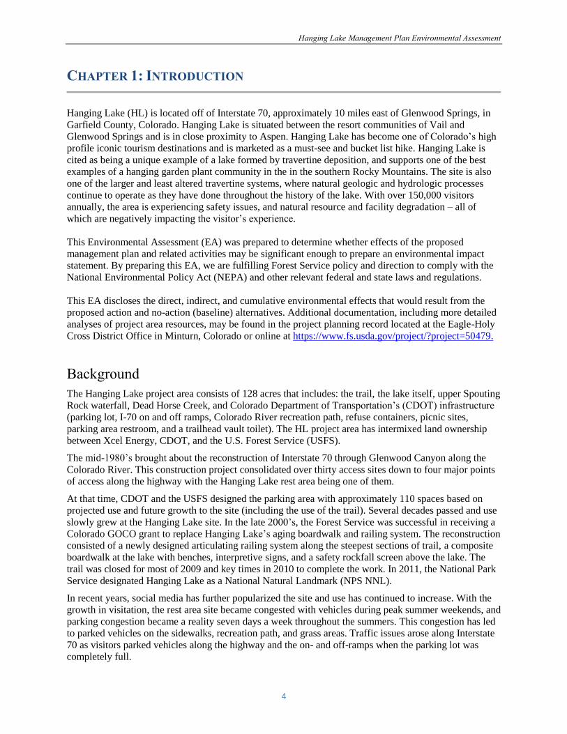
Figure 1. Hanging Lake Vicinity Map

Hanging Lake Management Plan Environmental Assessment
6
Purpose and Need
The purpose of the action:
To protect and preserve the unique and fragile natural resources at the Hanging Lake area, and
sustain opportunities for high-quality recreation experiences and the related socio-economic
contributions to adjacent communities.
The need for action is driven by:
The growing volume of use to the Hanging Lake Area – annual visitation has grown to over
150,000 visitors with an average of 1,000 hikers per day, between May and October.
The unmanaged visitation is causing degradation to the infrastructure (parking lot, trail tread,
bridges, boardwalks and railing systems), which has resulted in safety issues.
The unmanaged visitation has caused resource damage including compacted soils, loss of plant
habitat, degradation of water quality, and impacts to historic features.
The volume of traffic on and off Interstate 70 has resulted in safety issues.
The visitor experience at the Hanging Lake Area has been negatively impacted as a result of the
unmanaged use.
Proposed Action
The proposed action is to approve and implement the Proposed Hanging Lake Area Management Plan,
which has within it several key decisions that will support feasible and long-term management actions.
More specifically, the plan would (a) allocate and manage the area to a defined daily capacity of 615
visitors per day, year round; (b) manage this capacity through a fee-based reservation or permit system;
(c) utilize a third party mandatory transportation provider in order to allocate and manage to the areas
daily capacity during the “Peak” season (currently proposed from May 1st through October 31st); and (d)
implement an adaptive management strategy to ensure that the intent of the plan continues to be realized
in light of potential future changes.
The overall goal of the HL Plan is to create and implement a management system that is implementable,
sustainable, and maintains the areas defined desired conditions by meeting the following objectives:
I. Protect natural resources
II. Manage congestion
III. Enhance public safety
IV. Improve visitor experience
V. Support local tourism
While the proposed Hanging Lake Management plan will set management direction on USFS lands,
working with stakeholders and partners will be integral to implementing the goals and objectives and to
long-term management success.
Hanging Lake Management Plan Environmental Assessment
7
Forest Plan Direction
This proposal would move the Hanging Lake project area toward desired conditions described in the
goals and objectives outlined in the 2002 White River National Forest Land and Resource Management
Plan (LRMP). This EA is tiered to the LRMP Final Environmental Impact Statement and Record of
Decision. Current management direction and LRMP goals, objectives, and strategies applicable to this
analysis can be found in the Proposed Hanging Lake Management Plan.
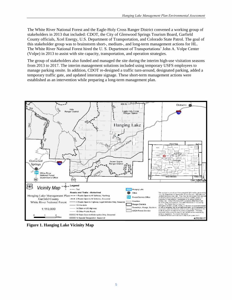
Figure 2. Land Ownership and Project Area Map

Hanging Lake Management Plan Environmental Assessment
8
The project area is located within the Forest Plan Management Area prescription: “4.4 Recreation Rivers-
Designated and Eligible”. This project is in conformance with 4.4 Management Area desired condition,
goals, and objectives. For a complete description see Appendix 4.
The project will be designed to conform to the Forest LRMP and all other laws, regulations, and policies.
Forest LRMP standards and guidelines will be applied as appropriate to meet Forest Plan goals and
desired conditions for all resources. The 2002 White River LRMP can be found:
https://www.fs.usda.gov/detail/whiteriver/landmanagement/?cid=fsbdev3_001228
Decision and Implementation
The deciding official will decide whether to: 1) Implement the Proposed Hanging Lake Management
Plan, 2) Modify the Proposed Hanging Lake Management Plan, or 3) Not implement the Proposed
Hanging Lake Management Plan at this time. An affirmative decision on the Proposed Hanging Lake
Management Plan authorizes implementation of the management tools contained therein but does not
dictate implementation methods as there is a host of implementation tools available to the USFS that
would meet the specific desired conditions, indicators and thresholds described in the plan.
The deciding official will consider implementation methods based on: legal authorities, feasibility,
technical and operational logistics, operation and capital needs, long-term sustainability, and USFS
physical and financial capabilities.
A suite of phased management actions could be implemented, including but not limited to: increased
education, interpretation and outreach, signing, increased ranger presence, engineering controls (e.g.
barriers, trail hardening, post, and cables, etc.), adjusting transportation times, group size limits, and
change of daily capacity limits up or down.
The following is a brief description of some, but not all, of the methods the Forest Service could utilize to
implement the HL plan. These options could be phased in, used alone, or in combination:
1. Utilize Recreation.gov to issue reservations through the National Recreation Reservation
Service. There is an administrative fee for this reservation system. The USFS intent is to
provide fair and equal opportunity to access a permit reservation system.
2. Manage capacity through the Outfitter and Guide (O&G) via its permitting process using the
O&G’s reservation system.
3. Manage capacity through a third-party transportation provider’s reservation system.
4. Manage capacity through a reservation system and allow for parking on site.
5. Provide enhanced management and specialized visitor services, reclamation, restoration and
other on-site needs via instituting a Special Recreation Permit in accordance with the Federal
Lands Recreation Enhancement Act (FLREA). A special recreation permit would generate
revenue that would allow for sustainable on-site management actions. This would require
following national and regional processes and would include a separate public participation
process. This tool may be phased-in and integrated into the above four options.
Specific implementation details such as cost, how to obtain a permit, etc. will be determined by the option
and/or service provider selected above; however, all the implementation methods above would meet the
Hanging Lake Management Plan Environmental Assessment
9
goals, objectives, and desired condition of the plan. A variety of methods could be needed in case one
approach proves to be infeasible, does not meet goals of the plan, or if conditions change over time.
Numerous comments were received regarding implementation details, so the following supplemental
information is provided in order to address some of those questions.
Transportation Service
The decision from this EA would issue a special use permit for a set number of service days, to provide
for commercial transportation services during the peak season within the 615 capacity, as well as other
associated customer service opportunities as they arise. These commercial services may occur outside the
mandatory season. The decision will not address the business rule details of the transportation service, as
that is outside the scope of this environmental analysis. The commercial transportation system would be
the only authorized vehicle access to the Hanging Lake area for the general public during the peak season
(May through October).
Reservation System
The decision from this EA would make the determination to institute a reservation system which would
execute and allocate visitation to the daily capacity of 615 on the trail. Any reservation system utilized
would be required to provide for equal and fair access for visitors to obtain a permit. The reservation
system would also be used to stagger the timing of visitors so as to reduce crowding on the trail and
enhance the visitor experience. The reservation system business rules and details will not be provided in
this analysis as those details will be dependent on the service provider.
Fees The Hanging Lake Management plan would result in a fee for a variety of identified visitor services
needed to implement the plan. While there are numerous implementation tools that can be utilized to meet
the plans overall goals, objectives, and desired conditions, all result in some type of fee to cover
operational costs related to reservations, transportation service, enhanced visitor services, on-site
maintenance, and Forest Service improvements. A reservation system is needed to allocate the daily
visitor capacity year round in order to address crowding, safety and resource damage issues, in addition to
providing the customer with a single point of contact for reservations and fee collection. During the off-
peak season, visitors will be able to drive to the Hanging Lake parking area, but will still be required to
obtain a permit through a reservation system in order to ensure the site’s daily capacity is not exceeded.
The reservation and transportation fees will not cover enhanced visitor services and restoration,
maintenance, and infrastructure improvements needed on-site. It is likely that an additional fee would
be pursued under the FLREA authority and phased-in over subsequent years. A fee proposal under
FLREA would have its own public scoping period and require a business plan identifying specific
operational and management costs needed for the Hanging Lake Area. An example of on-site needs
identified in the planning process includes, but is not limited to: ranger presence, interpretation and
education, as well as addressing trail improvements, deferred maintenance on infrastructure (bridge
replacement/repairs, railing/boardwalk repairs, and signage), restoration and reclamation efforts,
and monitoring.
Public Involvement
In 2012, The White River National Forest convened a stakeholder group to examine management
planning for Hanging Lake. The goal of this stakeholder group was to develop management actions for
short, medium and long-term for the Hanging Lake project area. Also in 2012, the White River National
Forest hired the Department of Transportation’s, John A. Volpe Center to assist with capacity,
transportation and operation studies. The stakeholder group helped guide the Forest Service to fund and
manage the site during the interim period from 2012 to 2017 high-use seasons.
Hanging Lake Management Plan Environmental Assessment
10
Since the stakeholder group was first formed, monthly discussions have taken place. The Forest Service
has outreached with the public in several public meetings, numerous presentations, radio shows, and
newspaper articles. An initial 30-day scoping period invited the public, organizations, and agencies to
comment on the Draft Hanging Lake Management Plan on August 22, 2017, and a legal notice was
published in the newspaper of record, The Vail Daily, on the same day. The Forest Service received
approximately 150 comments during this initial scoping period.
Issues brought forward by the public from the initial scoping period are addressed in the Hanging Lake
Management Plan and/or in this EA. Some of those issues include but are not limited to: transportation
service, Glenwood Canyon River and bike trail access, capacity, ease of reservation system,
trail/infrastructure improvements, ranger presence, education, fees, restoration, and local user
displacement. For detailed information see the Comment Analysis in Appendix 5.
Hanging Lake Management Plan Environmental Assessment
11
CHAPTER 2: DESCRIPTION OF THE ALTERNATIVES
Proposed Action
The proposed action is to approve and implement the Proposed Hanging Lake Area Management Plan,
which has within it several key decisions that will support feasible and long-term management actions.
More specifically, the plan would (a) allocate and manage the area to a defined daily capacity of 615
visitors per day, year round; (b) manage this capacity through a fee-based reservation or permit system;
(c) utilize a third party transportation provider in order to allocate and manage to the areas daily capacity
during the “Peak” season (currently proposed from May 1st through October 31st); and (d) implement an
adaptive management strategy to ensure that the intent of the plan continues to be realized in light of
potential future changes.
The overall goal of the HL Plan is to create and implement a management system that is implementable,
sustainable, and maintains the areas defined desired conditions by meeting the following objectives:
I. Protect natural resources
II. Manage congestion
III. Enhance public safety
IV. Improve visitor experience
V. Support local tourism
No-Action Alternative
The no-action alternative would continue to manage the HL area under the current management scenario;
No set daily capacity limits.
Year-round visitation and personal vehicle access.
Forest Service and partner organizations staff the parking lot intermittently based on available
funding during the peak season (currently Friday-Monday).
Forest Service staff would continue to focus on managing safety issues, parking congestion,
stage vehicles and/or turn away all visitors when staging and parking is full.
Forest Service presence along the trail, at the lake, and at Spouting Rock would continue based
on available funding, but would likely not be at a level consistent with USFS standards.
Infrastructure such as the water diversion features, bridges, railing system, boardwalk and other
barrier devices may not see deferred maintenance needs addressed.
Issues or Alternatives Considered But Not Carried Forward
Issues considered but not carried forward at this time included additional planning for a comprehensive
Glenwood Canyon management plan. The USFS, CDOT and other affected and interested parties
recognize that a comprehensive plan is needed to address greater visitor displacement, access, site
capacity, visitor conflict, crowding, and infrastructure needs in the canyon. However, the rapid increase in
visitation and subsequent management issues at Hanging Lake, precipitated the more urgent need for a
dedicated Hanging Lake plan. Comprehensive planning for Glenwood Canyon will be considered to
address the overall Canyon issues as a separate analysis in the future.
Another alternative or options considered but not fully analyzed was Option #4, as described in the
Volpe’s “Hanging Lake Transportation and Operations Study” (See Study Appendix 1). Option #4. “REA
Special Permit Fee without Shuttle” was not brought forward for full analysis as the operations study

Hanging Lake Management Plan Environmental Assessment
12
provided enough information to conclude that it did not meet the goals, objectives and other
considerations as required, and therefore was not carried forward. While Option #4 is technically feasible,
manageability and operational needs would require far more physical and financial capacity from the
USFS at a time when budgets and staffing are uncertain.

Hanging Lake Management Plan Environmental Assessment
13
CHAPTER 3: ENVIRONMENTAL EFFECTS OF THE ALTERNATIVES
This section summarizes the social, physical, and biological environments of the project area and the
estimated effects associated with the implementation of the Hanging Lake Management Plan (proposed
action). The existing environmental condition serves as the baseline condition for each resource. The
alternatives were analyzed to provide a comparison of the effects to the baseline condition.
These analyses draw on the best available science as well as guiding laws and policies (e.g., FLRMP and
the Endangered Species Act). Resources not included in this EA were those resources that the proposed
action does not have the potential to impact that resource.
Complete specialist reports, Biological Assessments, Biological Evaluations, and references cited have
been included in the official project record.
Recreation
Affected Environment
The HL Area is iconic to Colorado and to Garfield County, where it resides. The local tourism destination
communities of Glenwood Springs, Basalt, and Aspen rely on this natural feature as a tourism draw.
Maintaining the socio-economic contributions generated by Hanging Lake visitors to our local
communities is apparent and important management goals for the Forest.
Hiking use has grown from approximately 78,000 hikers in 2012 to approximately 150,000 hikers in
2016. This growth has resulted in resource damage on and near the trail including widening and
vegetation trampling. The infrastructure of bridges, boardwalks and railing systems are failing due to the
high use and continued increasing in visitors. Congestion in the parking area, along the trail, at the lake
and Spouting Rock creates safety issues, trail impacts, infrastructure damage, and impacts visitor’s
experiences.
Figure 3. Hanging Lake Trailhead Monthly Traffic Averages
Hanging Lake Management Plan Environmental Assessment
14
Since 1972, Hanging Lake Trail #1850 has been managed and maintained by the Eagle-Holy Cross
Ranger District’s trails program. The trail is open to hiking during both the summer and winter seasons.
The Hanging Lake Trail is 1.2 miles long with .2 of the trail traveling on the CDOT paved recreation path
along the Colorado River.
Management of the HL Area has consisted of two to six USFS employees over the last five years during
the peak summer months. This crew has been funded from federal appropriated sources as well as key
partners, and outside grant funding. The funding levels, no matter the source, do not support the staffing
required to have a USFS presence 7 days a week. The current management scenario has allowed for up to
five staff to be on site four days a week with the majority of the focus being on managing the congestion
in the parking area. Minimal attention has been devoted to natural resource protection, enforcement, and
infrastructure maintenance or providing for basic and/or enhanced visitor services. The remaining three
days of the week are unstaffed and unmanaged with the exception of CDOT crews servicing their
facilities. This existing management regime affects all aspects of the HL Area including the infrastructure,
natural environment, and visitor’s experiences when some visitors violate posted rules and regulations.
The Eagle-Holy Cross Ranger District trail crew conducts maintenance on roughly 600 miles trail. The
USFS hosts several volunteer/intern work projects annually to address the heavy trail maintenance
required on this highly developed trail.
The Hanging Lake trail has many constructed features which includes: a kiosk, seven bridges over
Deadhorse Creek, over six hundred constructed rock steps, seven wooden resting benches, three stone
resting benches, approximately 305 feet of articulating railing system, approximately 1,486 square feet of
boardwalk at Hanging Lake, 447 feet of railing along the boardwalk, safety “rock slide” steel netting,
signage, and approximately 333 feet of post and chain barrier throughout the trail to protect sensitive
ecosystem habitats. A wooden three sided shelter constructed by the Civilian Conservation Corps is
located along the trail. Current management actions include an existing Forest Supervisor Special Order
(Appendix 5) for the HL Area.
The unmanaged volume of visitation in the HL Area has increased trail and other infrastructure
maintenance needs. The trail is widening due to the volume of hikers stepping off to pass or just rest. The
trail has grown from approximately 24 inches to over 8 feet in places. This widening creates a host of
resource issues (compacted soils, loss of vegetation, erosion along the trail, and increased sedimentation
into Deadhorse Creek). Bridge components are in need of replacement due to use levels. The railing
system constructed in 2010 along the steep steps below the Lake was designed to last 20 years is showing
deterioration and failures.
Hanging Lake’s average visitor experience during the peak season, is often described as congested. Upon
arrival they may wait an hour for a parking space in a staging line or be turned away after they have
traveled on average three hours for this iconic hike. Visitors often are agitated due to parking and access
issues. The agitated mindset has leads to confrontational situations between the visitors and towards the
USFS staff. Once on the trail, there are on average 300 people hiking at any one time on a normal peak
season day (See Capacity Study, Appendix 3).
The Lake and Spouting Rock are the attraction points. Users congregate at these two locations to take
photos and rest leading to crowding and congestion. With the increase in use, there has been an increase
in vandalism and resource damage along the trail’s infrastructure and natural features. Graffiti has been an
issue on the historic shelter with modern day carvings and paint. With an increase in visitation there has
been an increase in visitors violating the posted regulations. On any given day, people enter the lake, walk
on the log, hike off the trail, litter and bring their dogs.
Hanging Lake Management Plan Environmental Assessment
15
The natural environment has shown degradation due to the increase in use, insufficient USFS presence
and disregard for regulations. The surrounding riparian area along Deadhorse Creek has become
compacted from users off trail to let other pass or visit the creek bank. The compaction has caused the
loss of vegetation in these areas which eventually causes increased erosion, loss of soil, and trail damage.
Visitors frequently hike above the trail into loose rock creating impact to delicate plant ecosystems and
creating rock fall onto the trail and onto visitors. With no restroom facilities along the trail, unprepared
visitors leave human waste along the trail which causes health and safety issues along the trail and
Deadhorse Creek.
No-Action Alternative
Under the no-action alternative, the USFS and CDOT would continue to endeavor to manage the site
under the existing condition allowing the public to drive to the site year round. Congestion and safety
issues would continue in the parking area, onto I-70, and along the trail. These safety and congestion
issues would continue to have both direct and indirect negative impacts to related management actions
conducted by CDOT and Colorado State Patrol as well as other local agencies dealing with these issues.
Illegal parking would continue at the HL Area as well as throughout Glenwood Canyon rest areas.
Assumptions are that visitation will continue to grow and visitors would continue to park in unsafe
locations along on/off ramps and the shoulders of Interstate 70. This would continue to result in hazardous
conditions along the I-70 as well as restricting emergency personnel and vehicles access to the area.
In the No-action alternative with no visitor capacity limitation and limited management capabilities,
emergency calls to the already taxed Garfield County Search and Rescue would likely increase.
Unmanaged parking would result in continued and increased negative impacts to CDOT’s infrastructure
such as broken irrigation lines, damaged green space, parking lot and restroom maintenance, damaged
signs, and increased maintenance staff needs.
The no-action alternative with no visitor daily capacity limitation. The USFS would continue to seek and
secure uncertain external funding every year for the operation of the site. Administration of the site during
the summer months would continue to focus on parking management to address the congestion and safety
issues related to the vehicle use rather than a presence on the trail, resource protection, enforcement,
infrastructure maintenance and providing for enhanced visitor experiences.
Visitation monitoring shows increasing visitation trends that would have direct impacts to the trail
infrastructure and social conditions. Alternatively, as use increases, visitors may be displaced as
overcrowding, conflict, and deteriorating biophysical conditions push visitors to discover trails elsewhere.
Effects to the trail include; trail widening, erosion and trenching within the trail tread. The infrastructure
of the bridges, railing systems, benches, boardwalk, and barriers would require heavier annual
maintenance than normal and deferred maintenance (over 50% replacement) sooner than the planned
lifespan for each feature. Degraded infrastructure is a direct tie to user safety along the trail. Safety
features provide for water crossings and navigating steep hillsides. Other features provide for natural
resource protection such as drainages, boardwalks, signs, and barriers. Increased visitation will have a
direct effect on these features causing their full replacement earlier than planned for.
The no-action alternative would also likely reduce or limit visitor’s opportunities to obtain a high-quality
recreation experience while visiting the Hanging Lake Area. With no daily limitations, visitor’s
experiences would likely be characterized and dominated as congested and crowded. Visitors would still
be able to drive their personal vehicles to the site year-round. The congestion would continue in the HL
parking area as well as the other CDOT sites (Grizzly, No Name, and Bair). Without enhanced

Hanging Lake Management Plan Environmental Assessment
16
management, illegal parking would likely continue in the lot, on/off ramps, and along Interstate 70. Illegal
behavior would likely continue to expand throughout the area in respect to following basic stewardship
ethics, and current rules and regulations. Without increased USFS presence along the trail and at the Lake,
resource damage and negative behaviors are expected to continue.
Proposed Action
Visitors to Hanging Lake would be instructed that there was a daily capacity limit, reservation system and
a mandatory transportation system during the peak months. The daily capacity, transportation system, and
associated reservation systems would be administered to provide for fair and equal access to obtain a
permit.
Users would gain valuable information prior to their trip via the transportation provider and/or the
reservation ticket system to be more prepared for the hike, weather, elevation gain, and overall
expectations of this hike.
The proposed action is expected to reduce overflow parking at other Glenwood Canyon rest areas and
along Interstate 70. If parking issues are alleviated, visitor experience and safety will be improved and
people may experience less frustration and social unrest in the parking lot due to lack of parking. The
proposed action would initiate a daily capacity limit.
Administration of the site would change the USFS management focus from the parking area to increased
presence on the trail, resource protection, enforcement, infrastructure maintenance and providing visitor
information and interpretation. The proposed action will provide visitors enhanced opportunities to obtain
a high-quality recreation experience.
The trail and its related infrastructure would see reduced visitation year round. This reduced use would
result in direct beneficial effects on the trail infrastructure of the tread condition/width, bridges, erosion
control features, railing system, benches, signs, boardwalk, and barriers. The effects to the trail's
infrastructure include less trail widening, less erosion and trenching within the trail tread. As a result of
decreased use, the trails infrastructure; bridges, railing systems, benches, boardwalk, and barriers would
need less annual maintenance. The deferred maintenance (over 50% replacement) would remain on its
normal schedule for the planned lifespan for each feature.
The social effect in actively managing the HL Area would likely result in increased compliance of
regulations and unwanted behaviors should be reduced since all users will have information via the
permit/reservation system which will also result in a decrease in resource degradation. A short term effect
of the proposed action could displace visitors to seek other hikes in Glenwood Canyon. This is expected
to be reduced as visitors learn of alternative hikes outside the canyon, learn the reservation system, and
prepare in advance.
In summary, the proposed action would result in a decrease in resource degradation to physical, social and
infrastructure resources. In addition, with the proposed plans, adaptive management strategy, management
actions are available to address issues in a more timely manner. The visitor's experience would be
enhanced under the proposed action alternative. The USFS would be able to focus on enhancing the
hiker's experience through increased interpretation, education, improved infrastructure, by having a
presence on the trail, rather than managing the parking lot.

Hanging Lake Management Plan Environmental Assessment
17
Cumulative Effects
By definition, cumulative effects are the combined incremental impacts of past, present, and reasonably
foreseeable actions. Therefore, the no-action alternative would have no cumulative effect as it is not an
action. However, under the no-action alternative social, physical and environmental degradation trends
would continue.
Under the proposed action, there may be an impact to recreation patterns and use in the analysis area as
instituting a permit system may affect the spontaneity and freedom associated with no capacity limits. It is
reasonable to assume that a Glenwood Canyon comprehensive management plan will be analyzed in the
future; however, due to the limited number of past, present, and reasonably foreseeable actions
implementing a management plan would not significantly affect the analysis area.
Socio-Economic
While the project area is located within Garfield County, a two-county study area is used in the
socioeconomic analysis (Garfield and Eagle). As part of the U.S. DOT Volpe Center’s visitor survey (see
Appendix 2), respondents were asked to estimate their trip expenditures within 50 miles of Hanging Lake
– which includes Eagle County and Garfield County. This analysis utilizes the same two-county study
area in the Affected Environment section in order to describe the existing socioeconomic conditions of the
analysis area.
Affected Environment
The existing economic and social conditions of the study area are necessary to set the context for
comparison of alternatives and consideration of the decision described in this section. Summaries of
existing demographic, social and economic conditions are examined for counties within the project area
(Eagle County and Garfield County in CO). Unless otherwise noted, sources consist of 2016 data from
the U.S. Department of Commerce, Census Bureau, American Community Survey, Department of Labor
and other official sources retrieved using the EPS-HDT (2016) software system maintained by Headwater
Economics®. Major trends and benchmark comparisons (State of Colorado) and detail data with
complete, county-by-county statistics are found in the project record.
No-Action Alternative
The no-action alternative would continue to manage the HL area under the current management system,
without a daily capacity limit. Due to parking issues, people who cannot find a parking spot will continue
to leave agitated and frustrated or create social unrest in the lot, confront other visitors and/or staffs,
compromising the safety of other visitors and employees. On top of parking issues, crowding and
congestion on the trail will continue to create rushed, stressed, and frustrated visitor experiences.
If unmanaged use along the trail, at the lake, and at Spouting Rock continue to intensify resource
degradations, to the point where it becomes necessary to implement future restrictions – either seasonal or
extended – then the public will not have the full opportunity to experience this National Natural
Landmark. Economic contributions from visitor spending may be affected. If the site is left unmanaged or
additional restrictions are implemented visitors (first time as well as returning) may choose not to make a
trip out to Garfield or Eagle County for other activities, then potential expenditures are lost in the local
economy. On the other hand, if the site is further restricted by special orders and potential visitors still

Hanging Lake Management Plan Environmental Assessment
18
choose to a make a trip out to Garfield or Eagle County for other recreation activities, then visitor
expenditures are retained in the area.
Proposed Action
The Proposed Action of allocating and managing the area to a defined daily capacity of 615 users per day
year round is aimed to protect resources, manage congestion, improve safety and visitor experience and
thereby continue to support local tourism.
Quality of visitor experience aside, economic contributions from recreation spending may be affected by
the daily capacity limit. Since visitation during the summer months currently averages from 714 to 1,013
hikers per day, the proposed daily limit of 615 users per day (year-round). This reduction may translate to
a decline in recreation spending in the local area. Potentially, some hopeful visitors may not be
able/willing, to secure a permit or utilize the transportation system at a day and time of their choosing
(from a variety of reasons such as work, school, and other time conflicts). When that occurs, if those
displaced HL visitors choose not to make a trip out to Garfield or Eagle County for other activities, then
potential recreation expenditures are lost. On the other hand, if those displaced HL visitors still decide to a
make a trip out to Garfield or Eagle County for other recreation activities at a different day and time, then
tourism expenditures may be retained in the area. While both scenarios are plausible, survey results
(Volpe Center) showed that more than 65% of all visitors traveled over three hours from the Front Range
and the hike was the focus of the day’s activity; moreover, 70% of visitors were there for the first time
and have no other activities planned.
Scoping comments raised concern regarding potential fees associated with a mandatory transportation
system. Specifically, comments were whether the cost of riding the transportation system would preclude
some members of the public from enjoying this recreation area. While the establishment of transportation
fee rates will be determined in subsequent efforts and not part of this decision, the Volpe Center visitor
survey (Appendix 2) had gathered visitor opinions on this topic. A majority of survey respondents
indicated that a willingness to pay $5 to $10 per person for transportation. This represents a minor portion
of the total cost which existing visitors incur during a trip out to the HL recreation area (see ‘average
hiker expenditures by spending category’, Appendix 2).
Wild and Scenic Rivers
Affected Environment
The Hanging Lake Area is within the Colorado River corridor within Glenwood Canyon where two
segments of the river were found to be eligible under 5(d) (1) study criteria in the Wild and Scenic Rivers
Act (WSR) as part of the 2002 FLRMP planning process.
The FLRMP prescribed Management Area “4.4 Recreation Rivers- Designated and Eligible” (See
Appendix 4) to the Hanging Lake area. In 2015, an interagency (BLM, USFS) WSR Suitability Study was
completed and the Forest’s two segments on the Colorado River corridor maintained its “eligibility” and
the forest plan management prescriptions remained. Both the BLM and USFS made decisions as
documented in each agencies Record of Decision as part of the BLM’s, Colorado River Valley Field
Office, Resource Management Plan, Revision, 2015, EIS to adopt the “Stakeholder Plan”. The
Stakeholder Plan is elated to management of water delivery and water-related values within in the
Colorado River corridor that included USFS segments 1 and 2 (Glenwood Canyon). For more information
on the WSR Suitability Study go to https://www.fs.usda.gov/project/?project=43846 . This collaborative
Hanging Lake Management Plan Environmental Assessment
19
partnership is in conformance with and compliments Forest Plan direction for management activities in
Glenwood Canyon and on upstream segments on the Colorado River.
The goal of the FLRMP’s management area prescriptions for WSR’s is to administratively preserve the
corridors identified Outstandingly Remarkable Values (ORV’s) and to maintain the corridors eligibility or
suitability. The ORV’s identified in this segment were recreational, scenic, and geologic values. The
Hanging Lake area contains all the identified ORV’s and is within Colorado River Segment 1. Forest Plan
direction for “Recreation Rivers” states that “These areas are managed to protect and perpetuate eligible
river segments in their current conditions so that their recreation river qualities are not diminished…”
(See Appendix 4. for complete description).
No-Action Alternative
The no-action alternative will have no direct effect on the Colorado Rivers WSR ORV’s values identified
in Glenwood Canyon (Segment 1), nor will it affect the overall corridors “eligibility” status. However,
indirect and potential cumulative effects are reasonably feasible and could be realized under the No
Action Alternative as physical, social and administrative resource degradation will likely continue to
occur due to unlimited and increasing amounts of visitors within the Hanging Lake project area.
Hanging Lakes geologic ORV, consisting of its relatively undisturbed travertine formation, is likely to
experience considerable or irreplaceable effects if the current number of visitors continues without
enhanced management actions. Effects could also be realized to the areas scenic values that are tied to
Hanging Lake’s unique geologic display. Hanging Lakes’ popularity is largely driven by the area’s highly
publicized scenic values.
In addition, ongoing management issues and concerns related to graffiti, trash, and facility degradation
are likely to escalate if current management issues are not addressed. Without enhanced on-site
management actions such as cables, barriers, interpretation signing, ranger presence, etc., damage to the
areas sensitive and vulnerable geologic features at the Lake and Spouting Rock could result in cumulative
and irreversible impacts to this part of the WSR corridor. Assumptions can be made that under the no
action alternative visitor’s recreational experience and values will continue to degrade as crowding,
congestion, and resource degradation continues.
In summary, while these direct and indirect effects may be realized on 128 acres within the Hanging Lake
project area, the overall determination of “Eligibility” would remain for the USFS segments 1 and 2 on
the Colorado River until future WSR studies either confirm its “Eligibility” status and boundaries, find it
“Suitable”, or release it from further study.
Proposed Action
The proposed action would result in both short and long-term direct and indirect effects to the WSR
ORV’s within segment 1 on the Colorado River and within the Hanging Lake project area which would
maintain and potentially enhance the ORV’s. Implementation of the proposed action would result in
direct effects as a result of the area being managed to a daily capacity year round. Managing to a daily
capacity would result in decreased resource degradation to physical, social and administrative resources.
In addition, with the proposed adaptive management strategy, reaction to future resource damage will be
more responsive. With a decrease in the sheer volume of visitation, WSR ORV’s within the project area
would be protected and potentially improved over the long term, thereby preserving and perpetuating the
segments WSR eligibility and potential future designation as stated in the 2002 FLRMP.

Hanging Lake Management Plan Environmental Assessment
20
It can be assumed that cumulative effects will be realized within the Hanging Lake project area with the
combined results of past efforts; National Park Service National Natural Landscape designation, Colorado
Natural Heritage Program (CNHP) Conservation Area identification/recommendations, and current
planning efforts found in: the WRNF Forest Plan, Upper Colorado WSR Stakeholder Group Plan, and
with future management direction in the Hanging Lake Management Plan. Beneficial effects are expected
through the above suite of administrative management direction to the areas identified scenic, geologic,
and recreational ORVs.
In summary, the proposed action will meet the intent of the WSR Act in that the corridors identified
ORV’s will be administratively protected and thereby preserved. The proposed action is in conformance
with the Forests LRMP. Specifically, the proposed action will maintain the corridors WSR eligibility or
suitability, and preserve the areas identified Outstanding Remarkable Values. Since there are no
significant negative direct or indirect effects expected to WSR resources as a result of the proposed
action, there are no expected cumulative effects, above the baseline condition, associated with the
proposed action.
Heritage
Affected Environment
The cultural resources within the Hanging Lake Management Plan project area consist of the Hanging
Lake trail shelter and portions of the Hanging Lake trail (steps, railings) that were constructed by the
Civilian Conservation Corp in the 1930s. Hanging Lake is a “special place” which as a natural resource
has a cultural/spiritual value for many people.
Under Section 106 of the National Historic Preservation Act of 1966 (NHPA), Federal agencies are
required to take into account the effects of a Federal undertaking that is eligible to or listed in the National
Register of Historic Places (NRHP). “36 CFR §800.3 Initiation of the Section 106 process”, states:
(a)(1) No potential to cause effects. If the undertaking is a type of activity that does not have the
potential to cause effects on historic properties, assuming such historic properties were present,
the agency official has no further obligations under section 106 or this part.
No Action Alternative
A No-Action Alternative would not implement the HL plan. This alternative would continue current
conditions that further threaten the cultural resources within the area. Without a reduction of
overcrowding, the historic features along the Hanging Lake Trail will continue to be threatened by graffiti
and other vandalism. The “special place” aspect of Hanging Lake as a cultural resource will continue to
be impacted by current and future overcrowding unless a new management plan or additional
regulation/restriction is executed.
Proposed Action
Under the HL plan as proposed, USFS staff will be able to be coordinate with USFS heritage staff to
develop an awareness through interpretation and education regarding the cultural sites within the HL area,
help monitor those sites and develop management actions if a site is damaged or threatened by use levels.

Hanging Lake Management Plan Environmental Assessment
21
The HL plan will reduce impacts to the cultural resources in the project area by limiting daily visits to
Hanging Lake year-round by using a permitting system, therefore decreasing potential high use impacts to
historic features. Fewer people equates to fewer impacts to historic features. There is no proposed ground
disturbance, no modification or removal of historic features.
In summary, the HL plan is not an undertaking that will cause effects on historic properties. It is a reduced
use permitting action that will provide less impact to historic features, therefore the WRNF is in
compliance with Section 106 of the National Historic Preservation Act. This aligns with Forest Service
and federal policies and laws that protect cultural resources. The permitting process and adaptive
management strategy would incorporate visitor education, and cultural resource protection this would
result in beneficial affects to cultural resources. Since there are no significant negative direct or indirect
effects expected to heritage resources as a result of the proposed action, there are no expected cumulative
effects, above the baseline condition, associated with the proposed action.
Lands and Realty
Affected Environment
In addition to the Federally-owned land upon which Hanging Lake and the Hanging Lake Trail (#1850)
are located, there are two parcels of non-Federal property which have a direct impact upon the Forest
Service’s management of recreational use. One parcel is titled to Public Service Company of Colorado
(PSCo - a utility subsidiary of Xcel Energy Inc.), and the other parcel is titled to the Colorado Department
of Transportation (CDOT). Both parcels are located in the bottom of Glenwood Canyon and include
segments of the Colorado River and Interstate 70. The PSCo parcel also includes a portion of the Hanging
Lake rest area/parking lot, while the CDOT parcel includes the lowest elevation portion of the Hanging
Lake Trail.
The Forest Service holds a trail right-of-way easement across the CDOT parcel for the lowest segments of
the Hanging Lake Trail. Existing USFS Special Use Authorizations (SUP) in the immediate area include a
permit to PSCo for overhead electric utility lines, a lease for a cellular communications site, and a series
of highway easement deed to CDOT for Interstate 70.
No-Action Alternative
If the Proposed Action is not implemented, and current conditions remain in effect into the future, the
Lands-Realty program should ensure that agency actions in the Hanging Lake area continue to comply
with the terms of the 1985 trail easement from CDOT, and do not interfere with the operation of the
various existing special use authorizations listed above.
Proposed Action
As discussed in the proposed HL plan, numerous actions will need to take place with other partners that
have management responsibilities at Hanging Lake in order to implement all elements of the plan. An
initial five-year lease from CDOT to USFS will be done which will require processing by the WRNF and
Region 2 Lands-Realty program, in order to ensure compliance with laws, regulations, and agency
policies. Similar processing by the Lands-Realty program would also be required for the planned future
land exchange of full fee title.
Additional lands and realty actions taking place outside the USFS will also include CDOT and Federal
Highway Administration (FHWA) actions, who will prepare documentation justifying the abandonment of
Hanging Lake Management Plan Environmental Assessment
22
the Hanging Lakes “Safety Rest Area” designation. This documentation would need to be submitted to
FHWA but would not require an official approval action by FHWA. Per 23 CFR 710, if there are any
disposals of interstate ROW, changes to interstate access lines, or if the interstate ROW was disposed of at
less than fair market value, FHWA would have to approve these requests. If any of these actions are
necessary, FHWA would need to review/approve a Categorical Exclusion.
Wildlife
Affected Environment
The analysis area has an elevation range from 6,086 to 7,156 feet. The vegetation adjacent to the Hanging
Lake and Spouting Rock trails is composed primarily of Douglas fir (Pseudotsuga menziesii), Engelmann
spruce (Picea engelmannii), and narrowleaf cottonwood (Populus angustifolia) with a shrub component
(including red-osier dogwood (Cornus sericea) and Rocky Mountain maple (Acer glabrum)).
No-Action and Proposed Action Alternatives
The black swift, Cypseloides niger, is the only threatened, endangered or proposed species, and USFS
Region 2 sensitive species that may be influenced by proposed management actions in the Hanging Lake
area, and was the only species further analyzed for this project. All other species identified in the BA/BE
(found in the project record) were not further analyzed as project activities would not affect the species as
there are no vegetation management activities associated with this project. No further analysis is needed
for species that are not known or suspected to occur in the project area, and for which no suitable habitat
is present.
Black Swift
Black swifts are neotropical migrants that winter in Central and South America and breed in North
America. They nest in sheltered crevices or ledges on cliff faces, caves, or, uniquely, behind waterfalls.
For the latter, they make their cup-like nests using moss materials found around waterfalls, and in
Colorado, the nests are on average 8-10 feet high, but up to 100’, to avoid predation (Wiggins, 2004).
Black swifts arrive in Colorado later than other migrants, typically in June and begin incubating eggs
(they lay a single egg) in early July. Black swifts return to the same nesting sites each year (Wiggins,
2004).
Prior year surveys have found black swifts nesting behind Spouting Rock Falls and Bridal Veil falls, most
recently in 2005. In 2017, surveyors did not find any sign that black swifts were nesting at Bridal Veil
Falls or behind Spouting Rock.
In summary, there would be no impact to the black swift as a result of either the no action or the proposed
action alternatives. This is because there are no proposed vegetation management activities that would
affect water levels or prey availability, visitation levels would remain high at 615 visitors per day (though
lower than current estimates), and a no-disturbance buffer has not been implemented around Spouting
Rock Falls.
There are no negative effects expected as a result of the proposed action and wildlife habit health, both
physical and biological, is expected to be maintained or improved. Since there are no significant negative
direct or indirect effects expected to wildlife resources as a result of the proposed action, there are no
expected cumulative effects, above the baseline condition, associated with the proposed action.

Hanging Lake Management Plan Environmental Assessment
23
Aquatics
Affected Environment
The analysis area includes the Dead Horse Creek watershed and a small downstream section of the
Colorado River on USFS lands on the on the Eagle-Holy Cross Ranger District, Garfield County,
Colorado.
No-Action and Proposed Action Alternatives
The greenback cutthroat trout, Oncorhynchus clarkii stomias, is the only federally threatened, endangered,
or proposed aquatic species found on the White River National Forest. The habitat in Dead Horse Creek is
characterized by steep gradient channel types with low-quality fish habitat, and Hanging Lake is
considered to be naturally fishless. However, the lake has been stocked with non-native brook trout. The
Colorado River provides better quality habitat but is also dominated by non-native fish species.
Greenback/green lineage cutthroat trout are not located in or expected to occur within the project area and
as a result, there would be no effects to the greenback cutthroat trout (Oncorhynchus clarkii stomias) as a
result of the proposed management plan or a no-action alternative.
Water diversion projects may affect habitat for ESA-listed fish species found in the Colorado River
downstream of the White River National Forest boundary. Since no water depletions are associated with
the proposed management plan or the no-action alternative, “no effects” are expected to bonytail (Gila
elegans), Colorado pike minnow (Ptychocheilus lucius), humpback chub (Gila cypha), and razorback
sucker (Xyrauchen texanus).
A review was conducted of available information to assemble occurrence records, describe habitat needs
and ecological requirements, and determine whether field reconnaissance is needed to complete the
analysis. Sources of information may include Forest Service records and files, the State Natural Heritage
Program database, state wildlife agency information, and published research.
No further analysis is needed for species that are not known or suspected to occur in the project area, and
for which no suitable habitat is present. No suitable habitat is found within the project area for the boreal
toad. If suitable but unoccupied habitat is present, the potential effects on habitat were evaluated.
Leopard Frogs
Lake/wetland habitat is present at Hanging Lake that could be occupied by northern leopard frogs. Over
the last eleven years, surveys conducted by USFS, Colorado Parks and Wildlife, and Colorado Natural
Heritage Program biologists have failed to detect northern leopard frogs on the Eagle-Holy Cross Ranger
District. In addition, there have been no reported sightings of northern leopard frogs at Hanging Lake. If
they ever occurred there, the stocking of non-native brook trout would have extirpated the population.
Fish species
Suitable habitat exists for bluehead sucker, flannelmouth sucker, mountain sucker, roundtail chub, and
Colorado River cutthroat trout throughout the project area and in downstream receiving streams. Flannel
mouth suckers, bluehead suckers, and roundtail chub are found in the Colorado River downstream of the
project area. However, the establishment of non-native fish that compete with these species contributes to
less than ideal conditions. The Shoshone dam also contributes to altered habitat structure by altering
hydrological tables and temperature. Mountain suckers have not been documented on the Eagle-Holy
Cross Ranger District. There are 13 known populations of Colorado River/blue lineage cutthroat trout
Hanging Lake Management Plan Environmental Assessment
24
found on the Eagle-Holy Cross Ranger District, however, none are located near the project area. The
intent of the management plan is to limit the daily visitation use of the Hanging Lake area. There are no
significant changes to stream habitat either positive or negative associated with this proposal or the no-
action alternative. Stream habitat would be maintained by the implementation of either the proposed
action or no-action alternatives.
Based on the discussion above, there would be no impact to bluehead sucker (Catostomus discobolus),
flannelmouth sucker (Catostomus latipinnis), mountain sucker (Catostomus platyrhynchus), roundtail
chub (Gila robusta), Colorado River cutthroat trout (Oncorhynchus clarkii pleuriticus), northern leopard
frog (Lithobates pipiens), or boreal toad (Anaxyrus boreas boreas) or their habitats as a result of either the
proposed action or no-action alternatives.
There are no negative effects expected as a result of the proposed action and stream health both physical
and biological is expected to be maintained. Since there are no significant negative direct or indirect
effects expected to aquatic resources as a result of the proposed action, there are no expected cumulative
effects, above the baseline condition, associated with the proposed action.
Soils and Geology
Affected Environment
The Hanging Lake project area comprises an area of 128 acres within the White River National Forest
(WRNF). Rock outcrop with small areas of Cryorthents, Torriorthents and shallow to moderately deep
Cryoborolls soils make up the substrate of the Hanging lake area. The Cryorthents and Torriorthents soils
are within the Entisols soil order which means they are weakly developed soils from sedimentary rock
(USDA Forest Service, unpublished data). In small pockets, the Cryoborolls soil is present – it is a
Mollisol soil due to the addition of organic materials from plants incorporated into the soil. In the
majority of the Hanging lake area, rock outcrop from Leadville limestone and granite create the canyons,
cliffs, and ridges. The lake itself is composed of travertine, created when the Leadville limestone was
dissolved. The textures of the soils in the area, in general, are medium to coarse textured (silt loam to
sandy loam) and have a high content of coarse rock fragments. Drainage class ratings for the soils are
typically well drained. The erodibility of the soil surface layers are below the “erodibility” threshold,
however, removal of organic-rich surface horizons often exposes much more erodible, clayey subsoils.
Maintenance of soil organic matter and surface O and A-horizon integrity is paramount in avoiding
erosion, compaction, and hydrology problems potentially associated with biomass removal from
recreation.
No Action-Alternative
The no-action alternative would allow for current and increased visitor use to continue to adversely
impact the soil resource on the trail, around Hanging Lake and Spouting Rock. The bare ground already
exposed from the widening of the trail and off-trail travel will erode and displace due to no topsoil and
vegetation cover present for protection. The soil is a very slow renewable resource as estimates for rates
of soil formation range from .0056 cm to .00078 cm a year (Alexander, 1998). Erosion caused by
recreation overuse is an irreversible and irretrievable commitment of resources. The loss of soil organic
and mineral matter and earth materials may potentially be offset by soil organic matter accumulation that
accompanies the regenerative growth of the trees, shrubs, grasses, and forbs on forest land.
Hanging Lake Management Plan Environmental Assessment
25
Proposed Action
The proposed action will generally reverse the current adverse environmental impacts that day-use
recreation has on soil resources in the Hanging Lake area. By limiting the number of visitors along the
trail, there will be less trail widening, compaction from foot traffic, and off-trail travel. Studies done by
the Volpe center has informed the Forest Service that with the increasing amount of visitors on the
Hanging Lake trail there is more removal of ground vegetation cover, litter, and topsoil lost which
exposes bare ground. Exposed bare ground causes high susceptibility to erosion and slope instability. The
proposed action will serve as a positive effect that will address soil and other biophysical impacts from
high visitation.
Botany
Affected Environment
Hanging Lake is composed of travertine, created when dissolved limestone from the Mississippian Period
Leadville Formation (through which Dead Horse Creek flows) is deposited on rocks and logs, creating
travertine layers. According to CNHP (2003), the site supports an excellent occurrence of a globally
imperiled hanging garden plant community (Sullivantia hapemanii- (Aquilegia barnebyi)). The site also
contains a good occurrence of globally vulnerable (G3/S2) montane Box elder/ red osier dogwood
riparian forest (Acer negundo/ Cornus sericea). This is a unique and rare riparian plant community (< 10
occurrences in the state of Colorado). This site also contains historical occurrences of globally vulnerable
plant subspecies, the hanging garden sullivantia (Sullivantia hapemanii var. purpusii), which is endemic
to western Colorado.
No Action Alternative
The no-action alternative would persist current soil degraded conditions and increase the potential for
invasive species to persist. If there continues to be an increase in invasive species and degraded soil health
there could be a negative impact on historical occurrences of globally vulnerable plant subspecies, the
hanging garden sullivantia (Sullivantia hapemanii var. purpusii). For the WRNF sensitive species, an
increase in invasive species could outcompete native vegetation in the area and therefore may have a
negative impact on these species. Future native plant monitoring would identify WRNF sensitive species.
At this time there are no known individuals or populations of the 2 species that have potential habitat,
lesser panicled sedge, and dwarf raspberry.
Proposed Action
The proposed action would limit soil compaction and improve soil health. Native plant viability and
distribution would improve with healthier soils. For the WRNF sensitive species, the action area contains
lake/wetland habitat that could be occupied by various sedges including lesser panicled sedge (Carex
diandra). The proposed action would limit the compaction near and surrounding the wetlands, therefore
improving soil health and habitat conditions for sedges. Suitable habitat potentially exists for dwarf
raspberry (Rubus arcticus subsp. Acaulis). Hanging Lake area would be at the lower elevation range for
this species. If individuals were found, improved soil and vegetation conditions would allow individuals
to persist.
Based on the discussion above and no known documented occurrences, indirect, direct impacts or
cumulative impacts, there would be no impact to dwarf raspberry or lesser panicled sedge.
Hanging Lake Management Plan Environmental Assessment
26
CHAPTER 4: AGENCIES AND PERSONS CONSULTED
The Forest Service consulted the following individuals, Federal, State, Tribal, and local agencies during
the development of this environmental assessment.
Garfield and Eagle Counties
Colorado Parks and Wildlife, Trails Program
Colorado Department of Transportation
Federal Highways
Colorado State Patrol
U.S. Department of Transportation, John A. Volpe Center Volpe Center
Roaring Fork Transportation Authority
Glenwood Springs Fire Department
Garfield County Search and Rescue
Glenwood Springs City Council
Glenwood Springs Tourism Promotion Board
National Park Service
White Mountain National Forest
Zion National Park
Roaring Fork Volunteers
Volunteers for Outdoor Colorado
Forest Conservancy
Rocky Mountain Youth Corps