HANDBOOK - Government of Yukon1).pdf · handbook is not exhaustive but does provide a ... Alaska...
60
������������������� for the Identification of Heritage Sites and Features HANDBOOK
-
Upload
nguyenkien -
Category
Documents
-
view
217 -
download
1
Transcript of HANDBOOK - Government of Yukon1).pdf · handbook is not exhaustive but does provide a ... Alaska...

�������������������
for the Identification of Heritage Sites and Features
HANDBOOK

PREPARED BY
Ruth GotthardtHeritage Resources UnitCultural Services Branch
Department of Tourism and CultureGovernment of Yukon
AND
Chris ThomasThomas Heritage Consulting
Whitehorse, Yukon
March 2005 (revised 2007)
This publication arises out of a workshop on heritage resource management and Yukon forestry, held Whitehorse in 2004. Workshop participants included the Government of Yukon Heritage Resources and Forestry personnel and Yukon First Nations heritage representatives.
The list of heritage features described in this handbook is not exhaustive but does provide a good representation of what might be encountered in Yukon’s forests. Additions, comments and corrections by users of the handbook are welcome.
Funding for the production of this handbook was provided by the Government of Yukon Development Assessment Process Branch.
Contents
Introduction . . . . . . . . . . . . . . . . . . . . . . . . . 1Heritage resource checklist . . . . . . . . . . . . . . . . . . . . . . 4Recording . . . . . . . . . . . . . . . . . . . . . . . . . . . . . . . . . . . . . . 6Reporting . . . . . . . . . . . . . . . . . . . . . . . . . . . . . . . . . . . . . . . 8
Heritage sites and features . . . . . . . . . . . . 9Cabins . . . . . . . . . . . . . . . . . . . . . . . . . . . . . . . . . . . . . . . . . . 9Tent frames . . . . . . . . . . . . . . . . . . . . . . . . . . . . . . . . . . . . 11Brush camps . . . . . . . . . . . . . . . . . . . . . . . . . . . . . . . . . . . 12Other signs of a camp . . . . . . . . . . . . . . . . . . . . . . . . . . . 14Caches . . . . . . . . . . . . . . . . . . . . . . . . . . . . . . . . . . . . . . . . . 16Traps and snares . . . . . . . . . . . . . . . . . . . . . . . . . . . . . . . 25Fire-cracked rock . . . . . . . . . . . . . . . . . . . . . . . . . . . . . . . 30Fish camps . . . . . . . . . . . . . . . . . . . . . . . . . . . . . . . . . . . . . 32Watercraft . . . . . . . . . . . . . . . . . . . . . . . . . . . . . . . . . . . . . 35Stone adze-cut stumps . . . . . . . . . . . . . . . . . . . . . . . . . 37Game drives and surrounds . . . . . . . . . . . . . . . . . . . . . 39Harvesting bark, pitch and sap . . . . . . . . . . . . . . . . . . 40Trails . . . . . . . . . . . . . . . . . . . . . . . . . . . . . . . . . . . . . . . . . . 42Other traces of historic activities . . . . . . . . . . . . . . . . 44Graves . . . . . . . . . . . . . . . . . . . . . . . . . . . . . . . . . . . . . . . . . 48
Alpine Sites . . . . . . . . . . . . . . . . . . . . . . . . . . . . . . . . . . . . 53
References cited . . . . . . . . . . . . . . . . . . . . 56
Contacts . . . . . . . . . . . . . . . . . . . . . . . . . . . . 57

1
The Yukon’s heritage resourcesYukon history is preserved in the cabins, camps, trails and material remains left behind by past people. A distinction is made between historical and archaeological sites in the management of these resources. Historical sites generally date to the time of written history (in the Yukon, the past 100 to 150 years) and typically contain examples of built heritage — structures such as cabins, caches and graves. Archaeological sites are older and usually found buried in the ground. While a buried historic occupation may be present, most archaeological sites in the Yukon are characterized by stone tools and chips, animal bone fragments, and the remains of ancient hearths or campfires.
Archaeology in the Yukon Archaeological sites in the Yukon contain some of the earliest evidence of human occupation in the New World. These sites preserve the history of the original people of the Yukon, and witness the arrival of fur traders and prospectors in the past 150 years. There are more than 3,000 known archaeological sites in the Yukon, spanning the time period from the last Ice Age to the construction of Alaska Highway. Archaeological sites may consist of simple scatters of stone chips, ancient hearths, gold rush artifacts or a World War II aircraft wreck.
Heritage sites are vulnerable Historic structures such as cabins, caches and brush camps are fragile and can be damaged by even small disturbances. Archaeological sites are extremely vulnerable. The thin soils which are typical of the Yukon environment may contain up to 10,000 years of history compacted into only the upper 20 to 30 cm of ground. Any activity which disturbs the ground can destroy an archaeological site.
Introduction

2
Archaeological sites and artifacts are protected Archaeological and historical sites are protected from disturbance under the Yukon Historic Resources Act (Archaeological Site Regulations). No artifacts may be removed from an archaeological or historic site without a permit. According to the Yukon Archaeological Sites Regulations, an artifact is an object of archaeological or historical interest that is older than 45 years and has been abandoned.
Historic artifacts associated with a collapsed cache.

3
Identifying archaeological and historic sites• A change in vegetation, such as a grassy clearing or a
patch of alder or cottonwood in the midst of a spruce or pine forest, is a clue that there might have been a camp at that location. People usually kept their habitation sites free of brush.
• Habitation sites are generally on well-drained, elevated ground, not too far from water or other wetlands. Very ancient sites may be associated with former water courses such as meltwater channels or may occur on old river terraces high above the present river levels.
• Stream confluences, lake narrows and lake outlets/inlets are particularly sensitive areas.
• High terraces, ridges or hills were favoured game lookouts and also were traditionally preferred for burial sites.
• Winter sites, particularly those relating to trapping, are scattered and may not be associated with water or elevated ground. Look for cut stumps (winter cut), blazed trees and scattered artifacts.
• Limbed trees and axe-cut stumps are a sign that people were camping in an area.
4
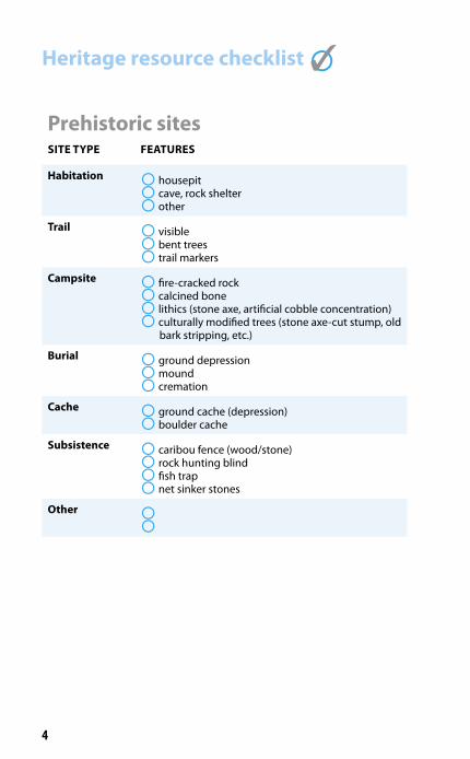
Prehistoric sitesSITE TYPE FEATURES
Habitation ° housepit° cave, rock shelter° other
Trail ° visible° bent trees° trail markers
Campsite ° fire-cracked rock° calcined bone° lithics (stone axe, artificial cobble concentration)° culturally modified trees (stone axe-cut stump, old
bark stripping, etc.)
Burial ° ground depression° mound° cremation
Cache ° ground cache (depression)° boulder cache
Subsistence ° caribou fence (wood/stone)° rock hunting blind° fish trap° net sinker stones
Other ° °
Heritage resource checklist °✓
5
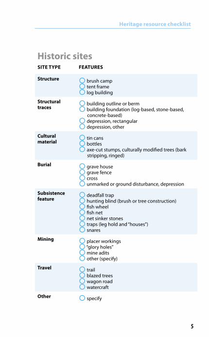
Historic sitesSITE TYPE FEATURES
Structure ° brush camp° tent frame° log building
Structural traces
° building outline or berm° building foundation (log-based, stone-based,
concrete-based)° depression, rectangular° depression, other
Cultural material
° tin cans° bottles° axe-cut stumps, culturally modified trees (bark
stripping, ringed)
Burial ° grave house° grave fence° cross° unmarked or ground disturbance, depression
Subsistence feature
° deadfall trap° hunting blind (brush or tree construction)° fish wheel° fish net° net sinker stones° traps (leg hold and “houses”)° snares
Mining ° placer workings° “glory holes”° mine adits° other (specify)
Travel ° trail° blazed trees° wagon road° watercraft
Other ° specify
Heritage resource checklist

6
The following information should be recorded for heritage sites or features encountered in the field. • Global Positioning System (GPS) location: latitude and
longitude or UTM coordinates and NAD (27 or 83). • Current date and time. • Estimate of site and feature extent: estimated size of the
camp or scatter of cultural remains. • Brief description of setting and access to assist in
locating the site (e.g., on a small rise on the north side of marsh; abandoned river terrace, access via logging road at km xx RHS, Campbell Highway).
Recording
Recording a collapsed and overgrown cabin. Corner of cabin just visible by researcher’s knee.

7
Heritage features above treeline. Remains of a hunting blind.
Historic artifacts associated with a historic dwelling depression.
• Brief description of site and features (eg., cabin with collapsed cache and artifact scatter).
• Photograph, if possible. Be sure to record frame or photo numbers for the site or feature.

8
If heritage sites or features are discovered, please report to: Ruth GotthardtArchaeology Heritage Resources Unit, Cultural Services Branch Department of Tourism and Culture Government of Yukon Box 2703, Whitehorse, Yukon Y1A 2C6 Phone (867) 667-5983; toll free [email protected]
or contact the local First Nations’ Lands or Heritageoffices. (Listing on page 57.)
Reporting
Collapsed four-post cache with household goods.

9
Basal logs of a very old cabin.
Heritage sites and featuresCabinsCabins built by trappers and prospectors are found throughout Yukon forests. These are usually small buildings, constructed of logs with sod roofs.

10
More difficult to detect are former cabin locations. Thrifty Yukoners often recycled their logs. All that then remains are basal logs, generally rotted in place, and a slightly bermed rectangular outline where dirt was mounded up around the base of the cabin. Vegetation growth is more lush inside a cabin outline due to higher organic content. A depression inside the outline indicates a root cellar.
Cabins
Trees growing inside the root cellar, within the outline of a former cabin.

11
Canvas tents came into the Yukon with the Klondike gold rush and quickly became a mainstay of First Nations trappers throughout the territory, replacing moose skin tents and brush camps.
Tent frames
Generally one to two basal logs were used to hold down the edges of a canvas wall tent.

12
The traditional brush camp was a lean-to made with spruce branches or small spruce trees covering a pole tripod framework. Often, temporary brush camps were built by piling up small spruce trees and boughs around the base of a large spruce tree. The tree was always spruce because it is always dry underneath spruce trees. The size of the brush camp varied depending on people’s needs; the average family would construct a shelter approximately 5.5 to 6 feet in height, and 6 by 6 feet at the base. In the upper portion, cross-branches were set to make a kind of storage area. The floor of the brush camp was covered with spruce boughs. In a camp made up of several families, related people would usually construct their brush camps facing each other, about 1 to 2 feet apart, and would share a common fire placed between the two camps (Legros, 1981:798). In winter, the brush shelter could be covered with mooseskin or moss. Sometimes, for added insulation, snow was piled up along the sides and water thrown over it to form ice.
Brush camps

13
Brush camps

14
Tent poles
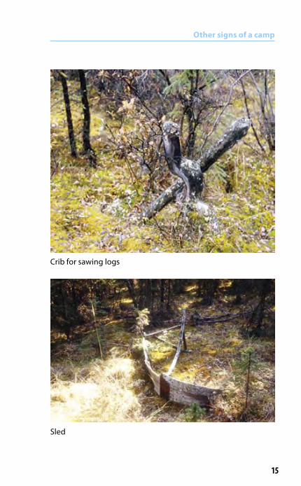
Other signs of a camp
Hide-tanning pole
15
Crib for sawing logs
Sled
Other signs of a camp

16
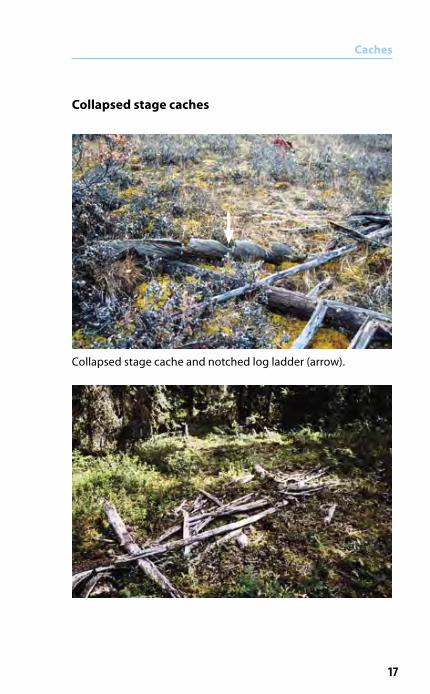
Stage cachesStage caches consist of a platform between two trees or a group of trees, generally at a height of between five and eight metres. The food stores were placed on the platform and were protected by a skin, and then covered with numerous logs. The cache was accessed by means of a notched log ladder.
Caches
Metal cans ring the upright posts to discourage wolverines climbing up to the cache.
17
Collapsed stage cache and notched log ladder (arrow).
Caches
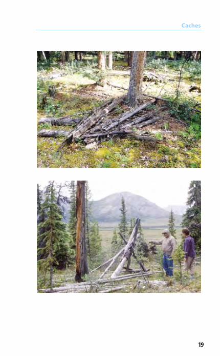
Collapsed stage caches

18
Caches
19
Caches
20
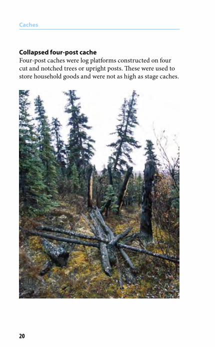
Collapsed four-post cacheFour-post caches were log platforms constructed on four cut and notched trees or upright posts. These were used to store household goods and were not as high as stage caches.
Caches

21
Caches
22
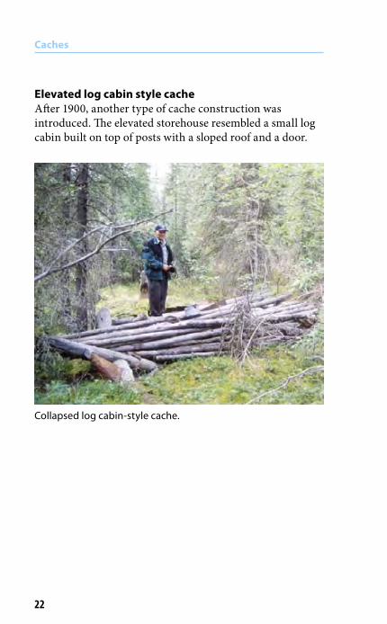
Collapsed log cabin-style cache.
Caches
Elevated log cabin style cacheAfter 1900, another type of cache construction was introduced. The elevated storehouse resembled a small log cabin built on top of posts with a sloped roof and a door.

23
Log-lined cache associated with Hudson’s Bay post at Fort Selkirk, ca. 1850.
Other cache typesPit caches for food storage generally measured about 3 to 4 m by 1.5 m and were about 50 cm deep. The edges were raised up on two or three logs. The pit was lined, usually with hide, and then covered with heavy fresh-cut tree trunks. Pit caches were built on very dry, well-drained soil or into hillsides. Most pit caches are now visible only as circular or square ground depressions.
Caches
Caches
24
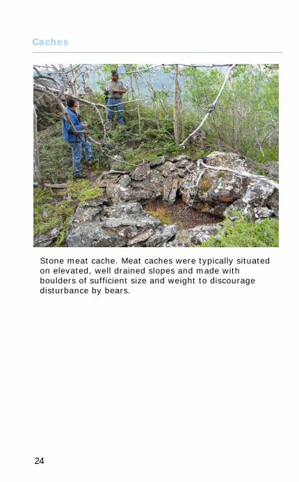
Stone meat cache. Meat caches were typically situated on elevated, well drained slopes and made with boulders of sufficient size and weight to discourage disturbance by bears.

25
�
��
�
����
��
��
��
�
�
�
�
�
DeadfallsDeadfalls were used for brown bears, marmots, wolverines, wolves, fox, marten, ermines, mink and weasel. The diagram below illustrates the way in which a deadfall would be used to capture a bear. The animal was forced to enter through point M in order to reach the bait (C). Parts K and J of the deadfall were propped up with a trigger (E) which was connected to the bait at point D. As soon as the bait was touched, the trigger would be loosened, thus releasing K and J. K and J were heavy green logs, which would fall onto the animal, breaking its back. Deadfall traps continued to be used long after 1900.
Traps and snares
Bear deadfall. (Legros 1981)

26
Traps and snares

27
Traps and snares
Lynx houses were built around leg-hold traps.
Trap: lynx house

28
Moose snare set on a trail (Legros 1981)
Traps and snares
Snares
moose trail
counterweight
support stick

29
Bark strips tied high in cottonwoods along a well-used trail. Likely used to anchor part of a snare mechanism.
Traps and snares
30
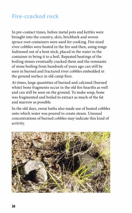
In pre-contact times, before metal pots and kettles were brought into the country, skin, birchbark and woven spruce root containers were used for cooking. Fist-sized river cobbles were heated in the fire and then, using tongs fashioned out of a bent stick, placed in the water in the container to bring it to a boil. Repeated heatings of the boiling stones eventually cracked them and the remnants of stone boiling from hundreds of years ago can still be seen in burned and fractured river cobbles embedded in the ground surface in old camp fires. At times, large quantities of burned and calcined (burned white) bone fragments occur in the old fire hearths as well and can still be seen on the ground. To make soup, bone was fragmented and boiled to extract as much of the fat and marrow as possible. In the old days, sweat baths also made use of heated cobbles onto which water was poured to create steam. Unusual concentrations of burned cobbles may indicate this kind of activity.
Fire-cracked rock

31
Fire-cracked rock
Small white-coloured fragments in this hearth are calcined bone fragments

32
Fish camps
Net fishing sites The large fish nets that are in common use today at family fish camps were introduced within the past 100 years. Evidence of net fishing can be seen in cached net sinker stones. The principal locations of fish camps are on lakes at outlets and inlets, and at lake narrows.
Cached net sinker stores.

33
����������������������������������
�������������������
���������������������������������������
���������
���������
���������������������������������������������������
�����������������������������������������������������������������������������������������������������������
Fish camps
Fish traps (from Stewart 1977)
Fish traps In pre-contact times, fish traps were set in shallow channels of rivers and streams where the water flow was reduced. These were ideal locations for the construction of fish weirs and fish traps. The actual camp sites associated with these locations were often a short distance away so that the noise and activities of the camp would not disturb the fish run. Because river and stream channels shift over time, fish camp locations may only have been in use several decades before they needed to be moved.

34
Fish basket cached in the willows
Cache of poles for fish basket construction. Hammerstones were cached nearby as well.
Fish camps

35
Watercraft
Dug-out canoes, spruce-bark canoes and other watercraft may still be found cached near water bodies and rivers in the Yukon.
Dug-out canoes. The canoe in the bottom picture has been trampled by horses.

36
Paddle made by shaping a thick sapling.
Frame of a canvas-covered canoe
Watercraft

37
Stone adze-cut stumps
Stumps cut with a stone adze (or stone axe) exhibit long flutes around the circumference and come to a blunt point. The tree-cutter used the adze to wedge out long splinters of wood from the trunk, working around the tree until it was ready to fall.
38
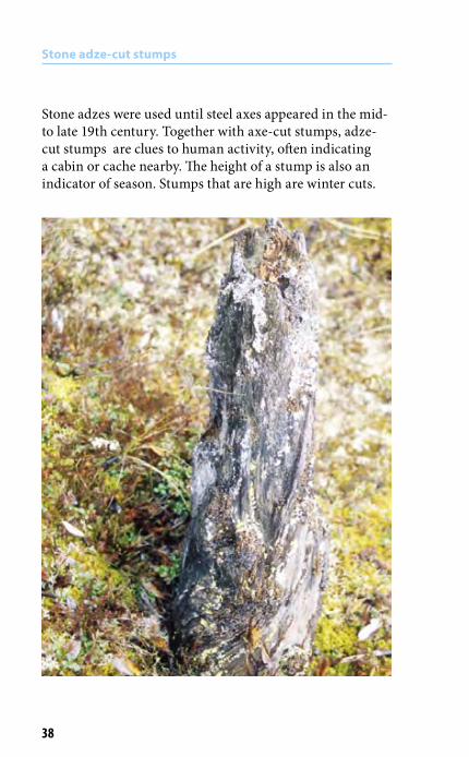
Stone adzes were used until steel axes appeared in the mid- to late 19th century. Together with axe-cut stumps, adze-cut stumps are clues to human activity, often indicating a cabin or cache nearby. The height of a stump is also an indicator of season. Stumps that are high are winter cuts.
Stone adze-cut stumps

39
Caribou fences were constructed in treeline situations. The arms sometimes extended over 2 to 3 km and were constructed of felled trees and brush, using stone adzes, and steel axes in later times.
Game drives and surrounds
“On the ground” view of the arm of a caribou fence in northern Yukon.

40
Bark stripping In spring when the sap started to run, people used to strip bark to get at the sweet sap. Bark stripping on pine may also indicate harvesting of the cambium or inner bark. Dried and pounded up, this was used in some places as starvation food. The inner bark of spruce was chewed to relieve hunger pangs. Note: It may be difficult to distinguish bark stripping from forest fire scars on trees.
Harvesting bark, pitch and sap

41
Collecting pitch and sap Lesions were made in alpine fir to harvest medicinal pitch.
Harvesting bark, pitch and sap
“Burl” formed by a ring of lesions
42
Trails
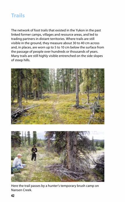
Here the trail passes by a hunter’s temporary brush camp on Nansen Creek.
The network of foot trails that existed in the Yukon in the past linked former camps, villages and resource areas, and led to trading partners in distant territories. Where trails are still visible in the ground, they measure about 30 to 40 cm across and, in places, are worn up to 5 to 10 cm below the surface from the passage of people over hundreds or thousands of years. Many trails are still highly visible entrenched on the side slopes of steep hills.

43
Trails
Blazes on trees are a common trail marker. Before axes were introduced, a young tree might be broken or bent to mark the trail.
Trail marker in the Klukshu Flats area (Cruikshank 1991).
Blaze or marker on tree.
44
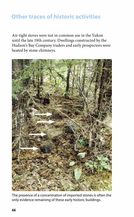
Other traces of historic activities
Air-tight stoves were not in common use in the Yukon until the late 19th century. Dwellings constructed by the Hudson’s Bay Company traders and early prospectors were heated by stone chimneys.
The presence of a concentration of imported stones is often the only evidence remaining of these early historic buildings.

45
Bottle middens and other debris are also signs of gold rush and post-gold rush activity.
Other traces of historic activities
Remains of a gold rush wagon at Canyon City.
Gold rush-vintage can midden at Canyon City.
46
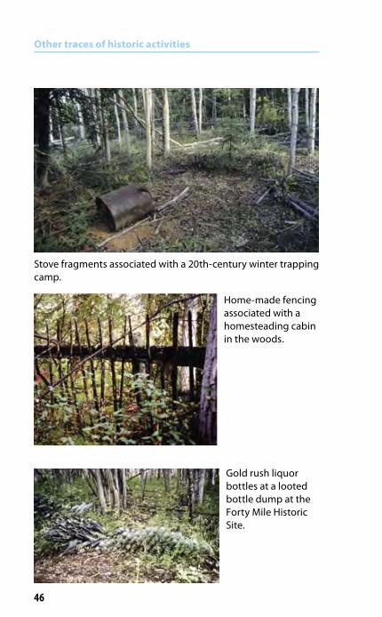
Other traces of historic activities
Stove fragments associated with a 20th-century winter trapping camp.
Home-made fencing associated with a homesteading cabin in the woods.
Gold rush liquor bottles at a looted bottle dump at the Forty Mile Historic Site.

47
Other traces of historic activities
Second World War military facilities associated with Alaska Highway and Canol and Alcan highway pipeline construction. These sites are part of the Yukon’s heritage as well.

48
Fence grave with personal items.
Graves
Corner posts are all that remain of a fence grave burned in a forest fire.
A typical location for graves is on a prominent terrace or hill overlooking a lake or river.
49
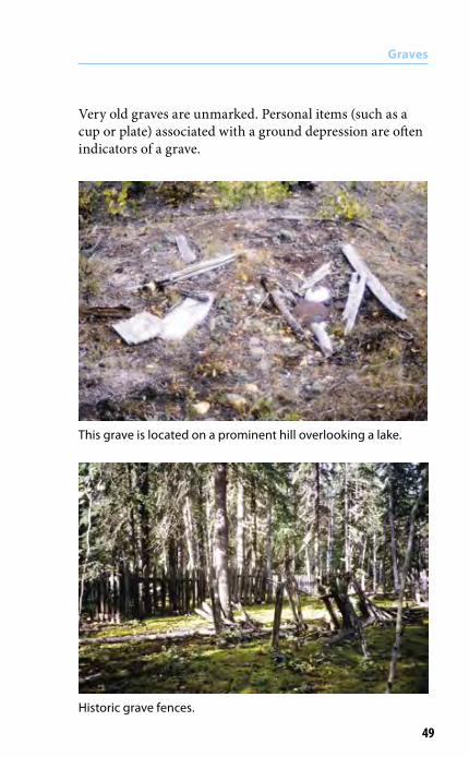
Very old graves are unmarked. Personal items (such as a cup or plate) associated with a ground depression are often indicators of a grave.
Graves
This grave is located on a prominent hill overlooking a lake.
Historic grave fences.
50
Graves
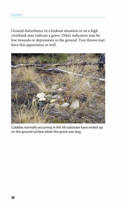
Ground disturbance in a lookout situation or on a high riverbank may indicate a grave. Other indicators may be low mounds or depressions in the ground. Tree throws may have this appearance as well.
Cobbles normally occurring in the till substrate have ended up on the ground surface when the grave was dug.

51
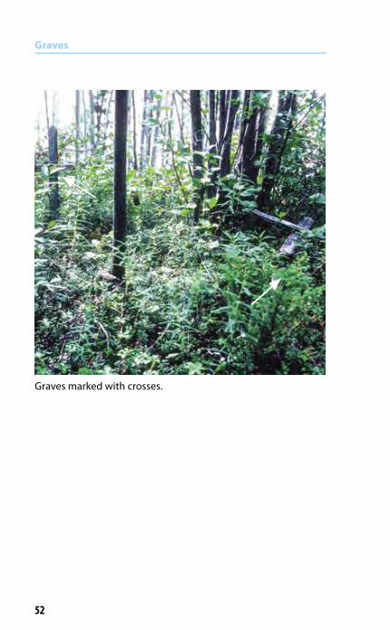
The collapsed fence surrounding this grave is almost entirely obscured by moss. A stylized cross leaning up against the small spruce is the most visible marker of the grave.
Graves
52
Graves
Graves marked with crosses.

Alpine Sites
53
Perennial snow patches in the alpine can preserve a significant record of past animal and human activity, in some cases dating to the end of the last Ice Age. These sites should be avoided by development activities.

Alpine Sites
54
Exceptionally well preserved hunting implements recovered from permanent snow patches reveal a record of caribou and sheep exploitation in the alpine which spans thousands of years. Preserved caribou dung is often seen melting from the edges of the snow patches, testifying to thousands of years of caribou use of these sites.
Foreshaft and stone spear point (above); spear shaft with broken stone point (left). These hunting implements date between 3,000 and 4,500 years ago.

Alpine Sites
55
Semi-circular stone hunting blinds are strategically situated to intercept sheep and caribou movement in the alpine. Blinds may occur in clusters or in a line over several kilometres or may be single blinds.

References cited
Cruikshank, Julie, 1991. Reading Voices. Vancouver, Douglas and McIntyre.
Legros, Dominque, 2007. Oral History as History: Tutchone Athapaskan in the Period 1840-1920. Occasional Papers in Yukon History No. 3(1 & 2). Whitehorse.
McClellan, Catharine, 1987. Part of the Land, Part of the Water. Vancouver, Douglas and McIntyre.
Stewart, Hilary, 1977. Indian Fishing: Early Methods on the Northwest Coast. Vancouver, Douglas and McIntyre.
56

Contacts
Carcross/Tagish First Nations Heritage Office(867) 821-8215
Champagne and AishihikFirst Nation Heritage Office(867) 634-4010
Kluane First NationHeritage Office(867) 841-5501 ext 247
Kwanlin Dün First NationHeritage, Lands and Resources(867) 633-7822
Liard First NationLands and Resources(867) 536-2912
Little Salmon/Carmacks First Nation Heritage Office(867) 863-5576
Selkirk First Nation Heritage Office(867) 537-3331
Yukon ArchaeologistGovernment of Yukon(867) 667-5983 toll free 1-800-661-0408
Ta’an Kwäch’än CouncilHeritage Office(867) 668-3613 ext 117
Teslin Tlingit CouncilHeritage Office(867) 390-2532 ext 383
Tr’ondëk Hwëch’in Heritage Office(867) 993-7114
White River First NationNatural Resources(867) 862-7014
Vuntut Gwitchin Heritage Office(867) 966-3261 ext 246
Ross River Dena Council(867) 969-2278
57