Hancock - Mass.gov · BioMap2: Guiding Land Conservation for Biodiversity in Massachusetts Hancock...
14
BioMap2 Guiding Land Conservation for Biodiversity in Massachusetts Hancock This report and associated maps provide information about important sites for biodiversity conservation in your area. This information is intended for conservation planning, and is not intended for use in state regulations. Produced by: Natural Heritage & Endangered Species Program Massachusetts Division of Fisheries and Wildlife Commonwealth of Massachusetts Produced in 2011
-
Upload
truongminh -
Category
Documents
-
view
216 -
download
2
Transcript of Hancock - Mass.gov · BioMap2: Guiding Land Conservation for Biodiversity in Massachusetts Hancock...
BioMap2
Guiding Land Conservation forBiodiversity in Massachusetts
Hancock
This report and associated maps provide information about important sites for biodiversity conservation in your area
This information is intended for conservation planning and is not intended for use in state regulations
Produced by Natural Heritage amp Endangered Species Program Massachusetts Division of Fisheries and Wildlife
Commonwealth of Massachusetts
Produced in 2011
BioMap2 Guiding Land Conservation for Biodiversity in Massachusetts
Preferred citation NHESP 2011 BioMap2 Guiding Land Conservation for Biodiversity in Massachusetts Hancock Natural Heri-tage amp Endangered Species Program Massachusetts Division of Fisheries and Wildlife Westborough MA
The preferred citation for BioMap2 is Woolsey H A Finton J DeNormandie 2010 BioMap2 Conserving the Biodiversity of Massachusetts in a Changing World MA Department of Fish and GameNatural Heritage amp Endangered Species Program and The Nature ConservancyMassachusetts Program httpwwwmassgovdfweledfwnhespland_protectionbiomapbiomap2_summary_reportpdf
Funding for this project was made available by the Massachusetts Sub-Council of the Housatonic River Trustee Council under the auspices of the Massachusetts and Department of the Interior (DOI) Natural Resource Damages Assessment and Restoration Programs and contributions to the Natural Heritage amp Endangered Species Fund
Natural Heritage amp Endangered Species
Program
Massachusetts Division of Fisheries and Wildlife 1 Rabbit Hill Westborough MA 01581
Tel (508) 389-6360 Fax (508) 389-7891 httpwwwnhesporg
For more information on rare species and natural communities please see our fact sheets online at wwwnhesporg
BioMap2 Guiding Land Conservation for Biodiversity in Massachusetts
Hancock
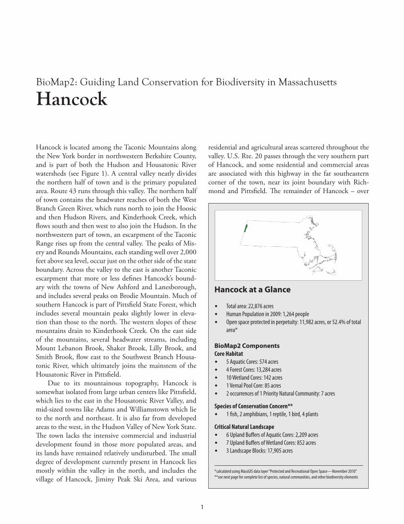
Hancock is located among the Taconic Mountains along the New York border in northwestern Berkshire County and is part of both the Hudson and Housatonic River watersheds (see Figure 1) A central valley neatly divides the northern half of town and is the primary populated area Route 43 runs through this valley The northern half of town contains the headwater reaches of both the West Branch Green River which runs north to join the Hoosic and then Hudson Rivers and Kinderhook Creek which flows south and then west to also join the Hudson In the northwestern part of town an escarpment of the Taconic Range rises up from the central valley The peaks of Mis-ery and Rounds Mountains each standing well over 2000 feet above sea level occur just on the other side of the state boundary Across the valley to the east is another Taconic escarpment that more or less defines Hancockrsquos bound-ary with the towns of New Ashford and Lanesborough and includes several peaks on Brodie Mountain Much of southern Hancock is part of Pittsfield State Forest which includes several mountain peaks slightly lower in eleva-tion than those to the north The western slopes of these mountains drain to Kinderhook Creek On the east side of the mountains several headwater streams including Mount Lebanon Brook Shaker Brook Lilly Brook and Smith Brook flow east to the Southwest Branch Housa-tonic River which ultimately joins the mainstem of the Housatonic River in Pittsfield
Hancock at a Glance
bull Total area 22876 acres bull Human Population in 2009 1264 people bull Open space protected in perpetuity 11982 acres or 524 of total
area
BioMap2 Components Core Habitat bull 5 Aquatic Cores 574 acres bull 4 Forest Cores 13284 acres bull 10 Wetland Cores 142 acres bull 1 Vernal Pool Core 85 acres bull 2 occurrences of 1 Priority Natural Community 7 acres
Species of Conservation Concern bull 1 fish 2 amphibians 1 reptile 1 bird 4 plants
Critical Natural Landscape bull 6 Upland Buffers of Aquatic Cores 2209 acres bull 7 Upland Buffers of Wetland Cores 852 acres bull 3 Landscape Blocks 17905 acres
calculated using MassGIS data layer ldquoProtected and Recreational Open SpacemdashNovember 2010rdquo see next page for complete list of species natural communities and other biodiversity elements
Due to its mountainous topography Hancock is somewhat isolated from large urban centers like Pittsfield which lies to the east in the Housatonic River Valley and mid-sized towns like Adams and Williamstown which lie to the north and northeast It is also far from developed areas to the west in the Hudson Valley of New York State The town lacks the intensive commercial and industrial development found in those more populated areas and its lands have remained relatively undisturbed The small degree of development currently present in Hancock lies mostly within the valley in the north and includes the village of Hancock Jiminy Peak Ski Area and various
residential and agricultural areas scattered throughout the valley US Rte 20 passes through the very southern part of Hancock and some residential and commercial areas are associated with this highway in the far southeastern corner of the town near its joint boundary with Rich-mond and Pittsfield The remainder of Hancock ndash over
1
BioMap2 Guiding Land Conservation for Biodiversity in Massachusetts
Hancock
52000 acres or 89 percent of the townrsquos land area ndash is forested and accessed relatively infrequently by people
Mountainous and forested areas of Hancock are less rich in uncommon aspects of biodiversity than areas that
lie within the marble valleys to the east and south yet these highlands support their own suite of ecologically important species and natural communities For example a cluster of vernal pools in southern Hancock provides breeding habitat for the state-listed Jefferson Salamander Spring Salamanders are also found nearby along headwa-ter streams and in areas with steep slopes Areas of the nat-ural community Rich Mesic Forest are found along Lilly Brook these support extensive stands of sugar maples and a diverse understory of fern sedge lily and buttercup spe-cies Along Route 43 near Whitman Road toward the up-permost reaches of Kinderhook Creek the open waters of a small reservoir and its associated wetland areas support nesting and breeding habitat for the state-listed marshbird Least Bittern To the north along the upper reaches of the West Branch Green River Longnose Suckers live and feed along rocky areas of the stream bottom
Species of Conservation Concern Priority Natural Communities and Other Elements of Biodiversity in Hancock
Fish Hillrsquos Pondweed (Potamogeton hillii) Special Concern Longnose Sucker (Catostomus catostomus) Special Concern Ogdenrsquos Pondweed (Potamogeton ogdenii) Endangered
Amphibians Priority Natural Community Jefferson Salamander (Ambystoma jeffersonianum) Special Concern Rich Mesic Forest Spring Salamander (Gyrinophilus porphyriticus) SWAP Other BioMap2 Components
Reptiles Aquatic Cores Wood Turtle (Glyptemys insculpta) Special Concern Forest Cores
Birds Landscape Blocks Least Bittern (Ixobrychus exilis) Endangered Upland Buffers of Aquatic Cores
Plants Upland Buffers of Aquatic Cores Bristly Black Currant (Ribes lacustre) Special Concern Vernal Pool Cores Crooked-stem Aster (Symphyotrichum prenanthoides) Endangered Wetland Cores
Western New England Marble Valleys Taconic Mountains
Berkshire Highlands Taconic Foothills Rensselaer Plateau
ECOREGIONS
HANCOCK
N
RICHMOND
PITTSFIELD
LANESBOROUGH
NEW ASHFORD
WILLIAMSTOWN
CHESHIRE
N E
W
Y
O R
K
Onota Lake
W est
B r
H
ousa
toni
c Ri
v er
E ast B r H ousatonic Riv er
Pontoosuc Lake
Kind
er ho
ok C
r eek
W B
r Gr ee
n Ri
ver
Wyo
man
cok
Cree
k
Jiminy Peak Ski Area
Kinderhook
Creek
Hudson River Watershed
Housatonic River Watershed
To wn B r ook
Bentley Broo
k
Daniels Bk
Churchill Bk
Whitman Bk
BRODIE MOUNTAIN
MISERY
MOUNTAIN
Lulu Brook
Berry Pond Bk
E ast
B r oo
k
W est
B r o
ok
Lily Brook
May Brook
Smith BrookParker Brook
Mt Lebanon Brook
Shaker Brook
Pine Mtn
Tower Mtn
Smith Mtn
Honwee Mtn
Widow Whites Pk
Mt Lebanon
Shaker Mtn
G reen Riv er
Stony Ledge
Mt Prospect
Saddle Ball Mtn
Rounds Rock
Savage Hill
Oak Hill
Perry Peak
T A C O N I C
R A N G E
ROUNDS
MTN
PITTSFIELD STATE FOREST
PITTSFIELD STATE FOREST
MT GREYLOCKSTATE RESERVATION
Hancock
North Hancock
Pittsfield
Figure 1 Town boundaries and ecoregions for Hancock Hancock is in the Hudson and Housatonic watersheds
BIODIVERSITY CONSERVATION TARGETS IN HANCOCK CORE HABITAT CRITICAL NATURAL LANDSCAPE amp PRIORITY CONSERVATION AREAS
Overview In this section we outline areas in Hancock that warrant special focus of conservation efforts locally regionally and throughout the state Components of the Natural Heri-tage amp Endangered Species Programrsquos (NHESPrsquos) state-wide BioMap2 project which incorporates NHESP data and includes findings of studies funded by the Natural Resource Damages Assessment and Restoration Program (NRD) conducted in 2008 and 2009 as part of its Core Habitat and Critical Natural Landscape were used to de-lineate and map these areas The areas range in size from
2
BioMap2 Guiding Land Conservation for Biodiversity in Massachusetts
Hancock
fewer than 10 acres to several thousand acres Areas of Core Habitat each called a BioMap2 Core (BC) and ar-eas of Critical Natural Landscape (CNL) along with their associated components are illustrated in Figure 2 and out-lined in detail below BioMap2 components described in this report are those that occur only in Hancock although a given area of Core Habitat or Critical Natural Land-scape listed here may extend outside the town boundaries of Hancock and contain additional components
To facilitate land protection and stewardship NHESP further prioritized areas in each of the towns in the water-shed using habitat size habitat conditions and other bio-diversity indicators Priority Conservation Areas (PCAs) were considered to be of high biodiversity value if they contained concentrations of state-listed species or Priority Natural Communities or large areas of intact habitat In each town a total of one to six Town PCAs were selected Each Town PCA contains part of at least one BioMap2 Core in Hancock three Town PCAs were selected Fig-ure 3 illustrates how BioMap2 Core Habitat and Criti-cal Natural Landscape relate to the distribution of Town PCAs in Hancock
In addition to the Town PCAs a larger scale prioriti-zation was conducted to select Regional PCAs of the high-
est conservation and stewardship value among all towns in Massachusettsrsquo portion of the Housatonic River water-shed Regional PCAs often cross town boundaries and are quite large ranging from 373 acres to more than 25000 acres Ecological connectivity within these Regional PCAs is important to biodiversity conservation and these large units often include select Town PCAs that are of particu-lar biodiversity value to both the town and the region In this way biodiversity can be conserved at two scales locally within each town and within a broader regional context In Hancock Regional PCA 7 encompasses much of the northeastern and southern portions of the town including Town PCA 1 and Town PCA 3 which together contain thousands of acres of state forest in the Taconic Mountains
3
Biodiversity Studies in Massachusetts and the Housatonic River Watershed
BioMap2 is a statewide biodiversity conservation plan produced in 2010 by MassWildlifersquos Natural Heritage amp Endan-gered Species Program and The Nature Conservancy It is designed to guide strategic biodiversity conservation in Mas-sachusetts over the next decade by focusing land protection and stewardship on the areas that are most critical for ensuring the long-term persistence of rare and other native species and their habitats Priority Natural Communities and a diversity of ecosystems BioMap2 is also designed to include the habitats and Species of Conservation Concern identified in the State Wildlife Action Plan (SWAP)
BioMap2 identifies two complementary spatial layers Core Habitat and Critical Natural Landscape Core Habitat identi-fies key areas that are critical for the long-term persistence of rare species and other Species of Conservation Concern as well as a wide diversity of natural communities and intact ecosystems across the Commonwealth Protection of Core Habitats will contribute to the conservation of specific elements of biodiversity Critical Natural Landscape identi-fies large Landscape Blocks that are minimally impacted by development If protected these areas will provide habitat for wide-ranging native species support intact ecological processes maintain connectivity among habitats and en-hance ecological resilience to natural and anthropogenic disturbances in a rapidly changing world Areas delineated as Critical Natural Landscape also include buffering upland around wetland coastal and aquatic Core Habitats to help ensure their long-term integrity
In 2008 and 2009 field surveys were carried out to improve knowledge of the regionrsquos biodiversity resources in towns in the Housatonic River watershed in western Massachusetts During these surveys coordinated by the Natural Heri-tage and Endangered Species Program (NHESP) with funds from the Natural Resources Damage Assessment and Res-toration (NRD) Program researchers collected important information about state-listed species and Priority Natural Communities of 19 towns in the region Surveys were conducted by NHESP staff expert consultants academic re-searchers and graduate students Information on the surveysrsquo findings was added to the NHESP database combined with other NHESP data and incorporated into Core Habitat of BioMap2 BioMap2 data layers complete with these data and other information are now available for use in conservation planning at the town regional and state levels
Core Habitat and Critical Natural Landscape Components in Hancock Areas of Core Habitat in Hancock called BioMap2 Cores (BCs) are summarized here as are the various compo-nents of each BC which may include Species of Conser-vation Concern Exemplary and Priority Natural Com-munities and Aquatic Forest Vernal Pool or Wetland Cores Components of Critical Natural Landscape (CNL) associated with each BC are also provided These include Upland Buffers of Aquatic and Wetland Cores as well as Landscape Blocks
Overview of CNLs in Hancock Most BioMap2 Cores in Hancock Lanesborough and the northern areas of Pittsfield Dalton and Windsor are part of CNL1332 This CNL totals nearly 85000 acres and falls almost entirely within the Taconic Mountains and Berkshire Highlands ecoregions Elevations in these regions are typically well above 1000 feet with peaks reaching higher than 2000 feet The land is largely forest-ed and aquatic ecosystems consist primarily of headwater wetlands and streams Like other CNLs CNL1332 con-sists of large Landscape Blocks as well as Upland Buffers of Wetland and Aquatic Cores in certain areas At 1104 acres CNL1169 is relatively small compared to other CNLs in the region and consists of only one BioMap2 core BC2437 It falls on the eastern slopes of Rounds Mountain along the boundary with New York State and supports a moderate-size Forest Core
BC2191 and CNL1332 BC2191 is a 23-acre area bordering west Main Street just across the state line from New Lebanon NY It is part of an Upland Buffer of Aquatic Core and Landscape Block in CNL1332 BC2191 includes one state-listed plant
BC2341 and CNL1332 BC2341 lies mostly in Hancock although parts of this BC are also in Lanesborough and Pittsfield with a very small extension south into Richmond In Hancock this core contains a variety of important biodiversity elements characteristic of many highland areas in the Housatonic River watershed It is heavily forested with a large area of Forest Core (8239 acres) and includes six Wetland Cores that cover an area of 73 total acres It includes Aquatic Cores along Kinderhook Creek and its tributaries and Mount Lebanon Brook in the very southern part of the town CNL1332 has Upland Buffers around the Aquatic and Wetland Cores An 85-acre Vernal Pool Core is also part of this BC In Hancock BC2341 supports two un-common salamander species two state-listed plant spe-cies and one Priority Natural Community
BioMap2 Guiding Land Conservation for Biodiversity in Massachusetts
Hancock
Amphibians Spring Salamander (Gyrinophilus porphyriticus) SWAP Spring Salamanders inhabit clean cold high-gradient brooks and headwater seeps in forest habitat usually at elevations above 300 feet Larvae are entirely aquatic and largely nocturnal spending daylight hours buried below the streambed or hidden under stones Adults are semi-aquatic and spend most of their time under cover objects along the margins of brooks springs and seeps however they will venture into upland for-est during rainy weather In BC2341 this salamander is documented along the upper reaches of Parker and Lulu Brooks Jefferson Salamander (Ambystoma jeffersonianum) Special Concern Jefferson Salamanders inhabit upland forest during most of the year where they reside in small-mammal burrows and other subsurface retreats Adults migrate during late winter or early spring to breed in vernal pools and fish-free areas of swamps marshes or similar wetlands Larvae metamorphose in late summer or early fall then disperse into upland forest These sala-manders are documented from a 395-acre area in the southern portion of BC2341 close to Certified Vernal Pools along the headwaters of Shaker Brook
Plants Bristly Black Currant (Ribes lacustre) Special Concern This short shrub grows at fairly high elevations near streams seeps and swamps in rich cool and moist woods and sometimes on ledges Crooked-stem Aster (Symphyotrichum prenanthoides) Threat-ened (recommended rank change to Special Concern in 2011) This perennial herbaceous plant grows in rich soils in open to semi-open conditions along rivers streams and seeps In BC2341 it occurs just north of BC2191 (where it is also documented)
Priority Natural Community Rich Mesic Forest Community (Vulnerable) This Priority Natural Community is a variant of northern hardwood forest that is dominated by sugar maple with diverse herbaceous plants It typically includes many spring wild flowers and occurs in moist nutrient-rich environ-ments It occurs in the western part of BC2341 in two small areas that total seven acres along Lily Brook
BC2437 and CNL1169 BC2437 lies within a 1102-acre Landscape Block in CNL1169 This area is in west-central Hancock along the townrsquos boundary with New York The core consists of one moderate-sized (595-acre) Forest Core as well as the upper reaches of Whitman Brook watershed which drains into Kinderhook Creek
4
BC2191
Kinderhook Creek
W B
r Gree
n Ri
ver
Shaker Brook
Kinderhook Creek
W B
r Gree
n Ri
ver
Shaker Brook
BioMap2 Guiding Land Conservation for Biodiversity in Massachusetts
Hancock
Figure 2 Hancock includes a total of six BioMap2 Cores (BCs left) and two areas of Critical Natural Landscape (CNL right)
BC2487 and CNL1332 BC2487 includes a small part of Hancockrsquos northern val-ley and the headwaters of Kinderhook Creek It falls with-in Aquatic and Upland Buffers of CNL1332 and is also part of a large Landscape Block This BC includes many BioMap2 core components including a 97-acre Aquatic Core and three adjacent Wetland Cores that make up 66 acres These components encompass a reservoir that is formed by a dam at the downstream end of the core near Whitman Road BC2487 includes two aquatic plants and one marsh bird species
Plants Hillrsquos Pondweed (Potamogeton hillii) Special Concern This submersed aquatic plant grows best in cold shallow slow-moving and clean alkaline bodies of water on muddy substrates It occurs throughout aquatic areas in BC2487 as well as in adjacent wetlands Ogdenrsquos Pondweed (Potamogeton ogdenii) Endangered This species is an annual aquatic herb with submersed leaves that grows in shallow alkaline still or very slow-moving waters Like Hillrsquos Pondweed it grows in aquatic and wetland areas throughout BC2487
Bird Least Bittern (Ixobrychus exilis) Endangered Least Bitterns are wading heron-like birds that typically nest in cat-tail marshes interspersed with open water They are very sensitive to disturbances from pollution such as siltation and chemical insecticides and to the estab-lishment of invasive plants like Phragmites and Purple Loosestrife that do well in disturbed areas
BC2955 and CNL1332 BC2955 consists of a single 2433 acre Forest Core and lies in northwest Hancock within a Landscape Block of CNL1332
BC2979 and CNL1332 BC2979 includes the West Branch Green River and much of the upper reaches of Kinderhook Creek These streams and their riparian areas each form an Aquatic Core and are surrounded by Upland Buffers of CNL1332 This core also includes a Forest Core in CNL1332rsquos Landscape Block that covers Brodie Mountain in northeast Hancock its land drains west into both the West Branch Green Riv-er and Kinderhook Creek BC2979 also includes a small
5
BioMap2 Guiding Land Conservation for Biodiversity in Massachusetts
Hancock
Wetland Core at its very northern edge near the bound-ary with Williamstown Two state-listed animal species one fish and one turtle are documented in BC2979
Fish Longnose Sucker (Catostomus catostomus) Special Concern This torpedo-shaped fish has a snout extending beyond its downturned mouth It is typically found in cool lower-order streams and rivers with rocky substrates These fish rely on clean and well oxygenated gravel sub-strates to rear their eggs In Massachusetts they only oc-cur in the western part of the state and are documented throughout the Green River in Hancock
Reptiles Wood Turtle (Glyptemys insculpta) Special Concern Wood Turtle habitat consists of streams and rivers preferably with long corridors of undeveloped connected uplands extending on both sides of the waterways Riparian ar-eas in this core are both large and interconnected thus providing excellent habitat for this species
Core
Hab
itat +
Criti
cal N
atur
al La
ndsc
ape
Regio
nal P
riorit
y Con
serv
ation
Area
s To
wn Pr
iority
Cons
erva
tion A
reas
Figure 3 Core Habitat (dark green) Critical Natural Land-scape (light green) Town Priority Conservation Areas (PCAs reddish-brown grid) and Regional Priority Conservation Areas (black) in Hancock Town PCAs make up 17963 acres or 785 percent of the townrsquos total area Regional PCAs make up 13461 acres or 588 percent of the townrsquos total area
Priority Conservation Areas in Hancock The town of Hancock contains three areas identified as Priority Conservation Areas (PCAs) by NHESP All three are Town PCAs and two are part of a larger Regional PCA
Town PCA 1Regional PCA 7 Town PCA 1 in Hancock is part of Regional PCA 7 which includes over 20000 acres in Hancock and western Pittsfield and Lanesborough This Regional PCA contains areas of extensive and relatively undisturbed forest habitat It also includes the watersheds of several headwater streams those that flow to Kinder-hook Creek and the West Branch Green River in Han-cock to the Southwest Branch Housatonic River and Onota Brook in Pittsfield and to Secum Brook in Lanes-borough Town PCA 1 includes both the mountains of BC2341 and a portion of CNL1332 At approximately 164 square miles in size it is Hancockrsquos largest Town PCA and encompasses a large area of Forest Core and Wetland Cores all embedded in a Landscape Block It also supports populations of two state-listed salamanders and two state-listed plant species as well as areas of the Priority Natural Community Rich Mesic Forest along Lilly Brook Several
6
headwater streams of the Housatonic River flow east from this area and eventually meet the mainstem of that river in Pittsfield A total of 9609 acres of this Town PCA (917 percent of it) is protected in perpetuity primarily as part of Pittsfield State Forest
Town PCA 2 Hancockrsquos second Town PCA is located in the northwest portion of the town and is defined by two Forest Cores embedded within Landscape Blocks in CNL1169 and CNL1332 It includes headwaters of the Green River in the north and headwaters of Kinderhook Creek in the south In this Town PCA 1716 acres or 38 percent of its area is protected by various land holdings including the Taconic Train State Forest and Hancock Wildlife Management Area
Town PCA 3Regional PCA 7 Hancockrsquos third Town PCA is located in the northeast part of the town Like Town PCA 1 it is part of the larger Regional PCA 7 described above It encompasses 2965 acres on Brodie Mountain and its western slopes that drain to the Green River and Kinder-hook Creek in Hancock It also includes BC2979 and its fairly extensive Forest Core The reservoir and associated wetland areas in upper Kinderhook Creek as well as sec-tions of the Green River are also part of this PCA Of Hancockrsquos three Town PCAs this one contains the small-est amount of protected land only 723 acres or 24 per-cent of its area is protected in perpetuity
BioMap2 Guiding Land Conservation for Biodiversity in Massachusetts
Hancock
7
Glossary
Aquatic Cores (in BioMap2 a component of Core Habitat) include intact river corridors within which important physi-cal and ecological processes of the river or stream occur delineated using integrated and functional ecosystems for fish species and other aquatic Species of Conservation Concern To identify those areas integrally connected to each river and stream each river segment was buffered 30 meters All wetlands wholly or partially contained within this buffer were then included and the combination of the river channel the adjacent buffer and the connected wet-lands make up this riverine Core Habitat
BioMap2 Cores (BCs) (called Core Habitats in BioMap2) identify key areas that are critical for the long-term per-sistence of rare species and other Species of Conservation Concern as well as a wide diversity of natural communities and intact ecosystems across the Commonwealth Protec-tion of Core Habitats will contribute to the conservation of specific elements of biodiversity
Certified Vernal Pools are temporary ponds or other fish-less wetlands that meet certain biological and physical criteria to be classified as essential breeding habitat for a number of amphibian and invertebrate species such as Wood Frog Spotted Salamander Blue-spotted Salamander Jefferson Salamander Marbled Salamander and Intricate Fairy Shrimp The certification of vernal pool habitat in The Commonwealth is administered by the Natural Heritage amp Endangered Species Program A number of regulations in-corporate protections for certified vernal pools (please see httpwwwmassgovdfweledfwnhespvernal_pools pdfvpcertpdf for more information)
Critical Natural Landscape (CNL) (part of BioMap2) iden-tifies large natural landscape areas that are minimally impacted by development If protected these areas will provide habitat for wide-ranging native species support intact ecological processes maintain connectivity among habitats and enhance ecological resilience to natural and anthropogenic disturbances in a rapidly changing world Areas delineated as Critical Natural Landscape also include buffering upland around wetland coastal and aquatic Core Habitats to help ensure their long-term integrity
Cobbles are small hills or rocky knolls made of marble and quartzite The alkaline soils derived from the calcareous rocks support a distinct and diverse flora Examples include Bartholomewrsquos Cobble in southern Sheffield and Tyring-ham Cobble in Tyringham
Critically Imperiled natural communities typically have five or fewer documented sites or have very few remain-
ing acres in the state Natural Community types ranked as Critically Imperiled are in the Priority Natural Communities category
Disturbance in an ecological sense is an event that dis-rupts the normal structure and function of an ecosystem Disturbances often produce bare soil and openings in for-ests where rapidly growing sun-loving species including invasive exotic species can grow Human activities have accelerated the number and types of disturbances in many ecosystems
Ecoregions are areas of relatively homogeneous ecologi-cal systems including vegetation soils climate geology and patterns of human uses
Endangered species are in danger of extinction through-out all or a significant portion of their range or are in dan-ger of extirpation from Massachusetts Endangered is a cat-egory of state-listed species defined in the Massachusetts Endangered Species Act (MGL c131A) and listed in its regulations (321 CMR 1000)
Exemplary Natural Communities are the best examples documented of relatively common (Secure) types of natu-ral communities
Forest Cores (in BioMap2 a component of Core Habitat) identify the best examples of large intact forests that are least impacted by roads and development providing criti-cal ldquoforest interiorrdquohabitat for numerous woodland species
Fragmented Landscape in ecological and conservation terms refers to the idea that a large spatial area (the land-scape) that in the past might have had connected habitats (for example unbroken forest continuous river or undis-rupted grasslands) have become interspersed with arti-facts of human development that alter habitat and ecologi-cal processes ndash or that the human influence has come to dominate the land leaving patches or fragments of natural habitat surrounded by development
Imperiled communities typically have 6-20 sites or few remaining acres in the state Natural Community types ranked as Imperiled are included in the Priority Natural Communities category
Landscape Blocks (component of BioMap2 Critical Natu-ral Landscape) the primary component of Critical Natural Landscape are large areas of intact and predominately nat-ural vegetation consisting of contiguous forests wetland rivers lakes and ponds as well as coastal habitats such as
A-1
barrier beaches and salt marshes Pastures and power-line right-of-way which are less intensively altered than most developed areas were also included since they provide habitat and connectivity for many species
Landscape Context refers to taking the broadest view of the ability of ecosystems or species populations to main-tain themselves where they are by considering the siting within the larger area For example a wooded area within a city park has a very different urban context than a wooded area on a farm
MESA (Massachusetts Endangered Species Act) (MGL c131A) and its implementing regulations (321 CMR 1000) provide regulatory protection of rare species and their habitats MESA protects rare species and their habitats by prohibiting the ldquoTakerdquo of any plant or animal species listed as Endangered Threatened or Special Concern by the MA Division of Fisheries amp Wildlife
Natural Communities are assemblages of species that oc-cur together in space and time These groups of plants and animals are found in recurring patterns that are classified and described by their dominant biological and physical features
Nymphs sometimes informally referred to as larvae are the young immature form of dragonflies and some other invertebrates Dragonfly nymphs are aquatic On maturing they change into the flying terrestrial adults that are seen along rivers and lakes and nearby uplands
Priority Natural Communities include types of natural communities with limited distribution or relatively few oc-currences andor low acreages in Massachusetts
Protected in Perpetuity refers to land owned as conserva-tion land by a public entity in Massachusetts whose lands come under the authority of Massachusetts Constitution Article 97 or federal land owned by a federal conservation agency or by a non-profit dedicated to land conservation or for which the conservation values have been protected by legal restrictions on the deed or by a conservation ease-ment (conservation restriction)
Secure types of natural communities typically have over 100 sites or abundant acreage across the state excellent examples are identified as Core Habitat to ensure contin-ued protection and are referred to as Exemplary Natural Communities
Special Concern species have suffered a decline that could threaten the species if allowed to continue unchecked or occur in such small numbers or with such restricted dis-tribution or specialized habitat requirements that they could easily become Threatened in Massachusetts Special Concern is a category of state-listed species defined in the
Massachusetts Endangered Species Act (MGL c131A) and listed in its regulations (321 CMR 1000)
Species of Conservation Concern (in BioMap2 a compo-nent of Core Habitat) include those species that meet the criteria for listing under the Massachusetts Endangered Species Act as well as a number of species that do not meet these criteria for listing but are considered to be of conservation concern within Massachusetts such as inclu-sion in the State Wildlife Action Plan (SWAP)
State-listed Species are species listed under the Massa-chusetts Endangered Species Act (MGL c131A) and its regulations (321 CMR 1000) ndash that is Endangered Threat-ened or Special Concern species
SWAP (State Wildlife Action Plan) approved in 2006 the Massachusetts Division of Fisheries and Wildlifersquos State Wildlife Conservation Strategy most often referred to as the State Wildlife Action Plan (SWAP) is a comprehensive document to help guide wildlife conservation decision making for Massachusettsrsquo wildlife for many years
SWAP Species were identified as being those in greatest need of conservation in the Massachusetts Division of Fish-eries and WildlifersquoState Wildlife Conservation Strategy most often referred to as the State Wildlife Action Plan (SWAP)
Threatened species are likely to become Endangered in Massachusetts in the foreseeable future throughout all or a significant portion of their range Threatened is a category of state-listed species defined in the Massachusetts Endan-gered Species Act (MGL c131A) and listed in its regula-tions (321 CMR 1000)
Upland Buffers of Aquatic Cores (component of Bio-Map2rsquos Critical Natural Landscape) identify protective up-land areas adjacent to all Aquatic Cores A variable width buffer that extends deeper into surrounding unfragment-ed habitats than into developed areas was used to include the most intact areas around Aquatic Cores The conser-vation of wetland buffers will support habitats and func-tionality of each aquatic area and also include adjacent uplands that are important for many species that move between habitat types
Upland Buffer of Wetland Cores (component of BioMap2rsquos Critical Natural Landscape) identify protective upland areas adjacent to all Wetland Cores A variable-width buffer that extends deeper into surrounding unfragmented habitats than into developed areas was used to include the most intact areas around the Wetland Cores The conservation of wetland buffers will support habitats and functionality of each wetland and also include adjacent uplands that are important for many species that move between habitat types
A-2
Variant of a natural community refers to a named subtype of a more broadly defined type of community In Massa-chusetts the term is not a formal designation but rather is intended as an aid for understanding community relation-ships
Vernal Pools also known as ephemeral pools autumnal pools and temporary woodland ponds typically fill with water in the autumn or winter due to rainfall and rising groundwater and remain ponded through the spring and into summer They usually dry completely by the middle or end of summer each year Vernal pools are unique wildlife habitats best known for the amphibians and invertebrate animals that use them to breed
Vernal Pool Cores (BioMap2 component of Core Habitat) identify based on a GIS model the highest quality most in-terconnected clusters of Potential Vernal Pools (a dataset of likely vernal pools identified from interpretation of aerial photographs) and the habitat between them
Vulnerable communities typically have 21-100 sites or limited acreage across the state Natural Community types ranked as Vulnerable are in the Priority Natural Communi-ties category
Wetland Cores (BioMap2 component of Core Habitat) identify based on a GIS model the least disturbed wet-lands within undeveloped landscapesmdashthose with intact buffers and little fragmentation or other stressors associat-ed development These wetlands are most likely to support critical wetland functions (ie natural hydrologic condi-tions diverse plant and animal habitats etc) and are most likely to maintain these functions into the future
A-3
Help Save Endangered WildlifePlease contribute on your Massachusetts income tax form or directly to the
Natural Heritage amp Endangered Species Fund
To learn more about the Natural Heritage amp Endangered Species Programand the Commonwealthrsquos rare species visit our web site at wwwnhesporg
- Hancock reportpdf
- Glossary
-
BioMap2 Guiding Land Conservation for Biodiversity in Massachusetts
Preferred citation NHESP 2011 BioMap2 Guiding Land Conservation for Biodiversity in Massachusetts Hancock Natural Heri-tage amp Endangered Species Program Massachusetts Division of Fisheries and Wildlife Westborough MA
The preferred citation for BioMap2 is Woolsey H A Finton J DeNormandie 2010 BioMap2 Conserving the Biodiversity of Massachusetts in a Changing World MA Department of Fish and GameNatural Heritage amp Endangered Species Program and The Nature ConservancyMassachusetts Program httpwwwmassgovdfweledfwnhespland_protectionbiomapbiomap2_summary_reportpdf
Funding for this project was made available by the Massachusetts Sub-Council of the Housatonic River Trustee Council under the auspices of the Massachusetts and Department of the Interior (DOI) Natural Resource Damages Assessment and Restoration Programs and contributions to the Natural Heritage amp Endangered Species Fund
Natural Heritage amp Endangered Species
Program
Massachusetts Division of Fisheries and Wildlife 1 Rabbit Hill Westborough MA 01581
Tel (508) 389-6360 Fax (508) 389-7891 httpwwwnhesporg
For more information on rare species and natural communities please see our fact sheets online at wwwnhesporg
BioMap2 Guiding Land Conservation for Biodiversity in Massachusetts
Hancock
Hancock is located among the Taconic Mountains along the New York border in northwestern Berkshire County and is part of both the Hudson and Housatonic River watersheds (see Figure 1) A central valley neatly divides the northern half of town and is the primary populated area Route 43 runs through this valley The northern half of town contains the headwater reaches of both the West Branch Green River which runs north to join the Hoosic and then Hudson Rivers and Kinderhook Creek which flows south and then west to also join the Hudson In the northwestern part of town an escarpment of the Taconic Range rises up from the central valley The peaks of Mis-ery and Rounds Mountains each standing well over 2000 feet above sea level occur just on the other side of the state boundary Across the valley to the east is another Taconic escarpment that more or less defines Hancockrsquos bound-ary with the towns of New Ashford and Lanesborough and includes several peaks on Brodie Mountain Much of southern Hancock is part of Pittsfield State Forest which includes several mountain peaks slightly lower in eleva-tion than those to the north The western slopes of these mountains drain to Kinderhook Creek On the east side of the mountains several headwater streams including Mount Lebanon Brook Shaker Brook Lilly Brook and Smith Brook flow east to the Southwest Branch Housa-tonic River which ultimately joins the mainstem of the Housatonic River in Pittsfield
Hancock at a Glance
bull Total area 22876 acres bull Human Population in 2009 1264 people bull Open space protected in perpetuity 11982 acres or 524 of total
area
BioMap2 Components Core Habitat bull 5 Aquatic Cores 574 acres bull 4 Forest Cores 13284 acres bull 10 Wetland Cores 142 acres bull 1 Vernal Pool Core 85 acres bull 2 occurrences of 1 Priority Natural Community 7 acres
Species of Conservation Concern bull 1 fish 2 amphibians 1 reptile 1 bird 4 plants
Critical Natural Landscape bull 6 Upland Buffers of Aquatic Cores 2209 acres bull 7 Upland Buffers of Wetland Cores 852 acres bull 3 Landscape Blocks 17905 acres
calculated using MassGIS data layer ldquoProtected and Recreational Open SpacemdashNovember 2010rdquo see next page for complete list of species natural communities and other biodiversity elements
Due to its mountainous topography Hancock is somewhat isolated from large urban centers like Pittsfield which lies to the east in the Housatonic River Valley and mid-sized towns like Adams and Williamstown which lie to the north and northeast It is also far from developed areas to the west in the Hudson Valley of New York State The town lacks the intensive commercial and industrial development found in those more populated areas and its lands have remained relatively undisturbed The small degree of development currently present in Hancock lies mostly within the valley in the north and includes the village of Hancock Jiminy Peak Ski Area and various
residential and agricultural areas scattered throughout the valley US Rte 20 passes through the very southern part of Hancock and some residential and commercial areas are associated with this highway in the far southeastern corner of the town near its joint boundary with Rich-mond and Pittsfield The remainder of Hancock ndash over
1
BioMap2 Guiding Land Conservation for Biodiversity in Massachusetts
Hancock
52000 acres or 89 percent of the townrsquos land area ndash is forested and accessed relatively infrequently by people
Mountainous and forested areas of Hancock are less rich in uncommon aspects of biodiversity than areas that
lie within the marble valleys to the east and south yet these highlands support their own suite of ecologically important species and natural communities For example a cluster of vernal pools in southern Hancock provides breeding habitat for the state-listed Jefferson Salamander Spring Salamanders are also found nearby along headwa-ter streams and in areas with steep slopes Areas of the nat-ural community Rich Mesic Forest are found along Lilly Brook these support extensive stands of sugar maples and a diverse understory of fern sedge lily and buttercup spe-cies Along Route 43 near Whitman Road toward the up-permost reaches of Kinderhook Creek the open waters of a small reservoir and its associated wetland areas support nesting and breeding habitat for the state-listed marshbird Least Bittern To the north along the upper reaches of the West Branch Green River Longnose Suckers live and feed along rocky areas of the stream bottom
Species of Conservation Concern Priority Natural Communities and Other Elements of Biodiversity in Hancock
Fish Hillrsquos Pondweed (Potamogeton hillii) Special Concern Longnose Sucker (Catostomus catostomus) Special Concern Ogdenrsquos Pondweed (Potamogeton ogdenii) Endangered
Amphibians Priority Natural Community Jefferson Salamander (Ambystoma jeffersonianum) Special Concern Rich Mesic Forest Spring Salamander (Gyrinophilus porphyriticus) SWAP Other BioMap2 Components
Reptiles Aquatic Cores Wood Turtle (Glyptemys insculpta) Special Concern Forest Cores
Birds Landscape Blocks Least Bittern (Ixobrychus exilis) Endangered Upland Buffers of Aquatic Cores
Plants Upland Buffers of Aquatic Cores Bristly Black Currant (Ribes lacustre) Special Concern Vernal Pool Cores Crooked-stem Aster (Symphyotrichum prenanthoides) Endangered Wetland Cores
Western New England Marble Valleys Taconic Mountains
Berkshire Highlands Taconic Foothills Rensselaer Plateau
ECOREGIONS
HANCOCK
N
RICHMOND
PITTSFIELD
LANESBOROUGH
NEW ASHFORD
WILLIAMSTOWN
CHESHIRE
N E
W
Y
O R
K
Onota Lake
W est
B r
H
ousa
toni
c Ri
v er
E ast B r H ousatonic Riv er
Pontoosuc Lake
Kind
er ho
ok C
r eek
W B
r Gr ee
n Ri
ver
Wyo
man
cok
Cree
k
Jiminy Peak Ski Area
Kinderhook
Creek
Hudson River Watershed
Housatonic River Watershed
To wn B r ook
Bentley Broo
k
Daniels Bk
Churchill Bk
Whitman Bk
BRODIE MOUNTAIN
MISERY
MOUNTAIN
Lulu Brook
Berry Pond Bk
E ast
B r oo
k
W est
B r o
ok
Lily Brook
May Brook
Smith BrookParker Brook
Mt Lebanon Brook
Shaker Brook
Pine Mtn
Tower Mtn
Smith Mtn
Honwee Mtn
Widow Whites Pk
Mt Lebanon
Shaker Mtn
G reen Riv er
Stony Ledge
Mt Prospect
Saddle Ball Mtn
Rounds Rock
Savage Hill
Oak Hill
Perry Peak
T A C O N I C
R A N G E
ROUNDS
MTN
PITTSFIELD STATE FOREST
PITTSFIELD STATE FOREST
MT GREYLOCKSTATE RESERVATION
Hancock
North Hancock
Pittsfield
Figure 1 Town boundaries and ecoregions for Hancock Hancock is in the Hudson and Housatonic watersheds
BIODIVERSITY CONSERVATION TARGETS IN HANCOCK CORE HABITAT CRITICAL NATURAL LANDSCAPE amp PRIORITY CONSERVATION AREAS
Overview In this section we outline areas in Hancock that warrant special focus of conservation efforts locally regionally and throughout the state Components of the Natural Heri-tage amp Endangered Species Programrsquos (NHESPrsquos) state-wide BioMap2 project which incorporates NHESP data and includes findings of studies funded by the Natural Resource Damages Assessment and Restoration Program (NRD) conducted in 2008 and 2009 as part of its Core Habitat and Critical Natural Landscape were used to de-lineate and map these areas The areas range in size from
2
BioMap2 Guiding Land Conservation for Biodiversity in Massachusetts
Hancock
fewer than 10 acres to several thousand acres Areas of Core Habitat each called a BioMap2 Core (BC) and ar-eas of Critical Natural Landscape (CNL) along with their associated components are illustrated in Figure 2 and out-lined in detail below BioMap2 components described in this report are those that occur only in Hancock although a given area of Core Habitat or Critical Natural Land-scape listed here may extend outside the town boundaries of Hancock and contain additional components
To facilitate land protection and stewardship NHESP further prioritized areas in each of the towns in the water-shed using habitat size habitat conditions and other bio-diversity indicators Priority Conservation Areas (PCAs) were considered to be of high biodiversity value if they contained concentrations of state-listed species or Priority Natural Communities or large areas of intact habitat In each town a total of one to six Town PCAs were selected Each Town PCA contains part of at least one BioMap2 Core in Hancock three Town PCAs were selected Fig-ure 3 illustrates how BioMap2 Core Habitat and Criti-cal Natural Landscape relate to the distribution of Town PCAs in Hancock
In addition to the Town PCAs a larger scale prioriti-zation was conducted to select Regional PCAs of the high-
est conservation and stewardship value among all towns in Massachusettsrsquo portion of the Housatonic River water-shed Regional PCAs often cross town boundaries and are quite large ranging from 373 acres to more than 25000 acres Ecological connectivity within these Regional PCAs is important to biodiversity conservation and these large units often include select Town PCAs that are of particu-lar biodiversity value to both the town and the region In this way biodiversity can be conserved at two scales locally within each town and within a broader regional context In Hancock Regional PCA 7 encompasses much of the northeastern and southern portions of the town including Town PCA 1 and Town PCA 3 which together contain thousands of acres of state forest in the Taconic Mountains
3
Biodiversity Studies in Massachusetts and the Housatonic River Watershed
BioMap2 is a statewide biodiversity conservation plan produced in 2010 by MassWildlifersquos Natural Heritage amp Endan-gered Species Program and The Nature Conservancy It is designed to guide strategic biodiversity conservation in Mas-sachusetts over the next decade by focusing land protection and stewardship on the areas that are most critical for ensuring the long-term persistence of rare and other native species and their habitats Priority Natural Communities and a diversity of ecosystems BioMap2 is also designed to include the habitats and Species of Conservation Concern identified in the State Wildlife Action Plan (SWAP)
BioMap2 identifies two complementary spatial layers Core Habitat and Critical Natural Landscape Core Habitat identi-fies key areas that are critical for the long-term persistence of rare species and other Species of Conservation Concern as well as a wide diversity of natural communities and intact ecosystems across the Commonwealth Protection of Core Habitats will contribute to the conservation of specific elements of biodiversity Critical Natural Landscape identi-fies large Landscape Blocks that are minimally impacted by development If protected these areas will provide habitat for wide-ranging native species support intact ecological processes maintain connectivity among habitats and en-hance ecological resilience to natural and anthropogenic disturbances in a rapidly changing world Areas delineated as Critical Natural Landscape also include buffering upland around wetland coastal and aquatic Core Habitats to help ensure their long-term integrity
In 2008 and 2009 field surveys were carried out to improve knowledge of the regionrsquos biodiversity resources in towns in the Housatonic River watershed in western Massachusetts During these surveys coordinated by the Natural Heri-tage and Endangered Species Program (NHESP) with funds from the Natural Resources Damage Assessment and Res-toration (NRD) Program researchers collected important information about state-listed species and Priority Natural Communities of 19 towns in the region Surveys were conducted by NHESP staff expert consultants academic re-searchers and graduate students Information on the surveysrsquo findings was added to the NHESP database combined with other NHESP data and incorporated into Core Habitat of BioMap2 BioMap2 data layers complete with these data and other information are now available for use in conservation planning at the town regional and state levels
Core Habitat and Critical Natural Landscape Components in Hancock Areas of Core Habitat in Hancock called BioMap2 Cores (BCs) are summarized here as are the various compo-nents of each BC which may include Species of Conser-vation Concern Exemplary and Priority Natural Com-munities and Aquatic Forest Vernal Pool or Wetland Cores Components of Critical Natural Landscape (CNL) associated with each BC are also provided These include Upland Buffers of Aquatic and Wetland Cores as well as Landscape Blocks
Overview of CNLs in Hancock Most BioMap2 Cores in Hancock Lanesborough and the northern areas of Pittsfield Dalton and Windsor are part of CNL1332 This CNL totals nearly 85000 acres and falls almost entirely within the Taconic Mountains and Berkshire Highlands ecoregions Elevations in these regions are typically well above 1000 feet with peaks reaching higher than 2000 feet The land is largely forest-ed and aquatic ecosystems consist primarily of headwater wetlands and streams Like other CNLs CNL1332 con-sists of large Landscape Blocks as well as Upland Buffers of Wetland and Aquatic Cores in certain areas At 1104 acres CNL1169 is relatively small compared to other CNLs in the region and consists of only one BioMap2 core BC2437 It falls on the eastern slopes of Rounds Mountain along the boundary with New York State and supports a moderate-size Forest Core
BC2191 and CNL1332 BC2191 is a 23-acre area bordering west Main Street just across the state line from New Lebanon NY It is part of an Upland Buffer of Aquatic Core and Landscape Block in CNL1332 BC2191 includes one state-listed plant
BC2341 and CNL1332 BC2341 lies mostly in Hancock although parts of this BC are also in Lanesborough and Pittsfield with a very small extension south into Richmond In Hancock this core contains a variety of important biodiversity elements characteristic of many highland areas in the Housatonic River watershed It is heavily forested with a large area of Forest Core (8239 acres) and includes six Wetland Cores that cover an area of 73 total acres It includes Aquatic Cores along Kinderhook Creek and its tributaries and Mount Lebanon Brook in the very southern part of the town CNL1332 has Upland Buffers around the Aquatic and Wetland Cores An 85-acre Vernal Pool Core is also part of this BC In Hancock BC2341 supports two un-common salamander species two state-listed plant spe-cies and one Priority Natural Community
BioMap2 Guiding Land Conservation for Biodiversity in Massachusetts
Hancock
Amphibians Spring Salamander (Gyrinophilus porphyriticus) SWAP Spring Salamanders inhabit clean cold high-gradient brooks and headwater seeps in forest habitat usually at elevations above 300 feet Larvae are entirely aquatic and largely nocturnal spending daylight hours buried below the streambed or hidden under stones Adults are semi-aquatic and spend most of their time under cover objects along the margins of brooks springs and seeps however they will venture into upland for-est during rainy weather In BC2341 this salamander is documented along the upper reaches of Parker and Lulu Brooks Jefferson Salamander (Ambystoma jeffersonianum) Special Concern Jefferson Salamanders inhabit upland forest during most of the year where they reside in small-mammal burrows and other subsurface retreats Adults migrate during late winter or early spring to breed in vernal pools and fish-free areas of swamps marshes or similar wetlands Larvae metamorphose in late summer or early fall then disperse into upland forest These sala-manders are documented from a 395-acre area in the southern portion of BC2341 close to Certified Vernal Pools along the headwaters of Shaker Brook
Plants Bristly Black Currant (Ribes lacustre) Special Concern This short shrub grows at fairly high elevations near streams seeps and swamps in rich cool and moist woods and sometimes on ledges Crooked-stem Aster (Symphyotrichum prenanthoides) Threat-ened (recommended rank change to Special Concern in 2011) This perennial herbaceous plant grows in rich soils in open to semi-open conditions along rivers streams and seeps In BC2341 it occurs just north of BC2191 (where it is also documented)
Priority Natural Community Rich Mesic Forest Community (Vulnerable) This Priority Natural Community is a variant of northern hardwood forest that is dominated by sugar maple with diverse herbaceous plants It typically includes many spring wild flowers and occurs in moist nutrient-rich environ-ments It occurs in the western part of BC2341 in two small areas that total seven acres along Lily Brook
BC2437 and CNL1169 BC2437 lies within a 1102-acre Landscape Block in CNL1169 This area is in west-central Hancock along the townrsquos boundary with New York The core consists of one moderate-sized (595-acre) Forest Core as well as the upper reaches of Whitman Brook watershed which drains into Kinderhook Creek
4
BC2191
Kinderhook Creek
W B
r Gree
n Ri
ver
Shaker Brook
Kinderhook Creek
W B
r Gree
n Ri
ver
Shaker Brook
BioMap2 Guiding Land Conservation for Biodiversity in Massachusetts
Hancock
Figure 2 Hancock includes a total of six BioMap2 Cores (BCs left) and two areas of Critical Natural Landscape (CNL right)
BC2487 and CNL1332 BC2487 includes a small part of Hancockrsquos northern val-ley and the headwaters of Kinderhook Creek It falls with-in Aquatic and Upland Buffers of CNL1332 and is also part of a large Landscape Block This BC includes many BioMap2 core components including a 97-acre Aquatic Core and three adjacent Wetland Cores that make up 66 acres These components encompass a reservoir that is formed by a dam at the downstream end of the core near Whitman Road BC2487 includes two aquatic plants and one marsh bird species
Plants Hillrsquos Pondweed (Potamogeton hillii) Special Concern This submersed aquatic plant grows best in cold shallow slow-moving and clean alkaline bodies of water on muddy substrates It occurs throughout aquatic areas in BC2487 as well as in adjacent wetlands Ogdenrsquos Pondweed (Potamogeton ogdenii) Endangered This species is an annual aquatic herb with submersed leaves that grows in shallow alkaline still or very slow-moving waters Like Hillrsquos Pondweed it grows in aquatic and wetland areas throughout BC2487
Bird Least Bittern (Ixobrychus exilis) Endangered Least Bitterns are wading heron-like birds that typically nest in cat-tail marshes interspersed with open water They are very sensitive to disturbances from pollution such as siltation and chemical insecticides and to the estab-lishment of invasive plants like Phragmites and Purple Loosestrife that do well in disturbed areas
BC2955 and CNL1332 BC2955 consists of a single 2433 acre Forest Core and lies in northwest Hancock within a Landscape Block of CNL1332
BC2979 and CNL1332 BC2979 includes the West Branch Green River and much of the upper reaches of Kinderhook Creek These streams and their riparian areas each form an Aquatic Core and are surrounded by Upland Buffers of CNL1332 This core also includes a Forest Core in CNL1332rsquos Landscape Block that covers Brodie Mountain in northeast Hancock its land drains west into both the West Branch Green Riv-er and Kinderhook Creek BC2979 also includes a small
5
BioMap2 Guiding Land Conservation for Biodiversity in Massachusetts
Hancock
Wetland Core at its very northern edge near the bound-ary with Williamstown Two state-listed animal species one fish and one turtle are documented in BC2979
Fish Longnose Sucker (Catostomus catostomus) Special Concern This torpedo-shaped fish has a snout extending beyond its downturned mouth It is typically found in cool lower-order streams and rivers with rocky substrates These fish rely on clean and well oxygenated gravel sub-strates to rear their eggs In Massachusetts they only oc-cur in the western part of the state and are documented throughout the Green River in Hancock
Reptiles Wood Turtle (Glyptemys insculpta) Special Concern Wood Turtle habitat consists of streams and rivers preferably with long corridors of undeveloped connected uplands extending on both sides of the waterways Riparian ar-eas in this core are both large and interconnected thus providing excellent habitat for this species
Core
Hab
itat +
Criti
cal N
atur
al La
ndsc
ape
Regio
nal P
riorit
y Con
serv
ation
Area
s To
wn Pr
iority
Cons
erva
tion A
reas
Figure 3 Core Habitat (dark green) Critical Natural Land-scape (light green) Town Priority Conservation Areas (PCAs reddish-brown grid) and Regional Priority Conservation Areas (black) in Hancock Town PCAs make up 17963 acres or 785 percent of the townrsquos total area Regional PCAs make up 13461 acres or 588 percent of the townrsquos total area
Priority Conservation Areas in Hancock The town of Hancock contains three areas identified as Priority Conservation Areas (PCAs) by NHESP All three are Town PCAs and two are part of a larger Regional PCA
Town PCA 1Regional PCA 7 Town PCA 1 in Hancock is part of Regional PCA 7 which includes over 20000 acres in Hancock and western Pittsfield and Lanesborough This Regional PCA contains areas of extensive and relatively undisturbed forest habitat It also includes the watersheds of several headwater streams those that flow to Kinder-hook Creek and the West Branch Green River in Han-cock to the Southwest Branch Housatonic River and Onota Brook in Pittsfield and to Secum Brook in Lanes-borough Town PCA 1 includes both the mountains of BC2341 and a portion of CNL1332 At approximately 164 square miles in size it is Hancockrsquos largest Town PCA and encompasses a large area of Forest Core and Wetland Cores all embedded in a Landscape Block It also supports populations of two state-listed salamanders and two state-listed plant species as well as areas of the Priority Natural Community Rich Mesic Forest along Lilly Brook Several
6
headwater streams of the Housatonic River flow east from this area and eventually meet the mainstem of that river in Pittsfield A total of 9609 acres of this Town PCA (917 percent of it) is protected in perpetuity primarily as part of Pittsfield State Forest
Town PCA 2 Hancockrsquos second Town PCA is located in the northwest portion of the town and is defined by two Forest Cores embedded within Landscape Blocks in CNL1169 and CNL1332 It includes headwaters of the Green River in the north and headwaters of Kinderhook Creek in the south In this Town PCA 1716 acres or 38 percent of its area is protected by various land holdings including the Taconic Train State Forest and Hancock Wildlife Management Area
Town PCA 3Regional PCA 7 Hancockrsquos third Town PCA is located in the northeast part of the town Like Town PCA 1 it is part of the larger Regional PCA 7 described above It encompasses 2965 acres on Brodie Mountain and its western slopes that drain to the Green River and Kinder-hook Creek in Hancock It also includes BC2979 and its fairly extensive Forest Core The reservoir and associated wetland areas in upper Kinderhook Creek as well as sec-tions of the Green River are also part of this PCA Of Hancockrsquos three Town PCAs this one contains the small-est amount of protected land only 723 acres or 24 per-cent of its area is protected in perpetuity
BioMap2 Guiding Land Conservation for Biodiversity in Massachusetts
Hancock
7
Glossary
Aquatic Cores (in BioMap2 a component of Core Habitat) include intact river corridors within which important physi-cal and ecological processes of the river or stream occur delineated using integrated and functional ecosystems for fish species and other aquatic Species of Conservation Concern To identify those areas integrally connected to each river and stream each river segment was buffered 30 meters All wetlands wholly or partially contained within this buffer were then included and the combination of the river channel the adjacent buffer and the connected wet-lands make up this riverine Core Habitat
BioMap2 Cores (BCs) (called Core Habitats in BioMap2) identify key areas that are critical for the long-term per-sistence of rare species and other Species of Conservation Concern as well as a wide diversity of natural communities and intact ecosystems across the Commonwealth Protec-tion of Core Habitats will contribute to the conservation of specific elements of biodiversity
Certified Vernal Pools are temporary ponds or other fish-less wetlands that meet certain biological and physical criteria to be classified as essential breeding habitat for a number of amphibian and invertebrate species such as Wood Frog Spotted Salamander Blue-spotted Salamander Jefferson Salamander Marbled Salamander and Intricate Fairy Shrimp The certification of vernal pool habitat in The Commonwealth is administered by the Natural Heritage amp Endangered Species Program A number of regulations in-corporate protections for certified vernal pools (please see httpwwwmassgovdfweledfwnhespvernal_pools pdfvpcertpdf for more information)
Critical Natural Landscape (CNL) (part of BioMap2) iden-tifies large natural landscape areas that are minimally impacted by development If protected these areas will provide habitat for wide-ranging native species support intact ecological processes maintain connectivity among habitats and enhance ecological resilience to natural and anthropogenic disturbances in a rapidly changing world Areas delineated as Critical Natural Landscape also include buffering upland around wetland coastal and aquatic Core Habitats to help ensure their long-term integrity
Cobbles are small hills or rocky knolls made of marble and quartzite The alkaline soils derived from the calcareous rocks support a distinct and diverse flora Examples include Bartholomewrsquos Cobble in southern Sheffield and Tyring-ham Cobble in Tyringham
Critically Imperiled natural communities typically have five or fewer documented sites or have very few remain-
ing acres in the state Natural Community types ranked as Critically Imperiled are in the Priority Natural Communities category
Disturbance in an ecological sense is an event that dis-rupts the normal structure and function of an ecosystem Disturbances often produce bare soil and openings in for-ests where rapidly growing sun-loving species including invasive exotic species can grow Human activities have accelerated the number and types of disturbances in many ecosystems
Ecoregions are areas of relatively homogeneous ecologi-cal systems including vegetation soils climate geology and patterns of human uses
Endangered species are in danger of extinction through-out all or a significant portion of their range or are in dan-ger of extirpation from Massachusetts Endangered is a cat-egory of state-listed species defined in the Massachusetts Endangered Species Act (MGL c131A) and listed in its regulations (321 CMR 1000)
Exemplary Natural Communities are the best examples documented of relatively common (Secure) types of natu-ral communities
Forest Cores (in BioMap2 a component of Core Habitat) identify the best examples of large intact forests that are least impacted by roads and development providing criti-cal ldquoforest interiorrdquohabitat for numerous woodland species
Fragmented Landscape in ecological and conservation terms refers to the idea that a large spatial area (the land-scape) that in the past might have had connected habitats (for example unbroken forest continuous river or undis-rupted grasslands) have become interspersed with arti-facts of human development that alter habitat and ecologi-cal processes ndash or that the human influence has come to dominate the land leaving patches or fragments of natural habitat surrounded by development
Imperiled communities typically have 6-20 sites or few remaining acres in the state Natural Community types ranked as Imperiled are included in the Priority Natural Communities category
Landscape Blocks (component of BioMap2 Critical Natu-ral Landscape) the primary component of Critical Natural Landscape are large areas of intact and predominately nat-ural vegetation consisting of contiguous forests wetland rivers lakes and ponds as well as coastal habitats such as
A-1
barrier beaches and salt marshes Pastures and power-line right-of-way which are less intensively altered than most developed areas were also included since they provide habitat and connectivity for many species
Landscape Context refers to taking the broadest view of the ability of ecosystems or species populations to main-tain themselves where they are by considering the siting within the larger area For example a wooded area within a city park has a very different urban context than a wooded area on a farm
MESA (Massachusetts Endangered Species Act) (MGL c131A) and its implementing regulations (321 CMR 1000) provide regulatory protection of rare species and their habitats MESA protects rare species and their habitats by prohibiting the ldquoTakerdquo of any plant or animal species listed as Endangered Threatened or Special Concern by the MA Division of Fisheries amp Wildlife
Natural Communities are assemblages of species that oc-cur together in space and time These groups of plants and animals are found in recurring patterns that are classified and described by their dominant biological and physical features
Nymphs sometimes informally referred to as larvae are the young immature form of dragonflies and some other invertebrates Dragonfly nymphs are aquatic On maturing they change into the flying terrestrial adults that are seen along rivers and lakes and nearby uplands
Priority Natural Communities include types of natural communities with limited distribution or relatively few oc-currences andor low acreages in Massachusetts
Protected in Perpetuity refers to land owned as conserva-tion land by a public entity in Massachusetts whose lands come under the authority of Massachusetts Constitution Article 97 or federal land owned by a federal conservation agency or by a non-profit dedicated to land conservation or for which the conservation values have been protected by legal restrictions on the deed or by a conservation ease-ment (conservation restriction)
Secure types of natural communities typically have over 100 sites or abundant acreage across the state excellent examples are identified as Core Habitat to ensure contin-ued protection and are referred to as Exemplary Natural Communities
Special Concern species have suffered a decline that could threaten the species if allowed to continue unchecked or occur in such small numbers or with such restricted dis-tribution or specialized habitat requirements that they could easily become Threatened in Massachusetts Special Concern is a category of state-listed species defined in the
Massachusetts Endangered Species Act (MGL c131A) and listed in its regulations (321 CMR 1000)
Species of Conservation Concern (in BioMap2 a compo-nent of Core Habitat) include those species that meet the criteria for listing under the Massachusetts Endangered Species Act as well as a number of species that do not meet these criteria for listing but are considered to be of conservation concern within Massachusetts such as inclu-sion in the State Wildlife Action Plan (SWAP)
State-listed Species are species listed under the Massa-chusetts Endangered Species Act (MGL c131A) and its regulations (321 CMR 1000) ndash that is Endangered Threat-ened or Special Concern species
SWAP (State Wildlife Action Plan) approved in 2006 the Massachusetts Division of Fisheries and Wildlifersquos State Wildlife Conservation Strategy most often referred to as the State Wildlife Action Plan (SWAP) is a comprehensive document to help guide wildlife conservation decision making for Massachusettsrsquo wildlife for many years
SWAP Species were identified as being those in greatest need of conservation in the Massachusetts Division of Fish-eries and WildlifersquoState Wildlife Conservation Strategy most often referred to as the State Wildlife Action Plan (SWAP)
Threatened species are likely to become Endangered in Massachusetts in the foreseeable future throughout all or a significant portion of their range Threatened is a category of state-listed species defined in the Massachusetts Endan-gered Species Act (MGL c131A) and listed in its regula-tions (321 CMR 1000)
Upland Buffers of Aquatic Cores (component of Bio-Map2rsquos Critical Natural Landscape) identify protective up-land areas adjacent to all Aquatic Cores A variable width buffer that extends deeper into surrounding unfragment-ed habitats than into developed areas was used to include the most intact areas around Aquatic Cores The conser-vation of wetland buffers will support habitats and func-tionality of each aquatic area and also include adjacent uplands that are important for many species that move between habitat types
Upland Buffer of Wetland Cores (component of BioMap2rsquos Critical Natural Landscape) identify protective upland areas adjacent to all Wetland Cores A variable-width buffer that extends deeper into surrounding unfragmented habitats than into developed areas was used to include the most intact areas around the Wetland Cores The conservation of wetland buffers will support habitats and functionality of each wetland and also include adjacent uplands that are important for many species that move between habitat types
A-2
Variant of a natural community refers to a named subtype of a more broadly defined type of community In Massa-chusetts the term is not a formal designation but rather is intended as an aid for understanding community relation-ships
Vernal Pools also known as ephemeral pools autumnal pools and temporary woodland ponds typically fill with water in the autumn or winter due to rainfall and rising groundwater and remain ponded through the spring and into summer They usually dry completely by the middle or end of summer each year Vernal pools are unique wildlife habitats best known for the amphibians and invertebrate animals that use them to breed
Vernal Pool Cores (BioMap2 component of Core Habitat) identify based on a GIS model the highest quality most in-terconnected clusters of Potential Vernal Pools (a dataset of likely vernal pools identified from interpretation of aerial photographs) and the habitat between them
Vulnerable communities typically have 21-100 sites or limited acreage across the state Natural Community types ranked as Vulnerable are in the Priority Natural Communi-ties category
Wetland Cores (BioMap2 component of Core Habitat) identify based on a GIS model the least disturbed wet-lands within undeveloped landscapesmdashthose with intact buffers and little fragmentation or other stressors associat-ed development These wetlands are most likely to support critical wetland functions (ie natural hydrologic condi-tions diverse plant and animal habitats etc) and are most likely to maintain these functions into the future
A-3
Help Save Endangered WildlifePlease contribute on your Massachusetts income tax form or directly to the
Natural Heritage amp Endangered Species Fund
To learn more about the Natural Heritage amp Endangered Species Programand the Commonwealthrsquos rare species visit our web site at wwwnhesporg
- Hancock reportpdf
- Glossary
-
BioMap2 Guiding Land Conservation for Biodiversity in Massachusetts
Hancock
Hancock is located among the Taconic Mountains along the New York border in northwestern Berkshire County and is part of both the Hudson and Housatonic River watersheds (see Figure 1) A central valley neatly divides the northern half of town and is the primary populated area Route 43 runs through this valley The northern half of town contains the headwater reaches of both the West Branch Green River which runs north to join the Hoosic and then Hudson Rivers and Kinderhook Creek which flows south and then west to also join the Hudson In the northwestern part of town an escarpment of the Taconic Range rises up from the central valley The peaks of Mis-ery and Rounds Mountains each standing well over 2000 feet above sea level occur just on the other side of the state boundary Across the valley to the east is another Taconic escarpment that more or less defines Hancockrsquos bound-ary with the towns of New Ashford and Lanesborough and includes several peaks on Brodie Mountain Much of southern Hancock is part of Pittsfield State Forest which includes several mountain peaks slightly lower in eleva-tion than those to the north The western slopes of these mountains drain to Kinderhook Creek On the east side of the mountains several headwater streams including Mount Lebanon Brook Shaker Brook Lilly Brook and Smith Brook flow east to the Southwest Branch Housa-tonic River which ultimately joins the mainstem of the Housatonic River in Pittsfield
Hancock at a Glance
bull Total area 22876 acres bull Human Population in 2009 1264 people bull Open space protected in perpetuity 11982 acres or 524 of total
area
BioMap2 Components Core Habitat bull 5 Aquatic Cores 574 acres bull 4 Forest Cores 13284 acres bull 10 Wetland Cores 142 acres bull 1 Vernal Pool Core 85 acres bull 2 occurrences of 1 Priority Natural Community 7 acres
Species of Conservation Concern bull 1 fish 2 amphibians 1 reptile 1 bird 4 plants
Critical Natural Landscape bull 6 Upland Buffers of Aquatic Cores 2209 acres bull 7 Upland Buffers of Wetland Cores 852 acres bull 3 Landscape Blocks 17905 acres
calculated using MassGIS data layer ldquoProtected and Recreational Open SpacemdashNovember 2010rdquo see next page for complete list of species natural communities and other biodiversity elements
Due to its mountainous topography Hancock is somewhat isolated from large urban centers like Pittsfield which lies to the east in the Housatonic River Valley and mid-sized towns like Adams and Williamstown which lie to the north and northeast It is also far from developed areas to the west in the Hudson Valley of New York State The town lacks the intensive commercial and industrial development found in those more populated areas and its lands have remained relatively undisturbed The small degree of development currently present in Hancock lies mostly within the valley in the north and includes the village of Hancock Jiminy Peak Ski Area and various
residential and agricultural areas scattered throughout the valley US Rte 20 passes through the very southern part of Hancock and some residential and commercial areas are associated with this highway in the far southeastern corner of the town near its joint boundary with Rich-mond and Pittsfield The remainder of Hancock ndash over
1
BioMap2 Guiding Land Conservation for Biodiversity in Massachusetts
Hancock
52000 acres or 89 percent of the townrsquos land area ndash is forested and accessed relatively infrequently by people
Mountainous and forested areas of Hancock are less rich in uncommon aspects of biodiversity than areas that
lie within the marble valleys to the east and south yet these highlands support their own suite of ecologically important species and natural communities For example a cluster of vernal pools in southern Hancock provides breeding habitat for the state-listed Jefferson Salamander Spring Salamanders are also found nearby along headwa-ter streams and in areas with steep slopes Areas of the nat-ural community Rich Mesic Forest are found along Lilly Brook these support extensive stands of sugar maples and a diverse understory of fern sedge lily and buttercup spe-cies Along Route 43 near Whitman Road toward the up-permost reaches of Kinderhook Creek the open waters of a small reservoir and its associated wetland areas support nesting and breeding habitat for the state-listed marshbird Least Bittern To the north along the upper reaches of the West Branch Green River Longnose Suckers live and feed along rocky areas of the stream bottom
Species of Conservation Concern Priority Natural Communities and Other Elements of Biodiversity in Hancock
Fish Hillrsquos Pondweed (Potamogeton hillii) Special Concern Longnose Sucker (Catostomus catostomus) Special Concern Ogdenrsquos Pondweed (Potamogeton ogdenii) Endangered
Amphibians Priority Natural Community Jefferson Salamander (Ambystoma jeffersonianum) Special Concern Rich Mesic Forest Spring Salamander (Gyrinophilus porphyriticus) SWAP Other BioMap2 Components
Reptiles Aquatic Cores Wood Turtle (Glyptemys insculpta) Special Concern Forest Cores
Birds Landscape Blocks Least Bittern (Ixobrychus exilis) Endangered Upland Buffers of Aquatic Cores
Plants Upland Buffers of Aquatic Cores Bristly Black Currant (Ribes lacustre) Special Concern Vernal Pool Cores Crooked-stem Aster (Symphyotrichum prenanthoides) Endangered Wetland Cores
Western New England Marble Valleys Taconic Mountains
Berkshire Highlands Taconic Foothills Rensselaer Plateau
ECOREGIONS
HANCOCK
N
RICHMOND
PITTSFIELD
LANESBOROUGH
NEW ASHFORD
WILLIAMSTOWN
CHESHIRE
N E
W
Y
O R
K
Onota Lake
W est
B r
H
ousa
toni
c Ri
v er
E ast B r H ousatonic Riv er
Pontoosuc Lake
Kind
er ho
ok C
r eek
W B
r Gr ee
n Ri
ver
Wyo
man
cok
Cree
k
Jiminy Peak Ski Area
Kinderhook
Creek
Hudson River Watershed
Housatonic River Watershed
To wn B r ook
Bentley Broo
k
Daniels Bk
Churchill Bk
Whitman Bk
BRODIE MOUNTAIN
MISERY
MOUNTAIN
Lulu Brook
Berry Pond Bk
E ast
B r oo
k
W est
B r o
ok
Lily Brook
May Brook
Smith BrookParker Brook
Mt Lebanon Brook
Shaker Brook
Pine Mtn
Tower Mtn
Smith Mtn
Honwee Mtn
Widow Whites Pk
Mt Lebanon
Shaker Mtn
G reen Riv er
Stony Ledge
Mt Prospect
Saddle Ball Mtn
Rounds Rock
Savage Hill
Oak Hill
Perry Peak
T A C O N I C
R A N G E
ROUNDS
MTN
PITTSFIELD STATE FOREST
PITTSFIELD STATE FOREST
MT GREYLOCKSTATE RESERVATION
Hancock
North Hancock
Pittsfield
Figure 1 Town boundaries and ecoregions for Hancock Hancock is in the Hudson and Housatonic watersheds
BIODIVERSITY CONSERVATION TARGETS IN HANCOCK CORE HABITAT CRITICAL NATURAL LANDSCAPE amp PRIORITY CONSERVATION AREAS
Overview In this section we outline areas in Hancock that warrant special focus of conservation efforts locally regionally and throughout the state Components of the Natural Heri-tage amp Endangered Species Programrsquos (NHESPrsquos) state-wide BioMap2 project which incorporates NHESP data and includes findings of studies funded by the Natural Resource Damages Assessment and Restoration Program (NRD) conducted in 2008 and 2009 as part of its Core Habitat and Critical Natural Landscape were used to de-lineate and map these areas The areas range in size from
2
BioMap2 Guiding Land Conservation for Biodiversity in Massachusetts
Hancock
fewer than 10 acres to several thousand acres Areas of Core Habitat each called a BioMap2 Core (BC) and ar-eas of Critical Natural Landscape (CNL) along with their associated components are illustrated in Figure 2 and out-lined in detail below BioMap2 components described in this report are those that occur only in Hancock although a given area of Core Habitat or Critical Natural Land-scape listed here may extend outside the town boundaries of Hancock and contain additional components
To facilitate land protection and stewardship NHESP further prioritized areas in each of the towns in the water-shed using habitat size habitat conditions and other bio-diversity indicators Priority Conservation Areas (PCAs) were considered to be of high biodiversity value if they contained concentrations of state-listed species or Priority Natural Communities or large areas of intact habitat In each town a total of one to six Town PCAs were selected Each Town PCA contains part of at least one BioMap2 Core in Hancock three Town PCAs were selected Fig-ure 3 illustrates how BioMap2 Core Habitat and Criti-cal Natural Landscape relate to the distribution of Town PCAs in Hancock
In addition to the Town PCAs a larger scale prioriti-zation was conducted to select Regional PCAs of the high-
est conservation and stewardship value among all towns in Massachusettsrsquo portion of the Housatonic River water-shed Regional PCAs often cross town boundaries and are quite large ranging from 373 acres to more than 25000 acres Ecological connectivity within these Regional PCAs is important to biodiversity conservation and these large units often include select Town PCAs that are of particu-lar biodiversity value to both the town and the region In this way biodiversity can be conserved at two scales locally within each town and within a broader regional context In Hancock Regional PCA 7 encompasses much of the northeastern and southern portions of the town including Town PCA 1 and Town PCA 3 which together contain thousands of acres of state forest in the Taconic Mountains
3
Biodiversity Studies in Massachusetts and the Housatonic River Watershed
BioMap2 is a statewide biodiversity conservation plan produced in 2010 by MassWildlifersquos Natural Heritage amp Endan-gered Species Program and The Nature Conservancy It is designed to guide strategic biodiversity conservation in Mas-sachusetts over the next decade by focusing land protection and stewardship on the areas that are most critical for ensuring the long-term persistence of rare and other native species and their habitats Priority Natural Communities and a diversity of ecosystems BioMap2 is also designed to include the habitats and Species of Conservation Concern identified in the State Wildlife Action Plan (SWAP)
BioMap2 identifies two complementary spatial layers Core Habitat and Critical Natural Landscape Core Habitat identi-fies key areas that are critical for the long-term persistence of rare species and other Species of Conservation Concern as well as a wide diversity of natural communities and intact ecosystems across the Commonwealth Protection of Core Habitats will contribute to the conservation of specific elements of biodiversity Critical Natural Landscape identi-fies large Landscape Blocks that are minimally impacted by development If protected these areas will provide habitat for wide-ranging native species support intact ecological processes maintain connectivity among habitats and en-hance ecological resilience to natural and anthropogenic disturbances in a rapidly changing world Areas delineated as Critical Natural Landscape also include buffering upland around wetland coastal and aquatic Core Habitats to help ensure their long-term integrity
In 2008 and 2009 field surveys were carried out to improve knowledge of the regionrsquos biodiversity resources in towns in the Housatonic River watershed in western Massachusetts During these surveys coordinated by the Natural Heri-tage and Endangered Species Program (NHESP) with funds from the Natural Resources Damage Assessment and Res-toration (NRD) Program researchers collected important information about state-listed species and Priority Natural Communities of 19 towns in the region Surveys were conducted by NHESP staff expert consultants academic re-searchers and graduate students Information on the surveysrsquo findings was added to the NHESP database combined with other NHESP data and incorporated into Core Habitat of BioMap2 BioMap2 data layers complete with these data and other information are now available for use in conservation planning at the town regional and state levels
Core Habitat and Critical Natural Landscape Components in Hancock Areas of Core Habitat in Hancock called BioMap2 Cores (BCs) are summarized here as are the various compo-nents of each BC which may include Species of Conser-vation Concern Exemplary and Priority Natural Com-munities and Aquatic Forest Vernal Pool or Wetland Cores Components of Critical Natural Landscape (CNL) associated with each BC are also provided These include Upland Buffers of Aquatic and Wetland Cores as well as Landscape Blocks
Overview of CNLs in Hancock Most BioMap2 Cores in Hancock Lanesborough and the northern areas of Pittsfield Dalton and Windsor are part of CNL1332 This CNL totals nearly 85000 acres and falls almost entirely within the Taconic Mountains and Berkshire Highlands ecoregions Elevations in these regions are typically well above 1000 feet with peaks reaching higher than 2000 feet The land is largely forest-ed and aquatic ecosystems consist primarily of headwater wetlands and streams Like other CNLs CNL1332 con-sists of large Landscape Blocks as well as Upland Buffers of Wetland and Aquatic Cores in certain areas At 1104 acres CNL1169 is relatively small compared to other CNLs in the region and consists of only one BioMap2 core BC2437 It falls on the eastern slopes of Rounds Mountain along the boundary with New York State and supports a moderate-size Forest Core
BC2191 and CNL1332 BC2191 is a 23-acre area bordering west Main Street just across the state line from New Lebanon NY It is part of an Upland Buffer of Aquatic Core and Landscape Block in CNL1332 BC2191 includes one state-listed plant
BC2341 and CNL1332 BC2341 lies mostly in Hancock although parts of this BC are also in Lanesborough and Pittsfield with a very small extension south into Richmond In Hancock this core contains a variety of important biodiversity elements characteristic of many highland areas in the Housatonic River watershed It is heavily forested with a large area of Forest Core (8239 acres) and includes six Wetland Cores that cover an area of 73 total acres It includes Aquatic Cores along Kinderhook Creek and its tributaries and Mount Lebanon Brook in the very southern part of the town CNL1332 has Upland Buffers around the Aquatic and Wetland Cores An 85-acre Vernal Pool Core is also part of this BC In Hancock BC2341 supports two un-common salamander species two state-listed plant spe-cies and one Priority Natural Community
BioMap2 Guiding Land Conservation for Biodiversity in Massachusetts
Hancock
Amphibians Spring Salamander (Gyrinophilus porphyriticus) SWAP Spring Salamanders inhabit clean cold high-gradient brooks and headwater seeps in forest habitat usually at elevations above 300 feet Larvae are entirely aquatic and largely nocturnal spending daylight hours buried below the streambed or hidden under stones Adults are semi-aquatic and spend most of their time under cover objects along the margins of brooks springs and seeps however they will venture into upland for-est during rainy weather In BC2341 this salamander is documented along the upper reaches of Parker and Lulu Brooks Jefferson Salamander (Ambystoma jeffersonianum) Special Concern Jefferson Salamanders inhabit upland forest during most of the year where they reside in small-mammal burrows and other subsurface retreats Adults migrate during late winter or early spring to breed in vernal pools and fish-free areas of swamps marshes or similar wetlands Larvae metamorphose in late summer or early fall then disperse into upland forest These sala-manders are documented from a 395-acre area in the southern portion of BC2341 close to Certified Vernal Pools along the headwaters of Shaker Brook
Plants Bristly Black Currant (Ribes lacustre) Special Concern This short shrub grows at fairly high elevations near streams seeps and swamps in rich cool and moist woods and sometimes on ledges Crooked-stem Aster (Symphyotrichum prenanthoides) Threat-ened (recommended rank change to Special Concern in 2011) This perennial herbaceous plant grows in rich soils in open to semi-open conditions along rivers streams and seeps In BC2341 it occurs just north of BC2191 (where it is also documented)
Priority Natural Community Rich Mesic Forest Community (Vulnerable) This Priority Natural Community is a variant of northern hardwood forest that is dominated by sugar maple with diverse herbaceous plants It typically includes many spring wild flowers and occurs in moist nutrient-rich environ-ments It occurs in the western part of BC2341 in two small areas that total seven acres along Lily Brook
BC2437 and CNL1169 BC2437 lies within a 1102-acre Landscape Block in CNL1169 This area is in west-central Hancock along the townrsquos boundary with New York The core consists of one moderate-sized (595-acre) Forest Core as well as the upper reaches of Whitman Brook watershed which drains into Kinderhook Creek
4
BC2191
Kinderhook Creek
W B
r Gree
n Ri
ver
Shaker Brook
Kinderhook Creek
W B
r Gree
n Ri
ver
Shaker Brook
BioMap2 Guiding Land Conservation for Biodiversity in Massachusetts
Hancock
Figure 2 Hancock includes a total of six BioMap2 Cores (BCs left) and two areas of Critical Natural Landscape (CNL right)
BC2487 and CNL1332 BC2487 includes a small part of Hancockrsquos northern val-ley and the headwaters of Kinderhook Creek It falls with-in Aquatic and Upland Buffers of CNL1332 and is also part of a large Landscape Block This BC includes many BioMap2 core components including a 97-acre Aquatic Core and three adjacent Wetland Cores that make up 66 acres These components encompass a reservoir that is formed by a dam at the downstream end of the core near Whitman Road BC2487 includes two aquatic plants and one marsh bird species
Plants Hillrsquos Pondweed (Potamogeton hillii) Special Concern This submersed aquatic plant grows best in cold shallow slow-moving and clean alkaline bodies of water on muddy substrates It occurs throughout aquatic areas in BC2487 as well as in adjacent wetlands Ogdenrsquos Pondweed (Potamogeton ogdenii) Endangered This species is an annual aquatic herb with submersed leaves that grows in shallow alkaline still or very slow-moving waters Like Hillrsquos Pondweed it grows in aquatic and wetland areas throughout BC2487
Bird Least Bittern (Ixobrychus exilis) Endangered Least Bitterns are wading heron-like birds that typically nest in cat-tail marshes interspersed with open water They are very sensitive to disturbances from pollution such as siltation and chemical insecticides and to the estab-lishment of invasive plants like Phragmites and Purple Loosestrife that do well in disturbed areas
BC2955 and CNL1332 BC2955 consists of a single 2433 acre Forest Core and lies in northwest Hancock within a Landscape Block of CNL1332
BC2979 and CNL1332 BC2979 includes the West Branch Green River and much of the upper reaches of Kinderhook Creek These streams and their riparian areas each form an Aquatic Core and are surrounded by Upland Buffers of CNL1332 This core also includes a Forest Core in CNL1332rsquos Landscape Block that covers Brodie Mountain in northeast Hancock its land drains west into both the West Branch Green Riv-er and Kinderhook Creek BC2979 also includes a small
5
BioMap2 Guiding Land Conservation for Biodiversity in Massachusetts
Hancock
Wetland Core at its very northern edge near the bound-ary with Williamstown Two state-listed animal species one fish and one turtle are documented in BC2979
Fish Longnose Sucker (Catostomus catostomus) Special Concern This torpedo-shaped fish has a snout extending beyond its downturned mouth It is typically found in cool lower-order streams and rivers with rocky substrates These fish rely on clean and well oxygenated gravel sub-strates to rear their eggs In Massachusetts they only oc-cur in the western part of the state and are documented throughout the Green River in Hancock
Reptiles Wood Turtle (Glyptemys insculpta) Special Concern Wood Turtle habitat consists of streams and rivers preferably with long corridors of undeveloped connected uplands extending on both sides of the waterways Riparian ar-eas in this core are both large and interconnected thus providing excellent habitat for this species
Core
Hab
itat +
Criti
cal N
atur
al La
ndsc
ape
Regio
nal P
riorit
y Con
serv
ation
Area
s To
wn Pr
iority
Cons
erva
tion A
reas
Figure 3 Core Habitat (dark green) Critical Natural Land-scape (light green) Town Priority Conservation Areas (PCAs reddish-brown grid) and Regional Priority Conservation Areas (black) in Hancock Town PCAs make up 17963 acres or 785 percent of the townrsquos total area Regional PCAs make up 13461 acres or 588 percent of the townrsquos total area
Priority Conservation Areas in Hancock The town of Hancock contains three areas identified as Priority Conservation Areas (PCAs) by NHESP All three are Town PCAs and two are part of a larger Regional PCA
Town PCA 1Regional PCA 7 Town PCA 1 in Hancock is part of Regional PCA 7 which includes over 20000 acres in Hancock and western Pittsfield and Lanesborough This Regional PCA contains areas of extensive and relatively undisturbed forest habitat It also includes the watersheds of several headwater streams those that flow to Kinder-hook Creek and the West Branch Green River in Han-cock to the Southwest Branch Housatonic River and Onota Brook in Pittsfield and to Secum Brook in Lanes-borough Town PCA 1 includes both the mountains of BC2341 and a portion of CNL1332 At approximately 164 square miles in size it is Hancockrsquos largest Town PCA and encompasses a large area of Forest Core and Wetland Cores all embedded in a Landscape Block It also supports populations of two state-listed salamanders and two state-listed plant species as well as areas of the Priority Natural Community Rich Mesic Forest along Lilly Brook Several
6
headwater streams of the Housatonic River flow east from this area and eventually meet the mainstem of that river in Pittsfield A total of 9609 acres of this Town PCA (917 percent of it) is protected in perpetuity primarily as part of Pittsfield State Forest
Town PCA 2 Hancockrsquos second Town PCA is located in the northwest portion of the town and is defined by two Forest Cores embedded within Landscape Blocks in CNL1169 and CNL1332 It includes headwaters of the Green River in the north and headwaters of Kinderhook Creek in the south In this Town PCA 1716 acres or 38 percent of its area is protected by various land holdings including the Taconic Train State Forest and Hancock Wildlife Management Area
Town PCA 3Regional PCA 7 Hancockrsquos third Town PCA is located in the northeast part of the town Like Town PCA 1 it is part of the larger Regional PCA 7 described above It encompasses 2965 acres on Brodie Mountain and its western slopes that drain to the Green River and Kinder-hook Creek in Hancock It also includes BC2979 and its fairly extensive Forest Core The reservoir and associated wetland areas in upper Kinderhook Creek as well as sec-tions of the Green River are also part of this PCA Of Hancockrsquos three Town PCAs this one contains the small-est amount of protected land only 723 acres or 24 per-cent of its area is protected in perpetuity
BioMap2 Guiding Land Conservation for Biodiversity in Massachusetts
Hancock
7
Glossary
Aquatic Cores (in BioMap2 a component of Core Habitat) include intact river corridors within which important physi-cal and ecological processes of the river or stream occur delineated using integrated and functional ecosystems for fish species and other aquatic Species of Conservation Concern To identify those areas integrally connected to each river and stream each river segment was buffered 30 meters All wetlands wholly or partially contained within this buffer were then included and the combination of the river channel the adjacent buffer and the connected wet-lands make up this riverine Core Habitat
BioMap2 Cores (BCs) (called Core Habitats in BioMap2) identify key areas that are critical for the long-term per-sistence of rare species and other Species of Conservation Concern as well as a wide diversity of natural communities and intact ecosystems across the Commonwealth Protec-tion of Core Habitats will contribute to the conservation of specific elements of biodiversity
Certified Vernal Pools are temporary ponds or other fish-less wetlands that meet certain biological and physical criteria to be classified as essential breeding habitat for a number of amphibian and invertebrate species such as Wood Frog Spotted Salamander Blue-spotted Salamander Jefferson Salamander Marbled Salamander and Intricate Fairy Shrimp The certification of vernal pool habitat in The Commonwealth is administered by the Natural Heritage amp Endangered Species Program A number of regulations in-corporate protections for certified vernal pools (please see httpwwwmassgovdfweledfwnhespvernal_pools pdfvpcertpdf for more information)
Critical Natural Landscape (CNL) (part of BioMap2) iden-tifies large natural landscape areas that are minimally impacted by development If protected these areas will provide habitat for wide-ranging native species support intact ecological processes maintain connectivity among habitats and enhance ecological resilience to natural and anthropogenic disturbances in a rapidly changing world Areas delineated as Critical Natural Landscape also include buffering upland around wetland coastal and aquatic Core Habitats to help ensure their long-term integrity
Cobbles are small hills or rocky knolls made of marble and quartzite The alkaline soils derived from the calcareous rocks support a distinct and diverse flora Examples include Bartholomewrsquos Cobble in southern Sheffield and Tyring-ham Cobble in Tyringham
Critically Imperiled natural communities typically have five or fewer documented sites or have very few remain-
ing acres in the state Natural Community types ranked as Critically Imperiled are in the Priority Natural Communities category
Disturbance in an ecological sense is an event that dis-rupts the normal structure and function of an ecosystem Disturbances often produce bare soil and openings in for-ests where rapidly growing sun-loving species including invasive exotic species can grow Human activities have accelerated the number and types of disturbances in many ecosystems
Ecoregions are areas of relatively homogeneous ecologi-cal systems including vegetation soils climate geology and patterns of human uses
Endangered species are in danger of extinction through-out all or a significant portion of their range or are in dan-ger of extirpation from Massachusetts Endangered is a cat-egory of state-listed species defined in the Massachusetts Endangered Species Act (MGL c131A) and listed in its regulations (321 CMR 1000)
Exemplary Natural Communities are the best examples documented of relatively common (Secure) types of natu-ral communities
Forest Cores (in BioMap2 a component of Core Habitat) identify the best examples of large intact forests that are least impacted by roads and development providing criti-cal ldquoforest interiorrdquohabitat for numerous woodland species
Fragmented Landscape in ecological and conservation terms refers to the idea that a large spatial area (the land-scape) that in the past might have had connected habitats (for example unbroken forest continuous river or undis-rupted grasslands) have become interspersed with arti-facts of human development that alter habitat and ecologi-cal processes ndash or that the human influence has come to dominate the land leaving patches or fragments of natural habitat surrounded by development
Imperiled communities typically have 6-20 sites or few remaining acres in the state Natural Community types ranked as Imperiled are included in the Priority Natural Communities category
Landscape Blocks (component of BioMap2 Critical Natu-ral Landscape) the primary component of Critical Natural Landscape are large areas of intact and predominately nat-ural vegetation consisting of contiguous forests wetland rivers lakes and ponds as well as coastal habitats such as
A-1
barrier beaches and salt marshes Pastures and power-line right-of-way which are less intensively altered than most developed areas were also included since they provide habitat and connectivity for many species
Landscape Context refers to taking the broadest view of the ability of ecosystems or species populations to main-tain themselves where they are by considering the siting within the larger area For example a wooded area within a city park has a very different urban context than a wooded area on a farm
MESA (Massachusetts Endangered Species Act) (MGL c131A) and its implementing regulations (321 CMR 1000) provide regulatory protection of rare species and their habitats MESA protects rare species and their habitats by prohibiting the ldquoTakerdquo of any plant or animal species listed as Endangered Threatened or Special Concern by the MA Division of Fisheries amp Wildlife
Natural Communities are assemblages of species that oc-cur together in space and time These groups of plants and animals are found in recurring patterns that are classified and described by their dominant biological and physical features
Nymphs sometimes informally referred to as larvae are the young immature form of dragonflies and some other invertebrates Dragonfly nymphs are aquatic On maturing they change into the flying terrestrial adults that are seen along rivers and lakes and nearby uplands
Priority Natural Communities include types of natural communities with limited distribution or relatively few oc-currences andor low acreages in Massachusetts
Protected in Perpetuity refers to land owned as conserva-tion land by a public entity in Massachusetts whose lands come under the authority of Massachusetts Constitution Article 97 or federal land owned by a federal conservation agency or by a non-profit dedicated to land conservation or for which the conservation values have been protected by legal restrictions on the deed or by a conservation ease-ment (conservation restriction)
Secure types of natural communities typically have over 100 sites or abundant acreage across the state excellent examples are identified as Core Habitat to ensure contin-ued protection and are referred to as Exemplary Natural Communities
Special Concern species have suffered a decline that could threaten the species if allowed to continue unchecked or occur in such small numbers or with such restricted dis-tribution or specialized habitat requirements that they could easily become Threatened in Massachusetts Special Concern is a category of state-listed species defined in the
Massachusetts Endangered Species Act (MGL c131A) and listed in its regulations (321 CMR 1000)
Species of Conservation Concern (in BioMap2 a compo-nent of Core Habitat) include those species that meet the criteria for listing under the Massachusetts Endangered Species Act as well as a number of species that do not meet these criteria for listing but are considered to be of conservation concern within Massachusetts such as inclu-sion in the State Wildlife Action Plan (SWAP)
State-listed Species are species listed under the Massa-chusetts Endangered Species Act (MGL c131A) and its regulations (321 CMR 1000) ndash that is Endangered Threat-ened or Special Concern species
SWAP (State Wildlife Action Plan) approved in 2006 the Massachusetts Division of Fisheries and Wildlifersquos State Wildlife Conservation Strategy most often referred to as the State Wildlife Action Plan (SWAP) is a comprehensive document to help guide wildlife conservation decision making for Massachusettsrsquo wildlife for many years
SWAP Species were identified as being those in greatest need of conservation in the Massachusetts Division of Fish-eries and WildlifersquoState Wildlife Conservation Strategy most often referred to as the State Wildlife Action Plan (SWAP)
Threatened species are likely to become Endangered in Massachusetts in the foreseeable future throughout all or a significant portion of their range Threatened is a category of state-listed species defined in the Massachusetts Endan-gered Species Act (MGL c131A) and listed in its regula-tions (321 CMR 1000)
Upland Buffers of Aquatic Cores (component of Bio-Map2rsquos Critical Natural Landscape) identify protective up-land areas adjacent to all Aquatic Cores A variable width buffer that extends deeper into surrounding unfragment-ed habitats than into developed areas was used to include the most intact areas around Aquatic Cores The conser-vation of wetland buffers will support habitats and func-tionality of each aquatic area and also include adjacent uplands that are important for many species that move between habitat types
Upland Buffer of Wetland Cores (component of BioMap2rsquos Critical Natural Landscape) identify protective upland areas adjacent to all Wetland Cores A variable-width buffer that extends deeper into surrounding unfragmented habitats than into developed areas was used to include the most intact areas around the Wetland Cores The conservation of wetland buffers will support habitats and functionality of each wetland and also include adjacent uplands that are important for many species that move between habitat types
A-2
Variant of a natural community refers to a named subtype of a more broadly defined type of community In Massa-chusetts the term is not a formal designation but rather is intended as an aid for understanding community relation-ships
Vernal Pools also known as ephemeral pools autumnal pools and temporary woodland ponds typically fill with water in the autumn or winter due to rainfall and rising groundwater and remain ponded through the spring and into summer They usually dry completely by the middle or end of summer each year Vernal pools are unique wildlife habitats best known for the amphibians and invertebrate animals that use them to breed
Vernal Pool Cores (BioMap2 component of Core Habitat) identify based on a GIS model the highest quality most in-terconnected clusters of Potential Vernal Pools (a dataset of likely vernal pools identified from interpretation of aerial photographs) and the habitat between them
Vulnerable communities typically have 21-100 sites or limited acreage across the state Natural Community types ranked as Vulnerable are in the Priority Natural Communi-ties category
Wetland Cores (BioMap2 component of Core Habitat) identify based on a GIS model the least disturbed wet-lands within undeveloped landscapesmdashthose with intact buffers and little fragmentation or other stressors associat-ed development These wetlands are most likely to support critical wetland functions (ie natural hydrologic condi-tions diverse plant and animal habitats etc) and are most likely to maintain these functions into the future
A-3
Help Save Endangered WildlifePlease contribute on your Massachusetts income tax form or directly to the
Natural Heritage amp Endangered Species Fund
To learn more about the Natural Heritage amp Endangered Species Programand the Commonwealthrsquos rare species visit our web site at wwwnhesporg
- Hancock reportpdf
- Glossary
-
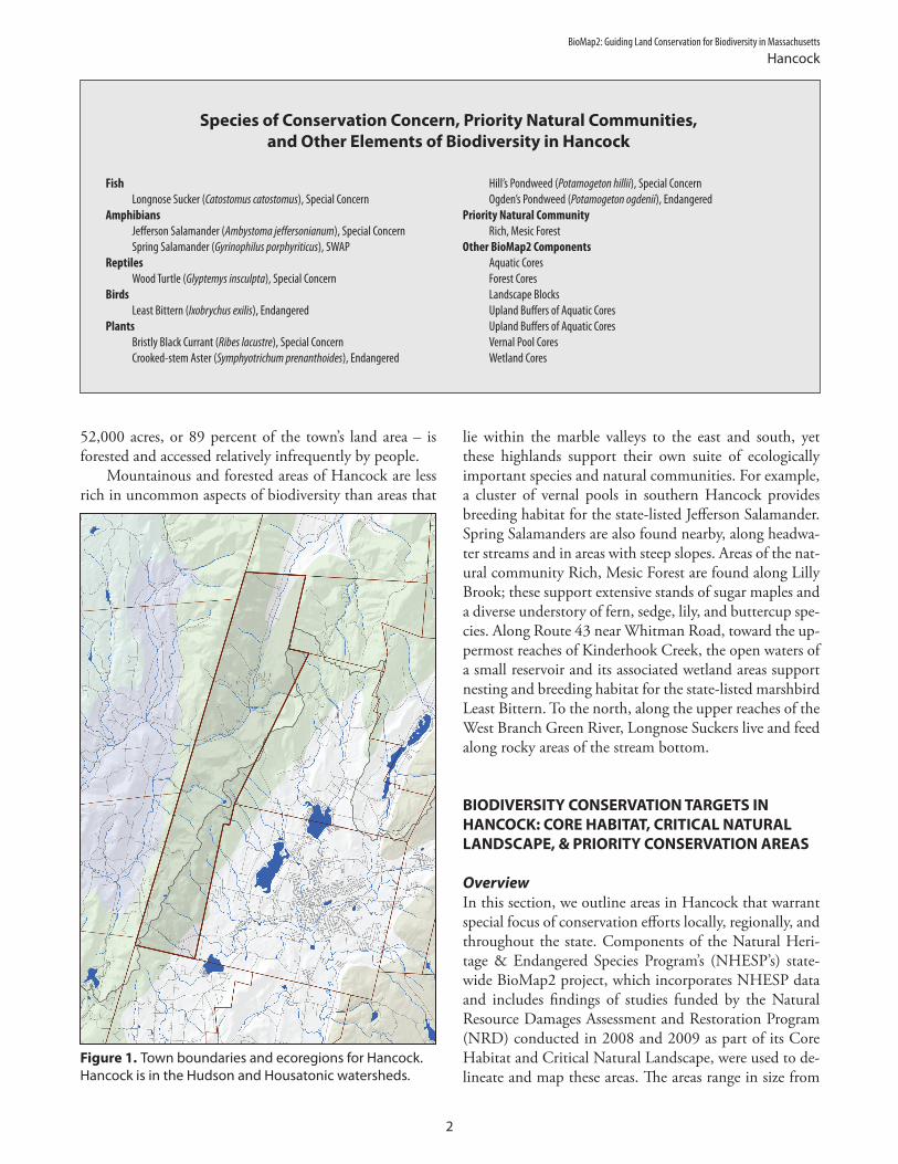
BioMap2 Guiding Land Conservation for Biodiversity in Massachusetts
Hancock
52000 acres or 89 percent of the townrsquos land area ndash is forested and accessed relatively infrequently by people
Mountainous and forested areas of Hancock are less rich in uncommon aspects of biodiversity than areas that
lie within the marble valleys to the east and south yet these highlands support their own suite of ecologically important species and natural communities For example a cluster of vernal pools in southern Hancock provides breeding habitat for the state-listed Jefferson Salamander Spring Salamanders are also found nearby along headwa-ter streams and in areas with steep slopes Areas of the nat-ural community Rich Mesic Forest are found along Lilly Brook these support extensive stands of sugar maples and a diverse understory of fern sedge lily and buttercup spe-cies Along Route 43 near Whitman Road toward the up-permost reaches of Kinderhook Creek the open waters of a small reservoir and its associated wetland areas support nesting and breeding habitat for the state-listed marshbird Least Bittern To the north along the upper reaches of the West Branch Green River Longnose Suckers live and feed along rocky areas of the stream bottom
Species of Conservation Concern Priority Natural Communities and Other Elements of Biodiversity in Hancock
Fish Hillrsquos Pondweed (Potamogeton hillii) Special Concern Longnose Sucker (Catostomus catostomus) Special Concern Ogdenrsquos Pondweed (Potamogeton ogdenii) Endangered
Amphibians Priority Natural Community Jefferson Salamander (Ambystoma jeffersonianum) Special Concern Rich Mesic Forest Spring Salamander (Gyrinophilus porphyriticus) SWAP Other BioMap2 Components
Reptiles Aquatic Cores Wood Turtle (Glyptemys insculpta) Special Concern Forest Cores
Birds Landscape Blocks Least Bittern (Ixobrychus exilis) Endangered Upland Buffers of Aquatic Cores
Plants Upland Buffers of Aquatic Cores Bristly Black Currant (Ribes lacustre) Special Concern Vernal Pool Cores Crooked-stem Aster (Symphyotrichum prenanthoides) Endangered Wetland Cores
Western New England Marble Valleys Taconic Mountains
Berkshire Highlands Taconic Foothills Rensselaer Plateau
ECOREGIONS
HANCOCK
N
RICHMOND
PITTSFIELD
LANESBOROUGH
NEW ASHFORD
WILLIAMSTOWN
CHESHIRE
N E
W
Y
O R
K
Onota Lake
W est
B r
H
ousa
toni
c Ri
v er
E ast B r H ousatonic Riv er
Pontoosuc Lake
Kind
er ho
ok C
r eek
W B
r Gr ee
n Ri
ver
Wyo
man
cok
Cree
k
Jiminy Peak Ski Area
Kinderhook
Creek
Hudson River Watershed
Housatonic River Watershed
To wn B r ook
Bentley Broo
k
Daniels Bk
Churchill Bk
Whitman Bk
BRODIE MOUNTAIN
MISERY
MOUNTAIN
Lulu Brook
Berry Pond Bk
E ast
B r oo
k
W est
B r o
ok
Lily Brook
May Brook
Smith BrookParker Brook
Mt Lebanon Brook
Shaker Brook
Pine Mtn
Tower Mtn
Smith Mtn
Honwee Mtn
Widow Whites Pk
Mt Lebanon
Shaker Mtn
G reen Riv er
Stony Ledge
Mt Prospect
Saddle Ball Mtn
Rounds Rock
Savage Hill
Oak Hill
Perry Peak
T A C O N I C
R A N G E
ROUNDS
MTN
PITTSFIELD STATE FOREST
PITTSFIELD STATE FOREST
MT GREYLOCKSTATE RESERVATION
Hancock
North Hancock
Pittsfield
Figure 1 Town boundaries and ecoregions for Hancock Hancock is in the Hudson and Housatonic watersheds
BIODIVERSITY CONSERVATION TARGETS IN HANCOCK CORE HABITAT CRITICAL NATURAL LANDSCAPE amp PRIORITY CONSERVATION AREAS
Overview In this section we outline areas in Hancock that warrant special focus of conservation efforts locally regionally and throughout the state Components of the Natural Heri-tage amp Endangered Species Programrsquos (NHESPrsquos) state-wide BioMap2 project which incorporates NHESP data and includes findings of studies funded by the Natural Resource Damages Assessment and Restoration Program (NRD) conducted in 2008 and 2009 as part of its Core Habitat and Critical Natural Landscape were used to de-lineate and map these areas The areas range in size from
2
BioMap2 Guiding Land Conservation for Biodiversity in Massachusetts
Hancock
fewer than 10 acres to several thousand acres Areas of Core Habitat each called a BioMap2 Core (BC) and ar-eas of Critical Natural Landscape (CNL) along with their associated components are illustrated in Figure 2 and out-lined in detail below BioMap2 components described in this report are those that occur only in Hancock although a given area of Core Habitat or Critical Natural Land-scape listed here may extend outside the town boundaries of Hancock and contain additional components
To facilitate land protection and stewardship NHESP further prioritized areas in each of the towns in the water-shed using habitat size habitat conditions and other bio-diversity indicators Priority Conservation Areas (PCAs) were considered to be of high biodiversity value if they contained concentrations of state-listed species or Priority Natural Communities or large areas of intact habitat In each town a total of one to six Town PCAs were selected Each Town PCA contains part of at least one BioMap2 Core in Hancock three Town PCAs were selected Fig-ure 3 illustrates how BioMap2 Core Habitat and Criti-cal Natural Landscape relate to the distribution of Town PCAs in Hancock
In addition to the Town PCAs a larger scale prioriti-zation was conducted to select Regional PCAs of the high-
est conservation and stewardship value among all towns in Massachusettsrsquo portion of the Housatonic River water-shed Regional PCAs often cross town boundaries and are quite large ranging from 373 acres to more than 25000 acres Ecological connectivity within these Regional PCAs is important to biodiversity conservation and these large units often include select Town PCAs that are of particu-lar biodiversity value to both the town and the region In this way biodiversity can be conserved at two scales locally within each town and within a broader regional context In Hancock Regional PCA 7 encompasses much of the northeastern and southern portions of the town including Town PCA 1 and Town PCA 3 which together contain thousands of acres of state forest in the Taconic Mountains
3
Biodiversity Studies in Massachusetts and the Housatonic River Watershed
BioMap2 is a statewide biodiversity conservation plan produced in 2010 by MassWildlifersquos Natural Heritage amp Endan-gered Species Program and The Nature Conservancy It is designed to guide strategic biodiversity conservation in Mas-sachusetts over the next decade by focusing land protection and stewardship on the areas that are most critical for ensuring the long-term persistence of rare and other native species and their habitats Priority Natural Communities and a diversity of ecosystems BioMap2 is also designed to include the habitats and Species of Conservation Concern identified in the State Wildlife Action Plan (SWAP)
BioMap2 identifies two complementary spatial layers Core Habitat and Critical Natural Landscape Core Habitat identi-fies key areas that are critical for the long-term persistence of rare species and other Species of Conservation Concern as well as a wide diversity of natural communities and intact ecosystems across the Commonwealth Protection of Core Habitats will contribute to the conservation of specific elements of biodiversity Critical Natural Landscape identi-fies large Landscape Blocks that are minimally impacted by development If protected these areas will provide habitat for wide-ranging native species support intact ecological processes maintain connectivity among habitats and en-hance ecological resilience to natural and anthropogenic disturbances in a rapidly changing world Areas delineated as Critical Natural Landscape also include buffering upland around wetland coastal and aquatic Core Habitats to help ensure their long-term integrity
In 2008 and 2009 field surveys were carried out to improve knowledge of the regionrsquos biodiversity resources in towns in the Housatonic River watershed in western Massachusetts During these surveys coordinated by the Natural Heri-tage and Endangered Species Program (NHESP) with funds from the Natural Resources Damage Assessment and Res-toration (NRD) Program researchers collected important information about state-listed species and Priority Natural Communities of 19 towns in the region Surveys were conducted by NHESP staff expert consultants academic re-searchers and graduate students Information on the surveysrsquo findings was added to the NHESP database combined with other NHESP data and incorporated into Core Habitat of BioMap2 BioMap2 data layers complete with these data and other information are now available for use in conservation planning at the town regional and state levels
Core Habitat and Critical Natural Landscape Components in Hancock Areas of Core Habitat in Hancock called BioMap2 Cores (BCs) are summarized here as are the various compo-nents of each BC which may include Species of Conser-vation Concern Exemplary and Priority Natural Com-munities and Aquatic Forest Vernal Pool or Wetland Cores Components of Critical Natural Landscape (CNL) associated with each BC are also provided These include Upland Buffers of Aquatic and Wetland Cores as well as Landscape Blocks
Overview of CNLs in Hancock Most BioMap2 Cores in Hancock Lanesborough and the northern areas of Pittsfield Dalton and Windsor are part of CNL1332 This CNL totals nearly 85000 acres and falls almost entirely within the Taconic Mountains and Berkshire Highlands ecoregions Elevations in these regions are typically well above 1000 feet with peaks reaching higher than 2000 feet The land is largely forest-ed and aquatic ecosystems consist primarily of headwater wetlands and streams Like other CNLs CNL1332 con-sists of large Landscape Blocks as well as Upland Buffers of Wetland and Aquatic Cores in certain areas At 1104 acres CNL1169 is relatively small compared to other CNLs in the region and consists of only one BioMap2 core BC2437 It falls on the eastern slopes of Rounds Mountain along the boundary with New York State and supports a moderate-size Forest Core
BC2191 and CNL1332 BC2191 is a 23-acre area bordering west Main Street just across the state line from New Lebanon NY It is part of an Upland Buffer of Aquatic Core and Landscape Block in CNL1332 BC2191 includes one state-listed plant
BC2341 and CNL1332 BC2341 lies mostly in Hancock although parts of this BC are also in Lanesborough and Pittsfield with a very small extension south into Richmond In Hancock this core contains a variety of important biodiversity elements characteristic of many highland areas in the Housatonic River watershed It is heavily forested with a large area of Forest Core (8239 acres) and includes six Wetland Cores that cover an area of 73 total acres It includes Aquatic Cores along Kinderhook Creek and its tributaries and Mount Lebanon Brook in the very southern part of the town CNL1332 has Upland Buffers around the Aquatic and Wetland Cores An 85-acre Vernal Pool Core is also part of this BC In Hancock BC2341 supports two un-common salamander species two state-listed plant spe-cies and one Priority Natural Community
BioMap2 Guiding Land Conservation for Biodiversity in Massachusetts
Hancock
Amphibians Spring Salamander (Gyrinophilus porphyriticus) SWAP Spring Salamanders inhabit clean cold high-gradient brooks and headwater seeps in forest habitat usually at elevations above 300 feet Larvae are entirely aquatic and largely nocturnal spending daylight hours buried below the streambed or hidden under stones Adults are semi-aquatic and spend most of their time under cover objects along the margins of brooks springs and seeps however they will venture into upland for-est during rainy weather In BC2341 this salamander is documented along the upper reaches of Parker and Lulu Brooks Jefferson Salamander (Ambystoma jeffersonianum) Special Concern Jefferson Salamanders inhabit upland forest during most of the year where they reside in small-mammal burrows and other subsurface retreats Adults migrate during late winter or early spring to breed in vernal pools and fish-free areas of swamps marshes or similar wetlands Larvae metamorphose in late summer or early fall then disperse into upland forest These sala-manders are documented from a 395-acre area in the southern portion of BC2341 close to Certified Vernal Pools along the headwaters of Shaker Brook
Plants Bristly Black Currant (Ribes lacustre) Special Concern This short shrub grows at fairly high elevations near streams seeps and swamps in rich cool and moist woods and sometimes on ledges Crooked-stem Aster (Symphyotrichum prenanthoides) Threat-ened (recommended rank change to Special Concern in 2011) This perennial herbaceous plant grows in rich soils in open to semi-open conditions along rivers streams and seeps In BC2341 it occurs just north of BC2191 (where it is also documented)
Priority Natural Community Rich Mesic Forest Community (Vulnerable) This Priority Natural Community is a variant of northern hardwood forest that is dominated by sugar maple with diverse herbaceous plants It typically includes many spring wild flowers and occurs in moist nutrient-rich environ-ments It occurs in the western part of BC2341 in two small areas that total seven acres along Lily Brook
BC2437 and CNL1169 BC2437 lies within a 1102-acre Landscape Block in CNL1169 This area is in west-central Hancock along the townrsquos boundary with New York The core consists of one moderate-sized (595-acre) Forest Core as well as the upper reaches of Whitman Brook watershed which drains into Kinderhook Creek
4
BC2191
Kinderhook Creek
W B
r Gree
n Ri
ver
Shaker Brook
Kinderhook Creek
W B
r Gree
n Ri
ver
Shaker Brook
BioMap2 Guiding Land Conservation for Biodiversity in Massachusetts
Hancock
Figure 2 Hancock includes a total of six BioMap2 Cores (BCs left) and two areas of Critical Natural Landscape (CNL right)
BC2487 and CNL1332 BC2487 includes a small part of Hancockrsquos northern val-ley and the headwaters of Kinderhook Creek It falls with-in Aquatic and Upland Buffers of CNL1332 and is also part of a large Landscape Block This BC includes many BioMap2 core components including a 97-acre Aquatic Core and three adjacent Wetland Cores that make up 66 acres These components encompass a reservoir that is formed by a dam at the downstream end of the core near Whitman Road BC2487 includes two aquatic plants and one marsh bird species
Plants Hillrsquos Pondweed (Potamogeton hillii) Special Concern This submersed aquatic plant grows best in cold shallow slow-moving and clean alkaline bodies of water on muddy substrates It occurs throughout aquatic areas in BC2487 as well as in adjacent wetlands Ogdenrsquos Pondweed (Potamogeton ogdenii) Endangered This species is an annual aquatic herb with submersed leaves that grows in shallow alkaline still or very slow-moving waters Like Hillrsquos Pondweed it grows in aquatic and wetland areas throughout BC2487
Bird Least Bittern (Ixobrychus exilis) Endangered Least Bitterns are wading heron-like birds that typically nest in cat-tail marshes interspersed with open water They are very sensitive to disturbances from pollution such as siltation and chemical insecticides and to the estab-lishment of invasive plants like Phragmites and Purple Loosestrife that do well in disturbed areas
BC2955 and CNL1332 BC2955 consists of a single 2433 acre Forest Core and lies in northwest Hancock within a Landscape Block of CNL1332
BC2979 and CNL1332 BC2979 includes the West Branch Green River and much of the upper reaches of Kinderhook Creek These streams and their riparian areas each form an Aquatic Core and are surrounded by Upland Buffers of CNL1332 This core also includes a Forest Core in CNL1332rsquos Landscape Block that covers Brodie Mountain in northeast Hancock its land drains west into both the West Branch Green Riv-er and Kinderhook Creek BC2979 also includes a small
5
BioMap2 Guiding Land Conservation for Biodiversity in Massachusetts
Hancock
Wetland Core at its very northern edge near the bound-ary with Williamstown Two state-listed animal species one fish and one turtle are documented in BC2979
Fish Longnose Sucker (Catostomus catostomus) Special Concern This torpedo-shaped fish has a snout extending beyond its downturned mouth It is typically found in cool lower-order streams and rivers with rocky substrates These fish rely on clean and well oxygenated gravel sub-strates to rear their eggs In Massachusetts they only oc-cur in the western part of the state and are documented throughout the Green River in Hancock
Reptiles Wood Turtle (Glyptemys insculpta) Special Concern Wood Turtle habitat consists of streams and rivers preferably with long corridors of undeveloped connected uplands extending on both sides of the waterways Riparian ar-eas in this core are both large and interconnected thus providing excellent habitat for this species
Core
Hab
itat +
Criti
cal N
atur
al La
ndsc
ape
Regio
nal P
riorit
y Con
serv
ation
Area
s To
wn Pr
iority
Cons
erva
tion A
reas
Figure 3 Core Habitat (dark green) Critical Natural Land-scape (light green) Town Priority Conservation Areas (PCAs reddish-brown grid) and Regional Priority Conservation Areas (black) in Hancock Town PCAs make up 17963 acres or 785 percent of the townrsquos total area Regional PCAs make up 13461 acres or 588 percent of the townrsquos total area
Priority Conservation Areas in Hancock The town of Hancock contains three areas identified as Priority Conservation Areas (PCAs) by NHESP All three are Town PCAs and two are part of a larger Regional PCA
Town PCA 1Regional PCA 7 Town PCA 1 in Hancock is part of Regional PCA 7 which includes over 20000 acres in Hancock and western Pittsfield and Lanesborough This Regional PCA contains areas of extensive and relatively undisturbed forest habitat It also includes the watersheds of several headwater streams those that flow to Kinder-hook Creek and the West Branch Green River in Han-cock to the Southwest Branch Housatonic River and Onota Brook in Pittsfield and to Secum Brook in Lanes-borough Town PCA 1 includes both the mountains of BC2341 and a portion of CNL1332 At approximately 164 square miles in size it is Hancockrsquos largest Town PCA and encompasses a large area of Forest Core and Wetland Cores all embedded in a Landscape Block It also supports populations of two state-listed salamanders and two state-listed plant species as well as areas of the Priority Natural Community Rich Mesic Forest along Lilly Brook Several
6
headwater streams of the Housatonic River flow east from this area and eventually meet the mainstem of that river in Pittsfield A total of 9609 acres of this Town PCA (917 percent of it) is protected in perpetuity primarily as part of Pittsfield State Forest
Town PCA 2 Hancockrsquos second Town PCA is located in the northwest portion of the town and is defined by two Forest Cores embedded within Landscape Blocks in CNL1169 and CNL1332 It includes headwaters of the Green River in the north and headwaters of Kinderhook Creek in the south In this Town PCA 1716 acres or 38 percent of its area is protected by various land holdings including the Taconic Train State Forest and Hancock Wildlife Management Area
Town PCA 3Regional PCA 7 Hancockrsquos third Town PCA is located in the northeast part of the town Like Town PCA 1 it is part of the larger Regional PCA 7 described above It encompasses 2965 acres on Brodie Mountain and its western slopes that drain to the Green River and Kinder-hook Creek in Hancock It also includes BC2979 and its fairly extensive Forest Core The reservoir and associated wetland areas in upper Kinderhook Creek as well as sec-tions of the Green River are also part of this PCA Of Hancockrsquos three Town PCAs this one contains the small-est amount of protected land only 723 acres or 24 per-cent of its area is protected in perpetuity
BioMap2 Guiding Land Conservation for Biodiversity in Massachusetts
Hancock
7
Glossary
Aquatic Cores (in BioMap2 a component of Core Habitat) include intact river corridors within which important physi-cal and ecological processes of the river or stream occur delineated using integrated and functional ecosystems for fish species and other aquatic Species of Conservation Concern To identify those areas integrally connected to each river and stream each river segment was buffered 30 meters All wetlands wholly or partially contained within this buffer were then included and the combination of the river channel the adjacent buffer and the connected wet-lands make up this riverine Core Habitat
BioMap2 Cores (BCs) (called Core Habitats in BioMap2) identify key areas that are critical for the long-term per-sistence of rare species and other Species of Conservation Concern as well as a wide diversity of natural communities and intact ecosystems across the Commonwealth Protec-tion of Core Habitats will contribute to the conservation of specific elements of biodiversity
Certified Vernal Pools are temporary ponds or other fish-less wetlands that meet certain biological and physical criteria to be classified as essential breeding habitat for a number of amphibian and invertebrate species such as Wood Frog Spotted Salamander Blue-spotted Salamander Jefferson Salamander Marbled Salamander and Intricate Fairy Shrimp The certification of vernal pool habitat in The Commonwealth is administered by the Natural Heritage amp Endangered Species Program A number of regulations in-corporate protections for certified vernal pools (please see httpwwwmassgovdfweledfwnhespvernal_pools pdfvpcertpdf for more information)
Critical Natural Landscape (CNL) (part of BioMap2) iden-tifies large natural landscape areas that are minimally impacted by development If protected these areas will provide habitat for wide-ranging native species support intact ecological processes maintain connectivity among habitats and enhance ecological resilience to natural and anthropogenic disturbances in a rapidly changing world Areas delineated as Critical Natural Landscape also include buffering upland around wetland coastal and aquatic Core Habitats to help ensure their long-term integrity
Cobbles are small hills or rocky knolls made of marble and quartzite The alkaline soils derived from the calcareous rocks support a distinct and diverse flora Examples include Bartholomewrsquos Cobble in southern Sheffield and Tyring-ham Cobble in Tyringham
Critically Imperiled natural communities typically have five or fewer documented sites or have very few remain-
ing acres in the state Natural Community types ranked as Critically Imperiled are in the Priority Natural Communities category
Disturbance in an ecological sense is an event that dis-rupts the normal structure and function of an ecosystem Disturbances often produce bare soil and openings in for-ests where rapidly growing sun-loving species including invasive exotic species can grow Human activities have accelerated the number and types of disturbances in many ecosystems
Ecoregions are areas of relatively homogeneous ecologi-cal systems including vegetation soils climate geology and patterns of human uses
Endangered species are in danger of extinction through-out all or a significant portion of their range or are in dan-ger of extirpation from Massachusetts Endangered is a cat-egory of state-listed species defined in the Massachusetts Endangered Species Act (MGL c131A) and listed in its regulations (321 CMR 1000)
Exemplary Natural Communities are the best examples documented of relatively common (Secure) types of natu-ral communities
Forest Cores (in BioMap2 a component of Core Habitat) identify the best examples of large intact forests that are least impacted by roads and development providing criti-cal ldquoforest interiorrdquohabitat for numerous woodland species
Fragmented Landscape in ecological and conservation terms refers to the idea that a large spatial area (the land-scape) that in the past might have had connected habitats (for example unbroken forest continuous river or undis-rupted grasslands) have become interspersed with arti-facts of human development that alter habitat and ecologi-cal processes ndash or that the human influence has come to dominate the land leaving patches or fragments of natural habitat surrounded by development
Imperiled communities typically have 6-20 sites or few remaining acres in the state Natural Community types ranked as Imperiled are included in the Priority Natural Communities category
Landscape Blocks (component of BioMap2 Critical Natu-ral Landscape) the primary component of Critical Natural Landscape are large areas of intact and predominately nat-ural vegetation consisting of contiguous forests wetland rivers lakes and ponds as well as coastal habitats such as
A-1
barrier beaches and salt marshes Pastures and power-line right-of-way which are less intensively altered than most developed areas were also included since they provide habitat and connectivity for many species
Landscape Context refers to taking the broadest view of the ability of ecosystems or species populations to main-tain themselves where they are by considering the siting within the larger area For example a wooded area within a city park has a very different urban context than a wooded area on a farm
MESA (Massachusetts Endangered Species Act) (MGL c131A) and its implementing regulations (321 CMR 1000) provide regulatory protection of rare species and their habitats MESA protects rare species and their habitats by prohibiting the ldquoTakerdquo of any plant or animal species listed as Endangered Threatened or Special Concern by the MA Division of Fisheries amp Wildlife
Natural Communities are assemblages of species that oc-cur together in space and time These groups of plants and animals are found in recurring patterns that are classified and described by their dominant biological and physical features
Nymphs sometimes informally referred to as larvae are the young immature form of dragonflies and some other invertebrates Dragonfly nymphs are aquatic On maturing they change into the flying terrestrial adults that are seen along rivers and lakes and nearby uplands
Priority Natural Communities include types of natural communities with limited distribution or relatively few oc-currences andor low acreages in Massachusetts
Protected in Perpetuity refers to land owned as conserva-tion land by a public entity in Massachusetts whose lands come under the authority of Massachusetts Constitution Article 97 or federal land owned by a federal conservation agency or by a non-profit dedicated to land conservation or for which the conservation values have been protected by legal restrictions on the deed or by a conservation ease-ment (conservation restriction)
Secure types of natural communities typically have over 100 sites or abundant acreage across the state excellent examples are identified as Core Habitat to ensure contin-ued protection and are referred to as Exemplary Natural Communities
Special Concern species have suffered a decline that could threaten the species if allowed to continue unchecked or occur in such small numbers or with such restricted dis-tribution or specialized habitat requirements that they could easily become Threatened in Massachusetts Special Concern is a category of state-listed species defined in the
Massachusetts Endangered Species Act (MGL c131A) and listed in its regulations (321 CMR 1000)
Species of Conservation Concern (in BioMap2 a compo-nent of Core Habitat) include those species that meet the criteria for listing under the Massachusetts Endangered Species Act as well as a number of species that do not meet these criteria for listing but are considered to be of conservation concern within Massachusetts such as inclu-sion in the State Wildlife Action Plan (SWAP)
State-listed Species are species listed under the Massa-chusetts Endangered Species Act (MGL c131A) and its regulations (321 CMR 1000) ndash that is Endangered Threat-ened or Special Concern species
SWAP (State Wildlife Action Plan) approved in 2006 the Massachusetts Division of Fisheries and Wildlifersquos State Wildlife Conservation Strategy most often referred to as the State Wildlife Action Plan (SWAP) is a comprehensive document to help guide wildlife conservation decision making for Massachusettsrsquo wildlife for many years
SWAP Species were identified as being those in greatest need of conservation in the Massachusetts Division of Fish-eries and WildlifersquoState Wildlife Conservation Strategy most often referred to as the State Wildlife Action Plan (SWAP)
Threatened species are likely to become Endangered in Massachusetts in the foreseeable future throughout all or a significant portion of their range Threatened is a category of state-listed species defined in the Massachusetts Endan-gered Species Act (MGL c131A) and listed in its regula-tions (321 CMR 1000)
Upland Buffers of Aquatic Cores (component of Bio-Map2rsquos Critical Natural Landscape) identify protective up-land areas adjacent to all Aquatic Cores A variable width buffer that extends deeper into surrounding unfragment-ed habitats than into developed areas was used to include the most intact areas around Aquatic Cores The conser-vation of wetland buffers will support habitats and func-tionality of each aquatic area and also include adjacent uplands that are important for many species that move between habitat types
Upland Buffer of Wetland Cores (component of BioMap2rsquos Critical Natural Landscape) identify protective upland areas adjacent to all Wetland Cores A variable-width buffer that extends deeper into surrounding unfragmented habitats than into developed areas was used to include the most intact areas around the Wetland Cores The conservation of wetland buffers will support habitats and functionality of each wetland and also include adjacent uplands that are important for many species that move between habitat types
A-2
Variant of a natural community refers to a named subtype of a more broadly defined type of community In Massa-chusetts the term is not a formal designation but rather is intended as an aid for understanding community relation-ships
Vernal Pools also known as ephemeral pools autumnal pools and temporary woodland ponds typically fill with water in the autumn or winter due to rainfall and rising groundwater and remain ponded through the spring and into summer They usually dry completely by the middle or end of summer each year Vernal pools are unique wildlife habitats best known for the amphibians and invertebrate animals that use them to breed
Vernal Pool Cores (BioMap2 component of Core Habitat) identify based on a GIS model the highest quality most in-terconnected clusters of Potential Vernal Pools (a dataset of likely vernal pools identified from interpretation of aerial photographs) and the habitat between them
Vulnerable communities typically have 21-100 sites or limited acreage across the state Natural Community types ranked as Vulnerable are in the Priority Natural Communi-ties category
Wetland Cores (BioMap2 component of Core Habitat) identify based on a GIS model the least disturbed wet-lands within undeveloped landscapesmdashthose with intact buffers and little fragmentation or other stressors associat-ed development These wetlands are most likely to support critical wetland functions (ie natural hydrologic condi-tions diverse plant and animal habitats etc) and are most likely to maintain these functions into the future
A-3
Help Save Endangered WildlifePlease contribute on your Massachusetts income tax form or directly to the
Natural Heritage amp Endangered Species Fund
To learn more about the Natural Heritage amp Endangered Species Programand the Commonwealthrsquos rare species visit our web site at wwwnhesporg
- Hancock reportpdf
- Glossary
-
BioMap2 Guiding Land Conservation for Biodiversity in Massachusetts
Hancock
fewer than 10 acres to several thousand acres Areas of Core Habitat each called a BioMap2 Core (BC) and ar-eas of Critical Natural Landscape (CNL) along with their associated components are illustrated in Figure 2 and out-lined in detail below BioMap2 components described in this report are those that occur only in Hancock although a given area of Core Habitat or Critical Natural Land-scape listed here may extend outside the town boundaries of Hancock and contain additional components
To facilitate land protection and stewardship NHESP further prioritized areas in each of the towns in the water-shed using habitat size habitat conditions and other bio-diversity indicators Priority Conservation Areas (PCAs) were considered to be of high biodiversity value if they contained concentrations of state-listed species or Priority Natural Communities or large areas of intact habitat In each town a total of one to six Town PCAs were selected Each Town PCA contains part of at least one BioMap2 Core in Hancock three Town PCAs were selected Fig-ure 3 illustrates how BioMap2 Core Habitat and Criti-cal Natural Landscape relate to the distribution of Town PCAs in Hancock
In addition to the Town PCAs a larger scale prioriti-zation was conducted to select Regional PCAs of the high-
est conservation and stewardship value among all towns in Massachusettsrsquo portion of the Housatonic River water-shed Regional PCAs often cross town boundaries and are quite large ranging from 373 acres to more than 25000 acres Ecological connectivity within these Regional PCAs is important to biodiversity conservation and these large units often include select Town PCAs that are of particu-lar biodiversity value to both the town and the region In this way biodiversity can be conserved at two scales locally within each town and within a broader regional context In Hancock Regional PCA 7 encompasses much of the northeastern and southern portions of the town including Town PCA 1 and Town PCA 3 which together contain thousands of acres of state forest in the Taconic Mountains
3
Biodiversity Studies in Massachusetts and the Housatonic River Watershed
BioMap2 is a statewide biodiversity conservation plan produced in 2010 by MassWildlifersquos Natural Heritage amp Endan-gered Species Program and The Nature Conservancy It is designed to guide strategic biodiversity conservation in Mas-sachusetts over the next decade by focusing land protection and stewardship on the areas that are most critical for ensuring the long-term persistence of rare and other native species and their habitats Priority Natural Communities and a diversity of ecosystems BioMap2 is also designed to include the habitats and Species of Conservation Concern identified in the State Wildlife Action Plan (SWAP)
BioMap2 identifies two complementary spatial layers Core Habitat and Critical Natural Landscape Core Habitat identi-fies key areas that are critical for the long-term persistence of rare species and other Species of Conservation Concern as well as a wide diversity of natural communities and intact ecosystems across the Commonwealth Protection of Core Habitats will contribute to the conservation of specific elements of biodiversity Critical Natural Landscape identi-fies large Landscape Blocks that are minimally impacted by development If protected these areas will provide habitat for wide-ranging native species support intact ecological processes maintain connectivity among habitats and en-hance ecological resilience to natural and anthropogenic disturbances in a rapidly changing world Areas delineated as Critical Natural Landscape also include buffering upland around wetland coastal and aquatic Core Habitats to help ensure their long-term integrity
In 2008 and 2009 field surveys were carried out to improve knowledge of the regionrsquos biodiversity resources in towns in the Housatonic River watershed in western Massachusetts During these surveys coordinated by the Natural Heri-tage and Endangered Species Program (NHESP) with funds from the Natural Resources Damage Assessment and Res-toration (NRD) Program researchers collected important information about state-listed species and Priority Natural Communities of 19 towns in the region Surveys were conducted by NHESP staff expert consultants academic re-searchers and graduate students Information on the surveysrsquo findings was added to the NHESP database combined with other NHESP data and incorporated into Core Habitat of BioMap2 BioMap2 data layers complete with these data and other information are now available for use in conservation planning at the town regional and state levels
Core Habitat and Critical Natural Landscape Components in Hancock Areas of Core Habitat in Hancock called BioMap2 Cores (BCs) are summarized here as are the various compo-nents of each BC which may include Species of Conser-vation Concern Exemplary and Priority Natural Com-munities and Aquatic Forest Vernal Pool or Wetland Cores Components of Critical Natural Landscape (CNL) associated with each BC are also provided These include Upland Buffers of Aquatic and Wetland Cores as well as Landscape Blocks
Overview of CNLs in Hancock Most BioMap2 Cores in Hancock Lanesborough and the northern areas of Pittsfield Dalton and Windsor are part of CNL1332 This CNL totals nearly 85000 acres and falls almost entirely within the Taconic Mountains and Berkshire Highlands ecoregions Elevations in these regions are typically well above 1000 feet with peaks reaching higher than 2000 feet The land is largely forest-ed and aquatic ecosystems consist primarily of headwater wetlands and streams Like other CNLs CNL1332 con-sists of large Landscape Blocks as well as Upland Buffers of Wetland and Aquatic Cores in certain areas At 1104 acres CNL1169 is relatively small compared to other CNLs in the region and consists of only one BioMap2 core BC2437 It falls on the eastern slopes of Rounds Mountain along the boundary with New York State and supports a moderate-size Forest Core
BC2191 and CNL1332 BC2191 is a 23-acre area bordering west Main Street just across the state line from New Lebanon NY It is part of an Upland Buffer of Aquatic Core and Landscape Block in CNL1332 BC2191 includes one state-listed plant
BC2341 and CNL1332 BC2341 lies mostly in Hancock although parts of this BC are also in Lanesborough and Pittsfield with a very small extension south into Richmond In Hancock this core contains a variety of important biodiversity elements characteristic of many highland areas in the Housatonic River watershed It is heavily forested with a large area of Forest Core (8239 acres) and includes six Wetland Cores that cover an area of 73 total acres It includes Aquatic Cores along Kinderhook Creek and its tributaries and Mount Lebanon Brook in the very southern part of the town CNL1332 has Upland Buffers around the Aquatic and Wetland Cores An 85-acre Vernal Pool Core is also part of this BC In Hancock BC2341 supports two un-common salamander species two state-listed plant spe-cies and one Priority Natural Community
BioMap2 Guiding Land Conservation for Biodiversity in Massachusetts
Hancock
Amphibians Spring Salamander (Gyrinophilus porphyriticus) SWAP Spring Salamanders inhabit clean cold high-gradient brooks and headwater seeps in forest habitat usually at elevations above 300 feet Larvae are entirely aquatic and largely nocturnal spending daylight hours buried below the streambed or hidden under stones Adults are semi-aquatic and spend most of their time under cover objects along the margins of brooks springs and seeps however they will venture into upland for-est during rainy weather In BC2341 this salamander is documented along the upper reaches of Parker and Lulu Brooks Jefferson Salamander (Ambystoma jeffersonianum) Special Concern Jefferson Salamanders inhabit upland forest during most of the year where they reside in small-mammal burrows and other subsurface retreats Adults migrate during late winter or early spring to breed in vernal pools and fish-free areas of swamps marshes or similar wetlands Larvae metamorphose in late summer or early fall then disperse into upland forest These sala-manders are documented from a 395-acre area in the southern portion of BC2341 close to Certified Vernal Pools along the headwaters of Shaker Brook
Plants Bristly Black Currant (Ribes lacustre) Special Concern This short shrub grows at fairly high elevations near streams seeps and swamps in rich cool and moist woods and sometimes on ledges Crooked-stem Aster (Symphyotrichum prenanthoides) Threat-ened (recommended rank change to Special Concern in 2011) This perennial herbaceous plant grows in rich soils in open to semi-open conditions along rivers streams and seeps In BC2341 it occurs just north of BC2191 (where it is also documented)
Priority Natural Community Rich Mesic Forest Community (Vulnerable) This Priority Natural Community is a variant of northern hardwood forest that is dominated by sugar maple with diverse herbaceous plants It typically includes many spring wild flowers and occurs in moist nutrient-rich environ-ments It occurs in the western part of BC2341 in two small areas that total seven acres along Lily Brook
BC2437 and CNL1169 BC2437 lies within a 1102-acre Landscape Block in CNL1169 This area is in west-central Hancock along the townrsquos boundary with New York The core consists of one moderate-sized (595-acre) Forest Core as well as the upper reaches of Whitman Brook watershed which drains into Kinderhook Creek
4
BC2191
Kinderhook Creek
W B
r Gree
n Ri
ver
Shaker Brook
Kinderhook Creek
W B
r Gree
n Ri
ver
Shaker Brook
BioMap2 Guiding Land Conservation for Biodiversity in Massachusetts
Hancock
Figure 2 Hancock includes a total of six BioMap2 Cores (BCs left) and two areas of Critical Natural Landscape (CNL right)
BC2487 and CNL1332 BC2487 includes a small part of Hancockrsquos northern val-ley and the headwaters of Kinderhook Creek It falls with-in Aquatic and Upland Buffers of CNL1332 and is also part of a large Landscape Block This BC includes many BioMap2 core components including a 97-acre Aquatic Core and three adjacent Wetland Cores that make up 66 acres These components encompass a reservoir that is formed by a dam at the downstream end of the core near Whitman Road BC2487 includes two aquatic plants and one marsh bird species
Plants Hillrsquos Pondweed (Potamogeton hillii) Special Concern This submersed aquatic plant grows best in cold shallow slow-moving and clean alkaline bodies of water on muddy substrates It occurs throughout aquatic areas in BC2487 as well as in adjacent wetlands Ogdenrsquos Pondweed (Potamogeton ogdenii) Endangered This species is an annual aquatic herb with submersed leaves that grows in shallow alkaline still or very slow-moving waters Like Hillrsquos Pondweed it grows in aquatic and wetland areas throughout BC2487
Bird Least Bittern (Ixobrychus exilis) Endangered Least Bitterns are wading heron-like birds that typically nest in cat-tail marshes interspersed with open water They are very sensitive to disturbances from pollution such as siltation and chemical insecticides and to the estab-lishment of invasive plants like Phragmites and Purple Loosestrife that do well in disturbed areas
BC2955 and CNL1332 BC2955 consists of a single 2433 acre Forest Core and lies in northwest Hancock within a Landscape Block of CNL1332
BC2979 and CNL1332 BC2979 includes the West Branch Green River and much of the upper reaches of Kinderhook Creek These streams and their riparian areas each form an Aquatic Core and are surrounded by Upland Buffers of CNL1332 This core also includes a Forest Core in CNL1332rsquos Landscape Block that covers Brodie Mountain in northeast Hancock its land drains west into both the West Branch Green Riv-er and Kinderhook Creek BC2979 also includes a small
5
BioMap2 Guiding Land Conservation for Biodiversity in Massachusetts
Hancock
Wetland Core at its very northern edge near the bound-ary with Williamstown Two state-listed animal species one fish and one turtle are documented in BC2979
Fish Longnose Sucker (Catostomus catostomus) Special Concern This torpedo-shaped fish has a snout extending beyond its downturned mouth It is typically found in cool lower-order streams and rivers with rocky substrates These fish rely on clean and well oxygenated gravel sub-strates to rear their eggs In Massachusetts they only oc-cur in the western part of the state and are documented throughout the Green River in Hancock
Reptiles Wood Turtle (Glyptemys insculpta) Special Concern Wood Turtle habitat consists of streams and rivers preferably with long corridors of undeveloped connected uplands extending on both sides of the waterways Riparian ar-eas in this core are both large and interconnected thus providing excellent habitat for this species
Core
Hab
itat +
Criti
cal N
atur
al La
ndsc
ape
Regio
nal P
riorit
y Con
serv
ation
Area
s To
wn Pr
iority
Cons
erva
tion A
reas
Figure 3 Core Habitat (dark green) Critical Natural Land-scape (light green) Town Priority Conservation Areas (PCAs reddish-brown grid) and Regional Priority Conservation Areas (black) in Hancock Town PCAs make up 17963 acres or 785 percent of the townrsquos total area Regional PCAs make up 13461 acres or 588 percent of the townrsquos total area
Priority Conservation Areas in Hancock The town of Hancock contains three areas identified as Priority Conservation Areas (PCAs) by NHESP All three are Town PCAs and two are part of a larger Regional PCA
Town PCA 1Regional PCA 7 Town PCA 1 in Hancock is part of Regional PCA 7 which includes over 20000 acres in Hancock and western Pittsfield and Lanesborough This Regional PCA contains areas of extensive and relatively undisturbed forest habitat It also includes the watersheds of several headwater streams those that flow to Kinder-hook Creek and the West Branch Green River in Han-cock to the Southwest Branch Housatonic River and Onota Brook in Pittsfield and to Secum Brook in Lanes-borough Town PCA 1 includes both the mountains of BC2341 and a portion of CNL1332 At approximately 164 square miles in size it is Hancockrsquos largest Town PCA and encompasses a large area of Forest Core and Wetland Cores all embedded in a Landscape Block It also supports populations of two state-listed salamanders and two state-listed plant species as well as areas of the Priority Natural Community Rich Mesic Forest along Lilly Brook Several
6
headwater streams of the Housatonic River flow east from this area and eventually meet the mainstem of that river in Pittsfield A total of 9609 acres of this Town PCA (917 percent of it) is protected in perpetuity primarily as part of Pittsfield State Forest
Town PCA 2 Hancockrsquos second Town PCA is located in the northwest portion of the town and is defined by two Forest Cores embedded within Landscape Blocks in CNL1169 and CNL1332 It includes headwaters of the Green River in the north and headwaters of Kinderhook Creek in the south In this Town PCA 1716 acres or 38 percent of its area is protected by various land holdings including the Taconic Train State Forest and Hancock Wildlife Management Area
Town PCA 3Regional PCA 7 Hancockrsquos third Town PCA is located in the northeast part of the town Like Town PCA 1 it is part of the larger Regional PCA 7 described above It encompasses 2965 acres on Brodie Mountain and its western slopes that drain to the Green River and Kinder-hook Creek in Hancock It also includes BC2979 and its fairly extensive Forest Core The reservoir and associated wetland areas in upper Kinderhook Creek as well as sec-tions of the Green River are also part of this PCA Of Hancockrsquos three Town PCAs this one contains the small-est amount of protected land only 723 acres or 24 per-cent of its area is protected in perpetuity
BioMap2 Guiding Land Conservation for Biodiversity in Massachusetts
Hancock
7
Glossary
Aquatic Cores (in BioMap2 a component of Core Habitat) include intact river corridors within which important physi-cal and ecological processes of the river or stream occur delineated using integrated and functional ecosystems for fish species and other aquatic Species of Conservation Concern To identify those areas integrally connected to each river and stream each river segment was buffered 30 meters All wetlands wholly or partially contained within this buffer were then included and the combination of the river channel the adjacent buffer and the connected wet-lands make up this riverine Core Habitat
BioMap2 Cores (BCs) (called Core Habitats in BioMap2) identify key areas that are critical for the long-term per-sistence of rare species and other Species of Conservation Concern as well as a wide diversity of natural communities and intact ecosystems across the Commonwealth Protec-tion of Core Habitats will contribute to the conservation of specific elements of biodiversity
Certified Vernal Pools are temporary ponds or other fish-less wetlands that meet certain biological and physical criteria to be classified as essential breeding habitat for a number of amphibian and invertebrate species such as Wood Frog Spotted Salamander Blue-spotted Salamander Jefferson Salamander Marbled Salamander and Intricate Fairy Shrimp The certification of vernal pool habitat in The Commonwealth is administered by the Natural Heritage amp Endangered Species Program A number of regulations in-corporate protections for certified vernal pools (please see httpwwwmassgovdfweledfwnhespvernal_pools pdfvpcertpdf for more information)
Critical Natural Landscape (CNL) (part of BioMap2) iden-tifies large natural landscape areas that are minimally impacted by development If protected these areas will provide habitat for wide-ranging native species support intact ecological processes maintain connectivity among habitats and enhance ecological resilience to natural and anthropogenic disturbances in a rapidly changing world Areas delineated as Critical Natural Landscape also include buffering upland around wetland coastal and aquatic Core Habitats to help ensure their long-term integrity
Cobbles are small hills or rocky knolls made of marble and quartzite The alkaline soils derived from the calcareous rocks support a distinct and diverse flora Examples include Bartholomewrsquos Cobble in southern Sheffield and Tyring-ham Cobble in Tyringham
Critically Imperiled natural communities typically have five or fewer documented sites or have very few remain-
ing acres in the state Natural Community types ranked as Critically Imperiled are in the Priority Natural Communities category
Disturbance in an ecological sense is an event that dis-rupts the normal structure and function of an ecosystem Disturbances often produce bare soil and openings in for-ests where rapidly growing sun-loving species including invasive exotic species can grow Human activities have accelerated the number and types of disturbances in many ecosystems
Ecoregions are areas of relatively homogeneous ecologi-cal systems including vegetation soils climate geology and patterns of human uses
Endangered species are in danger of extinction through-out all or a significant portion of their range or are in dan-ger of extirpation from Massachusetts Endangered is a cat-egory of state-listed species defined in the Massachusetts Endangered Species Act (MGL c131A) and listed in its regulations (321 CMR 1000)
Exemplary Natural Communities are the best examples documented of relatively common (Secure) types of natu-ral communities
Forest Cores (in BioMap2 a component of Core Habitat) identify the best examples of large intact forests that are least impacted by roads and development providing criti-cal ldquoforest interiorrdquohabitat for numerous woodland species
Fragmented Landscape in ecological and conservation terms refers to the idea that a large spatial area (the land-scape) that in the past might have had connected habitats (for example unbroken forest continuous river or undis-rupted grasslands) have become interspersed with arti-facts of human development that alter habitat and ecologi-cal processes ndash or that the human influence has come to dominate the land leaving patches or fragments of natural habitat surrounded by development
Imperiled communities typically have 6-20 sites or few remaining acres in the state Natural Community types ranked as Imperiled are included in the Priority Natural Communities category
Landscape Blocks (component of BioMap2 Critical Natu-ral Landscape) the primary component of Critical Natural Landscape are large areas of intact and predominately nat-ural vegetation consisting of contiguous forests wetland rivers lakes and ponds as well as coastal habitats such as
A-1
barrier beaches and salt marshes Pastures and power-line right-of-way which are less intensively altered than most developed areas were also included since they provide habitat and connectivity for many species
Landscape Context refers to taking the broadest view of the ability of ecosystems or species populations to main-tain themselves where they are by considering the siting within the larger area For example a wooded area within a city park has a very different urban context than a wooded area on a farm
MESA (Massachusetts Endangered Species Act) (MGL c131A) and its implementing regulations (321 CMR 1000) provide regulatory protection of rare species and their habitats MESA protects rare species and their habitats by prohibiting the ldquoTakerdquo of any plant or animal species listed as Endangered Threatened or Special Concern by the MA Division of Fisheries amp Wildlife
Natural Communities are assemblages of species that oc-cur together in space and time These groups of plants and animals are found in recurring patterns that are classified and described by their dominant biological and physical features
Nymphs sometimes informally referred to as larvae are the young immature form of dragonflies and some other invertebrates Dragonfly nymphs are aquatic On maturing they change into the flying terrestrial adults that are seen along rivers and lakes and nearby uplands
Priority Natural Communities include types of natural communities with limited distribution or relatively few oc-currences andor low acreages in Massachusetts
Protected in Perpetuity refers to land owned as conserva-tion land by a public entity in Massachusetts whose lands come under the authority of Massachusetts Constitution Article 97 or federal land owned by a federal conservation agency or by a non-profit dedicated to land conservation or for which the conservation values have been protected by legal restrictions on the deed or by a conservation ease-ment (conservation restriction)
Secure types of natural communities typically have over 100 sites or abundant acreage across the state excellent examples are identified as Core Habitat to ensure contin-ued protection and are referred to as Exemplary Natural Communities
Special Concern species have suffered a decline that could threaten the species if allowed to continue unchecked or occur in such small numbers or with such restricted dis-tribution or specialized habitat requirements that they could easily become Threatened in Massachusetts Special Concern is a category of state-listed species defined in the
Massachusetts Endangered Species Act (MGL c131A) and listed in its regulations (321 CMR 1000)
Species of Conservation Concern (in BioMap2 a compo-nent of Core Habitat) include those species that meet the criteria for listing under the Massachusetts Endangered Species Act as well as a number of species that do not meet these criteria for listing but are considered to be of conservation concern within Massachusetts such as inclu-sion in the State Wildlife Action Plan (SWAP)
State-listed Species are species listed under the Massa-chusetts Endangered Species Act (MGL c131A) and its regulations (321 CMR 1000) ndash that is Endangered Threat-ened or Special Concern species
SWAP (State Wildlife Action Plan) approved in 2006 the Massachusetts Division of Fisheries and Wildlifersquos State Wildlife Conservation Strategy most often referred to as the State Wildlife Action Plan (SWAP) is a comprehensive document to help guide wildlife conservation decision making for Massachusettsrsquo wildlife for many years
SWAP Species were identified as being those in greatest need of conservation in the Massachusetts Division of Fish-eries and WildlifersquoState Wildlife Conservation Strategy most often referred to as the State Wildlife Action Plan (SWAP)
Threatened species are likely to become Endangered in Massachusetts in the foreseeable future throughout all or a significant portion of their range Threatened is a category of state-listed species defined in the Massachusetts Endan-gered Species Act (MGL c131A) and listed in its regula-tions (321 CMR 1000)
Upland Buffers of Aquatic Cores (component of Bio-Map2rsquos Critical Natural Landscape) identify protective up-land areas adjacent to all Aquatic Cores A variable width buffer that extends deeper into surrounding unfragment-ed habitats than into developed areas was used to include the most intact areas around Aquatic Cores The conser-vation of wetland buffers will support habitats and func-tionality of each aquatic area and also include adjacent uplands that are important for many species that move between habitat types
Upland Buffer of Wetland Cores (component of BioMap2rsquos Critical Natural Landscape) identify protective upland areas adjacent to all Wetland Cores A variable-width buffer that extends deeper into surrounding unfragmented habitats than into developed areas was used to include the most intact areas around the Wetland Cores The conservation of wetland buffers will support habitats and functionality of each wetland and also include adjacent uplands that are important for many species that move between habitat types
A-2
Variant of a natural community refers to a named subtype of a more broadly defined type of community In Massa-chusetts the term is not a formal designation but rather is intended as an aid for understanding community relation-ships
Vernal Pools also known as ephemeral pools autumnal pools and temporary woodland ponds typically fill with water in the autumn or winter due to rainfall and rising groundwater and remain ponded through the spring and into summer They usually dry completely by the middle or end of summer each year Vernal pools are unique wildlife habitats best known for the amphibians and invertebrate animals that use them to breed
Vernal Pool Cores (BioMap2 component of Core Habitat) identify based on a GIS model the highest quality most in-terconnected clusters of Potential Vernal Pools (a dataset of likely vernal pools identified from interpretation of aerial photographs) and the habitat between them
Vulnerable communities typically have 21-100 sites or limited acreage across the state Natural Community types ranked as Vulnerable are in the Priority Natural Communi-ties category
Wetland Cores (BioMap2 component of Core Habitat) identify based on a GIS model the least disturbed wet-lands within undeveloped landscapesmdashthose with intact buffers and little fragmentation or other stressors associat-ed development These wetlands are most likely to support critical wetland functions (ie natural hydrologic condi-tions diverse plant and animal habitats etc) and are most likely to maintain these functions into the future
A-3
Help Save Endangered WildlifePlease contribute on your Massachusetts income tax form or directly to the
Natural Heritage amp Endangered Species Fund
To learn more about the Natural Heritage amp Endangered Species Programand the Commonwealthrsquos rare species visit our web site at wwwnhesporg
- Hancock reportpdf
- Glossary
-

BioMap2 Guiding Land Conservation for Biodiversity in Massachusetts
Hancock
Wetland Core at its very northern edge near the bound-ary with Williamstown Two state-listed animal species one fish and one turtle are documented in BC2979
Fish Longnose Sucker (Catostomus catostomus) Special Concern This torpedo-shaped fish has a snout extending beyond its downturned mouth It is typically found in cool lower-order streams and rivers with rocky substrates These fish rely on clean and well oxygenated gravel sub-strates to rear their eggs In Massachusetts they only oc-cur in the western part of the state and are documented throughout the Green River in Hancock
Reptiles Wood Turtle (Glyptemys insculpta) Special Concern Wood Turtle habitat consists of streams and rivers preferably with long corridors of undeveloped connected uplands extending on both sides of the waterways Riparian ar-eas in this core are both large and interconnected thus providing excellent habitat for this species
Core
Hab
itat +
Criti
cal N
atur
al La
ndsc
ape
Regio
nal P
riorit
y Con
serv
ation
Area
s To
wn Pr
iority
Cons
erva
tion A
reas
Figure 3 Core Habitat (dark green) Critical Natural Land-scape (light green) Town Priority Conservation Areas (PCAs reddish-brown grid) and Regional Priority Conservation Areas (black) in Hancock Town PCAs make up 17963 acres or 785 percent of the townrsquos total area Regional PCAs make up 13461 acres or 588 percent of the townrsquos total area
Priority Conservation Areas in Hancock The town of Hancock contains three areas identified as Priority Conservation Areas (PCAs) by NHESP All three are Town PCAs and two are part of a larger Regional PCA
Town PCA 1Regional PCA 7 Town PCA 1 in Hancock is part of Regional PCA 7 which includes over 20000 acres in Hancock and western Pittsfield and Lanesborough This Regional PCA contains areas of extensive and relatively undisturbed forest habitat It also includes the watersheds of several headwater streams those that flow to Kinder-hook Creek and the West Branch Green River in Han-cock to the Southwest Branch Housatonic River and Onota Brook in Pittsfield and to Secum Brook in Lanes-borough Town PCA 1 includes both the mountains of BC2341 and a portion of CNL1332 At approximately 164 square miles in size it is Hancockrsquos largest Town PCA and encompasses a large area of Forest Core and Wetland Cores all embedded in a Landscape Block It also supports populations of two state-listed salamanders and two state-listed plant species as well as areas of the Priority Natural Community Rich Mesic Forest along Lilly Brook Several
6
headwater streams of the Housatonic River flow east from this area and eventually meet the mainstem of that river in Pittsfield A total of 9609 acres of this Town PCA (917 percent of it) is protected in perpetuity primarily as part of Pittsfield State Forest
Town PCA 2 Hancockrsquos second Town PCA is located in the northwest portion of the town and is defined by two Forest Cores embedded within Landscape Blocks in CNL1169 and CNL1332 It includes headwaters of the Green River in the north and headwaters of Kinderhook Creek in the south In this Town PCA 1716 acres or 38 percent of its area is protected by various land holdings including the Taconic Train State Forest and Hancock Wildlife Management Area
Town PCA 3Regional PCA 7 Hancockrsquos third Town PCA is located in the northeast part of the town Like Town PCA 1 it is part of the larger Regional PCA 7 described above It encompasses 2965 acres on Brodie Mountain and its western slopes that drain to the Green River and Kinder-hook Creek in Hancock It also includes BC2979 and its fairly extensive Forest Core The reservoir and associated wetland areas in upper Kinderhook Creek as well as sec-tions of the Green River are also part of this PCA Of Hancockrsquos three Town PCAs this one contains the small-est amount of protected land only 723 acres or 24 per-cent of its area is protected in perpetuity
BioMap2 Guiding Land Conservation for Biodiversity in Massachusetts
Hancock
7
Glossary
Aquatic Cores (in BioMap2 a component of Core Habitat) include intact river corridors within which important physi-cal and ecological processes of the river or stream occur delineated using integrated and functional ecosystems for fish species and other aquatic Species of Conservation Concern To identify those areas integrally connected to each river and stream each river segment was buffered 30 meters All wetlands wholly or partially contained within this buffer were then included and the combination of the river channel the adjacent buffer and the connected wet-lands make up this riverine Core Habitat
BioMap2 Cores (BCs) (called Core Habitats in BioMap2) identify key areas that are critical for the long-term per-sistence of rare species and other Species of Conservation Concern as well as a wide diversity of natural communities and intact ecosystems across the Commonwealth Protec-tion of Core Habitats will contribute to the conservation of specific elements of biodiversity
Certified Vernal Pools are temporary ponds or other fish-less wetlands that meet certain biological and physical criteria to be classified as essential breeding habitat for a number of amphibian and invertebrate species such as Wood Frog Spotted Salamander Blue-spotted Salamander Jefferson Salamander Marbled Salamander and Intricate Fairy Shrimp The certification of vernal pool habitat in The Commonwealth is administered by the Natural Heritage amp Endangered Species Program A number of regulations in-corporate protections for certified vernal pools (please see httpwwwmassgovdfweledfwnhespvernal_pools pdfvpcertpdf for more information)
Critical Natural Landscape (CNL) (part of BioMap2) iden-tifies large natural landscape areas that are minimally impacted by development If protected these areas will provide habitat for wide-ranging native species support intact ecological processes maintain connectivity among habitats and enhance ecological resilience to natural and anthropogenic disturbances in a rapidly changing world Areas delineated as Critical Natural Landscape also include buffering upland around wetland coastal and aquatic Core Habitats to help ensure their long-term integrity
Cobbles are small hills or rocky knolls made of marble and quartzite The alkaline soils derived from the calcareous rocks support a distinct and diverse flora Examples include Bartholomewrsquos Cobble in southern Sheffield and Tyring-ham Cobble in Tyringham
Critically Imperiled natural communities typically have five or fewer documented sites or have very few remain-
ing acres in the state Natural Community types ranked as Critically Imperiled are in the Priority Natural Communities category
Disturbance in an ecological sense is an event that dis-rupts the normal structure and function of an ecosystem Disturbances often produce bare soil and openings in for-ests where rapidly growing sun-loving species including invasive exotic species can grow Human activities have accelerated the number and types of disturbances in many ecosystems
Ecoregions are areas of relatively homogeneous ecologi-cal systems including vegetation soils climate geology and patterns of human uses
Endangered species are in danger of extinction through-out all or a significant portion of their range or are in dan-ger of extirpation from Massachusetts Endangered is a cat-egory of state-listed species defined in the Massachusetts Endangered Species Act (MGL c131A) and listed in its regulations (321 CMR 1000)
Exemplary Natural Communities are the best examples documented of relatively common (Secure) types of natu-ral communities
Forest Cores (in BioMap2 a component of Core Habitat) identify the best examples of large intact forests that are least impacted by roads and development providing criti-cal ldquoforest interiorrdquohabitat for numerous woodland species
Fragmented Landscape in ecological and conservation terms refers to the idea that a large spatial area (the land-scape) that in the past might have had connected habitats (for example unbroken forest continuous river or undis-rupted grasslands) have become interspersed with arti-facts of human development that alter habitat and ecologi-cal processes ndash or that the human influence has come to dominate the land leaving patches or fragments of natural habitat surrounded by development
Imperiled communities typically have 6-20 sites or few remaining acres in the state Natural Community types ranked as Imperiled are included in the Priority Natural Communities category
Landscape Blocks (component of BioMap2 Critical Natu-ral Landscape) the primary component of Critical Natural Landscape are large areas of intact and predominately nat-ural vegetation consisting of contiguous forests wetland rivers lakes and ponds as well as coastal habitats such as
A-1
barrier beaches and salt marshes Pastures and power-line right-of-way which are less intensively altered than most developed areas were also included since they provide habitat and connectivity for many species
Landscape Context refers to taking the broadest view of the ability of ecosystems or species populations to main-tain themselves where they are by considering the siting within the larger area For example a wooded area within a city park has a very different urban context than a wooded area on a farm
MESA (Massachusetts Endangered Species Act) (MGL c131A) and its implementing regulations (321 CMR 1000) provide regulatory protection of rare species and their habitats MESA protects rare species and their habitats by prohibiting the ldquoTakerdquo of any plant or animal species listed as Endangered Threatened or Special Concern by the MA Division of Fisheries amp Wildlife
Natural Communities are assemblages of species that oc-cur together in space and time These groups of plants and animals are found in recurring patterns that are classified and described by their dominant biological and physical features
Nymphs sometimes informally referred to as larvae are the young immature form of dragonflies and some other invertebrates Dragonfly nymphs are aquatic On maturing they change into the flying terrestrial adults that are seen along rivers and lakes and nearby uplands
Priority Natural Communities include types of natural communities with limited distribution or relatively few oc-currences andor low acreages in Massachusetts
Protected in Perpetuity refers to land owned as conserva-tion land by a public entity in Massachusetts whose lands come under the authority of Massachusetts Constitution Article 97 or federal land owned by a federal conservation agency or by a non-profit dedicated to land conservation or for which the conservation values have been protected by legal restrictions on the deed or by a conservation ease-ment (conservation restriction)
Secure types of natural communities typically have over 100 sites or abundant acreage across the state excellent examples are identified as Core Habitat to ensure contin-ued protection and are referred to as Exemplary Natural Communities
Special Concern species have suffered a decline that could threaten the species if allowed to continue unchecked or occur in such small numbers or with such restricted dis-tribution or specialized habitat requirements that they could easily become Threatened in Massachusetts Special Concern is a category of state-listed species defined in the
Massachusetts Endangered Species Act (MGL c131A) and listed in its regulations (321 CMR 1000)
Species of Conservation Concern (in BioMap2 a compo-nent of Core Habitat) include those species that meet the criteria for listing under the Massachusetts Endangered Species Act as well as a number of species that do not meet these criteria for listing but are considered to be of conservation concern within Massachusetts such as inclu-sion in the State Wildlife Action Plan (SWAP)
State-listed Species are species listed under the Massa-chusetts Endangered Species Act (MGL c131A) and its regulations (321 CMR 1000) ndash that is Endangered Threat-ened or Special Concern species
SWAP (State Wildlife Action Plan) approved in 2006 the Massachusetts Division of Fisheries and Wildlifersquos State Wildlife Conservation Strategy most often referred to as the State Wildlife Action Plan (SWAP) is a comprehensive document to help guide wildlife conservation decision making for Massachusettsrsquo wildlife for many years
SWAP Species were identified as being those in greatest need of conservation in the Massachusetts Division of Fish-eries and WildlifersquoState Wildlife Conservation Strategy most often referred to as the State Wildlife Action Plan (SWAP)
Threatened species are likely to become Endangered in Massachusetts in the foreseeable future throughout all or a significant portion of their range Threatened is a category of state-listed species defined in the Massachusetts Endan-gered Species Act (MGL c131A) and listed in its regula-tions (321 CMR 1000)
Upland Buffers of Aquatic Cores (component of Bio-Map2rsquos Critical Natural Landscape) identify protective up-land areas adjacent to all Aquatic Cores A variable width buffer that extends deeper into surrounding unfragment-ed habitats than into developed areas was used to include the most intact areas around Aquatic Cores The conser-vation of wetland buffers will support habitats and func-tionality of each aquatic area and also include adjacent uplands that are important for many species that move between habitat types
Upland Buffer of Wetland Cores (component of BioMap2rsquos Critical Natural Landscape) identify protective upland areas adjacent to all Wetland Cores A variable-width buffer that extends deeper into surrounding unfragmented habitats than into developed areas was used to include the most intact areas around the Wetland Cores The conservation of wetland buffers will support habitats and functionality of each wetland and also include adjacent uplands that are important for many species that move between habitat types
A-2
Variant of a natural community refers to a named subtype of a more broadly defined type of community In Massa-chusetts the term is not a formal designation but rather is intended as an aid for understanding community relation-ships
Vernal Pools also known as ephemeral pools autumnal pools and temporary woodland ponds typically fill with water in the autumn or winter due to rainfall and rising groundwater and remain ponded through the spring and into summer They usually dry completely by the middle or end of summer each year Vernal pools are unique wildlife habitats best known for the amphibians and invertebrate animals that use them to breed
Vernal Pool Cores (BioMap2 component of Core Habitat) identify based on a GIS model the highest quality most in-terconnected clusters of Potential Vernal Pools (a dataset of likely vernal pools identified from interpretation of aerial photographs) and the habitat between them
Vulnerable communities typically have 21-100 sites or limited acreage across the state Natural Community types ranked as Vulnerable are in the Priority Natural Communi-ties category
Wetland Cores (BioMap2 component of Core Habitat) identify based on a GIS model the least disturbed wet-lands within undeveloped landscapesmdashthose with intact buffers and little fragmentation or other stressors associat-ed development These wetlands are most likely to support critical wetland functions (ie natural hydrologic condi-tions diverse plant and animal habitats etc) and are most likely to maintain these functions into the future
A-3
Help Save Endangered WildlifePlease contribute on your Massachusetts income tax form or directly to the
Natural Heritage amp Endangered Species Fund
To learn more about the Natural Heritage amp Endangered Species Programand the Commonwealthrsquos rare species visit our web site at wwwnhesporg
- Hancock reportpdf
- Glossary
-