
A topographic earthwork surveyof Thynghowe.Hanger Hill, Nottinghamshire
Upload
emily-gillott-at-nccCategory
view
42download
1description

1
Hamilton Hill,
Sutton in Ashfield
Ursilla Spence
2
Contents Summary 1. Introduction 2. Site description, topography and geology 3. History of Land-use – cartographic and documentary references 4. Hamilton Hill –place name evidence. 5. Hamilton Hill within the wider landscape. 6. Consideration of possible site types 7. Conclusions . Acknowledgements Thanks are due to Tim Allen and English Heritage for the commission, and to the site owners, Robert and Jane Thompson for their help, encouragement and patience.
Written By Read by Signed off Report date and Revisions
UMS EG UMS 2010, 2012, 2015
Cover: extract from Sanderson’s map of Twenty Miles round Mansfield, 1835
3
Summary This report pulls together the results of several different pieces of work in an attempt to understand better the archaeological resource of Hamilton Hill, Sutton in Ashfield. Hamilton Hill is clearly something specific, but does not fit readily into any typical class of monument, and the topographic survey undertaken highlights this. In undertaking this work, we have become aware of a number of research issues which focus on our limited understanding of early medieval administrative structures. In particular, how areas were managed by pre-Danelaw local government, and how these were affected by the Danelaw and the Conquest. Domesday Book entries for Nottinghamshire make occasional reference to hundreds, while the shape and size of some of the Wapentakes recorded at Domesday seem unfeasible in practical terms. Nevertheless, Hamilton Hill bears similarity to a class of monument about which we are learning more all the time; the early medieval meeting place, moot or “thing”. As with previous studies of this particular monument, this report can offer no definitive answers, except possibly in terms of ruling out with some confidence certain types of monument class. In addition, the work has provided baseline data on ground conditions, particularly relevant in the areas where modern ground slumping is evident, and has provided fixed survey points which will allow a measure of monitoring control over ground movement into the future. 1. Introduction Hamilton Hill is a prominent landscape feature dominating a thin and diminishing green wedge between the urban sprawls of Mansfield, Kirkby in Ashfield, and Sutton in Ashfield, and centred on OS NGR SK 520555894. It is a scheduled monument (Nt133317), poorly understood, but variously identified as a motte, gallows or gibbet, prehistoric burial mound, or moot site, and lacking definitive evidence to be any of these. It lies within the parish and district of Sutton in Ashfield, but close to the boundary of the parish and district of Mansfield. It is ovoid in plan, with steeply sloping sides and a reasonably level hill top. The hill top has a roughly triangular depression approximately 2m deep, within which is a circular mound the upper surface of which is generally level with the hill top, i.e. it does not rise above the hill top. There are a number of pit-like hollows which are generally circular on the hill top with further pits and more irregular creases on the hill sides, while on the eastern slope of the hill there are clear signs of ground slippage or subsidence. The site owners report that the rate of subsidence has increased over the last few decades. EH commissioned NCC Archaeology in 2007 to undertake fresh survey and investigation of the site, in an attempt to understand better the archaeological resource, the possible causes of subsidence, and to propose recommendations for the future management of the site as appropriate. The work undertaken includes desk based assessment, detailed topographic survey, the fixing of 6 heavy duty survey pegs to allow ground slumping to be monitored and the excavation of three test pits. This work was undertaken by Emily Gillott, Andy Gaunt, Ben Crossley and Ursilla Spence, of Nottinghamshire County Council1. In addition ground penetrating radar survey and magnetometer survey was undertaken by Peter Masters of
1 Spence, 2010 (a) and (b)
4
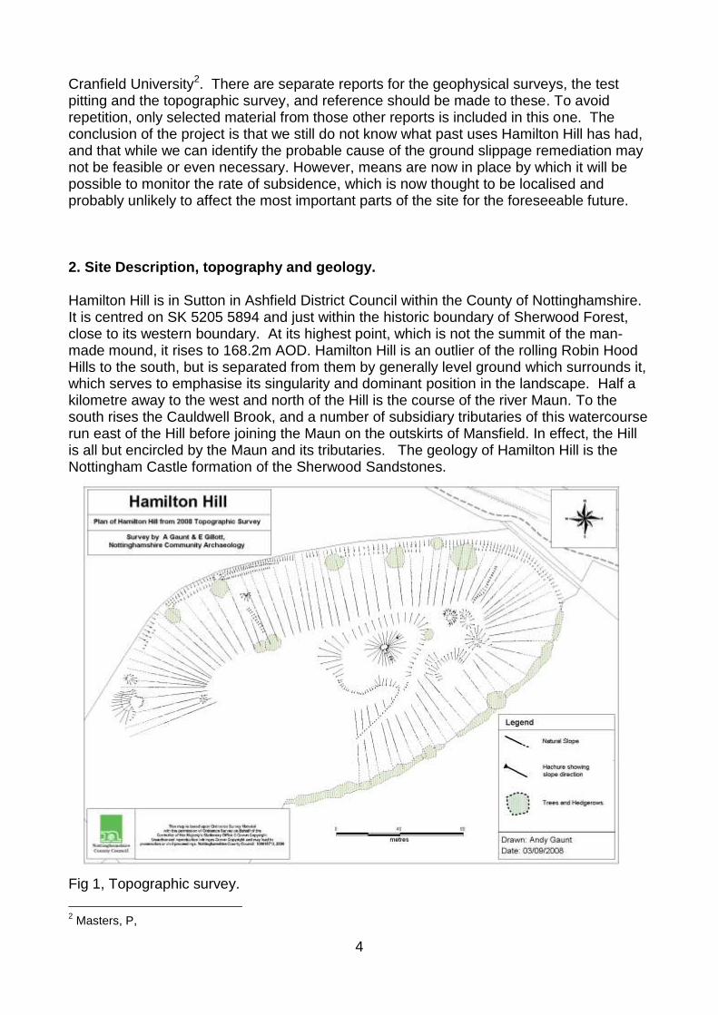
Cranfield University2. There are separate reports for the geophysical surveys, the test pitting and the topographic survey, and reference should be made to these. To avoid repetition, only selected material from those other reports is included in this one. The conclusion of the project is that we still do not know what past uses Hamilton Hill has had, and that while we can identify the probable cause of the ground slippage remediation may not be feasible or even necessary. However, means are now in place by which it will be possible to monitor the rate of subsidence, which is now thought to be localised and probably unlikely to affect the most important parts of the site for the foreseeable future. 2. Site Description, topography and geology. Hamilton Hill is in Sutton in Ashfield District Council within the County of Nottinghamshire. It is centred on SK 5205 5894 and just within the historic boundary of Sherwood Forest, close to its western boundary. At its highest point, which is not the summit of the man-made mound, it rises to 168.2m AOD. Hamilton Hill is an outlier of the rolling Robin Hood Hills to the south, but is separated from them by generally level ground which surrounds it, which serves to emphasise its singularity and dominant position in the landscape. Half a kilometre away to the west and north of the Hill is the course of the river Maun. To the south rises the Cauldwell Brook, and a number of subsidiary tributaries of this watercourse run east of the Hill before joining the Maun on the outskirts of Mansfield. In effect, the Hill is all but encircled by the Maun and its tributaries. The geology of Hamilton Hill is the Nottingham Castle formation of the Sherwood Sandstones.
Fig 1, Topographic survey.
2 Masters, P,
5
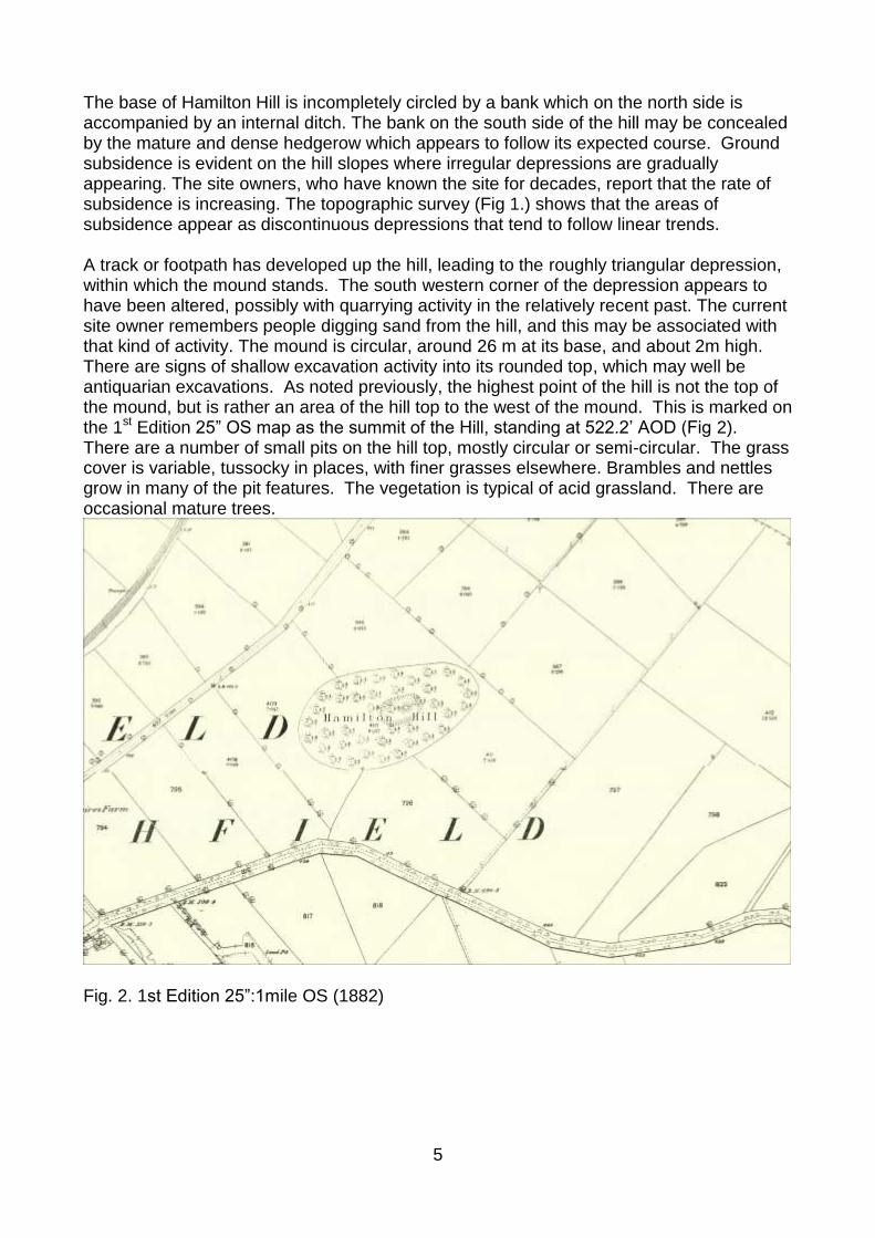
The base of Hamilton Hill is incompletely circled by a bank which on the north side is accompanied by an internal ditch. The bank on the south side of the hill may be concealed by the mature and dense hedgerow which appears to follow its expected course. Ground subsidence is evident on the hill slopes where irregular depressions are gradually appearing. The site owners, who have known the site for decades, report that the rate of subsidence is increasing. The topographic survey (Fig 1.) shows that the areas of subsidence appear as discontinuous depressions that tend to follow linear trends. A track or footpath has developed up the hill, leading to the roughly triangular depression, within which the mound stands. The south western corner of the depression appears to have been altered, possibly with quarrying activity in the relatively recent past. The current site owner remembers people digging sand from the hill, and this may be associated with that kind of activity. The mound is circular, around 26 m at its base, and about 2m high. There are signs of shallow excavation activity into its rounded top, which may well be antiquarian excavations. As noted previously, the highest point of the hill is not the top of the mound, but is rather an area of the hill top to the west of the mound. This is marked on the 1st Edition 25” OS map as the summit of the Hill, standing at 522.2’ AOD (Fig 2). There are a number of small pits on the hill top, mostly circular or semi-circular. The grass cover is variable, tussocky in places, with finer grasses elsewhere. Brambles and nettles grow in many of the pit features. The vegetation is typical of acid grassland. There are occasional mature trees.
Fig. 2. 1st Edition 25”:1mile OS (1882)
6
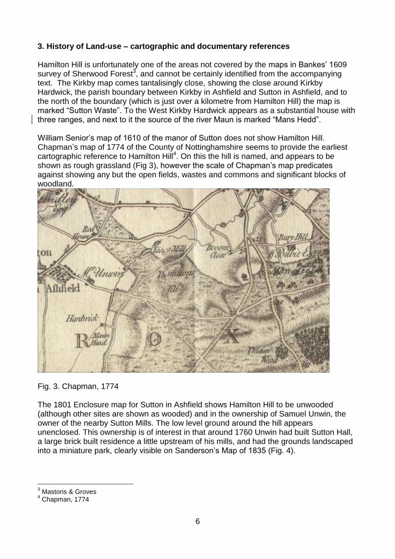
3. History of Land-use – cartographic and documentary references Hamilton Hill is unfortunately one of the areas not covered by the maps in Bankes’ 1609 survey of Sherwood Forest3, and cannot be certainly identified from the accompanying text. The Kirkby map comes tantalisingly close, showing the close around Kirkby Hardwick, the parish boundary between Kirkby in Ashfield and Sutton in Ashfield, and to the north of the boundary (which is just over a kilometre from Hamilton Hill) the map is marked “Sutton Waste”. To the West Kirkby Hardwick appears as a substantial house with three ranges, and next to it the source of the river Maun is marked “Mans Hedd”. William Senior’s map of 1610 of the manor of Sutton does not show Hamilton Hill. Chapman’s map of 1774 of the County of Nottinghamshire seems to provide the earliest cartographic reference to Hamilton Hill4. On this the hill is named, and appears to be shown as rough grassland (Fig 3), however the scale of Chapman’s map predicates against showing any but the open fields, wastes and commons and significant blocks of woodland.
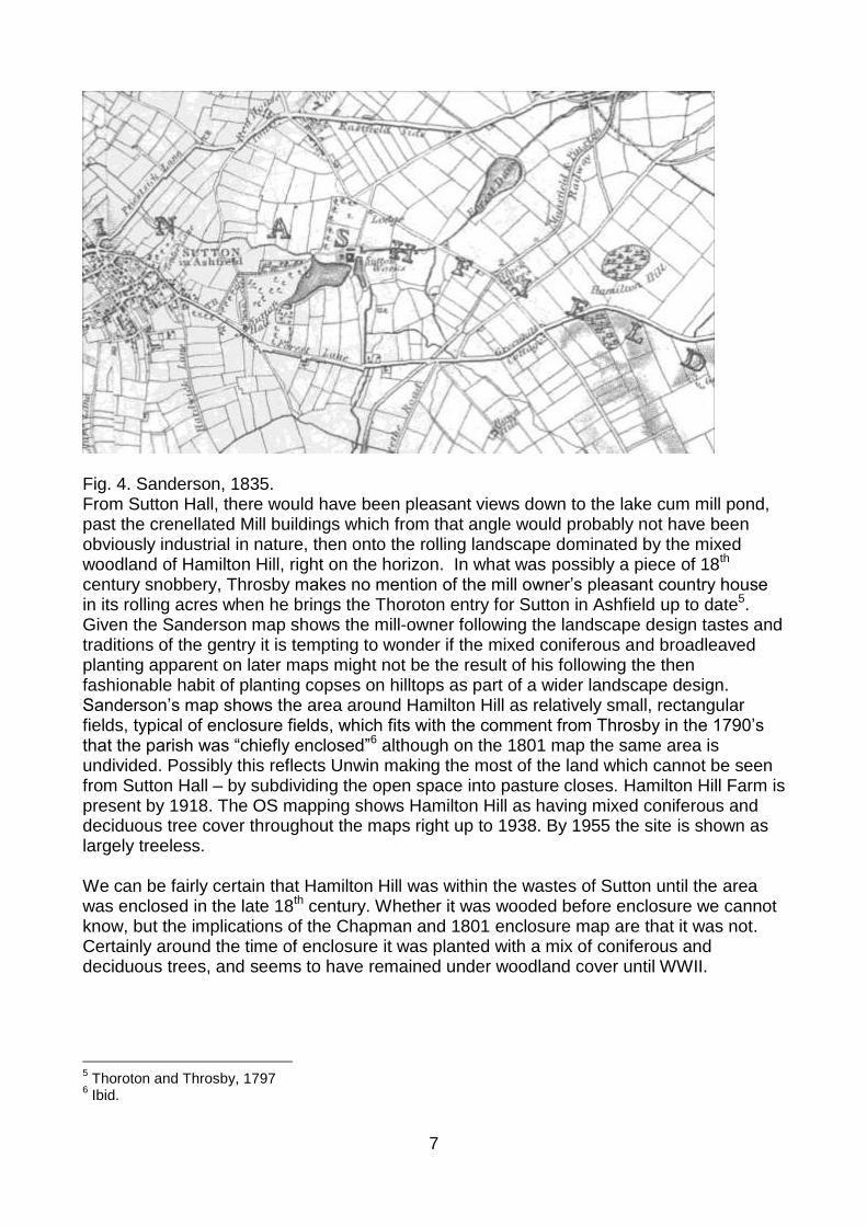
Fig. 3. Chapman, 1774 The 1801 Enclosure map for Sutton in Ashfield shows Hamilton Hill to be unwooded (although other sites are shown as wooded) and in the ownership of Samuel Unwin, the owner of the nearby Sutton Mills. The low level ground around the hill appears unenclosed. This ownership is of interest in that around 1760 Unwin had built Sutton Hall, a large brick built residence a little upstream of his mills, and had the grounds landscaped into a miniature park, clearly visible on Sanderson’s Map of 1835 (Fig. 4).
3 Mastoris & Groves
4 Chapman, 1774
7
Fig. 4. Sanderson, 1835. From Sutton Hall, there would have been pleasant views down to the lake cum mill pond, past the crenellated Mill buildings which from that angle would probably not have been obviously industrial in nature, then onto the rolling landscape dominated by the mixed woodland of Hamilton Hill, right on the horizon. In what was possibly a piece of 18th century snobbery, Throsby makes no mention of the mill owner’s pleasant country house in its rolling acres when he brings the Thoroton entry for Sutton in Ashfield up to date5. Given the Sanderson map shows the mill-owner following the landscape design tastes and traditions of the gentry it is tempting to wonder if the mixed coniferous and broadleaved planting apparent on later maps might not be the result of his following the then fashionable habit of planting copses on hilltops as part of a wider landscape design. Sanderson’s map shows the area around Hamilton Hill as relatively small, rectangular fields, typical of enclosure fields, which fits with the comment from Throsby in the 1790’s that the parish was “chiefly enclosed”6 although on the 1801 map the same area is undivided. Possibly this reflects Unwin making the most of the land which cannot be seen from Sutton Hall – by subdividing the open space into pasture closes. Hamilton Hill Farm is present by 1918. The OS mapping shows Hamilton Hill as having mixed coniferous and deciduous tree cover throughout the maps right up to 1938. By 1955 the site is shown as largely treeless. We can be fairly certain that Hamilton Hill was within the wastes of Sutton until the area was enclosed in the late 18th century. Whether it was wooded before enclosure we cannot know, but the implications of the Chapman and 1801 enclosure map are that it was not. Certainly around the time of enclosure it was planted with a mix of coniferous and deciduous trees, and seems to have remained under woodland cover until WWII.
5 Thoroton and Throsby, 1797
6 Ibid.
8
4. Hamilton Hill –place name evidence. The earliest documentary reference to Hamilton Hill appears to be Chapman’s map of 1774. This seems to be the first certain piece of documentary evidence that anyone had noticed this large sandstone knoll which dominates the skyline for a few kilometres around. As far as it is possible to tell Hamilton Hill does not seem to have attracted documentary attention from antiquarians. The exception to this is the local historian G.G. Bonser, who commented on the lack of investigation or interest in such a prominent landscape feature when writing in the first half of the 20th C. In a short journal article on “The Mam and its Neighbours” he states that the local name for the hill is the “Mam”7. Hamilton (or variously Hamildun and Hambledon in the late 19th Century, according to Bonser) is by no means unusual for a hill name. The first element is translated variously as bare, scarred, treeless, crooked, rough, rugged, or cut off or level; all of which could apply here8. The second element is dun or tun. Here dun, or hill, seems more likely than tun, or village. Both elements are OE. While Bonser refers to the hill being known locally as the “Mam” there is no supporting evidence for this, and the current owners have not heard it so described. The root of this word is the same as Mam Tor, a common Celtic hill name meaning, not surprisingly, “breast”. Gover, Mawer and Stenton make it clear that Mansfield was known from documents interchangeably as either Mamesfeld, as it appears in Domesday Book, or Manesfeld through the 11th, 12th and 13th centuries9. They note that a map of the early 13th c. has a place name “Mammesheved”, the second element of which is derived from the OE “heafod” or hill. Potentially, this name has the same roots as the “Mans Hedd” shown on the 1609 Bankes survey of Sherwood, just to the east of Kirkby Hardwick and southwest of Hamilton Hill, implying the head of the river. To confuse things somewhat, Gover et al note that this must be the same Mammesheued noted in the 1232 Perambulation of Sherwood Forest and go on to say that “Mammesheued must be the high ground to the North West of Kirkby Hardwick”. In the corrigenda they note further that “Professor Ekwall suggests…that Mansfield does contain the river name “Maun” but that the name is itself an early back formation from a hill named “Mamesheued”. Between Ekwall, Bonser, Gover, Mawer and Stenton, the “Mam” that gives rise to the names of the River Maun, and the town of Mansfield is either derived from the Celtic Hill name Mam, or from a river name whose “ultimate history is obscure”. Perhaps however, there are two early place names which share a common Man or Man element but refer to different topographic features, one Mamesheafod, or Mam/Mans Hill and the other Mam/Mans head which refers to the source, or head, of the river Maun. A candidate for Mamesheafod, “mam hill”, has to be Hamilton Hill. Given the ambiguous nature of what little evidence is available, this is advanced purely as a working hypothesis, readily offered for critical consideration.
7 Bonser, GG, 1942
8 Ekwall, 1959
9 Gover, Mawer and Stenton, 1940
9
5. Hamilton Hill within the wider landscape. We have noted that the Site lies within Sutton in Ashfield Parish, close to its boundary with the parishes of both Kirkby in Ashfield and Mansfield. Sutton is an elongated parish, running west- east, and in its shape one can see that it has been cut from the entity that was Mansfield. Bishop10 has argued that the entry for Mansfield in Domesday indicates that this manor was, by 1086, all that remained of a much larger multiple estate, one of several with a specific and close link to Royal support and administration. In Domesday, Sutton and the neighbouring Skegby are described as outliers to Mansfield with their taxable assets rolled up with and indistinguishable from those of Mansfield. Sutton remains part of the sokeland of Mansfield until ca. 1602. However, the map of the manor of Sutton drawn up by William Senior in 161011 of lands owned by Cavendish does not extend as far as Hamilton Hill, though areas to its west are clearly identifiable with the Sanderson map. The nearest recognisable fields lie to the west of Hamilton Hill, and are marked assarts, implying they have relatively recently been brought into cultivation, and possibly also that the areas beyond remain waste. These are disparate observations, given to indicate the sometimes contradictory evidence of the different sources or the interpretations which are applied to them. Hamilton Hill and its surrounding area still seem to have fallen off the edge of the map, and indeed, of the manor. Looking back to the evidence we have for Domesday boundaries, there are some interesting observations to make. The Manor of Mansfield and its outliers of Sutton and Skegby at the time of Domesday lay within the northern division of the Wapentake of Broxtowe. Broxtowe lay between the neighbouring Wapentakes of Bassetlaw, Thurgarton and the adjacent county of Derbyshire. The northern part of the wapentake containing Mansfield, Skegby and Sutton is the most sparsely populated area of the County at Domesday. The meeting place for the Broxtowe wapentake is relatively securely placed in Broxtowe itself, which is centrally placed within the southern division. While this was convenient for the men of that part of the Wapentake, for the men of Mansfield this meant a journey of some 12 miles as the crow flies (which will bear little resemblance to the road system of the day) through some of the most sparsely populated countryside in order to attend the meeting. We know that the Wapentakes were established by the later tenth century12 and often cut across sokes. Mansfield was a royal Saxon estate, but at Domesday its sokeland was spread across four separate wapentakes; Broxtowe, Lythe, Oswaldbeck and Bassetlaw. This may imply a layer of administration which is in the process of reorganising pre-existing hierarchical territorial arrangements. Before Domesday, however, and presumably for at least some time thereafter there will have remained a requirement for the sokemen of Mansfield to continue to pay regular attendance at the soke court. By the twelfth century wapentake assemblies were on a four week cycle. The evidence implies that there were men who were being required to fulfil their duty to attend multiple assemblies on a regular basis, although this situation may have been short lived as changes to the administrative situation worked their way through. For the Wapentake, at least, this must have placed considerable burdens on those who were to attend from its furthest limits. Another hint of pre-wapentake administrative organisation is the presence in the County of “small
10
Bishop, 1982 11
Senior map 1610 ref 12
Stafford, 1985.
10
hundreds”13; “these small hundreds of 12 carucates….. or multiples thereof, are confined to Nottinghamshire and adjacent shires”. Broxtowe has one such to the south with a collection of 5 manors which are physically separated from the rest of the Wapentake by Rushcliffe. Elsewhere in the text is a reference to Hundreds at Blidworth and Plumtree, while there is a reference in 1838 to Sutton parish being in the Hundred of North Broxtowe 14. That these small hundreds can be tentatively identified by summing the land measurements provided in Domesday suggests an administrative layer which was by then falling or already fallen out of use, possibly a pre-wapentake institution on a more local scale. The extensive sokelands of places such as Mansfield, still evident at Domesday, and the more implicit presence of the “small hundreds” suggests that in some Wapentakes at least it can be expected that there may be multiple meeting places, serving different administrative functions and with different dates of origin, and some potentially losing their identity or local recognition over time. At the time the fieldwork for this report was completed, there were possibly some 5 possible meeting sites known. Further research and developer funded work has expanded both the number of known sites, and enhanced our understanding of their form and archaeological potential. The Nottinghamshire assembly sites are beginning to display some interesting similarities in both the form of the individual sites, their archaeological resource, and in their wider landscape attributes. This is considered further below. To attempt to understand the archaeology of Hamilton Hill it is necessary to work backwards, looking at the possible interpretations of the site based on analogous forms and comparing these with the results of the recent geophysical investigations. There is little evidence to suggest that the earthworks on the hill top are modern in date. We have personal recollections of the current site owner that sand or clay was extracted in the relatively recent past, but this was clearly small scale work. Indeed, it might be worth considering why the Hill has not been used far more extensively for quarrying, given that those sloping hill sides would provide a good working face for sand and gravel extraction. No local tradition is reported for any other works to the Hill, during the lifetime of the current owner and his father before him. The mound and its surrounding depression are clearly shown on from the earliest OS mapping. They are not shown on Sanderson, but this is to be expected, as Sanderson is more interested in showing the woodland than localised topographic details of landform. 6. Consideration of possible site types A number of archaeological site types are associated with mounds, and it may be worth considering these to address their feasibility in this particular case. In this the focus is upon the mound first, it’s surrounding depression second and third their relative position on the hill-top. Burial Mound This is the obvious prehistoric monument type to be considered for Hamilton Hill. The position of the mound just off the summit of the hill might fit with such an interpretation,
13
(Morris, 1977, see note S1 and passim) 14
Hall, ST, 1838, History of Sutton.
11
although the shape of the surrounding depression – even allowing for amendment by recent quarrying – seems simply too irregular. Apart from this irregularity it is tantalisingly akin to the bowl and disc barrows of the Wessex culture, although these are not a common site type in the East Midlands, and are positively unknown in Nottinghamshire. It also seems odd that the mound is not just off the highest point, but is actually set below the surrounding hill top; burial mounds might not take the highest spot on a hill, but they are normally clearly visible as the most prominent feature against the skyline from some viewpoint. This is not the case here. Nevertheless, a burial mound has to remain a possibility. The geophysical survey failed to locate any obvious features one might associate with burials, but this is perhaps not surprising given that a grave or pit would be relatively small, and on this subsoil such a feature cut into the sandy soil would be backfilled with the same material. It may be worth noting that of the three test pits excavated as part of this work the one closest to the mound was the only one found to contain a concentration of gryphaea, the fossil remains of bivalve shellfish deposited in the shallows of Jurassic seas, and familiarly known as Devil’s toenails. By concentration, what is meant is that there were >15 in a 1m square test pit, all from the topsoil, while not one was recovered from the other test pits15. There appears to be no way in which these fossil shells could have been deposited here by natural geological processes16. In seeking an explanation of their presence, the possibility that they arrived as part of a load of lime, to be used as fertiliser, has been considered. While a rational explanation would be welcome, it is felt unlikely that this argument can be supported. Limestone for use as a fertiliser usually undergoes chemical and physical processes to ensure efficient release of the chemicals it contains; these include grinding or milling and burning; the presence of fossils of 10-20mm + in length would imply these processes were omitted or inefficient. Secondly, one might expect that if it has arrived as a fertiliser, presumably to sweeten acid grassland or heath, it would have been spread across the hill. If this were true, one would have expected to have found additional fossils in one or the other of the other two test pits. The excavator is adamant that this was not the case. The presence of fossils in association with prehistoric and early medieval burials has been noted on occasion17 and where the geological context is less clear cut, may more often than not have been overlooked. Whether related to burial rites, or some other practice, this concentration of non-local fossils close to the obviously archaeological feature of the mound seems likely to indicate that they are there as a result of deliberate activity. Motte It has also been postulated that this mound might be a small motte18. In terms of the wider landscape at the time of the Conquest, this hypothesis certainly has some potential. Hamilton Hill is in Sutton in Ashfield parish, but both Sutton and Skegby at the time of the Conquest were outliers of the important royal Saxon estate of Mansfield, and transfer to William thereafter. There are no documentary records to hint at a motte here, but this is not uncommon for the earliest of the earthen defences. While its self effacing position within the surrounding depression seems uncharacteristic for the practicalities of a motte, the strongest argument against this hypothesis may be the relatively small size of the
15
Gillott, E, pers comm.. 16
Carney, J, pers comm.. 17
Oakley, K, 1965 18
Sumpter, T, 19XX
12
mound, at roughly 26m in diameter. The results of the geophysical survey do not offer any suggestion of substantial structures, or hint at human occupation activity. Windmill Mound In favour of this possibility it can be noted that the mound is of dimensions which could fit with those of a mill mound. The hill-top location is certainly windswept. There is no documentary evidence for a mill here, but the absence of evidence certainly is not evidence of absence. Against the theory would seem to be the fact that the mound has been raised within the surrounding hollow, and the top of the mound is not the highest point of the hill. In addition a mill would need substantial engineering works, such as post holes for timbers, to secure the structure, so that the lack of evidence for such features from the geophysical survey would seem to predicate against this as a favourite option, although it may well have been a short lived adaptation (as it appears in no documentary records) to some pre-existing site. Gibbet/Gallows, moot or place of assembly, shrine Although these are often different sites, they are considered here together as the evidence (limited though it is) feasibly fits Hamilton Hill for one if not all three at differing times. The earliest sites appear to be the shrines. The literature on the archaeology and history of early meeting places, execution sites, and shrines bears striking testament to the complex range of variables from which the peoples of these islands in the early medieval period selected when choosing their significant sites. In doing so, unfortunately, they seem to have left little in the way of concrete archaeological evidence. Religious activities tended to focus in the first instance on natural landscape features of groves, hills, lakes and springs, and to some of these sites at least accreted a secondary role as an assembly place. Alternative foci19 might be pre-existing barrows, or the more recent burial mounds of prominent individuals. Still others have place name evidence suggesting man made timber or stone structures, possibly using any of the aforementioned natural features; “Place names of the Swineshead or Manshead type….may refer to animal and human heads set up as landmarks or cult objects”20. Here we have a classic example of the contrary nature of what may be taken for evidence; a placename for which there is direct local relevance but which has been interpreted very differently. Nevertheless this does suggest an alternative view of the placename evidence for the area. Realistically, it will be difficult to prove that Hamilton Hill started life as a shrine, but it would be useful to remember that the Hill is a prominent landscape feature, whose base is almost encircled by the rising of three of the tributaries of the River Maun. The possible links between the river name, the quoted local name for the hill and Mansfield have previously been noted Grimm notes a Germanic tradition that the shrines also acted as the focus of popular assembly21, and one may assume that at some point this incorporated the role of place of punishment. The nature of assemblies must have changed and developed, nevertheless, there is evidence for some sites acting as all three of these site types, possibly most
19
Meaney, 1995 20
Blair, 1995 21
Quoted in Meaney, 1995
13
obviously Yeavering, which has amphitheatre, shrine structures and execution cemetery, though the contemporaneity of these disparate functions may not be clear. Reynolds comments that “formal judicial execution grounds came into existence during the late seventh or early eighth centuries in England. Execution sites have distinct characteristics of location: placing on hundred or estate boundaries; the re-use of earthworks, principally barrows; close proximity to route ways and elevated locations.”22 While Hamilton Hill could fit the bill in all respects, these characteristics also fit more than a few assembly places. Sumpter tentatively posited Hamilton Hill as the site of a gibbet or gallows or a moot in the earlier report of 199323. In the 18th century, a gallows stood by the main road between Nottingham and Mansfield, and from documentary evidence it is known that the sight of it was the first intimation one was nearing Mansfield. This site has long been associated with a prominent mound just off the A60, at NGR SK 54695697. Recent work by NCC community archaeologists, comprising topographic survey and a re-consideration of various documentary sources indicates that not only is this almost certainly the site of the 18th and19th century gallows, but it is probably also the site of the “Gallow tre hil” of the 1437 Belvoir map24. This site in Thieves Wood therefore almost certainly accounts for the place of execution for Mansfield’s manorial court from the medieval into post medieval periods. If Hamilton Hill was an execution site it would presumably have to have an early Medieval date, and probably ought to be associated with the policing functions of soke, hundred or wapentake rather than the Royal manor. It is not clear from the literature how often or commonly the policing role of these institutions involved capital punishment, although there are certainly areas in the country which have good evidence for such sites25. From the fieldwork undertaken as part of this commission, there is nothing to lend strength to the idea that Hamilton Hill is an execution site. There are no obvious post settings for a gallows obvious from the geophysical investigation. The other obvious by-product of an execution site is graves. There is no hint of these from the geophysical investigation, but again perhaps this is not a surprise. Shallow graves cut into sandy soils and backfilled with sand and sandy topsoils will be hard to spot. In this case, excavation might be of no assistance either, as in these acid contexts skeletal material will decay rapidly, leaving soil stains at best. The very obvious practical advantage to a sandy hill top as a burial site for society’s outcasts is that grave digging would be very easy, the soils are light and easily worked, as at Blyth Law, the Abbot of Blyth’s gallows site (SK641 847) The attributes Reynolds notes for judicial execution sites can also apply to assembly sites, particularly before the seventh and eighth centuries and the growing desire for spatial separation of these judicial and administrative functions. It is worth thinking about the form of the earthworks at Hamilton Hill. To quote Sumpter26 “The fact that the mound is lower than the surrounding hill top may well lend support to the concept this is a speaking platform (whether or not this was its original purpose). A commanding high position may have advantages for showing off the outcomes of wrongdoing, but have distinct drawbacks if a speaker fights against the prevailing wind. The mound is in effect windproofed from the
22
Reynolds, 23
Sumpter, 1993 24
Gaunt &Gillott, 2010. 25
Reynolds, 2009 26
Sumpter, 1993
14
west and south west, and the audience likewise have some degree of shelter.” Meaney notes that “The mound is the archetypal assembly point, because it gives good opportunities for announcements, for speech making and for impressing inferiors. He who has control of a mound needs no soapbox”27. Work on other assembly sites in the County has begun to demonstrate a general pattern for their choice of location and their overall form. Further work on this subject is needed, but in general terms the known sites assumed to be moot sites in the County are found on the tops of hills, with (assuming limited tree cover) between 180 and 360 degree views of the surrounding area (Blyth Law (Blyth), Speller Hill (Aslockton), Spellow Hill (Colston Bassett), Thynghowe (Perlethorpe cum Budby), Moot House Pit (Tithby), and Broxtowe (Bilborough)). Most of the sites are close to at least one parish boundary. There is now evidence for man-made mounds atop the hills at Blyth, Thynghowe and by Moot House Pit. At the most recently discovered new site, in Colston Bassett parish, Roman settlement seems to have provided a focus for the later assembly place. Beside the site known as Moot House Pit, Stukeley records a mound alongside the Fosse Way; this is almost certainly the Bronze Age burial mound, later used by the Romans (possibly as a look out post), before being re-used as a focus of a late Roman and early Saxon cremation cemetery, and excavated during dualling of the A46. Bodies are known from Blyth Law, but it is assumed this was because it was the Abbot of Blyth’s gallows in the 14th C. A mound on a hill with good all round views and close to parish boundaries seems to be the basic requisite. Pre-existing archaeology may also be preferable. Hamilton Hill appears not to have the latter criterion, but it certainly has the former. 6. Conclusions This project has provided new information about the topography of Hamilton Hill. It has shown through gradiometry and GPR that there are no obvious previously unknown anthropogenic features on the hill top such as massive post holes indicative of a gallows or gibbet, but has identified linear ditch-type features which might fit well with the results of the test pitting. The three test pits clearly demonstrate there is an underlying geological cause for the localised subsidence, where bands of softer sandstones are more susceptible to water percolation and animal burrowing, which has possibly been precipitated by the effects of 20th c deforestation and the increasing impact of climate change. The test pitting also indicates that the geology of the area of most archaeological potential, the hill-top, seems to consist of the harder yellow sandstone. While monitoring of the subsidence needs to continue, this may mean that in fact the situation is more stable than had previously been thought. The topographic and geophysical surveys seem to predicate against further consideration of Hamilton hill as a motte or typical prehistoric burial mound. The presence of the fossil gryphaea in the depression around the mound, but in neither of the other test pits, is odd, and suggests what might be considered non-normative anthropogenic behaviour. What archaeological evidence can prove that this was a place where men stood to speak or sat to listen to discussions on local issues? No post holes, pits, ditches are necessary. A mound is useful, and if a hill top is involved, some wind protection is a good idea. The known assembly sites are beginning to show distinct practical similarities, while their
27
Meaney,1995.

15
original choice may have been guided by the interaction of any number of variables in the natural landscape of the day. Hamilton Hill has parallels with an increasing number of assembly sites, while there are growing signs that local government in the early medieval period may have undergone significant changes over time; changes for which existing documentary and topographic information can only provide limited and intriguing hints. Of all the possible explanations for the site, a place of early medieval assembly seems overall the most likely. Further work on the meeting places of the County is needed, and a gazetteer of the currently known sites would be an excellent starting point. Bibliography
16
Bishop, MW, 1982, Multiple Estates in Late Anglo-Saxon Nottinghamshire, TTS lxxxxvii Blair, J 1995, Anglo-Saxon shrines and their prototypes, Anglo-Saxon Studies in Archaeology and History 8. Bonser, GG, 1942, “The Mam and its neighbours”, TTS, xlvi, Ekwall, E, 1936,The Oxford Dictionary of English Place Names, Oxford Gaunt, A and Gillott, E, 2007, Archaeological and Topographic Survey of a mound in Thieves Wood, Mansfield, Nottinghamshire, NCC Unpublished Report Gover, GEB, Mawer, A and Stenton, FM, 1940, Place Names of Nottinghamshire, Vol 17 EPNS Hall, S.T., 1838, A History of Sutton in Ashfield , quoted in Lindley, L. Masters, P, 2010, Ground Penetrating Radar Survey at Hamilton Hill, Mansfield, Nottinghamshire, Cranfield Forensic Institute Report No 033 Mastoris, S. and Groves, S. 1997. Sherwood Forest in 1609. A Crown Survey by Richard Bankes. Thoroton Record Series xl. Meaney, A, 1993, Gazetteer of Hundred and Wapentake Meeting Places of the Cambridge Region, Proc Camb Ant Soc lxxxii Morris, J, 1977, Domesday Book 28 Nottinghamshire, Philimore Reynolds, A, 2009, Anglo-Saxon Deviant Burial Customs, OUP Roffe, D, Phd Thesis, Nottingham and the Shire, http://www.roffe.co.uk/phd/phd080.htm Spence, U, 2010, Topographic Survey of Hamilton Hill, NCC Unpublished report Spence, U, 2010, Test Pitting at Hamilton Hill, NCC Unpublished report Stafford, P 1985 The East Midlands in the Early Middle Ages. Leicester: Leicester University Press Sumpter, T, 1993, Hamilton Hill, Sutton in Ashfield, Nottinghamshire, JSAC Unpublished report Thoroton, R, ed Throsby J, 1790, History of Nottinghamshire, reprinted NCC Maps Chapman, J, 1774, Nottinghamshire, reprinted 2003 by NCC OS Mapping various Sanderson, G, 1835, Map of twenty miles round Mansfield, reprinted 2001 by NCC Senior, W, 1610, Manor of Sutton in Ashfield