Hamburg’s Green Spaces – Tradition and Trends Exploring ...
147
Hamburg’s Green Spaces – Tradition and Trends Exploring Parks and Countryside
Transcript of Hamburg’s Green Spaces – Tradition and Trends Exploring ...

Hamburg’s Green Spaces – Tradition and TrendsExploring Parks and Countryside

Ham
bu
rgs
Grü
n z
wis
chen
Tra
dit
ion
un
d T
ren
ds
Als
ter
Berl
iner
To
r
Ritt
erst
raße
War
tena
u
Land
weh
r
Bar
mb
ek
Frie
dric
hs-
b
erg
Korn
weg
(K
lein
Bo
rste
l)
Hoh
enei
chen
Wel
lings
büt
tel
Pop
pen
bü
ttel
Hab
icht
stra
ße
Rübe
nkam
p
(C
ity
Nor
d) A
lte W
öhr
(Sta
dtp
ark)
Oh
lsd
orf
Seng
elm
anns
traß
e
(
Cit
y N
ord
)
Als
terd
orf
Latt
enka
mp
(
Spor
thal
le)
Hud
twal
cker
stra
ße
Kelli
nghu
sen-
str
aße
Nor
der
sted
t Mit
te
Rich
tung
Neu
mün
ster
Chr
istu
skirc
he
Emili
enst
raße
Ost
erst
raße
Lutt
erot
hstr
aße
Hag
enb
ecks
Tie
rpar
k
Hag
ende
el
Nie
nd
orf M
arkt
Joac
him
-Mäh
l-Str
aße
Schi
ppel
sweg
Nie
nd
orf N
ord
Stern
schanze
(M
esse)
Feldstr
aße
(Heilig
engeistfe
ld)
St. Pauli
Sch
lum
pH
olst
enst
raße
Alt
ona
Wedel
Rissen Sülldorf Ise
rbro
ok
Hochkam
p
BlankeneseKlein Flottb
ek
(B
otanisc
her Garte
n) Othm
arschenBahre
nfeld
Reeperbahn
Königstraße
Landungsbrü
cken
Eide
lste
dt
Zent
rum
Pris
dorf
Elm
shor
n
Lang
enm
oor
Spar
riesh
oop
Bokh
olt
Voßl
och
Barm
sted
t Br
unne
nstr
aße
Bar
mst
edt
Pin
neb
erg
Torn
esch
Rich
tung
Neu
mün
ster
/Kie
l
Rich
tung
Itze
hoe/
Hus
um
Dau
enh
of
Hor
stA
lves
lohe
Lang
eln
Buck
horn
Hoi
sbüt
tel
Oh
lste
dt
Vol
ksd
orf
Alte
r Tei
chw
eg
Stra
ßbur
ger S
traß
e
Wan
dsb
ek
Mar
kt
Wan
dsb
ek-
Gar
ten
stad
t
Trab
renn
bahn
Farm
sen
Bern
e
Mei
endo
rfer
Weg
Buchenkam
pAhre
nsburg
W
est
Ahrensb
urg
O
stSch
malenbeck
Kiekut
Großhansdorf
Bad
Old
eslo
e
Kupf
erm
ühle
Barg
tehe
ide
Ah
ren
sbur
g
Rei
nfe
ld
Rich
tung
Lüb
eck
Wah
lste
dt
Alte
ngör
s
Bad
Seg
eber
g
Wak
endo
rfFr
esen
burg
Ric
klin
g
Fahr
enkr
ugRich
tung
Neu
mün
ster
Roth
enb
urgs
ort
Billw
erde
r-M
oorf
leet
Mitt
lere
r Lan
dweg
Ber
ged
orf
ReinbekW
ohltorf
Aumühle
Friedric
hsruh
Schwarze
nbekMüsse
n
Rich
tung
Sc
hwer
in/R
osto
ck
Bü
chen
Rich
tung
D
anne
nber
gRi
chtu
ng U
elze
n
Lün
ebu
rg
Har
bu
rg
Laue
nbur
g
Eche
m
Tief
stac
k
Mec
kelfe
ldM
asch
enSt
elle
Win
sen
Radbruch
Bardowick
Vastorf
Bavendorf Dahlenburg Neetzendorf
Göhrde
Wendisc
h Evern
Hitt
feld
Klec
ken
Bu
chh
olz
Suer
hop
Hol
m-S
epp
ense
nBü
senb
acht
al
Han
del
oh
Sprötze
Tost
edt
Rich
tung
Sol
tau
Harburg
Rath
aus
Heimfeld
Neuwiedenthal Ri
chtu
ng B
rem
en
Bargste
dt
Brest-
Aspe
Kutenholz
Apensen
Ruschwedel
Harsefeld
Rich
tung
Br
emer
have
nN
eukl
oste
r
Hor
nebu
rg
Dol
lern
Aga
then
burg
Stad
e
Ham
mah
Him
mel
-p
fort
en
Rich
tung
Cu
xhav
en
Neugraben
Neu Wulm
storf
Thes
dorf
Elb
gau
stra
ße
Mön
ckeb
erg-
stra
ße
Meßberg
Stein
straße
Rathaus
Rödingsm
arkt
Baumwall
Jun
gfe
rnst
ieg
Mes
seha
llen
Gän
sem
arkt
(Op
er)
Step
hans
plat
z(O
per/
CCH
)
Stad
thau
s-b
rück
e
Epp
endo
rfer
Baum
H
ohel
uft-
b
rück
e
Klos
ters
tern
Hal
lers
traß
eD
amm
tor
(Mes
se /
CCH
)
Borgweg
(S
tadtp
ark)
Saarland-
st
raße
Sierichstr
aße
Ham
mer
bro
ok(C
ity
Süd
)
Wilh
elm
sbur
g
Lohm
ühle
nstr
aße
Ham
burg
er S
traß
e
Mun
dsbu
rg
Lübe
cker
Str
aße
Uhl
ands
traß
e
Deh
nhai
de
Burgstr
aße Hamm
er Kirc
heRauhes H
ausHorn
er Rennbahn
Legienstraße Bill
stedt M
erkenstraße
Steinfu
rther A
llee
Müm
melm
annsberg
Rahl
sted
t
Tonn
dorf
Wan
dsb
ek
Rich
tung
Lüb
eck
Möl
ln
Rat
zeb
urg
Hal
sten
bek
Krup
unde
r
Alle
rmöh
e
Net
teln
burg
Has
selb
rook
Gro
ßb
erei
ch
Ham
bu
rgG
roß
ber
eich
H
amb
urg
Stan
d/D
ate
of i
ssu
e14.
Dez
emb
er 2
008
© H
VV
Moo
rbek
halle
(S
chul
zent
rum
Nor
d)
Bönn
ings
tedt
Ash
ause
n
Och
sen
zoll
Fuh
lsb
ütt
el N
ord
Klei
n Bo
rste
l
Kalte
nkirc
hen
Süd
Nüt
zen
Bad
Bram
sted
t Kur
haus
Bo
ost
edt
Rich
tweg
Gar
sted
t
Kiw
ittsm
oor
Lang
enho
rn N
ord
Lang
enho
rn M
arkt
Fuhl
sbüt
tel
Elle
rau
Qu
ickb
orn
Mee
sche
nsee
Hör
gens
weg
Burg
wed
el
Tann
enec
k
Frie
dric
hsga
be
Qui
ckb
orne
r Str
aße
Has
lohf
urth
Has
loh
Qui
ckb
orn
Süd
Schn
else
n
Gro
ßena
spe
Wie
mer
sdor
fB
ad B
ram
sted
t
Lent
föhr
den
dode
nhof
Kal
ten
kirc
hen
Ulz
bu
rg S
üd
Hen
sted
t-U
lzbu
rg
Hol
sten
ther
me
Die
bst
eich
Lang
enfe
lde
Eid
elst
edt
Stel
linge
n
Are
na
Fischbek
Vedd
el(B
allin
Stad
t)
Wan
dsb
eker
C
hau
ssee
Ham
bu
rgA
irp
ort
(Flu
ghaf
en)
Nor
d
Süd
Sch
nel
lbah
n-/
Reg
ion
alve
rkeh
rR
apid
Tra
nsi
t/R
egio
nal
Rai
l
Buxtehude
Mo
-Sa
zeit
wei
lig
bis
Hau
ptb
ahnh
of
Nu
r ze
itw
eilig
/lim
ited
ser
vice
sH
alte
stel
len
Sch
nel
lbah
n-/
Reg
ion
alve
rkeh
rR
apid
Tra
nsi
t-/R
egio
nal
Rai
l-Sta
tio
ns
Gro
ßb
erei
chsg
ren
zeG
reat
er H
amb
urg
bo
un
dar
y
nic
ht
im H
VV
no
t in
sid
e H
VV
net
wo
rk
Park
en u
nd
Rei
sen
par
k an
d ri
de
Barr
iere
frei
er Z
ugan
g zu
den
Schn
ellb
ahne
nIn
fos
zum
bar
riere
frei
enZu
gang
zu
den
Regi
onal
bahn
enun
ter T
el. 0
40-1
9 44
9
Barr
ier-
free
acc
ess
to th
e ra
pid
tran
sit t
rain
sIn
form
atio
n on
bar
rier-
free
ac
cess
to th
e re
gion
al tr
ains
on T
el. 0
40-1
9 44
9
Nic
ht a
lle R
egio
nalv
erke
hrs-
züge
hal
ten
an je
dem
Bah
nhof
No
t al
l reg
ion
al t
rain
s st
op
at
all
stat
ion
s
Fern
bah
nh
of
Mai
n-L
ine
Stat
ion
Hau
pt-
bahn
hof
Cent
ral
Stat
ion
Info
s · F
ahrp
län
e · S
ervi
ce
ww
w.h
vv.d
e ·
04
0-1
9 4
49
Schnellbahn- und RegionalverkehrEine Fahrplanauskunft finden Sie im Internet unter www.hvv.de
Hamburgs Grün zwischen Tradition und TrendsStreifzüge durch Parks und Naturlandschaften

Hamburg’s Green Spaces – Tradition and TrendsExploring Parks and Countryside


Discover Hamburg’s green face!
Hamburg is green: parks and open spaces, street trees, squares and green riverbanks are an important part of the townscape. Such recreational havens can even be found right in the city centre. Green in combination with the omnipresent water characterizes the city’s atmosphere. This might surprise visitors, and citizens value it as a quality of life. We devote much effort to maintaining this quality, by reducing the footprint of developments, by designing new parks or by looking after our street trees.
Hamburg’s unique geographical location at the bifurcation of the Elbe, and the influence of this tidal river have created habitats with huge biodiversity. Bogs and floodplains in the river valleys remained largely intact, because they were deemed unsuitable for development for a long time. Moors and woodland are situated in northern and southern parts of the town. This valuable natural heritage is specially protected for future generations to enjoy: Eight percent of Hamburg’s total area are designated nature reserves. This is more than in any other German federal state – and we still hope to designate further areas.
With this paperback we intend to bring Hamburg’s green face closer to you: the traditional, well-known parks, such as Planten un Blomen and the Stadtpark; the many lesser-known parks and open spaces, which await to be discovered; and the nature reserves with their varied plants, wildlife and landscapes. Finally we wish to give you an impression of what is to come. As the city evolves, so shall the green spaces grow. One example of this future vision is the new large park on the island Wilhelmsburg that will emerge from the international garden show 2013.
Enjoy reading about and discovering Hamburg’s green face!
Anja HajdukSenator for Urban Development and Environment,Free and Hanseatic City of Hamburg

4
Nord
Altona
Mitte
Eimsbüttel
Wandsbek
Harburg
Bergedorf
For your orientation and to help with planning your route Hamburg’s seven districts are shown in different colours and the projects marked accordingly.
06 Introduction
12 Hamburg’s Green Heart 14 Alter Elbpark, Wallanlagen and Planten un Blomen 19 Promenade “Bei der Erholung” 20 Antonipark/ParkFiction22 Spielbudenplatz 23 Freizeitfläche Zirkusweg 24 Jungfernstieg and Binnenalster26 Domplatz28 Urban Parks, Squares and Promenades in HafenCity
34 Green Quarters 36 From Platz der Republik to Altonaer Balkon38 Square “Am Born”/”Kemal-Altun-Platz“40 Grünzug Neu-Altona and Wohlerspark42 Altonaer Volkspark44 Innocentiapark46 Lindenpark 47 Bewegungsräume Lenzsiedlung 48 Wacholderpark – Öffentlicher Garten Fuhlsbüttel 50 Hammer Park 52 River Landscape Elbe and National Park Hamburgisches Wattenmeer54 Hirschpark, Baurs Park and Nature Reserves Neßsand and Mühlenberger Loch57 Jenischpark incorporating the Nature Reserve Flottbektal60 Strandweg, Elbhöhenwanderweg and Römischer Garten 64 Nature Reserves Wittenbergener Heide/Elbwiesen and Schnaakenmoor
Contents

67 Rüschpark68 Nature Reserve Heuckenlock 70 Nature Reserve Zollenspieker 72 National Park Hamburgisches Wattenmeer
76 The Alster between Lombardsbrücke and Duvenstedter Brook78 Außenalster and Alsterpark 80 Hamburger Stadtpark 82 Ohlsdorfer Friedhof 84 Nature Reserve Wohldorfer Wald 86 Nature Reserves Rodenbeker Quellental and Hainesch-Iland89 Nature Reserve Duvenstedter Brook
92 The Wandse: From Kuhmühlenteich to Höltigbaum 94 Eilbek and Wandse-Grünzug including Eichtalpark and Botanischer Sondergarten 98 Nature Reserves Höltigbaum, Ahrensburger and Stellmoorer Tunneltal 102 Nature Reserve Volksdorfer Teichwiesen 104 The Bille with Vier- und Marschlande 106 Nature Reserve Boberger Niederung 108 Wasserpark Dove-Elbe and Nature Reserve “Die Reit“112 Bergedorfer Schlossgarten114 Nature Reserve Kirchwerder Wiesen
116 Future in the South – Protection and Design as part of the “Leap across the Elbe“ 118 internationale gartenschau hamburg 2013 124 BallinStadt and BallinPark126 Harburger Schlossinsel128 Schwarzenbergpark 130 Harburger Stadtpark 132 Nature Reserve Fischbeker Heide 136 Nature Reserve Moorgürtel
138 Services142 Picture Credits143 ImprintBack cover: Map of Hamburg
5


Introduction
The Green Metropolis on the Waterfront – Past and Present
7
Hamburg – German Capital of Nature Conservation
While gardens and parks are nature idealized and created by man, nature reserves protect parts of our natural environment, which remained largely intact until today. Parts of our cultural landscape that have only been used in a limited way are often equally valuable as habitats for rare plants and wildlife.
It may be surprising, that nature preservation is of any interest in a big city. But moors and wetland areas could not easily be built upon or turned into farmland and were therefore often preserved for centuries. Today we are aware of the value these areas have for biodiversity, natural cycles and safeguarding quality of life, which is
why we protect them as nature reserves. With eight percent of its total area designated as nature reserves, Hamburg tops the list of Germany’s federal states.
When it comes to plants Hamburg boasts great biodiversity, partly owing to the variety of landscapes. The Elbe valley determined the Greater Hamburg area since time immemorial. Bordering the river are marshlands, intersected by ditches. Due to its connection to the North Sea, the Elbe is a tidal river up to Geesthacht, which lies beyond Hamburg. The tides create fresh-water marshes that are extremely rare habitats throughout Europe. Some species are unique to the tidal freshwater flats of the Elbe. The mudflats of the Mühlenberger Loch, which were recently designated as a
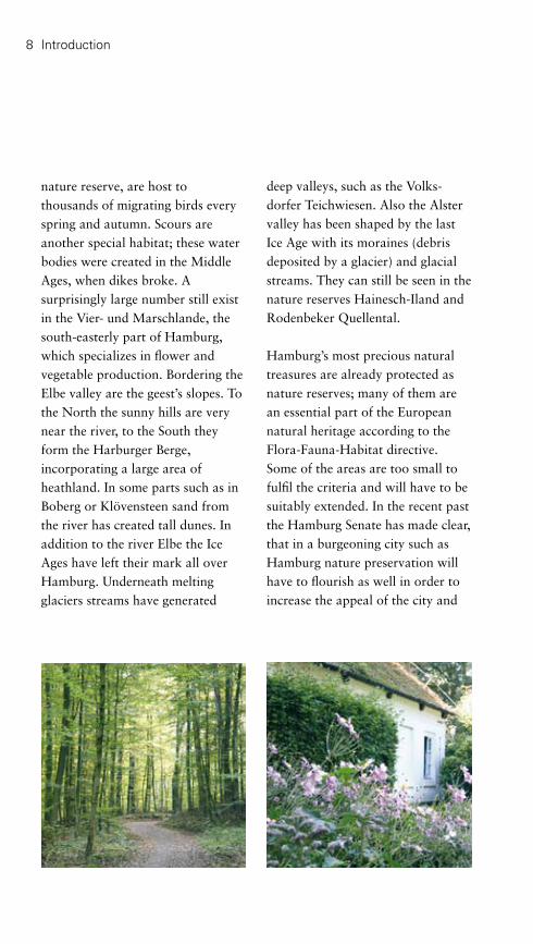
8 Introduction
nature reserve, are host to thousands of migrating birds every spring and autumn. Scours are another special habitat; these water bodies were created in the Middle Ages, when dikes broke. A surprisingly large number still exist in the Vier- und Marschlande, the south-easterly part of Hamburg, which specializes in flower and vegetable production. Bordering the Elbe valley are the geest’s slopes. To the North the sunny hills are very near the river, to the South they form the Harburger Berge, incorporating a large area of heathland. In some parts such as in Boberg or Klövensteen sand from the river has created tall dunes. In addition to the river Elbe the Ice Ages have left their mark all over Hamburg. Underneath melting glaciers streams have generated
deep valleys, such as the Volks-dorfer Teichwiesen. Also the Alster valley has been shaped by the last Ice Age with its moraines (debris deposited by a glacier) and glacial streams. They can still be seen in the nature reserves Hainesch-Iland and Rodenbeker Quellental.
Hamburg’s most precious natural treasures are already protected as nature reserves; many of them are an essential part of the European natural heritage according to the Flora-Fauna-Habitat directive. Some of the areas are too small to fulfil the criteria and will have to be suitably extended. In the recent past the Hamburg Senate has made clear, that in a burgeoning city such as Hamburg nature preservation will have to flourish as well in order to increase the appeal of the city and

9
its quality of life. By extending existing nature reserves and designating new ones their area has grown by ten percent to a total of approximately 6,000 hectares. Another important task in preserving Hamburg’s natural treasures is to protect nature reserves from gradual decline and from negative impacts, and to improve them instead, so that they can unfurl their full potential as habitats for flora and fauna alike.
Hamburg is growing green – Parks, Squares and Promenades
Hamburg’s many gardens and parks still reflect the significance and value they had in times gone by. Especially the parks along the Elbe, many of them formerly privately owned, contribute to Hamburg’s
reputation as a city of gardens and parks.
Several public open spaces are the result of state care. Impressively, nine percent of the city’s area are parks and green open spaces of different sizes, locations and functions; and almost half of them are near natural water bodies. Parks and valuable habitats are often closely linked or interconnected.In medieval towns green open spaces were confined to market squares or churchyards within the fortifications. Once the fortifications were no longer needed, they were razed, turned into green spaces and used for recreation by the citizens – this also happened in Hamburg. In the mid-19th Century it had become obvious that the density of buildings and the squalid working

10 Introduction
conditions led to health problems among the people. Light, air and space was in short supply. At that time Hamburg only had 1.6 square metres of green space per head, Cologne in comparison had 51.9 and Hanover 70.4.
Transforming the fortifications into promenades was by no means sufficient to create better living conditions for Hamburg’s citizens. At the turn of the 19th Century it became commonly known that in order to develop healthy living conditions large new parks were needed as well as the professional skills of landscape architects. In accordance with this, a Parks’ Department was added to already existing departments in Hamburg’s local authorities. Other German cities already had those for decades.
In 1913 Ferdinand Tutenberg became head of the department in the town of Altona (now part of Hamburg) and in 1914 Otto Linne followed in Hamburg. They contributed largely to creating a socially sustainable green infrastructure in both towns. The large parks dating to that period, such as in the borough of Winterhude and in the districts of Altona and Harburg still attract large numbers of visitors in the evenings and at weekends.
Especially the Hamburger Stadtpark in Winterhude was a model for modern park design at the time and still is internationally renowned. In addition the parks along the Alster, in Öjendorf or on the former fortifications, some of which were created in connection with

11
International Garden Exhibitions between 1953 and 1973, shape the townscape and are much-loved amenity spaces for relaxation, sports and recreation within the city limits. Many of these parks are listed owing to their cultural value. Their maintenance and improvement are responsibilities of garden heritage conservation so that they are protected well into the future.
Not only the big parks create Hamburg’s “green face”, but in particular the many small parks and open spaces that were built over the last fifty years in addition to the almost 245,000 street trees. Visitors tend to be impressed by the green townscape they are offered.


13
Hamburg’s Green Heart
Hamburg’s green heart beats at the centre of the city and radiates along green arteries to the outskirts. It is enclosed by the former fortifications with their green layer and bordering parks. The fortifications were turned into Hamburg’s first public park at the beginning of the 19th Century and form an entity with the beautiful park Planten un Blomen. In the vicinity are the Promenade “Bei der Erholung“, the Spielbudenplatz (on the Reeeperbahn), the Antonipark/Park Fiction and the Freizeitfläche Zirkusweg – all of them newly built, they reflect the diversity of Hamburg’s open space design at present.
In HafenCity, one of Europe’s biggest building sites, the ring of the former fortifications is meant to be continued: In combination with terraced squares and promenades along the water’s edge, with green courtyards and avenues a varied green pattern is emerging.
The Binnenalster, skirted by prome-nades, squares and a small park lies inside the green ring of the former fortifications. The Alster is one of the many examples of attractive interplay between water and green space, for which Hamburg is so well known.

14 Hamburg’s Green Heart
Alter Elbpark, Wallanlagen and Planten un Blomen
Going north from Stintfang, with its vineyard on the south facing slope, one quickly reaches another viewpoint: The Bismarck monument in Alter Elbpark. On the heights of the former bastion Casparus the city erected a colossal monument in honour of the first Chancellor as early as 1906. This was a risky gesture in the Kaiserreich, exacerbated by the fact that the figure faces west towards Altona, which belonged to the Kaiserreich unlike the Free City of Hamburg. In 1869 this had already been the site of the first International Garden Show, when eleven nations presented insights into trends in garden design to thousands of visitors in just eleven days. These exhibitions became a recurring feature in this section of the fortifications, moving north as time went on.
Having descended from lofty heights and crossed the Millerntor-damm one reaches Große Wall-anlagen. Here activities for all ages are on offer. The HamburgMuseum not only houses many paintings and models illustrating Hamburg’s history, but also a café. Further attractions in this section of the park are a children’s theatre, several playgrounds and the famous skating or ice rink. This is also,
Hamburg’s most central – and oldest – green space, the former fortifications, form a green connecting crescent between the rivers Alster and Elbe. They offer various options for an inspiring and relaxing day out on the edge of the city centre.
They start at the Landungsbrücken (part of the port) with a stunning view: The vantage point Stintfang offers long distance views of the port and the river Elbe. The steep slope of this former bastion (all of the bastions were named after 17th Century councilmen, this one was called Adolphus) gives a good impression of the size of Hamburg’s historic fortifications. They were built in the 17th Century, almost forming a circle from this point on the Elbe up to where Binnen- and Außenalster (Inner and Outer Alster) meet and then back towards the Elbe near Baumwall. Incorporating 22 bastions and a deep moat, they could only be crossed at one of the six gates. Several street names still relate to the fortifications, which were razed and turned into a park at the beginning of the 19th Century by the garden designer Isaac Altman from Bremen.

2 3
Planten un Blomen
Alter Elbpark
HamburgMuseum
Große Wallanlagen
Kleine WallanlagenLombardsbrücke
1
Stintfang
1 The former fortifications surround the city centre and were partly turned into a park.2 At Stintfang the former bastion Adolphus still is recognizable.3 Bismarck looking towards Altona.
Alter Botanischer Garten

16
bastion and moat. Floral displays and water features contribute to the tranquil character of this brief stretch.
A tunnel decorated with colourful mosaics leads to the most extensive part of the park with the old botanical garden and Planten un Blomen. The water course and waterfall that one encounters first was designed by Hamburg’s well-known landscape architect Karl Plomin for the International Garden Show (IGA) 1963. It connects to the only part of the park, where the historic moat of the former fortifications still can be
where for six months in 1897, 22 nations impressed the public with their displays at another Garden Exhibition (Allgemeine Gartenbau-ausstellung). After World War II the park was partly filled with debris, blurring the boundaries of the historic moat in this section, so that they are barely recognizable today.
Intersected by Sievekingsplatz, which was constructed together with the judiciary buildings between 1879 and 1912 in the grand style of the times, the park continues as the Kleine Wall-anlagen. It, too, is shaped by a
Hamburg’s Green Heart
The Heinrich-Hertz-Turm (television tower) is visible from many parts of Planten un Blomen.

offer all year round, but it is especially beautiful with autumn colours. Plant displays and areas for resting surround the landscape garden.
To the Northwest a true gardener’s paradise unfolds. Visitors can choose between the Japanese Garden with its tea pavilion, designed and built by Prof. Araki in 1990, the Rose Garden dating from 1993, the scientific Apothecary’s garden with its medicinal herbs and the Bürgergärten (Citizens’ Gardens) full of perennials. And should one want to relax among all the plants and flowers (Planten un Blomen), one can sit down at the cascades in one of the typical “Strahlensessel”, seats designed for Hamburg’s parks. The cascades are remnants of a Garden Show in 1935,
experienced to full extend.The raised path to the right allows visitors to fully appreciate the drop from the embankment to the moat. The Johan-van-Valckenburgh-Bridge (named after the engineer of Hamburg’s 17th Century fortifi-cations) leads across the moat and offers good views of the sunny Mittelmeerterrassen with their Mediterranean character and the glasshouses with tropical displays. This ensemble was also built for the IGA 1963. Owing to the skilful construction it is listed and is certainly worth a visit – both from the outside and within.
To the Northeast lies the Japanese Landscape Garden, dating from 1988. This masterpiece by the Japanese landscape architect Prof. Yoshikuni Araki has something to
1 Japanese autumn impressions in the middle of Hamburg.2 The Bullerberge are a children’s paradise.3 In the Rose Garden blooming roses and clematis compete for attention.
1
2 3

the Niederdeutsche Gartenschau Planten un Blomen that gave the park its name.The lake (Parksee) at the centre of this part of the park boasts the famous water-light-organ dating back to 1973. During the summer, visitors flock to the extensive lawns and grassy slopes to enjoy concerts every evening. Children can discover imaginary playgrounds, such as the Bullerberge or areas for water play, where they can exercise their agility. And music lovers of all tastes can enjoy concerts at the Musikpavillon – free of charge.
Hamburg’s green “business card” has a lot to offer: In the mornings guests staying at hotels nearby and the locals jog here, at lunch time visitors to the convention centre
and business people enjoy their well deserved lunch breaks, in the after-noon children play in the park, and in the evenings Hamburg’s visitors and citizens enjoy these surroun-dings – throughout the year.
District: Hamburg-MitteLocation: along Gorch-Fock-Wall and Holstenwall up to LandungsbrückenPT: Planten un Blomen: S1 Dammtor, U1 Stephans- platz; Wallanlagen, Hamburg Museum: U2 Messehallen, U3 St. Pauli, Stintfang, Alter Elbpark: U3 Landungsbrücken Size: approx. 50 hectaresSpecials: HamburgMuseum, plant displays, glasshouses, play grounds, cafésInformation: see page 138
2
1 3
1 Planten un Blomen, bordered by Dammtor-Station (at the top), the Congress Centre and Heinrich-Hertz-Turm.2 In the listed glasshouses tropical plants can be experienced from close by.3 A much loved nocturnal display: the water-light-show at the central lake (Park lake).

19
Promenade “Bei der Erholung”
Looking for a good view of the river Elbe and the port? Why not visit this promenade above Lan-dungsbrücken (part of the port)?
Along a 600-metre stretch on the geest high above the Elbe this footpath and cycle route offer some of the most beautiful views across the Port of Hamburg, and at its Eastern end connects the former fortifications and the Alter Elbpark with the river.
The three points of access from David-, Bernhard-Nocht- and Seewartenstraße are marked by custom-made metal nuggets and invite visitors to roam freely, enjoy the view in peace and quiet or stretch their legs. The Hamburg based landscape practice EGL also
created several viewpoints with seats that catch the midday sun. Between the viewpoints historic rows of trees were extended, so that one can also find a shady place. Visitors and locals (with their dogs) as well as local employees use the promenade frequently, not only during their lunch breaks or to watch the stunning firework displays on New Year’s Eve.
District: Hamburg-MitteLocation: parallel to Bernhard-Nocht- StraßePT: S1, U3 St. Pauli Landungs- brückenSize: 1,3 hectares, 600 metres longSpecials: View to Landungsbrücken, Alter Elbtunnel, Port of Hamburg
Hamburg’s Green Heart

20 Hamburg’s Green Heart
Antonipark/ParkFiction
District: Hamburg-MitteLocation: Bernhard-Nocht-Straße/ AntonistraßePT: S1/S3 KönigstraßeSize: 7,500 square metresSpecials: innovative design, intensive public consultation
The ParkFiction project shows clearly how creativity, dreams and professional knowledge can turn a small open space into a little gem. This group of small parks was shown at the Dokumenta XI in Kassel in 2002 and won inter-national acclaim.
Its unusual design may be partly responsible for it: Where else in a big city does one encounter a “tea island” and a “flying carpet” or artificial palm trees and a sandy beach with river view? But maybe its extraordinary design process has got something to do with it as well: “Dreams will leave the flats and will walk the streets…” The title of Margit Czenki’s movie in 1999 was the leitmotif of a group of locals and artists, who had combined forces in 1994 in order to stop the last open space in their borough of St. Pauli to fall victim to develop-ment.
The concept was conceived as a joint production by Christoph Schäfer, ParkFiction and the landscape practice arbos. It transformed individual wishes, needs and dreams relating to living conditions into professional designs, which ultimately were implemented. The campaign and the subsequent planning process
brought art, (sub)culture and politics together in a unique way.
Apart from a viewing platform, complete with tea-island and flying carpet made of grass – on a gym’s roof – there are a tulip playing field, an informal lawn for play and relaxation, and a dogs’ playground with poodle motifs. A garden for reading and resting, small neighbourhood gardens and a boules ground have been developed in the adjoining churchyard of the St. Pauli church. To the East an amphitheatre and the sunny Schauermanns Park-Terrasse have been created. All sections of this park have been creatively designed, are easy to use and can be experienced with all senses. Children use the beach at Schauer-manns Park-Terrasse as a big sand pit or sit at miniature tables and chairs in order to eat, draw or model. Adults prefer to drink coffee or beer from some of the neigh-bouring restaurants, while enjoying the view and the scent of flowers.

1
2
1 The “tea-island” with its view of the ship builders Blohm & Voss.2 Dogs have their own playground.3 Locals tend flowers and vegetables in their private plots in the churchyard.4 Schauermanns Park-Terrasse is a tranquil zone on the edge of the lively borough of St. Pauli.5 Apple trees and scented roses adorn Schauermanns Park-Terrasse.
4 5
3

22
Spielbudenplatz
For quite some time the Reeper-bahn is no longer seen as Hamburg’s red light district only, but also as a hub for theatres and musicals. Where stage abuts stage, it seems logical to give plays a suitable outdoor arena as well.
The design of the Spielbudenplatz by landscape architects Lützow 7 is simple and practical. Raised platforms with trees frame the oblong square at both ends and can be used as small stages. Steps lead to the platforms which double as seating areas. A large open space with two moveable stages lies at the centre. The two stages are made of metal and can be moved mechanically along continuous tracks, so that they can “meet” at any place within the square.
On a normal day though, the local pubs and cafés use the space as their outdoor dining area with tables and chairs as well as palm trees dotting the square. This is a good place to await a performance in one of the several theatres or to rest after a long walk down the Reeperbahn.
District: Hamburg-MitteLocation: ReeperbahnPT: U3 St. PauliSize: 4,000 square metresSpecials: moveable Vattenfall-stages
Hamburg’s Green Heart

23
Freizeitfläche Zirkusweg
Several generations under one (leafy) roof – that was the idea behind the re-design and extension of the playground Zirkusweg into a versatile amenity space.
Combining the adjacent storage area with the former playground opened the way for a novel design. Citizens of all ages and interests were extensively consulted during the planning process.
Resulting in an amenity space, where different areas are interconnected but can be used separately: Near the entrance the young and the old are offered tables for board games and water features for various uses. Toddlers will enjoy climbing the tree house or
riding wooden animals in the sandy arena.
The adolescents are invited to play table tennis or just to sit together. Those who prefer to withdraw from the activities will find tranquil areas with seats and lounge chairs in sunny or shady spots near the slope. Here a variety of perennials offer interest to all senses all year round.
District: Hamburg-MitteLocation: Zirkusweg/Helgoländer AlleePT: U3 St. PauliSize: 1,700 square metresSpecials: only open during daylight, amenities for the young and the old
Hamburg’s Green Heart
1 Comfortable seats invite visitors to rest underneath old trees. 2 Children of all ages enjoy the imaginative play areas.

24 Hamburg’s Green Heart
Jungfernstieg and Binnenalster
District: Hamburg-MitteLocation: JungfernstiegPT: U1, U2, S1, S3 Jungfernstieg, AlsterdampferSize: 3,75 hectaresSpecials: restaurants, Alster ferries and cruises, several eventsInformation: see page 138
The sight of the Alster “lakes” at the centre of the city surely is one of the main attractions for citizens and visitors of this Hanseatic city.
The Binnenalster (Inner Alster) is the smaller one of the two “sisters”. Almost forming a square and bordered by clear architectural lines, it works like a reflecting pool for the noble buildings surrounding it. Surprisingly this was not intended, but evolved gradually. The first stretch of the promenades to be constructed was what we now call Jungfernstieg. In 1235 a dam was built for the miller Reese, so that he could operate his flour mill. During the course of time the “Reesen-damm” was renamed “Jungfern-stieg” after the maids that strolled along it. Opposite the Jungfernstieg the 17th Century fortifications divided the Alster “Lakes” into Binnen- and Außenalster – today two bridges, the Lombards- and the Kennedybrücke, form the northern edge of the Binnenalster. The next stretch to follow was the Neue Jungfernstieg, originally designed as a promenade; it still offers pleasant walks underneath a leafy avenue. This bit was so well received, that the present Ballin-damm was built opposite in the same style in 1842. It still stands almost unaltered. The most
famous of them all is the Jungfern-stieg, which was re-designed in 2005/6. The site of the first Alster-pavillon of 1799 was left untouched – but it is the sixth building on this spot.
Following the designs of Hamburg-based landscape architects WES & Partner with Poitiers Architekten, the wide steps at the far end where turned into a kind of grandstand with moveable wooden seats, from which visitors can watch the hustle and bustle on the water. The road at the back was diverted to accommodate three rows of lime trees that shield the seats from the traffic. New buildings, meant to resemble ice cubes, house a restaurant and the offices of Alster touristik, which runs the famous “White Fleet” of Alster ferries. The signage has been unified to ease orientation.
The Binnenalster with its white ferries and its tall fountain has been turned into a stage – particularly on special occasions.

1
2
3 4
1 The newly designed Jungfernstieg seen from the Alster.2 The new glass cubes offer different aspects in changing light.3 The Binnenalster seen from Lombardsbrücke.4 Historical promenades frame the Binnenalster at Neuer Jungfernstieg and Ballindamm.

From 2009 onwards history will come alive at Domplatz – Hamburg’s new green square in the city centre: On one hand it is a green oasis in the city, on the other it tracks the long history of the Mariendom (St. Mary’s Cathedral).
The place has a turbulent past. For a very long time it was thought to be the site of the Hammaburg, a fortified castle that is seen as Hamburg’s foundation and has given the town its name. For more than 500 years it was home to the important Mariendom, after which the square is named. Originally the cathedral was surrounded by fortifications; later the first urban buildings were erected around it. Following secularization the cathedral was demolished in 1805. From 1840 the school Johanneum was built on this site; it was destroyed in World War II. After the war the empty square had been reduced to a public car park.
The shape of the historical cathedral and its fortifications inspired the new design: A dam made of steel follows the contours of the embankments. Three of the five sections can be walked on and offer views of the square. At the centre a simple lawn provides a tranquil place within the busy city. Here one
Domplatz
Hamburg’s Green Heart26
District: Hamburg-MitteLocation: DomstraßeEntrance: open to the publicPT: U3 Rathaus, U1 MeßbergSize: 5,450 square metres
can lie down underneath newly planted trees or sit on one of the 39 large seats. These square pieces of custom-made furniture mark the site of 39 of the cathedral’s pillars. They are especially impressive at night, when lit from the inside. One seat even has a small window and offers a view of the only relic left of the cathedral: The base of a pillar.
A footpath with steel slabs leads from Petrikirche (St. Peter’s church) across Domplatz towards HafenCity. The hollow sound of the steel slabs on level with the steel dams hint at the fact that there is more underneath and stimulate the imagination.
The combination of green oasis with living history designed by Hamburg-based landscape architects Breimann & Bruun matched the wishes of many people: In an online forum a majority had voted for a green re-design of Domplatz.

1 Bird’s eye view of Domplatz.2 Illuminated seats mark the sites of the demolished cathedral’s pillars.3 Domplatz is a direct and green link between HafenCity and the Alster.
1
2
3

28 Hamburg’s Green Heart
Urban Parks, Squares and Promenades in HafenCity
Century port basins are being transformed. The use of environ-mentally friendly building materials and renewable energy is strongly recommended. On an area of 157 hectares centrally located flats for 12,000 inhabitants are being constructed as well as 40,000 workplaces. Several public buildings for education, culture and recreation add to the scene as well as parks and squares, but also internationally important projects, such as the Elbphilharmonie (concert hall) or the new Science Centre. Attractions with maritime themes, such as the Internationale Maritime Museum
Living at the water is most people’s dream, especially when allied to green space. In HafenCity Hamburg has the opportunity to fulfil this dream for many.
At the moment HafenCity still is Europe’s biggest inner city building site. But some parts have already been finished and give an impression of what is in store: An urban village, where living and working blend with culture and recreation. Already in 2000 the HafenCity masterplan was decided. During the development of this new inner city quarter brown-field sites adjacent to the 19th
Magellan-Terrassen
Vasco-da-Gama-Platz
Speicherstadt
KreuzfahrtterminalElbphilharmonie
Marco-Polo-Terrassen
29
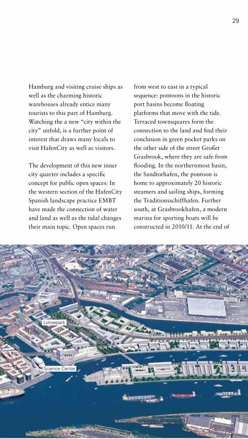
Hamburg and visiting cruise ships as well as the charming historic warehouses already entice many tourists to this part of Hamburg. Watching the a new “city within the city” unfold, is a further point of interest that draws many locals to visit HafenCity as well as visitors.
The development of this new inner city quarter includes a specific concept for public open spaces: In the western section of the HafenCity Spanish landscape practice EMBT have made the connection of water and land as well as the tidal changes their main topic. Open spaces run
from west to east in a typical sequence: pontoons in the historic port basins become floating platforms that move with the tide. Terraced townsquares form the connection to the land and find their conclusion in green pocket parks on the other side of the street Großer Grasbrook, where they are safe from flooding. In the northernmost basin, the Sandtorhafen, the pontoon is home to approximately 20 historic steamers and sailing ships, forming the Traditionsschiffhafen. Further south, at Grasbrookhafen, a modern marina for sporting boats will be constructed in 2010/11. At the end of
Lohsepark
Science Center

Hamburg’s Green Heart30
playground near the Kreuzfahrt-terminal (Cruise Centre) is a temporary solution only and will find its permanent location in Grasbrookpark. It has a treasure-island theme and was partly designed by the local community. South of Marco-Polo-Terrassen a passage way will lead through the new Unilever House to the river Elbe and Strandkai from 2009. The design follows that of Marco-Polo-Terrassen in order to make clear that this private space is open to the public.
In the central part of HafenCity, including Überseequartier, Magde-burger Hafen and St. Annenplatz, the open spaces were designed by the Spanish practice BB+GG with Beth Galí. Her choice of materials and the overall design relate to the historic surroundings. In front of the former warehouse Kaispeicher B, now home to the new Internationale Maritime Museum Hamburg, a first example has been accomplished: Stripes of grey and red granite are interspersed with granite sets and terrazzo tarmac. The generous promenade at the Magdeburger Hafen basin will look similar and will link Jungfernstieg on the Alster with the Elbe and the Science Centre. Along this so-called “cultural mile” the emphasis is meant to be on education and culture, interspersed with
the Sandtorhafen, Magellan-Terrassen were completed in 2005. Light, rounded concrete elements and brick ornaments correspond with the historic warehouses near this terraced square. Trees and curving light features accentuate the design. During the summer months the square is used for varied activities from tango performances to readings and children’s programmes.
The spacious Marco-Polo-Terrassen at the end of the Grasbrookhafen are similarly designed, but convey a more tranquil atmosphere. Grassy hills and wooden loungers invite relaxation. Liquidambers, redwoods and willows provide shade. Special features at both squares are the faces of the flood protection walls: Whereas at Magellan-Terrassen the yellow, ochre or red bricks depict fish, the ornaments at Marco-Polo-Terrassen take their inspiration from the nearby warehouses. The two pocket parks to the East of Großer Grasbrook offer grassy hills for informal use as well as playgrounds and meeting areas. Sandtorpark will open first; Grasbrookpark to the South will follow in 2012. The trees for both parks where selected to provide interest all year round – from the blossom of cherry trees in spring to the autumn colour of Liquid-ambers. The 850 square metres of

1 Marco-Polo-Terrassen at Grasbrookhafen.2 Evening at Magellan-Terrassen.3 Dalmannkaipromenade is ideal for a leisurely stroll.
services, dwellings and businesses. Überseeboulevard west of the Magdeburger Hafen forms the spine of the central part of HafenCity. Here Beth Galí and her practice were inspired by water: The boulevard meanders through the buildings like a river, opening into small squares here and there.
On the other side of the basin, the new HafenCity University will be built and its campus will form another desirable place on the water. This is also a major traffic junction, with a station of the new underground line U4 and a pier for the harbour ferries from 2011. Lohsepark, the largest green space of the whole HafenCity will form the connection to the eastern section. Its detailed design will be decided in
1
2
3

3232
1 The Traditionsschiffhafen (with historic boats) at Sandtorkai.2 At Dalmannkaitreppen four planes are in-
clined towards the water of Grasbrookhafen.3 The forecourt of the Internationale
Maritime Museum Hamburg. 4 A generous promenade leads through
Magdeburger Hafen and Überseequartier to the historic warehouse district.
1
2
43

33
District: Hamburg-MitteLocation: former part of the port south of the warehousesPT: U3 Baumwall, Metrobus 3,4,6Size: 157 hectaresSpecials: HafenCity InfoCenter at the Kesselhaus, viewing tower Viewpoint Information: see page 139
2009 by a competition. This park will connect the basin Ericusgraben in the North with the Baakenhafen in the South and will offer footpaths and green open space for sports and other activities for the local community. It will also incorporate a memorial: The former train station Hannoverscher Bahnhof was situated here, from which more than 7,000 Jews, Roma and Sinti were deported.
These open spaces of HafenCity are supplemented with promenades at the waterfront that double as flood protection and with small parks and courtyards. Two examples that have already been implemented are Dalmannkaitreppen with their terraced connection to the water and tree studded lawns as well as Vasco-da-Gama-Platz at Dalmannkai. This town square offers relaxing lunch breaks to local dwellers and workers, and its basketball field is a favourite of youths. Green courtyards between the buildings are retreats for the local community and protected play areas for children. Nonetheless they allow views of the water.
The open spaces of HafenCity contribute largely to the image of the borough; they create identities for its individual quarters and link to neighbouring boroughs. Therefore the new open spaces are designed to
have their own identities – this is achieved by using different plants or an individual approach to water, to privacy versus publicity, tranquillity versus activity. What they all have in common is versatility of use, car-free connections and a sense of place. Avenues connect open spaces with buildings and are planted with different tree species, following a tree masterplan. In total there will be ten kilometres of promenades along the quays, which will ease exploring this new borough – just 800 metres from the town hall.
A total of approximately 36 percent of the landmass in HafenCity will be open space for use by the general public, in combination with the typical remains from the former port they will characterize this new quarter.


35
Green Quarters
Hamburg is widely known as an attractive, green town. In addition to large and well-known parks the many smaller local parks, the numerous playgrounds and particularly the approximately 245,000 street trees contribute to this reputation. Lime and plane trees, horse chestnuts and other tree species not only beautify the roads, they also provide desirable shade in hot summers, help improve air quality and play an important role as green corridors for mankind and nature.
All of Hamburg’s districts possess various green spaces – from significant and large parks, such as Altonaer Volkspark to medium-sized ones, such as Hammer Park, to the small parks in densely populated boroughs. They all contribute to the quality of life in this town.
The oldest of these parks is Innocentiapark, which was built in the 1880s. At the beginning of the 20th Century large public parks, providing diverse options for use followed. But even today new parks are being built or old ones adapted to accommodate new requirements by the local population. In combination with the many playgrounds they form a local environment that invites relaxation at the weekend or in the evenings as well as activities in fresh air and contact with nature – in these times that is more important than ever.

36
From Platz der Republik to Altonaer Balkon
Century. After a brief relocation of the fountain in the 1970s and its restoration (1998 – 2000) it is now back in its old glory on Platz der Republik, surrounded by old trees, flower borders, play-grounds and seats as well as a boules ground.
The neo-classical town hall (Alto-naer Rathaus), a part of the historic railway station of 1844 forms the southern boundary of the square. During the refurbishment from railway station to town hall the sculptors Karl Garbers and Ernst Barlach created the new frieze on the gable.
Altonaer Balkon is situated on the other side of the Elbchaussee. This open space is an important link between the footpath above the Elbe (Elbuferwanderweg) and the fish market as well as Grünzug Neu-Altona (a green corridor). Recently an imaginative new playground was built here.
Hamburg has never been a feudal residence and was always proud to call itself a “Free City”. Altona on the other hand used to be an out-post of the Danish Court and later a border town of the Prussian Empire. At Platz der Republik it demonstrates its feudal elegance, even though the name suggests otherwise. The nearby Altonaer Balkon offers breathtaking views of the Port of Hamburg.
Platz der Republik was created at the end of the 19th Century, when the old railway station was moved further north. The square is a typical example of the times: It was used to connect the surrounding public buildings in grand style – the then town hall (now district authority), the Altonaer Museum and the new railway station. After several changes, the square once again boasts a formal design. The impos-ing fountain, Stuhlmannbrunnen, is named after its donor Günther Ludwig Stuhlmann, founder of the local water works. It was erected from 1898 to 1900 after designs by Berlin-based sculptor Paul Tümpe. The main figures of the fountain are two centaurs fighting for a fish caught in a net. This is meant to symbolize the quarrel between the towns of Hamburg and Altona about fishing rights since the 16th
Green Quarters
District: AltonaLocation: Platz der Republik, Altonaer Balkon: Max-Brauer-Allee; Christianskirche: Klopstock- strasse PT: S1, S11, S3 AltonaSpecials: view of the port from Altonaer Balkon, Stuhlmannbrunnen, Altonaer Rathaus, Altonaer MuseumInformation: see page 139

1 Platz der Republik.2 The mounted statue of Kaiser Wilhelm still recalls the square’s previous name “Kaiserplatz”.3 View of the Elbe from Altonaer Balkon.4 The restored fountain: Stuhlmannbrunnen.5 The grave of the famous poet Friedrich Gottlieb Klopstock can be found at the nearby churchyard (Christianskirchhof).
4
1
2 3
5

Where only a few decades ago the cogwheels of the Menck & Ham-brock factory were turning, today children go round on carousels. People of all ages meet here – the square has become the navel of this quarter.
Since the factory was closed, the site had lain bare in the 1980s, but in a borough like Ottensen, where public open spaces and playgrounds are very scarce, this did not last long: A first design in the 1990s created a diverse open space. The layout had not been very efficient though, but because of the lack of alternatives the space was well used. The unofficial name “Kemal-Altun-Platz“ goes back to those days.
In 2006 a new concept was implemented in co-operation with the local community. It offers something for all ages and interests: The new design of the 6,000 square metre site is more generous and open. It incorporates a sheltered playground for toddlers with imaginative equipment, a playing field with an artificial surface and walls for graffiti, a streetball-field with original seats and a lawn for relaxation.
The multi-functional central area can be used by the local circus as
Square “Am Born“/“Kemal-Altun-Platz“
Green Quarters
well as for other small events. A fenced off dogs’ playground makes sure that potential conflicts with other users do not arise. In addition the design relates to the place’s history: the central area and the raised lawn are shaped like two big cogwheels, and some elements from the 1990s layout have also been kept. An adventure playground abuts the square. At one entrance an old digger, formerly belonging to the factory at this site is tended to by the borough’s archive (Stadtteil-archiv Ottensen). They have also erected a board explaining some of the place’s history.
This local square is a good example for successful co-operation between the community and the planners at the local authorities.
38
District: AltonaLocation: Große Brunnenstraße/Am BornEntrance: open to the publicPT: Metrobus 1/Bus 150Size: 6,000 square metresSpecials: sporting facilities, playground, dogs’ playground

1 The raised lawn for relaxation.2 Cog-wheel patterns recall the site’s history.3 A central area for events of all kinds.4 The imaginative and well-loved playground.5 The playing field and the legendary wall with graffiti.6 The Streetball field with original seats.
1
2
3 4
5 6

40
Grünzug Neu-Altona and Wohlerspark
Green Quarters
District: AltonaLength: 2 kilometres
Fischmarkt/Kirche St. TrinitatisLocation: Große Elbstraße PT: S1 Königstraße
Walter-Möller-ParkLocation: between Louise-Schroeder- Straße and ThadenstraßePT: S1 Königstraße/Reeperbahn
WohlersparkLocation: between Thadenstraße and Max-Brauer-AlleePT: S11 Holstenstraße
The green corridor of Grünzug Neu-Altona offers interesting insights into Altona’s history.
The fish market is one of Altona’s oldest squares and is still used as a market place. It has a funnel-shaped opening towards the river Elbe and is framed be various restaurants and bistros.
Going north from here, the ground rises steeply towards the baroque church of St. Trinitatis. Opposite on the other side of the Königs-strasse another historically important area abuts: The Jewish cemetery was started in 1611 by Portuguese Jews living in Altona and until 1877 more and more German Jews also used it. Despite the National Socialists many graves are still intact. The cemetery can only be visited by appointment.
To the east of this historic site a green corridor starts that later becomes the Walter-Möller-Park. In this stretch one can still find traces of the 1950s: Since large areas had been destroyed by bombs in World War II, post-war town planners saw this as an opportunity to implement model designs. The famous landscape architect Prof. Herta Hammerbacher designed a green, open housing area. The
strong division between pedestrians and cars is typical of the 1950s – tunnels and bridges connect the different stretches of the park. In later phases modern play areas, a café and seats were added.
To the north lies Wohlerspark. The historic pattern of this former cemetery (Friedhof Norderreihe) dating from 1830/31is still recognizable: The main feature being a cross-shaped lime avenue; some of the important tombs also remain intact (e.g. Graf von Blücher-Altona). This unusual park is mainly used for quiet relaxation and contemplation.

1
1 Historic lime avenue in Wohlerspark.2 Relics of the former cemetery (Friedhof Norderreihe), now Wohlerspark.3 View from St. Trinitatis towards the Elbe.4 A favourite haunt on Sunday mornings: the Fischmarkt.5 The baroque church of St. Trinitatis.
2
3
54

42 Green Quarters
Altonaer Volkspark
District: AltonaLocation: Luruper ChausseePT: S3, S21 Stellingen Bus 2, 3, 22, 180Size: 170 hectares without the sporting arenasSpecials: Dahliengarten (dahlia garden), Schulgarten (educational garden), Heckentheater (garden theatre), Hauptfried- hof (main cemetery)
Altonaer Volkspark appears to be either an extensive, hilly wood in the city or a flower garden or a sporting area, depending from where you approach it. But it is worthwhile getting to know the other parts as well.
The area originally used to be a wood, the northern parts bogs and moors. Some sections were used as gravel pits or quarries. Even though the idea of a central park only materialized in 1894/95 the town of Altona had already started buying land some years before that. At the time Altona was one of the most densely populated German cities, much more so than nearby Hamburg, and it badly needed parks.
The final design for the large public park only emerged in 1913, once Ferdinand Tutenberg had become head of Altona’s Parks’ Department. Implementation already started the year after with the extensive central lawn and its 200 framing lime trees. Work was suspended during World War I. Tutenberg used the time to amend the plan in 1916 and also added a cemetery. Work continued in 1918 – resulting in a Schulgarten (an educational garden for local pupils), other flower gardens, an arboretum, a rock garden, a dahlia
garden (1930 – 32) as well as some model allotments and a large sporting arena. Some of the existing woods and moors were also opened to the public, but in a restrained way. After World War II the park was used as a source for wood for burning. Parts of the moor areas were filled with rubble, but from 1950 onwards restoration of the park began.
Apart from walks in the woods, visits to the many playgrounds, the garden theatre or the allotments, the dahlia garden and the well-tended flower gardens are the main attractions of Hamburg’s biggest park. They even draw visitors from further affield. Today Altonaer Volkspark also houses the Color-Line-, the HSH-Nordbank- and the Volksbank-Arenas. Sporting and cultural events are attractions in their own rights.

1
2
3
1,2 The dahlia garden in Altonaer Volkspark is one of the most important of its kind.3 The Schulgarten (educational garden) shows the possible use of perennials.4 Vista from the viewing point Tutenberg (war memorial) with formal hedges.5 Old trees overhanging shady paths form a contrast to formal garden design.
4 5

44 Green Quarters
Innocentiapark
District: EimsbüttelLocation: Brahmsallee/Innocentiastraße/ Oberstraße/ParkalleePT: U3 Hoheluftbrücke, U1 KlostersternSize: 3 hectaresSpecials: example of an English square surrounded by late 19th- Century buildings, 1950s blocks of flats: Grindelhochhäuser
If you are looking for green inner city flair, you will find it around this typical square in the borough of Harvestehude.
The name of the park refers to Pope Innocence IV, who had legitimized the former landowner, the monastery Herwardeshude in the mid-13th Century. The monastery gave the borough its name and owned extensive land in this area, which was originally used as farmland; for example sheep grazed the area of today’s park. The history of the monastery would make a good story in itself, but for here it should suffice to say that it became the St.-Johannis-Kloster (St. John’s monastery).
After Hamburg had outsized its fortifications in the 19th Century the monastery sold its farm Harvestehude to a consortium, which was only granted planning permission under the condition that parts of the area had to be turned into parks. One of these parks is Innocentiapark, designed in 1884/85 as a square in keeping with the elegant townhouses surrounding it. The idea for the square design came from London and fits well into the grid of streets. In the mid-19th Century similar squares were also built in Paris.
The original design as a landscape garden is still recognizable today: Trees and shrubs planted as a green belt along the perimeter shelter the park from the surrounding roads, but allow views of the neighbouring townhouses’ beautiful architecture.
Two hills with viewpoints were designed to offer sights of the park, but have become slightly overgrown. Extensive, curving lawns form the remainder of the park; they give an impression of space and can be used in many ways. Seats surrounding the lawns invite visitors to sit and linger. Whereas in the past a naturalistic pond used to add interest, today there is play equipment.

2
1 The lawns invite visitors to rest or practice T’ai Chi and Qi Gong.2 Noble townhouses surround the park.3 Female figure by the sculptor Curt Beck- mann underneath oak trees.4 The park offers picturesque aspects even in winter.
1
2
3 4

46
Lindenpark
Green Quarters
This park at the heart of the Eimsbüttel-District is not only a car-free link, but also a true paradise for play.
Before its re-design (until 2003) the park was used very little. Based on intensive public consultation the landscape practices EGL and GFP designed an inviting, multi-functional park with attractions for people of all ages: In the “jungle playground” there are opportu-nities for play and relaxation for children and youths, e.g. a meeting place in a hut, a large climbing frame made of ropes and a tunnelled slope. The “Robinson playground” has been designed for smaller children. A playing landscape complete with swings, a
District: EimsbüttelLocation: between Bellealliancestraße and Altonaer StraßePT: U2 ChristuskircheSize: 2 hectaresSpecials: diverse opportunities for play
giraffe carousel, a tree house and much more makes time pass all too quickly. A boules ground, a playing field with an artificial surface and a streetball field give youths and adults room for sports and activity. To make skating more pleasant the footpaths were built a smooth asphalt surface. Seats invite people to linger at the fountain, among beautifully planted flower borders and at the entrances. The large lawn is much loved for relaxing moments.

47
Bewegungsräume Lenzsiedlung
Green Quarters
The borough of Lokstedt is better known for Hamburg’s main zoo (Hagenbecks Tierpark) than for its green spaces, but this local park has won a prize.
Whereas the up to 14-stories tall blocks of flats of the Lenzsiedlung went up in the 1970s, the proposed park was only partly implemented. In 2000 the existing green spaces no longer fitted the requirements of the community, many of them children, youths and migrants.
The new design was done as part of a government programme “Spiel-raum Stadt” with intenive public consultation. Landscape architects Andreas Bunk and Outside integrated the green space within
District: EimsbüttelLocation: Julius-Vosseler-Straße 193PT: U2 LutterothstraßeSize: 1.42 hectaresSpecials: Opportunities for sports and play
the car-free network of cycle routes and footpaths. The existing community and youth centre now opens onto a new space facing the buildings. The green space is open and inviting; groundmodelling creates different rooms for play and activity. In addition there is a playing field with an artificial lawn, a skating rink, a streetball field and the beach volleyball field of the local sports club Grün-Weiß Eimsbüttel.

48 Green Quarters
Wacholderpark –Öffentlicher Garten Fuhlsbüttel
District: Hamburg-NordLocation: Wacholderweg/Bergkoppel- wegEntrance: opposite the underground stationPT: U 1 FuhlsbüttelSize: 1 hectareSpecials: historic lime arbour
This little jewel of a garden, designed by the famous landscape architect Leberecht Migge, is situated near the underground station Fuhlsbüttel in the Hamburg-North District.
Like the 19th Century Innocentia-park in the borough of Harveste-hude, this garden was also part of a new development. In connection with the construction of the underground around 1910 the surrounding area was developed and a new park was designed for the community. With its simple, multi-functional layout, this park is an early and typical example of the so-called Reformgartenkunst at the beginning of the 20th Century. Migge himself called it the “first German park for play”.
The centrepiece of this one-hectare park is a sunny meadow, deliberately intersected by tracks. On this meadow visitors of all ages can play sports or rest. Romantic lime arbours frame the eastern and southern boundaries. They were designed to allow strolls in the shade and offer views through arcaded “windows”. In the western section of the garden two green “rooms” were created to offer sheltered seating, each with a different character – one is a small,
dense red maple wood, the other a light birch grove. A playground, accompanied by seats in the sunny recesses of a cut hedge, still lies between the two green rooms. The sunken flower garden sadly no longer exists; it was situated near the playground and was meant to offer enjoyment and education at the same time. It could probably be restored. Unfortunately the former main entrance and one corner of the park were lost to car parking near the underground station in the 1960s.
Despite this the main structures of this garden still remain intact, so that it is an exceptional example of its kind and known to professionals all over Europe. This little gem is always worth a visit.

1
2
1 The pollarded lime trees have formed a romantic arbour for almost a hundred years.2 The light birch grove gives an impression of the original formal design. 3 This bird’s-eye view is an original drawing by the park’s designer Leberecht Migge.
3
50 Green Quarters
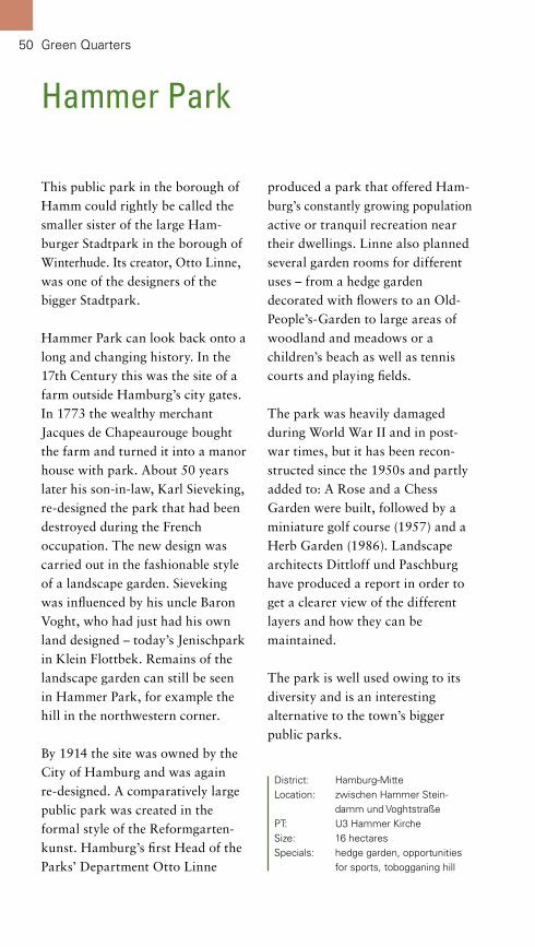
Hammer Park
District: Hamburg-MitteLocation: zwischen Hammer Stein- damm und VoghtstraßePT: U3 Hammer KircheSize: 16 hectaresSpecials: hedge garden, opportunities for sports, tobogganing hill
This public park in the borough of Hamm could rightly be called the smaller sister of the large Ham-burger Stadtpark in the borough of Winterhude. Its creator, Otto Linne, was one of the designers of the bigger Stadtpark.
Hammer Park can look back onto a long and changing history. In the 17th Century this was the site of a farm outside Hamburg’s city gates. In 1773 the wealthy merchant Jacques de Chapeaurouge bought the farm and turned it into a manor house with park. About 50 years later his son-in-law, Karl Sieveking, re-designed the park that had been destroyed during the French occupation. The new design was carried out in the fashionable style of a landscape garden. Sieveking was influenced by his uncle Baron Voght, who had just had his own land designed – today’s Jenischpark in Klein Flottbek. Remains of the landscape garden can still be seen in Hammer Park, for example the hill in the northwestern corner.
By 1914 the site was owned by the City of Hamburg and was again re-designed. A comparatively large public park was created in the formal style of the Reformgarten-kunst. Hamburg’s first Head of the Parks’ Department Otto Linne
produced a park that offered Ham-burg’s constantly growing population active or tranquil recreation near their dwellings. Linne also planned several garden rooms for different uses – from a hedge garden decorated with flowers to an Old-People’s-Garden to large areas of woodland and meadows or a children’s beach as well as tennis courts and playing fields.
The park was heavily damaged during World War II and in post-war times, but it has been recon-structed since the 1950s and partly added to: A Rose and a Chess Garden were built, followed by a miniature golf course (1957) and a Herb Garden (1986). Landscape architects Dittloff und Paschburg have produced a report in order to get a clearer view of the different layers and how they can be maintained.
The park is well used owing to its diversity and is an interesting alternative to the town’s bigger public parks.

1
2
1 The Hammer Park offers Hamburg’s population in the eastern parts of the town recreation on the doorstep.2 The planting in the hedge garden reflects the seasons.3 The former 18th Century vineyard is used for tobogganing in the winter.4 Formal avenues invite visitors for a stroll.
3 4


53
River Landscape Elbe and National Park Hamburgisches Wattenmeer
The river Elbe is Hamburg’s lifeline. It is closely connected with the origins of the town and its port has given Hamburg the name of a “Gateway to the World“. During its course through the metropolis the river changes its character from the port to the estuary on the North Sea coast.
It runs through the open marshes in the East, mainly used as farmland, bifurcates into Norder- and Süderelbe with the main parts of the industrial port in their middle and continues re-united to the cliffs in the West, where the most beautiful parks appear like pearls on a string.
As the general landscape changes along Elbe, so do the green spaces. Where the dynamics of low and high tide continue, more natural shores have developed. The rare tidal freshwater flats, the carrs and riparian forests as well as reed beds offer valuable habitats for plants and wildlife. On the steep slopes in the West the creative touch of mankind is more obvious. Here are numerous historic villas with their parks dating to different eras. The footpath along the Elbe (Elbwanderweg) invites people to view and experience its diverse nature and culture. Finally, just off the Elbe estuary lies a maritime habitat: The National Park Hamburgisches Watten-meer, including its islands Neuwerk, Scharhörn und Nigehörn, is one of the most significant breeding and resting places for water birds internationally.

54 River Landscape Elbe and National Park Hamburgisches Wattenmeer
Deer still live in the park, but in a fenced off area. There is a small viewing point with seats on the cliff facing the river. Footpaths intersect the whole park; they offer enticing views of the Elbe, of the historic village Blankenese and the park’s interior.
Further west lies Baurs Park, named after G. F. Baur, who bought land from eleven previous owners to form one new estate. French garden designer Joseph Ramée created a landscape park in the late English style for Baur. Those parks are characterized by an abundance of garden features. Accordingly a Chinese Pagoda, several small temples, a Japanese-style umbrella, a folly of a castle ruin, a grotto with mirrors and many more features adorned this park. Some of these are documen-ted by paintings, but none of them exist any longer. This is manly due to the fact that the park was divided in the 1920s and new houses were built.
Some of the historic viewing points and the promenade on the riverbank still exist though and offer spectacular views of the Elbe with the nature reserves
Hirschpark and Baurs Park are just two of the many parks appearing like the pearls on a string along the northern bank of the river Elbe. Situated high on the geest’s ridge, they offer long distance views across the river – on a clear day as far as the Harburger Berge (hills to the South).
Hirschpark was laid out from 1620 onwards by A. Oldehorst. The impressive double lime avenue in the park still dates to that time. At the end of the 18th Century Johann Caesar IV. Godeffroy bought the estate and commissioned the then little-known architect C. F. Hansen to design a white manor house. Today the building is home to a ballet school. The majority of the park was re-designed in the fashion of an English landscape garden to fit with the manor house: open meadows, imposing trees, one of them a huge sycamore, picturesque clumps of trees as well as wooded areas and viewing points. But some formal flower gardens were also created: A small cottage garden in front of the present-day restaurant “Witthüs” and a larger garden, framed by scented azaleas, which used to be called Garden of Antiquities.
Hirschpark, Baurs Park and the Nature Reserves Neßsand and Mühlenberger Loch
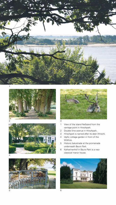
1
5 6
1 View of the island Neßsand from the vantage point in Hirschpark.2 Double lime avenue in Hirschpark.3 Hirschpark is named after its deer (Hirsch).4 Idyllic cottage garden in front of the Witthüs.5 Historic balustrade at the promenade underneath Baurs Park.6 Katharinenhof in Baurs Park is a neo- classical manor house.
3
4
2
Alster: Zwischen Lombardsbrücke und Duvenstedter Brook
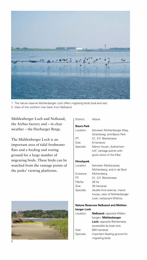
Mühlenberger Loch and Neßsand, the Airbus factory and – in clear weather – the Harburger Berge.
The Mühlenberger Loch is an important area of tidal freshwater flats and a feeding and resting ground for a large number of migrating birds. These birds can be watched from the vantage points of the parks’ viewing platforms.
2
1 The nature reserve Mühlenberger Loch offers migrating birds food and rest.2 View of the northern river bank from Neßsand.
District: Altona
Baurs ParkLocation: between Mühlenberger Weg, Strandweg, and Baurs ParkPT: S1, S11 BlankeneseSize: 8 hectaresSpecials: Manor house „Katharinen- hof“, vantage points with good views of the Elbe
HirschparkLocation: between Elbchaussee, Mühlenberg, and In de BostEntrance: MühlenbergPT: S1, S11 BlankeneseFläche: 26 haSize: 26 hectaresSpecials: double lime avenue, manor house, view of Mühlenberger Loch, restaurant Witthüs
Nature Reserves Neßsand and Mühlen-berger LochLocation: Neßsand: opposite Witten- bergen; Mühlenberger Loch: opposite Blankenese, accessible by boat onlySize: 650 hectaresSpecials: important feeding ground for migrating birds

57River Landscape Elbe and National Park Hamburgisches Wattenmeer
Jenischpark incorporating the Nature Reserve FlottbektalThe Jenischpark not only offers a beautiful environment with views of the river Elbe and two museums, but is also one of the most important landscape gardens in Northern Germany. Most of the paths that lead through the park were designed in the early 19th Century to give diverse, pleasant impressions – a real treat.
Inspired by the English poet William Shenstone and his estate The Leasowes near Birmingham, the merchant Caspar Voght from Hamburg created an expansive idealistic landscape in the late 18th Century – his “ornamented farm”. It combined aesthetic and economic
aspects with social responsibility. Agricultural use was part of the picturesque scenery, which also included small areas of woodland and clumps of trees. The owner, the workmen and visitors were meant to experience different atmospheres through diverse design of the park’s sections.
Following the acquisition of Baron Voght’s estate by the merchant and senator Martin Johann Jenisch from Hamburg, the white manor house in Jenischpark, designed by Hamburg-based architect Franz Gustav Forsmann, was built from 1831 to 1833. Jenisch also commissioned the garden designer Johann

58
Heinrich Ohlendorff to change the layout of the park and add glass-houses and formal gardens. Perennials and bedding plants still flower profusely in this northern part of the garden. Some exotic trees relate to the historic fashion for plant collecting and illustrate the commercial links to foreign countries at that time.
When in 1927 Jenisch’s inheritors intended to divide and sell the estate, the town of Altona rented the park and opened it to the public. In 1939 the City of Hamburg, to which Altona belonged by then, bought Jenischpark. The manor house Jenischhaus has since been turned into a museum and is well worth a visit, as is the nearby Ernst-Barlach-Haus with its modern art exhibition.
The present day Jenischpark roughly covers the area of the former Süderpark (southern park), only a small part of Caspar Voght’s originally much larger estate. Here the character of the landscape garden remained largely intact and has been further enhanced since the mid-1990s, following a landscape management study. As part of this report some of the park’s features were re-constructed, such as a rustic
District: AltonaLocation: Klein FlottbekEntrance: Baron-Voght-Straße, Hochrad, Elbchaussee, HolztwietePT: S1, S11 Klein Flottbek, Elbe-Ferry 64Size: 42 hectaresSpecials: museums Jenischhaus and Ernst-Barlach-HausInformation: see page 139
wooden bridge and the “Eierhütte”, a hut in the same style; vistas were opened again and footpaths were restored. These measures contribute further to Jenischpark’s ranking as one of Hamburg’s favourite attractions and as an important listed garden.
The course of the Flottbek (a small river) almost divides the Jenischpark into two halves. The river valley is the only interruption in the geest’s ridge along this stretch of the river Elbe. The Flottbek is the last natural watercourse draining the geest; and its lower section is influenced by the tide. The small river with its accompanying banks covered in typical plant species has partly been designated as a nature reserve. In addition to 80-year-old Willows, Butterbur, Sorrel and Buttercups grow here. And in the adjacent water meadows large swathes of Lady’s Smock draw a pink veil across the landscape in May.
River Landscape Elbe and National Park Hamburgisches Wattenmeer

1
4
1 The abundant vegetation along the river Flottbek contrasts with the landscaped park.2 Entrance gate dating from 1906.3 The neo-classical Jenischhaus has been turned into a museum, where one can experience the lavish lifestyle of past generations.4 The re-constructed rustic hut “Eierhütte“.5 Flowering Meadowsweet on the banks of the river Flottbek.
2 3
5

60
Strandweg, Elbhöhenwander-weg and Römischer Garten
River Landscape Elbe and National Park Hamburgisches Wattenmeer
Promenades and footpaths along the riverbanks are the “string” for the pearl necklace of parks along the Elbe; some are close to the water’s edge, some are up on the geest’s ridge and offer long distance views. One of the parks on the geest is the Italianate Römische Garten.
The lower footpath, the Elbufer-weg, starts at the Port of Hamburg and continues uninterrupted to Wedel, a small town west of Hamburg. The path evolved in stretches from the 1930s onwards. Coming from the Port some of the first parks are Altonaer Balkon, Heinepark and Donnerspark, followed by the small gardens of the houses in the borough of Övelgönne. Further west lie Schröders Elbpark, Hindenburg-park and Jenischpark.
Underneath Baurs Park a promenade with a remarkable historic balustrade leads further west. This stretch of the Elbe-wanderweg originally belonged to Baurs Park, and accordingly it was beautifully constructed. Above Strandweg further inland towards Blankenese are Hessepark and Gosslers Park – two smaller landscape gardens. On the other side of the historic village
Blankenese one can climb a hill to the viewpoint Bismarckstein and en route catch a glimpse of Schinkels Park. If one prefers to save one’s energy for a very real jewel among the pearl necklace, one ought to remain on Strandweg until Falkensteiner Weg. Just after the crossing steps lead up to the Italianate Römische Garten.
Römischer Garten with its three terraced parts is so-called due to its Mediterranean appearance. The garden originates from approximately 1880-90. Its owner Anton Julius Richter had been inspired by travels to Italy. After the banking family Warburg bought the estate a garden theatre, a rose garden, a lily pond and flower borders on dry stone walls were added well into the 1920s. The emigration of the Warburg family during the Third Reich was a first step towards decline; a fate it shares with many similar estates. The estate was returned to the family after the war, but Römischer Garten was given to the City of Hamburg in 1951 under the condition that it should be kept and maintained. In 1991 the garden’s history was researched with a view to listing, and a park management study was undertaken, leading to the restoration of some of its parts.

1 Italian impressions high above the Elbe: the garden theatre in Römischer Garten.2 The artistically pruned garlands of the hedge.3 View through the hedge to the hills south of Hamburg.4 Recently restored: lily pond and flower borders.5 A new semicircular seat following an historic design.
1
2 3
4 5

62
The garden is like a well-conducted play and beyond comparison. It has been opened to the public and offers the most stunning views through a garland-shaped Thuja hedge of the Elbe valley 30 metres below and across it towards the distant hills. Occasionally the garden theatre is used for small performances.
Further towards the West the Elbhöhenwanderweg meanders along the edge of the geest. Through rhododendron and pine trees or densely wooded stretches it offers lovely views of the Elbe or allows glimpses of some of the old gardens bordering it. The view from the Puppenmuseum (dolls’ museum) in Sven-Simon-Park is particularly beautiful. The park
River Landscape Elbe and National Park Hamburgisches Wattenmeer
3
2
4
1 Süllberg in Blankenese.2 Strandweg is suitable for long walks down the Elbe even in winter.3 The dolls’ museum in Sven-Simon-Park high above the Elbe.4 Steep steps lead up to the viewing point Bismarckstein.
1

Elbhöhenwanderweg/StrandwegLocation: from Mühlenberg down- stream to Wedel PT: Bus 286, 189, 48, 49Length: approx. 5 kilometresSpecials: stunning views, Sven-Simon- Park with dolls’ museum and art galleryInformation: see page 139
Römischer GartenLocation: Elbhöhenwanderweg/Falken- steiner UferEntrance: ElbhöhenwanderwegPT: Bus 48Specials: garden theatre, formal gardens, garland-shaped Thuja hedge
used to be the private garden of the famous German publisher Axel Springer. The museum and an art gallery are situated in an impressive country house. The white villa, designed by Karl Schneider in a simple modernist style, was built in 1923 and is one of the most important 20th Century buildings in all of Hamburg. The garden was designed in the 1950s by Hamburg’s well-known landscape designer Gustav Lüttge – with long vistas in the landscape garden and stone-walls and flower borders near the buildings. The park has fallen into decay and awaits restoration.
From here to Hamburg’s western boundary the Elbhöhenwanderweg (raised footpath) runs through the nature reserve Wittenbergener
Heide, which is described in a separate chapter.
Along the whole stretch of the riverbank several small cafés and kiosks offer rest and sustenance.
View from Bismarckstein of the island Neßsand.

64
Natural beach and water meadows underneath Wittenbergener Heide.
Nature Reserves Wittenbergener Heide/Elbwiesen and Schnaakenmoor
Two much-loved and very different nature reserves are situated near Hamburg’s western boundary with neighbouring Schleswig-Holstein. The two reserves are similar in their combination of dry and wet habitats, but the location of Wittenbergener Heide and Elbwiesen on the river-banks on the one hand and the proximity of Schnakenmoor to the woods of Forst Klövensteen on the other already hint at the differences.
The Wittenbergener Heide and Elbwiesen are very diverse. The last
stretch of natural beach in Hamburg is located right at the water’s edge; and it is heavily used not only during the summer. Just inland the nature reserve Elbwiesen abuts. These meadows are only used in a limited way: The grass is cut only once a year in July – by this means a rare habitat is maintained. In addition to Reed Mannagrass, Butterbur, Angelica and Comfrey rare Snake’s-heads grow here. In these wetland areas amphibians such as frogs and Common Toads find a suitable habitat. Bordering the meadows or
River Landscape Elbe and National Park Hamburgisches Wattenmeer

the beach respectively are the dramatic cliffs of the Wittenbergener Ufer. In some parts beech trees grow on the slopes. Whereas freshly eroded parts are left bare. This is an ideal place for the quick, emerald-green lizards to sunbathe.
On top of the slope the landscape’s character changes – heathland dominates here. Until the Middle Ages the area was densely wooded, but it was so intensely used that the wood has vanished almost completely. Instead heathland developed, some-times intersected by oak copses or dunes. Heather, copses and dunes are typical habitats created through human use. Heather can only survive, if trees and shrubs are kept at bay, which was originally caused by logging and grazing and is now done according to a management plan. Copses with their
bizarrely shaped trees were originally used as feed for farm animals. The dunes were also caused by intensive logging and erosion. The absolutely straight lines of the Sand Sedge, a pioneer for re-vegetation, can be seen on the otherwise bare sand.
The nature reserve Schnaakenmoor is situated further inland, in the cherished wood Forst Klövensteen. The landscape was originally made of dunes and moors, which were exploited since the Middle Ages. The trees on the dunes were logged; Heather and bare sand followed. But in the 19th Century the dunes were re-planted with (fir) trees. Peat from the moors was also used and the land subsequently turned into farmland or woods.
The diversity of the original flora and fauna declined due to intensive use, but
In the nature reserve: white dunes with Heather, Birch and pine trees.

Alster: Zwischen Lombardsbrücke und Duvenstedter Brook
District: Altona
Nature Reserve Wittenbergener Heide/ElbwiesenLocation: Wittenbergener WegPT: Bus 189, 286Size: 39 hectaresSpecials: Heathland, dunes, water meadows
Nature Reserve SchnaakenmoorLocation: Klövensteenweg/Feldweg 84PT: S1 RissenSize: 100 hectaresSpecials: diverse landscape with heath- land and moors
some natural “islands” were left. These were employed as starting points for restoring the landscape. Whereas the management favours heather and grass on the dry dunes, the wet areas are meant to return to moors. Because of their close proximity it is possible to distinguish Scotch Heather (on dry soil) from Bog Heather (on moors) within one nature reserve. Further to this one can see rare wildlife such as snakes, frogs and toads as well as over 100 species of butterfly. In addition Wood Larks and Little Ringed Plover sing and Hobbies hunt in this area.
Whereas in Wittenbergen biodiversity has been increased by the sensitive use through man, the intensive use in Schnaakenmoor has caused damage, which is in the process of being rectified. The comparison is
interesting and it is a pleasure to be in beautiful surroundings. The two nature reserves are not for nothing favourites for weekend outings and are well known outside Hamburg.
Das Moorgebiet ist für viele seltene Pflanzen- und Tierarten ein wertvoller Lebensraum.
In restored moor areas bigger trees and shrubs gradually give way to the originally open landscape.

67
Rüschpark
Rüschpark is situated on the southern banks of the Elbe, next door to the Airbus factory and has its own pier. The views of the river, the opposite bank and passing ships attract visitors from all over Hamburg.
Until the 1970s this area belonged to the shipbuilder Deutsche Werft. Some buildings and other remnants of the factory are still recognizable. The Deutsche Werft used to be of huge importance for Hamburg; but it also had its dark side: During World War II forced labourers and prisoners from concentration camps had to work here – a memorial has been erected in their honour in the southern section of the park.
District: Hamburg-MitteLocation: Finks WegPT: Bus 17, 47, 150, 251, Ferry 64 to Teufelsbrück Size: 11.4 hectaresSpecials: view of the hilly northern riverbank
River Landscape Elbe and National Park Hamburgisches Wattenmeer
To compensate for the extension of the Airbus factory a park was created in the early 1990s, but had to be altered again in 2004 to accommodate the lengthening of the runway. Today the park consists of two parts: The one near the river is inspired by nature, dotted with a few sunny seats and an area for beach-volleyball. The second part, on the other side of the street Leegerwall, is more intensely used. It boasts a playground, a sporting field, a skating rink and a formal garden.

68
Nature Reserve Heuckenlock
River Landscape Elbe and National Park Hamburgisches Wattenmeer
District: HarburgLocation: following Süderelbe along Moorwerder HauptdeichEntrance: Stillhorner HauptdeichPT: S3 Wilhelmsburg, Bus 351Size: 120 hectaresSpecials: unique riparian forest
The nature reserve Heuckenlock with its “jungle” of trees and diverse tidal freshwater flats as well as very rare species feels a bit like a collection of curiosities.
The location on a peninsula is special in itself. At Bunthausspitze the Elbe bifurcates into Norder- and Süderelbe. This was an important site for our ancestors; here Hamburg gained control of the Süderelbe and therefore became a significant port.
Otherwise the bog was left to itself. The only major impact was the construction of the motorway in 1939, dissecting the existing nature reserve. Despite this the area is of importance for wildlife on a European scale.
From Bunthausspitze a footpath leads along the embankment to the motorway A1. Whereas a circular walk guides visitors through the nature reserve, crossing inlets in the mudflats and the typical riparian forests. A small path leads to a 400 year-old elm tree. The lower parts of the nature reserve are influenced by the tides and are full of nutrients. Here reed grows up to five metres tall and in summer wildflowers bloom. Interspersed are meadows that are only used in a
limited way, allowing Marsh Mari-golds and the rare Snake’s-head to grow. Two plants, Oenanthe conioides and Deschampsia wibeliana, are even endemic to the tidal freshwater flats of the Elbe.
The almost untouched nature in this reserve not only brings forth unique plants, but also attracts rare animals: Apart from Stork, Bittern, Heron and Cormorant, one can see and hear songbirds, such as the bright yellow Golden Oriole. Furthermore there are large numbers of insects and fish in this area.
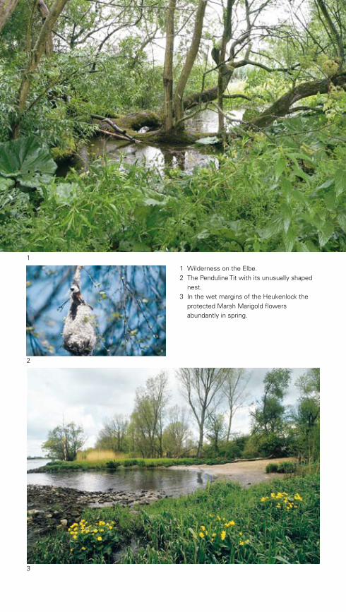
1
1 Wilderness on the Elbe.2 The Penduline Tit with its unusually shaped
nest.3 In the wet margins of the Heukenlock the protected Marsh Marigold flowers abundantly in spring.
3
2
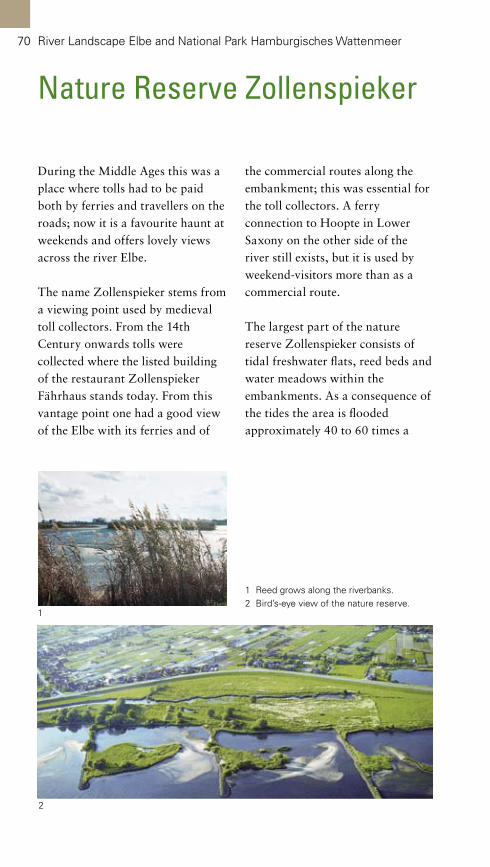
70 River Landscape Elbe and National Park Hamburgisches Wattenmeer
Nature Reserve Zollenspieker
During the Middle Ages this was a place where tolls had to be paid both by ferries and travellers on the roads; now it is a favourite haunt at weekends and offers lovely views across the river Elbe.
The name Zollenspieker stems from a viewing point used by medieval toll collectors. From the 14th Century onwards tolls were collected where the listed building of the restaurant Zollenspieker Fährhaus stands today. From this vantage point one had a good view of the Elbe with its ferries and of
the commercial routes along the embankment; this was essential for the toll collectors. A ferry connection to Hoopte in Lower Saxony on the other side of the river still exists, but it is used by weekend-visitors more than as a commercial route.
The largest part of the nature reserve Zollenspieker consists of tidal freshwater flats, reed beds and water meadows within the embankments. As a consequence of the tides the area is flooded approximately 40 to 60 times a
1 Reed grows along the riverbanks.2 Bird’s-eye view of the nature reserve.
2
1

Reed beds play an important role in water purification.
year. This has created a highly specialized flora and fauna, with rare plants such as Xanthium albinum ssp. albinum, Artemisia annua and the grass Deschampsia wibeliana. Special nature conser-vation measures are employed to try to establish Oenanthe coinoides, which is endemic to the tidal freshwater flats of the Elbe, thus enlarging its habitat.
Among the birds, those living in meadows are the most noticeable: Lap Wing, Common Snipe and Meadow Pipit as well as the rare Black-tailed Godwit and Red Shank. On steep banks the quick Kingfisher can be seen and in tree studded areas Golden Oriole and Wry Neck sing. The river and the inlets in the mudflats teem with
Common Merganser, Shelduck and Teal, which are rare in other parts of Hamburg. This stretch of the river also functions as breeding and resting ground for a large number of specialized fish.
Many of the rare plants and animals can be observed from the footpath on the main embankment. Lower Saxony on the other side can also be seen from here – or if one wanted a change of perspective, one could take the ferry across.
District: BergedorfLocation: along the main embankment at ZollenspiekerPT: S21 Bergedorf, Bus 124Size: 80 hectaresSpecials: bikers meet at the restaurant Zollenspieker Fährhaus

72
National Park Hamburgisches Wattenmeer
River Landscape Elbe and National Park Hamburgisches Wattenmeer
The island of Neuwerk is Hamburg’s jewel in the North Sea, or to be more precise in the National Park Hamburgisches Wattenmeer. This ancient and unusual part of Hamburg is situated approximately 100 kilometres from the city centre in the Elbe estuary and offers pure nature and adventure – already starting with the method by which one approaches the island.
The car-free island of Neuwerk can only be reached by boat or at low tide with a horse-drawn cart or on foot. This has not changed since the Middle Ages. Approximately 900 years ago, the island with the short name “O” consisted of almost bare dunes. Over time the dune’s sparse vegetation managed to spread, resulting in a green outpost for fishermen, which was also used for grazing during the summer. In 1299 Hamburg was granted permission by the Dukes of Sachsen-Lauenburg to build a fort (“Werk”) in order to protect the commercial shipping route into Hamburg. From 1300 to 1310 the mighty tower or “Neue Werk” was erected. It still stands as a listed building and has given the island its name.
From 1556 onwards a dike was constructed along the island’s
perimeter to enable agricultural use all year round and to protect the island’s buildings from storm floods. Today the medieval farming methods are maintained by the National Park for the Hamburg-Mitte District to which the island belongs.
A smooth natural “lawn” of common saltmarsh-grass, grazed by horses and cows, covers the saltmarshes in the northern part of the island. In spring the pink blooms of the Sea Pink adorn the area.
In the eastern parts of the island, outside the dike, special measures are used to encourage the natural vegetation of the saltmarshes and their diverse fauna. This is why during the summer this part of the island boasts a colourful carpet of blooms with highly specialized and therefore rare species such as Sea Lavender and Sea Aster. The air is mildly scented by the blue-green Wormwood, a medicinal herb.
The sandy or muddy tidal flats are by far the largest part of the National Park. They become visible twice a day with the falling tide. Innumerable crabs, snails, mussels and worms inhabit these areas. Most of them hide in the soil

1
1 Saltmarshes in bloom.2 Arriving by horse-drawn cart is a special start to visiting the island of Neuwerk. Neuwerk’s landmark in the background: the medieval tower.3 During low tide masses of mussels become visible. In the distance one can see the island’s old northern marker buoy.
2
3

74 River Landscape Elbe and National Park Hamburgisches Wattenmeer
during low tide and are only discernable by the typical trails they leave on the surface. The mudflats are intersected by deep inlets, which carry water constantly at their lowest points and protect maritime fauna such as crabs, starfish and fish from falling dry. These inlets are also home to the tasty North Sea shrimp, commonly known as “Krabbe” or “Granat”.
Hungry guests are never far off, where nature has laid such an abundant table: Millions of birds use the tidal mudflats as feeding,
breeding or resting ground or to hibernate altogether. Especially in spring and autumn, when migrating birds start their long journeys, the area is full of life. Geese, Shelduck and several species of wading birds, such as Curlews, Sandpipers und Bar-tailed Godwits rest here.
In the summer months the neigh-bouring islands Neuwerk, Schar-hörn and Nigehörn become important breeding grounds for seagulls, terns, Oyster Catchers and the rare Red Shank. Seals from the open sea join the breeding birds in
1 Startled terns on the island of Scharhörn.2 Pioneer of the tidal mudflats: Saltwort.3 Young Cormorant in its nest.
1 3
2

the tidal mudflats to raise their young ones on the sandbanks. Visitors may even get a glimpse of the endangered Porpoise, a six-foot mammal.
On the boat trip to Neuwerk, it can sometimes be seen at close proximity: The whale emerges at regular intervals to catch breath while it hunts for fish. Since the 1990s several huge Pot Whales have strayed into this area. Once these 15-metre long and very heavy hulks have strayed into the shallow waters, they usually face death.
The full scale of the adventure of visiting the tidal mudflats can only be guessed at by the number of plants, animals and habitats. It is therefore strongly recommended to obey the rules for observation and
walks by the National Park administration or simply to join a guided tour. Otherwise a day at the seaside can easily end with too much excitement.
Bird’s-eye view of the eastern part of the island, which has been returned to nature.
District: Hamburg-MitteLocation: Elbe-estuary off CuxhavenPT: boat from Cuxhaven, horse- drawn cart or on foot through the tidal mudflats from Cuxhaven-SahlenburgSize: 13,750 hectares (National Park)Specials: historic tower, Nationalpark- Haus (information centre), saltmarshes in the East, walks through the tidal mudflats to ScharhörnInformation: see page 140


77
The Alster between Lombardsbrücke and Duvenstedter Brook
The Binnen- and the Außenalster (Inner and Outer Alster) with their green banks at the heart of Hamburg are internationally known and characterize the townscape. But the Alster has also a lot of sights and attractive landscape to offer further upstream.
Created artificially through the construction of a miller’s dam in the 13th Century the Außenalster is surrounded by green. The most important green space is Alster-vorland with its architectural promenade contrasting with organically shaped meadows. This park lies west of the large expanseof water.
Further upstream the Alster is canalized up to Fuhlsbüttler Schleuse (a lock). In connection with the
canalization at the beginning of the 20th Century parks were created along the banks, from Haynspark in the borough of Eppendorf to Alster-krüger Kehre and further to the park near the public swimming pool in the borough of Ohlsdorf. Concurrently Hamburg’s first large public park, Stadtpark in Winterhude, was built from 1914 onwards. This park is internationally known as a prime example and still cherished by visitors.
Near Ohlsdorfer Kehre lie the public swimming pool, which is much used, and the famous Ohlsdorfer Friedhof, the world’s largest park cemetery. This cemetery is not only used as a burial ground, but also as a recreational space.
Upstream from the lock Fuhlsbüttler Schleuse the naturally meandering riverbed still remains. The accom-panying footpath Alsterwanderweg leads to several nature reserves; the Duvenstedter Brook being the most famous of them. During the deer’s rut it attracts large crowds of people.

78
Außenalster and Alsterpark
The Alster between Lombardsbrücke and Duvenstedter Brook
District: EimsbüttelLocation: Alstervorland: Harvestehuder WegPT: U1 Hallerstraße, Bus 109Specials: sculptures, 7.5-kilometre circular track for running, cafés, boat hire, Alster ferries
The Außenalster with its green necklace is one of Hamburg’s high-lights. Sailing boats and Alster ferries can be watched from the parks and cafés on the shores. And from the water – or in cold winters from the ice – there are attractive views of the villas, gardens and parks that frame the Alster.
But this impressive scene is not as natural as it appears. Until the 12th Century the Alster had been a small stream meandering towards the Elbe. The Reesendamm, built in 1235, caused flooding as far up-stream as Winterhude and Harveste-hude: The Außenalster (Outer Alster) had been created. To begin with it was surrounded with pastures, which mainly belonged to the Cistercian monastery Herwardes-hude. From 1680 history relates increasing use as horticultural land and gardens, some of them magni-ficent baroque gardens. Until the mid-19th Century the number of country houses outside the city gates grew continuously, some of them had landscaped gardens right down to the water’s edge. Public access to the Alster was limited.
All this changed once the city gates were no longer locked at night and a ring road was constructed around the Alster between 1875 and 1907.
Concurrently the first public open spaces were created, initially on the eastern banks. But proposals for a public park on the western bank already existed. Its implementation was only made possible after World War II. In preparation for the International Garden Show 1953, the area was transferred into public ownership and Hamburg’s famous garden designer Gustav Lüttge was commissioned with planning the park. During the Garden Show the area was used to exhibit 50 sculp-tures. In order to emphasize the special charm of this beautiful spot, Lüttge designed an architectural promenade as the backbone to the whole site. It provides views across the open meadow towards the Alster. A seating wall, small squares with granite sets and the open meadow offered diverse backgrounds for the sculptures and gave the park a good structure. After the Show flowering peren-nials were added to the otherwise plain planting scheme. The basic structure of the park is still recognizable today.

11 Springtime walk underneath flowering cherries.2 The rhythmically structured promenade forms the backbone of the whole site.3 Sculptures, Alster ferries, villas and several piers with cafés – there is a lot to see around the Außenalster.
3
2

1
1 The main axis leads across the lake and the central lawn to the planetarium.2 The re-constructed plane avenue is an important part of the internationally renowned and listed Hamburger Stadtpark.3 The formal gardens were designed by Otto Linne.4 Canoeing on the lake.5 Flowers and sculptures decorate many parts of the park.
2 3
54

81
Young and old, those looking for activity or relaxation, the culturally interested and lovers of nature – everyone enjoys Hamburger Stadt-park. And what is more the park is situated in the borough of Winter-hude – in the middle of Hamburg.
The park was opened to the public in 1914 and due to the thoughtful-ness of its famous planners it is still hugely attractive. Initially the well-known town planner Fritz Schu-macher developed ideas for the 148-hectare park, later assisted by Hamburg’s first head of the Parks’ Department Otto Linne. Their designs were so timeless and con-vincing that the expression “Volks-park” is internationally connected with Hamburger Stadtpark.
During World War II the park‘s trees were used as firewood and the land was cultivated to grow vege-tables; for a brief period after the war, huts for the many homeless were erected. But since the 1950s most of the park has been returned to its original layout. Though most of Schumacher’s buildings were destroyed in the war, the under-lying idea can still be discerned: For example the vast open space of the main axis from the Planetarium to the lake contrasting with the cosiness of the small gardens, such
as the hedge-gardens and the flower gardens. Since 1997 a park management study aims to combine historic elements with present uses and capacities for maintenance.
That way Hamburg’s citizens and visitors can stroll through the re-constructed plane avenue and admire the re-planted rows of trees that frame the central meadow. Alternatively one can use the manifold sporting and recreational areas, admire works of art and flower borders, partake in guided walks or in the extensive cultural activities of the planetarium or just relax with a cup of tea.
The park with its lakes, the wood Sierichsches Gehölz, the open lawns and abundant flower borders is also a kind of green lung for the town and an important habitat on the green artery leading north from the city centre. Rare birds can be watched as well as frogs and fish, bats and butterflies.
District: Hamburg-NordLocation: JahnringEntrance: open to the publicPT: U3 Borgweg/Saarlandstr., S1, S11 Alte WöhrSize: 148 hectaresSpecials: public swimming pool, open air stage, cafés, planetarium, sporting areasInformation: see page 140
Hamburger Stadtpark
The Alster between Lombardsbrücke and Duvenstedter Brook
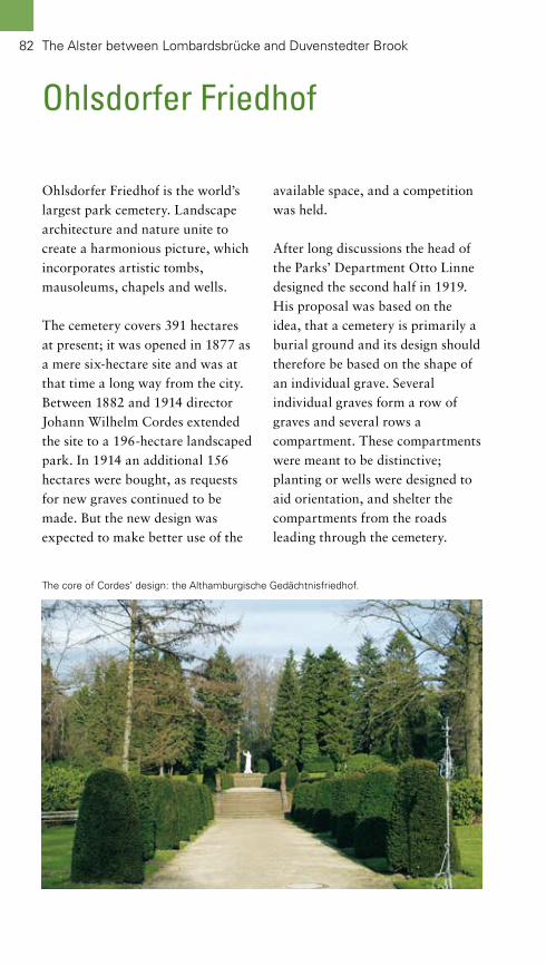
82
Ohlsdorfer Friedhof
Ohlsdorfer Friedhof is the world’s largest park cemetery. Landscape architecture and nature unite to create a harmonious picture, which incorporates artistic tombs, mausoleums, chapels and wells.
The cemetery covers 391 hectares at present; it was opened in 1877 as a mere six-hectare site and was at that time a long way from the city. Between 1882 and 1914 director Johann Wilhelm Cordes extended the site to a 196-hectare landscaped park. In 1914 an additional 156 hectares were bought, as requests for new graves continued to be made. But the new design was expected to make better use of the
available space, and a competition was held.
After long discussions the head of the Parks’ Department Otto Linne designed the second half in 1919. His proposal was based on the idea, that a cemetery is primarily a burial ground and its design should therefore be based on the shape of an individual grave. Several individual graves form a row of graves and several rows a compartment. These compartments were meant to be distinctive; planting or wells were designed to aid orientation, and shelter the compartments from the roads leading through the cemetery.
The core of Cordes’ design: the Althamburgische Gedächtnisfriedhof.
The Alster between Lombardsbrücke and Duvenstedter Brook

Der Hamburger Stadtpark
Alster: Zwischen Lombardsbrücke und Duvenstedter Brook 83
Flowering rhododendron in the landscaped part of the Ohlsdorfer Friedhof in May.
Despite his geometrical design Linne found it essential to keep existing trees and hedgerows. Large family vaults and abundant flowers in the small compartments contributed to making the whole park appear less rigid. A logical consequence of focussing on the individual graves and the compartments was the desire to influence the size, shape and material of the tombstones – regulations that Linne introduced.
The difference between the two styles is still recognizable today: The original landscape garden designed by Cordes in the western part and the regular layout by Linne in the eastern extension. Some of the compartments also reflect the clarity of Linne’s
proposals. Graves of several famous people can be found in both parts. The Althamburgische Gedächtnis-friedhof (where famous local people are buried), the Jewish cemetery and the Rose Garden are some of the highlights. The Rose Garden is regarded as a good example of garden design and was restored following the historic layout in 1997.
District: Hamburg-NordLocation: between Fuhlsbüttler Straße, Bramfelder Chaussee and Große HorstEntrance: Fuhlsbüttler StraßePT: U1, S1, S11 OhlsdorfSize: 391 hectaresSpecials: graves of famous people, rhododendron bloom in MayInformation: see page 140

84
Nature Reserve Wohldorfer WaldThe nearly 365-hectare Wohldorfer Wald in the borough of Ohlstedt is Hamburg’s largest deciduous wood and one of the oldest in town. A good third of the area is designated as a nature reserve. The different areas of this wood can be enjoyed on long walks.
The existence of woodland in this area can be traced back to the Middle Ages. And already since 1770 the much-loved Wohldorfer Wald was officially designated as a recreational wood owing to its beautiful landscape.
Beech trees cover most of the area, some of them are over 200 years old and their canopies have created the typical dome effect of a mature beech woods: The tall trees block out the light to such an extent that the undergrowth possesses hardly any shrubs or trees. The canopies form a kind of dome above the trunks that appear like pillars. Since beech leaves sprout rather late one often finds beautiful carpets of spring flowers in those woods. One of them is the charming Anemone.
In addition there are some mixed oak and beech woods, where Cowslips, scented Woodruff and Sanicle grow. These ancient
In spring anemones create a flowering carpet.
The Alster between Lombardsbrücke and Duvenstedter Brook

District: WandsbekLocation: north of the borough Wohldorf- Ohlstedt Entrance: KupferredderPT: U1 OhlstedtSize: 136 hectaresSpecials: manor house, woodland cemetery, remains of an old arboretum, information centre Duvenstedter BrookInformation: see page 140
woodlands are home to rare birds such as Pied Flycatcher, Hobby, Tawny Owl and even Eagle Owl.
Along the small rivers Ammersbek and Drosselbek as well as the ponds Kupfer- and Mühlenteich and other small water bodies specialized woodland, such as riparian forests and carrs can be found. Whereas riparian forests are characterized by sporadic flooding, the water remains still for longer periods in carrs. Therefore both types possess specialized flora and fauna. Apart from Kingfishers and Woodcocks, the water is home to Great Crested Newts and Otters.
Woodpeckers love decaying trees of which there are a lot in both nature reserves – so one can spot all three species of Spotted Woodpeckers, as
well as Black and Green Wood-peckers. By cutting the meadows within the woods only once a year, orchids are kept alive and well.
This short account shows that there is a lot to see. Should you require further information, please visit the nature reserve’s information centre north of Wohldorfer Wald. At the Mühlenteich (mill pond) one can also find several places to rest and “refuel”.
In mature beech woods there are no shrubs or trees in the undergrowth.

86
Nature Reserves Rodenbeker Quellental and Hainesch-Iland
(mill pond) was created before 1345 in a former clay pit. From then on it was used to power a mill. The former fishponds stem from a later date. All the water bodies are special habitats for a large number of animals. Apart from different types of fish such as Bitterling, Red-eye, Pike, Perch and Gudgeon, amphibians abound, among them Water, Moor and Common Frogs. There are also a huge variety of dragonflies. The quick Kingfisher and the Dipper, which hunts underneath the water’s surface, rely upon these habitats and can be observed by perceptive visitors.
The name of the nature reserve Hainesch-Iland further south already indicates that is used agriculturally: Esch is an old german name for arable field. And indeed the 12 bronze-age burial mounds confirm human utilization for over 5,000 years. So the land-scape is not only shaped by woodland, springs and water bodies, but also by mankind. Typical examples of human use are orchards and copses, which mainly consist of oak or beech trees. The trees were coppiced every 15 to 20 years to obtain firewood and their fruits were fed to farm animals.
The last ice age has left its mark at the upper reaches of the Alster: Small valleys with streams, vertical slopes with springs and mounds all joined in close proximity. This undulating landscape also has a lot to offer in the way of wildlife.
The Rodenbeker Quellental is mainly wooded, from riparian forest along the Alster to other deciduous woods, either with mixed Beech, Oak, Hornbeam and Birch or mature, single-species beech woods. These latter produce too much shade for other trees and shrubs to develop in the under-growth – so the canopies form domes, supported by pillar-like trunks. All of the different types of woodland are home to an abun-dance of animals, many of which, such as woodpeckers, thrive on decaying wood. Therefore the dead wood is left in the nature reserves.
Watercourses, in particular the Alster, combined with woodland areas characterize the Rodenbeker Quellental. The Alster’s tributaries Rodenbek and Bredenbek have developed naturally and were recently revitalized. In addition to these there are several artificial water bodies: The Mühlenteich
The Alster between Lombardsbrücke and Duvenstedter Brook

1
2
1 Dense beech wood on a cliff above the Alster.2 Hainesch-Iland possesses an intricate mosaic of woodland and arable fields.3 Lush riparian forest along the Saselbek.
3

Alster: Zwischen Lombardsbrücke und Duvenstedter Brook
Copses usually consist of bizarrely shaped trees and possess a varied undergrowth of herbal plants, some of them rare species such as Rampion and Corydalis.
Meadows, pastures and arable fields are incorporated in the woodland. Water is provided by the small stream Saselbek as well as some ditches and a miller’s pond, dating from the 14th Century. The mill was in operation until 1969 and has since become a favourite restaurant.
This varied landscape is the breeding or feeding ground for
more than 130 species of birds, among them rare songbirds such as Chiffchaff. Kingfishers, some diving ducks, Hawfinches and Tawny Owls also live here.
District: WandsbekLocation: Borough of Bergstedt
Rodenbeker QuellentalLocation: RodenbekredderPT: U1 Ohlstedt, Bus 176Size: 47 hectares
Hainesch-Iland Location: Furtredder/IlandPT: S1 Poppenbüttel, Bus 276Size: 74 hectaresSpecials: Restaurant „Alte Mühle“
2
1
1 Lesser Celandine is just one of the many plants that prefer light woodland.2 Marsh Marigolds live on the margins of water bodies.

89
Nature Reserve Duvenstedter Brook
dating to the last Ice Age have been covered with several metres of sand leading to moors and bog vegetation. Southeast of the road the loamy soil of the former glacial streams is more alkaline and support mixed oak woods and riparian forests.
From the Iron Age until the 1950s intensive human use had destroyed much of the original landscape: When regulations protecting the nature reserve were passed in 1958, only 34 hectares of woodland and six hectares of moors had been left untouched. Activities to re-instate nature, especially in the bogs and moor areas, began in the 1970s.
Duvenstedter Brook is situated near Hamburg’s northern boundary and is well known for its diverse landscape and the large number of deer. It attracts many visitors from near and far, especially during the rut in October. But Duvenstedter Brook has a lot to offer at other times as well.
Covering an area of 780 hectares, Duvenstedter Brook is Hamburg’s second biggest nature reserve. The word brook hints at a boggy site, but Duvenstedter Brook is not only a bog; it is one of Hamburg’s most diverse nature reserves. This is partly caused by the differences in the ground: Northwest of the road Duvenstedter Triftweg clay deposits
The Alster between Lombardsbrücke and Duvenstedter Brook

The Alster between Lombardsbrücke and Duvenstedter Brook90
3
2
On the moors clumps of the typical sphagnum-mosses grow, inter-spersed with Cotton Grass, Cran-berry, Bog Rosemary, Bogbean and carnivorous Sundew. The heathland areas consist mainly of Bog Heather, which is a typical moor plant as opposed to Scotch Heather. Adjacent to the moors are carrs.
On the other side of Duvenstedter Triftweg one mainly encounters mixed oak woods and riparian forest with a diverse groundcover: Star-of-Bethlehem, Dog’s-Mercury, Royal Fern, Yellow Wood Anemone and several orchids grow here, among them three species of orchis.
In total 400 plant species have been found in Duvenstedter Brook.
The mosaic of habitats also attracts a diverse fauna. The 160 species of birds found in this area include Herons and rare Cranes, which breed here. Several species of predatory birds, such as the huge Sea Eagle and Osprey, Harriers, the rare Honey Buzzard, Falcons, Tawny Owls and many others were sighted. In addition one can listen to the voices of the bright yellow Golden Oriole, several species of Warblers, Brown Tree Pipit, Cuckoo, Great Grey Shrike and Red-backed Shrike. The latter
1

District: WandsbekLocation: directly north of the Wohldorfer WaldEntrance: Duvenstedter TriftwegPT: U1 Ohlstedt, Bus 276Fläche: 780 haSize: 780 hectaresSpecials: rut in autumn; information centre on Duvenstedter Trift- wegInformation: see page 140
betrays himself by leaving his prey pinned to twigs.
Red and Fallow Deer are the most obvious of the 38 species of mammals in the area, due to their far-reaching noises during the rutting season in October. They were bred in Duvenstedter Brook in the 1930s. At dusk one can also spot Wildboars, Roe Deer, Foxes, Martens, Polecats, Weasels and Badgers. In some areas there are even observation huts, but one still has to remain silent, because even in the metropolis, wildlife is not that tame.
To discover more about the land-scape, flora and fauna as well as nature conservation, please visit the
information centre. If you prefer to continue your walk, there are further nature reserves adjoining to the north and the south.
41 Duvenstedter Brook is intersected by various bridle ways and footpaths.2 The little stream Ammersbek.3 Agriculture surrounds the nature reserve.4 Flowering Cotton Grass on the moors.

93
The Wandse: Vom Kuhmühlen-teich to Höltigbaum
The Wandse is the longest tributary of the Alster. Together with its accompanying green spaces it forms one of the green arteries that connect the city with the surrounding countryside.
There are similarities with the Alster: The Kuhmühlenteich near the city centre can be compared to the Binnenalster; here too a dam was built to create this mill pond. And further upstream this river was also canalized. The canalized stretch is called Eilbek and is complemented by lime avenues.
At its height the river powered eight mills. Upstream from Wandsbeker Mühlenteich, another mill pond, the river was left to meander and is accompanied by a footpath. Varied green spaces are stringed along this stretch: Originally Eichtalpark with its native and exotic oak species surrounded a manor house. The same is true of the park at Pulverhofteich, where the historic manor house still exists. In between lies Botanischer Sondergarten, a garden displaying exuberant flowers. It was developed on the site of a former quarry.
The nature reserve Höltigbaum is situated along the upper reaches of the Wandse. It invites walkers, cyclists and skaters to extensive tours through the open steppe.

94
Eilbek and Wandse-Grünzug including Eichtalpark and Botanischer Sondergarten
The Wandse: From Kuhmühlenteich to Höltigbaum
and is called Eilbek. The banks are built as formal promenades and feature double lime avenues. Elegant townhouses establish the urban scenery. This formality is only punctuated at Kuhmühlen-teich, a former mill pond with its flowing lines and Weeping Willows that sway in the wind.
Surprisingly for such a small river, eight mills in total were powered by the Wandse. Among others, this fact contributed to turning the adjacent Wandsbek-District into a major industrial location. Upstream from Mühlenteich (another mill pond) near Friedrichsberg, the meandering river bears the original name Wandse and is accompanied by several green spaces.
The first sizeable park is the six-hectare Eichtalpark. Originally part of the summer residence of local business tycoon Lucas Luetkens. Around 1830 Luetkens started planting oak trees to produce tan from the trees for his leather factory nearby. The tan mill, in which the tan (bark, wood and leaves) was crushed, had been on the site of today’s restaurant “Zum Eichtalpark” since 1335.
In addition to the riverbanks of the Elbe and the Alster, Hamburg possesses a third green artery alongside a watercourse: the approximately seven kilometres of green corridor, the Wandse-Grün-zug. Most varied parks and nature reserves are strung upstream from the Außenalster (Outer Alster) to the eastern boundary of the town. Some of them are still little known.
With a total length of approximately 20 kilometres the Wandse is the longest tributary of the Alster. But because its name changes several times along the way, this fact is largely obscured. Not only the name, but also the character of the river and the landscapes either side changes considerably. During its course the river displays a huge diversity, beginning near the nature reserve Höltigbaum, a former military training area, and ending with the outlet into the Außenalster (Outer Alster) at Schwanenwik in the borough of Hohenfelde.
The small green space on Schwanen-wikbucht offers stunning views across the widest part of the Außenalster. Further to the east the Wandse flows in a canalized bed

1
2
1 The upper reaches of the Wandse in winter.2 Many bridges cross the Eilbek.3 Lime avenues accompany the Eilbek on its way to Kuhmühlenteich.4 Kuhmühlenteich with church St. Gertruden.
3 4
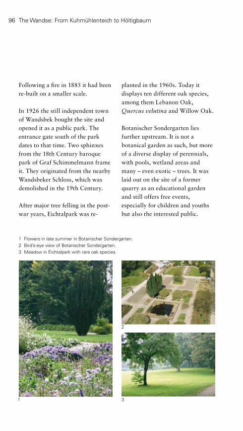
96 The Wandse: From Kuhmühlenteich to Höltigbaum
1 Flowers in late summer in Botanischer Sondergarten.2 Bird’s-eye view of Botanischer Sondergarten.3 Meadow in Eichtalpark with rare oak species.
Following a fire in 1885 it had been re-built on a smaller scale.
In 1926 the still independent town of Wandsbek bought the site and opened it as a public park. The entrance gate south of the park dates to that time. Two sphinxes from the 18th Century baroque park of Graf Schimmelmann frame it. They originated from the nearby Wandsbeker Schloss, which was demolished in the 19th Century.
After major tree felling in the post-war years, Eichtalpark was re-
planted in the 1960s. Today it displays ten different oak species, among them Lebanon Oak, Quercus velutina and Willow Oak.
Botanischer Sondergarten lies further upstream. It is not a botanical garden as such, but more of a diverse display of perennials, with pools, wetland areas and many – even exotic – trees. It was laid out on the site of a former quarry as an educational garden and still offers free events, especially for children and youths but also the interested public.
2
31

Upstream from here the Wandse meanders through many ecologically valuable areas, such as Tonndorfer Feuchtwiesen. These wetlands offer a habitat not only for rare orchids, but also for Kingfishers, Herons and many bats. Dedicated citizens look after certain stretches of the river as part of a special programme.
Halfway up this more natural stretch of the Wandse lies the park of a former manor house: Pulverhofpark dates back to an historic farm from 1602 owned by Ditmar Koel. He operated two mills until the late 19th Century, when both burnt down and were replaced by a manor house. The surrounding park features many rare trees, including Cypress Oaks, Tulip Trees and Liquidambers with their magnificent autumn colour.
The remainder of the Wandse belongs to the nature reserve Höltigbaum, which is described in the following chapter.
4 Manor house in Pulverhofpark.5 In the borough of Rahlstedt the Wandse meanders more naturally through meadows and fallow land.
District: Wandsbek
KuhmühlenteichLocation: Kuhmühle/EilenauPT: U2 Uhlandstraße
Eichtalpark, Botanischer SondergartenLocation: between Kedenburgstraße and ÖlmühlenwegPT: Bus 262Specials: rare oaks and other species, flower bordersInformation: see page 140
PulverhofparkLocation: Am Pulverhof/Stein-Harden- berg-StraßePT: S4 Rahlstedt, Bus 27Specials: historic manor house, rare tree species
4 5

1
2
5
1 Red Bent is one of the typical plants of grassland that is poor in nutrients.2 The Map Butterfly, a rare species.3 Possibly a sustainable method for landscape maintenance: Restrained husbandry.4 The Wandse reservoir.5 The wide-open steppe invites visitors to long strolls.
43

99The Wandse: From Kuhmühlenteich to Höltigbaum
Nature Reserves Höltigbaum, Ahrensburger and Stellmoorer Tunneltal
Wide open steppe – that is the succinct description of the 558-heactare nature reserve Höltigbaum that is divided in two halves by the borders between the Hamburg borough of Rahlstedt and the Stormarn-District in the federal state of Schleswig-Holstein. The nature reserves Stellmoorer and Ahrensburger Tunneltal with a combined area of 541 hectares adjoin further west and north respectively. The wide landscape offers a variety of recreational activities – from inline skating or cycling on comfortable concrete paths to sunbathing and picnicking on the expansive meadow to wildlife watching.
The undulations at Höltigbaum with their sparse grassland developed on rubble deposits from the Ice Ages. Grassland that is poor in nutrients is very rare due to the extensive use of fertilizers in modern agriculture. It offers a perfect habitat for grasses such as Red Fescue and Red Bent as well as other plants, including St.-John’s-wort with its uplifting properties. In addition there are areas of heathland that provide a touch of colour to the landscape in August.
The nature reserves Stellmoorer and Ahrensburger Tunneltal also owe their looks to the last Ice Age. The tunnel valleys were created approximately 15,000 years ago: Water from melting glaciers reached the glacier’s bottom through crevasses; its powerful currents dug a tunnel in the rubble – the depth depending on the rubble’s consistency and the water’s pressure.
Glacier tongues often followed these tunnel valleys. Sand and gravel entrained in the glacier’s water were deposited in small mounds that followed the direction of the flow and now form small ridges. Tunnel valleys are very rare, because they were often filled with natural deposits or by man. The small ridges are rarer still – our ancestors used them widely as an easy source for gravel or sand extraction. These nature reserves still feature good examples of both glacial remains.
The centre of tunnel valleys was often saved from development and intensive agriculture or forestry, due to the boggy soil (peat and mud are up to 20 metres deep). Common

The Wandse: From Kuhmühlenteich to Höltigbaum100100
District: Wandsbek/Kreis StormarnLocation: along the roads B 435, B 75 Entrance SW: Eichberg PT: R10 Rahlstedt, Bus 563Entrance N: KuhlenmoorwegPT: U 1 Ahrensburg WestSize: 1,438 hectaresSpecials: bridle ways and footpaths, inline skating, area for dogs, information centre
Alder, Bird Cherry, birch trees, sedges, ferns and mosses grow in the valleys’ carrs. Stellmoorer Tunneltal is also home to rare species of dragonfly and a variety of reptiles and amphibians, such as Common Lizard, Great Crested Newt and Common Toad.
The steppe was already used by reindeer-hunters during the Stone Age. The protection of archaeological findings from this period is another reason for the importance of this site. The first evidence of hunting with bow and arrow throughout all of Europe occurred in the “Ahrensburger Kultur” (approximately 8,200 BC), which was named after this area.
Later agricultural use remained limited and contributed hedgerows with Blackthorn and similar shrubs on the fields’ boundaries as well as copses with Common Apple and Wild Pear.
Between 1937 and 1995 the reserve was used as a military training area and was therefore spared from intensive agriculture with its heavy use of fertilizers and pesticides. In addition tanks continued to scarify the developing ground cover, which enabled rare pioneering plants such as Centaury to colonize the area.
The boggy valleys though were threatened by drainage from the 1930s well into the 1980s. Measures to restore the wetland areas have halted this development. Today orchids thrive here as well as 30 different species of dragonfly, Moor and Common Frogs plus several birds, Sky Larks, Common Snipe, Lap Wing and Red-backed Shrike among them.
Galloways, German Heath and other sheep are employed to keep the grass and heather down. According to a study they are attended to on a minimal basis.
The successful combination of nature conservation and recreation turned this project into a model in nature conservation.

1 The Ahrensburger Tunneltal.2 Bizarrely shaped trees are typical of copses.3 The last Ice Age left an undulating landscape.
1
2
3

102 The Wandse: From Kuhmühlenteich to Höltigbaum
Nature Reserve Volksdorfer Teichwiesen
District: WandsbekLocation: between Waldweg, Saseler Weg, and An den TeichwiesenPT: U1 VolksdorfSize: 39 hectaresSpecials: flowering orchids in spring
Even if the name does not betray the fact, the Volksdorfer Teich-wiesen are an example for a so-called tunnel valley. A changeable history has left so many traces on 39 hectares, that the circular walk along the perimeter resembles a discovery route.
The origins of the tunnel valley date back to the Ice Age, when water from melting glaciers created deep valleys underneath the ice; here it is the valley of the small stream Saselbek. In the 13th Century a dam was built to create a mill pond that powered several mills for over 300 years. Later the water level was lowered and the pond used as a fish pond until 1882, when it was drained completely and used as a meadow. The fen that gradually developed in the swale was even opened for peat cutting between 1945 and 1960. Adjacent areas were in agricultural use.
The different uses have created an intricate mosaic of habitats: Water courses and water bodies, reeds and carrs as well as meadows, pastures and hedgerows are home to more than 285 plant species, 63 of them endangered species. In spring thousands of orchid flowers compete with a sea of Ragged Robin, Devil’s-bit Scabious and
Yellow Meadow-rue. The local fauna is also varied. More than 60 species of birds, including Lap Wing, Common Snipe and River Warbler can be seen.
In the evenings even mammals fly here: The bat population extends from the tiny Common Pipistrelle to the large Noctule. Common Toad, Common Frog and Water Frog live in the meadows; during the mating season they intone a fantastic concert. And even the world of insects holds rarities in store: Several species of butterfly and locust live here.
Meadows and pastures are only used in a limited way and thereby maintained as they used to be. Small water bodies and the remaining woods are nurtured, to retain the landscape’s mosaic, thereby allowing a stroll through varied surroundings.

1
3
2
1 Sorrel and thistles colour the meadows red.2 Autumn at the ponds.3 The Saselbek leaves the Teichwiesen towards the Alster.4 Flowering Orchis.5 Polluted run-off from the road is filtered at the Halenreie reservoir.6 One of the many pollarded willows.
4
5 6
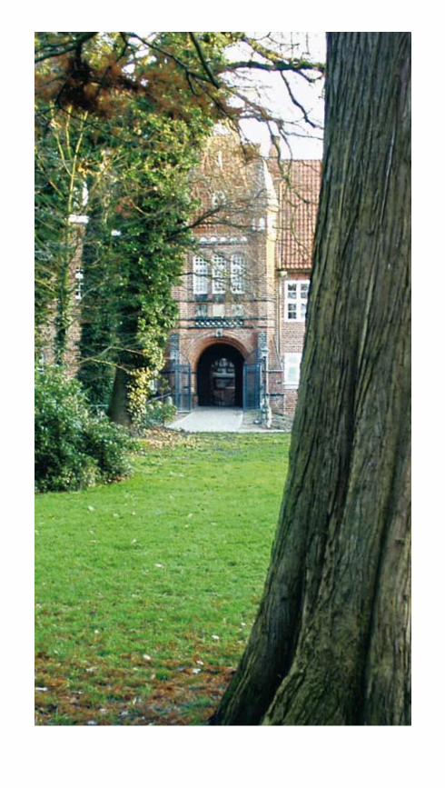
105
The Bille with Vier- und Marschlande
The Bille is a tributary of the Elbe. Together with Vier- und Marschlande the river characterizes the Southeast of Hamburg, which seems comparatively rural.
The peasant landscape portrays a side of the town that determined Hamburg’s look for centuries. The soil of the marshes is so rich in nutrients that they still contribute to supply the city. At the same time the historic villages and the cultural landscape offer Hamburg’s citizens varied options for recreation.
Ditches intersect the extensive meadows, pastures and fields of Vier- und Marschlande, thereby creating the typical striped landscape. In combination with remains of riparian forests and carrs as well as the foothills of the geest at the dunes Boberger Dünen an intricate mosaic of almost undisturbed habitats has developed. Here one can watch rare species near the city.
Last but not least two historically important sites lie at the centre of the former town Bergedorf: The Renaissance castle with its museum explaining the history of the area and the surrounding gardens.

106
Nature Reserve Boberger Niederung
The Bille with Vier- und Marschlande
District: BergedorfLocation: between Bergedorfer Straße and Billwerder BilldeichPT: Bus 12, 534Size: 350 hectaresSpecials: impressive dune; information centre Boberger FurtInformation: see page 141
The nature reserve Boberger Niederung is an area of great contrasts: The 30-metre slope of the geest and the Bille valley, the dry sandy areas of the dunes and the wet meadows and bogs differ greatly. Four well-signed circular walks ease exploring this extremely diverse landscape.
The geest’s slope on the area’s northern edge dates back to the Saale-Ice-Age when glaciers deposited loamy moraines. The use as a clay pit 150 years ago has given the site its terraced contours. The excavation cut into aquifers, opening some springs and producing a sunny slope with a mosaic of soil types. Here several orchid species grow, among them Marsh Helleborine and Broad-leaved Marsh Orchid. The plants are joined by several rare species of butterfly, such as Six Spot Burnet Moth.
The adjacent dunes have been greatly reduced in size by extensive digging. Nevertheless German Pink and Sheep’s-bit live in the dry grassland that covers the remaining area. In other parts heather and a mixed wood of oak and birch grow. Various insects cavort here, among them butterflies such as Common Blue or Fritillary and locusts. Wood
Lark and Sky Lark are typical of the local birdlife.
Peat was dug in the boggy valleys. Despite this the remaining alder-carrs offer habitats to 40 endangered species. Typical birds in this type of woodland are Siskin, Golden Oriole, Penduline Tit and Nightingale. Greater Bladderwort, a carnivorous plant, and Moor Frogs live in the water. In the mating season the frogs are almost as blue as another local – the Kingfisher.
In addition to the footpaths there is also a lake for swimming and several view points. Sporting options in the area extend from gliding to horse riding. For more information and in-depth literature please contact the local information centre “Boberger Furt”.

1
2
1 Open sand area on the dunes.2 Grazing sheep and goats maintain the landscape.3 The boggy valley of the river Bille forms an interesting contrast to the sandy dunes.4 Several footpaths lead through the area.
3 4

3
1 Embedded in green nature: the regatta stretch of the water sports centre for rowing and canoeing.2 All around the Wasserpark Dove-Elbe rare plants can be seen, such as Chicory.3 Eichbaumsee provides recreation near the city.
2
1

Wasserpark Dove-Elbe and Nature Reserve “Die Reit”
The Bille with Vier- und Marschlande
Wasserpark Dove-Elbe (a so-called water park) has much more to offer than the well-known lake Eich-baumsee with its beach. The land-scape appears so natural, that the underlying design only becomes discernable on closer inspection – but that is well worth it.
This landscape at the point where two tributaries of the Elbe (Dove- and Gose-Elbe) converge has been cultivated over centuries. Agricultural use was already documented in the mid-13th Century. But after 1965 the area changed considerably, caused by gravel extraction for large development projects and motorway construction.
Following the gravel extraction the resultant pit was turned into a place for recreation and water sports. Even the surrounding cultural landscape and the nature reserve “Die Reit” was incorporated into the plans. Landscape architects Isterling and EGL won the competition in the early 1980s. According to their plans the approximately 28-hectares lake Eichbaumsee was officially designated for swimming. Car parking areas cleverly situated
near the motorway’s exit “Aller-möhe” reduce on-site traffic. Outdoor furniture was only sparingly used and therefor provides comfort for visitors without impacting on the landscape.
A regatta stretch for rowers and canoeists was installed on the Dove-Elbe. It complies with international regulations for high-performance sports. On days without competitions, the observation tower serves as a viewing platform, and the neighbouring lawns are favourite places for sunbathing, resting and picnicking.
The nature reserve “Die Reit”, that abuts to the south, is characterized by the typical vegetation of wet habitats and resembles an open-air-terrarium: Many different species of newts, frogs and toads abound and can be seen at close proximity. One of them is the rare Great Crested Newt. There are also rarities among the 200 species of birds that live here, from the huge Marsh Harrier and the equally big Osprey to various songbirds and Water Rail. Even the flora is highly varied: Spatterdocks and Water
109

Alster: Zwischen Lombardsbrücke und Duvenstedter Brook
1 Diverse carrs cover large parts of “Die Reit”.2 Snake’s-head now only grows at a few sites along the Elbe.3 The Tree Frog is one of the many amphibians living in “Die Reit”.4 Since 1973 the nature reserve “Die Reit“ has been internationally renowned for researching migrating birds.
2 3
4
1

Wasserpark Dove-ElbeDistrict: BergedorfLocation: Beach: Moorfleeter Deich, Water sports centre: EichbaumbrückePT: Bus 321Fläche: 88,4 haSize: 88.4 hectaresSpecials: beach, high-performance water sports centre for rowing and canoeing
Nature reserve “Die Reit“District: BergedorfLocation: between Reitdeich and Reitbrooker WesterdeichPT: Bus 222Size: 48 hectaresSpecials: one-hour circular walk
Lilies grow on ponds and tarns, reed with Bulrushes decorate the margins, and the carrs consist of Willows, Birch and several flowering shrubs. Meadows and pastures inside the embankment are dotted with Snake’s-head. The whole area is so rich in species that it is protected under European law.
The nature reserve is surrounded by an intricate cultural landscape with many historical buildings and small wetlands with interesting shrubs and trees. Remains of riparian forests, hedgerows and rows of pollarded willows give structure to a landscape that owes its typical stripes to drainage ditches. The top of the embankment is a good place to observe water sports and the nature reserve as well as look at the many meadows, pastures and fields with
vegetables and flowers. Bird watching is best done in the morning; amphibians are more active in the evening.
Waterbody with reeds in the nature reserve „Die Reit“.

1
2
3
4 5
1 The castle Bergedorfer Schloss combines architectural styles from the 16th to the 19th Century.2 A suspension bridge with Art Deco ornaments crosses the moat between the garden and the castle’s island.3 The former kitchen garden was turned into a formal garden.4 The romantic moat.5 A stone lioness guards the castle’s driveway.

113
Bergedorfer Schlossgarten
The Bille with Vier- und Marschlande
District: BergedorfLocation: Bergedorfer SchloßstraßePT: S2/S21 BergedorfSize: nearly 5 hectaresSpecials: renaissance castle with Museum für Bergedorf und die VierlandeInformation: see page 141
Bergedorfer Schlossgarten – the former castle’s garden – is a green island in the inner city of Bergedorf and is not only of historical importance. Together the former castle and the park provide a place for an al-fresco lunch break, for sunbathing on meadows and for an educational visit to the museum.
The history of the castle, which was later used as a municipal building, is extraordinary. The Danes erected the first castle in the early 13th Century on an important trade route between the Hanseatic Cities of Hamburg and Lübeck. After the Saxons’ victory over the Danes in 1227 the castle was home to various branches of Saxony’s ducal family until the 15th Century. Following several raids on their laden tradesmen, the Hanseatic towns successfully stormed the castle in 1420 and turned it into a municipal building. Hamburg and Lübeck administrated alternating. No garden existed at that time, as the castle was surrounded by a system of embankments and moats.
The south-east wing dating from 1588 – 90 is the oldest part of the present building. The garden – a landscaped park with a Lusthaus – was laid out from 1805 onwards,
once the fortifications were taken down and parts of the moat filled. The park was extended from 1816 onwards. In 1868 Hamburg took over Bergedorf completely and housed several administrative departments in the castle. The park was further extended and opened to the public in 1896. The monument to Emperor Wilhelm I. is typical of the time. A formal garden replaced the former kitchen garden. Roses and bedding plants are still planted here and the surrounding rhododendron turn into a sea of flowers in May.
A wide driveway to the castle’s courtyard leads straight to the entrance of the “Museum für Bergedorf und die Vierlande”, which explains the region’s lively history.

114
Nature Reserve Kirchwerder Wiesen
The Bille with Vier- und Marschlande
The 860-hectare nature reserve Kirchwerder Wiesen is Hamburg’s largest nature reserve and one of the oldest cultural landscapes. The pattern of narrow strips of arable land or grassland and ditches has already existed for more than 800 years.
Until the early 12th Century the area was influenced by the tides that reached the region via the Elbe. Then the Danes built the first dams. They were extended until the mid-15th Century, complimented by a system of ditches and mills. In the late 19th Century electrical pumps replaced the mills and the ditches were altered well into the
1920s. Agricultural use has barely changed. The lower wetlands are used as meadows or pastures, the raised stripes as arable fields. Initially corn and hops were the main crops, from the mid-18th Century onwards it changed increasingly to fruit and vegetables. Since the 1950s flowers are grown in glasshouses. To this day Vier- und Marschlande supply Hamburg’s weekly markets.
The water meadows and the many ditches are most important for nature conservation. More than 200 species of plants grow here, among them many grasses, but also flowering plants such as Marsh Pea
2
31

District: BergedorfLocation: between Fersenweg, Kirch- werder Landweg, and Heinrich-Osterath-StraßePT: Bus 124, 223, 323, 322Size: 860 hectares
and Yellow Rattle or the rare Water Soldier. Some of the ditches are poor in nutrients and therefore a refuge for endangered species such as Bogbean, Marsh Cinquefoil and sphagnum-mosses. These plants sometimes cause silting, but with careful maintenance these habitats can be retained.
Most birds visiting these meadows, such as Lap Wing, Common Snipe, Red Shank and Whinchat depend on limited agriculture, which contributes to keeping the landscape open. The ditches in this area are the only place in all of Hamburg where Black Terns live. The fauna also boasts Reed Bunting, Sedge Warbler, several
duck species, Moor and Common frog as well as Common and Great Crested Newt.
Roads on the dikes and the embankment of the former marsh trains provide comfortable routes for extensive cycle tours or walks in this historical landscape.
41 The Gose-Elbe forms the nature reserves northern boundary.2 Where agriculture is limited, the meadows are not cut until late summer.3 The diverse flora of the area.4 Many ditches intersect and enrich the nature reserve.


117
Future in the South – Conservation and Design as part of the “Leap across the Elbe“
Hamburg’s boroughs south of the river appeared to be offside for a long time. The “Leap across the Elbe“ with its major projects international garden show (igs 2013) and International Building Exhibition (IBA) in 2013 is meant to change this and to create a green link as part of the plan.
Already some of the smaller “stepping stones” such as Harburg Channel, BallinStadt with the emigration museum and BallinPark as well as the castle island in Harburg with its star-shaped park, contribute to turning the Elbe from a dividing line into a link between boroughs north and south of the river.
The historic precedents of this green evolution can be seen further south in the centre of Harburg: Schwarzenberg-park was already re-modelled as a public park in the 19th Century, and Harburger Stadtpark on the lake Außenmühlenteich dates to the 20th Century. Both are an important factor in providing green space for locals and visitors alike.
On its western boundary the Harburg-District has two contrasting nature reserves on offer: Fischbeker Heide in the hills Harburger Berge and Moor-gürtel (moor belt) on the intersection with Altes Land (Hamburg’s fruit basket). Both have individual appeal and are unique habitats for plants and wildlife, but they are also important recreational areas.

118
internationale gartenschau hamburg 2013 The international garden show 2013 (igs 2013) will add the fifth to Hamburg’s present four large public parks: Stadtpark in Winterhude, Altonaer Volkspark, Öjendorfer Park and Harburger Stadtpark. A modern public park for the 21st Century will be created on a site of approximately 100 hectares. It will form the new green centre for Wilhelmsburg and will invite us all to “leap across the Elbe”. You can partake in this exciting process.
The island Wilhelmsburg, one of Europe’s largest river islands, is situated in an area, where the Elbe bifurcates. It was formed approximately 7,000 years ago
through accumulation of sediments in the Elbe. This fertile marsh divides the river into Norder- and Süderelbe (Northern and Southern Elbe) and was initially used for farming. Several small islands were surrounded by dikes to form the one large river island – Wilhelms-burg. Subsequently the land was developed and industrialized.
The island’s landscape is characterized by water in different shapes: port basins, canals, ditches, potholes and ponds of all sizes. Another important feature are national traffic routes – wide roads, railway tracks and waterways that dissect the area from north to south. The divisions almost lead to
Future in the South
View of the showground from the western entrance.

119
different uses on each strip of land: industry and commerce dominate the West at Reiherstieg. Up to the national route B 4/75 a mosaic of dense housing, commerce, allot-ments and green spaces follows. Allotments and commerce are the main uses between the B 4/75 and the railway tracks. East of the railway tracks varied housing areas adjoin, and also extensive agri-cultural land and nature reserves. These nature reserves evolved largely unimpaired despite the proximity of housing.
The design by landscape architect Stephan Lenzen (rmp Landschafts-architekten, Bonn) for the igs 2013 takes up the characteristic
structures of the landscape and the international nature of its community. The igs 2013 is meant to bequeath a park to present and future residents. This new green centre of Wilhelmsburg aims to satisfy the requirements for public open space and contribute to the spatial and social cohesion of the borough. It is intended to provide a variety of sports and recreational activities – from amateur to high-performance. Sports and activity are distinctive features of modern and sustainable parks.
Noise protection is a major challenge for the new park: In an area that accommodates several traffic routes parallel to sensitive
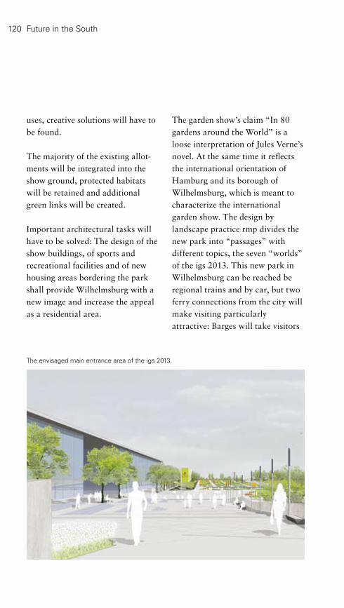
The envisaged main entrance area of the igs 2013.
120
uses, creative solutions will have to be found.
The majority of the existing allot-ments will be integrated into the show ground, protected habitats will be retained and additional green links will be created.
Important architectural tasks will have to be solved: The design of the show buildings, of sports and recreational facilities and of new housing areas bordering the park shall provide Wilhelmsburg with a new image and increase the appeal as a residential area.
The garden show’s claim “In 80 gardens around the World” is a loose interpretation of Jules Verne’s novel. At the same time it reflects the international orientation of Hamburg and its borough of Wilhelmsburg, which is meant to characterize the international garden show. The design by landscape practice rmp divides the new park into “passages” with different topics, the seven “worlds” of the igs 2013. This new park in Wilhelmsburg can be reached be regional trains and by car, but two ferry connections from the city will make visiting particularly attractive: Barges will take visitors
Future in the South

directly to the community centre at the heart of the river island and ferries from the main port will gain a new pier at Reiherstieg and the Dockville events’ ground. A promenade will lead directly to the western entrance of the new park.
The western entrance is marked by a water tower whereas the eastern entrance is near the station Wilhelmsburg, starting at either end visitors will embark on a journey through the show’s seven “worlds”: The “World of religions” relates the influence religion had on garden design – possibly a Garden Eden, a Catholic or Buddhist monastery garden or an Islamic-Oriental courtyard garden.
“Water Worlds” allow visitors to experience the different vegetation zones of the earth – from dry steppe and prairie to grassland and mixed woodland to bogs with their abundance of water. A water play area for children will not be missing either.
Containers play a main part in the “World of Ports”: Colourful flower borders fill the footprint of a 40-foot container, Clematis, Virgina Creeper and Kiwi climb up supports that are as high as a container, and among these floral displays real containers are used as a kiosk, a café with a roof garden, an information point or a stage.
Wilhelmsburg – one of Europe’s largest river islands – is situated between Norder- und Süderelbe.

122
The “World of Activity” appeals to children with a number of activity playgrounds and to pensioners with spa gardens. Asiatic gardens host martial arts demonstrations, a climbing garden and fitness or sports gardens invite visitors to watch presentations and competitions. From 2014 the Floral Halls will be turned into arenas for sports and other events with indoor and outdoor facilities.
The “World of Cultures” with its café and terraces on the pond Kuckucksteich will become the communicative centre of the park and the point were all the passages converge.
The passage “World of Continents” displays international gardens along the 53rd degree latitude on which Hamburg lies; it will not cease to amaze and surprise. Here visitors will discover the origins of their garden or balcony plants; and at the southern most point of this new park information about 80 gardens, parks and squares worldwide can be admired in an attractive and compacted multi-media version.
“Nature Worlds” show how the diverse natural and cultural land-scapes in and around Hamburg
evolved; from fruit production in Altes Land to flower and vegetable rearing in Vier- und Marschlande to tree nurseries and rose specialists in the Pinneberg-District (west of Hamburg) or the heathland south of the Elbe.
The circular walk through the whole park with its seven passages will be approximately 6.5 kilo-metres long and will cater for pedestrians, cyclists and skaters after the show.
The international garden show will open its gates to locals and international visitors in 2013.
District: Hamburg-MitteLocation: between Wilhelmsburger Reichsstraße and the motorway A1PT: S3/S31 WilhelmsburgSize: 100 hectaresSpecials: international gardens and public park for the 21st CenturyInformation: see page 141
Future in the South

2 1
3 4
1 Masterplan for the igs 2013.2 Proposal for a pedestrian bridge in the western section of the park.3 Containers play a major part in „World of Ports“; even the flower borders are modelled on their footprint.4 The „Water Worlds“ area is expected to cater for culinary needs even before 2013.

124
BallinStadt and BallinPark
BallinStadt as a museum on historic ground displays the topic of emigration from the mid-19th Century onwards. Germany’s largest seaport Hamburg became the „Gateway to the World“ for roughly five million emigrants between 1850 and 1939. BallinStadt and BallinPark were opened to the public on the 4th of July 2007. BallinStadt is largely a reconstruction of the former emigrants’ village since most of the historic fabric was sadly lost.
The site is central to the green corridor between Hamburg and Harburg as part of the project “Leap across the Elbe”; it also was an opportunity for additional open space in the borough of Veddel, which is squeezed in between several traffic routes. This was the reason to create not only BallinStadt but also BallinPark to explain the site’s history.
At the back of the three re-constructed buildings that house the museum three further emigrants’ quarters were interpreted as “green buildings”. Three large green “cushions”, shaded by a grove of small trees, provide a favourite sitting area. Oversized portraits of emigrants substitute the former walls and help
visualize the crowdedness of the historic emigrants’ quarters.
A large meadow forms the centre of the site and can be used for meeting, barbecuing and playing. A few paths that ensure the main pedestrian connections and work as “timelines” intersect the meadow. Oversized portraits relate the fate of emigrants. At one end these timelines cross the former street “Am Veddeler Boden” and lead to the quayside promenade; they become gangways and open new horizons.
The existing trees were complemented by species with strong autumn colours. At the canal Müggenburger Zollkanal European plane trees symbolize the Old World, whereas further west American Silver Maple hint at the New World, and the meadow represents the ocean between the continents.
Future in the South
Museum BallinStadtDistrict: Hamburg-MitteLocation: Veddeler StraßePT: S3/S31 Veddel, Landungs- brücken Brücke 10 Circle LineSize: 3.5 hectaresInformation: see page 141

1
2 3
4
1 The museum’s theme is continued in the park.2 Three pavilions of BallinStadt were re- constructed following original plans.3 Oversized portraits along the timelines.4 Glass structures link the re-constructed buildings.

126
Harburger Schlossinsel
Re-structuring Harburger Schloss-insel (castle island) at the centre of the Harburg port is another important contribution to the town’s major project “Leap across the Elbe”.
The castle island was the cradle of the former town Harburg, now one of Hamburg’s seven districts. The Horeburg (a castle in a bog) was first mentioned in 1137. In the Mid-16th Century the ducal family of Brunswick-Lüneburg built a palace. A hundred years later it was up-graded to a citadel: The island became a striking star-shaped bastion. In the 18th Century the palace was used for the regional
administration of Harburg, which by then belonged to the Hanoverian court. The palace was heavily damaged during the French occupation in the Seven Year’s War and re-built more plainly in 1764. In 1813 one wing was destroyed. Shortly afterwards the bastions were razed; the palace remained a municipal building.
In the late 19th Century increasing use as a port changed the appearance of the area considerably, while new traffic routes (the national road B75 and railway tracks) cut it off from Harburg’s centre. The palace’s only remaining wing was altered
Future in the South
1 The proposal emphasizes the star shape of the historic citadel (Functions – second phase of development).2 The park’s “beams“ lead to the water’s edge.
1 2

Harburger SchlossinselDistrict: HarburgLocation: ZitadellenstraßePT: Bus 153, 157Size: 33 hectaresSpecials: annual event Harburger Binnenhafenfest (in the second quarter)
3 The remains of the Harburg palace at the centre of an amorphous industrial area.4 Historical lithograph of the palace around 1850.
considerably, so that only the decorated window surrounds and balustrades on the steps recall the former glory. The building leads a sad existence among austere industrial structures.
Proposals by Raumwerk and landscape architects Club L 94 try to emphasize the shape of the former citadel through modern architecture and landscape architecture. A star-shaped park forms the centre of the design. The palace’s remaining wing is at the heart of the park and its “beams” link the island’s core to steps at the water’s edge. Buildings follow the shoreline and emphasize the park’s
star shape. Pocket parks and ope-nings to the waterfront are situated at the centre of the buildings. The design also encompasses the public squares at Harburger Binnenhafen, such as Kanalplatz.
4
3

128 Future in the South
Schwarzenbergpark
Schwarzenbergpark on the northern edge of Harburg’s centre provides long distance views of the Elbe and the port; it is a mosaic of historical elements.
It is not entirely clear where the name Schwarzenberg (black hill) came from, maybe from dark conifers, maybe from its former use as a gibbet hill. In any case the name indicates that it is a peak; and this was widely exploited.
Early on Schwarzenberg was used to position guns; during the French occupation the Harburg palace was shot at from up here. Two guns still stand on the slope, they were later used to fire warning shots in case of storm floods or to fire salutes, for example at the inauguration of the first railway line. In addition there is a monument made of cannon-balls – they were fashionable in the 19th Century, but only very few survive to this day.
Another relic of Harburg’s military past is the historic cemetery for the palace and the garrison on the northern slope. The tombs are indicative of the former glory of the cemetery and the significance of the military. The Jewish cemetery of the 17th Century is situated a little higher up on the slope. According
to Jewish custom no more burials take place on this site, but it is kept as a memorial ground.
Major Ferdinand von Bissing converted the hill into a public park in the mid-19th Century – complete with promenades through woodland and meadows. He was criticized by his superiors for deploying soldiers to carry out the initial operations. Work was continued by a “beautifying society” and supervised by the gardener Georg Hölscher, who also oversaw a Horticultural Exhibition on this site in 1898.
The Kaiserplatz from 1873 lies at the top of the hill. A double lime avenue frames the adjacent former parade ground. It now serves other events. Since 1528 it has also hosted the traditional clay pigeon shooting.
District: HarburgLocation: SchwarzenbergstraßePT: S3/S31 HeimfeldSize: nearly 16 hectaresSpecials: events on the former parade ground, cemetery for the palace and garrison, Jewish cemetery

1
2
3 5
4
1 Footpaths cross the diverse park.2 The Kaiserplatz recalls the emperor’s visit in 1873: Viewpoint with fountain.3 A double lime avenue frames the former parade ground.4 Historic tombs of the garrison’s soldiers.5 The Jewish cemetery lies a little further up the hill.

130 Future in the South
Harburger Stadtpark
District: HarburgLocation: Hohe Straße/Marmstorfer WegEntrance: NymphenwegPT: Bus 142, 145, 245Size: 90 hectaresSpecials: show gardens, extensive play and sports facilities, open-air- theatre, public swimming pool Midsommerland
1933 the educational garden, the dahlia garden and the terraces with bedding plants were added. Only three years later the sports and parade ground was finished.
During World War II implemen-tation was suspended and roughly 120 bombs damaged the site. In the early 1950s the park was re-instated and further extended towards the West. In 1987 naturalistic additions followed that were typical of the times. The habitats were combined with modern art in the landscape.
More recently the so-called “Gardens of the Centuries” were implemented; they are meant to display the styles of different eras in a simplified way and were complemented in 2004 by a rose garden. In other areas the historic design is being restored.
The Harburg-District also possesses a large public park: Harburger Stadtpark. The hilly site and the historic mill pond combine to give the park a unique character.
The creation of the park became necessary owing to massive growth in Harburg’s population, following the industrialization. The existing park on Schwarzenberg no longer fulfilled the requirements of a contemporary park. First designs and even implementation were undertaken as early as 1913, but the first part of the park was only opened in 1926: The gardeners Georg and Ferdinand Hölscher built a landscape garden at the 17th-Century mill pond. They employed the 30 metres difference in height and the existing woodland to create varied views and garden rooms with different uses. Initially these were an open-air-theatre, a playground and a hockey field with flower borders as well as two viewpoints and several meadows.
In 1927 the park was extended by the Schillerplatz (a square), the Beethovenhöhe (a viewpoint), the lily pond with the Ludowieg-Brunnen (a fountain) and the oval knoll. The public pool on the eastern shore followed in 1930. In

1
2
4
1 The frozen Außenmühlenteich invites visitors for a stroll.2 The shore is a favourite resting place in the summer.3 View across Außenmühlenteich facing north.4 Garden plants and medicinal herbs are displayed in the educational garden.5 The southern parts of the park are more naturalistic.
3 5
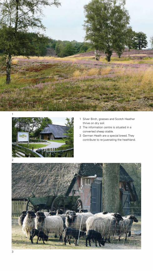
1
2
3
1 Silver Birch, grasses and Scotch Heather thrive on dry soil.2 The information centre is situated in a converted sheep stable.3 German Heath are a special breed. They contribute to re-juvenating the heathland.
3

133
Nature ReserveFischbeker Heide
Future in the South
(German Heath) kept the areas free from shrubs and trees.
In the 19th and 20th Century some parts were afforested with pine trees and spruce, others were turned into arable fields, an activity that was helped by recently invented fertilizers. After World War II the last remains of heather were threatened by development, but were saved in 1958 when the area was designated as a nature reserve. It incorporates some copses, deciduous woodland, spring fens and other wetland areas.
The typical plant of heathland is the Scotch Heather, which was used to produce brooms at one time. The plant is a dwarf shrub that can live for 80 years (double its normal age), if cut back or grazed regularly. It is accompanied by Bog Rosemary, various species of gorse, Crowberry and Cranberry as well as Hamburg’s only incidence of the rare Bearberry. Over 2,000 small animals live in this landscape, including the elegant Yellow-winged Darter and rare butterflies, such as some of the blues. Roughly 140 species of spider have also been observed here. More than 300 animal species depend on heathland as their main habitat. In addition to beetles and insects
The 773-hectares nature reserve Fischbeker Heide is situated on the hilly Harburger Berge and almost V-shaped, with the southern tip on the highpoint at 116 metres. These relatively great heights and the blooming heather in late summer are the main attractions of this diverse and easily accessible area.
The Harburger Berge are relics of the Saale-Ice-Age, approximately 150,000 years ago and consist mainly of sand and rubble. On these poor soils man produced the heathland of the Fischbeker Heide; it therefore is a cultural landscape. The first settlers appeared in the late Stone Age; they cleared parts of the dense mixed oak woodland, to obtain wood and create arable fields. The easily discernable barrows (prehistoric graves) and subterranean cairns date from that time. Logging increased during the Bronze and the Iron Age, since large amounts of wood were needed to smelt the ore. The last vestiges of the woods south of Hamburg were felled in the Middle Ages, because the salt works in nearby Lüneburg used wood to fuel their saltpans. As a consequence large stretches of heathland developed, such as the Lüneburger Heide and its smaller “sister” Fischbeker Heide. Grazing sheep

Alster: Zwischen Lombardsbrücke und Duvenstedter BrookZukunft Süden
1 By adapting their colour to their surroun- dings Common Lizards are almost completely disguised.2 Wood on the edge of the heathland.3 The rare Common Blue.
2
1
Several footpaths intersect Fischbeker Heide.
3

District: HarburgLocation: south of Cuxhavener StraßeEntrance: Fischbeker HeidewegPT: S3 Neugraben, Bus 250Size: 149 hectaresSpecials: information centreInformation: see page 141
A herd of German Heath among heather in bloom in late summer.
Hamburg’s largest population of Sand Lizards live here. These animals have adapted their colour to suit the surroundings – except in the mating season, when males are bright emerald. Other reptiles are Common Lizard and the poisonous Common Viper. Of all the birds only Wood Lark and Eurasian Nightjar shall be mentioned here, especially as this the latter’s sole habitat in all of Hamburg.
In addition to heathland there are copses and deciduous woodland, grassland poor in nutrients and open sand as well as spring fens and bogs – all of them further important habitats for rare plants and wildlife. For example carni-vorous Sundew, Bog Asphodel, White Beak-Sedge, sphagnum-mosses and Cotton Grass thrive on bogs, whereas Sweet Gale and Marsh Gentian live in spring fens.
As heathland is man-made, maintenance is required to keep them. Sheep graze the heather in the nature reserve and in addition it is cut. Shrub and tree seedlings are removed and ageing parts of the heather are re-juvenated by removal of the top layer and sowing from scratch.
Please visit the information centre for further details on this fascinating landscape.
136 Future in the South
Nature Reserve Moorgürtel
District: HarburgLocation: between Francoper/ Neuenfelder Hinterdeich and Cuxhavener StraßePT: S3 Neugraben, Bus 140, 240Size: 737 hectares
The 737-hectare nature reserve Moorgürtel – a chain of bogs – is situated next to Hamburg’s “fruit basket” Altes Land to the South-east and is characterized by an intricate mosaic of different plots within the cultural landscape.
The bog was cultivated since man settled in the area, but it could only be used in a limited way, owing to the wet conditions. Local farmers contributed to the creation of the area’s mosaic of uses, consisting of moors, shrubs, copses, small water bodies, reed beds as well as meadows and pastures. Since agricultural use on the boggy soil is limited, the Corncrake can be found here; this bird is an endangered species throughout Europe. The landscape’s diversity is essential for the Corncrake’s rearing of its young ones. Other species also benefit from the varied habitats: Among them are Stone-chat, Red-backed Shrike and Grasshopper Warbler.
Rare flowers, such as Cabbage Thistle, Ragged Robin, Yellow Rattle, Snake Root and scarce orchids grow on the meadows. They are also home to Stork, Lap Wing, Common Snipe and Meadow Pipit as well as many amphibians, including Moor Frogs. In addition
small fish and dragonflies live in and around the ditches. In Nincoper and Francoper Moor, the larger of the remaining bogs, Cotton Grass, sphagnum-mosses, Royal Fern, Orchis and Sweet Gale can be found. The latter is a rare plant that used to be employed for dyeing (yellow), but also to season beer and liquors, owing to its intoxicating qualities.
Nature conservation and farming are regulated by contracts in order to maintain the mosaic of uses, which is essential for the protection of the Corncrake and other species. In addition to limited farming re-vitalization of bogs is encouraged.
This varied landscape can easily be explored by cycling or walking on one of the many farm tracks.

1
2
1 Flowering sorrel offers an attractive contrast to the rich green of the meadows.2, 5 Impounded ditches serve to re-create the area’s original wet conditions.3 Leas are particularly diverse and flower almost all year round.4 The intricate pattern of copses and open fields provide diverse habitats.
4 5
3

138
Services
14 Alter Elbpark, Wallanlagen and Planten un Blomen HamburgMuseum Museum für Hamburgische Geschichte Holstenwall 24, 20355 Hamburg www.hamburgmuseum.de Phone: 040-428 132-2380 Opening times: Tue - Sat: 10 - 17 hrs, Sun: until 18 hrs
Planten un Blomen www.plantenunblomen.hamburg.de Warden: Planten un Blomen: Phone: 040-428 23 21 25, Wallanlagen: Phone: 040-428 23 21 57 Opening times: May - September: 7 - 23 hrs, October - April: 7 - 20 hrs
Freundeskreis Planten un Blomen e.V. www.hamburg-messe.de/plantenunblomen
Wasserlichtkonzerte (concerts with fountain and light displays) May - August: 22 hrs, September: 21 hrs
Tropenschauhäuser (glasshouses) Opening times: March until October: weekdays: 9 - 16.45 hrs, Sat, Sun, public hols.: 10 - 17.45 hrs November until February: weekdays: 9 - 15.45 hrs, Sat, Sun, public hols.: 10 - 15.45 hrs
Ice Rink Große Wallanlagen Holstenwall 30, 20355 Hamburg, Phone: 040-317 47 39 Open from mid-October until mid-March www.eisbahn.info
Skating Rink April until September, Opening times: until 30 April: 7 - 20 hrs, 1 May - 30 September: 7 - 23 hrs
24 Jungfernstieg and Binnenalster Alster cruises Alster-Touristik GmbH Anleger Jungfernstieg, 20354 Hamburg, Phone: 040-357 424-0 www.alstertouristik.de
Events www.hamburg.de www.lebendiger-jungfernstieg.de
Addresses, Opening Times, Information

139
28 HafenCity www.hafencity.com
HafenCity InfoCenter im Kesselhaus Am Sandtorkai 30, 20457 Hamburg, Phone: 040-369 01 799 Opening times: Tue - Sun: 10 - 18 hrs, May - September Thu 10 - 20 hrs
Guided Walks HafenCity Landgang Sat 15 hrs HafenCity cycle tour May - September every 1st and 3rd Sun 11 hrs
Viewing Tower Viewpoint at present Großer Grasbrook
Traditionsschiffhafen (historic boats) www.stiftung-hamburg-maritim.de
Internationales Maritimes Museum Hamburg Kaispeicher B, Koreastraße 1, 20457 Hamburg www.internationales-maritimes-museum.de Opening times: Tue - Sun: 10 - 18 hrs, Thu: 10 - 20 hrs
36 From Platz der Republik to Altonaer Balkon Altonaer Museum Norddeutsches Landesmuseum Museumstraße 23, 22765 Hamburg www.altonaermuseum.de Opening times: Tue - Sun: 10 - 18 hrs, Thu: until 21 hrs
57 Jenischpark incorporating the Nature Reserve Flottbektal Jenisch Haus Baron-Voght-Str. 50, 22609 Hamburg, Phone: 040-428 11 35 82 Opening times: Tue - Sun: 11 - 18 hrs
Verein Freunde des Jenischparks e.V., www.jenischparkverein.de
Ernst-Barlach-Haus Baron-Voght-Str. 50a, 22609 Hamburg, Phone: 040-80 60 85 www.barlach-haus.de Opening times: Tue - Sun: 11 - 18 hrs
60 Strandweg, Elbhöhenwanderweg and Römischer Garten Puppenmuseum Falkenstein, Sammlung Elke Dröscher Grotiusweg 79, 22587 Hamburg, Phone: 040-81 05 82 www.elke-droescher.de
140
Services
Addresses, Opening Times, Information
72 National Park Hamburgisches Wattenmeer Nationalpark-Station 27499 Insel Neuwerk, Phone: 04721/692 71 www.nationalpark-hamburgisches-wattenmeer.de Opening times depending on the tide
80 Hamburger Stadtpark Planetarium Hamburg Hindenburgstraße 1b, 22303 Hamburg, Phone: 040-428 86 52-0 www.planetarium-hamburg.de Opening times: Tue: 9 - 15 hrs, Wed: 9 - 21 hrs, Thu: 9 - 21.30 hrs, Fri: 9 - 21.45 hrs, Sat: 12.30 - 21.30 hrs, Sun: 12.30 - 19.00 hrs
Hamburger Stadtpark Verein e.V., www.stadtparkverein.de
82 Ohlsdorfer Friedhof Opening times: April - October: 8 - 21 hrs, November - March: 8 - 18 hrs
Guided Walks, List of Famous People, Information and Map, Events www.friedhof-hamburg.de
Friedhofsmuseum www.fof-ohlsdorf.de
89 Nature Reserve Duvenstedter Brook Information centre Duvenstedter Triftweg 140, 22397 Hamburg, Phone: 040-607 24 66 Opening times: April - October: Tue - Fri: 14 - 17 hrs, Sat: 12 – 18 hrs, Sun: 10 - 18 hrs February, March, November: Sat: 12 - 16 hrs, Sun: 10 - 16 hrs
94 Eilbek and Wandse-Grünzug including Eichtalpark and Botanischer Sondergarten Botanischer Sondergarten Wandsbek Walddörferstraße 273, 22047 Hamburg, Phone: 040-693 97 34 E-Mail: [email protected] Opening times: during daylight

141
98 Nature Reserves Höltigbaum, Ahrensburger and Stellmoorer Tunneltal Information centre „Haus der Wilden Weiden“ Eichberg 63, 22143 Hamburg, Phone: 040/780 711 88 Opening times: November - March: Wed, Thu, Fri: 14 - 16 hrs, Sat, Sun: 11 - 16 hrs March - October: Wed, Thu, Fri: 14 - 17 hrs, Sat, Sun: 11 - 16 hrs www.hamburg.de/info-hoeltigbaum/ 106 Nature Reserve Boberger Niederung Information centre Boberger Furt Opening times: April - October Tue - Fri: 10 - 13 hrs, Sun und public hols.: 11 - 17 hrs
112 Bergedorfer Schlossgarten Museum für Bergedorf und die Vierlande im Schloss Bergedorf Opening times: April - October Tue - Thu, Sat + Sun: 10 - 18 hrs November - March Tue - Thu, Sat + Sun: 11 - 16 hrs
118 internationale gartenschau hamburg 2013 internationale gartenschau hamburg 2013 GmbH Neuhöfer Straße 23, 21107 Hamburg, Phone: 040-226 31 98-0 www.igs-hamburg.de
Informationen [email protected]
124 BallinStadt und BallinPark Auswandererwelt BallinStadt Hamburg Veddeler Bogen 2, 20539 Hamburg www.ballinstadt.de Opening times: daily 10 - 18 hrs (last admissions 17 hrs)
132 Nature Reserve Fischbeker Heide Information centre Fischbeker Heideweg 43 a, 21149 Hamburg Opening times: April - October Tue - Fri: 10 - 13 hrs, Sun + public hols.: 11 - 17 hrs

142
Picture Credits
Photographer ........................................................Page/Image numberSven Baumung .........................................................110/4Breimann & Bruun........................................ ..........27BSU......................................................................... 7/2; 10; 11/1; 18/3; 56; 59/5; 65; 69; 70/2; 84; 87/1,2; 88/2; 90/2; 98; 103/4; 107; 110/2,3; 121; 132/2,3; 134/1,2,3; 135; 137 - Andreas Eggers..................................................... 71; 111 - Karin Gaedicke...................................................... 89; 91 - Heino Grunert...................................................... 15/3; 17/1,2; 18/2; 41/3,5; 43/3,4; 45/4; 51; 55/3,5; 61/1,2,3; 62/2; 73/2; 79/3; 82; 83; 90/3; 95/1; 97/2; 104; 129/1,5; 131/1,2,4,5; 132/1- Dr. Klaus Janke .....................................................7/1; 73/1,3; 74/2,3 - Thomas Möller .......................................................37/5- Ewald Rothstein ....................................................21/1 - Manfred Stern........................................................2; 34; 47; 90/1Denkmalschutzamt Hamburg, Fotoarchiv ................127/4 Urheberrecht: No 889/30 Falcon Crest/U. Sieglitz............................................12Klaus Frahm..............................................................25/2HafenCity Hamburg GmbH - behrendt + männchen (Illustration)........................32/4- ELBE&FLUT......................................... ....................31/2,3; 32/1 - M. Korol (Illustration), B. Kuhn (Foto).................. .28/29- Tim Kraus................................................... ............31/1; 32/2,3Günther Helm.............................................. .............74/1 Eva Henze..................................................... ..........37/3, 67; 79/1,2 Herzog & de Meuron Architekten............... ...........31/3Armin Jeß.................................................................75Egbert Kossak...........................................................55/6; 62/1,3; 64; 70/1; 80/1; 85; 87/3; 88/1; 134/1 Landesbetrieb Geoinformation und Vermessung ..15/1 Mediaserver Hamburg................................. ............41/4; 76 - Martin Brinkmann...................................... ............16/1 - Frank Szymanska....................................................18RMP/Raderschall, Möhren und Partner...... ...........118-119; 120; 123Raumwerk Architekten, Club L94 LandschaftsArchitekten............... ..........126ReGe Hamburg............................................. ..........125/1Dirk Robbers............................................... ............25/1Birte Rolff.............................................................. 6; 8; 11/2; 15/2; 19; 21/2,3,4,5; 23; 37/1,2,4; 39; 41/1,2,3,5; 43/1,2,5;45/1,2,3; 46; 49; 52; 55/1,2,4; 57; 59/1,2,3,4; 61/4,5; 62/4; 63; 66; 80/2,3,5; 92; 95/2,3,4; 96/1,3; 97; 101; 103/1,2,3,5,6; 108; 110/1; 112; 114/2,3;115/4; 125/2,3,4; 129; 131/3urbanista..................................................... .............TitelSebastian Vollmert....................................... ............18/3; 22; 80/4
143
Imprint
Publisher: Free and Hanseatic City of Hamburg Ministry for Urban Planning and Environment (BSU) Stadthausbrücke 8 20355 Hamburg www.bsu.hamburg.de
Contact: Kristina von Bülow
Concept: Heiner Baumgarten, Karin Gaedicke, Heino Grunert, Wolfgang Prott
Text: Eva Henze
Design: Birte Rolff
We are extremely grateful for information to:
June Baker, Susanne Bühler, Iris Carius, Andreas Eggers, Ulrich Hein-Wussow, Britta von Hollen, Dr. Klaus Janke, Grischa Koch, Lutz Rehkopf, Wolfgang Schmahl, Andreas Schmeling, Werner Steinke, Thomas Vesting, Olaf Bahr, Ina HeidemannMail order address: Stadtmodell Hamburg, c/o Behörde für Stadtentwicklung und Umwelt Wexstr. 7, 20355 Hamburg, [email protected]
Lithography: Hamburgs Agentur, Agency for Geo-Information and Surveying Print: February 2009, 1st English edition: 3 000 copies,
printed on 100% recycled paper
Note on distribution:
This book is published as part of public relations by the Senate of the Free and Hanseatic City of Hamburg. It may not be used by political parties and their aides during election campaigns for campaigning purposes. This applies to European, national, regional and local elections. Especially the distribution at campaigning events, at parties’ information booths and the combination with party-political information or advertising material constitutes misuse. The circulation to third parties for campaigning purposes is also prohibited. It may not be used even outside election campaigns in any way that might suggest the federal state government took sides in favour of individual political groups, independent of when, how and in what numbers this publication has been received. However, parties may use this publication to inform their own members.

Legend
Hamburg’s Green Heart 14 Alter Elbpark, Wallanlagen and Planten un Blomen
19 Promenade “Bei der Erholung“
20 Antonipark/ParkFiction
22 Spielbudenplatz
23 Freizeitfläche Zirkusweg
24 Jungfernstieg and Binnenalster
26 Domplatz
28 Urban Parks, Squares and Promenades in HafenCity
Green Quarters 36 From Platz der Republik to Altonaer Balkon
38 Square “Am Born“/”Kemal-Altun-Platz“
40 Grünzug Neu-Altona and Wohlerspark
42 Altonaer Volkspark
44 Innocentiapark
46 Lindenpark
47 Bewegungsräume Lenzsiedlung
48 Wacholderpark
50 Hammer Park
River Landscape Elbe54 Hirschpark, Baurs Park and Natur Reserves Neßsand and Mühlenberger Loch
57 Jenischpark incorporating the Nature Reserve Flottbektal
60 Strandweg, Elbhöhenwanderweg and Römischer Garten
64 Nature Reserves Wittenbergener Heide/ Elbwiesen and Schnaakenmoor
67 Rüschpark
68 Nature Reserve Heuckenlock
70 Nature Reserve Zollenspieker
National Park Hamburgisches Wattenmeer is situated in the North Sea near the Elbe estuary.
The Alster between Lombardsbrücke and Duvenstedter Brook78 Außenalster and Alsterpark
80 Hamburger Stadtpark
82 Ohlsdorfer Friedhof
84 Nature Reserve Wohldorfer Wald
86 Nature Reserves Rodenbeker Quellental and Hainesch-Iland
89 Nature Reserve Duvenstedter Brook
The Wandse: From Kuhmühlenteich to Höltigbaum94 Eilbek and Wandse-Grünzug including Eichtalpark and Botanischer Sondergarten
98 Nature Reserves Höltigbaum, Ahrensburger and Stellmoorer Tunneltal
102 Nature Reserve Volksdorfer Teichwiesen
The Bille with Vier- und Marschlande 106 Nature Reserve Boberger Niederung
108 Wasserpark Dove-Elbe and Nature Reserve “Die Reit“
112 Bergedorfer Schlossgarten
114 Nature Reserve Kirchwerder Wiesen
Future in the South – Protection and Design as part of the “Leap across the Elbe“118 internationale gartenschau hamburg 2013
124 BallinStadt and BallinPark
126 Harburger Schlossinsel
128 Schwarzenbergpark
130 Harburger Stadtpark
132 Nature Reserve Fischbeker Heide
136 Nature Reserve Moorgürtel

64
64
6054
54
54
57
67
42
136
132
130
126128
118
124
68108
114
70
112
106
50
80
8248
47
46
44
38
14
26
40
20
22 23
86
86
102
89
84
98
94
19
24
78
28
36


![Producció d’Energia en el Tractament i la valorització de ...aca-web.gencat.cat/aca/documents/ca/jornadatecnica... · [TERMOQUIMIC] Incineració EDAR Hamburg’s Köhlbrandhöft](https://static.fdocuments.net/doc/165x107/5f09a7037e708231d427dd21/producci-daenergia-en-el-tractament-i-la-valoritzaci-de-aca-web-termoquimic.jpg)
