Habitat Plan 12 09 - dec.ny.gov · Mall Metro k SYW-12 Area Still ... West Wall Portion of the...
20
Transcript of Habitat Plan 12 09 - dec.ny.gov · Mall Metro k SYW-12 Area Still ... West Wall Portion of the...


Ley C
reek
Harbor
Brook
Ley Creek
9B
6A
2A
1Carousel
Mall
Metro
Onondaga Creek
SYW-12 Area StillUnder Evaluation.Proposed combinationof wetlands and uplands
SYW-12
3B
5B
8B
Phragmites control channel (Module 4A) extends along entire length of wall
Remediation Area E(High Energy)
1
2A
2B
3B
6B5B
6A8B
SMU 8
3B
2A
1
SMU
7SM
U 1
SMU 7SMU 6
SMU 6SMU 5
SMU 6RAE-3
RAE-2RAE-1
RAD-4
West Wall Portion of the Wastebed B/Harbor Brook IRM
Extent of ILWD in Littoral Zone
Willis/Semet IRM Barrier Wall
Tributary to be remediatedby Honeywell
Area covered by Onondaga LakeRemedial Design Elements for Habitat Restoration
Cross-section Location and IdentificationRAE-1
Sediment Management Unit (SMU) Boundary
Aquatic Plants(From Onondaga County Departmentof Water Environment Protection, 2008)
NYSDEC ApprovedWetland Boundaries
Remediation AreaBoundary (Parsons, 2009)
Onondaga LakeSyracuse, New York
301 PLAINFIELD RD, SUITE 350; SYRACUSE, NY 13212
PARSONS
FIGURE 5.14
Restored Habitat Module ApplicationRemediation Area E
300 0 300150
Feet .


8B
6A
8B
8B
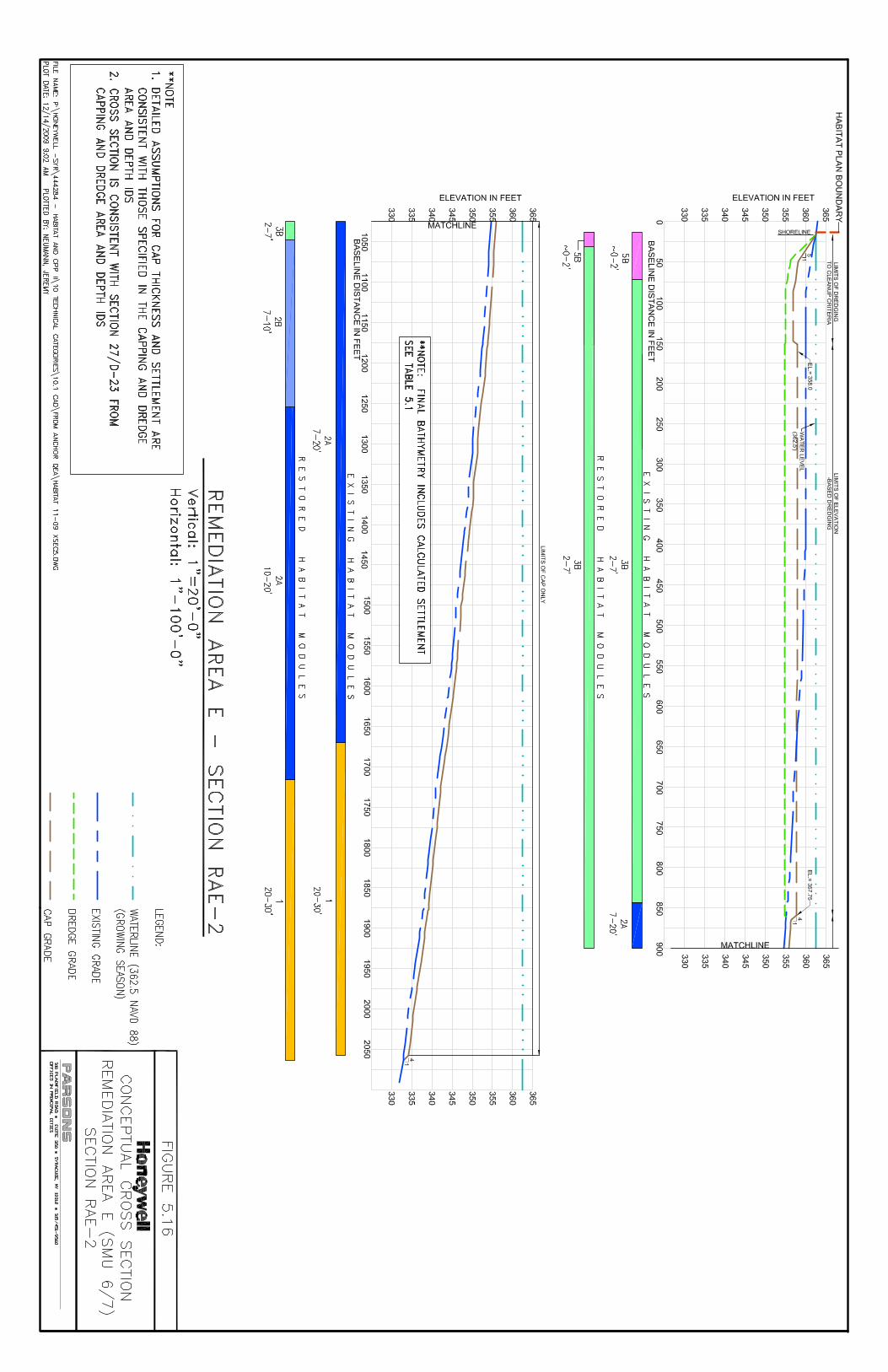
Remediation Area D(SMU 1)
Deeper (1-2')Wetland Areas for Fishery Enhancement
FormerHarbor BrookChannel
Phragmites Control Channel(Module 4A)Extends Length ofBarrier Wall
6A
6A
Mounds for WaterfowlNesting
3B
5B
3B
3B
2A
8B
6B
4A
Remediation Area E(SMU 7)
2B
.New York State Digital
Orthoimagery from 2003
90 0 9045
Feet
Sediment Management Unit (SMU) Boundary
NYSDEC ApprovedWetland Boundaries
Remediation AreaBoundary (Parsons, 2009)
Area covered by Onondaga LakeRemedial Design Elements for Habitat RestorationWest Wall Portion of the WB-B/HB IRM
Approximate location of East Wall Portion of the WB-B/HB IRM
(Q:\G
IS\G
IS_L
ake\
HAB
_PA
\HB_
grap
hic.
mxd
) 9/1
1/20
08 --
9:0
4:32
AM
Onondaga LakeSyracuse, New York
301 PLAINFIELD RD, SUITE 350; SYRACUSE, NY 13212
PARSONS
FIGURE 5.18
Conceptual Plan for Lower Harbor Brook and Adjacent Wetland Areas

M d f W t f lMound for Waterfowl Nesting
Braided Channel for Fishery Enhancement
Braided Channel for Fishery Enhancement Fishery EnhancementFishery Enhancement
Harbor Brook Channel
Isolation Cap
Habitat Layer (Wetland Substrate)
Figure 5.19Onondaga LakeSyracuse, NY
Woody Debris
Isolation Cap (Sand)Extent of
Removal
P:\Honeywell -SYR\445112 - Habitat and CPP III\09 Reports\9.2 Revised Habitat Plan\Figures/Figure 5.19 12-09.ppt
Not to Scale 301 Plainfield Road * Suite 350 * Syracuse, NY * 315-451-9560
PARSONS
Conceptual Profile of Harbor Brook and Adjacent Wetland Area

Ninemile Creek§̈¦690
Wastebeds 1-8
SMU
4
Shoreline area of WB 1-8 still underevaluation. Proposed combination of
wetlands and uplands.
SMU 3(Medium Energy)
Remediation Area A
SMU 8
3-5' Deeper
SMU
3
SMU 5
SMU 4
1-3' Deeper
3-5' Shallower
1-3' Shallower3-5' Shallower
0-1' Shallower
Area covered by Onondaga LakeRemedial Design Elements for Habitat Restoration
Remediation AreaBoundary (Parsons, 2009)
1-3' Deeper
3-5' Deeper
1-3' Shallower
3-5' Shallower
Post-Remedy Change in Water Depth
.Onondaga Lake
Syracuse, New York
301 PLAINFIELD RD, SUITE 350; SYRACUSE, NY 13212
PARSONS
FIGURE 5.20
Change in Water DepthRemediation Area A
300 0 300150
Feet

Wastebeds 1-8
SMU
4
SMU 3(Medium Energy)
Remediation Area B
SMU
3
3-5' Shallower
1-3' Shallower
1-3' Shallower
3-5' Shallower
1-3' Shallower
0-1' Shallower
SMU 8
Area covered by Onondaga LakeRemedial Design Elements for Habitat Restoration
Remediation AreaBoundary (Parsons, 2009)
1-3' Deeper
3-5' Deeper
1-3' Shallower
3-5' Shallower
Post-Remedy Change in Water Depth
.Onondaga Lake
Syracuse, New York
301 PLAINFIELD RD, SUITE 350; SYRACUSE, NY 13212
PARSONS
FIGURE 5.21
Change in Water DepthRemediation Area B
300 0 300150
Feet

East Flume
Remediation Area C
Wastebed B
§̈¦690
3-5' Shallower
1-3' Shallower
3-5' Shallower
1-3' Shallower
1-3' Deeper
1-3' Shallower
0-1' Shallower
SMU 8
SMU 3
SMU 2
SMU
2SM
U 1
Area covered by Onondaga LakeRemedial Design Elements for Habitat Restoration
Remediation AreaBoundary (Parsons, 2009)
1-3' Deeper
3-5' Deeper
1-3' Shallower
3-5' Shallower
Post-Remedy Change in Water Depth
.Onondaga Lake
Syracuse, New York
301 PLAINFIELD RD, SUITE 350; SYRACUSE, NY 13212
PARSONS
FIGURE 5.22
Change in Water DepthRemediation Area C
300 0 300150
Feet

Harbor
Brook
8B
Wastebed B
§̈¦690
3-5' Deeper
Remediation Area DAddendum
Remediation Area D
1-3' Deeper
3-5' Deeper
1-3' Deeper
3-5' Shallower3-5' Deeper
3-5' Shallower
SMU 8
Remediation Area C
SMU
2SM
U 1
SMU
7SM
U 1
2A
Area covered by Onondaga LakeRemedial Design Elements for Habitat Restoration
Remediation AreaBoundary (Parsons, 2009)
1-3' Deeper
3-5' Deeper
1-3' Shallower
3-5' Shallower
Post-Remedy Change in Water Depth
.Onondaga Lake
Syracuse, New York
301 PLAINFIELD RD, SUITE 350; SYRACUSE, NY 13212
PARSONS
FIGURE 5.23
Change in Water DepthRemediation Area D
300 0 300150
Feet
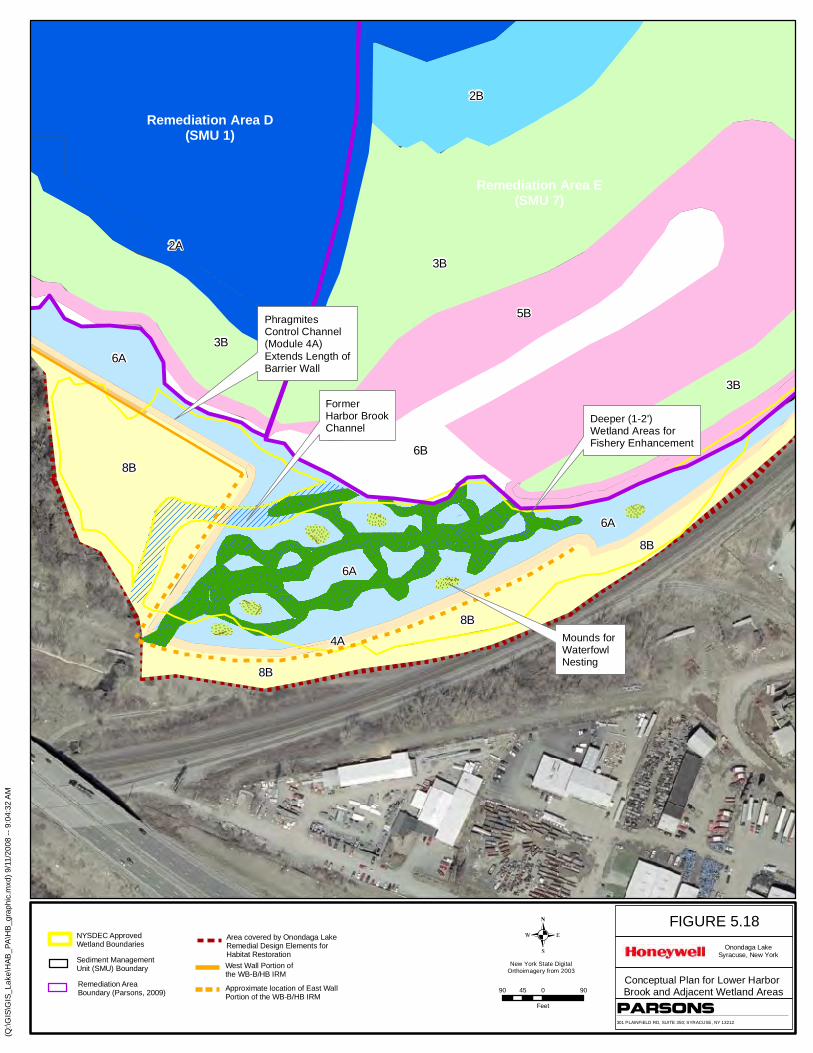
Ley C
reek
Carousel Mall
Metro
8A
3-5' Deeper3-5' Deeper
1-3' Shallower
3-5' Shallower
1-3' Shallower
1-3' Deeper
1-3' Deeper
1-3' Deeper
3-5' Deeper0-1' Shallower
SMU 8
Remediation Area E
SYW-12
SMU 1
SMU 7
SMU 7SMU 6
SMU 6SMU 5
Area covered by Onondaga LakeRemedial Design Elements for Habitat Restoration
Remediation AreaBoundary (Parsons, 2009)
1-3' Deeper
3-5' Deeper
1-3' Shallower
3-5' Shallower
Post-Remedy Change in Water Depth
.Onondaga Lake
Syracuse, New York
301 PLAINFIELD RD, SUITE 350; SYRACUSE, NY 13212
PARSONS
FIGURE 5.24
Change in Water DepthRemediation Area E
300 0 300150
Feet

Ninemile Creek
§̈¦690
Wastebeds 1-8
Wastebeds 1-8
SMU
4
Shoreline area of WB 1-8 still underevaluation. Proposed combination of
wetlands and uplands.
SMU 3(Medium Energy)
SHORELINE STABILIZATION (8B)
Graded Gravel
Remediation Area A(Low Energy)
SMU 8
Phragmites control channel (Module 4A)to be located along shoreline (2' x 20')
SMU
3
SMU 5
SMU 4RAA-1 RAA-1
Topsoil
Medium Sand
Fine Gravel
Fines
Medium SandFines
Medium Sand
Tributary to be remediatedby Honeywell
Area covered by Onondaga LakeRemedial Design Elements for Habitat Restoration
Cross-section Location and IdentifierRAA-1
Sediment Management Unit (SMU) Boundary
Aquatic Plants(From Onondaga County Departmentof Water Environment Protection, 2008)
NYSDEC ApprovedWetland Boundaries
Remediation AreaBoundary (Parsons, 2009)
.Onondaga Lake
Syracuse, New York
301 PLAINFIELD RD, SUITE 350; SYRACUSE, NY 13212
PARSONS
FIGURE 5.25
Restored Habitat SubstrateRemediation Area A
300 0 300150
Feet
Substrate TypeFinesMedium SandFine GravelCoarse GravelTopsoilWetland
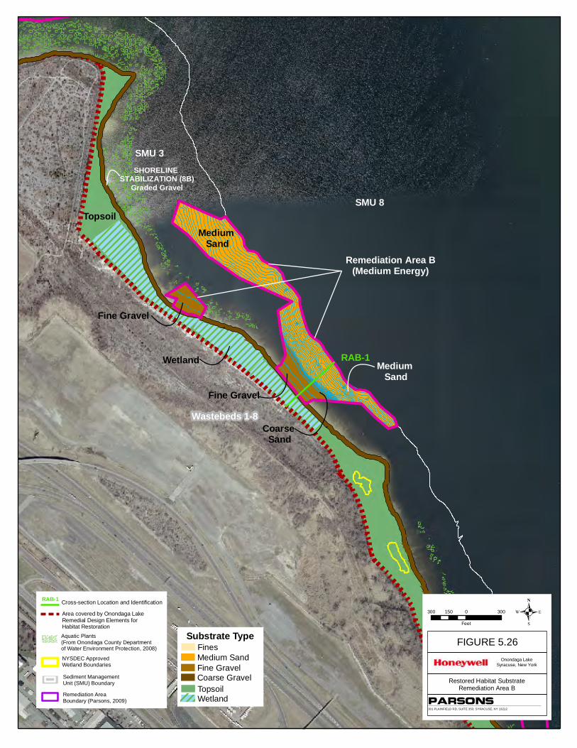
Ditch A
Wastebeds 1-8
SMU 3(Medium Energy)
2A
RAC-1
SMU 3SHORELINE
STABILIZATION (8B)Graded Gravel
3B5B 1
SMU 8
Remediation Area B(Medium Energy)
Topsoil
Wetland
Medium Sand
Medium Sand
Fine Gravel
Fine Gravel
Coarse Sand
RAB-1
Area covered by Onondaga LakeRemedial Design Elements for Habitat Restoration
Sediment Management Unit (SMU) Boundary
Aquatic Plants(From Onondaga County Departmentof Water Environment Protection, 2008)
NYSDEC ApprovedWetland Boundaries
Remediation AreaBoundary (Parsons, 2009)
Cross-section Location and IdentificationRAB-1
Substrate TypeFinesMedium SandFine GravelCoarse GravelTopsoilWetland
Onondaga LakeSyracuse, New York
301 PLAINFIELD RD, SUITE 350; SYRACUSE, NY 13212
PARSONS
FIGURE 5.26
Restored Habitat SubstrateRemediation Area B
300 0 300150
Feet .
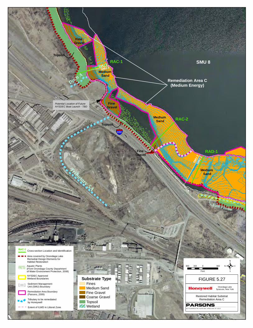
East Flume
Tributary 5A
Ditch A
9B
Wastebed B
Potential Location of Future NYSDEC Boat Launch - TBD
SMU 8
Phragmites ControlChannel (Module 4A) extends along entire length of wall(See Figure 8)
§̈¦690
Remediation Area C(Medium Energy)
SMU 3SMU 2
SMU
2SM
U 1
Fine Gravel
Medium Sand
Fine Gravel
Medium Sand
Topsoil
Topsoil
SMU 8
Fine Gravel
Medium Sand
RAC-1
RAC-2
RAD-1
Tributary to be remediatedby Honeywell
Area covered by Onondaga LakeRemedial Design Elements for Habitat Restoration
Extent of ILWD in Littoral Zone
Cross-section Location and IdentificationRAC-1
Sediment Management Unit (SMU) Boundary
Aquatic Plants(From Onondaga County Departmentof Water Environment Protection, 2008)
NYSDEC ApprovedWetland Boundaries
Remediation Area Boundary(Parsons, 2009)
Substrate TypeFinesMedium SandFine GravelCoarse GravelTopsoilWetland
Onondaga LakeSyracuse, New York
301 PLAINFIELD RD, SUITE 350; SYRACUSE, NY 13212
PARSONS
FIGURE 5.27
Restored Habitat SubstratRemediation Area C
300 0 300150
Feet .

Harbor
Brook
East FlumeWetland
Harbor Brook
Medium Sand
Topsoil
Topsoil
8A
Wastebed B
SMU 8
Phragmites control channel (Module 4A) extends along entire length of wall
Remediation Area D(Medium Energy)
Remediation Area D
Addendum
Wetland
Coarse Sand
Fine Gravel
Coarse Gravel
SMU
1
SMU
2SM
U 1
SMU
7
SMU 7SMU 6
The bathymetric contour lines in Remediation Area Dare closely spaced and may appear as bold blue lines. Note that they follow standard mapping guidelines anddo not cross one another.
1
3B
2B
SMU 2(Medium Energy)
SMU 6(High Energy)
RAC-2
RAD-1 RAD-2RAD-3 RAD-4RAE-1 RAE-2
RAE-3
Willis/Semet IRM Barrier Wall
West Wall Portion of the Wastebed B/Harbor Brook IRM
Approximate Location of East Wall Portion of the Wastebed B/Harbor Brook IRM
Extent of ILWD in Littoral Zone
Tributary to be remediatedby Honeywell
Area covered by Onondaga LakeRemedial Design Elements for Habitat Restoration
RAD-1Cross-section Location and Identification
Sediment Management Unit (SMU) Boundary
Aquatic Plants(From Onondaga County Departmentof Water Environment Protection, 2008)
NYSDEC ApprovedWetland Boundaries
Remediation Area Boundary(Parsons, 2009)
Substrate TypeFinesMedium SandFine GravelCoarse GravelTopsoilWetland
.Onondaga Lake
Syracuse, New York
301 PLAINFIELD RD, SUITE 350; SYRACUSE, NY 13212
PARSONS
FIGURE 5.28
Restored Habitat SubstrateRemediation Area D
300 0 300150
Feet
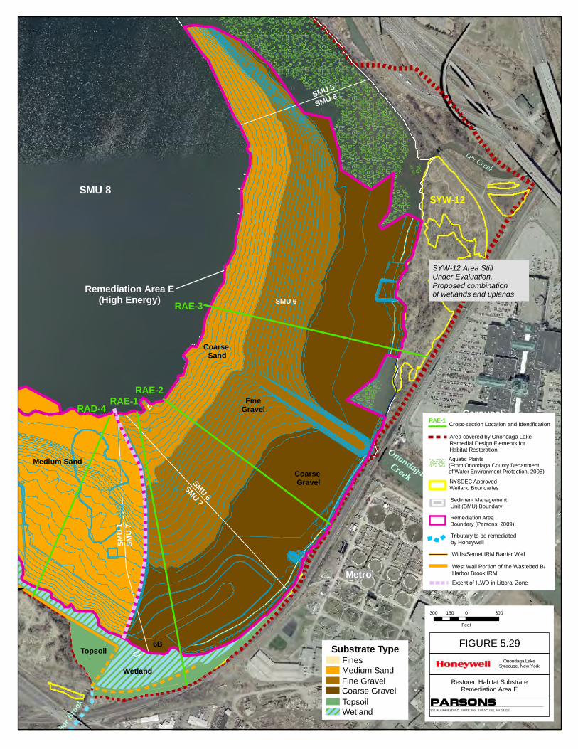
Ley C
reek
Harbor
Brook
Ley Creek
9B
6A
Carousel Mall
Metro
Onondaga Creek
SYW-12 Area StillUnder Evaluation.Proposed combinationof wetlands and uplands
SYW-12
3B
5B
Topsoil
Phragmites control channel (Module 4A) extends along entire length of wall
Remediation Area E(High Energy)
Coarse Sand
FineGravel
Coarse Gravel
6B
Wetland
SMU 8
Medium Sand
SMU
7SM
U 1
SMU 7SMU 6
SMU 6SMU 5
SMU 6RAE-3
RAE-2RAE-1
RAD-4
West Wall Portion of the Wastebed B/Harbor Brook IRM
Extent of ILWD in Littoral Zone
Willis/Semet IRM Barrier Wall
Tributary to be remediatedby Honeywell
Area covered by Onondaga LakeRemedial Design Elements for Habitat Restoration
Cross-section Location and IdentificationRAE-1
Sediment Management Unit (SMU) Boundary
Aquatic Plants(From Onondaga County Departmentof Water Environment Protection, 2008)
NYSDEC ApprovedWetland Boundaries
Remediation AreaBoundary (Parsons, 2009)
Substrate TypeFinesMedium SandFine GravelCoarse GravelTopsoilWetland
.Onondaga Lake
Syracuse, New York
301 PLAINFIELD RD, SUITE 350; SYRACUSE, NY 13212
PARSONS
FIGURE 5.29
Restored Habitat SubstrateRemediation Area E
300 0 300150
Feet