Gutierrez Chortis-Maya Final
76
THE MAYA-CHORTÍS BOUNDARY: A TECTONOSTRATIGRAPHIC APPROACH Fernando Ortega-Gutiérrez 1 , Luigi A. Solari 1 , Carlos Ortega-Obregón 1 , Mariano Elías- Herrera 1 , Uve Martens 2 , Sergio Morán-Icál 3 , Mauricio Chiquín 3 , John Duncan Keppie 1 , Rafael Torres de León 1 , Peter Schaaf 4 1 Instituto de Geología, Universidad Nacional Autónoma de México 2 Department of Geological and Environmental Sciences, Stanford University, USA 3 Universidad de San Carlos, Cobán, Guatemala 4 Instituto de Geofísica, Universidad Nacional Autónoma de México Corresponding author: Fernando Ortega Gutiérrez [email protected] Tel. +5255-56224300, ext. 106 Fax +5255-564289 1
-
Upload
julio-nery -
Category
Documents
-
view
48 -
download
1
Transcript of Gutierrez Chortis-Maya Final

THE MAYA-CHORTÍS BOUNDARY: A TECTONOSTRATIGRAPHIC APPROACH
Fernando Ortega-Gutiérrez1, Luigi A. Solari1, Carlos Ortega-Obregón1, Mariano Elías-
Herrera1, Uve Martens2, Sergio Morán-Icál3, Mauricio Chiquín3, John Duncan Keppie1,
Rafael Torres de León1, Peter Schaaf4
1 Instituto de Geología, Universidad Nacional Autónoma de México
2 Department of Geological and Environmental Sciences, Stanford University, USA
3 Universidad de San Carlos, Cobán, Guatemala
4 Instituto de Geofísica, Universidad Nacional Autónoma de México
Corresponding author: Fernando Ortega Gutiérrez
Tel. +5255-56224300, ext. 106
Fax +5255-564289
1

ABSTRACT
This work presents an updated revision of the complex stratigraphic and tectonic
relationships that characterize the geologic boundary between the Chortís and Maya
continental blocks of the Caribbean region. Based on field, petrologic, structural and
geochronological work in key areas of central Guatemala, we propose a new
tectonostratigraphic structure that appraises more fully the fundamental tectonic role of
the multiple major faults that cut across the continental isthmus between the Americas,
and bounds separate stratigraphic packages that may well qualify as
tectonostratigraphic terranes (or fault blocks according to JDK). Accordingly, we
subdivide the area into seven of theses units, which from south to north are as follows:
1. Chortís, 2. Yoro, 3. Sula, 4. El Tambor, 5. Jacalteco, 6. Achí, and 7. Maya, bounded
respectively by the Agúan-La Ceiba, Jocotán-Chamelecón, Motagua, Baja Verapaz,
and Chixoy-Polochic fault zones. Unfortunately, the extreme paucity of modern geologic
data bearing on the pre-Cretaceous cover and basement units in the entire region,
constitutes a major obstacle for building up convincing paleogeographic models that
may explain the complex tectonic evolution of the area from Precambrian to Cenozoic
times. Consequently, this work should be taken as a valuable line to understand more
clearly the nature and contact relationships between deep crustal blocks in the Nuclear
Central America area, and as a contribution to the ultimate endeavor of restoring their
geologic evolution in the modern paradigm of plate tectonics.
1. INTRODUCTION
The integral geology of the Central America-Caribbean region was first presented in the
monumental work of Schuchert (1935), followed by the opus magnus of Sapper
2
(1937), then well described in relation to its mineral deposits (Roberts and Irving,
1957), subsequently comprehensively treated by Butterlin (1977) and Weyl (1980),
and most thoroughly reviewed on occasion of the Centennial Decade celebration of the
Geological Society of America by Donnelly and others (1990). Subsequently, geologic
research in the area has been mainly directed toward fundamental questions about the
Mesozoic and Cenozoic tectonic evolution of the Caribbean realm (e.g. Pindell and
Barret, 1990; Heubeck and Mann, 1991; Beccaluva et al., 1995; Meshede and
Frisch, 1998; Rogers, 2003), including a complete volume of the Geologica Acta
dedicated to plate tectonics implications of the Caribbean (Iturralde-Vinent and Lidiak,
2006), and yet very little has been published about the metamorphic basement
complexes, or the pre-Jurassic cover of the Central America subcontinent, which
constitutes a critical element bridging the North American and South American cratons.
Complex geological conditions require careful assessment of the local and regional
stratigraphy before meaningful reconstructions of past geological history are attempted.
In this regard, the pre-Mesozoic stratigraphic composition of the Chortís and Maya
blocks (Dengo, 1969), as well as the intervening old crustal slices, have to be
considered as completely as possible before establishing robust correlations with the
pre-Mesozoic rocks of continental areas of Mexico, northern South America, and the
United States. In this paper, we use well established tectonostratigraphic criteria (e.g.
Coney et al., 1980; Howell, 1985) to differentiate fault-bounded geologic entities in the
region and to group them in three major domains: 1) Chortís block (Dengo, 1969), 2)
Maya block (Dengo, 1969), and 3) intervening fault-bounded crystalline complexes
(note that JDK prefers the term “fault blocks” rather than terranes for these fault-
bounded blocks because the age of many of the units is too uncertain to be sure if one
3
is comparing rocks of the same age: see Keppie, 2004). The latter group is herein
defined as a series of crustal slices formed by metamorphic basement complexes
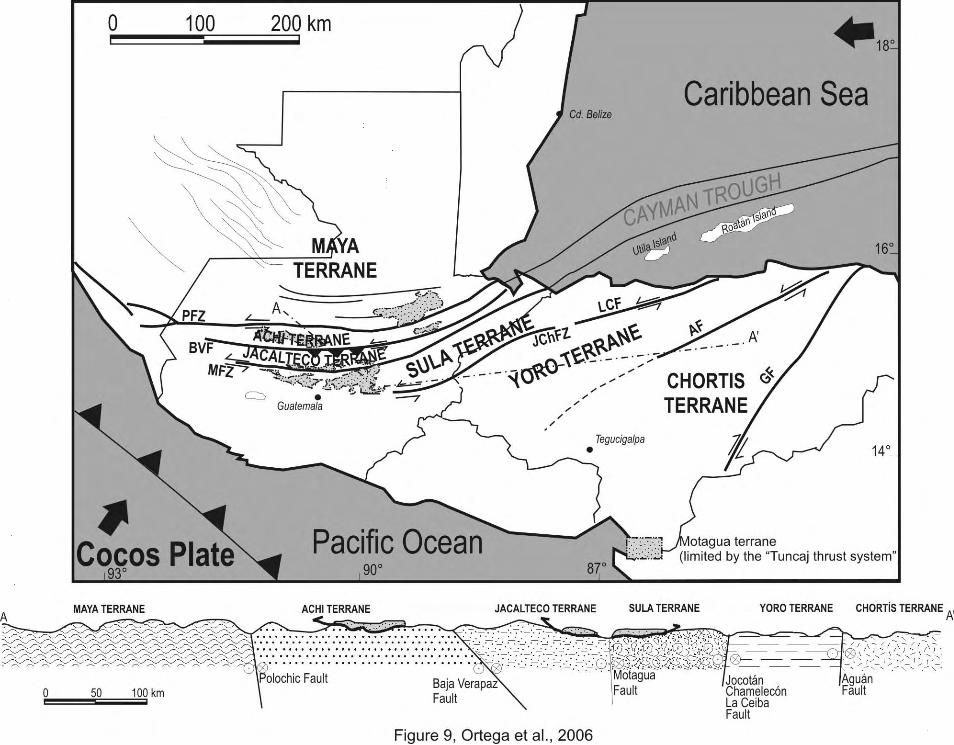
located between the Polochic-Cuilco-Chixoy fault system in the north, and the Jocotán-
Chamelecón-La Ceiba in the south (Figure 1). With this approach, the main purpose of
the study is to present a new regional stratigraphic framework that may serve to better
accommodate and understand the abundant data that is presently produced by a
growing international community working in the area.
2. NORTH WESTERN BOUNDARY OF THE NORTH AMERICA-CARIBBEAN
PLATES
The boundary between the Caribbean and North America plates in the Central
American region is marked (Figure 1) by a diffuse arcuate system of roughly E-W
trending faults, concave northwards with a mean radius of about 300 km centered at the
northern Mexico-Guatemala border near the town of Paxbán. From south to north, the
Jocotán-Chamelecón, San Agustín-Motagua-Cabañas, and Cuilco-Chixoy-Polochic fault
systems, subsequently referred respectively as Jocotán, Motagua, and Polochic faults
for simplicity, currently define this composite structural boundary. On the other hand,
Guzmán-Speziale, (1989, 1998) extended the active part of the plate boundary as far
north as the Chiapas fold-thrust belt in southeastern Mexico (see Figure 1), and
proposed left lateral displacements of about 70 km accumulated on 9 major faults. We
think, from field work in the area and the analysis of satellite imagery, that the Polochic
fault splays into two main branches: a) the Cuilco-Motozintla fault that intersects the
Mexican border near Amatenango de la Frontera, following from there about 20 km up
to the Motozintla River headwaters where it seems to end, contrary to other models (i.e.
4

Burkart et al., 1987) that continue the fault westwards gradually bending it northward to
follow the southern limit of the Soconusco batholith, and b) a structural lineament
complex that departing from just west of Huehuetenango in Guatemala follows the
Selegua River and continues across the Mexican border along an arcuate fault, which in
turn joins at Mapastepec with a major shear zone defining the southern margin of the
Chiapas batholith (Figure 1). This major fault was named as the Tonalá shear zone
(Wawrzyniec et al., 2005) and is marked by vertical mylonites dated (Ar-Ar) at 8.0 ± 0.1
Ma with left lateral kinematics (Tovar-Cortés et al., 2005). The Motagua fault, on the
other hand, although apparently interrupted or buried in central Guatemala by the most
recent volcanic deposits, may be traced into Mexico following the E-trending Belisario
Domínguez mylonitic shear zone that intersects the Mexico-Guatemala border near the
Tacaná volcano (Figure 1), and it may continue from there eastward under the
Guatemalan volcanic cover, to merge with the westernmost exposed trace of the
Motagua fault south of Huehuetenango.
Present activity along these faults (Malfait and Dinkelman, 1972; Dengo, 1985;
Donnelly et al., 1990; Cáceres et al., 2005), is recorded along the Motagua-Polochic
fault system (Figure 2), as dramatically demonstrated by the 1976 earthquake (Ms =
7.5, Plafker, 1976; Kanamori and Stewart, 1978) with measured sinistral
displacements up to 2 meters along the Motagua-Cabañas fault, and the by the large
Guatemalan earthquake of 1816 (MW = 7.5-7.75) with epicenter at the Polochic fault
(White, 1985). The present displacement rate of the Caribbean plate relative to the
North America plate is around 2 cm/year (e.g. De Mets et al., 2000). Other authors (e.g.
Burkart, 1983) proposed that the northern Caribbean limit was successively occupied
since Miocene times by one of the three main faults: Polochic, Motagua, and Jocotán.
5

Cumulative displacements proposed across these faults vary from more than 1100 km
(Mann and Burke, 1984; Rosencrantz and Sclater, 1986; Rosencrantz et al., 1988)
to only a few hundred kilometers, with a maximum displacement of 130 km taken by the
Polochic fault, as documented by Burkart (1978, 1983), and Deaton and Burkart
(1984). The remaining offset (>1000 km), if true, should be recorded by the Motagua-
Jocotán and other undocumented faults south of the Polochic. However, total
displacements based alone on geologic relations of these faults are essentially
unknown (Gordon and Muehlberger 1994), or up to 300 km (Manton, 1987). The
Polochic fault extends westward across central Guatemala and constitutes the
northernmost and distinct structural element of the inferred northwestern Caribbean
Plate boundary. To the west, and just before entering Mexico, it appears to develop a
horsetail pattern that does not reach the Pacific Ocean, whereas other authors have
advocated continuity of the Polochic fault to the west where it either intersects the
Acapulco trench at a putative triple junction in the Gulf of Tehuantepec area (e.g. De
Cserna, 1958; Muehlberger and Ritchie, 1975; Burkart and Self, 1985), or along the
southern margin of the Chiapas batholith (Lapierre et al., 2000). An eastward 45º
deflection of the NW-trending Chiapas-Petén fold-and-thrust belt (from NW to E-W) as it
approaches the E-W-trending Polochic fault indicates a minimum left-lateral
displacement of about 150 km (assuming the bending is linked with faulting). The
continuity of the present Cayman Trough and main Guatemalan fault systems, with the
ancestral Middle America trench in the past, is implicit in models that advocate up to
1400 km of Eocene-Miocene, left-lateral displacements of the Chortís block off the
margin of southwestern Mexico. This order-of-magnitude difference and uncertainty in
possible Cenozoic displacements between the Chortís and Maya blocks places severe
6

constraints to robust paleogeographic reconstructions of the region as discussed below.
On the other hand, Keppie and Morán-Zenteno (2005) propose that the Eocene
boundary between the North America and Caribbean plates may be projected
southwestward along the strike of the Cayman faults beneath the Central America arc
and coinciding with a gravity anomaly, allowing the Chortís block to move 1100 km
about a pole of rotation located near Santiago de Chile northeastward from the Pacific
Ocean to its present position.
3. STRATIGRAPHY
The region of Central America has been naturally subdivided into blocks or terranes
with contrasting stratigraphic columns (Figure 3) separated by major faults (e.g. Dengo,
1969; Horne et al., 1976; Case et al., 1984). Each block contains a distinctive
crystalline basement with poorly known ages exposed under a cover of sedimentary
and volcanic rocks, the age of which may be as old as early Paleozoic (this work), to as
young as Neogene. Unfortunately, stratigraphic correlations among the blocks (e.g.
Figure 2 of Horne et al., 1976), have been plagued by the paucity of fossiliferous rocks
in the pre-Cretaceous cover, as well as by the lack of reliable isotopic ages for their
crystalline basements; consequently, the relative mobility and magnitude of offsets
across the major faults in the studied area still remain as principal subjects of study and
debate. From south to north we now describe the crystalline basement components
(Figure 4) of three tectonostratigraphic domains: a) Chortís block, b) fault-bounded
crystalline terranes, and c) Maya block, followed by a general description of the pre-
Cretaceous volcanic and sedimentary cover across the area
7
3.1. Pre-Mesozoic crystalline basement units of Chortís and Maya blocks
3.1.1. Chortís Block
Nelson et al., (1997) stated that U/Pb zircon crystallization ages and Sm-Nd data
indicate that the Chortís crust in Guatemala and Honduras “is mainly of Grenville age or
has an inherited Grenville component.” If the Chortís block indeed extends to the
Motagua fault zone, the oldest rocks reported (Grenvillian) from the Chortís block crop
out south of the Jocotán-La Ceiba fault between the El Progreso and Yoro (Figure 1) in
NW Honduras (Manton, 1996). Mesozoic sedimentary rocks cover this basement
terrane and it is in fault contact with low-grade units of the undated San Diego Phyllite.
Unfortunately, the data are in abstract form and the full appraisal of geologic
relationships and precision of the study cannot be assessed, particularly in the apparent
absence of supracrustal rocks of Paleozoic age throughout the Chortís block. These
metamorphic rocks were included in his more recent work (Manton and Manton, 1999).
Along the northern limit of the Chortís block in Guatemala, between the Motagua and
Jocotán faults, orthogneissic units of Las Ovejas Complex in southeastern Guatemala,
and equivalent lithologies of Sierra de Omoa in northwestern Honduras (Bañaderos
complex) were also dated by Rb-Sr as possibly Precambrian (Horne et al., 1976).
However, although these rocks are commonly included in the Chortís block, their fault-
bounded nature casts some doubts on their inclusion within the Chortís block, and thus,
we choose to describe them under the intervening domain of fault-bounded crystalline
terranes.
Well within the Chortís block, crystalline basement units crop out in central Honduras
(Fakundiny and Everett, 1976), and northwestern Nicaragua (Nueva Segovia District).
The oldest sedimentary packages overlying this basement consist of low grade, Late
8
Triassic (?) to Middle Jurassic marine and continental metasediments of the Agua Fría
Formation (Ritchie and Finch, 1985) that, in turn, underlie with strong angular
unconformity Lower Cretaceous clastic and carbonate platform marine sequences
(Tepemechin Formation and Yojoa Group), followed by red beds of the Upper
Cretaceous Valle de Angeles Group. Detailed descriptions of these basement
complexes of the Chortís and Maya blocks are given below proceeding from the
southeast (Nicaragua) to the northwest (Guatemala, Belize, and southeastern Mexico).
3.1.1.1. Cacaguapa Group (Fakundiny, 1970) and equivalent formations in Nicaragua:
(Palacaguina of Zoppis, 1957), and Petén Formation in Honduras (Carpenter, 1954)
Extensive outcrop areas in northwestern Nicaragua and northeastern Honduras contain
low and very rarely high-grade metamorphic rocks of volcanic and sedimentary origin.
They are considered of Paleozoic age because limited radiometric dating (Pushkar et
al., in Horne et al., 1976) suggest a maximum Silurian age (412 Ma), and apparently
rest unconformably beneath Middle Jurassic rocks of the Agua Fría Formation (Viland
et al., 1996), or Late Triassic-Jurassic sedimentary rocks of the El Plan Formation
(Carpenter, 1954; Maldonado-Koerdell, 1953). The Cacaguapa Group or Schist
(locally called Petén and Palacaguina formations) is described more generally as a
sequence of phyllitic micaceous and graphitic rocks with abundant concordant quartz
veins and pyrite casts, locally grading to garnet schist, metaconglomerate, quartzite,
metavolcanics (meta-andesite and meta-rhyolite), and including a distinctive
augenschist characterized by intersecting foliations. In the El Porvenir quadrangle (not
shown in Figure 1) of Honduras, Simonson (1981) described epidote-amphibolite
facies rocks beneath Jurassic beds that consist of garnet-chloritoid-biotite-albite-chlorite
9
schists, marble, and mylonitic augengneisses with up to three phases of deformation. A
few kilometers northeast of La Chacra, in central Honduras, Fakundiny and Everett
(1976) report “Paleozoic” quartz-muscovite schists unconformably overlain by Jurassic
“shales” of the Agua Fría Formation. Particularly intriguing are the antigorite
serpentinites and related mafic and ultramafic rocks reported by Emmet (1988) from the
Guanaja Quadrangle of central Honduras, as these, possibly ophiolitic tectonites, would
suggest the presence of major sutures of unknown age well within the Chortís block. It
should be kept in mind that local contact relationships of these higher grade crystalline
rocks with the pre-Jurassic phyllitic units have been described as unconformable,
tectonic or gradational, and the generally assumed Paleozoic age for the more strongly
metamorphosed rocks must be verified before considering them as true pre-Mesozoic
basement.
3.1.1.2. Nueva Segovia Schist (Del Giudice, 1960)
Most outcrops of this metamorphic complex occur in the alto Río Coco area of Nueva
Segovia District in northwestern Nicaragua (see Figure 4a). They are described as
phyllites, quartzites and mica schists, some of which still preserve primary sedimentary
features (Paz-Rivera, 1962). However, a small outcrop of these rocks described at
Macuelizo, Nueva Segovia by Echávarri-Pérez and Rueda-Gaxiola (1962) consists of
quartz, muscovite, biotite, sericite, rutile, hematite, chlorite, tourmaline, and opaques.
Furthermore, in another local report (Piñeiro and Romero, 1962), the metamorphic
rocks exposed in a nearby area are described as consisting of schists, phyllites,
marbles, quartzites and gneisses, thus indicating the possible presence of basement
formations with different ages and exposure depths. The lower grade metamorphic
rocks are intensely folded and intruded by abundant veins and pods of quartz. A
10

gneissic rock that crops out near the Carao village over the Mosonte River consists of
quartz, biotite and muscovite. The rocks are intruded by batholithic bodies of granitic to
dioritic composition, and covered nonconformably by coarse continental clastics of
Tertiary age known as Totogalpa Formation (Del Giudice, 1960). According to Rogers
(2003) the Middle Jurassic Agua Fría Formation, east of the Guayape fault, shows a
transition to low-grade metasediments, which elsewhere have been considered part of
the Paleozoic Cacaguapa Schist. On the other hand, the common presence in the
Quebrada Santa Ana, and Mosonte River areas of schists and gneisses with biotite,
pyroxene, graphite, oligoclase and cordierite, suggests the existence of high-grade
rocks.
3.2. Intervening fault-bounded crystalline complexes or terranes
Between the Polochic fault in the north and the Jocotán fault in the south, several
crustal slices tens of kilometers wide and composed essentially of high-grade crystalline
rocks, crop out defining the main mountain ranges of Central Guatemala and
northwestern Honduras. The Motagua Valley, on the other hand, is mainly occupied by
volcano-sedimentary and low-grade metamorphic rocks of oceanic affinity constituting a
composite tectonostratigraphic terrane with its Cenozoic cover: the Late Jurassic-
Cretaceous El Tambor Group (McBirney, 1963; McBirney and Bass, 1969; Wilson,
1974; Beccaluva et al., 1995; Giunta et al., 2002. This composite terrane, however,
will not be considered in detail here, as it consists of a late Mesozoic accretionary
wedge of tectonic slices and melange that rest above, or abut against older basement
and pre-Cenozoic units of the Maya and Chortís blocks. At many places most rocks of
this Jurassic-Cretaceous sequence appear to form rootless allochthons derived from
11

Late Jurassic-Early Cretaceous arc-ocean complexes associated with the evolution of
the Caribbean area (Dengo, 1972; Williams, 1975; Rosenfeld, 1981; Lewis et al.,
2006). Further descriptions and discussion of tectonic and paleogeographic models
constitute a complex subject far beyond the purposes of this paper, which mostly
focuses on pre-Mesozoic history of the Chortís-Maya region.
3.2.1. Precambrian Yoro complex
South of the Jocotán fault and north of the inferred southern continuation of the Aguán-
Esperanza fault, between the towns of El Progreso and Yoro in northwestern Honduras,
high-grade metamorphic and crystalline basement rocks, here named as Yoro Complex,
are exposed (Manton, 1996; Manton and Manton, 1999). They extend 60 km along a
WNW-trending strip with a maximum width of 10 km, and consist of massive and
banded granitic gneisses, together with minor greenschist-lower amphibolite facies
micaceous to garnetiferous metapelites, that are intruded by lineated granites. The
granites were dated (Manton, 1996) and yielded concordant U-Pb data on zircon at
1000 Ma, with a Sm-Nd model age of 1400 Ma. Low-grade metasedimentary rocks
occur in the same area, but their contact relationships are undetermined. Because the
age and nature of these high grade rocks differ from adjacent basement units (Las
Ovejas Complex on the north, and Cacaguapa Schist on the south), and they lie
between the Jocotán fault to the north and Aguán-Esperanza faults to the south (see
Figures 1 and 10), the Sula-Yoro block may be considered as the southernmost
tectonostratigraphic slice interposed between the less deformed Maya and Chortís
blocks.
3.2.2. Las Ovejas-Omoa Complex
12
The high-grade metamorphic rocks exposed between the Motagua and the Jocotán
faults structurally overlain by ultramafic late Campanian allochthons of El Tambor
sequence, were grouped under the name of Las Ovejas Complex (Schwartz, 1977) in
Guatemala, and Omoa complex in Honduras (Horne et al., 1976). The former
sequence was described in detail at El Progreso quadrangle as consisting of gneiss,
schist and migmatite, with sporadic thin beds of white marble, and defining a strip
parallel to the E-W trend of the Motagua fault with a maximum width of 22 km. The best
outcrops occur between the El Tambor and Las Ovejas rivers, and in the Zacapa-
Gualán area of east-central Guatemala (see Figure 4b). Structurally, Las Ovejas
Complex consists of an upper part formed by granitic gneisses and intercalated marble,
and a lower sequence of dioritic gneisses and amphibolites. However, common
migmatitic aluminous metapelites with garnet, sillimanite, staurolite and potassium
feldspar indicate abundant sedimentary protoliths affected by middle to upper
amphibolite facies metamorphism that was accompanied by migmatization. Las Ovejas
Complex is intruded by the 50 ± 5 Ma (K-Ar) Chiquimula pluton and covered tectonically
by the late Campanian to Aptian ophiolitic nappes. Eastwards, Las Ovejas Complex
eventually merges with the Omoa Complex in the Sierra de Omoa, of northwestern
Honduras. Here, metamorphic rocks near San Pedro Sula are remarkably similar to
those of Las Ovejas Complex, except that marbles are poorly represented, whereas
kyanite is common along with garnet and staurolite. Poorly defined early Paleozoic to
Late Precambrian Rb-Sr ages (980-460 Ma) were reported (Horne et al., 1976) for
some of the Omoa orthogneisses (Bañaderos Complex) intruding the metasedimentary
units. More specifically, these authors dated a granitic pluton at 305 ± 12 Ma (Rb-Sr
whole-rock isochron) that crosscuts infolded medium-grade calcareous to silicic and
13

metavolcanic units in the eastern part of Sierra de Omoa. On the other hand, similar
low-grade metavolcanic rocks dated as Mesozoic (Ave-Lallemant and Gordon, 1999)
occur further east in the Roatán Island. The only “well" dated intrusion into the Omoa
Complex is an undeformed adamellite-granodiorite pluton yielding an age (Rb-Sr) of
150 Ma. Early Cretaceous sedimentary rocks rest unconformably on the low- and high-
grade units in the area, indicating a minimum Jurassic age for the metamorphic
basement of this fault-bounded crystalline unit extending between the Motagua and
Jocotán faults.
3.2.3. Chuacús Complex
Although this metamorphic complex is commonly considered the basement of the Maya
block in Guatemala, it is, in fact, bounded by large-scale faults (Baja Verapaz and
Motagua), and true unconformable stratigraphic relationships with neighboring late
Paleozoic sedimentary rocks of the Santa Rosa Group have not been demonstrated.
For this reason, we prefer to group the unit within the fault-bounded tectonostratigraphic
domains of Nuclear Central America separating the more stable Maya and Chortís
continental blocks.
The Chuacús Complex was originally referred to as Chuacús Series (McBirney, 1963)
and then changed to Chuacús Group by Kesler et al. (1970). In a more recent
publication (Ortega-Gutiérrez et al. (2004) proposed the name Chuacús Complex, in
conformity with current stratigraphic nomenclature for high-grade metamorphic or
structural terranes where primary stratigraphic relations have been essentially
destroyed (Whitaker et al., 1991; International Subcommission on Stratigraphic
Classification, 1994). Ortega-Gutiérrez et al. (2004) reported a pervasive eclogite
14

facies event that conveyed a fundamentally new tectonic significance to the entire unit
because of the strong possibility that pressure conditions occurred in the coesite or
diamond fields of ultra-high pressure metamorphism.
The type locality lies at the Sierra de Chuacús of central Guatemala, where the first
systematic study and definition of the metamorphic unit was published (McBirney,
1963). Later, the sequence was extended and mapped as the Western Chuacús by
Kesler et al. (1970), and subdivided into several lithostratigraphic units in areas
adjacent to the Motagua fault zone of east central Guatemala (Newcomb, 1978; Roper,
1978). Previous and more detailed studies exist in several unpublished thesis (Bosc,
1971; van den Boom, 1972; Schwartz, 1976). The ages determined for the Chuacús
Complex are poorly known, as they range from the Precambrian (e.g. Gomberg et al.,
1968), late Paleozoic (Ortega-Gutiérrez et al., 2004), to as young as the Late
Cretaceous. The metamorphic complex consists throughout of banded, highly
aluminous gneisses and schists formed originally in the eclogite and amphibolite facies
(see Figures 4c-d) that later underwent several events of retrogression and
mylonitization (Figures 4e-f) related to continued orogeny since its formation probably
in the Paleozoic (Ortega-Gutiérrez et al., 2004). Non-conformable relationships
between the upper Paleozoic Santa Rosa Group and the Chuacús Complex, as
proposed by McBirney (1963), have been generally considered proof of its pre-
Pennsylvanian age (McBirney and Bass, 1969; Carfantan, 1985, p. 196; Donnelly et
al., 1990). However, detailed studies carried out by us in the same area (Figure 5),
have failed to support this contention and demonstrate instead that the northern limit of
the Chuacús Complex is located tens of kilometers south of the Polochic fault, where it
is abruptly faulted against a low-grade siliciclastic sequence (the Salamá schist of van
15
den Boom, 1972), which in turn was intruded by the Rabinal granite, recently dated as
early Paleozoic (Ortega-Obregón, 2005). This relationship may be extended
westwards to the Huehuetenango area, where a thin band of low grade metasediments
similar to those formerly included in the Salamá schist and intruded by muscovite
leucogranites strongly resembling certain facies of the Rabinal pluton, separates the
Western Chuacús retrograde gneisses to the south, from the Maya block located north
of the Polochic fault where the upper Paleozoic Santa Rosa Group is widely exposed.
Therefore, in our opinion, the age of the Chuacús Complex is still unconstrained by
stratigraphic relations, whilst radiometric ages are also scarce and controversial. The U-
Pb age of 305 ± 5 Ma recently published (Ortega-Gutiérrez et al., 2004) for the
migmatization event represented in the El Chol area (about 15 km south of Rabinal)
within the Chuacús Complex should presently be considered the best evidence for its
pre-Mesozoic age. Previously, Gomberg and others (1968) obtained a mixed age from
rocks of the Rabinal granite and Chuacús Complex at 1075 ± 25 Ma, but warned about
the possibility of zircon inheritance from unknown Precambrian sources. Other Rb-Sr
data assigned an age of 395 Ma to one Chuacús gneiss (Pushkar, 1968), whereas
most K-Ar data obtained from different minerals (white mica, biotite, and hornblende)
across all of the Chuacús Complex and published by several authors (Gomberg et al.,
1968; Ortega-Gutiérrez et al., 2004), fall in a narrow interval between about 70-60 Ma,
indicating a pervasive, Late Cretaceous event superposed on the Chuacús Complex
that reset all relatively low temperature “geoclocks”. However, provided there is no
excess argon, a previous event may be recorded in some hornblendes from Chuacús
amphibolites that yielded a 40Ar/39Ar age of 238 Ma (Donnelly et al., 1990), and several
16
Paleozoic hornblende and mica dates that we have measured (unpublished data) in
migmatitic gneisses at El Chol area.
3.2.4. San Gabriel-Rabinal suite
Low-grade clastic rocks, here referred to as the San Gabriel sequence after a small
town between the cities of Salamá and Rabinal (see Figure 5), crop out in close
intrusive relationship with the Rabinal granite of the Baja Verapaz area. This unit was
formerly considered part of the Chuacús Complex and named the Salamá schist (van
den Boom, 1972). It constitutes a critical and independent sequence separating high-
grade gneisses of the Chuacús Complex to the south, from typical Paleozoic
sedimentary and probably Precambrian basement rocks of the Maya block to the north.
The newly-defined Baja Verapaz shear zone (Ortega-Obregón et al., 2004) (Figure 5)
defines a wide (ca.10 km), moderately south-dipping, left-lateral oblique thrust that
places retrograde gneisses of the Chuacús Complex above the low-grade granite-
metasedimentary terrane to the north. Whereas intrusive relationships of the Rabinal
granite and the San Gabriel sequence are clearly exposed between the towns of
Salamá and Rabinal, similar granites at Huehuetenango intruding the Chuacús
Complex and low-grade units comparable to the San Gabriel sequence may or may not
correspond with the Rabinal granite. At Chixolop (Figure 5), a small village east of
Salamá, deformed limestone and shales with conodonts of Early Mississippian age, and
thus older than the Sacapulas Formation of the Maya block, rest unconformably on the
San Gabriel sequence and the Rabinal granite (Ortega-Obregón et al., 2004, Ortega-
Obregón, 2005) indicating a pre-Mississippian stratigraphic age for both units. On the
other hand, near the village of San Francisco (see Figure 5) and at the eastern road
17

entrance to Salamá, coarse-grained sedimentary units, including basal
metaconglomerates with abundant pebbles of deformed (mylonitized) and undeformed
granites similar to Rabinal granite, may represent strata equivalent to the Sacapulas
Formation. These granitic pebbles in the basal conglomerates at San Francisco and
Salamá support an important nonconformity between the late Paleozoic rocks above,
and the Rabinal granite-San Gabriel sequence below. The observed stratigraphic
relationships are consistent with K-Ar ages recently obtained by us for igneous
muscovite books in pegmatites of the Rabinal Granite intruding the San Gabriel
sequence, which dated the granite between 440 and 429 Ma (Ortega-Obregón, 2005).
3.3 Maya block
The Maya block is currently extended westward across the Isthmus of Tehuantepec into
the Mixtequita area, where Grenvillian basement granulite facies rocks are intruded by
late Paleozoic to Jurassic plutons (Weber and Köhler, 2001; Restrepo-Pace et al.,
2002). However, east of the Tehuantepec Isthmus, the Maya block is extensively
covered by Mesozoic and Cenozoic formations, and only in the Chicomuselo area, the
Maya Mountains of Belize (Dixon, 1955; Steiner and Walker, 1996; Steiner, 2006),
the Chiapas batholith (Schaaf et al., 2002; Weber et al., 2005), and in the core of the
Altos Cuchumatanes in Guatemala (Anderson et al., 1973; this work) pre-Mesozoic
crystalline rocks and late Paleozoic sedimentary units are well exposed. On the other
hand, east of the Isthmus of Tehuantepec exposed Grenvillian crust is essentially
absent, thus making the Grenvillian integrity of the Maya block across the isthmus
suspect.
3.3.1. The Chiapas batholith
18

The Pacific coast along the entire state of Chiapas in southeastern Mexico is formed by
a continuous crystalline complex known as the Chiapas batholith because most of its
rocks are intrusive granitoids dated as late Paleozoic to Triassic (Schaaf et al., 2002;
Weber et al., 2005), with only a few younger (Jurassic) and possibly older (early
Paleozoic and Neoproterozoic) outliers. In fact, only a few pre-batholithic rocks were
previously known (Pantoja-Alor et al., 1974; Damon et al., in Salas, 1975), until
Weber et al., (2005) recently documented an extensive orogenic event 250-254 Ma old,
including abundant high-grade metamorphic rocks in the Chiapas batholith. These rocks
are represented by migmatites, ortho-, and para-gneisses intruded by undeformed
plutons with ages around 250 Ma. This deep orogenic event is not registered in the
Pennsylvanian-Permian sedimentary rocks exposed in the Chicomuselo area, which
extend along the strike to meet the upper Paleozoic Santa Rosa Group of west central
Guatemalan. Direct contact relationships of the Paleozoic-earliest Mesozoic granitoids
and the older sedimentary units are mostly buried beneath a thick blanket (> 2000 m) of
Middle Jurassic red beds of the Todos Santos Formation. However, the presence of
chiastolite (andalusite) and granitic dikes within sedimentary rocks closely bordering the
granitoids in the Chicomuselo area (Carfantan, 1985), and clearly exposed in the Valle
de Obregón-Amatenango de la Frontera area, demonstrate intrusive relationships, in
accord with the younger radiometric ages obtained from the granites and the
paleontologic evidence of possible Mississippian to Early Permian age of the
sedimentary rocks at Chicomuselo (Hernández-García, 1973).
Although inherited Grenvillian zircons are commonly found in the granitoids (Weber et
al., 2005), no pre-late Paleozoic crystalline rocks of any kind have been satisfactorily
identified in the entire massif. Stratigraphic relationships in the southeastern sector of
19
the batholith show pre-Middle Jurassic marine sedimentary rocks overlying high-grade
gneisses in the Honduras-Pablo Galeana area north of Motozintla. At Barranca Honda,
near the villages of Honduras and Paisthal (not shown in map), crystalline basement
rocks for the late Paleozoic sequence of Chicomuselo are probably exposed
(Carfantan, 1985, p. 116). The sedimentary sequence is represented either by basal
conglomerates, followed by black metapelites and intruded by granites, or
unconformably covered by the Jurassic red beds with basal units containing abundant
pebbles of gneisses, schists, and vein quartz. Additional possible basement rocks found
in our study consist of retrograde, high-grade, quartzo-feldspathic gneisses including
wide bands of garnet amphibolite that suggest minimum formation pressures of 8-12
kbar (e.g. Liu et al., 1996). These pressures stand in contrast with the relatively low
pressures (up to 5.8 kbar at 730-780 ºC) of metamorphism (Hiller et al., 2004) and the
post-Early Permian ages that characterize the paragneissic rocks elsewhere in the
Chiapas batholith.
3.3.2. Maya Mountains
Pre-Mesozoic crystalline, sedimentary and volcanic rocks crop out in the Maya
Mountains of Belize in the heart of the Maya block (Hall and Bateson, 1972; Kesler et
al., 1973; Bateson and Hall, 1977; Steiner and Walker, 1996). Most of the area
(about 8000 km2) consists of upper Paleozoic fossiliferous sedimentary rocks of the
Santa Rosa Group, with the remainder occupied by several plutons, the age of which
range from Silurian to Permian or Triassic (Bateson and Hall, 1977; Steiner and
Walker, 1996). On the other hand, high-grade metamorphic rocks have not been
encountered in the region, and intrusive relationships between some of the plutons and
the Santa Rosa Group rocks are inconclusive. Steiner and Walker (1996) offered a
20

detailed description of the igneous bodies, which in general consist of undeformed, two-
mica granitoids that range in composition from granite to diorite. Three main bodies
were studied, Mountain Ridge, Cockscomb-Sapote, and Hummingbird. The two former
are similar and consisting of leucocratic, unfoliated muscovite-biotite-perthite-oligoclase-
tourmaline granite rich in alkalis (up to 8.32 wt %) and silica (75.58 wt %), whereas the
latter is a granodiorite with 65-66 SiO2 wt %. The zircon U-Pb Devonian-latest Silurian
ages (404-418 Ma) obtained by Steiner and Walker (1996) for three of the Maya
Mountains plutons unfortunately are not well constrained because of strong isotopic
disturbance and paucity of data. Monazite in one of these granites yielded similar Late
Silurian ages, but the data are highly (14-30 %) discordant. Moreover, some of the
conglomerates in the upper Paleozoic sequence include pebbles of contact
metamorphic sedimentary rocks, and one of the plutons dated as Silurian is surrounded
by andalusite-bearing pelites, locally with abundant biotite, sillimanite, garnet, and
staurolite probably of the Pennsylvanian Santa Rosa Group, indicating, in this case, a
younger age for the intrusion. Steiner and Walker (1996) explained this apparent
inconsistency in terms of a hypothetical hydrothermal event triggered by the breakup of
Pangea in the Late Triassic. The common presence in the pelitic rocks of the Santa
Rosa Group of chiastolite (a variety of andalusite) demonstrates that some of these
plutons intruded the upper Pennsylvanian-Lower Permian sequence, and consequently
that they may be of latest Paleozoic to Triassic age. Older formations in the basement
of the Maya block are represented by zircon populations ejected in the Cretaceous from
the Chicxulub crater (Krogh et al., 1993). They yielded a dominant basement
component of 544 ± 5 and 559 ± 5 Ma, and minor populations at 418 ± 6, 320 ± 31, and
286 ± 14 Ma.
21

3.3.3. Altos Cuchumatanes
The metamorphic rocks of the Altos Cuchumatanes uplift are only poorly known. As
described by Anderson et al., (1973), they consist chiefly of “gneiss, schist,
amphibolite, and metavolcanic and metaplutonic rocks”. Based on relict textures and
intense superposed retrogression and cataclasis, these authors considered that the
original rocks were in the upper greenschist and lower amphibolite facies. However,
most of the rocks described in the area lie south of, or at the Polochic fault in the
Huehuetenango District (e.g. Colotenango, Santa Barbara, San Sebastián, and Selegua
river areas), and thus they may or may not belong to the Maya block, but instead could
be part of the fault-bounded Chuacús Complex, or of the structurally underlying Rabinal
granite and San Gabriel sequence (Ortega-Obregón et al., 2004).
Within the dissected part of the Altos Cuchumatanes uplift, 30-40 km north of the
Polochic fault trace and near the town of Barillas (see Figure 1), metamorphic rocks
were described to consist of low-grade metasedimentary rocks (slate and phyllite)
correlative with the lower Santa Rosa Group, as well as limited outcrops of underlying
biotite gneiss, and amphibolite. Abundant granites probably intruded the phyllites
because they contain andalusite. Anderson et al., (1973) described the core of the
Altos Cuchumatanes as consisting mainly of biotite gneiss, mica schist, and amphibolite
correlative with the metamorphic units exposed at or south the Polochic fault in the
Huehuetenango area (Western Chuacús Group of Kesler and others, 1970). However,
along the Amelco River near the town of Barillas, we found well-exposed high-grade
crystalline rocks of metamorphic and igneous origin, including probable high-pressure
lithologies consisting of strongly retrogressed kyanite schists and garnet amphibolites.
22
These rocks are comparable with certain facies of the Chuacús Complex, but differ from
it by the lack of muscovite, which characterizes everywhere the latter unit.
4. PRE-JURASSIC COVER
4.1. Chortís block
No sedimentary or volcanic rocks of proved Paleozoic age are known anywhere in the
Chortís block, even if it is extended to the Motagua fault. However, in Honduras (San
Juancito area), phyllitic rocks (Agua Fría Formation?) as old as Late Triassic were
reported (Maldonado-Koerdell, 1953) based on the presence of Palaeoneilo sp. and
Tropites Mojsisovics, which are similar to marine fossils from the well-known Upper
Triassic Zacatecas Formation of north central Mexico. The underlying Cacaguapa or
Nueva Segovia schists, on the other hand, are considered of Paleozoic age, but this
age has not been proven either. In fact, Rogers (2003) has suggested that there may be
a transitional contact between the Agua Fría Formation of Middle Jurassic age and
these “basement” units. It is clear that this conundrum in the stratigraphy of the Chortís
block deserves the priority attention of researchers interested in finding a home place
for the Chortís block.
4.2. Fault-bounded complexes
The fault-bounded crustal slice situated between Jocotán and Motagua faults, whose
crystalline basement is considered to be Las Ovejas and Bañaderos complexes,
includes sedimentary (San Diego Phyllite) and igneous rocks (granitoids) of possible
Paleozoic age, overlain by marine Cretaceous strata. Because the San Diego Phyllite
has been correlated with the late Paleozoic Santa Rosa Group of the Maya block and is
23

intruded by granitoids as old as Early Jurassic (Hirshman, 1963; Lawrence, 1975;
Horne et al., 1976), it is currently considered of possible Paleozoic age. However, the
San Diego Phyllite lacks any fossils and its contact relationships with Las Ovejas
Complex is either faulted or unexposed (e.g., Lawrence, 1975). Apart from this
intriguing and extensive unit, which crops out on both sides of the Jocotán fault, not
other sedimentary or volcanic units of presumed Paleozoic age have been found south
of the Motagua fault. The San Diego Phyllite is lithologically similar to both, the low-
grade phyllites of the pre-Jurassic Palacaguina and Cacaguapa formations, and to the
slightly metamorphosed phyllites of the Middle Jurassic Agua Fría Formation, and thus
it cannot be specifically correlated on this basis with any of these units that characterize
the metamorphic basement of the Chortís block. The sequence in the San Diego-La
Union region located between the Motagua and Jocotán faults consists of very low
grade (subgreenschist facies) carbonate-free, siliciclastic laminated units varying from
dark metapelite to feldspathic schist and fine grained conglomerates with clasts of chert,
quartzose rocks, vein quartz and pyrite cubes reminiscent of those abundantly found in
the Cacaguapa Schist. Locally, it contains a marked fine-grained tuffaceous component
of felsic and intermediate composition mixed with the carbonaceous phyllites. It shows a
single penetrative foliation with local crenulation folding.
The crystalline basement rocks exposed between the Motagua and Polochic faults are
covered by sedimentary and volcanic rocks deposits of Cenozoic age. The Chuacús
Complex situated between the Motagua and Baja Verapaz faults is unconformably
overlain only by upper Cenozoic volcanics. On the other hand, ophiolitic units of the
Upper Jurassic-Cretaceous El Tambor sequence were thrust over the Chuacús
Complex during the Campanian (e. g. Fourcade et al., 1994) thus implying a minimum
24
Cretaceous age for the overridden basement. Although sedimentary and volcanic rocks
assigned to the late Paleozoic Santa Rosa Group crop out south of the Polochic fault in
the San Sebastián Huehuetenango and Sacapulas areas (Bohnemberger, 1966;
Anderson et al., 1973; Clemons et al., 1974), as well as in the Baja Verapaz area,
direct contact relationships with the Chuacús Complex are not clearly exposed and may
be tectonic, as documented further east in the Salamá area (Ortega-Obregón et al.,
2005). Moreover, no rocks of Jurassic age that commonly blanket the Chortís and Maya
blocks have been reported in the cover of any of the fault-bounded complexes, possibly
due to either non-deposition or profound erosion.
Finally, the mountainous, west-trending strip located between the Baja Verapaz shear
zone to the south and the Polochic fault to the north contains the Silurian Rabinal
granite and the intruded San Gabriel sedimentary sequence covered by a sedimentary
sequence correlated with the Sacapulas Formation of Pennsylvanian age. The Early
Mississippian strata reported from this unit, however, is older than the Santa Rosa
Group typical of the Maya terrane Paleozoic cover, and thus cast some doubts about
their continuity across the Polochic fault.
4.3. Maya block
Mississippian (?) to Early Permian marine sedimentary rocks crop out abundantly in SE
Mexico along the NE flank of the Chiapas batholith near the Guatemalan border
(Hernández-García, 1973), in the Maya Mountains of Belize (Dixon, 1955; Batson,
1972; Batson and Hall, 1977) and in dispersed small outcrops along west central
Guatemala north, and probably south of the Polochic fault (Bohnenberger, 1966;
Anderson et al., 1973; Clemons et al., 1974; Vachard et al., 1997).
25
4.3.1. West central Guatemala
Chicol Formation
The type locality was defined 2-5 km southeast of San Sebastián Huehuetenango,
where rocks exposed along the Chicol and Selegua Rivers on both sides of the Polochic
fault consist of 1000 m of coarse clastics and volcanic rocks affected by deformation
and low-grade regional and contact metamorphism. Granitic sills and dikes intruding the
conglomeratic units (Anderson et al., 1973) may have been fed by the large intrusive
bodies that crop out in the Huehuetenango area, south of the Polochic fault. Moreover,
the abundance of conglomerates in the unit suggested to Anderson et al. (1973)
tectonic and volcanic activity as old as late Paleozoic associated with a precursor or
ancestral Polochic fault. Unfortunately, the formation is bounded by faults associated
with the splayed termination of the Polochic fault in Mexico, and neither its Paleozoic
age nor its presence south of the main trace of the Polochic fault are certain.
Nevertheless, the Chicol Formation was correlated by Anderson et al. (1973) with the
late Paleozoic Sacapulas Formation defined by Bohnemberger (1966) about 60 km
east of Huehuetenango, but based only on their lithologic similarities.
Sacapulas Formation (Bohnemberger, 1966)
According to Donnelly et al. (1990) this unit may be up to 1200 m thick and is similar in
lithology (volcanosedimentary) to the Chicol Formation, although topped by distinctive
limestone beds. It is locally considered to form the base of the upper Paleozoic Santa
Rosa Group and has been be extended to the Salamá area, about 30 km south of the
Polochic fault, where it unconformably overlies pre-Devonian, low grade metasediments
of the San Gabriel sequence and the Rabinal granite.
Tactic Formation (Anderson et al., 1973)
26

This unit consists of interbedded black shale, quartzite and rare beds of limestone and
dolomite. It crops out at or north of Polochic fault and may be more than 800 m thick,
locally converted to slate and phyllite by incipient metamorphism and strong
deformation.
Esperanza Formation (Anderson et al., 1973)
This unit is a fossiliferous, 470 m thick sequence of dark shales and siltstones that
grades into the underlying Tactic Formation, but is distinguished from the latter by the
abundance of >5 m thick limestone beds. The Esperanza Formation grades upwards
into more massive Leonardian carbonates of the Chóchal Formation.
Chóchal Formation (Roberts and Irving, 1957)
This unit and equivalent carbonates in Mexico cap the late Paleozoic sedimentary
column of the Maya terrane. It consists of 500-1000 m of fossiliferous, massive
limestone and dolomite with shale intervals that locally grade into the underlying Tactic
Formation. The abundance and preservation of fossils indicate an age as young as
Roadian (Vachard et al., 2004) at the base of the middle Permian.
4.3.2. Maya Mountains (Belize)
This area exposes by far the majority of late Paleozoic sedimentary rocks in the entire
Maya block. Dixon (1955) first described and named the sedimentary and metamorphic
rocks widely exposed in the Maya Mountains of Belize. He subdivided the sequence
into two separate Series, the Maya (graywackes, phyllites, shales, quartzite, shales, and
some schists and gneisses), and the Macal (conglomerate, sandstone and shales with
Late Pennsylvanian to Middle Permian fossils). Kesler et al. (1971) questioned this
subdivision as they found neither a regional unconformity within the sequence, nor
schists or gneisses, and only one penetrative folding phase affecting both units.
27

Therefore, those authors proposed the Macal Group be extended to the entire
sequence and be considered equivalent to the Santa Rosa Group. The Santa Rosa
Group in the Maya Mountains of Belize (Maya and Macal series) consists of slightly
metamorphosed shale, graywacke, quartzite, conglomerate and some limestone with
late Pennsylvanian to middle Permian fusulinids, and includes some “schists and
gneisses” (Dixon, 1955). Distinctive felsic volcanic rocks in the sequence were mapped
as the Bladen Volcanic Member, which together with the plutonic rocks yielded K-Ar and
Rb apparent Triassic ages between 205 and 237 Ma (Steiner and Walker, 1996). The
volcanic rocks include alkalic rhyolite breccias and andesitic lavas exposed along an
ENE-trending band 25 long and 7 km wide (Bateson and Hall, 1971). Unfortunately,
contact relationships with neighboring plutonic units are poorly known and for the most
part faulted. Although a plethora of local names were assigned to this sequence of
slightly metamorphosed rocks, they may be included in the Santa Rosa Group, which in
Guatemala consists of the Chicol and Sacapulas formations of Pennsylvanian age at
the base, and capped by the Chóchal Limestone of Leonardian age (Figure 6).
Bateson (1972) and Bateson and Hall (1977) described a large area about 4200 km2
(70 x 60 km) trending N60E in the Maya Mountains, where the late Paleozoic rocks are
better exposed. Intrusive granitoids compose about 500 km2 of the outcrop area, and a
thick volcanic unit named the Bladen Volcanic Member formed by mixed rhyolitic, tuffs
and lavas within the sedimentary rocks was separately mapped as a member of the
Group. The Late Pennsylvanian age assigned to part of the sequence on the basis of its
fossils is consistent with the Rb-Sr whole-rock isochron age of 300 Ma for one of the
intrusive granitoids (Bateson, 1972). Intrusive relationships are supported by the growth
of andalusite porphyroblasts as large as 15 cm and small grains of sillimanite in the
28

contact with the surrounding sedimentary rocks. Garnet, biotite and staurolite also occur
locally indicating a considerable depth of intrusion.
4.3.3. Chicomuselo area (SE Mexico)
Late Paleozoic, shallow sedimentary and low-grade metamorphic marine rocks are
continuously exposed within an anticlinorium trending WNW in southeastern Chiapas,
Mexico. The outcrops extend from Comalapa at the border of Guatemala to the
Concordia area for nearly 100 km along the strike and are about 30 km wide. They
contain fossiliferous Middle Pennsylvanian-Early Permian and probably Mississippian,
clastic units in the core, and Permian shales and carbonates in the limbs of the structure
(Hernández-García, 1973). These rocks are poorly studied and their total thickness
estimates vary from about 2700 m (Gutiérrez-Gil, 1956) to more than 7500 m
(Hernández-García, 1973); they have been correlated with the Santa Rosa Group of
Guatemala, and formally subdivided into a lower, weakly metamorphic section (slate-
metaquartzite) of apparent Late Mississippian age, and an upper, unmetamorphosed
section where carbonates rich in fusulinids indicate an Early Permian age for the
youngest carbonates. The contact between the two sequences is an angular
unconformity, which indicates important Carboniferous orogenic perturbations in this
region before the Middle Pennsylvanian.
5. ULTRAMAFIC BODIES
The area between the Jocotán and Polochic fault systems and a few kilometers south of
Siuna in northwestern Nicaragua (Baumgartner, 2004), contain allochthonous bodies
of partly to completely serpentinized peridotites, varying in size from a few hundred
meters up to 80 x 10 km associated with other members of an ophiolitic complex. Main
outcrops of this suite occur in the Sierra Santa Cruz of east central Guatemala
29
(Rosenfeld, 1981). Because mantle rocks in orogenic systems commonly mark the site
of fundamental faults (sutures), establishing the crystallization and emplacement ages
of these bodies would be germane to the tectonic interpretation of the Maya-Chortís
connections in the past. Although the ultramafic units in Guatemala are now considered
part of the Late Jurassic-Cretaceous El Tambor Group, in his pioneer work on the
basement rocks of the Sierra de Chuacús, McBirney (1963) considered the
serpentinites as the main Paleozoic or Precambrian basement for the rest of the rock
column, including the highly metamorphosed units of the Chuacús Complex. Indeed, the
reported presence of serpentinite within the Chuacús Complex west of Rabinal (van
den Boom, 1972), and as cobbles in basal conglomerates of the Middle Jurassic Todos
Santos Formation (cf. Anderson et al., 1973, p. 809), as well as the serpentinite
mélange tectonically beneath the Santa Rosa Group just north of Huehuetenango
(Anderson et al., 1973), indicate the existence of pre-Jurassic serpentinites associated
with a protracted history for some of these major tectonic boundaries.
6. INTRUSIVE POST-PALEOZOIC BODIES
Mesozoic and Cenozoic plutonic igneous rocks of granitic to gabbroic composition are
mainly found in the Chortís block, but are present in all tectonostratigraphic domains
(see Weyl, 1980, Table 9, p. 192-193 for a comprehensive compilation up to that year).
In the interior of the Maya block, several Cretaceous to Tertiary intrusions are exposed
in the Chiapas batholith and adjacent to the Polochic fault. In the Altos Cuchumatanes
generally undated deformed and undeformed granitic intrusions are common. The only
one for which a radiometric age exists in this latter area is a deformed granitoid exposed
in the Poxlac area, with a K-Ar date of 196 Ma reported by Donnelly et al. (1990). Las
30

Ovejas Complex, south of the Motagua fault, is intruded by the Chiquimula pluton dated
(K-Ar) at 50 ± 5 Ma (Clemons and Long, 1971), and the Palacaguina Formation in the
Chortís block is intruded by a pluton with a four-point Rb-Sr isochron age (Horne et al.,
1976) of 140 ± 15 Ma. Several large intrusive granitoids are known from central
Honduras, with K-Ar hornblendes ages ranging from 55 ± 1.1 to 123 ± 2 Ma, and from
59 ± 1 to 118 ± 2 Ma on biotites (McDowell, in Gose, 1985). At San Marcos, Honduras
a granitic pluton dated at 149 ± 7 Ma (Rb-Sr) intrudes the metamorphic basemement
(Horne et al., 1976).
The Chuacús Complex contains scarce granitic intrusions, of which the largest one is
the Matanzas granite that intrudes biotite gneisses of the Chuacús Complex in the
northern slopes of Sierra Chuacús (McBirney, 1963). A Rb-Sr whole rock-mineral
analyses performed on this body yielded ages of 250 and 280 Ma, assuming 86Sr/87Sr
initial ratios of 0.707 and 0.703 respectively (McBirney and Bass, 1969), whereas
biotite and muscovite separates yielded Ar-Ar ages ranging from 161 to 213 Ma (cf.
Donnelly et al., 1990, p. 44). These data, if true, reinforce the pre-Mesozoic age
generally assigned to the Chuacús Complex. Other intrusive rocks in the Chortís block,
mostly dated as Late Cretaceous-Paleogene, form voluminous batholiths, which are
commonly associated with skarn metallic deposits at contact zones with the massive
Cretaceous carbonates (i.e., Drobe and Crane, 2001). Along the Motagua valley and
south of Motagua fault, several intrusive bodies stitching the Las Ovejas Complex
(Omoa Complex of Horne et al., 1976) and the San Diego Phyllite, yielded apparent
Rb/Sr and 39Ar/Ar40 ages from 104 to 35 Ma (Donnelly et al., 1990).
31
7. TECTONOSTRATIGRAPHIC APPROACH
Although the golden age for the terrane paradigm born in the early eighties and
successfully used across the world and into the present century (e. g. Coney et al.,
1980; Jones et al. 1983; Howell et al., 1985; Dickinson and Lawton, 2001) appears
to have passed, there are areas such as Central America where the concept has not
been systematically applied despite the obvious complexity of its rock units and the
hefty faults that characterize the area. As described above, the land extending more
than a thousand kilometers from the Isthmus of Tehuantepec in the Maya block to
central Nicaragua in the Chortís block, includes major displaced pieces of past and
present orogens that have to be considered separately because each package is
characterized by fault-bounded geologic entities that comply fully with the canonical
definition of a terrane (Coney et al., 1980).
7.1. Southern boundary of the Maya block and formerly proposed tectonostratigraphic
terranes in Nuclear Central America
The Maya block is currently considered to abut the Chortís block at the Motagua fault
system (e.g. Dengo, 1969; Avé-Lallemant and Gordon, 1999) without consideration of
the different crystalline complexes that characterize the intervening region between the
two continental platforms. Furthermore, the very presence along the Motagua valley of
the widespread El Tambor Group, composed of ocean-kindred successions that are
tectonically emplaced on all high-grade crystalline terranes from the Chortís to the Maya
blocks, indicate considerable displacements and plate interactions in the region that
render the Chortís-Maya connection a rather complex suture zone.
32

Using the late Paleozoic sedimentary cover (Santa Rosa Group) of the Chicomuselo
basin in southeastern Mexico, north-central Guatemala (Altos Cuchumatanes), and
widely exposed in central Belize (Maya Mountains) as a critical stratigraphic reference
for the identification of the Maya block, the main trace of the Polochic fault could not
represent such limit if clastic and calcareous rocks of Paleozoic age (Bonis, 1967;
Vachard et al., 2000) are proved to stratigraphically overlie crystalline basement (e.g.
Chuacús Complex) south of the fault. In their detailed geologic map Anderson et al.
(1973) show the Chicol Formation of Pennsylvanian age cropping out on both sides of
the Polochic fault, implying little or no post-Paleozoic displacement there. However, the
very small exposure of Chicol Formation (3 km2) mapped south of the fault, may
constitute a rootless allochthonous mass displaced from the north across the Polochic
fault, which probably exposes pre-Middle Jurassic serpentinite at the foot of the scarp
just of north of Huehuetenango; this age is suggested by the presence of pebbles of
serpentinite in the overlying Middle Jurassic red beds of the Todos Santos Formation.
Our current studies in that area, demonstrate that tens of kilometers south of Polochic
fault, at the Rabinal-Salamá region, late Paleozoic fossiliferous sedimentary rocks as
old as Early Mississippian (van den Boom, 1972; Ortega-Obregón, 2005) were
deposited on low-grade metasediments (San Gabriel sequence) intruded by the Rabinal
granite, the igneous micas of which yield K-Ar ages between 429 and 440 Ma (Ortega-
Obregón, 2005). However, these late Paleozoic fossiliferous rocks may or may not be
continuous with Santa Rosa Group of the Maya block because its age is Late
Pennsylvanian to Early Permian, and lack Early Mississippian strata. Thus, the crustal
slice in the Baja Verapaz district of Guatemala, bounded by the Polochic fault to the
north and by the Baja Verapaz fault to the south, is stratigraphically suspect and may or
33
may not constitute a new tectonostratigraphic terrane accreted to the Maya block in the
Carboniferous. Because rocks equivalent to San Gabriel or Rabinal units have not been
found intruding or covering the Chuacús Complex, but they are tectonically juxtaposed
along the Baja Verapaz shear zone (Figure 5), we prefer to define the true northern
boundary of the Chuacús Complex along this newly defined shear zone (Ortega-
Obregón et al., 2004). However, the absence of ophiolitic units occupying the Baja
Verapaz fault zone and its dominant left lateral component, may also suggest that the
Chuacús Complex and San Gabriel-Rabinal units belong to the Maya continental
margin, which were later sliced off from that margin during the Late Cretaceous left
oblique collisional orogeny, and then again displaced in the Cenozoic by left lateral
movements associated with the active Polochic-Motagua fault system.
Reconnaissance studies recently performed in the core of the Cuchumatanes uplift by
us, revealed garnet-rich banded gneiss, garnet amphibolites and kyanite schist
(suggesting former eclogite facies rocks), intruded by deformed and undeformed pre-
Jurassic plutons of possible Permian-Triassic age. This high grade crystalline basement
is best exposed along the Amelco and Ixbal rivers between the villages of Barillas in the
north, and Soloma in the south (see Figure 1), where it seems to be covered by
sedimentary rocks of the Santa Rosa Group, indicating an early Paleozoic or
Precambrian age for the basement of the Maya block in this area.
7.2. Current terrane subdivisions in the study area
Case et al., (1984) distinguished over 100 geologic provinces in the Caribbean-Central
America region, including tectonostratigraphic terranes if bounded by major faults. In the
area of our study, they distinguished about 10 of these geologic provinces, but did not
34

explain which of them were tectonostratigraphic terranes, nor which specific faults
defined the respective boundaries. Nevertheless, they referred to the Chortís block and
the Motagua zone as superterranes.
Based mainly on Pb isotopes of mineral deposits distributed across most of the Central
American region (Figure 7) and magnetic anomalies, Rogers (2003) proposed five
major “terranes” forming the Chortís block in Honduras dubbed as Northern, Central,
and Eastern Chortís continental “terranes”, together with the Mesozoic Southern Chortís
arc and Siuna oceanic terranes (Venable, 1994). Note that this usage does not conform
to the standard definition of tectonostratigraphic terranes that is based on stratigraphy:
Pb isotopes and magnetic anomalies may reflect such terrane boundaries, but the initial
definition requires a stratigraphic basis. On the other hand, the oceanic stratigraphy of
Siuna terrane, in contrast with the continental nature of the Chortis block, does qualify it
as a tectonostratigraphic terrane. Probably the most striking fact in this subdivision is
the similarity of the Pb isotopes of the Central Chortís and Maya terranes in spite of the
intervening ophiolitic complexes and the Motagua, Baja Verapaz, and Polochic fault
zones, as well as their different basement and cover stratigraphies. The Eastern Chortís
(floored by Jurassic sedimentary rocks), and Siuna “terranes”, on the other hand, plot
well outside the Maya lead isotopes, possibly indicating their younger origins. It should
be pointed out that the Central and Northern Chortís “terranes” of Rogers (2003)
contain the highest grade metamorphic complexes so far described from Central
America, namely Las Ovejas Complex of unknown, possibly Paleozoic age, and yet
correlated with the Yoro Complex, dated as Grenvillian. The Southern Chortís arc
“terrane” is shown by Rogers (2003, his Figure 5.8) as a Late Cretaceous (80 Ma)
tectonic accretion to the Pacific margin of the Chortís block synchronously with the
35

emplacement of the Guerrero terrane onto the western margin of Mexico, whereas the
Siuna oceanic “terrane” was accreted to the Chortís block later by Cretaceous-
Paleogene times during the full collision of the Caribbean plate onto the southern edge
of the Maya block. Implicit in this subdivision is the direct connection between the
Chortís and the Maya blocks, with the latter extending south of the Polochic fault as far
south as the Motagua fault, thus comprising within the same block the fault-bounded
Chuacús and San Gabriel-Rabinal crystalline complexes. The 300 km long
transcontinental Guayape fault (Finch and Ritchie, 1991; Gordon and Muehelberger,
1994) juxtaposing blocks with exposed pre-Mesozoic crust and younger Mesozoic
formations, may represent another major terrane boundary within the Chortís block,
thus making this region a truly composite superterrane. However, the Agua Fría
Formation of Middle Jurassic age was deposited synchronously with dextral
displacements along the fault and lays on either side of it (Gordon, 1993); therefore, the
accretion of terranes along this fault, if at all real, occurred before the Jurassic.
However, a full discussion on the nature and evolution of possible terranes within the
Chortís block is again beyond the scope of the present study.
On the other hand, Keppie (2004) divided the region into three blocks: Chortís,
Motagua and Maya based on the occurrence of ophiolites in the Motagua terrane
between two continental terranes.
7.3. Proposed terrane subdivision
The former and more recent terrane subdivision (Rogers, 2003) followed geophysical
and geochemical criteria based mainly on buried properties of the crust beneath the
Chortís block. We prefer to follow more specific stratigraphic and structural criteria that
are visible in the geology of each packet for the definition of terranes in the wider
36

Central America area (Figure 8). Based on our field work on the crystalline complexes
exposed from the Maya to the Chortís blocks as described above, and a review of the
literature that document the presence of major tectonic boundaries truncating their
stratigraphic packages, our terrane names were chosen following the traditional usage
for Central America established by Dengo, (1969), and Anderson and Schmidt
(1983), who named major tectonic blocks in Mesoamerica after the dominant pre-
Hispanic cultures in each region as Maya, Chortís, and Chorotega. From south to
north, we have recognized in the Nuclear Central American region seven fault-bounded
geologic entities (Figure 8) characterized by notable contrasts in their basement
complexes (shown between parentheses), and supracrustal cover as follows: 1. Chortís
(Cacaguapa Group of unknown age, possibly Paleozoic). 2. Yoro (Grenvillian complex).
3. Sula (Las Ovejas Complex of unknown, possibly Paleozoic age). 4. Motagua
(Jurassic oceanic crust). 5. Jacalteco (Chuacús Complex of apparent Paleozoic age). 6.
Achí (early Paleozoic San Gabriel-Rabinal suite). 7. Maya (Barillas complex of
unknown, possibly Paleozoic or Precambrian age). The poor age constraints for many
of these units led one of us (JDK) to prefer the term, fault blocks for most of the
terranes, as contrasts could merely reflect different aged units. These blocks are
separated from south to north by the Aguán-La Ceiba, Jocotán, Motagua, Baja Verapaz
(this work), and Polochic faults. The eastern limit of the Chortís block is currently
defined by the Hess Escarpment and its projection across Nicaragua; however, the
recent discovery of mafic and ultramafic rocks in northeastern Nicaragua (Baumgartner
et al., 2004), which have been associated with the western boundary of an oceanic
terrane in Nicaragua (Siuna) have major implications about the true extension of the
Chortís block as a pre-Mesozoic continental block.
37

Most probably the Chortís and Yoro terranes, although they preserve different
basement units (Paleozoic and Grenvillian outcrops respectively), belong to the same
block, considering that the Aguán fault is not a conspicuous structure as the other
terrane-boundary faults are. However, marked differences in basement age and
lithology, make the Yoro a tectonostratigraphic unit until better dating and geologic
mapping is done in the area. Also, the apparent presence of the Santa Rosa and
Chochal formations south of the Polochic and, if fully documented, would extend the
Maya block down to the northern edge of the Baja Verapaz shear zone, thus deleting
the Achí terrane (Rabinal-San Gabriel suite) to include it in the Maya terrane or block.
8. PAST POSITIONS OF CHORTÍS BLOCK
The origin of the Chortís block has been a matter of debate ever since the first
publication on the reconstruction of Pangea (Bullard et al., 1965) placed the entire
region overlapping with the South American Plate. Several models have considered the
pre-Cenozoic position of the Chortís block in contrasting paleogeographic scenarios: In
Pangean reconstructions (Triassic-Jurassic) the Chortis block has been placed a) filling
the Gulf of Mexico (Freeland and Dietz, 1971), b) attached to southern Mexico in the
Pacific (Karig et al., 1978; Pindell and Dewey, 1982; Anderson and Schmidt, 1983;
Wadge and Burke, 1983; Pindell, 1982, 1985, 2006; Pindell et al., 1988; Ross and
Scotese, 1990; Meshede and Frisch, 1998; Dickinson and Lawton, 2001; Harlow et
al., 2004). In pre-Pangean times (Paleozoic and Precambrian) the Chortís block has
been attached to northwestern South America (Keppie, 1977; Keppie and Ramos,
1999; Keppie, 2004)). In Cenozoic times the Chortis block has been placed adjacent to
the southern part of the North American Cordillera (Sedlock et al., 1983; and within the
38
Pacific ocean (MacDonald, 1976; Vachard et al., 2000; Giunta et al., 2002, 2006;
Keppie and Morán-Zenteno, 2004), as an autochthonous microplate (Dillon and
Vedder, 1973), or simply ignored (Montgomery et al., 1994). Because the geologic
history of the Chortís block extends to the Mesoproterozoic (Manton 1996; Nelson et
al., 1997) and many authors have used regional stratigraphic correlations with
Precambrian to Mesozoic terranes in southern Mexico (see Figure 9), it is convenient to
discuss its past positions in these three major stages: Pre-Pangean, Pangean and post-
Pangean.
8.1 Pre-Pangean
Unfortunately, the paucity of stratigraphically proven pre-Mesozoic rocks and precise
paleomagnetic and age data for well described Mesozoic and pre-Mesozoic basement
rocks in the Chortís block severely limit inferences about its paleogeographic positions
before the assembly of Pangea. The Mesoproterozoic (1,075 Ma) gneisses briefly
described by Manton (1996), may have counterparts in the Oaxaquia superterrane of
southern and eastern Mexico (Ortega-Gutiérrez et al., 1995), which at southern Mexico
it is composed of ca. 990-1,150 Ma granulite facies banded ortho and paragneisses
intruded by pre- to synkinematic anorthositic complexes (Solari et al., 2003; Keppie et
al., 2003). Accreted and autochthonous belts with Grenvillian gneisses along northern
and western Amazonia, also exist in northwestern and west central South America
(Colombia, Ecuador, and Perú) forming the cratonic margin of Amazonia
(Kroonemberg, 1982; Sadowski and Betancourt, 1996; Restrepo-Pace et al., 1997;
Loewy et al., 2004), and Grenvillian granitoids of Laurentian affinity intruded into
greenschist to amphibolite facies formations are common in northwestern Mexico and
39

southwestern U.S.A. (e.g. Anderson et al., 1979; Condie et al., 1992, Iriondo et al.,
2004). These areas, that once formed part of the supercontinent Rodinia, may be
considered as other possible paleogeographic connections for the Grenvillian units of
the Chortís block exposed in Honduras. Current models analyzing the evolution of the
pre-Mesozoic oceans of the pre-Atlantic paleogeographic domain (i.e. Murphy et al.,
2006) locate the Chortís block by the end of the Proterozoic on the eastern side of the
Iapetus Ocean adjacent to NW Amazonia and next to Oaxaquia and Yucatán blocks.
Evidently, in the absence of precise data regarding all aspects of the pre-Mesozoic
geology including the basement and cover units of the Central American region, the pre-
Pangean position of the Chortís block cannot be constrained by geologic correlations,
and any pre-Mesozoic paleogeographic model linking the Chortís block with any of
those areas on these bases should be considered with extreme caution. Nonetheless,
considering the apparent absence of Paleozoic sedimentary rocks in the cover of the
crystalline basement in the Chortís block, precise connections for this time with
southwestern Mexico and the Maya blocks, which contain a thick blanket of late
Paleozoic marine and continental fossiliferous units resting on crystalline basement
rocks, cannot be established.
8.2 Pangean
The final accretion of Pangea in the Mesoamerican region occurred in latest Paleozoic
times, involving collision of the southern margin of Laurentia onto the northern leading
edge of Gondwana, amalgamating major continental areas such as Oaxaquia, Yucatán,
Florida, and possibly the Chortís block. A continental collision of this magnitude
imprinted a strong sedimentological and tectonothermal record in the local geology of
the Oaxaquia and Maya blocks, represented by thick sedimentary prisms, massive
40

batholiths, and tectonothermal events of late Paleozoic to earliest Mesozoic age. On the
other hand, the Chortís block does not show a similar geologic history, which may be
explained by two possible scenarios: (i) that orogenic rocks of late Paleozoic age exist
in the block but are not exposed, or have not been dated nor discovered; for example,
the high-grade metamorphic rocks of Las Ovejas Complex and San Diego Phyllite
intruded by Middle Jurassic plutons may be of Paleozoic age and thus form an integral
part of the Chortís block; (ii) that the Chortís block arrived at its present position in
Mesozoic or Cenozoic times traveling from exposed cratonic masses facing the Pacific
Ocean, which were not affected by the terminal Pangean collisional orogenic fronts.
This latter possibility would preclude the Chortís block from being part of the suture
zone between Gondwana and Laurentia that formed Pangea (Ortega-Gutiérrez, et al.,
1995; Grajales-Nishimura et al., 1999; Elías-Herrera and Ortega-Gutiérrez, 2002).
On the other hand, if confirmed, the Mississippian age of intense deformation and high-
grade metamorphism of the Chuacús Complex measured at El Chol (Ortega-Gutiérrez
et al., 2004) would imply collisional orogenic activity and terrane accretion associated
with the integration of Pangea in the Chortís-Maya suture zone. However, the
ambiguous tectonic setting of the Chuacús Complex as part of the Maya, Chortís or
other blocks requires further studies to evaluate its role in the context of Alleghenian-
Variscan tectonism and formation of Pangea in this region.
8.3. Post-Pangean
The position of the Chortís block during Mesozoic and early Cenozoic times, although
better constrained by stratigraphic successions (see Figure 9), is still controversial;
some Jurassic plate tectonic models place it outboard in the Pacific (e.g. Giunta et al.,
2006), whereas most other models show the entire block attached to southern Mexico
41

until the Jurassic (e.g. Anderson and Schmidt, 1983, Keppie, 2004), or remaining
fixed there until the Eocene (e.g. Pindell and Dewey, 1982; Gose, 1985; Ross and
Scotese, 1988; Pindell and Barret, 1990; Meshede and Frish, 1998; Kerr et al.,
1999; Harlow et al., 2004; Pindell, 2006). More elaborate models (Rogers, 2003)
include an Early Cretaceous rifting event of the Chortís block off southern Mexico and
its orogenic collision in the Albian in order to explain certain Cretaceous stratigraphic
and tectonic events that southern Mexico and the Chortís block seem to share. The
ubiquitous presence of Middle Jurassic to Early Cretaceous marine and continental
facies containing similar taxa of ammonites and plants that extend from southern
Mexico to Nicaragua, Cuba (Figure 9), and the northwestern South American Andes
(Ritchie and Finch 1985; Azema et al., 1985; Westerman et al., 1992; Rodríguez,
1995, Viland, 1996) suggests close paleogerographic connections at this time.
Moreover, the subsequent Cretaceous stratigraphic succession is similar across the
entire Central America area and southern Mexico (see Figure 3), and composed of
Early to middle Cretaceous massive carbonates followed by Late Cretaceous
terrigenous sedimentary rocks of marine as well as continental and volcanic origin. This
similarity of sedimentary, volcanic, and faunal facies for the middle and late Mesozoic
stratigraphic record of Mesoamerican terranes, and also for some of the Andean
terranes in northwestern South America, constitutes a fundamental geologic framework
that constrains relative displacements between terranes to at most a few hundred
kilometers since the Jurassic. A little known but intriguing correlation model between
Nuclear Central America and southern Mexico (de Cserna, 1990) was based upon
similarities in the nature and age of mineral deposits along the Cordilleran margins of
those regions, implying close connections of both blocks during the Mesozoic.
42
The comparative analysis of the Cretaceous and Eocene-Miocene stratigraphy of
Chortís block and southern México blocks is thus germane for the paleogeographic
reconstruction and timing of the latest movements of these blocks. Mills (1998) also
proposed a close Cretaceous connection between southern Mexico and the Chortís
block based on structural, stratigraphic, and sedimentological correlations between the
Early Cretaceous Morelos Formation of southern Mexico, and deformed equivalent
Cretaceous carbonates of the Atima Formation in northern Honduras. However, the
units underlying the Morelos Formation in Mexico, namely the Chapolapa
volcanosedimentary formation and the polymetamorphic Acatlán Complex, are different
in age (Early Cretaceous and Ordovician-Permian respectively), and their lithologies are
vastly different than the rocks shown by Mills (1998) beneath the Yojoa Group of
Honduras (Agua Fría Formation of Middle Jurassic age, and Las Ovejas Complex of
unknown age). Therefore, the direct continuity between Chortís and southern Mexico
blocks during the Cretaceous is not clear. The thick (up to 3,000 m) Subinal Formation
of Eocene-Miocene? of central Guatemala (Hirshman, 1963; Donnelly et al., 1990, p.
52-53) is virtually restricted to the Motagua valley. Its sediments include serpentinite
and blueschist pebbles, indicating post- Cretaceous tectonic disturbances and uplift
along the fault that may be related to displacements of the Chortís block in the
Paleogene. Similar, but somewhat older (Paleocene-Eocene) thick continental red beds
in southern Mexico are well represented in the Balsas Formation (Fries, 1960). The
younger age of the Subinal Formation could be explained by a southeasterly migrating
depocenter associated with the alleged displacement of the Chortís block off Mexico
during the Cenozoic. However, a fatal argument against all models depicting the Chortís
block adjacent to southwestern Mexico during the Paleogene may be that the
43

Caribbean ophiolitic nappes were emplaced in the Late Cretaceous onto both the Maya
and Chortís blocks, implying juxtaposition of the two blocks by that time (e.g. Pindell,
1985; Mauffret et al., 2001; Keppie, 2004). Another fatal argument is the presence of
an undeformed Cretaceous to Holocene sedimentary basin in the Gulf of Tehuantepec
that straddles the Motagua fault zone (Keppie and Morán-Zenteno, 2005). Other
similar models depict the extinction of El Tambor basin (proto-Caribbean sea) and
compressional orogeny by late Campanian time at the southern edge of the Maya block,
but caused by collision of the Greater Antilles arc and the Caribbean oceanic plateau
migrating eastward from the Pacific (Stockhert et al., 1995; Bralower and Iturralde-
Vinent, 1997; Hutson et al., 1998; Kerr and Tarney, 2005). However, as proposed by
Harlow et al. (2004) and supported by detailed structural analysis (Francis, 2005), the
Chortís block may have traveled more than a thousand kilometers between 120 and 80
Ma ago along the paleo-Motagua fault, with their southern ophiolitic slabs emplaced
during the Aptian collision with southern Mexico, to clash again in the Maastrichtian
against the southern margin of the Maya block, closing a segment of the Caribbean
ocean and producing the northern ophiolitic nappes.
The present position of the Chortís block has generally been linked to the tectonic
history of the Motagua and Polochic fault zones that have moved since the Paleogene,
as the Cayman Trough was formed (McBirney and Bass, 1969). Current models link
the two active faults to the early Cenozoic opening of the Cayman Trough in the
Caribbean and the Middle America trench in the Pacific, thereby restoring a minimum of
1,100 km of sinistral movement of the Chortís and thus placing it adjacent to
southwestern Mexico in theA
Eocene. However, while it is evident that the Motagua and
44

Polochic faults are still moving, the newly defined Baja Verapaz shear zone that outlines
the northern limit of the Chuacús Complex (Jacalteco terrane) appears to be inactive. If
by Cretaceous times this terrane had been amalgamated with the Maya block, during
the Cenozoic it probably moved no more than about 200 kilometers to its present
position along the Baja Verapaz transpressional and Polochic-Motagua left lateral
structures. Evidently, and as thoroughly discussed by James (2006), the Cretaceous
location of the Chortís block near its present position would make it impossible for the
Caribbean plate to have a Pacific origin.
The few paleomagnetic data available from the rigid blocks, Maya (see Steiner, 2006
for a recent synthesis), and Chortís (Gose, 1985) unfortunately have not been
conclusive, although for the latter block the results suggest latitudinal displacements of
up to 1,500 km, and counterclockwise rotations up to 60° consistent with a past position
in front of southern Mexico.
In conclusion, models that propose the emplacement of the Chortís block near its actual
position by the end of the Paleogene would be more in accord with left lateral
transpressional orogenic interactions of the Maya and Chortís blocks in Eocene-
Holocene times associated with activity of the Cayman Trough, but those that advocate
a Cretaceous arrival are more consistent with geologic studies produced at the southern
edge of the Maya block. In this regard, it should be reckoned that the Chuacús
Complex, located between the Maya and Chortís blocks, was affected by very high-
pressure metamorphism and covered by far-travelled ophiolitic nappes of El Tambor
Group during the Late Cretaceous, arguing for some sort of full continental collision
rather than the oblique interaction of the Maya margin with passing Caribbean arcs.
45

As a inevitable concluding remark it should be mentioned again that the virtually
unknown nature of the pre-Mesozoic Chortís block basement, and the apparent
absence of Paleozoic supracrustal units south of the Baja Verapaz fault, seriously
hamper the Precambrian and Paleozoic paleogeographic reconstructions of the area in
relation the adjacent continents. Younger paleogeographic scenarios may be easier to
develop, however, but they should be based on close geologic comparisons between
the known Mesozoic and Cenozoic stratigraphic units of southern Mexico and Central
America, and their possible counterparts of the Circum-Caribbean region, particularly
including large segments of Andean terranes in northwestern South America.
10. ACKNOWLEDGEMENTS
This paper benefited from funds from the Universidad Nacional Autónoma de México
(PAPIIT-DGAPA Grant IN100002 to LAS), and from internal funds of the Instituto de
Geología, UNAM. We want to thank the CUNOR, Universidad de San Carlos, for
logistical support during fieldwork. Diego Aparicio at UNAM, Instituto de Geología, made
more than 300 thin sections for petrography and microprobe of selected studied areas
in Central America, which were used to elucidate petrographic conditions of some of the
outcrops.
REFERENCES
Anderson, T. H., 1968, Pre-Pennsylvanian and later displacements along Chixoy-
Polochic fault trace, northwestern Guatemala: Geological Society of America
Abstracts with Programs Special Paper 121, p. 6,
46

Anderson, T. H., Burkart, B., Clemons, R.E., Bohnenberger, O.H., and Blount, D.N.,
1973, Geology of the Western Altos Cuchumatanes, Northwestern Guatemala:
Geological Society of America Bulletin, v. 84, p. 805-826.
Anderson, T. H., et al., 1979, Geological Society of America, Field trip to Guidebook
Cordilleran Section
Anderson, T. H., and Schmidt, V.A., 1983, The evolution of Middle America and the Gulf
of Mexico-Caribbean Sea region during Mesozoic time: Geological Society of
America Bulletin, v. 94, p. 941-966.
Anderson, T. H., Erdlac, R. J., and Sandstrom, M. A., 1985, Late Cretaceous
allochthons and post-Cretaceous strike-slip displacement along the Cuilco-Chixoy-
Polochic fault, Guatemala: Tectonics, v. 5, p. 453-475.
Avé-Lallemant, H. G., and Gordon, M., 1999, Deformation history of Roatán Island:
Implications for the origin of the Tela Basin: in Mann, P., (ed.), Sedimentary Basins
of the World 4, Amsterdam, Elsevier, p. 197-218.
Azema, J., Biju-Duval, B., Bizon, J. J., Carfantan, J. C., Mascle, A., and Tardy, M.,
1985, Le Honduras (Amérique Centrale Nucleare) et le bloc d’Oaxaca (Sud du
Mexique): deux ensambles comparables du continent Nord-Americain séparés par
le jeu décrochant sénestre des failles du système Polochic-Motagua:
Géodynamique des Caraíbes Symposium, Paris 1985, Editions Technp 27, Paris,
France, p. 427-438.
Bateson, J. H., 1972, New interpretation of geology of Maya Mountains, British
Honduras: American Association of Petroleum Geologists Bulletin, v. 56, 956-963.
Bateson, J. H., and Hall, I. H. S., 1977, The geology of the Maya Mountains, Belize:
Inst. Geol. Sci., Nat. Environ. Res. Council, London, Overseas Memoir 3, 45 p.
47

Baumgartner, P.O., Flores, K., and Denyer, P., 2004, Discovery of ocean remnants in
the Siuna area (NE-Nicaragua): 2nd Swiss Geoscience Meeting, Lausanne, p. 1.
Beccaluva, L., Bellia. S., Coltorti, M., Dengo, G., Giunta, G., Mendez, J., Romero, J.,
and Siena, F., 1995, The northwestern border of the Caribbean Plate in
Guatemala: new geological and petrological data on the Motagua ophiolitic belt:
Ophioliti, v. 20, p. 1-15.
Bohnemberger, O. H., 1966, Nomenclatura de las Capas Santa Rosa en Guatemala:
Publicaciones Geológicas del ICAITI (Guatemala), v. 1, p. 47-51.
Bonis, S. B., 1967, Geological reconnaissance of the Alta Verapaz fold belt Guatemala:
Baton Rouge, Louisiana State University, Ph. D., thesis (unpublished), 104 p.
Bosc, E., 1971, Geology of the San Agustín Acasaguastlán quadrangle and
northeastern part of El Progreso quadrangle: Rice University, Houston, Texas, Ph.
D. Thesis (unpublished), 131 p.
Bralower, T. J., and Iturralde-Vinent, M. A., 1997, Micropaleontological dating of the
collision between the North American plate and the Greater Antilles arc in western
Cuba: Palaios, v. 12, p. 133-150.
Bullard, E. C., Everett, J., and Smith, A. G., 1965, A symposium on continental drift:
Royal Soc. London Philosophical Transactions series A, v. 258, p. 41-51.
Burkart, B., 1978, Offset across the Polochic fault of Guatemala and Chiapas: Geology,
v. 6., p. 328-332.
Burkart, B., 1983, Neogene North American-Caribbean plate boundary across northern
Central America: Offset along the Polochic fault: Tectonophysics, v. 99, p. 251-
270.
48
Burkart, B., and Self, 1985, Extension and rotation of crustal blocks in northern Central
America and effect on the volcanic arc: Geology, v. 3, p. 22-26.
Burkart, B., Deaton, B. C., Dengo, C., and Moreno, G., 1987, Tectonic wedges and
offset Laramide structures along the Polochic fault of Guatemala and Chiapas,
Mexico: Reaffirmation of large Neogene displacements: Tectonics, v. 6, p. 411-
422.
Butterlin, J., 1977, Géologie structurale de la région des Caraibes (Mexique-Amérique
Centrale-Antilles-Cordillére Caraibe): Masson, Paris, New York, 259 p.
Cáceres, D., Monterroso, D., and Tavakoli, B., 2005, Crustal deformation in northern
Central America: Tectonophysics, v. 404, p. 119-131.
Carfantan, J. C., 1985, Du systeme cordillerain Nord-Americain au domaine Caraibe:
Memoire de these de Docteur d’Etat, Université de Savoie a Chambéry, 558 p.
Carpenter, R. H., 1954, Geology and ore deposits of the Rosario Mining District and the
San Juancito Mountains, Honduras, Central America: Geological Society of
America Bulletin, v. 65, p. 23-38.
Case, J. E., Holcombe, T. L., and Martin, R G., 1984, Map of geological provinces in the
Caribbean region, Geological Society of America Memoir 162, p. 1-30, Map 4.
Clemons, R. E., and Long, L.E., 1971, Petrologic and Rb-Sr isotopic study of the
Chiquimula pluton, southeastern Guatemala: Geological Society of America
Bulletin, v. 82, p. 2729-2740.
Clemons, R. E., Anderson, T. H., Bohnemberger, O. H., and Burkart, B., 1974,
Stratigraphic nomenclature of recognized Paleozoic and Mesozoic rocks of
western Guatemala: American Association of Petroleum Geologists Bulletin, v. 58,
p. 313-320.
49

Condie, K. C., 1992, Proterozoic terranes and continental accretion in southwestern
North America, in K.C. Condie (ed.), Proterozoic crustal evolution, New York,
Elsevier, p. 447-480.
Coney, P. J., Jones, D. L., and Monger, J. W. H., 1980, Cordilleran suspect terranes:
Nature, v. 288, p. 329-333.
Damon, P., in Salas, 1975, Carta y Provincias metalogenéticas de la República
Mexicana, Consejo de Recursos Minerales, Publicación 216, p. 220-221.
Deaton, B. C., and Burkart, B., 1984, Time of sinistral slip along the Polochic fault of
Guatemala: Tectonophysics, v. 102, p. 297-313.
De Cserna, Z., 1958, Notes on the tectonics of southern Mexico, in Habitat of Oil; Tulsa,
Oklahoma: American Association of Petroleum Geologists, p. 523-532.
De Cserna, Z., 1990, Geotectonic framework of Mexican and Central American mineral
deposits: The Australasian Institute of Mining and Metallurgy, Pacific Rim
Congress 90, Proceedings, v. II, p. 39-52.
Del Giudice, P., 1960, Apuntes sobre la geología del Departamento de Nueva Segovia:
Boletín del Servicio Geológico de Nicaragua, v. 4, p. 19-37.
DeMets, C., Jansma, P. E., Mattioli, G. S., Dixon, T. H., Farina, F., Bilhamn, R., Calais,
E., and Mann, P., 2000, GPS geodetic constraints on Caribbean-North American
plate motion: Geophysical Research Letters, v. 27, p . 437-440.
Dengo, G., 1969, Problems of tectonic relations between Central America and the
Caribbean: Transactions of the Gulf Coast Association of Geological Societies, v.
19. p. 311-320.
Dengo, G., 1972, Review of Caribbean serpentinites and their tectonic implications:
Geological Society of America Memoir, 132, p. 303-312.
50

Dengo, G., 1985, Mid America; tectonic setting fro the Pacific margin from southern
Mexico to northwestern Colombia, in Nairn, A.E.M., and Stehli, F.G., eds., The
Ocean Basins and Margins, v. 7, New York, Plenum Press, p. 123-180.
Dickinson and Lawton, 2001
Dillon, W. P., and Vedder, J. G., 1973, Structure and development of the continental
margin of British Honduras: Geological Society of America Bulletin, v. 64, p. 2713-
2732.
Dixon, C.G., 1955, Geology of southern British Honduras, with notes on adjacent areas:
Belize Government Printer, 85 p.
Donnelly, T. W., Horne, G. S., Finch, R. C., and López-Ramos, E., 1990, Northern
Central America; the Maya and Chortís blocks. In Dengo, G. and Case, J.E.,
(Eds.), The Caribbean Region: Boulder, Colorado, Geological Society of America,
The Geology of North America, v. 11, p. 37-76.
Drobe, J., and Cann, R. M., 2001, Cu-Au skarn mineralization, Minas de Oro District,
Honduras, Central America: Exploration and Mining Geology, v. 9, p. 51-63.
Echávarri-Pérez, A., and Rueda-Gaxiola, J., 1962, Estudio geológico económico de los
yacimientos de tungsteno y molibdeno de Macuelizo, Nueva Segovia: Boletín del
Servicio Geológico de Nicaragua, v. 6, p. 23-43.
Emmet, P. A., 1988, Mapa Geológico de Honduras, Hoja de Guanaja, escala 1:50,000:
Instituto Geográfico Nacional, Tegucigalpa, Honduras.
Ernst, W. G., Mosenfelder, J. L., Leech, M. L., and Liu, J., 1998, H2O recycling during
continental collision: Phase equilibrium and kinetic considerations, in Hacker, B.R.,
and Liou, J. G., (eds.): When continents collide, Chapter 11, p. 275-295.
51
Fakundiny, R. H., 1970, Geology of the El Rosario quadrangle, Honduras, Central
America, Ph. D. thesis (unpublished), University of Texas, Austin, 234 p.
Fakundiny, R. H., and Everett, J. R., 1976, Re-examination of Mesozoic stratigraphy of
El Rosario and Comayagua quadrangles, Central Honduras: Publicaciones
Geológicas ICAITI, v. 5, p. 5-17.
Finch, R. C., and Ritchie, A. W., 1991, The Guayape fault system, Honduras, Central
America: Journal of South American Earth Sciences, v. 4, p. 43-60.
Francis, A.H., 2005, Deformation history of the Maya and Chortís blocks: insight to the
evolution of the Motagua fault zone, Guatemala: Houston, Texas, Master thesis,
Rice University, 89 p.
Freeland, G., and Dietz, R., 1971, Plate tectonic evolution of the Caribbean-Gulf of
Mexico region: Nature, v. 232, p. 2-23.
Fries, C. Jr., 1960, Geología del Estado de Morelos y de partes adyacentes de Mexico
y Guerrero, región central meridional de Mexico: Univ. Nal. Autón. Mex., Instituto
de Geología., Boletín, v. 60, 236 p.
Fourcade, E., Méndez, J., Azéma, J., Bellier, J. P., Cros, P., Michaud, F., Carballo, M.,
and Villagrán, J. C., 1994, Dating of the settling and drowning of the carbonate
platform, and the over thrusting of the ophiolites on the Maya Block during the
Mesozoic (Guatemala): Newsletter on Stratigraphy, v. 30., p. 33-43.
Giunta, G., Beccaluva, L., Coltorti, M., Cutrupia, D., Dengo, C., Harlow, G. F., Mota, B.,
Padoa, E., Rosenfeld, J., and Siena, F., 2002, The Motagua suture zone in
Guatemala. Field trip guide-book of the IGCP 433 Workshop and 2nd Italian-Latin
American Geological Meeting “In memory of Gabriel Dengo”: Ofioliti, v. 27, p. 47-
72.
52
Giunta, G., Beccaluva, L., and Siena, F., 2006, Caribbean plate margin evolution:
constraints and current problems: Geologica Acta, v. 4, p. 265-277.
Gomberg, D. N., Banks, P. O., and McBirney, A. R., 1968, Guatemala: preliminary
zircon ages from Central Cordillera: Science, v. 162, p. 121-122.
Gordon, M. B., 1993, Revised Jurassic and Early Cretaceous (pre-Yojoa Group)
stratigraphy of the Chortís block: Paleogeographic and tectonic implications:
GCSSEPM Foundation, 13th Annual Research Conference Proceedings, p. 143-
154.
Gordon, M. B., and Muehlberger, W.R., 1994, Rotation of the Chortís block causes
dextral slip on the Guayape fault: Tectonics, v. 13, p. 858-872.
Gose, W. A., 1985, Paleomagnetic results from Honduras and their bearing on
Caribbean tectonics: Tectonics, v. 4, p. 565-585.
Gutiérrez-Gil, R., 1956, Bosquejo geológico del Estado de Chiapas: XX International
Geologic Congress, México D.F., Excursión C-15, Geología del Mesozoico y
Estratigrafía Pérmica del Estado de Chiapas, p. 9-32.
Guzmán-Speziale, M., Pennington, W. D., Matumoto, T., 1989, The triple junction of the
North America, Cocos, and Caribbean plates: seismicity and tectonics: Tectonics,
v. 8, p. 981-997.
Guzmán-Speziale, M., 2000, The North America-Caribbean plate boundary west of the
Motagua-Polochic fault system: a fault jog in southeastern Mexico: Journal of
South American Earth Sciences, v. 13, p. 459-468.
Hall, I. H. S., and Bateson, J. H., 1972, Late Paleozoic lavas in Maya Mountains, British
Honduras, and their possible regional significance: American Association of
Petroleum Geologists Bulletin, v. 56, p. 950-983.
53

Harlow, G.E., Hemming, S.R., Avé-Lallemant, H.G., Sisson, V.B., and Sorensen, S.S.,
2004, Two high-pressure-low temperature serpentinite-matrix mélange belts,
Motagua fault zone, Guatemala: A record of Aptian and Maastrichtian collisions:
Geology, v. 32, p. 17-20.
Hernández-García, R., 1973, Paleogeografía del Paleozoico de Chiapas, Mexico:
Boletín de la Asociación Mexicana de Geólogos Petoleros, v. 25, p. 77-134.
Heubeck, C., and Mann, P., 1991, Geologic evolution of plate cinematic models for the
North American plate boundary zone: Tectonophysics, v. 191, p. 1-26.
Hiller, R., Weber, B., Hecht, L., Ortega-Gutiérrez, F., Schaaf, P., y López-Martínez, M.,
2004, The Sepultura unit – a medium to high grade metasedimentary sequence in
the Chiapas massif: IV Reunión Nacional de Ciencias de la Tierra, Querétaro
(Mexico), Libro de Resúmenes, p. 200-201.
Hirshman, T. S., 1963, Reconnaissance geology and stratigraphy of the Subinal
Formation (Tertiary) of the El Progreso area, Guatemala, C.A.: Master thesis
(unpublished), Bloomington, Indiana University, 66 p.
Horne, G. S., Clark, G. S., and Pushkar, P., 1976, Pre-Cretaceous rocks of
northwestern Honduras: basement terrane in Sierra de Omoa: American
Association of Petroleum Geologists Bulletin, v. 58, p. 566-583.
Howell. D. G., 1985, (ed.) Tectonostratigraphic terranes of the circum-Pacific region;
Circum-Pacific Council for Energy and Mineral Resources, Earth Science Series,
vol. Houston, TX, 581 p.
Hutson F., Mann, P., and Renne, P., 1998, 40Ar/39Ar dating of single muscovite grains in
Jurassic siliciclastic rocks (San Cayetano Formation): Constraints on the
paleoposition of western Cuba: Geology, v. 26, p. 83-86.
54

International Subcommission on Stratigraphic Classification (ISSC), 1994, International
Stratigraphic Guide -A guide to stratigraphic classification, terminology, and
procedure (Amos Salvador, ed.), 2nd edition: The International Union of
Geological Sciences and The Geological Society of America, Inc., 214 p.
Iriondo, A., Premo, W. R., Martínez-Torres, L. M., Budahan, J R., Atkinson, Jr., W. W.,
Siems, D. F., and Guarás-González, B., 2004, Isotopic, geochemical and temporal
characterization of Proterozoic basement rocks in the Quitovac region,
northwestern Sonora, Mexico: implications for the reconstruction of the
southwestern margin of Laurentia: Geological Society of America Bulletin, v. 116,
p. 154-170
James, K. H., 2006, Arguments for and against the Pacific origin of the Caribbean Plate;
discussion, finding for an inter-American origin: Geologica Acta, v. 4, p. 279-302.
Jones, D.L., Howell, D.G., Coney, P.J., and Monger, J.W.H., 1983, Recognition,
character, and analysis of tectonostratigraphic terranes in western North America:
in M. Hashimoto and S. Uyeda (eds.), Accretion Tectonics in the Circum-Pacific
Regions. Tokyo, Terra Scientific Publishing Company, p. 21-35.
Kanamori, H., and Stewart, G. S., 1978, Seismological aspects of the Guatemala
earthquake of February 4, 1976: Journal of Geophysical Research, v. 83, p. 3427-
3434.
Karig, D. E., Cardwell, R.K., Moore, G. F., and Moore, D. G., Late Cenozoic subduction
and continental margin truncation along the northern Middle America Trench:
Geological Society of America Bulletin, v. 89, p. 265-
Keppie, J. D., 1977, Plate tectonic interpretation of Paleozoic world maps: Nova Scotia
Dept. of Mines, Paper 77-3, 30 p.
55
Keppie, J.D., 2004, Mexican terranes revisited: a 1.3 billion year odyssey. International
Geology Review, v. 46, p. 765-794.
Keppie, J. D., and Ramos, V. A., 1999, Odyssey of terranes in the Iapetus and Rheic
oceans during the Paleozoic: in V.A., Ramos, and J.D. Keppie, eds., Laurentia-
Gondwana connections before Pangea, Geological Society of America Special
Paper, 336, p. 267-276.
Keppie, J.D., Dostal, J., Cameron, K.L., Solari, L.A., Ortega-Gutiérrez, F., and
Lopez, R. 2003. Geochronology and geochemistry of Grenvillian igneous
suites in the northern Oaxacan Complex, southern México: tectonic
implications. Precambrian Research, v. 120 (2003), p. 365-389.
Keppie, J. D., and Morán-Zenteno, D. J., 2004, Tectonic implications of alternative
Cenozoic reconstructions for southern Mexico and the Chortís block: International
Geology Review, v. 47, p. 473-491.
Kerr, A. C., Iturralde-Vinent, M. A., Saunders, A. D., Babbs, T. L., and Tarney, J., 1999,
New plate tectonic model of the Caribbean: Implications from a geochemical
reconnaissance of Cuban Mesozoic volcanic rocks: Geological Society of America
Bulletin, v. 111, p. 1581-1599.
Kesler, S. E., Josey, W. L., and Collins, W. M., 1970, Basement rocks of western
nuclear Central America: The western Chuacús Group, Guatemala: Geological
Society of America Bulletin, v. 81, p. 3307-3322.
Kesler, S. E., Bateson H., Josey, W. l., Cramer, G. H., and Simmons, W. A., 1971,
Mesoscopic structural homogeneity of Maya Series and Macal Series, Mountain
Pine Ridge, British Honduras American Association of Petroleum Geologists
Bulletin, v. 55, p. 97-103.
56

Krogh, T. E., Kamo, S. L., Sharpton, V. L., Marin, L. E., and Hildebrand, A. L., 1993, U-
Pb ages of single shocked zircons linking distal K/T ejecta to the Chicxulub crater:
Science, v. 366, p. 731-734.
Kroonemberg, S., 1982, Grenvillian granulite belt in the Colombian Andes and its
relations to the Guiana Shield: Geologie Mijnbouw, v. 61, p. 325-333.
Lapierre, H., et al., (with fourteen coauthors), 2000, Multiple plume events in the
genesis of the peri-Caribbean Cretaceous oceanic plateau province: Journal of
Geophysical Research, No. B4, v. 105, p. 8403-8421.
Lawrence, 1975, Petrology and structural geology of the Sanarate-El Progreso area,
Guatemala, Ph. D. thesis (unpublished), Binghamton, State University of New
York, 255 p.
Liu, J., Bohlen, S.R., and Ernst, W.G., 1996, Stability of hydrous phases in subducting
oceanic crust: Earth and Planetary Science Letters, v. 143, p. 161-171.
Loewy. S. L., Connelly, J.N., and Dalziel, I.W.D., 2004, An orphaned basement block:
The Arequipa-Antofalla basement of the central margin of South America:
Geological Society of America Bulletin, v. 116, p, 171-187.
Maldonado-Koerdell, M., 1953, Plantas del Rético-Liásico y otros fósiles triásicos de
Honduras, C.A., Ciencia (México), v. 11-12, p. 294-296.
Malfait, B. T., and Dinkelman, M. G., 1972, Circum-Caribbean tectonic and igneous
activity and the evolution of the Caribbean Plate: Geological Society of America
Bulletin, v. 83, p. 251-272.
Mann, P., and Burke, K., 1988, Cenozoic rift formation in the northern Caribbean:
Geology, v. 12, p. 732-736.
57

Manton, W. I., 1987, Tectonic interpretation of the morphology of Honduras: Tectonics,
v. 5, p. 633-651.
Manton. W. I., 1996, The Grenville of Honduras: Geological Society of America,
Abstracts with Programs, v. 28, p. A-493.
Manton, W. I., and Manton, R. S., 1999, The southern flank of the Tela Basin, Republic
of Honduras: in Mann, P. (ed.), Caribbean Basins, Sedimentary Basins of the
World, 4, Amsterdam, Elsevier, p. 219-216.
Mauffret, A., Leroy, S., Vlla, J-M., Hallot, E., de Lépinay, D.M., and Duncan, R.A., 2001,
Prolonged magmatic and tectonic development of the Caribbean igneous province
revealed by a diving submersible survey: Marine Geophysical Researches, v. 22,
p. 17-45.
McBirney, W. 1963, Geology of a part of a part of the Central Guatemalan Cordillera:
University of California Publications in Geological Sciences, v. 38, p. 177-242.
McBirney, A. R., and Bass, M. N., 1969, Structural relations of pre-Mesozoic rocks of
northern Central America: American Association of Petroleum Geologists Memoir
11, p. 269-280.
Meshede, M., and Frisch, W., 1988, A plate-tectonic model for the Mesozoic and early
Cenozoic history of the Caribbean plate: Tectonophysics, v. 296, p. 269-291.
Mills, R. A., 1998, Carbonate detritus and mylonite zones in Guerrero, Mexico and
northern Honduras: new evidence for detachment of the Chortís block from
southern Mexico: Journal of South American Earth Sciences, v. 11, p. 291-307.
Montgomery, H., Pessagno, A., Lewis, J.F., and Schellekens, J., 1994, Paleogeography
of Jurassic fragments in the Caribbean: Tectonics, v., 13, p. 725-732.
58

Muehelberger, W. R., and Ritchie, A. W., 1975, Caribbean-Americas plate boundary in
Guatemala and southern Mexico as seen on Skylab IV orbital photography:
Geology, v. 3, p. 629-632.
Muehlberger, W., 1976, The Honduras depression: Public. Geol. ICAITI (Guatemala),
No. 5, p. 43-51.
Murphy, J.B., Gutiérrez-Alonso, G., Nance, D.R, Fernández-Suárez, J., Keppie, J.D.,
Quesada, C., Strachan, R.A., and Dostal, J., Origin of the Rheic Ocean: Rifting
along a Neoproterozoic suture?: 2006: Geology, v. 34, p. 325-328.
Nelson, B.K., Herrmann, U.R., Gordon, M.B., and Ratsbacher, L., 1997, Sm-Nd and U-
Pb evidence for Proterozoic crust for in the Chortís block, Central America:
comparison with the crustal history of southern Mexico: Terra Nova, v. 9, Abstract
Supplement, No. 1, p. 496.
Newcomb, W. E., 1978, Retrograde cataclastic gneiss north of Motagua fault zone,
east-central Guatemala: Geologie en Mijnbouw, v. 57, p. 271-276.
Ortega-Gutiérrez, F., Ruiz, J., and Centeno-García, E., 1995, Oaxaquia, a Proterozoic
microcontinent accreted to North America during the late Paleozoic: Geology, v.
23, p. 1127-1130.
Ortega-Gutiérrez, F., Solari, L. A., Solé-Viñas, J., Martens, U., Gómez-Tuena, A., C.,
Morán-Ical, S., Reyes-Salas, M., and Ortega-Obregón, C., 2004, Polyphase, high-
temperature eclogite-facies metamorphism in the Chuacús Complex, Central
Guatemala: petrology, geochronology, and tectonic implications: International
Geology Review, v. 46, p. 445-470.
59

Ortega-Obregón, C., Solari, L. A., Ortega-Gutiérrez, F., Solé-Viñas, J., y Gómez-Tuena,
A., 2004, Caracterización estructural, petrológica y geocronológica de la zona de
cizalla “Baja Verapaz”, Guatemala: IV Reunión Nacional de Ciencias de la Tierra,
Querétaro (México), Libro de Resúmenes, p. 204.
Ortega-Obregón, C., 2005, Caracterización estructural petrológica y geoquímica de la
zona de cizalla “Baja Verapaz”, Guatemala, Ms. thesis (unpublished), Univ. Nal.
Autón. México, 99 p.
Pantoja-Alor, J., Fries, C., Rincón-Orta, C., Silver. L. T., and Solorio-Munguía, J., 1974,
Contribución a la geocronología del Estado de Chiapas: Boletin de la Asociación
Mexicana de Geólogos Petroleros, v 26, p. 205-223.
Paz-Rivera, N.,1962, Reconocimiento geológico en la cuenca hidrográfica de los ríos
Coco y Bocay: Boletín del Servicio Geológico de Nicaragua, v. 6, p. 5-22.
Pindell, J. L., and Dewey, J. F., 1982, Permo-Triassic reconstruction of western
Pangea, and the evolution of the Gulf of Mexico/Caribbean regions: Tectonics, v.
1, p. 179-211.
Pindell, J. L., 1985, Alleghanian reconstruction and subsequent evolution of the Gulf of
Mexico, Bahamas, and Proto-Caribbean: Tectonics, v. 4, p. 1-39.
Pindell, J. L., Cande, S.C. III, Pitman, W. C., Rowley, D.B., Dewey, J.F., Labrecque, J.,
and Haxby, W., 1988, A plate-cinematic framework for models of Caribbean
evolution: Tectonophysics, v. 155, p. 121-138.
Pindell, J. L., and Barret, S. F., 1990, Geologic evolution of the Caribbean region: A
plate tectonic perspective. In, Dengo, G., and Case, J.E., (eds.), The Geology of
North America, v. H, The Caribbean Region, Geological Society of America, p.
405-432.
60
Pindell, J. L., Kennan, L., Stanek, K. P., Maresch, W. V., and Draper, G., 2006,
Foundations of Gulf of Mexico and Caribbean evolution: eight controversies
resolved: Geologica Acta, v. 4, p. 303-341.
Piñeiro, R.F., and Romero, M. S., 1962, Reconocimiento geológico minero de la porción
noroeste de la República de Nicaragua: Bol. Serv. Geol. Nal. Nicaragua, v. 6, p.
50-91.
Plafker, G. W., 1976, Tectonic aspects of the Guatemalan earthquake of 4 February
1976, Science, v.193, p. 1201-1208.
Pushkar, P., 1968, Strontium isotope ratios in volcanic rocks of three island arcs areas:
Journal of Geophysical Research., v. 73, p. 2701-2714.
Restrepo-Pace, P. A., Ruiz, J., Gehrels, G., and Cosca, M., 1997, Geochronology and
Nd isotopic data of Grenville-age rocks in the Colombian Andes: new constraints
for Late Proterozoic-Early Paleozoic paleocontinental reconstructions of the
Americas: Earth and Planetary Science Letters, v. 150, p. 427-441.
Ritchie, A. W., and Finch, R. C., 1985, Widespread Jurassic strata on the Chortis Block
of the Caribbean plate: Geological Society of America Abstracts with Programs, v.
17, p. 700-701.
Roberts, R.J., and Irving, E. M., 1957, Mineral Deposits of Central America, U.S.
Geological Survey, Bull. 1034, 205 p.
Rodríguez, 1995, Geología Colombiana, v. 19, p. 165-172.
Rogers, R. D., 2003, Jurassic-Recent tectonic and stratigraphic history of the Chortís
block of Honduras and Nicaragua (northern Central America): Ph.D. thesis
(unpublished), The University of Texas at Austin, 286 p.
61

Roper, P. J., 1978, Stratigraphy of the Chuacús Group on the south side of the Sierra
de las Minas range, Guatemala: Geologie en Mijnbouw, v. 57, p. 309-313.
Rosencrantz, E., and Sclater, J. G., 1986, Depth and age in the Cayman Trough: Earth
and Planetary Science Letters, v. 79, p. 133-144.
Rosencrantz, E., Ross, M. I., and Sclater, J. G., 1988, Age and spreading history of the
Cayman Trough as determined from depth, heat flow, and magnetic anomalies:
Journal of Geophysical Research, v. 93, p. 2141-2157.
Rosenfeld, L., 1981, Geology of the western Sierra de Santa Cruz, Guatemala: Ph. D.
Thesis, New York State University (unpublished), 313 p.
Ross, M. I., and Scotese, C. R., 1988, A hierarchical tectonic model of the Gulf of
Mexico and the Caribbean region: Tectonophysics, v. 155, p. 139-168.
Sadowski, G. R., and Betancourt, J.S., 1996, Mesoproterozoic tectonic correlations
between eastern Laurentia and the western border of the Amazon craton:
Precambrian Research, v. 76, p. 213-227.
Sapper, K., 1937, Mittleamerika: Handb. Reg. Geol. Bd. 8, Heft. 29, Steinman and
Wilckens, Heidelberg, Germany, 160 p.
Schaaf, P., Morán-Zenteno, D. J., Hernández-Bernal, M. S., Solís-Pichardo, G., Tolson,
G., and Köhler, H., 1995, Paleogene continental margin truncation in southwestern
Mexico, geochronological evidence: Tectonics, v. 14, p. 1339-1350.
Schaaf, P., Weber, B., Weis, P., Groß, A., Ortega-Gutiérrez, F., and Köhler, H., 2002,
The Chiapas Massif (Mexico), revised: New geologic and isotopic data and
basement characteristics: N. Jb., Geol. Paläont. Abh., 225 (1), p. 1-23.
Schwartz, D. P., 1976, Geology of the Zacapa Quadrangle and vicinity, Guatemala,
Central America: Ph. D. thesis, State University New York, Binghamton, 191 p.
62
Schuchert, C., 1935, Historical geology of the Antillean-Caribbean region: J. Wiley &
Sons, New York, 811 p.
Simonson, B. M. 1981, Mapa Geológico de Honduras, Hoja de El Porvenir, escala
1:50,000: Instituto Geográfico Nacional, Tegucigalpa, Honduras.
Solari, L., Keppie, J.D., Ortega-Gutiérrez, F., Cameron, K. L., Lopez, R., and Hames,
W.E., 2002, 990 and 1100 Ma Grenvillian tectonothermal events in the northern
Oaxacan Complex, southern Mexico: roots of an orogen: Tectonophysics, v. 365,
p. 257-282.
Steiner, M. B., and Walker, J.D.,1996, Late Silurian plutons in Yucatán: Journal of
Geophysical Research, v. 101/B8, p. 17727-17735.
Steiner, M. B., 2006, Pangean reconstruction of the Yucatan block: its Permian,
Triassic, and Jurassic geologic and tectonic history: Geological Society of America
Special Paper 393, p. 457-480.
Stöckhert, B., Maresh, W.V., Brix, M., Kaiser, C., Toetz, A., Kluge, R., and Lueder-
Krückhans, G., 1995, Crustal history of Margarita Island (Venezuela) in detail:
Constraint on the Caribbean plate-tectonic scenario: Geology, v. 23, p. 787-790.
Tovar-Cortés, J., Weber, B., and López-Martínez, M., 2005, Edad y cinemática de
milonitas en el área de Pijijiapan, Chiapas: evidencia para el movimiento lateral
entre el bloque Maya y Chortis: Unión Geofísica Mexicana, Boletín Informativo,
Epoca II, GEOS, v. 25, p. 94.
Vachard, D., and Fourcade, E., 1997, Foraminiferes et algues du Permien du
Guatemala: Geobios, v. 30, p. 745-784.
63

Vachard, D., Flores de Dios. A., and Buitrón, B., 2004, Guadalupian and Lopigian
(Middle and Late Permian deposits from Mexico and Guatemala, a review with
new data : Geobios, v 37, p. 99-115.
Van den Boom, G., 1972, Petrofazziele Gliederung des metamorphen Grundgebirges in
der Sierra de Chuacús, Guatemala: Beiheffe Geol. Jahrb., v. 122, p. 5-49.
Venable, M., 1994, A geological, tectonic, and metallogenic evaluation of the Siuna
terrane (Nicaragua): Ph.D. dissertation, University of Arizona, 154 p.
Viland, J., Henry, B., Calix, R., and Diaz, C., 1996, Late Jurassic deformation in
Honduras: proposals for a revised regional stratigraphy: Journal of South
American Earth Sciences, v. 9, p. 153-160.
Wawrzyniec, T., Molina-Garza, R.S., Geissman. J., and Iriondo, A., 2005, A newly
discovered, relic, transcurrent plate boundary –the Tonalá shear zone and
paleomagnetic evaluation of the western Maya block, SW Mexico: Geological
Society of America Annual Meeting, Abstracts with Programs, v. p.
Weber, B., and Cameron, K. L., 2003, U-Pb zircon dating of metamorphic rocks from
the Chiapas massif: evidence for Grenville crust and Late Permian orogeny in the
southern Maya terrane: Geological Society of America Abstracts with Programs, v.
35 num. 4, p. 65.
Weber, B., Schaaf, P., Premo, W.R., Iriondo, A., y Ortega-Gutiérrez, F., 2004, New
insights on the provenance of the southern Maya terrane and its implications on
southern Mexico-South America connections: IV Reunión Nacional de Ciencias de
la Tierra, Querétaro (Mexico), Libro de Resúmenes, p. 200.
Weber, B., Cameron, K. L., Osorio, M., Schaaf, P., 2005. A Late Permian
tectonothermal event in Grenville crust of the Southern Maya terrane: U-Pb zircon
64
ages from the Chiapas massif, Southeastern México: International Geology
Review, v. 47, p. 509-529.
Westerman, G. E. G., 1992. The Jurassic of the Circum-Pacific: Cambridge University
Press, 676 p.
Weyl, R., 1980, Geology of Central America, Second Edition, Gebrüder Borntraeger,
Berlin, 371 p.
Whitaker, A., and 11 authors more, 1991, A guide to stratigraphical procedure: Journal
of the Geological Society London, v. 148, p. 813-824.
White, R. A., 1985, The Guatemalan earthquake of 1816 on the Chixoy-Polochic Fault:
Bulletin of the Seismological Society of America, v. 75, p. 455-473.
Williams, M. D., 1975, Emplacement of Sierra Santa Cruz, eastern Guatemala:
American Association of Petroleum Geologists Bulletin, v. 59, p. 1211-1216.
Wilson, H. H., 1974, Cretaceous sedimentation and orogeny in nuclear Central America:
American Association of Petroleum Geologists Bulletin, v. 58, p. 1348-1396.
Zoppis, B. L., 1957, Estudio geológico de la región de Palacaguina y de su depósito de
antimonio: Boletín del Servicio Geológico de Nicaragua, v. 1, p. 29-34.
FIGURE CAPTIONS
Figure 1. Main geographic localities and major tectonic features of the Maya-Chortís
continental region referred in the text.
Figure 2. Panoramic views of the major physiographic units that characterize the
tectonic boundary between the Chortís block to the south, and the Maya block to the
north. a) Northern mountainous front (Sierra de Las Minas) of the Motagua fault zone.
65

b) Rugged interior of the Sierra de Chuacús. c) Northern front of the Sierra de Chuacús
and the northern limit of the Chuacús Complex defined by the Baja Verapaz fault zone.
d) Altos Cuchumatanes, an impressive plateau uplift of almost 4000 m at the southern
edge the Maya block, facing the Polochic fault zone to the south.
Figure 3. Tectonostratigraphic correlation chart for the study area as discussed in this
work.
Figure 4. a) High-Al metapelite of the Cacaguapa schist (Nueva Segovia, Nicaragua) a
basement outcrop of the Chortís block. b). Las Ovejas Complex, Gualán area. c) Garnet
amphibolites (meta-eclogite) of the Chuacús Complex interlayered with banded quartzo-
feldspathic high-pressure gneisses (Sierra de Las Minas). d) Retrograde, refolded
gneisses of Chuacús Complex in tectonic contact with low-grade metasediments of
unknown age (Rio Hondo). e) Typical outcrop of the low-grade arkosic psammite San
Gabriel sequence, route Rabinal-Salamá, near the town of San Miguel Chicaj. f)
Weathered outcrop of the Rabinal granite about 3 km northwest of Rabinal city. g) Block
of garnet amphibolite (metaeclogite?), Barillas town area, along the Amelco River,
representing local outcrops of the Barillas metamorphic complex. h) Ophiolitic tectonites
of El Tambor Group at the trace of the Motagua fault zone.
Figure 5. Detailed geologic map and cross section of the Baja Verapaz shear zone, as
exposed between the cities of Rabinal and Salamá (modified from Ortega-Obregón,
2005).
66

Figure 6. Correlation table for units of the late Paleozoic Maya block (modified from
Clemons et al. (1973).
Figure 7. Tectonostratigraphic correlation chart for terranes located in southern Mexico
and in the Maya-Chortís blocks.
Figure 8. Terrane subdivision as proposed by Rogers (2003) on the bases of Pb
isotope and magnetometric geophysical data. Inset: Pb isotopes for selected
tectonostratigraphic provinces of the Central America region (data from Rogers, 2003).
Figure 9. A) Schematic map of proposed terrane subdivision for the Chortís-Maya
region, based on terrane analysis principles, namely, the presence of distinctive
stratigraphic packages bounded by major faults. PF, Polochic fault; BVZ, Baja Verapaz
fault; MFZ, Motagua fault; JchF, Jocotán-Chamelecón-La Ceiba fault; AF, Aguán fault.
B) Schematic tectonostratigraphic cross-section from the Maya to the Chortís block.
67

Caribbean Plate
Cocos Plate
MAYA
CHORTIS
NICARAGUA
HONDURAS
EL SALVADOR
MEXICO
Pacific Ocean
0 100 200 km
BELIZE
PFZ
ZMF
JChFZLCF
GF
BVF
Guatemala
Paxban
Salama’
Tegucigalpa
San Pedro Sula
Tuxtla Gutiérrez
A
I
CHIAPS BATHOL TH
B
CHIAPAS-PETÉN FOLD ELT
GJ
V BAS
RI ALA
INChicomuselo
Motozintla
Tapachula
TOSALCU UMCH ATANES
Barillas
Huehuetenango
Sacapulas
QuetzaltenangoL. Atitlán
MAYA MOUNTAINS
Cd. Belize
SIERRA S. CRUZ
SI RRA LA MINA
E S
S
S E RA E CH A ÚSI R D U C
Gualán
Jocotán
Chiquimula
87°90°93°
18°
16°
14°
Progreso
AF
La Ceiba
Roa Isla d
tánn
Util I landa s
NUE A V
SEGOVIA
CAYMAN TROUGH
Zacapa
Rabinal
YUCATAN PLATFORM
CI
AS - PETÉN
HAPFOLD BELT
Caribbean Sea
YUCATAN BASIN
North American Plate
GUATEMALA
NUCLEAR CENTRAL AMERICA
CIFF
SRE B
IN
PAIC O
FHO
AS
ACIFI BASIN
PC
Figure 1, Ortega et al., 2006
Tacaná volcano

a b
c d

AGE
CE
NO
ZO
IC
EARLY
LATE
T
J
KL
E
E
E
L
L
M
M
Q
Pl
Mi
Ol
Eo
Pal
C
O
S
D
Ms
Ps
P
MAYA FAULT BOUNDED TERRANES CHORTIS
BARILLAS
COMPLEX
S. GABRIEL sequence
RABINALCACAGUAPA
SCHIST
PALACAGUINA
CHIXOLOP FM
YOROJACALTECOACHIGUATEMALA
SACAPULASCHICOL
TACTIC
CHOCHAL
TODOSSANTOS
COBAN
SEPUR
TEPEMECHIN
AGUA FRIA
EL PLAN
CAMPUR-
SUBINAL
VOLCANICS ALLUVIUM TUFF ALLUVIUM TUFFALLUVIUM
ME
SO
ZO
ICP
AL
EO
ZO
IC
?
?
?
?
SAN RICARDO
SA
NTA
RO
SA
GR
OU
P
TUILÁN
MOTAGUA SULA
SACAPULAS
?
PO
LO
CH
IC F
AU
LT
ZO
NE
BA
JA
VE
RA
PA
Z F
AU
LT
ZO
NE
TU
NC
AJ
TH
RU
ST
JO
CO
TÁ
N-C
HA
ME
LE
CÓ
N-L
A C
EIB
A F
AU
LT
AG
UÁ
N F
AU
LT
?
?
?
CHUACÚSCOMPLEX
SUBINAL
?
?
TUFFALLUVIUM
GUASTATOYA
EL TAMBORGROUP
GUASTATOYA
PADRE MIGUEL
VALLE DE ANGELES
ATIMACANTARRANAS
SAN DIEGOPHYLLITE
?
?
? ?
?
LAS OVEJASCOMPLEX
LAS OVEJASCOMPLEX
(?)
1.075 GaGRANITES
&GNEISSES
PADRE MIGUEL PADRE MIGUEL
VALLE DE ANGELESVALLE DE ANGELES
ATIMACANTARRANAS
ATIMACANTARRANAS
NUEVA SEGOVIA
?
?
?
Figure 3, Ortega et al., 2006
HONDURAS/NICARAGUA
COYOL
P
MO
TA
GU
A F
AU
LT
ZO
NE
PUNTA GORDA PUNTA GORDA
CHORTÍSAND
MAYABLOCKS
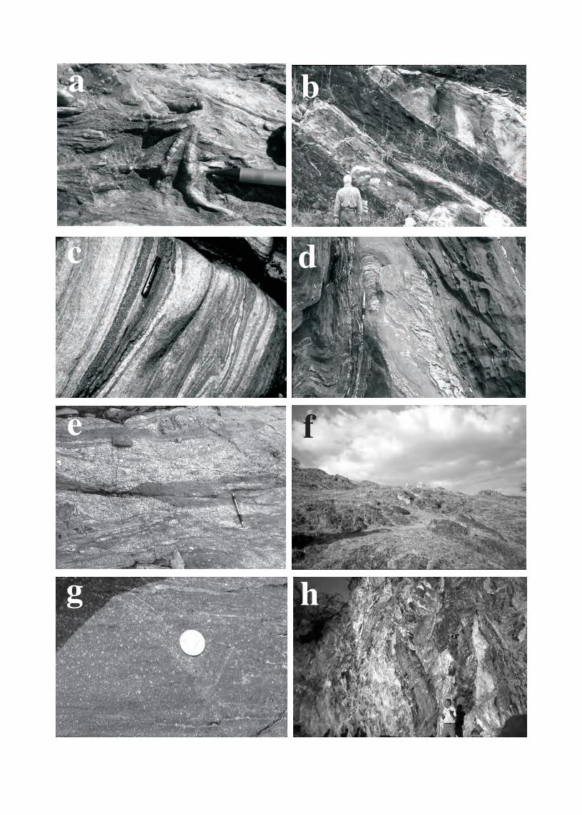
c d
e f
g h
a b
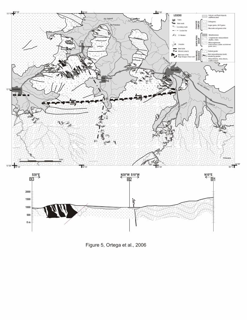
ío La Ei
R
tancs
a
ío La Ei
R
tancs
a
R
amá
ío Sal
R
amá
ío Sal
r
R oan J
ó
í
ni
S
emo
r
R oan J
ó
í
ni
S
emo
am áRío Salam áRío Sal
au
Pyá
e
o
q
Rí au
Pyá
e
o
q
Rí
ba O
a
ura
r tán
ed
Qb
a Oa
ura
r tán
ed
Q
90°30’15°10’
15°05’
Cerro Camperez
Cerro El Jocotillo
Cerro Mumús
Cerro El Cimiento
Cerro La Cruz Cerro El Portezuelo
Montaña Chiquihuital
Cumbre Balamche
15°00’90°30’ 90°20’90°25’ 90°15’
15°00’
90°20’90°25’
SALAMÁ
San MiguelChichaj
San Francisco
El Tempisque
RABINAL
San Gabriel
Chixolop
Las Minas
El Durazno
5
5458
40
4033
5532
4140 55
77
78
34
3235
21
51
32
46
40
648056
66
6026
52
70
15
53
6465
5442
59
64
53
8047
7383
73
58
5144
44
4747
54
6885
72
63
46
34
49
34
46
77
37
5342
79
85
75
44
22 34
45
7148
48 4082 64
67
5266
53
45
19
3645
32 48
4047
50
45
50
26
151048
4754
52
55
43
34
22
1410
28
06
15
05
38
10
18 2507
15
35
38
3420 10
7066 80
34
0 1 5 Km
S1 foliation
LEGEND
Towns
Secondary roads
Main roads
52
Rabinal granite
Metalimestones
Conglomeratic metasandstonephylites, shales Metaconglomerate
(metasandstone, phylites and deformedgranite clasts )S
AN
TA R
OS
A
GR
OU
P
Lineation46
Orthogneiss
Augen gneiss, Bt-Pl gneiss
Muscovite and garnet schistCH
UA
CÚ
S
CO
MP
LE
X
Volcanic and fluvial depositsundifferenciated
Metasediments, meta-arkoses, undifferentiated
Main faults
Inferred contacts
?
?
??
Section line
Main metasedimentary bands intruded by granites
Main trace of the“Baja Verapaz Shear zone”
B3
B2
B1
SA
N M
IGU
EL
SE
QU
EN
CE
1000
1500
2000
0 m
500
S10°WN30°WS30°E N10°E
B2 1B3B
Figure 5, Ortega et al., 2006

AGEMAYA BLOCK
GUADALUPAN PASOHONDO
LEONARDIAN
WOLFCAMP
PRE-WOLFCAMP
Chiapas Central Guatemala Maya Mts.S Chuacús
Thompson & Miller 1944
Bohnenberger1966
Van der Boomet al.1971
Mc Birney1963
Bateson& Hall1971
CHUACÚS CHUACÚSCHUACÚS
GANIT
OI
R
DS
VAINILLA
GRUPERA
SANTAROSA
Cuchumatanes
Andersonet al. 1973
CHUACÚS
CHOCHAL
ESER
ANZA
P
SA
NTA
RO
SA
GR
OU
P
TACTIC
CHICOL
SA
NTA
RO
SA
GR
OU
P
SA
NTA
RO
SA
GR
OU
PCHOCHAL
TACTIC UPPERTACTIC
L. TACTIC
SACAPULAS SACAPULASSACAPULAS
TACTIC Bladen Volc.
Figure 6, Ortega et al., 2006

AGETerrane CHATINO JUCHATECO MIXTECO ZAPOTECO MAYA CHORTÍS
MIOCENE
OLIGOCENE
PAL-EOCENE
LATE K
EARLY K
LATE J
MIDDLE J
EARLY J
TRIASSIC
LATE PZ
EARLY PZ
NEOPROT
MESOPROT
?
?
?
?
?
?
?
Limestone Continental clastic Marine clastic Volcanic Intrusive Metamorphic
Figure 7, Ortega et al., 2006

15.00
15.50
16.00
16.50
17.00
17.50
18.00
18.50
19.00
19.50
20.00
MAYA CCT ECT SIUNA CLIPSCT
207/204 Minumum
207/204 Maximum
206/204 Minimum
206/204 Maximum
CLIP
SIUNA
SCT
ECT
CCT
Northern NicaraguanRise
Southern NicaraguanRise
MAYA
94° 89° 84°
15°
20°
Figure 8, Ortega et al., 2006
Hess escar mentp
C y n ouga ma tr h