gulf Islands Ecosystem - CPAWScpaws.org/uploads/pubs/atlas-gulf.pdf · Southern Gulf Islands...
81
gulf Islands Ecosystem Community Atlas CPAWS British Columbia Chapter Canadian Parks and Wilderness Society
Transcript of gulf Islands Ecosystem - CPAWScpaws.org/uploads/pubs/atlas-gulf.pdf · Southern Gulf Islands...

g u l f I s l a n d s E c o s y s t e m
Community AtlasCPAWSBritish Columbia Chapter
Canadian Parks and Wilderness Society

Project Coordinator:
Dora Repard, Canadian Parks and Wilderness Society – BC Chapter
Writers:
Judith Shapiro, Consultant
Corrie Leung, Canadian Parks and Wilderness Society – BC Chapter
Shannon Denny, Geological Survey of Canada
Murray Journeay, Geological Survey of Canada
Editor:
Lucy Kenward, Consultant
Photographers:
Todd Carnahan, Judith Hammond, Virginia Hayes, Sabine Jessen, Chris Junck, Elisabeth McColl,
Denise Sturmwind
Map Design:
Dora Repard, Canadian Parks and Wilderness Society – BC Chapter
Publication Design:
Roger Handling, Terra Firma Digital Arts
Printing:
Quest Point Enterprises
Copyright: © 2005 Canadian Parks and Wilderness Society – BC Chapter
Disclaimer:
All data herein are provided without warranty of any kind. The user assumes the entire risk as to the
quality of the data. No guarantees of accuracy or precision are made and the Canadian Parks and
Wilderness Society and all data contributors to the Gulf Islands Ecosystem Community Atlas do not
accept liability for any damages or misrepresentation caused by inaccuracies in the data, nor is there
responsibility assumed to maintain the data in any manner or form or for any period of time.
Natural features can be complex to describe and often change in position or character over time. As a
result, the maps contained in this atlas are representations only and are not necessarily positionally
accurate or defi nitively correct.
Lot boundaries displayed on the maps in Part Four have evolved from a variety of data sources and are
under constant update and refi nement. The lot boundaries on these maps cannot be considered to have
consistent positional accuracy and are best viewed as general guidelines only.
In no event shall the Canadian Parks and Wilderness Society or any of the data contributors to the Gulf
Islands Ecosystem Community Atlas be liable for direct, indirect, incidental, consequential or special
damages of any kind, including, but not limited to, loss of anticipated profi ts or benefi ts arising out of
use of or reliance on the data.

�Contents
INTRODUCT ION . . . . . . . . . . . . . . . . . . . . . . . . . . . . . . . . . . . . . . . . . . . . . 5
PART ONE: THE SOUTHERN GULF ISLANDS 7
PART TWO: PHYS ICAL ENVIRONMENT 11GEOLOGY . . . . . . . . . . . . . . . . . . . . . . . . . . . . . . . . . . . . . . . . . . . . . . . 12
SOILS . . . . . . . . . . . . . . . . . . . . . . . . . . . . . . . . . . . . . . . . . . . . . . . . . . . 22
GROUNDWATER . . . . . . . . . . . . . . . . . . . . . . . . . . . . . . . . . . . . . . . . . 30
PART THREE: SPECIES & BIOLOGICAL COMMUNITIES 41ECOLOGICALLY IMPORTANT AREAS . . . . . . . . . . . . . . . . . . . . 42
BIODIVERS ITY . . . . . . . . . . . . . . . . . . . . . . . . . . . . . . . . . . . . . . . . . . . 45
ECOSYSTEM MAPP ING . . . . . . . . . . . . . . . . . . . . . . . . . . . . . . . . . . 54
SENS IT IVE ECOSYSTEM INVENTORY . . . . . . . . . . . . . . . . . . . . 62
PART FOUR: CULTURAL ISSUES 71HUMAN PRESENCE & ALTERED LANDSCAPES . . . . . . . . . 72
METADATA APPENDIX . . . . . . . . . . . . . . . . . . . . . . . . . . . . . . . . . . . . . 83
�3
GULF ISLANDS Ecosystem Community Atlas

Top left: Female rufous hummingbird. © toddcarnahan.com
Top right: View over the Strait of Georgia from Saturna Island. Elisabeth McColl
Right: A damsel fl y warms itself on a stalk of grass. © toddcarnahan.com

�From 2002 to 2004, the Canadian Parks and Wilderness Society embarked on an exciting project working with local groups, individuals and agencies involved in land management around four of Canada’s national parks: St. Lawrence Islands National Park and Bruce Peninsula National Park in Ontario, Riding Mountain National Park in Manitoba and Gulf Islands National Park Reserve in British Columbia. Our objective was to gather information about the regions surround-ing the national parks, to compile this information into community conservation atlases and to present these atlases in a way that will contribute to local policy development and land use that supports the ecological integrity of the national parks at the core of these landscapes. This atlas is one of the four that resulted from the project.
We now know that the long-term ecological health of our national parks depends not only on how lands within park borders are managed, but also on what happens in the surrounding region, referred to sometimes as the greater park eco-system. In other words, activities both inside and outside national parks have an impact on how well parks can protect plants, animals and ecological processes.
Although we have used the technical tools of geographic information systems (GIS) to analyze and present the data in a map form, this project has been much more than a GIS project. It has been about working collaboratively to determine what information is needed to manage the landscape around a national park in a way that is supportive of healthy park ecosystems and healthy communities. It has been about involving people who live in the greater ecosystems of national parks and ensuring that the atlases meet the needs of the individuals, agencies and organizations who will use it in their work and their voluntary activities.
With this in mind, we involved local groups, agencies and individuals from the very beginning. Before we produced any maps, we talked to people, soliciting ideas about what information would be useful in a community conservation atlas, how it could be presented and how it might be used. We consulted on what data were available to build the atlas. The information that was generously provided by many people at many stages of the project is an absolutely essential part of the fi nal atlas that is presented here.
We envision that this atlas could be used to inform government planning and policy development directly, and to help citizens and groups participate in
public planning processes in and around national parks. For example, national park management planning, local and regional planning all solicit participation from the public.
The challenge now will be to keep the information in these atlases up to date. We welcome your continued input into the atlases, and welcome suggestions on how we can continue to update the valuable work that we have done together.
The Southern Gulf Islands Ecosystem Atlas
The Southern Gulf Islands Ecosystem Atlas was produced in partnership with Parks Canada, and focuses on the terrestrial ecosystems of the islands. A marine atlas of the Southern Strait of Georgia has also been produced by Parks Canada and includes information about the waters surrounding the Gulf Islands.
The Southern Gulf Islands Ecosystem Atlas has four sections. Part One introduces the Southern Gulf Islands ecosystem, including its location, climate and general ecology. Part Two describes physical aspects of the area, including its geology, soils and groundwater. Information about the region’s specifi c ecology, including its sensitive areas, plant and animal species and ecosystem classifi cation, is included in Part Three. Finally, using cadastral (property boundaries) and land-ownership information, Part Four outlines current human presence on the land.
Introduction – The Community Atlas Project
Garry oak meadow. In Canada, the Garry oak ecosystem is found only in British Columbia and is limited to southwestern Vancouver Island, the Gulf Islands and two small stands in the Fraser Valley. Chris Junck
�5
GULF ISLANDS Ecosystem Community Atlas

About CPAWS
The Canadian Parks and Wilderness Society (CPAWS) is a non-profi t charitable conservation organization that has been working to conserve nature since 1963. We are a grassroots organization with twelve regional chapters and a national offi ce. Since it was founded in 1978, the British Columbia chapter has played a lead role in establishing and protecting wilderness areas across BC. We achieve our goals through advocacy, education and cooperative partnerships with environmental groups, industry, governments, First Nations and others.
Canadian Parks and Wilderness Society – British Columbia Chapter610–555 West Georgia StreetVancouver, BC Canada V6B 1Z6Telephone: (604) 685-7445 • Fax: (604) 685-6449E-mail: [email protected] • Web site: www.cpawsbc.org
Partners, Collaborators and Acknowledgements
The Southern Gulf Islands Ecosystem atlas was created by the BC chapter of the Canadian Parks and Wilderness Society (CPAWS) in partnership with Parks Canada. Data contributors to the project include the Islands Trust, Geological Survey of Canada Pacifi c Division, BC Conservation Data Centre, Decision Support Services Branch of the Ministry of Sustainable Resource Management, Canada Wildlife Service and Nature Conservancy Canada.
The following individuals played an important role in creating this atlas:
Linda Adams, Islands TrustAndrew Couturier, Bird Studies CanadaShannon Denny, Geological Survey of CanadaMarta Donovan, BC Conservation Data CentreMichael Dunn, Canadian Wildlife ServiceKeith Ericson, Galiano Conservancy AssociationShane Ford, BC Conservation Data CentreTodd Golumbia, Parks CanadaRon Hamilton, Parks CanadaBill Henwood, Parks CanadaSally Hermansen, University of British Columbia, Geography Department
Pierre Iachetti, Nature Conservancy CanadaMurray Journeay, Geological Survey of CanadaJan Kirkby, Canadian Wildlife ServiceBrett Korteling, Islands TrustJudy Kwan, Environment CanadaGreg MacMillan, Parks CanadaKen Millard, Galiano Conservancy AssociationKathleen Moore, Canadian Wildlife ServiceArdice Neudorf, Islands TrustEva Riccius, Canadian Parks and Wilderness Society – BC ChapterIan Scott, Ecotrust CanadaTara Sharma, Parks CanadaMark Stone, Decision Support Services, Ministry of Sustainable Resource ManagementBrian Thom, Hul’qumi’num Treaty GroupPeggy Ward, Canadian Wildlife ServiceAlison Woodley, Canadian Parks and Wilderness SocietySarah Wren, Nature Canada
�6
CPAWS – BRITISH COLUMBIA chapter

P a r t O n e
T h e S o u t h e r n G u l f I s l a n d s
Inse
t: ©
Virg
inia
Hay
es B
ackg
roun
d: D
enis
e St
urm
win
d/ce
dars
ong
phto
grap
hy

The Southern Gulf Islands comprise 10 major islands: Gabriola, Galiano, Kuper, Mayne, North and South Pender, Salt Spring, Saturna, Thetis, Valdez and numerous smaller islands. Together, they make up a distinct ecological area that supports many rare plant and animal species.
A Unique Climate
The Southern Gulf Islands are situated in the rain shadow of the mountains of Vancouver Island and Washington’s Olympic Peninsula. In this mild Mediterranean-like climate, the average temperature is 3.5 degrees Celsius in the winter and rises to an average of 15 degrees Celsius in the summer. The islands usually receive between 600 and 1000 millimeters of precipitation per year (most of it during the winter months), which is half the amount that falls on the Vancouver region (Figure 1.1). This unique climate has resulted in diverse habitats that support an abundance of plants and animals.
Douglas fi r, western red cedar and Garry oak dominate the region. The Southern Gulf Islands fall predominantly into the Coastal Douglas Fir biogeoclimatic zone, with pockets of Coastal Western Hemlock on Salt Spring Island (see Figure 1.2). British Columbia is made up of 14 such biogeoclimatic zones—regions that share a similar ecology. The Coastal Douglas Fir zone is BC’s smallest zone, reinforcing the uniqueness of this corner of the province. Many species found in the region are at the northern extreme of their range and do not occur anywhere else in Canada. More common species which may be found in the Coastal Douglas Fir zone include salal and Oregon grape in upland areas, wild rose, snowberry and ocean spray in rocky outcrops, and big leaf maple, sword fern and salmonberry in moister regions.
A New National Park
Gulf Islands National Park Reserve of Canada was established in May 2003 to protect a representative portion of the Strait of Georgia Lowlands (see Fig 1.3), one of Canada’s most endangered natural regions. The park is spread over numerous islands, islets and reefs from Prevost Island at the northern limit to D’Arcy Island at the southern extreme. As of January 2005, the park totals 35 km2 of lands, including a 25-meter intertidal zone. A marine zone extending an additional 175 meters into the adjacent waters also falls under Parks Canada’s
Figure 1.1: Southwestern British Columbia PRISM Average Annual Precipitation (1961-1990)
South Western British ColumbiaPRISM Average Annual Precipitation (1961-1990)
�8
CPAWS – BRITISH COLUMBIA chapter

Figure 1.2: Biogeoclimatic zones of southwestern British Columbia
The Biogeoclimatic Ecosystem Classifi cation (BEC) system identifi es the plant community predicted to grow at a site, based on climatic and soil conditions. The Coastal Douglas fi r (CDF) zone is named after its most common tree, which may grow alongside western red cedar, grand fi r, bigleaf maple and Pacifi c dogwood, with the understory consisting of salal, Oregon grape, sword fern, salmonberry and trillium. Drier CDF sites are characterized by arbutus and Garry oak, with grasses and fl owers in the understory.
Figure 1.3: Parks Canada Natural Regions
Parks Canada has identifi ed 39 “national park natural regions” in Canada, including natural region 2, Strait of Georgia Lowlands, which is the smallest of the thirty-nine. The Southern Gulf Islands National Park Reserve is the fi rst national park to have been designated in this natural region. The government has committed to protect a representative sample of each of Canada’s landscapes within its national parks system.
ParksCanada
ParcsCanada
Legend
Western Mountains1. Pacific Coast Mountains2. Strait of Georgia Lowlands3. Interior Dry Plateau4. Columbia Mountains5. Rocky Mountains6. Northern Coast Mountains7. Northern Interior Plateaux
and Mountains8. Mackenzie Mountains9. NorthernYukon
Canadian Shield15. Tundra Hills16. Central Tundra17. Northwestern Boreal Uplands18. Central Boreal Uplands19a. West Great Lakes –
St. Lawrence Precambrian Region19b. Central Great Lakes –
St. Lawrence Precambrian Region19c. East Great Lakes –
St. Lawrence Precambrian Region20. Laurentian Boreal Highlands
21. East Coast Boreal Region22. Boreal Lake Plateau23. Whale River24. Northern Labrador Mountains25. UngavaTundra Plateau26. Northern Davis Region
Hudson Bay Lowlands27. Hudson-James Lowlands28. Southampton Plain
St. Lawrence Lowlands29a. West St. Lawrence Lowland29b. Central St. Lawrence Lowland29c. East St. Lawrence Lowland
Appalachian Region30. Notre Dame – Megantic Mountains31. Maritime Acadian Highlands32. Maritime Plain33. Atlantic Coast Uplands34. Western Newfoundland Highlands35. Eastern Newfoundland Atlantic Region
Arctic Lowlands36. Western Arctic Lowlands37. Eastern Arctic Lowlands
High Arctic Islands38. Western High Arctic39. Eastern High Arctic
Completing Canada's National Park SystemCompleting Canada's National Park SystemInterior Plains10. Mackenzie Delta11. Northern Boreal Plains12. Southern Boreal Plains
and Plateaux13. Prairie Grasslands14. Manitoba Lowlands
3
4
5
1
76
8
9
10
11
12
13
14
15
16
17
19 a
19 b
19 c
20
2122
23 2425
26
27
28
29 a
29 b
29 c
30
31
3132
33
3534
3637
38
39
18
2
0 200 400Kilometres200
ManitobaLowlands
SouthOkanagan
NorthernBathurst Island
Torngat Mountains
Mealy Mountains
East Arm of Great SlaveLake
Wolf Lake
*
*
National park or reserve (R)
Region represented
Region with interim protection
Region not represented
Lands withdrawn for a future national park / reserve
National park area of interest
Land assembly underway
Sirmilik
Operational ServicesNational Parks DirectorateFebruary 2004 ian joyce
Kejimkujik
Terra Nova
Cape Breton HighlandsForillon
Prince Edward Island
Quttinirpaaq
IvvavikVuntut
ElkIsland
St. LawrenceIslands
BrucePeninsula
Auyuittuq
Wood Buffalo
Pacific Rim (R)
PrinceAlbert
Grasslands
Pukaskwa
Point Pelee
Aulavik
Kluane (R)
TuktutNogait
Wapusk
Nahanni (R)
Jasper
GwaiiHaanas(R)
WatertonLakes
RidingMountain
MountRevelstoke
Yoho
Kootenay
Glacier
Georgian BayIslands
Kouchibouguac
GrosMorne
MinganArchipelago(R)
Fundy
Banff
La Mauricie
Ukkusiksalik
Gulf Islands (R)
*
�9
GULF ISLANDS Ecosystem Community Atlas�9
GULF ISLANDS Ecosystem Community Atlas

Figure 1.4: Area jurisdiction
jurisdiction, totaling an additional 26 km2. An on-going land acquisition program focusing on enhancing the park’s ecological integrity means that this park will continue to grow in future years.
The park encompasses signifi cant portions of Saturna Island (43%) and of South Pender Island (33%), as well as lands on North Pender and Mayne Island. The patchwork nature of the park on these inhabited islands requires cooperative planning with Islands Trust and the Capital Regional District (see Fig 1.4). The park includes nine former provincial parks and marine parks, as well as two provincial ecological reserves. These former parks contain the majority of the national park’s recreational facilities, including campgrounds and backcountry campsites, trails, mooring buoys, docks and day-use areas. Interim management guidelines are being developed to guide park managers pending the completion of research to develop a comprehensive park management plan over the next 5 to 6 years.
To fi nd out about public information sessions or to provide comments to the management plan for the Gulf Islands National Park Reserve, contact:
Gulf Islands National Park Reserve 2220 Harbour Road, Sidney, BC Canada V8L 2P6Telephone: (250) 654-4000 • Fax: (250) 654-4014 E-mail: [email protected]
Area jurisdiction
The Gulf Islands ecosystem is intricately connected, both within and outside of the National Park Reserve’s borders. Park management planning is just one piece of the puzzle; private land owners, local governments and local organizations can play large roles in the ecological health of the islands. Three regional districts—Capital Regional District, Cowichan Valley Regional District and Nanaimo Regional District—oversee local issues such as transportation, water systems and sewage lines from a region-wide perspective that includes the Southern Gulf Islands. The islands fall into the jurisdiction of the Islands Trust Area, an area of thirteen major islands and more than 450 smaller islands between southern Vancouver Island and the mainland of BC whose land use is administered by the Islands Trust Fund. The Islands Trust is a federation of local island governments
whose purpose is to “preserve and protect the Trust area and its unique amenities and environment.” Further information is available about the Islands Trust in Part Three, and for private landowners in Part Four.
An example of brood parasitism. Brown-headed cowbirds lay their eggs in the nests of other species. The female song sparrow feeds the cowbird nestling (light grey) as well as their own, and the cowbird parents are freed from their parental responsibilities. Judith Hammond
Islands Trust Areas 1. North Pender2. South Pender3. Salt Spring4. Saturna5. Mayne
6. Galiano7. Thetis8. Gabriola9. Gambier10. Executive
11. Lasqueti12. Hornby13. Denman
�10
CPAWS – BRITISH COLUMBIA chapter
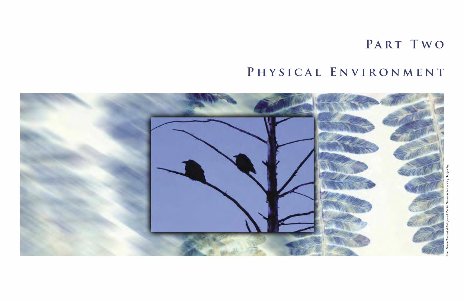
P a r t T w o
P h y s i c a l E n v i r o n m e n t
Inse
t: D
enis
e St
urm
win
d Ba
ckgr
ound
: Den
ise
Stur
mw
ind/
ceda
rson
g ph
togr
aphy

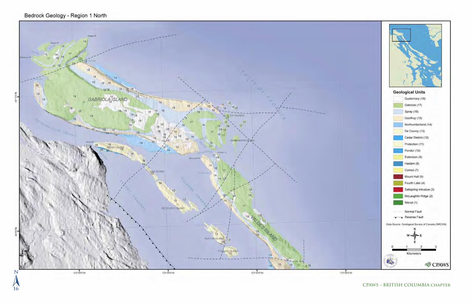
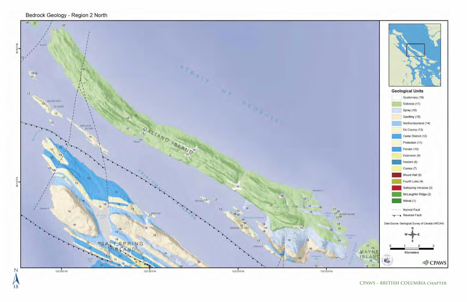
�Geological maps are like architectural drawings. They provide a means of representing the distribution and three-dimensional geometry (form and structure) of geological features exposed at the Earth’s surface, and a record of geological processes that have shaped the landscape and underlying bedrock foundation over time.
The geological landscape of the Southern Gulf Islands is characterized by a folded and faulted succession of metamorphic, plutonic and sedimentary rocks that record more than 400 million years of earth history. Included in this record are tales of ancient volcanic island arcs that collided with and were subducted beneath the western plate margin of North America, of mountain belts that once towered along the coast and have since been eroded into fl anking marine basins, and of glaciers that have sculpted and modifi ed the relics of this ancient geological landscape. Legacies of these geological processes include the formation of mineral deposits and the development of groundwater aquifers. Earthquakes throughout the region are a constant reminder that similar geologic processes are active today along the boundary between western North America
Geology of the Southern Gulf Islands
and the oceanic crust of the Juan de Fuca and Pacifi c plates. Reading and under-standing the geological landscape is fundamental to the ongoing stewardship and sustainable development of vulnerable groundwater aquifers in the region and to minimizing seismic risks associated with living along an active plate margin.
The oldest component of the bedrock foundation for Vancouver Island and the Southern Gulf Islands is a collage of metamorphic, igneous and sedimentary rocks, known collectively as Wrangellia. These rocks represent the relics of island arc and oceanic crustal fragments, many of which were derived from distant parts of the Pacifi c Ocean basin and assembled along the ancient continental margin of North America about 200 million years ago. Since the Early Jurassic (~185 million years ago), these crustal fragments have been faulted and shuffl ed along the continental margin in response to ongoing subduction of oceanic crust beneath the western edge of North America. Beginning nearly 100 million years ago, the Wrangellia Terrane collided with and was pushed beneath the western margin of North America, leading to large-scale crustal deformation and the development of a mountain belt that would have rivaled the modern Himalayas. Sand, gravel and
Prevost Island, showing the prominent northwesterly-southeast alignment of the Gulf Islands. Geological Survey of Canada
Sedimentary Rocks: formed at the Earth’s surface by the consolidation of loose sediment that has been eroded from older rock, transported by wind or water and accumulated in layers.
Igneous Rocks: ancient pools of melted rock that have formed in the Earth’s crust and crystallized to solid rock below the Earth’s surface.
Metamorphic Rocks: formed deep in the Earth’s crust at elevated temperatures and pressures by recrystallization and deformation of pre-existing rock.
�12
CPAWS – BRITISH COLUMBIA chapter

mud were shed westward from these eroding mountains into a fl anking marine basin, forming a thick succession of sandstone, conglomerate and siltstone on top of older rocks of Wrangellia Terrane. Ongoing subduction of oceanic crust along the western margin of Wrangellia resulted in folding and faulting of these sedimentary rocks that, today, we call the Nanaimo Group. A second collision occurred about 54 million years ago when sedimentary and volcanic rocks of an island archipelago (Pacifi c Rim Terrane) were rammed beneath the southern and western edges of Wrangellia, leading to continued folding and faulting of the con-tinental margin. A third and fi nal collision occurred about 42 million years ago when a volcanic island (Crescent Terrane, similar to modern Iceland) was subducted beneath the Pacifi c Rim Terrane.
Life 80 million years ago
Sedimentary rocks of the Nanaimo Group record an environment very different from that of today. Sand, gravel and mud eroded from coastal mountains accumulated along shorelines and on the seafl oor. Decaying vegetation in swamps accumulated as layers of peat that later transformed into coal, oil and gas. Eighty-million-year-old fossil leaves, fl owers, nuts, turtles, clams, snails, lobsters, crabs and sharks can all be found in the sedimentary rocks. Some of the animals, including ammonites, mosasaurs and elasmosaurs, are long extinct.
Mayne Island rock formation. Dora Repard
�13
GULF ISLANDS Ecosystem Community Atlas

Geologic Landforms
The collision of terranes along the western North American plate margin resulted in folding and faulting of metamorphic, igneous and sedimentary rocks in the Gulf Island region. The coincidence of inter-layered formations of shale and sand-stone/conglomerate, their northwesterly aligned folded structure and the eroding power of southeasterly moving glacial ice have resulted in the prominent north-westerly-southeasterly alignment of the Gulf Islands. Throughout these islands, prominent headlands and high ridges are formed from erosion-resistant sandstone and conglomerate, whereas the narrow bays and valleys are sculpted from softer and more easily eroded shale.
Glaciation
During glaciation the crust was depressed beneath the weight of the ice and sea level was lowered because water was removed from the oceans to form glaciers. As the ice melted the depressed crust and lowered sea levels regained their former elevations, resulting in marked changes to shorelines in the area as well as the distribution and types of forest cover. Modern sea level was reached about 5,000 years ago and since then has changed very little. The effects of glaciation in the Gulf Islands are conspicuous. Bedrock exposures commonly are striated and grooved, dramatically showing the erosive effects of ice-entrained debris during the last glaciation, between 30,000 and 10,000 years ago.
Beach peebles. © Denise Sturmwind/Cedar Song Photography
�14
CPAWS – BRITISH COLUMBIA chapter

Shoreline. © Denise Sturmwind/Cedar Song Photography
�15
GULF ISLANDS Ecosystem Community Atlas
�16
CPAWS – BRITISH COLUMBIA chapter

�17
GULF Islands Ecosystem Community Atlas
�18
CPAWS – BRITISH COLUMBIA chapter

�19
GULF Islands Ecosystem Community Atlas

�20
CPAWS – BRITISH COLUMBIA chapter

�21
GULF Islands Ecosystem Community Atlas

�Just as the ecosystem in the Southern Gulf Islands and southeastern Vancouver Island is distinct from the rest of British Columbia’s coast, so is its soil landscape. The soils in this region are more diverse than along the rest of the coast, largely because the climate is sunnier, drier and warmer as a result of the rain shadow created by the mountains of Vancouver Island and Washington’s Olympic Peninsula.
A BACKGROUND TO SOILSAll soils are formed from a combination of fi ve highly interrelated factors that infl uence depth, composition, and levels of moisture and nutrients:
1. ClimateHigher temperatures generally lead to higher rates of bedrock weathering and faster soil formation. Higher precipitation levels generally lead to higher soil moisture levels, which facilitate the weathering of bedrock and sediments.
2. Living organismsPlants affect soils from both above and below the ground. Leaves, needles, twigs and cones provide organic material that decomposes into humus; because the organic material in coniferous forests is typically more acidic than in hardwood forests, the soils in conifer-ous forests are also more acidic. Roots reduce soil erosion by anchoring the soil surface and, when they die and decay, create humus; because grasses have such fi brous root systems, the soils beneath grasses have much larger humus layers than those beneath forests.
3. Parent materialParent material is the rock and mineral material, either bedrock or sediment, from which soil develops; it infl uences the mineral makeup of the soil.
4. TopographySlope and aspect also infl uence soil development. Water and topsoil generally move from higher places in a landscape to lower places, creating thicker and more fertile soil in valley bottoms. As well, steeper slopes result in more erosion and inhibit the formation of a soil layer. South-facing slopes are usually warmer and drier than north-facing slopes.
5. TimeThe time required for soil to develop in depth and complexity depends on the other four factors listed above. For example, soil will form more quickly in warm, humid climates than in cold, dry ones.
Soil Mapping in the Southern Gulf Islands
The soils in the Gulf Islands were fi rst mapped in the 1950s, when an increasing population on the islands led to a demand for land planning and agricultural information. A number of surveys have been conducted since then, the most re-
Soils of the Southern Gulf Islands
cent of which resulted in the maps produced here. Fieldwork for this data set was completed in 1983, and Soils of the Gulf Islands of British Columbia was published in 1987. The data were collected by interpreting aerial photos and digging soil pits. Soils were classifi ed according to the Canadian System of Soil Classifi cation.
Soils in the Gulf Islands are more diverse than along most of BC’s coast, in large part because of variations in both climate and parent material over very short distances. For example, Garry oak woodlands grow where summer soil moisture is low and soils are shallow; Douglas fi r forests occur on deeper, well-drained soils; and wetlands occur on poorly drained, water-saturated soils.
Local variations in climate are due to the Gulf Islands’ position at the interface of the Strait of Georgia, the Juan de Fuca Strait and the Fraser Valley, where they are subject to a complex mix of weather systems. In addition, these islands have signifi cant topographic relief that creates microclimates with their own miniature rain shadow effects.
The bedrock in the Gulf Islands includes both metamorphic and sedimentary rocks, which have been affected by glaciation in two ways. First, glaciers scraped the Gulf Islands down to bedrock in some places and deposited large amounts of sediment in others. Where sediment forms the parent material, the soils are more productive because water and plant roots can easily penetrate the pores in these deposits. Second, on several occasions the weight of the glaciers pushed the Gulf Islands partway below sea level, resulting in marine infl uence on the parent materials, except at a few high-elevation sites that were not submerged.
SOIL CLASSIFICATIONAncient civilizations once used terms such as “black cotton soils” or “olive soils” to identify and communicate about soil types. In contrast, soil scientists classify soil based on how it was formed. Just as living organisms are classifi ed hierarchically, so are soils. The Canadian System of Soil Classifi cation contains fi ve categories: order, great group, subgroup, family and series. Soils are most often described by their order:
1. Brunisolic soils Brunisols are mineral soils that show the effects of climate and plant and animal life. As the soils are weathered, the minerals release iron which gives the upper soil a brownish colour. Brunisolic soils are not highly leached, so they are generally easy to manage for growing plants.
Many parts of the Gulf Islands have very shallow soils with rocky outcrops. An example of this is the coast bluff ecosystem, seen here on Saturna Island. Elisabeth McColl
�22
CPAWS – BRITISH COLUMBIA chapter

2. Gleysolic soilsGleysols are mineral soils that are saturated with water for prolonged periods of time, including much of the growing season. They are found on fl ats or in depressions, wherever water accumulates. Commonly these soils have an organically enriched surface underlain by a dark grey subsoil (known as “blue-clay” to well drillers). The dark colour results from an accumulation of partially decomposed organic matter and indicates that the soil has been so saturated with water that there has not been enough air to facilitate decomposi-tion. Gleysols are neither leached of nutrients nor highly weathered, thus they are pro-ductive, prized agricultural soils if they are artifi cially drained. (Note the overlap between Agriculture Land Reserve (ALR) boundaries and gleysolic soils in the following map series.)
3. Organic soils Organic soils have more than 30 per cent organic matter by weight. Common natural vegetation includes sedges, reeds, cattails, dwarf willows, hardhack, dwarfed pine and mosses. Organic soils are saturated with water almost throughout the year. Depending on the degree of decomposition, they are called peats (if decomposition is slight) or mucks (if decomposition is high).
4. Podzolic soils Podzols are sometimes referred to as “true” forest soils. They are well-drained mineral soils that have formed under a moist, temperate climate that has allowed leaching to occur freely and iron to be released in abundance from the original minerals in the parent material. These soils characteristically have a distinct forest fl oor (leaves, twigs, woody materials), occasionally underlain by a thin greyish layer and a brown to reddish-brown subsoil. Although highly productive for tree growth, podzols are less well-suited for agriculture. They usually require the addition of lime and fertilizer for most crops.
5. Regosolic soilsRegosols are “young” soils, such as shallow soils on bedrock, active fl oodplains (new parent material after each fl ood), shifting dunes, beaches, landslides, etc.
6. Coastal Beach Present-day coarse textured sand and gravelly beach areas.
7. Made Land Soils that have been artifi cially altered or disturbed by the activities of humans to such a degree that they cannot be identifi ed and classifi ed.
8. Rock
9. Tidal Flat Coastal areas with poorly drained, saline soils being inundated by the sea at high tides.
10. Water Small lakes.
Soils in the Ecosystem and Human Society
The Gulf Islands are a small, heavily populated area whose soils are in danger of being overused and overexploited. It is important to remember that soils are important for several reasons:
1. Perform complex water management:Water in the soil provides a medium for nutrients that are absorbed by plant roots, supports the decomposition activities of micro-organisms, and accelerates the breakdown of rocks and minerals to form soil. Water may also percolate through soil down to the groundwater reservoir, which feeds rivers, springs and wells. As it does, soil acts as a fi lter, absorbing many pollutants from wastewater; however, pollutants that are highly water-soluble may be carried into the ground-water.
2. House the recycling depot of the ecosystem:Soil organisms recycle vast amounts of plant and animal material, converting the mineral nutrients in organic wastes to forms that can be used by living organisms, and returning carbon to the atmosphere as carbon dioxide, where it will be taken up again by plants through photosynthesis.
3. Provide habitat for a myriad of organisms:Soil contains, hidden from our view, a microcosm of the giant ecosystems. Billions of organisms belonging to thousands of species, including predators, prey, producers, consumers and parasites may all live in a single handful of soil. Although humans have discovered a great deal about the myriad soil microbes (tuberculosis, for example, was controlled for the fi rst time by streptomycin, a chemical isolated from a soil bacterium in 1947), we still have a lot to learn.
4. Support plants and animals upon which we depend:How much soil and how porous it is, among other characteristics, affect the plant productivity it can support. A loose, porous soil with humus clusters allows roots, air and water to move, and helps seedlings emerge by preventing soil crusts from forming.
Range land on Saturna. Elisabeth McColl
THE AGRICULTURAL LAND RESERVEThe Agricultural Land Reserve (ALR) is provincial zoning that recognizes agriculture as the priority for land use. Within a designated reserve, non-agricultural uses are controlled and farming is encouraged. The ALR was established between 1974 and 1976 (based on soil capabil-ity for agriculture, co-operative efforts with local governments and public input) and is adminis-tered by the Agricultural Land Commission, an independent provincial agency that works with local governments to plan in accordance with the provincial policy of preserving agricultural land. The ALR is continuously updated.
�23
GULF ISLANDS Ecosystem Community Atlas

�24
CPAWS – BRITISH COLUMBIA chapter

�25
GULF Islands Ecosystem Community Atlas

�26
CPAWS – BRITISH COLUMBIA chapter

�27
GULF Islands Ecosystem Community Atlas

�28
CPAWS – BRITISH COLUMBIA chapter

�29
GULF Islands Ecosystem Community Atlas

�Groundwater of the Southern Gulf Islands
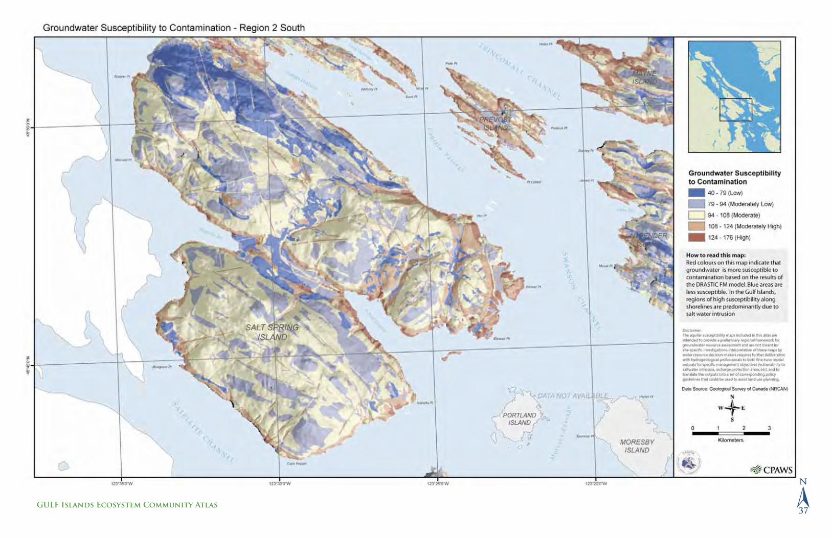
The Gulf Islands are representative of many communities across Canada that rely primarily on groundwater for domestic and agricultural use. Precipitation fl uctuations, along with increased water demand from population growth and development, have already contributed to saltwater intrusion, increased numbers of abandoned wells and signifi cant declines in water quality during the summer months. Regional growth models for Canada suggest that the majority of growth will occur in urban centres and adjacent urban/rural fringe areas. This growth will have an impact on land use planning and sustainable resource management.
There is a need to share and translate scientifi c knowledge and understanding of groundwater resources with decision-makers across all levels of government. To address the potential impacts that future development may have on the ground-water resources of island communities, groundwater susceptibility maps can be used as a guide to support land use decisions that have the least impact on a water resource. Groundwater susceptibility maps rank the hydrogeologic characteristics of an environment and provide a basis upon which to evaluate and manage risk.
The aquifer susceptibility maps included in this atlas are intended to provide a preliminary regional framework for groundwater resource assessment and are not meant for site-specifi c investigations. Interpretation of these maps by water resource decision-makers requires further deliberation with hydrogeological professionals to both fi ne-tune model outputs for specifi c management objectives (vulnerability to saltwater intrusion, recharge protection areas, etc.), and to translate the outputs into a set of corresponding policy guidelines that could be used to assist land use planning.
Geology
Geology in the Gulf Islands is represented primarily by interlayered sandstone- and mudstone-dominant formations (see pages 12–15). Mudstone formations are more densely fractured compared to sandstone, and as a result they have a greater storage capacity and act as aquifers. The cliff in Figure 2.1 exposes a layer of thin-bedded mudstone and sandstone aquifer (mudstone-dominant formation) between sandstone layers (sandstone-dominant formation). Water from the surface fl ows down the fracture that cuts these rocks. Where the fracture crosses the mudstone-dominant aquifer, the water spreads out in the many fractures. This example illustrates the greater fracturing and storage capacity of the aquifer relative to the sandstone.
Well pump on Gabriola Island. Geological Survey of Canada.
Figure 2.1
An example of a mudstone aquifer in the Gulf Islands.
SandstoneFracture
Sandstone
Thin-bedded mudstone and
sandstone aquifer
Flow of
surface water
�30
CPAWS – BRITISH COLUMBIA chapter

Aquifers in the Gulf Islands
Any body of rock or sediment that yields useful amounts of water is an aquifer. In the Gulf Islands, two types of aquifers exist: fractured rock and sand and gravel layers (Figure 2.2). Fractured bedrock aquifers provide the primary source of freshwater for the majority of island residents. Fractures in bedrock located below the water table fi ll with water and provide freshwater to surrounding wells. The density of fractures and the proximity to major faults have an impact on the water yield from individual wells.
Figure 2.2
Groundwater fi lls cracks and pores below the water table.
Over-Pumping of Wells
Excessive pumping of wells over an extended period of time can lower the water table over a broad area (Figure 2.3). This can divert water from streams and cause them to dry up. In an island setting, freshwater naturally migrates seaward and creates a fresh/salt water boundary. Over-pumping reduces freshwater discharge to the ocean and causes saltwater to encroach into aquifers. Often, wells that have experienced severe saltwater intrusion are abandoned.
Figure 2.3
Water storage in the Gulf Islands (Turner et. al., 2004).
The Pacifi c tree frog (Hyla regilla), also called the Pacifi c chorus frog, is found on Vancouver Island, the Gulf Islands and the southern third of BC. © toddcarnahan.com
�31
GULF ISLANDS Ecosystem Community Atlas
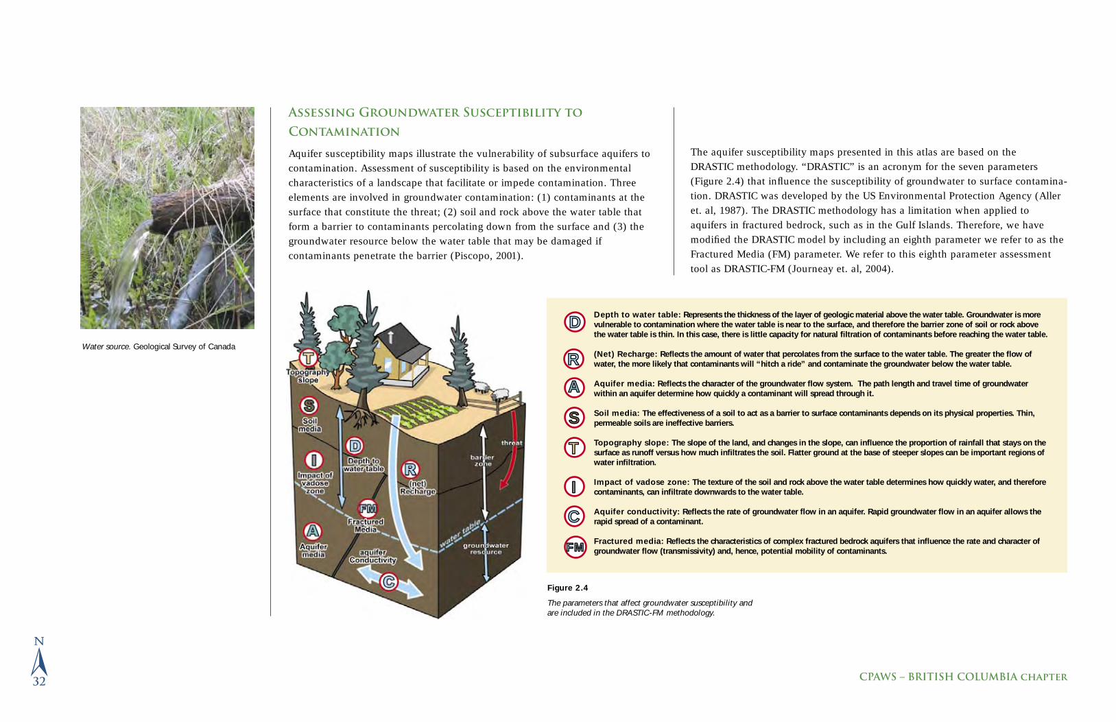
Assessing Groundwater Susceptibility to
Contamination
Aquifer susceptibility maps illustrate the vulnerability of subsurface aquifers to contamination. Assessment of susceptibility is based on the environmental characteristics of a landscape that facilitate or impede contamination. Three elements are involved in groundwater contamination: (1) contaminants at the surface that constitute the threat; (2) soil and rock above the water table that form a barrier to contaminants percolating down from the surface and (3) the groundwater resource below the water table that may be damaged if contaminants penetrate the barrier (Piscopo, 2001).
Figure 2.4
The parameters that affect groundwater susceptibility and are included in the DRASTIC-FM methodology.
Water source. Geological Survey of Canada
The aquifer susceptibility maps presented in this atlas are based on the DRASTIC methodology. “DRASTIC” is an acronym for the seven parameters (Figure 2.4) that infl uence the susceptibility of groundwater to surface contamina-tion. DRASTIC was developed by the US Environmental Protection Agency (Aller et. al, 1987). The DRASTIC methodology has a limitation when applied to aquifers in fractured bedrock, such as in the Gulf Islands. Therefore, we have modifi ed the DRASTIC model by including an eighth parameter we refer to as the Fractured Media (FM) parameter. We refer to this eighth parameter assessment tool as DRASTIC-FM (Journeay et. al, 2004).
Depth to water table: Represents the thickness of the layer of geologic material above the water table. Groundwater is more vulnerable to contamination where the water table is near to the surface, and therefore the barrier zone of soil or rock above the water table is thin. In this case, there is little capacity for natural fi ltration of contaminants before reaching the water table.
(Net) Recharge: Refl ects the amount of water that percolates from the surface to the water table. The greater the fl ow of water, the more likely that contaminants will “hitch a ride” and contaminate the groundwater below the water table.
Aquifer media: Refl ects the character of the groundwater fl ow system. The path length and travel time of groundwater within an aquifer determine how quickly a contaminant will spread through it.
Soil media: The effectiveness of a soil to act as a barrier to surface contaminants depends on its physical properties. Thin, permeable soils are ineffective barriers.
Topography slope: The slope of the land, and changes in the slope, can infl uence the proportion of rainfall that stays on the surface as runoff versus how much infi ltrates the soil. Flatter ground at the base of steeper slopes can be important regions of water infi ltration.
Impact of vadose zone: The texture of the soil and rock above the water table determines how quickly water, and therefore contaminants, can infi ltrate downwards to the water table.
Aquifer conductivity: Refl ects the rate of groundwater fl ow in an aquifer. Rapid groundwater fl ow in an aquifer allows the rapid spread of a contaminant.
Fractured media: Refl ects the characteristics of complex fractured bedrock aquifers that infl uence the rate and character of groundwater fl ow (transmissivity) and, hence, potential mobility of contaminants.
S
I
A
D
R
T
C
FMFM
�32
CPAWS – BRITISH COLUMBIA chapter

Understanding DRASTIC-FM Model Outputs
DRASTIC-FM assigns a value to each parameter according to its potential to impact the susceptibility of a groundwater resource. We created the aquifer susceptibility maps in this atlas using DRASTIC-FM parameters based on information from a variety of federal and provincial maps and data sets for bed-rock geology, soil, digital elevation model (DEM), water well database and precipitation. Using Geographic Information System (GIS) technology, data layers representing each of the DRASTIC-FM parameters are overlaid (Figure 2.5). Ranked values from each of the data layers are combined to create the fi nal map. The model is highly sensitive to variations in soil media (S), depth to water table (D) and proximity to known fault and fracture systems (FM).
The atlas maps generated by the DRASTIC-FM model assess the susceptibility of fractured aquifers in the Gulf Islands to a range of potential hazards, including saltwater intrusion in coastal areas that is infl uenced by over-pumping of wells, and various types of point and non-point surface contamination.
In general, regions of low and moderately low susceptibility to aquifer contamination occur where depth to the water table is greatest, a feature commonly found in higher-elevation areas. A deep water table provides a broad zone above it that acts as
a barrier to contamination.
Regions of moderate susceptibility include areas along major fault and fracture systems, in areas where the water table is within 20 meters of the surface (i.e. moderately thin barrier zone) and in areas underlain by permeable materials such as
sands and gravels or mudstone-dominated bedrock that contains extensive fractures.
Regions of moderately high and high susceptibility include coastal areas with shallow water tables that are most vulner-able to saltwater intrusion due to physical factors or where the shoreline is transected by major fault and fracture systems.
References
Aller, L., Bennet, T., Lehr, J.H. and Petty, R.J. (1987). DRASTIC: a standardized system for evaluating groundwater
pollution potential using hydrogeologic settings, U.S. EPA Report 600/2- 85/018.
Journeay, J.M., Denny, S., Allen, D.M., Forster, C., Turner, R. and Wei, M. (2004) Integrated Groundwater Resource
Assessment of Fractured Bedrock Aquifers in the Gulf Islands, B.C. 57th Canadian Geotechnical Conference – 5th Joint
IAH-CNC-CGS Conference, Quebec.
Turner, R.J.W., Franklin, R.G., Journeay, J.M., and Denny, S. (2004) Waterscape Gulf Islands: Protecting and
Conserving Our Island Water; Geological Survey of Canada, Miscellaneous Report 89. (www.geoscape.nrcan.gc.ca)
Low and moderately low susceptibility
Moderate susceptibility
Moderately high and high
susceptibility
Figure 2.5
DRASTIC inputs are overlaid to create the fi nal output maps.
Clouds. ©toddcarnahan.com
�33
GULF ISLANDS Ecosystem Community Atlas

�34
CPAWS – BRITISH COLUMBIA chapter
�35
GULF Islands Ecosystem Community Atlas

�36
CPAWS – BRITISH COLUMBIA chapter
�37
GULF Islands Ecosystem Community Atlas

�38
CPAWS – BRITISH COLUMBIA chapter

�39
GULF Islands Ecosystem Community Atlas

P a r t T h r e e
S p e c i e s a n d B i o l o g i c a l C o m m u n i t i e s
Inse
t: ©
tom
carn
ahan
.com
Bac
kgro
und:
Den
ise
Stur
mw
ind/
ceda
rson
g ph
togr
aphy

�Ecologically Important Areas
In recent years, numerous conservation organizations have attempted to identify “ecologically important areas” or “hotspot areas” as candidate sites for special management in Canada and internationally. This is based on the idea that given the limited resources for creating protected areas or designing special management zones, it is best to spend energy where the ecological gains will be the greatest. Dif-ferent organizations have approached this issue with different methodologies. Where some have identifi ed sites ad hoc from local or expert opinion, others have used complex analyses of spatial data describing species, ecology and land ownership.
The Gulf Islands have been included in a number of broad analyses of ecologically important areas. Some of these projects are exclusively marine and have not been included here. One study, the Sensitive Ecosystem Inventory of East Vancouver Island and the Gulf Islands, focused much more closely on the Gulf Islands and was therefore at a much fi ner resolution than the other studies. The Sensitive Ecosystem Inventory is included in this atlas separately with supporting maps (see pages 62–70).
Three separate broad-scale initiatives identifi ed terrestrial sites in the Gulf Islands. Using at-risk species and natural plant community information from across Brit-ish Columbia, the BC Conservation Data Centre maintains records of sites or areas with high concentrations of rare and endangered plants, animals or plant asso-ciations (e.g., Garry oak and arbutus). The CDC also applies conservation status ranks to these areas. In contrast, Bird Studies Canada, Nature Canada (formerly Canadian Nature Federation) and local partners of BirdLife International used data from across Canada to identify areas that have endangered bird populations and that are key migratory bird stopover sites. Finally, the Nature Conservancy of Canada and its partners studied the ecoregion known as the Willamette Valley–Puget Trough–Georgia Basin to highlight a diverse and representative group of areas that, if protected, would maintain the biodiversity of the entire region. It is interesting to discover what sites have been selected by these three initiatives in the Gulf Islands, and where there is overlap despite the different methodologies used. For more information on each of these initiatives, see below.
The result of overlaying the fi ndings of each of these initiatives is displayed in Figure 3.1. Seven areas in particular stand out: the land surrounding Active Pass, Mount Maxwell (Salt Spring Island), Mount Tuam-Bruce (Salt Spring Island), the land surrounding Porlier Pass, Reginald Hill (Salt Spring Island), Saturna Bluffs and
Sidney Island / Channel. This is not to suggest that other areas are not important —only that given the current level of understanding, multiple organizations using different methodologies have identifi ed these areas as ecologically valuable to the overall ecosystem of the islands and beyond.
BC Conservation Data Centre Site Basic Records
The British Columbia Conservation Data Centre (CDC) is part of the BC Ministry of Sustainable Resource Management. It is also a member of Nature-Serve, an international not-for-profi t organization whose aim is to provide both scientifi c information and effective tools for use in conservation. Staff specialists at the Conservation Data Centre, in cooperation with scientists and experts throughout the province, identify BC’s most vulnerable species and natural plant communities and assign a provincial (sub-national) conservation status rank according to an objective set of criteria established by NatureServe. Once identifi ed, species and natural plant communities at risk are “tracked” in the CDC’s computerized database. Information on their biology, conservation status, and individual locations or “occurrences” is systematically collected.
Additionally, the CDC identifi es sites that are a high priority for conservation (these are known as “Site Basic Records”; Figure 3.1) using international criteria developed by NatureServe. To designate the ecological importance of sites and their priority for conservation, the following criteria are evaluated:
• Biodiversity Signifi cance: presence and viability of rare and endangered species, migratory stopovers or representative ecosystems;
• Protection Urgency: urgency to protect the site, which generally increases with impending threats until legal, political or other administrative measures are taken;
• Management Urgency: urgency for management action requires stewardship intervention in order to maintain occurrences of rare or endangered species at the site;
• Representativeness: considers how well the site’s ecosystem types and associated features and plant and animal species are represented within the
Garry oaks on Saturna Island. © Virginia Hayes
�42
CPAWS – BRITISH COLUMBIA chapter

Ecoregion and Ecoprovince; considers the question of adequate representation of all ecosystem types, even relatively common ones;
• Other Values: the signifi cance of the site in terms of its aesthetic, recreational, open space and other ecological values, including its role in maintaining ecosystem health.
Management is distinct from legal protection and may include burning prescribed areas, removing exotic species, building barriers to prevent recreational vehicle use, rerouting trails, patrolling for collectors, hunters or trespassers, etc.
Site Basic records are updated – check with the Conservation Data Centre http://srmwww.gov.bc.ca/cdc/ for the latest information.
Important Bird Areas of Canada
In 1985, the European Economic Community asked BirdLife International, a non-governmental organization dedicated to conserving the world’s birds, to produce a priority list of sites for protecting birds in Europe. The result of this initiative is BirdLife’s Important Bird Area (IBA) program, which has since expanded to Asia, Africa, the Middle East and the Americas. BirdLife’s Canadian affi liates are Nature Canada and Bird Studies Canada (BSC) which, between 1997 and 2001, conducted a fi rst round of IBA designations in Canada.
The IBA program has three goals:
• To identify a network of sites that conserve the national diversity of Canadian bird species and are critical for the long-term viability of naturally occurring bird populations;
• To determine the type of protection or stewardship required for each site, and to ensure the conservation of sites through partnerships of local stakeholders who develop and implement appropriate on-the-ground conservation plans;
• To establish ongoing local involvement in site protection and monitoring.
According to standardized international protocol, a site can be designated as an IBA in one of four categories:
1. Sites that regularly hold signifi cant numbers of one or more threatened species can be designated as nationally or globally signifi cant, depending on whether the species is threatened at a national or a global level. In general, 1 per cent or more of the relevant population is generally considered to be “signifi cant.”
2. Sites that regularly hold signifi cant numbers of endemic species or species with restricted ranges can be designated. That is, some species are locally abundant and not considered to be threatened, but they are distributed over a very limited area and are therefore vulnerable to habitat loss and natural disturbances.
3. Sites that regularly hold a signifi cant component of an assemblage of species that is restricted to one biome or unique or threatened community type can also be designated. Sites that regularly hold a signifi cant number of a combination of species found only in one biome (a geographic area containing species of plants and animals that are adapted only to those particular climatic conditions) or other, unique threatened community.
4. Sites that are used by a signifi cant proportion (more than 1 per cent) of a species’ global, continental or national population, or that are used by a large congregation of species (e.g., waterfowl, shorebirds, raptors) are the most frequently designated. These sites are often areas where birds congregate in large numbers during the breeding season, in the winter or during migration.
For more details about the IBA program in Canada, for information about individual sites in the Gulf Islands, or to fi nd out how you can participate, please visit www.ibacanada.com or contact Nature Canada at 1-800-267-4088.
Nature Conservancy of Canada (NCC) Priority
Conservation Areas
To evaluate lands and waters in the highly developed, fertile region of the Pacifi c Northwest, the Nature Conservancy of Canada (NCC) and partners used a “coarse fi lter fi ne fi lter” approach to select high-priority conservation sites on land and in salt and freshwater. The idea behind this approach is that if an adequate amount of each type of habitat in a region is protected, most of the region’s biodiversity will also be protected.
The male house fi nch is distinguished from the female by its display of colour, ranging from yellow to bright red as shown here. © Virginia Hayes
�43
GULF ISLANDS Ecosystem Community Atlas

In the Southern Gulf Islands portion of this project, the “coarse fi lter” goal was to protect 30 per cent of the historic extent of each type of habitat. (Long-term em-pirical studies suggest that protecting 30 per cent of a habitat maintains roughly 66 to 83 per cent of the species in it.) For habitats that have been highly reduced by human activity, for which less than 30 per cent of the historical extent re-mains, the goal was to protect all that exists.
Recognizing that some species will be missed by a “coarse fi lter” (for example, species with a highly reduced population or plant assemblages with particular habitat requirements) and to increase the proportion of species protected, a “fi ne fi lter” was also used to select priority conservation areas. The conservation goals for endangered species and rare plant associations vary based on the species and its global distribution. For example, for annual plants that are endemic to the region, the goal was to protect twenty-fi ve known occurrences of at least 1,000 individuals. For clonal perennials, which are less vulnerable than annuals, the goal was to protect twenty-fi ve known occurrences of at least 100 individuals.
To select priority conservation areas to meet these goals, fi ve steps are taken:
• Delineate the types of habitat to be used in the “coarse fi lter” (e.g., intertidal salt marshes, oak meadows) and assess the historic (circa 1850) and current ex-tent of those habitats;
• Identify endangered species and rare plant associations to be used in the “fi ne fi lter” and assess their historic and current occurrences;
• Develop “cost” or “suitability” indices for all sites in the region, considering such factors as land ownership and zoning, and the quality and size of habitat patches. (Public land is preferable to private land because it is easier and less costly to enact conservation measures on public land, large areas of habitat are easier to conserve than small ones, habitat areas close together are preferred over those that are far apart, and areas with little habitat fragmentation are preferred to highly fragmented ones);
• Use a computer program (SITES) to determine which sets of sites meet both “coarse fi lter” and “fi ne fi lter” conservation goals in the smallest area possible, thereby protecting the most biodiversity for the least cost; and
Note that this map shows ecologically signifi cant areas that may be vulnerable to development and that are in need of private land stewardship or protection; it is not a map of land acquisition targets. Some of these ecologically signifi cant areas are part of the Gulf Islands National Park Reserve, others are protected by conservation covenants or may be stewarded by private landowners.
Oregon grape fl ourishes on Bodega Ridge, Galiano Island. © Virginia Hayes
• Finalize the recommended priority conservation areas based on expert review.
The results of this analysis are meant to help conservation agencies, planners and organizations get the most “conservation bang for their buck” by directing their resources to the most important places for supporting the region’s biodiver-sity. As science evolves and our understanding of how much habitat is needed to maintain most species in an area increases, our methods may change and our ability to protect species expand.
For more details about the Willamette Valley–Puget Trough–Georgia Basin Ecore-gional Assessment, please visit www.conserveonline.org.
�44
CPAWS – BRITISH COLUMBIA chapter

�Biodiversity of the Southern Gulf Islands
The Mediterranean-like climate, nutrient-rich waters and varied plant ecosystems of the Southern Gulf Islands create an inviting living environment for some of the most rare and unique wildlife in Canada.
On land, Garry oak and arbutus trees, species that are found mostly on these islands, and more common vegetation such as bigleaf maple, Douglas fi r, grand fi r, lodgepole pine, Pacifi c dogwood, red alder and Western red cedar, which make up most of the plant communities, are home to a number of animals. These include California bat, Columbia black-tailed deer, Douglas’ squirrel, Pacifi c water shrew, Townsend’s chipmunk and Western spotted skunk.
The rocky shores on and around the islands are stopover sites for migratory birds and nesting sites for many seabirds, including eider ducks, pigeon guillemots, tufted puffi ns, surf scoters, and razorbill auks. There are also haul-out sites for California and Steller sea lions and harbour seals.
However, habitat loss from urbanization, increased weed infestation and fi re suppression is the main cause of endangered and threatened species in the Southern Gulf Islands. Currently, the Committee on the Status of Endangered Wildlife in Canada (COSEWIC) lists fi fteen endangered species, ten threatened species and thirteen species of special concern on its list for the Southern Gulf Islands. Some of the species listed are Great Blue Heron, fannini subspecies (endangered); peregrine falcon, anatum subspecies (threatened); sharp-tailed snake (endangered); and spotted bat (special concern). Conversely, the provincial listing of red and blue listed species in the Gulf Islands is double the COSEWIC numbers: forty-three red listed (endangered), thirty-three blue listed (threatened), three special concern, and one yellow listed (uncommon / small numbers).
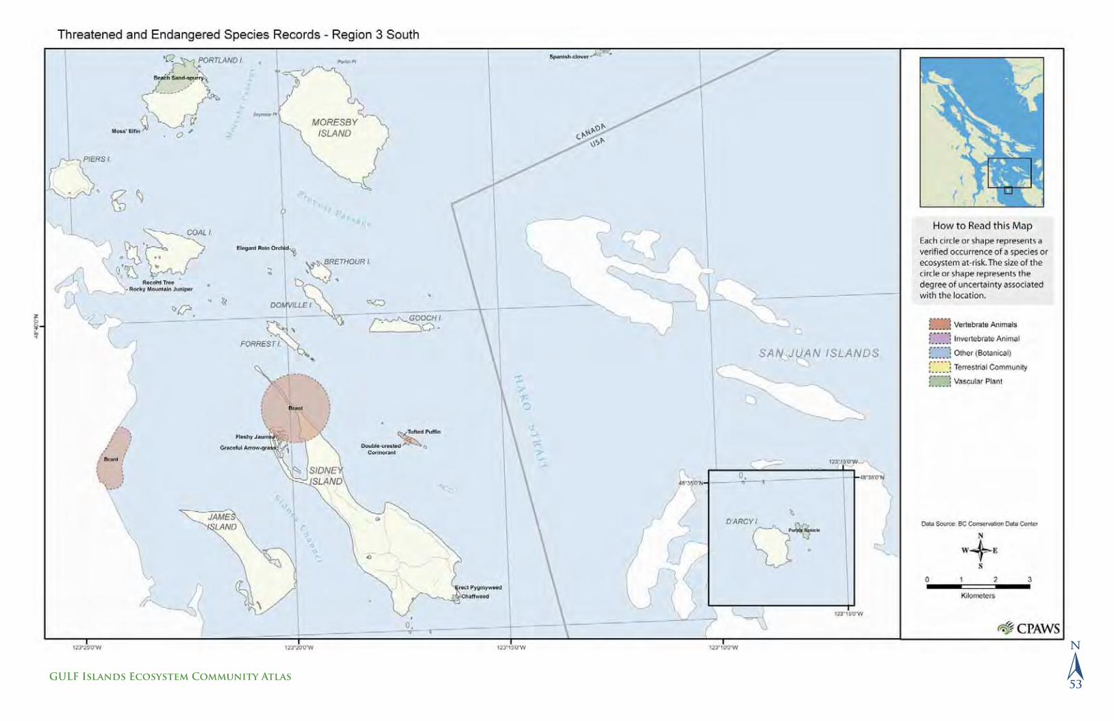
Species Mapping
There is very little detailed spatial information describing locations or ranges of individual species in the Gulf Islands. The existing inventories have focused on threatened and endangered species or ecosystems. The BC Conservation Data Centre maintains a database of known locations of threatened and endangered species which was used to produce the maps on the following pages. The database is updated regularly, and maps in this chapter were produced from information that was last updated in 2004. See http://srmwww.gov.bc.ca/cdc/ for
more information. The Sensitive Ecosystem Inventory has identifi ed species that are associated with sensitive ecosystems—see http://srmwww.gov.bc.ca/sei/ for more information.
There are large gaps in information regarding the status of more common species, or the spread of exotic species. As urban development and human
Figure 3.2
Seabird Colonies. Locations of colonies for the six species of seabirds and one shorebird that breed in the Southern Gulf Islands. Data from Canadian Wildlife Service, 2001. British Columbia Seabird Colony Inventory: Digital dataset. Canadian Wildlife Service, Pacifi c and Yukon Region, British Columbia.
�45
GULF ISLANDS Ecosystem Community Atlas

encroachment continue to challenge land managers in the future, comprehensive data and inventories of the species on the islands are needed to effectively assess and implement land strategies to help maintain ecosystem integrity.
Introduced Species:Urbanization and suppression of fi re in traditionally burned areas have resulted in extremely vulnerable ecosystems on the Gulf Islands. Of particular concern is the infl ux and rapid colonization of introduced species also known as “alien,” “exotic” or “non-native.” These words are used interchangeably to describe a species living outside its former range, and usually mean that humans moved the species to its new location, either deliberately or accidentally.
Species’ ranges have always been dynamic. Immigration, emigration, extinction and speciation are all natural occurrences in the absence of human impact. For example, thousands of years ago lions roamed North America and hummingbirds fl itted about Europe. Natural barriers such as oceans and mountains restricted the rate and distance of species’ movement, which have resulted in distinct fl ora and fauna evolving on different continents and islands. However, the world has become a global village due to globalization and faster modes of transportation such as ships, airplanes and cars eliminating natural barriers to species movement. Many introduced species “hitched a ride” on ships or airplanes to establish in new areas.
The main concern of introduced species is the increased rate and scale of establishment in new environments and their impacts on biological processes, wildlife interactions and habitat loss. For example, introduced plants displace native plant communities, which decrease food, forage areas and habitat for native wildlife.
Among the main introduced plants on the Southern Gulf Islands are English ivy, gorse, orchard grass and Scotch broom. All have weed-like characteristics and can out compete native plants for water and soil nutrients because they can establish quickly in an area and reproduce rapidly. Many native plants are usually slower growing, take longer to establish in an area and do not produce as many seeds.
Exotic species are often introduced to an area through a human disturbance such as clear-cutting forests, building roadways or removing natural predators. Prevention is repeatedly prescribed as the best policy to introduced species because eradication of an invasive species can be expensive, labour-intensive
Figure 3.3
Haul-out sites traditionally used by California and Steller sea lions. These sites provide habitat for mating, raising young pups and taking refuge from danger. Data from Booth, J. and Associates. 1995. Trust Fund Inventory of Special Areas and Features.
�46
CPAWS – BRITISH COLUMBIA chapter

and, in many cases, impossible. Once an invasive species is widespread, its control will often require ongoing maintenance entailing an infi nite fi nancial commitment.
There are several ways to prevent the introduction and spread of exotic species such as:
1. Garden with native plants or at least get to know your invasive plants so you do not introduce them onto your property. English ivy and Scotch broom (among the top fi ve invasive non-native plants in the Southern Gulf Islands) were intro-duced to many areas through garden ornamentals. Naturescape BC (www.hctf.ca/nature.htm) can provide recommendations about plants that will benefi t local wildlife in your area.
2. Remove any introduced plant species from your property to control the spread of invasive weeds to other areas.
3. Participate in community restoration and enhancement activities with local conservancy groups such as Scotch broom pulls or native plantings.
4. Spay or neuter your pets, particularly cats. Feral cat populations can become extremely detrimental to native wildlife and can reproduce at an incredible rate.
Examples of Endangered Species Found on the Gulf Islands:The following is a small sample of the types of endangered species found in the Gulf Islands, identifi ed in the maps for this chapter.
• Golden paintbrush is found in grassy, low-elevation meadows and is a rare vascular plant.
• Propertius duskywing is a large dark brown butterfl y associated with the Garry oak ecosystem.
• Phantom orchid is a very rare saprophyte (lives off dead organic matter) that prefers to grow in moist coniferous forests of low to mid elevation.
• Purple sanicle grows in dry open forests, meadows and on bluffs and rocky slopes at low elevations.
• Sharp-tailed snake can be found in open forests or woodlands of coastal Douglas fi r ecosystems. They are extremely vulnerable due to their relatively small, isolated populations in southwestern BC.
Double-crested cormorants are found in coastal areas, particularly in the Strait of Georgia and the Juan de Fuca Strait in bays, inlets, harbours, estuaries and lagoons. © Virginia Hayes
�47
GULF ISLANDS Ecosystem Community Atlas

�48
CPAWS – BRITISH COLUMBIA chapter

�49
GULF Islands Ecosystem Community Atlas

�50
CPAWS – BRITISH COLUMBIA chapter

�51
GULF Islands Ecosystem Community Atlas

�52
CPAWS – BRITISH COLUMBIA chapter
�53
GULF Islands Ecosystem Community Atlas

�Islands Trust Ecosystem Mapping and Galiano Conservancy Landscape Classification
Mapping ecosystems is one of the most important tools for protecting their long-term health. Working from aerial photos, cartographers look for uniform ecosystems and delineate these areas, which are then digitized into a computer program. The resulting maps help to identify the locations of ecosystems that are sensitive or show signs of heavy impact and, by comparing or overlaying data from aerial photos from different years, can also be used to see changes over time.
In the Gulf Islands, the Islands Trust has mapped the entire landscape of each large island except Galiano Island, using aerial photos from 2000 and 2002. Galiano Island was mapped using a similar methodology by the Galiano Conservancy Association in 1999. Together, these maps make up part of the Islands Trust Ecosystem Mapping project (ITEM). This project is similar to the Sensitive Ecosystem Initiative (SEI) described on pages 62–70 in that both projects used aerial photos to delineate ecosystems. However, the ITEM maps cover the entire land base whereas the SEI maps show only sensitive areas. Discrepancies between the two are a result of differing interpretations of the aerial photos or differences due to changes over time.
The Islands Trust Fund is using the ITEM maps to identify conservation priority areas, which will then be incorporated in a regional conservation plan for the Islands Trust Area, the area between the mainland and southern Vancouver Island.
As you peruse the maps, note that the data are based on aerial photos rather than site visits and that they do not refl ect landscape changes that have occurred since 2002. ITEM will be updated in the future, and public input is appreciated. For more more information, visit www.islandstrust.bc.ca
Islands Trust
The Islands Trust, a unique federation of local island governments, was established by the Islands Trust Act (1974) to “preserve and protect the Trust Area and its unique amenities and environment.”
The “Trust Area” encompasses, generally, the islands and waters between the British Columbia mainland and southern Vancouver Island, with the exception
of lands and waters within adjacent municipal boundaries and boundaries of Indian reserves. The Trust Area is a unique and special place—a scenic and biologically rich archipelago of thirteen major islands and more than 450 smaller islands.
In 1990, the Province of British Columbia amended the Islands Trust Act, increasing the Trust’s responsibilities in order to establish a regional perspective to land use planning and to establish the Islands Trust Fund, a conservation land trust.
The Island Trust Fund’s role is to preserve and protect unique ecological or cultural properties in the Islands Trust Area. It works with the community to protect special places in perpetuity through voluntary land donations, conserva-tion covenants, land acquisition and public education. With fi fty protected areas established and managed for conservation, the Islands Trust Fund aims to protect 25 per cent of the remaining coastal Douglas fi r and coastal Western hemlock ecosystems in the Trust Area and their related features, values and habitats, including woodlands, wetlands, coastal bluffs, and creeks and streams.
Galiano Conservancy
The Galiano Conservancy Association was founded in 1989 as one of British Columbia’s fi rst community-based land trusts. With a focus on education and on
Valdez)
A ladybug explores a Scotch broom seed pod. Scotch broom is an introduced species that has invaded the Gulf Islands. © Denise Sturmwind/cedarsong photography
�54
CPAWS – BRITISH COLUMBIA chapter

building a sustainable relationship between the island’s human and natural environment, the conservancy pursues its goals through a volunteer board of directors and a diverse community-based membership.
The Galiano Conservancy initiated the Habitat Conservation Project in 1999 to collect reliable science-based geographic information and clearly and effectively communicate community-held environmental values and priorities. Core components of the project include a 1:5,000 scale landscape classifi cation map of Galiano, an ecological analysis of the geographic data and a series of community-based workshops focused on the relationship between the island’s human and ecological communities. Recommendations developed during the workshops addressed the sustainability of both cultural and environmental values.
Ecosystem Classifications
Natural EcosystemsNatural Ecosystems in the Trust Area are usually remnantfragments of what once were much larger ecosystems. Most of theecosystems captured in this mapping are considered by both the provincial and federal government to be fragile and/or rare.However, development pressures within the Trust Area continueto result in significant loss of these natural ecosystems.
ModifiedModified ecosystems are areas where there is humandevelopment or disturbance evident throughout the landscape.There are four classes in this category including: Young Forest,Rural, Agricultural, and Developed. How these areas aremaintained and developed can be crucial to the success of naturalecosystems. For example, young forest ecosystems will eventuallybecome mature forest, but in the meantime they provide buffer areas tonatural ecosystems and can provide corridors for species to move fromone protected area to the next. Rural, agricultural and developedareas can also provide much needed habitat and can be part ofenhancing the natural landscape.
Herbaceous ecosystems are non-forestedecosystems with less than 10% tree cover. They are typically found in areas of shallow soils and bedrock near shorelines and at the summit of hills and mountains.
Riparian ecosystems occur adjacent to lakes,streams, gullies, canyons and rivers and mayvary in width.
Wetland ecosystems are characterized by daily, seasonal or year-round water at or above the surface.
Woodland ecosystems are open stands of deciduous forest, composed of pure or mixed stands of Garry oak or mixed stand of arbutus and Douglas fir. Mature big-leaf maple can also be found in sites designatedas woodland. Woodlands may include nonforestedopenings, often with shallow soils and bedrock outcroppings.
Lacustrine ecosystems are freshwater ecosystems where total vegetated coverage of the total surface area is less than 5%. (i.e. lakes and ponds)
Littoral ecosystems are marine influenced ecosystems where total vegetated coverageof the total surface areas is less than 5%.(i.e. mudflat and beach).
Cliff ecosystems are steep, vertical or overhanging rock faces where sparse vegetation may occur in crevices or on ledges.
Young Forest ecosystems are coniferousdominated stands with an age range thatvaries between 0 and 80 years old
Rural ecosystems are areas in which humandevelopments are interspersed with forestrange, farmland and native vegetation orcultivated crops.
Developed ecosystems are areas in whichhuman features or disturbances are dominantacross the landscape
Agricultural
Cliff
Developed
Herbaceous
Mature Forest
Old Growth Forest
Riparian
Rural
Young Forest
Woodland
Wetland
Lacustrine
Littoral
Old Growth Forest ecosystems are structurally complexstands comprised mainly of shade-tolerant andregenerating species (>250 years old). The understory can include snags, coarse woody debris inall stages of decomposition, and a fully developed mosslayer
Mature Forest ecosystems are characterized byestablishment of shade-tolerant trees after the lastdisturbance (80-250 years old). The understory can bewell developed as the canopy begins to open up, but inDouglas-fir forests the understory is typically dry withfew woody shrubs, forbs and grasses.
Agricultural ecosystems are areas where thedominant use is for agricultural purposes
Dragonfl ies have a unique method of mating and are often seen in a wheel-like position. ©toddcarnahan.com
�55
GULF ISLANDS Ecosystem Community Atlas

�56
CPAWS – BRITISH COLUMBIA chapter

�57
GULF Islands Ecosystem Community Atlas

�58
CPAWS – BRITISH COLUMBIA chapter

�59
GULF Islands Ecosystem Community Atlas

�60
CPAWS – BRITISH COLUMBIA chapter
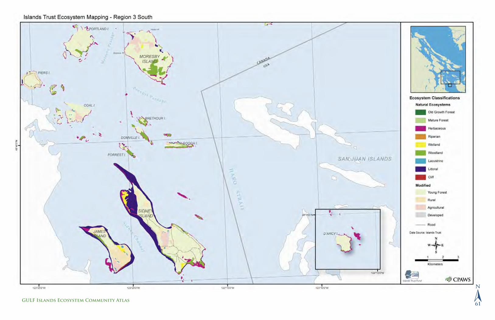
�61
GULF Islands Ecosystem Community Atlas

�Sensitive Ecosystem Inventory and Orthophotography
The Sensitive Ecosystem Inventory (SEI) of East Vancouver Island and the Gulf Islands was initiated in 1993 to obtain information about the fragile and endangered ecosystems in this area. A joint federal-provincial initiative of Environment Canada (Canadian Wildlife Service), the BC Ministry of Sustainable Resource Management (Conservation Data Centre) and the BC Ministry of Water, Land and Air Protection, the inventory was launched in response to intense development pressure and loss of habitat in this highly bio-diverse area, which supports many rare species and is a unique ecological region in Canada.
The goal of the SEI was to map the remaining fragments of land that are eco-logically signifi cant, relatively unmodifi ed and could support appropriate land use planning decisions. In the end, seven types of sensitive ecosystems—coastal bluff, older forest, riparian, sparsely vegetated, terrestrial herbaceous, wetland and woodlands—were mapped, as were seasonally fl ooded agricultural fi elds and large patches of older second-growth forests (although altered by human activity and not considered rare or fragile, these last two ecosystems are considered very biodiverse). Inventory data were gathered by interpreting aerial photos and verifi ed by “ground truthing,” or fi eld checking.
The fi rst SEI, completed in 1997, found that less than 8 per cent of the region remained relatively undisturbed. This inventory also determined that many of these sites were at high risk of conversion to other land uses, degradation by human use and /or invasion by exotic plants. Therefore, each and every sensitive ecosystem site identifi ed was considered a high conservation priority. (Seasonally fl ooded agricultural fi elds made up 0.7 per cent of the region, and 10.9 per cent of the region was occupied by large stands of second-growth forests more than sixty years old.)
A second inventory of SEI sites, completed in 2004, found that more than 8800 hectares (11 per cent) of the area occupied by the nine SEI ecosystem types in the early 1990s had been disturbed by 2002. Logging, urban or rural use, road building, agricultural and industrial use were found to be the main reasons. Older forests had the highest rate of loss at 8.6 per cent (915 hectares) followed by riparian (4.6 per cent), woodland (2.6 per cent) and wetland (2.0 per cent) ecosystems. The largest area of loss was 7,360 hectares (16.4 per cent) in the
older second-growth forests. Losses due to fragmentation are currently being assessed and will be added to these totals.
These results are summarized and recommendations outlined in a document called Sensitive Ecosystems Inventory: East Vancouver Island and Gulf Islands 1993–1997. Volume 2: Conservation Manual, which is available at http://srmw-ww.gov.bc.ca/sei/. This manual also describes the importance of the SEI ecosystems, the impacts, the management guidelines of the nine SEI ecosystems and a description of the conservation tools available.
ORTHOIMAGERYAn orthophotograph is an aerial photo that has been corrected for any distortions caused by the terrain, orientation of the plane and camera lens. It can be used as a base map on which other maps can be overlaid. The orthoimagery in the chapter was included in order to provide a visual reference for locating the sensitive ecosystems on the islands, and also to display the extent of development in certain areas. The orthophotos were taken in 2002 at a 0.5-meter pixel resolution and were generously supplied by Integrated Mapping Technologies Inc. (www.imtcan.com).
Types of Ecosystems
Coastal bluffCoastal bluff ecosystems include rocky shorelines, rocky islets and steep coastal cliffs with grasses, mosses and lichens. They are characterized by little or no soil, except in rock crevices and sheltered depressions where the soil is dry, shallow and often very saline.
Disturbed SEI ecosystemsOriginally identifi ed as SEI ecosystems, these areas have been disturbed by logging, urban or rural use, roads, trails, recreation, agriculture or industrial use since the original inventory. In some cases, the remaining intact portion of a partially disturbed area is too small or isolated to be considered a viable example of a sensitive ecosystem. These small remnants are also mapped as disturbed areas.
Older forestFor the purposes of the SEI, an older forest is defi ned as a forest dominated by conifers with an average age of at least 100 years. These forests are made up of open stands of large trees; a thick moss layer blanketing the ground; herbs,
Bonaparte’s gulls can be found throughout British Columbia, especially in areas where food is abundant. For example, in the spring, spawning Pacifi c herring attract large fl ocks of Bonaparte’s gulls, numbering in the thousands, to the Juan de Fuca Strait and the Strait of Georgia. © Virgina Hayes
�62
CPAWS – BRITISH COLUMBIA chapter

grasses and shrubs in the understory; and nurse logs (fallen dead trees) and snags (standing dead trees) throughout.
Older second-growth forestOlder second-growth forests are forests between sixty and 100 years old and they are the most common forested ecosystem in the SEI study area. Although they provide less valuable habitat than older forests, they do connect many higher-value patches. If they are retained for long enough, older second-growth forests eventually mature, becoming older forests more than 100 years old.
RiparianRiparian ecosystems are the lands along rivers, streams, lakes and marshes, as well as fl oodplains.
Seasonally fl oodedAlthough seasonally fl ooded agricultural fi elds generally do not contain native plants, they are important stopping points for some migratory birds and over-wintering grounds for others. Often former wetlands and sometimes adjacent to surviving wetlands, these fi elds are benefi cial to certain wetland wildlife, including American widgeon, northern pintail, northern shoveler, buffl ehead, hooded merganser.
Sparsely vegetatedSparsely vegetated ecosystems include inland cliffs and bluffs, coastal sand dunes, and coastal gravel and sand spits. Vegetation covers only 5 to 20 per cent of the sand, gravel or bedrock, because they are often highly disturbed. Generally there are no trees and shrubs, except for nootka rose, small Douglas fi r, Pacifi c crabapple and Douglas hawthorn, which can be found on gravel spits.
Terrestrial herbaceousTerrestrial herbaceous ecosystems include open wildfl ower meadows and grassy hilltops, often interspersed with moss- and lichen-covered rock outcrops. They often occur as a mosaic in openings in the forest.
WetlandWetlands are characterized by seasonal or year-round water at or above the soil surface or within the root zone of plants. Six classes of wetlands are identifi ed
by the Sensitive Ecosystem Inventory: marshes and swamps (most common) and bogs, fens, shallow water and wet meadows (less common). These ecosystems are the most productive in the world, as they play a vital role in reducing the levels of sediments, nutrients and toxic chemicals in the water and in regulating rainfall run-off.
WoodlandWoodlands are found on the south-facing slopes of rocky knolls and ridges with shallow soils. They occur in places where either historic disturbance (e.g., burning) or soil and moisture conditions have prevented coniferous forests from growing. Woodlands include open forests of Garry oak, Douglas fi r and Garry oak, or Douglas fi r and arbutus with a rich understory of wildfl owers, grasses, shrubs and mosses.
The marsh wren is widely distributed across southern BC and parts of central and northeastern BC, Marsh wrens occur in wetland habitats.© Virginia Hayes
�63
GULF ISLANDS Ecosystem Community Atlas

�64
CPAWS – BRITISH COLUMBIA chapter

�65
GULF Islands Ecosystem Community Atlas

�66
CPAWS – BRITISH COLUMBIA chapter

�67
GULF Islands Ecosystem Community Atlas

�68
CPAWS – BRITISH COLUMBIA chapter

�69
GULF Islands Ecosystem Community Atlas
P a r t F o u r
C u l t u r a l I s s u e s
Inse
t: D
enis
e St
urm
win
d Ba
ckgr
ound
: Den
ise
Stur
mw
ind/
ceda
rson
g ph
togr
aphy

�Human Presence and Altered Landscapes
The character and climate of the Southern Gulf Islands and their proximity to major urban centres make them attractive to many people both locally and abroad. Approximately 75 per cent of lands in the Gulf Islands are privately owned, which is the opposite trend to the majority of British Columbia where 94 per cent is publicly owned. The high percentage of privately held land has implications for ecosystem and wildlife management, and raises questions about the carrying capacity of the islands (the maximum number of people that the islands can support) and the resources required to sustain large populations, now and in the future.
The Pressures of Private Land Ownership
The number of individual landowners in the Gulf Islands and the variety of confl icting interests make managing the integrity of the ecosystems a complicated process. Three other factors also contribute to the challenge.
First, private lands are generally subject to fewer regulations governing what activities can take place on those lands, and the most highly sought-after properties in the Gulf Islands are in rare and sensitive habitats such as coastal bluffs and Garry oak woodlands. Development on and next to these lands is degrading the ecological values of the islands.
Second, all residents are affected by the management of public resources such as groundwater, fi sh-bearing streams and beach access. As anywhere, the activities of each person have an impact on the neighbours and the community as a whole; however, in the Gulf Islands where many private landowners use their property as a recreational property rather than a full-time, permanent residence, it can be diffi cult to incorporate sustainable community initiatives.
Finally, many First Nations living on the islands have unresolved land claims. This provides uncertainty on how the public lands will be managed.
The Importance of Land Stewardship
To protect the islands’ character, their rare habitat and their species, hard decisions must be made and strategic planning undertaken. Although there are no easy solutions to overdevelopment and habitat loss, government and individuals
will have to work together. The Islands Trust, regional districts and the residents of the Gulf Islands must determine the carrying capacity of each island and then plan appropriately. Local individuals must continue to encourage restrictions on development and to support the important work of the Islands Trust and other local conservancies (see pages 54 and 55). Ultimately, however, private landowners, local organizations, local governments and First Nation communities must all share the responsibility of looking after and protecting the land and resources on the Gulf Islands. The area’s rare and sensitive ecosystems are too signifi cant to lose.
Strategies for Land Stewardship
Three possible stewardship activities for private land owners are described here:
1. Advance planningFor private landowners, property development planning is important both to avoid damaging sensitive ecosystems and to maintain the look and feel of the site without clearing large tracts of land. Before building, it is important to consider what size of house is necessary, how it will fi t on the site and how to avoid the most ecologically sensitive areas on the property.
Pacifi c tree frog. © toddcarnahan.com
�72
CPAWS – BRITISH COLUMBIA chapter

2. Habitat restoration, or “naturescaping” Re-establishing native plant species that have been degraded or cleared is important both to avoid introducing invasive weeds and also to restore the natural hydrologic regime of the surrounding ecosystem. Naturescaping your property enhances the surrounding environment by providing habitat, foraging areas and food for wildlife.
NATURESCAPE BRITISH COLUMBIANaturescape British Columbia is a voluntary land stewardship program that can help private landowners plan and restore their property by encouraging them to create, maintain andprotect wildlife habitat on their urban land.
3. Stewardship agreementsLandowners can also enter into formal stewardship agreements, such as conservation covenants with land conservancy organizations. A conservation covenant is a legal instrument that can protect natural features of the land while allowing the owner to use the land in ways that are consistent with the terms of the agreement.
By covenanting all or a portion of their land, a landowner can take advantage of both income and property tax programs. These include:
• the Ecological Gifts Program (www.cws-scf.ec.gc.ca/ecogifts)
• The Natural Area Protection Tax Exemption Program (NAPTEP) (www.island-strust.bc.ca)
Other options that a landowner may wish to consider for the protection of their land include:a) Selling their land at below market value to a conservation group to receive a “Gift” tax receipt;b) Donate their land (also eligible for a “gift” tax receipt);c) Donate the land but retain a life estate that enables them to live on and /or use the property as long as they live.
Cadastral MappingCadastral or property boundary information in the Gulf Islands is maintained by the regional districts and the Islands Trust. The land status maps on the following pages have been provided by the Islands Trust and were last updated
in December 2004. These maps do not represent legal parcel defi nitions or prop-erty ownership but have been provided to give a sense of the division of land.
First Nations and Land Ownership
The following maps depict the current layout of land ownership but do not take into consideration First Nations land claims. This “right to the land,” also known as “Aboriginal Title,” is an issue that has yet to be resolved in much of British Columbia.
Before the Europeans arrived, First Nations people lived in large permanent villages and smaller family communities throughout the Pacifi c Coast area. When the Europeans began to settle the Gulf Islands, they had only limited recognition that they should compensate First Nations people for the land.
Governor James Douglas, chief factor for the Hudson’s Bay Company in the Victoria area, initiated the process of compensation in the early 1850s. Over a four-year period he made treaties with fourteen communities living around Victoria, Nanaimo and Prince Rupert. Many First Nations were not part of the Douglas Treaty process and were not compensated for their loss of land and access to resources. Instead they were relegated to small areas of land that were set aside as “Indian Reserves.” The system of reserve allocation was ad hoc, and it was not uncommon for lands that were designated for First Nations to be later confi scated and awarded to colonists.
Today, many First Nations in the Gulf Islands area are involved in the modern-day treaty process. Certain descendants of the Douglas Treaty signatories have also chosen to negotiate a modern-day agreement as an extension to their Douglas Treaty. Under this treaty process, there is common interest by First Nations, some sectors of governments and other stakeholders to protect ecosystems. However, the challenge remains to balance the interests of these groups with those of other land users in order to make sound land use management decisions.
Until the First Nations land claims are resolved, some areas such as the Gulf Islands National Park Reserve are subject to interim management. The word “reserve” means that this park does not have full legislated park status and that
River rain. © toddcarnahan.com
�73
GULF ISLANDS Ecosystem Community Atlas

the land is still available as part of a land claim settlement. In the meantime, however, the ecosystem is being protected so that the land remains in good environmental condition, and Canadian law requires that First Nations people be invited to be involved in all aspects of planning and managing these national parks.
�74
CPAWS – BRITISH COLUMBIA chapter

Top left: Raccoon. © Virginia Hayes
Top right: Arbutus bark. © Denise Sturmwind/cedar song photography
Left: Prevost and Salt Spring Islands from the air. Sabine Jessen
�75
GULF ISLANDS Ecosystem Community Atlas

�76
CPAWS – BRITISH COLUMBIA chapter

�77
GULF Islands Ecosystem Community Atlas

�78
CPAWS – BRITISH COLUMBIA chapter

�79
GULF Islands Ecosystem Community Atlas

�80
CPAWS – BRITISH COLUMBIA chapter

�81
GULF Islands Ecosystem Community Atlas

BASE MAPS:
Name: CoastlineDescription: Polygon outlines of land and waterProduced: Parks CanadaContributed by: Parks CanadaSpatial accuracy: 1:20,000Date: -
Name: Canada Province BoundariesDescription: Polygon outlines of provincial boundariesProduced by: ESRIContributed by: ESRISpatial accuracy: 1:50,000Date: 2000
Name: US State BoundariesDescription: Polygon outlines of state boundariesProduced by: ESRIContributed by: ESRISpatial accuracy: 1:2,000,000Date: 2001
Name: International Border – Parks CanadaDescription: The US – Canada International Border in the Southern Strait of GeorgiaProduced by: Parks CanadaContributed by: Parks CanadaSpatial accuracy: display purpose onlyDate: -
TABLE OF CONTENTS
Name: Park PropertyDescription: Contains island properties that were purchased or transferred from the Province of British Columbia to make up the Gulf Islands National Park Reserve. The property boundaries were developed from the Integrated Cadastral Initiative (ICI).Produced by: Parks CanadaContributed by: Parks CanadaScale: 1:20,000Update date: January 2005
INTRODUCTION TO THE SOUTHERN GULF ISLANDS
Name: Regional District BoundariesDescription: Regional District/Census division boundaries for BCProduced by: Clover Point CartographicsContributed by: BC MSRMSpatial accuracy: display purposes only Date: Digitized 1994, updated 2003
Name: Islands Trust Area BoundariesDescription: Boundaries of Islands Trust AreasProduced by: CPAWS BCContributed by: -Scale: display purposes only (~1:250,000)Date: digitized 2004
Name: BC MunicipalitiesDescription: Legally incorporated entities which were created to regulate the affairs within their boundaries.Produced by: BC Crown Land Registry – Administrative Boundary Management SystemContributed by: BC MSRM Scale: 1:250,000Update date: 1998
Name: Provincial Biogeoclimatic Subzone/Variant Mapping (BEC)Description: The BEC system consists of two components: a zonal classifi cation and a site classifi cation (Meidinger and Pojar, 1991; Pojar et al., 1987). The zonal classifi cation is a hierarchical system that integrates climate, vegetation and site classifi cations at a broad landscape level—this is the level the digital map addresses. The zonal or regional climate (refl ected by vegetation and soil relationships) defi nes the basic biogeoclimatic unit, the subzone. These units are grouped into zones and may be further subdivided into variants based on further refi nements of climate (e.g., wetter, drier, snowier). The map units of the digital map are biogeoclimatic units mapped to the level of resolution possible—subzone or variant. In some cases, where further sampling is required to defi ne the unit climatically, poly-gons are labeled as an undifferentiated unit (e.g. CWH un).
Produced by: Ministry of Forests Research BranchContributed by: Ministry of ForestsSpatial accuracy: variable (1:250,000 in Southern Gulf Islands)Date: April 2003
BEDROCK GEOLOGY
Name: Bedrock GeologyDescription: This dataset represents a compilation of bed-rock information from existing maps and fi eldwork. Polygons on the map represent the dominant geological formations at or near the Earth’s surface. Produced by: Murray Journeay, Geological Survey of Canada (GSC)Contributed by: Geological Survey of Canada – Natural Resources Canada (NRCAN)Spatial accuracy: 1:50,000Date: 2004
Name: FaultsDescription: This dataset represents the distribution of major onshore and offshore faults that have disrupted the Earth’s crust.Produced by: Murray Journeay, Geological Survey of CanadaContributed by: Geological Survey of Canada (NRCAN)Spatial accuracy: 1:50,000Date: 2004
SOILS
Name: Soils of the Gulf IslandsDescription: This dataset indicates the representative soils that occur within a soil polygon. Soils polygons have been merged to represent information at the level of soil order.Produced by: Agriculture and Agri-Food Canada: Canadian Soil Information System (CanSIS)Contributed by: Geological Survey of Canada (NRCAN)Spatial accuracy: 1:20,000Date: produced 1987-1991, modifi ed 2003
Name: Agricultural Land ReserveDescription: Delineation of the Agricultural Land Reserves as established by the Agricultural Land Commission for NTS map sheets 92G and 92BProduced by: BC Provincial Agricultural Land CommissionContributed by: BC Provincial Agricultural Land CommissionSpatial accuracy: 1:20,000Date: unknown (received by CPAWS 2003)
GROUNDWATER SUSCEPTIBILITY TO CONTAMINATION
Name: Groundwater Susceptibility to ContaminationDescription: This dataset represents an aquifer susceptibility assessment that classifi es the Southern Gulf Islands into fi ve categories of potential susceptibility to groundwater contamination. Produced by: Murray Journeay (Geological Survey of Canada (GSC)), Diana Allen (Simon Fraser University), Shannon Denny (GSC)Contributed by: Geological Survey of CanadaSpatial accuracy: 20m grid cellDate: 2004
ECOLOGICALLY IMPORTANT AREAS
Name: Priority Conservation Areas in the Gulf Islands Description: Terrestrial and near-shore marine priority conservation sites identifi ed through the Willamette Valley – Puget Trough – Georgia Basin Ecoregional Assessment.Contact the Nature Conservancy Canada for more information.Produced by: Nature Conservancy / Nature Conservancy CanadaContributed by: Nature Conservancy CanadaSpatial accuracy: 1:100,000Date: September 2003
Name: Conservation Data Centre Site Basic RecordsDescription: Sites identifi ed as being high conservation priorities using international criteria developed by NatureServe.Produced by: BC Conservation Data Centre
�Metadata Appendix
�83
GULF ISLANDS Ecosystem Community Atlas

Contributed by: BC Conservation Data CentreSpatial accuracy: unknownDate: 2000
Name: Important Bird Areas of CanadaDescription: An Important Bird Area is a site providing essential habitat for one or more species of breeding or non-breeding birds. These sites may contain threatened species, endemic species, species representative of a biome or highly exceptional concentrations of birds.Produced by: Bird Studies CanadaContributed by: Bird Studies CanadaScale: unknownDate: 2001
BIODIVERSITY
Name: Seal and Sea Lion HauloutsDescription: From report – Booth, J. and Associates. 1995. Trust Fund Inventory of Special Areas and FeaturesProduced by: Jackie BoothContributed by: Islands TrustSpatial Accuracy: Date: 1995
Name: Canadian Wildlife Service Seabird ColoniesDescription: Locations of all known seabird coloniesProduced by: Canadian Wildlife ServiceContributed by: Canadian Wildlife ServiceSpatial accuracy: 1:250,000Date: data collection 1980-1989, digital fi le 2002
Name: Conservation Data Centre Rare and Endangered Species Element Occurrence PolygonsDescription: Known locations of red and blue-listed species and natural plant communities as well as record-sized trees.Produced by: BC Conservation Data CentreContributed by: BC Conservation Data CentreSpatial accuracy: variableDate: variable, data is continually added, last update for this atlas 2003
ISLANDS TRUST ECOSYSTEM MAPPING
Name: Islands Trust Ecosystem MappingDescription: Identifi cation of ecosystems in the Islands Trust Areas (except Galiano and Kuper) to assist in land use decisions and effective conservation planning. Data was captured using aerial photographs fl own in 2002.Produced by: Islands TrustContributed by: Islands Trust
Spatial accuracy: 1:42,000Date: aerial photography 2002, last update 2004
Name: Galiano Conservancy Landscape Classifi cationDescription: The Landscape Classifi cation is an interpreta-tion of the current ecological state of Galiano Island. All forested, aquatic, natural non-forested and developed areas have been mapped, forming a contiguous cover of Galiano’s entire 6000-hectare landscapeProduced by: Galiano Conservancy AssociationContributed by: Galiano Conservancy AssociationSpatial accuracy: 1:5,000Date: aerial photography 1998, last update 2004
Name: RoadsDescription: Main and secondary roads in the Gulf Islands. Roads are based on TRIM data but attributes have been modifi ed based on local maps. Some newer roads were digi-tized using the Islands Trust cadastral information. Produced by: CPAWS BCContributed by: CPAWS BCSpatial accuracy: for display purposes only (~1:75,000)Date: 2004
SENSITIVE ECOSYSTEM INVENTORY AND ORTHOPHOTOS
Name: Integrated Mapping Technologies OrthophotosDescription: Black-and-white ortho-rectifi ed photos based on 2002 aerial photography.Produced by: Integrated Mapping TechnologiesContributed by: Islands TrustSpatial accuracy: 1:42,000Date: 2002
Name: Sensitive Ecosystem Inventory of East Vancouver Island and the Gulf Islands (Version 2)Description: Sensitive ecosystems are identifi ed as those which are fragile and /or rare, ie. wetland, riparian, coastal bluff, terrestrial herbaceous, older forest, woodland and sparsely vegetated ecosystems. Preliminary inventory results show that these sensitive ecosystems cover 32,467 ha or 7.9% of the study area (4,121 km2). Two additional signifi cant habitat types were included in the inventory for their general biodiversity values: large stands of older second-growth forest and seasonally fl ooded agricultural fi elds.Produced by: Axys Environmental ConsultingContributed by: Canadian Wildlife ServiceSpatial accuracy: 1:20,000Date: Version 1 based on air photos from 1990-1992,
version 2 based on air photos from 2002. Data interpreta-tion completed 2004
CULTURAL ISSUES
Name: Band locationDescription: Location of First Nations community offi cesProduced by: BC MSRMContributed by: BC MSRMSpatial accuracy: variableDate: 2003
Name: First Nations Reserves (Indian Reserves)Description: Locations of First Nations ReservationsProduced by: Bolster Consulting Ltd. for BC MSRMContributed by: BC MSRMSpatial accuracy: 1:20,000Date: 2002
Name: CadastralDescription: Location of legal parcel boundariesProduced by: Islands TrustContributed by: Islands TrustSpatial accuracy: variableDate: variable, data is continually added, last update for this atlas December 2004
�84
CPAWS – BRITISH COLUMBIA chapter