Guidelines for incorporating coastal erosion concerns...
72
Guidelines for incorporating coastal erosion concerns into the strategic environmental assessment (SEA) processes FINAL REPORT European Commission DGENV Final Document i Development of a Guidance Document on Strategic Environmental Assessment (SEA) and Coastal Erosion Final Report DGENV European Commission November 2004
Transcript of Guidelines for incorporating coastal erosion concerns...

Guidelines for incorporating coastal erosion concerns into the strategic environmental assessment (SEA) processes
FINAL REPORT
European Commission DGENV Final Document
i
Development of a Guidance Document on Strategic Environmental Assessment (SEA) and Coastal Erosion
Final Report DGENV European Commission November 2004
Guidelines for incorporating coastal erosion concerns into the strategic environmental assessment (SEA) processes
FINAL REPORT
European Commission DGENV Final Document
ii
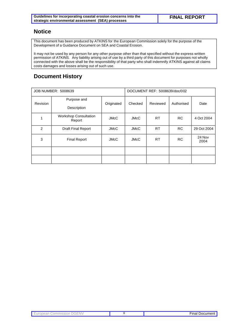
Notice This document has been produced by ATKINS for the European Commission solely for the purpose of the Development of a Guidance Document on SEA and Coastal Erosion. It may not be used by any person for any other purpose other than that specified without the express written permission of ATKINS. Any liability arising out of use by a third party of this document for purposes not wholly connected with the above shall be the responsibility of that party who shall indemnify ATKINS against all claims costs damages and losses arising out of such use.
Document History
JOB NUMBER: 5008639 DOCUMENT REF: 5008639/doc/002
Revision Purpose and
Description Originated Checked Reviewed Authorised Date
1 Workshop Consultation Report JMcC JMcC RT RC 4 Oct 2004
2 Draft Final Report JMcC JMcC RT RC 29 Oct 2004
3 Final Report JMcC JMcC RT RC 24 Nov 2004
Guidelines for incorporating coastal erosion concerns into the strategic environmental assessment (SEA) processes
FINAL REPORT
European Commission DGENV Final Document
iii
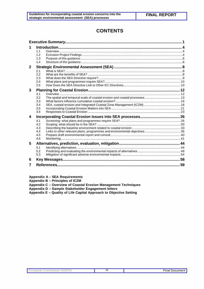
CONTENTS
Executive Summary..................................................................................................................1 1 Introduction........................................................................................................................4
1.1 Overview ................................................................................................................................................................4 1.2 EUrosion Project Findings...................................................................................................................................4 1.3 Purpose of this guidance.....................................................................................................................................6 1.4 Structure of the guidance....................................................................................................................................6
2 Strategic Environmental Assessment (SEA) ..................................................................8 2.1 What is SEA? ........................................................................................................................................................8 2.2 What are the benefits of SEA? ...........................................................................................................................8 2.3 What does the SEA Directive require?..............................................................................................................9 2.4 What plans and programmes require SEA?.................................................................................................. 10 2.5 How Does the SEA Directive Link to Other EC Directives.......................................................................... 10
3 Planning for Coastal Erosion.........................................................................................12 3.1 Overview ............................................................................................................................................................. 12 3.2 The spatial and temporal scale of coastal erosion and coastal processes .............................................. 13 3.3 What factors influence cumulative coastal erosion?.................................................................................... 16 3.4 SEA, coastal erosion and Integrated Coastal Zone Management (ICZM) ............................................... 18 3.5 Incorporating Coastal Erosion Matters into SEA.......................................................................................... 21 3.6 Responses to Coastal Erosion ........................................................................................................................ 23
4 Incorporating Coastal Erosion Issues into SEA processes.......................................26 4.1 Screening: what plans and programmes require SEA? .............................................................................. 26 4.2 Scoping: what should be in the SEA? ............................................................................................................ 30 4.3 Describing the baseline environment related to coastal erosion............................................................... 33 4.4 Links to other relevant plans, programmes and environmental objectives .............................................. 36 4.5 Prepare draft environmental report and consult........................................................................................... 40 4.6 Monitoring........................................................................................................................................................... 41
5 Alternatives, prediction, evaluation, mitigation...........................................................44 5.1 Identifying alternatives ...................................................................................................................................... 44 5.2 Predicting and evaluating the environmental impacts of alternatives ....................................................... 49 5.3 Mitigation of significant adverse environmental impacts ............................................................................. 54
6 Key Messages..................................................................................................................58 7 References........................................................................................................................59 Appendix A – SEA Requirements Appendix B – Principles of ICZM Appendix C – Overview of Coastal Erosion Management Techniques Appendix D – Sample Stakeholder Engagement letters Appendix E – Quality of Life Capital Approach to Objective Setting

Guidelines for incorporating coastal erosion concerns into the strategic environmental assessment (SEA) processes
FINAL REPORT
European Commission DGENV Final Document
iv
GLOSSARY OF TERMS COASTAL SQUEEZE
The process by which coastal habitats and natural features are progressively lost or drowned, caught between coastal defences and rising sea levels.
DO NOTHING A "without project" case where there is no flood or coastal defence activity. The effects of doing nothing should be costed in a project appraisal as a basis for comparison with schemes involving some investment.
ENVIRONMENT Where environmental issues are referred to, this term is used to encompass landscape/natural beauty, flora, fauna, geological or geomorphological features and buildings, sites and objects of archaeological, architectural or historical interest.
FLOODING Refers to inundation by water whether this is caused by breaches, overtopping of banks or defences, or by inadequate or slow drainage of rainfall or underlying ground water levels. Flooding due to blocked drains and sewers or the escape of water from a water supply service will usually be the responsibility of the local Water Company and will not be affected by Managed Realignment.
NATURA 2000 SITES Sites protected under the Conservation (Natural Habitats &c.) Regulations 1994. These are sites designated as Special Areas of Conservation (SACs) under the European Habitats Directive; Special Protection Areas (SPAs) under the European Birds Directive; and wetlands designated under the Ramsar Convention (Ramsar sites)
NATURAL Encompasses both the small number of natural areas and the much greater semi-natural areas of Europe which have been influenced by humans over the years. It is also applied to those processes over which humans have no significant control, e.g. wind, waves, sediment transport etc.
OPERATING AUTHORITIES A body with statutory powers to undertake flood defence or coast protection activities, usually a Govt Agency or Local Authority.
SUSTAINABLE PROJECTS Projects which take account of the inter-relationship with other defences, developments and processes within a catchment area; which take account of their serial and environmental impact, including use of non-measurable resources; and which avoid, as far as possible, tying future generations into inflexible and expensive options for the defence.
WALK AWAY Where there is an existing structure which is not sustainable. The effects of ceasing maintenance should be costed in a project appraisal as a basis for comparison with schemes involving further maintenance or replacement.

Guidelines for incorporating coastal erosion concerns into the strategic environmental assessment (SEA) processes
FINAL REPORT
European Commission DGENV Final Document
1
Executive Summary
EUrosion Findings The EUrosion project findings showed that incorporation of coastal erosion issues into project specific Environmental Impact Assessment, at an appropriate strategic level, is lacking. Strategic Environmental Assessment (SEA), as a complement to core robust planning and management procedures, is proposed as an important tool that can provide decision makers with a real opportunity to help address strategic coastal erosion management issues associated with sectoral plans/programmes around Europe as a whole. SEA and Coastal Erosion The purpose of Strategic Environmental Assessment (SEA), put simply, is to assess the environmental impacts arising from the implementation of a plan or programme. As far as this document is concerned, “plans” may include any that has a potential influence on the nature of the coast, be it from tourism development or from transport planning (ports) or example. This assessment feeds into the decision-making processes, ensuring that coastal erosion impacts of measures or policies are considered as they are being selected.
As coastal processes operate over different temporal and spatial scales, there is a need for a tool (such as SEA) to be able to acknowledge the potential risks and uncertainties of coastal erosion and how proposed plans/policies/programmes may influence this. Whilst not specifically designed to incorporate coastal erosion issues directly, SEA does offer the potential for better transparency in decision making at various planning scales. It represents one possible instrument to enhance the integration of coastal erosion concerns where the current EIA Directive has been found not to be efficient. SEA aims to integrate environmental and sustainability considerations in strategic decision-making and potentially provides an opportunity for the objectives of Coastal Sediment Management Plans to be mainstreamed into relevant other sectoral plans. Planning for Coastal Erosion There is no clear definition on the types of plans/programmes that will actually require SEA. This guidance however attempts to assist policy makers by identifying:
• plans and programmes that are significantly affected by, or that significantly, affect coastal erosion are identified and made subject to SEA where appropriate;
• that coastal erosion issues are appropriately considered in the Environmental Report, including in the description of the environmental baseline; identification of environmental problems; discussion of links with other coastal-related plans, programmes and environmental objectives; and analysis of the plan or programme’s environmental effects;
• that relevant coastal experts are involved in the SEA process. SEA as a planning tool could be effectively used to help deliver the EUrosion project aims and findings by helping to more widely communicate the role of identification of strategic sediment reservoirs (ie: Offshore/nearshore: sands on the sea bed; eroding cliffs if natural erosion processes can be allowed in the future; intertidal sediments (supporting dunes and beaches). Being able to identify whether a plan/programme is influenced by or is to influence coastal erosion rates needs to be considered early in the planning process. Often, this is not done.
Of key importance for plan/programme/policy makers is the ability to understand the underlying causes of coastal erosion within an area (based on coastal typology etc), and coupled with this, an acknowledgement of how coastal systems change over time and space. An increase of coastal resilience will be enhanced by reserving space in the terrestrial part of the coastal zone, and by identification of strategic sediment reservoirs within the marine part of the coastal zone.

Guidelines for incorporating coastal erosion concerns into the strategic environmental assessment (SEA) processes
FINAL REPORT
European Commission DGENV Final Document
2
It is also apparent that most plans and programmes do not set out a long enough “vision ” that acknowledge coastal evolutionary change. Neither does the issue of cumulative impact often be suitably addressed as coastal erosion can almost never be attributed to one single cause, be it natural or human-driven, but to a combination or accumulation of various factors which together create the conditions for erosion to take place. The EUrosion study also pointed to the links between coastal sediment management and wider ICZM. Where ICZM strategies or plans are developed coastal sediment issues should be included ICZM as a process requires clear engagement and integration of coastal stakeholders to better improve the synergy of sectoral objectives within plans/programmes operating within the coastal zone. To achieve this, a coherent approach across policy areas is needed and ICZM may provide a framework to this effect.
Incorporating Coastal Erosion Issues into SEA Processes With regard to actually undertaking an SEA, a key message is that there is a difference in screening detail required between an EIA and an SEA. This is especially the case with regard to the variance in timescales and outlook that different plans / programmes often need to consider at both the screening and scoping phases. This is because commonly, plans such as local and regional plans cover up to 20 years whereas plans such as tourism or transport master plans, for example, are often designed to cover 5 or 10 years to allow flexibility in economic driver trends. To achieve the EUrosion Vision, the ability of these plans to at least acknowledge the importance of planning longer term (50 to 100 years for a coastal sediment management plan) is paramount and needs to be considered early in the SEA stages. An appreciation that plans and programmes may potentially affect coastal erosion in neighbouring countries is also needed. Consequently, the development of trans-boundary coastal erosion or “sediment transport” objectives is an increasingly important message that should be incorporated into screening of the SEA. In terms of the environmental baseline information required, where coastal erosion is identified during the scoping process as being an issue, the SEA should describe the coastal erosion and its context, key causes of coastal erosion, shoreline behaviour over time and key impacts of coastal erosion. Monitoring outcomes as part of the SEA process is paramount, however, evaluative studies of coastal erosion related initiatives focusing on outcomes are rare and are also the hardest and most infrequently completed type of evaluation. Nevertheless, they are the most important if SEA is to demonstrate having a beneficial impact 'on - the- ground'. Assessing Alternatives The identification and assessment of alternatives is an important part of the SEA process. A hierarchy of options needs to be considered, from need/obviation of demand, to mode/process, location, and timing and detailed implementation. Of relevance to coastal erosion issues, early appreciation and alternatives (eg: a port development or a coastal housing strategy on an eroding stretch of coast) need to be initially understood and from that, clearly ranked (using different appropriate techniques available) to help decision makers. Assessing the impacts of alternatives involves prediction of the impacts’ magnitude, duration, etc.; and evaluation of their significance. Coastal erosion impact prediction is a technical process and evaluation involves judgement. It is recommended that a “top level” impact assessment is carried out, based on an overview appreciation of shoreline evolution at a strategic level by testing the predicted impacts against agreed targets (e.g. for water quality), the views of the local community, or using expert judgement. Many standard techniques can be used (eg: risk assessment, multi criteria analysis etc) to help assess impact prediction to aid evaluation. Importantly, from any assessment of alternatives carried out, the SEA should highlight the coastal erosion related consequences of the alternatives, though not make any decisions. Mitigation strategies (ranging from improved training to better data management) can then be advocated for further consideration within the SEA.
Key Messages

Guidelines for incorporating coastal erosion concerns into the strategic environmental assessment (SEA) processes
FINAL REPORT
European Commission DGENV Final Document
3
The following represent the key messages of this guidance document:
• Instil the EUrosion Vision Concepts of Coastal Resilience and Strategic Sediment Reservoirs EARLY IN THE PROCESS to planners and decision makers on an SEA trans-national level.
• Instil the principles of ICZM to help SEA plans/programmes to prepare integrated objectives, even if SEA is not mandatory. Objectives should attempt to acknowledge or where possible restore the natural resilience of the coast to sea level rise and human induced pressures.
• Ensure mechanisms are set up to enable knowledge on coastal erosion issues to be better communicated at various temporal and spatial scales, thus helping to support the implementation of SEA for plans/programmes. Coastal zones are quite varied, and the information must be adapted for these different circumstances. Strengthening networks for the exchange of coastal erosion information and expert knowledge between the Member States (between coastal and non coastal experts) is vital.
• The above points apply to plans and programmes NOT required by the SEA Directive, as well as plans/programmes that are.
• Integrating coastal erosion data and information in plan-making is NOT an onerous task and its incorporation into expected planning procedures required for the preparation of a SEA plan should be straight forward. Coastal erosion issues can also be linked directly to similar guidance produced for biodiversity and climate change (Therival 2004).
• Training on coastal erosion risk appraisals to SEA policy makers (transport planners etc) is recommended.

Guidelines for incorporating coastal erosion concerns into the strategic environmental assessment (SEA) processes
FINAL REPORT
European Commission DGENV Final Document
4
1 Introduction
1.1 Overview Coastal erosion management is currently piecemeal around Europe. Many plans, programmes and policies currently in existence around the European coastal zone are inherently sectoral in their vision and approach. This is essentially a result of contemporary land use planning procedures that rarely take combined impacts of disparate sectors plans and programmes into account. Assistance, using a range of possible planning tools is therefore needed to encourage a more strategic and broader management perspective. Coastal erosion can occur naturally and to a much higher extent because of human intervention. It can influence both the management of plans/programmes or equally be influenced by the implementation of a plan/programme over a range of spatial and temporal scales. The very fact that coastal sediments (eg: sand and gravel) can be transported by waves and currents and beaches can be naturally replenished by material derived from river catchment areas or distant cliff systems suggests that there is a clear need to better understand coastal morpho-dynamics and cumulative impacts. These issues can span political and national boundaries and result in outcomes being trans -national in context. With about 70 out of the 455 million citizens of the enlarged European Union, (ie: 16% of the EU population) l iving in coastal municipalities, the issue of strategic coastal planning and wider integrated coastal zone management (ICZM) is becoming an integral component of regional spatial planning in many parts of Europe. The consequence of increasing coastal populations often results in the reassessment of regional housing strategies, transport strategies, tourism strategies waste management strategies and ultimately land use planning programmes. However, rarely do these plans/programmes effectively deliver integrated and sustainable policies that address long term shoreline evolutionary change. This has been brought even more into the spotlight following recent research by the European Commission (EUrosion 2004) that outlines that all European States are to some extent affected by coastal erosion, with about 20,000km of coast (up to 20% of Europe’s coasts), facing impacts from coastal erosion. Strategic Environmental Assessment (SEA), as a complement to core robust planning and management procedures, does represent an important tool that can provide decision makers with a real opportunity to help address strategic coastal erosion management issues associated with sectoral plans/programmes around Europe as a whole. SEA provides a clear framework to rank and choose between strategic development options. Hence, whilst not specifically designed to incorporate coastal erosion issues directly, SEA does offer the potential for better transparency in decision making at various planning scales . It represents one possible instrument to enhance the integration of coastal erosion concerns where the current EIA Directive has been found not to be efficient.
1.2 EUrosion Project Findings One important finding of the EUrosion project completed in May 2004 (and the subsequent reason for the preparation of this report) was that strategic coastal erosion issues are not sufficiently well addressed within current environmental assessment procedures. SEA at plan or programme level (Directive 2001/42/EC), as opposed to EIA at project level (EIA Directive 85/337/EEC), is seen as a possible more promising tool to help address coastal erosion issues and could be used to better identify cumulative impacts.
Guidelines for incorporating coastal erosion concerns into the strategic environmental assessment (SEA) processes
FINAL REPORT
European Commission DGENV Final Document
5
The EUrosion study also highlights four other key findings relating to coastal erosion problems around Europe (for details see EUrosion reports, 2004c):
• Increasing human encroachment in the coastal zone and the river basin lead to a shortage of coastal sediments and space. This in turn results into “coastal squeeze” whereby less and less space is available for natural coastal processes to accommodate eroding forces or adjust to changes such as sea-level rise. Such reduced coastal resilience makes the coast more vulnerable to coastal erosion and exacerbates its potential impacts.
• The risk and costs of coastal erosion are predominantly supported by public authorities and hence the public at large. With the costs of coastal erosion management rising significantly, a better spread of risks and costs between public and private beneficiaries should be found through enhanced risk and impact assessment of investment and planning decisions.
• While there is a trend towards more innovative coastal defence techniques, the majority of interventions still rely on placement of hard structures in a limited area after coastal erosion problems have occurred. However such traditional approaches to counteract coastal erosion are often found to be counterproductive and merely displacing the problem to adjacent areas. A more pro-active approach is needed, based on a wider geographical and temporal perspective and due attention for natural coastal sediment processes.
• The knowledge base for decision making on coastline management is weak in general. The weaknesses concern the understanding of coastal processes, but especially also a considerable fragmentation of data/information over different actors and agencies . Such fragmentation hampers the accessibility of relevant information to decision makers. In particular information gaps were found to correspond to the areas of risk assessments, cost-benefit analyses and impact assessment.
Based on these findings, EUrosion proposes the vision and objectives that should underlie sustainable coastal erosion management.
As an overarching aim, the concept of coastal resilience is introduced. Coastal resilience is the inherent ability of the coast to accommodate changes induced by sea-level rise, extreme events and occasional human impacts, whilst maintaining the functions fulfilled by the coastal system in the longer term.
Coastal resilience depends on two key factors:
• the availability of sediments (quantity and quality) – this is because chronic losses of sediments will lead to an increase in the balance of erosion over accretion and ultimately to loss of shoreline. The sediments required to assure a dynamic equilibrium between erosion and accretion, and thus support coastal resilience, correspond to the “favourable sediment status”.
• space for coastal processes to operate – this is because coastal resilience will be weakened by limitations in space to accommodate for natural cliff or habitat retreat and/or spatial obstructions to the redistribution of sediments around the coastal system.
The link between availability of sediments and space is made by introducing the concept of Strategic Sediment Reservoirs. A negative sediment balance in a particular coastal area is likely to lead to erosion and increased threat of flooding. To counteract a negative sediment balance in a particular coastal zone, EUrosion recommends that a source of sediment needs to be identified. Such Strategic Sediment Reservoirs (supplies of sediment of ‘appropriate’ characteristics that are available for replenishment of the coastal zone, either temporarily or long term) need to be planned for and their availability ensured by leaving them undeveloped.

Guidelines for incorporating coastal erosion concerns into the strategic environmental assessment (SEA) processes
FINAL REPORT
European Commission DGENV Final Document
6
In addition to the vision and concepts, the E Urosion project proposed four recommendations to make coastal erosion problems and risks in Europe more manageable:
• Restore the sediment balance and provide space for coastal processes, based on the overall aim of coastal resilience.
• Internalise coastal erosion cost and risk in planning and investment decisions.
• Make responses to coastal erosion accountable.
• Strengthen the knowledge base of coastal erosion management and planning.
1.3 Purpose of this guidance The lack of completed SEA documents around Europe that clearly demonstrate sound adoption of coastal erosion management issues at various scales is acknowledged by national SEA planners. This guidance document is therefore produced to complement existing work on environmental assessment (EA) undertaken under the E Urosion project, though with a clear focus on the potential for using SEA as a tool to better integrat e the visions/objectives proposed by EUrosion and how coastal erosion matters can be better considered in wider strategic plans and programmes. The focus of the document is therefore to discuss coastal erosion related issues on a strategic level and how, using examples from around Europe where possible, this can be better communicated for incorporation into mechanisms to implement the Directive of SEA by planners and decision makers. This guidance also aims to provide suggestions on how coastal erosion concerns, and especially a more proactive and strategic approach to shoreline management as advocated by the EUrosion recommendations, can be incorporated in SEA processes. It does not aim to inform practitioners on “how to do an SEA”, but instead aims to help Member States to design their SEA systems in a way that incorporates temporal and spatial timescales associated with coastal erosion more effectively. This report refers to those plans/programmes that require SEA under European Directive 2001/42/EC “on the assessment of the effects of certain plans and programmes on the environment” (the “SEA Directive”). However, it also provides advice to coastal managers/policy developers on those plans/programmes that currently do not require a formal SEA to be produced. For the purposes of clarity, and with a view towards better communicating the importance of understanding the temporal and spatial scale variation associated with strategic coastal erosion management, the term “Coastal Sediment Management “ is used to capture coastal erosion and sediment transport issues together. This represents one aspect of wider Integrated Coastal Zone Management (ICZM) which is currently being considered as a process by the EC (Commission proposal for a European Parliament and Council Recommendation concerning the implementation of Integrated Coastal Zone Management in Europe (COM/2000/545), adopted 8 September, 2000).
1.4 Structure of the guidance The following helps the reader to navigate to relevant sections of this Guidance:
• Section 2 introduces SEA, and particularly the requirements of the SEA Directive.
• Section 3 discusses key principles of coastal erosion, its causes, its impacts, and forms of coastal sediment management. It seeks to distinguish between plans and programmes

Guidelines for incorporating coastal erosion concerns into the strategic environmental assessment (SEA) processes
FINAL REPORT
European Commission DGENV Final Document
7
that affect coastal eros ion and those that are affected by coastal erosion, however in practice, a given plan can both affect and be affected by coastal erosion.
• Section 4 explains how coastal erosion issues can be addressed in the early stage of
SEA – screening, scoping, description of the environmental and policy context: this will apply to all plans and programmes that affect and/or are affected by coastal erosion.
• Section 5 discusses how, (for those plans likely to affect coastal erosion) the latter stages
of SEA can be carried out which include identification of option alternatives, impact prediction of alternatives , monitoring and mitigation options.
Chapter conclusions The EUrosion project findings showed that incorporation of coastal erosion issues into project specific Environmental Impact Assessment, (EIA) at an appropriate strategic level, is lacking. Strategic Environmental Assessment (SEA), as a complement to core robust planning and management procedures, is proposed as an important tool that can provide decision makers with a real opportunity to help address strategic coastal erosion management issues associated with sectoral plans/programmes around Europe as a whole. As coastal processes operate over different temporal and spatial scales, there is a need for a tool (such as SEA) to be able to acknowledge the potential risks and uncertainties of coastal erosion and how proposed plans/policies/programmes may influence this. Although not specifically designed to incorporate coastal erosion issues directly, SEA does offer the potential for better transparency in decision making at various planning scales. It represents planners with one possible instrument to enhance the integration of coastal erosion concerns where the current EIA Directive has been found not to be efficient.

Guidelines for incorporating coastal erosion concerns into the strategic environmental assessment (SEA) processes
FINAL REPORT
European Commission DGENV Final Document
8
2 Strategic Environmental Assessment (SEA)
This section discusses what SEA is, what the requirements of the European SEA Directive (2001/42/EC) are and what plans/programmes it applies to.
2.1 What is SEA? SEA is a process that aims to integrate environmental and sustainability considerations in strategic decision-making. It involves :
• Identifying the likely impacts of a plan or programme (and in some SEA systems a policy); • Determining whether the impacts are significant; • Proposing mitigation measures for any significant adverse impacts; • Consulting with a range of stakeholders; • Incorporating all these findings in decision-making.
SEA covers a wider range of activities, a wider geographic area and often a longer time span than the EIA of projects. SEA might be applied to an entire sector (e.g. a national transport plan) or a geographical area (e.g. a local development, regional spatial strategy or land use plan). SEA does not generally replace or reduce the need for project-level EIA, but it can help to streamline the incorporation of environmental concerns (including coastal erosion) into decision-making, often making project-level EIA more effective. It can better deal with the accumulation of small impacts of multiple projects and activities, any of which may be insignificant by themselves, but which together have a significant impact. In terms of coastal erosion and coastal sediment management, SEA may also constitute a far more efficient tool than project specific EIA for anticipating the impact of future investments on shoreline stability as coastal erosion.
2.2 What are the benefits of SEA?
SEA as a process can help to achieve clearer, more environment -friendly and more publicly-acceptable strategic actions that are approved more quickly. For issues relating to coastal sediment management, the potential for using SEA to better understand plan/programme impacts is being realised :
• SEA incorporates environmental and sustainability considerations in strategic decision-making, in a way that has not been done previously. This will provide an opportunity for the objectives of Coastal Sediment Management Plans to be mainstreamed into relevant other sectoral plans.
• SEA affects more decisions than does project environmental impact assessment (EIA). It offers the chance to influence the kinds of projects that are built, not just the details of projects that are already being considered.
• SEA deals with impacts that are difficult to consider at the project level, for instance the cumulative and synergistic impacts of multiple projects, e.g. urban plus tourism plus transport projects on a coastline.

Guidelines for incorporating coastal erosion concerns into the strategic environmental assessment (SEA) processes
FINAL REPORT
European Commission DGENV Final Document
9
• SEA can deal with larger-scale coastal and environmental impacts such as those on coastal biodiversity or global warming (increased wave height etc) more effectively than can individual EIAs.
• SEA promotes a better consideration of alternatives. By the time most projects are proposed, many alternatives have already been closed off because of higher-level decisions already made. SEA affects the decision-making process at a stage where more alternatives are available for consideration, including demand reduction.
• SEA facilitates public participation in strategic decision-making. As a minimum, SEA provides one opportunity for the public to comment on a strategic action before it is formally agreed. At best, it allows the public to be actively involved throughout the strategic decision-making process.
• SEA helps to ensure that the strategic action will be implemented effectively and that no unintended impacts will result from the strategic action.
• SEA helps decision-makers to better understand their plan, feel more confident about it, and learn about sustainability issues which, where appropriate, can consider the wider coast.
• SEA has the potential to promote more streamlined decision-making, where decisions taken at one planning stage (using SEA at that stage) may not need to be revisited at subsequent stages of decision-making (and their SEA or EIA).
2.3 What does the SEA Directive require? In Europe, SEA of certain plans/programmes that are likely to have significant environmental impacts is required through the SEA Directive. The Directive aims ‘to provide for a high level of protection of the environment and to contribute to the integration of environm ental considerations into the preparation and adoption of plans and programmes with a view to promoting sustainable development’. The basic steps of SEA are similar to those of EIA (see Figure 1-1 of EUrosion Report 5_4), with some adaptation to take into account the broader temporal and spatial scope of plans and programmes, their relationship with other planning instruments, the greater uncertainty inherent in their implementation, and the different nature of plan-making bodies as opposed to project developers. The main steps in SEA are: • Preparing an Environmental Report on the likely significant effects of the draft plan or
programme, including a discussion of; Ø the plan or programme’s relationship with other relevant plans and programmes and with
environmental protection objectives ; Ø the environmental baseline and likely future environmental trends; Ø existing environmental problems relevant to the plan or programme; Ø the plan or programme’s likely significant effects on the environment, including on issues
such as biodiversity, population, human health, fauna, flora, soil, water, air, climatic factors, material assets, cultural heritage including architectural and archaeological heritage, landscape and the interrelationship between the above factors. (Th ese effects should include secondary, cumulative, synergistic, short, medium and long-term permanent and temporary, positive and negative effects);
Ø mitigation measures for any significant adverse environmental effects; Ø what alternatives were dealt with and why the preferred alternative(s) was selected; Ø proposed monitoring measures;
• Consulting on the draft plan or programme and the accompanying Environmental Report;
Guidelines for incorporating coastal erosion concerns into the strategic environmental assessment (SEA) processes
FINAL REPORT
European Commission DGENV Final Document
10
• Taking into account the Environmental Report /results of consultation in decision making; • Providing information when the plan or programme is adopted and showing how the results of
the environmental assessment have been taken into account; • Monitoring of the approved plan/programme for its actual effects. Appendix A provides more detail on the Directive. EU Member States were required to transpose the SEA Directive by 21 July 2004.
2.4 What plans and programmes require SEA? The SEA Directive’s requirements apply to plans and programmes, and modifications of plans and programmes, that:
• are subject to preparation and/or adoption by an authority; and • are required by legislative, regulatory or administrative provisions; and • are likely to have significant environmental effects; and • are prepared for agriculture, forestry, fisheries, energy, industry, transport, waste
management, water management, telecommunications, tourism, town and country planning or land use and set the framework for development consent of projects listed in the EIA Directive; or in view of the likely effect on sites, require an appropriate assessment under the Habitats Directive; or are other plans and programmes determined by Member States to set the framework for future development consent of projects;
The Directive’s requirements do not apply to:
• policies ; • plans and programmes that determine the use of small areas at local level or are minor
modifications to plans and programmes that would otherwise require SEA and that are unlikely to have significant environmental effects;
• financial or budget plans or programmes ; • plans/program mes whose primary purpose is to serve national defence/ civil emergency; • plans and programmes that began before 21 July 2004 and are adopted before 21 July
2006. Building on the above, there is no clear definition on the types of plans/programmes that will actually require SEA. There is a great variety of plans and programmes in each Member State and the administrative and regulatory context in which the plans and programmes are set differ also considerably. Consequently, for the purposes of this Guidance Document, a list of possible plans that may influence coastal sediment management are presented in Table 4.2 of this report.
2.5 How Does the SEA Directive Link to Other EC Directives
2.5.1 Habitats Directive The Habitats Directive has an important relationship with SEA for a number of reasons. Article 3(2b) states that ‘an environmental assessment shall be carried out for all plans and programmes, which, in view of the likely effect on sites, have been determined to require an assessment pursuant to Article 6 or 7 of Directive 92/43/EEC’. Therefore, plans and programmes that have been determined to require assessment pursuant to the Habitats Directive, are also subject to the assessment procedure under the SEA Directive. Thus, the SEA Directive and the Habitats

Guidelines for incorporating coastal erosion concerns into the strategic environmental assessment (SEA) processes
FINAL REPORT
European Commission DGENV Final Document
11
Directive apply for all the plans and programmes which have effects on protected sites pursuant to Article 6 or 7 of the Habitats Directive. There is also scope within the SEA Directive to avoid duplication of assessment ‘where the obligation to carry out assessments of the effects on the environment arises simultaneously from this Directive and other Community legislation, such as… Directive 92/43/EEC…, in order to avoid duplication of the assessment, Member States may provide for co-ordinated or joint procedures fulfilling the requirements of the relevant Community legislation.’ Therefore, if both an ‘Appropriate Assessment’ in accordance with the Habitats Directive and an SEA are required, then "a combined procedure may be carried out provided it fulfils both the requirements of the SEA Directive and the Habitats Directive. In this case, the procedure has to include the procedural steps required by the SEA Directive, and the substantive test regarding the effect on protected sites required by the Habitats Directive." EC 2003. However, within an SEA there are no binding rules against the taking of a certain decision, as there are in the case of the Habitats Directive. Thus when creating a joint procedure, there have to be special substantive consequenc es as far as the areas designated in these two directives are concerned. It may, therefore be preferable to describe the effects on protected sites and on selected species (i.e. those falling under the Habitats Directive) in a separate chapter as the findings on such effects are binding for the decision on the plan or programme. Key differences between appropriate assessment and SEA include:
• SEA focuses on and helps inform the plan-making process, whilst appropriate assessment focuses on and helps dictat e the plan outcome as well as the plan-making process, i.e. the impact it may have on the integrity of designated sites;
• SEA considers biodiversity broadly, whilst appropriate assessment focuses on the integrity of designated sites;
• Under the Habitats Directive, if the plan is found to have a risk of an adverse impact on the integrity of the site, the plan can only be adopted under the limited conditions of Article 6(4). Under SEA, the environmental report and consultation findings must "be taken into account", but no corresponding thresholds exist.
The EC guidance on how to interpret the SEA Directive (EC, 2003) includes some information on how SEA and appropriate assessment can be integrated. More information is provided at CCW et al. (2004).
Chapter conclusions SEA is a process that aims to integrate environmental and sustainability considerations in strategic decision-making. It potentially provides planners with an opportunity for the objectives of Coastal Sediment Management Plans to be mainstreamed into relevant other sectoral plans. There is no clear definition on the types of plans/programmes that will actually require SEA. This guidance however attempts to assist policy makers by identifying :
• plans and programmes that are significantly affected by, or that significantly, affect coastal erosion;
• how coastal erosion issues are appropriately considered in the SEA Environmental Report, including in the description of the environmental baseline; identification of environmental problems; discussion of links with other coastal -related plans, programmes and environmental objectives; and analysis of the plan or programme’s environmental effects;
• that relevant coastal experts need to be involved in the SEA process.
Guidelines for incorporating coastal erosion concerns into the strategic environmental assessment (SEA) processes
FINAL REPORT
European Commission DGENV Final Document
12
3 Planning for Coastal Erosion
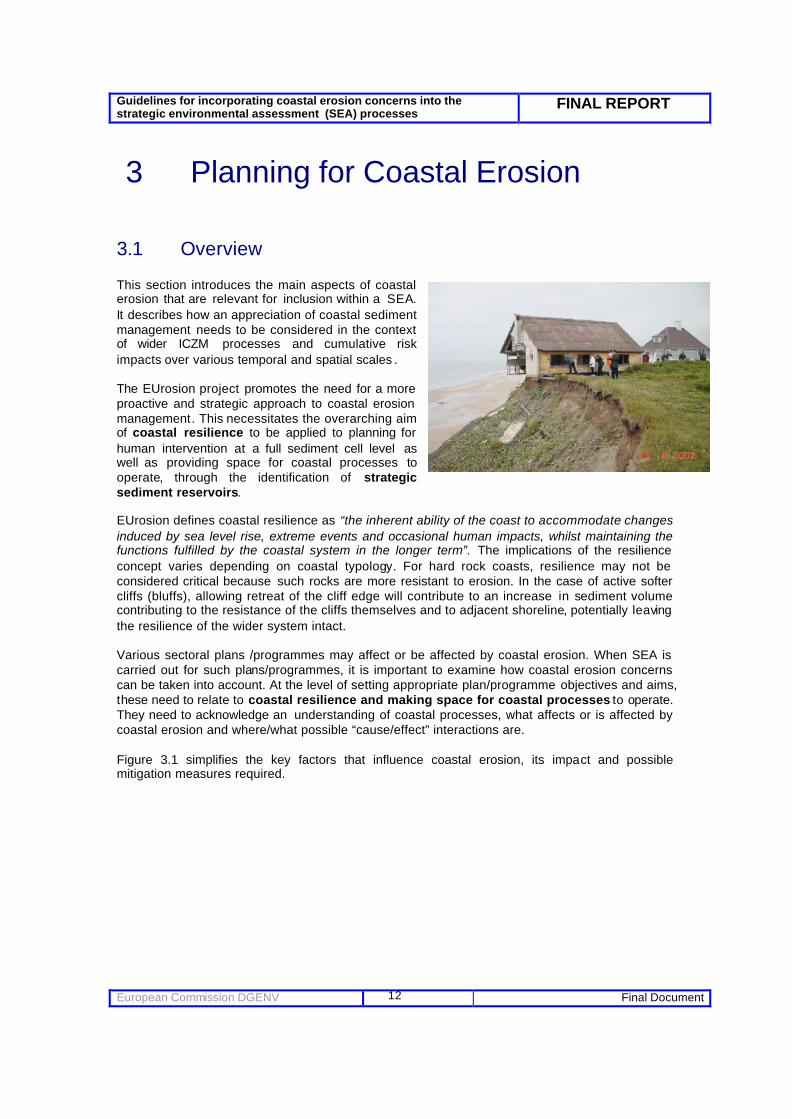
3.1 Overview This section introduces the main aspects of coastal erosion that are relevant for inclusion within a SEA. It describes how an appreciation of coastal sediment management needs to be considered in the context of wider ICZM processes and cumulative risk impacts over various temporal and spatial scales . The EUrosion project promotes the need for a more proactive and strategic approach to coastal erosion management. This necessitates the overarching aim of coastal resilience to be applied to planning for human intervention at a full sediment cell level as well as providing space for coastal processes to operate, through the identification of strategic sediment reservoirs. EUrosion defines coastal resilience as “the inherent ability of the coast to accommodate changes induced by sea level rise, extreme events and occasional human impacts, whilst maintaining the functions fulfilled by the coastal system in the longer term”. The implications of the resilience concept varies depending on coastal typology. For hard rock coasts, resilience may not be considered critical because such rocks are more resistant to erosion. In the case of active softer cliffs (bluffs), allowing retreat of the cliff edge will contribute to an increase in sediment volume contributing to the resistance of the cliffs themselves and to adjacent shoreline, potentially leaving the resilience of the wider system intact. Various sectoral plans /programmes may affect or be affected by coastal erosion. When SEA is carried out for such plans/programmes, it is important to examine how coastal erosion concerns can be taken into account. At the level of setting appropriate plan/programme objectives and aims, these need to relate to coastal resilience and making space for coastal processes to operate. They need to acknowledge an understanding of coastal processes, what affects or is affected by coastal erosion and where/what possible “cause/effect” interactions are. Figure 3.1 simplifies the key factors that influence coastal erosion, its impact and possible mitigation measures required.

Guidelines for incorporating coastal erosion concerns into the strategic environmental assessment (SEA) processes
FINAL REPORT
European Commission DGENV Final Document
13
Factors influencing coastal erosion
• natural (waves, winds, tides, storms, current, sea level rise etc.)
• human induced (hard coastal defence, soft coastal defence, land reclamation, dredging, aggregate extraction etc.)
• Cumulative effects
Factors that
affect erosion
response Typology of coast Coastal resilience Location of Sediment reservoirs
Impact of coastal erosion
• Impact on biodiversity, flora/fauna
• population and human health
• Increas ed social concern.
• Soil erosion • Saltwater intrusion • Loss of material
assets • Impact on cultural,
archaeological heritage and landscape
• Economic consequences (compensation etc)
Possible mitigation measures
• hard techniques: (breakwater, gabion, geo-textiles, etc)
• soft techniques: (managed realignment, beach recharge, beach drainage, etc.
• data management • knowledge
management • planning (planning
set back ) approaches
• compensation sites • Risk and cost
sharing, including financial compensation mechanisms
• ICZM approach Figure 3. 1 - Main aspects of coastal erosion This Section describes the aspects of coastal erosion that require consideration when preparing a SEA in the following order:
• The fundamental aspects of coastal erosion management – understanding spatial & temporal scale.
• Coastal sediment management under the umbrella of Integrated Coastal Zone Management (ICZM).
• A Description of the aspects of plans/programmes that are relevant for coastal erosion, in potentially affecting coastal erosion or being affected by erosion.
• The types of responses to coastal erosion at plan/programme level.
3.2 The spatial and temporal scale of coastal erosion and coastal processes
3.2.1 Concept of the Coastal Sediment Cell (Spatial Scales)
Any discussion of coastal erosion must keep the scale of the problem in mind. This is because a coastal “system” should be considered over a large enough time and spatial scale to be able to consider how the shape of a coastline is to change in the future. When managing erosion problems, the coastal system (or coastal sediment cell) that needs to be considered is often larger than the area in which the actual erosion takes place. Moreover, in terms of SEA plan development, a given “coastal sediment cell”, whilst reflective of

Guidelines for incorporating coastal erosion concerns into the strategic environmental assessment (SEA) processes
FINAL REPORT
European Commission DGENV Final Document
14
natural processes, may not fit with other types of administrative areas, for instance regional or local planning areas. The full coastal sediment cell needs due recognition as a minimum. A coastal sediment cell, in simple terms, is a boundary defined by littoral processes and zones of sediment convergence and divergence. In practice, this means that measures taken within a specific sediment cell may have an impact of other sections of the same sediment cell but will not impact adjacent cells. In practical and management terms, a coastal sediment cell commonly sits within a sedimentary framework composed of three geographical zones: • the catchment, • the shoreline, • the near shore marine environment. The interactions and influences between catchment, onshore and offshore areas vary greatly according to the specific local situation. However, these processes need to be carefully understood for undue disturbance to be avoided. The importance of understanding the boundaries of the coastal sediment cells and sediment transport processes is illustrated by the examples of the Camargue, (Rhone delta). At Espiguette there have been fruitless efforts to stop coastal erosion via coastal defences (already submerged by the sea). Figure 3.2 illustrates the “knock on” coastal erosion effects that threaten the town of Saintes Maries de la Mer, the tourism infrastructure and the salt pans located behind the coastal dunes.
Figure 3. 2 Knock on cumulative impacts of coastal erosion across coastal cells (from EUrosion 2004b) The benefit of the cell approach is that it reflects regional processes on a basis that is easy to communicate to wider stakeholders. Nevertheless, it should be kept in mind that the littoral cell concept is only one aspect of coastal system behaviour and other factors also need to be taken into account when assessing future evolution (such as climate change impacts and relative sea level rise). In terms of coastal resilience, and from the “coastal sediment cell” perspective, a loss of sediment is less favourable than redistribution within the coastal system. Less sediment within the system restricts the ability of the coastline to adapt to changing circumstances. Furthermore, hard constructions like breakwaters can block a percentage of the natural sediment transport volume. . The same effects occur when stabilizing cliffs which can prevent the natural input of sediments from cliff erosion. Consequently, fixing of sediments through hard constructions is less favourable than using measures which make use of the natural processes, for example beach- and foreshore nourishments.

Guidelines for incorporating coastal erosion concerns into the strategic environmental assessment (SEA) processes
FINAL REPORT
European Commission DGENV Final Document
15
Overall, taking account of coastal erosion in a proactive and strategic way implies that space is left for coastal processes to operate and that strategic sediment reservoirs are identified and/or safeguarded. This requires a thorough understanding of the coastal sediment cell to underpin large-scale and longer-term predictions of coastal evolution. Where a coastal sediment cell is deficient in sediments, for instance due to past human interventions, the strategic sediment reservoirs necessary to support current and future coastal resilience may have to be identified “off-site”.
3.2.2 Temporal Scale Figure 3.3 is prepared to demonstrate a few examples of the scale of impact that certain localised human activities (eg: dredging and river damming) and larger scale human activities (land reclamation, gas mining etc) can have both in time and space. Of relevance is the inertia of climatic processes and how this may have a more rapid influence on coastal dynamics than previously believed (ie: tens of years as opposed to hundreds of years).
Figure 3. 3 Temporal and spatial scale impacts of various activities in the coastal zone. (taken from EUrosion 2004c) Solving coastal erosion problems requires a consistent approach not only with regard to its spatial scale, but also the temporal scale which is intrinsically linked to. Coastal evolution should be considered over a long-term period, considering the lengthy time-scales at which major factors influencing coastal erosion take effect. To appropriately gauge future coastal evolution it is necessary to have an in-depth understanding of the contemporary conditions and long term past coastal evolution (past 5000 years). With this in mind, long term vision statements need to be effectively implemented (eg: set within Coastal Sediment Management Plans over say a 100 year period or more) with a clear relationship to planning documents that set policies / actions over much shorter timescales. Figure 3.4 demonstrates (from a non exhaustive sample list) that most plans and programmes do not set out a long enough “vision” that plan for timescales that acknowledge coastal evolutionary change. As a result of this, certain factors often stay “hidden” from coastal engineers and planners for decades before there are finally evoked and quantified.
While it will not be feasible to change the time-spans of the sectoral plans/programmes to coincide with the time-scale necessary to gauge coastal evolutionary change, all plans/programmes should, however, take into account the longer term consequences of their

Guidelines for incorporating coastal erosion concerns into the strategic environmental assessment (SEA) processes
FINAL REPORT
European Commission DGENV Final Document
16
actions and policies, beyond the time-span proper of the plan/programme, so as to duly consider the geo-morphological processes that affect, and are affected by , the plan/programme.
Figure 3. 4 How different plans influence or are influenced by coastal erosion over time.
3.3 What factors influence cumulative coastal erosion? In relation to the main causes of erosion, a distinction can be made between natural and human causes. Examples of natural causes are relative sea level rise and storms and human causes are for example river damming, hard defences and urbanisation. Figure 3.5 demonstrates the natural and human induced factors that influence coastal erosion.
affected by coastal erosion
affects coastal erosion
Shoreline management plan (50-100 years) Marine aggregate plan (circa 20 years)
River Basin Management Plans (<20 years) Transport Plans (circa 10 years) Estuary Harbour dredging plans (<10 years) (<10 years)
Landscape Management Plan (<20 years) Housing development plans (<20 years) Fisheries Plans (not specified)
Land use management plan (non-coastal authorities)
Tourism Master Plans (<10 years) Biodiversity Action Plans (<20 years) Coastal Recreation Plans (<5 years) Coastal Habitat Management Plans (<20 years)
European Regional Development Plans/programmes (<20 years) Marine Spatial Plans (use of seabed) timescales not yet determined European Social/Cohesion Funds

Guidelines for incorporating coastal erosion concerns into the strategic environmental assessment (SEA) processes
FINAL REPORT
European Commission DGENV Final Document
17
Some of the principle causes of change in sediment movement in a ‘sediment system’. In this diagram the coast is taken to include the sea cliffs and sand dunes, tidal saltmarshes and mud/sand flats. Nearshore marine waters (blue) and the hinterland (green) make up the ‘sediment system’. In the diagram sediment movement is tending towards ‘sediment sinks’ associated with a coastal embayment, such as an estuary. Figure 3. 5 Some principal causes of coastal erosion (taken from EUrosion 2004c)
The Guidelines for incorporating coastal erosion information on Environmental Assessment procedures (EUrosion 2004a) from the EUrosion project describes the natural factors and the human factors, as well as interaction in detail. To take account of coastal erosion concerns in EIA or SEA, it is essential that authorities, planners, practitioners and developers gain a good understanding of these factors. Natural factors influencing coastal erosion can include: • waves . • winds. • tides. • near-shore currents. • storms. • sea level rise. • slope processes. • vertical land movements (compaction). Human-induced coastal erosion mainly proceeds from the cumulative and indirect impacts of small and medium size projects, typically from: • hard /soft coastal defence. • land reclamation. • river water regulation works. • dredging and aggregate extraction. • littoral vegetation clearing. • offshore renewable energy • oil /gas exploration (long term subsidence in coastal areas). • water extraction/drainage issues.

Guidelines for incorporating coastal erosion concerns into the strategic environmental assessment (SEA) processes
FINAL REPORT
European Commission DGENV Final Document
18
• impediment of aeolian (sand) transport between hinterland and foreshore. • beach sand extraction. • ship-induced waves. • marina developments • hotel construction along the seafront. Despite these generic distinctions made above, coastal erosion can almost never be attributed to one single cause, be it natural or human-driven, but to a combination or cumulation of various factors which together create the conditions for erosion to take place.
3.4 SEA, coastal erosion and Integrated Coastal Zone Management (ICZM)
In May 2002 the EU Recommendation concerning implementation of Integrated Coastal Zone Management (ICZM) was adopted by the European Parliament and Council of Ministers (2002/413/EC). The Recommendation lists a number of strategic challenges, among which sound coastal defence. It gives a series of principles that should underlie coastal zone management and calls on Member States to set up national strategies for ICZM. The EUrosion study pointed to the links between coastal sediment management and wider ICZM. Where ICZM strategies or plans are developed coastal sediment issues should be included ICZM as a process requires clear engagement and integration of coastal stakeholders to better improve the synergy of sectoral objectives within plans/programmes operating within the coastal zone. To achieve aims such as coastal resilience and integration, a coherent approach across policy areas is needed. An ICZM strategy or plan will provide a framework to this effect as when examining a sectoral plan or programme, an SEA itself will need to take into account other relevant plans and programmes and their objectives.
The EU ICZM Recommendation invites Member States to follow eight principles in formulating national strategies for integrated coastal zone management (ICZM) and any subsequent measures based on these strategies. The eight principles are listed below, and for each a coastal erosion risk perspective is added to demonstrate the synergy between coastal sediment management and ICZM: A broad overall perspective: coastal management issues should be considered in the widest possible context. With reference to coastal sediment management, ICZM advocates that all sectoral aspects (transport, housing, tourism, forestry etc) should be considered together over various spatial and temporal scales. A long-term perspective: the needs of both present and future generations should be considered concurrently and equally, and in an institutional framework that looks beyond the present planning and political time horizons. With reference to coastal sediment management, ICZM advocates that any plan/programme needs to acknowledge changing environments (social/physical/economic) in tandem with the physical evolution of the coastal zone. Adaptive management. ICZM is an evolving process, which should be able to deal not only with today’s problems but also with as yet unforeseen issues that may arise in the future. Good coastal zone planning and management should be based on the ‘precautionary principle’ – trying to anticipate potential problems and erring on the side of caution if there is uncertainty about whether an action will have a detrimental effect on the coastal environment. This is particularly

Guidelines for incorporating coastal erosion concerns into the strategic environmental assessment (SEA) processes
FINAL REPORT
European Commission DGENV Final Document
19
the case with regard to predicting coastal erosion rates and the resilience of specific coastal landforms to change over time. Local specificity. ICZM initiatives need to ensure a consistent approach, yet allow freedom and flexibility for actions to reflect and respond to local circumstances. For example, the management of one dune system may not be appropriate for a similar dune system in another region. Working with natural processes and respecting the carrying capacity of coastal habitats and ecosystems: natural processes and the dynamics of coastal systems are in continual and sometimes sudden flux. One should work with, rather than against these natural processes, and recognise the limits (or carrying capacity) which is imposed as a result. Involving all the parties concerned: The views of stakeholders need to be drawn into the process, as such involvement helps to identify real issues, harness local knowledge and build commitment and shared responsibility for the outcomes. Better communication of coastal erosion risk is often lacking at the planning stage of plans/programmes and improvements on this aspect will prove beneficial. Support and involvement of relevant administrative bodies at national, regional and local level. The support and involvement of relevant administrative bodies is another essential element of successful ICZM. Involvement often is linked to awareness and appreciation of coastal erosion risk issues and so is integrally linked to better understanding of erosion issues at all levels. Using a combination of instruments: is needed to deliver ICZM. They include legal and economic instruments, voluntary agreements, information provision, technological solutions, research and education. There should be coherence between legal instruments and administrative objectives and between planning and management. Linking the issue of coastal sediment management with ICZM planning issues is a complex task and is not the purpose of this guidance document. Nevertheless, it is relevant to demonstrat e the complexities. Figure 3.8 sets out a series of possible coastal sectoral scenarios. The examples used are generic and identify the stakeholders who are involved in future outcomes and who is likely to be responsible for managing the potential coastal response over the broader spatial and temporal scales (see Section 3. 2).

Guidelines for incorporating coastal erosion concerns into the strategic environmental assessment (SEA) processes
FINAL REPORT
European Commission DGENV Final Document
20
? Littoral Drift direction
? Littoral Drift direction is south to north
? Littoral Drift direction
Littoral Drift direction is north to south ? Figure 3.8 Strategic scenarios outlining potential cumulative impact (adapted from Defra, 2003b)
SCENARIO 1 – New Housing Development New defences are proposed to defend a new coastal development. Existing defence is a dune belt. New defences needed as beach levels are receding and steepening due to a new port developed to the east. To the west of development is an internationally important marine cSAC designation. ICZM Conundrum? Who is responsible for long term maintenance of good ecological status within the cSAC?
Users at Risk? – individuals, local groups, regional organisations, national organisations SCENARIO 2 – New Defence Realignment Option A new economically viable defence is proposed to defend a historic coastal development. The existing defence is a built seawall to be removed in the proposed development. To the north is a new major marina (proposed from regional development programme and economic regeneration funds) that is concerned about increased sediment transport moving north causing dredging problems. ICZM Conundrum? Who is responsible for managing the areas sediment budget? Users at Risk? – local groups, regional organisations, national organisations SCENARIO 3 – Intensive Tourism Development Area To promote economic regeneration, a new area is designated for development. This exists in a “soft geology” cliffed region area with existing small villages along the coast. Hinterland is designated for its landscape/scenic quality. Transport plans wish to create new set back road system due to poor current infrastructure, tourist industry development require a “coastal” location. Coastal resilience to accommodating change within its “stable” state position is limited and would require significant defence investment ICZM Conundrum? Who is responsible for long term coastal defence in this unsustainable location? Should this be developers, indus try or Govt for promoting the concept in the Regional Development Plan ? Users at Risk? – individuals, local groups, regional organisations, national organisations SCENARIO 4 – New Port Expansion Project A considerable extension to an existing port is proposed from the Regional Transport Plan to improve a nations commercial portfolio. To enable larger ships to access the port, the estuary mouth needs widening. Proposed new set back lines do not directly impinge on international important coastal designated sites, though there is immediate loss of habitat. Littoral drift impacts as a consequence of new defence proposals on current harbour dredging plans and coastal recreational plans for the area. ICZM Conundrum? Is the proposed port in a suitable location and is the coast resilient enough to accommodate its presence over time? Users at Risk? – individuals, local groups, regional organisations, national organisations

Guidelines for incorporating coastal erosion concerns into the strategic environmental assessment (SEA) processes
FINAL REPORT
European Commission DGENV Final Document
21
3.5 Incorporating Coastal Erosion Matters into SEA Table 3. 1 is prepared as an overview to outline, for each sector plan/programme under Article 2 of the SEA Directive, a series of possible plan/programme example impacts (under each generic Article 2 heading title set out within the SEA Directive) whose implementation may be affected by coastal erosion as well as those that may affect future coastal erosion rates. Specific examples are provided where possible. A column is provided to outline the link with other sectors (indicate potential cumulative impacts) and where, possible, examples from around Europe are presented to illustrate the point. Sector (SEA Directive, Art. 2)
Indicative Plans Affected by coastal erosion
Affect coastal erosion rates Link to other planning Sectors?
Specific Examples
Agriculture, forestry (AF)
Local Land Use Plans Forestry Management Plans Regional Economic Strategies
• Coastal pasture land eroded.
• Increased salinisation of water table.
• Risk of coastal forest erosion.
• Re-planting of coastal trees impeding sediment transfer to the active beach system
• Eroded beach levels may impact of fisherfolk beach landing access.
• Changes to dune/saltmarsh biodiversity and thus natural defence.
• Beach sand removal for land “liming”
F; HD
Ainsdale forest erosion issues (Lancashire coastline, UK) http://www.english-nature.org.uk/about/teams/NewsDetails.asp?Id=8&NewsId=267
Fisheries (F) Fisheries Management Plans Local Land Use Plans
• Increased turbidity from cliff erosion affecting water quality.
• Loss of nearshore sand banks used as nursery grounds for juvenile fish stocks.
• Marine aggregate extraction influencing nursery fish stocks
• Certain fishing practices . • Fish farms construction.
AF; HD, E Culver Sands marine aggregate extraction (Severn Estuary , UK)
Energy (E) Local Land Use Plans Regional Economic Strategies
• Offshore developments (e.g. oil wells, wave power stations) change wave patterns.
• Land subsidence associated with gas field extractions
• Location of coastal nuclear sites (always defended).
I; T; HD DTI SEA report on offshore renewable energy for the UK (www.dti.gov.uk/)
Industry (I) Local Land Use Plans Regional Economic Strategies
• Dredging (capital/maintenance).
• Marine aggregate extraction.
E; T; F; SP; HD
Transport (T) Local Land Use Plans Regional Economic Strategies
• Port development. • Road construction close
to shoreline. • Bridge construction. • Coastal airport
construction. • Larger ships causing
wake erosion.
E; I; SP; HD
Telecommunications (TC)
• Development at risk of erosion if located on/near eroding coast.
• Offshore wind turbine placement.
• Road networks placed
in eroding shorelines.
• Exposure of buried
telecommunication pipes beneath eroding beach.
• Hinder sediment transport rates by placement of sub-sea cables.
I; T; E; HD

Guidelines for incorporating coastal erosion concerns into the strategic environmental assessment (SEA) processes
FINAL REPORT
European Commission DGENV Final Document
22
Sector (SEA Directive, Art. 2)
Indicative Plans Affected by coastal erosion
Affect coastal erosion rates Link to other planning Sectors?
Specific Examples
Spatial planning (incorporating local planning) (SP)
Regional Spatial Strategies Regional Economic Strategies
• Impact on housing development/retail planning on coast.
• Uses of the seabed restricted by increased erosion rates.
• Increased f lood risk in case of extreme events .
• Hinder natural shoreline evolution should infrastructure development be granted along a “sediment source” length of coast.
• Policy for marine aggregate extraction.
• Set policy for port expansion.
F; AF; I; T; E; TC; TO; WM; W; HD
Netherlands National Spatial Strategy Document http://www2.vrom.nl/docs/internationaal/Ruimte%20Nota-Engels.pdf
Tourism (TO) Local Land Use Plans Regional Economic Strategies Tourism Master Plans
• Economic impact of reduced beach levels lower at a key beach resort.
• Reduction in tourism contribution to GDP.
• Flood risk increased impacts to tourism assets.
• Marina development hindering sediment transport.
• Poor set back policy of tourist beach complexes hinders sediment transport.
• Hotel placement can hinder aeolian sand transfer between active beach and hinterland (resulting in beach erosion)
SP; I; T; HD
Fuerteventura Hotel development at Sotavento Beaches (see Alonso et al 2002)
Waste management (WM)
Regional Economic Strategies
• Erosion risk to coastal landfill tip sites.
• Increased demand for waste refuse sites in coastal areas with increased population.
• Defended landfill sites in unsustainable locations due to limited alternatives for relocation of waste.
SP; W; WM; E; I; HD
Walney Island Coastal Management project, Barrow BC, UK
Water management (W)
River Basin Management Plans Catchment Flood Management Plans
• Cliff drainage issues • Water Framework
Directive implementation
• Exacerbate beach drawdown should natural drainage issues on beaches/cliffs be altered.
• Policy for flood storage in estuaries/coastal zones.
HD RIbble Pilot River Basin Management Plan, North West England.
Other plans/ programmes requiring appropriate assessment under Habitats Directive (HD)
Biodiversity Action Plans River Basin Management Plans Catchment Flood Management Plans
• Marine SAC Management Schemes
• Coastal Habitat Management Plans set up to address this issue – loss of internationally important habitat
n/a F; AF; I; T; E; TC; TO; WM; W
Other plans/ programmes that set the framework for future deve-lopment con-sent of projects and which are likely to have significant environmental effects
Habitat Action Plans Port Management Plans
• Tourism Master Plans may be influenced by receding shorelines and depleted beach levels.
• Port Management Plans may influence dredging strategies in an area and thus sediment budgets.
F; AF; I; T; E; TC; TO; WM; W; HD
Table 3.1 Article 2 SEA sectors titles and associated plans/programmes that either are affecting or likely to affect coastal erosion rates.

Guidelines for incorporating coastal erosion concerns into the strategic environmental assessment (SEA) processes
FINAL REPORT
European Commission DGENV Final Document
23
3.6 Responses to Coastal Erosion
3.6.1 Planning Solutions
There are a few key planning solutions that can seek to address coastal erosion issues. These are outlined below :
Setting Coastal Sediment Management Policy
To implement strategic coastal sediment management, EUrosion recommends that Coastal Sediment Management Plans are prepared to provide the building block for coastal erosion management around Europe. This document would set the objectives of favourable sediment status within a specific coastal sediment cell and define the means for achieving these objectives. This issue is addressed in full within the EUrosion Shoreline Management Policy Report (2004).
In summary, the planning options presented within a Coastal Sediment Management Plan are:
• Hold the line.
• Move seaward.
• Managed realignment.
• No active intervention.
Allowing space for coastal processes to operate
As mentioned earlier in this section, an appreciation of coastal typology is important to better appreciate actually how resilient coastal landforms are. Table 3.2 identifies the variance in generic coastal types and sub-features and how their role as a landform both needs to be planned for accordingly and carefully managed.
Coastal Landform Typology
Related sub-features
Indicative evidence of/ identified by
Role(s) of sub-features Sensitivity of sub-features
Embayment Diffraction of obliquely approaching waves around a headland.
Progressively tends towards swash-alignment.
Dependent upon: dominant wave direction, continued presence of at least one control point and degree of development/ maturity.
Banner bank
Sediment supply from around headland, tidal eddies created by highly rectilinear flow.
Storage of sediments, some wave refraction.
Dependent on stability of headland and supply of sediment.
Headland
En-echelon bank Sediment supply and wave diffraction around a receding headland.
Storage of sediments, some wave refraction.
Dependent upon a retreating headland and sediment supply.
Flood deltas (inside estuary / inlet mouth)
Tidal delta, sediment supply, fluvial and tidal process interactions.
Storage of (finer) sediment, part of sediment bypassing mechanism around estuary/ inlet mouth.
Sensitive to: changes in sediment supply (rate and composition), estuary tidal prism and wave energy.
Estuaries or tidal inlets
Ebb deltas (just seaward of estuary / inlet mouth)
Tidal delta, sediment supply, fluvial and tidal process interactions.
Storage of (coarse) sediment, protection to shoreline - dissipates waves, part of sediment bypassing mechanism around estuary/ inlet mouth.
Sensitive to: changes in sediment supply (rate and composition), estuary tidal prism and wave energy.

Guidelines for incorporating coastal erosion concerns into the strategic environmental assessment (SEA) processes
FINAL REPORT
European Commission DGENV Final Document
24
Spits Longshore transport of sediment interrupted by estuary / inlet mouth.
Storage of sediment, part of sediment bypassing mechanism around estuary / inlet mouth. Protects estuary from waves.
Sensitive to: relative importance of longshore and tidal processes and sediment supply.
Bank Sediment supply to bank and existence of rotary tidal currents.
Wave refraction, storage of sediments. Circulation of sediment around the bank.
Sensitive to: shoreline recession (may cut off sediment supply) and sea level rise (could cause bank to become moribund). Offshore
Gully Depression within sea bed surface. Potential sink of sediment. Could become infilled due to
sediment supply.
Drift-aligned shore
Sediment supply exists and w aves approach shoreline obliquely.
Balances sediment and energy inputs to the beach with sediment and energy outputs.
Sensitive to changes in sediment supply and wave direction and energy (i.e. rate and direction or drift).
Processes and/or sediment supply Swash-aligned
shore.
Lack of sediment supply. Waves approach shoreline perpendicularly.
Minimises longshore drift potential.
Sensitive to changes in wave direction and energy.
Table 3.2 Adapted from Defra 2003 (Future Coast – UK)
From this table, setting standard distances for planning set-back lines (prohibition and/or restriction of coastal development at a certain distance from the shoreline.) cannot be clearly set as each coastal landform has different sensitivities and play different roles in wider coastal sediment management. Examples of set-back line distances can be found in various European countries, ranging from 5m to 100-300m or further. (The distance depends on issues such as coastal typology, land ownership and existing land usage). Similarly restrictions of sea bed use in the near and fore-shore area can be considered through zonation.
A clearer understanding of who benefits and who suffers from inappropriate coastal sediment management is required as part of the SEA process. Robust planning and management procedures should be used to assist in this understanding (see Section 4).
Acknowledging “Strategic Sediment Reservoirs” within planning documents
The need to counteract a negative sediment balance in a particular coastal zone will require a source of sediment to be identified. To facilitate the future availability of such an ‘appropriate’ sediment supply, the EUrosion project proposes the concept of ‘strategic sediment reservoirs’. These are defined as: “supplies of sediment of ‘appropriate’ characteristics that are available for replenishment of the coastal zone, either temporarily (to compensate for losses due to extreme storms) or in the long term (at least 100 years). They can be identified offshore, in the coastal zone (both above and below low water) and in the hinterland. After designation of strategic sediment reservoirs their availability should be ensured by leaving them undeveloped. The success of any planning solution is dictated by the robustness and relevance of the objectives that its sets. This is an important factor which governs the success of longer term coastal sediment management.
Plans should also integrate a “sediment friendly vision” into their objectives and target setting for the future. For example, if a tourism master plan advocates a 10% coastal resort expansion over the next 10 years, the plan should also aim, as part of its implementation measures, to evaluate the carrying capacity of the resort to accommodate this expansion plus the scale of impact this may have on coastal erosion.
3.6.2 Engineered Solutions Appendix C outlines a range of engineering mitigation options that can be reviewed as part of the SEA process. Regional or strategic shoreline monitoring is a “side by side” requirement for each engineering option identified in that Appendix. Monitoring issues are addressed in Section 4.6.

Guidelines for incorporating coastal erosion concerns into the strategic environmental assessment (SEA) processes
FINAL REPORT
European Commission DGENV Final Document
25
3.6.3 Market instruments and financial solutions
In connection with the identification of strategic sediment reservoirs, initiatives can be set up at the planning stage to discuss methods for linking private and public sector funding initiatives to help longer term management of coastal areas.
There are, however, only a small number of examples where regions have attempted to create a framework schemes for financial compensation (expropriation) to implement this actually on the ground. In Tuscony (Italy), mechanisms are being proposed to engage the private sector into co-financing beach re-nourishment schemes. Examples are even less common where financial compensation programmes are set up to resettle coastal populations at imminent risk from coastal erosion/flooding. One example of this is provided by the French Law that facilitates compensation of assets threatened by natural hazards (Loi Barnier). Whilst no compensation schemes for land lost by coastal erosion schemes are set up in the UK, new funding streams are being established by UK Government through an initiative called the Aggregate Levy Sustainability Fund (ALSF) combine public and private sector funds (circa EUR6 million per year) to finance sustainable development related projects around the UK coastal zone.
It is important to acknowledge critical long term issues potentially as components of Regional Development Funds or Cohesion / Social Programmes in the future and to prepare a mechanism to allow for expropriation or compensation in order to accommodate managed realignment in compliance with EC competition regulations. Coupled with this, better awareness programmes and participation of all stakeholders within potential coastal erosion risk areas is needed to help communicate the joint responsibility of adapting to longer term coastal erosion risk.
Chapter conclusions Of key importance for plan/programme/policy planners is the need to understand the underlying causes of coastal erosion within an costal cell (based on coastal typology etc), and coupled with this, an acknowledgement of how coastal systems change over time and space.
An increase in coastal resilience will be enhanced by reserving space in the terrestrial part of the coastal zone, and by identification of strategic sediment reservoirs within the marine part of the coastal zone. The identification and designation of ‘strategic sediment reservoirs’ for each coastal sediment aims to facilitate the restoration of a favourable sediment status and the provision of space for coastal processes to take place. Being able to identify whether a plan/programme is influenced by or is to influence coastal erosion rates needs to be considered early in the planning process. Often, this is not done.
SEA as a planning tool can be effectively used to help deliver the EUrosion project aims and findings by helping to more widely communicate the identification of strategic sediment reservoirs to all sectoral interests (ie: offshore/nearshore: sands on the sea bed; eroding cliffs; intertidal sediments supporting dunes and beaches).
Planners should (when preparing plans and programmes) acknowledge the importance of a long enough “vision” to acknowledge coastal evolutionary change. The issue of cumulative impact needs to be suitably addressed as coastal erosion can almost never be attributed to one single cause, be it natural or human-driven, but to a combination or accumulation of various factors which together create the conditions for erosion to take place. The EUrosion study also pointed to the links between coastal sediment management and wider ICZM. ICZM as a process requires clear engagement and integration of coastal stakeholders to better improve the synergy of sectoral objectives within plans/programmes operating within the coastal zone. To achieve this, a coherent approach across policy areas is needed and ICZM may provide a framework to this effect. Sectoral planners should seek to incorporate this into decision making.

Guidelines for incorporating coastal erosion concerns into the strategic environmental assessment (SEA) processes
FINAL REPORT
European Commission DGENV Final Document
26
4 Incorporating Coastal Erosion Issues into SEA processes
This section deals with those aspects of SEA that need to be addressed for both plans that affect, and those that are affected by, coastal erosion. This involves phases such as:
• screening;
• scoping;
• describing the baseline environment related to coastal erosion,
• analysing links to other plans and programmes related to coastal erosion,
• preparing an environmental report, and consulting relevant stakeholders.
Section 5 then discusses possible techniques to help address strategic options assessments, alternatives for plans and programmes that affect coastal erosion.
4.1 Screening: what plans and programmes require SEA? The screening process determines whether a given plan or programme1 requires SEA. Figure 4.1 summarises the screening ‘test’ of the SEA Directive and has been adapted to bring this into a coastal context where possible. The reader is referred to the guidance document from the European Commission on the implementation of the SEA Directive (2003), much of which is dedicated to screening. In summary, screening is the essential first stage of the assessment, undertaken to determine whether a plan or programme requires a SEA under the Directive where this is decided on a case by case basis. The list of predefined plans/sectors presented in Section 2.4 and 3.5 of this report helps to determine, during a screening exercise, the types of coastal erosion issues that need to be considered. With regard to Annex II of the Directive, it is important to document the following :
• Characteristics of the plan: e.g. the scale of development envisaged over the life of the plan; the degree to which the plan sets out to promote sustainable development (and awareness of coastal resilience if appropriate).
• Characteristics of the effects of implementing the plan and of the area: e.g.the magnitude and reversibility of the effects on the coastal zone; the vulnerability of the coastal area (typology) to development pressures. Importantly, the size of the area alone is not sufficient to rule out SEA.
1 The Directive does not specify what is meant by ‘plan’ and ‘programme’, but the European Commission (2003) suggests that a plan “sets out how it is proposed to carry out or implement a scheme or a policy”, for instance land use plans which guide the kind of development that might be appropriate in particular areas; and a programme covers “a set of projects in a given area” , for example a scheme for regenerating an urban area comprising of several separate construction projects.

Guidelines for incorporating coastal erosion concerns into the strategic environmental assessment (SEA) processes
FINAL REPORT
European Commission DGENV Final Document
27
Often, adopting a preliminary risk-based approach is useful to determine whether the likelihood and consequence of coastal erosion risks (associated with the relevant plan) are potentially significant. It is also important to consider likely cumulative coastal effects at the Screening stage. Annex II of the SEA Directive, (reproduced at Box 4.1overleaf), gives criteria for determining significance of effects. At the stage of screening it is not required to quantify these criteria, or provide assessment against thresholds, reference values etc. Actually stating the likelihood of significant effects on the coast actually occurring is deemed sufficient enough for a plan/programme. Hence designing a risk assessment table to address coastal erosion issues is a proactive approach that should be initiated. Table 3.2 in Section 3 has already provided some indication about what plans and programmes affect coastal erosion and the nature of potential effects. As opposed to the EIA Screening process, a more top level overview screening exercise is required for an SEA, with appropriate coastal erosion related issues covered at this time. Hence, the screening criteria for coastal erosion related issues is not deemed to be an onerous task and for the purposes of this guidance document, should essentially reflect on providing answers to the following questions:
• Is the plan/programme likely to influence coastal erosion or sediment transport regimes? (if so, an SEA is likely to be required).
• Is the plan/programme likely to be influenced by coastal erosion or changing sediment transport regimes? (if so, an SEA is likely to be required).
• Is there a need for the plan/programme under review to consider cumulative effects on coastal erosion? (if so, an SEA is likely to be required).
• Does the plan/programme, in combination with other activities, have a cumulative effect on coastal erosion”??

Guidelines for incorporating coastal erosion concerns into the strategic environmental assessment (SEA) processes
FINAL REPORT
European Commission DGENV Final Document
28
Figure 4.1 Screening flowchart for the SEA Directive (adapted from ODPM, 2003)
This diagram is intended as a guide to the criteria for application of the Directive to plans and programmes (PPs). It has no legal status. Attempts have been made to present a coastal erosion specific focus where possible.
No to both criteria
Yes to either criterion
No
Yes
No to either criterion
Yes to both criteria Yes No
No
No to both criteria Yes to either criterion Yes
No
Yes
No to both criteria Yes to either criterion
* The Directive requires Member States to determine whether plans or programmes in this category are likely to have significant environmental effects. These determinations may be made on a case by case basis
and/or by specifying types of plan or programme.
The decision route indicated by the red dashed line is unlikely to be realistic in practice.
Is the PP subject to preparation and/or adoption by a national, regional or local authority (eg: National Ports Authority) OR prepared by an authority for adoption through a legislative procedure by Parliament or Government? (Art. 2(a))
Is the PP required by legislative, regulatory or administrative provisions? (Art. 2(a))
Is the PP prepared for agriculture, forestry, fisheries, energy, industry, transport, waste management, water management, telecommunications, tourism, town and country planning or land use, AND does it set a framework for future development consent of projects in Annexes I and II to the EIA Directive? (Art. 3.2(a))
Will the PP, in view of its likely effect on coastal habitat sites, require an assessment under Article 6 or 7 of the Habitats Directive? (Art. 3.2(b))
Does the PP determine the use of small areas at local level, or is it a minor modification of a PP subject to Art 3.2? (Art.3.3)
Does the PP set the framework for future development consent of projects (not just projects in Annexes to the EIA Directive)? (Art 3.4)
Is it likely to have a significant effect on the coastal environment? (Art
3.5) *
Is the PP's sole purpose to serve national defence or civil emergency, or is it a financial or budget PP, or is it co-financed by structural funds or EAGGF programmes 2000 to 2006/7? (Art. 3.8, 3.9)
DIRECTIVE DOES NOT REQUIRE AN SEA
DIRECTIVE REQUIRES AN SEA

Guidelines for incorporating coastal erosion concerns into the strategic environmental assessment (SEA) processes
FINAL REPORT
European Commission DGENV Final Document
29
Box 4.1 SEA Directive, Annex II: Criteria for determining the likely significance of a plan or programme’s effects on the environment (aspects in bold represent those likely to be related to coastal erosion; aspects in italics are examples related to coastal erosion)
1. The characteristics of plans and programmes, having regard, in particular, to • the degree to which the plan or programme sets a framework for projects and other
activities, either with regard to the location, nature, size and operating conditions or by allocating resources,
• the degree to which the plan or programme influences other plans and programmes including those in a hierarchy,
• the relevance of the plan or programme for the integration of environmental considerations in particular with a view to promoting sustainable development,
• environmental problems relevant to the plan or programme (e.g. likely future flooding problems caused by increased sea levels, requiring management in a coastal sediment management plan),
• the relevance of the plan or programme for the implementation of Community legislation on the environment (eg plans and programmes linked to waste-management or water protection).
2. Characteristics of the effects and of the area likely to be affected, having regard, in particular, to
• the probability, duration, frequency and reversibility of the effects, • the cumulative nature of the effects (e.g. multiple housing and tourism activities at a
coastal resort progressively leading to increased risk, and hence pressure to put in place further defence measures)
• the trans-boundary nature of the effects (e.g. coastal management activities by one country leading to increased erosion on the coastline of another country)
• the risks to human health or the environment (eg due to accidents) (e.g. the possibility of a plan increasing or helping to avoid the collapse of cliffs, flooding, problems accessing essential services)
• the magnitude and spatial extent of the effects (geographical area and size of the population likely to be affected),
• the value and vulnerability of the area likely to be affected due to: o special natural characteristics or cultural heritage, o exceeded environmental quality standards or limit values, o intensive land-use,
• the effects on areas or landscapes which have a recognised national, Community or international protection status.
In some instances, such as in Vlaanderen in the Netherlands, screening for SEA is carried out independently by an expert. The expert is tasked with defining the extent of the study area to be reviewed within the SEA (spatial scale extent) and also the criteria for future monitoring of impact. Examples of criteria to use may include factors such as recorded coastal erosion rates or beach profile steepening. It is recommended that this approach is adopted by Member States to help identify early on in the process the spatial and temporal areas potentially to be affected by the plan/programme. The selection of the expert is critical here and that individual needs to be able to address the coastal erosion related issues that require acknowledgment (eg: a soil/geotechnical expert or a geomorphologist).

Guidelines for incorporating coastal erosion concerns into the strategic environmental assessment (SEA) processes
FINAL REPORT
European Commission DGENV Final Document
30
4.2 Scoping: what should be in the SEA?
Based on the results of the Interreg project ENPlan2 that examined environmental assessment, , 3 sub-headings are proposed as guidance for planners when scoping an SEA.
4.2.1 Define Planning Framework (to incorporate coastal sediment management)
The tasks required to implement this important phase include :
• Establish the main coastal sediment management objectives and how these link to the aims of the Plan/ Programme (hierarchy of plans and their interaction).
• Identify the coastal spatial and temporal boundaries of the Plan/Programme assessment. Box 4.2 gives an example of how spatial scales can be addressed in plan -making;
• Develop SEA Brief with consultants (possibly based on Generic SEA Brief Template produced by EC)
• Brainstorm coastal sediment management strategic options with project team.
An example from the Scoping phase of the Interreg IIIB Medoc ENPLAN project (“Environmental assessment of plans and programs”) is presented above.
4.2.2 Define Environmental Context • Identify and review the relationship with other relevant plans and programmes and
identify the synergy with other environmental protection objectives within the coastal cell area.
• Identify the relevant aspects of the current state of the coastal environment, and likely shoreline evolution tendency without implementation of the plan or programme.
• Identify the coastal typology and shoreline characteristics of the areas likely to be significantly affected by the plan or programme.
• Identify who are the key stakeholders at risk and why are they at risk?
2 http://www.interreg-enplan.org/
TTeemm áátt iiccaa aa ccoo nnssiidd eerraarr pp aarraa llaa dd eeffiinn iicc iióó nn dd eell áámmbb ii tt oo dd ee iinnfflluu eenn cciiaa dd eell PP//PP
Elaboración del marco planificador y programático § Análisis de la influencia sobre otros P/P o de su
dependencia § Marco estructurado de los objetivos ambientales y de
las decisiones presentes en el P/P que afectan al área o al sector
Análisis de contexto § Aspectos ambientales clave: retos,
potencialidades, aspectos sensibles y críticos del ámbito del P/P § Aspectos socioeconòmicos determinantes § Aspectos territoriales clave
Determinación de los agentes que hay que implicar
§ Estado, regiones, provincias, municipios § Otros organismos territorialmente
competentes § Autoridades competentes en materia
ambiental § Ocasionalmente otros agentes.
Identificación del ámbito espacio – tiempo del P/P § Definición de la escala de trabajo, delimitación
espacial – temporal del área implicada § Identificación de los posibles tipos de intervención i de
los acumulativos, sinérgicos y/o impactos significativos en la salud humana y en el ecosistema

Guidelines for incorporating coastal erosion concerns into the strategic environmental assessment (SEA) processes
FINAL REPORT
European Commission DGENV Final Document
31
• Describe any existing coastal erosion related problems and opportunities for enhancement which are relevant to the plan or programme.
• Decide now on need for a standalone Environmental Report or an Environmental report integrated into the Plan or Programme Report.
• Develop strategic options that take into consideration shoreline evolution.
4.2.3 Agree on Scope of Assessment • Compile a draft scoping letter and easy to understand “Coastal Sediment Management
Awareness” document for the purposes of internal and external consultation. • Consult statutory consultation bodies and (where appropriate) other relevant
organisations . • Compile a draft scoping report to document this exercise including a summary of
consultation responses. • Quality Assure and Sign -off ‘Scoping Report’ • Issue Scoping Report to consultees for information. • Confirm SEA Brief with consultants.
Adhering to the above approach to the scoping process will help to incorporate coastal erosion issues into SEA processes by:
• Involving all actors with an interest (economic or regulatory) in the coast (as well as coastal engineering/scientific experts) early in the process, gaining agreement on the spatial and temporal scale of SEA analysis, (Box 4.3 gives an example of how this might be done)
• acknowledgement of the key coastal evolution issues and problem areas to be addressed, • acceptance on the methodologies to be used and data management techniques to adopt , • ensure robust consultation and participation is carried out, and • seek to identify alternatives to help mitigate against coastal erosion.
Box 4.1 SEA Directive, Annex II: Criteria for determining the likely significance of a plan or programme’s effects on the environment (aspects in bold represent those likely to be related to coastal erosion; aspects in italics are examples related to coastal erosion) 1. The characteristics of plans and programmes, having regard, in particular, to
• the degree to which the plan or programme sets a framework for projects and other activities, either with regard to the location, nature, size and operating conditions or by allocating resources,
• the degree to which the plan or programme influences other plans and programmes including those in a hierarchy,
• the relevance of the plan or programme for the integration of environmental considerations in particular with a view to promoting sustainable development,
• environmental problems relevant to the plan or programme (e.g. likely future flooding problems caused by increased sea levels, requiring management in a coastal sediment management plan),
• the relevance of the plan or programme for the implementation of Community legislation on the environment (eg plans and programmes linked to waste-management or water protection).
2. Characteristics of the effects and of the area likely to be affected, having regard, in particular, to
• the probability, duration, frequency and reversibility of the effects, • the cumulative nature of the effects (e.g. multiple housing and tourism activities at a
coastal resort progressively leading to increased risk, and hence pressure to put in place

Guidelines for incorporating coastal erosion concerns into the strategic environmental assessment (SEA) processes
FINAL REPORT
European Commission DGENV Final Document
32
further defence measures) • the trans-boundary nature of the effects (e.g. coastal management activities by one
country leading to increased erosion on the coastline of another country) • the risks to human health or the environment (eg due to accidents) (e.g. the possibility
of a plan increasing or helping to avoid the collapse of cliffs, flooding, problems accessing essential services)
• the magnitude and spatial extent of the effects (geographical area and size of the population likely to be affected),
• the value and vulnerability of the area likely to be affected due to: o special natural characteristics or cultural heritage, o exceeded environmental quality standards or limit values, o intensive land-use,
• the effects on areas or landscapes which have a recognised national, Community or international protection status.
Box 4.2 Area of analysis: example of Yorkshire and Humber Assembly Some European regions where coastal erosion is a key issue have incorporat ed the “coast” as a ‘sub-area’ to help develop overall policy drivers. Such an approach allows the different characteristics of parts of the region to be highlighted where they will impact on the policy approach to be developed for shaping future patterns of development. For instance the evolving Regional Spatial Strategy (RSS) for the Yorkshire and Humber region in the UK, has identified sub-areas – including the ‘coast’ sub-area - that should help in the development of policies primarily concerned with the distribution of development – economy, housing, transport and the roles of the principal centres in the region. Allied to these elements are important issues around the protection and enhancement of the environment and concerns to improve social inclusion. In the UK, SEA is compulsory for RSS documents, hence a recommended way of raising the issue of coastal erosion is through inclusion within an RSS. (from PlaNET - Yorkshire and Humber Assembly 2004)
Box 4.3 Quality of Life (QoL) Assessment approach as an approach to scoping Shoreline Management Plans (SMPs) needs to be guided by a set of relevant objectives that apply to a coastal cell. These objectives fulfil two roles. Firstly, they help inform the development of policy options for that coastal cell. Secondly, they help provide a focus for consensus amongst the coastal and non coastal stakeholders about the various issues, sometimes conflicting, that are raised during the process of plan formulation. The Quality of Life Assessment approach is used for UK SMPs to help in the formulation of objectives. The process ensures a close link with the existing mandatory land use planning process, which was critical in SEA processes. The approach focuses on the “benefits” or “services” that a feature (eg: a beach) contributes to a location, a region or a nation. This focus on benefits helps clarify why a feature on the coast may or may not require protection. This additional understanding of why a feature is important to stakeholders either locally or nationally helps ensure the process is transparent. See Appendix D for a worked QoL example for a stretch of coast. (from Defra 2003b)

Guidelines for incorporating coastal erosion concerns into the strategic environmental assessment (SEA) processes
FINAL REPORT
European Commission DGENV Final Document
33
4.3 Describing the baseline environment related to coastal erosion
The SEA Directive requires an analysis of “the relevant aspects of the current state of the environment and the likely evolution thereof without implementation of the plan or programme” (Annex Ib) and “the environmental characteristics of areas likely to be significantly affected” (Annex Ic). Where coastal erosion is identified during the scoping process as being an issue, the SEA should describe the coastal erosion and its context, key causes of coastal erosion, shoreline behaviour over time and key impacts of coastal erosion. As described in section 3.2 the spatial and temporal scale of coastal erosion processes can be very broad, but for a good understanding of coastal erosion it is critical that this broad perspective is captured well in an SEA. Similarly, section 3.3 present s the complex interplay of natural and human factors that affect coastal erosion, or sectors that are affected by erosion. Hence, represent ing coastal erosion well in a baseline study implies recognition of the coastal system and the complex interplay of factors over a usually broad geographical area and longer time-frame. Figure 4.2 and Table 4.1 suggest the types of information required and s possible data sources and ways of presenting this information. In addition, it is recommended where possible that attention is placed on attempting to visualise the proposed causal change in the appearance of the coast should the plan/programme be implemented. Visualisation techniques can be introduced to demonstrate “what if” scenarios.
One example of this is a project entitled Thetis (http://www.ercim.org/publication/Ercim_News/enw39/thetis.html). This is an information system dedicated to providing coastal management data, appropriately visualised with all the necessary supporting information to any potential user. Thetis integrates remote data repositories, models and visualisation tools such that a user is provided with the actual information they need to make decisions, rather than just data. It seeks to address the frequent requirement of scientists, engineers and decision-makers to access, process and subsequently visualise data collected and stored in different formats and held at different locations. The technologies used at this project are Web tools, digital library indexing/search service, over the Web visualisation, 2D and 3D visualisation tools, Geographical Information Systems, Virtual Reality Modelling Language).
The EUrosion project developed a free-of-charge prototype for a local information system, based on COASTBASE technology, similarly capable of combining various sources of data and information.

Guidelines for incorporating coastal erosion concerns into the strategic environmental assessment (SEA) processes
FINAL REPORT
European Commission DGENV Final Document
34
INTEGRATION OF KNOWLEDGE TOESTABLISH COASTAL BEHAVIOUR
HISTORICAL TRENDSANALYSIS
PROCESS ANALYSIS& SEDIMENT AUDIT
ASSESS OFFSHOREINFLUENCES
ASSESS ESTUARINEINFLUENCES
ASSESS SHOREINFLUENCES
CLASSIFICATION OFSHORELINE AND
HINTERLAND
REVIEWLITERATURE
HISTORICALMAPS
MAPS
AERIAL VIDEO
DETERMINESOURCES AND SINKS
ANALYSE / DEFINESEDIMENTPATHWAYS
ASSESS OFFSHOREFEATURES/ GEOLOGY
HISTORICALCHARTS
REVIEWLITERATURE
ASSESS OFFSHOREMORPHOLOGICAL
CHANGES
ANALYSEOCEANOGRAPHIC/METEOROLOGICAL
INFLUENCES
REVIEWLITERATURE
MAPS
DETERMINESOURCES AND SINKS
LOCAL EXPERTISE
MACRO REVIEW
Figure 4.2 - Factors to be integrated into SEA processes to help develop an appreciation of coastal behaviour (adapted from Defra 2002)
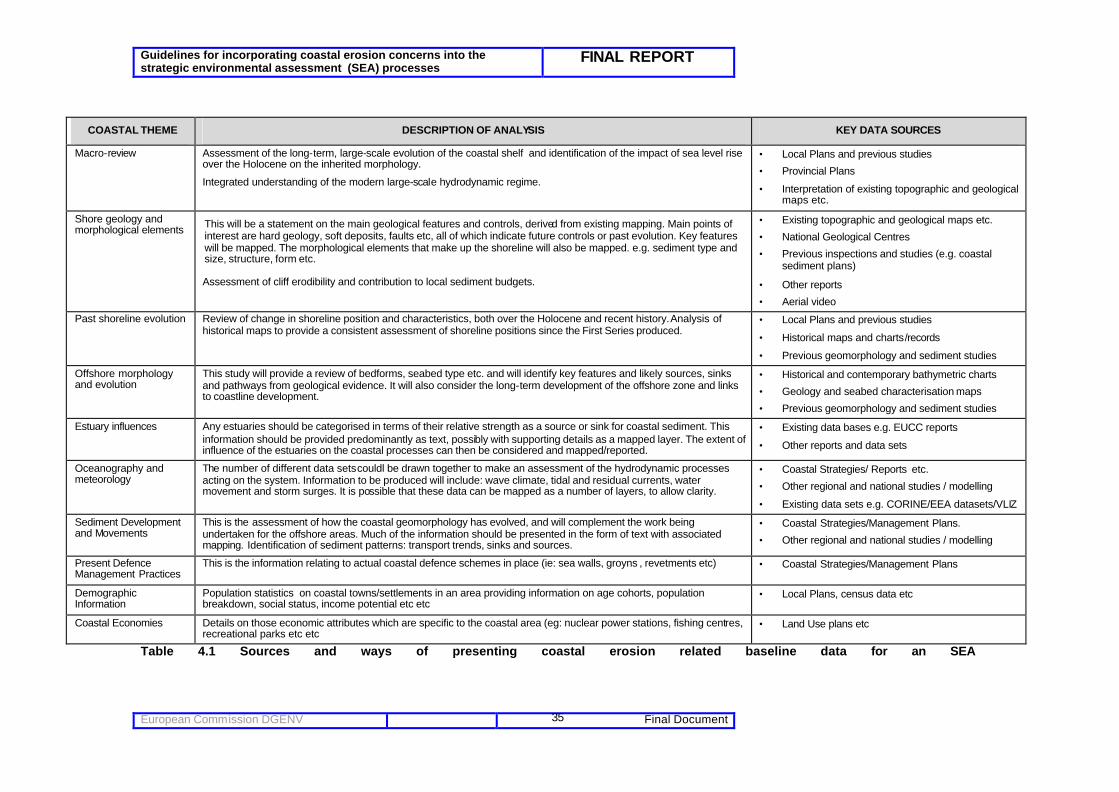
Guidelines for incorporating coastal erosion concerns into the strategic environmental assessment (SEA) processes
FINAL REPORT
European Commission DGENV Final Document
35
COASTAL THEME DESCRIPTION OF ANALYSIS KEY DATA SOURCES
Macro-review Assessment of the long-term, large-scale evolution of the coastal shelf and identification of the impact of sea level rise over the Holocene on the inherited morphology.
Integrated understanding of the modern large-scale hydrodynamic regime.
• Local Plans and previous studies
• Provincial Plans
• Interpretation of existing topographic and geological maps etc.
Shore geology and morphological elements This will be a statement on the main geological features and controls, derived from existing mapping. Main points of
interest are hard geology, soft deposits, faults etc, all of which indicate future controls or past evolution. Key features will be mapped. The morphological elements that make up the shoreline will also be mapped. e.g. sediment type and size, structure, form etc.
Assessment of cliff erodibility and contribution to local sediment budgets.
• Existing topographic and geological maps etc.
• National Geological Centres
• Previous inspections and studies (e.g. coastal sediment plans)
• Other reports
• Aerial video
Past shoreline evolution Review of change in shoreline position and characteristics, both over the Holocene and recent history. Analysis of historical maps to provide a consistent assessment of shoreline positions since the First Series produced.
• Local Plans and previous studies
• Historical maps and charts/records
• Previous geomorphology and sediment studies
Offshore morphology and evolution
This study will provide a review of bedforms, seabed type etc. and will identify key features and likely sources, sinks and pathways from geological evidence. It will also consider the long-term development of the offshore zone and links to coastline development.
• Historical and contemporary bathymetric charts
• Geology and seabed characterisation maps
• Previous geomorphology and sediment studies
Estuary influences Any estuaries should be categorised in terms of their relative strength as a source or sink for coastal sediment. This information should be provided predominantly as text, possibly with supporting details as a mapped layer. The extent of influence of the estuaries on the coastal processes can then be considered and mapped/reported.
• Existing data bases e.g. EUCC reports
• Other reports and data sets
Oceanography and meteorology
The number of different data sets couldl be drawn together to make an assessment of the hydrodynamic processes acting on the system. Information to be produced will include: wave climate, tidal and residual currents, water movement and storm surges. It is possible that these data can be mapped as a number of layers, to allow clarity.
• Coastal Strategies/ Reports etc.
• Other regional and national studies / modelling
• Existing data sets e.g. CORINE/EEA datasets/VLIZ
Sediment Development and Movements
This is the assessment of how the coastal geomorphology has evolved, and will complement the work being undertaken for the offshore areas. Much of the information should be presented in the form of text with associated mapping. Identification of sediment patterns: transport trends, sinks and sources.
• Coastal Strategies/Management Plans.
• Other regional and national studies / modelling
Present Defence Management Practices
This is the information relating to actual coastal defence schemes in place (ie: sea walls, groyns , revetments etc) • Coastal Strategies/Management Plans
Demographic Information
Population statistics on coastal towns/settlements in an area providing information on age cohorts, population breakdown, social status, income potential etc etc
• Local Plans, census data etc
Coastal Economies Details on those economic attributes which are specific to the coastal area (eg: nuclear power stations, fishing centres, recreational parks etc etc
• Land Use plans etc
Table 4.1 Sources and ways of presenting coastal erosion related baseline data for an SEA

Guidelines for incorporating coastal erosion concerns into the strategic environmental assessment (SEA) processes
FINAL REPORT
European Commission DGENV Final Document
36
4.4 Links to other relevant plans, programmes and environmental objectives
4.4.1 Comprehending Aspirations, Issues and Objectives The Lessons Learnt EUrosion report (Part IV – A guide to coastal erosion management practices in Europe – Lessons Learn May 2004) highlights the lack of consideration for coastal sediment transport processes in EIA, and links this to the poor level of sensitisation of project developers in the coastal zone. The lack of joined up “objective setting” amongst planners at an early stage is seen as a key factor in failing to address cumulative impact of an activity and whether it influences or is likely to be influenced by changing coastal erosion rates in the future. The SEA Directive requires an analysis of the plan or programme’s “relationship with other relevant plans and programmes” (Annex Ia) and “the environmental protection objectives… which are relevant to the plan or programme and the way those objectives and any environmental considerations have been taken into account during its preparation” (Annex Ie). This should help to reduce any lack of coherence between different plans. There is a need to be able to distinguish the difference between aspirations, concerns and objectives as often, many plans/programmes may not provide this distinction and it is one area where better clarification through the SEA process would prove very beneficial. The following explanations are presented for guidance only using generic examples where appropriate to highlight the differences that may arise between regions, sectors or even nations on coastal erosion issues. ASPIRATION – this is a stated desire or vision for a geographic length of coast, a time period (eg: “protect us for 100yrs”), future land use or for the management of a themed sector (i.e.: beach recreation). It stands alone against any cross-sectoral conflict. It is not an agreed or stated management agreement that requires implementation as it was presented. Commonly aspirations are presented in consultation letter form (sometimes from statutory bodies) even though they have no powers to fulfil its implementation. For example, “the landscape quality of the Catalonia region should be protected” - “Maintain area of habitat “, “Develop seafront of town x to accommodate casinos” etc CONCERN – this is a stated actual or perceived problem, raised by an individual or stakeholder. A concern can be either strategic or local and have cross sectoral or trans-boundary implications. ISSUE – Where two separate “aspirations” conflict. Such as aggregate extraction and beach depletion. Such a situation generates an “issue” that may be addressed within a coastal sediment management plan. Therefore, an Issue is NOT “high energy wave conditions”, but it becomes an issue if married with a planning aspiration to “encourage recreational boating” or “marina development” in an area. OBJECTIVE - an objective is set, through consultation with key parties, to encourage the resolution of the Issue or range of Issues. It is a des ired state to be achieved in the future. For example, where key priority coastal habitats are seen at risk from land use change or a natural shoreline evolution, this may be stated as “Implement restoration projects to both enhance flood control and achieve National Biodiversity Action Plan targets for the area”. Table 4.2 lists possible plans, programmes, environmental objectives and other relevant issues that may require integration of objectives with the plan or programme under consideration. For each relevant plan/programme/objective, it is important to analyse:

Guidelines for incorporating coastal erosion concerns into the strategic environmental assessment (SEA) processes
FINAL REPORT
European Commission DGENV Final Document
37
• What are main points of the other plan/programme/environmental objective etc? • Over what time and spatial scale is it relevant? • How does the plan/programme in question fulfil the requirements of the other
plan/programme/objective -- in this case, requirements related to coastal erosion concerns -- or if not, why not?

Guidelines for incorporating coastal erosion concerns into the strategic environmental assessment (SEA) processes
FINAL REPORT
European Commission DGENV Final Document
38
Table 4.2 Relevant plans, programmes, environmental objectives and other issues
Relevant plans, programmes, environmental objectives and other issues Environmental issues from the SEA Directive Annex I (f)
Relevant sub-impacts linked to coastal sediment management Higher tier, national and regional level
(For example: Coastal Sediment Management Plans, ICZM Plans, River Basin Management Plans, Catchment Flood Management Plans)
Medium tier, sub-regional and local level (For example: Coastal Defence strategies, Catchment Abstraction Management Strategies, Tourism Action Plans, Marine Aggregate Plans)
Biodiversity and Flora and Fauna; Focus on coastal/marine biodiversity
• Species • Coastal habitats • Coastal ecological processes • Marine biodiversity • Coastal geomorphology
• Development/land use plans • National biodiversity action plans (BAP) • Habitat action plans • Coastal Sediment Management Plans • Coastal Habitat Management Plans
(CHaMPS) • Fisheries Management Plans
• National and local biodiversity action plans and habitat action plans.
• Local wildlifeorganisation conservation targets (Some overlaps with flora and fauna). • SAC Management Scheme Plans • Marine SPA Schemes of Management • Oil spill contingency plans
Population; Coastal demographic change and diversity issues.
• Total coastal population • Demographic cohort of aging coastal
population • Employment (incl seasonal) • Quality of life of coastal towns • Opportunities for individuals
• Regional Spatial Strategies (trends for growth or loss of population);
• Regional Economic Strategies (Employment trends)
• Distribution and trends in population at a local authority level.
• Levels of employment, trends in employment at a local authority level.
• Harbour Plans • Coastal Tourism/Recreation Plans
Human health; Population’s health in general in coastal towns/villages. Trends of future change linked to industrial development or land use change proposals .
• Hospital admissions • Provision of healthcare • Trauma /stress linked to coastal
erosion • Leisure pursuits on coast • “Value” of coastal living
• Regional health statistics, hospital admissions • Clusters of health issues evident regionally • Development /Struc ture Plans
• Local health issues • Provision of health facilities, and accessibility
at a local authority level • Oil spill contingency plans • Port waste management plans • Health and safety coastal Codes of Practice.
Soil; Linked to cliff instability and erosion.
• Quality of coastal land • Land use • Cliff Drainage Issues • Cliff Instability • Groundwater • Erosion/Accretion issues
• Regional issues with contaminated land and quality of land.
• Coastal Sediment Management Plans • Catchment Flood Management Plans
• Agricultural land classification • Contaminated land and pollution • Cliff Erosion susceptibility • Coastal Defence strategies • Catchment Abstraction Management
Strategies Water; The quality and availability of surface and sub-surface waters.
• Water resources • Water quality • Flood risk • Coastal overtopping • Surface water run off • Ground water infiltration • Oil spill pollution
• General Quality Assessment • Coastal water quality Objectives (part of ICZM
Plan) • Indicative coastal floodplain mapping • Flood warning areas • Catchment Abstraction Management
Strategies • Catchment Flood Management Plans • Coastal Sediment Management Plans • River Basin Management Plans (post 2007)
• General Quality Assessment • Groundwater source protection zones • Flood warning areas • Catchment Abstraction Management
Strategies • Oil spill contingency plans • Port waste management plans • Health and safety coastal Codes of Practice.

Guidelines for incorporating coastal erosion concerns into the strategic environmental assessment (SEA) processes
FINAL REPORT
European Commission DGENV Final Document
39
Relevant plans, programmes, environmental objectives and other issues Environmental issues from the SEA Directive Annex I (f)
Relevant sub-impacts linked to coastal sediment management Higher tier, national and regional level
(For example: Coastal Sediment Management Plans, ICZM Plans, River Basin Management Plans, Catchment Flood Management Plans)
Medium tier, sub-regional and local level (For example: Coastal Defence strategies, Catchment Abstraction Management Strategies, Tourism Action Plans, Marine Aggregate Plans)
Air; Air quality
• Air quality problems • Sensitive receptors • Traffic • Industrial • Construction
• Regional air quality issues. • Regional air quality issues. • Local air quality management areas
Climatic factors; Long term trends in weather patterns at large geographic and temporal scales and climate change.
• Climate change trend • Amount of rain • Distribution of rain • Temperatures
• Predicted trends for weather • Impacts of changing climate at a regional
scale.
• Predicted trends for weather • Impacts of changing climate at a regional
scale. • Local implications of climate change
Material Assets; Infrastructure This section is more likely to be described as land use, in particular when there are large areas of development.
• Public access to facilities • Future land use allocation • Availability of services; • Infrastructure
• Regional level priorities for land use. • Government policy for development. • Key statements in local development/land use
plans • Regional trends for development, demand for
services and infrastructure
• Regional level priorities for land use. • Local authority development/land use plan
proposal maps; • Strategic transport infrastructure • Other key services e.g. energy, water supply,
waste management. • Landowner Management Plans
Cultural, architectural and archaeological heritage; These refer to the historic environment, including buildings, landscape and archaeology.
• Known archaeology • Unknown archaeology • Built heritage • Cultural heritage • Landscape heritage (see landscape)
• World Heritage Sites and areas • Landscape character areas (assessments)
• World Heritage Sites and areas • Landscape character areas • Designated historical monuments • Built environment conservation areas. • Archaeological sites
Landscape; Landscape is a combination of the visual dimension with other factors including geology, topography, soils, cultural heritage, land use, ecology and architecture which determine its overall character. It is therefore part of our natural, social and cultural heritage resources base.
• Character • Quality • Landscape heritage • Value • Visual amenity
• Marine National Park Plans; • Landscape designations • Landscape character areas
• National Parks • Landscape designations • Landscape character areas • Special landscape areas • Built environment conservation areas
Interactions between the above factors
• Beneficial interaction • Detrimental interactions
• E.g. water quality assessment relationship and Natura 2000 or Ramsar sites.
• Local Agenda 21 plans
• E.g. land use policy and scheduled monuments.

Guidelines for incorporating coastal erosion concerns into the strategic environmental assessment (SEA) processes
FINAL REPORT
European Commission DGENV Final Document
40
4.5 Prepare draft environmental report and consult The Environmental Report is a key element of the environmental assessment required by the Directive. Where SEA is required, an Environmental Report must be prepared in which the likely significant environmental effects of implementing the PP as well as reasonable alternatives (taking into account the objectives and the geographical scope of the PP) are identified, described and evaluated. The process of preparing the Environmental Report should start as early as possible and, ideally, at the same time as the preparation of the PP. The preparation of the Environmental Report and the integration of coastal erosion considerations into the preparation of plans and programmes form an iterative process that contributes to more sustainable solutions in decision-making. Article 5.4 of the SEA Directive requires consultation with relevant authorities on the “scope and level of detail” of the SEA. Typically this would be done after the stages highlighted in Sections 4.2 - 4.4 of this document have been undertaken. The data from those stages would be compiled into a draft Environmental Report covering: • The draft objectives of the plan or programme. • The other plans, programmes and objectives relevant to the plan, with information on potential
synergies or conflicts. • Baseline data, either already collected or still needed, with notes on sources and any problems
encountered. • Environmental problems and constraints, and how these were identified. • The options which it is proposed to consider in more detail, if appropriate (see Section 5.2) • Suggestions on methodology for the rest of the SEA. • Proposals for the structure and level of detail of the Environmental Report. As the plan or programme evolves, and the SEA is added to and refined, further consultation is required. Table 4.3 summarises the SEA Directive’s consultation requirements. Stage of SEA Mandatory Requirements Additional
Requirements where the plan/programme is likely to have significant trans-boundary effects
a Determination if a plan or programme requires SEA
Consultation of authorities (Art. 3.6) Information made available to the public (Art. 3.7)
b Decision on the scope and level of detail of the SEA
Consultation of authorities (Art. 5.4)
c Environmental report and draft plan or programme
Information made available to authorities and the public (Art. 6.1) Consultation of authorities and the public (Art. 6.2)
Consultation of authorities and public in the Member State likely to be affected (Art. 7.2)
d Adopted plan or programme; statement on how the SEA information has been taken into account in decision-making (Art. 9.1b); monitoring measures
Information made available to authorities and public (Art. 9.1)
Information made available to the consulted Member State (Art. 9.1)
Table 4.3 Summary of the SEA Directives consultation requirements (Adapted from EC - 2003)

Guidelines for incorporating coastal erosion concerns into the strategic environmental assessment (SEA) processes
FINAL REPORT
European Commission DGENV Final Document
41
As a consequence of the large spatial scales of coastal erosion issues, and because coastal sediment cells often do not match administrative boundaries, it is likely that a wider range of consultees – including consultees from other countries and/or administrative areas - will need to be involved for plans and programmes affecting the coast. Such consultees should include coastal experts; and planners from authorities affecting, and affected by, the plan in question. A wider range of ‘public’ may also need to be consulted.
Figure 4. “Inventory Map of Stakeholders used in the SEA”. The development of the plan/programme is often a long term process including several rounds of consultations. Therefore, the management of consultation procedures at the SEA level plays a greater role than for project EIA, with more feedback cycles.
4.6 Monitoring
The SEA Directive requires the Environmental Report to include “a description of the measures envisaged concerning monitoring” (Annex Ii), and requires Member States to “monitor the significant environmental effects of the implementation of plans and programmes in order, inter alia, to identify at an early stage unforeseen adverse effects, and to be able to undertake appropriate remedial action” (Article 10.1). Attempting to unravel natural change from human induced coastal change remains a constant area of debate. The importance of strategic regional shoreline monitoring is well acknowledged: the use of common approaches and capturing time series information that is “fit for purpose” is key. It is also important to be able to deduce, through shoreline monitoring where possible, the cumulative implications of plans/programmes requesting an SEA to be produced. Time series data is required, though being able to detect and “accuse” a plan/programme of an impact is very difficult to prove. Regional monitoring exercises are currently being tested in ‘coastal observatories’: for instance the UK Channel South Coast Observatory (www.channelcoast.org) has brought together all local authorities and those responsible for shoreline monitoring to standardise the capture of shoreline information. The

Guidelines for incorporating coastal erosion concerns into the strategic environmental assessment (SEA) processes
FINAL REPORT
European Commission DGENV Final Document
42
results can then be interpreted by other sectors as required. Where it is available, such data can be used in the SEA; where it is not, then separate data collection, specifically to monitor the effects of the adopted plan/programme, will be needed.
The major task of outcome evaluation is measuring change in outcome conditions and confidently attributing some or all of these changes to the plan/programme being reviewed. Monitoring the outcomes of plans/programmes on coastal areas is therefore of key importance. The Maasvlakte 2 project in Rotterdam, is part of Rotterdam Mainport Development Project. The aim of this project is to improve both the economy and the quality of life in the Rotterdam region. The two other components are the creation of a new 750 ha area around Rotterdam, devoted to nature and recreation, and a number of projects geared to making more intensive use of the existing space in Rotterdam’s port area. The monitoring of this development (being carried out over two phases up to 2023), requires clear evaluation of the wider strategic outcomes and coastal erosion impacts. Uncertainty lies on the responsibilities that each actor/stakeholder actually has on monitoring outcomes.
Evaluative studies of coastal erosion related initiatives focusing on outcomes are rare and are also the hardest and most infrequently completed type of evaluation. However, they are the most important if it is to be demonstrated that an SEA is having a beneficial impact 'on- the- ground'. There are various challenges in the design of a suitable outcome monitoring framework. Nevertheless, the following are presented to help decision makers and planners to try to incorporate outcome monitoring into the initial design of a plan/programme (with specific focus on coastal erosion issues). These include:
• There needs to be consensus on appropriate coastal indicators for measuring specific outcomes;
• There needs to be good quality coastal erosion related baseline and time-series data on which to base these indicators;
• Use techniques to model different types of shoreline evolutionary cause and effect relations;
• Appreciation of time for the effects of human activities to become apparent;
• Determining causation (e.g. determining the extent to which coastal erosion, rather than other factors, caused the outcome being measured);
.
Chapter conclusions
Practical messages to note are that there is a difference in screening detail required between an EIA and an SEA. This is especially the case with regard to the variance in timescales and outlook that different plans / programmes often need to consider at both the screening and scoping phases. This is because commonly, plans such as local and regional plans cover up to 20 years whereas plans such as tourism or transport master plans, for example, are often designed to cover 5 or 10 years to allow flexibility in economic driver trends. To achieve the EUrosion Vision, the ability of these plans to acknowledge the importance of planning longer term (50 to 100 years for a coastal sediment management plan) is paramount and needs to be considered by planners early on in the preparation of an SEA. Planners need also to appreciat e that plans and programmes may potentially affect coastal erosion across national boundaries into neighbouring countries. Consequently, the development of trans-boundary coastal erosion or “sediment transport” objectives is an increasingly important message that should be incorporated into screening of any SEA. The Guidance Document does not provide detail on exactly what should be included within an SEA Environmental Report, though in terms of an environmental baseline, where coastal erosion is identified during the scoping process as being an issue, an SEA should describe coastal erosion and sediment processes and its wider context, identify where possible what the key causes of coastal erosion are and where possible, identify shoreline behaviour over time and key impacts thereof .

Guidelines for incorporating coastal erosion concerns into the strategic environmental assessment (SEA) processes
FINAL REPORT
European Commission DGENV Final Document
43
Monitoring outcomes as part of the SEA process is paramount. With relation to coastal sediment management, it is more important for planners to be able to deduce the outcome of a coastal defence policy than actually monitoring the impact of a defence policy. Evaluative studies of coastal erosion related initiatives that focus on outcomes are rare and are also the hardest and most infrequently completed type of evaluation. Nevertheless, they are the most important if SEA is to demonstrate having a beneficial impact 'on- the- ground'.

Guidelines for incorporating coastal erosion concerns into the strategic environmental assessment (SEA) processes
FINAL REPORT
European Commission DGENV Final Document
44
5 Alternatives, prediction, evaluation, mitigation
This chapter discusses, for those plans and programmes likely to have a significant effect on coastal erosion, how to identify relevant alternatives, and predict and evaluate their likely impacts, and suggest mitigation for any significant adverse impacts. It also discusses how plan/programme alternatives/options can be identified and assessed early enough in the decision making process to illuminate issues of coastal erosion impact on the long term. Clarification on what is meant for each of these terms is presented in the table below. Definition Coastal Example Alternatives Choices open to plan/programme
makers for delivering the plan/programme objectives.
To assess whether port/marina development, nature conservation or urban development along a length of coast is the primary factor.
Prediction Identification and description of the changes to the environmental baseline (impacts) that are predicted to arise from the plan/programme.
To predict whether the proposed urban development creates regional coastal management problems further downdrift; predict whether the scale, magnitude and location of the development exacerbates planning and management problems elsewhere; predict the likely environmental and cumulative impacts downdrift etc (increased population problems).
Evaluation Determination of whether an impact is significant or not.
Based on prediction findings (modelling results etc), evaluate whether the proposed urban development and associated activities would increase sedimentation and coastal erosion significantly.
Mitigation Measure to avoid, reduce or offset significant adverse effect of the plan/programme.
Based on the evaluation criteria used, propose suitable engineering or planning mitigation measures/policies such as hold the line, move seaward, managed realignment… or move the development further inland, reduce its scale etc.
5.1 Identifying alternatives The SEA Directive requires the Environmental Report (see Section 4.5) to consider “the likely significant effects on the environment of implementing the plan or programme and reasonable alternatives taking into account the objectives and the geographical scope of the plan or programme” (Article 5). Any assessment of alternative management scenarios within SEA processes, to allow consideration of coastal erosion issues, will be dependent upon two key aspects:
• Is there a current or future concern linked to coastal erosion? • What is the nature of the coastline in question (hard or soft coast)?
Alternatives within SEA can be either options which involve a clear choice (eg: allow development in area A or don’t allow development); or else combinations of different components in various ways, with any range of them included in a plan or equally taken out of a decision making plan.

Guidelines for incorporating coastal erosion concerns into the strategic environmental assessment (SEA) processes
FINAL REPORT
European Commission DGENV Final Document
45
Alternatives may be grouped into scenarios, for instance “business as usual, policy target or “deep green” or “deep red” growth options (eg: rapid economic growth or over compensation on environmental delivery targets). This is a particularly effective mechanism for coastal erosion management problem solving. Alternatives may be designed to respond to, or reflect, different future outcomes linked to changing strategic economic and social pressures. For instance Figure 3.1 outlined a series of possible future outcomes, and identifies who would be responsible for the potential coastal response: it represents “options” for future coastal sediment management. For some issues, a hierarchy of options should be considered, from need/obviation of demand, to mode/process, location, and timing and detailed implementation (ODPM, 2003). Figures 5.2 and 5.3 show two examples with relevance to coastal erosion. These being potential erosion issues linked to a port development, and a housing strategy on an eroding stretch of coast (coastal sediment management defence options). Minimising demand (obviation) is often environmentally and socially better than providing for demand or rationing consumption through price or limited capacity. Obviation is not the same thing as restricting or thwarting demands: it should be seen as looking for different, more sustainable means to, achieve human quality of life ends. Providing coastal examples may help to understand this, such as better use of recycled aggregates might reduce the need for marine aggregate extraction; better planning of coastal resorts to accommodate for seasonal beach change and re-use of dredged spoil on a foreshore (bolstering inter-tidal foreshore levels) can reduce the capital demand for coastal protection works etc.
Table 5.1 details some examples of alternatives.

Guidelines for incorporating coastal erosion concerns into the strategic environmental assessment (SEA) processes
FINAL REPORT
European Commission DGENV Final Document
46
Examples of alternatives (ODPM, 2003) Many of these are alternatives to more conventional forms of development (adaptable to coastal erosion situations). Not all are within the direct remit of land use plans, but they can be supported, or made more difficult to achieve, by planning. Topic Obviation Mode/type Location Implementation / timing Transport / accessibility
Reduce the need to travel by locating amenities/services nearer their users, or housing users nearer the amenities they need; helping people meet more needs at home (e.g. homeworking, information technology) Support community-scale infrastructure and services to reduce need to transport goods, e.g. small-scale incinerators, reservoirs, wind turbines
Encourage walking and cycling Support good public transport, matched to journey desires (e.g. provides sites for modal interchange, protect rail corridors)
Locate amenities/services together, so people can accomplish several errands in one trip, e.g. multi-functional town centres Locate bike stands and bus stops more conveniently than parking
Have walking/cycling infrastructure and public transport services in place before development comes into use If extra traffic capacity is unavoidable, design at minimum necessary capacity, avoid discouraging other modes (e.g. design in traffic calming, safe routes for pedestrians and cyclists), minimise noise, land take and visual intrusion
Shopping / retail development
Provide services in a different way, e.g. allotments that allow people to grow their own food, local non-monetary exchange schemes, community centres Meet demands through: • changes to existing businesses e.g. village
shops also acting as bank or post office • better use of existing property, e.g.
subdivision, shop within a shop • new technologies, e.g. e-commerce
(possibly using existing retailers and delivery rounds)
Buildings adaptable for multiple uses. Promote farm shops and other shops that provide local goods locally
Retail and service centres that allow multiple errands in single trips, near public transport, near users
Ensure that provision is in place when housing is occupied, to avoid unsustainable transport habits becoming established
Economic development
Meet needs or provide occupation without more business development, e.g. community / cooperative schemes for childcare, home maintenance, food growing, play schemes
Support locally owned and managed businesses; production of goods/services to meet local needs
Near customers and/or raw materials (e.g. market gardens around settlements)
Develop businesses in tandem with housing to reduce the need to commute long distance Develop at a pace and form that takes up ‘slack’ in staff and buildings as it occurs - neither displacing old but still viable businesses nor leaving a gap of unemployment / decay
Rural economic development, farm conversion & diversification
Avoid need to convert or diversify by supporting new opportunities, e.g. organic, locally distinctive, locally processed and marketed, high value added
Promote activities that require much land but not quick/frequent access to urban amenities: e.g. wildlife, retreat
Given Develop in a manner that supports other agricultural/rural uses and the local community
Tourism Improve standard of where people live; provide Activities aimed at local or Near users / public Engage local people in decision and

Guidelines for incorporating coastal erosion concerns into the strategic environmental assessment (SEA) processes
FINAL REPORT
European Commission DGENV Final Document
47
local recreation/leisure facilities, green areas, beach safety issues etc
short distance visitors; convenient reliable access by foot, cycle, public transport
transport implementation
Housing generally
Match supply to needs: • encourage adaptation of buildings to
maximise the potential for comfortable occupation (e.g. loft and garage conversions, subdivision of large houses)
• high standard sheltered accommodation for older people as an alternative to staying in unnecessarily large houses
Make best use of existing building stock: • encourage living above shops (flood risk) • conversion of redundant non-domestic
buildings, loft conversions, flexible subletting of surplus space
Make best use of land: • encourage infill,
development of small sites, rebuilding at higher densities
• promote dense and land-efficient built forms, e.g. terraces, low rise flats, communal open spaces
• maximise density • use existing infrastructure
in new construction
Minimise new infrastructure demands (e.g. by avoiding locations remote from amenities) Focus new housing on brownfield sites and away from floodplains
Match timing of housing development to needs and to public service provision Encourage self-build or community-build housing as a way of reducing costs and promoting participation
Affordable housing
Reduce loss of affordable housing, e.g. disincentives to second homes in coastal resort towns .
Promote flexible/modular housing where residents can buy a 'starter pack' and add onto this as circumstances permit
Site and configure housing to maximise opportunities for people to stay near family, community ties and work
Match to demographic profile of customers
Waste Encourage developers to prepare waste management plans for coastal areas
Ensure that waste can be used as a resource by providing facilities for storing recyclable products (e.g. architectural salvage yards, sites for storage of recycled aggregates)
Locate waste management sites near source of waste and/or users of waste as resource
Provide recycling facilities at housing and employment sites Use materials efficiently in construction. Use recycled materials in construction
Energy Reduce demand for energy in housing by promoting low energy lighting and appliances, very efficient boilers, high insulation standards, conservatories and lobbies, large south-facing and small north-facing windows etc
Promote renewable energy, energy from waste, Combined Heat and Power
Small-scale, community-owned renewable energy installations to minimise transmission loss
Use best available energy efficiency technologies in building construction and operation; site housing to optimise solar gain; use materials with low embodied energy
Water Promote rainwater collection systems, effluent recycling
Consider several smaller facilities rather than one large one
Promote use of water-saving devices, e.g. low-flow showers, low-flush toilets Promote landscaping using plants that do not require much watering
Table 5.1 Examples of Alternatives that could be adapted to coastal erosion situations.

Guidelines for incorporating coastal erosion concerns into the strategic environmental assessment (SEA) processes
FINAL REPORT
European Commission DGENV Final Document
48
Need or demand: is it necessary?
Can the need or demand be met without new development / infrastructure at all? Can development be obviated? (eg: is the port development of national importance and needed to help transport planning need?)
i assume it is Mode or process: how should it be done?
Are there technologies or methods that can meet the need with less environmental/sustainability damage than ‘obvious’ or traditional methods? (if the port is needed, can it be designed to minimise impact on sediment transport regimes or can sediment bypassing pumping be instigated?)
i Location: where should it go?
(could the port be located away from sediment reservoirs or strategically important environmentally areas ?)
i Timing and detailed implementation: When, and in what sequence, should
developments be carried out? What details matter, and what requirements should be made about them?
(engineering design report details for the proposed port – EIA level of detail – see EUrosion REPORT 5_4)
Figure 5.2: Example of hierarchy of options: possible port development
Need or demand: is it necessary?
Can the need or demand be met without new development / infrastructure at all? Can development be obviated? (eg: is the housing development of regional/national importance and needed to alleviate housing problems?)
i assume it is Mode or process: how should it be done?
Are there technologies or methods that can meet the need with less environmental/sustainability damage than ‘obvious’ or traditional methods? (if the new town is needed, what are the long term coastal evolution trends for the area and is it likely to be a sustainable location to build a new development?)
i Location: where should it go?
(Is there a need for a preferred set back line to be agreed upon for the development?)
i Timing and detailed implementation: When, and in what sequence, should
developments be carried out? What details matter, and what requirements should be made about them?
(future coastal defence design details for the proposed housing development – EIA level of detail – see EUrosion REPORT 5_4)
Figure 5.3: Example of hierarchy of options – possible new coastal housing development

Guidelines for incorporating coastal erosion concerns into the strategic environmental assessment (SEA) processes
FINAL REPORT
European Commission DGENV Final Document
49
5.2 Predicting and evaluating the environmental impacts of alternatives
The SEA Directive requires the Environmental Report to discuss “the likely significant effects on the environment, including on issues such as biodiversity, population, human health, fauna, flora, soil, water, air, climatic factors, material assets, cultural heritage including architectural and archaeological heritage, landscape and the interrelationship between the above factors” (Annex If). Assessing the impacts of alternatives involves prediction of the impacts’ magnitude, duration, etc.; and evaluation of their significance. Impact prediction is a technical process; evaluation involves judgement. Figure 5.4 illustrates this.
Figure 5.4 Links between SEA prediction, evaluation and mitigation (Therivel, 2004)
5.2.1 Techniques to help weigh up alternatives together Impact prediction typically involves a range of techniques, including modelling, scenario testing, and/or expert judgement. Impact evaluation involves determining whether the impact is significant or not. This would typically be done by testing the predicted impacts against agreed targets (e.g. for water quality), the views of the local community (e.g. “we don’t want our access to the beach to get worse”), or again using expert judgement. Many of the techniques used in impact prediction can also help in evaluation: Table 5.1 suggests what tools might be used in what stage of SEA, and Box 5.1 gives brief details about these techniques. The heterogeneity of the nature of plans and programmes will require the use of different techniques according to the specific characteristics of a plan or programme.
Box 5.1 SEA prediction and evaluation techniques (based on Therivel, 2004; Therivel and Wood, 2004) Expert judgment involves one or more experts considering the relevant issue, possibly using formal approaches such as the Delphi technique. Expert judgment is quick, cheap, requires no specialist equipment, can lead to innovative solutions, copes with partial and unquantifiable information, and fosters innovation and inform ation sharing. On the other hand, it has the potential for bias depending on the experts involved, and is perceived as unscientific.
where mitigation changes the strategic action significantly
prediction: how will be coastline respond to the impact, when will this show itself?
evaluation: is the predicted coastal impact significant?
mitigation: can negative coastal impacts be reduced and positive ones enhanced?
target/threshold, expert judgement etc
Coastal strategic action
Shoreline impact prediction techniques
baseline coastal erosion data

Guidelines for incorporating coastal erosion concerns into the strategic environmental assessment (SEA) processes
FINAL REPORT
European Commission DGENV Final Document
50
Public participation: The public are informed, consulted or fully involved in identifying, predicting, assessing and mitigating the strategic action's impacts. This helps to ensure that the SEA is comprehensive and possibly makes the strat egic action easier to implement. However it takes time and resources, can be dominated by specialist interests, and it is often difficult to interest the public in strategic level issues. Impact matrices show the sub-components of the strategic action (or alternatives to the strategic action) on one axis and environmental topics or objectives on the other axis. The resulting cells show the effect of the sub-components or alternatives on the environmental objectives. Impact matrices can be used to summarise and present the results of other analyses or as assessment tools in their own right. They are simple to use and transparent, but do not cope well with indirect or spatially based impacts. Quality of Life Assessment identifies what matters and why in an area. Its core idea is that the environment, economy and soc iety provide a range of benefits for people, and that it is these benefits that need to be protected and/or enhanced. QoLA involves describing the relevant area; identifying the benefits/dis-benefits that the area offers; analyzing how important each benefit/dis-benefit is, to whom, why, whether there is enough of it, what (if anything) could substitute for the benefits, and what management implications this has for the benefit/dis-benefit. This allows a list to be devised of things that any management of that area should achieve. QoLA acknowledges the complementary role of experts and local residents, and promotes enhancement of an area, but it is anthropocentric and can reduce the environment into its subcomponents. Appendix D gives an example. Geographical information systems are a combination of a computerized cartography system that stores map data, and a database management system that stores attribute data. Links between map data and attribute data allow maps of the attribute data to be displayed, combined and analyzed with relative speed and ease. Table 4.1 suggests some maps of coastal erosion related data for which GIS data already exists. This could be further analysed, for instance by using buffer zones to identify housing affected by erosion and the socio-economic characteristics of residents living in those houses. Network analysis (also caused causal effect diagrams) aims to identify the key cause-effect links which describe the pathway from initial action to ultimate environmental outcome. In doing so, it can also identify assumptions made in impact predictions, unintended consequences of the strategic action, and possible measures to ensure effective implementation. It is particularly useful for identifying cumulative impacts. Modelling involves making assumptions about future conditions with and without the strategic action, and calculating the resulting impacts. Models typically deal with quantifiable impacts. Many models have evolved from EIA techniques and are computerized. Models of shoreline interactions and response include geomorphic extrapolation, shoreline response, extrapolation of historical data, and parametric equilibrium models. Models are perceived to be objective, 'scientific' and rigorous; but they are limited to impacts that can be quantified/modelled, can require large amounts of data, are often complex 'black boxes' that do not encourage public participation, and tend to promote project- rather than strategic-level thinking. Scenario/sensitivity analysis: The impacts of a strategic action, or the relative benefits and disbenefits of different options often depend on variables outside the strategic action’s control: for instance future noise levels in one authority could depend on whether an airport is built in a neighboring authority. The impact of a strategic action can be forecast and compared for different scenarios that describe a range of future conditions – sensitivity analysis – to test the strategic action’s robustness to different possible futures. Sensitivity analysis aims to reflect uncertainties and provide ideas for reducing uncertainties, but can be time and resource intensive. Multi-criteria analysis (also called multiple attribute analysis or multi-objective trade-off)

Guidelines for incorporating coastal erosion concerns into the strategic environmental assessment (SEA) processes
FINAL REPORT
European Commission DGENV Final Document
51
analyses and compares how well different alternatives achieve different objectives, and helps to identify preferred alternatives. It involves identi fying assessment criteria and alternatives; scoring how each alternative affects each criterion; assigning a weight (value of importance) to the impact; and aggregating the score and weight of each alternative. The scores and weightings are then multiplied and the results added up for each alternative. The alternative that scores most highly ‘wins’. MCA is easy to understand, can be used in a variety of settings, acknowledges diverse stakeholders with different goals and values, and reflects the fact that some issues ‘matter’ more than others. However it can lead to very different results depending on who determines the weights and scores. Risk assessment estimates the risk that products and activities cause to human health and ecosystems. It involves identifying possible hazards, estimating their frequency, and identifying and analyzing their likely impacts. Risks – frequency times impacts - can be phrased as the probability of a spec ified event, eg 1 in 100 chance of a flood in area X in a given year; or as consequences, eg 10 homes flooded per year. Risk assessment can be used to compare alternatives on the basis of the risk that they cause, but only considers one aspect of the ‘environment’ (i.e. risk/safety), often extrapolates the risks at high dose levels of a pollutant to low dose levels with consequent uncertainties, and its results can vary greatly depending on the assumptions made. Compatibility appraisal aims to ensure that the strategic action is internally coherent and consistent with other strategic actions . An internal compatibility matrix plots different components/statements of the strategic action on one axis and the same strategic actions on the other axis: matrix cells are filled in by asking ‘is this statement compatible with that statement or not?’. An external compatibility matrix plots the strategic action against other relevant strategic actions: matrix cells are filled in by listing those statements of the strategic action that fulfill the requirements of the other strategic actions, or explaining how the evolving strat egic action should take the requirements into account. Compatibility appraisal clari fies trade-offs and is easy to understand, but it is subjective.
SEA stage Type of technique
Technique
Des
crib
e b
asel
ine
Iden
tify
im
pac
ts
Pre
dict
imp
acts
Eva
luat
e im
pac
ts
En
sure
co
her
ence
Expert judgement ü ü ü ü ü Public participation ü ü ü Impact matrices ü ü ü
Qualitative, participatory
Quality of Life Assessment ü ü Mapping Geographical Information Systems (GIS) ü ü ü
Network analysis ü ü Modelling ü
Impact prediction
Scenario/sensitivity analysis ü Multi-criteria analysis ü Impact evaluation Risk assessment ü ü
Sound planning Compatibility assessment ü

Guidelines for incorporating coastal erosion concerns into the strategic environmental assessment (SEA) processes
FINAL REPORT
European Commission DGENV Final Document
52
Table 5.2 Possible applications of SEA prediction and evaluation techniques (see Box 5.1 for description of the techniques (Based on Therivel, 2004; Therivel and Wood, 2004)
5.2.2 Techniques to help evaluate alternatives in detail Impact predictions/evaluations are often summarised in a matrix. Table 5.3 shows an example of a matrix that analyses different temporal aspects (short, medium, long term) of one coastal policy option; Table 5.4 shows an example of a matrix used to compare different options. Matrices can also be used to identify cumulative impacts (by “reading across” the table).
Table 5.3 Example of a matrix to assess the impacts of one option/scenario (from Defra 2003b) SEA issue
Target
Option A Option B Option C Option D
biodiversity/flora/ fauna
10% increase in coastal cliff biodiversity levels over next 5 years
+ ++ 0 ?
population and human health
10% reduction in people living in tidal floodplain, by 2025.
- + -- -
Soil no worsening of soil wind erosion levels impacting on cliff integrity.
0 0 + ?
Table 5.4 Example of a table to compare the impacts of multiple options
5.2.3 Choosing between alternatives Alternatives are normally compared using SEA objectives or indicators. The comparison is typically done in a matrix format, with the alternatives along one axis and the indicators along the other. In some cases, one alternative will clearly be better than all the others, but in many cases the decision will be more complex. For instance the choice of one alternative (eg whether to promote tourism along a coast) could also affect the choice of another alternative (eg on transport infrastructure needed), or one environmental component may be more important than another.

Guidelines for incorporating coastal erosion concerns into the strategic environmental assessment (SEA) processes
FINAL REPORT
European Commission DGENV Final Document
53
SEA should highlight the environmental consequences of the alternatives, not make decisions. However, there are some obvious rules of thumb to follow in choosing the preferred alternative:
• avoid irreversible impacts; • give greater weight to longer -term impacts; • avoid impacts that would exceed environmental thresholds or limits; • avoid impacts on particularly sensitive areas; and • avoid impacts that affect ecosystems, resources or communities that have already been
cumulatively affected. The preferred alternative may not come from the original list of alternatives, but instead may include components of several of the original alternatives, or be a completely new option. The final choice will probably be a political decision, encompassing many issues in addition to the environment/sustainability, for instance political or security concerns (Therivel, 2004).
5.2.4 Uncertainty and risk in impact prediction The assessment of risk and uncertainty is central to decision making at all stages of plan-making. Risk assessment builds recognition of risk and uncertainty into the decision making process and can take the form of : • Mitigation (incorporation of procedures to limit consequences if risks occur). • Control (actions taken to avoid risks occurring). • Acceptance (e.g.: provision of an appropriate allowance in case the risk arises).
There should be a “common thread” of risk assessment running from the high level (European Regional Development Programme etc) through to the more detailed level (eg: coastal sediment management plan or local harbour dredging plan) and that all risks are identified at an early stage when the policies for coastal erosion management are being set. Without this approach, it may not be possible to implement them through future strategic considerations. Addressing a range of alternative management risk scenarios is therefore an important aspect, though need not be an onerous task depending on the geographic and socio-economic context of the programme or policy being assessed. Coastal typology has already been set for the coastal zone of Europe (see opposite) and this can be used to identify “at risk” coastlines at a broad level.
Identifying who is at risk from coastal erosion, when and why is a key component of understanding cumulative impact. This is because attempting to understand coastal erosion “cause” and “effect” is critically linked to how humans behave along the coast. Determining who actually benefits from a plan/programme as well as determining who is at risk is equally of importance. For example, does wider society, individuals, communities (local or regional), groups or institutions benefit from the plan/programme? The following four categories often help to amalgamate groups in this sense: • Individuals - not organizations.
• local - residents or people from an immediate catchment area (user groups/fishermen/business etc).
• regional users – regionally important stakeholders.
• national users .

Guidelines for incorporating coastal erosion concerns into the strategic environmental assessment (SEA) processes
FINAL REPORT
European Commission DGENV Final Document
54
There are a great range of drivers and factors that may influence or have an impact on future coastal sediment management decisions. These social and economic drivers may have been “organic” in origin (inevi table development) or promoted via plan/programme. These drivers may include : Social Economic Demographic change in an area Seaward development demands Increase demand for housing Renewable energy demands offfshore Increasing recreational time Increased marine resource extraction
(aggregates) Changing social landscape Port development pressures
5.3 Mitigation of significant adverse environmental impacts The environmental report should discuss “the measures envisaged to prevent, reduce and as fully as possible offset any significant adverse effects on the environment of implementing the plan or programme” (SEA Directive, Annex Ig). Mitigation can include technical measures, improved data management, knowledge management and networking, and financial or market -based instruments.
5.3.1 Technical measures and planning The EUrosion guide on Environmental Assessment outlines a wide range of technical and planning measures to mitigate significant coastal erosion effects: they are summarised in Appendix C. A t a more strategic level, authorities may need to identify strategic sediment reservoirs to counteract a negative sediment balance in a particular coastal zone will require a source of sediment to be identified. To facilitate the future availability of such an ‘appropriate’ sediment supply, the EUrosion project proposes the concept of ‘strategic sediment reservoirs’. These are defined as: “supplies of sediment of ‘appropriate’ characteristics that are available for replenishment of the coastal zone, either temporarily (to compensate for losses due to extreme storms) or in the long term (at least 100 years). They can be identified offshore, in the coastal zone (both above and below low water) and in the hinterland. After designation of strategic sediment reservoirs their availability should be ensured by leaving them undeveloped. This concept requires trans-boundary acceptance and compliance in terms of national policy setting between nations to ensure this vision is implementable. Intricate relationships exist between sedimentary systems because sediments also cross borders in the coastal zone. Participation, knowledge management and effective participation is therefore required to achieve this.
5.3.2 Improved data management
The work carried out by EUrosion to produce Local Information Systems needs to be developed further for SEA plans/programmes. These systems present the key requirements for a successful and decision-oriented information system in the field of coastal sediment management. The requirements cover a broad range of aspects including institutional and organisational procedures, functional requirements, data content specifications, database modelling, spatial representation and data access and exchange technologies. A prototype Local Information System (LIS) has been developed which can be customised for any regional authority willing to facilitate coastal data sharing.

Guidelines for incorporating coastal erosion concerns into the strategic environmental assessment (SEA) processes
FINAL REPORT
European Commission DGENV Final Document
55
Figure 5.5 Proposed adoption of LIS Principles into SEA Process (from EUrosion 2004d)
Whilst (EUrosion 2004d) covers the issue of LIS in more detail, the critical questions as to how this system may be used to assist in SEA planning is linked to the answers to the following questions :
• Will the plan/programme (investment) be exposed to coastal erosion hazard during its lifetime?
• Will the plan/programme (investment ) impact upon coastal erosion processes? • Do the benefits generated by the plan/programme (investment ) (including the
environmental benefits) exceed its costs (including environmental costs)? The importance of the appropriate data management system (LIS) and its subsequent design can then be integrated into the wider SEA management process as required. Details on “how“ this could be established require further consideration. However, EUrosion (2004d) does present the case for a regional database of information to help wider strategic planning even if datasets are at a 1:100,000 scale. This is the case in particular for the provision of data on offshore wave and wind regime (provided by EUrosion) which in turn can be transformed into near -shore wave and wind regime after combination with bathymetry and wave transformation models. These are clear illustrations that the availability of Europe-wide data may turn quite useful for certain SEA plan/programmes.
5.3.3 Training and capacity building The EUrosion report on environmental assessment showed the need for training of all EIA actors and for the early development of guidelines (i.e. before formal implementation). The same applies to SEA. In several Member States, and in particular in those countries where formal requirements for SEA exist, seminars or training courses on the integration of coastal sediment management and coastal erosion concerns into plans and programmes should take place. These training and dissemination efforts have been put on hold until the emergence of the SEA Directive. Even if there is no formal requirement for SEA at present, coastal erosion information need to be increasingly integrated into policies, plans and programmes. For this reason alone, training is needed. Because of the heterogeneity of SEA procedures, general SEA training is not possible. Training has to be oriented at the individual plan or program. Therefore, "learning by doing" or "training on the job" are regarded as most appropriate.

Guidelines for incorporating coastal erosion concerns into the strategic environmental assessment (SEA) processes
FINAL REPORT
European Commission DGENV Final Document
56
Dissemination and networking on coastal erosion management should not be restricted to environmental authorities and environmental specialists. Networking with the non-environmental or coastal sector is very important, too (e.g., networking with sectoral planners for transport, economy or tourism). Participation by the public can also help to ensure that any coastal erosion concerns are raised relating to the quality of life, the cultural and social heritage, and leisure. Public participation enables the proper application of procedures, whether under ICZM or environmental assessment. Appendix E gives further information on participation. Where possible, those involved in managing coastal erosion risk should seek to improve their public relations to disseminate possible benefits of incorporating coastal erosion matters into the SEA process to overcome political constraints that may arise.
5.3.4 Financial or market based instruments
Establishing liability for causing coastal erosion remains a difficult topic to address. In an attempt to share risk and most of the responsibility, and following a similar principle set out in the Environmental Liability Directive, EUrosion recommendations set out may be delivered through establishing a “Coastal Negligence Fund”. Where authorities or developers are found to have a direct impact on natural coastal resilience (eg: new large tourism development), a fund should be set up, financed by the developer or local authority that granted its planning acceptance, which would pool money into a “coastal cell bank”. This would be collated and re-used for preparation or updates to Coastal Sediment Management Plans or actual sustainable schemes/management within a coastal cell. Being able to apportion causes of impact does take time-series datasets (eg: beach profiles) to be consistent and robust. This therefore needs to be linked to effective and integrated shoreline monitoring programmes (see Section 4.6 and the EUrosion “Shoreline Management Guide” for more details on coastal erosion monitoring techniques).
A broader use of financial market instruments (eg: insurance issues) should be used in SEA processes, in particular financial transfer to transfer the costs related to adverse consequences of coastal erosion (externalities) from the community to investors through insurance policies, bank loan conditions, and limitations to disaster compensation funds.
Management schemes involving private and public sector organisations (establishing permits etc) is one positive way forward to address strategic coastal issues. The Aggregate Levy Sustainability Fund (ALSF) in England is one positive example of cross sectoral involvement to deliver research funds for better coastal sustainability. The aim of the ALSF is to support projects that will help to mitigate the effects of aggregate extraction at both the strategic and site specific levels, in particular by encouraging economy in the use of aggregates, increased use of recycled aggregates, better environmental management of aggregate sites and improved approaches to dealing with the legacy of damage from past quarry operations.
Chapter conclusions
The identification and assessment of alternatives is an important part of the SEA process. A hierarchy of options needs to be considered, from need/obviat ion of demand, to mode/process, location, timing and detailed implementation. Of relevance to coastal erosion issues, early appreciation and alternatives (eg: a port development or a coastal housing strategy on an eroding stretch of coast) need to be initially understood by all involved in the SEA process and from that, clearly ranked alternatives presented (using different appropriate techniques available) to help decision makers make judged decisions. Assessing the impacts of alternatives involves prediction of the impacts’ magnitude, duration and evaluation of their significance. Coastal erosion impact prediction is a technical process and
Guidelines for incorporating coastal erosion concerns into the strategic environmental assessment (SEA) processes
FINAL REPORT
European Commission DGENV Final Document
57
evaluation involves judgement. It is recommended that a “top level” impact assessment is carried out, based on an overview appreciation of shoreline evolution at a strategic level by testing the predicted impacts against agreed targets (e.g. for coastal water quality), the views of the local community, or using expert judgement. Many standard techniques can be used (eg: risk assessment, multi criteria analysis etc) to help assess impact prediction to aid evaluation. Importantly, from any assessment of alternatives carried out, the SEA should highlight the coastal erosion related consequences of the alternatives, though not make any decisions as to the possible outcome of the option to be selected. Mitigation strategies (ranging from improved training to better data management) can then be advocated for further consideration within the SEA.

Guidelines for incorporating coastal erosion concerns into the strategic environmental assessment (SEA) processes
FINAL REPORT
European Commission DGENV Final Document
58
6 Key Messages
Coastal sediment management considerations can influence present day and future generations in a number of ways. They can affect coastal and non coastal populations and may also impact on trans-boundary considerations. The SEA Directive sets out procedures that need to be fulfilled during the preparation of a plan or programme. SEA can help to support the economic regeneration of coastal areas, and ensure that social and environmental assets are not devalued. This Guide encourages all Member States to understand the pot ential of SEA and how, by addressing coastal erosion issues in plans/programmes, non-coastal as well as coastal populations/industries may benefit in the future. Although the SEA Directive applies to only a relatively limited range of plans and programmes, other policies, plans and programmes – for instance coastal sediment management plans and national policies on marine aggregates - also have the potential to have significant effects on coastal erosion. SEA should ideally be applied to these policies, plans and programmes as well. In some cases, this would involve private companies voluntarily carrying out SEA of their plans (e.g. marina developments etc). As the nature of private plans and programmes differs considerably from the formalised plans and programmes by public agencies, new procedures will have to be developed for the private sector. For example, the consultation of authorities and public participation probably would meet resistance. The existence of a national Coastal Sediment Management Plan or a strategy for sustainable development (ICZM Plan as recommended from the current EU Recommendation on ICZM), from which coastal quality objectives can be derived, will certainly help an SEA to be aware of longer term coastal resilience issues. The following represent the key messages of this guidance document :
• Instil the EUrosion Vision Concepts of Coastal Resilience and Strategic Sediment Reservoirs EARLY IN THE PROCESS to planners and decision makers on an SEA trans -national level.
• Instil the principles of ICZM to help SEA plans/programmes to prepare integrated objectives, even if SEA is not mandatory. Objectives should attempt to acknowledge or where possible restore the natural resilience of the coast to sea level rise and human induced pressures.
• Ensure mechanisms are set up to enable knowledge on coastal erosion issues to be better communicated at various temporal and spatial scales, thus helping to support the implementation of SEA for plans/programmes. Coastal zones are quite varied, and the information must be adapted for these different circumstances. Strengthening networks for the exchange of coastal erosion information and expert knowledge between the Member States (between coastal and non coastal experts) is vital.
• The above points apply to policies, plans and programmes NOT required by the SEA Directive, as well as plans/programmes that are.
• Integrating coastal erosion data and information in plan -making is NOT an onerous task and its incorporation into expected planning procedures required for the preparation of a SEA plan should be straight forward. Coastal erosion issues can also be linked directly to similar guidance produced for biodiversity and climate change (Therival 2004).
• Training on coastal erosion risk appraisals to SEA policy makers (transport planners etc) is recommended.
.
Guidelines for incorporating coastal erosion concerns into the strategic environmental assessment (SEA) processes
FINAL REPORT
European Commission DGENV Final Document
59
7 References
Alonso J, Alcantar-Carrio and Cabrera L (2002) “Tourist Resorts and their Impact on Beach Erosion at Sotavento Beaches, Fuerteventura, Spain” Journal of Coastal Research Special Issue 36, 2002. Atkins (2004) ICZM in the UK: A Stocktake http://www.defra.gov.uk/environment/marine/iczm/stocktake/full-report.pdf Channel Coastal Observatory (2004) http://www.channelcoast.org CORINE coastal erosion database (2004): European Environment Agency. http://dataservice.eea.eu.int/dataservice/metadetails.asp?id=236 Countryside Council for Wales, English Nature, Environment Agency, Royal Society for the Protection of Birds (2004) Strategic Environmental Assessment and Biodiversity: Guidance for Practitioners, www.rspb.org.uk/policy/planningpolicy/s_e_a.asp. Defra (2002) Future Coast Project. Defra (2003a) Managed Realignment: Land purchase, compensation and payment for alternative beneficial land use, http://www.defra.gov.uk/environ/fcd/policy/mrcomp.htm Defra (2003b) Procedural Guidance for Production of Shoreline Management Plans: interim guidance, Appendix L: standard output formats, http://www.defra.gov.uk/corporate/consult/smpguidance/appendices/appendixl.pdf EC Directorate General DGXI (2001) Assessment of plans and projects significantly affecting Natura 2000 sites: Methodological guidance on the provisions of Article 6(3) and 6(4) of the Habitats Directive 92/43/EEC
EUCC (European Union for Coastal Conservation) Coastal Guide (2004) http://www.coastalguide.org/links/cme.html European Commission (2001) Directive 2001/42/EC on the assessment of the effects of certain plans and programmes on the environment , http://europa.eu.int/comm/environment/eia European Commission (2003) Implementation of Directive 2001/4/EC on the assessment of the effects of certain plans and programmes on the environment , Belgium EUrosion GIS Database (2004) http://www. EUrosion.org/database/index.html EUrosion (2004a) Living with Coastal Erosion in Europe: Sediment and Space for Sustainability: Guidelines for incorporating coastal erosion issues into Environmental Assessment (EA) procedures, prepared for European Commission Directorate General Environment, Service contract B4-3301/2001/329175/MAR/B3. http://www.EUrosion.org/reports-online/part5_4.pdf EUrosion (2004b) Living with Coastal Erosion in Europe: Sediment and Space for Sustainability: A guide to coastal erosion management practices in Europe, prepared for European Commission Directorate General Environment, Service contract B4-3301/2001/329175/MAR/B3. http://www.EUrosion.org/reports-online/reports.html

Guidelines for incorporating coastal erosion concerns into the strategic environmental assessment (SEA) processes
FINAL REPORT
European Commission DGENV Final Document
60
EUrosion (2004c) Living with Coastal Erosion in Europe: Sediment and Space for Sustainability: Part IV-A guide to coastal erosion management practices in Europe: Lessons Learned, prepared for European Commission Directorate General Environment, Service contract B4-3301/2001/329175/MAR/B3. http://www.EUrosion.org/reports-online/part4.pdf EUrosion (2004d) Living with Coastal Erosion in Europe: Sediment and Space for Sustainability: PART 5_0 – Guidelines for implementing local information systems dedicated to coastal erosion management Executive Summary INSPIRE (Infrastructure for Spatial Information in Europe) European Geo-Portal (2004) http://eu -geoportal.jrc.it/ Office of the Deputy Prime Minister (2003) The Strategic Environmental Assessment Directive: Guidance for Local Planning Authorities , London. Serra J and Montori C (2003) “Morphology And Sedimentary Processes of The Subaqueous Tordera River Delta, Nw Mediterranean (Spain). Paper presented at the Coastal Sediments 03 Conference. Therivel, R. (2004) Strategic Environmental Assessment in Action, Earthscan, London. Therivel, R. and G. Wood (2004, forthcoming) “Tools for SEA”, Chapter 25 in Schmidt, M., E. Joao, L. Knopp and E. Albrecht, Implementing Strategic Environmental Assessment , Springer -Verlag. Yorkshire and Humber Assembly (2004) PLANet Yorkshire and Humber: Developing the Regional Spatial Strategy: Draft spatial vision and strategic approach consultation document. Yorkshire and Humber.

Guidelines for incorporating coastal erosion concerns into the strategic environmental assessment (SEA) processes
FINAL REPORT
European Commission DGENV Final Document
61
APPENDIX A - SEA Directive requirements Preparing an environmental report in which the likely significant effects on the environment of implementing the plan, and reasonable alternatives taking into account the objectives and geographical scope of the plan, are identified, described and evaluated. The information to be given is (Article 5 and Annex I): a) An outline of the contents, main objectives of the plan, and relationship with other relevant
plans and programmes; b) The relevant aspects of the current state of the environment and the likely evolution thereof
without implementation of the plan; c) The environmental characteristics of areas likely to be significantly affected; d) Any existing environmental problems which are relevant to the plan including, in particular,
those relating to any areas of a particular environmental importance, such as areas designated pursuant to Directives 79/409/EEC and 92/43/EEC;
e) The environmental protection objectives, established at international, Community or national level, which are relevant to the plan and the way those objectives and any environmental considerations have been taken into account during its preparation;
f) The likely significant effects on the environment, including on issues such as biodiversity, population, human health, fauna, flora, soil, water, air, climatic factors, material assets, cultural heritage including architectural and archaeological heritage, landscape and the interrelationship between the above factors. (These effects should include secondary, cumulative, synergistic, short, medium and long-term permanent and temporary, positive and negative effects);
g) The measures envisaged to prevent, reduce and as fully as possible offset any significant adverse effects on the environment of implementing the plan;
h) An outline of the reasons for selecting the alternatives dealt with, and a description of how the assessment was undertaken including any difficulties (such as technical deficiencies or lack of know-how) encountered in compiling the required information;
i) a description of measures envisaged concerning monitoring in accordance with Article 10; j) a non-technical summary of the information provided under the above headings The report must include the information that may reasonably be required taking into account current knowledge and methods of assessment, the contents and level of detail in the plan, its stage in the decision-making process and the extent to which certain matters are more appropriately assessed at different levels in that process to avoid duplication of the assessment (Article 5.2) Consulting: • authorities with environmental responsibilities, when deciding on the scope and level of detail
of the information which must be included in the environmental report (Article 5.4) • authorities with environmental responsibilities and the public, to give them an early and
effective opportunity within appropriate time frames to express their opinion on the draft plan and the accompanying environmental report before the adoption of the plan (Article 6.1, 6.2)
• other EU Member States, where the implementation of the plan is likely to have significant effects on the environment in these countries (Article 7).
Compared to project EIA, SEA calls for a closer cooperation between environmental and sectoral authorities. From an environmental point of view, the crucial question often is the need of the respective action which is dealt with by sectoral plans and programmes. In many countries, it is the responsibility of regional planning to co-ordinate the different sectoral plans and programmes. Taking the environmental report and the results of the consultations into account in decision-making (Article 8)

Guidelines for incorporating coastal erosion concerns into the strategic environmental assessment (SEA) processes
FINAL REPORT
European Commission DGENV Final Document
62
Providing information on the decision: When the plan is adopted, the public and any countries consulted under Article 7 must be informed and the following made available to those so informed: • the plan as adopted • a statement summarising how environmental considerations have been integrated into the
plan and how the environmental report of Article 5, the opinions expressed pursuant to Article 6 and the results of consultations entered into pursuant to Article 7 have been taken into account in accordance with Article 8, and the reasons for choosing the plan as adopted, in the light of the other reasonable alternatives dealt with; and
• the measures decided concerning monitoring (Article 9) Monitoring the significant environmental effects of the plan's implementation (Article 10)

Guidelines for incorporating coastal erosion concerns into the strategic environmental assessment (SEA) processes
FINAL REPORT
European Commission DGENV Final Document
63
APPENDIX B – PRINCIPLES OF ICZM Broad Overall Perspective The need to consider coastal management issues in the widest possible context is also relevant to individual sectoral interests and is particularly well illustrated by examining the approach to coast protection in the UK. In the 1970’s most schemes were viewed from a very local perspective with consideration of potential effects mostly limited to the immediate area. The situation is totally different today with schemes being assessed within the much broader context of Shoreline Management Plans (SMPs). In 1993, the Ministry of Agriculture, Fisheries and Food and the Welsh Office published their ‘Strategy for Flood and Coastal Defence in England and Wales’. This document set out the need for management to based on coastal process cells or sub-cells rather than the administrative boundaries of coastal operating authorities. The resulting regions cover many kilometres of coast and provide the necessary broad context in which individual schemes need to be considered. A major challenge in trying to take a broad, holistic approach to coastal management, is finding an effective way to link the work of the many organisations and individuals who need to be involved, while taking account of their indivi dual roles and responsibilities. At the same time it is essential to make the end product relevant and useful to the different sectoral interests. A long Term Perspective Coastal management solutions that resolve current problems may be very different to strategies required in the future or to tackle issues in the long-term. This principle sets out the need to consider the needs of both present and future generations concurrently and equally, and in an institutional framework that looks beyond the present political cycle. There is considerable variety in the planning horizon for sectors operating in the coastal environment. Coastal Sediment Management Plans are one of the larger and more influential coastal management strategies that take a long-term perspective. Climate change scenarios have been considered in coastal management plans with coastal defence strategies which are looking towards the management of fluctuating coastal processes over 100 years. Recommendations, monitoring, research and management review procedures are created to ensure that the SMP is carried into the future as a working document. Another area where progress has been slow has been in setting out a long-term coastal vision for a region, looking perhaps 25 or 50 years ahead. It is recommended that this aspect is improved to utlilise, for example, the information already gathered during the EUrosion project (Local Information System – see EUrosion Report 5_5). Adaptive management during a gradual process Changes to any management regime in light of lessons learnt can also be seen in individual sector plans of coastal activity. They are often reactive and respond to changes that have occurred. Coastal erosion impact timescales are often longer than those for flood event (except during rare catastrophic cliff failure episodes). ICZM is an evolving process, which is not only able to deal with today’s problems but also flexible enough to adapt to as yet unforeseen issues that may arise in the future. The EU advocates that good coastal zone planning and management should be based on the ‘precautionary principle’ – trying to anticipate potential problems and erring on the side of caution if there is uncertainty about whether an action will have a detrimental effect on the coastal environment. Set back policies for example need to be set to reflect current knowledge of coastal erosion rates in an area and an appreciation of other plans and programmes (eg: transport, waste management etc). An important pre-requisite is good information provision, shared responsibilities and monitoring so a set back programme (for example) can be adjusted as problems and knowledge evolve. Reflect Local Specificity At a national level, ICZM initiatives need to provide support and guidance in order to ensure a consistent approach, yet allow freedom and flexibility for actions to reflect and respond to local

Guidelines for incorporating coastal erosion concerns into the strategic environmental assessment (SEA) processes
FINAL REPORT
European Commission DGENV Final Document
64
circumstances. Planning policy guidance at regional and national levels provides a framework within which coastal planning and management can reflects local circumstances but the extent to which there has been a local response has been variable. In England, for example, Regional Development Agencies (RDA) have been set up to provide coordinated regional economic development and regeneration within England’s nine geographic regions. They work within regional planning guidance and local authority development plans which set out the long term spatial planning context for the region including for coastal areas. The RDAs are therefore ideally placed to advocate locally appropriate solutions for ICZM in their Regional Economic Strategies. Work with natural processes This principle recognises that natural processes and the dynamics of coastal systems are in continual and sometimes sudden flux. It advocates working with, rather than against these natural processes as well a recognising the limits (or carrying capacity) which is imposed as a result. The emphasis given to working with natural processes in the development and review of Shoreline Management Plans shows that this approach has become accepted practice in the UK, at least in the area of coast protection and flood defence. Dynamic processes are essential for the conservation of coastal habitats, but can result in change to other habitats of equal conservation importance. There are also consequences for site boundaries where the designated features are mobile, and implications for flood management where features have conflicting ecological requirements. This raises difficult questions particularly in relation to implementing the EC Birds Directive and Habitats Directive on dynamic coastlines. Participatory planning The opportunity for stakeholders to participate in the development, implementation, and review of SEA is essential to the success of any programme. The views of stakeholders need to be drawn into the process as such involvement helps to identify real issues, harness local knowledge and build commitment and shared responsibility for the outcomes. Participatory planning is at the heart of most ICZM initiat ives around Europe and is perhaps a reflection of the origin of such initiatives. In the absence of any statutory basis for ICZM, the only way that coastal erosion management issues are likely to be put into practice, was with the full support of all interested parties. This led to a collaborative approach to ICZM, with a desire to keep stakeholders involved and informed of the process and to benefit from their input. Participation of stakeholders remains the foundation of ICZM initiatives in this country and has been formalised in some cases, such as the development of Shoreline Management Plans. Support and involvement of all relevant administrative bodies The support and involvement of relevant administrative bodies is another essential element of successful ICZM and thus SEA because administrative policies, programmes and plans set the context for management at the coast. These bodies may have responsibilities at local, regional or national level and may deal with European or wider international matters that help to deliver ICZM and can therefore provide a nested set of planning and management actions at different scales. This principle also stresses the need for support and links between sectors of administration and coordination of policies as well as ensuring that legal instruments which influence the coastal zone are mutually compatible and coherent. Use of a combination of instruments This principle recognises the need for a mix of instruments to deliver ICZM. They include legal and economic instrum ents, voluntary agreements, information provision, technological solutions, research and education. In such circumstances it is also clear that there should be coherence between legal instruments and administrative objectives and between planning and management.

Guidelines for incorporating coastal erosion concerns into the strategic environmental assessment (SEA) processes
FINAL REPORT
European Commission DGENV Final Document
65
APPENDIX C – OVERVIEW OF COASTAL EROSION MANAGEMENT TECHNIQUES

Guidelines for incorporating coastal erosion concerns into the strategic environmental assessment (SEA) processes
FINAL REPORT
European Commission DGENV Final Document
66
APPENDIX D – QUALITY OF LIFE CAPITAL APPROACH TO OBJECTIVE SETTING

Guidelines for incorporating coastal erosion concerns into the strategic environmental assessment (SEA) processes
FINAL REPORT
European Commission DGENV Final Document
67
APPENDIX E - PROMOTING STAKEHOLDER ENGAGEMENT The following guiding principles for a Stakeholder Engagement Strategy are proposed as a model for adoption around Europe relating to coastal erosion and SEA processes:
• Inclusivity. • The initiation of the consultation process should indicate whether a participatory or a
consultative approach is adopted and outline the extent of wider community involvement. • Transparency. Timely, accurate, comprehensive and accessible recording of
representations, decisions and their justification is required to track decisions. The strategy should indicate who has responsibility for this.
• Appropriateness, The range of stakeholders, their level of involvement and likely knowledge, the potential for differences of view and the opportunity for awareness raising will influence the approach adopted
• Clarity. The roles of different “players”, including where final decision-making lies, must be made clear in the strategy.
• Comprehensiveness. The strategy should cover all stages, including plan dissemination and arrangements for reporting on stakeholder engagement.
Engaging new stakeholders (incl public) The involvement of new stakeholders can be facilitated if a positive, considerate and proactive strategy is adopted in which there is a genuine commitment to engage all stakeholders. Use of local radio and newspapers, the Internet and focus groups can all be effective means of contacting and involving these groups. Other approaches include:
• Proactive recruitment methods – going out to where these groups are (youth clubs or community centres);
• Provision of information in other forms (other languages, Braille, speaker tapes) and provision of translators;
• Careful consideration of venues for personal safety issues or accessibility; • Innovative and simple presentation of information to enable non-technical people to
understand.
The techniques that could be used include : • Invitation Letters - Useful in early stages of consultation to provide information regarding
the process and disseminate instructions on how to respond/get involved. • Questionnaires and Surveys - Structured way of obtaining basic information of peoples
views on coastal erosion risk, which can be easily statistically analysed. Able to reach a large number of people they are convenient, economic and thus a good staring point. They need to be well structured and ensure that the questions are not leading Exhibitions and Road Shows Useful way of presenting basic information and options to the public especially local communities. Able to reach large numbers of people if well advertised. Allows face to face feedback of information
• Public Meetings - Present basic information to the general public. Allows large numbers of people to be involved in some limited discussion. Need to be carefully managed to ensure all views are heard. Cheaper than exhibitions and road shows.
• Use of the full range of the media - Engages large numbers of the population, through television, newspapers and radio. Useful at reaching those who may be more difficult to involve. Internet, websites, online questionnaires, chat rooms and notice boards have become increasingly popular ways of providing information and seeking feedback. Media can be used throughout the SMP process
Guidelines for incorporating coastal erosion concerns into the strategic environmental assessment (SEA) processes
FINAL REPORT
European Commission DGENV Final Document
68
• Structured Interviews - Useful for obtaining specific information and attitudes from wider stakeholders in the early stages of the SMP.
• Semi-Structured interviews - Useful in exploring more complex issues from key stakeholders later in the SMP process. The more open questions together with some structure allow a compromise between a thorough exploration of the issues and ease of analysis of responses
• Forums - Vary in representation, size, outcome and timing Focus Groups Small groups (6-12) people, which are asked questions by an experience facilitator. Allows facilitator to probe emerging issues and recreates how people form opinions in discussion with their peers.
• Round Table Discussions - Facilitated debates between groups with different views with the aim of reaching consensus. Useful for engaging specialist interest and single-issue groups into coastal erosion risk discussions.
Resolving differences of view on coastal erosion matters The existence of differences of view is a positive feature of plan preparation and inevitably arises when discussion coastal erosion and coastal resilience issues. Resolving differences improves analysis of problems and consideration of outcomes and contributes to a better plan. There are two clear opportunities to resolve differences during development of an SEA.
• when information is gathered and existing policies reviewed; • and when provisional policy is published.
Conferences, round table discussions, facilitated workshops and meetings provide opportunities to gather feedback from key stakeholders and debate contentious matters. Negotiated outcomes should be sought, moving the process towards consensus on the coastal resilience issues. Public examination, representations on differences of view should be sought from consultees receiving the draft plan work and from the public when the draft reports are available in public offices and, perhaps, on the Internet. They may also be sought through conferences, public meetings and exhibitions.