GUIDELINES : ACTIVE FRONTAGE
26
BRUNSWICK STRUCTURE PLAN — 25 VOLUME 2, PART 2 : LYGON STREET GUIDELINES : ACTIVE FRONTAGE For detailed mapping of active frontage categories refer to relevant precinct map. Active frontage type A – retail core This category of active frontage applies primarily to property adjacent to identified activity corridors. Refer to precinct maps. Buildings with ground level frontages to active frontage(s) type A as identified on the precinct plan maps must contribute to the appearance and retail function of the area by providing: - a display window and/or entrance measuring at least 80 per cent of the width of the street frontage of each individual shop premises and food and drink premises, or at least 60 per cent of the width of the street frontage of each premises used for other commercial uses. Security grilles must be visually permeable or transparent, and are encouraged to be internally mounted. - façade design that incorporates lighting to add to a sense of security at night. - built scale appropriate to the street and proximity to pedestrians. Vehicle ingress and egress, loading facilities and building services should not be located on frontages to active frontage type A streets. Active frontage type B - activity streets and links This category of active frontage applies primarily to property adjacent to other identified activity streets and identified active movement links. Refer to precinct maps. Buildings with ground level frontages to active frontage(s) type B as identified on the relevant precinct plan map must present an attractive pedestrian focused frontage by providing: - individual entry doors to ground level dwellings to create a residential address to the street. - shelter and lighting to entries. grilles must be visually permeable or transparent, and are encouraged to be internally mounted. - no, or low visually permeable front fencing only. - built scale appropriate to the street and proximity to pedestrians. Vehicle ingress and egress, loading facilities and building services should not be located on frontages to active frontage type B streets or laneways, unless there is no alternative. Other frontages This category applies to property adjacent to other streets, laneways or other public land not covered by active frontage type A and B but within the local area boundary. All other frontages to street, lane or public land, other than the identified active frontage types A and B, should contribute to high quality safe and attractive street frontages through the provision of lighting, street furniture, entry doors, habitable rooms with windows, low fences and display windows where possible. Vehicle ingress and egress, loading facilities and building services should be located on lanes where possible.
Transcript of GUIDELINES : ACTIVE FRONTAGE
BRUNSWICK STRUCTURE PLAN — 25
VOLUME 2, PART 2 : LYGON STREET
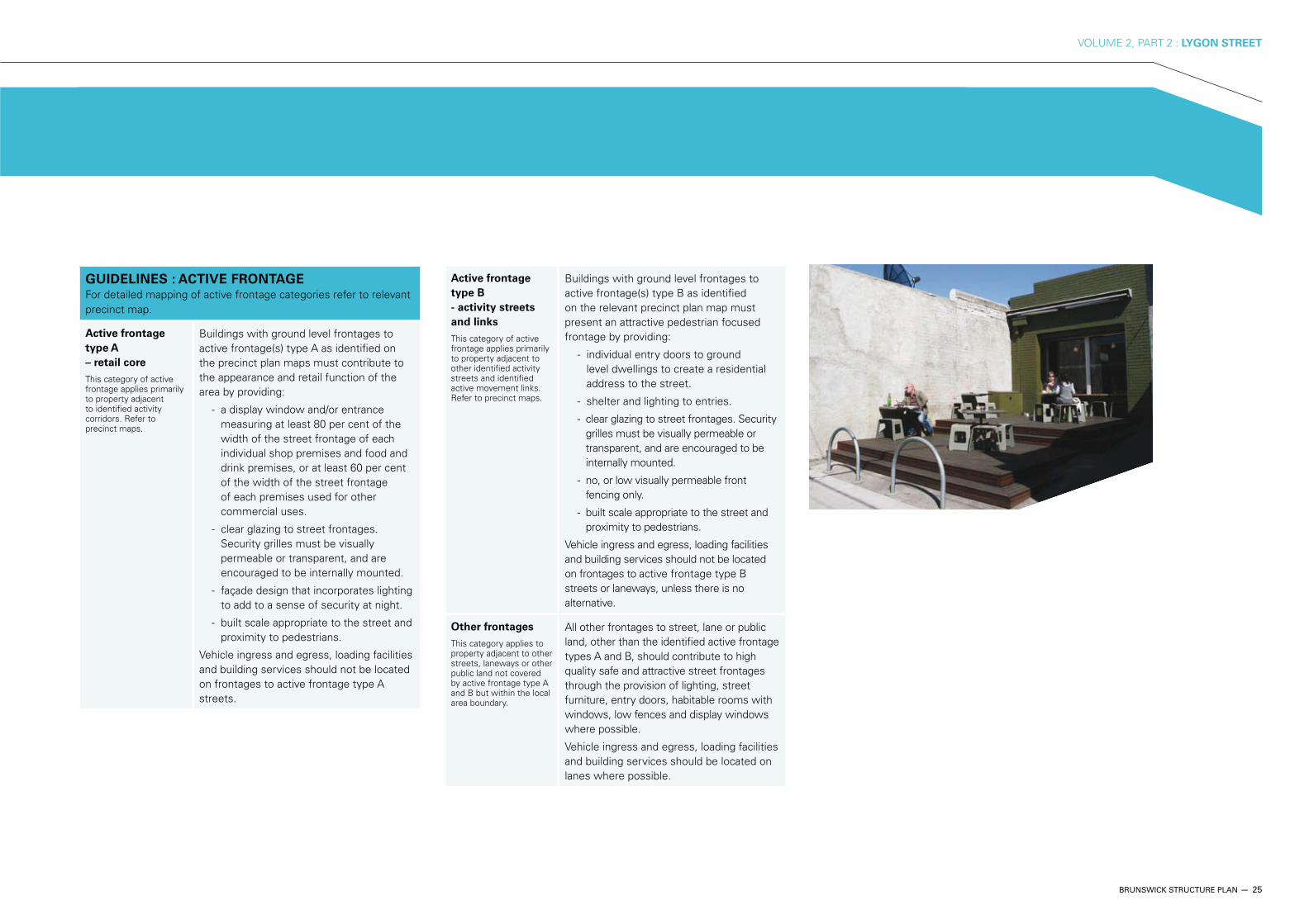
GUIDELINES : ACTIVE FRONTAGE For detailed mapping of active frontage categories refer to relevant precinct map.
Active frontage
type A
– retail core
This category of active frontage applies primarily to property adjacent to identified activity corridors. Refer to precinct maps.
Buildings with ground level frontages to active frontage(s) type A as identified on the precinct plan maps must contribute to the appearance and retail function of the area by providing:
- a display window and/or entrance measuring at least 80 per cent of the width of the street frontage of each individual shop premises and food and drink premises, or at least 60 per cent of the width of the street frontage of each premises used for other commercial uses.
Security grilles must be visually permeable or transparent, and are encouraged to be internally mounted.
- façade design that incorporates lighting to add to a sense of security at night.
- built scale appropriate to the street and proximity to pedestrians.
Vehicle ingress and egress, loading facilities and building services should not be located on frontages to active frontage type A streets.
Active frontage
type B
- activity streets
and links
This category of active frontage applies primarily to property adjacent to other identified activity streets and identified active movement links. Refer to precinct maps.
Buildings with ground level frontages to active frontage(s) type B as identified on the relevant precinct plan map must present an attractive pedestrian focused frontage by providing:
- individual entry doors to ground level dwellings to create a residential address to the street.
- shelter and lighting to entries.
grilles must be visually permeable or transparent, and are encouraged to be internally mounted.
- no, or low visually permeable front fencing only.
- built scale appropriate to the street and proximity to pedestrians.
Vehicle ingress and egress, loading facilities and building services should not be located on frontages to active frontage type B streets or laneways, unless there is no alternative.
Other frontages
This category applies to property adjacent to other streets, laneways or other public land not covered by active frontage type A and B but within the local area boundary.
All other frontages to street, lane or public land, other than the identified active frontage types A and B, should contribute to high quality safe and attractive street frontages through the provision of lighting, street furniture, entry doors, habitable rooms with windows, low fences and display windows where possible.
Vehicle ingress and egress, loading facilities and building services should be located on lanes where possible.
26 — BRUNSWICK STRUCTURE PLAN
VOLUME 2, PART 2 : LYGON STREET
4.7 CHARACTER AND IDENTITY
OBJECTIVE 3
To retain and enhance the eclectic character of Lygon Street.
STRATEGY 3.1
Develop heritage guidelines for conservation and change within the defined precincts, and for significant and contributory buildings.
STRATEGY 3.2
Encourage high quality architecture and urban design in all new development.
OBJECTIVE 4
To promote local creative businesses through the streetscape /
urban realm.
STRATEGY 4.1
Develop a streetscaping plan that manages the tree planting, landscaping, art and streetscape needs of the area in an holistic and long-term manner
OBJECTIVE 1
To create a sense of visual identity along Lygon Street through
the celebration of existing landmark buildings, and ensuring
that new development contributes sympathetic architecture
and urban design.
STRATEGY 1.1
Encourage the development of appropriate architecture and urban design when redeveloping key sites.
STRATEGY 1.2
Ensure new development does not adversely impact the visual identity and character of existing landmark and civic buildings.
STRATEGY 1.3
Promote existing grand and civic buildings as identified on Map 9.
OBJECTIVE 2
To protect places with heritage value along Lygon Street,
including inter-war and mid twentieth century industrial
buildings
STRATEGY 2.1
Include seven new precincts on Lygon Street as identified in the Lygon Street Heritage Review 2008 within the Moreland Planning Scheme Heritage Overlay.
STRATEGY 2.2
Celebrate buildings and groups of buildings with identified heritage value, particularly the East Brunswick Maternal and Child Health Centre.
GUIDELINES : FUTURE CHARACTER Refer to Map 9 - Character and Identity
Lygon Street Lygon Street will be strengthened as a coherent streetscape well defined by visual gateways at the northern and southern ends. These gateways will be further improved by new landmark buildings and public space improvements. Activity will increase along the whole of Lygon Street, and improvements such as footpath widening and potential street trees will be implemented.
A new community hub will be focused around the Maternal and Child Health Centre and Fleming Park, resulting in Albert and Victoria Streets becoming key pedestrian links.
Albert and Victoria
Axis
The east-west axis of Albert and Victoria Streets will be developed as pedestrian-friendly links between district parklands in the east and west. These links will also connect new community hubs, one at Lygon Street / Fleming Park and another at Brunswick Central Parklands.
These pedestrian friendly community links will also provide a cross-Brunswick heritage interpretation and artworks trail.
GUIDELINES : PUBLIC ART
Public art should seek to achieve the following:
Interpret, define and enhance the character and cultural identity of a city
Acknowledge cultural heritage and traditions
Provide a sense of public ownership of public art objects and spaces
Encourage positive and practical interaction between people and public spaces
Challenge perceptions and prejudices
Express the principles of sustainability
BRUNSWICK STRUCTURE PLAN — 27
VOLUME 2, PART 2 : LYGON STREET
AllardPark
JonesPark
FlemingPark
BalfePark
MethvenPark
Barkly StPark
Merri Creek
NIC
HO
LSO
N
STR
EE
T
LYG
ON
S
TRE
ET
BRUNSWICK ROAD
GLENLYON ROAD
ALBERT STREET
VICTORIA STREET
STEWART STREET
ALBION STREET
BLYTH STREET
HO
LME
S
STR
EE
T
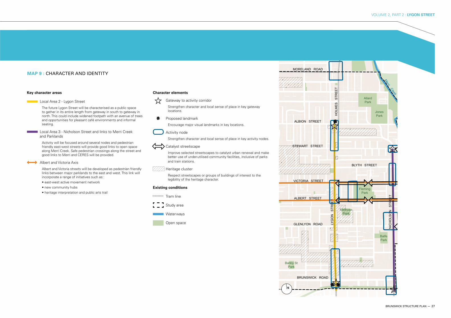
MORELAND ROADMAP 9 : CHARACTER AND IDENTITY
Key character areas
Local Area 2 - Lygon Street
The future Lygon Street will be characterised as a public space to gather in its entire length from gateway in south to gateway in north. This could include widened footpath with an avenue of trees and opportunities for pleasant café environments and informal seating.
Local Area 3 - Nicholson Street and links to Merri Creek and Parklands
Activity will be focused around several nodes and pedestrian friendly east-west streets will provide good links to open space along Merri Creek. Safe pedestrian crossings along the street and good links to Merri and CERES will be provided.
Albert and Victoria Axis
Albert and Victoria streets will be developed as pedestrian friendly links between major parklands to the east and west. This link will incorporate a range of initiatives such as:
Character elements
Gateway to activity corridor
Strengthen character and local sense of place in key gateway locations.
Proposed landmark
Encourage major visual landmarks in key locations.
Activity node
Strengthen character and local sense of place in key activity nodes.
Catalyst streetscape
Improve selected streetscapes to catalyst urban renewal and make better use of under-utilised community facilities, inclusive of parks and train stations.
Heritage cluster
Respect streetscapes or groups of buildings of interest to the legibility of the heritage character.
Existing conditions
Tram line
Study area
Waterways
Open space
28 — BRUNSWICK STRUCTURE PLAN
VOLUME 2, PART 2 : LYGON STREET
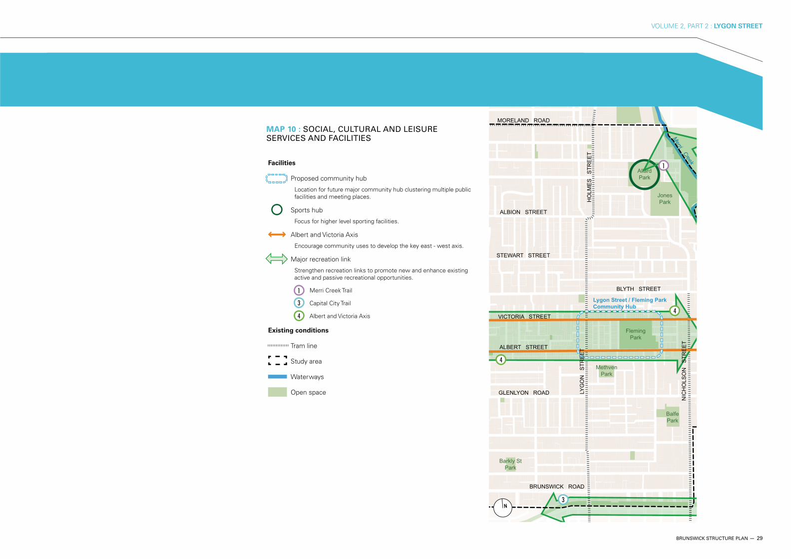
4.8 SOCIAL, CULTURAL AND LEISURE SERVICES AND FACILITIES
OBJECTIVE 1
To meet the current and future demand for Early Years Facilities
(maternal and child health, child care and kindergarten).
STRATEGY 1.1
Identify opportunities for future early years facilities, including the potential for expanding existing facilities and co-location of services.
BRUNSWICK STRUCTURE PLAN — 29
VOLUME 2, PART 2 : LYGON STREET
MAP 10 : SOCIAL, CULTURAL AND LEISURE SERVICES AND FACILITIES
AllardPark
JonesPark
FlemingPark
BalfePark
MethvenPark
Barkly StPark
Merri Creek
NIC
HO
LSO
N
STR
EE
T
LYG
ON
S
TRE
ET
BRUNSWICK ROAD
GLENLYON ROAD
ALBERT STREET
VICTORIA STREET
STEWART STREET
ALBION STREET
BLYTH STREET
HO
LME
S
STR
EE
T
MORELAND ROAD
Lygon Street / Fleming ParkCommunity Hub
4
1Facilities
Proposed community hub
Location for future major community hub clustering multiple public facilities and meeting places.
Sports hub
Focus for higher level sporting facilities.
Albert and Victoria Axis
Encourage community uses to develop the key east - west axis.
Major recreation link
Strengthen recreation links to promote new and enhance existing active and passive recreational opportunities.
Merri Creek Trail
Capital City Trail
Albert and Victoria Axis
Existing conditions
Tram line
Study area
Waterways
Open space
3
3
4
1
4
30 — BRUNSWICK STRUCTURE PLAN
VOLUME 2, PART 2 : LYGON STREET
PLANNING AND LAND USE
OBJECTIVE 1
To ensure the rezoning and redevelopment of major sites
makes a positive contribution to the local area, including
amenity, parking, built form and land uses.
STRATEGY 1.1
the Moreland Industrial Land Use Strategy 2004.
OBJECTIVE 2
To ensure a coordinated approach to the retail functioning,
administration and marketing of the precinct.
STRATEGY 2.1
Work with local traders to develop a retail plan and marketing strategy.
STRATEGY 2.2
Support the function and marketing of Precinct 2A as a unique destination, with a focus on restaurants, bars and entertainment venues.
OBJECTIVE 3
To ensure Precinct 2A retains its local convenience function in
spite of competition from new developments outside of the
precinct.
STRATEGY 3.1
Support the convenience retail functions of the precinct through business support, marketing and advocacy.
TRANSPORT AND MOVEMENT
OBJECTIVE 1
To improve the transport interchange at the corner of
Brunswick Road and Lygon Street.
STRATEGY 1.1
Improve pedestrian access to trams and buses by designing an enhanced interchange at the intersection of Brunswick Road and Lygon Street.
OBJECTIVE 2
To address the parking needs of the precinct for various
activities, particularly the night time dining and entertainment
activities.
STRATEGY 2.1
Prepare a parking management plan to identify current and future parking needs and recommend solutions.
OBJECTIVE 3
To ensure that existing parking pressures are not exacerbated
by new developments, such as the redevelopment of the
former Tip Top site on Edward Street, Brunswick East.
STRATEGY 3.1
Require new developments, in particular the former Tip Top site, to provide on-site solutions to their carparking needs.
STRATEGY 3.2
Require Green Travel Plans for all new development to reduce car dependence and use, and car parking demand.
5.1 PRECINCT 2A : LYGON STREET SOUTH GATEWAY
5 LOCAL AREA PRECINCTS
TOTAL LAND AREA (GROSS): 15.4 HECTARES
ANTICIPATED NEW DWELLINGS: 634
The Lygon Street South precinct is a retail and wholesale strip, with some industrial activity in the side streets. Retailing in the precinct is dominated by cafés and restaurants, and as such the strip caters to a sub-regional market. The wholesale activity includes building supply outlets that also have a retail function, and wholesalers providing for the inner city catering and office equipment markets.
The former Tip Top bread factory site to the east of Lygon Street is a notable vacant site that has yet to be developed. The former Spicers clothing factory on the corner of Brunswick Road and Lygon Street is another major development site at the gateway to the precinct.
This precinct can improve its position as a dining and entertainment precinct, adding to the liveability of the whole of Brunswick. It can also provide an attractive gateway to the Activity Centre, encouraging further visitation and investment by residents and businesses.
5.1.1 OBJECTIVES AND STRATEGIES
The following objectives and strategies apply to this precinct only. Please also refer to Section 4 - Local Area Strategic Framework
BRUNSWICK STRUCTURE PLAN — 31
VOLUME 2, PART 2 : LYGON STREET
OBJECTIVE 4
To improve the pedestrian and cycling amenity and safety at
the southern gateway to Lygon Street.
STRATEGY 4.1
Develop a traffic management plan for Local Area 2 that addresses pedestrian and cycling issues, particularly at the Brunswick Road and Lygon Street intersection.
OBJECTIVE 5
To improve traffic management, including flow, amenity and
safety, at the Brunswick Road and Lygon Street intersection.
STRATEGY 5.1
Develop a traffic management plan for Local Area 2 that includes the Brunswick Road and Lygon Street intersection.
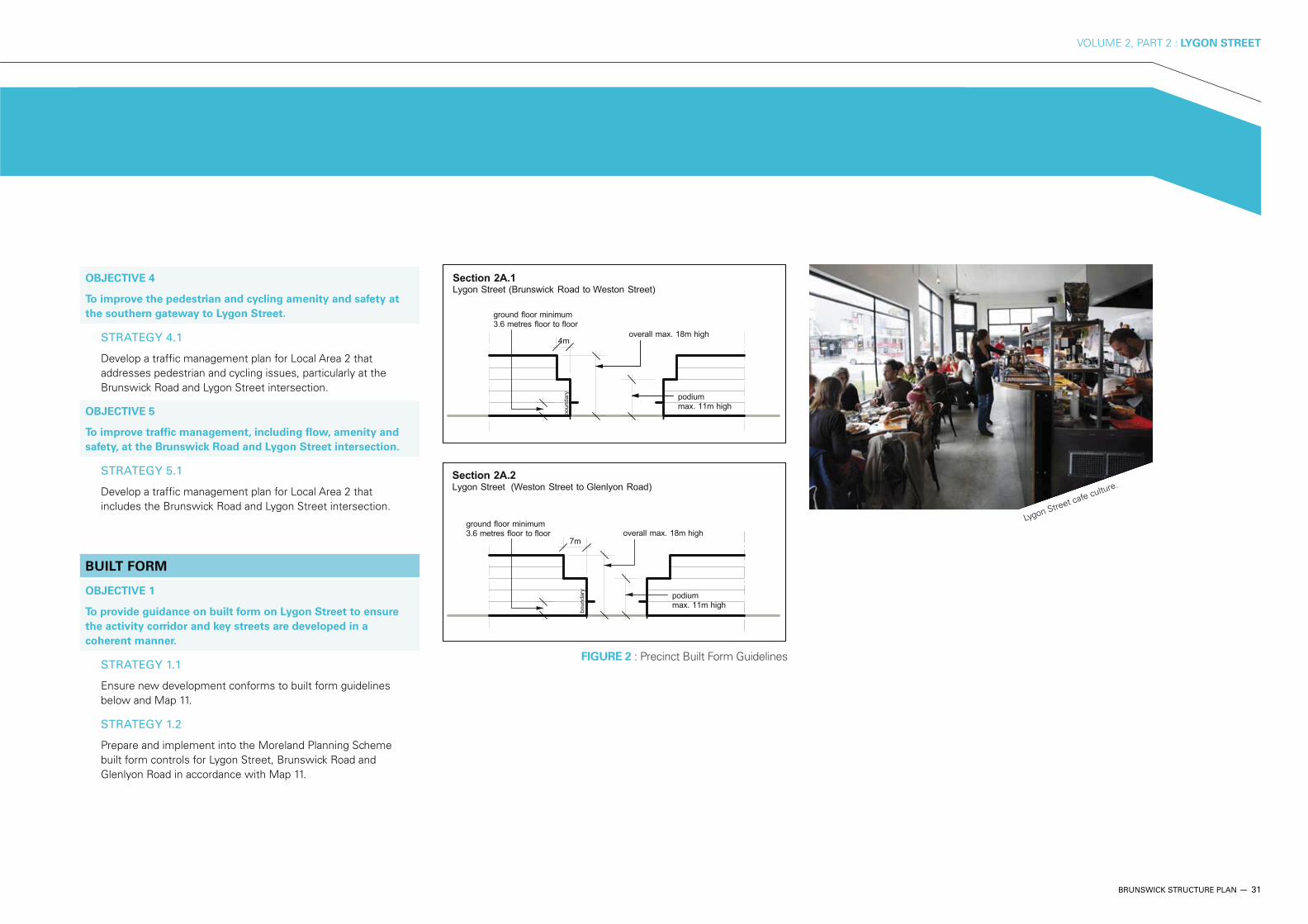
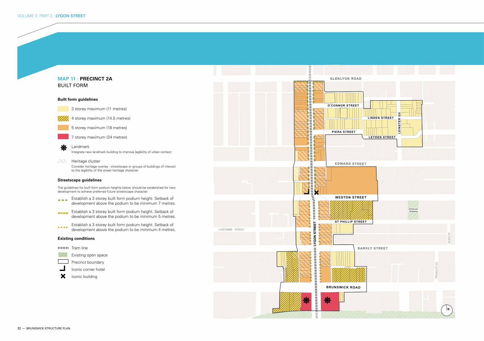
BUILT FORM
OBJECTIVE 1
To provide guidance on built form on Lygon Street to ensure
the activity corridor and key streets are developed in a
coherent manner.
STRATEGY 1.1
Ensure new development conforms to built form guidelines below and Map 11.
STRATEGY 1.2
Prepare and implement into the Moreland Planning Scheme built form controls for Lygon Street, Brunswick Road and Glenlyon Road in accordance with Map 11.
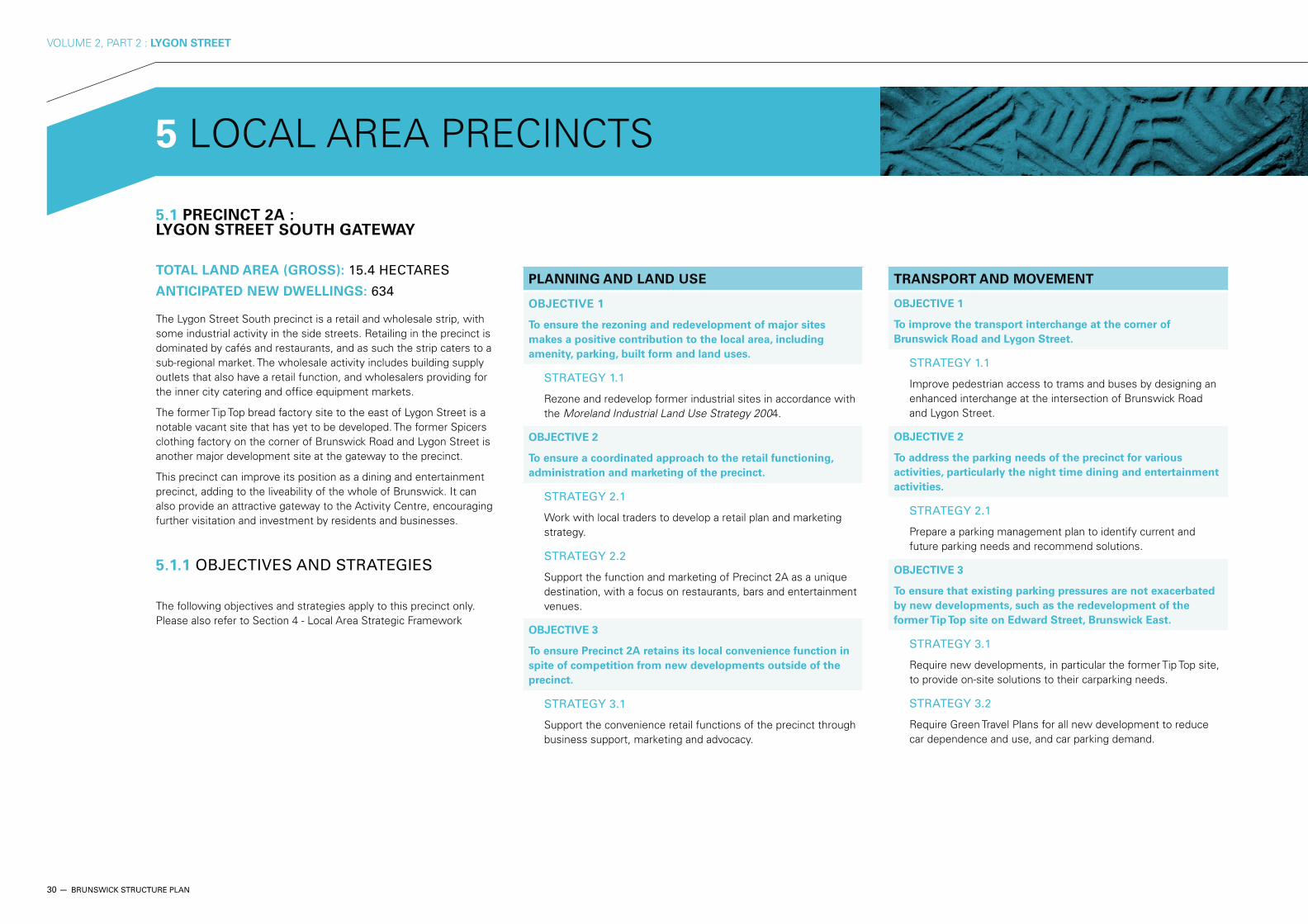
Lygon Street cafe culture.
FIGURE 2 : Precinct Built Form Guidelines
32 — BRUNSWICK STRUCTURE PLAN
VOLUME 2, PART 2 : LYGON STREET
LINDEN STREET
LE
INS
TE
R G
V
TRU
SC
UTT
ST
GLE
W S
T
LYG
ON
STR
EET
LUSCOMBE STREET
TRU
SC
UTT
ST
GLE
W S
T
LUSCOMBE STREET
LEYDEN STREET
MAP 11 : PRECINCT 2A
BUILT FORM
Built form guidelines
3 storey maximum (11 metres)
4 storey maximum (14.5 metres)
5 storey maximum (18 metres)
7 storey maximum (24 metres)
LandmarkIntegrate new landmark building to improve legibility of urban context
Heritage clusterConsider heritage overlay - streetscape or groups of buildings of interest to the legibility of the street heritage character
Streetscape guidelines
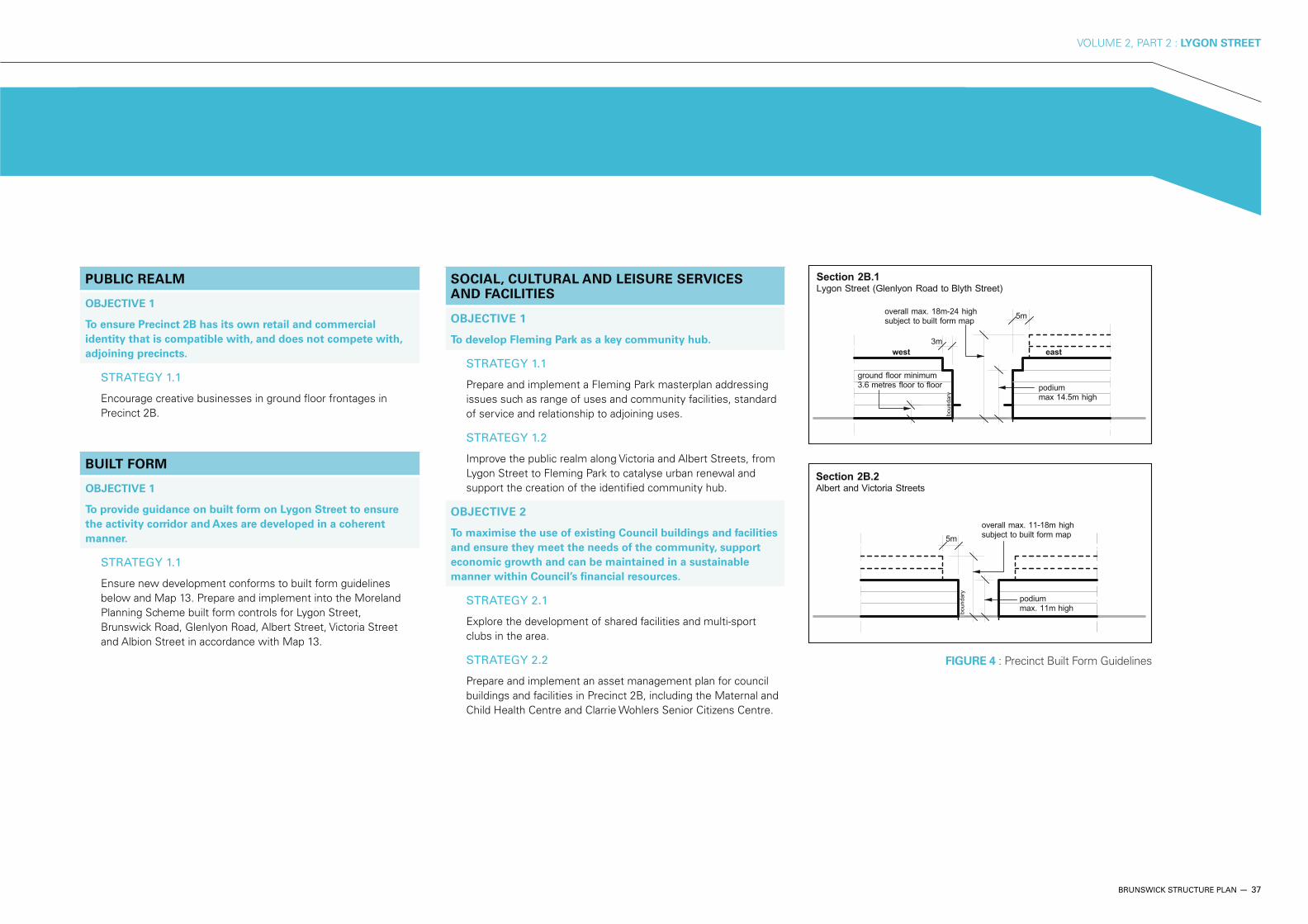
The guidelines for built form podium heights below should be established for new development to achieve preferred future streetscape character.
Establish a 3 storey built form podium height. Setback of development above the podium to be minimum 7 metres.
Establish a 3 storey built form podium height. Setback of development above the podium to be minimum 5 metres.
Establish a 3 storey built form podium height. Setback of development above the podium to be minimum 4 metres.
Existing conditions
Tram line
Existing open space
Precinct boundary
Iconic corner hotel
Iconic building

BRUNSWICK STRUCTURE PLAN — 33
VOLUME 2, PART 2 : LYGON STREET
LINDEN STREET
LE
INS
TE
R G
V
TRU
SC
UTT
ST
GLE
W S
T
LYG
ON
STR
EET
LUSCOMBE STREET
LEYDEN STREET
TRU
SC
UTT
ST
GLE
W S
T
LUSCOMBE STREET
MAP 12 : PRECINCT 2A
PUBLIC REALM AND ACTIVE FRONTAGE
Activity streets
Active frontage type A - Refer to section 4.6 - Guidelines
Active frontage type B - Refer to section 4.6 - Guidelines
Public realm improvements
Pedestrian priority street - Refer to section 4.5 - Guidelines
Provide high level pedestrian priority through streetscape improvements.
New green street - Refer to section 4.5 - Guidelines
Consider potential kerb extensions and greening of streets, including Water Sensitive Urban Design with plants and trees.
Pedestrian linksNew or improved pedestrian link through property or public land with high level active frontage to development and high level pedestrian amenity.
Enhanced tram stop
Existing conditions
Tram line
Existing open space
Existing buildings
Precinct boundary
Major visual gateway
Other visual gateway
34 — BRUNSWICK STRUCTURE PLAN
VOLUME 2, PART 2 : LYGON STREET
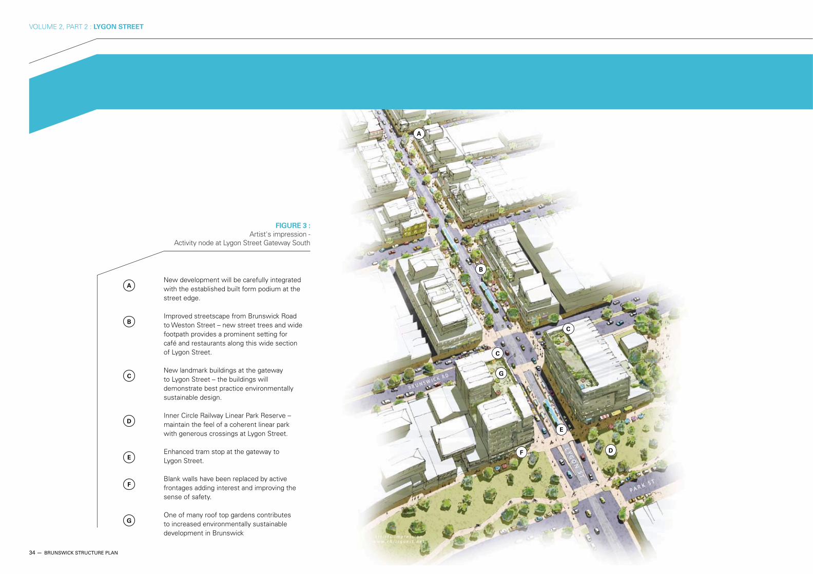
B
C
C
A
E
F D
G
A New development will be carefully integrated
with the established built form podium at the street edge.
B Improved streetscape from Brunswick Road
to Weston Street – new street trees and wide footpath provides a prominent setting for café and restaurants along this wide section of Lygon Street.
C New landmark buildings at the gateway
to Lygon Street – the buildings will demonstrate best practice environmentally sustainable design.
D Inner Circle Railway Linear Park Reserve –
maintain the feel of a coherent linear park with generous crossings at Lygon Street.
E Enhanced tram stop at the gateway to
Lygon Street.
F Blank walls have been replaced by active
frontages adding interest and improving the sense of safety.
G One of many roof top gardens contributes
to increased environmentally sustainable development in Brunswick
FIGURE 3 :
Artist's impression - Activity node at Lygon Street Gateway South
BRUNSWICK STRUCTURE PLAN — 35
VOLUME 2, PART 2 : LYGON STREET
36 — BRUNSWICK STRUCTURE PLAN
VOLUME 2, PART 2 : LYGON STREET
PLANNING AND LAND USE
OBJECTIVE 1
To promote the location of local creative businesses along
street frontages in Precinct 2B.
STRATEGY 1.1
Support the creative business function of the precinct through business support, marketing and advocacy.
STRATEGY 1.2
Work with local traders to develop a Creative Business Strategy including identity, role, marketing and ongoing management.
OBJECTIVE 2
To ensure the changing profile of employment uses supports a
viable daytime retail economy.
STRATEGY 2.1
Ensure that office activities are part of the range of options available to property developers in Precinct 2B, including through the encouragement of multi-use buildings and loose-fit buildings that can accommodate either housing or employment uses.
OBJECTIVE 3
To ensure that the increasing resident population and the
changing profile of employment uses supports a balanced
economy.
STRATEGY 3.1
Ensure that new development provides a balanced mix of uses.
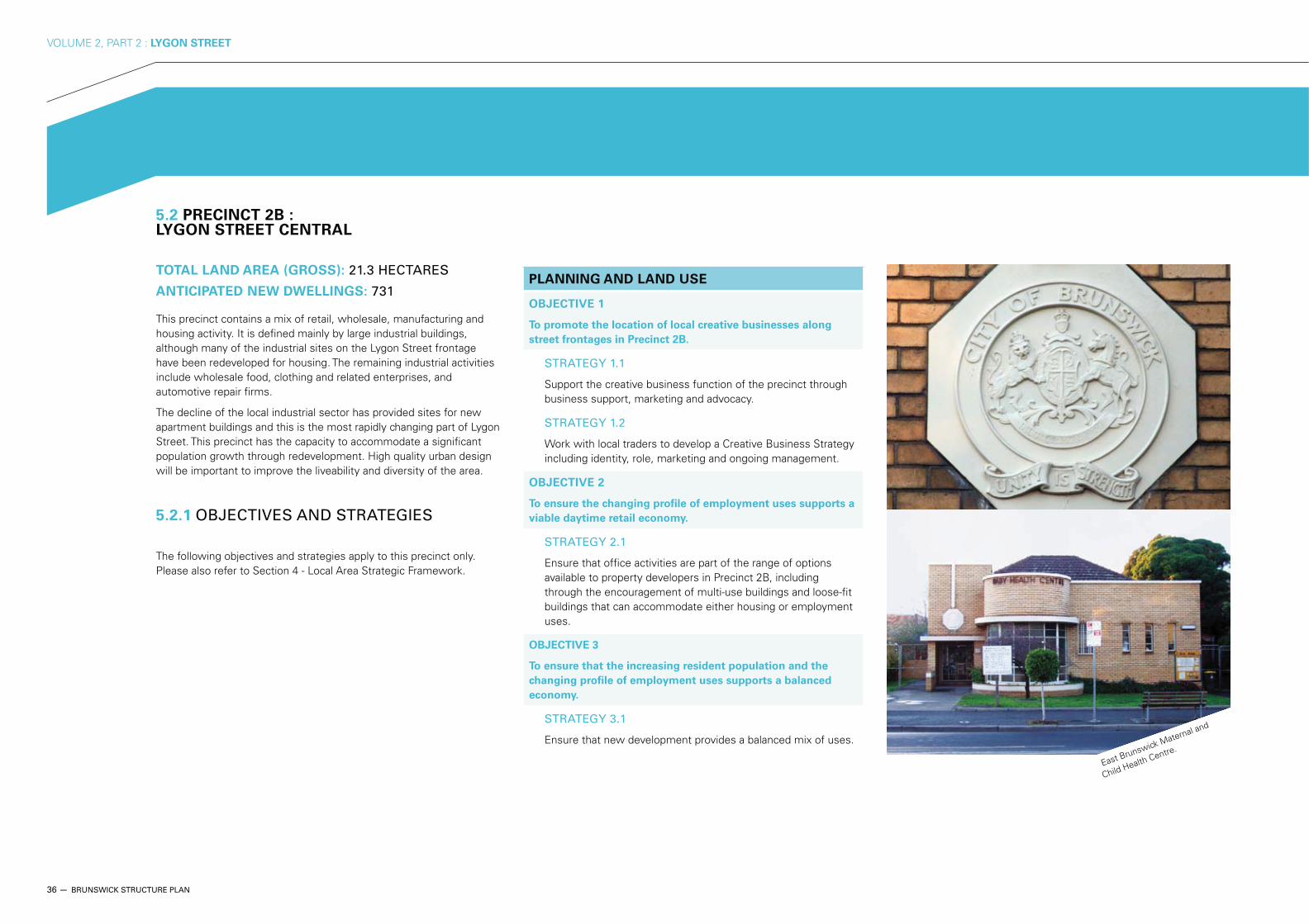
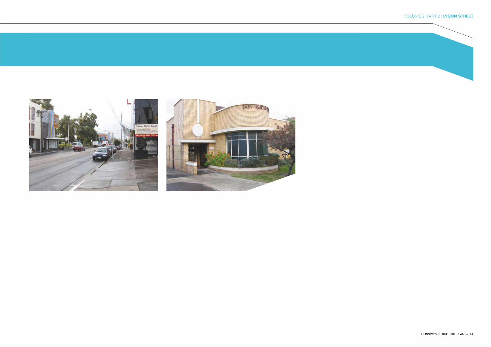
East Brunswick Maternal and
Child Health Centre.
5.2 PRECINCT 2B : LYGON STREET CENTRAL
TOTAL LAND AREA (GROSS): 21.3 HECTARES
ANTICIPATED NEW DWELLINGS: 731
This precinct contains a mix of retail, wholesale, manufacturing and housing activity. It is defined mainly by large industrial buildings, although many of the industrial sites on the Lygon Street frontage have been redeveloped for housing. The remaining industrial activities include wholesale food, clothing and related enterprises, and automotive repair firms.
The decline of the local industrial sector has provided sites for new apartment buildings and this is the most rapidly changing part of Lygon Street. This precinct has the capacity to accommodate a significant population growth through redevelopment. High quality urban design will be important to improve the liveability and diversity of the area.
5.2.1 OBJECTIVES AND STRATEGIES
The following objectives and strategies apply to this precinct only. Please also refer to Section 4 - Local Area Strategic Framework.
BRUNSWICK STRUCTURE PLAN — 37
VOLUME 2, PART 2 : LYGON STREET
PUBLIC REALM
OBJECTIVE 1
To ensure Precinct 2B has its own retail and commercial
identity that is compatible with, and does not compete with,
adjoining precincts.
STRATEGY 1.1
Encourage creative businesses in ground floor frontages in Precinct 2B.
BUILT FORM
OBJECTIVE 1
To provide guidance on built form on Lygon Street to ensure
the activity corridor and Axes are developed in a coherent
manner.
STRATEGY 1.1
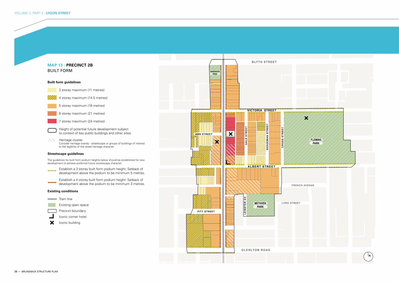
Ensure new development conforms to built form guidelines below and Map 13. Prepare and implement into the Moreland Planning Scheme built form controls for Lygon Street, Brunswick Road, Glenlyon Road, Albert Street, Victoria Street and Albion Street in accordance with Map 13.
SOCIAL, CULTURAL AND LEISURE SERVICES AND FACILITIES
OBJECTIVE 1
To develop Fleming Park as a key community hub.
STRATEGY 1.1
Prepare and implement a Fleming Park masterplan addressing issues such as range of uses and community facilities, standard of service and relationship to adjoining uses.
STRATEGY 1.2
Improve the public realm along Victoria and Albert Streets, from Lygon Street to Fleming Park to catalyse urban renewal and support the creation of the identified community hub.
OBJECTIVE 2
To maximise the use of existing Council buildings and facilities
and ensure they meet the needs of the community, support
economic growth and can be maintained in a sustainable
manner within Council’s financial resources.
STRATEGY 2.1
Explore the development of shared facilities and multi-sport clubs in the area.
STRATEGY 2.2
Prepare and implement an asset management plan for council buildings and facilities in Precinct 2B, including the Maternal and
FIGURE 4 : Precinct Built Form Guidelines
38 — BRUNSWICK STRUCTURE PLAN
VOLUME 2, PART 2 : LYGON STREET
CR
OS
S S
TR
EE
T
MAP 13 : PRECINCT 2B
BUILT FORM
Built form guidelines
3 storey maximum (11 metres)
4 storey maximum (14.5 metres)
5 storey maximum (18 metres)
6 storey maximum (21 metres)
7 storey maximum (24 metres)
Height of potential future development subject to context of key public buildings and other sites.
Heritage cluster Consider heritage overlay - streetscape or groups of buildings of interest to the legibility of the street heritage character
Streetscape guidelines
The guidelines for built form podium heights below should be established for new development to achieve preferred future streetscape character.
Establish a 3 storey built form podium height. Setback of development above the podium to be minimum 5 metres.
Establish a 4 storey built form podium height. Setback of development above the podium to be minimum 3 metres.
Existing conditions
Tram line
Existing open space
Precinct boundary
Iconic corner hotel
Iconic building
BRUNSWICK STRUCTURE PLAN — 39
VOLUME 2, PART 2 : LYGON STREET
CR
OS
S S
TR
EE
T
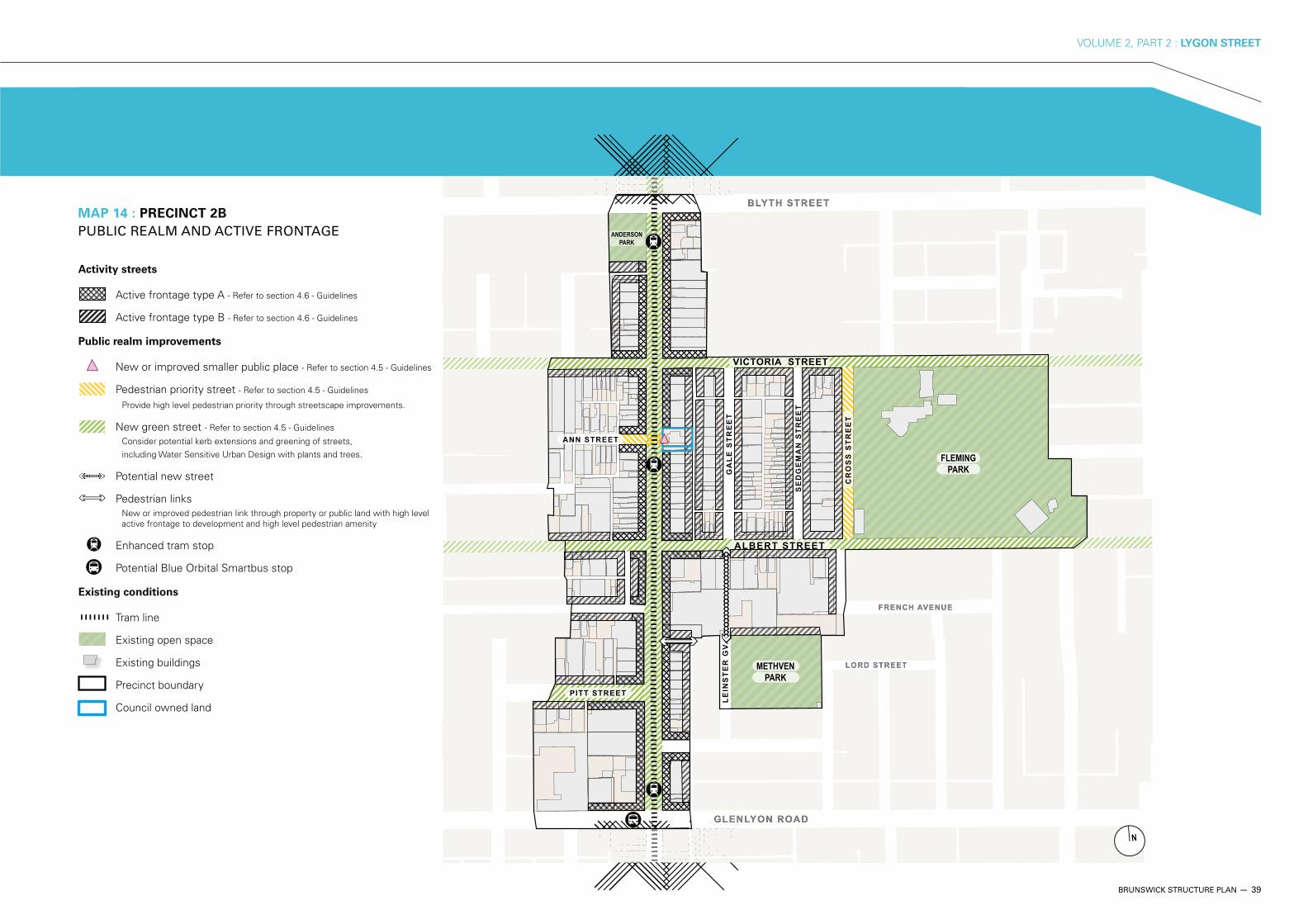
MAP 14 : PRECINCT 2B
PUBLIC REALM AND ACTIVE FRONTAGE
Activity streets
Active frontage type A - Refer to section 4.6 - Guidelines
Active frontage type B - Refer to section 4.6 - Guidelines
Public realm improvements
New or improved smaller public place - Refer to section 4.5 - Guidelines
Pedestrian priority street - Refer to section 4.5 - Guidelines
Provide high level pedestrian priority through streetscape improvements.
New green street - Refer to section 4.5 - Guidelines
Consider potential kerb extensions and greening of streets, including Water Sensitive Urban Design with plants and trees.
Potential new street
Pedestrian linksNew or improved pedestrian link through property or public land with high level active frontage to development and high level pedestrian amenity
Enhanced tram stop
Potential Blue Orbital Smartbus stop
Existing conditions
Tram line
Existing open space
Existing buildings
Precinct boundary
Council owned land
40 — BRUNSWICK STRUCTURE PLAN
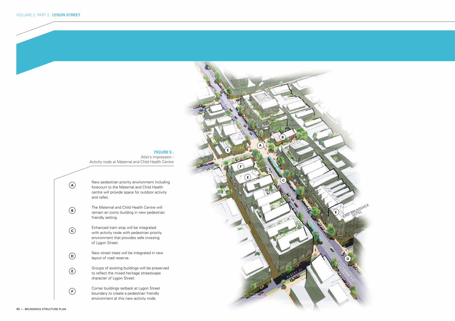
VOLUME 2, PART 2 : LYGON STREET
B
F
E
E
E
D
A
EAST BRUNSWICK
HOTEL
A New pedestrian priority environment including
forecourt to the Maternal and Child Health centre will provide space for outdoor activity and cafes.
B The Maternal and Child Health Centre will
remain an iconic building in new pedestrian friendly setting.
C Enhanced tram stop will be integrated
with activity node with pedestrian priority environment that provides safe crossing of Lygon Street.
D New street trees will be integrated in new
layout of road reserve.
E Groups of existing buildings will be preserved
to reflect the mixed heritage streetscape character of Lygon Street.
F Corner buildings setback at Lygon Street
boundary to create a pedestrian friendly environment at this new activity node.
FIGURE 5 : Atist's impression -
Activity node at Maternal and Child Health Centre
C
BRUNSWICK STRUCTURE PLAN — 41
VOLUME 2, PART 2 : LYGON STREET
42 — BRUNSWICK STRUCTURE PLAN
VOLUME 2, PART 2 : LYGON STREET
PLANNING AND LAND USE
OBJECTIVE 1
To ensure land use zonings support a range of retail uses from
local convenience to larger scale supermarkets.
STRATEGY 1.1
Moreland Industrial Land Use Strategy 2004.
STRATEGY 1.2
Support consolidation of sites to create opportunities for larger format retail activity.
OBJECTIVE 2
To ensure retail centres are supported by sufficient carparking,
pedestrian and cycling facilities.
STRATEGY 2.1
Prepare and implement a carparking strategy to address the needs of retail and commercial areas.
STRATEGY 2.2
Implement improvements to pedestrian and cycling facilities in retail centres, such as bicycle lock up facilities and pedestrian amenity.
OBJECTIVE 3
To support viable existing commercial and industrial uses
and ensure a smooth transition for those sites changing to
other uses.
STRATEGY 3.1
Support the retention and/or redevelopment of commercial and industrial sites in accordance with the Moreland Industrial Land Use Strategy 2004.
5.3 PRECINCT 2C : LYGON STREET NORTH GATEWAY
TOTAL LAND AREA (GROSS): 5.6 HECTARES
ANTICIPATED NEW DWELLINGS: 143
This precinct provides small convenience shopping services to its local neighbourhood and hosts a number of larger format shops and showrooms that serve a wider market for fabrics and household goods. In addition, the precinct accommodates several large clubs and hotels.
Like Precinct 2B, Lygon Street North is changing, with recent major residential development and a fluid mix of retail tenancy. The large format shops on the west side of the strip appear to be performing poorly and may become targets for redevelopment.
This precinct can continue to provide convenience shopping for its neighbourhood and can host a range of small street-front enterprises.
5.3.1 OBJECTIVES AND STRATEGIES
The following objectives and strategies apply to this precinct only. Please also refer to Section 4 - Local Area Strategic Framework.
BRUNSWICK STRUCTURE PLAN — 43
VOLUME 2, PART 2 : LYGON STREET
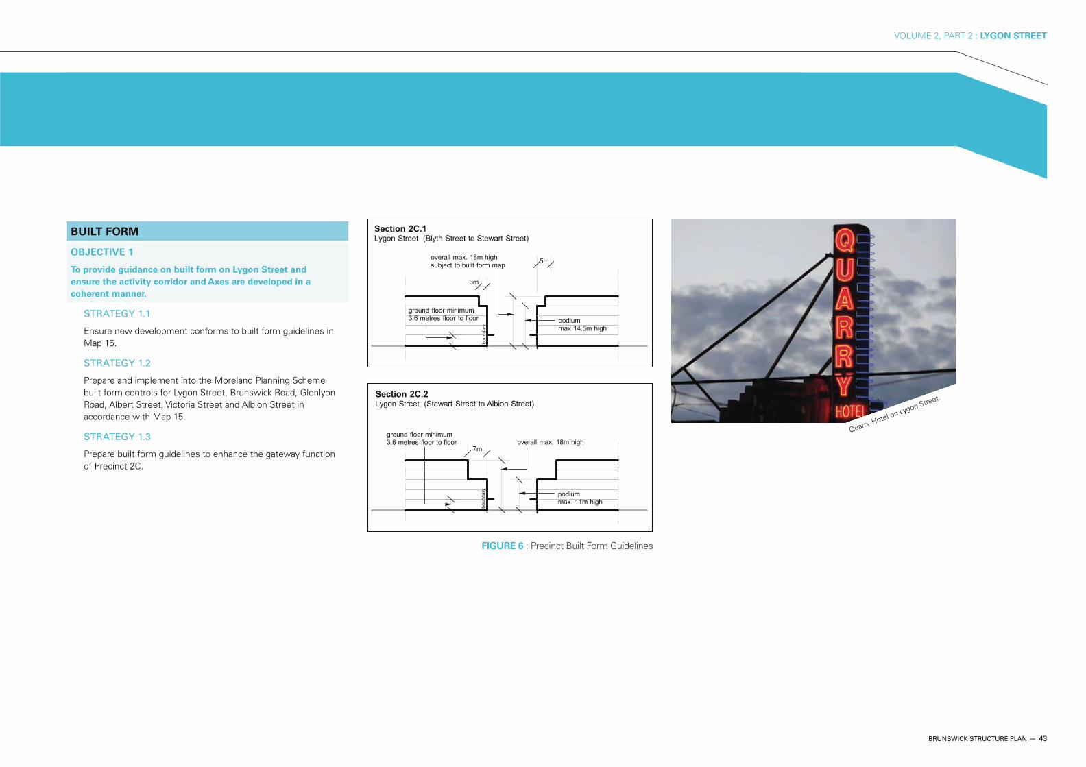
BUILT FORM
OBJECTIVE 1
To provide guidance on built form on Lygon Street and
ensure the activity corridor and Axes are developed in a
coherent manner.
STRATEGY 1.1
Ensure new development conforms to built form guidelines in Map 15.
STRATEGY 1.2
Prepare and implement into the Moreland Planning Scheme built form controls for Lygon Street, Brunswick Road, Glenlyon Road, Albert Street, Victoria Street and Albion Street in accordance with Map 15.
STRATEGY 1.3
Prepare built form guidelines to enhance the gateway function of Precinct 2C.
Quarry Hotel on Lygon Street.
FIGURE 6 : Precinct Built Form Guidelines
44 — BRUNSWICK STRUCTURE PLAN
VOLUME 2, PART 2 : LYGON STREET
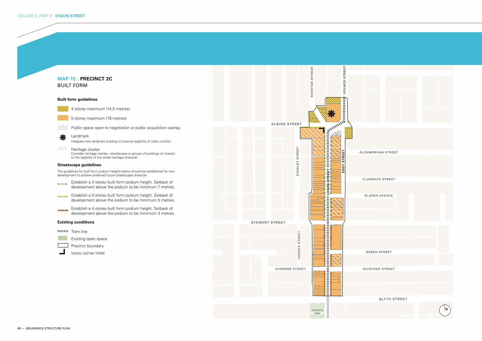
MAP 15 : PRECINCT 2C
BUILT FORM
Built form guidelines
4 storey maximum (14.5 metres)
5 storey maximum (18 metres)
Public space open to negotiation or public acquisition overlay.
LandmarkIntegrate new landmark building to improve legibility of urban context
Heritage cluster Consider heritage overlay - streetscape or groups of buildings of interest to the legibility of the street heritage character
Streetscape guidelines
The guidelines for built form podium heights below should be established for new development to achieve preferred future streetscape character.
Establish a 3 storey built form podium height. Setback of development above the podium to be minimum 7 metres.
Establish a 3 storey built form podium height. Setback of development above the podium to be minimum 5 metres.
Establish a 4 storey built form podium height. Setback of development above the podium to be minimum 3 metres.
Existing conditions
Tram line
Existing open space
Precinct boundary
Iconic corner hotel

BRUNSWICK STRUCTURE PLAN — 45
VOLUME 2, PART 2 : LYGON STREET
MAP 16 : PRECINCT 2C
PUBLIC REALM AND ACTIVE FRONTAGE
Activity streets
Active frontage type A - Refer to section 4.6 - Guidelines
Active frontage type B - Refer to section 4.6 - Guidelines
Public realm improvements
New major public place - Refer to section 4.5 - Guidelines
Pedestrian priority street - Refer to section 4.5 - Guidelines
Provide high level pedestrian priority through streetscape improvements.
New green street - Refer to section 4.5 - Guidelines
Consider potential kerb extensions and greening of streets, including Water Sensitive Urban Design with plants and trees.
Enhanced tram stop
Existing conditions
Tram line
Existing open space
Existing buildings
Precinct boundary
Major visual gateway

46 — BRUNSWICK STRUCTURE PLAN
VOLUME 2, PART 2 : LYGON STREET
D
D
C
B
A
A New landmark building at northern gateway
to Lygon Street demonstrating best practice environmental design.
B N
amenity and café pavilion.
C The streetscape on Lygon Street will be
upgraded by extending the kerbs and new street trees.
D Upgraded bus stop and enhanced tram stop
interchange at Albion Street/Lygon Street – improved pedestrian crossings.
FIGURE 7 : Artist's impression -
Activity node at Lygon Street Gateway North

BRUNSWICK STRUCTURE PLAN — 47
VOLUME 2, PART 2 : LYGON STREET
6 GLOSSARY
Accessible housing – housing designed to provide for the needs of all people without requiring adaptation or specialised design.
Active / inactive frontages – street frontages where an active visual engagement occurs between people in the street and those on the ground floors of buildings. This quality is assisted where the front façades of buildings, including the main entrance, face and open toward the street.
Activity centre – a place where people shop, work, meet, relax and often live. They are typically well served by public transport, and range
activity centre concept is a central part of Melbourne 2030, which encourages development to occur in activity centres as a way to use existing infrastructure effectively, and to foster lively communities.
Activity link – a key pedestrian link between an activity nodes and an open space.
Active movement network – the pedestrian and cycling network connecting the key activity nodes within the Activity Centre.
Activity node – areas or nodes where public transport and economic and social activities come together. Activity nodes are key destinations in the active movement network and become focus areas for new transport interchanges and improvements to public space.
Activity corridor – the Brunswick Activity Centre features three main north-south activity corridors, Sydney Road, Lygon Street and Nicholson Street. Each corridor has tram services and significant retail and business activity. These corridors will be developed as prime locations of economic and social activity.
Activity streets - streets with a high level of pedestrian amenity. These streets feel safe during the day and night because they are always active with people moving about their business. Activity streets in the Brunswick Activity Centre will include those streets with higher-density mixed-used development such as Sydney Road, Lygon Street, Nicholson Street, Albert Street and Victoria Street.
Adaptable housing – housing that is visitable although not initially fully accessible, but can be made fully accessible should the need arise. This relates to structural or design features that would be difficult to change later if not considered at the time of construction.
Affordable housing – housing that can be purchased or rented by payment of 30 per cent or less of the average household’s gross income.
Agent of change – the agent of change principle determines responsibility for noise management. That is, where changed conditions are introduced into an environment, (for example through a new use, or changed operating conditions), the reasonable expectations of the existing land users should be respected. This applies to both venue operators and residents.
BSP – Brunswick Structure Plan.
CAD – Central Activity District – the centre of metropolitan Melbourne.
Carbon footprint – a measure of the impact human activities have on the environment in terms of the amount of greenhouse gases produced, measured in units of carbon dioxide. Carbon dioxide enters the earth’s atmosphere (the air that we breathe) during the energy conversion of fossil fuels, such as crude oil and coal, into petrol and electricity. Carbon dioxide emissions, or ‘green house gas emissions’, are deemed responsible for the global warming process (climate change).
Climate Change – the long-term significant change in average weather patterns. (Refer also to ‘Greenhouse gas’ and ‘Global warming’). ‘Climate change is arguably the greatest challenge facing humanity. The scientific evidence linking climate change to the increasing carbon concentration in the atmosphere, arising from human activity, is now overwhelming. Absolute proof of the linkage will not emerge for decades. However the evidence is sufficiently clear that urgent precautionary measures should be taken to reduce carbon emissions if dangerous consequences are to be avoided.’(Source: Dunlop, Ian 2007, Climate Change and Peak Oil – an integrated policy)
Community hub – an area or facility in which complementary community services are provided.
Diverse mobility – the wide variety (diversity) of human mobility needs and capabilities. This notion reflects a need to ensure our city structure and infrastructure has adaptable interfaces that can accommodate the whole population.
Environmentally Sustainable Development (ESD) – ‘development that improves the total quality of life, both now and in the future, in a way that maintains the ecological processes on which life depends.’
(Source: Australian Government 1992, ‘National Strategy for Ecologically Sustainable Development’, prepared by the Ecologically Sustainable Development Steering Committee, endorsed by the Council of Australian Governments, December, 1992, ISBN 0 644 27253 8.)
Fine-grained public transport – a local well-serviced public transport network that includes a possible minibus / shuttle bus service operating between nodes of activity, with a focus on east-west
connections across tram corridors, linking community hubs, shopping corridors and transport interchanges around train stations.
Food access (also known as food security) – the ability of all people to access safe, affordable, healthy and culturally appropriate food at all times, without the use of emergency food relief in the form of food vouchers or parcels. The concept has its origins in the need to consider the sustainability of food supply. Water shortages, climate change and dwindling supplies of oil (see ’Peak oil’) means food security is becoming a global issue.
Gateway – the experience of arriving in the Activity Centre. Land at the gateways to the municipality and the Activity Centre are focal points where high quality, architecturally designed signature buildings are encouraged.
Gentrification – or urban gentrification – changes in demographics, land uses and building conditions in an area, accompanied by rapid increase in property prices, and influx of investment and physical remodelling and renovation. Gentrification brings new investment, makes improvements to buildings, helps preserve local heritage and increases the Council rate base. However, it can also displace low income tenant households and commercial leases, and result in social homogenisation (or polarisation and homogeneity at the extremes of the socio-economic scale) and loss of cultural diversity.
Global warming – the increased temperature in recent decades, of the earth’s atmosphere and its projected continuation – it implies a human influence.
Greenhouse gas – gases present in the atmosphere, which reduce the loss of heat into space and therefore contribute to global temperatures through the greenhouse effect. Greenhouse gases are essential to maintaining the temperature of the Earth; without them, the planet would be so cold as to be uninhabitable. However, an excess of greenhouse gases can raise the temperature of a planet to lethal levels.(Source: United Nations Framework Convention on Climate Change.)
Heritage place – a place acknowledged under the Victorian Heritage Register or the Moreland Planning Scheme for its cultural significance. Cultural significance means aesthetic, historic, scientific, social or spiritual value for past, present or future generations. Place means site, area, land, landscape, building or other work, group of buildings or other works, and may include components, contents, spaces and views.
48 — BRUNSWICK STRUCTURE PLAN
VOLUME 2, PART 2 : LYGON STREET
Intermodal – activities between different modes of transport.
Landmark – ‘an external reference point, usually a simply defined physical object.’ (Source: Lynch 1993, The image of the city, The MIT Press, Mass.).
Legibility – a term used in the context of neighbourhood character. It is the need to ensure that a place appears coherent, as in, visual cues convey a sense of how to move about the centre with ease.
MCC – Moreland City Council.
MILUS – Moreland Industrial Land Use Strategy, August 2004.
MITS – Moreland Integrated Transport Strategy, November 1998.
MOSS – Moreland Open Space Strategy, August 2004.
MUZ – Mixed Use Zone
Planning scheme – unless otherwise noted, references to the planning scheme are the Moreland Planning Scheme.
Passive surveillance – natural surveillance, or eyes on the street provided by local people as they go about their daily activities – this can deter antisocial behaviour and make places ‘feel’ safer.
Peak oil – the point at which further expansion of oil production becomes impossible because new production is fully offset by the decline of existing production, irrespective of the oil price. There is a high probability that the peak of global oil production will be reached within the next 5 years. It may take the form of a sharp peak, from which oil availability declines rapidly, or it may be an undulating plateau spread over a number of years if, for example, oil demand drops as a result of climate change impact. Given the absolute dependency of modern societies on oil and gas, the result will be traumatic. Australia is particularly vulnerable.(Source: Dunlop, Ian 2007, Climate Change and Peak Oil – an integrated policy).
Pedestrian – ‘Any person wishing to travel by foot, wheelchair or authorised electric scooter, throughout the community. The definition of pedestrian thus includes all people with a disability, including people with visual, physical, mental or sensory impairment.’(Source: Pedestrian Council of Australia).
Permeability – ensuring a place is easy to get to and move through. A permeable place gives people maximum journey choice taking into account all forms of movement (foot / cycle / public transport and car), and minimises travel distances and maximises access to facilities and services.
Plaza/Piazza – a public square or open space in a city or town.
Podium – a low continuous structure serving as a base for a building, often built to the street edge.
Precinct – smaller geographic areas within the Activity Centre that have similar built form and /or land use patterns, and where particular characteristics or features are to be encouraged and developed.
SEIFA – Socio-Economic Indexes for Areas prepared by the Australian Bureau of Statistics.
Self containment index – the ability of residents to perform multiple tasks locally i.e. shops, school, work and home without the use of a private vehicle. The notion is aligned with environmental sustainability. A high rate of self-containment indicates that activities are located in relative proximity to each other, thereby enabling multi tasks to be performed. A low rate indicates wide dispersal of activities, requiring the use of individual cars.
Sense of address – an urban design term relating to the how people experience the Activity Centre. A good sense of address requires buildings to have an outward orientation i.e. be visually engaging, and to create opportunities for informal rest /meeting areas at building entrances.
Statistical Local Area (SLA) – a small geographic area used by the Australian Bureau of Statistics to collect and disseminate statistics.
Sustainable development – development that meets the needs of current generations without compromising the ability of future generations to meet their own needs (also see Environmentally Sustainable Development).
Sustainable Design Scorecard (SDS) – Moreland City Council and the City of Port Phillip’s on-line scorecard for evaluating the sustainability of non-residential buildings.
Sustainable Tools for Environmental Performance Strategy
(STEPS) – Moreland City Council’s on-line sustainable design assessment tool. STEPS measures the impact of residential building design on greenhouse gas emissions, peak cooling demand, water consumption, stormwater run-off and material use.
Transit-oriented development – development that is well serviced by public transport or shaped around a transport hub.
Universal design – The design of products and environments that are usable by all people, to the greatest extent possible, without the need for adaptation or specialised design.
Urban renewal – the rehabilitation of urban areas, by regeneration, replacement, repair, or renovation, in accordance with comprehensive plans (such as a structure plan).
Urban village – environmentally sustatinable, mixed use, and public transport oriented town or neighbourhood centres. These are mostly located at existing public transport and activity nodes.
VAMPIRE index – vulnerability assessment for mortgage, petrol and inflation risks and expenses’ (VAMPIRE) – used to assess how potential adverse impacts from rising fuel costs would likely be distributed across Australian cities based on ABS Census data. It also assesses the capacity of existing urban structures and transport systems to accommodate behavioural responses to rising fuel costs and changing household financial pressures. The VAMPIRE index is a policy tool used to address oil and mortgage vulnerability with an emphasis on equitable spatial provision of public transport services.
Visitable housing – housing that can allow all people to enter a home, navigate through the ground or entry level and to a bathroom suitable for universal use. It should include a suitable bedroom on the ground or entry level.
Walkability – relates to the notion of a network of connected, direct and easy to follow walking routes that are safe, comfortable, attractive and well-maintained, linking people to their homes, shops, schools, parks, public transport interchanges, green spaces and other important destinations. (Source: Walk 21 Charter)
Waste minimisation – the implementation of integrated facilities to encourage separation of garbage, recyclable and organic waste, bin storage and safe collection points into the design of the development.
Water Sensitive Urban Design (WSUD) – the implementation of integrated water management through recycling, water quality, stormwater run-off, drinking water, sewerage treatment into urban design and development.


For further information contact:
Moreland City Council
90 Bell Street Coburg 3058 moreland.vic.gov.au
Telephone: (03) 9240 1111
Facsimile: (03) 9240 1212
Translation: (03) 9240 2256
Printed on recycled paper using vegetable-based inks
2010/September13/DED07