Guideline for Hydromorphological Monitoring and Assessment ... · Guideline for Hydromorphological...
92
Guideline for Hydromorphological Monitoring and Assessment of Rivers in Croatia
Transcript of Guideline for Hydromorphological Monitoring and Assessment ... · Guideline for Hydromorphological...

Guideline for Hydromorphological
Monitoring and Assessment of Rivers in Croatia

2
3
Guideline for Hydromorphological
Monitoring and Assessment of Rivers in Croatia
March 2013
Diaptomus
Typewritten Text
PROPOSAL

4

5
Summary
Since the start of the process of accession into the European Union, the Republic of Croatia is preparing to meet all the requirements of the EU regulations, such as the Water Framework Directive, the Flood Directive and the Birds- and Habitat Directive (Natura 2000). In this process of EU integration, the Republic of Croatia needed to harmonise its legislation and
Water Management and Nature protection (monitoring) practices with the requirements of the various EU Directives. As hydromorphology is a new element introduced through the Water Framework Directive, Croatian progress in this field is running behind and this element urgently needs to be developed. The ‘Guideline for Hydromorphological Monitoring and Assessment of Rivers in Croatia’ has been developed in the framework of the G2G project ‘Capacity Building for Hydromorphological
Monitoring and Measures in Croatia’ (MEANDER) by a working group with employees of Croatian Waters, State Institute of Nature Protection, Croatian Meteorological and Hydrological Service and
the Dutch Water Authority Brabantse Delta. The Guideline fully meets the EU Water Framework Directive requirements. It enables surveyors to assess the basic hydromorphological quality elements, to quantitatively and qualitatively score
hydromorphological features and to classify hydromorphological modifications in Croatian rivers. The developed methodology is based on proven methodologies throughout the EU, and is adapted to specific Croatian circumstances. The methodology basically consists of four separate parts, covering the three broad zones of river environments (river channel, banks/riparian zone and floodplain): 1. General data about the survey unit and survey site;
2. Hydrological regime assessment; 3. Longitudinal connectivity affected by artificial structures; 4. Morphology, incl. channel geometry, substrates, channel vegetation and organic debris,
erosion/deposition character, bank structure and modifications, vegetation type/structure on banks and adjacent land, land-use and associated features and channel-floodplain interactions.
The guideline also describes the collection of data and data sources in order to prepare field
surveys. A sound preparation in the office reduces the actual time needed for field surveys (many of the features and parameters can already be assessed without an actual survey), and improves the quality of the data collection in the field. In addition to data collection, the guideline also extensively describes the basic principles of developing a monitoring, survey and assessment strategy. Monitoring hydromorphological features is not a matter of following a blueprint, but needs a thorough preparation concerning the selection
and boundary definition of representative river reaches and survey sites as well as the definition of specific monitoring/survey objectives. Finally, the guideline describes a strategy to implement and harmonise the hydromorphological monitoring and assessment methodology into Croatian legislation and to continue capacity building and development after the MEANDER project is finalised.

6

7
Contents Summary .......................................................................................................................... 5
1. Introduction ................................................................................................................. 9
1.1 Hydromorphological monitoring and assessment and the EU-Water Framework Directive ........ 9
1.2 Development of a guideline and capacity for hydromorphological monitoring and assessment in Croatia (MEANDER project) .................................................................................................. 9
1.3 General outline of the guideline ...................................................................................... 10
1.4 Disclaimer .................................................................................................................... 10
2. Hydromorphology and the EU-Water Framework Directive ........................................ 13
2.1 Introduction ................................................................................................................. 13
2.2 Ecological status classes and reference conditions ............................................................. 15
2.3 Heavily modified water bodies ........................................................................................ 16
2.4 Monitoring hydromorphological features .......................................................................... 17
3. General monitoring, survey and assessment strategy ................................................ 19
3.1 Assessment strategy ..................................................................................................... 19
3.1.1 Principles .................................................................................................................. 19
3.1.2 Reference conditions .................................................................................................. 19
3.2 Survey strategy and procedure ....................................................................................... 20
3.2.1 Dividing rivers into reaches ......................................................................................... 20
3.2.2 Survey strategy ......................................................................................................... 21
3.2.3 Scale of surveys and evaluations ................................................................................. 21
3.3 Timing and frequency of field surveys ............................................................................. 22
4. Survey procedure and protocol ................................................................................... 23
4.1 Introduction ................................................................................................................. 23
4.2 Field survey protocol ..................................................................................................... 24
5. Hydromorphological assessment ................................................................................ 31
5.1 Introduction ................................................................................................................. 31
5.2 Scoring ........................................................................................................................ 31
5.3 Classification ................................................................................................................ 35
5.4 Reporting and data presentation ..................................................................................... 36
6. Training and quality assurance ................................................................................... 39
6.1 Training and quality assurance for survey and assessment ................................................. 39
6.2 Training manuals .......................................................................................................... 39
6.3 Data entry and validation ............................................................................................... 40
7. Literature ................................................................................................................... 41

8
List of Figures, Tables and Annexes
Figure 2.1 Basic principle for classification of ecological status. Figure 3.1 Hypothetical catchment showing the two approaches to hydromorphological surveys
in Croatia, set within the context of river scale.
Figure 5.1 Example of a (5-band) colour-coded map of hydromorphological quality (Verdon catchment, southern France).
Figure 7.1 Organisational scheme for implementing hydromorphological monitoring in the Republic of Croatia.
Figure A.6.1 Schematic development process component 2 with relations between various activities and deliverables.
Figure A.6.2 Map of visited rivers and sites during fieldtrip April 2012.
Table 2.1 Hydromorphological elements to be monitored with typical sampling frequency. Table 3.1 Overview of the hierarchical survey strategy. Table 3.2 Length of survey units (SU) used in the hydromorphological survey. Table 4.1 Specific source of information for general data about the survey unit and survey
site.
Table 5.1 Scoring of hydromorphological features (score band A and B).
Table 5.2 Look-up table for scoring Feature 2.2 (score 1 to 5). Table 5.3 Reporting options and procedures for reporting hydromorphological modification
scores. Table 5.4 Classification terms for hydromorphological modification in three classes. Table 5.5 Classification terms for hydromorphological modification in five classes. Table A.5.1 Classification of (non-)natural substrates.
Table A.5.2 Classification of (non-)natural bank structures. Table A.5.3 Classification of (non-)natural land-use. Table A.6.1 Planning Meander component 2. Table A.6.2 Members working group component 2. Table A.6.3 List of participants basic training on hydromorphological monitoring and
assessment. Table A.6.4 Programme basic training on hydromorphological monitoring and assessment.
Table A.6.5 Workshop participants. Table A.6.6 Participants fieldtrip 16 – 19 April 2012. Annex 1. Definitions and abbreviations
Annex 2. Field survey protocol for hydromorphological survey of Croatian rivers and streams and scoring card
Annex 3. Factsheets for hydromorphological features Annex 4. Biological reference conditions in Croatia Annex 5. Classification of (non-)natural substrates, bank structures and land-use Annex 6. Development process of component 2 deliverables Annex 7. Strategies for implementing and harmonising the hydromorphological monitoring
and assessment methodology into Croatian Water Law and for continuous capacity building and development

9
1. Introduction
1.1 Hydromorphological monitoring and assessment and the EU-Water
Framework Directive
Historically, many countries in Europe have assessed ‘river quality’ in terms of the chemical, biological or pollution status of surface waters. A more comprehensive view of river habitats is needed, however, to answer pressing ecological questions such as those arising from the Water Framework Directive (WFD) (CEC, 2000) and the EC Habitats Directive to assess proposed river engineering schemes and other catchment developments. In most European countries there are now pressures from statutory and voluntary environment and conservation agencies to see streams and rivers returned to a more natural condition. This implies a need to evaluate areas
deserving protection and those requiring rehabilitation, and to encourage better management of
river systems throughout Europe. The monitoring and assessment of the hydromorphological quality of streams and rivers is an integrated part of the WFD. Hydromorphology is a basic prerequisite for biotic communities in streams and rivers. Rivers are characterised by a dynamic environment, constantly changing due to variations in flow and sediment transport. These variations and the resulting physical structures
of the river bed, banks and riparian zones are important boundary conditions for riverine ecosystems. Therefore, the WFD attributes equal attention to the assessment of hydromorphological, chemical and biotic features.
1.2 Development of a guideline and capacity for hydromorphological monitoring
and assessment in Croatia (MEANDER project)
In the process of EU integration, the Republic of Croatia needs to harmonise its monitoring
practices with the requirements of the WFD, and to implement these in its national legislation. The
national monitoring system for the main biological quality elements is partially in line with WFD requirements for macroinvertebrates, macrophyta, phytobenthos and fish (OG 89/10). Since hydromorphology is a relative new element introduced through the WFD, progress in this field is running behind in Croatia, as is the case for many EU Member States, and urgently needs to be developed to comply with EU standards. The WFD requires the achievement of a good status of surface waters, entailing chemical, biological
and hydromorphological quality elements. According to the preliminary assessments in e.g. the Mirna river basin (CW, 2009), hydromorphological pressures – such as flood protection works - are the main cause of failing to meet the good status in approximately one third of the water bodies in the basin. A number of these water bodies lie within Natura 2000 sites or are hydrologically linked to these sites. A comparable situation can be found in other basins in Croatia. At the same time, Natura 2000 legislation requires the attainment of favourable conservation status for Natura 2000 areas and the drawing up of management plans.
Croatian Waters (CW) has ample experience in flood protection, however mostly by technical
(structural) measures that often adversely affect the ecological status. Experience is lacking in the assessment and mitigation of adverse effects of hydromorphological modifications and pressures on habitats and biota. To enhance sustainability, Croatia is therefore keen to develop its capacity to monitor and assess hydromorphological features in rivers and to design and implement measures
in the River Basin Management Plans (RBMP’s) and Management Plans to improve the ecological status. Integrated river restoration is also seen as a promising tool to reduce hydromorphological pressures, in order to meet the objectives of the WFD, Birds (2009/147/EC; CEU, 2009), Habitat (92/43/EEC; CEC, 1992) and Floods (2007/60/EC; CEU, 2007) Directives.

10
Hydromorphological monitoring and assessment activities need to be undertaken in Croatia in order
to: • Comply with EU WFD regulations; • Increase and improve the (technical/scientific) insights and support for implementing stream
restoration measures;
• Bridge the ‘gap’ between various disciplines (e.g. Biology, Ecology, Civil Engineering, Hydrology, etc.) in order to achieve and develop multi-disciplinary approaches to river basin management;
• Illustrate the missing links and gaps in the Croatian knowledge base regarding hydromorphology, and to provide input into (existing and future) research programmes.
To comply with EU-standards regarding hydromorphology and contribute to national strategy development on WFD and Natura 2000, a project has been delivered focussing on capacity building
through training and exchange of experience and the development of a guideline, factsheets, protocol and strategy papers. The preceding guideline is one of the results of the G2G “MEANDER” (MEAsures for Naturation and Development of Rivers) project, executed by CW and the Dutch Government Service for Land and Water Management (DLG) in 2011 and 2012. In addition, the Croatian Meteorological and Hydrological Service (CMHS), the State Institute for Nature Protection (SINP) and various Knowledge and Science institutes participated in the realisation of the guideline.
This guideline provides guidance on the features to be recorded when characterising and assessing the hydromorphology and the degree of modification of (approx. 90% of) streams and rivers in Croatia. It is based on the EU Standards EN 14614:2004 (CEN, 2004), EN 15843:2010 (CEN, 2010) and a method developed and tested in the Slovak Republic (SMHI, 2004). The guideline describes a hydromorphological survey method (incl. a field survey protocol), data processing and scoring, classification and interpretation and presentation of results in relation to the reporting
requirements of the WFD. The development of this guideline was part of component 2 of the MEANDER project. The details of the development process and the relation with component 3 (development of a Croatian guideline for river restoration projects) are outlined in Annex 6.
1.3 General outline of the guideline
This guideline contains a few general aspects regarding hydromorphological monitoring and the relations with the WFD (Chapter 2). Most of the content is however related to the preparations, the actual field surveys and the interpretation of monitoring results.
Chapter 3 describes various aspects related to the monitoring, survey and assessment strategies, including the scale of sampling units and the timing and frequencies of field surveys. The Croatian survey procedure and protocol, including all assessment parameters, is described in Chapter 4. Chapter 5 describes the hydromorphological assessment, with the scoring of features and parameters based on the field surveys, the classification of scores and the reporting and presentation of results.
The essential training and quality assurance procedures are described in Chapter 6. The Annexes contain amongst others the field protocol for the hydromorphological survey of Croatian rivers and streams and scoring card (Annex 2), the factsheets for the interpretation of hydromorphological features (Annex 3) and the hydromorphological classification tables (Annex 5). Annex 6 outlines the development process of the preceding guideline and Annex 7 describes the strategies for the implementation and harmonisation of the hydromorphological monitoring and
assessment methodology into the Croatian Water Law and for continuous capacity building and
development after the MEANDER project is finalised.
1.4 Disclaimer
The preceding guideline is not officially approved by the Croatian Government, and is not yet implemented into the Croatian Water Law. Although many Croatian stakeholders in the field of water management and nature protection have been involved in the development of this guideline, it is considered as a first initial version of a

11
Croatian methodology for hydromorphological monitoring and assessment in rivers and streams.
Continuing utilisation and adjustment of this methodology should eventually lead to a ‘final’ and well excepted methodology in order to soundly monitor the hydromorphological conditions of Croatian rivers and streams. The methodology described in this guideline does not cover transitional-, coastal- and groundwater
bodies.

12

13
2. Hydromorphology and the EU-Water Framework Directive
2.1 Introduction
The assessment of hydromorphological features in rivers and streams is an integrated part of the Water Framework Directive (WFD). The relevance of a standardised assessment methodology is
related to defining reference conditions and setting ecological class boundaries. Hydromorphology furthermore plays a key role in water body delineation and designation of heavily modified water bodies. The following hydromorphological elements should be monitored to fulfil the demands of the WFD (Table 2.1): Quantity and dynamics of water flow;
Connection to groundwater bodies; River continuity; River depth and width variations; Structure and substrates of the river bed; Structure of the riparian zones. Quantity and dynamics of water flow
Flow is an important factor affecting the distribution and ecology of plants and animals in rivers. Macrophyte communities, for example, are often characterised by bryophytes in upland, eroding headwaters where flows are fast and spates are frequent. This is in contrast with the deepest and slowest reaches downstream, where emergent and floating leaved species may occur. Basic information and assessments of river flows are derived from existing information, often held
by organisations such as Croatian Waters (CW) and the Croatian Meteorological and Hydrological Service (CMHS). Other sources of information, such as specific hydrological studies or strong circumstantial evidence of flow problems on particular river stretches, may also be used. The availability of data on river flows may vary around Croatia. Staff involved in hydromorphological assessments may require considerable assistance with handling and
interpreting data on river flows, particularly with respect to human impacts on natural flow regimes (e.g. hydro-peaking as a result of reservoir management).
Where available, data on mean daily naturalised flow should be used. Such an analysis requires that flow naturalisation procedures are applied to the river, with the subsequent application of flow accretion procedures, to assess spatial patterns in naturalised flows and human pressures on those flows (abstraction/impoundment). Connection to groundwater bodies Groundwater is an important hydrological element related to maintaining the flow, quality and
ecology of dependent surface waters. Measures for cross profile constructions, dykes, channelization, bank reinforcement and fixations, embankments and deepening change the length and transverse river profile and often disrupt the connectivity with groundwater. As a result specific river habitats disappear. Disconnection of groundwater affects the hydrological regime of the river and groundwater dependent ecosystems.
In Croatia, Karst is an important geological phenomenon and plays an important role in the
connection between rivers and groundwater bodies. However, the current state-of-the-art knowledge regarding the relation between Karst and hydromorphology is still not well advanced. Karstic elements and features are not well covered in the existing methodologies for hydromorphological monitoring and assessment. The relation between biotic communities and hydromorphologic parameters is not always obvious in Karstic areas however, focusing on the
hydromorphologic pressures should have the first priority. If possible, Karstic areas could be covered by (regular) surveillance monitoring. Basic information on groundwater bodies and levels in Croatia can be retrieved from the Croatian Meteorological and Hydrological Service.

14
River continuity
As long linear ecosystems, rivers and streams are particularly vulnerable to fragmentation. The longitudinal connectivity is fundamental for an optimal functioning of riverine ecosystems. The existence of transverse obstacles and structures in river beds has serious ecological consequences due to the hindrance of the natural flow of water, sediments, aquatic organisms and
woody debris. As many species highly depend upon the different habitat characteristics, especially for reproduction, up- and downstream passage is essential. The most familiar human-caused barriers are dams, barriers and weirs. However, there is growing concern about the role of road crossings (especially culverts) in altering habitats and disrupting river and stream continuity.
River continuity is mostly assessed by a (GIS) analysis of topographic maps. River depth and width variations Watercourses with a high degree of naturalness will be governed by dynamic processes, resulting in temporal and spatial variations in width and depth, but also in a variety of physical habitat features, substrate types, flow, sedimentation and erosion features, etc..
These natural variations in planform often disappear as a result of channel modification and
normalisation. The naturalness of the planform of a certain river stretch can often be analysed by the use of historical aerial photography and topographic maps.
Table 2.1 Hydromorphological elements to be monitored with typical sampling frequency. Structure and substrates of the river bed Siltation levels in a river vary naturally, depending upon the reach type and hydrodynamic regime. Most sites along a river should have a variety of channel substrates. Localised accumulations of silt on the inside of bends (point bars) or in back channels and oxbow lakes do not necessarily indicate
a problem. However, widespread siltation of riverine sediments, caused by high particulate loads
and/or reduced scour within the channel, is a major threat to many species and their habitats. In mountainous and upstream river types, there should be a predominance of ‘clean’ gravels, pebbles and cobbles, with a relatively low cover by silt-dominated substrates. Many characteristic species of different river types are susceptible to elevated solids levels, through
reduced light availability (for photosynthesis), the clogging of respiratory structures, impaired visibility or siltation of coarse substrates. Lowland clay and alluvial river sections are more depositional in character and resident biota are generally more tolerant. Sources of silt often include run-off from agricultural land, sewage and industrial discharges. The field survey can only provide a broad indication that excessive siltation may be occurring. A fluvial
Hydromorphological elements Measured parameters Typical sampling frequency
Quantity & dynamics water flow
Historical flows Modelled flows Real time flows Flow velocities
in-situ, real time
Connection to ground water
bodies
Water table height
Surface water discharge
6 months, depending on
climatology and geology
River continuity Number and type of barriers Associated provision for fish
passages every 5-6 years
River depth/width variations River cross-section
Flow patterns annual
Structure & substrate river bed Cross-sections Particle size Location of coarse woody debris
annual
Structure riparian zone
Length Width Vegetation/species present Continuity Ground cover
annual

15
audit of the catchment is recommended where specific problems have been identified, e.g. where
there is a perceived risk of damage occurring. A fluvial audit is not a monitoring tool but can deliver an understanding of geomorphological problems unattainable by any other method, such as the causes or sources of siltation.
Geological and hydro-geomorphological maps often provide information on both natural substrates as well as likely downstream changes in substrate compositions. Structure of the riparian zones The riparian zone and its habitats support the surrounding riverine ecosystem throughout its entire length and integrates many interactions between the aquatic and terrestrial components of the river valley. The riparian zone also represents a vital component of river management because
their state affects many river-related environmental services. Due to their spatial position and connectivity with water channels, riparian systems and vegetation are flooded periodically and play an important role in water infiltration and aquifer recharge and in controlling sediment erosion, transport and deposition, both in the channel and in the floodplain. The natural structure of riparian zones is often disturbed by bank protection works (revetments),
re-profiling and channel clearing. Natural vegetation disappears (or is fragmented), woody debris is
removed, natural bank processes (erosion/sedimentation) is disturbed, etc. Besides field surveys, the structure of the riparian zone can be assessed by using land-use, vegetation cover and topographic maps.
2.2 Ecological status classes and reference conditions
The WFD requires the achievement of a ‘Good Ecological Status’ of surface waters, entailing chemical, biological and hydromorphological quality elements (see Figure 2.1). The hydromorphological quality elements are required for the determination of a ‘High Ecological Status’. A high status for the specific hydromorphological quality elements is normative defined as
(CEC, 2000): Hydrological regime - The quantity and dynamics of flow, and the resultant connection to
groundwaters, reflect totally, or nearly totally, undisturbed conditions.
River continuity - The continuity of the river is not disturbed by anthropogenic activities and allows undisturbed migration of aquatic organisms and sediment transport.
Morphological conditions - Channel patterns, width and depth variations, flow velocities,
substrate conditions and both the structure and condition of the riparian zones correspond totally or nearly totally to undisturbed conditions.
Figure 2.1 Basic principle for classification of ecological status. For other status classes the hydromorphological elements are required to have conditions consistent with the achievement of the values specified for the biological quality elements (Wallin et al., 2003). Consequently, hydromorphological features in, for example, the ‘good’ status class

16
should be able to support biological communities that are only slightly changed when compared to
reference conditions. The same applies for the ‘moderate’ status class with the exception that a moderate deviation from the reference condition is allowed. The WFD provides no definitions for hydromorphological quality elements in ‘poor’ and ‘bad’ status classes.
Reference conditions do not necessarily refer to totally undisturbed and pristine conditions. They may include, however, minor disturbances, meaning that human pressures are allowed as long as there are no or only limited ecological effects (Wallin, et al. , 2003). Reference conditions equal a high ecological status, i.e. no or only limited evidence of disturbance for each of the general physico-chemical, hydromorphological and biological quality elements is found, and can be a state in the present or in the past. Consequently, specific hydromorphological
quality elements are required to determine a high status. The level of direct morphological alteration, e.g. artificial in-stream and bank structures, river profiles, and lateral connectivity should allow adaptation and recovery to a level of biodiversity, and ecological functioning that is equivalent to unmodified, natural water bodies. Levels of regulation result only in limited reductions of flow levels, having only minor effects on the general quality elements. There should be natural vegetation present appropriate to the type and geographical location of the stream or
river, and reference sites should not be used for recreation purposes (no intensive camping,
swimming, boating, etc.). Hydromorphological reference conditions still need to be defined in Croatia. Section 3.1.2 outlines a description for the determination of hydromorphological reference conditions. Existing biological reference conditions are briefly described in Annex 4.
2.3 Heavily modified water bodies
Heavily modified water bodies (HMWB’s) may be identified and designated where a good ecological status is not being achieved because of impacts on the hydromorphological characteristics of a surface water resulting from physical alterations, such as restoration measures. Member States
may designate a surface water body as artificial or heavily modified, when the changes to the hydromorphological characteristics of that body, which would be necessary for achieving a good ecological status, would have significant adverse effects on the wider environment (e.g. navigation,
recreation, drinking water supply, power generation, irrigation, flood protection, land drainage). In addition, the beneficial objectives served by HMWB’s cannot, for reasons of technical feasibility or disproportionate costs, reasonably be achieved by other means, which are a significantly better
environmental option (EC, 2003a). Such designation and the reasons for it shall be specifically mentioned in the River Basin Management Plans (RBMP’s) and reviewed every 6 years. The identification of HMWB’s must be based on the designation criteria set out in the WFD. In principle, the boundaries of HMWB’s are primarily delineated by the extent of changes to the hydromorphological characteristics that (i) result from physical alterations by human activity and (ii) prevent the achievement of a good ecological status.
According to article 14. of the Croatian Regulation on Water Quality Standards, surface waters can be defined as an artificial or heavily modified water body in RBMP’s in the following cases: a. If hydromorphological measures, which are necessary to achieve a good ecological status of a
water body have significant adverse effects on:
1. The surrounding environment;
2. Navigation, including harbor facilities and recreation;
3. Activities for accumulation of water e.g. drinking water supply, energy supply or irrigation;
4. Regulation of water, flood defense, drainage; or
5. Other equally important sustainable management activities.
b. If a useful purpose of artificial or heavily modified characteristics of water bodies cannot be
achieved with ecologically accepted standards because of technical or financial difficulties.
On the basis of preliminary analyses in the draft RBMP it was concluded that the character of some water bodies was significantly changed because of physical measures that resulted from human activities on behalf of sustainable (economic) development. Those water bodies were assigned as possible candidates for artificial or heavily modified water bodies. On such water bodies lower

17
standards for water quality would be applied then standards for most similar natural water bodies.
Limitations of artificial and heavily modified water bodies as a result of necessary measures for the assigned purpose of the water body would be accepted. The environmental objective of HMWB’s is defined as the ‘Good Ecological Potential’ (GEP) and their
reference condition as the ‘Maximum Ecological Potential’ (MEP). The assessment and classification of the hydromorphological features in HWB’s or artificial water bodies (AWB’s) are fully comparable to that for natural water bodies (CEC, 2000). Streams and rivers with a maximum ecological potential should have hydromorphological conditions that are consistent with the impacts that were the reason for assigning the water body as heavily modified or artificial. Furthermore, all mitigation measures should be taken into account to allow especially free migration of species within the river continuum and sustaining suitable spawning and breeding grounds. The normative definition for
the good and moderate ecological potential quality bands corresponds completely to natural water bodies with the exception that the benchmark is the maximum ecological potential.
2.4 Monitoring hydromorphological features
The recommended monitoring frequency is once in 6 years with respect to continuity and morphology, whereas hydrology should be monitored continuously. Surveillance monitoring shall be carried out at each monitoring site for a period of one year during the period covered by a RBMP for parameters indicative of all hydromorphological quality elements. For bodies at risk from significant hydromorphological pressure, sufficient monitoring points within a selection of the bodies should be identified in order to assess the magnitude and impact of the hydromorphological
pressures. The selection of bodies shall be indicative for the overall impact of the hydromorphological pressure to which all the bodies are subject.

18

19
3. General monitoring, survey and assessment strategy
3.1 Assessment strategy
3.1.1 Principles
This guideline describes an assessment protocol for recording the hydromorphological features of river channels and streams, banks, riparian zones and floodplains and the extent to which these features are modified (see Chapter 4). These features have been divided into two groups – a larger group of ‘core features’ and a smaller group of ‘subsidiary features’ (CEN, 2010). Core features are used to establish the ‘departure from naturalness’ as a result of human pressures on river hydromorphology. Subsidiary features also include some that contribute to habitat quality assessment. The former can be determined without reference to river type using data from field
surveys, remote sensing, maps or local knowledge, whereas the latter require an understanding of the features to be expected in different types of rivers. The guideline focuses on river features as surrogates for river processes. Those making assessments, therefore, do not need to be trained geomorphologists, although some geomorphological input may be useful in determining the contribution made by subsidiary, type specific features.
The range of features surveyed, and the methods used for survey, may vary according to river characteristics and the objectives of the study (see also section 1.2). The principal output of this guideline is to assess the hydromorphological characteristics of river reaches (preferably through comparison with reference conditions) and the degree of modification of hydromorphological features.
The assessment strategy is based on the principle that the highest quality is obtained when the hydromorphological conditions are as close to the reference situation as possible and when the spatial variation is as large as possible. When a comparison with the reference situation is possible, this is given priority. For example with planform, a good score is given to rivers where the
planform equals the reference condition and not a specific planform (e.g. a straight stream is given a good score if it is also straight in the reference condition). These principles have been applied in the assessment of the hydromorphological features of streams and rivers in many European
countries, e.g. The River Habitat Survey in Great Britain (Raven et al., 1998), the Danish Stream Habitat Index (Pedersen & Baattrup-Pedersen, 2003), Large River Survey in Germany (Fleischhacker & Kern, 2002).
3.1.2 Reference conditions
The reference condition is the original state of the river before it was affected by human influences
(see also section 2.2 and Annex 4). Knowledge of the reference condition is a prerequisite for correct interpretation of the hydromorphological quality within the concept of the WFD. Old maps are a key source of information for setting the reference condition for some hydromorphological parameters. Field surveys on reference sites may be needed to identify the reference conditions for other parameters. Parameter values may differ between streams even though they are in a reference condition. This simply reflects the natural variation in parameters values found in natural river systems.
The identification of hydromorphological reference conditions is an essential prerequisite for assessing hydromorphological quality, and is a specific requirement of the WFD to enable classification of other levels of status. Reference conditions should be identified within each river type reflecting totally, or nearly totally, undisturbed conditions, using the following criteria: A. Bed and bank character
Reference conditions: lacking any artificial in-stream and bank structures that disrupt natural hydromorphological processes, and/or unaffected by any such structures outside the site; bed and banks are composed of natural materials.

20
B. Planform and river profile
Reference conditions: planform and river profiles are not modified by human activities. C. Lateral connectivity and freedom of lateral movement
Reference conditions: lacking any structural modifications that hinder the flow of water between the channel and the floodplain, or prevent the migration of a river channel across the floodplain.
D. Free flow of water and sediment in the channel Reference conditions: lacking any in-stream structural modifications that affect the natural movement of sediment, water and biota.
E. Vegetation in the riparian zone Reference conditions: having adjacent natural vegetation appropriate to the type and geographical location of the river.
If reference conditions for any particular type cannot be found, they may be sought in other countries or regions, by modelling, or by using expert judgement (note that the reach scale is not necessarily the scale at which reference conditions will be set under the WFD).
3.2 Survey strategy and procedure
3.2.1 Dividing rivers into reaches
The river types and the water body delineation (definition of reaches) are carried out as part of the implementation of the WFD. In this guideline the word ‘reach’ is used synonymously with the word ‘water body’. Typology and reach definition will be carried out as part of the WFD implementation
and is only roughly described in this guideline.
Figure 3.1 Hypothetical catchment showing the two approaches to hydromorphological surveys in Croatia, set within the context of river scale (‘type’, ‘reach’, ‘survey unit’; = survey unit).

21
The relationship between river type, river reach and survey unit is fundamental to survey strategy
and assessment. An individual catchment needs first to be divided into river type(s) and then into component reaches (Figure 3.1) based on a significant change in the following factors: Geology; Valley form;
Slope; Discharge (input of significant tributary/change in stream order); Land-use; Sediment transport (lake, reservoir, dam, major weirs, etc.).
3.2.2 Survey strategy
Monitoring objectives and reporting requirements are described in the annual monitoring plan, which is harmonized with the Croatian Water Act and the Regulation on Water Quality Standards. The Water Act requires systematic monitoring of the status of water, covering indicators needed for the identification of, inter alia, ecological and chemical status and ecological potential for surface waters, including hydromorphological features. The Regulation on Water Quality Standards defines criteria for the preparation of the monitoring plan, indicators and a water status assessment
system. The annual monitoring plan is derived from the proposed monitoring as defined in the River Basin Management Plan (RBMP). An analysis of river basin district characteristics, which is made within the preparation of RBMP’s, has identified river types and reaches (water bodies with a catchment area exceeding 10 km2), including natural water bodies, artificial water bodies and heavily modified water bodies. In this guideline the word ‘reach’ (used in the CEN standard; CEN, 2004) is used synonymously with the
word ‘water body’ (used in the WFD; CEC, 2000). For the purpose of assessing the ecological status in terms of hydromorphological quality elements, it is possible to classify these reaches based on the same surface water type and comparable hydromorphological situation. The annual monitoring plan defines a network of monitoring stations, in order to cover the entire territory of the Republic of Croatia over a period of 6 years. For water bodies with a high and good status, the monitoring frequency shall be chosen so as to achieve an acceptable level of confidence
and precision. Estimates of the confidence and precision attained by the monitoring system used shall be stated in the RBMP’s (EC, 2003b) and depends also on the rate of hydromorphological modifications.
The reach provides the primary framework for survey. In this guideline, two different approaches for the survey of the whole reach are proposed:
single survey: the entire reach is assessed in a single representative survey unit; multiple survey: the entire reach is assessed in two or more survey units, representative for the
presence of different hydromorphological changes. Survey design should take account of the monitoring objectives and the reporting requirements (e.g. hydromorphological characterisation and/or extent of hydromorphological modification). Where the primary objective is an overall assessment of a river reach, this can be obtained by
combining the results from smaller survey units. Individual reaches can also be combined – for example, to assist in reporting the status of ‘water bodies’ under the WFD. In these cases the overall assessment should take account of the relative length of the constituent reaches. Where the multiple protocol option is used, care must be taken to ensure that the density of the site network is adequate for representing the overall character of the length of river assessed. If the survey is designed to characterise the hydromorphology of rivers over a wide area (rather than targeted on particular areas of impact) a stratified random sampling procedure may be used to survey only a
proportion of sites (e.g. 10%) within a type.
In contrast, where the purpose of a survey is to determine the impact of specific environmental pressures (extent of modification) on hydromorphology (an aspect of ‘investigative monitoring’ in the WFD), a more focused survey strategy will be required.
3.2.3 Scale of surveys and evaluations
The length of a survey unit depends on the purpose of the assessment and the size of the river. Survey units should be 200 m, 500 m, 1 km or variable lengths according to the degree of morphological uniformity and/or modification (Table 3.1.). Where the main purpose of survey is to

22
assist in operational river management, more detailed collection of data on river features may be
required when the degree of modification is assessed.
Table 3.1 Overview of the hierarchical survey strategy. Lateral survey boundaries need to encompass all floodplain features that may be present. For large, active, rivers in their lower reaches these features could extend several kilometres from the channel. Where the river valley is less than 100 m wide, it is possible for surveys to include the river and its floodplain. A standard distance of 50 m on either side is recommended for all other watercourses. A category of ‘special features’ should be used to ensure that any features of
ecological or conservation importance but beyond the 50 m boundary are included as well. Where embankments are present, hydromorphological field survey should not extend beyond them. However, notes should be made to allow a description of the potential floodplain area and features that could be present if embankments were absent, or damaged by floods.
Riparian vegetation is assessed in a 20-meter wide zone along both sides of the river. Hydromorphological information should be gathered for the left and right banks, enabling
assessments to be made for each bank separately or both banks together. The basis for the hydromorphological survey is the survey unit (SU), see Figure 3.1. The size of morphological forms and features changes as river size increases and therefore the length of the SU is scaled according to the size of rivers (Church, 2002). Adamkova et al. (2004) studied morphological variation in rivers in the Slovak Republic and proposed a classification of rivers in
three size groups for the purpose of defining survey lengths (Table 3.2). The boundaries between river size classes were established based on the evaluation of accessible data concerning river channel width (maps at scale 1:25,000) and field observations. Channel width is used as the basis for size definitions rather than discharge because it is easily measured in the field or it can be interpreted from a map or aerial photograph. Thes preceding guideline also recommends this classification.
The length of the reaches defined will vary from river system to river system and from upland to lowland streams. The exact location of the hydromorphological survey within the reach will depend
on the environmental variation along the reaches defined. The selected survey unit should therefore be representative of the river reach in question with respect to channel morphology, land-use, geology and geomorphology.
Table 3.2 Length of survey units (SU) used in the hydromorphological survey.
3.3 Timing and frequency of field surveys
Assessments should be carried out during periods of the year when all features can be described with confidence and when the riverbed structures and substrates are visible. This will often be
during periods of low flow (but not when flows have ceased) and where the vegetation type or structure within the channel, bank and riparian zone can be recorded accurately (e.g. April – September). The vegetation period may differ throughout Croatia due to climatic and topographic
differences, and the survey period should be adjusted to the climatic conditions The frequency of survey should ideally be linked with the rate of hydromorphological change; this may result in surveys being repeated every 5-10 years.
Sampling scale Definition
Reach Identified as part of the WFD implementation process (equals the water body)
Survey unit (SU) One survey unit on a representative part of the reach
River size Channel width Length of survey unit (SU)
Small river < 10 m 200 m
Medium river 10 – 30 m 500 m
Large river > 30 m 1000 m

23
4. Survey procedure and protocol
4.1 Introduction
Basically, the general survey procedure for assessing hydromorphological features consists of five different steps:
1. Collection of data; 2. Defining survey units within the reaches; 3. Assessing map based parameters; 4. Field survey; 5. Assessment and presentation (see Chapter 5). Step 1. Collection of data
Before going into the field a thorough collection of data and preparation of the field survey is of utmost importance. A sound preparation in the office reduces the actual time needed for field surveys (many of the features and parameters can already be assessed without an actual survey), and improves the quality of the data collection in the field. Data sources that can be collected consist of maps, aerial photographs and GIS layers, as well as maps showing the water body delineation within catchments. The following material can be used for the survey preparation (see also Chapter 2):
Topographic maps 1:25,000 for the definition of the current planform; Historical maps for comparison of sinuosity, preferably Croatian military maps or older; Historical photographs; GIS database layers or maps for land-use analysis on the floodplain and in the catchment; Geological and geomorphological maps (1:100,000); Aerial photographs (ortho-photo) and/or (remote sensing) vegetation maps for estimation of
the land-use and the vegetation on the floodplain and riparian areas; Hydrological time series (discharges, water levels, etc.); Other material regarding water abstraction, reservoir management, etc.. Step 2. Defining survey units within the reaches (design of survey strategy)
Representative sites should be selected based on the results of the above mentioned data collection (step 1) and the monitoring/survey objectives (see section 3.2). The exact location of the
survey units should be determined from a map survey, combined with existing field knowledge. The basis for this work is the delineation of the rivers into water bodies (reaches), carried out prior to the assessment described in this guideline (see section 3.2). The locations of the units to be surveyed should be marked on a topographic map, together with the exact boundaries of the different survey units. Step 3. Assessing map based parameters
Map based parameters include catchment parameters and parameters related to channel modifications. Furthermore, parameters related to river valley form (maps and aerial photographs) can also assist in the assessment of land-use and floodplain structure. The results can then be checked in the field afterwards. The results are entered in the field protocol (see Annex 2) before going into the field, Including other site protocol parameters that can be obtained from maps. In some cases the assessment of the map-based parameters will be substituted by expert
judgements. This will be case where map data are unavailable. Expert judgements will typically involve transfer of data or knowledge from similar sites in other catchments or nearby sites up- or
downstream from the reach under survey (Thorne et al., 1997). Step 4. Field survey Field surveyors require a good understanding of the survey method, and familiarity with the features recorded. Surveys should characterise the river by recording the presence and relative
abundance of hydromorphological features and attributes, whether natural or artificial, rather than producing detailed descriptions. Completed survey protocols should be accompanied by photographs of the site with details of the location carefully recorded. These are important for reporting purposes as well as providing a record for future comparisons. Locations of sites (e.g.

24
upstream and downstream limits, positions of photographs) may be accurately determined using
GPS equipment. The field survey should be carried out in the survey units as defined in step 2. Any changes to the location of survey units in the field should be mapped and documented for future use. The exact
location of survey units should be altered only where field surveying is impossible due to restrictions on access to the river or stream. Parameter descriptions, including pictures showing the different features (factsheets, see Annex 3) should be taken to the field in order to enhance the quality of the assessment. The field survey protocols should be completed in the field and the (preliminary recorded) map survey parameters (see step 3) should be checked whenever possible. The field survey should be carried out by walking along both sides of the watercourse, and (if
possible) by wading the stream. For large rivers and waterways, that are too deep for wading, inspections are carried out by boat and occasional landings. Under certain conditions it may be impossible to gain access to the channel to record features such as river substrates. These may sometimes be obvious from the bank, but entering the channel to check is recommended wherever possible.
Safety issues are paramount when surveying rivers. Surveyors should conform to EU and national
Health and Safety legislation, and any additional guidelines appropriate for working in or near rivers.
4.2 Field survey protocol
The site (survey) protocol includes a number of parameters used to characterise the river and its surroundings. It is also used to identify the survey site and includes many relevant parameters that will enable a variety of analyses. Most parameters can be used to group streams with identical features thereby enabling comparison of hydromorphological and biological parameters among identical streams.
The site protocol consists of 4 separate parts, covering the three broad zones of river environments (river channel, banks/riparian zone and floodplain): 1. General data about the survey unit (SU) and survey site;
2. Hydrological regime assessment; 3. Longitudinal connectivity affected by artificial structures; 4. Morphology, including channel geometry, substrates, channel vegetation and organic debris,
erosion/deposition character, bank structure and modifications, vegetation type/structure on banks and adjacent land, land-use and associated features and channel-floodplain interactions.
The first parameters are used to identify the site and the exact location within the catchment. Many of the parameters can be assessed from maps; the remaining should be assessed from other relevant sources (see section 4.1 and Chapter 2). Individual map parameters should preferably be derived from maps having identical scales to ensure consistent parameter estimation. The
surveyor, date of survey, and a photo or a sketch of the site is also included in the general part of the protocol. If the surveyor is not confident in allocating a score, the attribute should be left unscored. The parameters of the site protocol are briefly described below (the numbers refer to the boxes in the protocol, and the described scoring is qualitative – Band B; see also Table 5.1). The protocol itself and the scoring card is supplied in Annex 2.
1. General data about the survey unit (SU) and survey site The specific source of information for describing general data and parameters of the survey unit (SU) and survey site is illustrated in Table 4.1.

25
Table 4.1 Specific source of information for general data about the survey unit and survey site.
Parameter Description Units and source of
information
1.1. Stream / River name
Name of the river or stream where the survey is carried out.
Name
1.2. Site name The exact location of the survey, usually the name of a nearby bridge or town.
Name
1.3. River type The river type according to the national Croatian typology.
Uredba o standardu kakvoće voda (NN 89/10)
1.4. Water body ID The number of the water body according to the Draft River Basin Management Plan.
Number Draft River Basin Management Plan
1.5. Site latitude Exact latitude of the site. WTS 84 or Gauss Krüger HRV 1630
GPS, map (1:25 000) or GIS
1.6. Site longitude Exact longitude of the site. WTS 84 or Gauss Krüger HRV 1630 GPS, map (1:25 000) or GIS
1.7. Site altitude Approximate site altitude. meters above sea level (m a.s.l.)
GPS, map (1:25 000) or GIS
1.8. Ecoregion / Subecoregion
Name of Ecoregion and/or Subecoregion.
Uredba o standardu kakvoće voda (NN 89/10)
1.9. Catchment area Size of catchment area. The catchment
area includes the entire SU and is calculated from the downstream part of the SU.
km2
(Topographic) Map (1:25 000) or GIS
1.10. Geology of SU (dominant)
Geology of the SU (carbonate and silicate rocks and organic soil).
Lithology Basic lithological map in GIS
1.11. Latitude of the beginning of the SU
Exact latitude of the beginning of the SU.
Coordinate in WTS 84 or Gauss Krüger HRV 1630 GPS, map (1:25 000) or GIS
1.12. Longitude of the beginning of the
SU
Exact longitude of the beginning of the SU.
Coordinate in WTS 84 or Gauss Krüger HRV 1630
GPS, map (1:25 000) or GIS
1.13. Altitude of the beginning of SU
Approximate altitude of the beginning of the SU.
meters above sea level (m a.s.l.) GPS, map (1:25 000) or GIS
1.14. Latitude of the end of the SU
Exact latitude of the end of the SU. Coordinate in WTS 84 or Gauss Krüger HRV 1630
GPS, map (1:25 000) or GIS
1.15. Longitude of the end of the SU
Exact longitude of the end of the SU. Coordinate in WTS 84 or Gauss Krüger HRV 1630 GPS, map (1:25 000) or GIS
1.16. Altitude of the end of SU
Approximate altitude of the end of the SU.
meters above sea level (m a.s.l.) GPS, map (1:25 000) or GIS
1.17. Distance from source
Water course distance from source to survey site.
km GIS or map (1: 25 000)
1.18. River width at
site
Width of the river at site. m
GIS (orthophoto) or Google Earth
1.19. River slope of the SU
The slope near the SU is calculated as the difference in elevation (in meters) between two points (altitude of the beginning and the end of SU; 1.13. and
1.16.) divided by the length of the SU
(1.21.) or the distance (in metres) between two points.
‰ Difference in altitude of the beginning and the end of SU (m) / distance (m)
1.20. Sketch / Photo A sketch or photo showing the characteristics of the site.
Picture or sketch
1.21. Stretch unit length
Length of the SU in kilometres between the beginning and the end of the SU.
km GPS, GIS or map (1: 25 000)
1.22. Date of survey Date of survey. Date
1.23. Surveyor Name and Surname of surveyor. Name

26
2. Hydrological regime assessment
2.1. Impacts of artificial in-channel structures within the reach This feature covers the effects of artificial structures (e.g. groynes, weirs, bridges, fords) or water abstraction on flow type diversity and sediment transport. Feature 2.1. does not refer to changes in
discharge, these are assessed in feature 2.2. Scoring artificial in-channel structures: 1. Flow character is not or only slightly affected by structures within the reach; 3. Flow character is moderately altered; or 5. Flow character is extensively altered. 2.2. Effects of catchment-wide modifications to natural flow character This features is always evaluated upstream of the reach (e.g. by hydropower dams, abstractions,
etc.). Hydrological data to establish the relevance of discharge alterations are needed. Where long-term river discharge data are not available, it is only possible to use expert judgement applied to qualitative scoring. Scoring catchment-wide modifications to natural flow character: 1. Discharge is near-natural; 3. Discharge is moderately altered; or 5. Discharge is greatly altered.
2.3. Effects of daily flow alteration Ramping is the rapid increase in discharge owing to releases that result in river level rises and falls exceeding 5 cm/h. Hydro-peaking is the sharp increase in discharge on a daily basis owing to releases; such increases may occur gradually with water levels rising or falling at rates less than 5 cm/h. The effect of hydro-peaking regimes varies (e.g. according to timing of release, quantity of residual
flow); this will affect scoring. Scoring daily flow alteration: 1. No rapid flow ramping or peaking occurring (< 5 % of the time); 3. Rare or irregular flow ramping or peaking occurring (approx.. 5% to 20% of the time); or 5. Regular flow ramping or peaking occurring (approx. > 20% of the time). Note: move up one class if affected reach is downstream of lakes/delaying reservoirs, or if ramping
is significantly smoothed in river. 3. Longitudinal connectivity affected by artificial structures
3. Longitudinal connectivity This assessment applies only to artificial barriers on rivers, and not to natural barriers such as
lakes. It is not possible to provide guidance on scoring with respect to the sizes or heights of structures, as their impact will vary according to river type, migratory species present, etc. Note: If barriers are large, and the reach is in the downstream part of the catchment, they may affect many other reaches upstream. Scoring longitudinal connectivity: 1. No structures, or if present they have no effect (or minor
effect) on migration or on sediment transport; 3. Structures present, but having only minor or moderate effects on migratory biota and sediment transport; or 5. Structures that in general are barriers to all species and to sediment. 4. Morphology 4.1. Channel geometry
4.1.1. Planform
In this context, ’planform’ refers both to changes in channel sinuosity and to changes in channel braiding or to multiple channels. If possible, use absolute or recorded amounts of change rather than estimates from variety of sources. Scoring planform: 1. Near-natural planform; 3. Planform changes throughout part of the reach; or
5. Planform changed in majority of reach, or reach completely, or almost completely, straightened. Note: Where a river has some artificial sinuosity, but has lost its natural meandering, assign score 5.

27
4.1.2. Channel section (long-section and cross-section)
For this features, site and other data should be used and combined for the whole reach. Scoring channel section: 1. Channel is near-natural: no, or minimal, change in cross- and/or long-section; 3. Channel is moderately altered: channel is partially affected by one or more of the
following: regrading, reinforcement, culvert, berm, or clear evidence of dredging causing some changes in width/depth ratio; or 5. Channel is greatly altered: channel is predominantly affected by one or more of the following: regrading, reinforcement, culvert, berm, or clear evidence of dredging causing major change in width/depth ratio. 4.2. Substrate 4.2.1. Extent of artificial material
The assessment of non-natural channel sediments is based on e.g. increased siltation, gravel compaction/ cementation. Additional information on field observations of (non-)natural substrates is illustrated in Annex 5 (Table A.5.1). Scoring artificial material: 1. No, or minimal, presence of artificial material; 3. Small to moderate presence of artificial material; or 5. Extensive presence of artificial material.
4.2.2. ’Natural’ substrate mix or character altered Only natural substrates should be recorded: mud, silt, sand, pebbles, gravel, stones, rocks, organic substrates. In lowland streams with sandy or loamy substrates the diversity of substrates is restricted to smaller grain sizes. Recording of substrates might be difficult in larger and turbid rivers and streams, and may need to be estimated approximately.
Scoring natural substrate mix: 1. Near-natural mix; 3. Natural mix/character slightly to moderately altered; or 5. Natural mix/character greatly altered. 4.3. Channel vegetation and organic debris The type and quantity of channel vegetation and organic debris varies according to surrounding land-cover, altitude, degree of shading, recent flooding, etc.. At one extreme, for example, no organic debris is expected in high-altitude regions lacking terrestrial vegetation.
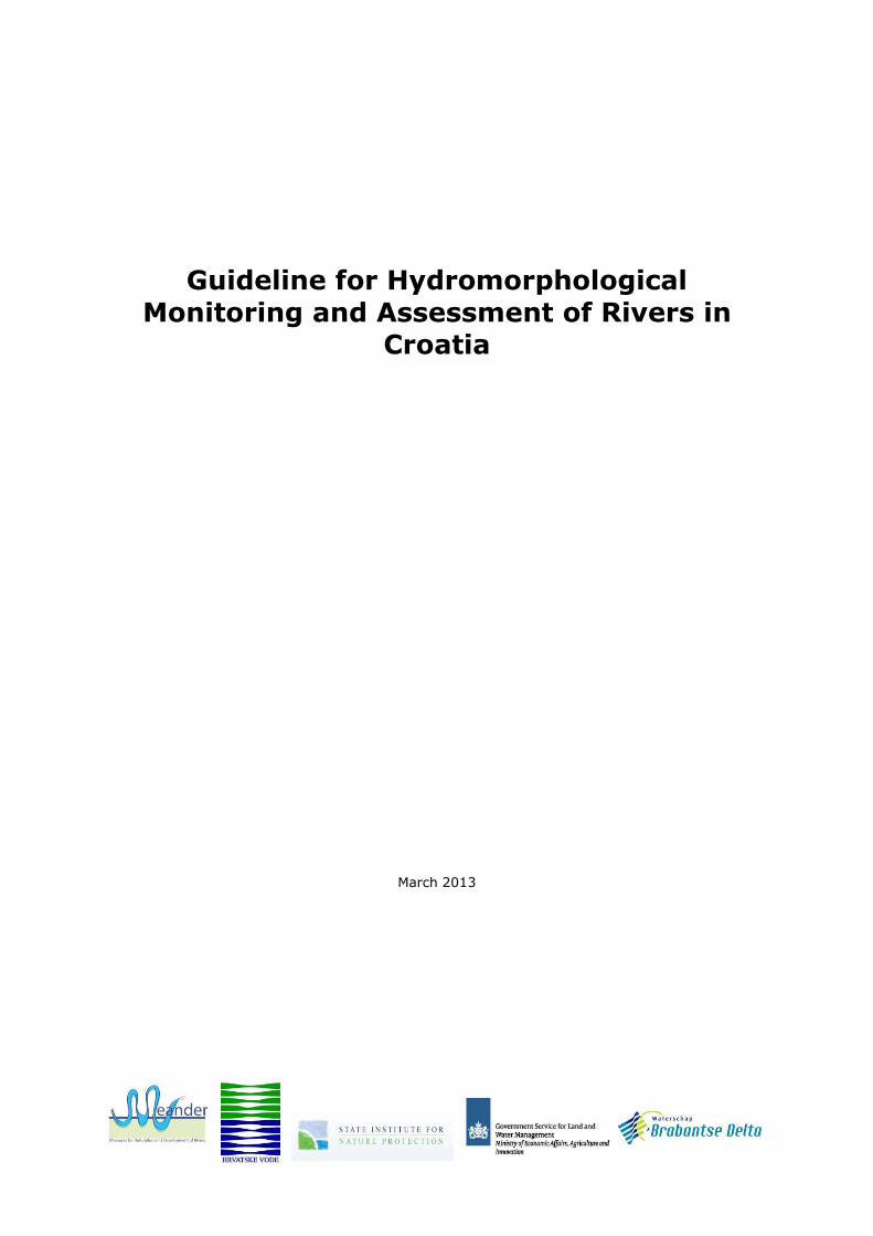
4.3.1. Aquatic vegetation management Assessments of aquatic vegetation structure should be carried out during the period of active growth. Local knowledge should be used to apply the guidance for scoring in 4.3.1. and 4.3.2. to
situations not specifically covered in the score bands.
Scoring aquatic vegetation management: 1. No vegetation management, or very little (e.g. affecting < 10% of reach); 3. Moderate level of vegetation management (e.g. 10% to 50% of reach affected by vegetation management at least every two years); or 5. High level of vegetation management (e.g. annual vegetation management affecting > 50% of reach). 4.3.2. Extent of woody debris if expected Woody debris should be observed from the aspect of active removal, both within and upstream of
the reach. Scoring woody debris: 1. Near-natural amount and size of woody debris, no active removal or addition; 3. Amount and size of woody debris is slightly to moderately altered, occasional active removal or addition; or 5. Amount and size of woody debris is greatly altered, regular active removal or addition.
4.4. Erosion
In-channel features comprise depositional features (e.g. steps, riffles, bars, islands, shallow waters), and erosional features (e.g. pools, potholes, cliffs), and also features such as cushions of aquatic plants, large wood, etc.. This feature is essentially a measure of the combination of pressures that affect river processes. It is assessed using expert judgement, based on river type, the presence and extent of features expected under near-natural conditions, and the intensity of
management both in the channel (e.g. realignment, gravel removal, dredging) and in the catchment (e.g. underdrainage that increases sediment input). Notes should be made when more (as well as fewer) in-channel features are present than would be expected owing to catchment disturbance.

28
Scoring erosion: 1. Erosion/deposition features reflect near-natural conditions; 3.
Erosion/deposition features reflect moderate departure from near-natural conditions (10% to50 % of the features expected are absent); or 5. Erosion/deposition features reflect great departure from near-natural conditions (≥ 50% of the features expected are absent).
4.5. Bank structure and modifications Banks can be affected by hard artificial materials, and/or by soft materials. The assessment of the extent of affected banks is based on the predominant material present (may be a mix of two types). Data from both banks are combined for the assessment. Additional information on field observations of (non-)natural bank structures is illustrated in Annex 5 (Table A.5.2). Scoring bank structure and modifications: 1. Banks are not, or only minimally, affected by hard
artificial materials, or moderately affected by soft materials; 3. Banks are slightly or moderately affected by hard artificial materials, or greatly affected by soft materials; or 5. The majority of banks is composed of hard artificial materials. Note: if modified bank materials are ’natural’ (e.g. willow spiling) maximum score is 3.
4.6. Vegetation type/structure on banks and adjacent land
The overall aim is to record the naturalness of the vegetation in the riparian zone (the strip of vegetation adjoining a river channel), where naturalness is based on land cover as a surrogate, thus not requiring the expertise of professional botanists. This guideline does not specify any fixed width for the riparian zone. However, surveyors should state (with reasons) the width of the riparian zone used for each assessed reach. The width may be a fixed value (e.g. 1 m, 5 m, 20 m) or be related to the width of the river (e.g. 1,5 * river width). Abrupt changes in land cover could
indicate the boundary between the riparian zone and the floodplain. Non-natural land cover classes include: recreational and high intensity agricultural grassland, cultivated land, urban areas, etc.. Near-natural land cover classes include natural wetland, alluvial forest/natural woodlands, moorland. Scoring vegetation type/structure: 1. No, or only minimal, areas of the riparian zone with non-natural land cover; 3. Moderately large areas of the riparian zone with non-natural land cover; or
5. Non-natural land cover is dominant in the riparian zone. 4.7. Land-use and associated features This feature includes the floodplain where one exists. The overall aim is to record the naturalness
of the vegetation in the river corridor beyond the riparian zone, where naturalness is based on land cover as a surrogate, thus not requiring the expertise of professional botanists. Non-natural land
cover classes include: recreational and high intensity agricultural grassland, cultivated land, urban areas, etc.. Near-natural land cover classes include natural wetland, alluvial forest/natural woodlands, moorland. Floodplain features include remnant channels, bogs, and artificially created open-water habitats. Additional information on field observations of (non-)natural land-use is illustrated in Annex 5 (Table A.5.3).
Scoring land-use and associated features: 1 = No, or minimal, areas of the river corridor beyond the riparian zone with non-natural land cover (e.g. dominated by near-natural vegetation and/or features such as ox-bows, remnant channels, bogs); 3. Moderately large areas of the river corridor beyond the riparian zone with non-natural land cover; or 5.Non-natural land cover is dominant in the river corridor beyond the riparian zone (e.g. near-natural vegetation and/or features such as ox-bows, remnant channels, bogs) mainly or totally absent).
4.8. Channel-floodplain interactions
4.8.1. Degree of lateral connectivity of river and floodplain For this feature it is essential to know the delineation of the historical extent of the floodplain – e.g. some may now be lost to urban development (include all, not just recent, development that has reduced the natural inundation of the floodplain). Land cover may be a guide – grassland, wet woodlands and other wetlands are more likely to be flooded than arable/cultivated and urban land.
Scoring lateral connectivity channel-floodplain: 1. None, or minimal amount, of reach is affected by embankments or other measures impeding flooding of floodplain (e.g. deep dredging); 3. Moderate amount of reach is affected by embankments or other measures impeding flooding of floodplain; or 5. Majority of reach is affected by embankments or other measures impeding flooding of floodplain.

29
Note: scoring is only taking place if over-bank flooding is likely to occur (or likely to have occurred
historically) naturally in the reach. Area data should be used where available, if not, use % length of reach. Any flooding deliberately allowed as flood storage under the EC Floods Directive should not be taken as natural.
4.8.2. Degree of lateral movement of river channel This feature assesses the ability of the river to migrate naturally (laterally) within its floodplains, in the absence of any man-made constraints.. Scoring degree lateral movement river channel: 1. Free movement; 3. Partially constrained; or 5. Totally constrained, heavy engineering works (e.g. sheet piling, gabions) restrain the river from moving laterally within the floodplain.
Note: scoring is only taking place if there is still a possibility for the river channel to move laterally within its floodplain.

30

31
5. Hydromorphological assessment
5.1 Introduction
The field protocol parameters are collected to characterise the landscape features at the survey units and sites, and in the catchment. This information will be used for scoring the various
hydromorphological assessment parameters, and to classify the surveyed survey unit/site (see scoring card in Annex 2). The assessment parameters are divided into three main feature categories: Hydrology, Longitudinal connectivity and Morphology. A Microsoft Excel spreadsheet has been developed to calculate the classification, based on the the class bounds of the individual assessment parameters.
5.2 Scoring
The procedure for scoring is describing how to allocate scores for each assessed parameter and category. In principle, the scoring of assessment parameters can be assigned on quantitative (score band A) or qualitative (score band B) data. The score band with quantitative data consists of a five-point scale (1 = lowest degree of modification, 5 = highest degree of modification) and with
qualitative data of a three-point scale (1, 3, 5; following the same general approach as for score band A). Scoring band A generally has a higher degree of confidence. The ‘Croatian methodology’, described in this guideline, is based on the qualitative scoring band. Nevertheless, Table 5.1 contains both separate procedures for scoring, which could be helpful for further detailed assessments.
Feature category: 2. Hydrology
Feature assessed
Scoring band
2.1. Impacts of
artificial in-channel structures within the reach
Quantitative (score band A): Feature not scored
Qualitative (score band B):
1 = Flow character not, or only slightly, affected by structures within reach 3 = Flow character moderately altered 5 = Flow character extensively altered
2.2. Effects of catchment-wide modifications to natural flow
Quantitative (score band A): Score 1 to 5 on quantitative scale according to how much mean daily flow departs from natural using Table 5.2. Assess flow in spring, summer, autumn
and winter periods and take the worst (highest) score as the score for 2.2.
Qualitative (score band B): 1 = Discharge near-natural 3 = Discharge moderately altered 5 = Discharge greatly altered
2.3. Effects of daily flow alteration (e.g. hydro-peaking)
Quantitative (score band A): 1 = No alteration to natural daily flow changes, or intervention results in flow
for < 2% of the time (seven days per year) being at least doubled or halved, or rises/falls in level of > 5 cm per hour occurring
2 = Intervention results in flow for > 2 to 5% of the time being at least
doubled or halved, or rises/falls in level of > 5 cm per hour occurring
3 = Intervention results in flow for > 5 to 20% of the time being at least doubled or halved, or rises/falls in level of > 5 cm per hour occurring
4 = Intervention results in flow for > 20 to 40% of the time being at least doubled or halved, or rises/falls in level of > 5 cm per hour occurring
5 = intervention results in flow for > 40% of the time at least doubled or halved, or rises/falls in level of > 5 cm per hour occurring
Qualitative (score band B): 1 = No rapid flow ramping or peaking occurring (< 5% of the time) 3 = Rare or irregular flow ramping or peaking (approx. 5 to 20% of the time) 5 = Regular flow ramping or peaking occurring (approx. > 20% of the time)

32
Feature category: 3. Longitudinal connectivity affected by artificial structures
3. Longitudinal continuity
Quantitative (score band A): Feature not scored
Qualitative (score band B): 1 = No structures, or if present they have no effect (or minor effect) on
migration or on sediment transport 3 = Structures present, but having only minor or moderate effects on
migratory biota and sediment transport 5 = Structures that in general are barriers to all species and to sediment
Feature category: 4. Morphology
4.1 Channel geometry
4.1.1.Planform
Quantitative (score band A): 1 = 0 to 5% of reach length with changed planform 2 = > 5 to 15% of reach length with changed planform 3 = > 15 to 35% of reach length with changed planform 4 = > 35 to 75% of reach length with changed planform 5 = > 75% of reach length with changed planform
Qualitative (score band B):
1 = Near-natural planform 3 = Planform changes throughout part of the reach 5 = Planform changed in majority of reach, or reach completely, or almost
completely, straightened
4.1.2. Channel section
Quantitative (score band A): 1 = 0 to 5% of reach length with changed channel section 2 = > 5 to 15% of reach length with changed channel section 3 = > 15 to 35% of reach length with changed channel section 4 = > 35 to 75% of reach length with changed channel section 5 = > 75% of reach length with changed channel section
Qualitative (score band B): 1 = Near-natural; no, or minimal, change in cross- and/or long-section 3 = Moderately altered; channel partially affected by one or more of the
following: regrading, reinforcement, culvert, berm, or clear evidence of dredging causing some changes in width/depth ratio
5 = Greatly altered; channel predominantly affected by one or more of the
following: regrading, reinforcement, culvert, berm, or clear evidence of
dredging causing major change in width/depth ratio
4.2 Substrates
4.2.1. Extent of artificial material
Quantitative (score band A):
1 = 0 to 1% artificial material 2 = > 1 to 5% artificial material 3 = > 5 to 15% artificial material 4 = > 15 to 30% artificial material 5 = > 30% artificial material
Qualitative (score band B):
1 = No, or minimal, presence of artificial material 3 = Small to moderate presence of artificial material 5 = Extensive presence of artificial material
4.2.2. ‘Natural’
substrate mix or character altered
Quantitative (score band A): Feature not scored
Qualitative (score band B): 1 = Near-natural mix 3 = Natural mix/character slightly to moderately altered 5 = Natural mix/character greatly altered
4.3. Channel vegetation and organic debris
4.3.1. Aquatic vegetation management
Quantitative (score band A): Feature not scored
Qualitative (score band B): 1 = No vegetation management, or very little (e.g. affecting < 10% of reach) 3 = Moderate level of vegetation management (e.g. 10 to 50% of reach
affected by vegetation management at least every two years)
5 = High level of vegetation management (e.g. annual vegetation management affecting > 50% of reach)

33
4.3.2. Extent of woody debris if
expected
Quantitative (score band A): Feature not scored
Qualitative (score band B): 1 = Near-natural amount and size of woody debris; no active removal or
addition 3 = Amount and size of woody debris slightly to moderately altered;
occasional active removal or addition 5 = Amount and size of woody debris greatly altered; regular active removal
or addition
4.4. Erosion/deposition character
Quantitative (score band A): Feature not scored
Qualitative (score band B): 1 = Erosion/deposition features reflect near-natural conditions 3 = Erosion/deposition features reflect moderate departure from near-natural
conditions (10 to 50% of the features expected are absent) 5 = Erosion/deposition features reflect great departure from near-natural
conditions (≥ 50% of the features expected are absent)
4.5. Bank structure and modifications
Quantitative (score band A): 1 = Banks affected by 0 to 5% hard, or 0% to 10% soft, artificial materials 2 = Banks affected by > 5 to 15% hard, or >10 to 50% soft, artificial
materials 3 = Banks affected by > 15 to 35% hard, or > 50 to 100% soft, artificial
materials 4 = Banks affected by > 35 to 75% hard artificial materials 5 = Banks affected by > 75% hard artificial materials
Qualitative (score band B): 1 = Banks not, or only minimally, affected by hard artificial materials, or
moderately affected by soft materials 3 = Banks slightly or moderately affected by hard artificial materials, or
greatly affected by soft materials 5 = Majority of banks composed of hard artificial materials
4.6. Vegetation type/structure on banks and
adjacent land
Quantitative (score band A): 1 = 0 to 5% non-natural land cover in riparian zone 2 = > 5 to 15% non-natural land cover in riparian zone 3 = > 15 to 35% non-natural land cover in riparian zone 4 = > 35 to 75% non-natural land cover in riparian zone 5 = > 75% non-natural land cover in riparian zone
Qualitative (score band B): 1 = No, or only minimal, areas of the riparian zone with non-natural land
cover 3 = Moderately large areas of the riparian zone with non-natural land cover 5 = Non-natural land cover is dominant in the riparian zone
4.7. Land-use and associated features
Quantitative (score band A): 1 = 0 to 5% non-natural land cover beyond the riparian zone 2 = > 5 to 15% non-natural land cover beyond the riparian zone 3 = > 15 to 35% non-natural land cover beyond the riparian zone 4 = > 35 to 75% non-natural land cover beyond the riparian zone 5 = > 75% non-natural land cover beyond the riparian zone
Qualitative (score band B): 1 = No, or minimal, areas of the river corridor beyond the riparian zone with
non-natural land cover (e.g. dominated by near-natural vegetation and/or features such as ox-bows, remnant channels, bogs)
3 = Moderately large areas of the river corridor beyond the riparian zone with non-natural land cover
5 = Non-natural land cover is dominant in the river corridor beyond the riparian zone (e.g. near-natural vegetation and/or features such as ox- bows, remnant channels, bogs) mainly or totally absent)

34
Table 5.1 Scoring of hydromorphological features (score band A and B).
Table 5.2 Look-up table for scoring Feature 2.2 (score 1 to 5). The five-band scales (quantitative scoring band A) and the three-band scales (qualitative scoring band B) are interchangeable as follows:
If the quantitative scoring band A is used, an asterisk (i.e. 1*) should be added for those features where the score equals 1 = 0 to 5% change (features 4.1.1., 4.1.2., 4.2.1., 4.5., 4.6., 4.7., 4.8.1 and 4.8.2.) and where the recorded change is only 0 to 1%. This is to highlight river reaches with extremely low levels of modification. A symbol should be added (i.e. 5) to indicate extreme
levels of modification.
4.8. Channel-floodplain interactions
4.8.1. Degree of lateral connec-tivity of river and floodplain (is over-bank
flooding likely to occur (or likely to have occurred historically) naturally in the reach? If no – N/A, if yes, score)
Quantitative (score band A): 1 = 0 to 5% reach affected by embankments or other measures impeding
flooding of floodplain (e.g. channel and bank regrading) 2 = > 5 to 15% as above 3 = > 15 to 35% as above 4 = > 35 to 75% as above 5 = > 75% as above
Qualitative (score band B): 1 = None, or minimal amount, of reach affected by embankments or other
measures impeding flooding of floodplain (e.g. deep dredging) 3 = Moderate amount of reach affected by embankments or other measures
impeding flooding of floodplain
5 = Majority of reach affected by embankments or other measures impeding flooding of floodplain
4.8.2. Degree of lateral movement of river channel
(is the river likely
to move laterally within its flood-plain in the absence of any man-made constraints? If no – N/A, if yes,
score)
Quantitative (score band A): 1 = 0 to 5% reach constrained 2 = > 5 to 15% reach constrained
3 = > 15 to 35% reach constrained
4 = > 35 to 75% reach constrained 5 = > 75% reach constrained
Qualitative (score band B): 1 = Free 3 = Partially constrained
5 = Totally constrained
% days flow different from natural in spring, summer, autumn or winter (choose the worst – highest score)
< 20 20 to < 40
40 to < 60
60 to < 80
≥ 80
< 5% decrease or < 10% increase in flow 1 1 1 2 2
5 to < 15% decrease in flow or 10 to < 50% increase in flow 1 2 2 3 3
15 to < 30% decrease in flow or 50 to < 100% increase in flow
1 2 3 3 4
30 to < 50% decrease in flow or 100 to < 500% increase in flow
1 2 3 4 5
≥ 50% decrease in flow or ≥ 500% increase in flow 2 3 4 5 5
Five-band score (quantitative scoring band A)
Three-band score (qualitative scoring band B)
1 1
2 1
3 3
4 5
5 5

35
The importance of each of the assessed features for geomorphological and ecological functioning
will not be the same. However, at present there is insufficient scientific evidence to justify differential weighting of the scores allocated. The field protocol describes the present state of the river, whereas many of the assessment
parameters describe the present state compared to the reference situation, indicated in comments column (Annex 2).
5.3 Classification
Converting the scores of the hydromorphological parameters into a classification, depends mainly on the application for which the assessment is required. In any case, the scores from the field survey protocols should be tabulated as shown in Table 5.3. For reporting option 1, 2 and 3, the tabulation is separate for each survey unit. Reporting option 4 requires the combination (averaging) of all scores for the reach assessed. The tabulation process, for which a Microsoft Excel spread sheet is available, provides a range of
reporting options for different purposes. Table 5.3 also indicates how the three combined scores (reporting options 2, 3 and 4) are being derived: Reporting option 1, tabulating the 16 scores separately, provides the maximum amount of
information for river management; Reporting option 2, using a three digit code, reports river modifications within the three main
hydromorphological quality elements given in the WFD (morphology, hydrological regime assessment, and longitudinal continuity), without attempting to link hydromorphology with
biology. For example, a code of 111 would indicate a river with the lowest degree of morphological modification, near-natural flow, and with no structures inhibiting upstream and downstream movement of sediment and biota.
Reporting option 3, grouping features according to zone, reports on the three main river zones: ‘channel’, ‘banks/riparian zone’ and ‘floodplain’, as recommended in EN 14614 (CEN, 2004);
Reporting option 4, a single score for the reach assessed, reports the overall hydromorphological modification of a river reach without any details.
Although there are arguments for assigning greater importance to some feature categories than others, there is insufficient scientific evidence to justify incorporating a weighting system in the scoring protocol. For the purposes of river management, it is important to keep the scores for
features separate (options 1). For high-level reporting purposes, there might be a case for combining scores into a single quality score for a river or river reach (option 2, 3 and 4).
Table 5.3 Reporting options and procedures for reporting hydromorphological modification scores.
Reporting option Procedure
1: Tabulate 16 scores separately
Score as in Table 5.1 for all features (2.1., 2.2., 2.3., 3., 4.1.1., 4.1.2., 4.2.1., 4.2.2., 4.3.1., 4.3.2.,4.4., 4.5., 4.6., 4.7., 4.8.1. and 4.8.2.); do not combine.
2: Create a three-digit code
Combine the scores for categories 4.1.1., 4.1.2., 4.2.1., 4.2.2., 4.5., 4.6., 4.7., 4.8.1. and 4.8.2. to create a single mean score for morphology (the first of the three digits). Scores should be rounded up or down to the nearest integer (rounding up any that end in .5). Report the score for category 2. for hydrological regime assessment (the second of the three digits) using 2.1., 2.2. and/or 2.3., whichever has the higher score (i.e. represents the greater impact).
Report the score for category 3. for longitudinal continuity (the third of the three digits).
3: Group features
according to zone
Feature categories should be grouped as follows and mean scores
calculated for the three zones. Scores should be rounded up or down to the nearest integer (rounding up any that end in .5):
Channel: 2.1., 2.2., 2.3., 3., 4.1.1., 4.1.2., 4.2.1. and 4.2.2. Banks/riparian zone: 4.5. and 4.6. Floodplain: 4.7., 4.8.1. and 4.8.2.
4: Produce a single score for the reach
assessed
Take the mean of the 16 scores (see reporting option 1) and round up or down to the nearest integer. Scores ending in .5 should be rounded up.

36
When three classes for classification are used (qualitative scoring band A), the following terms
should be assigned to descriptions of hydromorphological modification, and represented (if required) on a map using the colour codings as recommended in EN 14614 (CEN, 2004) and illustrated in Table 5.4.
Table 5.4 Classification terms for hydromorphological modification in three classes. In the case five classes are used, the colour codings should be as illustrated in Table 5.5.
Table 5.5 Classification terms for hydromorphological modification in five classes.
The names used to describe each class (e.g. ’near-natural’) have been deliberately chosen to be different from the terms used in the WFD (e.g. ’high’, ’good’) to emphasise that classifications used in this guideline are not related to classifications of ecological status for the WFD (see also section 2.2). Although the listed descriptions in Table 5.4 and 5.5 for reporting hydromorphological modification are the same as those in the WFD, they are also used routinely for reporting other (non-WFD) aspects of environmental quality.
5.4 Reporting and data presentation
This guideline describes the procedure of reporting and presenting hydromorphological survey data based on the EU standards EN 14614:2004 (CEN, 2004) and EN 15843:2010 (CEN, 2010). The
procedure for hydromorphological reporting will vary depending on the purpose of assessment (e.g. identifying sites or reaches in reference condition under the WFD, assisting with local river management, guiding the rehabilitation of degraded stretches of rivers, etc.). Hydromorphological monitoring and assessment in Croatia has to be implemented in order to: Fulfil obligations based on the requirements of the Water Act (as recommended by the WFD);
Support an interdisciplinary approach in river basin management (e.g. biology, civil engineering, geology, hydrology, etc.);
Point to gaps and inconsistencies in the knowledge about hydromorphology gained so far and provide inputs for the existing and future survey programmes;
Broaden and improve expert and scientific knowledge and support the implementation of river restoration processes.
The above-mentioned requirements also give rise to the obligations to report to the Ministry of Agriculture, the Croatian Environment Agency and the European Commission. The extent of deviation from the reference condition is used to place a site or reach in one of three
or one of five classes according to its degree of hydromorphological modification. This is achieved by assessing data from field surveys and other sources (e.g. maps, remote sensing) to determine how far the criteria described by reference conditions (see section 3.1.2) are met. Reference
conditions (WFD ’high status’) for hydromorphology take into account the natural range of variation but form a narrow quality band. The boundaries between other hydromorphological quality bands should reflect deviation from reference conditions. Depending on the specific purpose, assessment reports may include hydromorphological classifications given in four ways, according to Table 5.3 (section 5.3).
Score Class Description Map colour
1 to < 2,5 1 Near-natural to slightly modified (reference condition) Blue
2,5 to < 3,5 3 Slightly to moderately modified Yellow
3,5 to 5,0 5 Extensively to severely modified Red
Score Class Description Map colour
1 to < 1,5 1 Near-natural (reference condition) Blue
1,5 to < 2,5 2 Slightly modified Green
2,5 to < 3,5 3 Moderately modified Yellow
3,5 to < 4,5 4 Extensively modified Orange
4,5 to 5,0 5 Severely modified Red

37
A general outline of a hydromorphological assessment report should contain (at least) the following
elements: A brief and general description of the catchment, river and reach assessed; The specific monitoring purpose/objectives related to the Croatian annual monitoring plan; A brief description of the survey strategy (e.g. size of survey units) and specific deviations from
this guideline; The assessment results (scores and classification), incl. a copy of the field survey protocols in
Annexes; Conclusions related to the purpose/objectives and recommendations regarding future
hydromorphological monitoring and assessment (site specific and general). For strategic reporting purposes, a single composite assessment for a river or river reach is likely
to be a necessity. However, for operational or monitoring purposes it will be essential to keep elements of the assessment (i.e. hydrology, morphology and longitudinal connectivity or channel, banks/riparian zone and floodplain) separate. Mapping these separate components is important, both for a fuller understanding of the outputs and to encourage managers to make better use of the information. With the use of GIS ‘layering’ technology, it is possible to present information at different scales and levels of integration, including the relationship between hydromorphological
features and artificial modifications.
Whilst the WFD does not require hydromorphology to be reported in five classes, this guideline initially recommends the use of an equivalent 3-band classification system in which reference conditions (near-natural to slightly modified; high status) are defined as class 1, with the remaining classes as 3 and 5. Nevertheless, a 5-band classification system can also be used (class 1 = reference condition (near-natural), remaining classes 2-5). It also recommends that the use of
the WFD terms such as ‘good status’ or ‘moderate status’ should be avoided as they are linked entirely to ecological status assessment. Where maps of hydromorphological quality are produced, it is recommended that the colour codes are used as illustrated in Table 5.4 and 5.5 (section 5.3). As an example of one form of colour-coded output, Figure 5.1 shows a map derived from the SEQ method of assessment in France.
Figure 5.1 Example of a (5-band) colour-coded map of hydromorphological quality (Verdon catchment, southern France).

38

39
6. Training and quality assurance
6.1 Training and quality assurance for survey and assessment
Surveyor training is essential to ensure consistency in recording hydromorphological river features. Surveyors should have a background in environmental science, but they should not normally be
expected to have specialist knowledge of plant identification or fluvial geomorphology. Training can initially be conducted by members of the Working Group for Hydromorphological Monitoring ans Assessment. This working group consists of experts with different profiles (biologists, hydrologists, geologists, GIS experts) who have followed the Training of Trainers (ToT) course and other component 2 activities within the MEANDER project. Training should be structured to cover aspects such as:
Safety issues concerning field work;
Planning surveys, taking into account the issue of authority of institutions conducting the field surveys, (including issues of access and permission);
Recognizing hydromorphological features; Determining boundaries/areas for field surveys (survey strategies); Accurate completion of field survey protocols; How to compile a series of reference photographs;
How to collect and interpret non-survey data, such as historical maps, aerial photos, historical data about river interventions and works (a catalogue of hydraulic structures).
Training should also: Incorporate a certification system (in the first phase an internal certificate will be issued by
Croatian Waters (CW) or the competent Ministry for surveyors who have completed the training
for field surveys of hydromorphological parameters); Include regular refresher courses; Be carried out over a wide range of river types, including Pannonian and Dinaric ecoregions; Be fully supported by manuals, including photos and videos and other teaching aids. A field survey assessment system should be put in place, as well as testing (quality assurance)
procedures to compare the results obtained by different surveyors on the same stretches of a river.
If a surveyor consistently records results which vary from those recorded by others, the problem should be rectified by additional training. A control system shall be implemented, initially on a monthly basis and later on a quarterly basis, after which a period of control/testing of field survey shall be defined as needed.
6.2 Training manuals
Training manuals should present general background on the development of the method, and unambiguous information on how to carry out the survey, with accurate descriptions of the features to be recorded. Texts should be supported by illustrative material (e.g. photographs, videos, DVDs, CDs) to illustrate the appearance of features (not just the typical, but extreme forms
as well).
Training manuals should include guidance on: How to transfer information from field survey protocols to databases; How to obtain and interpret information from maps, hydromorphological pressures and historical
data; How to apply the results to assessments of hydromorphological quality;
How to apply quality assurance protocols; Issues of health and safety; Matters relating to access to rivers. The preceding guideline, together with the ToT materials of the MEANDER project could be used as initial training materials.

40
6.3 Data entry and validation
Data entry and validation will be done by authorized staff of CW. CW will provide a database with all procedures for checking the entry and assessment of field data and entry control procedures.
Data adjustments change and system updates will be carried out by authorized CW staff. It is important that no errors occur when transferring data from field survey protocols to databases. Suitable quality assurance methods should be used, such as double entry of data onto databases by two different operators, followed by tests to ensure the results are identical. Random testing should also be carried out on hydromorphological quality assessments and other applications to ensure that consistent results are obtained from the same data. Data corruption can occur when systems are up-dated or during information transfer; some form of checking procedure
is required following such changes.

41
7. Literature
Adamková J., Hensel, K., Grešková, A., Klozík, M., Lehotský, M., Otahelová, H., Šporka, F.,
Štefková, E. & M. Valachovic, 2004. Hydromorphological River Survey and Assessment (Slovakia). Report to SHMI, Bratislava, Slovakia.
CEC - Commission of the European Communities, 1992. Directive 92/43/EEC On the Conservation of Natural Habitats and of Wild Fauna and Flora. Official Journal of the European Communities,
92L0043. CEC - Commission of the European Communities, 2000. Directive 2000/60/EC Establishing a
Framework for Community Action in the Field of Water Policy. Official Journal of the European Communities, L327.CEU - Commission of the European Union, 2007. Directive 2007/60/EC On the Assessment and Management of Flood Risks. Official Journal of the European Union, L288.
CEU - Commission of the European Union, 2009. Directive 2009/147/EC On the Conservation of Wild Birds. Official Journal of the European Union, L20.
CEN – European Committee for Standardisation, 2004. EU Standard EN 14614:2004 Water quality
– Guidance standard for assessing the hydromorphological features of rivers. CEN – European Committee for Standardisation, 2010. EU Standard EN 15843:2010 Water quality
– Guidance standard on determining the degree of modification of river hydromorphology. Church, M., 2002. Geomorphic thresholds in riverine landscapes. Freshwater Biology Vol. 47,
pp.541–557.
CW – Croatian Waters, 2009. Mirna River Basin Management Plan. Rijeka, Croatia. June 2009. EC – European Communities, 2003a. Identification and Designation of Heavily Modified and
Artificial Water Bodies; Guidance Document No 4. Report by Working Group 2.2 – HMWB. EC – European Communities, 2003b. Overall Approach to the Classification of Ecological Status and
Ecological Potential. Report by Working Group 2 A Ecological Status (ECOSTAT). Fleischhacker, T. & K. Kern, 2002. Ecomorphological Survey of Large Rivers. German Institute of
Hydrology.
Maurizi, S. (ed.) & F. Poillon (ed.), 1992. Restoration of Aquatic Ecosystems. National Academy Press, Washington, D.C.
Pedersen, M.L. & A. Baattrup-Pedersen, 2003. National monitoring programme 2003-2009; Assessment methods manual. National Environmental Research Institute of Denmark. Technical Report no. 21.
Raven, P.J., Holmes, N.T.H., Dawson, F.H., Fox, P J.A., Everard, M., Fozzard, I.R. &. K.J. Rouen, 1998. River Habitat Quality – the physical character of rivers and streams in the UK and Isle of
Man. Environment Agency, Bristol, UK. SMHI - Slovak Hydrometeorological Institute, 2004. Establishment of the Protocol on Monitoring
and Assessment of the Hydromorphological Elements. Twinning light Project No. TLP 01 – 29. Report SR 0110 01 01 0009.
Thorne, C.R., Hey, R D. & M.D. Newson (eds.), 1997. Applied fluvial geomorphology for river engineering and management. John Wiley and Sons Ltd., Chichester.
Wallin, M., Wiederholm, T. & R.K. Johnson, 2003. Guidance on establishing reference conditions and ecological status class boundaries for inland surface waters. Report by Working Group 2.3 – REFCOND.

42

43
Annexes

44

45
Annex 1. Definitions and abbreviations
Aquatic macrophytes - plants (mostly vascular plants and bryophytes) which are easily seen with the naked eye and are associated with open water or wetlands with shallow water. Attribute - a specific recorded element of a hydromorphological feature (e.g. ‘boulders’ and ‘silt’ are substrate attributes; ‘sheet piling’ and ‘gabions’ are attributes of engineered banks). AWB - Artificial Water Body.
Backwater - area of low velocity or static water under dry-weather flows, most commonly former river channels or flood channels within the alluvial floodplain and physically separated from the river channel. Bank - permanent side of a river or island, which is above the normal water level and only submerged during periods of high river flow. Note: in the context of this guideline, the top is marked by the first major break in slope, above which cultivation or development is possible. Bankfull - maximum point on banks at which floods are held within the channel before spilling
over onto the floodplain. Berm - natural or artificial shelf within a river that is exposed above water level during low flows,
but is submerged during high flows. Bog - a wetland, fed by atmospheric precipitation, in which the vegetation communities (usually dominated by Sphagnum mosses) form peat over long periods of time. Braiding - naturally divided course of a river by deposited sediment accumulations, characterised
by at least two channels which often change their course regularly. Bryophytes - a collective term for liverworts and mosses – plants which are often abundant on exposed boulders and bedrock of upland streams. CMHS - Croatian Meteorological and Hydrological Service. Compaction - consolidation of the river bed through physical, chemical or biological processes. Contiguous survey - survey carried out along entire river reaches, with data collected from adjoining survey units.
CW - Croatian Waters (Hrvatske Vode). Culvert - arched, enclosed or piped structure constructed to carry water under roads, railways and buildings. DLG - Dutch Government Service for Land and Water Management. Ecological status - expression of the quality of the structure and functioning of aquatic ecosystems, expressed by comparing the prevailing conditions with reference conditions. Note: as
classified in accordance with Annex V of the EC Water Framework Directive.
Embankment (levee) - artificial bank built to raise the natural bank level thereby reducing the frequency of flooding of adjacent land. Floodplain - the valley floor adjacent to a river that is (or was historically) inundated periodically by flood waters. Fluvial features - features shaped by sedimentation and erosion. Gabion - wire basket containing stones, used for river-bed or bank protection.
GEP - Good Ecological Potential. Glide - moderately-flowing water with undisturbed surface other than occasional swirls or eddies (cf. ‘run’). Hard materials/engineering - bank protection using artificial materials such as concrete, sheet piling or bricks. Note: see ‘soft materials’. HMWB - Heavily Modified Water Body. Hydromorphology - physical and hydrological characteristics of rivers including the underlying
processes from which they result. Hydro-peaking - rapid and frequent fluctuations in flow resulting from hydropower generation to meet peak demands in electricity. IOF - Institute of Oceanography and Fisheries.
Lateral connectivity - the freedom for water to move between the channel and the floodplain. Lateral movement - the freedom for a river channel to migrate across a floodplain. Levee - see ‘embankment’.
MEP - Maximum Ecological Potential. MoC - Ministry of Culture. MoRDFWM - Ministry of Regional Development, Forestry and Water Management. Planform - view of river pattern from above (e.g. sinuous, straight). Point bar - bar of river sediment formed on the inside of a bend in a river (cf. ‘side bar’).

46
Pool - a distinct feature of deeper water that does not exceed three channel widths in length,
where depth is sustained through fluvial scour and where river flow may be imperceptible in dry weather conditions. PoZ - Polytechnic of Zagreb. Reach - a major sub-division of a river, defined by physical, hydrological, and chemical character
that distinguishes it from other parts of the river system upstream and downstream. Reference conditions - conditions reflecting a totally undisturbed state, lacking human impact, or near-natural with only minor evidence of distortion (for waters not designated as heavily modified or artificial, synonymous with ‘high ecological status’ in the Water Framework Directive). Regarding - river widening and deepening and modifying the bed and bank profiles to accommodate increased flows. Reinforcement - strengthening of river beds and banks for various purposes (e.g. ford
construction, erosion control) using materials such as boulders, sheet piling, geotextiles, etc. Residual flow - flow remaining in a river after abstraction (e.g. for hydropower generation, water supply, etc.). Note: a minimum residual flow may be set to protect downstream uses, below which abstraction is not permitted. Revetment - facing built to support a bank. Riffle - fast-flowing shallow water with distinctly broken or disturbed surface over gravel/pebble or
cobble substrate.
Riparian zone - for small rivers, this comprises the bank face and a strip of land on the bank top capable of exerting physical, hydrological and ecological impacts on the aquatic ecosystem (e.g. shading, leaf litter input). For large rivers, the riparian zone usually ends at the bankfull level. In this standard, the term ‘riparian zone’ does not include the wider floodplain. Riparian zone vegetation structure - physical character of the vegetation that creates habitat on the banks and land immediately adjacent to the river; e.g. ‘complex’ – mixture of shrubs,
herbaceous vegetation, etc. or ‘simple’ – only herbaceous vegetation. River rehabilitation - partial return of a river to a pre-disturbance condition (e.g. by dredging backwaters that have filled with sediment, changing the planform of channelised reaches, or planting riparian vegetation). River type - a group of rivers that can be broadly differentiated from other groups on the basis of their physical and chemical characteristics (e.g. lowland chalk streams; upland ultra-oligotrophic rivers).
Run - fast-flowing water with a disturbed, but not broken, surface (cf. ‘glide’). RWABD - Regional Water Authority Brabantse Delta. Sheet piling - corrugated metal sheets used for vertical bank protection. Side bar - discrete sediment deposit made by the river along the sides of relatively straight
reaches (cf. ‘point bar’). SINP - State Institute for Nature Protection.
Sinuosity - degree of deviation from a straight line, usually defined as channel length/valley length. Soft materials/engineering - bank protection using biodegradable materials such as brushwood, reeds or live willows. Note: see ‘hard materials’. Stream ordering - methods for classifying rivers and streams related to the complexity of the drainage basin, with progressively higher order numbers usually assigned to streams with greater discharge lower down the catchment.
Submerged vegetation - plants rooted to the bed and either completely submerged or with only part of their shoots floating or emergent. Substrate/substratum - material making up the bed of a river. Survey unit (SU) - length of river from which data are collected during field survey; this may be a fixed length (e.g. 500 m) or variable, according to the method used, but must always be defined and recorded. ToT - Training of Trainers.
UoL - University of Ljubljana.
UoR (FoCE) - University of Rijeka, Faculty of Civil Engineering. UoZ (FoCE) - University of Zagreb, Faculty of Civil Engineering. UoZ (FoS, DoB) - University of Zagreb, Faculty of Science, Department of Biology. UoZ (FoS, DoG) - University of Zagreb, Faculty of Science, Department of Geology. Weir - structure used for controlling flow and upstream surface level, or for measuring discharge.
Wetlands - habitats (e.g. marsh, fen, shallow temporary water) occupying the transitional zone between permanently inundated, and generally dry, environments WFD - Water Framework Directive. Willow spiling - method of soft engineering used for strengthening river banks using retaining walls constructed of woven willow stems from which trees will sprout.

47
Woody debris - dead woody material that falls into rivers and streams, ranging in size from leaf
fragments (fine woody debris) to branches or whole trees (coarse woody debris). WMI - Water Management Institute (Croatian Waters).

48

49
Annex 2. Field survey protocol for hydromorphological survey of Croatian rivers and streams and scoring card
Field survey protocol
1.1. Stream / River name:
1.2. Site name 1.3. River type 1.4. Waterbody ID
1.5. Site latitude 1.6. Site longitude 1.7. Site altitude
1.8. Ecoregion / Subecoregion 1.9. Catchment area 1.10. Geology of SU (dominant)
1.11. Latitude of the beginning of the SU
1.12. Longitude of the beginning of the SU
1.13. Altitude of the beginning of the SU
1.14. Latitude of the end of the SU
1.15. Longitude of the end of the SU
1.16. Altitude of the end of the SU
1.17. Distance from source 1.18. River width at site 1.19. River slope of the SU (‰)
1.20. Sketch / Photo
1.21. SU length 1.22. Date of survey 1.23. Surveyor
2.1. Mean annual long-term discharge (m3 s-1)

50

51
Annex 3. Factsheets for hydromorphological features
1. General data about the survey unit (SU) and survey site 1.1 Stream / River name Name of the river or stream where the survey is carried out.
1.2 Site name The exact location of the survey. Usually the name of a nearby bridge or town. 1.3 River type (NN 89/10) The river type according to the national Croatian typology according to the Uredba o standardu kakvoće voda (NN 89/10).
1.4. Waterbody ID The number the waterbody according to the Draft River Basin Management Plan.
1.5 and 1.6 Site Latitude and Site Longitude Exact latitude and longitude of the site extracted from GPS, map (1:25 000) or GIS.
1.7. Site altitude Approximate site altitude in meters above sea level (m a.s.l.) taken from the GPS, map (1:25 000) or GIS. 1.8. Ecoregion/Subecoregion Name of Ecoregion and/or Subecoregion according to the Regulation on water quality standards (NN 89/10).
1.9. Catchment area Catchment area (km2) should be determined from maps (1:25 000) or using GIS. Catchment area should include the entire SU and should therefore be calculated from the downstream part of SU. Define more???
1.10. Geology of SU (dominant)
Geology of the SU (carbonate and silicate rocks and organic soil) should be determined form basic lithological map in GIS. 1.11., 1.12., 1.14 and 1.15 Latitude and longitude of the beginning and the end of the SU Exact latitude and longitude of the beginning and the end of the SU extracted from GPS, map (1:25 000) or GIS.
1.13. and 1.16. Altitude of the beginning and the end of SU Approximate altitude of the beginning and the end of SU in meters above sea level (m a.s.l.) taken from the GPS, map (1:25 000) or GIS. 1.17. Distance from source Water course distance from source to survey site in kilometres extracted from GIS or map (1: 25
000). 1.18. River width at site Width of the river at site in meters extracted from GIS (orto-photo) or Google Earth.
1.19. River slope of the SU (‰) The SU slope is calculated as the difference in elevation (in meters) between two points (Altitude of
the beginning and the end of SU ) divided by the distance (in kilometres) between the two points. 1.20 Sketch / Photo A sketch or photo showing the characteristics of the site should be included in the protocol. 1.21. SU length
Length of the SU in kilometres between two points, beginning and the end of the SU.

52
1.22. Date of survey
Date of survey. 1.23. Surveyor Name and Surname of surveyor.

53
Feature not scored.
1 3 5
Flow character not, or only slightly,
affected by structures within the reach.
Flow character moderately altered. Flow character extensively altered.
This feature covers the effects of artificial structures (e.g. groynes, weirs, bridges, fords) or water abstraction on flow type diversity and sediment transport. Feature 2.1.1. does not refer to changes in discharge; these are assessed in feature 2.1.2.
2.1. Discharge
2.1.1. Impacts of artificial in-channel structures within the reach
Quantitative
Qualitative
Guidance

54
Score 1 to 5 on quantitative scale according to how much mean daily flow departs from natural using the "look up" Table A2. Assess flow in spring, summer, autumn and winter periods and take the worst (highest) score as the score for 5b.
1 3 5
Discharge near-natural. Discharge moderately altered. Discharge greatly altered.
Need hydrological data to establish relevance of discharge alterations. Where long-term river discharge data are not available, it is only possible to use expert judgement applied to qualitative scoring.
Podaci stanice SLAVONSKI BROD za godinu 2011, PROTOK (m3/s)
01.1201.1101.1001.0901.0801.0701.0601.0501.0401.0301.0201.01
m3/s
2200
2100
2000
1900
1800
1700
1600
1500
1400
1300
1200
1100
1000
900
800
700
600
500
400
300
200
100
Podaci stanice PODSUSED ŽIČARA za godinu 2011, PROTOK (m3/s)
01.1201.1101.1001.0901.0801.0701.0601.0501.0401.0301.0201.01
m3/s
1500
1400
1300
1200
1100
1000
900
800
700
600
500
400
300
200
100
0
Podaci stanice BOTOVO za godinu 2011, PROTOK (m3/s)
01.1201.1101.1001.0901.0801.0701.0601.0501.0401.0301.0201.01
m3/s
1150
1100
1050
1000
950
900
850
800
750
700
650
600
550
500
450
400
350
300
250
200
150
100
2.1.2. Effects of catchment-wide modifications to natural flow character
Quantitative
Qualitative
Guidance

55
1 2 3 4 5
No alteration to
natural daily flow changes, or
intervention results in flow for < 2 % of the time (seven days
per year) being at least doubled or
halved, or rises/falls in level of > 5 cm
per hour occurring.
Intervention results in flow for > 2 % to
5 % of the time
being at least doubled or halved,
or rises/falls in level of > 5 cm per hour
occurring.
Intervention results in flow for > 5 % to
20 % of the time
being at least doubled or halved,
or rises/falls in level of > 5 cm per hour
occurring.
Intervention results in flow for > 20 % to
40 % of the time
being at least doubled or halved,
or rises/falls in level of > 5 cm per hour
occurring.
Intervention results in flow for > 40 % of
the time at least doubled or halved,
or rises/falls in level of > 5 cm per hour
occurring.
1 3 5
No rapid flow ramping or peaking occurring (< 5 % of the time).
Rare or irregular flow ramping or peaking occurring (ca 5 % to 20 %
of the time).
Regular flow ramping or peaking occurring (ca > 20 % of the time).
Ramping is the rapid increase in discharge owing to releases that result in river level rises and falls exceeding 5 cm/h. Hydro-peaking is the sharp increase in discharge on a daily basis owing to releases; such increases may occur gradually with water levels rising or falling at rates less than 5 cm/h.
The effect of hydro-peaking regimes varies (e.g. according to timing of release, quantity of residual flow); this will affect scoring. *Move up one class if affected reach is downstream of lakes/delaying reservoirs, or if ramping is significantly smoothed in river.
Podaci stanice SLAVONSKI BROD za godinu 2011, PROTOK (m3/s)
03.0601.0630.0528.0526.0524.0522.0520.0518.0516.0514.0512.0510.0508.0506.0504.0502.0530.0428.04
700
650
600
550
500
450
400
350
300
Podaci stanice PODSUSED ŽIČARA za godinu 2011, PROTOK (m3/s)
04.0602.0631.0529.0527.0525.0523.0521.0519.0517.0515.0513.0511.0509.0507.0505.0503.0501.0529.04
320
300
280
260
240
220
200
180
160
140
120
100
80
Podaci stanice BOTOVO za godinu 2011, PROTOK (m3/s)
03.0601.0630.0528.0526.0524.0522.0520.0518.0516.0514.0512.0510.0508.0506.0504.0502.0530.0428.04
800
750
700
650
600
550
500
450
400
350
300
250
200
150
2.1.3. Effects of daily flow alteration
Quantitative
Qualitative
Guidance

56
Feature not scored.
1 3 5
No structures, or if present they
have no effect (or minor effect) on migration or on sediment transport.
Structures present, but having only
minor or moderate effects on migratory biota and sediment
transport.
Structures that in general are
barriers to all species and to sediment.
This assessment applies only to artificial barriers on rivers, and not to natural barriers such as lakes. It is not possible to provide guidance on scoring with respect to the sizes or heights of structures, as their impact will vary according to river type, migratory species present, etc. NOTE If barriers are large, and the reach is in the downstream part of the catchment, they may affect many other reaches upstream.
In some cases fish are prevented from passing through dams even though fish passes have been installed. A score of 3 should be assigned where a dam has a fish-pass fitted that functions effectively. Where all sediment is retained behind a dam a score of 5 should be assigned even if a few species are able to pass through. Where a large dam is present, assign 5. A large dam is defined by the International Commission on Large Dams as "those having a height of 15 m from the foundation or, if the height is between 5 m to 15 m, having a reservoir capacity of more than 3 million m³".
3.1. Longitudinal continuity as affected by artificial structures
3.1.1. Longitudinal continuity as affected by artificial structures
Quantitative
Qualitative
Guidance

1 2 3 4 5
0 % to 5 % of reach length with changed planform.
> 5 % to 15 % of reach length with changed planform.
> 15 % to 35 % of reach length with changed planform.
> 35 % to 75 % of reach length with changed planform.
> 75 % of reach length with
changed planform.
1 3 5
Near-natural planform. Planform changes throughout part
of the reach.
Planform changed in majority of reach, or reach completely, or
almost completely, straightened.
In this context, "planform" both to changes in channel sinuosity and to changes in channel braiding or to multiple channels. If possible, use absolute or recorded amounts of change rather than estimates from variety of sources. Where a river has some artificial sinuosity, but has lost its natural meandering, assign score 5.
4.1. Channel geometry
4.1.1. Planform
Quantitative
Qualitative
Guidance

-58-
1 2 3 4 5
0 % to 5 % of reach length with
changed channel section.
> 5 % to 15 % of reach length with
changed channel section.
> 15 % to 35 % of reach length with
changed channel section.
> 35 % to 75 % of reach length with
changed channel section.
> 75 % of reach length with
changed channel section.
1 3 5
Near-natural. No, or minimal, change in cross- and/or long-
section.
Moderately altered. Channel partially affected by one or more of
the following: regrading, reinforcement, culvert, berm, or
clear evidence of dredging causing some changes in width/depth ratio.
Greatly altered. Channel predominantly affected by one or more of the following: regrading, reinforcement, culvert, berm, or
clear evidence of dredging causing major change in width/depth ratio.
Examples of suitable methods/data use (for 4.1.1. and 4.1.2.):
- Consult maps and compare historical with present-day planform where changes have resulted from
engineering, etc. (includes loss of braiding, etc.) (4.1.1./4.1.2.). - Engineering construction and maintenance work records (4.1.1./4.1.2.). - Local/management personnel/expert assessment (4.1.2.).
- Survey data (e.g. evidence of regrading), structures installed (e.g. deflectors) (4.1.2.). - Knowledge of changes to width/depth ratios (4.1.2.).
4.1.2. Channel section (long-section and cross-section)
Quantitative
Qualitative
Guidance

-59-
1 2 3 4 5
0 % to 1 % artificial material.
> 1 % to 5 % artificial material.
> 5 % to 15 % artificial material.
> 15 % to 30 % artificial material.
> 30 % artificial material.
1 3 5
No, or minimal, presence of artificial material.
Small to moderate presence of artificial material.
Extensive presence of artificial material.
User assesses how the channel sediment is not natural (e.g. increased siltation, gravel compaction/ cementation).
4.2. Substrate
4.2.1. Extent of artificial material
Quantitative
Qualitative
Guidance

-60-
Feature not scored.
1 3 5
Near-natural mix. Natural mix/character slightly to
moderately altered. Natural mix/character greatly
altered.
Record only natural substrates: mud, silt, sand, pebbles, gravel, stones, rocks, organic substrates.
NOTE 1: In lowland streams with sandy or loamy substrates the diversity of substrates is restricted to smaller grain sizes. NOTE 2: Recording of substrates might be difficult in larger and turbid rivers and streams, and may need to be estimated approximately. Examples of suitable methods/data use (for 4.2.1. and 4.2.2.):
- Hydromorphological survey information (4.2.1./4.2.2.). - Observations made by walk-over surveys (4.2.1./4.2.2.).
- Local/management personnel/expert assessment (4.2.2.). - Observations made during biological sampling.
(Includes evidence of sediment running off fields; boulders installed for fish, compaction of gravels, etc.).
4.2.2. "Natural" substrate mix or character altered
Quantitative
Qualitative
Guidance
-61-
Feature not scored.
1 3 5
No vegetation management, or very little (e.g. affecting < 10 % of
reach).
Moderate level of vegetation management (e.g. 10 % to 50 % of
reach affected by vegetation
management at least every two years).
High level of vegetation management (e.g. annual vegetation management
affecting > 50 % of reach).
Assessments of aquatic vegetation structure should be carried out during the period of active growth. Local knowledge should be used to apply the guidance for scoring in 3a and 3b to situations not specifically covered in the score bands.
4.3. Channel vegetation and organic debris
4.3.1. Aquatic vegetation management
Quantitative
Qualitative
Guidance

-62-
Feature not scored.
1 3 5
Near-natural amount and size of
woody debris; no active removal or addition.
Amount and size of woody debris
slightly to moderately altered; occasional active removal or
addition.
Amount and size of woody
debris greatly altered; regular active removal or addition.
Examples of suitable methods/data use: Note that the score for management of woody debris can be
affected by management within the reach or upstream from the reach. Although scores are given only for woody debris, the presence of other organic debris (e.g. leaf packs) is important and should be noted where it occurs.
4.3.2. Extent of woody debris if expected
Quantitative
Qualitative
Guidance

-63-
Feature not scored.
1 3 5
Erosion/deposition features reflect near-natural
conditions.
Erosion/deposition features reflect moderate departure from near-natural
conditions (10 % to 50 % of the
features expected are absent).
Erosion/deposition features reflect great departure from near-natural conditions (≥ 50 % of the features
expected are absent).
In-channel features comprise depositional features (e.g. steps, riffles, bars, islands, shallow waters), and erosional features (e.g. pools, potholes, cliffs-, and also features such as cushions of aquatic plants, large wood, etc. This feature is essentially a measure of the combination of pressures that affect river processes. It is
assessed using expert judgement, based on river type, the presence and extent of features expected under near-natural conditions, and the intensity of management both in the channel (e.g. realignment, gravel removal, dredging) and in the catchment (e.g. under-drainage that increases sediment input). Notes should be made when more (as well as fewer) in-channel features are present than would be expected owing to catchment disturbance.
Examples of suitable methods/data use: Users should state what data were used, how collected, how used, and the level of confidence they have in determining whether erosion and deposition features should
be present.
4.4. Erosion
4.4.1. Presence of in-channel features such as gravel bars, etc.
Quantitative
Qualitative
Guidance

-64-
1 2 3 4 5
Banks affected by 0 % to 5 % hard, or
0 % to 10 % soft,
artificial materials.
Banks affected by > 5 % to 15 %
hard, or >10 % to 50 % soft, artificial
materials.
Banks affected by > 15 % to 35 %
hard, or > 50 % to 100 % soft,
artificial materials.
Banks affected by > 35 % to 75 %
hard artificial
materials.
Banks affected by > 75 % hard
artificial materials.
1 3 5
Banks not, or only minimally,
affected by hard artificial materials, or moderately
affected by soft materials.
Banks slightly or moderately
affected by hard artificial materials, or greatly affected by soft
materials.
Majority of banks composed of hard artificial materials
If modified bank materials are "natural" (e.g. willow spiling) maximum score is 3. Assessment of extent of bank affected is based on predominant material present (may be a mix of two
types). Data from both banks are combined for the assessment. Examples of suitable methods/data use:
- Local/management/engineering personnel/ expert assessment. - Hydromorphological and walk-over surveys. - Air photos.
4.5. Bank structure and modifications
4.5.1. Extent of reach affected by artificial bank material (% of bank length)
Quantitative
Qualitative
Guidance

-65-
1 2 3 4 5
0 % to 5 % non-natural land cover
in riparian zone.
> 5 % to 15 % non-natural land cover in riparian
zone.
> 15 % to 35 % non-natural land cover in riparian
zone.
> 35 % to 75 % non-natural land cover in riparian
zone.
> 75 % non-natural land cover in
riparian zone.
1 3 5
No, or only minimal, areas of the
riparian zone with non-natural land cover.
Moderately large areas of the
riparian zone with non-natural land cover.
Non-natural land cover is dominant in the riparian zone.
Overall aim is to record the naturalness of the vegetation in the riparian zone (the strip of vegetation adjoining a river channel), where naturalness is based on land cover as a surrogate, thus not requiring the expertise of professional botanists. This standard does not specify any fixed width for the riparian zone. However, users should state (with
reasons) the width of the riparian zone used for each reach assessed. The width may be a fixed value (e.g. 1 m, 5 m, 20 m) or be related to the width of the river (e.g. 1,5 x). Abrupt changes in land cover could indicate
the boundary between the riparian zone and the floodplain. Non-natural land cover classes include: recreational and high intensity agricultural grassland, cultivated land, urban areas, etc. Near-natural land cover classes include natural wetland, alluvial forest/natural woodlands, moorland.
Examples of suitable methods/data use: May combine reach-scale and site-based information from hydromorphological surveys, local knowledge and databases. Also use aerial photos and walk-over surveys.
4.6. Vegetation type/structure on banks and adjacent land
4.6.1. Land cover in riparian zone (% of bank length)
Quantitative
Qualitative
Guidance

-66-
1 2 3 4 5
0 % to 5 % non-natural land cover
beyond the riparian
zone.
> 5 % to 15 % non-natural land cover beyond the
riparian zone.
> 15 % to 35 % non-natural land cover beyond the
riparian zone.
> 35 % to 75 % non-natural land cover beyond the
riparian zone.
> 75 % non-natural land cover beyond the riparian zone.
1 3 5
No, or minimal, areas of the river corridor beyond the
riparian zone with non-natural
land cover (e.g. dominated by near-natural vegetation and/or
features such as ox-bows, remnant channels, bogs).
Moderately large areas of the river
corridor beyond the riparian zone with non-natural land cover.
Non-natural land cover is dominant in the river corridor beyond the riparian zone (e.g. near-natural
vegetation and/or features such as ox-bows, remnant channels, bogs)
mainly or totally absent).
This feature includes the floodplain where one exists. Overall aim is to record the naturalness of the vegetation in the river corridor beyond the riparian zone,
where naturalness is based on land cover as a surrogate, thus not requiring the expertise of professional
botanists. Non-natural land cover classes include: recreational and high intensity agricultural grassland, cultivated land, urban areas, etc. Near-natural land cover classes include natural wetland, alluvial forest/natural woodlands, moorland. Floodplain features include remnant channels, bogs, and artificially created open-water habitats. Examples of suitable methods/data use: May combine reach-scale and site-based information from hydromorphological surveys, local knowledge and databases. Also use remote sensed data (e.g. aerial
photos, satellite imagery, especially for large rivers) and walk-over surveys.
4.7. Land-use and associated features
4.7.1. Land cover beyond the riparian zone
Quantitative
Qualitative
Guidance

-67-
Is over-bank flooding likely to occur (or likely to have occurred historically) naturally in the reach? Yes/No.
If No – N/A. If Yes, score!
1 2 3 4 5
0 % to 5 % reach affected by flood
banks or other
measures impeding flooding of
floodplain (e.g. channel and bank
regrading).
> 5 % to 15 % reach affected by
flood banks or
other measures impeding flooding of floodplain (e.g. channel and bank
regrading).
> 15 % to 35 % reach affected by
flood banks or
other measures impeding flooding of floodplain (e.g. channel and bank
regrading).
35 % to 75 % reach affected by
flood banks or
other measures impeding flooding of floodplain (e.g. channel and bank
regrading).
> 75 % reach affected by flood
banks or other
measures impeding flooding of
floodplain (e.g. channel and bank
regrading).
Is over-bank flooding likely to occur (or likely to have occurred historically) naturally in the reach? Yes/No. If No – N/A. If Yes, score!
1 3 5
None, or minimal amount, of reach affected by floodbanks or other measures impeding flooding of floodplain (e.g. deep dredging).
Moderate amount of reach affected by floodbanks or other measures
impeding flooding of floodplain.
Majority of reach affected by floodbanks or other measures
impeding flooding of floodplain.
Need to know historical extent of floodplain – e.g. some may now be lost to urban development (include all,
not just recent, development that has reduced the natural inundation of the floodplain). Land cover may be a guide – grassland, wet woodlands and other wetlands more likely to be flooded than arable/cultivated and urban land.
4.8. Channel-floodplain interactions
4.8.1. Degree of lateral connectivity of river and floodplain
Quantitative
Qualitative
Guidance

-68-
NOTE Area data should be used where available; if not, use % length of reach.
Any flooding deliberately allowed as flood storage under the EC Floods Directive should not be taken as natural. Examples of suitable methods/data use: Use whatever information allows an assessment of the extent to which natural flooding is controlled:
- Land use in floodplain. - Controlling structures (e.g. flood banks, flood walls). - Engineering records (e.g. deepening, re-sectioned banks, two-stage channel). - Indicative floodplain maps. - Local knowledge. - Hydromorphological surveys/assessments. - Aerial photos.
- Walk-over surveys. - Historical maps.

-69-
Is the river likely to move laterally within its floodplain in the absence of any man-made constraints? Yes/No. If No – N/A. If Yes, score!
1 2 3 4 5
0 % to 5 % reach
constrained.
> 5 % to 15 %
reach constrained.
> 15 % to 35 %
reach constrained.
> 35 % to 75 %
reach constrained.
> 75 % reach
constrained.
Is the river likely to move laterally within its floodplain in the absence of any man-made constraints? Yes/No. If No – N/A. If Yes, score!
1 3 5
Free. Partially constrained. Totally constrained.
Only score 3 or 5 if there are heavy engineering works (e.g. sheet piling, gabions) that stop the river from moving NOTE There will often be similar scores generated for feature 10b as for feature 7. However, whereas feature 7 is assessing the lack of bank naturalness caused by hard engineering, and its impact on sediment erosion and deposition, feature 10 is assessing the ability of the river channel to move within the floodplain. Examples of suitable methods/data use: Use whatever information allows an assessment of the extent
to which natural flooding is controlled: - Land use in floodplain.
- Controlling structures (e.g. flood banks, flood walls). - Engineering records (e.g. deepening, re-sectioned banks, two-stage channel). - Indicative floodplain maps. - Local knowledge. - Hydromorphological surveys/assessments.
- Aerial photos. - Walk-over surveys. - Historical maps.
4.8.1. Degree of lateral movement of river channel
Quantitative
Qualitative
Guidance

-70-

Annex 4. Biological reference conditions in Croatia
In terms of limnology, the territory of the Republic of Croatia is divided into four separate units: The Pannonian ecoregion; The Continental sub-ecoregion of the Dinaric ecoregion; The Littoral subregion of the Dinaric ecoregion; and The Istrian region as a separate part of the Littoral subregion.
The division into regions and subregions can be justified by climatic and lithological-geologic features and the distribution of aquatic fauna. The river ecotypes are divided into 19 main groups for which reference conditions were defined based on their geologic-hydrologic and biocenology features. Reference conditions represent the conditions of an undisturbed environment or an environment with minimum human impact. One of the problems is the lack of sites with reference conditions, in particular in lowland watercourses and large rivers exposed to the strongest human
impacts, even though the sections of large lowland rivers in a relatively natural condition can still be found in Croatia. For each of the 19 groups of river ecotypes the following has been defined:
general and hydrological features, substrate, saprobiological and physical-chemical features, and reference conditions for macrozoobenthos, macrophyte community and fish community. Ecotype groups in the Pannonian ecoregion:
1. Mountainous and hilly rivers; 2. Small lowland rivers; 3. Alluvial lowland rivers; 4. Medium and large lowland rivers; 5. Very large lowland rivers. Ecotype groups in the Dinaric continental sub-ecoregion:
1. Small mountainous and hilly rivers; 2. Medium and large mountainous and hilly rivers; 3. Medium and large lowland rivers; 4. Medium hilly rivers in karst fields. Ecotype groups in the Dinaric littoral sub-ecoregion:
1. Small lowland and hilly rivers;
2. Medium and large hilly rivers; 3. Medium and large lowland rivers; 4. Short-flowing lowland rivers with a slope > 5‰; 5. Small and medium rivers in karst fields; 6. Intermittent rivers.
Ecotype groups in the Dinaric littoral sub-ecoregion – Istria: 1. Small lowland and hilly rivers in Istria; 2. Medium lowland rivers in Istria; 3. Intermittent rivers in Istria. During the preparation of the River Basin Management Plan, a number of hydromorphological elements was analysed and the impact of individual hydromorphological interventions / structures
on the deviation from reference conditions / high status was assessed. For reference conditions no hydromorphological interventions / structures or minimum hydromorphological interventions are allowed. The range of impact was assessed in percentages, from 0% for the structures without impact or where structures do not exist to 100% for the structures which fully modify the
functioning of an ecosystem in a particular reach. In order to identify reference conditions in terms of hydromorphological quality elements, it is
necessary to collect data from different sources, such as topographic maps in a scale of 1:25,000 the current planform, historical maps, GIS database layers for land-use analysis (CORINA Land Cover), geologic and geomorphologic maps (1:100,000), aerial photographs and/or maps of vegetation in floodplains and riparian zones, other available documents about the condition before hydromorphological structures were developed, etc. (see also section 2.2 and 3.1.2).

-72-

-73-
Annex 5. Classification of (non-)natural substrates, bank structures and land-use
Table A.5.1 Classification of (non-)natural substrates.
Table A.5.2 Classification of (non-)natural bank structures.
Table A.5.3 Classification of (non-)natural land-use.
Dominant substrate till 0,2 m depth Naturalness
Silt
Loam/clay Sand Pebbles (2 mm – 10 cm) Stones (sharp-edged 5 – 10 cm) Lose stones (5 – 30 cm) Stabile stones (5 – 30 cm) Large stones (> 30 cm)
Rocks Peat
Natural substrates
Non-natural channel substrates (concrete, armoured layers, etc.) Non-natural substrates
Bank structure Artificial hard/Natural
Bank structure Artificial hard/Natural
Barn artificial hard Pontoon artificial hard
Boathouse artificial hard artificial hard artificial hard
Bridge artificial hard artificial hard artificial hard
Bushes natural Reed land natural
Concrete cover/layer artificial hard Rip-rap artificial hard
Concrete elements artificial hard Sand natural
Construction in progress artificial hard Sheet pilling artificial hard
Crane artificial hard Shipyard artificial hard
Fallow land natural Sluice door artificial hard
Forest natural Stairs artificial hard
Grass natural Stone cover/layer artificial hard
Grassland natural Tar cover/layer artificial hard
Half paved artificial hard Tile cover/layer artificial hard
Industrial area artificial hard Trees and bushes natural
Not paved natural Wall artificial hard
Not visible artificial hard Weir artificial hard
Pier (jetty) artificial hard Wooden pilling artificial hard
Pillar artificial hard
Land-use Natural/Non-natural
Land-use Natural/Non-natural
Beets non-natural Greenhouses non-natural
Broadleaf forest natural Heathland natural
Build agricultural area non-natural Open drift-sand natural
Bulbs (flowers) non-natural Orchard non-natural
Corn non-natural Other agricultural crops non-natural
Fallow ground in build
area
non-natural Other open vegetated
nature area
natural
Fallow ground in nature
area
natural Peat natural
Forest in peat area natural Pine forest natural
Forest in swamp area natural Potatoes non-natural
Forest with build area non-natural (Rail)roads non-natural
Grain non-natural Reed natural
Grass non-natural Swamp natural
Grass in build area non-natural Urban area non-natural

-74-

-75-
Annex 6. Development process of component 2 deliverables
1. Introduction The basic set up of the MEANDER project consisted of two components: Capacity building through training and exchange of experience and development of a guideline,
factsheets, a protocol and strategy papers (component 2);
Development of a Croatian Guideline for River Restoration Projects (component 3). During an inception mission (31 January - 4 February 2011) rough outlines of both components have been discussed extensively with representatives of Croatian Waters (CW), the State Institute for nature Protection (SINP), the Ministry of Culture (MoC), the Ministry of Regional Development, Forestry and Water Management (MoRDFWM), the Dutch Government Service for Land and Water Management (DLG) and the Regional Water Authority Brabantse Delta (RWABD). Besides
interactive workshops and plenary discussions, a fieldtrip to the Mirna river further pinpointed the issues regarding hydromorphological monitoring and assessment in Croatia.
The results of the inception mission have been described in an inception report, which defines the key result and deliverables of component 2 as follows:
“Development of an accepted methodology and trained staff for hydromorphological monitoring and assessment in compliance with the Water Framework Directive (WFD).
Component 2 provides trained staff, a draft strategy on hydromorphological monitoring and a hydromorphological guideline on national (Croatian) level”.
Figure A.6.1 Schematic development process component 2 with relations between various activities and deliverables.
Development ToT approach
Basic training hydromorphological
monitoring & assessment
Start development draft protocol &
factsheets Workshop selection hydromorphological
monitoring & assessment methodology
Training hydromorphological monitoring + test
draft protocol (fieldtrip)
Start development draft guideline
Draft strategy capacity building/development +
implementation/harmonisation
Final protocol and factsheets

-76-
The basic development process and structure of component 2 is schematically illustrated in Figure
A.6.1 and included the following basic elements: Basic training on hydromorphological monitoring and assessment; Development of a guideline, protocol and factsheets; Workshop on selection of a hydromorphological monitoring and assessment methodology;
Fieldtrip to test the draft protocol and factsheets; Strategy development for continuing hydromorphological activities in Croatia after the
MEANDER project is finished. The planning of component 2 is illustrated in Table A.6.1. The number in the various cells refer to dates of meetings, workshops, training and fieldtrip.
Table A.6.1 Planning Meander component 2.
The (daily) project management was carried out by two ‘component leaders’ from Croatia and the Netherlands (resp. Mr. Igor Stankovic of CW and Mr. Klaas-jan Douben of RWABD). In addition,
project support was provided by DLG (initially Mrs. Ingelien Kroodsma, followed by Mr. Jeroen Kusters). The Croatian component leader was supported by a working group with members of CW and the Croatian Meteorological and Hydrological Service (CMHS) (see Table A.6.2).
Depending on specific activities during the development process, additional persons from various institutes and organisations joined the working group. Immediately after the inception phase, the working group decided to create a Google platform (including Gmail, Google Documents, Google Picasa and Google Groups) to exchange and disseminate documents and information, and to communicate via e-mail.
Year 2011 2012
Month J F M A M J J A S O N D J F M A M J J A S O N D
Inception mission
Inception workshop
1-4
Project inception report
Kick-off meeting
23-
25
Basic training hydromorphological monitoring & assessment
ToT development
Basic training on hy-mo monitoring & assessment
4-6
Development of guideline, protocol & factsheets
Preparation draft guideline, protocol and factsheets
Analysis hy-mo mon. & ass. methodologies & synthesis
7
25
Writing session 9-10
Workshop selection hydromorphological monitoring & assessment methodology
Workshop
24
Fieldtrip
Preparations fieldtrip (incl.
data collection)
Training on monitoring & testing draft guideline, protocol & fact-sheets
16-20
Strategy development
Strategy capacity building
hy-mo mon. & ass. in Croatia
7 25 16-20
9-10
Strategy implementation and harmonisation hy-mo mon. & ass. in Croatian
Water Law
7
25
16-20
9-10
Closing symposium
?

-77-
Table A.6.2 Members working group component 2. 2. Basic training hydromorphological monitoring and assessment
In February 2011 a training needs assessment has been executed to develop a rough outline for the Training of Trainers (ToT) programme for the basic training and capacity development on hydromorphological monitoring and assessment. A draft programme has been developed, which was discussed with the working group on 25 May 2011 (after the Kick-off meeting).
The overall objective of the basic training on hydromorphological monitoring and assessment was
defined to: Train Croatian staff and build capacity (future Trainers) for hydromorphological monitoring and
assessment in compliance with the WFD; Anticipate on the development of an accepted methodology for hydromorphological monitoring
and assessment in Croatia.
The participants (Trainees) that attended the training (see Table A.6.3): Are employed at national or local government level and/or knowledge institutes and ministries; Have a minimum educational background level, which equals senior vocational education in the
area of biology/ecology, hydrology/hydraulics/civil engineering and/or geology; Have a good written and spoken command of the English language.
Table A.6.3 List of participants basic training on hydromorphological monitoring and assessment. The learning objectives of the basic training on hydromorphological monitoring and assessment are defined as follows: The trainee comprehends the significance of hydromorphology within the WFD and is able to
explain the basic elements of hydromorphological monitoring and assessment; The trainee comprehends the basic principle of the monitoring cycle and is able to apply this
methodology within hydromorphological monitoring and assessment; The trainee comprehends the basic objectives of fieldwork, surveys and data collection
regarding hydromorphological monitoring and assessment and is able to apply survey forms and
field protocols; The trainee comprehends the basic principles of data analysis and assessment, and is able to
evaluate and synthesise hydromorphological classification systems; The trainee is able to draft evaluation reports regarding hydromorphological monitoring and
assessment in Croatia. The programme of the basic training (4-6 July 2011) is illustrated in Table A.6.4.
On Monday 4 July, the programme primarily focussed on basic introductions of the WFD and its relation with hydromorphology, the basic principles of hydromorphology and monitoring hydromorphological features in rivers and streams. The key features of the most important (and
Name Institution Name Institution
Ivan Vučković CW-Zagreb/ Elektroprojekt
Marija Marijanović Rajčić
CW-Zagreb
Dijana Oskoruš CMHS Dagmar Šurmanović CW-Zagreb
Renata Ćuk CW-Zagreb Igor Stanković CW-Zagreb
Antonija Žižić CW-Zagreb
Darko Barbalić CW-Zagreb Klaas-jan Douben RWABD
Name Institution Name Institution
Marija Šikoronja CW-Reijka Ivan Vučković CW-Zagreb
Anđelko Novosel SINP Renata Ćuk CW-Zagreb
Valerija Musić CW-Zagreb Maja Miličić CW-Zagreb
Tina Miholić CW-Zagreb Grozdan Kušpilić IOF-Split
Daria Čupić CW-Zagreb Marija Marijanović Rajčić
CW-Zagreb
Dunja Barišić MoRDFWM Dagmar Šurmanović CW-Zagreb
Zlatko Mihaljević UoZ (FoS, DoB) Antonija Žižić CW-Zagreb
Dijana Oskoruš CMHS Igor Stanković CW-Zagreb
Goran Jović CMHS Klaas-jan Douben RWABD

-78-
EU-wide excepted) methodologies on hydromorphological monitoring and assessment have been
presented, including their specific scoring and classification systems. Finally the participants (in groups of 3-4) were involved in an exercise, in which they had to ‘survey’ several sites along a river or stream on the basis of photographs. A spreadsheet programme was used to fill in the survey results, and to calculate various hydromorphological ‘classifications’.
The response of the participants to the lectures was positive, although many of them have not yet been involved into hydromorphological monitoring or whatsoever. Also the exercise was received very positive, it provided the participants opportunities to use some elements of the theory ‘in practice’, and generated numerous discussions.
Table A.6.4 Programme basic training on hydromorphological monitoring and assessment (Laboratory Croatian Waters, Zagreb, 4–6 July 2011). The second day (Tuesday 5 July) of the basic training focussed on the actual desk preparations
(e.g. data collection) and field surveys. Also the (preparatory work for the) selection of an appropriate methodology in Croatia was extensively covered and discussed. Gorazd Urbanic (University of Ljubljana) presented the hydromorphological monitoring and
assessment methodology, currently applied in the Alpine region of Slovenia. The methodology has been derived from the UK River Habitat Survey (RHS), and has been further modified for assessing five different hydromorphological indices (habitat quality, habitat modification, hydrological modification, hydromorphological modification and hydromorphological quality & modification).
Being an expert in this field, he was also extensively questioned during the afternoon discussion on the development of a Croatian guideline; an overview of the most important discussion topics: The Karstic elements and features are not (yet) well covered in the existing methodologies for
hydromorphological monitoring and assessment. The relation between biotic communities and hydromorphologic parameters is not always obvious in Karstic areas however, focusing on the hydromorphologic pressures should have the first priority.
Topic/component Lecturer
Day 1 – Monday 4 July 2011
Welcome, introduction (Meander project & basic training) Igor Stankovic (CW) & Klaas-jan Douben
(RWABD)
Introduction WFD & hydromorphological monitoring: What is & why hydromorphological monitoring? Relations between hydromorphology, ecology, water
quality & status
Klaas-jan Douben Renata Cuk (CW)
Hydromorphological reference situations and pressures in perspective; typical examples in river systems
Klaas-jan Douben
Methodologies for hydromorphological monitoring & assessment Klaas-jan Douben
Data analysis & assessment (incl. classification) Klaas-jan Douben
Exercise on hydromorphological monitoring of small alluvial rivers Klaas-jan Douben
Hydromorphological scoring & classification systems Klaas-jan Douben
Discussion & wrap up day 1 Igor Stankovic &
Klaas-jan Douben
Day 2 – Tuesday 5 July 2011
Monitoring strategies (site selection and survey reach/length) Valerija Musić (CW)
Data collection (desk preparations, data, materials & survey forms and protocols) and examples (maps & GIS)
Igor Stankovic & Klaas-jan Douben
Data mapping, management systems & reporting requirements Klaas-jan Douben
Methodology for hydromorphological monitoring & assessment in Slovenia
Gorazd Urbanic (UoL)
Interactive session; discussion on elements of Croatian guideline,
protocol & factsheets (incl. selection of methodology for hydromorphological monitoring and assessment)
Klaas-jan Douben/
Gorazd Urbanic
Introduction & preparation fieldwork/visit (site locations, maps, hydrologic data, protocols, etc.)
Igor Stankovic & Klaas-jan Douben
Discussion & wrap up day 2 Igor Stankovic & Klaas-jan Douben
Day 3 – Wednesday 6 July 2011
Fieldwork/visit at various sites around Zagreb (Bliznec stream, Kraljevčki stream and Sava river)
Croatian partners/ Klaas-jan Douben

-79-
Karstic areas in Slovenia are only covered by surveillance monitoring (24 sites; 1/3 years).
Besides some common hydrological data, mostly vegetation types and biological data are collected.
A similar methodology and assessment system as developed for Slovenian rivers, which has already proven itself, is also under development for coastal and transitional waters and lakes.
Compared to the original UK-RHS, the Slovenian RHS methodology does not include additional fieldwork however, additional indices need a little more analysis and assessment time in the office.
‘Costs’: 1-2 hours fieldwork/site (500 m) for an experienced surveyor. In Slovenia, 2-3 persons are involved in the actual hydromorphological monitoring and assessment activities. So far, these persons have covered the whole Alpine region.
A tailor-made database is used in Slovenia for the storage and assessment of (field) data.
Start monitoring activities in areas for which reference conditions are available, and start in rivers that have a high uncertainty regarding the ecological status. Use the priorities as described in the River Basin Management Plans.
The EU standard, containing a scoring system for hydromorphological assessment is under development, but has not been published yet.
Future regional cooperation on the development of methodologies could be facilitated via the
International Sava River Basin Commission, bi-laterally (research level) via Zlatko Mihaljević (UoZ, FoS, DoB), students exchange (Croatia – Slovenia), or via ‘ordinary’ contract work. Finally, there are regional initiatives and opportunities to apply for funding for international cooperation and capacity building. These possibilities need to be further explored. On Wednesday 6 July, the participants went into the field to practise and discuss the basics of
hydromorphological monitoring. A relatively simple survey protocol, which is applied in the Slovak Republic (a modified version of the German LAWA methodology), was used to monitor various sites with different hydromorphological features along the following streams and rivers:
Bliznec stream (north of Zagreb): middle stretch (heavily modified; retention basin) and upper stretch (rather natural, near spring);
Kraljevčki stream (north of Zagreb): upper stretch (partly modified; sediment trap); Sava river (near Zaprešić, northeast of Zagreb): modified stretch (bank protection works,
agricultural land-use floodplain, housing, ferry, ferry ramp). The field visits were received very positive by the participants, especially to ‘see’ the hydromorphological features and the relation between theory and practice in the field. The field
visits provided many opportunities to discuss the implementation of a methodology in Croatia, including relations with on-going biological monitoring.
3. Development of guideline, protocol and factsheets In July 2011 the working group drafted a so called ‘Development plan for a Guideline, Protocol and Factsheets for Hydromorphological Monitoring and Assessment in Croatia’, containing a progressive scheme with 7 different steps:
Step 1. Definition of criteria for the selection of an existing methodology for hydromorphological monitoring and assessment; Step 2. Assessment of existing hydromorphological monitoring and assessment methodologies; Step 3. Workshop to discuss the selection of a methodology with other ‘stakeholders’; Step 4. Data collection, development of knowledge map and design of survey strategies; Step 5. Fieldtrip to test the draft protocol and factsheets; Step 6. Selection of a ‘final methodology’ and drafting of guideline, factsheets and protocol;
Step 7. Finalisation of guideline, factsheets and protocol (relating to strategy development).
Step 1. Definition of criteria for the selection of an existing methodology for hydromorphological monitoring and assessment The following criteria were defined to select a methodology for hydromorphological monitoring and assessment in Croatia:
The selected methodology should comply with the ‘minimum’ WFD requirements however, these ‘minimum’ requirements should provide acceptable results to comply also to Croatian regulations and standards regarding water quality, minimum environmental flows, etc.;
The selected methodology should be able to harmonise the current macro zoo benthos (and macrophytes) assessment with future hydromorphological monitoring and assessment;

-80-
The selected methodology should include the monitoring and assessment of migration barriers
(hydromorphological pressures and connectivity), both for fish and sediment; The selected methodology should increase and improve the (technical/scientific) insights and
support for implementing stream restoration measures;
In addition, the selected methodology should: Bridge the ‘gap’ between various disciplines (e.g. Biology, Ecology, Civil Engineering, Hydrology,
etc.) in order to achieve a multi-disciplinary approach to river basin management in Croatia; Illustrate the missing links and gaps in the Croatian knowledge base regarding
hydromorphology, and providing input into (existing) research programmes. Step 2. Assessment of existing hydromorphological monitoring and assessment methodologies
Based on discussions during the basic training on hydromorphological monitoring and assessment, it has been decided to further analyse and assess the possibility to deploy the following methodologies in Croatia: 1. The River Habitat Survey as applied in Slovenia and the UK; 2. The LAWA methodology for small and large streams as applied in Germany; 3. The LAWA methodology for small and large streams as applied in the Slovak Republic.
A detailed assessment of the above-mentioned methodologies has been based on the following criteria/elements: Compliance with the criteria mentioned under step 1; Applicability of the specific survey strategy in Croatia (features and parameters); Applicability for analysing impacts of different water and river use, such as flood protection
features, irrigation and water abstraction features and features that describe the relation with
surface- and groundwater (Karstic elements). Opportunities to create ‘alliances’ with other countries that have been deploying the
methodologies already; The frequency in which the methodology has been applied already; The extent into which features and parameters match with parameters and data that already
have been collected in Croatia (biological monitoring protocols); The number and kind of institutes (disciplines) that need to be involved in the actual monitoring
and assessment activities; Time and costs involved, both for monitoring (field) and assessment (desk) activities. The assessment of the methodologies resulted in a SWOT analysis (matrix), which was extensively
discussed during several meetings with Croatian members of the working group. The preference of methodologies have been prioritised and substantiated in a brief document for discussion during
the October 2011 workshop. In addition, the working group decided that hydromorphological aspects of Karstic areas won’t play a dominant role in the assessment. The current state-of-the-art knowledge regarding Karst and hydromorphology is still not well advanced, and various institutes throughout Europe are involved in research projects regarding this topic. The MEANDER project attempted to make use of the state-of-the-art knowledge, however did not pursue research activities in this field. Cooperation with e.g. the Slovenian Karst Research Institute in Postojna and the International Cave and Karst
Research Institution Network (ICKRIN; http://network.speleogenesis.info/) will be envisaged in the near future. Step 3. Workshop to discuss the selection of a methodology with other ‘stakeholders’ See section 4. Workshop on selection of a hydromorphological monitoring and assessment methodology.
Step 4. Data collection, development of knowledge map and design of survey strategies
The collection of (meta) data and additional information was necessary to test the selected methodology in the office and to prepare the fieldtrip (April 2012). In addition, it served the development of a so called knowledge map, which indicates where certain data and information can be retrieved (databases, institutes, contact persons/information, etc.). Parallel, data was collected from previous studies and monitoring campaigns involving hydromorphological assessments, such
as the EU Twinning project ‘Implementing the WFD in the Republic of Croatia’, and hydrologic data (water levels, discharges, flow velocities, etc.) from CMHS. Step 5. Fieldtrip to test the draft protocol and factsheets (April 2012) See section 5. Fieldtrip.

-81-
Step 6. Selection of a ‘final methodology’ and drafting of guideline, factsheets and protocol
The results of the fieldtrip have been used to further develop the guideline, protocol and factsheets (April-September 2012). Additional adjustments of the selected methodology, matching specific Croatian situations, have been defined as well (see also section 4. Workshop on selection of a hydromorphological monitoring and assessment methodology and 5. Fieldtrip).
Dagmar Šurmanović and Klaas-jan Douben attended a CIS Eurostat workshop on hydromorphology in Brussels (12-13 June 2012). This workshop was considered very useful, since it dealt with many issues with which the working group was working on (e.g. comparison of methodologies, survey strategies, classification systems, links with ecological and water quality status, etc.). The workshop outputs were directly used for the development of the guideline.
Step 7. Finalisation of guideline, factsheets and protocol (relating to strategy development) The guideline, factsheets and protocol have been ‘finally drafted’ during a writing session in July 2012. During this session various sections and topics of the guideline, protocol and factsheets have been described and developed, based on a preliminary draft version that was written shortly after the fieldtrip (April 2012). The aim of the writing session was to develop a 90% draft, to be presented during the PAC
meeting of 18 September 2012, and to discuss the strategies for capacity development and
implementation and harmonisation. In the summer of 2012, and the period between September and mid-October, final editorial activities have been executed in order to deliver a final version by the end of November. 4. Workshop on selection of a hydromorphological monitoring and assessment
methodology Besides CW and CMHS, also other Croatian institutes will be involved in hydromorphological monitoring and assessment in the near future. A one day workshop (24 October 2011) for selecting a hydromorphological monitoring and assessment methodology to be applied in Croatia was organised to: • Inform stakeholders and decision makers about the assessment process;
• Present the (preferred) methodologies; • Elaborate on, and discuss the further steps in the development process; • Discuss the implementation process and outline of the future strategy.
The workshop envisaged the following results: 1. Selection of a methodology, including a discussion bringing forward arguments to underpin the
selection, and to gain support of (future) ‘stakeholders’ dealing with hydromorphological monitoring and assessment in Croatia (e.g. policy and decision-makers and scientific community);
2. Defining steps (milestones) for the way ahead concerning the implementation and harmonisation of the selected methodology into Croatian (water) law/decree’s (before 2015), as well as the development of a strategy for continuing capacity development and building in hydromorphological monitoring and assessment after the Meander project is finalised;
3. Discussing and filling in further steps of the progressive scheme for the development of a guideline, factsheets and protocol for hydromorphological monitoring and assessment in Croatia and strategies for implementation and harmonisation and capacity building and development (working group meeting Tuesday 25 October).
The workshop participants are listed in Table A.6.5.
The results of the working group assessments (see step 2 in section 3. Development of guideline,
protocol and factsheets) have been presented, followed by an interactive intermission (scoring of methodologies by participants, based on the most important criteria), a brief presentation underpinning the selection and finally a plenary discussion. The scoring of methodologies resulted in:
• Very high preferences for the Slovak LAWA methodology on meeting minimum WFD requirements, applicability in Croatia and time and costs involved;
• Very high preferences for the Slovenian RHS methodology on harmonisation of current macro zoo benthos (and macrophytes) assessments and increasing/improving the (technical/scientific) insights and support for implementing stream restoration measures in Croatia.
-82-
• Very low preferences for the German LAWA methodology, because it is basically used for large
rivers, not for small streams (< 10 m);
*: only morning session **: only afternoon session Table A.6.5 Workshop participants.
The working group proposed to select the Slovak LAWA methodology to be implemented in Croatia, based on the following arguments: The time and costs involved for monitoring and assessment, as being a very important criterion
for the Croatian government; The most pragmatic and relative easy to understand methodology (also for non-hydrologists
and morphologists), still meeting the minimum WFD requirements; A good starting point/basis for further development of hydromorphological monitoring and
assessment in Croatia. The most important weaknesses of the Slovak LAWA methodology: Some quality elements are qualitatively evaluated (in %, or with marks such as 'predominant'); The methodology needs well educated field surveyors despite its relative simplicity.
The workshop participants agreed to remove these weaknesses in time by further adjusting the methodology by defining/developing quantitative quality elements, implementing parameters/ features for specific Croatian circumstances, and by developing a well-balanced training/ accreditation programme for field surveyors. The harmonisation of current macro zoo benthos (and macrophytes) assessments with the Slovak LAWA methodology could be possible by implementing parameters/features of the Slovenian RHS
methodology. Increasing and improving the (technical/scientific) insights and support for implementing stream restoration measures in Croatia should be covered by additional research after the Meander project. This however, should also be synchronised with the results of component 3. It was concluded that the original specific focus on Karstic elements would be abolished for the time being. It is still a subject of debate in Europe, and the Meander project didn’t have sufficient
time and resources to cover this highly specialised field of expertise.
In the afternoon, the discussion was based on an
interactive ‘brainstorm’, in which participants were asked to note milestones on a small piece of paper and to put these on the wall, representing a time bar up to 2015,
marking the harmonisation of the Croatian Water Law. The fieldtrip of April 2012 is considered a first step in a longer period (multiple years) of testing and adjusting the selected methodology. The participants agreed that it takes several years to develop a ‘fine-tuned’ Croatian
Name Institution Name Institution
Marija Šikoronja CW-Reijka Petra Đurić* SINP
Darko Brbalić CW-Zagreb Anđelko Novosel SINP
Valerija Musić* CW-Zagreb Zlatko Mihaljević** UoZ (FoS, DoB)
Tina Miholić* CW-Zagreb Dijana Oskoruš CMHS
Daria Čupić* CW-Zagreb Dragan Ljevar CMHS
Renata Ćuk CW-Zagreb Stjepan Mišetić* Elektroprojekt
Marija Marijanović Rajčić**
CW-Zagreb Ivan Vučković* Elektroprojekt
Dagmar Šurmanović CW-Zagreb Mladen Petričec** PoZ
Antonija Žižić CW-Zagreb Gorana Ćosić Flajsig** PoZ
Igor Stanković CW-Zagreb Neven Kuspilić** UoZ (FoCE)
Daniela Schneider SINP Damir Bekić** UoZ (FoCE)
Neven Trenc** SINP Klaas-jan Douben RWABD

-83-
methodology, however the Slovak LAWA methodology is a good starting point, meeting the WFD
requirements. The on-going development of a ‘Croatian methodology’ after the MEANDER project should involve several committed (knowledge) institutes, such as CW, CMHS, MoRDFWM, SINP, UoZ, PoZ, etc.
This would also bridge the ‘gap’ between various disciplines (e.g. Biology, Ecology, Civil Engineering, Hydrology, etc.) in order to achieve a multi-disciplinary approach to river basin management in Croatia. The iterative development process should be designed in parallel with applying and testing the methodology (‘learning by doing’). This implies the initiation of e.g. PhD programmes in the area of biology, hydrology and civil engineering (cooperating in close contact), combined with regular
monitoring in the field and office desk assessments. Application in the field also illustrates the missing links and lacunas in the Croatian knowledge base regarding hydromorphology, providing input into (existing) research programmes. Field testing and application could be combined with regular zoo benthos, macrophyte and hydrologic/morphologic monitoring activities of CW, CMHS and universities. With the start of this long-term development process, reference conditions for various river typologies in Croatia should
be defined as well, which also is an on-going activity.
The participants agreed that the initial guideline (MEANDER deliverable) needs to be adjusted and revised periodically, and that this guideline marks the start of the long-term development process. The development process does not end in 2015 (harmonisation Croatian water law). However, by then the methodology should be sufficient to meet the WFD requirements and to warrant a self-reliant Croatian capacity development process in order to perform regular and structured
hydromorphological monitoring and assessments. The latter should be based on development plans, describing concrete recommendations for further development. These plans should be based on an implementation strategy (milestones and necessary steps) and a strategy to continue capacity building/development, additional research (PhD programmes and university curricula) and training of (accredited) field surveyors. It was stressed to take upstream developments and aspects (e.g. hydropower and water quality
issues) into consideration when assessing monitoring results. Similarly, transboundary issues need to be taken into consideration, hence in some specific cases international cooperation is necessary.
5. Fieldtrip (16 – 19 April 2012)
A fieldtrip has been organised to test the draft protocol and factsheets for hydromorphological monitoring and assessment in Croatia, which have been further developed after the October 2011 workshop. The preparations of the fieldtrip and working group meetings have resulted in the decision to test two protocols in the field: The EU standard EN 15843:2010 (Water quality – Guidance standard on determining the degree
of modification of river hydromorphology), which is primarily used to assess the ‘departure from naturalness’ as a result of human pressures on river hydromorphology.
The Hydromorphological Assessment Protocol for the Slovak Republic, containing the basic required features for assessing hydromorphological characteristics.
The main objectives of the fieldtrip was to test the draft protocol(s), to get acquainted with actual monitoring in the field and to discuss the interpretation of hydromorphological features.
In addition various aspects of surveying,
sampling strategies and data collection have been discussed. A number of rivers with various degrees of human modification have been visited. The typology of these river systems also varied,
which gave the participants a good insight in the wide range of morphological features that can be monitored. The following rivers (and sampling sites) with different hydromorphological features have been visited (see also Figure A.6.2):

-84-
Sava river - 3 sites: Drenje, Podsused prag HE and Podsused žičara;
Krapina river - 2 sites: Kupljenovo and confluence with Sava river; Mirna river - 4 sites: Kotli, Motovun, Minjera and Ponte Portone; Krka river - spring; Krčić river – various stretches and spring;
Cetina river - 5 sites: spring, Vinalić, Čikotina lađa, Radmanove Mlinice and Cetina estuary (partly transitional water);
Ruda river - spring; Jadro river - Solin (partly transitional water); Vranjic Bay (transitional water). Due to the different backgrounds and specialties of the participants (see Table A.6.6), a number of
discussions were based on e.g. the interpretation of hydromorphological features in the field, the definition of (boundaries of) monitoring reaches and sampling sites (survey strategy), the connection between hydromorphological monitoring and water quality and biological features, the relation between these quality elements and the degree of modification, etc.
Figure A.6.2 Map of visited rivers and sites during fieldtrip April 2012. An important lesson learned, which is related to the survey and sampling strategy, is the importance of a thorough desk preparation before going into the field. Although maps and hydrological data were collected, the participants concluded that the fieldtrip preparation was not optimal. A number of hydromorphological features can already be ‘assessed’ and analysed
preceding the site visits, which makes the actual monitoring much more efficient.
Table A.6.6 Participants fieldtrip 16 – 19 April 2012.
Name Organisation Name Organisation
Dijana Oskoruš CMHS Marija Šikoronja CW-Rijeka
Iva Vidaković Elektroprojekt Igor Kukuljan CW-Rijeka
Zlatko Mihaljević UoZ (FoS, DoB) Goran Petrović CW-Rijeka
Darko Barbalić CW-Zagreb Josip Rubinić UoR (FoCE)
Antonija Žižić CW-Zagreb Zoran Bekić UoZ (FoS, DoG)
Renata Ćuk CW-Zagreb Danijela Schneider SINP
Igor Stanković CW-Zagreb Iva Antolić MoC
Maja Miličić CW-Zagreb Grozdan Kušpilić IOF-Split
Dagmar Šurmanović CW-Zagreb Vedran Nikolić IOF-Split
Darija Čupić CW-Zagreb Gordana Zwicker SINP
Marija Marijanović Rajčić
CW-Zagreb Klaas-jan Douben RWABD

-85-
Working with the protocols also induced discussions on the basic set up of a specific Croatian
protocol and factsheets and the importance of clear-cut photos and unambiguous descriptions of features. As a result of the experience gathered during the fieldtrip, the working group decided to integrate the Slovak methodology and EU standard EN 15843:2010, and to slightly
adapted them to specific Croatian situations. A major advantage of this integration is the ability to assess the hydromorphological features of rivers as well as to determine the degree of modification of river hydromorphology. The document ‘Procjena hidromorfološkog
stanja’ (translation and elaboration of EU standard EN 15843:2010) is a very good starting point for factsheets. Monitoring hydromorphological features with a larger group includes the ‘risk’ of starting
analysing already in the field (important lesson learned). However, this created the opportunity to
also discuss the use (and misuse) of different classification systems and the application of EU standard EN 15843:2010 (Water quality – Guidance standard on determining the degree of modification of river hydromorphology) for bottleneck and problem analysis in order to improve hydromorphological features by implementing measures to reach a higher ecological status. The definitions and design of survey and sampling strategies have been discussed extensively.
Especially the reach definition (boundaries) in relation to water bodies and river typology and the definition and size of sampling units/sites in relation to reach definitions (geographic boundaries), hydraulic structures (dams and weirs) and general reach definition criteria (slope, tributaries, etc.). Altogether, the confidence and monitoring skills of the participants grew rapidly during the fieldtrip. The fieldtrip was anonymously considered as very useful, especially in combination with the previous background information (ToT of June 2011 and workshop in October 2011), and provided
a good insight in the actual monitoring practice in the field. 6. Strategy development
Besides the guideline, factsheets and protocol, component 2 also delivers two strategies to:
1. Implement and harmonise the hydromorphological monitoring and assessment methodology into the Croatian (water) law/decree’s (before 2015); and
2. Continue capacity building and development in hydromorphological monitoring and assessment after the Meander project is finalised.
Implementation and harmonisation strategy The strategy for implementing the accepted methodology for hydromorphological monitoring and
assessment into Croatian (water) laws/decree’s was a continuous discussion topic, already from the beginning of the project. Decision makers of CW and MoRDFWM needed to be involved in an early stage of strategy development, however this appeared to be problematic. The implementation procedure for an excepted methodology for hydromorphological monitoring and assessment in Croatia is most probably elapsing as follows: 1. the working group substantiates and proposes the application of a methodology to the
management of CW; and
2. CW will propose this methodology to MoRDFWM, which has the final responsibility for implementation.
The harmonisation of monitoring programmes in Croatia will be established between 2011 and 2015. In 2012, annexes to the ‘Regulation on Quality Standards for Water’ (OG 89/10) will
prescribe adequate biological and hydromorphological indicators as well as pollutants specific for Croatia. In the following years an institutional framework for the implementation of a harmonized monitoring programme will be established, and in parallel the strengthening of technical equipment and qualified personnel will be envisaged.

-86-
The strategy also includes milestones and necessary steps to be taken in the decision-making
process, as well as an estimation of resources (human and financial) needed over a period of 5 years. Capacity building and development strategy
After the fieldtrip it was concluded that a strategy for continuous capacity building and development became even more important, since it is foreseen that not many of the participants will perform the actual hydromorphological field monitoring in the future. Knowledge and experience should be transferred to colleagues, other institutes (Universities) and organisations (consultancies) as well. Hydromorphological monitoring and assessment resources still need to be developed in Croatia.
The (long-term) strategy for continuing capacity building and development in hydromorphological monitoring and assessment is closely related to the development and testing of the ‘Croatian’ methodology. This strategy will be developed in close cooperation with Universities and Knowledge Institutes and includes the development of human resources within CW. Since CW will be responsible for the actual monitoring and assessment, it needs to develop a (long-term) plan for the development and contingency of its resources. However, an ‘alliance’ with the
University of Zagreb (FoS, Dob and DoB) and CMHS is strongly advised to vouch for an
interdisciplinary approach. The strategy includes the identification and brief definition of additional research (various PhD programmes) to continue the development of the methodology, the integration of hydromorphological aspects into university curricula (contingency of capacity development) and training of (accredited) field surveyors (by using the ToT programme).
7. Relation between MEANDER components 2 and 3 Since the 1st of January 2011 a G2G (Government to Government) project between the Croation and Dutch Government has started. Croatian Waters and the Croatian State Institute for Nature Protection have started a cooperation with the Dutch Government Service for Land and Water Management and the Regional Water Authority Brabantse Delta in a project ‘Capacity Building for
Hydromorphological Monitoring and Measures in Croatia’ (MEANDER). The project defined two key results (components): 1) An accepted methodology and trained staff for hydromorphological monitoring and assessment
in compliance with the WFD (component 2). This component delivers trained staff and a national
Guideline for Hydromorphological Monitoring and Assessment in Rivers, incl. strategies for implementing the accepted methodology into Croatian (water) laws/decree’s and for continuous
capacity building and development after the project is finalised. 2) A developed approach on the definition of hydromorphological river restoration measures,
supporting the objectives of the WFD, Natura 2000 and key elements of the Flood Risk Management Directive (component 3). This component delivers a national Guideline for River Restoration Projects.
Each of the project deliverables results can be used independently but will serve a common
objective of assessing the status of water bodies and helping to achieve a good ecological status where it is necessary. The relation between the two components in view of the WFD is briefly described below. The aim of the WFD is to establish a framework for the protection of all surface waters and groundwater to achieve a ‘good status’ by 2015, except where specific derogations are applied. It requires that surface waters (rivers, lakes and coastal waters) and ground waters are to be
managed within the context of RBMP’s. All waters are to be characterized according to their
biological, chemical and hydromorphological characteristics. These have to be compared with waters, which are not modified by human activities and classified into different categories of ecological status. The WFD includes articles that regulate how to deal with protected areas, like Natura 2000 areas
falling under the Habitats and Birds Directives. The Birds and Habitats Directives (BHD) together form the backbone of the EU’s biodiversity policy as they protect Europe’s most valuable species and habitats. The protected areas designated under these directives form the Natura 2000 network. Both the nature directives and the WFD aim at ensuring healthy aquatic ecosystems while at the same time ensuring a balance between water/nature protection and the sustainable use of nature's natural resources.

-87-
According to the first EU RBMP’s, the majority of river water bodies in Europe do not meet the
‘good ecological status’ without further measures. In main parts of Europe, hydromorphological degradation is the most important stressor responsible for failing the objective of good ecological status, affecting rivers with moderate to bad status. Therefore, it is increasingly attempted to improve river hydromorphology in order to restore ecological quality. The situation in Croatia is
expected to be similar. In the process of EU integration, the Republic of Croatia still has to harmonize methods for hydromorphological monitoring and assessment, because progress in this field is running behind and this element needs to be developed to comply with EU standards. National draft RBMP’s have been developed and adopted as a basis for preparation of the final RBMP. Due to lack of experience and sufficient data in this field it contains only estimates of the hydromorphological status based on
predictive models. RBMP’s should integrate existing measures to protect the water environment and identify all remaining human pressures, which may result in a failure to achieve a ‘good status’. Member States are required to establish a programme of measures in each river basin appropriate to these pressures. This programme of measures must give an overview of basic and supplementary measures that are necessary to achieve the WFD goals in the river basin with estimates of costs
and effectiveness of these measures, based on calculations, models and other predictive
instruments. The RBMP gives an overview of all water related issues in a river basin with a global set of measures for solving these issues. Therefore additional sets of measures are needed for specific water-related issues in a particular area or on a particular topic which can be a part of the RBMP or be given as a part of a river restoration plan. River restoration as an overall concept can be defined as returning the system to a close
approximation of the pre-disturbed ecosystem that is persistent and self-sustaining, though dynamic in its composition and functioning (Maurizi & Poillon 1992). It encompasses the actual implementation of a set of measures in a designated area or on a designated spot aimed to help to ‘restore’ (part of) the river as an ecosystem or set of ecosystems. A river restoration plan has a strong link with the RBMP and can be viewed as the implementation of the WFD at a local scale.
8. Recommendations and notable themes/topics of interest The discussions during the basic training produced a number of notable themes/topics of interest, which need to be further elaborated, in the (annual) development plans:
In Croatia, the (hydraulic and ecological) modelling of river restoration measures, to predict effects and impacts, is not well developed yet. There is a strong need for further development,
both of instruments/tools as well as human capacity. This aspect is also considered to be an important link with component 3.
The designation of water body types (natural, heavily modified and artificial) brings forward quite some discussion. How to deal with the combination of river reaches with different types (e.g. natural and heavily modified), and ‘procedures’ to type the river as a whole is still under discussion. In addition, the definition and ‘design’ of the Maximum Ecological Potential (MEP) for a certain river type/reach is still under debate in Croatia.
The assessment and quantification of hydromorphological features and the methodologies to transfer these parameter values (quantitative and qualitative) into classification scores and scales is still under debate in Croatia (as well as in other European countries). Hydromorphological monitoring and assessment is considered as an important starting point to acknowledge hydromorphological pressures in heavily modified water bodies (HMWB’s) and artificial water bodies (AWB’s), hence an important step to define various measures for stream restoration. This is why quantification (incl. uncertainties) of classification parameters (and the
underlying hydromorphological features) is important. There is a need for reducing uncertainties
regarding decision-making (and implementation) of stream restoration measures. This aspect is also considered to be an important link with component 3.
It is strongly advised to continue with investments in educating human resources and data collection of landscape and ecological systems.

-88-

-89-
Annex 7. Strategies for implementing and harmonising the hydro-morphological monitoring and assessment methodology into
Croatian Water Law and for continuous capacity building and development Implementing and harmonising the hydromorphological monitoring and assessment methodology into Croatian Water Law In the Republic of Croatia, water status monitoring is regulated by the Water Act (OG No.
153/2009) and Regulation on Quality Standards for Water (OG No. 89/2010). Both regulations provide a legal framework for implementation of hydromorphological monitoring and assessment of hydromorphological changes. The Water Act, among other things, prescribes the enactment of by-laws regulating this field. Since amendments to the Regulation on Quality Standards for Water are planned in relation to the existing system of classification of ecological status of water, formal conditions exist to include hydromorphological monitoring and assessment in the national system of monitoring and assessment of the status of surface waters. Thereby, monitoring of ecological
status of water in Croatia would be harmonized with the requirements of the Water Framework Directive.
In order to implement hydromorphological monitoring, it is necessary to prepare guidelines/manual containing a description of the monitoring methodology and classification system of hydromorphological indicators. The results of the MEANDER project related to the description of the
methodology of monitoring and assessment will be the basis of the future guidelines. However, at this time, a decision has not be made whether, during preparation of the amendments to the Regulation on Quality Standards for Water, the methodology of hydromorphological monitoring will be described in detail in an Annex to the Regulation, or a separate implementing document will be enacted (operational manual) with described monitoring methodology and classification of hydromorphological indicators. The implementing document is enacted by Croatian Waters (CW), and the regulation by the body competent for enacting regulations (Croatian Parliament, Croatian
Government or Minister competent for water management). The organizational unit of CW that will launch the activities on the preparation of the guidelines/manual for hydromorphological monitoring is the Department of Development. The Department of Development shall organize and conduct the preparation of this document with the participation of the competent ministry and state bodies responsible for environment and nature,
as well as scientific and expert institutions dealing with biological, hydrological and
geomorphological aspects of surface waters and groundwater. Publication of the guidelines/manual for conducting monitoring creates the possibility to integrate hydromorphological monitoring into the national plan and programme of monitoring of the status of surface waters.
Even though legal grounds for implementation of hydromorphological monitoring and assessment exists, in order to launch the necessary activities, the first step will be to introduce the decision-makers and management of CW, competent ministry, State Institute for Nature Protection and other relevant stakeholders (Ministry of Environmental and Nature Protection, Faculty of Science, Faculty of Civil Engineering, scientific institutions involved in monitoring) to the results of the MEANDER project. This way, the main representatives of those institutions would gain knowledge of both the project and the necessity and obligation to introduce hydromorphological monitoring
into the national monitoring system, as well as the need to define the official methodology for monitoring and classification of hydromorphological indicators of the water status and to educate the staff required to implement it.
One of the project’s objectives was to educate a group of experts, representatives of CW, State Institute for Nature Protection and scientific institutions, to conduct hydromorphological monitoring, through participation in workshops under the project and through field work. During
project implementation, representatives of scientific institutions showed their willingness to introduce the basic principles of hydromorphological monitoring into the curriculum at their Faculties (Faculty of Science and Faculty of Civil Engineering – University of Zagreb, certain Polytechnics). The Department of Development at CW shall initiate and develop cooperation with scientific institutions in terms of development and harmonization of methodologies, research works and education of the staff required for implementation of hydromorphological monitoring.

-90-
As already mentioned, the law assigned the implementation of monitoring and assessment of the
water status to CW, and the Department of Development is an organizational unit of CW in charge of organizing the financial and implementing aspects of monitoring. Therefore the Department of Development is also responsible for developing hydromorphological monitoring since, apart from organizing the implementation of monitoring, the Department of Development also initiates
development and regulation of monitoring. Two other organizational units of CW, the Water Management Institute and Department of Water Protection, provide support for these activities. The Department of Development shall allocate the financial means required for the implementation of hydromorphological monitoring in the annual financial plan of CW.
Figure 7.1. Organisational scheme for implementing hydromorphological monitoring in the Republic of Croatia.
Employees of the Central Water Management Laboratory and Water Management Institute (Division for monitoring the water status, water systems and water management planning), as well as the staff of the Croatian Meteorological and Hydrological Service shall participate in the implementation of hydromorphological monitoring in terms of monitoring the biological,

-91-
hydrological, hydromorphological and hydrogeological indicators. In case of lack of expertise and
technical capacities for monitoring within CW, the Department of Development shall organize conditions for inclusion of relevant external institutions for performance of the said tasks, but shall primarily focus on strengthening its own capacities.
Within CW, reporting on the results of monitoring is the responsibility of the Water Management Institute, i.e. its Division for data preparation and reporting. The annual report on the water status is prepared by the Central Water Management Laboratory within the Department of Development, either by itself or in cooperation with the Department of Water Protection, and then sent to the Ministry of Agriculture and Croatian Environment Agency. The Croatian Environment Agency was established by a Decision of the Government of the Republic of Croatia as an independent public institution for collection, integration and processing of environmental data and reporting on the
water status for national and international needs, as well as to the public, and for reporting to the EU. Managerial decision-making in CW is conducted by the General Manager, his deputies, Director of Development and key officials and operating bodies of CW. Each organizational unit is headed by a Head of Department that manages the operation of the Department and makes decisions within its
field of operation.
Figure 7.1. shows organizational scheme of implementation of hydromorphological monitoring in the Republic of Croatia. The deadline for completion of the MEANDER project and, under the project, of the Guidelines for Hydromorphological Monitoring and Assessment in Croatia, is December 2012. After completion of
the project, in early 2013, it is planned to prepare the official guidelines/manual for hydromorphological monitoring and assessment in Croatia and start monitoring the designated river basins in Croatia. In the period up to 2015 it is planned to establish and conduct hydromorphological monitoring on all representative water bodies and conduct an assessment of the hydromorphological status of surface waters. Continuous capacity building and capacity development
Croatian Waters (CW) is under the law in charge of the monitoring and assessment of the status of water bodies in Croatia. Consequently, the development of expert and technical capacities for hydromorphological monitoring is within the competence of CW and the line ministry.
Since the Department of Development within CW is responsible for the establishment of a monitoring system, it will perform a yearly analysis of the required expert and technical capacities
for hydromorphological monitoring. CW is preparing a strategic document which will define and fully harmonize water monitoring with the requirements of the Water Act (Article 44), i.e. the Water Framework Directive (Article 8), including personnel requirements for hydromorphological monitoring. Due to insufficient capacities, initial priority will be given to capacity building of CW, particularly the Central Water Management Laboratory (CWML), which operates within the Department of
Development. The establishment of a Service for Hydromorphology within the CWML will be encouraged. This service is supposed to cooperate with the Water Management Institute (WMI) of CW and external cooperating institutions and monitor hydromorphological indicators and the impact of hydromorphological alterations on biological communities, particularly macrozoobenthos. The current capacities of the established Service for Biological Testing within the CWML are insufficient, although this service is essential for hydromorphological monitoring in Croatia. The number of staff-biologists is planned to increase, a certain number of whom will specialize for
hydromorphological monitoring. In addition to the staff members of the Department of
Development and the WMI, there are plans to include staff members of appropriate professions from the Water Management Departments of CW in hydromorphological monitoring as well. Hydrological monitoring is the responsibility of the Croatian Meteorological and Hydrological Service (CMHS). Its Department of Hydrology is making great efforts to fulfil its day-to-day obligations
based on annual agreements with CW and Hrvatska elektroprivreda (Croatian Power Utility), as well as its obligations related to the maintenance of the national network of hydrological stations, including hydrological measurements. Consequently, additional obligations derived from the demands for hydromorphological monitoring call for capacity strengthening in terms of staff, which implies at least one hydrology or hydrogeology engineer and one or two technicians for field measurements. Additional measuring equipment will also have to be procured.

-92-
Within the MEANDER Project, a group of experts (biologists, hydrologists, hydro-geologists, GIS
experts) from CW, the CMHS, the State Institute for Nature Protection and scientific institutions received elementary theoretical en field training for conducting hydromorphological monitoring. The intention of CW, Department of Development and the line ministry is to organize, in cooperation with the CMHS and the Faculty of Science of the University of Zagreb (UoZ, FoS), workshops in
which the before mentioned staff members of will transfer their experience and knowledge to the newly employed staff of CW and the CMHS. This will create a critical knowledge base within these institutions, providing a number of staff qualified for the activities of hydromorphological monitoring. The possibility of issuing internal certificates (accreditation) to the participants who have successfully completed the theoretical and field training within the MEANDER Project or within workshops will be investigated. The certificates would at first be issued by CW and/or the line ministry.
The Ordinance on special requirements for performing water sampling and analysis activities (OG No 20/2011) describes particular requirements concerning technical equipment and the number and qualifications of employees. It is based on the Ordinance that laboratories are certified and authorized for monitoring, including the analysis of hydromorphological indicators. Article 33 of the Ordinance states that the requirements for the analysis of hydromorphological indicators, including
the method of issuing certificates, will be laid down within two years from its entry into force.
During the project implementation, representatives of scientific institutions expressed their willingness to introduce the basic principles of hydromorphological monitoring into the curricula at their faculties. The Department of Development within CW will encourage and develop cooperation with scientific institutions in terms of the development and coordination of methodologies and exchange of experience with neighbouring countries, and investigation works in the field of
analyses of hydromorphological alterations. The Division of Biology at the Faculty of Science of the University of Zagreb (UoZ, FoS, DoB) intends to introduce hydromorphology as an important topic at graduate level for the course in Ecology and Nature Protection, module: Inland Waters. A seminar entitled Hydromorphology of Watercourses and its Impact on Macrozoobenthos Community will be offered to students within the course Inland Waters Ecology. The programme of the course Biology of Freshwater Pollution will
include lectures on the impact of the hydromorphological characteristics of rivers on biota. During field teaching, students will fill in hydromorphological field forms for different types of rivers. In addition to graduate studies, the testing and development of systems for hydromorphological assessment will also be topics for the drafting of dissertations at the UoZ, FoS, DoB, such as:
Assessment of the impact of structures on the hydromorphological status of a river; Relation of hydromorphology with relevant biological quality elements (macrozoobenthos, fish);
Relation with the implementation of hydromorphological measures, i.e. the impact of watercourse restoration on hydrological and morphological regime and on biota.
A bilateral project financed by the Croatian Ministry of Science, Education and Sports and the Slovenian Ministry of Higher Education, Science and Technology under the title of “Benthic invertebrate based ecological status assessment of large rivers with management goals focused on hydromorphological alterations” is in its development phase. The objective of the project is to test
and compare the methodology for hydromorphological monitoring developed within the MEANDER Project to the Slovenian method of hydromorphological monitoring and assessment on large rivers in Croatia. Under this project the UoZ, FoS, DoB and CW have organized the first workshop at which the above-mentioned methodologies were tested on large rivers in Croatia (the Sava, Drava, Mura and Kupa Rivers). The overall system of monitoring and targeted investigations, in which external institutions can
also be involved, will be financed by CW, and the required funds will be made available on an
annual basis from the Financial Plan of CW.