Guidebook for Rangitoto Island AQUA Field Trip, Auckland, 2016 · Guidebook for Rangitoto Island...
35
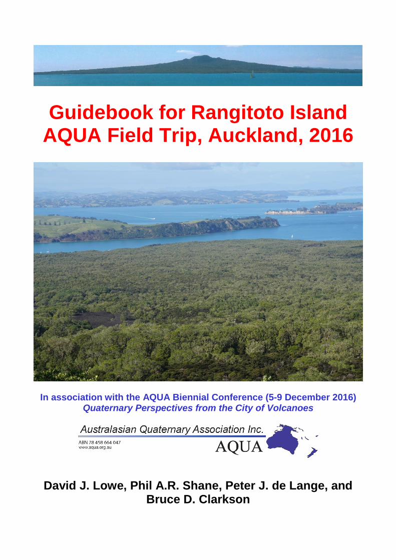
Guidebook for Rangitoto Island AQUA Field Trip, Auckland, 2016 In association with the AQUA Biennial Conference (5-9 December 2016) Quaternary Perspectives from the City of Volcanoes David J. Lowe, Phil A.R. Shane, Peter J. de Lange, and Bruce D. Clarkson
Transcript of Guidebook for Rangitoto Island AQUA Field Trip, Auckland, 2016 · Guidebook for Rangitoto Island...
Guidebook for Rangitoto Island AQUA Field Trip, Auckland, 2016
In association with the AQUA Biennial Conference (5-9 December 2016) Quaternary Perspectives from the City of Volcanoes
David J. Lowe, Phil A.R. Shane, Peter J. de Lange, and Bruce D. Clarkson
2
Guidebook citation: Lowe, D.J., Shane, P.A.R., de Lange, P.J., Clarkson, B.D. 2016. Guidebook for Rangitoto Island AQUA
field trip, Auckland, 2016. School of Science, University of Waikato, in association with the Australasian Quaternary Association (AQUA) Biennial Conference, Auckland, New Zealand, 5-9 December, 2016. 35 pp.
3
Guidebook for Rangitoto Island AQUA Field Trip, Auckland, 2016
David J. Lowe, Phil A.R. Shane, Peter J. de Lange,
and Bruce D. Clarkson
4
This trip is supported by
University of Waikato, University of Auckland, Department of Conservation, and the
Earthquake Commission (EQC)
Acknowledgements and notes
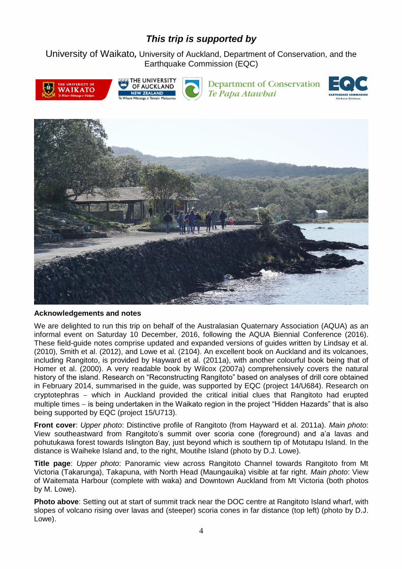
We are delighted to run this trip on behalf of the Australasian Quaternary Association (AQUA) as an informal event on Saturday 10 December, 2016, following the AQUA Biennial Conference (2016). These field-guide notes comprise updated and expanded versions of guides written by Lindsay et al. (2010), Smith et al. (2012), and Lowe et al. (2104). An excellent book on Auckland and its volcanoes, including Rangitoto, is provided by Hayward et al. (2011a), with another colourful book being that of Homer et al. (2000). A very readable book by Wilcox (2007a) comprehensively covers the natural history of the island. Research on “Reconstructing Rangitoto” based on analyses of drill core obtained in February 2014, summarised in the guide, was supported by EQC (project 14/U684). Research on
cryptotephras which in Auckland provided the critical initial clues that Rangitoto had erupted
multiple times is being undertaken in the Waikato region in the project “Hidden Hazards” that is also being supported by EQC (project 15/U713).
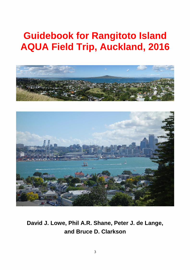
Front cover: Upper photo: Distinctive profile of Rangitoto (from Hayward et al. 2011a). Main photo: View southeastward from Rangitoto’s summit over scoria cone (foreground) and a’a lavas and pohutukawa forest towards Islington Bay, just beyond which is southern tip of Motutapu Island. In the distance is Waiheke Island and, to the right, Moutihe Island (photo by D.J. Lowe).
Title page: Upper photo: Panoramic view across Rangitoto Channel towards Rangitoto from Mt Victoria (Takarunga), Takapuna, with North Head (Maungauika) visible at far right. Main photo: View of Waitemata Harbour (complete with waka) and Downtown Auckland from Mt Victoria (both photos by M. Lowe).
Photo above: Setting out at start of summit track near the DOC centre at Rangitoto Island wharf, with slopes of volcano rising over lavas and (steeper) scoria cones in far distance (top left) (photo by D.J. Lowe).
5
Photo from Hayward et al. (2011a, p.3)
Rangitoto: Auckland’s youngest and largest volcano
Field trip leaders
David J. Lowe, School of Science, University of Waikato, Hamilton [email protected] Peter J. de Lange, Department of Conservation, Auckland [email protected] Departure place and times
The trip is scheduled from ~9:00 am to 3:00 pm, Saturday 10 December. Meet at the Downtown Ferry Terminal building (99 Quay St), Auckland, by 8.50 am to allow time to purchase tickets. The Fullers Ferry will depart from Pier 2 of the Ferry Terminal at 9.15 am. Tickets can be purchased from Fullers Ticket Office on Pier 1. Cost is $30 return for adults; please buy your own ticket. (There is an ATM on the pier.) Fullers recommend being ready to board ~20 minutes before sailing (gangway closes 2 minutes before sailing). After the hike on Rangitoto, the return ferry departs from Rangitoto Wharf at 2.30 pm. We therefore aim to return to the wharf on the island by ~2.15 pm. (There is an earlier pick-up at Rangitoto Wharf at 12.45 pm and later pick-ups at 4.00 pm and 5.00 pm). The trip from downtown Auckland to Rangitoto Wharf takes ~25 minutes. Note: Travel is weather-dependent. The trip is at participants’ own cost and risk ‒ safety guidelines are noted below.
What to wear and bring, and track conditions
You need boots or strong trainers/shoes, a raincoat/windproof is essential, and you must carry a warm jumper in backpack in case the weather turns bad. Showers are always possible but, if sunny, sun hats and sun block are needed. The summit walk is on rough tracks and requires a moderate fitness level. At the coast the tracks are gentle but they steepen near the island’s summit. Much of the track is sheltered. Do not go off the track at any time because the lava fields comprise very unstable, loose, sharp and glassy angular material which is dangerous to try to walk over. Be especially cautious on the steeper tracks descending from the summit where loose gravels can be ‘slippery’. You must purchase or bring food and drinks to sustain you through the day. No food or water are available on the island; some food can be purchased on the ferry. Bring plenty to drink.
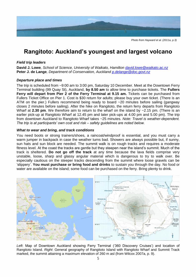
Left: Map of Downtown Auckland showing Ferry Terminal (‘360 Discovery Cruises’) and location of Rangitoto Island. Right: General geography of Rangitoto Island with Rangitoto Wharf and Summit Track marked, the summit attaining a maximum elevation of 260 m asl (from Wilcox 2007a, p. 9).
6
Introductory overview Rangitoto is arguably Auckland’s most beautiful and omnipresent landscape feature. It is a symmetrical, ~6-km wide, basaltic shield volcano that last erupted ~550‒500 cal. yr BP (c. 1400‒1450 AD), not long after the arrival and settlement of Polynesians in the Auckland region (c. 1280 AD). It is by far the largest, and the youngest, volcano in the Auckland Volcanic Field (AVF). The AVF consists of approximately 53 individual eruptive centres, all of which are within the boundaries of the Auckland urban area. Recent research on cryptotephras (defined below) in sediments from Lake Pupuke on North Shore and in wetlands on Motutapu Island, and on a 150-m-long drill core obtained in February, 2014, has revealed that Rangitoto has a much more complex history that previously thought, and may be better viewed as a ‘volcanic complex with multiple episodes of eruptions’ (Linnell et al. 2016). In summary, (1) activity commenced c. 6000 cal. yr BP involving minor effusive and
pyroclastic volcanism; (2) a voluminous shield-building phase took place from c. 650550 cal. yr BP
(c. 13001400 AD), forming the main island ediface; and (3) the final phase of activity, from c.
550500 cal. yr BP (c. 14001450 AD), was explosive and less voluminous, producing scoria cones at the summit.
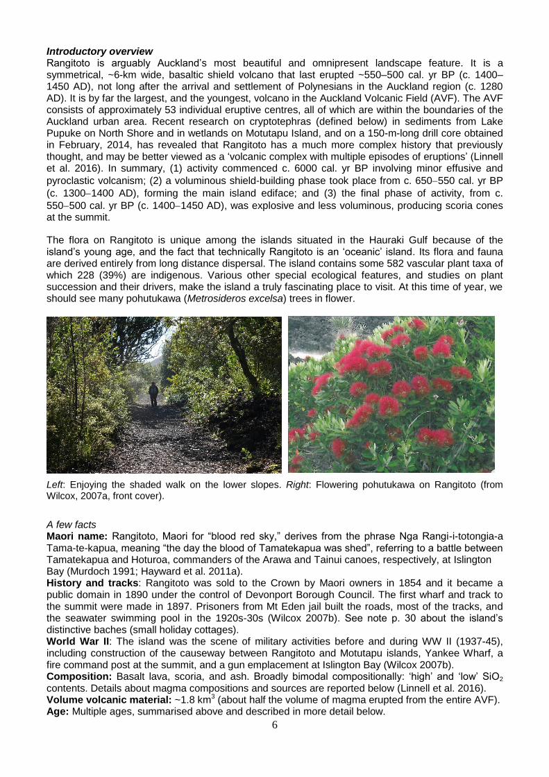
The flora on Rangitoto is unique among the islands situated in the Hauraki Gulf because of the island’s young age, and the fact that technically Rangitoto is an ‘oceanic’ island. Its flora and fauna are derived entirely from long distance dispersal. The island contains some 582 vascular plant taxa of which 228 (39%) are indigenous. Various other special ecological features, and studies on plant succession and their drivers, make the island a truly fascinating place to visit. At this time of year, we should see many pohutukawa (Metrosideros excelsa) trees in flower.
Left: Enjoying the shaded walk on the lower slopes. Right: Flowering pohutukawa on Rangitoto (from Wilcox, 2007a, front cover).
A few facts Maori name: Rangitoto, Maori for “blood red sky,” derives from the phrase Nga Rangi-i-totongia-a Tama-te-kapua, meaning “the day the blood of Tamatekapua was shed”, referring to a battle between Tamatekapua and Hoturoa, commanders of the Arawa and Tainui canoes, respectively, at Islington Bay (Murdoch 1991; Hayward et al. 2011a). History and tracks: Rangitoto was sold to the Crown by Maori owners in 1854 and it became a public domain in 1890 under the control of Devonport Borough Council. The first wharf and track to the summit were made in 1897. Prisoners from Mt Eden jail built the roads, most of the tracks, and the seawater swimming pool in the 1920s-30s (Wilcox 2007b). See note p. 30 about the island’s distinctive baches (small holiday cottages). World War II: The island was the scene of military activities before and during WW II (1937-45), including construction of the causeway between Rangitoto and Motutapu islands, Yankee Wharf, a fire command post at the summit, and a gun emplacement at Islington Bay (Wilcox 2007b). Composition: Basalt lava, scoria, and ash. Broadly bimodal compositionally: ‘high’ and ‘low’ SiO2 contents. Details about magma compositions and sources are reported below (Linnell et al. 2016). Volume volcanic material: ~1.8 km3 (about half the volume of magma erupted from the entire AVF). Age: Multiple ages, summarised above and described in more detail below.
7
Introduction to the Auckland Volcanic Field (AVF)
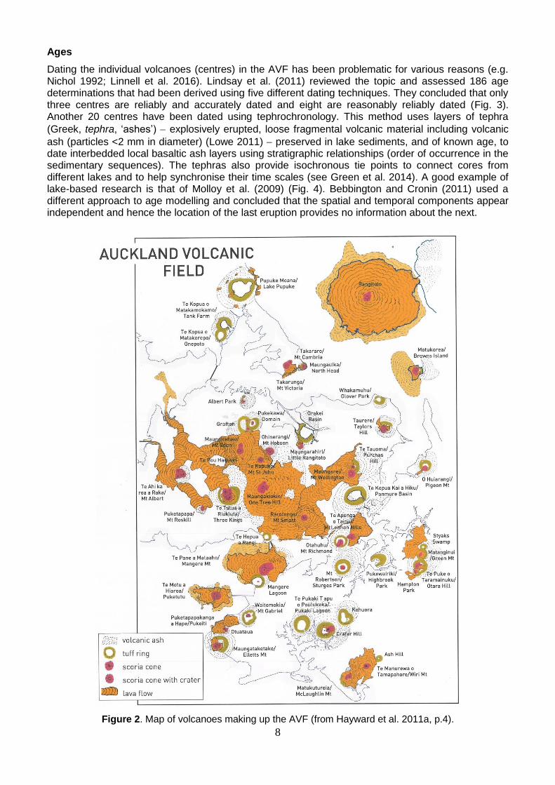
A volcanic field comprises an area where magma production rates are low and numerous eruptions occur at the land surface at widely spaced vents over a period of thousands to hundreds of thousands of years. The AVF is an excellent example of such a field, and consists of around 53 volcanoes within a 20-km radius of central Auckland (Hayward et al. 2011a, 2011b) (see Fig. 2 below). With the exception of Rangitoto, each volcano likely erupted only once over a period of possibly weeks to several years in a single eruption episode (possibly with multiple phases), and with each eruption episode in a different place so that a new volcanic crater or cone is produced (hence the term ‘monogenetic’ is usually applied to such volcanic fields, although the viability of that term has been questioned in light of the work at Rangitoto and elsewhere). The AVF has been active since c. 250,000 years ago. Rangitoto’s latest activity (generating summit scoria cones) was only about 600 to 550 years ago (c. 1400 to 1450 AD) and the field is considered to be still active and likely to erupt again (a summary of ages of volcanoes in the AVF is given below).
The basaltic magma generating Auckland volcanoes derives from the mantle 7090 km beneath the land surface (Hayward et al. 2011a). Magmas contain almost all of Earth’s known chemical elements, but typically they consist of just nine: silicon, oxygen, aluminium, magnesium, iron, calcium, sodium, potassium and titanium. Oxygen and silicon together are the most abundant elements, making up 48–76% by weight of most magmas. The chemistry of magma, especially silicon content, is important for influencing the way it erupts. Three main magma types, and resulting volcanic rocks, are identified on the basis of their chemical composition: andesite, basalt, and rhyolite (Smith et al. 2006).
Andesite magma is intermediate in composition and physical properties. Erupting at around 800–1,000 °C it is more viscous than basalt, but much less viscous than rhyolite. Andesite magma cools to form dark grey lava if gas-poor, or scoria if gas-rich.
Basalt is rich in iron and magnesium, but has less silicon than other magmas. It erupts at very high temperatures (around 1100–1200 °C) as a very fluid magma. Basalt magma with very little gas cools to form black, dense lava, but where magma erupts with lots of gas it cools to form ragged scoria.
Rhyolite magma is rich in silicon, potassium and sodium and erupts at temperatures between 700°C and 850 °C as an extremely viscous (sticky) magma. Rhyolite magma containing lots of gas bubbles cools to form pumice. Because it is low in iron, rhyolite is normally light-coloured – it may vary from white to pink or brown. Obsidian is a type of rhyolite produced when lava is chilled to form glass (from Smith et al. 2006).
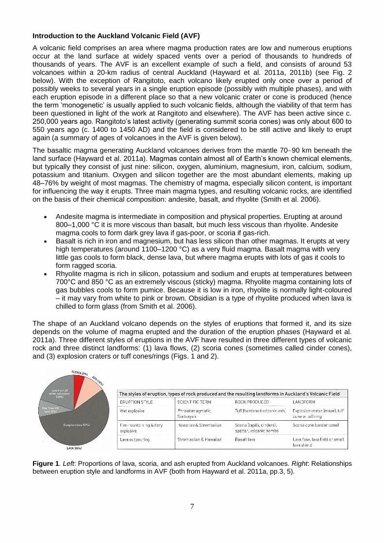
The shape of an Auckland volcano depends on the styles of eruptions that formed it, and its size depends on the volume of magma erupted and the duration of the eruption phases (Hayward et al. 2011a). Three different styles of eruptions in the AVF have resulted in three different types of volcanic rock and three distinct landforms: (1) lava flows, (2) scoria cones (sometimes called cinder cones), and (3) explosion craters or tuff cones/rings (Figs. 1 and 2).
Figure 1. Left: Proportions of lava, scoria, and ash erupted from Auckland volcanoes. Right: Relationships between eruption style and landforms in AVF (both from Hayward et al. 2011a, pp.3, 5).
8
Ages
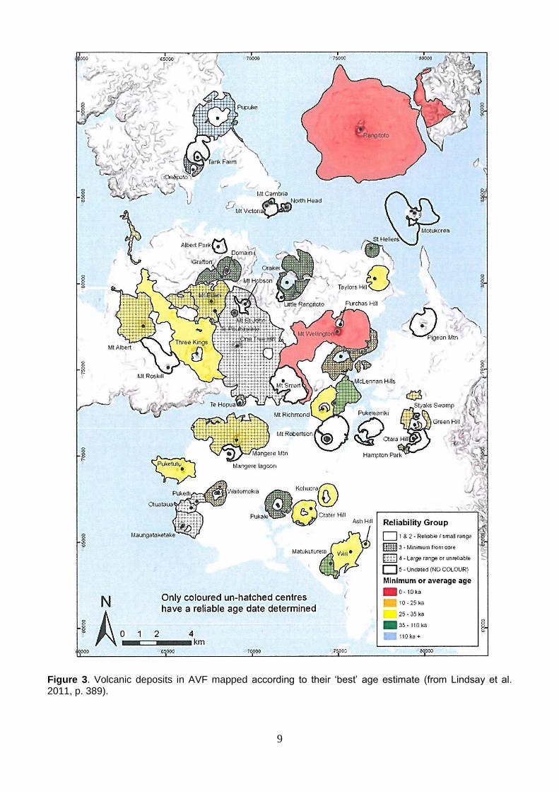
Dating the individual volcanoes (centres) in the AVF has been problematic for various reasons (e.g. Nichol 1992; Linnell et al. 2016). Lindsay et al. (2011) reviewed the topic and assessed 186 age determinations that had been derived using five different dating techniques. They concluded that only three centres are reliably and accurately dated and eight are reasonably reliably dated (Fig. 3). Another 20 centres have been dated using tephrochronology. This method uses layers of tephra
(Greek, tephra, ‘ashes’) explosively erupted, loose fragmental volcanic material including volcanic
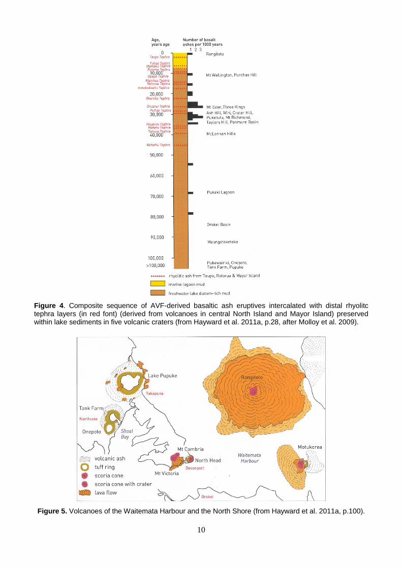
ash (particles <2 mm in diameter) (Lowe 2011) preserved in lake sediments, and of known age, to date interbedded local basaltic ash layers using stratigraphic relationships (order of occurrence in the sedimentary sequences). The tephras also provide isochronous tie points to connect cores from different lakes and to help synchronise their time scales (see Green et al. 2014). A good example of lake-based research is that of Molloy et al. (2009) (Fig. 4). Bebbington and Cronin (2011) used a different approach to age modelling and concluded that the spatial and temporal components appear independent and hence the location of the last eruption provides no information about the next.
Figure 2. Map of volcanoes making up the AVF (from Hayward et al. 2011a, p.4).
9
Figure 3. Volcanic deposits in AVF mapped according to their ‘best’ age estimate (from Lindsay et al. 2011, p. 389).
10
Figure 4. Composite sequence of AVF-derived basaltic ash eruptives intercalated with distal rhyolitc tephra layers (in red font) (derived from volcanoes in central North Island and Mayor Island) preserved within lake sediments in five volcanic craters (from Hayward et al. 2011a, p.28, after Molloy et al. 2009).
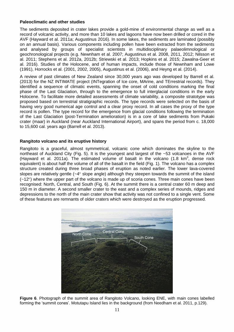
Figure 5. Volcanoes of the Waitemata Harbour and the North Shore (from Hayward et al. 2011a, p.100).
11
Paleoclimatic and other studies
The sediments deposited in crater lakes provide a gold-mine of environmental change as well as a record of volcanic activity, and more than 10 lakes and lagoons have now been drilled or cored in the AVF (Hayward et al. 2011a; Augustinus 2016). In some lakes, the sediments are laminated (possibly on an annual basis). Various components including pollen have been extracted from the sediments and analysed by groups of specialist scientists in multidisciplinary palaeolimnological or geochronological projects (e.g. Newnham et al. 2007; Augustinus et al. 2008, 2011, 2012; Nilsson et al. 2011; Stephens et al. 2012a, 2012b; Striewski et al. 2013; Hopkins et al. 2015; Zawalna-Geer et al. 2016). Studies of the Holocene, and of human impacts, include those of Newnham and Lowe (1991), Horrocks et al. (2001, 2002, 2005), Augustinus et al. (2006), and Heyng et al. (2014).
A review of past climates of New Zealand since 30,000 years ago was developed by Barrell et al. (2013) for the NZ INTIMATE project (INTegration of Ice core, MArine, and TErrestrial records). They identified a sequence of climatic events, spanning the onset of cold conditions marking the final phase of the Last Glaciation, through to the emergence to full interglacial conditions in the early Holocene. To facilitate more detailed assessments of climate variability, a composite stratotype was proposed based on terrestrial stratigraphic records. The type records were selected on the basis of having very good numerical age control and a clear proxy record. In all cases the proxy of the type record is pollen. The type record for the emergence from glacial conditions following the termination of the Last Glaciation (post-Termination amelioration) is in a core of lake sediments from Pukaki crater (maar) in Auckland (near Auckland International Airport), and spans the period from c. 18,000 to 15,600 cal. years ago (Barrell et al. 2013).
Rangitoto volcano and its eruptive history
Rangitoto is a graceful, almost symmetrical, volcanic cone which dominates the skyline to the northeast of Auckland City (Fig. 5). It is the youngest and largest of the ~53 volcanoes in the AVF (Hayward et al. 2011a). The estimated volume of basalt in the volcano (1.8 km3, dense rock equivalent) is about half the volume of all of the basalt in the field (Fig. 1). The volcano has a complex structure created during three broad phases of eruption as noted earlier. The lower lava-covered
slopes are relatively gentle (~4 slope angle) although they steepen towards the summit of the island
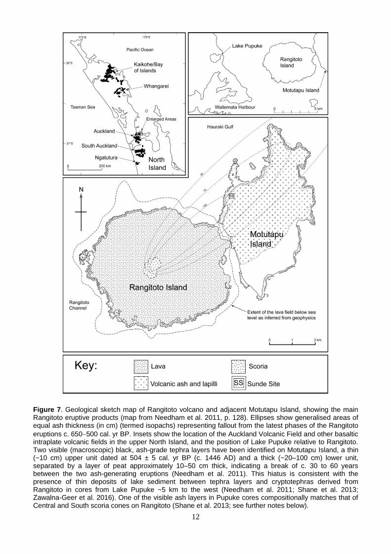
(~12) where the upper part of the volcano is made up of scoria cones. Three main cones have been recognised: North, Central, and South (Fig. 6). At the summit there is a central crater 60 m deep and 150 m in diameter. A second smaller crater to the east and a complex series of mounds, ridges and depressions to the north of the main crater show that activity was not confined to a single vent. Some of these features are remnants of older craters which were destroyed as the eruption progressed.
Figure 6. Photograph of the summit area of Rangitoto Volcano, looking ENE, with main cones labelled forming the ‘summit cones’. Motutapu Island lies in the background (from Needham et al. 2011, p.129).
12
Figure 7. Geological sketch map of Rangitoto volcano and adjacent Motutapu Island, showing the main Rangitoto eruptive products (map from Needham et al. 2011, p. 128). Ellipses show generalised areas of equal ash thickness (in cm) (termed isopachs) representing fallout from the latest phases of the Rangitoto
eruptions c. 650500 cal. yr BP. Insets show the location of the Auckland Volcanic Field and other basaltic intraplate volcanic fields in the upper North Island, and the position of Lake Pupuke relative to Rangitoto. Two visible (macroscopic) black, ash-grade tephra layers have been identified on Motutapu Island, a thin (~10 cm) upper unit dated at 504 ± 5 cal. yr BP (c. 1446 AD) and a thick (~20–100 cm) lower unit, separated by a layer of peat approximately 10–50 cm thick, indicating a break of c. 30 to 60 years between the two ash-generating eruptions (Needham et al. 2011). This hiatus is consistent with the presence of thin deposits of lake sediment between tephra layers and cryptotephras derived from Rangitoto in cores from Lake Pupuke ~5 km to the west (Needham et al. 2011; Shane et al. 2013; Zawalna-Geer et al. 2016). One of the visible ash layers in Pupuke cores compositionally matches that of Central and South scoria cones on Rangitoto (Shane et al. 2013; see further notes below).
13
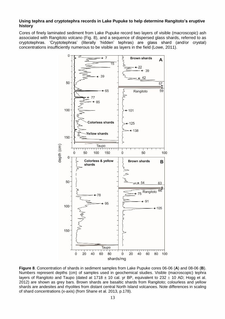
Using tephra and cryptotephra records in Lake Pupuke to help determine Rangitoto’s eruptive history
Cores of finely laminated sediment from Lake Pupuke record two layers of visible (macroscopic) ash associated with Rangitoto volcano (Fig. 8), and a sequence of dispersed glass shards, referred to as cryptotephras. ‘Cryptotephras’ (literally ‘hidden’ tephras) are glass shard (and/or crystal) concentrations insufficiently numerous to be visible as layers in the field (Lowe, 2011).
Figure 8. Concentration of shards in sediment samples from Lake Pupuke cores 06-06 (A) and 08-06 (B). Numbers represent depths (cm) of samples used in geochemical studies. Visible (macroscopic) tephra
layers of Rangitoto and Taupo (dated at 1718 ± 10 cal. yr BP, equivalent to 232 10 AD; Hogg et al. 2012) are shown as grey bars. Brown shards are basaltic shards from Rangitoto; colourless and yellow shards are andesites and rhyolites from distant central North Island volcanoes. Note differences in scaling of shard concentrations (x-axis) (from Shane et al. 2013, p.178).
14
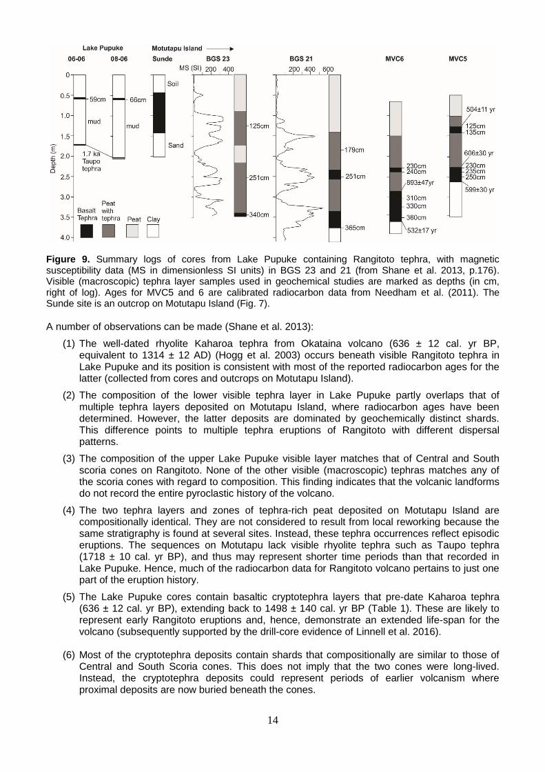
Figure 9. Summary logs of cores from Lake Pupuke containing Rangitoto tephra, with magnetic susceptibility data (MS in dimensionless SI units) in BGS 23 and 21 (from Shane et al. 2013, p.176). Visible (macroscopic) tephra layer samples used in geochemical studies are marked as depths (in cm, right of log). Ages for MVC5 and 6 are calibrated radiocarbon data from Needham et al. (2011). The Sunde site is an outcrop on Motutapu Island (Fig. 7).
A number of observations can be made (Shane et al. 2013):
(1) The well-dated rhyolite Kaharoa tephra from Okataina volcano (636 ± 12 cal. yr BP, equivalent to 1314 ± 12 AD) (Hogg et al. 2003) occurs beneath visible Rangitoto tephra in Lake Pupuke and its position is consistent with most of the reported radiocarbon ages for the latter (collected from cores and outcrops on Motutapu Island).
(2) The composition of the lower visible tephra layer in Lake Pupuke partly overlaps that of multiple tephra layers deposited on Motutapu Island, where radiocarbon ages have been determined. However, the latter deposits are dominated by geochemically distinct shards. This difference points to multiple tephra eruptions of Rangitoto with different dispersal patterns.
(3) The composition of the upper Lake Pupuke visible layer matches that of Central and South scoria cones on Rangitoto. None of the other visible (macroscopic) tephras matches any of the scoria cones with regard to composition. This finding indicates that the volcanic landforms do not record the entire pyroclastic history of the volcano.
(4) The two tephra layers and zones of tephra-rich peat deposited on Motutapu Island are compositionally identical. They are not considered to result from local reworking because the same stratigraphy is found at several sites. Instead, these tephra occurrences reflect episodic eruptions. The sequences on Motutapu lack visible rhyolite tephra such as Taupo tephra (1718 ± 10 cal. yr BP), and thus may represent shorter time periods than that recorded in Lake Pupuke. Hence, much of the radiocarbon data for Rangitoto volcano pertains to just one part of the eruption history.
(5) The Lake Pupuke cores contain basaltic cryptotephra layers that pre-date Kaharoa tephra (636 ± 12 cal. yr BP), extending back to 1498 ± 140 cal. yr BP (Table 1). These are likely to represent early Rangitoto eruptions and, hence, demonstrate an extended life-span for the volcano (subsequently supported by the drill-core evidence of Linnell et al. 2016).
(6) Most of the cryptotephra deposits contain shards that compositionally are similar to those of Central and South Scoria cones. This does not imply that the two cones were long-lived. Instead, the cryptotephra deposits could represent periods of earlier volcanism where proximal deposits are now buried beneath the cones.
15
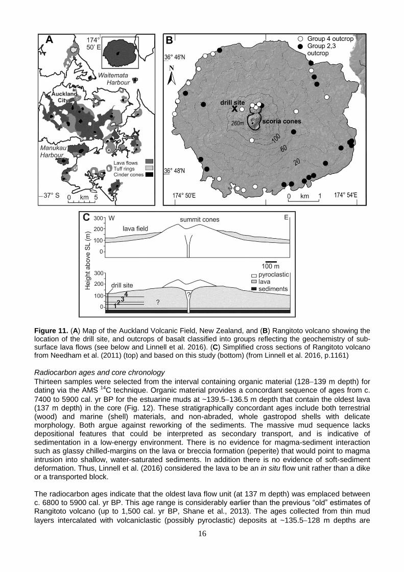
Rangitoto drilling project
The work is published in detail in Shane and Linnell (2015) and Linnell et al. (2016). The drill site (Fig. 10) is located at metric grid north 5927446, east 1765100 (map NZTopo50-BA32, edition 1.02; Land Information New Zealand 2012), ~120 m above sea level on the western flank of the volcano (Fig. 11). Lithology of the core sequence The lava sequence of the upper 128 m of core lacks unambiguous evidence of depositional hiatus such as paleosols, and pyroclastic units are not observed. One exception is observed clay-filled fractures that developed in the upper 1 m of a lava flow unit at about 95 m depth, which may reflect a period of weathering. The base of the lava flow sequence at 128.1 m is marked by a sharp contact between lava and fragmented fossil marine shells in ash overlying 20 cm of fossiliferous olive-grey mud (Fig. 12). A basaltic volcaniclastic (pyroclastic?) sequence between 128.3 and ~135 m comprises unconsolidated, poorly-sorted black ash to coarse lapilli. The lapilli are mostly sub-rounded to sub-angular blocky clasts displaying a range of vesicularity. Shell fragments and sedimentary grains occur in the ash-grade fraction. The unconsolidated character of the deposit and disruption from drilling prevents any
assessment of stratification. Thin mud layers (10 cm thick at 132.2 m, and 40 cm thick at 133.0133.4
m), seemingly divide the volcaniclastic unit. The interval 135.4140.3 m depth is a continuous massive and fossiliferous, olive-grey sandy mud sequence. This unit contains a thin (~60 cm)
massive lava flow unit (136.7137.2 m depth). The sequence beneath 140.3 m is highly weathered Miocene sandstone and mudstone.
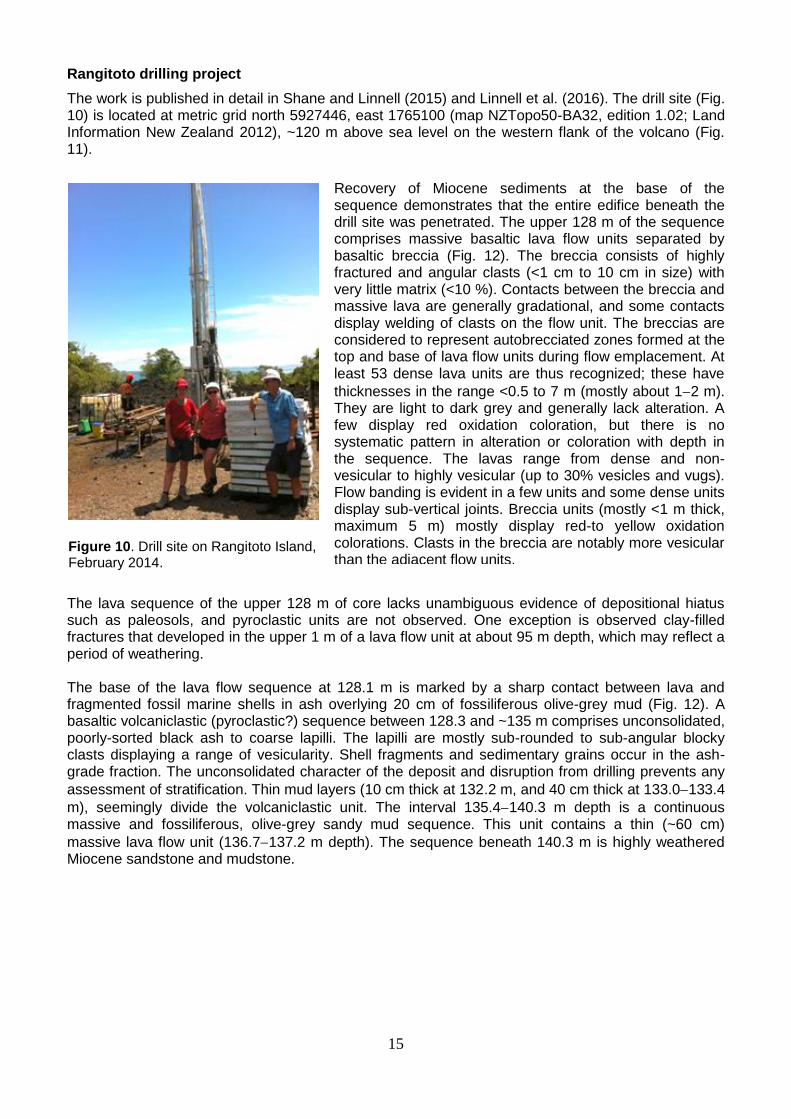
Figure 10. Drill site on Rangitoto Island, February 2014.
Recovery of Miocene sediments at the base of the sequence demonstrates that the entire edifice beneath the drill site was penetrated. The upper 128 m of the sequence comprises massive basaltic lava flow units separated by basaltic breccia (Fig. 12). The breccia consists of highly fractured and angular clasts (<1 cm to 10 cm in size) with very little matrix (<10 %). Contacts between the breccia and massive lava are generally gradational, and some contacts display welding of clasts on the flow unit. The breccias are considered to represent autobrecciated zones formed at the top and base of lava flow units during flow emplacement. At least 53 dense lava units are thus recognized; these have
thicknesses in the range <0.5 to 7 m (mostly about 12 m). They are light to dark grey and generally lack alteration. A few display red oxidation coloration, but there is no systematic pattern in alteration or coloration with depth in the sequence. The lavas range from dense and non-vesicular to highly vesicular (up to 30% vesicles and vugs). Flow banding is evident in a few units and some dense units display sub-vertical joints. Breccia units (mostly <1 m thick, maximum 5 m) mostly display red-to yellow oxidation colorations. Clasts in the breccia are notably more vesicular than the adjacent flow units.
16
Figure 11. (A) Map of the Auckland Volcanic Field, New Zealand, and (B) Rangitoto volcano showing the location of the drill site, and outcrops of basalt classified into groups reflecting the geochemistry of sub-surface lava flows (see below and Linnell et al. 2016). (C) Simplified cross sections of Rangitoto volcano from Needham et al. (2011) (top) and based on this study (bottom) (from Linnell et al. 2016, p.1161)
Radiocarbon ages and core chronology
Thirteen samples were selected from the interval containing organic material (128139 m depth) for dating via the AMS 14C technique. Organic material provides a concordant sequence of ages from c.
7400 to 5900 cal. yr BP for the estuarine muds at ~139.5136.5 m depth that contain the oldest lava (137 m depth) in the core (Fig. 12). These stratigraphically concordant ages include both terrestrial (wood) and marine (shell) materials, and non-abraded, whole gastropod shells with delicate morphology. Both argue against reworking of the sediments. The massive mud sequence lacks depositional features that could be interpreted as secondary transport, and is indicative of sedimentation in a low-energy environment. There is no evidence for magma-sediment interaction such as glassy chilled-margins on the lava or breccia formation (peperite) that would point to magma intrusion into shallow, water-saturated sediments. In addition there is no evidence of soft-sediment deformation. Thus, Linnell et al. (2016) considered the lava to be an in situ flow unit rather than a dike or a transported block. The radiocarbon ages indicate that the oldest lava flow unit (at 137 m depth) was emplaced between c. 6800 to 5900 cal. yr BP. This age range is considerably earlier than the previous “old” estimates of Rangitoto volcano (up to 1,500 cal. yr BP, Shane et al., 2013). The ages collected from thin mud
layers intercalated with volcaniclastic (possibly pyroclastic) deposits at ~135.5128 m depths are
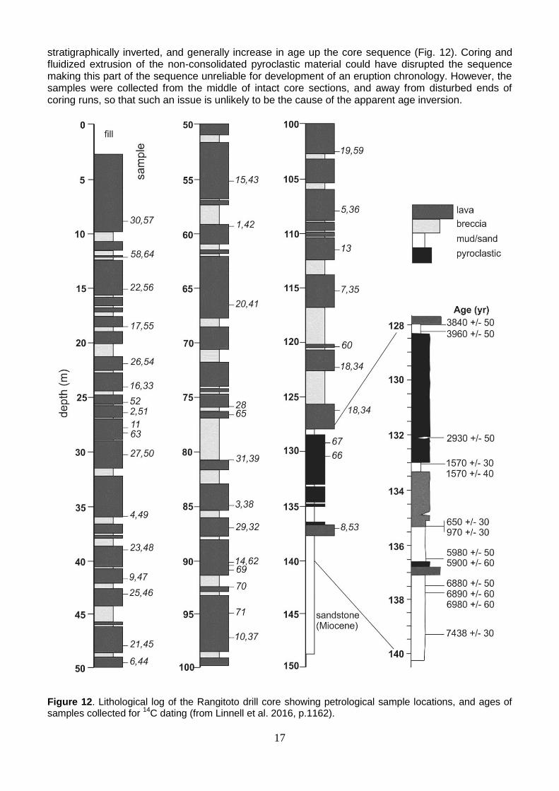
17
stratigraphically inverted, and generally increase in age up the core sequence (Fig. 12). Coring and fluidized extrusion of the non-consolidated pyroclastic material could have disrupted the sequence making this part of the sequence unreliable for development of an eruption chronology. However, the samples were collected from the middle of intact core sections, and away from disturbed ends of coring runs, so that such an issue is unlikely to be the cause of the apparent age inversion.
Figure 12. Lithological log of the Rangitoto drill core showing petrological sample locations, and ages of samples collected for
14C dating (from Linnell et al. 2016, p.1162).
18
Discordant ages of components from the same stratigraphic level at 135.4 m depth (foraminifera = 650 ± 30 cal. yr BP; shell fragments = 970 ± 30 cal. yr BP) indicate reworking has occurred. Linnell et
al. (2016) suggested one possible explanation for the age sequence at ~135.5128 m depth is that the volcaniclastic deposits and associated mud layers represent mass-flow units, emplaced by slumping from a sub-marine pyroclastic structure. The growth of the lava shield could have loaded and destabilized a pre-existing edifice. Catastrophic failure of a pyroclastic edifice and its marine-mud substrate is likely to have produced a chaotic/random series of dates in the resulting deposit. Instead, the inverted age sequence found could reflect a progressive ‘top-down’ incision of a nearby pyroclastic edifice with intercalated mud, built between c. 4000 to c. 650 cal. yr BP. This hypothesis suggests that shield growth was preceded by intermittent pyroclastic activity, which lends support to the findings of Shane et al. (2013) who reported cryptotephra deposits from Rangitoto volcano preserved in lake sediments extending back to 1498 ± 140 cal. yr BP, suggesting an extended time-span for the volcano (Figs. 8, 9). Regardless of the depositional history of the volcaniclastic deposits, the youngest age in the sequence (c. 650 cal. yr BP) provides a maximum age for the shield-building stage represented by the overlying lava flows. A previous paleomagnetic investigation of the lava field revealed scatter in the demagnetized remnant directions (Robertson 1986), but much of the data are within wide error limits thereby preventing reliable interpretation of eruption duration. The only previous radiocarbon determinations associated with lava flows produced widely disparate ages of 214 ± 129 cal. yr BP for wood beneath a flow unit and 1161 ± 72 cal. yr BP for marine shells in mud baked by a (different) lava flow. These were dismissed by some workers as representing young tree roots penetrating the lava flow, and relict shells pre-dating the eruption, respectively. However, the age of marine shells is within the range of ages obtained from the sub-surface sequence. If the tephra layers downwind of the volcano reflect pyroclastic activity associated with summit scoria
cones rather than the main shield-building stage, they then provide an upper age limit (c. 550500 cal. yr BP) for shield development. This gives a maximum duration of about 100 years for shield growth. Continuity of the eruption during the shield-building stage is suggested by the lack of intercalated sediments and paleosols. However, four composition groups erupted and the surface intercalation of lavas show that the shield was built in a series of closely spaced episodes (Linnell et al., 2016), with one compositional change coinciding with a horizon of clay-filled fractures (at 95 m depth between Groups 1 and 2), which may indicate a pause of a few years to decades. Volcanic history and implications Linnell et al. (2016) divided the construction of Rangitoto volcano into three major magmatic and eruptive phases. Phase 1 includes the oldest lava flow (c. 6000 cal. yr BP) and overlying volcaniclastic deposits. These units are compositionally indistinguishable from the lowermost shield-building lava flows (Group 1) that post-date c. 650 cal. yr BP. Two alterative explanations for the sequence are possible. (1) The deposits represent a phase of prolonged and/or periodic tapping a common magma source. The sub-alkalic basalts are unique to Rangitoto volcano and differ from the more alkalic compositions at other AVF volcanoes. Under this scenario, magmatic output was low until the beginning of the shield-building lava flow phase. The ages in the volcaniclastic deposits, albeit lacking stratigraphic order, reflect reworking of a pyroclastic edifice built during the interval c. 4000 to 650 cal. yr BP. (2) The oldest lava flow and the volcaniclastic deposits are part of a separate volcano (or several volcanoes) buried beneath the Rangitoto shield. Based on the high aerial density of volcanic centres in the AVF, the width of the shield could easily cover older edifices. However, close proximity of AVF volcanoes does not equate to similarity in age. Thus, Holocene ages for all deposits in the Rangitoto core point to a volcanic complex rather than coincidental spacing of volcanoes. Phase 2 comprises the main lava shield-building stage of Rangitoto when magma production
significantly increased for a short period at c. 650550 cal. yr BP. Cycles of increasing degree of melting at the mantle source occurred (Group 2 and 3 magma), presumably representing thermal perturbations.
19
Phase 3 represents a change to pyroclastic volcanism and the construction of summit scoria cones at
c. 550500 cal. yr BP. At this time, the magmatic system was compositionally more diverse, but volumetrically less productive. While Central and South Cones are compositionally similar to the shield-building lava flows, they also erupted lower-Mg# magma. In contrast, North Cone is distinctly alkalic magma reflecting a deep mantle source. The eruption of multiple magma batches both sequentially and simultaneously has been reported at other small basaltic volcanoes, in particular in the Newer Volcanics Province in southern Australia. Changes in magmatic compositions at these and other small volcanoes often accompany changes in eruption style, such as effusive versus explosive. However, no overriding temporal trends are evident. Of the few AVF volcanoes for which temporally-controlled data is available, there is a lack of common compositional evolution. This finding points to the localized influence of mantle heterogeneity and conduit systems. Implications Regardless of whether Rangitoto was a long-lived volcano (c. 6000 years) or was the site of separate eruptive episodes from edifices now buried, the new insights from drilling raise the possibility of future eruptions from that part of the AVF. Rangitoto may be better described as a complex that has experienced periods of activity. In addition, AVF volcanism in the Holocene was more frequent than previously known. The prolonged and varied pattern of behavior of Rangitoto volcano is consistent with other recently investigated volcanoes in monogenetic basaltic fields (e.g. Newer Volcanics Province), and may require a change in emphasis in hazard scenario modelling. By inference, other AVF volcanoes with large lava fields (e.g. One Tree Hill, Mt. Eden) could conceal earlier phases of eruption, but little is known about their sub-surface deposits. Future eruptions in the AVF could last for decades and involve large-volume outpourings of sub-alkalic basalt as the case of Rangitoto volcano. It is uncertain how long a mantle magma source for small intra-plate basalt volcanoes may be productive and generate eruptions, but the Rangitoto drill core chronology indicates a minimum duration of c. 6000 years.
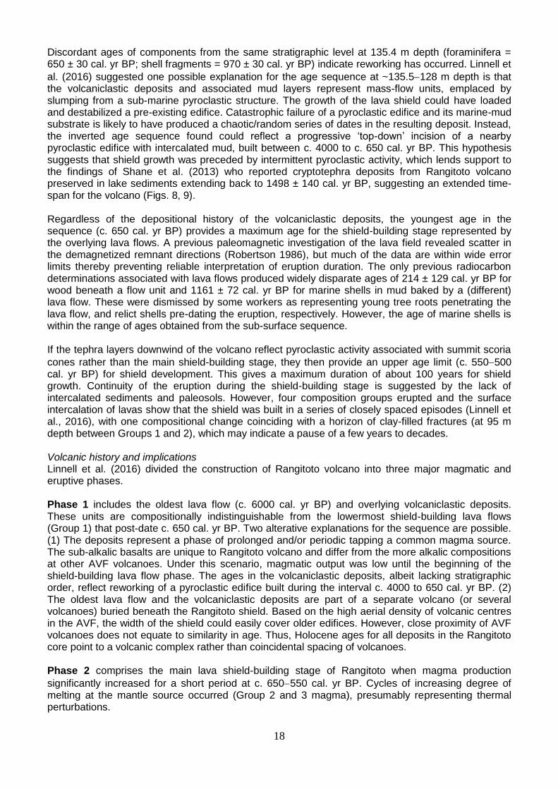
In a further effort to understand the origins of the island, including existing faults and possible seismic activity, UoA and the DEVORA (Determining Volcanic Risk in Auckland, see http://www.devora.org.nz/) project installed a specialized borehole seismometer into the hole left by the coring (Fig. 13). This sensitive instrument records any seismicity that occurs under Rangitoto as well as the surrounding area. Most interest is directed to the question whether small earthquakes occur under Rangitoto that are too small to be seen on seismic recordings from the rest of the Auckland seismic network, and whether faults can be located based on the occurrence of these small events.
Wide-ranging papers and articles on the volcanic risks and
potential impacts posed by Auckland volcanoes covering volcanic petrology to modelling to communication to
engineering aspects are listed on the DEVORA website (e.g. Lindsay 2010; Ashenden et al. 2011; Brand et al. 2014; Kereszturi et al. 2014; Potter et al. 2014; Tomsen et al. 2014; Bebbington 2015; Daly and Johnston 2015;, Dohaney et al. 2015; and McGee and Smith 2016). Newnham et al. (1999) highlighted the risk in the Auckland area from deposition of rhyolitic and andesitic tephras from distant sources in the Taupo Volcanic Zone, Mayor Island (Tuhua), and Egmont volcano in central North Island.
Figure 13. Borehole seismometer on Rangitoto.
20
Maori presence and earliest Polynesian settlement
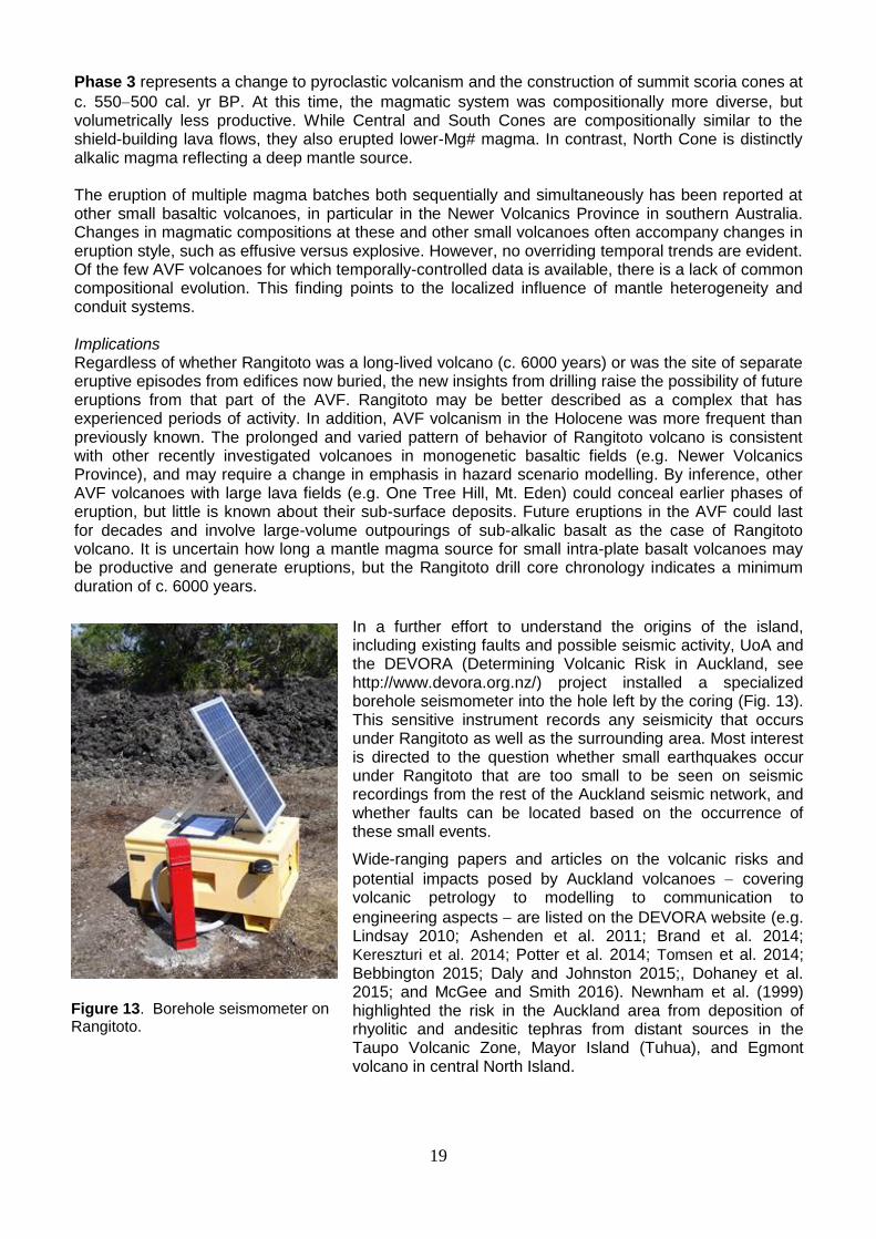
Although no oral tradition has survived that describes the eruption and formation of Rangitoto (Lowe et al. 2002), it is known that Maori (descendants of the initial Polynesian settlers) were living on the adjacent Motutapu Island at the time. Ash from the latest eruption phases buried wood and shell of a habitation site in Administration Bay, and excavations at the Sunde site have revealed casts of Maori dog and human footprints in the ash (photo at right is from Nichol 1982), together with evidence for gardening activities (Davidson 1978; Nichol 1981).
The timing of the earliest Polynesian settlement of the New Zealand archipelago, the last substantial land mass in the world (outside polar regions) to be colonized by humans, has been controversial, partly because it has been so recent (Lowe 2011). Radiocarbon age data, potentially open to question because of likely contamination in lake sediments by in-washing of old carbon as a result of Polynesian deforestation activities, inbuilt age, or dietary effects, effectively resulted in two
contradictory models of settlement: ‘early’ settlement about 15002000 years ago (Sutton 1987) versus ‘late’ settlement about 700 years ago (Anderson 1991, 2013, 2015). The rhyolitic Kaharoa tephra, erupted ~700 years ago from Mt Tarawera in winter, 1314 ± 12 AD (Hogg et al. 2003; Sahetapy-Engel et al. 2014), is distributed widely over much of eastern and northern North Island, and is present in Lake Pupuke as a cryptotephra as noted earlier (Fig. 8). It provides a ‘settlement datum’ or isochron in northern New Zealand to help determine which model was more likely to be correct by tephrochronologically linking and dating palynological (pollen) evidence of initial human impact (derived from analyses of cores from peat bogs and lakes) with archaeological and artefactual evidence to the same point in time (Newnham et al. 1998; Lowe 2011).
No cultural remains are known to occur beneath the Kaharoa tephra apart from a single rat-nibbled seed on the northeast coast of the Coromandel Peninsula (Wilmshurst and Higham 2004), and palynological evidence for earliest human-induced impact (a sustained deforestation signal comprising a decline in tall trees and a concomitant rise in bracken spores) occurs stratigraphically just before its deposition in five pollen profiles out of around two dozen documented sites (Lowe 2011). The use of the Kaharoa tephra isochron, together with a wide range of evidence including lake- and bog-derived pollen records, bones of the commensal Pacific rat Rattus exulans, rat-nibbled seed cases and snail-shells, fire records, ancient DNA, and archaeological and (reliable) radiocarbon data, all support the ‘late’ settlement model (Lowe and Pittari 2014). The earliest Polynesian settlement of New Zealand is now dated at c. 1280 AD (Higham and Hogg 1997; Higham et al. 1999; Wilmshurst et al. 2008, 2011, 2014). The presence of the rat-nibbled seed beneath Kaharoa tephra, and the sustained rise in bracken spores starting just below the tephra in pollen profiles, are consistent with earliest settlement in North Island occurring a few decades prior to the c. 1314 AD eruption of Kaharoa (Lowe et al. 2000; Lowe and Pittari 2014) (cf. Jacomb et al. 2014).
Soils on Rangitoto and Motutapu
The youthfulness of the latest eruptives on Rangitoto Island, and of the ash fallout deposits on adjacent Motutapu and Rakino islands, means that the soils are only weakly developed recent soils at best. Bare lavas are effectively ‘nonsoils’.
Rangitoto Island The soils may be mapped into two groups (i) on lavas, and (ii) on the scoria cones. The bare-rock lavas are ‘nonsoils’ in Soil Taxonomy (Soil Survey Staff 2014), and Rocky Raw Soils in New Zealand Soil Classification (Hewitt 2010). Sand-sized fragments of rock and partly-decomposed litter can occur in cracks and crevices in the lava. If these sand and organic materials are ≥ 5 cm in thickness then such small patches of soil are Lithic Udorthents (= sandy Entisols) or Lithic Udifolists (= shallow organic soil or Histosols) (ST), or Rocky Recent Soils (NZSC). On the scoria, the soils may qualify as
21
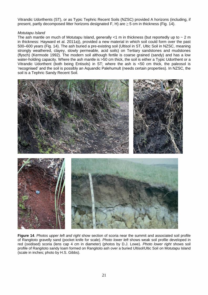
Vitrandic Udorthents (ST), or as Typic Tephric Recent Soils (NZSC) provided A horizons (including, if present, partly decomposed litter horizons designated F, H) are ≥ 5 cm in thickness (Fig. 14).
Motutapu Island The ash mantle on much of Motutapu Island, generally <1 m in thickness (but reportedly up to ~ 2 m in thickness: Hayward et al. 2011a)), provided a new material in which soil could form over the past 500‒600 years (Fig. 14). The ash buried a pre-existing soil (Ultisol in ST, Ultic Soil in NZSC, meaning strongly weathered, clayey, slowly permeable, acid soils) on Tertiary sandstones and mudstones (flysch) (Kermode 1992). The modern soil although fertile is coarse grained (sandy) and has a low water-holding capacity. Where the ash mantle is >50 cm thick, the soil is either a Typic Udorthent or a Vitrandic Udorthent (both being Entisols) in ST; where the ash is <50 cm thick, the paleosol is ‘recognised’ and the soil is possibly an Aquandic Palehumult (needs certain properties). In NZSC, the soil is a Tephric Sandy Recent Soil.
Figure 14. Photos upper left and right show section of scoria near the summit and associated soil profile of Rangitoto gravelly sand (pocket knife for scale). Photo lower left shows weak soil profile developed in red (oxidised) scoria (lens cap 4 cm in diameter) (photos by D.J. Lowe). Photo lower right shows soil profile of Rangitoto sandy loam formed on Rangitoto ash over a buried Ultisol/Ultic Soil on Motutapu Island (scale in inches; photo by H.S. Gibbs).
22
Flora of Rangitoto
The flora on Rangitoto is unique among the islands situated in the Hauraki Gulf because of the island’s young age, and the fact that technically Rangitoto is an ‘oceanic’ island. This means that as Rangitoto emerged from the sea, and was never connected to the mainland of New Zealand, its flora and fauna are derived entirely from long distance dispersal – an oddity indeed for an island which sits on a continental shelf in such shallow water. The island is home to some 582 vascular plant taxa of which 228 (39%) are indigenous (Wilcox et al. 2007). Although there are no endemic vascular plants, the island is a stronghold for a number of plants that are now ‘threatened’ or ‘at risk’, or both, on the adjacent mainland, e.g. the white-flowered kohuorangi or Kirk’s tree daisy (Brachyglottis kirkii var. kirkii), wild carrot (Daucus glochidiatus), and plumed greenhood (Pterostylis tasmanica) (de Lange et al. 2013). Kirk’s tree daisy is declining on the mainland because of possum browse, and the same was happening on Rangitoto until possum were eradicated from the island in 1996. Aside from flowering plants, conifers, ferns and clubmosses, Rangitoto is also home to 94 mosses (three naturalised) and 70 hornworts and liverworts (one, Lunularia cruciata, is naturalised). Although the mycobiota of the island have yet to be properly studied, 194 lichens (lichenized fungi) have been recorded from the island together with ~170 fungi. The island is the type locality for a number of mosses and liverworts, several of which were long believed endemic to the island, e.g. Lepidozia elobata, Plagiochila bazzanioides, and Tortella mooreae (now T. cirrhata). The occurrence of
endemic mosses and liverworts on an island with a flora believed to be c. 600700 years old or less was always considered anomalous, and it is not a surprise that all of these ‘endemics’ have since been discovered elsewhere in New Zealand, although, oddly, not so far from the adjacent mainland.
Ecologically what marks Rangitoto is the dominance of pohutukawa (Metrosideros excelsa) – Rangitoto supports the single largest tract of this forest association in New Zealand, and the role that this species has played in the colonisation of bare lava. This is a key process repeated by the genus Metrosideros throughout the Pacific where they all play a critical role in converting bare lava to forest (see below). On our visit, though, note the dominance of lichens, mosses and at times liverworts, all of which play an important role in converting lava to ‘soil’ thereby allowing other plants to establish.
Several other botanical features of Rangitoto are worth noting, namely the occurrence of many vascular plant epiphytes in terrestrial settings, the porous lava providing them with the same conditions found in forest canopies. Also there are ‘weed’ species, many of which derive from the distinctive holiday cottages (or ‘baches’) on the island (predating c. 1940). Some of these weed species are components of the Macronesian flora of the Canary Islands, brought to New Zealand as ornamentals and, finding Rangitoto offering a range of habitats similar to those of their distant volcanic home, they have flourished. Whilst most are aggressive weeds, some (such as the species of the genus Aeonium and Echium) are actually threatened plants in their distant home, and so present a ‘slight’ conservation management dilemma.
Now that Rangitoto and nearby Motutapu Island are ‘pest-free’, both islands afford innumerable opportunities for the restoration of flora and fauna now extirpated or threatened in the wider Hauraki Gulf region. As such the island has been subjected to a number of indigenous fauna introductions, and a range of plants have also been trialled, including the ‘threatened’ scurvy grass Lepidium flexicaule, last seen on the island in 1906.
Pattern and process of vegetation change (succession) on Rangitoto
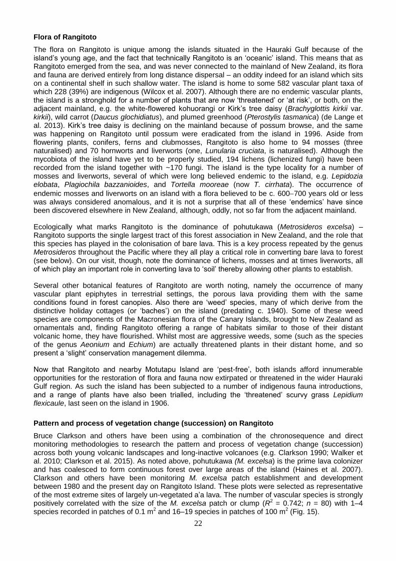
Bruce Clarkson and others have been using a combination of the chronosequence and direct monitoring methodologies to research the pattern and process of vegetation change (succession) across both young volcanic landscapes and long-inactive volcanoes (e.g. Clarkson 1990; Walker et al. 2010; Clarkson et al. 2015). As noted above, pohutukawa (M. excelsa) is the prime lava colonizer and has coalesced to form continuous forest over large areas of the island (Haines et al. 2007). Clarkson and others have been monitoring M. excelsa patch establishment and development between 1980 and the present day on Rangitoto Island. These plots were selected as representative of the most extreme sites of largely un-vegetated a’a lava. The number of vascular species is strongly positively correlated with the size of the M. excelsa patch or clump (R2 = 0.742; n = 80) with 1–4 species recorded in patches of 0.1 m2 and 16–19 species in patches of 100 m2 (Fig. 15).
23
Figure 15. Relationship between numbers of vascular species and size of pohutukawa (Metrosideros excelsa) patch on Rangitoto (y = 2.3101 Ln(x) + 5.4827).
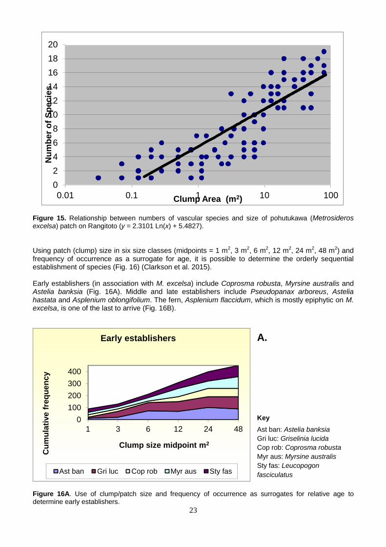
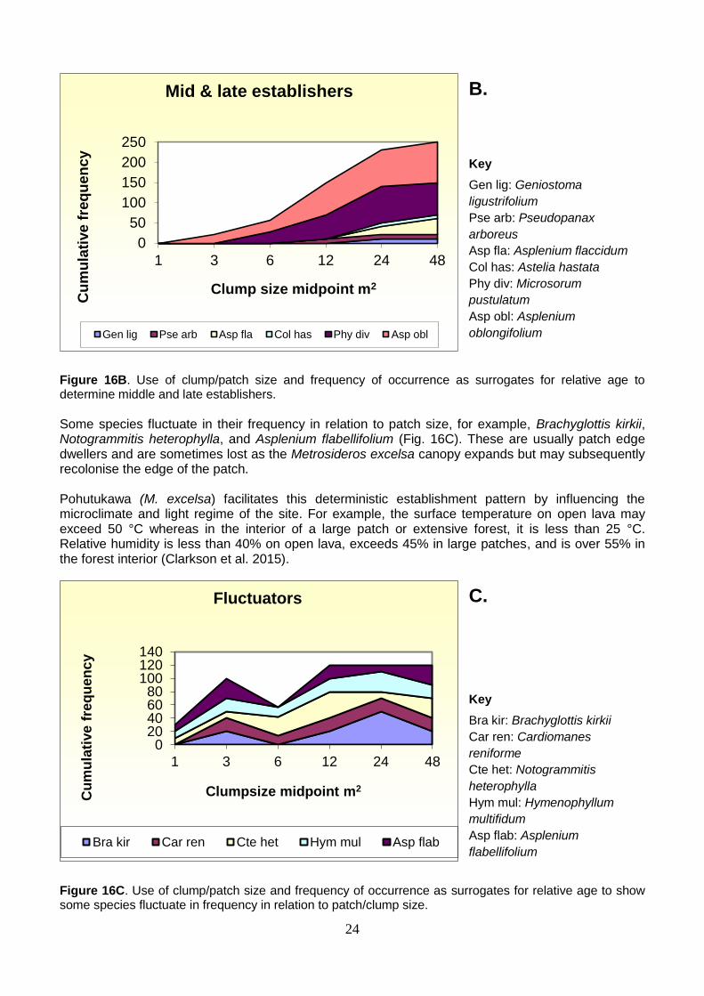
Using patch (clump) size in six size classes (midpoints = 1 m2, 3 m2, 6 m2, 12 m2, 24 m2, 48 m2) and frequency of occurrence as a surrogate for age, it is possible to determine the orderly sequential establishment of species (Fig. 16) (Clarkson et al. 2015). Early establishers (in association with M. excelsa) include Coprosma robusta, Myrsine australis and Astelia banksia (Fig. 16A). Middle and late establishers include Pseudopanax arboreus, Astelia hastata and Asplenium oblongifolium. The fern, Asplenium flaccidum, which is mostly epiphytic on M. excelsa, is one of the last to arrive (Fig. 16B).
Figure 16A. Use of clump/patch size and frequency of occurrence as surrogates for relative age to determine early establishers.
0
2
4
6
8
10
12
14
16
18
20
0.01 0.1 1 10 100
Nu
mb
er
of
Sp
ec
ies
Clump Area (m2)
0
100
200
300
400
1 3 6 12 24 48
Cu
mu
lati
ve
fre
qu
en
cy
Clump size midpoint m2
Early establishers
Ast ban Gri luc Cop rob Myr aus Sty fas
A. Key
Ast ban: Astelia banksia
Gri luc: Griselinia lucida
Cop rob: Coprosma robusta
Myr aus: Myrsine australis
Sty fas: Leucopogon
fasciculatus
24
Figure 16B. Use of clump/patch size and frequency of occurrence as surrogates for relative age to determine middle and late establishers.
Some species fluctuate in their frequency in relation to patch size, for example, Brachyglottis kirkii, Notogrammitis heterophylla, and Asplenium flabellifolium (Fig. 16C). These are usually patch edge dwellers and are sometimes lost as the Metrosideros excelsa canopy expands but may subsequently recolonise the edge of the patch. Pohutukawa (M. excelsa) facilitates this deterministic establishment pattern by influencing the microclimate and light regime of the site. For example, the surface temperature on open lava may exceed 50 °C whereas in the interior of a large patch or extensive forest, it is less than 25 °C. Relative humidity is less than 40% on open lava, exceeds 45% in large patches, and is over 55% in the forest interior (Clarkson et al. 2015).
Figure 16C. Use of clump/patch size and frequency of occurrence as surrogates for relative age to show some species fluctuate in frequency in relation to patch/clump size.
0
50
100
150
200
250
1 3 6 12 24 48
Cu
mu
lati
ve
fre
qu
en
cy
Clump size midpoint m2
Mid & late establishers
Gen lig Pse arb Asp fla Col has Phy div Asp obl
020406080
100120140
1 3 6 12 24 48
Cu
mu
lati
ve
fre
qu
en
cy
Clumpsize midpoint m2
Fluctuators
Bra kir Car ren Cte het Hym mul Asp flab
B. Key
Gen lig: Geniostoma
ligustrifolium
Pse arb: Pseudopanax
arboreus
Asp fla: Asplenium flaccidum
Col has: Astelia hastata
Phy div: Microsorum
pustulatum
Asp obl: Asplenium
oblongifolium
C. Key
Bra kir: Brachyglottis kirkii
Car ren: Cardiomanes
reniforme
Cte het: Notogrammitis
heterophylla
Hym mul: Hymenophyllum
multifidum
Asp flab: Asplenium
flabellifolium
25
Some geological features
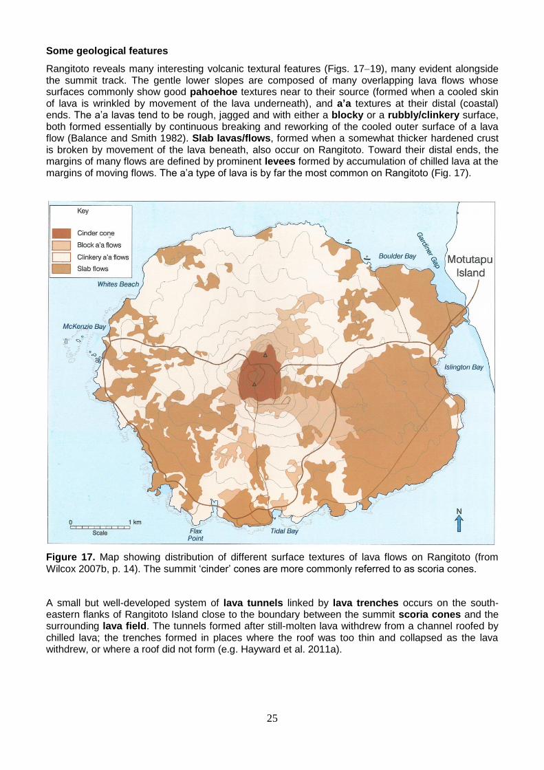
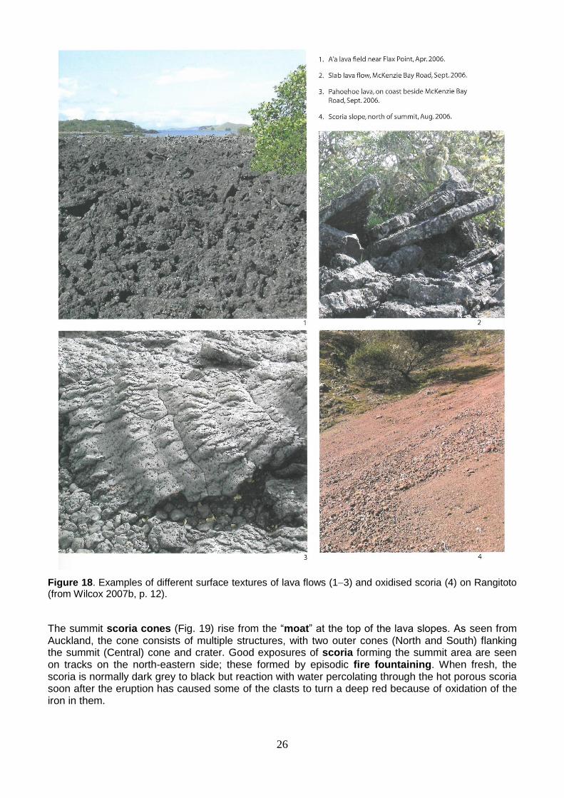
Rangitoto reveals many interesting volcanic textural features (Figs. 1719), many evident alongside the summit track. The gentle lower slopes are composed of many overlapping lava flows whose surfaces commonly show good pahoehoe textures near to their source (formed when a cooled skin of lava is wrinkled by movement of the lava underneath), and a’a textures at their distal (coastal) ends. The a’a lavas tend to be rough, jagged and with either a blocky or a rubbly/clinkery surface, both formed essentially by continuous breaking and reworking of the cooled outer surface of a lava flow (Balance and Smith 1982). Slab lavas/flows, formed when a somewhat thicker hardened crust is broken by movement of the lava beneath, also occur on Rangitoto. Toward their distal ends, the margins of many flows are defined by prominent levees formed by accumulation of chilled lava at the margins of moving flows. The a’a type of lava is by far the most common on Rangitoto (Fig. 17).
Figure 17. Map showing distribution of different surface textures of lava flows on Rangitoto (from Wilcox 2007b, p. 14). The summit ‘cinder’ cones are more commonly referred to as scoria cones.
A small but well-developed system of lava tunnels linked by lava trenches occurs on the south-eastern flanks of Rangitoto Island close to the boundary between the summit scoria cones and the surrounding lava field. The tunnels formed after still-molten lava withdrew from a channel roofed by chilled lava; the trenches formed in places where the roof was too thin and collapsed as the lava withdrew, or where a roof did not form (e.g. Hayward et al. 2011a).
26
Figure 18. Examples of different surface textures of lava flows (13) and oxidised scoria (4) on Rangitoto (from Wilcox 2007b, p. 12).
The summit scoria cones (Fig. 19) rise from the “moat” at the top of the lava slopes. As seen from Auckland, the cone consists of multiple structures, with two outer cones (North and South) flanking the summit (Central) cone and crater. Good exposures of scoria forming the summit area are seen on tracks on the north-eastern side; these formed by episodic fire fountaining. When fresh, the scoria is normally dark grey to black but reaction with water percolating through the hot porous scoria soon after the eruption has caused some of the clasts to turn a deep red because of oxidation of the iron in them.
27
Hydrology
The island has no appreciable surface runoff of rainwater, event after heavy rain (mean annual rainfall in Auckland is around 1200 mm), with an estimated ~9% of that percolating down into the underyling basaltic deposits to replenish a lens-shaped groundwater aquifer at a depth of ~40-60 m (Merrill 1994; Wilcox 2007b). A bore along Islington Bay Road (drilled in 1977) provides freshwater to facilities at Rangitoto Wharf. A small spring-fed freshwater wetland occurs near the coast north of McKenzie Bay, the only one on the island (Wilcox 2007b).
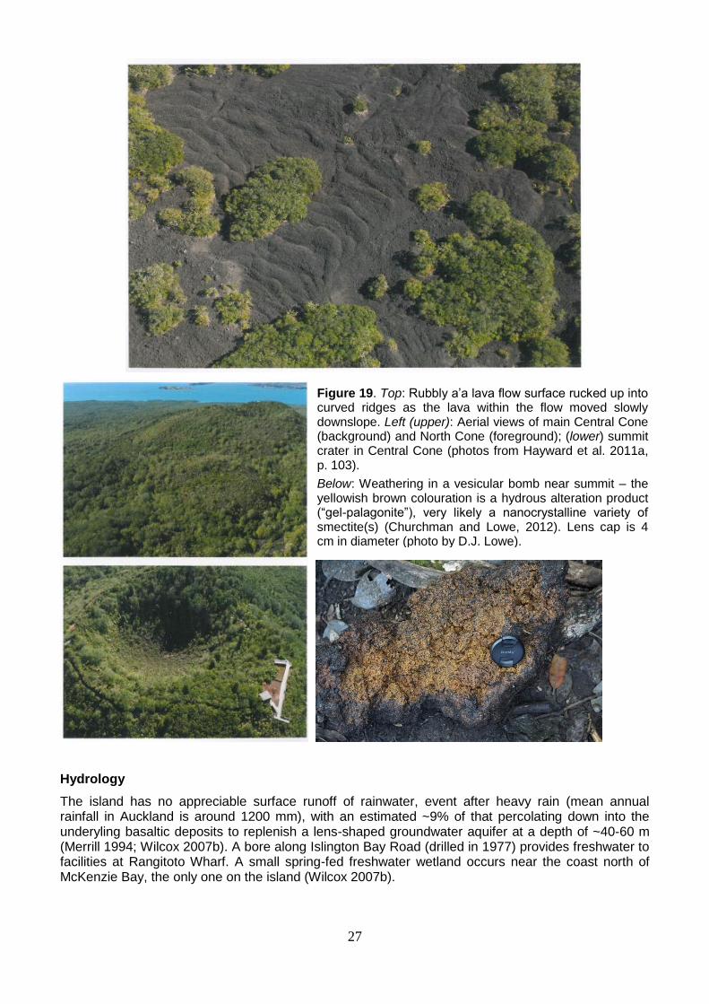
Figure 19. Top: Rubbly a’a lava flow surface rucked up into curved ridges as the lava within the flow moved slowly downslope. Left (upper): Aerial views of main Central Cone (background) and North Cone (foreground); (lower) summit crater in Central Cone (photos from Hayward et al. 2011a, p. 103).
Below: Weathering in a vesicular bomb near summit – the yellowish brown colouration is a hydrous alteration product (“gel-palagonite”), very likely a nanocrystalline variety of smectite(s) (Churchman and Lowe, 2012). Lens cap is 4 cm in diameter (photo by D.J. Lowe).
28
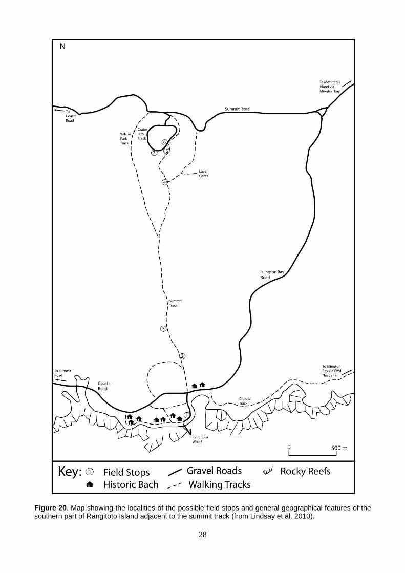
Figure 20. Map showing the localities of the possible field stops and general geographical features of the southern part of Rangitoto Island adjacent to the summit track (from Lindsay et al. 2010).
29
Description of possible field stops (Fig. 20; mainly after Lindsay et al. 2010). Vegetational features will also be addressed as appropriate.
Ferry from Auckland arrives approximately 9.45 am.
1. Information shelter at Rangitoto Wharf Introduction and briefing. Toilets available.
After a short ferry ride we will arrive at Rangitoto Wharf, situated on the southern coast of Rangitoto Island and at the periphery of the Rangitoto lava field. Sea level has remained essentially the same since the eruptions of Rangitoto, so the features seen on the coast will shed some light on how the lava interacted with the sea water towards the latter stages of the second eruption. Note the smooth, wrinkly, curved lava features that snake their way into the water parallel to the wharf.
We will stop here for very brief introductions: David Lowe: volcanic and archaeological perspectives Peter de Lange: vegetational perspective
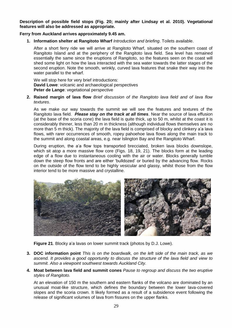
2. Raised margin of lava flow Brief discussion of the Rangitoto lava field and of lava flow textures.
As we make our way towards the summit we will see the features and textures of the Rangitoto lava field. Please stay on the track at all times. Near the source of lava effusion (at the base of the scoria cone) the lava field is quite thick, up to 50 m, whilst at the coast it is considerably thinner, less than 20 m in thickness (although individual flows themselves are no more than 5 m thick). The majority of the lava field is comprised of blocky and clinkery a’a lava flows, with rarer occurrences of smooth, ropey pahoehoe lava flows along the main track to the summit and along coastal areas, e.g. near Islington Bay and the Rangitoto Wharf.
During eruption, the a’a flow tops transported brecciated, broken lava blocks downslope, which sit atop a more massive flow core (Figs. 18, 19, 21). The blocks form at the leading edge of a flow due to instantaneous cooling with the air or water. Blocks generally tumble down the steep flow fronts and are either ‘bulldozed’ or buried by the advancing flow. Rocks on the outside of the flow tend to be highly vesicular and glassy, whilst those from the flow interior tend to be more massive and crystalline.
Figure 21. Blocky a’a lavas on lower summit track (photos by D.J. Lowe).
3. DOC information point This is on the boardwalk, on the left side of the main track, as we ascend. It provides a good opportunity to discuss the structure of the lava field and view to summit. Also a viewpoint southwest towards Auckland City.
4. Moat between lava field and summit cones Pause to regroup and discuss the two eruptive styles of Rangitoto.
At an elevation of 150 m the southern and eastern flanks of the volcano are dominated by an unusual moat-like structure, which defines the boundary between the lower lava-covered slopes and the scoria crown. It likely formed as a result of a subsidence event following the release of significant volumes of lava from fissures on the upper flanks.
30
5. On track immediately before summit crater Deposits of lapilli from the scoria cone.
Exposed in cuttings next to the summit track not far from the main crater are layers of the pyroclastic material (pyroclastic literally means ‘fiery fragmental’) comprising scoria of lapilli size (clasts 2-64 mm in diameter; ‘lapilli’ literally translates as ‘little stones’) and bombs (rounded clasts >64 mm) that make up the central scoria cone of Rangitoto. These glassy, highly vesicular rock fragments originate from gas-rich molten or semi-molten lava that has been ejected into the air, quickly cooled and deposited close to the vent, frequently still partially molten. The clasts are typically cylindrical, spherical, teardrop, dumbbell or button-like in shape, and generally take their shape when they are airborne. Also common in the pyroclastic deposits of Rangitoto is ‘welded’ scoria, which forms when semi-molten scoria clasts ‘stick’ to other clasts when they land. The accumulation of the pyroclastic fragments described above formed the Rangitoto scoria cone. As noted earlier, much of the scoria is dark or black; red scoria indicates Fe-bearing minerals have been oxidised during eruption. Weak soils have developed on the scoria (Fig. 14).
6. Summit crater Not far from Stop 5 is the observation deck located on the rim of the main crater of Rangitoto.
The near circular bowl-shaped crater of Rangitoto is approximately 150 m in diameter and 60 m in depth, and reaches a height of ~260 m asl (Fig. 19). This is the position of the vent for the latest Rangitoto eruptions c. 550–500 cal. yr BP (c. 1400–1450 AD), which started off as a moderately explosive (Strombolian style) eruption, forming the scoria cone, and then becoming more effusive (Hawaiian style) towards the latter stages of the eruption.
7. Summit Discussion of the Auckland Volcanic Field and of the two most recent eruptive phases of Rangitoto. Leave this stop by ~1.00 pm.
At the summit we are presented with a 360° view of Rangitoto volcano and the surrounding natural and human-made features. To the southwest we can see the Auckland CBD, situated next to the Waitemata Harbour, and some of the other larger volcanic cones (Mt Wellington, Mt Eden, One Tree Hill, The Domain, Mt Mangere) in the AVF. To the west we see the residential suburbs of North Shore City and smaller volcanic cones (North Head, Mt Victoria) and slightly larger explosion craters (Lake Pupuke, Tank Farm, Onepoto Basin) (see Fig. 2). To the north-east we see Motutapu Island, which was covered in significant volumes of volcanic ash from the Rangitoto eruptions. As described above, ash from the latest Rangitoto eruptions has also been found in drill core from Lake Pupuke (Figs. 8, 9). To the south and southeast we see the other islands of the Hauraki Gulf, the islands of Waiheke and Motuihe, and volcanic cone(s) of Motukorea (Brown’s Island), notable not only for its beautiful cones but also for its unique mineral, motukoreaite (Rodgers et al. 1977).
8. Descent Please take care on the descent as the scoria gravel can be unstable under the feet.
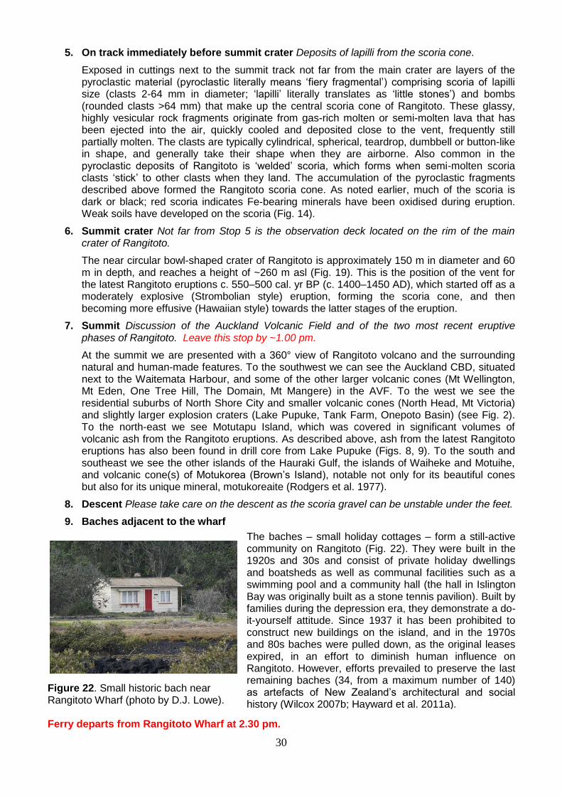
9. Baches adjacent to the wharf
Figure 22. Small historic bach near Rangitoto Wharf (photo by D.J. Lowe). Ferry departs from Rangitoto Wharf at 2.30 pm.
The baches – small holiday cottages – form a still-active community on Rangitoto (Fig. 22). They were built in the 1920s and 30s and consist of private holiday dwellings and boatsheds as well as communal facilities such as a swimming pool and a community hall (the hall in Islington Bay was originally built as a stone tennis pavilion). Built by families during the depression era, they demonstrate a do-it-yourself attitude. Since 1937 it has been prohibited to construct new buildings on the island, and in the 1970s and 80s baches were pulled down, as the original leases expired, in an effort to diminish human influence on Rangitoto. However, efforts prevailed to preserve the last remaining baches (34, from a maximum number of 140) as artefacts of New Zealand’s architectural and social history (Wilcox 2007b; Hayward et al. 2011a).
31
References
Anderson, A.J. 1991. The chronology of colonization in New Zealand. Antiquity 65, 767-695. Anderson, A.J. 2013. A fragile plenty: pre-European Maori and the New Zealand environment. In: Pawson,
E., Brooking, T. (editors) Making a New Land: Environmental Histories of New Zealand, new edition. Otago University Press, Dunedin, pp. 35-51.
Anderson, A. 2015. Speaking of migration AD 1150-1450. In: Anderson, A., Harris, A., Williams, B. (editors), Tangata Whenua – An Illustrated History. Bridget Williams Books, Auckland, pp. 42-69.
Ashenden, C.L., Lindsay, J.M., Sherburn, S., Smith, I.E.M., Miller, C., Malin, P. 2011. Some challenges of monitoring a potentially active volcanic field in a large urban area: Auckland Volcanic Field, New Zealand. Natural Hazards 59, 507-528.
Augustinus, P.C. 2016. Probing the history of New Zealand’s Orakei maar. Eos 97, https://eos.org/project-updates/probing-the-history-of-new-zealands-orakei-maar.
Augustinus, P.C., Reid, M., Andersson, S., Deng Y., Horrocks, M. 2006. Biological and geochemical record of anthropogenic impacts in recent sediments from Lake Pupuke, Auckland City, New Zealand. Journal of Paleolimnology 35, 789-805.
Augustinus, P., Bleakley, N., Deng, Y., Shane, P., Cochrane, U. 2008. Rapid change in early Holocene environments inferred from Lake Pupuke, Auckland City, New Zealand. Journal of Quaternary Science 23, 435-447.
Augustinus, P., D’Costa, D., Deng, Y., Hagg, J., Shane, P. 2011. A multi-proxy record of changing environments from ca. 30 000 to 9000 cal. a BP: Onepoto maar palaeolake, Auckland, New Zealand. Journal of Quaternary Science 26, 389-401.
Augustinus, P., Cochrane, U., Kattel, G., D’Costa, D., Shane, P., 2012. Late Quaternary paleolimnology of Onepoto maar, Auckland, New Zealand: implications for the drivers of regional paleoclimate. Quaternary International 253, 18-31.
Balance, P.F., Smith, I.E.M. 1982. Walks through Auckland’s geological past: a guide to the geological formations of Rangitoto, Motutapu, and Motuihe islands. Geological Society of New Zealand Guidebook 5, 24 pp.
Barrell, D.J.A., Almond, P.C., Vandergoes, M.J., Lowe, D.J., Newnham, R.M., NZ-INTIMATE members 2013. A composite pollen-based stratotype for inter-regional evaluation of climatic events in New Zealand over the past 30,000 years (NZ-INTIMATE project). Quaternary Science Reviews 74, 4-20.
Bebbington, M. 2015. Spatio-volumetric hazard estimation in the Auckland Volcanic Field. Bulletin of Volcanology 77, 39.
Bebbington, M.S., Cronin, S.J. 2011. Spatio-temporal hazard estimation in the Auckland Volcanic Field, New Zealand, with a new event-order model. Bulletin of Volcanology 73, 55-72.
Brand, B.D., Gravley, D., Clarke, A., Lindsay, J., Boomberg, S.H., Agustin-Flores, J., Németh, K. 2014. Combined field and numerical approach to understanding dilute pyroclastic density current dynamics and hazard potential: Auckland Volcanic Field, New Zealand. Journal of Volcanology and Geothermal Research 276, 215-232.
Churchman, G.J., Lowe, D.J. 2012. Alteration, formation, and occurrence of minerals in soils. In: Huang, P.M., Li, Y., Sumner, M.E. (editors) Handbook of Soil Sciences. 2
nd Edition. Vol. 1: Properties and
Processes. CRC Press, Boca Raton, FL, pp.20.1-20.72. Clarkson, B.D. 1990. A review of vegetation development following recent (<450 years) volcanic
disturbance in North Island, New Zealand. New Zealand Journal of Ecology 14, 59-71. Clarkson, B.D., Clarkson, B.R., Juvik, J.O. 2015. Pattern and process of vegetation change (succession)
on two northern New Zealand island volcanoes. Surtsey Research 13, 45-48. Davidson, J. M. 1978. The prehistory of Motutapu Island, New Zealand: five centuries of Polynesian
occupation in a changing landscape. Journal of the Polynesian Society 87, 327–337. Daly, M., Johnston D. 2015. The genesis of volcanic risk assessment for the Auckland engineering
lifelines project: 1996–2000. Journal of Applied Volcanology 4, 1-17. de Lange, P.J., Rolfe, J.R., Champion, P.D., Courtney, S.P., Heenan, P.B., Barkla, J.W., Cameron, E.K.,
Norton, D.A., Hitchmough, R.A. 2013. Conservation status of New Zealand indigenous vascular plants, 2012. New Zealand Threat Classification Series 3. New Zealand Department of Conservation. Available at: http://www.doc.govt.nz/publications/science-and-technical/products/series/new-zealand-threat-classification-series/
Dohaney, J., Brogt, E., Kennedy, B., Wilson, T., Lindsay, J. 2015. Training in crisis communication and volcanic eruption forecasting: design and evaluation of an authentic role-play simulation. Journal of Applied Volcanology 4, 1-26.
32
Green, R.M., Bebbington, M.S., Cronin, S.J., Jones, G. 2014. Automated statistical matching of multiple tephra records exemplified using five long maar sequences younger than 75 ka, Auckland, New Zealand. Quaternary Research 82, 405-419.
Haines, L., Julian, A., Wilcox, M.D. 2007. Vegetation patterns. In: Wilcox, M.D. (editor), Natural History of Rangitoto Island. Auckland Botanical Society, Epsom, Auckland, pp. 41-58.
Hayward, B.W., Murdoch, G., Maitland, G. 2011a. Volcanoes of Auckland: the Essential Guide. Auckland University Press, 234pp.
Hayward, B.W., Kenny, J.A., Grenfell, H.R. 2011b. More volcanoes recognised in Auckland Volcanic Field. Geoscience Society of New Zealand Newsletter 5, 11-16.
Hewitt, A.E. 2010. New Zealand Soil Classification, 3rd
Edition. Landcare Research Science Series 1, 1-136.
Heyng, A.M., Mayr, C., Lücke, A., Wissel, H., Striewski, B. 2014. Late Holocene hydrologic changes in northern New Zealand inferred from stable isotope values of aquatic cellulose in sediments from Lake Pupuke. Journal of Paleolimnology 51, 485-497.
Higham, T.F.G., Hogg, A.G. 1997. Evidence for late Polynesian colonisation of New Zealand: University of Waikato radiocarbon measurements. Radiocarbon 39, 149-192.
Higham, T.F.G., Anderson, A.J., Jacomb, C. 1999. Dating the first New Zealanders: the chronology of Wairau Bar. Antiquity 73, 420-427.
Hogg, A.G., Higham, T.F.G., Lowe, D.J., Palmer, J., Reimer, P., Newnham, R.M. 2003. A wiggle-match date for Polynesian settlement of New Zealand. Antiquity 77, 116-125.
Hogg, A.G., Lowe, D.J., Palmer, J.G., Boswijk, G., Bronk Ramsey, C.J. 2012. Revised calendar date for the Taupo eruption derived by
14C wiggle-matching using a New Zealand kauri
14C calibration data set.
The Holocene 22, 439-449. Homer, L., Moore, P., Kermode, L. 2000. Lava and strata: a guide to the volcanoes and rock formations of
Auckland. Landscape Publications with Institute of Geological and Nuclear Sciences, Wellington. 96 pp.
Hopkins, J., Millet, M.A., Timm, C., Wilson, C.J.N., Leonard, G.S., Palin, M.J., Neil, H. 2015. Tools and techniques for developing tephra stratigraphies in lake cores: a case study from the basaltic Auckland Volcanic Field, New Zealand. Quaternary Science Reviews 123, 58-75.
Horrocks, M., Deng, Y., Ogden, J., Alloway, B.V., Nichol, S., Sutton, D.G. 2001. High spatial resolution of pollen and charcoal in relation to the c. 600 year BP Kaharoa Tephra: implications for Polynesian settlement of Great Barrier Island New Zealand. Journal of Archaeological Science 28, 153-168.
Horrocks, M., Deng, Y., Nichol, S.L., Shane, P.A., Ogden, J. 2002. A palaeo-environmental record of natural and human change from the Auckland Isthmus, New Zealand, during the Late Holocene. Journal of the Royal Society of New Zealand 32, 337-353.
Horrocks, M., Augustinus, P.C., Deng, Y., Shane, P., Andersson, S. 2005. Holocene vegetation, environment and tephra recorded from Lake Pupuke, Auckland, New Zealand. New Zealand Journal of Geology and Geophysics 48, 85-94.
Jacomb, A., Holdaway, R.N., Allentoft, M.E., Bunce, M., Oskam, C.L., Walter, R., Brooks, E. 2014. High-precision dating and ancient DNA profiling of moa (Aves: Dinornithiformes) eggshell documents a complex feature at Wairau Bar and refines the chronology of New Zealand settlement by Polynesians. Journal of Archaeological Science 50, 24-30.
Kereszturi, G., Németh, K., Cronin, S.J., Procter, J., Agustín-Flores, J. 2014. Influences on the variability of eruption sequences and style transitions in the Auckland Volcanic Field, New Zealand. Journal of Volcanology and Geothermal Research 286, 101–115
Kermode, L. 1992. Geology of the Auckland urban area. Scale 1: 50,000. Institute of Geological and Nuclear Sciences geological map 2. 1 sheet + 63 pp. Institute of Geological and Nuclear Sciences Lower Hutt.
Lindsay, J.M. 2010. Volcanoes in the big smoke: a review of hazard and risk in the Auckland Volcanic Field. In: Williams, A.L., Pinches, G.M., Chin, C.Y. McMorran, T.J., Massey, C.I. (editors). Geologically Active. 11
th Congress of the International Association for Engineering Geology and the Environment
(IAEG). Taylor & Francis, London. Lindsay, J.M., Needham, A.J., Smith, I.E.M. 2010. Rangitoto re-visited: new insights to an old friend.
GeoNZ Conference 2010 – pre-conference field trip 3, The University of Auckland. Geoscience Society of New Zealand Miscellaneous Publication 129B, 8 pp.
Lindsay, J.M., Leonard, G.S., Smid, E.R., Hayward, B.W. 2011. Ages of the Auckland Volcanic Field: a review of existing data. New Zealand Journal of Geology and Geophysics 54, 379-401.
Linnell, T., Shane, P., Smith, I., Augustinus, P., Cronin, S., Lindsay, J., Maas, R. 2016. Long-lived shield volcanism within a monogenetic basaltic field: the conundrum of Rangitoto volcano, New Zealand. Geological Society of America Bulletin 128, 1160-1172.
33
Lowe, D.J. 2011. Tephrochronology and its application: a review. Quaternary Geochronology 6, 107-153. Lowe, D.J., Pittari, A. 2014. An ashy septingentenarian: the Kaharoa tephra turns 700 (with notes on its
volcanological, archaeological, and historical importance). Geoscience Society of New Zealand Newsletter 13, 35-46.
Lowe, D.J., Newnham, R.M., McFadgen, B.G., Higham, T.F.G. 2000. Tephras and New Zealand archaeology. Journal of Archaeological Science 27, 859-870.
Lowe, D.J., Newnham, R.M., McCraw, J.D. 2002. Volcanism and early Maori society in New Zealand. In: Torrence, R., Grattan, J. (editors) Natural Disasters and Cultural Change. Routledge, London, pp. 126-161.
Lowe, D.J., Kenedi, C.L., de Lange, P.J. 2014. Rangitoto volcano excursion, Auckland. Pre-conference field trip guide, 30
th August, 2014. 31
st ICSU General Assembly, International Council for Science,
Auckland, New Zealand. 22 pp. McGee, L.E., Smith, I.E.M. 2016. Interpreting chemical compositions of small scale basaltic systems: a
review. Journal of Volcanology and Geothermal Research 325, 45-60. McGee, L.E., Beier, C., Smith, I.E.M., Turner, S.P. 2010. Dynamics of melting beneath a small-scale
basaltic system: a U-Th-Ra study from Rangitoto Volcano, Auckland Volcanic Field, New Zealand. Contributions to Mineralogy and Petrology 162, 547-563.
Merrill, A. 1994. An investigation of the hydrological balance of Rangitoto Island. Unpublished MSc thesis, University of Auckland.
Molloy, C., Shane, P., Augustinus, P. 2009. Eruption recurrence rates in a basaltic volcanic field based on tephra layers in maar sediments: implications for hazards in the Auckland volcanic field. Geological Society of America Bulletin 121, 1666-1677.
Murdoch, G. (compiler) 1991. He Korero Ta Whito Mo Rangitoto – a brief outline of the Maori historical associations with Rangitoto Island. Unpublished paper, 14 pp.
Needham, A.J., Lindsay, J.M., Smith, I.E.M., Augustinus, P., Shane, P.A. 2011. Sequential eruption of alkaline and sub-alkaline magmas from a small monogenetic volcano in the Auckland Volcanic Field, New Zealand. Journal of Volcanology and Geothermal Research 201, 126-142.
Newnham, R.M., Lowe, D.J. 1991. Holocene vegetation and volcanic activity, Auckland Isthmus, New Zealand. Journal of Quaternary Science 6, 177-193.
Newnham, R.M., Lowe, D.J., McGlone, M.S., Wilmshurst, J.M., Higham, T.F.G. 1998. The Kaharoa Tephra as a critical datum for earliest human impact in northern New Zealand. Journal of Archaeological Science 25, 533-544.
Newnham, R.M., Lowe, D.J., Alloway, B.V. 1999. Volcanic hazards in Auckland, New Zealand: a preliminary assessment of the threat posed by central North Island silicic volcanism based on the Quaternary tephrostratigraphical record. Geological Society (London) Special Publications 161, 27-45.
Newnham, R.M., Lowe, D.J., Giles, T.M., Alloway, B.V. 2007. Vegetation and climate of Auckland, New Zealand, since ca. 32 000 cal. yr ago: support for an extended LGM. Journal of Quaternary Science 22, 517-534.
Nichol, R. 1981. Preliminary report on excavations at the Sunde site, N38/24, Motutapu Island. New Zealand Archaeological Association Newsletter 24, 237-256.
Nichol, R. 1982. Fossilised human footprints in Rangitoto Ash on Motutapu Island. Geological Society of New Zealand Newsletter 51, 11-13.
Nichol, R. 1992. The eruption history of Rangitoto: reappraisal of a small New Zealand myth. Journal of the Royal Society of New Zealand 22, 159-180.
Nilsson, A., Muscheler, R., Snowball, I., Aldahan, A., Possnert, G., Augustinus, P., Atkin, D., Stephens, T. 2011. Multi-proxy identification of the Laschamp geomagnetic field excursion in Lake Pupuke, New Zealand. Earth and Planetary Science Letters 311, 155-164.
Potter, S.H., Jolly, G.E., Neall, V.E., Johnston, D.M., Scott B.J. 2014. Communicating the status of volcanic activity: revising New Zealand’s volcanic alert level system. Journal of Applied Volcanology 3, 1-16.
Robertson, D.J. 1986. A paleomagnetic study of Rangitoto Island, Auckland, New Zealand. New Zealand Journal of Geology and Geophysics 29, 405-411.
Rodgers, K.A., Chisolm, J.E., Davis, R.J., Nelson, C.S. 1977. Motukoreaite, a new hydrated carbonate, sulphate, and hydroxide of Mg and Al from Auckland, New Zealand. Mineralogical Magazine 41, 389-390.
Sahetapy-Engel, S., Self, S., Carey, R.J., Nairn, I.A. 2014. Deposition and generation of multiple widespread fall units from the c. AD 1314 Kaharoa rhyolitic eruption, Tarawera, New Zealand. Bulletin of Volcanology 76, article 836. DOI 10.1007/s00445-014-0836-4.
34
Shane, P., Linnell, T. 2015. Earthquake Commission University Post-Graduate Research Programme: Reconstructing Rangitoto volcano from a 150-m-deep drill core (project 14/U684). Final report, University of Auckland. 12 pp.
Shane, P., Gehrels, M., Zawalna-Geer, A., Augustinus, P., Lindsay, J., Chaillou, I. 2013. Longevity of a small shield volcano revealed by crypto-tephra studies (Rangitoto Volcano, New Zealand): change in eruptive behaviour of a basaltic field. Journal of Volcanology and Geothermal Research 257,174-183.
Smith, R.T., Lowe, D.J., Wright, I.C. 2006. Volcanoes. Te Ara − The Encyclopedia of New Zealand [Online]. Updated 16 April, 2007. New Zealand Ministry for Culture and Heritage, Wellington. URL: http://www.TeAra.govt.nz/EarthSeaAndSky/NaturalHazardsAndDisasters/Volcanoes/en
Smith, I.E.M., Lindsay, J.M., Nemeth, K. 2012. Intra-conference field guide: Rangitoto, Auckland’s newest volcano. Gesocience Society of New Zealand Miscellaneous Publication 131D, 27-34
Soil Survey Staff 2014. Keys to Soil Taxonomy, 12th edition. USDA Natural Resources Conservation
Service. 362 pp. Stephens, T., Atkin, D., Augustinus, P., Shane, P., Lorrey, A., Street-Perrott, A., Nilsson, A., Snowball, I.
2012a. A late glacial Antarctic climate teleconnection and variable Holocene seasonality at Lake Pupuke, Auckland, New Zealand. Journal of Paleolimnology 48, 785-800.
Stephens, T., Atkin, D., Cochran, U., Augustinus, P., Reid, M., Lorrey, A., Shane, P., Street-Perrott, A., 2012b. A diatom-inferred record of reduced effective precipitation during the Last Glacial Coldest
Phase (28.818.0 cal kyr BP) and increasing Holocene seasonality at Lake Pupuke, Auckland, New Zealand. Journal of Paleolimnology 48, 801-817.
Striewski, B., Shulmeister, J., Augustinus, P.C., Soderholm, J. 2013. Late Holocene climate variability from Lake Pupuke maar, Auckland, New Zealand. Quaternary Science Reviews 77, 46-54.
Sutton, D.G. 1987. A paradigmatic shift in Polynesian prehistory: implications for New Zealand. New Zealand Journal of Archaeology 9, 135-155.
Tomsen, E., Lindsay, J., Gahegan, M., Wilson, T., Blake, D. 2014. Auckland Volcanic Field evacuation planning: a spatio-temporal approach for emergency management and transportation network decisions. Journal of Applied Volcanology 3, 1-22.
Walker, L.R., Wardle, D.A., Bardgett, R.D., Clarkson, B.D. 2010. The use of chronosequences in studies of ecological succession and soil development. Journal of Ecology 98, 725-736.
Wilcox, M.D. (editor) 2007a. Natural History of Rangitoto Island. Auckland Botanical Society, Epsom, Auckland. 192 pp.
Wilcox, M.D. 2007b. Introduction. In: Wilcox, M.D. (editor), Natural History of Rangitoto Island. Auckland Botanical Society, Epsom, Auckland, pp. 10-22.
Wilcox, M.D., Haines, L., Young, M.E., Brown, P.M., Gardner, R.O. 2007. List of vascular plants. In: Wilcox, M.D. (editor), Natural History of Rangitoto Island. Auckland Botanical Society, Epsom, Auckland, pp. 101-118.
Wilmshurst, J.M., Higham T.F.G. 2004. Using rat-gnawed seeds to independently date the arrival of Pacific rats and humans to New Zealand. The Holocene 14, 801-806.
Wilmshurst, J.M., Anderson, A.J., Higham, T.F.G., Worthy, T.H. 2008. Dating the late prehistoric dispersal of Polynesians to New Zealand using the commmensal Pacific rat. Proceedings of the National Academy of Sciences of the United States 105, 7676-7680.
Wilmshurst, J.M., Hunt, T.L., Lipo, C.P. Anderson, A.J. 2011. High-precision radiocarbon dating shows recent and rapid initial human colonization of East Polynesia. Proceedings of the National Academy of the United States of America 108, 1815-1820.
Wilmshurst, J.M., Moar, N.T., Wood, J.R., Bellingham, P.J., Findlater, A.M., Robinson, J.J., Stone, C. 2014. Use of pollen and ancient DNA as conservation baselines for offshore islands in New Zealand. Conservation Biology 28, 202-212.
Zawalna-Geer, A., Lindsay, J., Davies, S., Augustinus, P., Davies, S. 2016. Extracting a primary Holocene cryptotephra record from Pupuke maar sediments, Auckland, New Zealand. Journal of Quaternary Science 31, 442-457.

35
Notes


![New Aqua Key Aqua Facts - Earth Observing System · 2017. 1. 26. · Earth Science Reference Handbook [ Missions: Aqua ] 73 Aqua Summary Aqua is a major international Earth Science](https://static.fdocuments.net/doc/165x107/604176e56ec9bf22204cde4b/new-aqua-key-aqua-facts-earth-observing-system-2017-1-26-earth-science-reference.jpg)