GUIDE TO THE SQUARE - Wickham History...
23
1 Guide to the Village Centre Wickham Square and Environs
Transcript of GUIDE TO THE SQUARE - Wickham History...

1
Guide to the Village
Centre
Wickham Square and
Environs

2
Map ref. Feature Page 1, The Square 4 2. Greens 5 3. The Wine Bar 5 4. Pages Newsagents 7 5. Commerce House 7 6. The King’s Head 8 7. East Side of The Square 8 8. Chemist’s Shop 9 9. Warwick Lane 9 10. The Volunteer 10 11. Havelock and Wentworth 10 12. South Downs Funeral Services 11 13. Alexandra House 11
Map ref. Feature Page 14. Harringtons Estate Agents 12 15. The Anchorage 12 16. Knight Chambers 13 17. Bedford Place & Dairymoor 15 18. Eastbrook House 16 19. The Diamond Jubilee Clock 16 20. Lilly’s Café/Restaurant 17 21. Culverts 18 22. Headmasters and Byrne 18 23. Hemings 20 24. Tull’s Fine Foods 21 25. The Old House Hotel 22 26. Wickham House 23
CONTENTS - WICKHAM SQUARE AND ENVIRONS (Map on next page)
(For source information references, see separate page on this site)
CLICK ON A CONTENTS TITLE TO JUMP TO A FEATURE, THEN CLICK ON THE FEATURE TITLE TO JUMP BACK

3
MAP OF WICKHAM SQUARE AND ENVIRONS
(Numbers refer to features listed on the Contents page)

4
(Map ref. 1) THE SQUARE
On August 13th 1269, the Lord of the Manor, Roger de Scures, was granted a Royal Charter by King Henry III to hold a weekly market every Thursday and to hold a Fair on the anniversary of the Translation Of St. Nicholas, the removal of the Saint’s relics from Turkey to Italy, (now 20 May), every year “for ever”, – the Charter is still valid and Wickham Fair is still held annually on that day.
The Square was laid out in the thirteenth century on a dry site above the river floods as a place to hold the market and the fair. It began as a rectangle of grass with Burgage Plots laid out either side.
A Burgage Plot was a tenure in England and Scotland under which property of the king or lord of the town was held in return for a yearly rent or the rendering of a service.
Burgage Plots are properties which are long and narrow. Their original purpose was such that there was enough ground per Burgage Plot to feed a family in vegetables, to keep a pig, and to build a home at the front of the plot, facing onto the market square.

5
GREENS (Map ref. 2)
Greens public house was once called “The Star” and, indeed, its location is still called “Star Corner”. In 1908, when the current property was built, the population of Wickham village was about 1400. The current building replaces an earlier, Georgian, building which was certainly an inn as late as 1898 and probably up to 1908. There once was a tradition where the landlord of The Star would serve a pint of beer to a horse every year on Wickham Fair Day, 20
th May.
THE WINE BAR (Map ref. 3)
Once “The Old Curio Shop” and “Knockers”, currently Wickham Wine Bar & Restaurant and Studio 6 printers, it is an open hall timber framed building with a continuous jetty and dates back to the sixteenth Century.
As seen, it is over five hundred years old but stands on an occupation plot thought to be seven hundred years old. It is one of three Wealden Houses in the village, (although atypical, having a continuous jetty). The cladding is nineteenth century. Just what a timber framed Wealden House would have looked like when built can be seen in the picture on the next page.
Ref. 8.9.
Ref. 15.

6
The front wall is jettied, the upper part roughcast and the lower rendered, with some posts and curved brackets evident. Some later walls are of brickwork in Flemish bond with blue headers. The tile roof, with a tile-hung north gable, is half-hipped with a mini-hip at the north side and has a “catslide” roof at the rear over an extension, (above right), probably added during the early eighteenth century.
Inside, there are original oak beams
throughout the building to be seen. Also inside on the upper floor, medieval paintings with floral/geometric patterns can be seen,
preserved behind glass. There are more paintings on the underside of the same room, but these are protected and hidden from view by modern plasterboard.
Housed in the same building as the Wine
Bar, on the ground floor to the north, is a shop. During renovations carried out in 1978, a wonderful painted ceiling was revealed, (concealed by modern plasterboard at the time of writing). This monochrome ceiling dates from c1590-1610 and was painted by two different artists.
Typical mini-hip on both buildings.
catslide

7
PAGES NEWSAGENT (Map ref. 4)
This Victorian building was once a Temperance House given to the village by the Lord of the Manor as an alternative to public houses, (of which there were several in the village). Converted to a shop, it became Frank Stubbs offices, then a cycle repair shop, (a cycle shop located across the square moving into the building in the 1930s), and is now a newsagents. Note the elaborate late Victorian wall tiles and cast iron down pipes.
COMMERCE HOUSE (Map ref. 5)
Built in the eighteenth century the Solicitor’s offices have brick walls are Flemish bond with blue headers. There are cambered rubbed arches, a new roof of old tiles, and a carriage opening to a rear yard. Two identical doorways have twentieth century hoods on old carved brackets.
Commerce House was next door. A new frontage converted it to John Price grocers, then E G Fox grocers. It is now now The Co-Op.
Ref. 1.8.9.
Ref. 15.

8
THE KING’S HEAD (Map ref. 6)
The King’s Head was an important coaching inn with gates to the side that were large enough to allow a coach and horses to be driven through to the rear of the inn where there were stables. The original building is of 1767 date but may stand on the site of an earlier inn. It is named in honour of King Henry III who gave the village the charter for a market and fair in 1269. A third storey of the King’s Head was damaged by a fire in 1928 and never rebuilt. The arch at Havelock, (see later), may be associated with an early phase of the Kings Head. Note the old Cycling Club sign high on the wall.
THE EAST SIDE OF THE SQUARE (Map ref. 7)
Notice the roof line. Many buildings are older than they look. Many are timber framed, later faced in brick. Most were built in the sixteenth and seventeenth century but some are earlier. For example, The Anchorage, amongst other buildings, is of late medieval date.
Ref. 8.9.
Ref. 8.9.

9
THE CHEMIST’S SHOP (Map ref.8)
The Chemist’s Shop as we see it today is really an old house with a modern shop front.
Originally built as a house in the late eighteenth century, it now has a twentieth century ground-floor and renovations.
The walls are rendered, with plaster coved eaves. The tile roof has hipped dormers. The north-west front elevation has two storeys and an attic with two windows. The sash windows are in exposed frames, and there are casements to the dormers.
Another old house above a modern shop, built in the late eighteenth century, with twentieth century renovation. The brick walls are of Flemish bond with blue headers, typical of the date and the area. The tile roof is hipped at the north side. The symmetrical front is of two storeys with three windows of the twentieth century.
With a classical shop front, it was formally Thorns Confectioners and Mussons Engineers, then Warwick’s hardware shop.
Dame Mary Donaldson, first Lady Mayor of London, was born here. (see separate article – click HERE).
Ref. 8.9.
Ref. 1.8.9. WARWICK LANE (Map ref. 9)

10
THE VOLUNTEER ARMS (Map ref. 10)
The site of an old public house called “The Volunteer Arms”. This public house was present as late as 1904, After which the building housed H. Welch, a boot repairer, The old bu i l d ing has now been extensively remodelled and replaced by modern shops, (One-Stop, Panda, etc.), so that today the original building is barely recognisable.
Ref. 1.8.9.
HAVELOCK AND WENTWORTH (Map ref. 11)
Referred to in deeds dated 1678, during the reign of King Charles II, and built as one building, it became the Old Kings Head Inn. It was owned by a certain William Gilbert who bequeathed the building to his sons. It was they who, in 1751, converted the old inn into two houses. In 1763 the houses were sold to a Thomas Prescot for the princely sum of £420. The rebuilt houses have two tone brick facades and typical Georgian frontages with Georgian porches added a little later. The remains of an arch at the south end of Havelock indicates the position of the old coach entrance to the rear yard of the inn. The “Catslide” roof to the rear is indicative of an early date for this building.
Ref. 1.8.9.

11
SOUTH DOWNS FUNERAL SERVICE (Map ref. 12)
Originally a house, then Wheatley agricultural engineers, then, in living memory, a sweet shop run by a Mrs Brockhurst, and now a funeral directors. Timber-framed, the original building probably dates from the sixteenth century, with late
nineteenth century cladding of rendered walls and a tile roof, and may be another Wealden House in combination with Alexandra House, (see below).
The north west elevation is of two storeys with one casement window. The ground-floor has an early twentieth century shop front. The south side has a square carriageway opening, (almost to eaves level), indicating an early date for the building.
Ref. 8.9.
Formerly known, (curiously), as “The House”, Alexandra is a building of timber-framed origin, with a late eighteenth century front added and some late nineteenth century features. The original building beneath is much earlier than the brickwork, being part of a Wealden house in design and basic build, and is likely to be late sixteenth century in date. The walls are now of brickwork in blue headers with red quoins laid Flemish bond, and brick dentil eaves, (so called because they look like teeth). It has a tile roof and a north-west front elevation of two stories with two casement windows. The ground-floor has one wide splayed bay beneath a continuous canopy with brackets, and two doorways. The original Wealden house upper floor overhang can therefore still be seen.
ALEXANDRA HOUSE (Map ref. 13) Ref. 8.9.

12
Originally a house, then “Old Timbers” and “Jeans” shop and now an estate agent. A late medieval timber frame building of three bays, re-clad in the eighteenth century, with late nineteenth/early twentieth century rendering and altered features.
It has a steep, prominent tile roof. The north west front is of two storeys with three casement windows. The ground-floor has one splayed bay and a shop front beneath a continuous canopy, the upper three rooms overhanging. The old doorway has a reeded architrave and curved hood, and a shop door. Inside, much remains to be seen of the original timber framework.
HARRINGTONS ESTATE AGENTS (Map ref. 14)
THE ANCHORAGE (Map ref. 15)
Another late medieval house, timber-framed and with early nineteenth century cladding added as well as early twentieth century details. The walls are now rendered.
The steep tile roof has a half-hip rising above the ridge in the centre. The north-west front is of two storeys with two casement windows. The ground-floor has splayed bays and a six-panelled door in a plain frame. The original jettied upper floor can be made out, thanks to the exposed beam above the lower floor windows.
Ref. 8.9.
Ref. 8.9.

13
KNIGHT’S CHAMBERS (Map ref. 16)
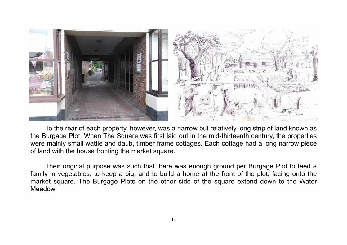
Originally Knight’s Building Yard and once housing older shops than we see today, (Lloyds Bank and an undertakers). Note the added “s” in name sign, suggesting a late addition to the family. The late Victorian façade is a fine example of Facadism preserving the front wall of the building. It was a builders yard until about 1980. The 1851 census for Wickham lists the Knight Family at 35 High Street - a master carpenter employing three joinery-men and seven apprentices with two girls, Caroline and Emily, employed as a milliner and a dressmaker. T h e building was later developed into shops at the front and offices and residential units to the rear. Behind the property, the plot extends a long way back from The Square. This is an example of a Burgage Plot.
continued...
Ref. 8.9.
14
To the rear of each property, however, was a narrow but relatively long strip of land known as the Burgage Plot. When The Square was first laid out in the mid-thirteenth century, the properties were mainly small wattle and daub, timber frame cottages. Each cottage had a long narrow piece of land with the house fronting the market square.
Their original purpose was such that there was enough ground per Burgage Plot to feed a
family in vegetables, to keep a pig, and to build a home at the front of the plot, facing onto the market square. The Burgage Plots on the other side of the square extend down to the Water Meadow.

15
BEDFORD PLACE AND THE DAIRYMOOR (Map ref. 17)
Bedford Place was a short piece of road between The Square and the Dairymoor. Bedford Place House was once “The Old Garage” up to 1950 with, until about 10 years ago, an old, manually operated petrol pump standing outside. The Dairymoor lower section was once known as “The Droke” meaning “passage” and was a short-cut between what is now Station Road and Bedford Place. It continues on to
an ancient drover’s route heading northwards. Cattle for sale were corralled at the top on higher, dry ground, close to the market square, where they could be watered by a tributary stream of the River Meon.
The Dairymoor and Bedford Place once boasted a number of public houses, The Bugle, (shown below), was one. A close look at the façade of the building reveals that it was built in three stages - each stage not properly
bonded to the previous stage. Note the builder’s brick left of the door which dates the building to 1758. Other Dairymoor pubs included The Bedford Arms, (round
the corner and up the hill from the Bugle), and The White Lion beside the Droke. The White Lion became the The Station Hotel with the advent of the railway, but with the railway’s demise it reverted to The White Lion and has been recently converted into flats.
Ref. 8.9.
2.5” Brick with builder’s mark dated 1758

16
THE DIAMOND JUBILEE CLOCK (Map ref. 19)
The villagers of Wickham have always loved their village and sought ways to improve it. The Dip Hole and the bridge in Bridge Street, both mentioned later, were built using funds raised by public subscription, a financing system for village improvements which is alive and well today.
The splendid Diamond Jubilee Clock was also procured using money raised by public subscription and erected on the façade of Lilly’s café/restaurant, (see below), in 2012, the sum offered by the villagers being more than sufficient to buy and mount the clock. It was made by “As Time Goes By”, a local clockmaker based in Curdridge.
EASTBROOK HOUSE (Map ref. 18) Eastbrook House, named after a tributary stream of the
River Meon, is considerably older than it looks. Deeds exist dating from 1651 but the base building is much older. Here we see a seventeenth century house frontage in Flemish bond blue and red brickwork typical of the period, facing a wood framed thirteenth century house, rebuilt in 1789.
The owner, Mr Swann, a surgeon apothecary, added the oriel window and porch in the early 1800s, giving the house a character unique in The Square. (An oriel window is a form of bay window which projects from the main wall of a building but does not reach to the ground).
Ref. 1.8.9.
Ref. 16.

17
LILLY’S (Map ref. 20)
The original building is of late eighteenth century date. It is one unit of “L” shape, and probably at one time two houses, one facing The Square and the other what once was called the High Street. It is now part shop but mainly a ground-floor café/restaurant.
It was the first Post Office in Wickham, (from about 1857 to about 1878). Upon its closure, mail was still received here for posting but other services were transferred to Fareham for a while.
The next occupier was Oliver the Boot Maker, and then it became The Old Tea House and is now Lilly’s restaurant. The walls are painted over brickwork in Flemish bond, with a plinth and first floor band, and rubbed flat arches with decorative keys. The tile roof has brick dentil eaves facing The Square, and coved plaster eaves facing the High Street.
The symmetrical south east front elevation is of two storeys with an attic and three windows, (two of them blank). The sash windows are in exposed frames, (not recessed). There is a wood Doric door case with open pediment, dentilled cornice, pilasters, arched opening with a small key, Gothic fanlight, and four-panelled door, (not used), above stone steps. The south-west elevation is symmetrical and of two storeys with two windows and an attic with one window, the east side having a gabled roof .Built in the eighteenth century but with Victorian sash windows, it now has a ground-floor shop front with central doorway, having panelled pilasters and the remains of a fanlight.
Ref. 8.9.

18
CULVERTS (Map ref. 21)
Originally a house of late eighteenth century date. The brick walls are of blue headers with flush red quoins and cambered arches. There is a second floor band, and stone sills. The tile roof has wood moulded eaves with carved dentils. The south-east front is of three storeys with two above two above one sash windows. The door-case has a pediment, thin pilasters, and a panelled door, (the top panels glazed), above three steps.
Culverts may be an “infill” house, blocking off an earlier passage leading from The Square to Bedford Place, (Culverts Cottages lie to the rear), but this is by no means certain.
Ref. 1.8.9.
HEADMASTERS AND BYRNE (Map ref. 22) Ref. 1.8.9.
Once three or four houses, then the Druid’s Head public house, (see below), then a shop, F H Crump & Corner Whyke, then Blunden the grocers and Vivian estate agents offices, and now a hair dressers and estate agent. At least of early Georgian origin and built as two units, (still separate), and re-fronted, the junction between different styles overlap into Byrne. The interior of Byrne has rooms partly within the Headmasters facade.
continued...

19
The southward side has brickwork of blue headers with red flush quoins and rubbed flat
arches, and a parapet. The northward side, (set back slightly), is red brickwork in Flemish bond with “rubbed” flat arches, (fine textured soft clay bricks), the ground-floor features having been al-tered. The building has a continuous tile roof. The south east elevation is of two storeys, with four over one sash windows. The southward side has a double-fronted shop front. The centre of Byrne, the northward side, has an early nineteenth century double-fronted shop front, with a cen-tral doorway between small bays, (each of eighteen panes), on brackets. The two other ground-floor windows fill former door openings. While much altered, the façade still displays a number of original features.

20
Hemings was once three cottages, (deeds exist dated 1649), then the kitchen block for Wickham House, then the village smithy, (c1825) and then a hardware shop. The present hardware shop was founded in 1905 and was the only building in Wickham to be bombed in Second World War. An incendiary bomb went through the roof to the lower level and would have set fire to a stock of wooden wheelbarrows, (valuable for the war effort), but the landlord of The White Lion was on fire duty at the time and he helped the family to put the fire out.
HEMINGS (Map ref. 23) Ref. 8.9.

21
TULL’S THE BUTCHER’S (Map ref. 24)
Tull’s Fine Foods originated from a residential dwelling. Of timber-framed origin, the front is of early nineteenth and twentieth century build. It has rendered walls, a parapet with band and stone coping, a tile roof, dormer with gable having decorative bargeboard. The north-west frontage is of two storeys and an attic with one Victorian sash window. The ground-floor is a shop front.
The first known trading butcher was a Mr Franklin who was succeeded by Mr Walter West when he purchased the property in 1895. In 1895 Mr Walter West traded in Bishops Waltham as well as in Wickham and had both of his shops fitted with the same shop front tiles by Carters tiles of Poole, which can still be seen today. At Wickham and Bishops Waltham, both shops ran a small abattoir on the premises where Mr G.B. Tull worked for Mr West until 1939, at which point he was asked to come to Wickham to manage that shop. Shortly before the war years, slaughtering stopped at Wickham and Mr G.B. Tull ran the shop during rationing. In 1946 Mr G.B Tull purchased the business and traded from the shop under its new name G.B. Tull. He ran two delivery vans north and south of Wickham. Tull’s is still a butcher’s shop.
Ref. 8.9.

22
THE OLD HOUSE (Map ref. 25)
The Old House was built about 1690 for Roger Clare, a carrier, with a new façade added in 1715. In 1795 it was sold to Joseph Good, an Excise Officer. It predates the neighbouring Wickham House, also Georgian fronted, by about 50 years, and both are in marked contrast to the lower and generally older two storey buildings that occur further down The Square to the south.
It is distinguished by the rounded pediment of the door arch. The flush window surrounds are typical of the date, prior to recessed windows being introduced to help control the spread of fire between floors.
Ref. 1.8.9.
The stabling for 30 to 40 horses was pulled down about a hundred years ago.The house once belonged to Baxters, the brewer. It is said he once had to flee in the night when incensed vil-lagers threatened to burn down the house, (for reasons unknown - watering down the beer per-haps?). The Old House was converted to an hotel and restaurant in 1970.

23
Wickham House, once Manor Farm, next door to the Old House, is of similar date. It has a fine pedimented doorway with a semicircular fanlight supported by fluted pilasters and a short flight of steps. It has a large number of re-used timbers from ships in its construction. Many early features survive inside the building. There still exists a tunnel from the Wickham House to Hemings which was once the kitchen building serving the Wickham House. In the second half of the twentieth century it was the medical practice of Dr Kinnear and Dr Moore and their receptionist Mrs Alan. Dr Kinnear’s mother lived for a while in The Old House next door before it became an hotel.
WICKHAM HOUSE (Map ref. 24) Ref. 1.8.9.