Guide to the geology of the Kankakee River State Park area ...
76
557 IL6gui 1997-C jide to the Geology of Kankakee River State Park Area, Kankakee County, Illinois Wayne T. Frankie Field Trip Guidebook 1997C Field Trip Guidebook 1998B Department of Natural Resources ILLINOIS STATE GEOLOGICAL SURVEY September 20, 1997 May 30, 1998
Transcript of Guide to the geology of the Kankakee River State Park area ...

557
IL6gui
1997-Cjide to the Geology of Kankakee River
State Park Area, Kankakee County, Illinois
Wayne T. Frankie
Field Trip Guidebook 1997C
Field Trip Guidebook 1998B
Department of Natural Resources
ILLINOIS STATE GEOLOGICAL SURVEY
September 20, 1997
May 30, 1998

Digitized by the Internet Archive
in 2012 with funding from
University of Illinois Urbana-Champaign
http://archive.org/details/guidetogeology97fran

Guide to the Geology of Kankakee River
State Park Area, Kankakee County, Illinois
Wayne T. Frankie
Field Trip Guidebook 1 997C September 20, 1 997
Field Trip Guidebook 1 998B May 30, 1 998
Department of Natural Resources
ILLINOIS STATE GEOLOGICAL SURVEYNatural Resources Building
61 5 E. Peabody Drive
Champaign, IL 61820-6964

Cover photo View of Rock Creek from suspension bridge looking north (photo by Joel M. Dexter).
Geological Science Field Trip The Geoscience Education and Outreach unit of the Illinois State
Geological Survey (ISGS) conducts four free tours each year to acquaint the public with the rocks,
mineral resources, and landscapes of various regions of the state and the geological processes that
have formed them. Each trip is an all-day excursion through one or more Illinois counties. Frequent
stops are made to explore interesting phenomena, explain the processes that shape our environ-
ment, discuss principles of earth science, and collect rocks and fossils. People of all ages and inter-
ests are welcome. The trips are especially helpful to teachers preparing earth science units. Grade
school students are welcome, but each must be accompanied by a parent or guardian. High school
science classes should be supervised by at least one adult for each ten students.
A list of guidebooks of earlier field trips, useful for planning class tours and private outings, can be
obtained by contacting the Geoscience Education and Outreach unit, Illinois State Geological Sur-
vey, Natural Resources Building, 615 East Peabody Drive, Champaign, IL 61820-6964. Telephone:
(217) 244-2427 or 333-4747.
Four U.S. Geogical Survey 7.5-Minute Quadrangle maps (Bonfield, Bradley, Bourbonnais, and
Peotone) cover this field trip area.
Editorial Board
Jonathan H. Goodwin, Chair
Michael L. Earnhardt David R. Larson
Heintz H. Damberger Donald G. Mikulic
Anne L. Erdmann Willam R. RoyPius Weibel
ILLINOIS
DEPARTMENT OFNATURALRESOURCES
© printed with soybean ink on recycled paper
Printed by authority of the State of Illinois/1997/1,000

CONTENTS
KANKAKEE RIVER STATE PARK AREA 1
Human History: Life along the Ti-yar-ac-ke 1
Geologic Framework 1
Precambrian Era 1
Paleozoic Era 2
Structural and Depositional History 4
Paleozoic Era 4
Mesozoic Era 6
Cenozoic Era: Glacial history 8
Geomorphology 1
1
Physiography 1
1
Kankakee Plain 13
Drainage 15
Relief 15
Natural Resources 15
Mineral production 15
Groundwater 15
Kankakee River State Park 1
6
The park's past 1
6
Wildlife 17
GUIDE TO THE ROUTE 18
STOP DESCRIPTIONS 32
1 Rock Creek Gorge, Kankakee River State Park 32
2 Devils Hole, Kankakee River State Park 39
3 Rubble Bar and Sand Dune Complex 46
4 Lunch: Davis Creek Area, Kankakee River State Park 47
5 Vulcan Materials Company, Manteno Quarry 47
6 North Central Materials, Manteno Quarry 53
7 Silurian Dolomite, Refuse Pile 54
REFERENCES 55
GLOSSARY 57
SUPPLEMENTARY READING

EraPeriod or Systemand Thickness
Age
(years ago)General Types of Rocks
\ Holocene
Quaternary0-500'
L 10,000Recent— alluvium in river valleys
2.2
Glacial till, glacial outwash, gravel, sand, silt,
lake deposits of clay and silt, loess andsand dunes ; covers nearly all of state
except northwest corner and southern tip
Pliocene
Tertiary
0-500'
1.6 m.
r 5.3 m."- 36.6 m.
Chert grovel, present in northern, southern,and western Illinois
Paleocene
Pennsylvanian
0-3,000'
("Coal Measures")
Mi ssissippian
0-3,500'
Devonian
0-1,500"
Silurian
0-1,000'
Ordovician
500- 2,000'
Cambrian
,500-3,000'
Precambrian
57.8 m.
66.4 m.
r 144 m. -i
286 m. -
320 m.
360 m.
408 m.
438 m. -
505 m.
570 m.
?.r.'SAMostly micaceous sand with some silt and cloy,
present only in southern Illinois
Mostly clay, little sand; present only in southernIllinois
Mostly sand, some thin beds of cloy and.locally,
gravel; present only in southern Illinois
Largely shale and sandstone with beds of coal,
limestone, and clay
Black and gray shole at base; middle zone of
thick limestone that grades to siltstone,
chert, and shale; upper zone of interbedded
sandstone, shale, and limestone
Thick limestone, minor sandstones ond shales;
largely chert and cherty limestone in southern
Illinois; black shale at top
Principally dolomite and limestone
Largely dolomite and limestone but contains
sandstone, shale, and siltstone formations
II I
Chiefly sandstones with some dolomite and shale;
exposed only in small areas in north-central
Illinois
Igneous and metarrwrphic rocks; known in
Illinois only from deep wells/ ^ /
Generalized geologic column showing succession of rocks in Illinois.

KANKAKEE RIVER STATE PARK AREA
The Kankakee River State Park area geological science field trip will acquaint you with the geology",
landscape, and mineral resources for part of Kankakee County, Illinois. Kankakee River State Park
is located in northeastern Illinois along the Kankakee River. It is approximately 60 miles south of
Chicago, 150 miles northeast of Springfield, 245 miles northeast of East St. Louis, and 314 miles
north of Cairo.
HUMAN HISTORY: LIFE ALONG THE TI-YAR-AC-KE
According to several sources, the Potawatomi Indians called the Kankakee River Tiyaracke (Ti-yar-
ac-ke). Some of the meanings are Wolf, Swampy Place, and Wonderful Land. The French had a
variety of names for it, including Theakiki (The-a-ki-ki) and Quinqueque (Quin-que-que), and the name
Kankakee appears to be an English version of the latter French word.
The first Europeans to descend the Kankakee River were the French explorers La Salle and Father
Hennepin in December 1679. They explored its entire length, and the river they found looked far
different from the one that exists today.
After portaging from the St. Joseph River, La Salle's party entered the river near present-day South
Bend, Indiana. From there, down to what is now Momence, Illinois, they wound their way through
some 250 miles of a marshy, sandy maze of meanders, oxbows, and sloughs teeming with a variety
of wildlife. This area would later become known as the "Grand Marsh." Downstream, below a lime-
stone outcropping at Momence, the river has a steeper gradient and probably appeared much the
same as it does today below the dam at Kankakee. Farther downstream, the Kankakee River con-
verges with the Des Plaines River to form the Illinois River.
Settlers first came to Kankakee County in March 1853. The City of Kankakee grew in the shadow of
Bourbonnais, a French settlement nearby. Kankakee nonetheless became the seat of government
for Kankakee County, and in 1855 became the site of a depot on the Illinois Central Railroad.
GEOLOGIC FRAMEWORKPrecambrian Era Through several billion years of geologic time, Kankakee County and the sur-
rounding areas have undergone many changes (see the rock succession column, facing page). The
oldest rocks beneath the field trip area belong to the ancient Precambrian basement complex. Weknow relatively little about these rocks from direct observations because they are not exposed at the
surface anywhere in Illinois. Only about 35 drill holes have reached deep enough for geologists to
collect samples from the Precambrian rocks of Illinois. From these samples, however, we know that
these ancient rocks consist mostly of granitic and rhyolitic igneous, and possibly metamorphic, crys-
talline rocks formed about 1.5 to 1 billion years ago. From about 1 billion to about 0.6 billion years
ago, these Precambrian rocks were exposed at the Earth's surface. During this long period, the
rocks were deeply weathered and eroded, and formed a landscape that was probably quite similar
to that of the present Missouri Ozarks. We have no rock record in Illinois for the long interval of
weathering and erosion that lasted from the time the Precambrian rocks were formed until the first
Cambrian-age sediments accumulated, but that interval is almost as long as the time from the
beginning of the Cambrian Period to the present.
*Words in italics are defined in the glossary at the back of the guidebook. Also please note: although all pres-
ent localities have only recently appeared within the geologic time frame, we use the present names of places
and geologic features because they provide clear reference points for describing the ancient landscape.

Figure 1 Location of some of the major structures
in the Illinois region. (1) La Salle Anticlinorium, (2)
Illinois Basin, (3) Ozark Dome, (4) Pascola Arch,
(5) Nashville Dome, (6) Cincinnati Arch, (7) RoughCreek Graben-Reelfoot Rift, and (8) Wisconsin Arch.
Because geologists cannot see the Precambrian basement rocks in Illinois except as cuttings and
cores from boreholes, they must use other various techniques, such as measurements of Earth's
gravitational and magnetic fields, and seismic exploration, to map out the regional characteristics
of the basement complex. The evidence indicates that in southernmost Illinois, near what is now
the historic Kentucky-Illinois Fluorspar Mining District, rift valleys like those in east Africa formed
as the movements of crustal plates (plate tectonics) began to rip apart the Precambrian North
American continent. These rift valleys in the midcontinent region are referred to as the Rough Creek
Graben and the Reelfoot Rift (fig. 1).
Paleozoic Era After the beginning of the Paleozoic Era, about 520 million years ago in the late
Cambrian Period, the rifting stopped and the hilly Precambrian landscape began to sink slowly on a
broad regional scale, allowing the invasion of a shallow sea from the south and southwest. During
the 280 million years of the Paleozoic Era, the area that is now called the Illinois Basin continued to
accumulate sediments deposited in the shallow seas that repeatedly covered it. The region contin-
ued to sink until at least 15,000 feet of sedimentary strata were deposited. At various times during
this era, the seas withdrew and the deposits were weathered and eroded. As a result, there are
some gaps in the sedimentary record in Illinois.
In the field trip area, bedrock strata range in age from more than 520 million years (the Cambrian
Period) to less than 438 million years old (the Silurian Period). Figure 2 shows the succession of
rock strata a drill bit would penetrate in this area if the rock record were complete and all the forma-
tions were present.

SYSTEM SERIES GROUP FORMATION
QUATERNARY
PENNSYLVANIAN
MISSISSIPPIAN
PLEISTOCENE
Mc LEANSBORO Shelburn
Carbondale
RACCOON CREEK
VALMEYERAN
DEVONIAN
SILURIAN
ORDOVICIAN
KINDERHOOKIAN
UPPER
MIDDLE
NIAGARAN
NEW ALBANY
ALEXANDRIAN
CINCINNATIAN
CHAMPLAINIAN
MAQUOKETA
GALENA
PLATTEVILLE
CANADIAN
ANCELL
PRAIRIEDUCHIEN
Tradewater
Keokuk-
Burlington
Hannibal
Grassy Creek
Sylamore
Racine
Sugar Run
Joliet
Kankakee
Elwood
Wilhelmi
NedaBrainard Sh
Ft. Atkinson Ls
Scales Sh
Glenwood
St. Peter Ss
Shakopee Dol
New Richmond Ss
Oneota Dol
Gunter Ss
CAMBRIAN
PRECAMBRIAN
CROIXAN
Eminence
Potosi Dol
Franconia
I ronton Ss
Galesville Ss
Eau Claire
Mt. Simon Ss
Figure 2 Generalized stratigraphic column of the Kankakee Area. Unconformities are
indicated by wavy lines.

The elevation of the top of the Precambrian basement rocks within the field trip area ranges from
4,200 feet below sea level in northern Kankakee County to 4,600 feet below sea level in southern
Kankakee County. The thickness of the Paleozoic sedimentary strata deposited on top of the Pre-
cambrian basement ranges from about 4,800 feet in northern Kankakee County to about 5,100 feet
in southern Kankakee County.
STRUCTURAL AND DEPOSITIONAL HISTORY
As noted previously, the Rough Creek Graben and the Reelfoot Rift (figs. 1 and 3) were formed by
tectonic activity that began in the latter part of the Precambrian Era and continued until the Late
Cambrian. Toward the end of the Cambrian, rifting ended and the whole region began to subside,
allowing shallow seas to cover the land.
Paleozoic Era From the Late Cambrian to the end of the Paleozoic Era, sediments continued to
accumulate in the shallow seas that repeatedly covered Illinois and adjacent states. These inland
seas connected with the open ocean to the south during much of the Paleozoic, and the area that is
now southern Illinois was like an embayment. The southern part of Illinois and adjacent parts of Indi-
ana and Kentucky sank more rapidly than the areas to the north, allowing a greater thickness of sedi-
ment to accumulate. During the Paleozoic and Mesozoic Eras, the Earth's thin crust was periodically
flexed and warped in places as stresses built up in response to tectonic forces (plate movement and
mountain building). These movements caused repeated invasions and withdrawals of the seas
across the region. The former sea floors were thus periodically exposed to erosion, which removed
some sediments from the rock record.
Many of the sedimentary units, called formations, have conformable contacts—that is, no significant
interruption in deposition occurred as one formation was succeeded by another (figs. 2 and 4). In
some instances, even though the composition and appearance of the rocks change significantly at
the contact between two formations, the fossils in the rocks and the relationships between the rocks
at the contact indicate that deposition was virtually continuous. In contrast however, in some places,
the top of the lower formation was at least partially eroded before deposition of the next formation
began. In these instances, fossils and other evidence in the two formations indicate that there is a
significant age difference between the lower unit and the overlying unit. This type of contact is called
an unconformity (fig. 4). If the beds above and below an unconformity are parallel, the unconformity
is called a disconformity. However, if the lower beds were tilted and eroded prior to deposition of
overlying beds, the contact is called an angular unconformity.
Unconformities occur throughout the Paleozoic rock record and are shown in the generalized stra-
tigraphic column (fig. 2) as wavy lines. Each unconformity represents an extended interval of time
for which there is no rock record in this area.
Near the close of the Mississippian Period, gentle arching of the rocks in eastern Illinois initiated the
development of the La Salle Anticlinorium (figs. 1 and 5). This is a complex structure having smaller
structures such as domes, anticlines, and synclines superimposed on the broad upwarp of the anti-
clinorium. Further gradual arching continued through the Pennsylvanian Period. Because the young-
est Pennsylvanian strata are absent from the area of the anticlinorium (either because they were not
deposited or because they were later eroded away), we cannot determine just when folding
ceased—perhaps by the end of the Pennsylvanian or during the Permian Period a little later, near
the close of the Paleozoic Era.

normal fault reverse fault
fault plane
fault line
footwall
hanging wall
normal fault after erosion and burial
horst
graben
Figure 3 Diagrammatic illustrations of fault types that may be present in the field trip area (arrows indicate
relative directions of movement on each side of the fault).

Figure 4 Schematic drawings of (A) a disconformity and (B) an angular unconformity (x represents the conformable
rock sequence and z is the plane of unconformity).
Mesozoic Era During the Mesozoic Era, the rise of the Pascola Arch (fig. 1) in southeastern Mis-
souri and western Tennessee produced a structural barrier that helped form the current shape of the
Illinois Basin by closing off the embayment and separating it from the open sea to the south. The Illi-
nois Basin is a broad, subsided region covering much of Illinois, southwestern Indiana, and western
Kentucky (fig. 1). Development of the Pascola Arch, in conjunction with the earlier sinking of the
deeper portion of the basin to the north, gave the basin its present asymmetrical, spoon-shaped
configuration (fig. 6). The geologic map (fig. 7) shows the distribution of the rock systems of the vari-
ous geologic time periods as they would appear if all the glacial, wind-blown, and surface materials
were removed.
The Kankakeee River State Park field trip area is located along the southwestern flank of the
Kankakee Arch on the northeastern edge of the Illinois Basin. The arch, which trends northwest-
southeast through northeastern Illinois and north-central Indiana, forms a broad divide, or saddle, that
connects the Wisconsin Arch and the Cincinnati Arch (fig. 5) and separates the Illinois Basin from
the Michigan Basin. The limits of the Kankakee Arch are not precisely defined because dips on its
flanks are extremely gentle. The Kankakee Arch was formed during the Early Ordovician. The lower
Ordovician rocks of the Prairie du Chien Group are arched and truncated by erosion (fig. 2). The
overlying Ordovician St. Peter Sandstone and the middle Ordovician rocks of the Platteville Group
thin across the arch (Nelson 1995). The axis of the Ordovician Kankakee Arch lay slightly northeast
of the present arch.
During the Silurian Period, reefs developed in the shallow seas covering the arch, and the position
of the reefs helps determine the boundary between the shallow sea and the deeper seas to the
north and south. By the Middle Devonian Epoch, the division became almost complete between the
Illinois and Michigan Basins. Not much is known about subsequent development because post-
Devonian rocks have been eroded from the arch. Mississippian and Pennsylvanian sediments at
least partially overlapped the Kankakee Arch, as shown by the presence of rocks of that age in the
Des Plaines Disturbance, which lies on the north flank of the arch (fig. 5) (Nelson 1995). Silurian
strata form the crest of the arch and are exposed along the Kankakee River, its tributaries, and in the
quarries in the field trip area. The highest elevations reached by this bedrock occur on the crests of
the Silurian reefs, 650 feet above sea level in north-central Kankakee County. The Silurian rocks are
overlain by early Pennsylvanian rocks in western Kankakee County.
Younger rocks of the latest Pennsylvanian Period, and perhaps the Permian (the youngest rock sys-
tems of the Paleozoic), may at one time have covered the Silurian strata throughout Kankakee
County. Mesozoic and Cenozoic rocks (see the generalized geologic column) were also possibly de-
posited here. Indirect evidence, based on the stage of development (rank) of coal deposits and the

Anticline
—4— Syncline
i— Monocline
Fault, ticks on F.C. Fault Complex
downthrown side F.F. Faulted Flexure
-$ Crypto-explosive or F.S. Fault System
impact structure F.Z. Fault Zone
80 Kilometers
v- :^ii
Figure 5 Structural features of Illinois (modified from Buschbach and Kolata 1 991
'

Chicago
Rockford
100 Mi
Figure 6 Stylized north-south cross section shows the structure of the Illinois Basin. To show detail, the thickness of
the sedimentary rocks has been greatly exaggerated and younger, unconsolidated surface deposits have been elimi-
nated. The oldest rocks are Precambrian (Pre-G) granites. They form a depression filled with layers of sedimentary
rocks of various ages: Cambrian (€), Ordovician (O), Silurian (S), Devonian (D), Mississippian (M), Pennsylvanian (P),
Cretaceous (K), and Tertiary (T). Scale is approximate.
generation and maturation of petroleum from source rocks (Damberger 1971), indicates that per-
haps as much as 1.5 miles of additional sedimentary rocks of latest Pennsylvanian age and younger
once covered southern Illinois. During the more than 240 million years since the end of the Paleo-
zoic Era (and before the onset of glaciation 1 to 2 million years ago), however, several thousands
of feet of strata may have been eroded. Nearly all traces of any post-Pennsylvanian bedrock that
may have been present in Illinois were removed. During this extended period of erosion, deep valleys
were carved into the gently tilted bedrock formations (fig. 8). Later, the topographic relief was re-
duced by repeated advances and melting back of continental glaciers that scoured and scraped the
bedrock surface. This glacial erosion affected all the formations exposed at the bedrock surface in
Illinois. The final melting of the glaciers left behind the nonlithified deposits in which our Modern Soil
has developed.
Cenozoic Era: Glacial History As stated above, erosion that took place long before the glaciers
advanced across the state left a network of deep valleys carved into the bedrock surface. Prior to
glaciation, the Kankakee Arch served as a drainage divide, controlling drainage towards the north
and northeast into the Michigan Basin and to the west and southwest into the Illinois Basin. The
southeastern, southwestern, and northwestern portions of Kankakee County were drained by un-
named tributaries flowing into the Onarga, Kempton, and Ticona Bedrock Valleys respectively (fig.
8). Drainage in the northeastern part of the county was towards the Michigan Basin.
As glaciation began, the streams probably stopped eroding and began to aggrade. That is, their
channels began to build up and fill in because the streams did not have sufficient volumes of water
to carry and move the increased volumes of sediment.

Pleistocene andPliocene not shown
Hi
m
MM TERT|ARY
_-_-_H CRETACEOUS
PENNSYLVAN1ANBond and Mattoon Formations
includes narrow belts of
older formations along
La Salle Anticlinorium
PENNSYLVANIANCarbondale, Shelburn, andPatoka Formations
PENNSYLVANIANCaseyville and TradewaterFormations
MISSISSIPPIANincludes Devonian in
Hardin County
DEVONIANIncludes Silurian in Douglas,Champaign, and western
Rock Island Counties
SILURIANIncludes Ordovician and Devonian in Calhoun
Greene, and Jersey Counties
ORDOVICIAN
CAMBRIAN
^ Des Plaines Disturbance—Ordovician to Pennsylvanian
^-— Fault
Figure 7 Bedrock geology beneath surficial deposits in Illinois.
(Woukegon
" LakeMichigan
CHICAGO
Axis of bedrock valley
Present river valley i\
Koskoskio R.- and bedrock valley (if^V^J J*present) roughly conform >v (H°
kempton v -Bedrock valley, largely buried y f~
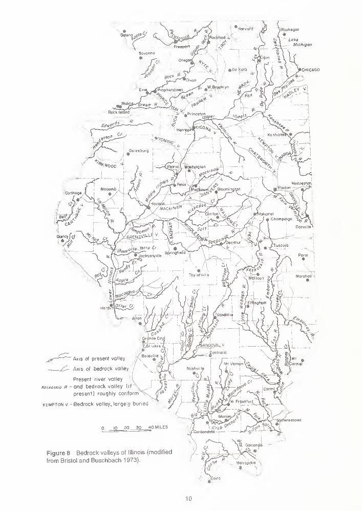
Figure 8 Bedrock valleys of Illinois (modified
from Bristol and Buschbach 1973).Metropolis .
9 \
10

These ancient stream valleys were completely filled by the outwash from later glaciations. The pres-
ent Kankakee River Valley was subsequently formed by glacial meltwater that cut a new channel
that now flows east-west. It is of interest to note that most of the sediment that filled the older stream
valleys was sand and gravels. These sands and gravels serve as major aquifers in part of south-
eastern Kankakee County. Because of the irregular bedrock surface formed by erosion, glacial drift
is unevenly distributed across Kankakee County.
During the Pleistocene Epoch, beginning about 1.6 million years ago, massive sheets of ice (called
continental glaciers), built up to thousands of feet thick and flowed slowly southward from Canada.
During the Illinois Episode, which began around 300,000 years B.P., North American continental
glaciers reached their southernmost position, approximately 290 miles south of here, in the northern
part of Johnson County (fig. 9). The last of these glaciers retreated (melted) from northeastern Illinois
about 13,500 years before the present (B.P.). The maximum thickness of these later Wisconsin Epi-
sode glaciers in Illinois was about 2,000 feet in the Lake Michigan Basin, but the ice was only about
700 feet thick over most of Illinois' land surface (Clark et al. 1988).
The topography of the bedrock surface throughout much of Illinois is largely hidden by glacial deposits,
except along the major streams. In many areas, the glacial drift is thick enough to completely mask
the underlying bedrock surface. Studies of mine shafts, water-well logs, and other drill-hole infor-
mation, in addition to the scattered bedrock exposures in some stream valleys and roadcuts, show
that the present land surface in the areas of Illinois where the glacial deposits are thickest does not
reflect the underlying bedrock surface. The topography of the preglacial surface has been signifi-
cantly modified by glacial erosion and subdued by glacial deposits. Within the field trip area, the
thickness of the glacial drift ranges from feet, where it has been removed by erosion and the bed-
rock is exposed, to more than 200 feet, where moraines formed.
Although the Illinois Episode glaciers probably built morainic ridges similar to those formed by the
later Wisconsin Episode glaciers, the Illinois Episode moraines apparently were not as numerous
and have been exposed to weathering and erosion for approximately 280,000 years longer than their
younger counterparts. For these reasons, lllinoian glacial features generally are not as conspicuous
as the younger Wisconsinan features.
Overlying the glacial deposits is a thin cover of material called the Peoria Loess (pronounced "luss"),
which has now been renamed the Peoria Silt (Hansel and Johnson 1996). These sediments were
deposited by the wind during the Wisconsin Episode from 25,000 to 12,500 years ago, and mantle
the glacial drift throughout the field trip area. (See Ancient Dust Storms in Illinois at the back of the
guidebook.) In Kankakee County, the loess is generally thinner than 2 feet and thins from west to
east. This fine grained dust, which covers most of Illinois, reaches thicknesses exceeding 15 feet west
of the field trip area along the Illinois River. Soils in this area have developed in the loess, in the
wind-blown sand, in the underlying weathered silty and clayey Wisconsin till, and in exposed Silu-
rian dolomite.
GEOMORPHOLOGY
Physiography The field trip area is located in the Kankakee River Basin, which is in the Kankakee
Plain of the Till Plains Section of the Central Lowland Physiographic Province (fig. 10). The pres-
ent landforms were formed during the Wisconsin Episode (the last major glaciation), but subsequent
erosion by wind and rain has continued to modify the lanscape. A large part of the Kankakee Plain
11

HOLOCENE AND WISCONSINAN
Alluvium, sand dunes,
and gravel terraces
WISCONSINAN
Lake deposits
WOODFOROIAN
Moraine
ALTONIAN
Till plain
ILLINOIAN
Moraine and ridged drift
'.
! Groundmorome
PRE-ILLINOIAN
Till plain
DRIFTLESS
Front of morainic system
Groundmoraine
Figure 9 Generalized map of glacial deposits in Illinois (modified from Willman and Frye 1970).
12

WISCONSIN
^\ SHAWNEE(HILLS SECTION LOW
PLATEAUS
^0ASTAL^=fROV,NCEPLAIN PROVINCE
Figure 10 Physiographic divisions of Illinois.
and the lower part of the Kankakee River basin was originally a prairie before settlers turned it into
farmland.
Kankakee Plain The Kankakee Plain, according to Leighton et al. (1948), is characterized by a
level to gently undulatory plain, with low morainic islands, glacial terraces, torrent bars, and sand
dunes. It was partly fluviolacustrine (formed by rivers and lakes), but it differs from the lake plains of
the Great Lake section in that the lakes that covered it were temporary expansions of glacial floods
and did not extensively alter its surface by deposition or erosion, except along the courses of strong
currents. The plain can be considered a modified intermorainic basin, floored largely with ground
moraine and bedrock in a topographically low area encompassed by a number of large moraines.
The Kankakee Plain is enclosed by a series of large moraines, including the Iroquois Moraine to
the southeast, the Marseilles Morainic System to the south and southwest, and the Manhattan
Moraine and the Valparaiso Morainic System on the north (fig. 11).
13

NSTEPHENSON WINNEBAGO
formation boundary
member boundary
Moraine or morainic system
Intermorainal area
10 20 30 mi
Figure 11 Areal distribution of moraines of the Wedron Group and the Trafalgar Formation in Illinois (modified from
Hansel and Johnson 1996).
14

Most of the region is poorly drained by shallow low-gradient streams that follow glacially constructed
depressions. The Kankakee and Des Plaines rivers occupy former sluiceways created by glacial
meltwater, which, near Kankakee and Joliet, are entrenched in Silurian dolomites. The drift thickness
varies from place to place, and in the Kankakee region, it is so thin that it scarcely conceals the bed-
rock surface.
Drainage Within the field trip area, drainage is controlled by the Kankakee River, Rock Creek,
Davis Creek, and their tributaries. The Kankakee River is a major tributary of the Illinois River. The
rivers have incised through the relatively thin cover of unconsolidated materials overlying the Silu-
rian dolomite bedrock, and their courses are now largely controlled by joint patterns in the bedrock,
which most likely reflect the effects of tectonic stresses related to the development of the Kankakee
Arch. Sedimentary rocks of the Silurian, and in some places the Upper Ordovician systems, are
exposed along the waterways throughout the field trip area.
Relief The highest land surface on the field trip route is on the crest of the Rockdale Moraine (near
the intersection of 500N and Route 45/52 at the SE quarter of Section 6, Township 31 North, Range
12 East), where the surface elevation is slightly more than 710 feet above mean sea level (msl). The
lowest elevation is about 550 feet above msl along the Kankakee River at the Warner Bridge. The
surface relief of the field trip area, calculated as the difference between the highest and lowest points,
is about 160 feet. Local relief is most pronounced along Rock Creek in Kankakee River State Park
where the Silurian dolomite forms sheer vertical bluffs that reach more than 40 feet above the river.
NATURAL RESOURCES
Mineral production Of the 102 counties in Illinois, 98 reported mineral production during 1995,
the last year for which complete records are available. The total value of all minerals extracted,
processed, and manufactured in Illinois during 1995 was $2,202,300,000, which is 10.9% lower than
the 1994 total. Minerals extracted accounted for 87.6% of this total; processed crude minerals and
manufactured minerals accounted for the remaining 12.4%. Coal continued to be the leading com-
modity, accounting for 64% of the total. Illinois is the fifth largest producer of coal in the nation and is
ranked 13th among the 31 oil-producing states, and 16th among the 50 states in total production of
nonfuel minerals, but leads all other states in the production of sand and gravel, industrial sand, and
tripoli (microcrystalline silica).
Economic minerals currently mined in Kankakee County include crushed stone, sand and gravel, and
clay. Although no coal mines are currently active in Kankakee County, cumulative production equals
19,192,105 tons. Coal has been mined from the Colchester and the Houchin Creek seams. The
Houchin Creek was formerly called the Summum and/or Lowell Coal.
Groundwater Groundwater is a mineral resource frequently overlooked in assessments of an
area's natural resource potential. The availability of this mineral resource is essential for orderly
economic and community development. More than 35% of the state's 1 1 .5 million citizens and
97% of those who live in rural areas depend on groundwater for their water supply. Groundwater is
derived from underground formations called aquifers. The water-yielding capacity of an aquifer can
only be evaluated by constructing wells into it. After construction, the wells are pumped to deter-
mine the quality and quantity of groundwater available for use.
Because glacial deposits occur in this area, sand and gravel deposits are common throughout most
of the county. However, most of these deposits are thin and do not yield vast amounts of water.
15
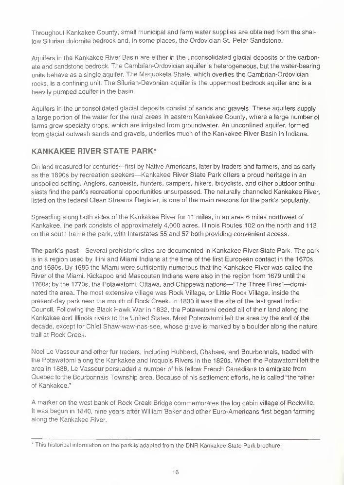
Throughout Kankakee County, small municipal and farm water supplies are obtained from the shal-
low Silurian dolomite bedrock and, in some places, the Ordovician St. Peter Sandstone.
Aquifers in the Kankakee River Basin are either in the unconsolidated glacial deposits or the carbon-
ate and sandstone bedrock. The Cambrian-Ordovician aquifer is heterogeneous, but the water-bearing
units behave as a single aquifer. The Maquoketa Shale, which overlies the Cambrian-Ordovician
rocks, is a confining unit. The Silurian-Devonian aquifer is the uppermost bedrock aquifer and is a
heavily pumped aquifer in the basin.
Aquifers in the unconsolidated glacial deposits consist of sands and gravels. These aquifers supply
a large portion of the water for the rural areas in eastern Kankakee County, where a large number of
farms grow specialty crops, which are irrigated from groundwater. An unconfined aquifer, formed
from glacial outwash sands and gravels, underlies much of the Kankakee River Basin in Indiana.
KANKAKEE RIVER STATE PARK*
On land treasured for centuries—first by Native Americans, later by traders and farmers, and as early
as the 1890s by recreation seekers—Kankakee River State Park offers a proud heritage in an
unspoiled setting. Anglers, canoeists, hunters, campers, hikers, bicyclists, and other outdoor enthu-
siasts find the park's recreational opportunities unsurpassed. The naturally channeled Kankakee River,
listed on the federal Clean Streams Register, is one of the main reasons for the park's popularity.
Spreading along both sides of the Kankakee River for 1 1 miles, in an area 6 miles northwest of
Kankakee, the park consists of approximately 4,000 acres. Illinois Routes 102 on the north and 113
on the south frame the park, with Interstates 55 and 57 both providing convenient access.
The park's past Several prehistoric sites are documented in Kankakee River State Park. The park
is in a region used by lllini and Miami Indians at the time of the first European contact in the 1670s
and 1680s. By 1685 the Miami were sufficiently numerous that the Kankakee River was called the
River of the Miami. Kickapoo and Mascouten Indians were also in the region from 1679 until the
1760s; by the 1770s, the Potawatomi, Ottawa, and Chippewa nations—
'The Three Fires"—domi-
nated the area. The most extensive village was Rock Village, or Little Rock Village, inside the
present-day park near the mouth of Rock Creek. In 1830 it was the site of the last great Indian
Council. Following the Black Hawk War in 1832, the Potawatomi ceded all of their land along the
Kankakee and Illinois rivers to the United States. Most Potawatomi left the area by the end of the
decade, except for Chief Shaw-waw-nas-see, whose grave is marked by a boulder along the nature
trail at Rock Creek.
Noel Le Vasseur and other fur traders, including Hubbard, Chabare, and Bourbonnais, traded with
the Potawatomi along the Kankakee and Iroquois Rivers in the 1820s. When the Potawatomi left the
area in 1838, Le Vasseur persuaded a number of his fellow French Canadians to emigrate from
Quebec to the Bourbonnais Township area. Because of his settlement efforts, he is called "the father
of Kankakee."
A marker on the west bank of Rock Creek Bridge commemorates the log cabin village of Rockville.
It was begun in 1840, nine years after William Baker and other Euro-Americans first began farming
along the Kankakee River.
* This historical information on the park is adapted from the DNR Kankakee State Park brochure.
16

The Kankakee & Iroquois Navigation Company—later known as the Kankakee Company—was char-
tered in 1847 to provide water power and a navigable waterway from the Illinois & Michigan Canal to
Warner's Landing, along the site of the present-day Warner Bridge Road. The company failed in the
early 1880s, shortly after the Wabash Railroad came through. At the Chippewa Campground, hand-
cut limestone pillars mark the place where a railway bridge was to have been built before financiers
ran out of money.
Just inside the park's main entrance is the Smith Cemetery with the graves of several family members,
most of whom died of yellow fever at the turn of the century.
A major industry in the area in the 1890s was the Custer Bowery Amusement Park, which frequently
drew crowds from Chicago. The park was gone by the 1920s, but by then the river had become a
popular spot for summer cottages. The area became more accessible to vacationers in 1928 when
concrete roads were built along both sides of the river. In 1938 Chicago resident Ethel Sturges
Dummer donated 35 acres of land for a state park. Commonwealth Edison turned over another
1,715 acres to the state in 1956. With the company's additional grants in 1989, the park now con-
tains approximately 4,000 acres.
Wildlife From badgers and beavers to turtles and wild turkeys, Kankakee River State Park teems
with wildlife. Some of the birds you could see are red-winged blackbirds, herons, and bluebirds. Fox,
coyote, and deer roam the park's bluffs and timbered areas, while frogs and nonpoisonous snakes
keep close to the riverbanks.
17

GUIDE TO THE ROUTE
The field trip starts at the Kankakee River State Park, Rock Creek Hiking Trail Access area (SW
SE, Sec. 32, T32N, R11E, 3rd P.M., Kankakee County, Bourbonnais 7.5-minute Quadrangle).
You must travel in the caravan Please drive with headlights on while in the caravan. Drive safely
but stay as close as you can to the car in front of you. Please obey all traffic signs. If the road cross-
ing is protected by an Illinois State Geological Survey (ISGS) vehicle with flashing lights and flags,
please obey the signals of the ISGS staff directing traffic. When we stop, park as close as possible
to the car in front of you and turn off your lights.
Private property Some stops on the field trip are on private property. The owners have graciously
given us permission to visit on the day of the field trip only. Please conduct yourselves as guests
and obey all instructions from the trip leaders. So that we may be welcome to return on future field
trips, follow these simple rules of courtesy:
e Do not litter the area.
• Do not climb on fences.
• Leave all gates as you found them.
• Treat public property as if you were the owner—which you are!
When using this booklet for another field trip with your students, a youth group, or family, remember
that you must get permission from property owners or their agents before entering private property.
No trespassing please.
Four U.S. Geological Survey 7.5-Minute Quadrangle maps (Bonfield, Bradley, Bourbonnais, and
Peotone) cover this field trip area.
STOP 1 Rock Creek Gorge The trail to Rock Creek is located west of the middle parking lot.
Miles Miles
to next from
point start
0.0 0.0 Exit the middle parking lot and TURN RIGHT heading south onto the main loop
at the Rock Creek Access area.
T-intersection. TURN RIGHT onto main access road heading toward Route 102.
STOP (1-way). T-intersection with Route 102. TURN RIGHT onto Route 102.
Main entrance to Kankakee River State Park on the left. CONTINUE AHEAD.
Cross Rock Creek. Notice the suspension bridge to the left.
T-intersection from the right (6000W/4-H Road). CONTINUE AHEAD.
Approaching Warner Bridge Road intersection. Prepare to turn left.
18
0.1 0.1
0.2 0.3
0.1 0.4
0.35 0.75
0.45 1.2
0.9 2.15

0.05 2.35
0.15 2.45
0.05 2.5
0.3 2.8
0.1 2.9
0.15 2.25 Intersection (7000W/Warner Bridge Road and Route 102/651 ON). TURN LEFT
onto Warner Bridge Road. This is Kankakee County Highway 20.
Begin descent into the Kankakee River Valley.
Kankakee River State Park, Fisherman's Entrance.
Center of the bridge. The five stone pillars to the right were for a railroad that was
never built. The railroad went bankrupt before they laid tracks across the river.
Begin ascent out of the Kankakee River Valley.
STOP (2-way). Intersection (7000W and Route 113). TURN LEFT onto Route
113, heading east. CAUTION: Fast moving traffic from the right and left does
not stop.
Hunting Area parking lot access area to the left.
Hunting Area 3 access to the left. CONTINUE AHEAD. Notice the rolling land-
scape to the left. You are following the path of the Kankakee Torrent.
T-intersection from the right (5500W). CONTINUE AHEAD.
Prepare to turn left.
T-intersection from the left; entrance to Hunting Area 2. TURN LEFT. Follow the
gravel road on the right-hand side of the parking lot to the lower parking lot.
0.3 5.1 Road jogs to the right and then immediately jogs to the left.
0.1 5.2 STOP 2 Devils Hole, Kankakee River State Park Enter the lower parking
lot of the Shotgun Trap Shooting Range.
0.0 5.2 Leave Stop 2 and retrace route back to Route 113.
0.5 5.6 STOP (1 -way). Intersection with Route 1 1 3. TURN LEFT. Directly across from
the Hunting Area 2 access is a log cabin with a fireplace made from local dolo-
mite. Landscaping in front also uses local dolomite. Note: Road is marked as
Kankakee 113-3.
Entrance to Hunting Area 1 to the left. CONTINUE AHEAD.
Pass under high-tension lines.
Approaching T-intersection from the right; prepare to turn right.
0.2 3.1
0.6 3.7
0.9 4.6
0.1 4.7
0.1 4.8
0.65 6.25
0.55 6.8
0.1 6.9
19

0.35 7.65
0.10 7.75
0.75 8.5
0.2 7.1 T-intersection from the right (4000N and Route 1 1 3). TURN RIGHT onto
4000N.
0.2 7.3 Note the small hills to the left and right. These hills are some of the rubble bars
and sand dunes formed by the Kankakee Torrent.
T-intersection from the left (5000W). TURN LEFT heading south.
Note large glacial erratic in the yard to the right.
Cross underground gas pipeline of the Natural Gas Pipeline Company of
America.
0.15 8.65 STOP (2-way). Intersection (5000W and 3000N). CONTINUE AHEAD.CAUTION: Cross traffic does not stop.
0.75 9.4 Cross two small rubble bars covered with oak forest.
0.25 9.65 T-intersection from the right (2000N and 5000W). TURN RIGHT. This is
Kankakee County Highway 6. Note the large grove of trees to the right and
straight ahead. These trees are growing on rubble bars and sand dunes left by
the Kankakee Torrent
1 .0 1 0.65 T-intersection from the right (6000W). CONTINUE AHEAD. Note the rise in the
road directly ahead. This is another of the rubble bar/sand dune complexes.
Road cuts through one of the rubble bars.
T-intersection from the left (6250W). CONTINUE AHEAD. Notice again the
rolling landscape.
Road ascends to the top of a rubble bar/sand dune complex.
Approaching intersection; prepare to stop.
Crossroad intersection (7000W and 2000N). TURN RIGHT onto 7000W and
prepare to pull over and stop on the shoulder of the road.
0.05 1 1 .7 STOP 3 Rubbie Bar and Sand Dune Complex Use extreme caution whenexiting your vehicles. Exit on the passenger side if possible.
0.0 1 1 .7 Leave Stop 3 and CONTINUE AHEAD.
0.95 1 2.65 Crossroad intersection (3000N- and 7000W). CONTINUE AHEAD.Notice the large groups of wooded areas scattered across the landscape.
These trees are generally growing on the rubble bar/sand dune complexes.
Unlike in most parts of the state, where, when you see trees growing, they are
0.2 10.85
0.05 10.9
0.5 11.4
0.2 11.6
0.05 11.65
20
1.0 13.65
0.2 13.85
0.25 14.1
0.3 14.4
0.9 15.3
along creeks or small streams, here they point to the location of these sand
dunes.
Crossroad intersection (4000N and 7000W). CONTINUE AHEAD.
Pass under high-tension lines.
Pass Shreffler Cemetery on right side of the road. Note the large erratic as a
marker in the center of the cemetery.
Crossroad intersection (4740N). CONTINUE AHEAD.
Approaching stop; cross a small rubble bar exposed in the roadcut south of the
intersection of the blacktop road and State Route 1 1 3.
This is an excellent exposure of a rubble bar created by the Kankakee Torrent.
The rubble is extremely coarse and consists of angular to sub-rounded rock
fragments composed predominantly of dolomite. The dolomite was ripped from
the valley bottom by the swift-moving currents of the Kankakee Torrent. Depos-
its left behind by the receding floodwaters are essentially unsorted, and the
material ranges in size from silt and sand to boulders—all attesting to the swift-
ness and muddiness of the water. Less than 10% of the material contained in
the bar is igneous, metamorphic, or sedimentary rock from outside of Illinois
(erratics). Even though these erratics are much harder than the dolomite, they
are more rounded than the dolomite because most of them were already
rounded when picked up and transported by the glaciers and then were further
rounded by the torrent.
Generally, the rubble is thin and rests directly on the bedrock. In this cut, a
maximum of about 12 feet of debris is exposed and thinly covered by sand and
soil at the top. The top of the bedrock (Joliet Dolomite) is exposed in the ditch
just to the north of the roadcut.
0.15 15.45 STOP (2-way). Crossroad intersection (IL Route 1 13/5830N and 7000W). Weare following Kankakee County Highway 20. CONTINUE AHEAD.
0.25 15.7 Fisherman's Parking Access Area to the right.
0.1 15.8 Re-cross the Kankakee River and Warner Bridge. Note the small gravel islands
with grass in the middle of the river to the right and left.
0.1 15.9 Access area to the left: Kankakee River State Park Fisherman's Parking and
Class D Camping. After crossing the Kankakee River, you will ascend out of the
valley and climb to the top of the bluffs, which are composed of Silurian dolo-
mite bedrock.
0.2 16.1 STOP (2-way). Intersection (7000W and Route 102/651 ON). TURN RIGHT onto
Route 102. CAUTION: Cross traffic does not stop.
21

0.4 16.5 To the left, the large tree line on the landscape outlines part of Rock Creek and
the Rockdale Moraine.
0.5 17.0 T-intersection from the left (6000W) leads to Camp Shaw-waw-nas-see. CON-TINUE AHEAD.
0.45 1 7.45 Cross Rock Creek. On the west side of the suspension bridge is a trail. As you
cross Rock Creek, the concession stand is on the right.
0.35 17.8 Entrance to Kankakee State Park; main entrance is to the right.
0.35 18.15 T-intersection from the left (Deselm Road). CONTINUE AHEAD. Approaching
park entrance.
0.15 18.3 Kankakee River State Park Potawatomi Campground Entrance to the right.
CONTINUE AHEAD.
0.6 1 8.9 T-intersection from the right (Altorf Road/4370W). CONTINUE AHEAD.
0.6 1 9.5 The road begins to climb a slight rise, which is also visible to the left in the field.
Several physiographic features are visible from here. Toward the south is the
Kankakee Torrent area. You are driving up onto the Rockdale Moraine. The
slope of the moraine rises gently toward the northeast. The outer slope of the
moraine in this area, from the southwest to the southeast, has been modified
and steepened by the erosive force of the Kankakee Torrent. The lower tree
line, to the right in the foreground, a little over 1 mile away, borders the Kankakee
River. Across the river to the south, there is a well developed tree-cover on the
sand dunes and rubble bars that were built by the torrent. The entire area to the
south was covered by the rushing waters of the torrent. Deposits of the Kankakee
Torrent in this vicinity occur below elevations of about 650 feet (see route map).
On the horizon, about 12 miles to the south, portions of the Marseilles Moraine
are faintly visible, which gives some impression of how vast an area was inun-
dated by the torrent.
Ahead, the road rises to the crest of the moraine.
Prepare to turn right just past the brown park sign for the Kankakee River State
Park Youth Group Camping and Bike Trail.
Crossroad intersection (3000W and Route 102). TURN RIGHT onto 3000W.
Road jogs to the left and then back to the right.
T-intersection (3000W and 3100N). TURN LEFT onto 3100N.
Road gently curves to the right and then back to the left.
T-intersection from the right; Davis Creek Area Youth Group Camping and Bike
Trail (brown sign). TURN RIGHT.
22
1.0 20.5
0.1 20.6
0.2 20.8
0.55 21.35
0.6 21.95
0.4 22.35
0.15 22.5

0.05 22.55 Road gently curves to the left and then back to the right.
0.15 22.7 Road straightens out.
0.1 22.8 STOP 4 Lunch: David Creek Area Enter parking lot at Davis Creek area.
Lunch stop. Are you hungry?
Reset odometer to 0.0 before leaving the lunch stop.
Miles Miles
to next from
point start
0.0 0.0
.0 0.3
0.05 0.35
Leave Stop 4 and retrace your route to 3100N.
T-intersection (Davis Creek area entrance and 3100N). TURN RIGHT.
T-intersection from the left (2320W). TURN LEFT onto 2320W.
0.55 0.9 Road makes a sharp 90° turn to the right. This intersection is marked 2320Wand 3630N.
0.05 0.95 Road makes a sharp 90° turn to the left. This intersection is marked 3630N and
2250W.
0.15 1.1 STOP (1-way). Intersection of (Route 102 and 2250W). TURN RIGHT onto
Route 102.
0.3 1 .4 Cross Davis Creek. Davis Creek follows a topographic low that marks the posi-
tion of a subglacial flow path and one of the flow paths of the Kankakee Torrent.
T-intersection from the right (Glen Road). CONTINUE AHEAD.
T-intersection from the right (Sportsman Club). CONTINUE AHEAD.
Entering the City of Bourbonnais.
Stoplight. Intersection (Briar Cliff Lane 1000W and Route 102/3000N). TURNLEFT onto 1000W heading north.
T-intersection from the right (3500N). CONTINUE AHEAD.
T-intersection from the right (Tremont Street). CONTINUE AHEAD.
Kankakee Area Career Center to the right.
Cross small tributary of Davis Creek.
0.5 1.9
0.1 2.0
0.2 2.2
0.35 2.55
0.45 3.0
0.5 3.5
0.05 3.55
0.35 3.9
23

0.6 4.5 T-intersection from the right (5000N and 1 000W). TURN RIGHT onto 5000N,
heading east.
0.8 5.3 You are on the crest of the Rockdale Moraine.
0.2 5.5 STOP (2-way). Intersection (5000N and Route 45-52/0000E). TURN LEFT onto
Route 45-52. CAUTION: Cross traffic does not stop. Indian Oaks Sale Center is
on the northeast corner of the intersection.
An exposure of Rockdale till occurs in the ditch on the northeast corner of the
intersection. This exposure is near the top of the Rockdale Moraine. Mottled
gray-brown, calcareous till is exposed beneath a thin brown soil zone in this
area. Till is an ice-laid deposit, characterized by its lack of sorting and lack of
stratification. Note the wide range of particle sizes—from clay to pebbles and
cobbles—in the till. Some of the rock fragments are faceted and striated
(scratched) from having been abraded during transport by the ice.
Most of the rock fragments in the till are dolomite and chert, which the glacier
gouged from the Silurian dolomites exposed at the bedrock surface in north-
eastern Illinois. Careful inspection will also reveal a variety of igneous, meta-
morphic, and other sedimentary rock types. The igneous and metamorphic rock
fragments are not indigenous to Illinois but were transported by the ice from
eastern Canada where they are exposed. Also abundant are sedimentary rock
fragments eroded from the southern Michigan peninsula and the Lake Michigan
Basin. Especially distinctive are fragments of dark shale from the Devonian
Antrim Shale, which underlies the axis of the Lake Michigan Basin.
Intersection (6000N and Route 45-52/0000E). TURN RIGHT onto 6000N.
Cross overpass of I-57.
T-intersection from the left (1000E). CONTINUE AHEAD.
Azzarelli Cement Plant to the left.
Cross dual set of Illinois Central Railroad tracks with lights and guard gates.
CONTINUE AHEAD.
0.05 8.0 STOP (2-way). Intersection (6000N and Route 50/1 450E). TURN LEFT onto
Route 50 and prepare to turn right into the Vulcan Materials Quarry, Manteno
Plant #10.
0.15 8.15 STOP 5 Vulcan Materials Company, Manteno Quarry TURN RIGHT and
enter the quarry. After leaving the quarry, retrace your route back to the entrance.
0.05 8.2 Leave Stop 5. Use exit north of the scale house. TURN LEFT onto Route 50
and immediately prepare to turn right. CAUTION: Fast moving traffic from both
directions.
0.2 8.4 Intersection (6000N and Route 50/1 450E). TURN RIGHT onto 6000N.
1.0 6.5
0.5 7.0
0.5 7.5
0.4 7.9
0.05 7.95
24

0.05 8.45
0.40 8.85
0.8 9.65
0.2 9.85
Cross Illinois Central Railroad dual tracks with lights and signal gates.
T-intersection from the right (1000E). TURN RIGHT onto 1000E.
View of North Central Materials, Manteno Quarry ahead and to the left.
T-intersection from the left (7000N). TURN LEFT onto 7000N. After making the
turn, the South Branch of Rock Creek is to the right. You are now following one
of the flow paths of the Kankakee Torrent, which is outlined by the South Branch
of Rock Creek.
0.45 1 0.3 Cross over I-57. A borrow pit is to the right on the west side of the interstate.
0.3 10.6 Cross small drainage ditch. There are a large number of glacial erratics and
concrete blocks in the ditch on either side of the road.
0.2 10.8 STOP (2-way). Intersection (Route 45-52/0000W and 7000N). TURN RIGHT
onto Route 45-52, heading north.
0.45 1 1 .25 Cross South Branch of Rock Creek.
0.55 1 1 .8 Cross a small channelized drainage ditch; prepare to turn right at the T-
intersection.
0.2 12.0 STOP 6 North Central Materials, Manteno Quarry TURN RIGHT and enter
North Central Quarry, Yard 95. After leaving the quarry, retrace your route
back to the entrance.
0.1 12.1 Leave Stop 6 and TURN RIGHT onto Route 45-52.
0.2 12.3 The ditch on the right side of the road contains a large number of glacial erratics
and locally derived dolomite mixed with clay, sand, and silt. This exposure is a
ground moraine that was deposited by the retreating glacier that formed the
Rockdale Moraine to the south. CAUTION: This ditch also contains a lot of con-
crete, bricks, broken glass, and other trash.
South and east of the quarry entrance is a large deposit of overburden from the
quarry operation, which is being used as fill material. This is a good location to
collect glacial erratics.
0.5 12.8 Sign for Kankakee River State Park, Manteno, and Deselm.
0.1 12.9 STOP (4-way). Intersection (North 45/West 52 and 9000N/ Kankakee County
Highway 9). TURN RIGHT onto 9000N .
1 .0 1 3.9 Intersection (Spruce Street/1 000E and 9000N/Kankakee County Highway 9).
TURN RIGHT onto 1000E heading south.
0.2 14.1 Entrance to K-Mart distribution center. Use the entrance to turn around and
head back north and park along the road.
25

0.1 14.2 STOP 7 Silurian Dolomite, Refuse Pile Pull over and park along the right
side of the road. The field on the right contains a large refuse pile of Silurian
dolomite. This is a good fossil collecting locality. End of trip.
Interstate I-57 can be seen to the right. The Manteno water tower can also be
seen. Manteno is east of the interstate.
Have a safe trip home and join us November 1 at the Cache Valley area near
Ullin, Illinois.
0.0 14.2 Leave Stop 7.
0.1 14.3 Stop (2-Way). Intersection (9000N/Kankakee County Highway 9 and Spruce
Street/1 000E). TURN RIGHT.
0.1 14.45 South bound entrance ramp of I-57; Kankakee is south. The north bound en-
trance ramp to I-57 is on the east side of the overpass.
26

'1
.
I 1!
1-<- '
^ -
s
-
o-l- o j
s'-i
27

]
i
'-&
F Ea^
.,
^ -
-^
o - - o
—&—
I
28
29

/ cm/
/--
3MI.
/' ~^1
. _9 kr^=2=J===
*\';v i
'/B
1:
pit
Wiley;
.--'
«1^#
S."
/ / >-, \
f 3 ^V~""
.JL1 - / -1
S,
.
G.a
• tgt m-(/)
i
W :
+ -
32;
- - - . - _ .. .• . _;
r~
%i vo --~. ,- _—-f -<,-.-'
30

31

STOP DESCRIPTIONS
STOPS 1A-E Rock Creek Gorge, Kankakee State Park (fig. 12) (W 1/2 of Section 32, T32N,
R11E, 3rd P.M., Kankakee County, Bourbonnais 7.5-Minute Quadrangle). Note: The parking lot is
located in the SW/SE quarter of Section 32.
From the middle parking lot, the trail leading to Rock Creek is approximately 200 feet to the west.
Follow the trail to the north-northwest approximately 250 feet and cross the small wooden bridge
over an unnamed creek. The trail now heads west; continue on the trail for another 150 feet, to
where the trail crosses an equestrian trail. Continue ahead on the small trail for another 250 feet,
where you will cross a second equestrian trail. Continue ahead for another 150 feet to the Rock
Creek trail, which at this point follows an old blacktop road.
On the day of the field trip, stops 1 A-E will be marked by orange flagging, and an ISGS staff mem-ber will be stationed at each stop. The distances for these stops are given to assist users of the
guidebook after today's field trip. The distances are measured from the guard rail located north of
IL Route 102, and have been paced off following the trail along the east side of Rock Creek. From
the guard rail, face north and follow the trail, which along this portion is the blacktop service road.
For those not familiar with the use of the term "pace," one pace is marked off by starting with both
feet together and—starting with either the right or left foot—counting off the number of times the
same foot hits the ground (that is, count only the number of times either the right or left foot hits the
ground). The distance of each pace will vary according to each hiker's stride. A pace length of
5 feet was used to calculate the distances given in the guidebook.
Paces Total paces Feet Description
9 9 45 Blacktop begins
10 19 95 Gravel service road to the right
17 36 180 Old trail to Rock Creek to the left
Stop 1A 10 46 230 View of cave on west side of Rock Creek
16 62 310 View of riffles in stream to the north
Stop 1
B
29 91 455 View of small stack
10 101 305 Trail coming in from the right (leads to parking lot)
5 106 530 View to the left steep cliffs & small cave to the
north along Rock Creek
50 156 780 View of small cave to the south
5 161 805 Trail coming in from the right
8 169 845 Steep cliffs
48 217 1,085 Steep cliffs and view of stream
13 230 1,150 End of blacktop service road
StopIC 11 241 1,205 Trail sign; path to the left leads to clay pit
7 248 1,240 Second path leading to clay pit
Stop 1
D
19 267 1,335 View of small arch to the left
95 362 1,810 High bluffs; old 300+ year old cedar trees growing
in rocky bluffs
78 440 2,200 Path to base of creek; small riffles in creek bed
10 450 2,250 Trail marker
46 496 2,480 Path to creek
Stop 1
E
113 609 3,045 Path to waterfall
40 649 3,245 Second path to waterfall
End of Trail
32

Figure 12 Large boulders of Silurian dolomite near the mouth of Rock Creek, look-
ing upstream from a point south of the suspension bridge. Route 102 bridge is in the
background (photo by W. Frankie).
STOP 1A Horsethief Cave (fig. 13) (NWSE SE SW, Sec. 32, T32N, R11E, 3rd P.M., Kankakee
County, Bourbonnais 7.5-Minute Quadrangle) The cave is located approximately 230 feet north of
Route 102).
The Rock Creek gorge has been cut into the Silurian-age Sugar Run and Joliet Formations of the
Niagaran Series. The stratigraphic section on page 34 describes the exposure on the west side of
Rock Creek and south of the bridge; it is taken from ISGS Circular 479, Rock Stratigraphy of the
Silurian System in Northeastern and Northwestern Illinois, by H.B. Willman (1973) (see also fig. 24).
To reach the bottom of Rock Creek gorge, carefully climb down the riprap spillway located just north
of the suspension bridge south of Route 102.
Horsethief Cave
The only known caves in the Silurian rocks in northeastern Illinois are located along the Kankakee
River Valley west of Kankakee. Most of these caves are small, and only one, Horsethief Cave (some-
times called Indian Cave), has enough room to stand up. The longest enterable cavity does not
exceed 30 feet (Bretz and Harris 1961). Several small caves or cavities occur in the Silurian dolo-
mitic rocks along Rock Creek. According to Bretz and Harris (1961), there are two types of cavities
here. Both were formed by groundwater (phreatic) solution, but under quite different and specific
conditions.
The first type of cavity developed as a result of normal soil-water solution processes. In this type of
solution feature, the reactions of normal acidic rainwater, enhanced by the acids in the overlying
33

Figure 13 Horsethief Cave along Rock Creek, located north of Route 102 bridge at stop 1 A. Note the
vertical joints and blocky nature of the bluffs adjacent to the cave (photo by W. Frankie).
Rock Creek Canyon Section
Outcrops on the west side of Rock Creek and south of the bridge of IL Route 102
SILURIAN SYSTEMSugar Run Formation (12'6")
Dolom
Dolom
Dolom
Dolom
te, argillaceous, silty, yellowish brown, very fine grained, dense; in 4 " to 1' beds
te, as above, but weathers shaley
te, as above, but less argillaceous and silty; a few beds slightly vesicular
te, brownish gray to brown, fine grained, slightly vesicular; in 3 " to 1' beds;
contains a few slightly argillaceous beds; prominent bedding plane at base
Joliet Formation (40 '1")
Romeo MemberDolomite, pure, light gray, fine grained, vesicular, vuggy; in 2 " to 8" beds
Dolomite, as above but light brownish gray, less vuggy, and more massive
Dolomite, light brownish gray; less vesicular and slightly less pure than above;
chert nodules 1' below top
Markgraf MemberDolomite, slightly argillaceous, light brownish gray, very fine grained, dense to
slightly vesicular; in weak 8" to 1 '6" beds
Dolomite, slightly argillaceous, light brownish gray, very fine grained, dense
to slightly vesicular; in weak 8 " to 1 '6" beds
Dolomite, slightly argillaceous, very light gray, very fine grained, dense to
slightly vesicular; in 4" to 1' beds; faint light green and light pink mottling
in lower 1'; prominent bedding plane at base
Brandon Bridge MemberDolomite, light greenish gray, very fine grained, dense; contains a few
coarse grained, pinkish lenses
Dolomite, as above, but more shaley and contains bright green shale partings
Dolomite, gray, green and pink mottled, very fine grained, dense; in 2 " to 8" beds
with green shale partings; base concealed at low water level
The section is cut by a fault at the south side of the bridge; the north side of the fault is down about 6
3'8"
7"
4'6"
3'9"
5'8'
4'9'
7'6'
7'6"
7'6"
4'9"
6"
7"
1'4"
34

The first type of cavity developed as a result of normal soil-water solution processes. In this type of
solution feature, the reactions of normal acidic rainwater, enhanced by the acids in the overlying
soils, have dissolved the dolomitic rocks. As in most caves elsewhere in Illinois, dissolution of these
cavities is fairly conventional in that the cavities occur along the joints (vertical cracks) and the bed-
ding planes in the rocks. These types of cavities are generally younger and smaller than the second
type in this area.
Horsethief Cave, however, is an example of the second, somewhat unusual type of cavity that oc-
curs along Rock Creek. These cavities formed by an artesian circulation beneath an impervious
shale cover. The circulation and dissolution within the Silurian carbonates occurred at the contact of
the insoluble, impermeable, unjointed shale overlying the Silurian rocks.
This second type of cavity, which is generally larger and deeper (up to 30 feet) than the first type,
formed long before Rock Creek Canyon was cut. In cross section, these cavities resemble sink-
holes in their downward taper and general lack of present roofs. Horsethief Cave is the only one
visible along Rock Creek that has a surviving roof. All of them are filled with clayey, sandy, or cherty
debris derived from a former overlying cover of Pennsylvanian rocks. The mechanical weakness of
this overlying cover rock allowed it to subside under its own weight into the enlarging joint cavities
below. Bretz and Harris (1961) cited the following evidence supporting an interpretation of collapse
of overlying roof rock into a cavity during solution. The Pennsylvanian-age shale filling these types
of cavities consistently exhibits deformed stratification that fills the varied cross-sectional shapes of
the cavities. Brecciation in the shale is common and drag-folding is known. Slickolite-marked sur-
faces (vertical striations produced by slippage and shearing on strongly dipping beds of limestone or
dolomite that form the molding on the wall of a solution cavity) occur on walls at the contact with the
fill. Cavities of this type have been discovered in many of the quarries in Silurian rocks near
Kankakee, Joliet, and other places in northeastern Illinois, and commonly are called "filled sinks."
Horsethief Cave appears to be a lateral toe of such a filled sink. The erosion and down-cutting by
Rock Creek has destroyed the larger and probably roofless part and has allowed the fill in this toe to
escape. Vertical slikolite markings on the walls of Horsethief Cave indicate downward movement of
material along the walls of the cavity.
STOP 1 B View of Small Stack ( SE NE SE SW, Sec. 32, T32N, R1 1 E, 3rd P.M., Kankakee
County, Bourbonnais 7.5-Minute Quadrangle) Site is approximately 455 feet north of Route 102.
Formation of the small "stack" is a chance happening. The course followed by Rock Creek is heavily
controlled by the natural joint patterns in the Silurian dolomite. Two sets of vertical joints can easily
be seen in the bluffs along the creek. The small stack (a monolith) located along the east side of
Rock Creek Canyon is an erosional remnant that was carved from the bluffs as Rock Creek was
down-cutting in this area. The falls, which have now migrated upstream, were once located near the
small stack. During times of high water flow over the falls, water preferentially followed zones of
weakness—in this case, joints on either side of the stack. Erosion first occurred along one joint (say,
the east side of the stack) and then changed its course to follow a second joint on the west side of
the stack. Remember mother nature has a right to change her mind whenever she feels like it.
35

STOP 1C Clay Pit (SE SE NE SW, Sec. 32, T32N, R1 1 E, 3rd P.M., Kankakee County, Bourbon-
nais 7.5-Minute Quadrangle) The site is located approximately 1,250 feet north of Route 102. Becareful! Extremely slippery when wet.
The clay pit is a filled sink, the same type of cavity as Horsethief Cave. The material in this sink is
Pennsylvanian-age clay. Slikolite-marked surfaces are visible in the southern wall of this cavity
(fig. 14). Given enough time, the fill in this cavity may be removed by erosion during high flow in
Rock Creek or by the small spring located near the base of the clay pit. The clay material in some of
the local Native American pottery found in the archeological excavations in the area of Kankakee
River State Park may have been mined from this spot. A rusted iron pipe driven into the clay just
south of the current spring suggests that someone may have used this spring as a source of drink-
ing water at some time in the not-too-distant past, probably during the "iron age."
Figure 14 Slikolite-marked surface (vertical striations) on southern wall of clay
pit at stop 1C (lens cap is for scale) (photo by W. Frankie).
36

STOP 1D Small Arch (fig. 15) (SW NE NE SW, Sec. 32, T32N, R11E, 3rd P.M., Kankakee
County, Bourbonnais 7.5-Minute Quadrangle) The arch is located approximately 1 ,345 feet north of
Route 102. Be careful! Watch your head.
The small arch located on the west side of Rock Creek is the world's smallest Silurian dolomite arch.
This arch may have initially started as a small dissolution cavity within the bedrock. One possible ex-
planation for its creation is that water flowed through the cavity and left the overlying roof of the cav-
ity in place as Rock Creek was down-cutting through the rocks.
Figure 15 Small Silurian dolomite arch at stop 1D. The wider angle at the base
of the opening below the arch than at the top possibly indicates that development
the of arch was created by flowing water (photo by W. Frankie).
STOP 1E Waterfalls (fig. 16) (SW NW SE NW, Sec. 32, T32N, R11E, 3rd P.M., Kankakee
County, Bourbonnais 7.5-Minute Quadrangle) The falls are located approximately 3,100 feet north of
Route 102.
As described above, the Rock Creek gorge has been cut into the Silurian-age Sugar Run and Joliet
Formations of the Niagaran Series (p. 34). Rock Creek cut this gorge after the Kankakee Torrent
receded about 12,000 years ago. As the flood waters from the melting glaciers receded, they be-
came more concentrated along the principal axis of flow and cut the Kankakee Valley. Down-cutting
was much more rapid along the Kankakee Valley than along the valley of Rock Creek, a much
smaller stream. Rock Creek became perched above the Kankakee River, forming a small waterfall
near its mouth. As a result, Rock Creek is in disequilibrium with respect to the Kankakee River, and
has been trying to establish an equilibrium by down-cutting. This down-cutting action is the result of
the water plunging over the falls; the plunging water erodes a deep pool at its base, called a "plunge
pool," that undermines the step from which the water falls. The original waterfall may have been
37
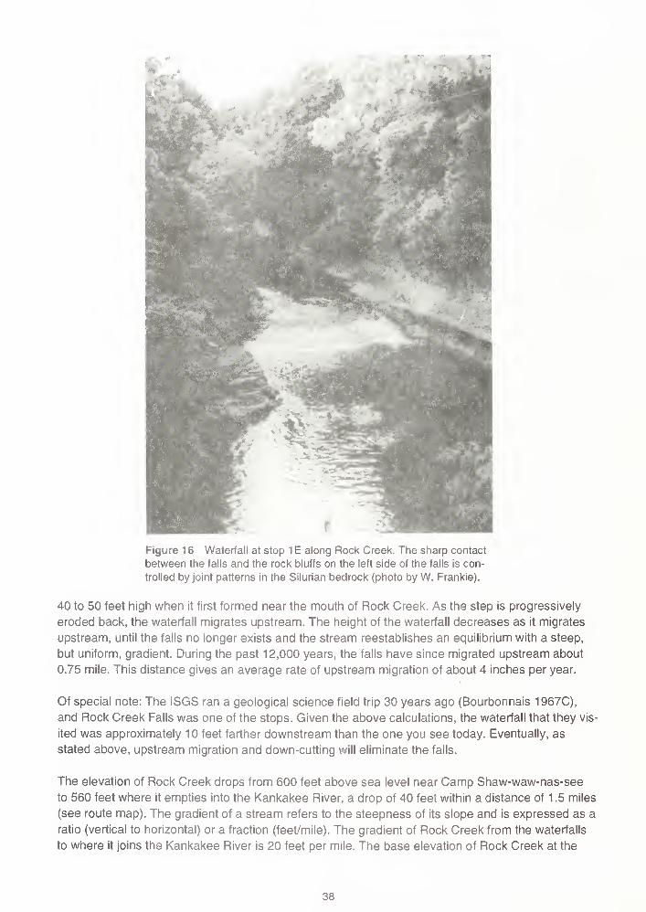
1 ';
Figure 16 Waterfall at stop 1 E along Rock Creek. The sharp contact
between the falls and the rock bluffs on the left side of the falls is con-
trolled by joint patterns in the Silurian bedrock (photo by W. Frankie).
40 to 50 feet high when it first formed near the mouth of Rock Creek. As the step is progressively
eroded back, the waterfall migrates upstream. The height of the waterfall decreases as it migrates
upstream, until the falls no longer exists and the stream reestablishes an equilibrium with a steep,
but uniform, gradient. During the past 12,000 years, the falls have since migrated upstream about
0.75 mile. This distance gives an average rate of upstream migration of about 4 inches per year.
Of special note: The iSGS ran a geological science field trip 30 years ago (Bourbonnais 1967C),
and Rock Creek Falls was one of the stops. Given the above calculations, the waterfall that they vis-
ited was approximately 10 feet farther downstream than the one you see today. Eventually, as
stated above, upstream migration and down-cutting will eliminate the falls.
The elevation of Rock Creek drops from 600 feet above sea level near Camp Shaw-waw-nas-see
to 560 feet where it empties into the Kankakee River, a drop of 40 feet within a distance of 1 .5 miles
(see route map). The gradient of a stream refers to the steepness of its slope and is expressed as a
ratio (vertical to horizontal) or a fraction (feet/mile). The gradient of Rock Creek from the waterfalls
to where it joins the Kankakee River is 20 feet per mile. The base elevation of Rock Creek at the
38

waterfalls is approximately 575 feet above sea level, and the base elevation near the mouth of Rock
Creek is 560 feet, equaling a drop of 15 feet within a distance of 0.75 miles. The gradient of the
Kankakee River near the mouth of Rock Creek is only 5 feet per mile. The gradient of the lower
portion of Rock Creek is 4 times greater than the gradient of the Kankakee River near the mouth of
Rock Creek. However, the gradient of the upper reach of Rock Creek is significantly less than the
lower portion where it is actively down-cutting to the base level of the Kankakee River. The gradient
of a portion of upper Rock Creek, calculated from the Deselm Bridge to where county road 7940N
crosses the Rock Creek (north of Flickerville), is 2.5 feet per mile—just half as steep as that of the
Kankakee River (see route maps).
STOP 2 Devils Hole, Kankakee River State Park (SE NE SE, Sec. 5, T31 N, R1 1 E, 3rd P.M.,
Kankakee County, Bourbonnais 7.5-Minute Quadrangle).
A number of studies have been conducted on the Kankakee River, and the following were used as
major references for writing this stop description: Ivens et al. (1981) and Gross and Berg (1981). In
addition, two Web sites contain some useful information on the Kankakee River: (1) the Upper Illi-
nois River Basin National Water Quality Assessment (NAWQA) Program home page
http://www.dwimdn.er.usgs.gov/nawqa/uirb/basin_desc/genrl_char/genrl.html
and (2) the Illinois Environmental Protection Agency (EPA) home page
http://www.epa.state.il.us/org/bow/water-quality/fact-sheet-10.html
Kankakee River The Kankakee River flows westward from Indiana into Illinois. The headwaters
are near South Bend, Indiana, and the mouth is the confluence of the Kankakee with the Des
Plaines River near Morris, where the two rivers merge and become the Illinois River (fig. 17). Of the
5,165 square miles in the Kankakee River drainage basin, 2,169 are in Illinois and 2,996 are in Indi-
ana. The river has a total length of about 150 miles, with 59 miles in Illinois. The climate of the
Kankakee River Basin is classified as humid continental. In general, summers are hot and humid
and winters are cold. The average annual precipitation, calculated for the period 1951-80 at the
headwaters of the Kankakee River, is 40 inches.
Beginning in the late nineteenth century and essentially complete by 1918, almost all the main chan-
nel of the Kankakee River in Indiana was channelized (straightened). Today, the Kankakee River in
Indiana is a man-made ditch, extending straight east from the Illinois-Indiana state line for many
miles. In Indiana, all the natural meanders were eliminated.
In Illinois, a very small dam exists at Momence, a larger dam at Kankakee, and an overflow dam at
Wilmington, but most of the river remains a naturally meandering stream. A major tributary of the
Kankakee River in Illinois is the Iroquois River, which joins the Kankakee just below Aroma Park.
Most of the Iroquois drainage basin also is in Indiana.
Before channelization, much of the drainage area of the river in Indiana was wetlands (swamps and
marshes) called the "Grand Marsh." About 100 years ago, the Grand Marsh encompassed approxi-
mately 400,000 acres, ranged from 3 to 5 miles in width, and had a water depth of 1 to 4 feet for 8 or
9 months of the year. The marsh plain was only about 85 miles long and had a gentle slope of 5 to 6
inches per mile. The river course, however, was about 250 miles in length and wound slowly along
39

igure 17 Kankakee River basin (modified from Gross and Berg 1981).
through some 2,000 bends. The nature of the marsh caused the Kankakee River to alter its course
continuously, resulting in the formation of a variety of meanders, oxbow lakes, sloughs, and bayous
(Ivensetal. 1981).
In Indiana, the river system has been constructed and managed as an agricultural drainage project;
the wetlands were drained and converted into very productive agricultural land. River management
in Indiana has been focused on the economics of agricultural production. In Illinois, however, and
especially in Kankakee County, the river has been used as a scenic, cultural, and recreational
resource. The Kankakee River from the Illinois state line to Momence is a naturally meandering,
sandy bottomed stream that traverses an area of timber and relatively undisturbed wetlands, com-
monly called the "Momence Wetlands" (Ivens et al. 1981).
Prior to the 1830s, the Kankakee River basin was inhabited primarily by the Potawatomi and a few
French fur traders. Since both groups were directly dependent on the wildlife resources provided by
this marsh, neither group had a compelling reason to alter it. As more and more settlers arrived in
Indiana and Illinois, however, the economy of the Kankakee basin turned toward agriculture. Unlike
the Potawatomi and the French fur traders, these settlers saw the Kankakee wetlands as a hindrance
and were quick to drain ("reclaim") them for agriculture. Most of the trees in the area were logged off,
and the river itself was channelized, which made shipping these logs to sawmills downstream easier.
40
Today, fewer than 30,000 acres of wetland can be found within the Kankakee basin. In Indiana,
channelization projects have compressed the Kankakee River's original meandering 250 mile
course into a fast and straight channel some 90 miles in length. Although this basin supported
nearly a million acres of cropland by 1 970, this productivity has come at considerable cost. Approxi-
mately one-fifth of this land is regularly flooded, and losses of wetland habitat have caused substan-
tial regional declines in fish and wildlife populations.
In the late 1980s, efforts were begun to restore some of the lost wetlands of the Kankakee River
basin. The levees that once constricted the Kankakee into its straight and narrow channel are being
strategically widened to allow the river access to parts of its former flood plain. It is hoped this strat-
egy will both reduce flooding and siltation as well as increase wildlife habitat with minimal losses to
existing agricultural lands.
Geology of the Kankakee River basin Our rivers and streams are the product not only of flowing
water and land use activities but also, most importantly, of the geologic foundation and land forms
on which they evolved. The Illinois State Geological Survey's detailed study of the Kankakee basin
(Gross and Berg 1981) describes the geologic history and the geology of the sediments of the river
and its basin. The study focused on the part of the Kankakee River between the City of Kankakee
and the Illinois-Indiana state line.
The geologic materials of the Kankakee River basin consist of a mantle of glacial deposits overlying
Paleozoic bedrock. In Illinois, most of the bedrock in the basin is Silurian-age dolomite, whereas in
Indiana much of the bedrock is Devonian-age shale. The geologic events responsible for the pres-
ent topography and surface materials took place during the melting of the last continent glaciers.
That melting occurred during the interval from approximately 16,000 to 13,000 years ago during the
latter part of the Wisconsin Glacial Episode. The distribution of the surface materials is shown in
figure 18. During this period, the retreating glacial lobes constructed numerous moraines.
Kankakee Torrent The most important geologic event shaping the landscape and the character of
the deposits in the basin was the ancient Kankakee Torrent, also known as the "Kankakee Flood."
The Wisconsin episode glaciers did not make a single advance and retreat, but advanced, retreated,
and re-advanced over the Kankakee area many times in response to alternately warmer and cooler
climatic conditions. How far the ice melted back at the end of each recession cannot be determined,
but the marginal outline of each re-advance, marked by an end moraine, was different from the pre-
ceding one.
The front of the glacier that built the Marseilles Morainic System extended across western Grundy
County, northeastern Livingston County, and southern Kankakee County about 13,000 years ago
(fig. 19). After the glacier had retreated from the Marseilles Moraine to the north and northeast, cool-
ing of the climate caused the ice to re-advance during Rockdale time. There is some doubt about the
exact location of the ice front because some of the front of the moraine has been removed by sub-
sequent erosion, particularly by the Kankakee Torrent. The glacier may have advanced farther to
the south than is now apparent. A slight warming of the climate caused the Rockdale glacier to melt
back. Another chilling of the climate caused the ice to re-advance to the position of the Wilton Center
Moraine. Retreat of the glacier from the Wilton Center Moraine was followed by a re-advance to the
position of the Manhattan Moraine. Warming once again caused a retreat of the Manhattan glacier,
which was followed by a major re-advance, leading to the development of the Valparaiso Moraine.
41

Kankakee River basin showing the distribution of surface materials (modified from Gross and Berg 1981).
The Valparaiso Moraine represents a major re-advance of the Wisconsin episode glacier into north-
eastern Illinois about 12,000 years ago. During melting of the Valparaiso ice, conditions were differ-
ent from earlier times in that ice lobes from the Lake Michigan, Saginaw, and Huron-Erie basins in
Illinois, Michigan, and Indiana coalesced in such a manner that the only drainageway for meltwater
from the three glacial lobes was down the Kankakee Valley (fig. 20). The meltwater first flooded the
Kankakee Valley because there was no outlet, and later because the only outlet was through a nar-
row constriction in the Marseilles Morainic System, in the Illinois River Valley to the west (figs. 19
and 20).
At the height of the flood (peak flow), the volume of in-flowing meltwater was so great that it could
not escape through the narrow outlet in the Marseilles Moraine. As a result, the water spilled over
the uplands into adjacent low areas and formed numerous glacial lakes (Lake Wauponsee, Lake
Watseka, Lake Ottawa, and Lake Pontiac) (fig. 21). The deposits associated with these lakes con-
sist mostly of fine grained lacustrine sediment (clays).
As the river of meltwater flowing from the glaciers entered the flooded Kankakee Valley, its velocity
and load carrying capacity were sharply decreased. Much of the coarse rock debris being carried by
the meltwater was deposited in the eastern part of the Kankakee Valley. Finer materials—sand, silt,
and clay—were deposited in quieter waters of the lake away from the main flowing currents.
42

end moraines limit of Kankakee flood
Figure 19 Areal extent of the Kankakee Torrent in the Morris-Kankakee Basin. Length of arrows indicates intensity of currents
(modified from Cote, Reinertsen, and Wilson 1967).
To understand the mechanics of the Kankakee Torrent, it is important to realize that the vast quanti-
ties of meltwater flowing from the conjunction of these three glacial lobes and being discharged
through the Kankakee Valley caused a great number of recurring floods, which are collectively referred
to as the Kankakee Torrent.
After the gap in the Marseilles Moraine was eventually eroded, the base level of the flood waters fell
considerably. Thereafter, the water flow was more concentrated in the central part of the Kankakee
River Valley, and the river scoured broad areas down to the bedrock surface, like the bedrock exposed
here at stop 2. Bedrock is exposed at the surface from the city of Kankakee to several miles past the
Kankakee River State Park. The erosive force of the currents deposited numerous bars of angular,
bouldery rubble, as well as relatively flat-lying bouldery material. A rubble bar is located at stop 3.
The gradient of the river and the water volume were great enough to give the torrent a velocity capa-
ble of carrying rock slabs up to 2 feet in diameter. Boulders were concentrated as the till deposits
were scoured out of the valley. The swift currents also eroded the Silurian bedrock and ripped up
blocks and slabs of dolomite. This erosion was most active in the early stages of the torrent as the
large volume of the flood water quickly drained through the Marseilles Moraine. The inner margin of
the Marseilles Moraine and the outer portions of the Rockdale Moraine were also cut away and per-
haps straightened by this erosion. Great bars of rubble, sand, and gravel were built up; a general
43

Formations in the
Lake Michigan Lobe
Kewaunee
Straits of Mackinac
Peoria
lobe boundary major flow path
Figure 20 Position of the Green Bay, Lake Michigan, Saginaw, and Huron-Erie
glacial lobes. Heavy arrow indicates flow path of glacial meltwaters during the
Kankakee Torrent. Shown are the surface distribution of the Tiskilwa, Lemont,
Wadsworth, and Kewanee Formations of the Wedron Group. Also shown are
the maximum ice-margin positions during the glacial phases in the Lake Michigan
Lobe: Marengo (M), Shelby (S), Putnam (P), Livingston (L), Woodstock (W),
Crown Point (C), Port Huron (PH), and Two Rivers (T) (modified from Hansel
and Johnson 1996).
44
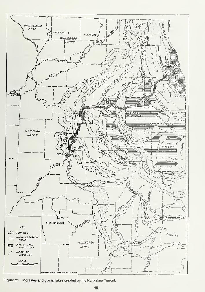
ILLINOIS STATt UOLOCICAL SUItVtr
Figure 21 Moraines and glacial lakes created by the Kankakee Torrent.
45
decrease in coarseness from east to west reflects a slackening of the currents in that direction. As
the torrent subsided, the flood became divided into several channels that assumed a braided pattern
among the rock ridges and rubble bars on the relatively flat floor of the Kankakee Valley.
As the Kankakee Torrent continued to subside, rivers became entrenched and large thick expanses
of sandy outwash sediments left behind by the receding flood waters were deposited in a wide belt
along the Kankakee Valley. As a result, a large tract of sandy sediments extends from an area just
west of the city of Kankakee to South Bend, Indiana. This extensive sandy deposit is the primary
source area for the sediments now lying in the Kankakee River Basin. In addition, the sand deposits
were exposed to eolian (wind) activity that built sand dunes. Stop 3 is at one of these sand dunes.
Eventually, as the Valparaiso glacier melted back, an eastern outlet to the south was opened along
the Wabash Valley and meltwater was diverted from the Lake Erie lobe, decreasing the volume of
flow into the Kankakee Valley. Continued retreat of the glaciers allowed other rivers to drain the region
north and east of this locality, and eventually most of the meltwater was deflected away from the
Kankakee Valley, marking the end of the Kankakee Torrent.
The final episode shaping the character of the geological materials in the Kankakee basin is the
modern deposition of silt, sand, and gravel adjacent to the Kankakee River and its tributaries. In Illinois
this modern material is referred to as Cahokia Alluvium. It consists of materials transported down the
valley and deposited in flood plains during intervals of flooding and also includes sediments deposited
directly by tributary streams. The alluvium generally rests unconformably on bedrock and glacial de-
posits. Along the Kankakee River, the material is primarily medium grained sand that commonly
occurs on top of the coarser sandy and gravelly materials of the Kankakee Torrent.
Devils Hole Devils Hole is located west of the parking lot in the SE SW NE quarter of Section 5.
Follow the trail west of the parking lot along the Kankakee River for approximately 0.5 mile (see
route map).
Devils Hole is a whirlpool feature in the Kankakee River. It formed along the outside of a meander,
where a small bluff protrudes into the Kankakee River. This protruding bluff is called a nick point and
is developed along a joint within the bedrock. The swirling action seen in the water is the result of
differences in stream velocities—fast flowing water is being diverted past the nick point, and slow
moving water is trapped behind the nick point. The faster moving water creates a hydraulic drag (a
suction) pulling the slower moving water into the main flow. As this happens, however, the water
being pulled out exerts a second hydraulic drag on a portion of the main flow to replace the water
that is being lost to the main current. This is very similar to a dog chasing his own tail. Is the tail or
the head leading the chase? In any case, the swirling action of the water has eroded into the bed of
the river creating a deep scour hole, which is reported to be a great fishing spot.
STOP 3 Rubble Bar and Sand Dune Complex (SW SW SW, Sec. 1 9, T31 N, R1 1 E, 3rd P.M.,
Kankakee County, Bonfield 7.5-Minute Quadrangle).
Numerous elongate ridges of sand and coarse rock debris (rubble bars) that trend roughly parallel
to the Kankakee River occur in a broad band some 8 to 10 miles in width. The rubble bars range
from 15 to 150 feet wide and are up to 3 miles long. Some bars are straight, others are sinuous. The
rock fragments in the bars are angular and composed mostly of local Silurian-age dolomite, which
46

indicates a comparatively short distance of transport. Also present are some fragments of igneous
and metamorphic rock types that were eroded from the glacial drift. Sorting or apparent bedding
structures are absent in the coarse rubble. The rubble here is overlain by about 7 feet of fine to
medium sand. On the east side of the road, little rubble is found and the section is almost entirely
sand. The sand consists predominantly of quartz, with abundant dolomite and minor amounts of
other minerals. The sand is well sorted and stratified—typical dune sand. The sand was blown from
the torrent deposits after the water receded; in some areas it formed well, defined dunes, whereas in
others, it mantled rubble bars, such as this one.
STOP 4 Lunch: Davis Creek Area (SW NW NE, Sec. 23, T31 N, R1 1 E, 3rd P.M., KankakeeCounty, Bourbonnais 7.5-Minute Quadrangle).
Pull into the parking lot, grab your lunch, and jump out of your vehicle. After you have finished your
lunch, take a leisurely walk around the large open areas of the campground. An excellent view of
the Kankakee River and the valley cut by the Kankakee Torrent can be seen from the parking lot. Atrail along the river, east of the canoe/boat launching area, leads to Davis Creek where an expo-
sure of the Silurian Racine Formation crops out near its mouth. Davis Creek flows in a subglacial
channel through the Rockdale Moraine. Scattered throughout the campground, especially west of
the parking lot, are several large glacial erratics. The large pit located southeast of the parking lot is
an abandoned sand and gravel operation. The campground is located on the edge of the Rockdale
Moraine, and the steep slope leading to the Kankakee River was carved by the Kankakee Torrent.
Of special note: It is reported that the first permanent habitation of a white man in the Kankakee
area was along the east side of Davis Creek, just north of Route 102 (Ekblaw and Wilson 1957).
STOP 5 Vulcan Materials Company, Manteno Quarry (fig. 22) (SW and NW, Sec. 33, T32N,
R12E, 3rd P.M., Kankakee County, Bradley 7.5-Minute Quadrangle).
This quarry is in one of the many reefs that characterize the Silurian Racine Formation in northeast-
ern Illinois (figs. 23 and 24). Several types of carbonate rock occur in the reef, depending on the part
of the reef in which they formed. The kinds of fossils that may be found vary for the same reason.
The core of the reef was built up by the accumulation in place of stony skeletons of such animals as
corals, stromatoparoids, and associated phyla, supplemented by finely fragmented fossil debris. On
the flanks of the reef, debris that was swept off the crest of the growing reef by waves and currents
accumulated in the forereef and backreef zones in beds deposited parallel to the slope. Between the
reefs, the beds are horizontal. In some places, the interreef rocks consist of clean dolomites, but at
others they are very argillaceous (clay-rich). These Silurian reefs tend to protrude above the sur-
rounding bedrock because the rocks of the core of the reef are more resistant to erosion than the
surrounding flank and interreef rocks. Several Silurian reefs have been located on the basis of their
topographic expression. One notable occurrence is at the Chicago suburb of Blue Island, where a
Silurian reef pokes through the muds deposited on the bed of Lake Michigan when the water level
was much higher. Silurian reefs beneath the water of modern Lake Michigan provide the bedrock
substrate essential for spawning lake trout.
47

Figure 22 Vulcan Materials Company, Manteno Quarry, at stop 5 (photo by M. Jeffords).
The core of this reef is located near the center of the quarry, but cores of smaller reefs occur in the
northwest part of the quarry. Beds that dip noticeably are visible in the quarry face. Individual beds
can be traced from the flanks of the reef core, where they have a significant dip, southward to where
they are nearly horizontal. Thin, shaley, horizontal interreef beds can be seen in the southwest part
of the quarry. The character of the rocks changes from the reef core, to the flanks, to the interreef
zone. The distinctive characteristics of the rocks deposited in those three zones are called "facies."
Also prevalent in the Silurian bedrock in northeastern Illinois are deposits of Pennsylvanian siltstone
and clay, which fill sinkholes in the dolomite. These are "buried" sinks, which formed after deposition
of the Pennsylvanian-age sediments. The following steps explain their origin. After deposition of the
Silurian rocks and subsequent erosion, the Pennsylvanian-age rocks were deposited. These lower
-< wind direction
flank
micnte bafflestone
with stromatactoids
reef core
cnnoid debris in lime mudwith Syringapora
flank
Figure 23 Idealized Silurian reef showing typical geometry of various facies. Steeper fore-
reef and backreef facies (beds on the flanks) and the sag of prereef strata are due to com-
paction under the reef (modified from Whitaker 1988).
48

FORMATION MEMBER COLUMN THICK,
(ft)GENERAL CHARACTER
<
<
<
Racine
Sugar Run
7"ryr 300
7~^r-
Dolomite, pure, gray, vuggy, in reefs; andargillaceous, silty, brownish gray andgreenish gray, cherty dolomite with bedsof relatively pure dolomite, between thereefs
Z A /- /
->-> -
I ~l - 10-30
Eel 2
Dolomite, slightly argillaceous and silty,light greenish gray, brown-weathering;in smooth-surfaced medium beds; building-stone beds
/ , / 7
Joliet
40'-80'
Romeoa77z±z
18-34Dolomite, pure, light gray to white, mot-
tled gray and pink; in faint thin stylo-tic beds
1Markgraf
,-7 * 7/ I /-
/ - /2-28
^^Dolomite, silty at base to slightly argil-
laceous at top, very light gray, cherty,med i um-bedded
Brandon
Bridge
- i ~ i/ -, /W 11-25
Dolomite, argillaceous to shaly, gray, red,
green; contains a few pure beds; sili-ceous foraminifera abundant
Z_3Z
<or
<x
Kankakee20'-50'
Plaines zzz 1.5-3Dolomite, pure, white, massive; contains Microcard i
-
na I ia and Pentamerus ; pitted smooth surface on top
ZFVZ7
Troutman I?^^^ 11-29Dolomite, pure, pinkish gray to greenish
gray; in thin wavy beds with green clay
partings; corals common
I. z
Offerman T221^ 2.5-11 Dolomite, as above, but slightly argilla-ceous
Drummond TZz l-llDolomite, as above, but massive, vuggy, glauconitic,
local ly sandy; contains PI atymere I la at base
Elwood
Wilhelmi
0-100'
/ - / AA A A
0-30 Dolomite, slightly argillaceous, brownish
gray; contains many layers of white chert
Birds^35/ ~ Z A /--/- /-
0-20 Dolomite, argillaceous, gray, slightlycherty
^mSchweizer / — / 0-80 Dolomite, very argillaceous, gray, and dolo-
mi t ic sha le
T T*Where overlain by next younger unit.
Figure 24 Silurian strata in northeastern Illinois (modified from Willman 1973).
49
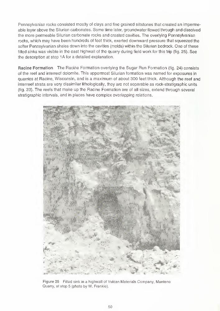
Pennsylvanian rocks consisted mostly of clays and fine grained siltstones that created an imperme-
able layer above the Silurian carbonates. Some time later, groundwater flowed through and dissolved
the more permeable Silurian carbonate rocks and created cavities. The overlying Pennsylvanian
rocks, which may have been hundreds of feet thick, exerted downward pressure that squeezed the
softer Pennsylvanian shales down into the cavities (molds) within the Silurian bedrock. One of these
filled sinks was visible in the east highwall of the quarry during field work for this trip (fig. 25). See
the description at stop 1 A for a detailed explanation.
Racine Formation The Racine Formation overlying the Sugar Run Formation (fig. 24) consists
of the reef and interreef dolomite. This uppermost Silurian formation was named for exposures in
quarries at Racine, Wisconsin, and is a maximum of about 300 feet thick. Although the reef and
interreef strata are very dissimilar lithologically, they are not separable as rock-stratigraphic units
(fig. 23). The reefs that make up the Racine Formation are of all sizes, extend through several
stratigraphic intervals, and in places have complex overlapping relations.
": ^w
'#*
Figure 25 Filled sink in a highwall of Vulcan Materials Company, MantenoQuarry, at stop 5 (photo by W. Frankie).
50

The reefs consist of pure dolomite that is medium to light gray, mottled dark gray, gray weathering,
medium grained, and vesicular to highly vuggy (containing small cavities). Some of the reefs are
more than 1 mile across, and the reef at Thornton is at least 150 feet thick. The central parts, or
cores, of the larger reefs are irregularly bedded to massive in structure. The marginal, or reef-flank,
rocks have well defined beds generally 4 inches to 1 foot thick, although some beds are 2 to 3 feet
thick. The reef-flank beds dip away from the central core at angles as steep as 30°. They represent
lateral growth of the reef and consist partly of storm debris from higher parts of the reef. Smaller
reefs are massive and do not have well defined reef-flank deposits. The reef cores are remarkably
free of clay and silt impurities. The insoluble residues are generally less than 1%, and many samples
contain essentially no residue other then pellets of the asphaltum that fills the vugs in some reef
rock. Chert has not been found in any of the reef cores. It is almost never found in the high-purity
rocks and only rarely in the highly silty or argillaceous rocks in the core of the reef (Willman 1973).
The interreef rocks in northeastern Illinois are largely silty, argillaceous, cherty, light gray to brownish
gray dolomite that weathers brown. They have prominent beds, but the beds vary in thickness. Near
the reefs, the interreef strata are highly varied in composition. Some massive, silty, argillaceous,
greenish gray beds contain 30% to 40% insoluble residue, and some beds grade into nodules of
carbonate rocks surrounded by a clay matrix. The clay-rich beds are separated by pure, vesicular,
gray dolomite like that in the reefs. Before they were converted to dolomite, these beds may have
consisted of sand-sized fragments of the shells or marine animals washed from the reefs. The inter-
reef rocks farther from the reefs are more uniform and are commonly slightly argillaceous or argilla-
ceous, dense, brownish gray, cherty dolomite (Willman 1973).
Reefs that have a base low in the Racine Formation occur along the lower part of Davis Creek (SE
NW NE Sec. 23, T31N, R11E, Bourbonnais 7.5-Minute Quadrangle) and in a small deeply incised
ravine at the southwest corner of Bourbonnais (NVa NW NW Sec. 30, T31N, R12E, 7.5-Minute
Quadrangle). Reefs in the middle of the formation occur in quarries near Manteno, Kankakee
County (NE SE SE Sec. 28, and SW SW SE Sec. 33, T31N, R12E).
The Racine reefs contain a large and varied fauna in which corals, stromatoporoids, bryozoans,
brachiopods, and crinoids are most common, and trilobites, gastropods, and pelecypods are not
rare (see fossil plate at the back of the guidebook). Fossils are not common in the interreef beds,
but they are present locally in reef detritus, in which sponges, crinoids, and brachiopods are most
abundant. The large brachiopod Kirkidium is abundant on the south slope of a hill 1 .5 miles south-
west of Manteno, Kankakee County (SW SW SE Sec. 20, T32N, R12 E, Bradley 7.5-Minute Quad-
rangle), which is near or below the middle of the formation.
The Silurian Period The following information about the Silurian Period was modified from the
Milwaukee Public Museum's Web page at
http://www.mpm.edu/collect/geology/geosec-noframes.html
This Web site contains an informative section on Silurian reefs, including a large number of graphics.
The Silurian Period is the geologic time between 438 and 408 million years ago, and is preceded by
the Ordovician and followed by the Devonian Periods. The term "Silurian" comes from Silures, the
name of a tribe of people who lived along the border of England and Wales before the time of the
Romans. In the early 1800s, British geologists recognized rocks in this area that contained a distinc-
tive assemblage of fossils that differed from the fossils in both the underlying (or older) strata and
overlying (or younger) strata. Silurian was applied to the period represented by this fossil assemblage.
51

Silurian fossils, identical to those in Britain, were subsequently discovered in many other regions of
the world, including the Great Lakes region of North America.
Changing environments The Silurian world was vastly different in many ways from the world of
today. The shapes and distribution of the continents differed from those of today, and shallow seas
covered much of the present continental areas. For example, the equator passed through North
America, and a nearly continuous inland sea stretched between New York and Nevada. Although
the Silurian seas were populated by a variety of marine life, the land was inhabited only by a few
types of small plants and animals.
Ancient and modern reefs A reef is a structure built by marine organisms that rises above the
surrounding seafloor. Throughout geologic history, reefs share a common set of environmental fea-
tures. They are built in warm, shallow seawater in the tropics and subtropics, and they occur only in
water that is relatively free of suspended, land-derived sediment; such clear water allows sunlight to
penetrate to the reef surface and permits photosynthetic organisms to live.
Reefs are characterized by their high biodiversity and the complex interdependencies of the plants
and animals that formed them. Reefs are formed by five major types of organisms:
1
.
Reef constructors, such as corals, help to build the reef by forming a framework of
hard skeletons.
2. Reef bafflers, such as crinoids, have upright fronds or stick-like growth forms that
interfere with currents and trap sediment on the reef surface.
3. Reef binders, such as algae, grow over and around loose sediment and skeletons
of reef organisms and literally bind them together.
4. Reef dwellers are a variety of species (trilobites, brachiopods, and
cephalopods) that live in and among the constructors and binders, but they
do not directly build the reef framework.
5. Reef destroyers (certain bivalves, sponges, worms, and sharks) bore into
or scrape away parts of the reef surface and convert hard reef framework
into loose particles of sediment.
The 425-million-year-old Silurian reefs have many features in common with those of today, including
tropical to subtropical distribution, growth in shallow water, and relatively high biodiversity. Silurian
and modern reefs, however, are different in important ways. Binders appear to have been more im-
portant in Silurian reefs, and destroyers less important, than in present-day reefs. The actual groups
of organisms that occupy various functional roles in the reef community are also different. For exam-
ple, stromatoporoids, an extinct type of sponge, were important constructors in Silurian reefs but are
unknown in today's reefs .
Biodiversity refers to the variety of organisms on earth. It is commonly expressed as the number of
species in a given area or environment, and is commonly compared between different environ-
ments. Silurian reefs contain more species than non-reef Silurian environments—a contrast also
seen in the modern marine world. Biodiversity can also be compared through time. The species
diversity of reefs has increased from Ordovician to modern times.
Fossil preservation and diagenesis A fossil is any feature preserved in a rock that indicates the
presence of ancient life. Body fossils are parts of organisms, such as shells, bones, and leaves.
52

Trace fossils (footprints, trails, and burrows) in rocks also demonstrate the presence of ancient life,
even though no part of the body is preserved.
Diagenesis refers to the chemical and physical changes that occur in sedimentary geologic materi-
als after their initial deposition or formation. During the Silurian Period, reefs consisted of shells and
soft mud composed of calcium carbonate. The shells and mud eventually were cemented together
into a rock called limestone. Sometime later, they were altered by magnesium-rich waters flowing
through the deposits, which changed them into a rock called dolostone (dolomite) consisting of
calcium-magnesium carbonate.
Although some fossils have not been changed from their original composition, most fossils have
undergone some degree of diagenesis. Petrification occurs when tiny spaces in bone or wood are
filled by new minerals. Silicification is the alteration of a shell composed of calcium carbonate into a
fossil shell composed of silica (Si02).
Shells may also be dissolved during diagenesis, which leaves only their impression in the rock. Most
Silurian reef fossils are preserved in this way. The external mold is an impression that preserves the
appearance of the outer surface of a shell. The internal mold is an impression of the inner surface of
a shell. External and internal molds of the same shell are often very different in appearance.
STOP 6 North Central Materials, Manteno Quarry (fig. 26) (NW and SW quarters of SW SE,
Sec. 20, T32N, R12E, 3rd P.M., Kankakee County, Bradley 7.5-Minute Quadrangle). Entrance to the
quarry is in the NW SW SW of Sec. 20, located on the Bourbonnais 7.5-Minute Quadrangle.
This quarry is also in the Silurian Racine Formation (fig. 24). At a first glance at the Bradley
7.5-Minute Quadrangle topographic map (see route map), the topographic contour lines may lead
Figure 26 North Central Materials, Manteno Quarry, at stop 6 (photo by M. Jeffords).
53

Figure 27 Large slide plane in the north highwall of North Central Materials, Manteno Quarry. The angle of the dipping
beds in the highwall indicates that these sediments were deposited on the flank of the reef (photo by W. Frankie).
you to believe that this structure is a glacial moraine or kame. However, the reef at this quarry forms
a topographic high on the bedrock surface. The Racine is often exposed in low hills that project
through the glacial drift in northeastern Illinois. Many of the hills (called klintar or, individually, a klint)
are reefs. The reef rock is more resistant to weathering than the surrounding interreef rock, which
has been more deeply eroded, in part by glacial scour. Along the Kankakee River, the Racine is ex-
posed from 3 miles northwest of Kankakee to Momence. It is also exposed in a large upland area
from Kankakee north to Manteno. Silurian reefs are generally more resistant to erosion than the sur-
rounding non-reef rocks and sometimes form topographic highs.
While field work was being conducted for this field trip, a large bedrock slump had occured in the
north highwall of the quarry (fig. 27). The slide was triggered by a shot (an explosive charge used to
break the rock) and occurred along a layer of shale that had become saturated with water; the satu-
rated shale layer created a glide plane along which the mass of rocks slid down into the pit. The
quarry is temporarily by-passing this area. Such rock slides as seen in this quarry are an all-too-
common feature along many roads built in mountainous areas.
STOP 7 Silurian Dolomite, Refuse Pile (NW NW, Sec. 21 , T32N, R12E, 3rd P.M., Kankakee
County, Bradley 7.5-Minute Quadrangle).
The pile of rocks in the field was deposited during the construction of the K-Mart truck distribution
center located to the south. This material is from the Racine Formation and contains many fossils,
especially the large brachiopod Kirkidium. Have fun collecting, and remember to leave some for the
next collector.
54
REFERENCES
Bretz, J.H., and S.E. Harris, Jr., 1961, Caves of Illinois: Illinois State Geological Survey, Report of
Investigations 215, 87 p.
Buschbach, T.C., and D.R. Kolata, 1991, Regional setting of the Illinois Basin, in M.W. Leighton,
D.R. Kolata, D.F. Oltz, and J.J. Eidel, editors, Interior Cratonic Basins: American Association of
Petroleum Geologists, Memoir 51, p. 29-55.
Clark, P.U., M.R. Greek, and M.J. Schneider, 1988, Surface morphology of the southern margin of
the Laurentide ice sheet from Illinois to Montana (abstr.), in Program and Abstracts of the Tenth
Biennial Meeting: American Quaternary Association, University of Massachusetts, Amherst, p. 60.
Clark, S.K., and J.S. Royds, 1948, Structural trends and fault systems in Eastern Interior Basin:
American Association of Petroleum Geologists Bulletin, v. 32, no. 9, p. 1728-1749.
Cote, W., D.L Reinertsen, and G. Wilson, 1967, Bourbonnais Area: Illinois State Geological Survey,
Geological Science Field Trip Guide Leaflet 1967C, 17 p.
Damberger, H.H., 1971, Coalification pattern of the Illinois Basin: Economic Geology, v. 66, no. 3,
p. 488-494.
Department of Natural Resources, 1997, Kankakee River State Park: Illinois Department of Natural
Resources brochure.
Ekblaw, G.E., and G.M. Wilson, 1957, Kankakee Area: Illinois State Geological Survey, Geological
Science Field Trip Guide Leaflet 1957C, 9 p. plus attachments.
Gross, D.L., and R.C. Berg, 1981, Geology of the Kankakee River System in Kankakee County,
Illinois: Illinois State Geological Survey, Environmental Geology Notes 92, 80 p.
Hansel, A.K., and W.H. Johnson, 1996, Wedron and Mason Groups: Lithostratigraphic Reclassifica-
tion of Deposits of the Wisconsin Episode, Lake Michigan Lobe Area: Illinois State Geological
Survey, Bulletin 104, 116 p.
Herzog, B.L., B.J. Stiff, C.A Chenoweth, K.L Warner, J.B. Sieverling, and C. Avery, 1994, Buried
Bedrock Surface of Illinois: Illinois State Geological Survey, Illinois Map 5; scale, 1:500,000;
size, 33.25" x 60.75".
Horberg, C.L., 1950, Bedrock Topography of Illinois: Illinois State Geological Survey, Bulletin 73,
111 p.
Illinois Coal Mines Maps and Directories, Directory of Coal Mines in Illinois, Kankakee County, 1991:
Illinois State Geological Survey, Open File Reports.
Ipe, V. (in preparation), Illinois Mineral Industry in 1995: Illinois State Geological Survey, Illinois
Mineral Notes.
Iseminger, W.R., 1996, Prehistoric cultural and environmental interaction in the American Bottom:
Paper presented at the I.S.M. Teachers Wetland Conference, August 1996.
Ivens, J.L., N.G. Bhowmik, A.R. Brigham, and D.L. Gross, 1981, The Kankakee River Yesterday
and Today: Illinois State Water Survey, Miscellaneous Publication 60, 24 p.
Keller, E.A.., 1992, Environmental Geology, 6th ed.: New York, Macmillan, 521 p.
Leighton, M.M., G.E. Ekblaw, and C.L. Horberg, 1948, Physiographic Divisions of Illinois: Illinois
State Geological Survey, Report of Investigations 129, 19 p.
Lineback, J.A., et al., 1979, Quaternary Deposits of Illinois: Illinois State Geological Survey Map;
scale, 1:500,000; size, 40" x 60"; color.
Nelson, J.W., 1995, Structural Features in Illinois: Illinois State Geological Survey, Bulletin 100, 144 p.
55

Palmer, A.N., 1991, Origin and morphology of limestone caves. Geological Society of America
Bulletin, v. 103, pp. 1-21.
Paschke, J.E., 1979, Soil Survey of Kankakee County, Illinois: U.S. Department of Agriculture, Soil
Conservation Service, 84 p. plus 96 soil maps.
Piskin, K., and R.E. Bergstrom, 1975, Glacial Drift in Illinois: Illinois State Geological Survey,
Circular 490, 35 p.
Rice, T.E., 1990, The Grand Kankakee, inThe Nature of Illinois: Society for the Illinois Scientific
Surveys, Vol. IV, No. 11, Winter 1990, 25 p.
Ritter, D.F., R.C. Kochel, and J.R. Miller, 1995, Process Geomorphology, 3rd ed.: Dubuque,
Wm. C. Brown, 546 p.
Smith W.H., 1968, Strippable Coal Reserves of Illinois, Part 6—La Salle, Livingston, Grundy,
Kankakee, Will, Putnam, and Parts of Bureau and Marshall Counties: Illinois State Geological
Survey, Circular 41 9, 29 p.
Treworgy, J.D., 1981, Structural Features in Illinois—A Compendium: Illinois State Geological
Survey, Circular 519, 22 p.
Whitaker, ST., 1988, Silurian Pinnacle Reef Distribution in Illinois—Model for Hydrocarbon Explora-
tion: Illinois State Geological Survey, Illinois Petroleum 130, 32 p.
Willman, H.B., 1973, Rock Stratigraphy of the Silurian System in Northeastern and Northwestern
Illinois: Illinois State Geological Survey, Circular 479, 55 p.
Willman, H.B., and J.C. Frye, 1970, Pleistocene Stratigraphy of Illinois: Illinois State Geological
Survey, Bulletin 94, 204 p.
Willman, H.B., et al., 1967, Geologic Map of Illinois: Illinois State Geological Survey Map; scale,
1:500,000; size, 40" x 56"; color.
Willman, H.B., J.A. Simon, B.M. Lynch, and V.A. Langenheim, 1968, Bibliography and Index of
Illinois Geology through 1965: Illinois State Geological Survey, Bulletin 92, 373 p.
Willman, H.B., E. Atherton, T.C. Buschbach, C. Collinson, J.C. Frye, M.E. Hopkins, J.A. Lineback,
and J.A. Simon, 1975, Handbook of Illinois Stratigraphy: Illinois State Geological Survey,
Bulletin 95, 261 p.
Yarbrough, R.E., 1974, The Physiography of Metro East: Illinois Geographical Society Bulletin, vol. 16,
no. 1 , p. 1 2-28.
56

GLOSSARY
The following definitions are from several sources in total or in part, but the main reference is: Bates,
R.L, and J.A. Jackson, editors, 1987, Glossary of Geology: American Geological Institute, Alexandria,
VA, 3rd edition, 788 p.
Ablation Separation and removal of rock material and formation of deposits, especially by wind action
or the washing away of loose and soluble materials.
Age An interval of geologic time; a division of an epoch.
Aggrading stream One that is actively building up its channel orfloodplain by being supplied with
more load than it can transport.
Alluviated valley One that has been at least partially filled with sand, silt, and mud by flowing water.
Alluvium A general term for clay, silt, sand, gravel, or similar unconsolidated detrital material depos-
ited during comparatively recent time by a stream or other body of running water as a sorted or
semisorted sediment in the bed of a stream or on its floodplain or delta, etc.
Anticline A convex upward rock fold in which strata have been bent into an arch; the strata on
each side of the core of the arch are inclined in opposite directions away from the axis or crest;
the core contains older rocks than does the perimeter of the structure.
Aquifer A geologic formation that is water-bearing and which transmits water from one point to
another.
Argillaceous Largely composed of clay-sized particles or clay minerals.
Arenite A relatively clean quartz sandstone that is well sorted and contains less than 10% argilla-
ceous material.
Base level Lowest limit of subaerial erosion by running water, controlled locally and temporarily by
water level at stream mouths into lakes or more generally and semipermanently into the ocean
(mean sea level).
Basement complex Largely crystalline igneous and/or metamorphic rocks of complex structure
and distribution that underlie a sedimentary sequence.
Basin A topographic or structural low area that generally receives thicker deposits of sediments
than adjacent areas; the low areas tend to sink more readily, partly because of the weight of the
thicker sediments; this also denotes an area of deeper water than found in adjacent shelf areas.
Bed A naturally occurring layer of Earth material of relatively greater horizontal than vertical extent
that is characterized by a change in physical properties from those overlying and underlying
materials. It also is the ground upon which any body of water rests or has rested, or the land
covered by the waters of a stream, lake, or ocean; the bottom of a watercourse or of a stream
channel.
Bedrock The solid rock underlying the unconsolidated (non-indurated) surface materials, such as,
soil, sand, gravel, glacial till, etc.
Bedrock valley A drainageway eroded into the solid bedrock beneath the surface materials. It maybe completely filled with unconsolidated (non-indurated) materials and hidden from view.
Braided stream A low gradient, low volume stream flowing through an intricate network of interlac-
ing shallow channels that repeatedly merge and divide, and are separated from each other by
branch islands or channel bars. Such a stream may be incapable of carrying all of its load.
Calcarenite Limestone composed of sand-sized grains consisting of more or less worn shell frag-
ments or pieces of older limestone; a clastic limestone.
57

Calcareous Containing calcium carbonate (CaC03); limy.
Calcined The heating of limestone to its temperature of dissociation so that it loses its water of
crystalization.
Calcite A common rock-forming mineral consisting of CaC03; it may be white, colorless, or pale
shades of gray, yellow, and blue; it has perfect rhombohedral cleavage, appears vitreous, and
has a hardness of 3 on Mohs' scale; it effervesces (fizzes) readily in cold dilute hydrochloric
acid. It is the principal constituent of limestone.
Chert Silicon dioxide (Si02); a compact, massive rock composed of minute particles of quartz
and/or chalcedony; it is similar to flint but lighter in color.
Clastic Fragmental rock composed of detritus, including broken organic hard parts as well as rock
substances of any sort.
Closure The difference in altitude between the crest of a dome or anticline and the lowest contour
that completely surrounds it.
Columnar section A graphic representation in a vertical column of the sequence and stratigraphic
relations of the rock units in a region.
Conformable Layers of strata deposited one upon another without interruption in accumulation of
sediment; beds parallel.
Delta A low, nearly flat, alluvial land deposited at or near the mouth of a river where it enters a bodyof standing water; commonly a triangular or fan-shaped plain sometimes extending beyond the
general trend of the coastline.
Detritus Material produced by mechanical disintegration.
Disconformity An unconformity marked by a distinct erosion-produced irregular, uneven surface of
appreciable relief between parallel strata below and above the break; sometimes represents a
considerable interval of nondeposition.
Dolomite A mineral, calcium-magnesium carbonate (Ca,Mg[C03]2); applied to those sedimentary
rocks that are composed largely of the mineral dolomite; it also is precipitated directly from sea-
water. It is white, colorless, or tinged yellow, brown, pink, or gray; has perfect rhombohedral
cleavage; appears pearly to vitreous; effervesces feebly in cold dilute hydrochloric acid.
Drift All rock material transported by a glacier and deposited either directly by the ice or reworked
and deposited by meltwater streams and/or the wind.
Driftless Area A 10,000-square-mile area in northeastern Iowa, southwestern Wisconsin, and
northwestern Illinois where the absence of glacial drift suggests that the area may not have
been glaciated.
End moraine A ridge-like or series of ridge-like accumulations of drift built along the margin of an
actively flowing glacier at any given time; a moraine that has been deposited at the lower or
outer end of a glacier.
Epoch An interval of geologic time; a division of a period.
Era A unit of geologic time that is next in magnitude beneath an eon; consists of two or more periods.
Escarpment A long, more or less continuous cliff or steep slope facing in one general direction,
generally marking the outcrop of a resistant layer of rocks.
Fault A fracture surface or zone in Earth materials along which there has been vertical and/or hori-
zontal displacement or movement of the strata on both sides relative to one another.
Flaggy Tending to split into layers of suitable thickness for use as flagstone.
58

Floodplain The surface or strip of relatively smooth land adjacent to a stream channel that hasbeen produced by the stream's erosion and deposition actions; the area covered with water
when the stream overflows its banks at times of high water; it is built of alluvium carried by the
stream during floods and deposited in the sluggish water beyond the influence of the swiftest
current.
Fluvial Of or pertaining to a river or rivers.
Formation The basic rock unit distinctive enough to be readily recognizable in the field and wide-
spread and thick enough to be plotted on a map. It describes the strata, such as limestone,
sandstone, shale, or combinations of these and other rock types; formations have formal
names, such as Joliet Formation or St. Louis Limestone (Formation), usually derived from geo-
graphic localities.
Fossil Any remains or traces of an once living plant or animal specimens that are preserved in
rocks (arbitrarily excludes Recent remains).
Friable Said of a rock or mineral that crumbles naturally or is easily broken, pulverized, or reduced
to powder, such as a soft and poorly cemented sandstone.
Geology The study of the planet Earth. It is concerned with the origin of the planet, the material andmorphology of the Earth, and its history and the processes that acted (and act) upon it to affect
its historic and present forms.
Geophysics Study of the Earth by quantitative physical methods.
Glaciation A collective term for the geologic processes of glacial activity, including erosion anddeposition, and the resulting effects of such action on the Earth's surface.
Glacier A large, slow-moving mass of ice at least in part on land.
Gradient(s) A part of a surface feature of the Earth that slopes upward or downward; a slope, as of
a stream channel or of a land surface.
Igneous Said of a rock or mineral that solidified from molten or partly molten material, i.e., from
magma.
Indurated A compact rock or soil hardened by the action of pressure, cementation, and especially
heat.
Joint A fracture or crack in rocks along which there has been no movement of the opposing sides.
Karst Area underlain by limestone having many sinkholes separated by steep ridges or irregular
hills. Tunnels and caves resulting from solution by groundwater honeycomb the subsurface.
Lacustrine Produced by or belonging to a lake.
Laurasia A combination of Laurentia, a paleogeographic term for the Canadian Shield and its sur-
roundings, and Eurasia. It is the protocontinent of the Northern Hemisphere, corresponding to
Gondwana in the Southern Hemisphere, from which the present continents of the Northern
Hemisphere have been derived by separation and continental displacement. The hypothetical
supercontinent from which both were derived is Pangea. The protocontinent included most of
North America, Greenland, and most of Eurasia, excluding India. The main zone of separation
was in the North Atlantic, with a branch in Hudson Bay, and geologic features on opposite sides
of these zones are very similar.
Limestone A sedimentary rock consisting primarily of calcium carbonate (the mineral, calcite).
Lithify To change to stone, or to petrify; especially to consolidate from a loose sediment to a solid
rock.
Lithology The description of rocks on the basis of color, structures, mineral composition, and grain
size; the physical character of a rock.
59
Local relief The vertical difference in elevation between the highest and lowest points of a land sur-
face within a specified horizontal distance or in a limited area.
Loess A homogeneous, unstratified deposit of silt deposited by the wind.
Magma Naturally occurring mobile rock material or fluid, generated within Earth and capable of
intrusion and extrusion, from which igneous rocks are thought to have been derived through
solidification and related processes.
Meander One of a series of somewhat regular, sharp, sinuous curves, bends, loops, or turns pro-
duced by a stream, particularly in its lower course where it swings from side to side across its
valley bottom.
Meander scars Crescent-shaped, concave marks along a river's floodplain that are abandonedmeanders, frequently filled in with sediments and vegetation.
Metamorphic rock Any rock derived from pre-existing rocks by mineralogical, chemical, and struc-
tural changes, essentially in the solid state, in response to marked changes in temperature,
pressure, shearing stress, and chemical environment at depth in Earth's crust (gneiss, schist,
marble, quartzite, etc.).
Mineral A naturally formed chemical element or compound having a definite chemical composition
and, usually, a characteristic crystal form.
Monolith (a) A piece of unfractured bedrock, generally more than a few meters across, (b) A large
upstanding mass of rock.
Moraine A mound, ridge, or other distinct accumulation of glacial drift, predominantly till, deposited
in a variety of topographic landforms that are independent of control by the surface on which the
drift lies.
Morphology The scientific study of form, and of the structures and development that influence
form; term used in most sciences.
Natural gamma log These logs are run in cased, uncased, air, or water-filled boreholes. Natural
gamma radiation increases from the left to the right side of the log. In marine sediments, low
radiation levels indicate non-argillaceous limestone, dolomite, and sandstone.
Nickpoint A place of abrupt inflection in a stream profile; A sharp angle cut by currents at base of a
cliff.
Nonconformity An unconformity resulting from deposition of sedimentary strata on massive crys-
talline rock.
Outwash Stratified drift (clay, silt, sand, gravel) that was deposited by meltwater streams in channels,
deltas, outwash plains, on floodplains, and in glacial lakes.
Outwash plain The surface of a broad body of outwash formed in front of a glacier.
Oxbow lake A crescent-shaped lake in an abandoned bend of a river channel.
Pangea A hypothetical supercontinent; supposed by many geologists to have existed at an early
time in the geologic past, and to have combined all the continental crust of the Earth, from which
the present continents were derived by fragmentation and movement away from each other by
means of some form of continental displacement. During an intermediate stage of the fragmen-
tation, between the existence of Pangea and that of the present widely separated continents,
Pangea was supposed to have split into two large fragments, Laurasia on the north and Gon-
dwana on the south. The proto-ocean around Pangea has been termed Panthalassa. Other
geologists, while believing in the former existence of Laurasia and Gondwana, are reluctant to
concede the existence of an original Pangea; in fact, the early (Paleozoic or older) history of
continental displacement remains largely undeciphered.
60
Ped A naturally formed unit of soil structure, e.g., granule, block, crumb, or aggregate.
Peneplain A land surface of regional proportions worn down by erosion to a nearly flat or broadly
undulating plain.
Period An interval of geologic time; a division of an era.
Physiography The study and classification of the surface features of Earth on the basis of similari-
ties in geologic strucure and the history of geologic changes.
Physiographic province (or division) (a) A region, all parts of which are similar in geologic struc-
ture and climate and which has consequently had a unified geologic history, (b) A region whosepattern of relief features or landforms differs significantly from that of adjacent regions.
Point bar A low arcuate ridge of sand and gravel developed on the inside of a stream meander by
slow accumulation of sediment as the stream channel migrates toward the outer bank.
Radioactivity logs Logs of bore holes obtained through the use of gamma logging, neutron log-
ging, or combinations of the several radioactivity logging methods.
Relief (a) A term used loosely for the actual physical shape, configuration, or general unevenness
of a part of Earth's surface, considered with reference to variations of height and slope or to
irregularities of the land surface; the elevations or differences in elevation, considered collec-
tively, of a land surface (frequently confused with topography), (b) The vertical difference in ele-
vation between the hilltops or mountain summits and the lowlands or valleys of a given region;
"high relief" has great variation; "low relief" has little variation.
Sediment Solid fragmental material, either inorganic or organic, that originates from weathering of
rocks and is transported by, suspended in, or deposited by air, water, or ice, or that is accumu-
lated by other natural agents, such as chemical precipitation from solution or secretion from
organisms, and that forms in layers on Earth's surface at ordinary temperatures in a loose,
unconsolidated form; e.g, sand, gravel, silt, mud, till, loess, alluvium.
Sedimentary rock A rock resulting from the consolidation of loose sediment that has accumulated
in layers (e.g., sandstone, siltstone, limestone).
Shoaling The effect of a near-costal sea bottom on wave height; it describes the alteration of a
wave as it proceeds from deep water into shallow water. The wave height increases as the
wave arrives on shore.
Sinkholes Small circular depressions that have formed by solution in areas underlain by soluble
rocks, most commonly limestone and dolomite.
Slip-off slope Long, low, gentle slope on the inside of a stream meander.
Stage, substage Geologic time-rock units; the strata formed during an age or subage, respectively.
Stratigraphy The study, definition, and description of major and minor natural divisions of rocks,
especially the study of the form, arrangement, geographic distribution, chronologic succession,
classification, correlation, and mutual relationships of rock strata.
Stratigraphic unit A stratum or body of strata recognized as a unit in the classification of the rocks
of Earth's crust with respect to any specific rock character, property, or attribute or for any pur-
pose such as description, mapping, and correlation.
Stratum A tabular or sheet-like mass, or a single and distinct layer, of homogeneous or gradational
sedimentary material of any thickness, visually separable from other layers above and below by
a discrete change in character of the material deposited or by a sharp physical break in deposi-
tion, or by both; a sedimentary bed.
Subage An interval of geologic time; a division of an age.
61

Syncline A downfold of strata which dip inward from the sides toward the axis; youngest rocks
along the axis; the opposite of anticline.
System The largest and fundamental geologic time-rock unit; the strata of a system were deposited
during a period of geologic time.
Tectonic Pertaining to the global forces involved in, or the resulting structures or features of
Earth's movements.
Tectonics The branch of geology dealing with the broad architecture of the upper (outer) part of
Earth's crust; a regional assembling of structural or deformational features, their origins, histori-
cal evolution, and mutual relations.
Temperature-resistance log This log, run only in water, portrays the earth's temperature and the
quality of groundwater in the well.
Terrace An abandoned floodplain formed when a stream flowed at a level above the level of its
present channel and floodplain.
Till Unconsolidated, nonsorted, unstratified drift deposited by and underneath a glacier and consist-
ing of a heterogenous mixture of different sizes and kinds of rock fragments.
Till plain The undulating surface of low relief in the area underlain by ground moraine.
Topography The natural or physical surface features of a region, considered collectively as to
form; the features revealed by the contour lines of a map.
Unconformable Having the relation of an unconformity to underlying rocks and separated from
them by an interruption in sedimentation, with or without any accompanying erosion of older
rocks.
Unconformity A surface of erosion or nondeposition that separates younger strata from older
strata; most unconformities indicate intervals of time when former areas of the sea bottom were
temporarily raised above sea level.
Valley trains The accumulations of outwash deposited by rivers in their valleys downstream from a
glacier.
Water table The upper surface of a zone of saturation.
Weathering The group of processes, chemical and physical, whereby rocks on exposure to the
weather change in character, decay, and finally crumble into soil.
62
REPRESENTATIVE SILURIAN FOSSILS FROM ILLINOIS
SIX
Halysites Astylospongio PycnoslylusOstraeospongia Hindia Fovosites


Illinois State Geological Survey
Geobit 1
EXOTIC ROCKS or Erratics Are Erratic
Here and there in Illinois
are boulders lying alone
or with companions in
the corner of a field or
someone's yard, on a
courthouse lawn or a
schoolyard. Many ofthem—colorful and glit-
tering granites, bandedgneisses, and other intri-
cately veined andstreaked igneous andmetamorphic rocks—seem out ofplace in the
stoneless, grassy knolls
and prairies of our state.
Their "erratic" occurrence
is the reason for their
interesting name.
Apiece of Canada sitting in central Illinois (photo by D. Reinertsen).
Where did erratics comefrom?These exotic rocks came from Canada and the states north of
us. The continental glaciers of the Great Ice Age scoured
and scraped the land surface as they advanced, pushing
up chunks of bedrock and grinding them against each
other or along the ground surface as the rock-laden ice
sheets pushed southward.
Sometimes you can tell where the erratic originally camefrom by determining the kind of rock it is. A large boulder of
granite, gneiss, or other igneous or metamorphic rock mayhave come from Canada.
Some erratics containing flecks of copper were probably
transported here from the "Copper Range" of the upper pen-
insula of Michigan. Large pieces of copper have been found
in glacial deposits of central and northern Illinois. Light gray
to white quartzite boulders with beautiful, rounded pebbles of
red jasper came from Ontario, Canada. Purplish pieces of quartz
ite, some of them banded, probably originated in Wisconsin.
Most interesting are the few large boulders of Canadian tillite.
Glacial till is an unsorted and unlayered mixture of clay, sand, gravel,
and boulders that vary widely in size and shape. Tillite is glacial till
that was deposited by a glacier many millions of years older than the
ones that invaded our state during the Great Ice Age. This glacial till has
been around so long that it has been hardened into a gray to greenish gray
rock containing a mixture of grains of different sizes and scattered pebbles
of various types and sizes. Glaciers spread southward into the Midwest
from two centers of ice accumulation in west-
ern and eastern Canada.

How did erratics get here?
Many boulders were probably dropped directly
from the melting front of the glacier. Others
may have been rafted to their present resting
places by icebergs in ancient lakes or on flood-
waters of some long-vanished stream as it
poured from a glacier. Still others, buried in
the glacial deposits, could have worked their
way up to the land surface as the surrounding
Keep an eye out for erratics.
You may find some of these glacial
strangers in your neighborhood.
loose soil repeatedly froze and thawed. Whenthe freezing ground expands, pieces of rock
tend to be pushed upward, where they are moreeasily reached by the farmer's plow and also
more likely to be exposed by erosion.
Many erratics are of notable size and beauty.
Some are used as monuments in courthouse
squares and parks, or along highways. Many are
marked with metal plaques to indicate an inter-
esting historical spot or event.
Contributed by M.M. Killey
While on a drive through central Illinois, you maycatch a glimpse of an erratic (photo by J. Dexter).
ILLINOIS STATE GEOLOGICAL SURVEY615 East Peabody Drive
Champaign, IL 61820-69642 1 7/333-4747 FAX 2 1 7/244-7004
ILLINOIS
DEPARTMENT OF
NATURALRESOURCES
Printed by authority of the State of Illinois/1997/1000
©printed using soybean ink on recycled paper

Illinois State Geological Survey
Geobit 2END MORAINES—the end ofthe glacial ride
We tend to think of Illinois as very
flat, but hike riders andjoggersknow that our landscape hasmany subtle hills, ridges, and long
uphill slopes. From a satellite or the
space shuttle high above the earth,
large broad ridges can be seenthat arc across northeastern Illinois.
These ridges, left behind whenthe last Ice Age glaciers meltedaway, are called end moraines;
they formed between about 25,000and 14,000 years ago during the
Wisconsin glacial episode. Although
these ridges are easy to see fromspace, they are so broad androunded you may sometimesoverlook them when you drive
across Illinois.
Satellite central Illinois shows broad curved ridges.
How do end morainesform? end moraineforming at
glacier margin^
glacier
margin
Melting at a glacier margin causes the
ice to thin, and ground-up rock debris
carried in the base of the ice or
dragged along beneath the glacier is
deposited. When the ice margin remains
in the same place for a relatively long time (tens
to hundreds of years), enough debris flows to the glacier's
leading edge and piles up to form a large end moraine on the landscape.
end moraine
5>utwash plain'
ourwashsand and gravel
What are end moraines made of?
The unsorted mixture of debris deposited by a glacier is called
till. Most end moraines in Illinois are thick ridges
of till. Aground moraine, the relatively flat,
low-lying landscape across which the
-^ melting glacier retreated, consists of
a thinner layer of till. Sheetlike deposits of
sand and gravel, called outwash plains, were left
behind by meltwater streams flowing away from the glacier.

During the Wisconsin glacial episode,
a vast sheet of ice formed over mostof Canada. Glaciers flowed away fromthe center of the ice sheet. The glacier
that flowed through the Lake Michigan
basin and into northeastern Illinois
reached its southernmost extent at
Shelbyville about 20,000 years ago.
End moraines in northeastern
Illinois
The glacier did not just flow into Illinois and then gradually melt
away. Its overall retreat was interrupted by many pauses during
which moraines formed. Most of the more than 30 end moraines in
Illinois (shown as dark arcs on the map) formed as the glacial lobe
was "retreating" from its southernmost position. At times during the
overall retreat, the ice margin temporarily readvanced, sometimes as
much as 50 miles.
Even as the lobe was retreating, however, the glacier continued to flow
toward its outer margin, delivering ice and debris to its leading edge. Large
moraines mark positions where the ice margin paused for hundreds of years.
Try to spot end moraines the next time you take a drive. Their
rounded crests form the highest parts of the landscape. Radio andTV towers are commonly located atop these moraine ridges
Illinois State Geological Survey615 East Peabody Drive
Champaign, IL 61820-6964217/333-4747
ILLINOIS
hi PAH1M! Nl CI
NATURALRESOURCES
contributed by A.K. Hansel
Printed by the authority of the State of Illinois/1997/1000
©printed using soybean ink on recycled paper