Guide Book on Spate Irrigation in...
68
Enabling the rural poor to overcome poverty Guide Book on Spate Irrigation in Pakistan
Transcript of Guide Book on Spate Irrigation in...
Enabling the rural poorto overcome poverty
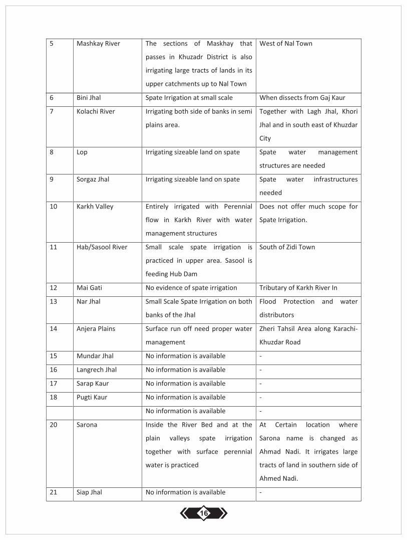
Guide Book on
Spate Irrigation in Pakistan
Guide Book on Spate Irrigation Published by Pakistan Spate Irrigation Network
National Secretariat Islamabad Pakistan
i
iii
v
Spate Irrigation in Pakistan
SPATE IRRIGATION IN BALOCHISTAN
1 Spate Irrigation in Balochistan, History, current status and practices
1.1 Geographical settings
1.2 Major Water Basins in Balochistan with surface water situation
1.3 Administrative Overview of Balochistan
1.4 History of Spate Irrigation in Balochistan
1.5 Scope of Spate Irrigation in Balochistan
2 Spate Irrigation in Quetta Division
2.1 Chagi and Nushki District
2.2 Quetta, Pishin and Killa Abdullah Districts
3 Spate Irrigation in Kalat Division
3.1 Awaran District
3.2 Khuzdar District
3.3 Kalat and Mastung Districts
3.4 Kharan District
3.5 Washuk District
4 Spate Irrigation in Mekran Division
4.1 Panjgur District
4.2 Kech (Turbat) District
4.3 Gawadar District
5 Spate Irrigation in Sibi Division
5.1 Sibi District
5.2 Dera Bugti District
5.3 Kohlu Diostrict
5.4 Harnai and Ziarat Districts
5.5 Ziarat District
6 Spate Irrigation in Zhob Division
6.1 Zhob and Sherani Districts
6.2 Sherani District
6.3 Killa Saifullah District
6.4 Loralai District
6.5 Musa Khel District
6.6 Barkhan District
7 Spate Irrigation in Nasir Abad Division
7.1 Bolan District
ii
8 Spate Irrigation in Punjabn, History, Current Status and Practices
SPATE IRRIGTION IN KHYBERPAKHTOONKHAWA PROVINCE
9 Current spate Irrigation Status in Khyber Pakhtoonkhawa
7.2 Jhal Magsi District
7.3 Naziabad and Jaffaerabad Districts
SPATE IRRIGATION IN PUNJAB
8.1 History of Spate Irrigation in Dera Jaat
8.2 Current Practices of Spate Irrigation in Punjab
8.3 Spate Irrigation in Dera Ghazi Khan and Rajanpjur Districts
SPATE IRRIGATION IN SINDH PROVINCE
Spate Irrigation in Jamshoro District
Spate Irrigation in Malir Karachi District
Spate Irrigation in Dadu District
ENGINEERING DYNAMIC IN SPATE IRRIATION
SOCIO-ECONOMIC CONDITIONS OF SPATE IRRIGATION IN PAKISTAN
Cropping Pattern in Spate Irrigation
Drinking Water in Spate Irrigation
Ground Water Availability in Spate Irrigation Area
Gender Issues in Spate Irrigation
Risk Coping Mechanism in Spate Irrigation Areas
Solidarity Mechanism in Spate Irrigation Areas
Conclusion and Recommendation

Acknowledgements
Pakistan Spate Irrigation Network express thanks to all those colleagues and friends who have contributed and
assisted in edits, quality checks and finalization of this handbook. I am thankful to Dr.Frank Van Steenbergen for
generating the idea of the guide book on Pakistan. I am also thankful to Mr. Matthijs Kool at MetaMeta Research
Netherlands for his patience and contribution to read through the line, edits and quality of language. My thanks are
also due to Mr.Karim Nawaz, Mr.Mohammad Usman Qazi and Hafeex Chahchar who has been source of inspiration
and guidance for the completion of first issue.
Allah Bakhsh BalochCoordinator Pakistan Spate Irrigation Network
iii
Forward
Spate Irrigation is neglected in the course of mainstream development at federal, provincial level and at donor
level. Larger majority of planners in some of the provinces line departments and donor's community are unaware of
the issues of the farmers in spate irrigation communities of Pakistan. The people living in spate irrigation areas are
poorest of the poor with comparison to the conventional agricultural ecological zones of various provinces where
agricultural returns make them well off. The services structures and public amenities are poor in spate regions
throughout all provinces of Pakistan. Such areas are tribal and semi-tribal in nature where internal rivalries and in-
equitable land holdings further aggravate the socioeconomic conditions.
This is first kind of Publication that carry the inside scope of the spate irrigation, land distribution patterns and
gender issues prevailing in the system. The information given in this guide books consists on more personal and
field experiences rather than an academic research. We confess at the time of this first publication that information
given are not sufficient to the desired level, for example, Climate Change is becoming precedent to the shifting
weather conditions in Pakistan and hence it would affect spate ecological zones in the country as well. Unexpected
unseasonal flash floods are another reason for causing damages to the human settlements and change in rivers
morphologies. Both paradigms are not discussed in this guide book.
Spate Information on districts Tank, Banu, Kohat, Laki Marwart and Karak in KPK, Mianwali in Punjab and Thar
desert in Sindh are not given in this book due to none availability of credible information.
Spate irrigation is under researched issue in Pakistan and hence information related to it. We assure to our valuable
readers that if time permitted, we shall improve the information level in our second additions of this document.
Readers, experts, field researchers from all provinces are requested to share the added information, pictures, and
research papers on spate irrigation for next publication. Please share your information at ([email protected]).
For more information on Pakistan spate irrigation please visit our web site www.spate-irrigation.org
v
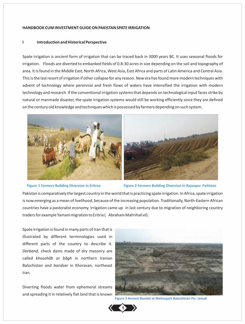
HANDBOOK CUM INVESTMENT GUIDE ON PAKISTAN SPATE IRRIGATION
I Introduction and Historical Perspective
Spate irrigation is ancient form of irrigation that can be traced back in 3000 years BC. It uses seasonal floods for
irrigation. Floods are diverted to embanked fields of 0.8-30 acres in size depending on the soil and topography of
area. It is found in the Middle East, North Africa, West Asia, East Africa and parts of Latin America and Central Asia.
This is the last resort of irrigation if other collapse for any reason. New era has found more modern techniques with
advent of technology where perennial and fresh flows of waters have intensified the irrigation with modern
technology and research. If the conventional irrigation systems that depends on technological input faces strike by
natural or manmade disaster, the spate irrigation systems would still be working efficiently since they are defined
on the century old knowledge and techniques which is possessed by farmers depending on such system.
Pakistan is comparatively the largest country in the world that is practicing spate irrigation. In Africa, spate irrigation
is now emerging as a mean of livelihood, because of the increasing population. Traditionally, North-Eastern African
countries have a pastoralist economy. Irrigation came up in last century due to migration of neighboring country
traders for example Yamani migration to Eritria ( Abraham Mahrihali el).
Spate irrigation is found in many parts of Iran that is
illustrated by different terminologies used in
different parts of the country to describe it.
Darband, check dams made of dry masonry are
called khooshãb or bãgh in northern Iranian
Balochistan and bandsar in Khorasan, northeast
Iran.
Diverting floods water from ephemeral streams
and spreading it in relatively flat land that is known
1
as dagar in southern Balochistan; ta, goudtak, taghal and gaband in the Izadkhast Plain, Darab and southeast Iran;
goorehband in Sistan, eastern Iran; and korband (bund in rivers) in southern Fars, southern Iran, the Persian Gulf
coast and the Qeshm Island. Lavar (silt bringer) is the name given to a spate-irrigated farm fields in the Dorz-
Sãyehbãn area in southeast Fars. Moreover, the upstream spate-irrigated fields in Mazaijohn, south of the
Izadkhast Plain, Darab, are called bonakhoo, and those on the downstream end are called shatmãl (sheet irrigation)
in Darab and takhtãbi in Khorasan. In Pakistani Balochistan there are large and mainly unexplained ancient
diversion bunds found in Khuzdar and Kalat districts, the so-called gabar bundhs. The similar, signs of irrigation are
also found in Mehergarh Balochistan which is Old Civilization of human settlement in 9.000 BC closer to the King
and Prophet Solomon time.
ii Spate Irrigation in Pakistan
Pakistan has utilized most of its surface water in the Indus basin by developing canal irrigation systems. After this,
spate irrigation gives most potential for agricultural development land available for spate irrigation expansion is
approximately 6.93 M ha–throughout all provinces, AJK and FATA (NESPAK 1998).The substantial land availability
can be set against the current spate irrigated area of 0.34 to 1.28 Mha in dry and wet years and a maximum
developed command area of 2.02 M ha. Allthough the estimate may be too high; it shows that there are
opportunities to develop a larger area under spate irrigation. Apart from expanding the area, there is a considerable
scope to improve the productivity of the existing areas. Developing spate irrigation will considerably improve the
national food security and augment livelihoods opportunities in the poorest, unsettled, marginalized and low
profile areas of the country. Even in spite of the current substantial extent (ranging from 3 to 10% of total irrigated
area of country) with greater potential, spate irrigation in Pakistan is a largely unknown territory. Spate irrigation in
Pakistan has a long history and has a large potential but is largely unknown and not well understood (Frank Van
Steenbergen). Spate irrigation is practiced in the area west of the Indus River in all the four provinces. It is called nai
in Sindh, sailaba in Balochistan and RodhKohi in Khyber Pakhtoonkhawa and Punjab. In the system, water from
short duration flashfloods is diverted to irrigate land and fill drinking water ponds, water rangelands and forest
ranges. Traditionally flood water is diverted from free intakes (on the piedmont zones) or (further down in the
plains) with the help of earthen diversion bunds build across the ephemeral rivers.These structures are usually built
in such a way that they wash out in very high floods – thus preventing that potentially destructive high floods play
havoc with the command area. Once diverted, flood water is guided and spread over sometimes very long distances
usually making sure the floods do not erode the command area. The following table shows the feasible sites in
Pakistan that can be developed under spate irrigation.
Table: Potential sites in Pakistan
2

1) NESPAK. 1998. Master Feasibility Studies for Management of Hill Torrents of Pakistan (summery Volume)
2) Based on an experts estimate
3) Practical note1: Potential for the spate Irrigation in Pakistan ( )www.spate-irrigation.org
3
SPATE IRRIGATION IN BALOCHISTAN PROVINCE
Chapter -I
Spate Irrigation in Balochistan, History Current Status and Practices
Balochistan is a South Western Province in Pakistan sharing international borders with Iran in the south and
Afghanistan in the west. The province has two types of topography: The northern high land and south-eastern
lowland plains and sandy deserts. Balochistan is 44% of Pakistan in terms of geographical area with a population of
7.2 million (Pakistan Population Census Report 1998). Out of total 6.39 million acres of land only 0.334 million acres
are irrigated, making 13% of the total irrigable land. The province is arid and dry in its climate with a low rainfall rate.
The north-western highlands get snowfall and rains (8-20 inches or 22-500mm) in Dec-April. The lowland and
southern Balochsitan gets monsoon rains in Jun-August at low intensity ranging 1-2 inches or 25-50mm. The
highlands are severely cold in winter and moderate in summer's months. The lowlands are severely hot in summer
months. Ethnically, the North is occupied by Pashtoon Tribes, while the south, southeastern and coastal regions are
inhabited by the Baloch Tribes. The area is tribal in nature. Traditional kinship and tribal bondage makes a strong
social tribal culture.
1.1 Geographical Setting
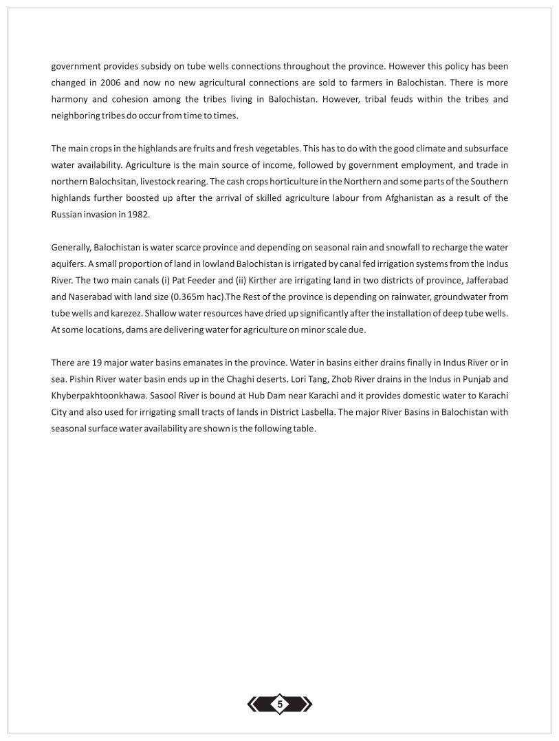
Balochistan has many natural resources such as irrigable arid lands, rivers, huge rangelands, oil, gas and coal mines
and gold reserves. In the south, Balochistan makes up two third of the coast line of Pakistan. This opens the corridor
for international trades with especially Aghanistan, Iran, central Asian Republics.
The province of Balochistan remains
largely underdeveloped. The province
has a, poor infrastructure, a severe water
crisis, and the weakest fiscal base. The
poor economic performance has led to
poor living standards. Balochistan has the
highest poverty rate along with KPK, and,
in parts of the province, the weakest state
institutions.
Paradigm shift in water needs and availability occurred at high intensity in the mid-seventies when traditional crops
cultivation trends shifted to commercial after the advent of tube wells. This tendency has gradually deteriorated
the groundwater level. Thousand of tubewells had been installed in the years 1977 to 1988. The provincial
Balochistan as share of Pakistan (Source: GOP 1998 and World Bank 2008; 2012)
4
government provides subsidy on tube wells connections throughout the province. However this policy has been
changed in 2006 and now no new agricultural connections are sold to farmers in Balochistan. There is more
harmony and cohesion among the tribes living in Balochistan. However, tribal feuds within the tribes and
neighboring tribes do occur from time to times.
The main crops in the highlands are fruits and fresh vegetables. This has to do with the good climate and subsurface
water availability. Agriculture is the main source of income, followed by government employment, and trade in
northern Balochsitan, livestock rearing. The cash crops horticulture in the Northern and some parts of the Southern
highlands further boosted up after the arrival of skilled agriculture labour from Afghanistan as a result of the
Russian invasion in 1982.
Generally, Balochistan is water scarce province and depending on seasonal rain and snowfall to recharge the water
aquifers. A small proportion of land in lowland Balochistan is irrigated by canal fed irrigation systems from the Indus
River. The two main canals (i) Pat Feeder and (ii) Kirther are irrigating land in two districts of province, Jafferabad
and Naserabad with land size (0.365m hac).The Rest of the province is depending on rainwater, groundwater from
tube wells and karezez. Shallow water resources have dried up significantly after the installation of deep tube wells.
At some locations, dams are delivering water for agriculture on minor scale due.
There are 19 major water basins emanates in the province. Water in basins either drains finally in Indus River or in
sea. Pishin River water basin ends up in the Chaghi deserts. Lori Tang, Zhob River drains in the Indus in Punjab and
Khyberpakhtoonkhawa. Sasool River is bound at Hub Dam near Karachi and it provides domestic water to Karachi
City and also used for irrigating small tracts of lands in District Lasbella. The major River Basins in Balochistan with
seasonal surface water availability are shown is the following table.
5
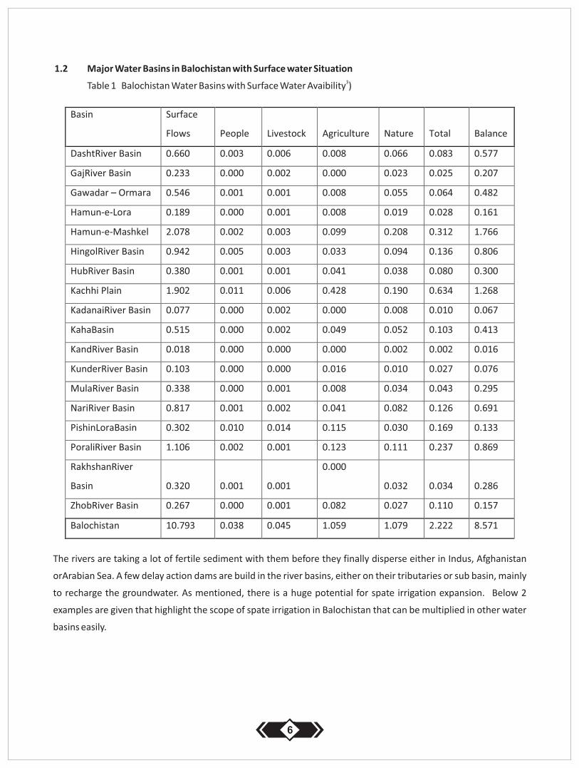
1.2 Major Water Basins in Balochistan with Surface water Situation3Table 1 Balochistan Water Basins with Surface Water Avaibility )
The rivers are taking a lot of fertile sediment with them before they finally disperse either in Indus, Afghanistan
orArabian Sea. A few delay action dams are build in the river basins, either on their tributaries or sub basin, mainly
to recharge the groundwater. As mentioned, there is a huge potential for spate irrigation expansion. Below 2
examples are given that highlight the scope of spate irrigation in Balochistan that can be multiplied in other water
basins easily.
6
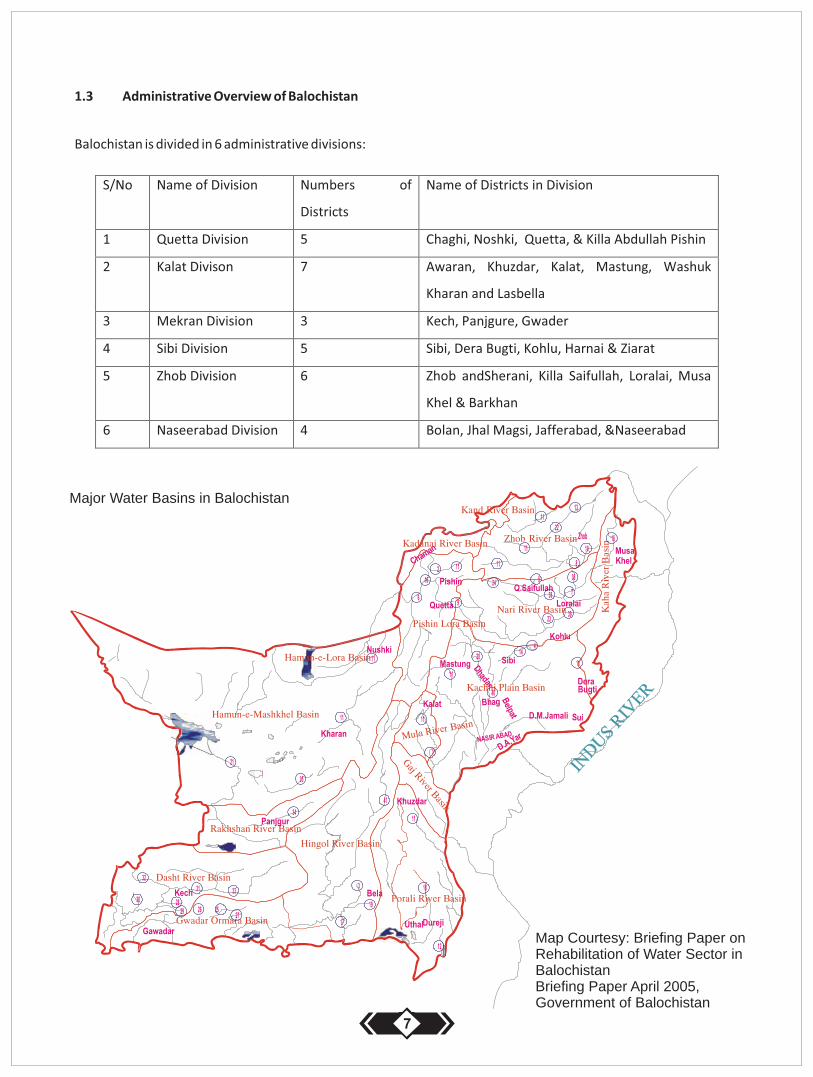
1.3 Administrative Overview of Balochistan
Balochistan is divided in 6 administrative divisions:
Major Water Basins in Balochistan
Map Courtesy: Briefing Paper on Rehabilitation of Water Sector in Balochistan Briefing Paper April 2005, Government of Balochistan
7
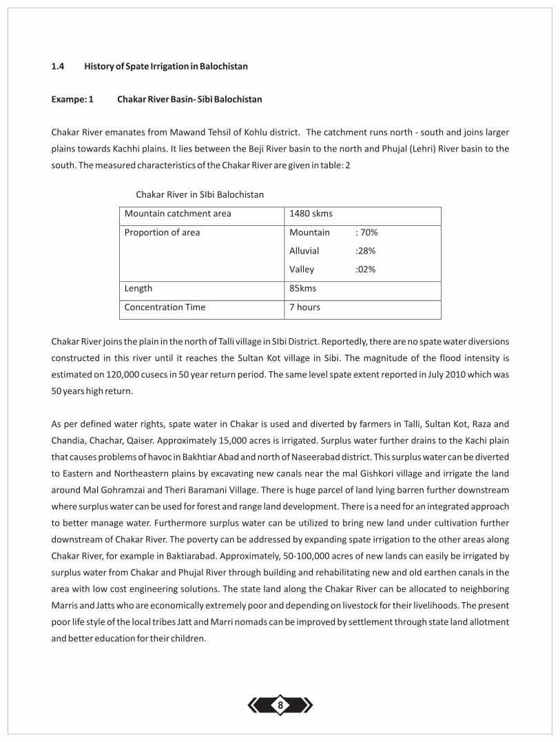
1.4 History of Spate Irrigation in Balochistan
Exampe: 1 Chakar River Basin- Sibi Balochistan
Chakar River emanates from Mawand Tehsil of Kohlu district. The catchment runs north - south and joins larger
plains towards Kachhi plains. It lies between the Beji River basin to the north and Phujal (Lehri) River basin to the
south. The measured characteristics of the Chakar River are given in table: 2
Chakar River joins the plain in the north of Talli village in SIbi District. Reportedly, there are no spate water diversions
constructed in this river until it reaches the Sultan Kot village in Sibi. The magnitude of the flood intensity is
estimated on 120,000 cusecs in 50 year return period. The same level spate extent reported in July 2010 which was
50 years high return.
As per defined water rights, spate water in Chakar is used and diverted by farmers in Talli, Sultan Kot, Raza and
Chandia, Chachar, Qaiser. Approximately 15,000 acres is irrigated. Surplus water further drains to the Kachi plain
that causes problems of havoc in Bakhtiar Abad and north of Naseerabad district. This surplus water can be diverted
to Eastern and Northeastern plains by excavating new canals near the mal Gishkori village and irrigate the land
around Mal Gohramzai and Theri Baramani Village. There is huge parcel of land lying barren further downstream
where surplus water can be used for forest and range land development. There is a need for an integrated approach
to better manage water. Furthermore surplus water can be utilized to bring new land under cultivation further
downstream of Chakar River. The poverty can be addressed by expanding spate irrigation to the other areas along
Chakar River, for example in Baktiarabad. Approximately, 50-100,000 acres of new lands can easily be irrigated by
surplus water from Chakar and Phujal River through building and rehabilitating new and old earthen canals in the
area with low cost engineering solutions. The state land along the Chakar River can be allocated to neighboring
Marris and Jatts who are economically extremely poor and depending on livestock for their livelihoods. The present
poor life style of the local tribes Jatt and Marri nomads can be improved by settlement through state land allotment
and better education for their children.
8
Example 2: Narri River in Bolan District
Narri River is one of the largest water basins in Balochistan. It drains water to Kachi plains which ultimately enters in
Dadu district in Sindh Province. Main catchment starts in the highlands of the Ziarat District, Loralai District and Part
of Zhob District. The river is flowing north to south from Loralai until it finally disappears in Manchar Lake in Sindh
Province. It passes through the hilly terrain of Kohlu district, vast sub plains around Mekhtar and Duki in Loralai
Balohistan. Narri is the principal stream of the water shed which drains an area of 22,525 sq kms (8,700 miles). The
Narri River has different names while it passed through different areas.
In different areas along the Narri River, spate irrigation is practiced. This is done on minor scale by tapping minor
flows in creeks within the catchment in Mektar, Duki area in Loralai District.
The largest proportion of the flow passes unutilized through Kohlu district, where large parcels of irrigable areas are
available. Only if Karahi Maidan in Kohlu district would be irrigated either through perennial flow or flood, it can
meet the food supply of entire Kohlu district. Such plains in many cases are not distributed among people and are
lying under communal tenure or under the ownership of the provincial government. The communal ownership
hampers the interest for development of the irrigation projects along the river. But if the efforts would be invested
in first hand investment before the commissioning of project, this could be settled through negotiation within the
owner tribe/tribes.
Perennial water in Narri River is used by the farmers of Sibi tehsil settled in 6 distinct villages. An average irrigated
land under perennial flow is approximately 5,000 acres.
Spate water in Narri River is used beyond Sibi town. A spate irrigation system can be found in Bolan district close to
SIbi. Spate irrigation is practiced here from the times of Kalat state. From Mithri to – Khokhar 6 diversion bunds
(gandas) are irrigating the lands on both sides of the river. During the Kalat state, there has been properly employed
staff for the management and operation of the system and in return the state government had collected taxes
against the services. The labor contributions, maintenance of the main diversions and water distribution are well
defined and recorded in the cadastral record of Revenue department of Bolan District.
Lands are registered in Revenue Department against individual titles. There are two types of land (i) Ghami and Be-
ghami. Ghami literally means contribution of Gham (labor, cash for system maintenance)the land with water rights.
Be-ghami land means, lands without water rights. These two kinds of land and water titles are known in the
area.The adjoining plains are lying barren under the communal ownership due to command problem and water
shortage and proper infrastructure.
The provincial department of irrigation is currently building 6 dispersal structures at different locations with the
cost of Rs 4.9 billion. The proposed scheme will approximately irrigate 100,000 acres of (both types of land) and
generate livelihoods for 5,000 households directly.
9
1.5 Scope of Spate Irrigation in Balochistan
The province lowland has at least fresh water resources for irrigation and domestic purpose other than runoff or
groundwater. Surface runoff is hardly utilized to the desired optimum level though provincial government is
building 100 dams throughout the province. It is general estimate that dams have no significant impact on the
irrigated agriculture of the province due to certain reasons (i) absence of proper water distribution among the
farmers (ii) farmers are not sure for the secure water supply throughout the year so no permanent crops like
orchards can be considered (iii) silt laden flood water is filling the dams before its projected life capability (iv) these
dams are small in size and does not cater the larger needs of the local farmers.
Such dams can make a substantial affect in the areas where shallow aquifers are being utilized for irrigation and
domestic use. Unfortunately, in many parts of the province the ground water has dropped to the depth of 500-
1,000 ft and such dams may not make any change on the recharging of deep aquifers. Construction of dams in
Balochistan may not yield revolutionary affects on the livelihood enhancement over all due to small in numbers and
water bearing and storage capacity
By managing flood water in various water basins In Balochistan Province millions acres of new land can be brought
under crops and forest cultivation. A buffer in sub soil water can be created through building new canals and
dispersal structures in plains. Additional and surplus water has to be catched and utilized in Balochistan plains
valleys which are currently draining off to Indus River, Manchar Lake and ultimately sea.
2 Spate Irrigation in Quetta Division
2.1 Chaghi and Nushki District
Quetta Division consists of 5 districts: Quetta, Pishin, Killa Abdullahand Nushki and newly established Chaghi
districts. The first three districts lay in the highlands north of Quetta Provincial Capital.The other two districts are
situated in the south-west along the RCD Highway Quetta – Iran – Turkey. District Nushki and Chaghi are bordering rdAfghanistan in west and Iran in south. 2/3 of Chaghi and Nushki district comprises of sandy desert and do not offer
much in term of irrigated agriculture with the exemption of piedmont areas. Spate Irrigation is practiced in the
valleys of the hilly region. There is a substantial scope of spate irrigation in district Nushki where large areas of flat
valleys lay barren. In these areas, spate water can be dispersed through building diversion structures with canal
network in line with locally defined water rights. Development of such lands can be turned into seasonal green
patches. The Northern part of Nushki, which constitute Chagi district (differed in recent times), consist of sandy
desert and offers no agricultural based livelihoods opportunities to the local inhabitants. In a wet year, isolated
alluvial parts in desert are cultivated to meet the animal fodder needs. Groundwater in Chagi area is essentially
brackish with no use of domestic and other purposes. The main source of income of the local population in this
district is trade with Iran and Afghanistan. Agriculture and government jobs are considered the second largest
10
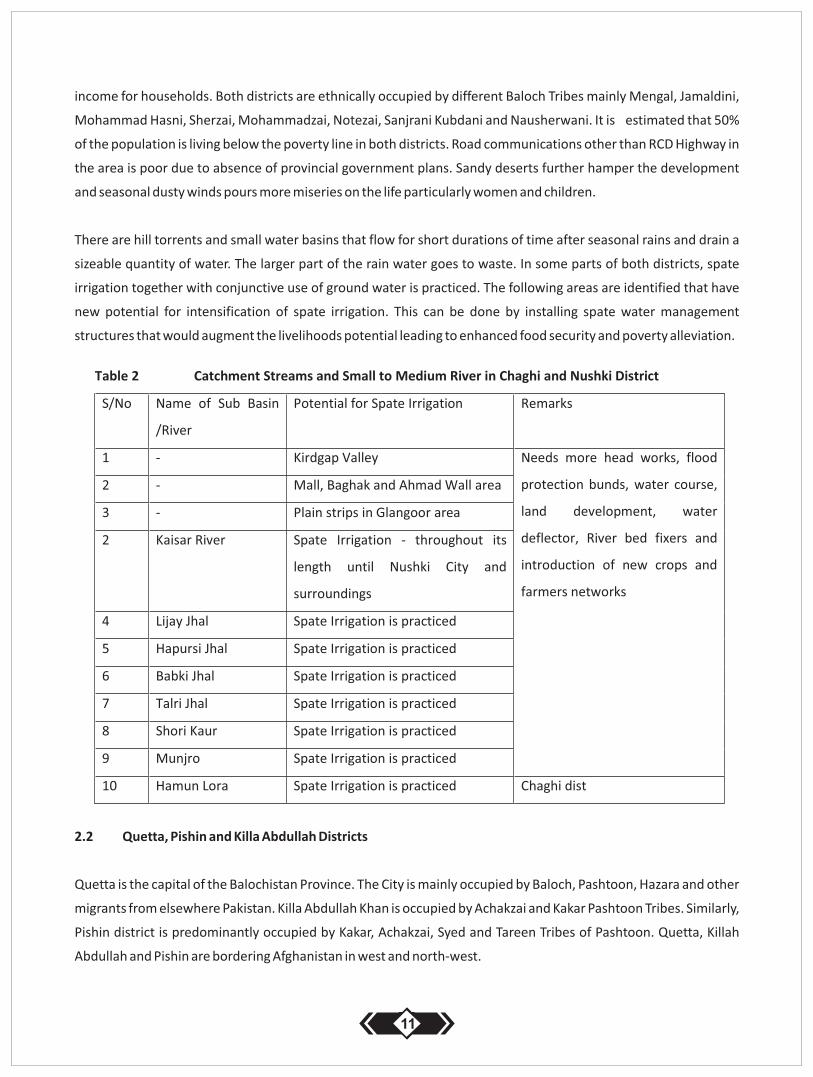
income for households. Both districts are ethnically occupied by different Baloch Tribes mainly Mengal, Jamaldini,
Mohammad Hasni, Sherzai, Mohammadzai, Notezai, Sanjrani Kubdani and Nausherwani. It is estimated that 50%
of the population is living below the poverty line in both districts. Road communications other than RCD Highway in
the area is poor due to absence of provincial government plans. Sandy deserts further hamper the development
and seasonal dusty winds pours more miseries on the life particularly women and children.
There are hill torrents and small water basins that flow for short durations of time after seasonal rains and drain a
sizeable quantity of water. The larger part of the rain water goes to waste. In some parts of both districts, spate
irrigation together with conjunctive use of ground water is practiced. The following areas are identified that have
new potential for intensification of spate irrigation. This can be done by installing spate water management
structures that would augment the livelihoods potential leading to enhanced food security and poverty alleviation.
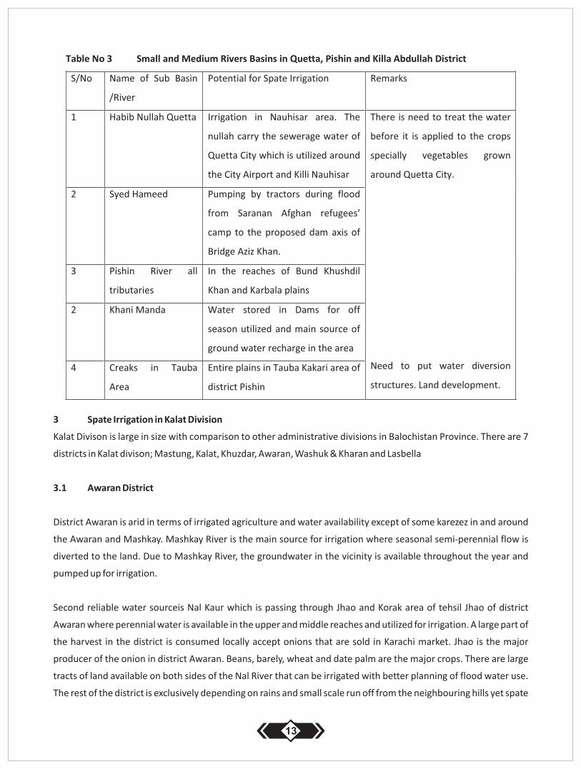
2.2 Quetta, Pishin and Killa Abdullah Districts
Quetta is the capital of the Balochistan Province. The City is mainly occupied by Baloch, Pashtoon, Hazara and other
migrants from elsewhere Pakistan. Killa Abdullah Khan is occupied by Achakzai and Kakar Pashtoon Tribes. Similarly,
Pishin district is predominantly occupied by Kakar, Achakzai, Syed and Tareen Tribes of Pashtoon. Quetta, Killah
Abdullah and Pishin are bordering Afghanistan in west and north-west.
11

The main population in all the three districts is depending on agricultural returns and is largely engaged in border
trade and local businesses. The famous dam Bund Khushdil Khan and Shebo head works are in situated in Pishin
district and were build in colonial times for irrigation purposes. Both structures were designed to store off seasonal
water utilized in the summer months for crop cultivation.
Shebo headwork's can be considered as an exemplary spate irrigation structure in Baochistan which can be easily
replicated in other spate irrigated areas of the Province. Shebo headwork diverts seasonal water to off shore
earthen reservoirs that is used by local farmers in the dry summer months for supplementary crop irrigation. Spate
canals are constructed to divert flood water to a tank which distributes water with tertiary canals to irrigate the total
command area. The tank stores water particularly in the winter months through snow melt.
The area in these 3 districts comprises hills, high peaks and valleys where irrigation is practiced. Currently irrigation
in Quetta is done mainly with spring water in Orak Valley, sewerage water in Quetta City and Nauhisar area west of
Quetta airport. Killa Abdullah and Pishin are dependent mainly on groundwater mining for irrigation and domestic
use. Major crops are apple orchards and fresh vegetables. These are sold in all three districts and consumed locally
in Quetta City. The surplus is sold on country markets. Fruit is supplied and sold on large country markets of Karachi,
Rawalpindi, Lahore, Multan and Peshawar. The area has one crop (Rabi crop) in a year. October – April are slack
seasons and no crops are cultivated in this season than only barley and wheat at minor scale.The crops remain
dormant through winter months Jan-March and start re-growth after mid March due to snow and harsh cold
temperatures.
Dependency on groundwater in Quetta, Killa Abdullah and Pishin has marked serious decay starting mid 1990 that
has led to serious decline in crop production. This let to a decrease of the groundwater level mainly in Kuchlagh
valley, Khani Baba, Mian Khazai, and Gulistan area. Irrigated land reduced to 30% with comparison to pre nineties
conditions. As a result, drinking water availability in Quetta, Pishin and Kuchlagh has become a serious problem.
The local population largely depends on tractor imported water on cash payment for domestic use. The current rate
of the one tanker water is Rs. 800 and the sale of domestic water has emerged a new business trend in Quetta and
Kuchlagh valley specially. The provincial government is now maintaining strict order on installation of new tube
wells in these valleys to protect the ground water storage that is utilized by the local population at present and in
future as well.
Quetta, Pishin and Abdullah Khan District do not offer scope for the development of spate irrigation system. The
water infrastructures are reasonably builtin these districts. However, there is good scope of spate irrigation in Toba
Achakzai, Toba Kakari and surrounding of Quetta area. The highlands receive sufficient snow and rain fall every year.
Small water body infrastructure like check dams, valley dikes, and land leveling can further offer good scope for
spate irrigation and groundwater recharge.
12
3 Spate Irrigation in Kalat Division
Kalat Divison is large in size with comparison to other administrative divisions in Balochistan Province. There are 7
districts in Kalat divison; Mastung, Kalat, Khuzdar, Awaran, Washuk & Kharan and Lasbella
3.1 Awaran District
District Awaran is arid in terms of irrigated agriculture and water availability except of some karezez in and around
the Awaran and Mashkay. Mashkay River is the main source for irrigation where seasonal semi-perennial flow is
diverted to the land. Due to Mashkay River, the groundwater in the vicinity is available throughout the year and
pumped up for irrigation.
Second reliable water sourceis Nal Kaur which is passing through Jhao and Korak area of tehsil Jhao of district
Awaran where perennial water is available in the upper and middle reaches and utilized for irrigation. A large part of
the harvest in the district is consumed locally accept onions that are sold in Karachi market. Jhao is the major
producer of the onion in district Awaran. Beans, barely, wheat and date palm are the major crops. There are large
tracts of land available on both sides of the Nal River that can be irrigated with better planning of flood water use.
The rest of the district is exclusively depending on rains and small scale run off from the neighbouring hills yet spate
13
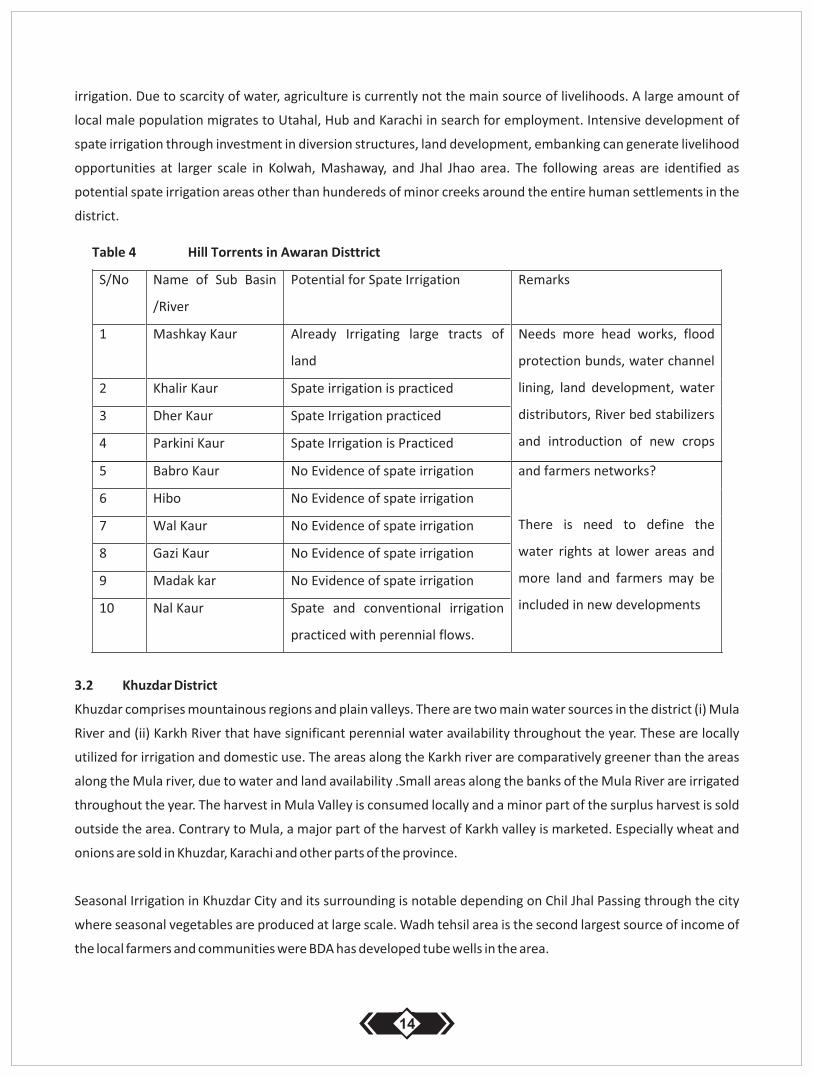
irrigation. Due to scarcity of water, agriculture is currently not the main source of livelihoods. A large amount of
local male population migrates to Utahal, Hub and Karachi in search for employment. Intensive development of
spate irrigation through investment in diversion structures, land development, embanking can generate livelihood
opportunities at larger scale in Kolwah, Mashaway, and Jhal Jhao area. The following areas are identified as
potential spate irrigation areas other than hundereds of minor creeks around the entire human settlements in the
district.
3.2 Khuzdar District
Khuzdar comprises mountainous regions and plain valleys. There are two main water sources in the district (i) Mula
River and (ii) Karkh River that have significant perennial water availability throughout the year. These are locally
utilized for irrigation and domestic use. The areas along the Karkh river are comparatively greener than the areas
along the Mula river, due to water and land availability .Small areas along the banks of the Mula River are irrigated
throughout the year. The harvest in Mula Valley is consumed locally and a minor part of the surplus harvest is sold
outside the area. Contrary to Mula, a major part of the harvest of Karkh valley is marketed. Especially wheat and
onions are sold in Khuzdar, Karachi and other parts of the province.
Seasonal Irrigation in Khuzdar City and its surrounding is notable depending on Chil Jhal Passing through the city
where seasonal vegetables are produced at large scale. Wadh tehsil area is the second largest source of income of
the local farmers and communities were BDA has developed tube wells in the area.
14
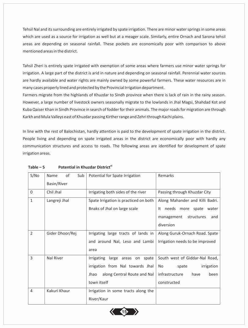
Tehsil Nal and its surrounding are entirely irrigated by spate irrigation. There are minor water springs in some areas
which are used as a source for irrigation as well but at a meager scale. Similarly, entire Ornach and Sarona tehsil
areas are depending on seasonal rainfall. These pockets are economically poor with comparison to above
mentioned areas in the district.
Tahsil Zheri is entirely spate irrigated with exemption of some areas where farmers use minor water springs for
irrigation. A large part of the district is arid in nature and depending on seasonal rainfall. Perennial water sources
are hardly available and water rights are mainly owned by some powerful farmers. These water resources are in
many cases properly lined and protected by the Provincial Irrigation department.
Farmers migrate from the highlands of Khuzdar to Sindh province when there is lack of rain in the rainy season.
However, a large number of livestock owners seasonally migrate to the lowlands in Jhal Magsi, Shahdad Kot and
Kuba Qaiser Khan in Sindh Province in search of fodder for their animals. The major roads for migration are through
Karkh and Mula Valleys east of Khuzdar passing Kirther range and Zehri through Kachi plains.
In line with the rest of Balochistan, hardly attention is paid to the development of spate irrigation in the district.
People living and depending on spate irrigated areas in the district are economically poor with hardly any
communication structures and access to roads. The following areas are identified for development of spate
irrigation areas.
15
16
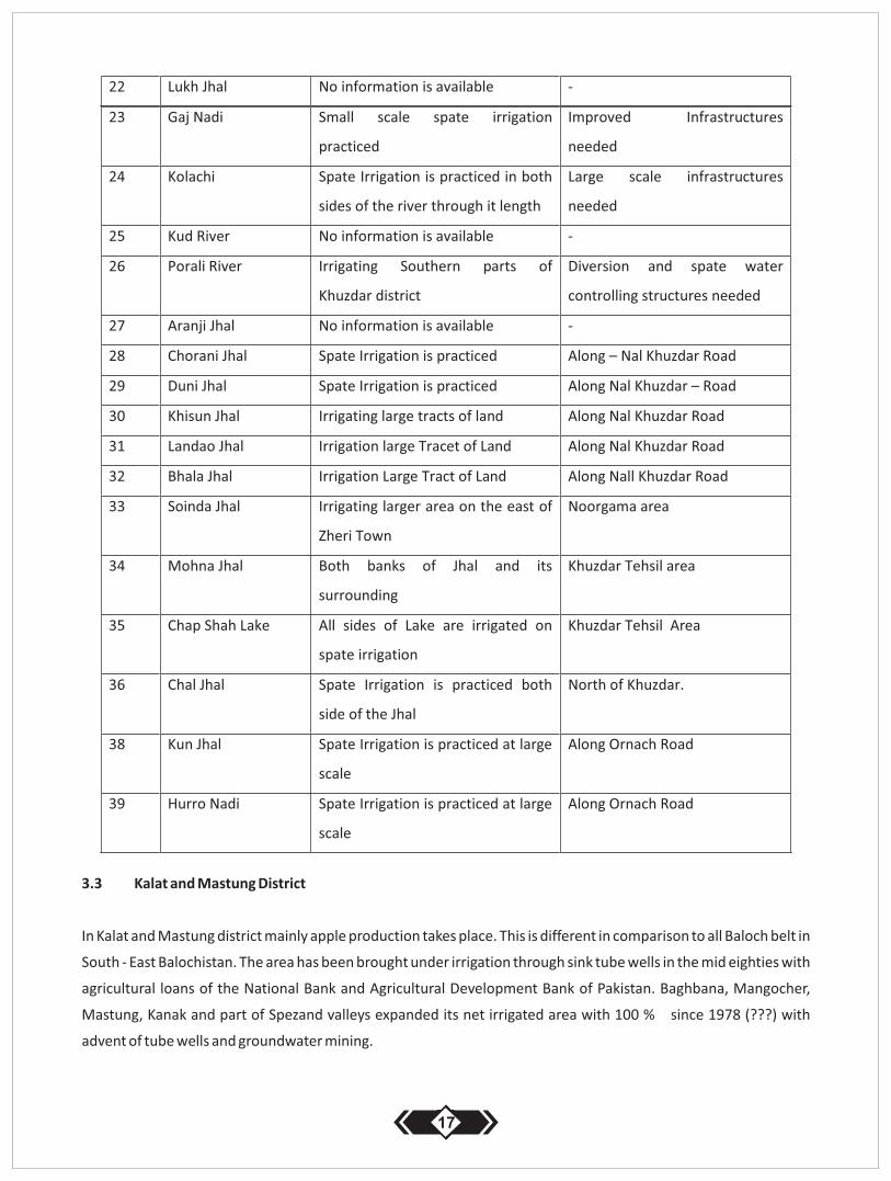
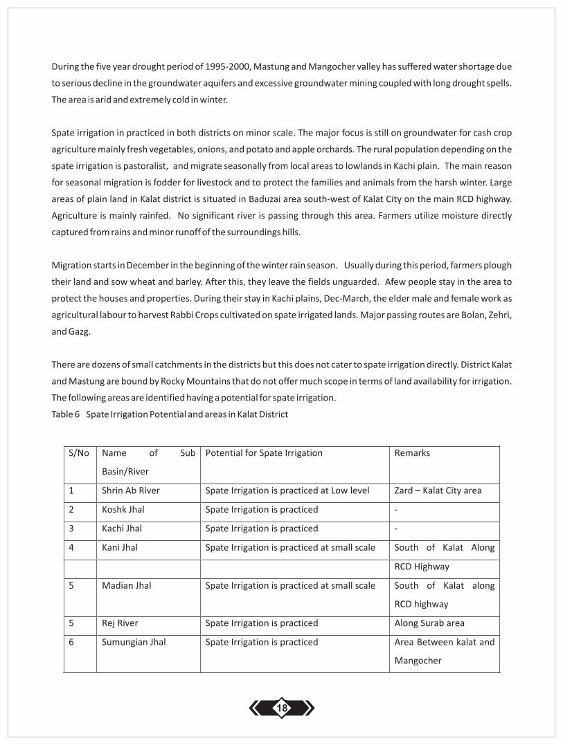
3.3 Kalat and Mastung District
In Kalat and Mastung district mainly apple production takes place. This is different in comparison to all Baloch belt in
South - East Balochistan. The area has been brought under irrigation through sink tube wells in the mid eighties with
agricultural loans of the National Bank and Agricultural Development Bank of Pakistan. Baghbana, Mangocher,
Mastung, Kanak and part of Spezand valleys expanded its net irrigated area with 100 % since 1978 (???) with
advent of tube wells and groundwater mining.
17
During the five year drought period of 1995-2000, Mastung and Mangocher valley has suffered water shortage due
to serious decline in the groundwater aquifers and excessive groundwater mining coupled with long drought spells.
The area is arid and extremely cold in winter.
Spate irrigation in practiced in both districts on minor scale. The major focus is still on groundwater for cash crop
agriculture mainly fresh vegetables, onions, and potato and apple orchards. The rural population depending on the
spate irrigation is pastoralist, and migrate seasonally from local areas to lowlands in Kachi plain. The main reason
for seasonal migration is fodder for livestock and to protect the families and animals from the harsh winter. Large
areas of plain land in Kalat district is situated in Baduzai area south-west of Kalat City on the main RCD highway.
Agriculture is mainly rainfed. No significant river is passing through this area. Farmers utilize moisture directly
captured from rains and minor runoff of the surroundings hills.
Migration starts in December in the beginning of the winter rain season. Usually during this period, farmers plough
their land and sow wheat and barley. After this, they leave the fields unguarded. Afew people stay in the area to
protect the houses and properties. During their stay in Kachi plains, Dec-March, the elder male and female work as
agricultural labour to harvest Rabbi Crops cultivated on spate irrigated lands. Major passing routes are Bolan, Zehri,
and Gazg.
There are dozens of small catchments in the districts but this does not cater to spate irrigation directly. District Kalat
and Mastung are bound by Rocky Mountains that do not offer much scope in terms of land availability for irrigation.
The following areas are identified having a potential for spate irrigation.
Table 6 Spate Irrigation Potential and areas in Kalat District
18
3.4 Kharan District
The Korakan River rises at the Zhal pass in the Garr hills and runs south-westward under the name of the Zhal River.
Curving south-westward it runs parallel with the Baddo It joins the Baddo at the Khargushki Band. After entering the
plain, it is called the Korakan. Near Langen Kahur, it is joined by the Gazno River from the north-east and by the
Chutok River from the east. From the east numerous other torrents also meet Korakan. In the Kharan valley, the
water from the river is used for irrigation in places where dams are construced. However, because of its narrow
bed, about 50 yards, and the heights of its banks, little water can be obtained. Important dams are situated at
Naurozabad, Tagazzi and Gazzi. However those are often destroyed by floods.
Korkan River has a great potential for spate irrigation development. Reportedly there are 5.000 households
depending on 11 diversion bunds along the Korkan and its different tributaries. River bed erosion in Korkan River
and difficulties of farmers in construction of diversion bunds on soft soils causes that the real potential for spate
irrigation returns is not made. Improvements in the management of spate systems will bring change in the life of
the poor communities. The following catchments are identified as high potential spate irrigation areas.
Implementing new spate irrigation structures in the district, will lead to an enhanced food security and improved
livelihoods at local level:
Valleys near Patkin
Bado River– construction of improved 11 off-takes in Buddo RiverKorkan River – diversion structures with
intake and outlet structures are recommended.
Sarap and Gurruk River– More investment in spate irrigation is recommended.
Plains in the foot hills of Char Kohan area – water diversion and land leveling is recommended
19
3.5 Washuk District
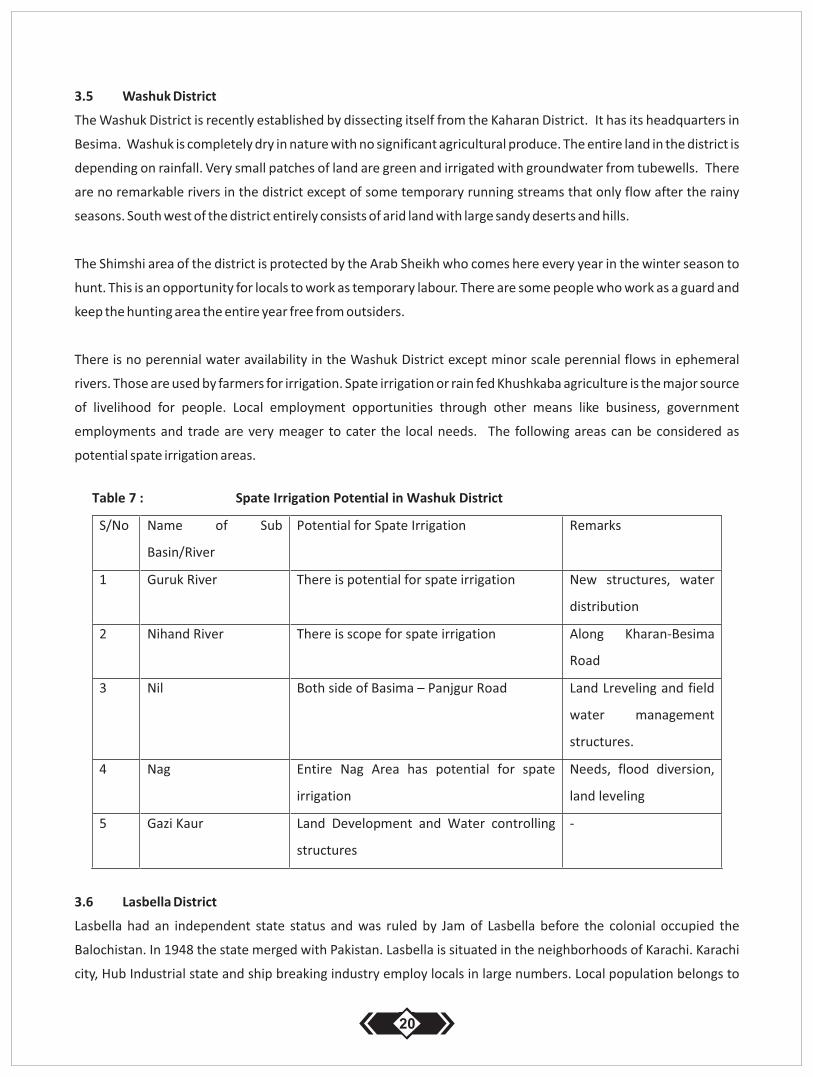
The Washuk District is recently established by dissecting itself from the Kaharan District. It has its headquarters in
Besima. Washuk is completely dry in nature with no significant agricultural produce. The entire land in the district is
depending on rainfall. Very small patches of land are green and irrigated with groundwater from tubewells. There
are no remarkable rivers in the district except of some temporary running streams that only flow after the rainy
seasons. South west of the district entirely consists of arid land with large sandy deserts and hills.
The Shimshi area of the district is protected by the Arab Sheikh who comes here every year in the winter season to
hunt. This is an opportunity for locals to work as temporary labour. There are some people who work as a guard and
keep the hunting area the entire year free from outsiders.
There is no perennial water availability in the Washuk District except minor scale perennial flows in ephemeral
rivers. Those are used by farmers for irrigation. Spate irrigation or rain fed Khushkaba agriculture is the major source
of livelihood for people. Local employment opportunities through other means like business, government
employments and trade are very meager to cater the local needs. The following areas can be considered as
potential spate irrigation areas.
3.6 Lasbella District
Lasbella had an independent state status and was ruled by Jam of Lasbella before the colonial occupied the
Balochistan. In 1948 the state merged with Pakistan. Lasbella is situated in the neighborhoods of Karachi. Karachi
city, Hub Industrial state and ship breaking industry employ locals in large numbers. Local population belongs to
20
various Baloch tribes Jam, Lasi, Rind, Mengal and huge numbers of Hindu. Urdu is the main language. Furthermore
Sindhi and Lasi is widely spoken. Besides the local population, large numbers of other households migrate from the
Mekran coast of Balochistan in search for better opportunities in Lasbella. There are significant numbers of
commercial poultry farms in the area who deliver their produce to Karachi city.
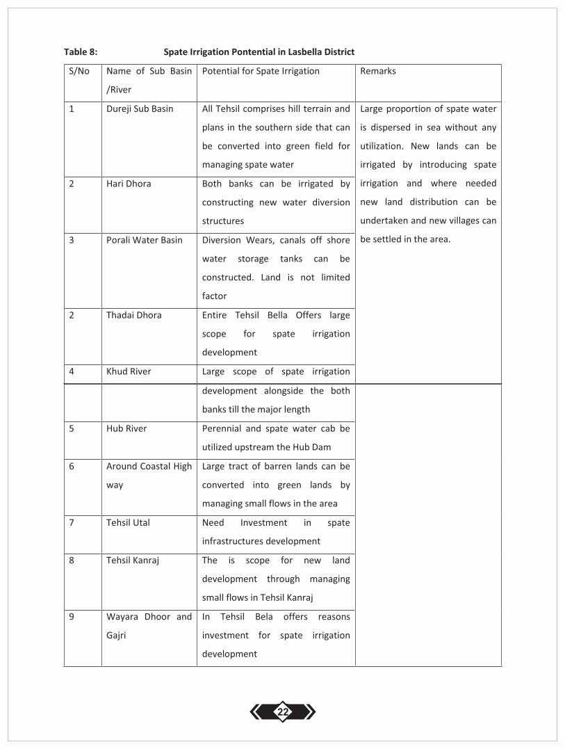
Some parts of the district are water rich. For example along the whole basin of the perennial Porali River water is
used for irrigation. Moreover, Porali River Basin is a large source of groundwater re-charge. The development of
groundwater irrigated agriculture started in the mid 90's and gained a high scale rise when a rich segment of
farmers in the province started to produce commercial fresh vegetables and green fodder for livestock.All the
products are sold in the Karachi market.
Similarly, irrigation is also practiced in the Hub Dam area where two minor canals from the dams are feeding the
lands in the Gaddani area. Mainly, vegetables, wheat, barley and green fodder are produced. Furthermore in the
north-west of Hub dam, Dureji area is also rich in water availability Farmers in this area are using perennial streams
and spate flows diverted through constructed irrigation canals successfully. Still there is a large scope for further
expansion of the new projects by building and diverting spate water in the plans of Dureji Tashil in Lasbella.
There is a famous archeological site in Lasbella as well called Cave City. Its ruins are from 1.500BC. In 1845 British
Colonial rulers mentioned it as an important historical site. The site is situated 40km from Bella City. There are many
Sufi Shrines in the district and for them Shah Norani is quite a famous place.
The following areas are identified as potential spate irrigation areas that will lead to poverty alleviation in the local
area and add to the Provincial exchequer on annual basis:
21
22
4 Spate Irrigation in Mekran Division
Mekran division consists of the following 4 districts Panjgur, Kech and Gwader respectively. Mekran Division
situated in south west of Balochistan, bordering Iran and Baloch Gulf. Recently the Federal Government has
developed Gwader Port which will contribute to the bright future of Balochistan through generating revenues,
development of road sector transport. The port is currently functional and connected to other cities in country
through a newly build coastal highway. Particularly it is connected to Karachi City and Indus Highway through Rato
Dero – Larkana via Khuzdar. The entire population in the area is Baloch and speaks Balochi.
The South West of Balochistan along the coast lines is a dry area. Only some small scale seasonal irrigation takes
place in and around the banks of different flood rivers. In Turbat (Kech district) the major source of irrigation is the
Kech River which is passing through Turbat city. The major crops cultivated are dates and fresh vegetables which are
seasonally grown. The dates are exported to other parts of country. The vegetables are consumed locally. Similarly,
in Panjgur the major source of irrigation is the Rakshan River which is passing through the Panjgur city. There is
surface-subsurface water availability in the reaches of Panjgur city which irrigates the both sides of River. Major
crops cultivated in Panjgur are dates, fresh vegetables and wheat on small scale. Apart from the dates, crops are
consumed and sold locally. The third important district in Mekran Division is Gwader which is devoid of fresh water
too. For the drinking purpose Akra Kaur dam was build in mid 1990 which is the main source of drinking water. The
water is pumped through a large network of pipe lines from a pumping station which supply water to the Gwader
and Jewani cities and to small hamlets settled along the sea. Local PHE department at Gwader is managing the
drinking water network and supplies from the dam.
The major source of income is daily wage labour in Karchi City and surroundings. Many people are engaged in trade
with Iran. There are also people who migrate to the gulf state such as Muskat and Oman serve in the local
government or earn their income from selling sea fish.
Small vehicles that are imported or smuggled from Iran are locally used for commutation in all three coastal
districts'. Similarly, POL is also coming from Iran. POL is further traded in other provincial markets and towns within
Balochistan.
Gwader is entirely dependent on Iran for food supply. Fish production is considered a major trade in district. Jewani,
Peshokan, Gwader, Pasni and Ormara are the coastal cities where fish and other sea food are sold on daily basis and
purchased by the local traders who further sell it in Karachi, Quetta, Khuzdar markets. Yet a large and surplus
portion of sea food is catched and sold by foreign fishing trawlers that are operating in international seas.
Small scale irrigation is also practiced around the Ephemeral Rivers
4.1 Panjgur District
The main source of irrigation water in district Panjgur is seasonal. However Rakhshan River, that is passing Panjgur
city, delivers water to farmers on the left and the right bank of the river that have developed small water channels to
23
their land locally called (korjo). Water right is divided among the farmers on the basis of having land on the left or
right river bank. As per local rule set by the farmers, none of the group is allowed to build any kind of permanent
structure across the river bed to tap the surface or subsurface flow. Moreover no evidence has been seen whether
farmers are utilizing spate water in Panjgur City. However, spate irrigation has been observed upstream of the city
along Rakshan River but at very minor scale. Similarly, no spate irrigation practices have seen beyond the city where
a surplus run off in Rakhsahn River offers development of spate irrigation.
In 2002, Panjgure got electricity that resulted in installation of many deep tube wells for irrigation. This has affected
the korjos. (Separate study is required to determine the effects). However the entire district has a potential to
develop and build new spate irrigation systems on various torrents. Furthermore there is a scope for spate irrigation
development in Guwarkoh Kaur area of Panjgure as well.
4.2 Kech (Turbat) District
The entire Kech district has a large spate irrigation potential along the Kech Kaur. Here spate runoff can be utilized
from small tributary and creaks. Kech River also offers sub-surface shallow water availability in most of its reaches
that can be supplemented with spate irrigation mainly up and down stream of the newly build (Mirani Dam). Spate
irrigation is practiced currently all along the Balnigor-Suruk road that need investment in land leveling, water
diversions, water distributions structures and land management. Similarly Bahri Kaur and Kil River in Hoshab area
offers a wide scope for spate irrigation as well. Spate irrigation based livelihoods opportunities can further be
explored in other parts of Kech District like Nihang and Nihang Kaur in Mand area, Shadi Kaur, Pidarak Kaur, Guruk
Khaur, Dada Kaur that offers huge development scope and livelihoods enhancement through spate water
management in valleys and lower semi arid pains annually. Tashil Buldea has also got a potential for development
and utilization of spate water in different valleys.
Moreover along the Turbat – Panjgur road there is a high scope of spate irrigation in Balgatar area, Patandar Kaur
and Sur Chap area. There is vast fine land available that can be irrigated by investing more in the development of
new spate irrigation systems in the district.
In recent times Mirani dams have been constructed in the district but it is not cultivating lands according to plan.
There are disputes on land and water distributions. There are certain protected areas for wild life which are known
as Dasht Natinal Park and Wild Life Sanctuary and further down Hingol National Park.
4.3 Gwadar District
Gwader district is bound with the Baloch Gulf in the south. Its main settlements are Jiwani, Peshokan, Pasni, and
Ormara which are basically fisherman towns. Fishing and sea food business is the main source of income for the
24
local population. Locally the fisherman man is called (Nahuda). They go offshore and fish during night times.They
use sailing boats. In the morning, the fishermen rewind the nets and clean the fish they catched during the night.
Normally, the fish is sold to big trawlers who sell the fish in international market. The daily average income per boat
in 2002 was around Rs.1.500-2.500.
The entire land in Gwader district is lying barren. Fresh water is only available in the areas close to northern hills.
The drinking water source in the district is Akra Kaur where a storage dam has been constructed by the provincial
government.
Entire Mekran Division including Gwader is depending on the food and merchandise supply predominantly from
Iran. Wheat flour, coca cola, eggs, sugar, audible oil, vehicles and their POLs are locally brought from Iran at cheaper
rates than other parts of Pakistan and sold on local markets of Mekran, mainly (Gwader, Turbat, and Pangure).
There is no irrigation taking place in the area. Approximately 75% percent of the local population in Mekran Division
earns their imcome through daily wages in Karachi, Dubi, Musquat, Sultanat of Oman and Iran. Local sources at
(Jiwani) mentioned that 5-10% local population is government employees in Iran. Large numbers of students from
Pakistani Balochistan are studying in Iran. There is high level of unemployment As a result, the majority of the youth
in Makran Division has fallen victim to drug use.
There is no credible scope of spate irrigation in Gwader district. However, areas along the Turbat – Gwader road also
offer spate irrigation expansion.
8 Spate Irrigation in Sibi Division
Sibi Division comprises 6 districts: Sibi, Bolan, Kohlu, Dera Bugti, Harnai and Ziarat. The later 2 are small in size with
comparison to other districts in the division. Harnai and Ziarat districts are inhabited by Pashtoon tribes while the
other 4 districts are occupied by different Baloch tribes. The terrain of the division comprises plains and mountains.
The road infrastructure is comparatively better in Bolan, Sibi and Ziarat and rest of the districts have low profile road
network.
Dera Bugti and Kohlu agencies are entirely occupied by Bugti and Marri tribes. Due to recent insurgency in
Balochistan, both districts are a no go area for development workers. The districts are economically poor and a large
amount of the population has been migrated to Punjab and Sindh and other parts of the Balochistan Province. Sui
gas is a natural resource which is coming from Sui-Dera Bugti Balochistan and is used for the national domestic and
industrial purposes. Both districts have many clans and linage groups of the tribes. Tribal Sardar controls the socio-
political culture of the districts. Literacy rate is low in both districts with comparison to other parts of Balochistan
Province. There is no significant agriculture produces in the area other than millet and sorghum in Dera Bugti. In
Kohlu district there are crop cultivated areas irrigated by tubewells and spate irrigation.
25
Harnai is a new established district. The district is geographically small but it is rich in water availability. Harnai has
got moderate temperatures in the summer. Large amount of fresh vegetables are produced that are mostly sold in
Quetta and Sibi. Harnai possesses large reserves of coals. The locals of Nasak, Zardalo and Sharag are engaged in
mining, mining related labor, transport and hotels businesses. The major dominant tribe in the disctrict is the
Tareen and the Kakar
The highland of Ziarat ranges 8.000-11.000ft above sea level. The winters in the mountains are harsh. Ziarat is
famous for its horticulture especially fresh apples, peaches and cherry fruits. Due to harsh weather conditions large
majority of the local population (60%) migrate to the Harnai plains where they spend the winter time. and return in
Mid April to their native areas. Ziarat is a tourist area and approximately 0.2 million peoples from various parts of
Balochistan, Sindh and Punjab are visiting Ziarat every year in summer months.
5.1 Sibi District
Three major hill torrents are flowing in Sibi District: Narri River, Chakar and Phujal River in Lehri tahsil.The provincial
irrigation department built a weir in the perennial Narri River. Water from the river is diverted and used for
irrigation and drinking purposes in Sibi and its surrounding villages.The estimated flow in the Narri is 120 cusecs
after moonsoon. The water is owned by local tribes, mainly Khajjak, Luni, Dhapal and Pani that are living in various
villages in the vicinity. The local government has also a share of water in the system and uses it for urban drinking
purposes and irrigating the landscapes in government premises of the Sibi City. There is a network of tertiary canal
for water distribution among the tribes mentioned.
Chakar River lays 15 kms in the east of Sibi City. The detail of the systems has been given in historical chapter
measuring scope of irrigation in Balochistan. The Water is historically diverted by local farmers. There are numbers
of off takes along the Chakar River. The first off take is (i) Talli (ii) Sultan Kot (iii) Raza Chandia (iii) Qaisar (iv) Chachar
and partially Mal area. All the off takes are irrigating approximately 10,000 acres of land in a good year. The water is
distributed on the principle of upstream first. The diversion systems are maintained jointly by the group of farmers
at each off take. The contributions are made proportionate to the size of land owned by the individual farmers. The
lands and water rights are registered in Revenue department SIbi.The entire water diversions structures are
(earthen) except Chandia. The systems needs rehabilitation, strengthening of embankments to avoid overtopping
of river at some locations, village protection walls and cleaning and extension of the centuries old systems are the
main problems along Chakr River.
Similarly, Phjual River is emanating from the Marri hills in the east. The Rivers flow east – west and then south
passing Lahri Village, Trehar Village and Bakhtiar Abad on main Jacobabad – Sibi highway. Final spate water enters in
the Narri River and ultimately dispersesin Kenjhar Lake in Sindh. The flood water from the river is diverted to
irrigation lands around Trehar and Lahri village at small scale. Further down, the spate water is utilized by several
villages of Domki Tribes. Sibi District is not entitled to the flood water from Narri River except its perennial flow
26
which is utilized by the farmers in and around SIbi City.
Surplus water of Chakar River are further diverted towards Mal Goramzai, and Theiri Baramani area where large
amounts of land lying barren. Similarly, surplus water from Phujal River is utilized on both sides of the 50 kms long
access road from Bakhtiarabad – Lahri Village. Furthermore villages bordering Dera Bugti District like Sonwah,
Maiwah and Mirwah areas are utilizing Phujal River water to irrigate their land every year. There is a need for land
development, diversion structures and water reservoirs in lower Phujal spate irrigated areas. New canals and
trenches may be developed to bring more land under vegetation cover, rehabilitate rangelandand recharge
groundwater aquifers.
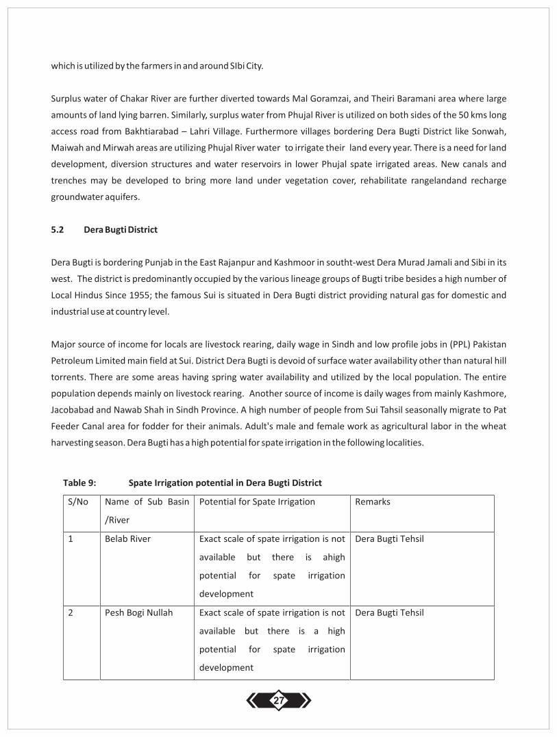
5.2 Dera Bugti District
Dera Bugti is bordering Punjab in the East Rajanpur and Kashmoor in southt-west Dera Murad Jamali and Sibi in its
west. The district is predominantly occupied by the various lineage groups of Bugti tribe besides a high number of
Local Hindus Since 1955; the famous Sui is situated in Dera Bugti district providing natural gas for domestic and
industrial use at country level.
Major source of income for locals are livestock rearing, daily wage in Sindh and low profile jobs in (PPL) Pakistan
Petroleum Limited main field at Sui. District Dera Bugti is devoid of surface water availability other than natural hill
torrents. There are some areas having spring water availability and utilized by the local population. The entire
population depends mainly on livestock rearing. Another source of income is daily wages from mainly Kashmore,
Jacobabad and Nawab Shah in Sindh Province. A high number of people from Sui Tahsil seasonally migrate to Pat
Feeder Canal area for fodder for their animals. Adult's male and female work as agricultural labor in the wheat
harvesting season. Dera Bugti has a high potential for spate irrigation in the following localities.
27

5.3 Kohlu District
Kohlu District is the area of the Marri tribe's who was founded by Chakar in 1550. Marri have been warriors in the
Baloch History of Balochistan. The district is mainly occupied by the various sub-tribes of the Mari tribe. A small
amount of Zarkoon belonging to the Pashton ethnic groups are also living in the vicinity of Kohlu City.
Kohlu has never been a good agricultural area. Agriculture is mostly rainfed and tubewells. Furthermore surface
runoff is used to capture moisture for crop cultivation. Kohlu comprises of large valleys. The human settlements are
based on clan and kinship basis of different sub tribes of Marri Tribe.
The entire population of the district is tribal; the clans are headed by their chief called wadera. The decisions are
28
made collectively not individually when the joint and common interests are involved. The Marri tribe remained
hostile to the government from 1974 when the federal government undertook astrong military operation. Since
then, the migration of the Marri tribe started and a high amount of Marri men left the area to settle in Sindh and
other parts of Balochistan. Initially migration took place for safety reasons that further converted into permanent
resident. In the mid nineties, electricity has increased the income from agriculture when a many people started to
use tubewells for agriculture in the surroundings of Kohlu City and its suburbs.
The locals are depending on rainfed agriculture, livestock and labour in coal mines in Chamalang on the border of
Loralai and Kohlu District.
Spate irrigation can be developed in many areas through Kohl district. The wider scope of such irrigation is possible
to intensify through construction of spate controlling structures in the following valleys:
Narri River - Passing near Karahi Maidan in Kohlu
Mawand - The entire Mawand Tahsil and mainly alongside the Sibi-Kohlu Road
5.4 Harnai and Ziaarat Districts
Harnai is rich in surface water. The all region is relying for irrigation on small perennial flows and shallow wells in
torrents passing through the district. The district is supplying fresh vegetables to the provincial market on large
scale. There are giant coal mines in the area. This creates the second largest source of income for the local people
who are engaged in transport and hotel business. There is no major potential for spate irrigation in this district and
no elobarate information on the subject is made part of this handbook.
Secondly Harnai is adjacent district to Ziarat. This district is severely cold in the winter months. Therefore many
people from Ziarat migrate to Harnai in December and stay until mid April. Almost 50% of the households' residents
in Ziarat district possess agricultural lands in Harani district as well. So, the people of Ziarat have two dwellings:
Ziarat itself in the summer and the Harnai plains in the winter season. Due to the steep slopes and volatile flood
flows, Ziarat does not offer potential for spate irrigation expansion.
5.5 Ziarat District
Ziarat comprises of mountains mostly covered with Juniper forest. Ziarat is a good place for local tourism in the
summer. It creates considerable income for the local people through renting guest houses and food based business.
The major part of irrigable land in Ziarat district is occupied by apple and cherry orchards that are irrigated by the
traditional karezes and deep tube wells and dug wells. The area receives heavy snow fall and precipitation in the
winter months which is the major source of water in district and recharges subsurface shallow aquifers used for
karezes and dug wells. Numbers of delay action dams are also build in the district to supplement irrigation water
needs and ground water recharge.
29
Spate Irrigation is practiced on small scale in the south eastern part of Ziarat beyond Shrin Viala. There is no high
potential for spate irrigation in this district apart from small scale water management through lined tanks. The
district needs protection against soil erosion. This can be provided through the contruction of stone packed gabion
structures along the rivers.
6 Spate Irrigation in Zhob Division
Zhob division comprises of 5 districts: Zhob, Killa Saifullah, Loralai, Musa Khel and Barkhan District. Most of the
areas in Zhob Division is tropical and gets excessive monsoon rains with comparison to other parts of Balochistan.
The entire region is moderate in the summer months and severely cold in the winters. Sherani and Killa Saifullah
districts get snow fall in winter every year. The population through Zhob division is sedentary and does not move
anywhere else with exception to several hundred households who have small ruminants flocks temporarily move
within their local territory in search of green rangelands for their animals.
The Zhob Division exists of various tribes of Pashtoon with exception to Barkhan that mainly comprises of Khetran
and Marri Tribes of Baloch. Major sources of income for the local population are irrigated agriculture followed by
livestock rearing and government employment and coal, (inferior type of) Onex and granite mining in the Loralai
and Killa Saif Ullah districts
The agriculture in Zhob division is depending on groundwater, natural springs, open surface shallow wells and
Karezez. Historically, the Pashtoons are not inclined towards spate irrigation system and its techniques. In the
division, no spate water rights or distributions practices are observed, neither registered in the land records.
However, in the rainy season farmers at local level divert small streams flows to fill their embanked bunds. Rabi
wheat, barley and mong beans are cultivated in Killa Saifullah district, Zhob District and part of Loralai district.
6.1 Zhob and Sherani Districts
Zhob is a district in a declared provincial tribal area which is borded by Afghanistan in the west, KPK in the north-east
and Killa Saifullah in the south. Zhob is situated 350 kms in the north of the provincial capital. The entire district is
mainly occupied by the Kakar, Mandokhel and Babar Tribes of Pashtoon.
Zhob has a tropical climate. It receives heavy rains during monsoon every year. Main sources of income are
agriculture, livestock, trades and government employment. Zhob entirely consists of hilly mountains with plains
and fertile valleys. The main water source for agriculture is predominantly perennial flows, springs and karezzes.The
recently build Sabakzai dam has added a new command area under irrigation in Mina Bazar area. It irrigates
approximately 7.000 acres of land on regular basis.
Zhob is rich in surface water Local communities settled along, Sawar River, Saliaza River, Zhob River. Irrigation water
is mainly diverted by the schemes constructed by the provincial irrigation department. No Formal spate irrigation is
30
practiced in Zhob District. But there is still a high potential for expansion, especially by investing in infrastructure,
land leveling and water distribution. The Following areas are suitable for spate irrigation in Zhob District:
Surab Manda and its both banks
Sra Khula Zhob
Tra Manda – Lakka Bund Area
Tirkha Manda – Margha Kibzai area
Both banks of Zhob River
In Laka band, shaghaloo and Tehsil Kamar Din Karez, the groundwater is shallow. Small scale pump sets can be
installed for irrigation. Traditionally the local population is depending on their livestock for income. The local
population is malnourished and economically poor and cannot make investment in the irrigation sector. A sort of
joint venture with community on share crops and investment basis can be set up in cooperation with the provincial
government.
6.2 Sherani District
Sherani has been a Tahsil of Zbob district and dissected to establish a new district in 2010. The entire Shirini district
is occupied by Shirini tribe of Pashtoons. There have been many local feuds thatlead to blood shedding. Majority of
local households in district earn their livelihoods from livestock rearing.The watersheds and mountains are
naturally green and offer a healthy environment for livestock breeding. The majority of the Shirini tribe is working in
the Arab Gulf States.
Irrigated agriculture is done on small scale for crops such as almond; wheat, barley, and maize. The agriculture
produce are mainly consumed locally. Surplus is sold in the outer market. The local population is not much inclined
to irrigation rather prefer to keep livestock. Agricultural employment is almost zero, due to non availability of good
soil in most part of the district.
6.3 Killa Saif Ullah District
Killa Saif Ullah district is abode the of the Kakar's Nawab that belong to the Jogezai tribe and has authority over all
Kakar tribe in Balochistan and Afghanistan. The area has been depending on spate irrigation until it was connected
to the national electricity grid in 1977. Human settlements are found along the rivers and dry water creaks. After the
rise of subsidized electricity, farmers switched 100% from spate irrigation to groundwater extraction for crop
cultivation. Major cash crops are fresh vegetables and fruits. The area bordering Afghanistan in the west forms a
large range land that offers livestock fodder for the seasonal nomads from Afghanistan and local livestock breeders.
Livelihood of local population is mainly depending on groundwater irrigation and livestock breeding. The villages
31
with electricity are now completely shifted to ground water for irrigation. Villages with no electyricity are
depending for their income on livestock rearing, government employment and trade.
Spate irrigation is practiced along Killasaifullah – Zhob high way on small scale where flows from nearby creeks are
diverted and utilized for irrigation. Temporary diversion structures build by the farmers are working well due to
small volume run off from the hills. Wheat, barley and mong bean are cultivated. Farmers depending on spate
irrigation are economically poor compared to farmers who cultivate cash crops with groundwater release from
tube wells.
The wide barren lands alongside the Zhob River starting from Kan Mehterzai offer the potential for spate irrigation
development. Balochistan government has recently prepared a pre-feasibility for the flood based farming by
constructing diversion structures in Killa Saif Ullah district to irrigate these plains. The proposed project will irrigate
5.000 acres of new occupied land.
6.4 Loralai District
Loralai district is occupied by Pashtoon tribes. The Kakar, Tareen and Nasar are the major tribes settled in the
various parts of the district. Irrigated agriculture in Loralai was affected by droughts in 1995-2001 when the major
irrigation systems depending on Karez supply run driy. In many villages 100% depletion of the groundwater aquifers
has forced local population to migrate elsewhere to earn any income.
Spate irrigation is largely practiced in Tehsil Mekhtar. Flood water is diverted from small and medium torrents.
Loralai Tahsil also lay in the range of monsoon which receives rains heavily in the season making green range land
and supply water for spate fed agriculture. Rains are erratic in this area and cause erosion.
The large majority of the people living in Tashil Duki are earning income from the local coal mines owned by the local
elite which provide large scale employment. Onex mines in loralai are also a major source of income which is owned
by the local communities. Coal mines of Chamalang are considered a large natural resource owned jointly by the
Luni and Mari tribe that provides high income to the local tribe's owners of the resource. The mining in Chamalang
has created new ways of income transport and trucking, hoteling and mining based employment in and around
Mekhtar area.
Spate irrigation has a much potential in Tahsil Duki, Tahsil Mekhtar and lower adjoining parts of the Sehan River in
Tehsil Bori where thousand acres of arid land are available. Ground water has been declined in Loralai district. There
is a need to develop and expand spate irrigation systems to meet the future food security of the increasing
population. The barren lands are owned by various local tribes and still lying under communal tenure. It can be
redistributed with the joint consensus of the tribes.
32
6.5 Musa Khel District
Musa Khel is situated 450 kms in the north east of Quetta. Musa Khel has been part of district Loralai until mid
eighties. Majority of local population belong to Musa Khel Tribe of Kakar Pashtoon with a couple of other small
tribes such as Jaffar and Qaisrani living in the eastern edge of district bordering Dera Ghazi Khan in Punjab –
Balochistan border. Local conflicts on land distribution, internal interest and tribal feud within the clans and tribes
remain high. The Primary source income in the district is livestock rearing followed by agriculture and daily wage
labor in Punjab. The entire district forms the catchment area for Snaghar River. Musa Khel is connected with Punjab
at Taunsa Sharif by a feeder road. Products for daily domestic use are also coming from Punjab.
The district falls under the monsoon range. That makes the annual rain fall higher in this region in comparison with
other districts of Balochistan. The north and north-eastern part of the range are naturally green which host the
nomad livestock herders of Musa Khel and Afghanistan. Similarly, in the winter Afghan nomads with their flocks
seasonally migrate through the district to the warmer Punjab plains.
Regular irrigation depends on small scale springs and perennial flows in the catchment. However the major part of
agriculture in Musa Khel district is rain fed. The local population is not used to irrigatetheir crops. Seasonal crops in
the area are wheat barely and sorghum which is consumed locally.
Following valleys and area offer potential for expansion of spate irrigation along the hill torrent in the district:
Loay Lahar - On both banks got a high potential
Kingri Nallah - Got a potential in various places
Luni Lahar - Small potential
Tributary of Lori Tang- Small Potential
Khajuri Nallah - Got a potential along its length
Sarin Lahar - Got a small potential
6.6 Barkhan District
Barkhan is bordering DG Khan Punjab in the east, Kohlu in the west, Dera Bugti in the south and Musa Khel in the
north. Bakrhan is entirely occupied by the different linage groups of Khetran tribe settled throughout the district.
The major source of income for the local population is agriculture, livestock, transport, and government
employment. The area receives heavy and regular monsoon rains every year. Some valleys in Barkhan are rich in
groundwater where farmers have installed tubewells to grow vegetables and other crops.
Temperatures in the summer are moderate. Farmers in Barkhan grow vegetables though March-June that they sell
on markets in DG Khan and Multan. Punjab is the nearest and common market place. The serious medical cases are
33
taken to the civil hospitals at D.G. Khan and Multan. For higher education there are many educational institutions in
Punjab.
The Khetran tribe has been in a historic conflict about land ownership with the Leghari Tribal Chief of DG Khan and
Sardar of Barkhan. Leghari Chief Claims that land in entire Barkhan valley is owned by his family which was given to
Khetran on tenancy and now the Khetran have occupied the land completely and not paying any share to the
Leghari. When Farooq Leghari Chief of Leghari Tribe became the president of Pakistan he started a case in Supreme
Court and won the ownership of land in Barkhan district. But he has not been able to secure land ownership.
Written In cadastral records of many valleys land ownership of Legharis and Khetran are their hereditary tenants.
In spate irrigation and rainfed cultivated areas in Barkhan mong beans, sorghum and millet are cultivated. The spate
irrigation practices in the district are different to other areas in Pakistan. Normally, the irrigated fields are in plain
valleys and catch the run off of the small hills and local plains.It is not common to divert water by ganda system or
diversion bunds except on a few typical locations on Rakhni manda. Farmers have built the dry stone intakes and
outlet at the field level and during rain the structures works properly without managing the water on the spot. Due
to heavy rainfall, the natural vegetative growth affects the crops seriously.
In Barkhan, many valleys lay under communal tenure that can be developed byrain water harvesting and spate
irrigation systems. There is no high potential for spate irrigation development in the district. However, minor
developments on water management, construction of inlet and outlet structures, land leveling would add to more
agriculture returns and incomes.
Following hill torrents and the valleys have potential for spate irrigation in Barkhan District:
Daula Rud and Tributaries - Through its entire length
Suka Lahar - Some it's Bottom Valleys
Pir Wali Naddi - Some of its Bottom Valleys
Churi Naddi - Some it's parts
Chang Area - Large Valley with spate harvesting potential
Wandoi Lahar - Some of its parts
Malain Area - Some of its Parts
Karach Nala - Some of its Bottom Valleys
Han - Its Bottom end areas
7 Spate Irrigation in Naseerabad Division
Naseer Abad Division situated in the east of Quetta on Main Jacobabad-Sibi -Quetta Road. Two of the four districts,
Naseerabad and jaffarabad, depend on the Indus River Canal systems for perennial irrigation. Patfeeder, the
34

recently built Rabbi Canal and the Kirthar Canal are serving the irrigation water needs of the districts. Dominant
tribes in Naseerabad division are Rind, Raisani, Chalgri and Jamoot in Bolan, Umrani, Khosa and Jamali in Jaferabad
and Naseerabad, Magsi, Lashari and Syed in Jhal Magsi district. The main spoken language of the area is Balochi and
Saraiki where Sindhi is widely spoken through all the districts in Naseerabad division. A high amount of local Hindus
live in all districts.
A Larger proportion of land in the districts Naseer Abad, Jafferabad, Bolan and Jhal Magsi is owned by the feudal
Baloch tribe. There are other tribes who own high amounts of land in western Balochistan. Among them are Lehri,
Zehri, Sasoli, Bugti and Mengal Baloch. The later have purchased the landin the past or acquired land rights during
the Kalat sate times. Hindus do not possess agricultural land and earn income from local trade, selling and buying of
surplus wheat, rice, sorghum and other local harvests.
Each tribal chief lives with his clan's men in their respective area. The tribal chiefs are traditionally making the
decisions at the time of conflicts and armed feuds. Local governments in the area are constituted through the will
and support of these localchiefs. In this case the government in this district is weak in power with comparison to
other district governments in the country.
Bolan is a very dry region. Only land is irrigated from water that comes from the Bolan River. Irrigation from this river
is taking place in Drabi, Rind Ali, and Kot Raisani area. However a large part of the Bolan district is depending on
groundwater from tubewells and spate irrigation. Land in the District of Jhal Magsi is irrigated from the perennial
flows of Mula River. The water is distributed among the different tribes. However the major amount of water is
used by the Bhotani Clan of the Nawab Magsi. The Lashari's of Patch, Syed in Fatehpur. Furthermore the
government farm Gandawa is also using water from the Mula River. There are few more springs in western Kirther
Range that are owned and utilized by Dinari at Khari, Kasuk at Konara and Shoran River for irrigating land in Gajan in
Jhal Magsi and Shuran in Bolan District.
The rest of the eastern lowlands are depending on seasonal spate irrigation, where majority of the population are
living in poverty. Normally the local people from these local areas seasonally migrate every year to canal irrigated
areas of Jafferabad and Naseerabad in search of livelihoods and green fodder for their animals.
Wheat, sorghum, mong, millet and mustered oil seed are the major spate irrigation crops in Bolan and part of Jhal
Magsi districts. Several water basins end up in the Nasseerabad Division that is mainly Bolan River, Mula River,
Kashuk River, Narri River, Chakar River and Phujjal Rivers. These rivers have the tendency for causing damages at the
lower parts of Naseerabad Division along district Dera Mrad Jamali. The surplus water from the rivers finally
dispersed in Manchar Lakre in Sindh.
35
7.1 Bolan District
Bolan district with it's headquarter at Dhadar is situated at the gate of Bolan Pass/River that enters in the Kachi
Plains. The dominant tribes in the area are Rind and Raisani. There are a few other small Bloch groups living in the
area such as the Khosa, Mugheri, Chalgri and Jamoot. District Bolan is a dry region. Only small permanent flow in
the Bolan River is utilized for irrigation by the Syed Dopasi, Raisani, Rind and Khosa tribes settled in Rindali and
Mushkaf village along the Sibi-Quetta National Highway. The major crops grown in this area are fresh vegetables,
wheat, barley and green fodder. Green Fodder is sold to the large commercial dairy farms in Quetta.
The remaining areas in Bolan are depending on spate irrigation. Mainly Rind, Raisani, and Shahwani tribe along the
Narri River are beneficiaries of spate irrigation. Spate Irrigation in Bolan district developed by the Kalat State was
distributed to tribes that joined the major state based military expedition in the time of Khanat. In Balochistan, the
Narri River spate irrigation system had been one of the well defined systems that is properly operated and
maintained by the local farmers under the supervision of Kalat State. Government of Balochistan is currently
building a modern spate irrigation system by placing mini barrages to replace the 6 traditional major off takes
(gandas) along the Narri River. The barrages would be electronically operated through locally generated electric
power and trained staff of Provincial Irrigation Department. With an estimate 150,000 acres of land will be irrigated
after the completion of the construction.
In the past the Bolan Dam and Mahram Dam were build to supplement spate irrigation. Both structures were
washed away during the 1985 floods and never re-build until now. In Balochistan, famous Mehrgrah Civilization
traces are found in Bolan that refers to 7.000 BC. There are ancient signs of spate irrigation in Bolan. Up hill Gazg,
Narmukh and Johan areas where large gori bund are still visible. District Bolan consists of hilly regions in the west
and Kachi plains in the east. This offers large potential for spate irrigation development. The following hill torrents
are potential area for spate irrigation expansion in Bolan district:
Bolan River - After Pir Thango area, the banks along the river have high potential.
Sukleji Rver - There is a high scope to irrigate the left bank lands
Narri River - There is large scale irrigation and efforts are required in introduction
- of agricultural extension and water management at canal level.
Mushkaf Nallah - Spate Irrigation is practiced but there is a huge scope for
expansion by digging new canals further downstream
Paro Nallah - There is a high potential in the lower plain area through water
managements and diversion structures.
Bibri/Sibri Nallah - High potential is diverting spate water to irrigate the land on
the right side of the river down the Sibi-Dhadar Road.
Dong Nallah - Reasonable potential in plain area where nallah emerge
Dhong Jhal - Reasonable potential in plain area. Needed land leveling and
36
water diversions
Kharo Nallah -Height potent ia l for spate i r r igat ion by managing water in
lower plains through- building canal, land level and field
embankments etc.
Phujjal - Tahsil Lehri area
7.2 Jhal Magsi District
Jhal Magsi has been part of Kachi district and got its district status in 2002. . The district lay in the foot hill of Kirthar
Range in the west, District Shahdad Kot in the south, district Bolan in the north and the eastern frontiers are
bounded to jafferabad and Naseerabad districts of Balochistan. The major ethnic groups are Magsi, Lashari, Dinari,
Syed and Jamoot. The land resources are largely owned by Nawab Magsi family in the district. In Pach, Kotra and
Kunara villages lands are owned by the Lashari's. Khari area is under the ownership of Dinari Baloch tribes. Size able
parts of lower plain irrigated by floods are owned by Syed, and other Jamoot tribes settled in the Gandawa and its
suburbs. There are 200 numbers of local Hindu families living in both tahsil Gandawa and Jhal who are mainly
engaged in local trades and –lend money to the local farmers for their day to day needs.
Floods from the hill torrents of Western Kerther Range are used for spate irrigation mainly in the lowland areas of
Tehsil Jhal and Gandawa. The rest of the water further drains to the east and then to the south and finally ends up in
Manchar Lake in Jamshoro district of Sindh Province.
The lands are distributed among the tribes at household level. There are no communal lands other than the
mountain range. The main source of income of the local population is agriculture and government employment.
The Nawab Magsi overall dominates the district in managing tribal conflicts and local politics. An occasionally
armed conflict erupts between the various tribes over the tribal matters. These conflicts were finally resolved in
Balochi Jirga through tribal elders. The political situation in the district, being in the vicinity of Sindh Border's is
however still unstable. It is unsafe to travel by road by night. Road robberies are often reported in local media.
Western line of Kirther range is rich in ground water. There are many springs and perennial flows that irrigate the
small lands. Mula River is main source for spate and perennial irrigation. Perennial water in the river is utilized by
the local farmers groups in Gandawa Tahsil. Water is distributed at the village level down to household level.
Large proportions of spate irrigated land are owned by the Nawab Magsi family in Tahsil Jhal with small
entitlements to the rest of the Magsi Tribe. The spate irrigated lands elsewhere in the district are tenant operated.
At the time of harvest the authorized Naib of the Nawab are informed for Batai distributions of shares. This is done
individually with each tenant. The share of Nawab is collected and sold by the Naibs.
Local markets are Gandawa and Jhal and are mainly owned by Hindu traders. Cash payments are not common.
Especially the small land owners and tenant families are borrowing daily needs from Hindu and the loans are re-
paid at the harvest. In some cases tenants hardly have any harvest left after Batai and the major left overs are
spent to settle the debts he has on monthly basis.
37
7.3 Nasirabad and Jafarabad District
District Naseerabad and Jaffarabad are bordering Sindh in the South. Both districts are connected with the Indus
connected Pat Feeder and Kirther canals. The dominant tribes in the districts are Jamali, Umrani, Khosa and Bugti,
Kharani, Nandwani and Jamoot. The tribal feudal possess large size of irrigable land in the district. The lands are
mainly operated by tenants. The major languages of the area are Sairaki and Sindhi. Major crops grown are paddy
and wheat. Winter vegetables are also cultivated in the districts and sold in Quetta.
Pat Feeder canal is passing through district Naseerabad. The torrential floods from Narri, Phujal, Bolan, Mula,
Kashuk are finally joining in the north of Dera Murad Jamali and flow along the right bank (Beroon) of the canal. High
floods inundate pat feeder in the tail close to Tahsil Chattar and flows towards south to finally disperse in Manchar
Lake,Sindh.
There is no scope of spate irrigation in the district at all. However, both districts have been affected by Indus floods
in 2010 and there is a need to construct flood protection dikes in various villages to cope with future floods. There is
a further need to train and sensitize the local population how to build houses particularly on artificially elevated
dikes.Howver the positive side is that due to flood water accumulation, there are small wet lands in the district that
host migratory birds in winters.
38
SPATE IRRIGATION IN PUNJAB PROVINCE
Chapter -II
8. Spate Irrigation in Punjab, History Current Status and Practices
8.1 History of Spate Irrigation in Dera Jaat
Spate irrigation in district DI Khan and DG Khan called Dera Jaat in British colonial records is not older than 500 years
when Baloch tribes migrated with Chakar Rind to Punjab plains. Koh-e-Suleman or Suleman ranges were occupied
by various migrant Baloch tribes. Tribes that settled down in the province from north to south area: Kaisrani,
Buzdar, Khosa, Lund, Leghari, Mazari and Dreshak and Gorchani. The entire lands in piedmont area of suliman range
and inside the mountain are occupied by these tribes within their own tribal boundary. All the tribes have their
known boundaries. The lands are distributed on the linage basis.In the past, the province have been under the rule
of various tribes. Under the Kalat State, the province was under the rule of the Baloch tribe. Then it was occupied by
the Nawab of Bahawalpur which later on was taken by Sikh density of Ranjeet Singh. Ranjeet Singh was expelled by
the English Colonials.
English colonials introduced land rights through recording the land title under Management System of Land
Revenue Department. Though there have been quarrels between the English colonial and local tribe men on the
inheritance rights to be given to the females which were denied by some tribes in Dera Ghazi Khan.
Spate irrigation systems were developed by setting the scale of operation and maintenance depending on the the
size of cultivated land. The same rules were used during land settlement from 1860-1901 in Dera Jat District.
Separate Rodh Kohi staff was appointed to settle and record the water rights. Water thefts, intentional breaches of
ganda and land right conflicts were put under the government rule. The department and staff still exist but their
support to the farmers is now diminished by taking care of the old records.
9 Current Status and Practices of Spate Irrigation in Punjab
Punjab province is depending on Indus River and Jehlum River to supply watet to t world largest canal irrigation
systems. There are three broader types of irrigation systems prevailing in the province: Perennially fed Punjab land,
tropical range fed regions and dry hill torrents.
Panjab's major piece of land is irrigated from the Indus and Jehlum River. The Potohar region comprises, Jehlam,
Chakwal and part of Mianwali, surrounding of Islamabad Capital, Haripur and Manshera districts. These districts
are tropical rain fed regions and are depending on seasonal rains for crop cultivation. Estimatedly, 50% land in
western hilly regions of Dera Ghazi Khan Rajanpur in south Punjab is irrigated though spate irrigation. This guide
book does not include any recommendations of the rest of Punjab irrigation sector and will stick only to the spate
Irrigation area with defined water distribution systems in Dera Ghazi Khan and Rajanpur. This Guideline does not
discuss khushkaba rain fed regions including Jehlam, Chakwal, Mianwali, Islamabad Federal Capital Territory and
Mansehra.
39
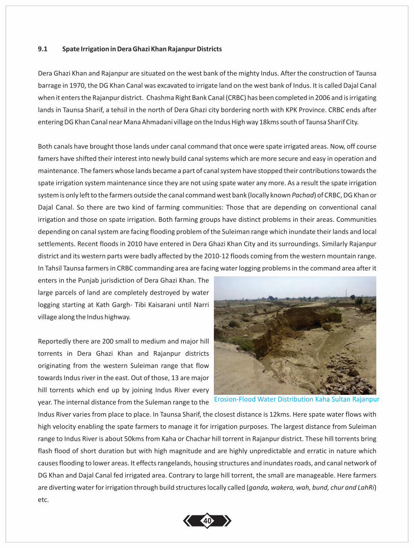
9.1 Spate Irrigation in Dera Ghazi Khan Rajanpur Districts
Dera Ghazi Khan and Rajanpur are situated on the west bank of the mighty Indus. After the construction of Taunsa
barrage in 1970, the DG Khan Canal was excavated to irrigate land on the west bank of Indus. It is called Dajal Canal
when it enters the Rajanpur district. Chashma Right Bank Canal (CRBC) has been completed in 2006 and is irrigating
lands in Taunsa Sharif, a tehsil in the north of Dera Ghazi city bordering north with KPK Province. CRBC ends after
entering DG Khan Canal near Mana Ahmadani village on the Indus High way 18kms south of Taunsa Sharif City.
Both canals have brought those lands under canal command that once were spate irrigated areas. Now, off course
famers have shifted their interest into newly build canal systems which are more secure and easy in operation and
maintenance. The famers whose lands became a part of canal system have stopped their contributions towards the
spate irrigation system maintenance since they are not using spate water any more. As a result the spate irrigation
system is only left to the farmers outside the canal command west bank (locally known Pachad) of CRBC, DG Khan or
Dajal Canal. So there are two kind of farming communities: Those that are depending on conventional canal
irrigation and those on spate irrigation. Both farming groups have distinct problems in their areas. Communities
depending on canal system are facing flooding problem of the Suleiman range which inundate their lands and local
settlements. Recent floods in 2010 have entered in Dera Ghazi Khan City and its surroundings. Similarly Rajanpur
district and its western parts were badly affected by the 2010-12 floods coming from the western mountain range.
In Tahsil Taunsa farmers in CRBC commanding area are facing water logging problems in the command area after it
enters in the Punjab jurisdiction of Dera Ghazi Khan. The
large parcels of land are completely destroyed by water
logging starting at Kath Gargh- Tibi Kaisarani until Narri
village along the Indus highway.
Reportedly there are 200 small to medium and major hill
torrents in Dera Ghazi Khan and Rajanpur districts
originating from the western Suleiman range that flow
towards Indus river in the east. Out of those, 13 are major
hill torrents which end up by joining Indus River every
year. The internal distance from the Suleman range to the
Indus River varies from place to place. In Taunsa Sharif, the closest distance is 12kms. Here spate water flows with
high velocity enabling the spate farmers to manage it for irrigation purposes. The largest distance from Suleiman
range to Indus River is about 50kms from Kaha or Chachar hill torrent in Rajanpur district. These hill torrents bring
flash flood of short duration but with high magnitude and are highly unpredictable and erratic in nature which
causes flooding to lower areas. It effects rangelands, housing structures and inundates roads, and canal network of
DG Khan and Dajal Canal fed irrigated area. Contrary to large hill torrent, the small are manageable. Here farmers
are diverting water for irrigation through build structures locally called (ganda, wakera, wah, bund, chur and LahRi)
etc.
40
Erosion-Flood Water Distribution Kaha Sultan Rajanpur
During the last decade, Punjab Irrigation Department Circle Dera Ghazi Khan built such structures in Mithawan,
Kaha, Kaura, Vehoa, Taunsa and Wadoor Hill Torrents. The main structures built are bed stabilizers, wire crated
diversion bund and intakes, Guide bunds, Erosion control walls, RCC intakes and flow division structures.
Construction work in some areas is still in progress. The main construction focus remained on the diversion
structures and no attention is given to the spate feeding canals which are either silting up or causing serious erosion
due to secured and augmented water supply from constructed diversions. It is imperative that the spate irrigation
should be seenas a whole. All three components must be included in the project plan (i) the diversion structures, (ii)
the main feeding canals and (iii) the command area development works. For example in the project channel bed
erosion in the feeding channels of Bigwari wah on Sanghar spate irrigation and Haji wah on Mithawan hill torrent is
not addressed. The channels beds are badly eroded and farmers are not able to divert water to their fields. As a
result, water in the channels is flushed away to the Indus or disperses in lower command depressions which cannot
be used for cultivation. It deprives the upstream farmers. Similarly in Kaura, the construction of proper headwork is
now causing flooding in the lower command area and local villages. These constructed structures at the river level
are free intakes which cannot stop the undesired flood flows.
Line department elsewhere are more focused on the construction of head works and guide bunds or to safely pass
the hill torrents floods to Indus River without causing damages to the public and private owned constructed
structures.
Additionally, there are drainage problems in major hill torrents in the district. After the excavation of DG Khan or
Dajal Canal in 1970, proper cross drainage structures are either not builds to pass the peak floods or they have been
silted up with the passage of time. Encroachment of the natural drainage routes are further narrowed down by the
local farmers. Another factor of flooding in Rajanpur district is the construction of Kachhi Canal which has blocked
the water in the 2010 and caused flood damages in the surrounding villages in Rajanpur district mainly in the west
of Kachi canal.
There are 2 major types of spate irrigation systems in Dera Ghazi Khan (i) in the mountains (ii) in the piedmont areas.
The farmers living in the mountains have small- pieces of land. Those are irrigated by water runoff from creaks that
is managed and drained during rain. Hence major problems of this category of spate system are frequent soil
erosion around flush structures. Intensive repairs needed are sometimes beyond the farmer's capacity. It is relevant
to mention that in the mountains spate irrigation is still done with bullocks due to none availability or in some cases
none accessibility of tractors and agricultural machinery. Protection of land is more important to save the small land
holdings from frequent erosion. Due to remoteness of catchment ranges, accessibility problems, the availability of
machinery spate irrigation practiced in the mountains are in bad shape. None of the governmental/NGOs have
focused on improvement of these irrigation systems.
Spate Irrigation in piedmont areas can be classified into sub-types. The first type is hill torrents where floods are
passing through the small and medium catchments yielding manageable flows. Small hill torrents used for the spate
41
irrigation have their distinct problems. In many cases there are disputes among the farmers over the distribution of
water. The farmers of such systems are economically poor and their efforts to system maintenance to rehabilitate
the inundation, and frequent breaches of diversion structures and soil erosion is weak. The second type of spate
irrigation in piedmont areas is where water that flows from small hilly routes called (chur or lahRi) and irrigates 50-
100 acres of land in a good year. Such systems are manageable and local farmers are successfully practicing the
spate irrigation through this category of irrigation system. Problem in this category are smaller with comparison to
farmers on medium-major hill torrents. rdSimilarly the 3 type of irrigation consists on medium to large hill torrents where water is distributed and diverted
from rivers. Along such rivers, there are always series of off takes (ganda) that divert water to individual canals
which is owned by the certain amount of famers. The maintenance of the diversion bund (ganda) is the collective
responsibility of the farmers taking water from that particular channel/wah. The maintenance of the wah is the
responsibility of the farmers. Similarly after the floods, the channel beds are cultivated and owned by the
neighboring farmers where it passes.
There are rules and regulation for maintenance and breaching of ganda and water distribution which are respected
and adhered in all parts of DG Khan, DI Khan, Rajanpur, Bolan, and Sibi districts.
The following main River in DG Khan and Rajanpur district is where spate irrigation is practiced. All systems are in
bad condition. Due to none availability of earth moving machinery and change in land rights and further land
distribution in the linage groups has reduced the land holdings. Most systems have become none productive. The
following systems can be improved through more investments in diversion structures:
Vehoa Roud - More New canals and Disaster Risk Management
Kaura Road - More new canals and Disaster Risk Management
Litra Hill Torrent - Water distributor, canal improvement and diversion structures
Bhatti Hil Torrent - Water deflector, guide bunds and land improvement
Kawhan hill Torrent - Diversion of water from Sanghar in the catchment, new canal for
reserve land, flood protection, intake structures (mohan).
Snghar Hill Torrent - More water management in Sokar village and Magrotha village
Mohi Hill Torrent - Water deflector, intake structures and outlet structures
Suri Lund - Diversion structure on both side of river in line with traditional water
distribution
Mithawan Roud - Improvement of diversion structures, flood protection structures,
- improvement of feeding canal, resolve the command problems.
Wadoor Roud - Water Diversion, flood protection around Wadoor village, and along
- the edges passing in the west of DG Khan City
Kaha Hill Torrents - Improvement in feeding canals, and at field water management
Chachar Hill Torrent - New diversion structures and proper drainage of access water.
42

10. SPATE IRRIGATION IN KHYBER PASHTOONKHAWA PROVINCE
Chapter III
Current Spate Irrigation Status and Practices in KPK
In KPK, well know nspate irrigation systems exist in Dera Ismail Khan. However, small scale spate irrigation is
practiced in Luki Marwat and Kohat Districts of the province. There is large potential for spate or conventional
irrigation on the hill torrent passing in the south of Bannu where large tracts of lands are lying barren on the both
sides of the river. Evidently, the width of the river is large here and it could be a problem for the local farmers to build
diversion structures. It appears that in past, local farmers have never tried to divert and utilize water from the River.
Dera Ismail Khan is the most southern district in KPK province. The district is bounded in the east by Bhakar and
Mianwali in Punjab, in the southwest by South Wazirstan Agency and Zhob in Balochistan and in the northwest by
Laki Marwat and Tank District. DI Khan livelihoods depend on agriculture that can be further divided into 2 major
categories (i) the canal fed agriculture and (ii) Spate irrigation based agriculture. In this guidebook the focus is on
spate irrigation.
There are 25 sizeable hill torrents in the district: Pezu Nallah, Paniallah Nallah, Tank Zam, kiriana Nallah, Takawara
Nallah, Hauz Khad, Soheli Nallah, Gomal River, Gomal Nallah, Luni North Nallah, Mochiwala Nallah, Bhuar Nallah,
Khad Haranwali, Luni South Nallah,Sheikh Hyder Zam Toya Nallah, Draban Zam, Khad Warukay, Chudwan Zam,
Kaura Khad, Gudh Nallah, Gajistan Nallah, Valhari Nallah, Sherana Nallah and Ramak Nallah. Along these hill
torrents, spate irrigation is practiced. Rivers carrying the name with Zam mean that they have perennial flow
availability throughout the year that is utilized by the locals. As per distribution, the upstream users have the first
right to utilize the perennial flows as well as the floods flows. 0.63 Million acres of land is irrigated through spate
irrigation every year.
Water distribution rules are well defined among the farmers and registered with the Revenue Department at Dera
Ismail Khan. Each of the rivers is feeding certain numbers of gandi along its length in series. Each gandi is entitled to
divert water as long as it survives the flood or its entitled command area is fully irrigated. Once the command area is
full irrigated, farmers are not allowed to re-build their gandi and traditionally (as per riwaj) are bound to let the
water flow to the downstream gandi to irrigate the land of those groups of farmers. Saropa-paina (head to tail
water distribution is practiced at River level, gandi level and channel level). The maintenance of the certain gandi,
its (saad the guide bund) is the responsibility of the group of farmers who belong to the gandi. There could be
several groups of farmers with the water rights on relevant gandi. There are also farmers owning land in more than
one gandi. The maintenance cost is collected jointly depending on the size of land owned under the Haqooq,
literally recognized rights of land and water. There is land further downstream that are declared non-haqooq having
no water rights in the hill torrents. So owners of such lands are not entitled to perennial or spate water, though the
43
lands are bunded and developed. Some of these lands get surplus water from breeches of fields in the vicinity.
Spate irrigation in DI Khan and elsewhere is in dismay due to shifting of interests of farmers in other sources
ofincome. DI Khan lower plains are now irrigated by the recently build Chashma Right Bank Canal (CRBC). For the
spate irrigation system that is left to the tenants it is unclear who is responsible for the maintenance and operation
of the systems. Due to none availability of earth moving machines the rehabilitation of canals and gandi on regular
seasonal basis is a difficult job and as a result many systems are damaged so badly that it beyond repairs.
Revenue department of District DI Khan is receiving marginal financial support in terms of bulldozers hours from
the provincial government for the 25 spate irrigation systems every year which is not sufficient to meet the needs.
There is no mechanism for the management of the meager resources provided for spate irrigation. In many cases
local MPA influence the process which erodes the equality based resource distribution among farmers.
There is large scope to bring more lands under spate irrigation command if the services are extended to the entire
spate irrigation systems in DI Khan. Huge investments are required in the construction of diversion structures,
improvement of feeding canals and land development.
KPK government has recently completed Gomal Zam Dam with the financial support of US aid. The scheme has yet
to be opertionalized since the district administrations together with the line department is working on the water
distributions among farmers and constructing tertiary canals network in the command area. The irrigation water
within the system of Gomal Zam was distributed according to Riawaj and Kuliat defined water distribution rights.
Now the situation has changed and new rules for water distribution would need to be defined and redefined. It is
estimated that 150,000 acres will be irrigated from the recently build structures. There is a potential risk for conflict
on water distribution among the farmers entitled for perennial water flow and the farmers entitled for spate water
irrigation under the old system.
44
11. SPATE IRRIGATION IN SINDH PROVINCE
Chapter IV
Spate Irrigation in Sindh Province
Sind province is entirely irrigated by the large canal networks dissecting from Gudu, Kotri and Sukkhar and Ghulam
Mohammed Barrage. However, spate irrigation is practiced in Kohistan area of Sindh province mainly in the north-
western Kerther range along Dadu, Jamshoro and part of Karachi district. There are dozens of other small to
medium hill torrents flow every season to the Indus River without being used for spate irrigation.
Similarly the entire western side of the Indus, from Jamshoro – Dadu, is entirely depending on spate irrigation.
However in this area spate irrigation systems are not yet developed. The development of the small scale spate
irrigation systems in the Kirther range is neglected by the Sindh government that has no development program
running in this area. For instance, farmers who live in the mountains and are now depending on livestock as the first
mean of income could use the small scale perennial flows in the area for irrigation. Similarly, people who live in the
piedmont area along the Jamshoro – Dadu- till the Balochistan frontiers are entirely depending on seasonal rainfall
for irrigation, livestock water and domestic wateruse. In many areas if it doesn't rain for a year, the groundwater
level drops down significantly and open surface wells are becoming dry.
11.1 Spate Irrigation in Jamshoro District
Jamshoro District in Sindh province is famous due its Agricultural University and Jamshoro Power Project. Jamshoro
is situated on the right bank of the Indus A log bridge connecting it with Hyderabad. One can say these are twin
cities. But the geographical area of Jamshoro is stretched to the north until district Dadu. Small scale Indus water
based irrigation is practiced along the right side of Jamshoro-Sewan Road mainly south of Sun Tahsil.
Jamshoro comprises plain lands and hilly terrains in the east and Kirther hill range in the west. A large part of
Jamshoro is dry . Many hill torrents flowing from Kirther are disappearing in the Indus. The larger majority of the
District population belongs to various Baloch tribes mainly Chandio, Khakheli and Syed. A small amount of farmers
living in Sun Tahsil, are pumping from a long distance water the Indus for irrigating winter wheat.
Spate irrigation systems that are well organized by Farmers in Sun Tahsil District Jamshoro are situated along the
Ocha River where from Khaskheli Goth, Joda Khosa Goth, kachi Goth, Abra Goth. Sher Khan Goth, master nazar
Mohammad Khakheli Goth and Mirwani goth are diverting the spate water for irrigation. Abra Goth is the largest
beneficiary and is large in population size. There is formal distribution of the water between the various villages.
Nothing is registered in cadastral records. Ocha River inundates the soil bunds and earthen structures when the
excessive flood comes. Sindh Irrigation department is considering building large storage dams in the catchment
area as irrigation reservoirs.
45
Ranni Kot River is another large spate water river. Most of its flood water flows into the Indus River in the east.
Recently the local irrigation department has built a new spate irrigation system close to the Rani Kot-Sun road. No
water distribution is introduced by the department until the completion of the scheme. As a result influential
farmers are the major beneficiaries of the project. The project hassignificant impact in the surrounding of the
Railway line in the east where groundwater has been recharged and farmers have started to pump water from
dugwells to irrigate small patches of lands along the Rani Kot Road.
Spate irrigation can further be developed in the following areas of district Jamshoro by building diversion
structures, feeding canals, , and water ponds. Furthermore there are large plain lands available in District
Jamshoro's North that can be converted into spate irrigation:
46
11.2 Spate Irrigation Malir Karachi District
Karachi is a cosmopolitan city with a population of 120 million. Karachi is the provincial capital of Sindh and belongs
to the National Hub of top largest cities generating revenues. There is significant scope of spate irrigation in the east
then along Karachi – Hyderabad Highway that consists on hilly and dry. The major population living in the area is
rural and belonging to various Baloch and Jamoot tribes. People in Noor Mohammed Goth and Khatore area are
depending on employment in Karachi as their main source of income. Being a least devalued area and small scale
irrigation; no significant investment has been made on the development of local irrigation systems mainly depends
on torrential rains run off.
The following areas are identified as potential spate irrigation sites.
11.3 Spate Irrigation in Dadu District
In Kohistan area there are hundreds of small to medium sized Nai or hill torrents . Nihang Nai, Angai Nai, Taki Nai,
Nali Nai, Shori Nai and gar Nai enter in Kacha area and finally flow into Manchar Lake. The major spate irrigation
system in Dadu district was constructed in 1934 called (Teer Bhit). This system was washed away in the 1995 flood
and rehabilitated in 1996 by Sindh Irrigation and Power Department.
Spate irrigation systems in this district are well defined in term of water and land distribution which is locally called
warabandi. In Kerther National Park area in the vicinity of Thana Bola Khan Farmers are also utilizing ground water
to supplement the spate irrigation and grow vegetable and onion on small scale level. The reported ground ater
depth in the national park area is 6-17m deep where farmers have developed hundreds of dug wells to grow cash
crops. Crop production through spate irrigation and the use of groundwater is the main source of income for the
local people in the area. Livestock is considered the second source of incomes. Gaj Nai is the largest spate irrigation
system in the upper Kirther hills which is feeding 9 separate off takes.
47
5 taluka in Jamshoro and Dadu district are entirely depending on spate irrigation that mainly include Dadu, Johi,
Sewen, Kotri and Thana Bola Khan. Moreover people in Bhan, Haji Khan Village and Hairo Khan – Johi are 100%
depending on spate irrigation farming. Reportedly 15.000 acres land was irrigated in district Dadu in 2001. This is
before far below the available arable lands that can be irrigated in District Dadu . Large amount of the population
migrate to the lowland in district Thatha to work as agricultural labor during the harvesting season every year.
12. ENGENEERING DYNAMIC IN SPATE IRRIGATION
Little investment has been made throughout Pakistan to develop and maintain this indigenous form of irrigation.
Pakistan is the largest country in world practicing spate irrigation. Throughout the 4 provinces, similar types of crops
and are cultivated in spate irrigated areas in similar types of environment. Furthermore the languages spoken in the
spate irrigation through all 4 provinces are of the same of dialect mainly, Saraiki, Sindhi and Balochi. A large majority
of the spate irrigation lands are from the Baloch tribe where Pashtoons own a large amount of spate irrigation areas
in Pakistan, predominantly in Balochistan.
Not many researches have been done in Pakistan in the selection of improved crop varities for arid agriculture.
Farmers are still using local seed varieties that have lost their production capacity. For instance the sorghum yield in
spate irrigation areas in Pakistan is far below t the sorghum yield that is produced in spate irrigation areas in Africa.
No research in Pakistan is focusing on crop-water management in spate irrigation areas. This is important because,
spate irrigation as a traditional form of irrigation where water flows are unpredictable need a different kind of
management comparing to conventional irrigation where the quanity of water flows are known and measured.
While designing spate irrigations structures, traditional ways of engineering, local norms of system maintenance
and water distribution have to be taken into account.
Engineering in spate irrigation is entirely different from that in perennial systems. Someof the spectacular failures in
improving spate irrigation in the recent past resulted from a lack of appreciation of the special characteristics of
pate irrigation systems. An evaluation of 47 relatively minor spate systems built in Balochistan between 1960 and
1990 for instance established that only 16 were still operational in 1990 (Groundwater Consult 1991). The main
reasons were that the diversion structures has either been severely damaged by the floods or had been by passed
after construction. In some cases disputes between water users had made the system inoperational. Another well-
known failure is the Mithawan Dam in DG Khan that filled up withsediment within one year of completion.
Fortunately in recent years the understanding on what works engineering-wise and what doesnot work in spate
irrigation has improved. For spate irrigation in most situations there is an appropriate improvement - be it in
improving traditional diversions or in constructing new diversions or in engaging earth moving equipment on
(reinforced) soil bunds. Special engineering challenges in spate irrigation are:
48
the challenge of capturing as much as possible of the usable floods in terms of volume, duration and timing
the need to deal with high floods - these may play havoc with the command area and are usually kept out
the need to deal with high sediment loads - in spate flows these can run up to 10% of volume. The sediment
loads can help built up soils and brings fertility but they can also carry coarse material, clog canals and cause
command areas to rise and go out ofCommand.
the need to operate in widely shifting river beds or in very soft alluvial material with the low flow channel
moving in different directions and being hard to capture
the need to be economical - with very costly investment usually not justified in the low or medium value
agriculture, that is supported by spate irrigation systems
the need to respect existing water rights and rules - these are often different in spate irrigation systems.
Rules often accommodate a large number of situations - the sequence of water turns between separate
command areas, the division of floods between both river banks, the designation of areas that are entitled
to spate irrigation and areas that are not, the practices with changes in the river bed. In many spate
irrigation systems
there are a series of separate intakes along the ephemeral river rather than one single diversion and water
rights systems are based on these.
There is always need to consider improvement of feeding canals alongside the main diversion structures at
spate irrigation systems. In many cases the feeding canals canal cause flooding to the villages, so the
disaster risk reduction structure be considered in the design.
Include spate irrigation in the higher education learning at University Level leading to solution oriented
modern research.
Availability of earth moving machines for the famers at district and provincial level
Spate irrigation produce organic crops and there is need to develop the value chains of different local crops
for example chickpeas, mustered, truffle mushrooms and other organic food legumes and other medicinal
plants.
Options for Engineering Structures in Spate Irrigation
49
50
51
SOCIO-ECONOMIC CONDITIONS OF SPATE IRRIGATION AREAS IN PAKISTAN
12.1 Land and Water Distribution Pattern and Current Practices
Since spate irrigation is practiced in Pakistan for many centuries. Spate irrigation was the prime source of irrigation,
before the modern irrigation systems were constructed in ninetienth century by the British colonials.
Maintenance of spate irrigation systems have to be done throughout the year because of frequent erosion and
breaches, deterioriation of the system due to rodents and invasive plant species . Farmers have to stay ready to
manage floods in the moments of the years those occurs.
The torrential floods have not been used effectively due to the absence of strong diversion structures. For instance
when upstream a diversion structure will collapse, the upstream farmers are not able to irrigate their land from
wah, or divert water from the river towards their canals during a particular flood event.
Therefore to secure water intake, more diversion structures (head to tail sarupa paina) are build along the river,
traditionally made with stones, brushwood and soil. This pattern is more common in medium to larger hill torrents
that flows several times in an average year.
Intakes are owned by a group of farmer who jointly build and maintain the system. Construction and maintenance
is managed by the water bailiff, in Balochistan, Rais, in DG Khan Mimhar who set the time and date for maintenance
work. This practice is normally recorded. The mimhar or water bailiff has to be present at the time of flood so that
downstream farmers do not breach their diversion structure (ganda). In DG Khan the mimhar or water bailiff were
entitled to receive part of the harvest. With the introduction of tractors in mid 1970 bullocks were replaced as
draught power. The mimhar system became something from the past. The majority of the poor and landless
families also kept bullocks to rent them out for maintenance work and ploughing the land. large part of the spate
irrigation areas is owned by the tribal rich class. The introduction of machinery Caused that those families of
tenants had to found new means of income.
52
Interestingly, the rich farmers are unable to supervise and operate their lands because of their social status. Sothe
tenants are still required to keep the spate system running. However, tenants cannot afford the operation cost of
tractors. The change in tenancy arrangements and decreasing use of bullocks for draught power has resulted in the
decay of spate systems. Another factor that has damaged the system is the continued land distribution among the
heirs of land owner leading to smaller land titles. This has caused that land owners are not capable anymore to
make a living from their land. Those conditions have led that spate irrigation areas are not abandoned completely
but have reduced in size to 50% with comparison to 30 years ago. The new type of tenancy has replaced the
traditional norms. Now the tenants are serving many land owners at a time and owners are satisfied whatever they
get as a return without investing much in maintenance. In such a tenancy pattern, the tenants are entitled to 50% of
harvest after deduction of expenditures on system maintenance, seeds, ploughing and threshing.
Potters, cobblers, barbers, blacksmiths jointly called (LoRis) and carpenters are seriously affected by the impact of
this change. Usually they provided their services on free basis to the families of tenants and land owners and were
entitled to receive a certain portion of the harvest in both the grains and fodder. The change in system has badly
affected potter and cobblers t. The other groups shifted to cash business. The blacksmiths have found the way by
establishing sanitary wares, steel molding in the housing industry.
Especially Potters and cobblers were seriously affected. The piped drinking water from tube wells has led to the
construction of small tanks at household level and dropped the demand of pots to zero. Similarly, the modern shoes
industry has reduced the village cobbler just stick to repair of shoes. During the hay days of spate irrigation such
artisans were living a comfortable life
Small irrigation systems mainly exist inside the catchments areas or just in the foot hills. Such systems are still fully
functional but their size with comparison to large irrigation systems is very small in terms of land versus production.
In Pakistan most of the irrigable lands are distributed among the local people and recorded in the cadastral records
on the names of individual households. The non irrigated arid areas surrounding the spate irrigation systems are
kept under shamlat, that literally means lands under communal ownership. Each of the households who possess a
certain amount of land in the irrigated command area is entitled to a piece of shamlat.The remaining lands are
mainly arid rangelands (Rakh) and haveno potential to be irrigated through spate or surface irrigation. Such
rangelands are also registered in the cadastral records under the ownership of provincial government and forest
department. Similarly, the catchments areas are also owned by the tribes
Land ownership is divided in different groups or tribes in areas along major rivers. For other rivers that have small
perennial flows or seasonal flows, upstream farmers are the first ones who are allowed to use the water.
Most of the spate irrigation systems in KPK, Punjab and Sindh Pakistan are lying on the western edge of the Indus
along the Suleman Range of Punjab and KPK and Kirther Range of Sindh. For Balochistan, this is different a case,
because the Indus is not flowing through this province. with exception of canal irrigation from the Indus in Dera
Mrad Jalami, Dera Allah Yar and Jhal Magsi District. The rest of Balochistan can be considered as water scarce and is
53
depending on small scale river flows, springs, shallow aquifers, karezez and groundwater. All spate irrigation
farmers in Pakistan are economically poor compared to the rest of the population and depending for their income
on agriculture, government employment, and daily wage labour. Public amenities like drinking water, education
and health, road infrastructure are poor in most spate irrigation areas in Pakistan.
Leasing and renting land in spate irrigation areas is not common. It is common that after harvest of certain seasonal
crops or in case of no irrigation, lands remains fallow and all local people are allowed to graze on such lands for free.
Cutting and pruning of wild trees is prohibited for non land owners. Green branches are sold to pastoralists with the
small ruminants such as goats. The green leaves of tree branches are also sold as fodder. The rate depends on the
type of tree species and the size of the tree. Buyers are only allowed to cut the branches and twigs.
Due to poverty, farmers in spate irrigation sell the tree bracnhes to traders who further sell them as firewood in
colder areas. For example Sindh, Balochistan and upper regions of Dera Ghazi Khan and Dera Ismail Khan are selling
tree branches to the nomad Pashtoon migrants. These migrants and convert some parts of the wood into charcoal
and sell them on local markets in Balochistan in winters.
12.2 Cropping Pattern in Spate Irrigation
The unique reality is that crops cultivated in spate irrigation areas are the same throughout Pakistan. Mainly
Sorghum, millet and guar beans are grown in Kharif where mustered, and chickpea are the major Rabbi Season
crops. In both seasons small crops are also grown like mung and moth beans and late Rabbi Sorghum is also
cultivated on availability of moisture for the animal fodder.
Centuries old traditional seeds are utilized in spate irrigation areas for crop production. No new notable crops in the
spate irrigation are introduced in the last 100 years. One time irrigation in a season is considered enough for the
crop to grow in spate irrigation fields. No pesticides are utilized for any reason. Hence, all crops cultivated in spate
irrigation are organic in nature. There is no defined marketing systems mechanism. Farmers sell the harvest to local
traders. Farmers keep seeds from the previous season harvest and there are no inputs shops throughout the spate
irrigation areas that can provide or sell seeds on time.
Looking at the moisture conditions farmers make the decision which crop to cultivate. Sorghum being major crops
is cultivated with mix cropping. However, some farmer mix mung and millet for an extra harvest and for animal
fodder. Sometimes if moisture conditions are good, sorghum is cultivated by applying extra amount of seeds than
normal. At the time when plants are mature , farmer through thinning gets the off season green fodder for the
animals. Similarly guar is cultivated with sorghum and mung not to get only the harvest for home consumption but
to get green fodder for the animals as well.
Rampant surge of technological options in the irrigation sector and the upcoming of electricity in the rural areas,
54
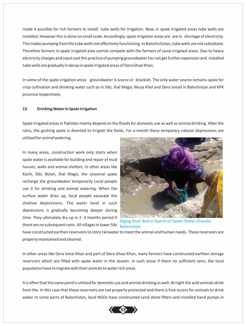
made it possible for rich farmers to install tube wells for irrigation. Now, in spate irrigated areas tube wells are
installed. However this is done on small scale. Accordingly, spate irrigation areas are are in shortage of electricity.
This makes pumping from the tube wells not effectively functioning. In Balochchistan, tube wells are not subsidized.
Therefore farmers in spate irrigated area cannot compete with the farmers of canal irrigated areas. Due to heavy
electricity charges and input cost this practice of pumping groundwater has not get further expansion and installed
tube wells are gradually in decay in spate irrigated areas of Dera Ghazi Khan.
In some of the spate irrigation areas groundwater is scarce or brackish. The only water source remains spate for
crop cultivation and drinking water such as in Sibi, Jhal Magsi, Musa Khel and Dera Ismail in Balochistan and KPK
province respectively.
13 Drinking Water in Spate Irrigation
Spate irrigated areas in Pakistan mainly depend on the floods for domestic use as well as animal drinking. After the
rains, the gushing spate is diverted to irrigate the fields. For a month these temporary natural depressions are
utilized for animal watering.
In many areas, construction work only starts when
spate water is available for building and repair of mud
houses, walls and animal shelters. In other areas like
Kachi, Sibi, Bolan, Jhal Magsi, the seasonal spate
recharge the groundwater temporarily Local people
use it for drinking and animal watering. When the
surface water dries up, local people excavate the
shallow depressions. The water level in such
depressions is gradually becoming deeper during
time. They ultimately dry up in 2 -3 months period if
there are no subsequent rains. All villages in lower Sibi
have constructed earthen reservoirs to store rainwater to meet the animal and human needs. These reservoirs are
properly maintained and cleaned.
In other areas like Dera Ismai Khan and part of Dera Ghazi Khan, many farmers have constructed earthen storage
reservoirs which are filled with spate water in the season. In such areas if there no sufficient rains, the local
population have to migrate with their animals to water rich areas.
It is often that the same pond is utilized for domestic use and animal drinking as well. At night the wild animals drink
from the. In this case that these reservoirs are not properly protected and there is free access for animals to drink
water. In some parts of Balochistan, local NGOs have constructed sand stone filters and installed hand pumps in
55
Diging River Bed in Search of Sweet Water-Chandia Balochistan
order to get relatively clean water. In some villages of Jhal Magsi it is also observed that villager have jointly
constructed a cemented reservoir and fill it with water imported by the tractors.
14 GROUND WATER AVAILABILITY IN SPATE IRRIGATION AREAS
Ground water availability and quality varies from place to place. Pakistan is irrigating (XXX???) percent of irrigated
agriculture through groundwater extraction. Groundwater is the second largest source of irrigation in Pakistan.
Groundwater is not the main topic of this document but being a vital source of life it has to be linked to spate
irrigation in Pakistan.
All spate irrigation areas are devoid of groundwater availability. However, its extraction, utilization for crop
production is not economical in comparison to canal water irrigation which is supplied to the farmers generally for
free. The second important factor is groundwater in spate irrigation areas is often brackish or totally unavailable.
In Balochistan province the major part of land is irrigated through groundwater. Reportedly 17.568 tub wells are
installed in Northern Balochistan for irrigation purposes. Electricity is provided to farmers on subsidized rates in
Balochistan charging fix amount of Rsn: 7.000 per month. These tube wells are operating 24 hours on availability of
electricity mainly in Kharif season when water is highly required by the crops specially orchards and green
vegetables. In winters the majority of the famers grow wheat and barley on small scale due to non availability of
fellow lands. Moreover the winters are harsh in most part of Balochistan that do not offer scope for Rabbi Crops.
The amount of tubewells in Balochistan expanded in early eighties. This has lead to high scale groundwater
extraction that has further deteriorated the groundwater level in many valleys. Among them Kuchlak, Loralai,
Mangocher some parts of district Pishin reached the bottom. Agriculture in Kuchlak has reduced significantly.
Similarly, in other valleys the groundwater level reached to 500-1000ft below the surface level and the situation is
alarming.
In southern Balochistan SIbi, Bolan, Jhal Magsi, Khudar, Kalat, Nushki the expansion in tubewells havebeen rampant
in the past 2 decades. It has converted the partially spate irrigated lands into tube well irrigation and has increased
the farmers' income many fold. However on the other hand groundwater reserve is depleting swiftly. Balochistan
is a water scarce province and management of spate water would increase and sustain the groundwater level.
In Sindh the ground water situation is the same in spate irrigated areas of Dadu, Johi, Jamshoro and Malir districts;
with minor difference that groundwater utilized for irrigation is charged every year through rains. If there are no
rains, the surface and groundwater will dryp up and lead to zero crop production.. Life in the in the spate irrigation
areas of Kohistan is totally depending on the seasonal rains and livestock rearing. The government in Sindh does
not provide subsidy for electricity to farmers like in Balochistan. So deep water aquifers are protected in Sindh
Kohistan area. In this case, farmers pump groundwater from shallow aquifers through diesel engines on seasonal
arrangements. Kohistan area is devoid of public facilities. There are hardly anyroads to the area and public transport
56
is limited.
Accordingly, in spate irrigation areas of Dera Ghazi khan, the groundwater is hardly available or brackish. The spate
irrigation areas are situated in the foothills of Kohi-Sulaiman Range and there is hardly any electricity available..
Similarly the government of Punjab does not provide subsidy for the electricity so it is not possible for the poor
farmers to install tube well. Poverty is rampant in the mountain areas as well as piedmont areas of Sulaiman Range.
Very few farmers have installed tube wells in Taunsa Sharif of district Dera Ghai Khan and Rajan Pur district.
Shortage of electricity and high electricity costs have pushed the farmers either to abandon the tubewell irrigation
or just opt for the Rabbi wheat. These farmers cannot compete with the farmers who use canal irrigation and get a
relatively good price due to minor input expenditures.
15. GENDER ISSUES IN SPATE IRRIGATION
Women, men and children work in the fields collectively. Agriculture related activities start with the filling of
embanked bunds. Farmer are checking them for couple of days to make sure that no breaches occur due to wind
velocity creating currents in the filled bund until water properly seeps down into the soil. When the soil is drying up
mulching is done. Mulching is mainly done during the early rabbi season when the season for sorghum, mung beans
and millet has passed. And time is required to protect the soil for the next Rabi Crops. For Kharif season, if there are
early flood in mid of March – April, crops are directly cultivated due to surging hot conditions that causes fast
evaporation of the soil moisture. In this season, mainly fodder crops are cultivated especially sorghum and millet.
Many farmers grow musk melon on small scale as well.
Women are responsible for cleaning seeds for cultivation. Women are also responsible to bring fuel woods and
collect wild green fodder for the animals. When crops are mature, part of is weeded by the women and primarily
used for animal fodder. After the monsoon rains many wild plants and tree species produce flowers and seeds.
Mushrooms are collected by the women for home consumption. In all known spate irrigated areas, truffles grow
naturally in sorghum and millet fields. The Truffle season is one month sand they do not grow in such high amounts
that it can be sold at commercial scale. Most of the truflles collected by the farmers is consumed at home. Surplus is
sold at village level. A few farmers or tenant families do truffle picking as a source of income earn Rs.500-1.000 on
daily basis in 30 days season.
Spate irrigation lands in Pakistan are owned by the tribes with a major portion owned by tribal chieftain. . In many
spate irrigation areas women do not inherit land. Recently government has evolved a law avoiding such
suppression and depriving off women from the inheritance rights. As a result, females are now getting their share of
inheritance in agricultural lands. In most of the cases the share of land she gets through inheritance right, is
transferred to paternal families. They are still being deprived off from her share in the family owned house and
other immoveable properties. Educational facilities are very poor in the spate irrigation areas. As a result, female
education in many spate irrigation areas is hardly taking place. Many girls do not attend schools where other leave
study after passing the primary, middle and metric level exams. University education of the females is almost
57
nonexistent due to absence of facilities.
During harvesting season tenant's and small farmers work as agriculture labor and harvest the panicles They are thentitled to 20 share of daily pick. They are further allowed to take the sorghum and millet harvested plants for their
animals to the weight they can carry. For other crops such as guar and wheat, they are not entitled for the fodder or
any other byproduct. Now instead of crop share, agricultural labor is paid in cash. Women are also responsible to
clean and store grains and collect water for domestic use.
Free movement of the women is also restricted in spate irrigation areas. They are not allowed to go alone to the
markets and shops. They financially depend on the head of the household for their daily needs. In many cases their
clothes and other daily needs are arranged by the older women at home. Polygamy and early childhood age
marriages are common in spate irrigation areas. Marriage proposal of the girls are accepted or rejected by their
parents. Treatment and regular check up of the pregnant women is not common unless complications and 65%
deliveries cases are attended by the untrained mid wives or older women at home. Marriage customs and
traditions are different in different spate irrigated areas for example in Balochistan the lab in Balochi and Walver in
Pashto is demanded by the parents that are usually paid in cash, kind or animal. Bijjar is one way of cash
contributions to the groom to meet the expenditures. Contrary to it, in Dera Ghazi Khan and Rajanpur spate
irrigation, area the lab or walver is not common; however in hilly parts of the districts this is still common to receive
the Lab on women though small with comparison to Pashtoons walvers.
Women are also responsible for feeding, milking, and cleaning the sheds of animal too. They process the milk for
yogurt and butter oil. Some of the households sell milk and butter oil to meet their cash needs. Further taking care
of kids, daily household chores women contributes more than men in rural spate irrigation areas. Women have no
direct access to cash except to those who keeps pet chickens and cell eggs others are engaged in embroidery,
stitching work at local level for women and kids suiting. In such cases the incomes are owned and possessed by the
respective working women. Female education is not common in spate irrigation areas due to cultural barriers and
none existence of educational facilities. However, DG Khan District is moderate and education of girls is
comparatively better than Balochistan and elsewhere in Pakistan.
16. RISK COOPING MECHANISM IN SPATE IRRIGATION AREA
The population in spate irrigation areas is depending on rains and floods. The rains are not stable throughout the
year. This makes the annual farmers' income fragile. The possibility of a bad agricultural season is in the minds of
local farmers. So, immediate risk cooping is managed through livestock rearing. This is common in spate irrigation
areas. The local population is depending on livestock and small ruminants as an alternate source of income for the
daily life as well as for emergency purposes. A large amount of farmers keep camels for to transport fire wood
transportation and sell it on the market as another source ofincome. A large amount of farmers is still depending
on the sale of milk and milk related by products.
58
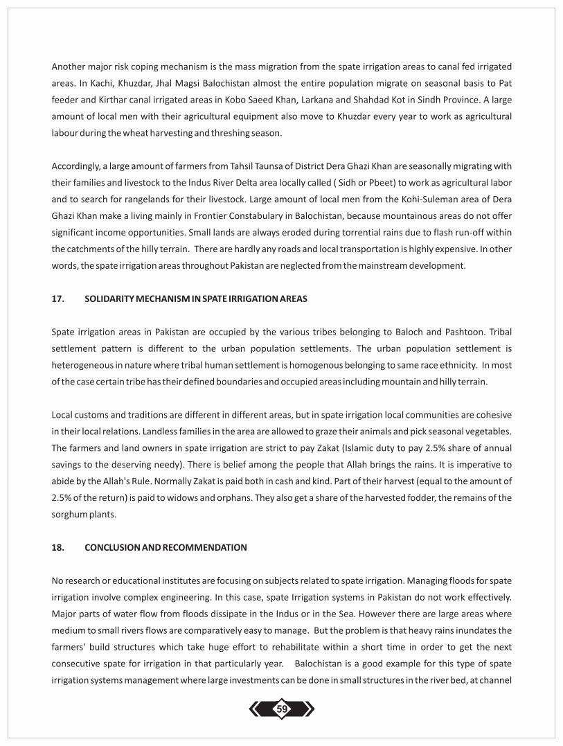
Another major risk coping mechanism is the mass migration from the spate irrigation areas to canal fed irrigated
areas. In Kachi, Khuzdar, Jhal Magsi Balochistan almost the entire population migrate on seasonal basis to Pat
feeder and Kirthar canal irrigated areas in Kobo Saeed Khan, Larkana and Shahdad Kot in Sindh Province. A large
amount of local men with their agricultural equipment also move to Khuzdar every year to work as agricultural
labour during the wheat harvesting and threshing season.
Accordingly, a large amount of farmers from Tahsil Taunsa of District Dera Ghazi Khan are seasonally migrating with
their families and livestock to the Indus River Delta area locally called ( Sidh or Pbeet) to work as agricultural labor
and to search for rangelands for their livestock. Large amount of local men from the Kohi-Suleman area of Dera
Ghazi Khan make a living mainly in Frontier Constabulary in Balochistan, because mountainous areas do not offer
significant income opportunities. Small lands are always eroded during torrential rains due to flash run-off within
the catchments of the hilly terrain. There are hardly any roads and local transportation is highly expensive. In other
words, the spate irrigation areas throughout Pakistan are neglected from the mainstream development.
17. SOLIDARITY MECHANISM IN SPATE IRRIGATION AREAS
Spate irrigation areas in Pakistan are occupied by the various tribes belonging to Baloch and Pashtoon. Tribal
settlement pattern is different to the urban population settlements. The urban population settlement is
heterogeneous in nature where tribal human settlement is homogenous belonging to same race ethnicity. In most
of the case certain tribe has their defined boundaries and occupied areas including mountain and hilly terrain.
Local customs and traditions are different in different areas, but in spate irrigation local communities are cohesive
in their local relations. Landless families in the area are allowed to graze their animals and pick seasonal vegetables.
The farmers and land owners in spate irrigation are strict to pay Zakat (Islamic duty to pay 2.5% share of annual
savings to the deserving needy). There is belief among the people that Allah brings the rains. It is imperative to
abide by the Allah's Rule. Normally Zakat is paid both in cash and kind. Part of their harvest (equal to the amount of
2.5% of the return) is paid to widows and orphans. They also get a share of the harvested fodder, the remains of the
sorghum plants.
18. CONCLUSION AND RECOMMENDATION
No research or educational institutes are focusing on subjects related to spate irrigation. Managing floods for spate
irrigation involve complex engineering. In this case, spate Irrigation systems in Pakistan do not work effectively.
Major parts of water flow from floods dissipate in the Indus or in the Sea. However there are large areas where
medium to small rivers flows are comparatively easy to manage. But the problem is that heavy rains inundates the
farmers' build structures which take huge effort to rehabilitate within a short time in order to get the next
consecutive spate for irrigation in that particularly year. Balochistan is a good example for this type of spate
irrigation systems management where large investments can be done in small structures in the river bed, at channel
59
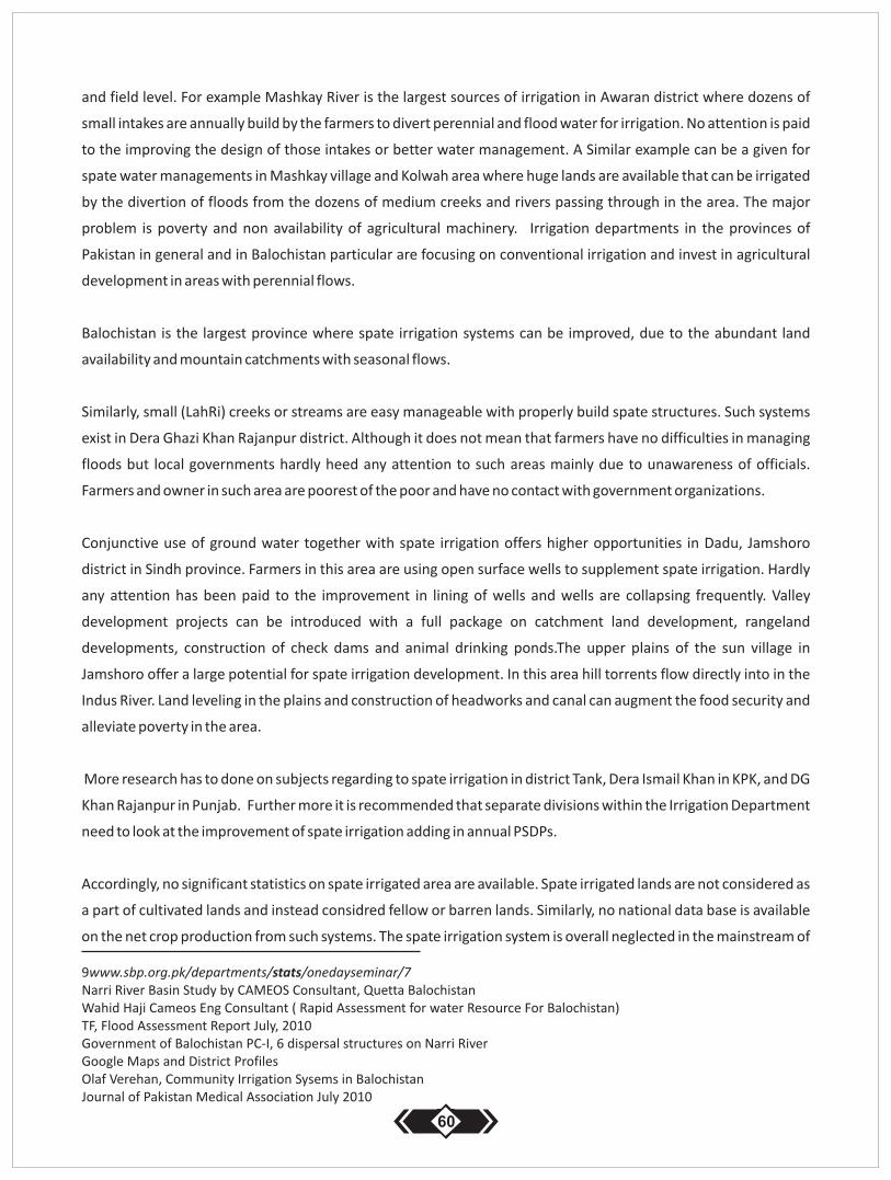
and field level. For example Mashkay River is the largest sources of irrigation in Awaran district where dozens of
small intakes are annually build by the farmers to divert perennial and flood water for irrigation. No attention is paid
to the improving the design of those intakes or better water management. A Similar example can be a given for
spate water managements in Mashkay village and Kolwah area where huge lands are available that can be irrigated
by the divertion of floods from the dozens of medium creeks and rivers passing through in the area. The major
problem is poverty and non availability of agricultural machinery. Irrigation departments in the provinces of
Pakistan in general and in Balochistan particular are focusing on conventional irrigation and invest in agricultural
development in areas with perennial flows.
Balochistan is the largest province where spate irrigation systems can be improved, due to the abundant land
availability and mountain catchments with seasonal flows.
Similarly, small (LahRi) creeks or streams are easy manageable with properly build spate structures. Such systems
exist in Dera Ghazi Khan Rajanpur district. Although it does not mean that farmers have no difficulties in managing
floods but local governments hardly heed any attention to such areas mainly due to unawareness of officials.
Farmers and owner in such area are poorest of the poor and have no contact with government organizations.
Conjunctive use of ground water together with spate irrigation offers higher opportunities in Dadu, Jamshoro
district in Sindh province. Farmers in this area are using open surface wells to supplement spate irrigation. Hardly
any attention has been paid to the improvement in lining of wells and wells are collapsing frequently. Valley
development projects can be introduced with a full package on catchment land development, rangeland
developments, construction of check dams and animal drinking ponds.The upper plains of the sun village in
Jamshoro offer a large potential for spate irrigation development. In this area hill torrents flow directly into in the
Indus River. Land leveling in the plains and construction of headworks and canal can augment the food security and
alleviate poverty in the area.
More research has to done on subjects regarding to spate irrigation in district Tank, Dera Ismail Khan in KPK, and DG
Khan Rajanpur in Punjab. Further more it is recommended that separate divisions within the Irrigation Department
need to look at the improvement of spate irrigation adding in annual PSDPs.
Accordingly, no significant statistics on spate irrigated area are available. Spate irrigated lands are not considered as
a part of cultivated lands and instead considred fellow or barren lands. Similarly, no national data base is available
on the net crop production from such systems. The spate irrigation system is overall neglected in the mainstream of
9www.sbp.org.pk/departments/stats/onedayseminar/7 Narri River Basin Study by CAMEOS Consultant, Quetta Balochistan Wahid Haji Cameos Eng Consultant ( Rapid Assessment for water Resource For Balochistan) TF, Flood Assessment Report July, 2010 Government of Balochistan PC-I, 6 dispersal structures on Narri River Google Maps and District Profiles Olaf Verehan, Community Irrigation Sysems in Balochistan Journal of Pakistan Medical Association July 2010
60
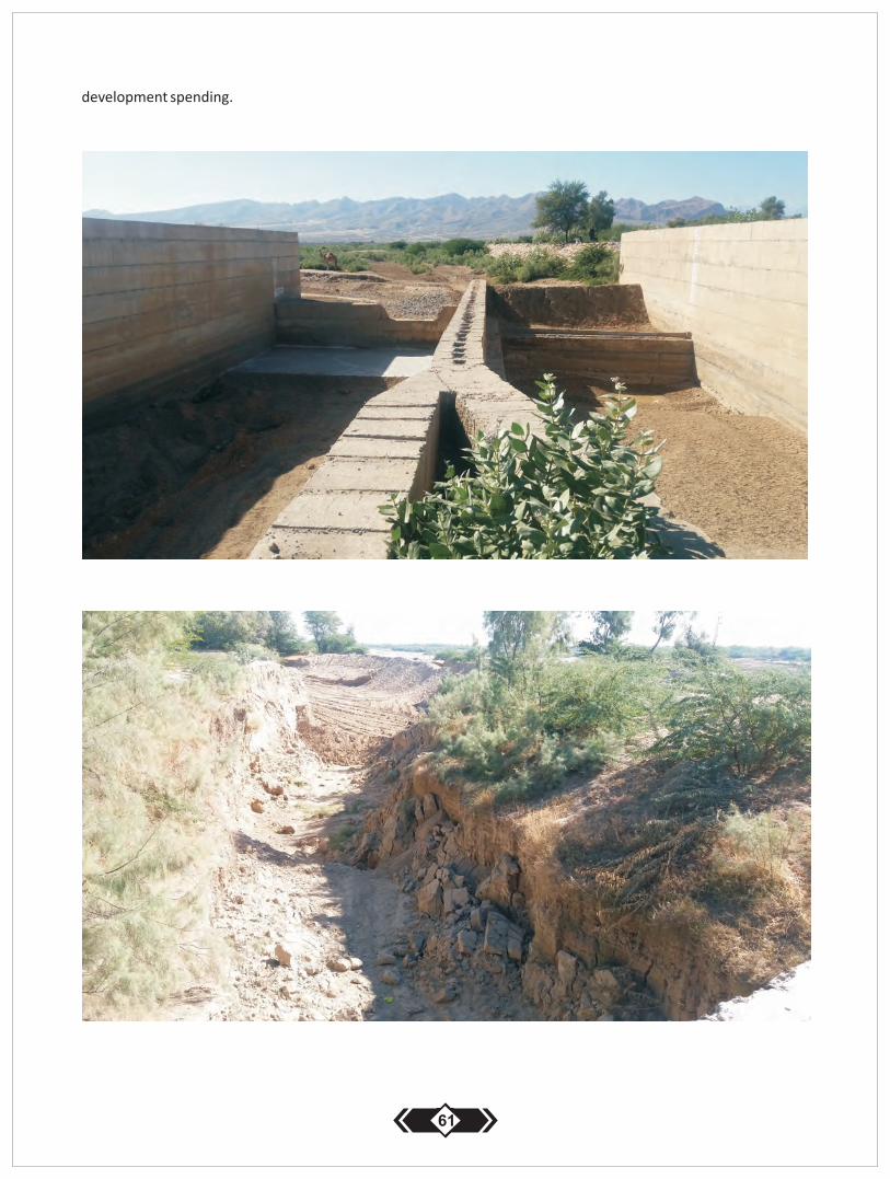
development spending.
61
Publication of this document is Supported by Africa to Asia and Back Again: Testing Adaptation in
Flood-Based Farming Systems IFAD and EC Grant to WLE hosted by IWMI, Implemented by
MetaMeta, UNESCO-IHE and ICRAF
Enabling the rural poorto overcome poverty