Managing Groundwater Protection Areas Guidance and Sample ...

Page 1 of 65
Commercial in
Confidence
VICROADS_n3051822_NPS_Studio_version_Growth_Area_Network_Planning_Guidance_&_Policy_Principles.DOCX
Guidance for Planning Road Networks
in Growth Areas
Version: Working Document (not versioned)
November 2015
WORKING DOCUMENT

_______________________________________________________________________________________________
This document uses the term ‘arterial road’ as a description of its functional operation, rather than that prescribed for
administrative purposes in the Road Management Act (2004), for road declaration.
QD 3051822 Working Document 2 of 65
Table of Contents
Foreword 4
Chapter 1: Overview 6
1.1 Purpose and Audience of the Guide 6
1.2 Growth Area Planning & the Metropolitan Planning Authority 6
1.3 VicRoads’ role 7
1.4 Phases of development 8
1.5 RRC and PRC involvement 9
Chapter 2: Principles-based decision-making 10
2.1 Context 10
2.2 Scope 10
2.3 Legislative Framework 10
2.4 Context Sensitive Design 10
2.5 How to make principles-based decisions 11
2.6 Decision-Making Principles 11
2.7 Guidance 12
Chapter 3: Planning the Urban Structure 13
3.1 Purpose 13
3.2 Planning the future urban structure principles 13
3.3 Application of planning the urban structure principles 14
Chapter 4: Planning the Ultimate Network 24
4.1 Purpose 24
4.2 Ultimate Network Principles 24
4.3 Application of ultimate network principles 25
4.4 Default intersection drawings 42
4.5 Default Midblock Cross Sections 46
Chapter 5: Planning the Interim, Network 47
5.1 Purpose 47
5.2 Interim design principles 47
5.3 Application of interim design principles 48
_______________________________________________________________________________________________
This document uses the term ‘arterial road’ as a description of its functional operation, rather than that prescribed for
administrative purposes in the Road Management Act (2004), for road declaration.
QD 3051822 Working Document 3 of 65
Chapter 6: Responding to PSA submissions 57
6.1 Purpose 57
6.2 Precinct Structure Plan 57
6.3 Development Contributions Plan 59
6.4 Schedule to the Urban Growth Zone (clause 37.07) 60
Chapter 7: Planning permit applications 61
7.1 Section 96A subdivision permit applications 61
7.2 Information to be submitted with Section 96A applications 61
7.3 Conditions of development consent 62
7.4 Referral to Public Transport Victoria 63
7.5 Timeframe for Permit Approval 63
7.6 Approval to Commence Work 63
7.7 Timeframe for Approval to Commence Works 64
7.8 Checklist: Planning permit applications 65
Figures
Figure 1-1: Precinct Structure Planning Issues and Interests 7
Figure 3-1: A Network of Arterial Roads and Connector Streets 18
Figure 3-2: Proposed Road Function 22
Figure 3-3: Proposed Network Structure 23
Figure 4-1: Separate Footpath and two-way off road bicycle paths at signalised intersection 34
Figure 4-2: Separated pedestrian and bicycle paths at left-turn slip lane island 35
Figure 4-3: Separated pedestrian and bicycle paths crossing a side road 36
Figure 4-4: Bus priority through space allocation 38
Tables
Table 4-1: Typical Turn Lane Lengths 29
Table 4-2 - Intersection Elements for the Ultimate Network 41
Table 5-1 - Intersection Design Elemnets for the Interim Network 55
Table 5-2 - Intersection Design Elements for the Interim Network 56

_______________________________________________________________________________________________
This document uses the term ‘arterial road’ as a description of its functional operation, rather than that prescribed for
administrative purposes in the Road Management Act (2004), for road declaration.
QD 3051822 Working Document 4 of 65
Foreword Growth area planning aims to create sustainable new communities where people enjoy living and
working.
The Metropolitan Planning Authority’s Precinct Structure Planning Guidelines set out a range of
elements and broad objectives for integrated place-making. Transport and movement is one of seven
key elements considered when preparing a precinct structure plan.
Through our wider strategic directions that aim to keep Victorians connected, meet the needs of
business and industry and maintain the ongoing prosperity and liveability of communities throughout
Victoria, VicRoads plays an important role in creating Melbourne’s newest communities.
Sometimes tensions arise between competing objectives and trade-offs need to be made. Broadly,
our planning considers the value that the community places on mobility, safety and amenity, and
looks at how to best balance a wide range of objectives in an effort to achieve coordinated whole-of-
government decision-making.
In this International Decade of Action for Road Safety, this handbook places a strong emphasis on
planning safe road networks to reduce the public health impacts of road trauma. It also incorporates
urban design and place-making principles, recognising a range of human and social values beyond
mobility
This handbook is not a complete guide to integrated transport planning in Melbourne’s growth areas;
there is no ‘one-size-fits-all’ solution. It aims to bring together relevant guidance, principles and
lessons learnt to date in growth area planning to support a transparent, consistent and repeatable
approach to transport decision-making in Melbourne’s growth areas. It is a living document and will
continue to be revised as we work with stakeholders, consider each precinct and reflect on our
experiences.
Finally, this handbook contributes to our ongoing effort to assist local and state government to
streamline planning processes and provide industry with greater certainty. This in turn seeks to
support the development of Melbourne’s growth areas and contribute to our state’s ongoing economic
prosperity.

_______________________________________________________________________________________________
This document uses the term ‘arterial road’ as a description of its functional operation, rather than that prescribed for
administrative purposes in the Road Management Act (2004), for road declaration.
QD 3051822 Working Document 5 of 65

_______________________________________________________________________________________________
This document uses the term ‘arterial road’ as a description of its functional operation, rather than that prescribed for
administrative purposes in the Road Management Act (2004), for road declaration.
QD 3051822 Working Document 6 of 65
Chapter 1: Overview
1.1 Purpose and Audience of the Guide This guide seeks to provide practical guidance for road network integrated decision-making and
implementation in the growth areas. A road network planner’s role is increasingly one of balancing
competing objectives and interests, recognising the road network’s role in a broader societal system.
This is a complex task that requires judgment to be exercised in prioritising planning objectives from
both within and beyond the transport portfolio.
This guide seeks to make the overall decision-making process more transparent and consistent—
from initial planning through to implementation—and to assist in the delivery of a coordinated and
timely service to the community and industry. This in turn can contribute to lowering the cost of
releasing land to the market to support Victoria’s ongoing economic prosperity and competitiveness.
The main objectives of this guide are to:
facilitate a principles based decision making approach for responding to conflicting land use,
urban design, competing transport modes or other objectives in growth area planning
provide relevant principles to offer guidance in the development and implementation of
Precinct Structure Plans
assist VicRoads officers working across Melbourne to achieve a more consistent approach
This guide will evolve over time as we engage further with our stakeholders — better understanding
their aims and objectives – and undertake case studies or demonstration projects with our partners.
This guide is primarily for use by VicRoads and MPA officers involved in the planning of Melbourne’s
growth areas. However, it is also intended to be made available to other government stakeholders,
Councils and industry to promote good governance through transparency.
Input from relevant stakeholders including Local Government, Public Transport Victoria, Bicycle
Network Victoria, Victoria Walks, RACV and DEDJTR is acknowledged in the development of this
guide.
1.2 Growth Area Planning & the Metropolitan Planning Authority Growth area planning is the process of planning areas for development to support population growth
and the demands for housing, employment and services that come with it.
The Metropolitan Planning Authority (MPA) is an independent statutory body with, inter alia, a broad
facilitative role to plan and coordinate infrastructure provision in Melbourne’s growth areas, and
reports directly to the Minister for Planning. In greenfields, the MPA achieves this through the
preparation and implementation of Precinct Structure Plans (PSPs). These are guided by Growth
Corridor Plans (GCPs), which are broad overarching strategic master plans (covering each of
Melbourne’s growth corridors) that identify indicative land use patterns, committed and proposed
major transport networks, regional open space and places requiring specific protection.
A Precinct Structure Plan sets the structure for a future suburb by defining specific land uses and the
transport network; ‘transport planning and land use planning is the same thing’1.
The plans identify the supporting infrastructure required and set out how this infrastructure will be
funded and delivered over time; but precinct structure planning is about much more than providing
infrastructure. It is about creating successful places and ensuring that the urban form can
1 Jim Betts, Previous Secretary Department of Transport

_______________________________________________________________________________________________
This document uses the term ‘arterial road’ as a description of its functional operation, rather than that prescribed for
administrative purposes in the Road Management Act (2004), for road declaration.
QD 3051822 Working Document 7 of 65
accommodate an appropriate range of social and economic activities and provide for more
sustainable transport choices to support liveable and adaptable communities.
This process is outlined in the Metropolitan Planning Authority’s Precinct Structure Planning
Guidelines.
MPA is seeking to achieve a Net Community Benefit for the PSP. This involves balancing multiple
objectives, some of which are complementary but are more often competing. Just one of these is
transport and consequently, the best transport outcome may not be achievable and be compromised.
See Figure below:
Figure 1-1: Precinct Structure Planning Issues and Interests
9
THE PSP
MPA - brokering, negotiation, on
balance decisions.
Net Community Benefit
Population for viable
community and commercial
services
Open space and recreation needs
Physical amenity & aesthetic character
Efficient and permeable transport networks
Education, community and health facilities
Viable integration of heritage,
environmental values
Providing for employment opportunities
+ more……
Timely drainage, & utilities
infrastructure & servicing
Commercial viability for developers
Responding to emerging
policies e.g. IWCM, bushfire
Reasonable cost
apportionment
Impacts of / on adjoining uses
Affordability
Consideration
of staging and delivery
Consideration of highest & best use
of land
Practicality and viability of initiatives
Flexibility
V
Certainty
PSP Issues & Interests Many
complementary & competing.
Ability to
implement
initiatives via planning system
Housing diversity /
density
Broad & deep assessment required.
Responding to existing
landowner circumstances
1.3 VicRoads’ role VicRoads plays an important role in supporting broad land use outcomes in growth areas through the
development of a multi-modal transport network that is planned for safe, efficient and balanced
operation—enabling communities to be connected with social and economic activities, provide a
sense of place, and facilitate commerce through the efficient transportation of goods and access to
services.
In partnership with the MPA, PTV, DEDJTR and Local Government, VicRoads contributes to arterial
road planning and responds to major planning activities across government in collaboration with key
stakeholders. VicRoads’ growth area planning activities can be considered to take place in two broad
streams of work, which have a number of activities in each:

_______________________________________________________________________________________________
This document uses the term ‘arterial road’ as a description of its functional operation, rather than that prescribed for
administrative purposes in the Road Management Act (2004), for road declaration.
QD 3051822 Working Document 8 of 65
Strategic Planning and Governance
Strategic road network planning
This is a key advisory role, working with other parties to help plan the structure, layout and road
transport alignments for the Growth Areas. The work includes undertaking planning for reservations
ensuring future multi-modal transport uses in coordination with growth corridor plans, as well as
agreeing the broad future road use hierarchy for each area.
Advising on planning activities led by others
VicRoads may need to advise of the potential impacts of proposals, undertake related planning
activities/studies, or provide an endorsed position on arterial road network related issues to inform the
growth area planning undertaken by the MPA.
Technical support: VicRoads in conjunction with DEDJTR, PTV and the MPA analyse and assess
submitted outputs from predictive transport modelling tools and relevant transport data-sets to inform
strategic planning activities and decision-making. This may include transport demand forecasts that
provide a significant input into assessing transport network requirements and prioritising potential
improvement projects.
Legislated Responsibilities
Road Development and Improvement Programs
VicRoads as the State road authority has responsibility to develop declared road network strategies,
including preparing road improvement programs and proposals for budget submissions.
Statutory planning
VicRoads work includes a range of planning functions such as planning scheme amendment reviews
(e.g. precinct structure plans), planning permit referrals, managing the road reserve, road declarations
and land tenure requests.
Road Safety
As well as holding the accountability for road safety on the declared road network, VicRoads is also
responsible for some key road safety considerations on local roads (arterial or otherwise), through the
authorisation of major traffic control devices.
1.4 Phases of development There are three broad phases of development of the Growth Areas that require collaboration between
VicRoads, the MPA, Local Government and PTV.
Phase 1: Structure Planning
The planning authority, usually the MPA, will consult with each of the transport agencies responsible
for transport including VicRoads, PTV and Council throughout the structure planning process to
develop an agreed urban structure and road network plan, generally in accordance with the current
Growth Corridor Plans. During this phase, VicRoads officers are advised to follow guidance provided
in Chapter 3: Planning the Urban Structure
Phase 2: Network Operation
The long-term desired network operation is based on the relevant Growth Corridor Plan and road use
hierarchy, and has two distinct parts; agreement on the expected ultimate network operation and land
requirements thereof, and the need to ensure a safe and efficient interim network operation while the
Growth Areas develop. This phase also has the potential to require decisions on the expected long
term management responsibilities of road network elements to be made. During this phase, VicRoads
officers are advised to follow guidance provided in Chapter 4: Planning the Ultimate Network, and
Chapter 5: Planning the Interim Network.

_______________________________________________________________________________________________
This document uses the term ‘arterial road’ as a description of its functional operation, rather than that prescribed for
administrative purposes in the Road Management Act (2004), for road declaration.
QD 3051822 Working Document 9 of 65
Phase 3: Statutory Requirements
In Phase 3, VicRoads is required to respond to draft planning scheme amendment documents
including Precinct Structure Plans (PSPs), Infrastructure Contribution Plans (ICPs, formerly
Development Contribution Plans,DCPs), Conservation Management Plans (CMPs), Schedule to the
Urban Growth Zone (UGZ) and Public Acquisition Overlays (PAOs). In some circumstances, Section
96a Permit Applications for subdivision will also be simultaneously received by VicRoads for
assessment and conditioning. During this phase, VicRoads officers are advised to follow guidance
provided in Chapter 6: Responding to PSA submissions, and Chapter 7: Planning permit applications.
1.5 RRC and PRC involvement VicRoads officers should provide a report to their Regional Review Committee (RRC), to keep senior
management informed of progress, but particularly highlighting any areas of contention or
disagreement. RRC (& PRC) should be more by exception rather than by rule if planning matters are
generally in accordance with the guide and other standards/legislation/VicRoads procedures. Officers
from the MPA, Public Transport Victoria and the relevant municipal council may be invited to attend
depending on the issues at hand, and at the discretion of the VicRoads officer.
During the planning of some precincts, officers may be required to report to the VicRoads Project
Review Committee (PRC) to seek approval for recommendations or to gain a VicRoads endorsed
position on particular issues. Reporting to PRC is either deemed necessary by the VicRoads
authorisations table, or where the region believes the issues to be contentious, high-risk or
strategically important with potential broader consequences for VicRoads.

_______________________________________________________________________________________________
This document uses the term ‘arterial road’ as a description of its functional operation, rather than that prescribed for
administrative purposes in the Road Management Act (2004), for road declaration.
QD 3051822 Working Document 10 of 65
Chapter 2: Principles-based decision-making
2.1 Context VicRoads is moving towards a more principles-based approach to decision-making; one based on the
transparent consideration of principles. While VicRoads and Austroads standards and guidelines are
considered in the initial instance to inform decisions, subsequent application of a principles-based
decision making approach utilise the discretionary principles included in the Austroads Guides to deal
with multi-objective integrated planning circumstances in a practical manner. With proper application,
these principles allow balancing with land use planning principles in context.
2.2 Scope This document provides guidance for decision making when planning, designing and building the road
network in growth areas and offers principles where the guidance provided is not suitable to specific
circumstances and alternate options need to be considered and assessed.
2.3 Legislative Framework The principles, and guidance, identified throughout this document have been determined within the
context of the Victorian Government’s planning and transport statutes. The principal Acts (and
amendments) applying to work within the Growth Areas are as follows:
Road Safety Act 1986
Transport Integration Act 2010
Road Management Act 2004
Planning and Environment Act 1987, including the Victorian Planning Provisions
A critical driver in development of integrated transport and land use outcomes is the Transport
Integration Act 2010 and its emphasis on multi-faceted assessment in decision-making.
2.4 Context Sensitive Design Principles-based decision-making is a further development on the existing Austroads approach of
‘Context Sensitive Design’, outlined within Guide to Road Design Part 2. It is an approach that
provides the flexibility to encourage independent design, tailored to particular situations. The concept
of Design Domain is central to this approach. This concept acknowledges that there are always a
range of values for each design consideration based on competing considerations such as mobility,
environmental impact, construction and maintenance cost, user cost and collision rate.
Austroads considers the design domain to be loosely divided into two parts - Normal Design Domain
(NDD) and Extended Design Domain (EDD), with a key distinction being that the former is for use in
Greenfield sites and locations of significant reconstruction. Although construction within growth areas
would seem to fit neatly within the NDD, the economic value of land (both for development and
transport) can preclude any area to be considered truly ‘green field’. This competing principle is rarely
explicitly considered within Austroads. Thus, the use of EDD values deserves further attention.
Austroads recommends that a documented risk assessment be undertaken for the use of values
within the EDD, whilst also suggesting that the use of EDD values be used within a package of NDD
values for any particular road section or intersection. Both recommendations are accepted and used
in the process of applying principles-based design making.

_______________________________________________________________________________________________
This document uses the term ‘arterial road’ as a description of its functional operation, rather than that prescribed for
administrative purposes in the Road Management Act (2004), for road declaration.
QD 3051822 Working Document 11 of 65
2.5 How to make principles-based decisions It is not realistic that a guide such as this can address every particular scenario or issue that may
arise in growth area planning. Instead, this document identifies the core principles for various stages
of development of the Precinct Structure Plan and provides guidance on how to apply the principles
for the majority of cases. Where the guidance is not appropriate for a specific situation, the principles,
in conjunction with engineering and technical judgement, should be applied to make a principles-
based decision. Principles-based decisions may be less “clear cut” than simply following standards
and guidelines and will require a greater degree of consideration of the competing issues in making
the decision.
Guidance
For most decisions, the guidance can be applied directly.
Principles
Where it is necessary to deviate from the guidance, the principles should be applied to make a
principles-based decision. These decisions must be documented and approved (generally for
VicRoads, by the relevant Regional/Project Director).
Exception
Where it is necessary to deviate from any of the principles, a principles-based decision should be
made in line with broader Government Policy, Strategies and Legislation. These decisions must be
documented and approved. (For VicRoads, generally these decisions should be endorsed by the
relevant Regional/Project Director and approved by the Executive Director Policy & Programs).
2.6 Decision-Making Principles Decision-making principles have been developed to facilitate decision-making when planning,
designing and building the road network in growth areas.
Road Network Principles
When planning the future urban structure;
Provide a tiered road network, based on road function that supports longer distance
movements and enables appropriate access
Prioritise different transport modes based on desired road function
Align transport network decisions and land use decisions to appropriately match accessibility needs
and desired road function for all transport modes.
When designing and building the interim and ultimate network, provide transport infrastructure that
can deliver the desired road function to an acceptable level of service for all transport modes.
When designing and building the interim network, ensure interim transport infrastructure supports
progressive land use development.
Safe System Principles
Provide a safe transport network for all users by:
Minimising the likelihood and severity of conflict between vulnerable users and other vehicles
through integrated infrastructure, operations and management decisions
Minimising the likelihood and severity of conflict between vehicles
Providing mitigation to reduce the impact force to within human tolerances when vehicles
collide with roadside objects

_______________________________________________________________________________________________
This document uses the term ‘arterial road’ as a description of its functional operation, rather than that prescribed for
administrative purposes in the Road Management Act (2004), for road declaration.
QD 3051822 Working Document 12 of 65
Sustainable Transport Principle
Provide transport infrastructure that supports sustainable transport take up.
Community Wellbeing Principles
Provide transport infrastructure that supports healthy liveable communities.
Where adjacent land uses support a high level of community activity then provide infrastructure
supporting active travel along and across the arterial network together with high-quality roadside
amenity
Resource Allocation Principles
Minimise overall costs to the community, while allocating reasonable shares of costs to developers
and appropriate levels of Government.
When designing and building the interim network:
Avoid interim treatments that require more land than the ultimate network.
Provide transport infrastructure in the interim that, where possible, aligns with the ultimate
network to avoid redundant works.
Minimise overall costs to governments and the community while ensuring particular care is
taken to avoid loading costs onto initial purchasers that are unrelated to development.
Utility Services Principle
Ensure road reserves can accommodate other appropriate uses, e.g. utilities and services
2.7 Guidance The guidance provided in each of the following chapters utilises the principles in the appropriate
context:
Chapter 3: Planning the Urban Structure
Chapter 4: Planning the Ultimate Network
Chapter 5: Planning the Interim Network
Where the guidance is not appropriate for a specific situation, the decision-making principles should
be applied and satisfied in consultation with relevant stakeholders. The process and reasoning for the
principles-based decision should be documented.
Further guidance regarding planning issues is provided in the following sections:
Chapter 6: Responding to PSA submissions
Chapter 7: Planning permit applications
_______________________________________________________________________________________________
This document uses the term ‘arterial road’ as a description of its functional operation, rather than that prescribed for
administrative purposes in the Road Management Act (2004), for road declaration.
QD 3051822 Working Document 13 of 65
Chapter 3: Planning the Urban Structure
3.1 Purpose Precinct Structure Plans (PSPs)
2 fill in the detail in the broad picture presented in the Growth Corridor
Plans. The essential first stage in developing a PSP is to create the structure of the precinct—the
skeleton for arranging the land uses and transport network to support the levels of infrastructure,
services and jobs to sustain the new community. This skeleton is referred to as “the urban structure”
throughout this document.
Development of the urban structure is an iterative process that is managed by the Planning Authority,
typically the MPA. Opportunities and constraints are identified, different land use and road and
drainage network scenarios are tested and options refined. This is done in an effort to converge on
an urban structure that best meets both the land use and transport objectives.
The urban structure is used as the basis from which to determine the ultimate infrastructure required
to service and support the full build out of a precinct, enabling land reservation requirements to be
identified. This part of the process is detailed in Chapter 4: Planning the Ultimate Network.
This section of the guide outlines the principles in determining an appropriate urban structure,
guidance on applying the principles and introduces the future urban structure.
3.2 Planning the future urban structure principles It must be noted that a transport system is not an end in itself. It primarily serves to move people and
goods between locations to support economic and social activities (i.e. the transport network services
the planned land use). In recognising this, these principles have been developed to guide how to plan
the urban structure:
Road Network Principles
Align transport network decisions and land use decisions to appropriately match accessibility needs
and desired road function for all transport modes (3A)
When planning the future urban structure, -
Provide a tiered road network, based on road function that supports longer distance
movements and enables appropriate access (3B)
Prioritise different transport modes based on desired road function (3C)
Safe System Principles
Provide a safe transport network for all users by:
Minimising the likelihood and severity of conflict between vulnerable users and other vehicles
through integrated infrastructure, operations and management decisions (3D)
Minimising the likelihood and severity of conflict between vehicles(3E)
Providing mitigation to reduce the impact force to within human tolerances when vehicles
collide with roadside objects (3F)
Sustainable Transport Principle
Provide transport infrastructure that supports sustainable transport take up (3G)
2 Growth Corridor Plans 2012 (Growth Areas Authority)

_______________________________________________________________________________________________
This document uses the term ‘arterial road’ as a description of its functional operation, rather than that prescribed for
administrative purposes in the Road Management Act (2004), for road declaration.
QD 3051822 Working Document 14 of 65
3.3 Application of planning the urban structure principles
Road Network Principles
Align transport network decisions and land use decisions to appropriately match
accessibility needs and desired road function for all transport modes (3A)
The planning of land use and transport networks (and other networks) need to be developed in an
integrated manner so that the transport network serves the planned land uses and the broader
objectives of developing sustainable communities. Conversely, land use planning also needs to
recognise the need to facilitate the appropriate transport network functions and locate sensitive land
uses appropriately. Aligning transport network and land use decisions will help to achieve an urban
structure that supports healthy, liveable communities.
When developing the urban structure, consideration needs to be given to (but not limited to) the
following:
Locate land uses and transport corridors in a way that provides more transport mode choice
and thus reduces the demand for, and length of, motorised trips to access commercial
services, community facilities and employment opportunities.
Develop a context-sensitive road network that is adjusted to meet the particular local needs
for the planned land uses (i.e. not a “one size fits all” approach).
Avoid creating barriers to community connectedness and network permeability.
Avoid locating land uses that compromise the intended function of the road network.
Locate mixed use and higher density developments around activity/town centres and/or
transport nodes to maximise the potential for travel by walking, cycling and public transport
Locate activity centres where the road network can support the economic viability of the
activities through appropriate access arrangements
More specifically:
Town Centre Location
The Growth Corridor Plans have established a hierarchy of activity areas within the growth areas,
namely; Central Activities Area, Principal Town Centre, Major Town Centre, Specialised Town Centre,
Local Town Centre and Neighbourhood Centre. Individual Growth Corridor Plans identify the
locations for the first three tiers of activity areas and provide guidance for the future location of all
other activity centres through the PSPs. The aim is for 80-90% of households within a precinct to be
within 1km of a local town centre. Therefore, in practical terms, the planning of town centres in the
growth areas is a prerequisite to the planning of the transport network. The transport network needs
to encourage specific modes along appropriate roads to support adjacent land uses.
To be economically viable town centres rely on a visible and accessible location, i.e. on a connector
street with abuttal to an arterial road. This is particularly important for attracting larger ‘anchor’ stores
in the medium to larger town centres.
Abuttal to a secondary arterial road is preferable to abuttal to a primary arterial. There is greater
scope to support public transport and vehicular access to the centre as well as modifications to the
abutting arterial road environment to provide a more sympathetic access to the town centre.
When a town centre abutting a primary arterial cannot be avoided, the town centre will need to be
designed to cater for restricted vehicular access from the arterial road and there will be more limited
possibilities of modifications to the abutting arterial road environment.
Street based activity in town centres is often important in creating a sense of place, character and
connection. While traditional arterial road street-based town centres often experience tensions
between town centre activity and transport objectives, in the Growth Areas this tension is mitigated by

_______________________________________________________________________________________________
This document uses the term ‘arterial road’ as a description of its functional operation, rather than that prescribed for
administrative purposes in the Road Management Act (2004), for road declaration.
QD 3051822 Working Document 15 of 65
not allowing town centres to straddle the nearby arterial road. Instead a connector street or lower
order access road will usually provide the location of any street based activity. Whether the ‘main
street’ of an activity centre is the local road or the connector street will influence the ultimate network
intersection elements to be planned for.
Inside the Town Centre
Urban form and street environment of the centre should be designed to support slow traffic speeds
and high pedestrian amenity. A critical aspect of creating a vibrant pedestrian friendly town centre is
maintaining a low vehicular speed environment. The aim is to encourage intuitively low operating
speeds through design rather than regulation. While any posted speed limit for a local town centre
street would be 40kph, a number of traffic management treatments and urban design elements could
be employed to support the lower desirable operating speed. These could include threshold
treatments, pedestrian crossings, raised pavements and the like.
It is the role of VicRoads to support the urban design process for each town centre, where particular
design elements require authorisation from VicRoads in its capacity as state road authority in
managing traffic control devices (e.g. speed limits).
Schools
Schools generate higher levels of pedestrian and cyclist activity, as well as traffic and parking needs
at particular times of the day. Schools should normally be more centrally located within each arterial
block and not adjacent to an arterial road to minimise the number of pupils required to cross arterial
roads to access the school and avoid school speed zones.
Where a school exists or a new school has to be located adjacent to an arterial road, no boundary
gate used for student access should be provided onto the arterial road itself in order to eliminate the
requirement of introducing a school speed zone (40 km/h on secondary arterials, 60km/h on primary
arterials generally and 40km/h on primary arterials where a flagged school crossing exists). This is
particularly important for primary arterials, due to the safety implications of large numbers of school
children using or crossing the arterial road and having a short, part-time, localised speed reduction
from 80 km/h to 60km/h (or 40km/h where a flagged school crossing exists).
Industrial/commercial land uses
Industrial/commercial land uses are ideally located on primary arterials, especially if the arterial forms
part of a freight network, to enable efficient access to industry and business. Attention needs to be
paid to access through consolidation of entries, access from internal networks or service roads as
appropriate.
When planning the future urban structure;
Provide a tiered road network, based on road function that supports longer distance
movements and enables appropriate access (3B)
This principle is about ensuring the road network reflects the different functions of through-movement
and precinct access that it must perform.
Roads - Declaration versus Function
Based on the Road Management Act 2004 (section 14(3), VicRoads has guidelines for the
circumstances in which a road might be considered eligible for declaration as a state arterial (or
‘declared arterial’). Depending on the local circumstances, a road may only need to meet one or two
of the criteria, for declaration to be considered by the State
a) provides a principal route for the movement of people and goods—
i) between major regions of the state
ii) between major centres of population or between major metropolitan activity centres
iii) to major transport terminals

_______________________________________________________________________________________________
This document uses the term ‘arterial road’ as a description of its functional operation, rather than that prescribed for
administrative purposes in the Road Management Act (2004), for road declaration.
QD 3051822 Working Document 16 of 65
iv) across or around cities
b) is a major route for public transport services
c) has state wide economic or tourism significance
d) provides necessary connections between arterial roads
Although the above circumstances for declaration are provided for the purposes for defining road
ownership and management responsibilities with the Road Management Act, for growth area network
planning, these criteria can instead be used as general functional descriptions of a road that performs
an arterial function, although lower-order arterial roads will necessarily have a more local function.
The issue of eventual road ownership and management responsibility can then be considered
separately in defining the ultimate road network (although it is important in defining network
development and early funding responsibilities).This change in perspective is pertinent in the growth
areas as the identification of any future arterial road on a growth corridor plan (or precinct structure
plan) does not indicate a commitment to funding or future declaration as a state arterial road.
Primary and Secondary Arterials
Traditionally arterial roads have functionally ranged from major long distance routes carrying freight
and high traffic volumes through to busy roads with a local arterial function – respectively primary and
secondary arterials. A broad approach (obviously subject to review based on local context) was
adopted during development of the Corridor plans that called for arterials at typically a 1.6km grid,
with broadly, alternating primary arterial and secondary arterial functions.
Alternating Primary and Secondary arterial roads shall be designed differently to emphasise the
different functions of long distance, through-movement versus a greater emphasis on precinct access.
Primary arterials
Designed to perform primarily a through-movement function, and connection into the freeway
network and secondary arterial network
Expected posted speed limit of 80kph for the ultimate network (full build out) including divided
carriageways and limited access
No on-street parking
Separate footpath and two-way off road bicycle paths to be provided on both sides of the
road.
- Footpath to be provided adjacent to the property frontage or loop road ie outside road
reservation.
- Providing a footpath further away from an arterial road can be considered improving
amenity for pedestrians.
- Such an arrangement will require the provision of access/crossing points for users to
enable safe passage to access Primary Arterial intersections.
- In the absence of a loop road the footpath is also to be accommodated within the road
reservation, adjacent to the two-way off road bicycle path.
Most likely to be prioritised for arterial declaration.
Six-lane cross-section in ultimate, long term build out. however a narrower cross section
could be considered for short roads or roads close to the ultimate edge of development and
when it can be demonstrated that six lanes is not needed to accommodate ultimate transport
requirements.
- A reduced number of lanes on primary arterials may be provided when it can be
demonstrated that the above mentioned number of lanes is not needed to accommodate
ultimate transport requirements.

_______________________________________________________________________________________________
This document uses the term ‘arterial road’ as a description of its functional operation, rather than that prescribed for
administrative purposes in the Road Management Act (2004), for road declaration.
QD 3051822 Working Document 17 of 65
Secondary arterials
Designed to perform a through-movement function but with greater emphasis placed on
providing access to local and abutting land uses
Expected posted speed limit of 60kph for the ultimate network (full build out) including divided
carriageways and regular intersections. Pedestrian crossing points will be provided at a
greater frequency than on primary arterials.
No on-street parking
Separate footpath and two-way off road bicycle paths to be provided on both sides of the
road, complimented with a high level-of-service at intersections to enable pedestrians and
cyclists to maintain their overall journey continuity and quality. If additional space is required
within the secondary arterial road reservation then the footpath could be provided adjacent to
the property frontage or loop road ie outside the road reservation. Such an arrangement will
require the provision of access/crossing points for users to enable safe passage to public
transport located along secondary arterials as well as to intersections.
Arterial declaration more likely to be considered in the longer term.
Generally four lane cross-section in ultimate, long term build-out, although in locations where
high bus frequencies may justify priority measures a wider cross section may be appropriate.
Arterial Road Spacing
In accordance with Victoria Planning Provisions, Particular Provisions Clause 56.06: Access and
Mobility, arterial roads are to be provided at intervals of approximately 1.6 kilometres (one mile), with
adequate reservation width to accommodate long term movement demand. This spacing may need
to be adjusted to account for local conditions such as the presence of rivers, rail lines and significant
cultural sites.
The traditional ‘one mile’ grid network seen in many established parts of Melbourne has proven to be
permeable, resilient and adaptable over time, as it affords choice and allows integration of uses and
activities. Permeability also includes having a legible network and identifying and minimising barriers
to pedestrians and cyclists. Keeping to the existing one mile grid also makes best use of the existing
land subdivisions and associated road reservations. Furthermore, a one-mile grid neatly creates
communities of roughly 8-10,000 people, enough to support necessary schools, services and sporting
facilities in each area.
Local and Connector Streets
A permeable and resilient precinct is created by providing a road network grid that maximises the use
of arterial roads for through traffic wishing to travel further than an adjacent grid block, and maximises
the use of local and connector streets for travel within a grid block or between adjacent blocks. This
form of grid system is adaptable in that there are multiple options (albeit with clear preferences) for
each journey, allowing traffic flows to balance themselves across the network and for flexibility in
times of unusual conditions (eg. vehicular breakdown or crashes).
Connector Streets
The Victorian Planning Provisions (VPP) distinguishes between two levels of Connector Street, with
Level 1 and 2 expected to have traffic volumes of 3000vpd and up to 7000vpd respectively. In the
growth areas, this level distinction is not made, with volumes ranging between 3000 and 7000vpd
acceptable on Connector Streets, with occasionally volumes up to 10,000 – 12,000vpd expected.
Connector streets are not expected to carry through traffic – that is the function of the arterial road
network. Therefore, clear differentiation in appearance and function, including lower speed limits (40
or 50 km/h), regular property access, narrower cross sections and limited intersection capacity is
appropriate.

_______________________________________________________________________________________________
This document uses the term ‘arterial road’ as a description of its functional operation, rather than that prescribed for
administrative purposes in the Road Management Act (2004), for road declaration.
QD 3051822 Working Document 18 of 65
Connector streets should be provided approximately halfway between arterial roads. Connector
streets should align across arterial roads between neighbourhoods for direct connection and
operational efficiency of movement of pedestrians, cyclists, public transport and other motor vehicles
at signalised intersections.
Access Streets
As well as major arterial road and connector street intersections, lower order access streets may
provide additional occasional connections to the arterial road network according to local land use
need, but would be expected to have restricted (e.g. left in/left out) access into the arterial network.
The VPP distinguishes between two levels of Access Street, with Level 1 and Level 2 expected to
have traffic volumes of 1-2000vpd and 2-3000vpd, respectively.
Figure 3-1: A Network of Arterial Roads and Connector Streets, Providing a Permeable and Resilient Precinct for Within-Block and Between-Block Journeys (Need to add Journey D – journey through the precinct (top to bottom of diagram)
When planning the future urban structure, -
Prioritise different transport modes based on desired road function (3C)
This principle recognises the competition for road space between different transport needs. It also
recognises the need to encourage active and sustainable modes to deliver against land use planning
objectives related to affordability, sustainability and healthy connected communities.
VicRoads’ SmartRoads framework has been set up to achieve a better balance between the needs of
different transport modes and between competing land use and transport objectives. Whilst the
framework was set up to manage competing interests on the road network in established areas, the
principles are still relevant for the planning of new areas given that competition for road space does
exist. Providing high priority (level of service) for all modes and movements would require an
unacceptably high level of investment in land and infrastructure as well as creating a poor urban
amenity and reducing development potential.
For further information on SmartRoads principles refer to the SmartRoads Guidelines (QD 2857289).

_______________________________________________________________________________________________
This document uses the term ‘arterial road’ as a description of its functional operation, rather than that prescribed for
administrative purposes in the Road Management Act (2004), for road declaration.
QD 3051822 Working Document 19 of 65
Understanding the desired function of a road (as defined in the previous Principle) will inform which
transport modes are given priority on that road.
Buses
All arterials, primary and secondary, will potentially carry bus routes and must be designed to
be bus capable.
As there is more frequent pedestrian access to residential areas, activity centres and other
services on secondary arterial roads, the preferred alignment for bus priority routes is on
secondary arterials. This also allows for greater scope for bus priority treatments.
Some bus priority routes may need to be positioned on primary arterials, for instance, where
the primary arterial provides direct access to abutting activity centres, and those catering for
more inter-regional travel
Network Development Plans, which show a hierarchy of bus service (eg. SmartBus,
connector and local services), are available from Public Transport Victoria. These network
plans should be used as the basis to identify the location of future networks and appropriate
bus priority treatments.
Bicycles
The alignment of many bicycle priority routes will follow both primary and secondary arterial
routes. However, given the expected lower speed limits on secondary arterials it is preferred
to align bicycle priority routes along these.
Bicycle priority routes are also likely along non-road alignments, such as along waterways
and service easements.
They will be supplemented by Municipal Bicycle Networks and the Principal Bicycle Network
on local roads to form a dense bicycle network accessing all neighbourhoods.
Crossing of arterial roads by strategic off-road bicycle routes will require attention, potentially
including signalisation.
Freight
Longer distance freight movements, such as intermodal freight transport, should be
encouraged on primary arterials over secondary arterials.
Land use planning should respond to strategic freight routes by promoting non-sensitive uses
in abutting areas where possible, eg schools.
The provision of local access roads around the local town centre street will provide for trucks
to access loading facilities, for delivery purposes, without relying on the local town centre
street intersection with the arterial road
Pedestrians
Activity centres and other high pedestrian areas should be designed so as not to straddle
arterial roads.
Activity centre roads should be designed for pedestrian priority, with the vehicular speed and
capacity characteristics of the road designed primarily to meet pedestrian and ‘place making’
requirements.
Town centres will generally be located on connector streets abutting arterial roads for
commercial exposure and good transport (including pedestrian) access.
Principal Pedestrian networks will be required to provide access to each major town centre
from the surrounding network.
Arterial roads adjacent to/abutting Town Centres should recognise the higher levels of
pedestrian activity expected and be designed accordingly. Design characteristics that
differentiate the arterial locally could include additional tree planting, reduced speed limits and
other features.

_______________________________________________________________________________________________
This document uses the term ‘arterial road’ as a description of its functional operation, rather than that prescribed for
administrative purposes in the Road Management Act (2004), for road declaration.
QD 3051822 Working Document 20 of 65

_______________________________________________________________________________________________
This document uses the term ‘arterial road’ as a description of its functional operation, rather than that prescribed for
administrative purposes in the Road Management Act (2004), for road declaration.
QD 3051822 Working Document 21 of 65
Safe System Principles
Provide a safe transport network for all users by:
Minimising the likelihood and severity of conflict between vulnerable users and
other vehicles through integrated infrastructure, operations and management
decisions (3D)
Minimising the likelihood and severity of conflict between vehicles (3E)
Providing mitigation to reduce the impact force to within human tolerances
when vehicles collide with roadside objects (3F)
When making planning decisions in growth areas, consideration must be given to
competing demands and conflicts between different land uses and transport modes whilst aiming to
maximise the overall safety and efficiency of the network.
This principle aligns with VicRoads’ legislative responsibility under the Road Management Act 2004,
to ensure that the road is safe for all users. Road infrastructure provided in the network must
contribute to Victoria’s Road Safety Strategy 2013-2022. The strategy outlines the Victoria’s ‘Safe
System’ vision of zero fatalities and zero serious injuries on Victorian roads.
A key component of a safe road network is ensuring that the speed limit is appropriate for the
environment and function of the road. When designing a road, the road environment should support
the speed limit, such that drivers ‘feel’ the speed limit is right for the situation and drive accordingly.
Also important is the protection of vulnerable users including pedestrians and cyclists. The provision
of appropriate facilities, including road crossing opportunities, is essential to protect the safety of
these road users.
Sustainable Transport Principle
Provide transport infrastructure that supports sustainable transport take up (3G)
It makes strong economic and environmental sense for the transport network to respond to travel
needs via the most affordable and environmentally sound means. For short trips this includes walking
and cycling, while for longer trips public transport should offer a viable alternative to cars. Looking
more broadly, walking and cycling in particular offer other benefits, including social and health
benefits, that are worth pursuing.
This principle reflects the need to provide direct, safe and easy movement through and between
neighbourhoods for pedestrians, cyclists and public transport in order to encourage a greater share of
public transport, walking and cycling trips as a proportion of all transport trips. This is facilitated
through providing an interconnected and continuous network of streets, cycle routes, shared paths,
footpaths and public transport routes within and between neighbourhoods
The planned transport network expansion must take into account links to the existing network of
arterial roads, neighbourhood streets, cycle routes, shared paths, footpaths and public transport
routes.

_______________________________________________________________________________________________
This document uses the term ‘arterial road’ as a description of its functional operation, rather than that prescribed for
administrative purposes in the Road Management Act (2004), for road declaration.
QD 3051822 Working Document 22 of 65
3.3.2 Summary of planning the urban structure
Figure 3-2: Proposed Road Function
(VicRoads modified version of Figure 2.1, Road Type and Function, Network and Corridor Planning Practice Notes, Road and Traffic Authority, NSW, November 2008 to suit Growth Areas)

_______________________________________________________________________________________________
This document uses the term ‘arterial road’ as a description of its functional operation, rather than that prescribed for
administrative purposes in the Road Management Act (2004), for road declaration.
QD 3051822 Working Document 23 of 65
Figure 3-3: Proposed Network Structure

_______________________________________________________________________________________________
This document uses the term ‘arterial road’ as a description of its functional operation, rather than that prescribed for
administrative purposes in the Road Management Act (2004), for road declaration.
QD 3051822 Working Document 24 of 65
Chapter 4: Planning the Ultimate Network
4.1 Purpose Once the urban structure has been generally agreed, land reservations need to be secured to
accommodate the ultimate transport infrastructure required to service and support the full build-out of
a precinct. This process is conducted through each Precinct Structure Plan, providing greater
certainty to the land developers on the shape and location of land provided for development, whilst
aiming to minimise upfront and ongoing costs to the community.
With regards to the road reservation, the ‘ultimate network’ is generally defined as the network
catering for the transport generated by the full take-up of development opportunities, within the
existing growth boundary.
In planning the ultimate network, we are aiming to achieve three key outcomes:
to achieve the land use and transport principles articulated in Chapter 3: Planning the Urban
Structure;
to determine the land required for ultimate road reservation width (including right-of-way
flaring at intersections) to be set aside through the provisions of the Precinct Structure Plan
(PSP) and Development Contributions Plan (DCP) or Infrastructure Contribution Plan (ICP)
with costs spread equitably throughout the precinct; and
to determine the desired concept for the ultimate road transport infrastructure as a basis from
which to determine appropriate interim road infrastructure.
Note that the declared arterial road network is unambiguously State infrastructure. The Planning &
Environment Act effectively prevents State infrastructure from being included in a DCP. Thus any
additional required land beyond direct developer works (including for widening) should be included via
a Planning Acquisition Overlay.
4.2 Ultimate Network Principles Principles have been developed to define how to design for the ultimate network:
Road Network Principles
When designing and building the ultimate network, provide transport infrastructure that can deliver the
desired road function to an acceptable level of service for all transport modes (4A)
Align transport network decisions and land use decisions to appropriately match accessibility needs
and desired road function for all transport modes (4B)
Safe System Principles
Provide a safe transport network for all users by:
Minimising the likelihood and severity of conflict between vulnerable users and other vehicles
through integrated infrastructure, operations and management decisions (4C)
Minimising the likelihood and severity of conflict between vehicles (4D)
Providing mitigation to reduce the impact force to within human tolerances when vehicles
collide with roadside objects (4E)
Sustainable Transport Principle
Provide transport infrastructure that supports sustainable transport take up (4F)
_______________________________________________________________________________________________
This document uses the term ‘arterial road’ as a description of its functional operation, rather than that prescribed for
administrative purposes in the Road Management Act (2004), for road declaration.
QD 3051822 Working Document 25 of 65
Community Wellbeing Principles
Provide transport infrastructure that supports healthy liveable communities (4G)
Where adjacent land uses support a high level of community activity then provide infrastructure
supporting active travel along and across the arterial network together with high-quality roadside
amenity (4H)
Resource Allocation Principles
Minimise overall costs to the community, while allocating reasonable shares of costs to developers
and appropriate levels of Government (4I)
Utility Services Principle
Ensure road reserves can accommodate other appropriate uses, e.g. utilities and services (4J)
4.3 Application of ultimate network principles
Road Network Principles
When designing and building the ultimate network, provide transport infrastructure
that can deliver the desired road function to an acceptable level of service for all
transport modes (4A)
This principle requires that the ultimate network is designed to adequately meet the future transport
demand in line with the road use hierarchy defined in Chapter 3: Planning the Urban Structure. This
section outlines the default arterial3 road infrastructure that should be provided to satisfy anticipated
future demand.
Road Reservation Width
Standard minimum road reservation widths have been developed for primary and secondary arterials.
These cross sections are 34 metres wide for 4-lane secondary arterials and 41 metres wide for 6-lane
primary arterials.
However, the exact cross section reservation will need to be determined on a case-by-case basis
when taking into account:
changes in topography necessitating additional cut/fill batters
any additional trunk service requirements
localised requirements for local frontage roads (eg. service roads)
where high frequency bus services are clearly expected on a secondary arterial, an additional
traffic or queue jump lane could be considered.
Intersection design
To determine the road reservation and flaring required for each intersection footprint, various road
design elements need to be considered, depending on the intersecting road classifications, expected
adjacent land use, and alternative access arrangements. In most circumstances, typical intersection
drawings can provide a ‘short cut’ for the purpose of securing road reservations, however adjacent
3 This document uses the term ‘arterial road’ as a description of its functional operation, rather than that prescribed for
administrative purposes in the Road Management Act (2004), for road declaration.
The issue of road ownership and management (VicRoads or local council) ideally should not be an issue for transport network
planning; the ability to deliver and fund a network cannot be ignored and needs to be addressed during planning.

_______________________________________________________________________________________________
This document uses the term ‘arterial road’ as a description of its functional operation, rather than that prescribed for
administrative purposes in the Road Management Act (2004), for road declaration.
QD 3051822 Working Document 26 of 65
land use and any existing infrastructure must be considered when choosing the necessary road
elements that make up the ultimate intersection design.
The overall network balance should also be considered, recognising that a robust and resilient
network will offer multiple travel paths for most trips such that areas of congestion can be avoided by
utilising alternative paths. In other words, rigidly addressing predicted congestion at one location
without considering opportunities for traffic flows to rebalance to less congested routes is
inappropriate in most situations.
Default intersection drawings have been developed and are available in Section 4.4 of this document.
These have been developed through extensive consultation with stakeholders and experienced
practitioners in the relevant areas, giving consideration to conflicts and competing demands of
different land uses and transport modes and overall safety and efficiency of the network. However,
typical intersection drawings should not be solely relied upon to determine intersection design and
mid-block road design elements in situations where atypical traffic conditions (such as highly
unbalanced flows) are clearly likely. Adjacent and nearby land uses need to be taken into
consideration in deciding the road network elements required at each site.
Further information
For further information regarding the design elements recommended for the ultimate network that
need to be provided in the ultimate road network, including standard drawings, refer to Table 4-2.
Roundabouts on Arterial Roads
Roundabouts can be considered as a form of intersection control for growth areas. Roundabouts are
effective in reducing vehicle speeds and the number of conflict points, however can create different
outcomes for road users, depending on their context; whether they are on local, connector or arterial
roads.
Some issues to consider include:
Minimising road crash risk of vehicles, pedestrians and cyclists, by reducing the number of
‘live’ conflict points when negotiating an intersection.
Promoting the mobility of pedestrian and cyclists at arterial road intersections.
Maintaining a high-to-good level of service for vehicles in the interim and long term road
design.
Maximising the re-use of interim road assets when building the ultimate intersection design.
Promoting the use of arterial roads over local roads for longer journeys.
More information relating to safety and mobility at roundabout is provided in the sections below.
Safety Risks – Vehicles
Statistically, roundabouts have much lower vehicle collision incidents
(and collision severity) than signalised intersections. If designed well,
with high deflection approaches/departures roundabouts significantly
reduce the speed of vehicles moving through the intersection (often
down to 40-50kph). Along with the reduction of live conflict points for
vehicles, roundabouts are often favoured for their vehicle road safety
benefits. The figure to the right shows the difference in the number of
major conflict points for different intersection types.
Safety Risks – Cyclists and Pedestrians
Roundabouts of all types, but most particularly multi-lane roundabouts,
may be hazardous for cyclists and pedestrians, but for different
reasons. For cyclists all conflicts points on a roundabout are constantly
‘live’ and high risk, as opposed to signalised intersections where all

_______________________________________________________________________________________________
This document uses the term ‘arterial road’ as a description of its functional operation, rather than that prescribed for
administrative purposes in the Road Management Act (2004), for road declaration.
QD 3051822 Working Document 27 of 65
conflict points can be temporarily closed (thus bearing significantly lower risk) at any one time.
Vehicles entering or leaving a roundabout are not obliged to give-way to pedestrians. Therefore, for
pedestrians crossing the roads leading to a roundabout, there is a high safety risk on each leg due to
the difficulty in judging when or whether vehicles are leaving a roundabout. This problem is
exacerbated for multi-lane approaches / departures due to the crossing distances involved. The
speed of vehicles within a roundabout (40-50km/h) is also a safety risk for pedestrians and cyclists, at
these speeds a pedestrian or cyclist struck could result in a serious/fatal crash.
Mobility – Vehicles
Roundabouts promote smooth vehicular flow and therefore generally have lower levels of vehicular
delay than signalised intersections. However, this benefit is lost when vehicular volumes continue to
rise. Roundabouts do not have the ability to legally restrict the time allowed for certain movements as
signalised intersections do, and therefore it is difficult to control the amount of localised 'rat-running'.
Bus priority is difficult to provide at roundabouts, which may be needed when buses on a priority bus
route are attempting to enter a roundabout.
Mobility - Cyclists and Pedestrians
The concern of ‘live’ and high risk conflict points for cyclists is a known deterrent for cyclist mobility
and mode choice. Cyclist priority is also more difficult to provide at roundabouts, particularly multi-
lane roundabouts.
Due to the legal status of pedestrians crossing at roundabout, pedestrians are not able to ‘assert a
right of way’ at any time. Rising traffic volumes expected with precinct development, make it
increasingly difficult for pedestrians to pick a gap to cross. Along with the practice of placing
pedestrian crossing points further away from the roundabout (away from pedestrian desire lines),
roundabouts on arterial roads are a significant barrier to pedestrian mobility, (particularly for those
with lower cognitive skills or mobility impairment).
For any facilities provided for cyclists and pedestrians to travel along an arterial road, the provision of
safe controlled crossing points should be considered for the cyclist/pedestrian to cross at an
intersection. The design needs to be suitable for varying user abilities. If roundabouts are to be used
at arterial/arterial intersections, consideration should be given to the provision of pedestrian operated
signals to connect all pedestrian and cyclist paths.
Interim intersection design
The lower initial installation cost of roundabouts (compared to traffic signals) may appeal to their use
for interim intersection design, particularly in urban fringe areas where semi-rural conditions are
anticipated to remain for some time, with low pedestrian / cyclist volumes expected. The later addition
of metering facilities can be considered to extend the life of a roundabout.
However, transport planners need to consider the likely timeframe for urbanisation to determine the
appropriate intersection treatment.
In situations where traffic volumes are expected to rise above the efficient operation of a roundabout
within the interim period, the use of traffic signals for the interim design should be considered. In the
case where the re-use of a roundabout road asset will be minimal when later converting to a
signalised intersection, traffic signals should be used for the interim design.

_______________________________________________________________________________________________
This document uses the term ‘arterial road’ as a description of its functional operation, rather than that prescribed for
administrative purposes in the Road Management Act (2004), for road declaration.
QD 3051822 Working Document 28 of 65
Align transport network decisions and land use decisions to appropriately match
accessibility needs and desired road function for all transport modes (4B)
This principle requires that arterial road infrastructure in the ultimate design allows for efficient and
effective road function and access to adjacent land uses for all modes.
Where arterial roads interface with connector and local streets, the arterial road infrastructure
provided should support the local road network’s access function and enable permeability.
As different land uses (eg residential, commercial, industrial) have different levels of activity, access
provided needs to consider the requirements of the different activity areas. This may be achieved
through provision of appropriate intersection elements at arterial road/connector street intersections
based on land use and vehicle type considerations. For instance, for residential areas, internal loop
roads are considered most appropriate. However, for commercial/industrial areas, traditional style
service roads, with direct access to the arterial, may be most appropriate.
Turn lanes
Primary Arterials
Double right turn lanes should be provided on the primary arterial approach to every controlled arterial
intersection. This will facilitate efficient intersection operation which will enable efficient and effective
access to abutting land uses, as well as facilitating the through-movement function of the arterial.
Single right turn lanes would normally be provided on the primary arterial approach to connector
roads, unless adjacent land use or volumes require double right turns, for example in industrial areas
or land uses warranting wider turning paths or more storage. The provision of a single right turn (with
long storage lane) into a town centre connector road, means that a departure-side merging facility
does not have to be provided, enables shorter crossing distances for pedestrians and cyclists,
increased available kerb-side for parking and improves overall urban design and amenity. To cater for
right turn demands into town centres additional right turn facilities should also be considered, such as
the provision of a U-turn (plus left-turn) facility past an intersection.
Secondary Arterials
Single right turn lanes should generally be provided on the secondary arterial approaches to every
controlled intersection, with additional unsignalised right turn facilities (U-turn, plus left-turn) to be
considered where necessitated by adjacent land uses.
The proposed urban structure for growth areas and planned primary and secondary arterial network
will facilitate the through movement and precinct access functionality of secondary arterial roads.
Single right turn lanes result in shorter crossing distances for pedestrians and cyclists and
differentiate secondary arterials from primary arterials.
Connector Streets
Single right turn lanes should generally be provided on the connector approach to every controlled
intersection to facilitate connections between neighbourhoods, permeability of the network and
access to land uses.
Access streets
Right turn facilities (in or out) are to be avoided on access streets intersecting with arterial roads.
Right turn facilities (in particular, right turn in facilities) may be provided on secondary arterials in
some circumstances, at the discretion of the road authority.
Length of turn lanes
When designing turn lanes, the length of right and left turn lanes at intersections is dependent on a
number of factors including the approach speed and storage of vehicles queuing while waiting to turn.

_______________________________________________________________________________________________
This document uses the term ‘arterial road’ as a description of its functional operation, rather than that prescribed for
administrative purposes in the Road Management Act (2004), for road declaration.
QD 3051822 Working Document 29 of 65
Double turn lanes are an effective way of storing the same number of queued vehicles in a shorter
length and allowing the signal phase for the turners to be shorter than when than the vehicles are
queued in a single turn lane.
Typical turn lane lengths are shown in Table 4 1, assuming the turn volumes listed, and level ground.
For situations outside these assumptions, refer to Austroads Guide to Road Design Part 4A:
Unsignalised and Signalised Intersections.
Table 4-1: Typical Turn Lane Lengths
ROAD TYPE TURN LANE ASSUMED TURN VOLUME
TOTAL TURN LANE LENGTH INC. TAPER
Primary Arterial Left 400 veh/hr 100m (inc. 25m taper)
Single Right 200 veh/hr 200m (inc. 25m taper)
Double Right 400 veh/hr 170m (inc. 55m taper)
Secondary Arterial Left 400 veh/hr 100m (inc. 20m taper)
Single Right 200 veh/hr 200m (inc. 20m taper)
Connector Street Left 500 veh/hr 100m (inc. 15m taper)
Right 500 veh/hr 100m (inc. 30m taper)
Slip Lanes
Arterial roads
Slip lanes are to be provided on all approaches for primary/primary, primary/secondary and
secondary/secondary intersections to assist with improved intersection efficiency and the through-
movement function of arterials.
Connector streets
Where significant volumes (typically more than an average of 6 in any hour) of large turning vehicles
(including buses) are expected to turn into or out of a connector street from an arterial, (e.g. leading to
a supermarket, depot, factory or train station), or where there are high volumes of left turners in peak
hour which could reduce the level of service for the connector, a slip lane for the relevant left turn
could be provided.
Slip lanes would normally be provided as a matter of course for access to/from industrial precincts.
Town Centre connector streets
Slip lanes should be avoided at the intersection of town centre connector streets with primary or
secondary arterials. This is intended to facilitate pedestrian and cyclist access to town centres and to
reduce pavement widths and entering vehicle speeds in the main pedestrian priority area in the town
centre. See PSP Guidelines for more details.
Where pedestrian flows are significant at signalised intersections, signalising the left turn slip lane is
to be considered.
U-Turns
In Victoria, U-turns are permitted at all intersections unless a sign is erected to prohibit the U-turn. It
should be noted that U-turners may cause delay for right turners, especially if they have to give way to
pedestrians or left-turning traffic.

_______________________________________________________________________________________________
This document uses the term ‘arterial road’ as a description of its functional operation, rather than that prescribed for
administrative purposes in the Road Management Act (2004), for road declaration.
QD 3051822 Working Document 30 of 65
At sites where there is predicted demand for U-turns and a U-turn facility is not to be provided at the
signals, a separate U-turn lane could be located a sufficient distance in advance of the signalised
intersection to ensure that:
it is clear to right-turning drivers that it is a U-turn lane and not a right-turn lane
U-turning drivers have time to perform the manoeuvre without conflicting with left-turning
vehicles from the intersecting road.
Local Access
It is often appropriate to provide local access roads around the local town centre street to provide for
trucks to access loading facilities without relying on the local town centre street intersection with the
arterial road. Local access connections to the arterial roads will normally be left in – left out treatments
designed to accommodate larger vehicles.
Loop roads
Internal loop roads generally do not provide the legible access from the arterial sought by commercial
enterprises, as the ‘way to’ the business cannot be visually deduced from the arterial road, and
requires either prior knowledge/directions or signage to undertake the journey. This issue is of much
less consequence for residential land use due to the largely recurrent nature of visitors to residential
areas.
The use of internal loop roads is more suitable for residential use, and other land uses where the
expected number of vehicles requiring access on a daily basis is predictably stable, recurrent and
generally low. It is therefore more acceptable to developers as a form of access control, despite the
generally larger land-take required for internal loop roads. Neighbourhoods based on low-connectivity
streets for vehicles (including culs-de-sac), generally have lower accident rates than areas containing
connective streets and many cross-intersections.
Service roads
Traditional service roads are more suited to commercial and light industrial land use, where numbers
of vehicles are likely to be higher, with visitors being less recurrent in nature and less likely to have
prior knowledge of how to get there. Large commercial/industrial lots backing onto arterials will also
typically result in a poor visual aspect, with business storage areas exposed. When designing service
roads consideration must be given to starting and ending the service roads at least 100m clear of
intersections, to ensure that full deceleration length can be provided to the service road entry, and
vehicles can exit the service road clear of any queuing at the approach to an intersection. Service
roads also need to service a reasonable length (i.e. 400m) of development. Service roads also need
to be supported by a local road network which allows trucks to access each lot in the service road
through a series of controlled turns. It is preferred to use loop roads to provide access to residential
properties fronting arterial roads rather than service roads.
Access Roads
It will often be appropriate to provide access-level intersections between signalised intersections to
provide improved access to local communities. Such connections reduce travel within local
communities and reduce turning demands at signalised connector street intersections. These
connections will normally be unsignalised left in-left out treatments with deceleration treatments on 80
km/h roads. Provisions of appropriate U-turn provisions on the arterial roads should also be provided,
as required.
Further information
For further information regarding when to provide turn lanes & slip lanes, refer to Table 4-2 -
Intersection Elements for the Ultimate Network. When designing these road elements consideration
must be given to the guidance provided in the VicRoads’ Traffic Engineering Manual, Austroads

_______________________________________________________________________________________________
This document uses the term ‘arterial road’ as a description of its functional operation, rather than that prescribed for
administrative purposes in the Road Management Act (2004), for road declaration.
QD 3051822 Working Document 31 of 65
Guides, Australian Standards and VicRoads Supplements, noting the provisions of the Extended
Design Domain that may be applied to achieve integrated outcomes.
For further information regarding the intersection design elements to be provided to facilitate local
access, refer to Table 4-2 - Intersection Elements for the Ultimate Network.
Safe System Principles
Provide a safe transport network for all users by:
Minimising the likelihood and severity of conflict between vulnerable users and
other vehicles through integrated infrastructure, operations and management
decisions (4C)
Minimising the likelihood and severity of conflict between vehicles (4D)
Providing mitigation to reduce the impact force to within human tolerances
when vehicles collide with roadside objects (4E)
This principle aligns with VicRoads’ legislative responsibility under the Road Management Act 2004,
to ensure that the road is safe for all users. The safety of each road user group must be considered
when designing transport infrastructure in the ultimate. Road infrastructure provided in the interim
network must contribute to Victoria’s Road Safety Strategy 2013-2022. The strategy outlines the
Victoria’s ‘Safe System’ vision of zero fatalities and zero serious injuries on Victorian roads.
A key component of a safe road network is ensuring that the speed limit is appropriate and that the
road is designed to complement the speed limit. When designing a road, the road environment should
support the speed limit, such that drivers ‘feel’ the speed limit is right for the situation and drive
accordingly.
Other significant contributors to the safety of vulnerable road users can complement appropriate
speed limits, as well as helping create the appropriate ‘feel’.
Speed Limits
Determination of appropriate speed limits follows strict guidelines to ensure consistency throughout
the network. Roads should be designed for posted speed environment.
Primary arterials
Primary arterials should be designed for a design speed limit of 80kph (with full build out) including
divided carriageways and limited access. In some circumstances, a case may be made for reducing
the speed limit to 60kph (for a minimum length of 600m to restrict the frequency of changes to speed
limit along a given route) in close proximity to a town centre, to cater for the increased concentration
of intersections, access arrangements and pedestrian/cycle movements expected in this zone.
Secondary arterials
Secondary arterials should be designed for a design speed limit of 60kph (with full build-out) including
divided carriageways and regular intersections (refer to Chapter 3: Planning the Urban Structure for
guidance on the spacing of intersections). This recognises the slightly different function of secondary
arterials compared to primary arterials and facilitates provision of increased priority for local functions
over through functions, and for cycling, walking and buses.
Connector streets
Connector streets should be designed for a design speed limit of 40 or 50kph depending on the urban
characteristics of the street environment. For town centre streets, adopting a speed limit of 40kph
should be considered to encourage high pedestrian permeability and comfort.

_______________________________________________________________________________________________
This document uses the term ‘arterial road’ as a description of its functional operation, rather than that prescribed for
administrative purposes in the Road Management Act (2004), for road declaration.
QD 3051822 Working Document 32 of 65
Further information
For further information regarding speed limits, refer to VicRoads’ Traffic Engineering Manual,
Austroads Guides, Australian Standards and VicRoads Supplements and VicRoads’ Speed Zoning
Guidelines (Traffic Engineering Manual Volume 1 Chapter 7: Speed Zoning Guidelines).
Vulnerable Road User Treatments
Cyclists and pedestrians are vulnerable to serious injury or fatality if hit by a car, with severity rising
strongly with higher speeds. Treatments must be provided to address safety of these users, including
pedestrian and bicycle paths and crossings. Pedestrian and cyclist facilities should be provided along
all arterial roads and safe controlled crossing points are to be provided at all intersections. Paths
should be designed to be convenient and direct to ensure that vulnerable road users are encouraged
to use them.
Sustainable Transport Principle
Provide transport infrastructure that supports sustainable transport take up (4F)
This principle is about providing transport infrastructure to facilitate and encourage sustainable
transport, such as public transport, walking and cycling, to compliment the adjacent land use.
Pedestrian and Cycling Facilities
As a minimum, separate footpath and two-way off road bicycle paths should be provided on both
sides of all arterial roads; connecting to regular controlled crossing points.
Provision of contiguous, continuous off-road cycling facilities is considered a good way to provide
facilities for cyclists that attracts the widest range of abilities. High standard paths connected through
good intersection design, provide for both pedestrians and cyclists.
Pedestrian and bicycle paths should be constructed in accordance with Austroads Guides.
Footpaths should generally be designed to a desirable width of 1.5m, which will allow for two
wheelchairs to pass. The general minimum footpath width for most roads and streets is 1.2m, the
clear width required for one wheelchair. Such a narrower width can be tolerated for short distances.
Bicycle path widths should generally be a desirable width of 3.0m as this can most effectively
accommodate overtaking and passing manoeuvres.
To ensure footpath and bicycle paths are suitable for bicycle commuter trips, good speed
maintenance should be considered in the design of both the paths and crossings.
Providing for pedestrians at intersections and mid-block crossings
For primary arterial roads pedestrian crossing facilities should be provided at least every 800 metres
and for secondary arterial roads at least every 400 metres. Primary arterials forming part of the
Principal Public Transport Network may require more frequent crossings, dependent on bus stop
spacing, to cater for the higher expected numbers of bus patrons. However, consideration should be
given to providing pedestrian crossing facilities on arterial roads no closer than 200m apart, to try and
minimise disruption and retain the intended mobility and access functions of arterial roads.
Midblock crossings should be located to provide accessibility to attractors and pedestrian generating
activity and connect with adjacent access roads. For instance, pedestrian crossings should be
provided in close proximity to mid-block bus stops. Crossings should be well lit, this is particularly
important in winter months when commuters may depart/arrive home in darkness.
Wherever walking or cycling paths are planned to cross an arterial road mid-block, an appropriate
crossing facility, often a fully-controlled crossing incorporating lanterns and actuators for both
pedestrians and bicycles, should be provided to allow for the safe and legal crossing of the road.

_______________________________________________________________________________________________
This document uses the term ‘arterial road’ as a description of its functional operation, rather than that prescribed for
administrative purposes in the Road Management Act (2004), for road declaration.
QD 3051822 Working Document 33 of 65
Providing for cyclists at intersections and mid-block crossings
Designers should aim for a high level of standard for cyclists at all intersections and mid-block
crossing points, to enable cyclists to maintain their overall journey speed, including appropriate path
alignments for turning movements and where possible, priority over minor side roads and service
roads.
As bicycle riders cannot legally ride across a pedestrian zebra crossing and are required to dismount
to cross, pedestrian zebra crossings are not encouraged on shared paths and bicycle paths as they
do not assist in providing a high level-of-service to cyclists. To enable bicycles and pedestrians to
have intersection priority, appropriate Give Way signage should be provided.
1) Signalised Road Intersections – no slip lane
Signalised intersections should provide the space and operational conditions to support walking and
cycling as viable alternative modes of transport, whilst providing a high level-of-service for pedestrians
and cyclists
Where practicable, pedestrian and cyclist movements across intersection should be separated. If this
is not possible and off-road bicycle facilities are to be integrated with other road user requirements at
signalised intersections, the designer should aim to provide a similar level of service through the
intersection for cyclists as for motor vehicles and ensure that the movements of cyclists are managed
and regulated to provide safe interaction of cyclists with pedestrians and motor vehicles.
Consideration should be given to providing facilities which support cyclists not having to dismount on
their journey to cross a road.
Desirably the signal phasing and timing should enable cyclists to pass through the intersection in one
stage.
The separated footpath and two-way bicycle paths can be merged at the approach to intersection
crossings as shown in Figure 4-1. The two paths can then proceed as separate facilities across the
intersection or as a combined crossing.
Consistency in the intersection crossing treatments across the network is encouraged to provide a
predictable facility for both cyclists and pedestrians.
In the absence of a design for separated crossing facilities at slip lanes, the adoption of the combined
intersection crossing is recommended as shown in the example in the Figure below.

_______________________________________________________________________________________________
This document uses the term ‘arterial road’ as a description of its functional operation, rather than that prescribed for
administrative purposes in the Road Management Act (2004), for road declaration.
QD 3051822 Working Document 34 of 65
Figure 4-1: Separate footpath and two-way off road bicycle paths at signalised intersection
Intersection treatments which can assist in providing high level-of-service for cyclists include:
provision of bicycle detection loops (where appropriate)
bicycle activated buttons located in convenient position close to the crossing approach or
holding line
the provision of adequate queuing and storage space for cyclist
additional width for cyclists starting up at the signals
designs and markings are designed to minimize conflict
auto activation of green bicycle lantern with green traffic lights
2) Signalised Road Intersections –slip lane
Where off-road bicycle routes are required to pass through major intersections with slip lanes, signal
control should be considered for left-turn slip lanes.
Treatments to consider in providing a high level of service for cyclists include priority for users at slip
lanes (use of Give Way signage), bicycle buttons to activate bike lantern at intersections, larger island
size to increase storage for pedestrians and cyclists, and quality of pavement surface.
So as to provide consistency and predictability for cyclists and pedestrians with what is provided at
non-slip lane intersections, the separated footpath and two-way bicycle path are combined at the
approach to the slip lanes and a combined road crossing is recommended for guiding cyclists and
pedestrian across the intersection. One example of this is shown in the Figure below.

_______________________________________________________________________________________________
This document uses the term ‘arterial road’ as a description of its functional operation, rather than that prescribed for
administrative purposes in the Road Management Act (2004), for road declaration.
QD 3051822 Working Document 35 of 65
Figure 4-2: Separated pedestrian and bicycle paths at left-turn slip lane island with on-road speed reduction device
Examples of design criteria which can be incorporated where slip lanes are considered necessary for
the operation of an intersection or particular left turn movement include:
High-entry-angle (70o) urban slip lane design;
Pedestrian / bicycle crossing point to be located on a raised platform (flat-top road hump),
with a 4m flat top (3m crossing, with 0.5m clearance to ramps) and 1.5m ramps, suitable for
trucks and buses;
Cycling and/or pedestrian crossing delineated with an appropriate crossing marking,
positioned with the downstream edge set back 6 metres from the yield line;
3.5m pedestrian cross walk width across the left-turn slip lane is provided to cater for cycling
speed of 15km/hr
3) Side roads
Off-road bicycle paths will have to cross intersecting side streets which may be minor or important
traffic routes.
When designing side street crossings, consideration should be given:
to ensure that motorists are aware of the existence of the crossing and the priority that applies
so that the location and the design of the crossing, and the priority adopted, does not put
motorists at risk when turning from the major road
to encourage safe and correct use by cyclists

_______________________________________________________________________________________________
This document uses the term ‘arterial road’ as a description of its functional operation, rather than that prescribed for
administrative purposes in the Road Management Act (2004), for road declaration.
QD 3051822 Working Document 36 of 65
with property boundaries set back to provide safe sigh stopping distances for vehicles using
the side road and for bicycles using the path.
To assist in providing an increased level of service for cyclists crossing unsignalised intersecting
streets, footpath and off-road bicycle paths can be set back 6m from arterial through lanes and flat top
speed hump and Give Way controls provided to assist to reduce the speed of motorists. One example
of how to provide for pedestrians and cyclists crossing side roads is shown in the figure below .
Figure 4-3: Separated pedestrian and bicycle paths crossing a side road
Street Furniture and Services
The location and design of pedestrian and bicycle paths should be coordinated with the many other
features and infrastructure that needs to be accommodated within road reservations such as bus
shelters, speed limit signage, above ground and underground services etc.
When planning for pedestrian and bicycle paths, consideration should be given to the placement of:
road furniture (signs, signals, barriers, bus stops)
above ground utility services that have to be located near paths,
location points to underground services (eg manholes, gratings, pit covers) so that they do not
constitute a hazard for pedestrians and cyclists using the paths or adversely affect operation
of the paths
Associated access & maintenance requirements of services and street furniture also need to be
considered so they do not adversely affect future operation of the path (eg access to utility pits
located within the path, maintenance vehicles associated with the utility provider driving or parking
along the path).
Bus Facilities
Arterial /Arterial Intersections
At primary/primary arterial intersections it is expected that the LOS of the intersection will enable
buses to travel through the intersections with general traffic, consequently not requiring dedicated bus
priority.
At primary/secondary with bus priority intersections, bus priority through space allocation is
recommended (see See Figure 4-4), combined with bus priority to complement time priority (provided
through extended green time). The location of bus priority routes will be guided by Public Transport
Victoria’s current public transport policy and priority through space allocation may be provided as
follows:

_______________________________________________________________________________________________
This document uses the term ‘arterial road’ as a description of its functional operation, rather than that prescribed for
administrative purposes in the Road Management Act (2004), for road declaration.
QD 3051822 Working Document 37 of 65
Approach-side bus lane (up to the 95th percentile back of queue for the through lane) leading
up to a channelised left turn and slip lane
Approach-side bus lane leading up to intersection stop line
Departure-side bus stop (to maximise the benefits gained from green time extension)
Departure-side acceleration and merge lane
Arterial /Connector Intersections
At arterial/connector intersections, time priority (through provision of extended green time) may be
used as the primary form of bus priority, without a significant impact on the level of service determined
for the connector street.
Mid-block bus facilities
The preference is for mid-block bus stops to be kerbside (not indented bus bays), allowing the bus to
stop in the running lane. This provides the best service for bus passengers as there is no delay
caused by merging out of a bus bay into free-flowing traffic. Bus bays can be provided on two lane,
two-way roads in the interim network.
At bus stops where high rates of bus patronage are expected (e.g. at key intersections and near
activity centres), a localised increase in the right-of-way flaring for the separate footpath and two-way
off road bicycle paths may be required so that bus passengers can wait and alight in comfort while not
disrupting path usage.
Separate bus lanes mid-block are generally not considered necessary on arterials in the growth
areas. However, left-turn lanes may be extended on the approach to arterial road intersections, as
congestion increases in the long term.
Lighting at bus facilities
Appropriate lighting should be provided at bus stops for safety reasons and to ensure passengers
waiting at bus stops are visible to bus drivers. This is particularly important in growth areas, as there
is typically less ambient light than in more established areas.

_______________________________________________________________________________________________
This document uses the term ‘arterial road’ as a description of its functional operation, rather than that prescribed for
administrative purposes in the Road Management Act (2004), for road declaration.
QD 3051822 Working Document 38 of 65
Figure 4-4: Bus priority through space allocation showing approach-side bus lane, departure-side bus stop and departure-side acceleration lane
Further information
For further information regarding the design elements recommended for the ultimate network, refer to
Table 4-2 - Intersection Elements for the Ultimate Network. When designing ultimate transport
infrastructure consideration must be given to the guidance provided in the VicRoads’ Traffic
Engineering Manual, Austroads Guides, Australian Standards and VicRoads Supplements.
Specifically refer to:
VicRoads Traffic Engineering Manual: Vol 1 Chapter 4 – Pedestrian Facilities
VicRoads Traffic Engineering Manual: Vol 2 Chapter 5 – Bicycle Facilities
VicRoads Cycle Notes No. 20 - Providing for Cyclists at Bus Stops (2007)
Austroads Guide to Road Design – Part 6A Pedestrian and Cyclist Paths Australian
Standards
VicRoads Bus Stop Guidelines 2006
VicRoads Bus Priority Guidelines 2003 (Draft – to be reviewed)

_______________________________________________________________________________________________
This document uses the term ‘arterial road’ as a description of its functional operation, rather than that prescribed for
administrative purposes in the Road Management Act (2004), for road declaration.
QD 3051822 Working Document 39 of 65
Community Wellbeing Principles
Provide transport infrastructure that supports healthy liveable communities (4G)
Where adjacent land uses support a high level of community activity then provide
infrastructure supporting active travel along and across the arterial network together
with high-quality roadside amenity (4H)
These principles are about aligning the transport network and land use decisions to result in an urban
structure that supports and promotes healthy liveable communities.
Development of the transport network should consider:
Maximising the potential for travel by walking, cycling and public transport
Providing connectivity between activity centres for transport modes such as public transport,
cycling and walking
Providing connecting active transport networks within activity and local town centres to
reduce reliance on motorised transport
Consider the ‘main street’ of an activity centre to be a local road or the connector street, as
street-based activity is often important in creating a sense of place, character and connection.
The mixed-function of the road (transport and ‘place’) is seen as fundamental to its success,
so that the street becomes part of the space in which community exchanges take place, as
well as achieving broader transport benefits of reduced travel demand.
Contributing to the psychological wellbeing and mental health of growth area communities as
well as facilitating walking through the provision of shade through the expansion of green
vegetative urban environments, including street trees.
Recognising roads as a key part of urban design and amenity and that large areas of
unrelieved pavement generally do not contribute to healthy liveable communities.
Consider opportunities for canopy tree plantings
Designing for future boulevards should be considered to enable the spread of a consistent
‘metropolitan character’ and sense of place for new areas of economic and social interaction.
Boulevards may be most appropriate in the vicinity of town centres, or similar place-making
locations that are likely to attract higher levels of street activity. There will also be other
locations appropriate for boulevard use including key linkages between places and areas of
interest. These situations should be considered on a case-by-case basis with reference to
any current boulevard strategies. The metropolitan boulevard strategy is being led by MPA.
Refer to VicRoads Tree Planting Policy for further guidance.
Resource Allocation Principles
Minimise overall costs to the community, while allocating reasonable shares of costs
to developers and appropriate levels of Government (4I)
Provision of community and transport infrastructure attracts significant upfront and ongoing costs. It is
necessary to balance the overall costs for provision of transport infrastructure with the need for other
vital infrastructure and housing costs for initial and future residents of the community. When planning
the ultimate road network, the land-take required to provide transport infrastructure must be
optimised.
For further information, refer to the default requirements in Table 4-2 - Intersection Elements for the
Ultimate Network. The default requirements are intended to optimise the land-take required to deliver
appropriate transport infrastructure.
In general, an ultimate intersection design must be able to be developed in sensible and functional
stages that allows for expenditure to be matched better with demand to avoid the need for

_______________________________________________________________________________________________
This document uses the term ‘arterial road’ as a description of its functional operation, rather than that prescribed for
administrative purposes in the Road Management Act (2004), for road declaration.
QD 3051822 Working Document 40 of 65
overinvestment. This is not only a design issue, but also relates to funding sources and resources,
while ensuring particular care is taken to avoid loading costs onto initial purchasers that are unrelated
to development (see Chapter 5: Planning the Interim Network).
Utility Services Principle
Ensure road reserves can accommodate other appropriate uses, e.g. utilities and
services (4J)
This principle requires that land reserved in the ultimate road network design allows for utilities and
services.
Road reservation placement and width should accommodate any cut/fill batters or similar earthworks
required in areas of undulating terrain. In developing the detail required to test for this, the ability of
developers to regrade the abutting development should be considered, rather than just assuming all
regrading is required within the road reserve.
The reservation must also provide for any additional trunk service requirements, whether above or
below ground and provide for any additional landscaping needs or public transport provisions.
Power supply shall be placed underground both for aesthetic and road safety reasons and this is
mandated for power lines rated at 22kV and below, and facilitated for 66 kV power lines.

_______________________________________________________________________________________________
This document uses the term ‘arterial road’ as a description of its functional operation, rather than that prescribed for administrative purposes in the Road Management Act (2004), for road
declaration.
QD 3051822 Working Document 41 of 65
Table 4-2 - Intersection Elements for the Ultimate Network
Intersection Type Elements Diagrams
Primary Arterial Intersections refer to Section 4.4 for Concept Plan 1 - Primary Arterial
Primary Arterial/
Primary Arterial
Primary Arterial Primary Arterial Primary Primary
Three through lanes
Left turn slip lanes
Double right turn lanes
Off road bike facilities
Three through lanes
Left turn slip lanes
Double right turn lanes
Off road bike facilities
Primary Arterial/
Connector (default)
Primary Arterial Connector Primary Connector
Three through lanes
No left turn slip lane-left turn stand up lane only
Single right turn lanes
Off road bike facilities
No left turn slip lanes
Secondary Arterial Intersections refer to Section 4.4 for Concept Plan 2 - Secondary Arterial
Secondary Arterial/
Primary Arterial
Secondary Arterial Primary Arterial Primary Secondary
Three through lanes
Left turn slip lanes
Single right turn lane
Off road bike facilities
Two through lanes
Left turn slip lanes
Double right turn lanes
Off road bike facilities
Secondary Arterial/
Secondary Arterial with bus priority
Secondary Arterial Secondary Arterial with bus priority Secondary Secondary with bus priority
Two through lanes
Left turn slip lanes
Single right turn lane
Off road bike facilities
In addition to elements mentioned on left
Approach side bus lanes (using the left turn lane)
Departure side bus stop (in a bus lane)
Departure side acceleration and merge lane
Connector Intersections refer to Section 4.4 for Concept Plan 3 -Connector
Connector (industrial/ high turning volumes) /
Primary Arterial
Primary Arterial Connector Primary Connector
Three through lanes
Left turn slip lanes
Double right turn lanes
Off road bike facilities
Left turn slip lanes
Connector (default) / Secondary Arterial
Secondary Arterial Connector Secondary Connector
Two through lanes
No left turn slip lane-left turn stand up lane only
Single right turn lane
Off road bike facilities
No left turn slip lanes
Single right turn lane
Access Street Intersections refer to Section 4.4 for Concept Plan 4 –Access Street
Access Street/
Primary Arterial
Primary Arterial Access Street Primary Access Street
Three through lanes
Left turn deceleration lane
Off road bike facilities
Left in/left out only
Separated bike and pedestrian path crossing (including flat top speed hump and Give Way controls) set back 6m from arterial through lanes (where relevant)
Access Street/
Secondary Arterial
Secondary Arterial Access Street Secondary Access Street
Two through lanes
Left turn deceleration lane (unless not warranted as per Austroads Guide to Road Design Part 4A Section 4.8)
Off road bike facilities
Left in/left out only
Separated bike and pedestrian path crossing (including flat top speed hump and Give Way controls) set back 6m from arterial through lanes (where relevant)
LEGEND
Slip Lane / Deceleration Lane
Stand-Up Turn Lane Shared Through / Turn Lane
Bus uses approach Slip Lane to access Stand-Up Bus Lane
Notes:
1. Detailed drawings for various intersection types (including those listed above) are currently being prepared, and will be included in Chapter 4.
2. Lane arrangements for connectors are indicative only and should be determined based on expected traffic distribution.

_______________________________________________________________________________________________
This document uses the term ‘arterial road’ as a description of its functional operation, rather than that prescribed for
administrative purposes in the Road Management Act (2004), for road declaration.
QD 3051822 Working Document 42 of 65
4.4 Default intersection drawings
Concept Plan 1 – Primary Arterial

_______________________________________________________________________________________________
This document uses the term ‘arterial road’ as a description of its functional operation, rather than that prescribed for
administrative purposes in the Road Management Act (2004), for road declaration.
QD 3051822 Working Document 43 of 65
Concept Plan 2 – Secondary Arterial

_______________________________________________________________________________________________
This document uses the term ‘arterial road’ as a description of its functional operation, rather than that prescribed for
administrative purposes in the Road Management Act (2004), for road declaration.
QD 3051822 Working Document 44 of 65
Concept Plan 3 – Connector
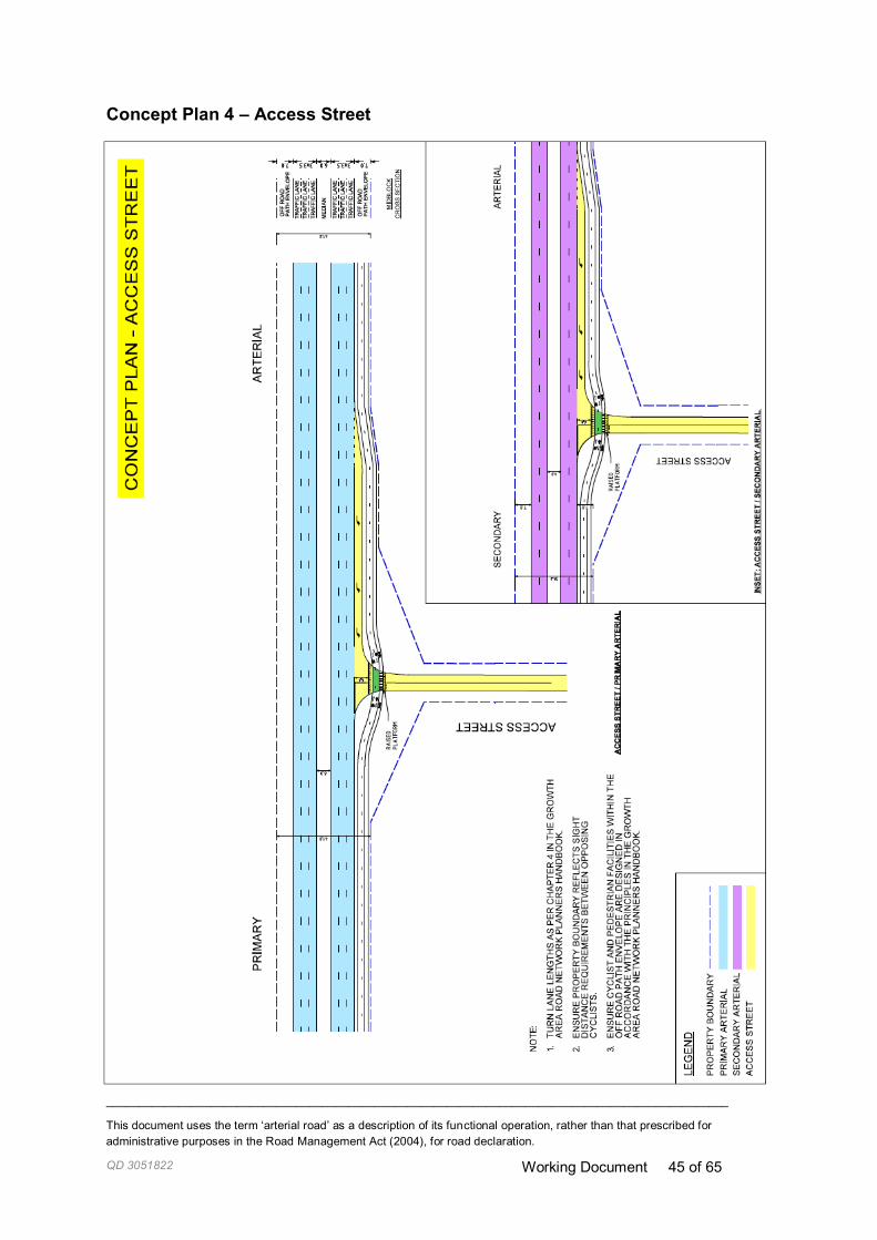
_______________________________________________________________________________________________
This document uses the term ‘arterial road’ as a description of its functional operation, rather than that prescribed for
administrative purposes in the Road Management Act (2004), for road declaration.
QD 3051822 Working Document 45 of 65
Concept Plan 4 – Access Street

_______________________________________________________________________________________________
This document uses the term ‘arterial road’ as a description of its functional operation, rather than that prescribed for administrative purposes in the Road Management Act (2004), for road
declaration.
QD 3051822 Working Document 46 of 65
4.5 Default Midblock Cross Sections
Primary Arterial
Secondary Arterial
_______________________________________________________________________________________________
This document uses the term ‘arterial road’ as a description of its functional operation, rather than that prescribed for
administrative purposes in the Road Management Act (2004), for road declaration.
QD 3051822 Working Document 47 of 65
Chapter 5: Planning the Interim Network When designing the interim network, there are several decision-making principles that are specific to
the interim environment of the Growth Areas, particularly given the uncertain nature of future transport
investment.
The 'interim network' is considered the road network while the Growth Areas are developing to their complete build.
For the purposes of this handbook, the ‘interim design’ is defined as the design for the Infrastructure Contribution Plan (ICP).
The ‘interim design horizon’ is generally considered to be 70-75% precinct development complete
with consideration of potential completion of neighbouring precincts. In the first instance it is proposed
to use ‘standardised interim templates’ for interim design & refer to 70-75% for unusual traffic
arrangements.
5.1 Purpose The purpose of this section is to build upon the decisions made for the ultimate network to inform the
design for the interim network.
This section of the guide outlines the principles in determining what is required as part of the interim
design, guidance on applying the principles and typical drawings for the interim road network .
5.2 Interim design principles Principles have been developed to define how to design for the interim network. As this section builds
on the decisions made for the ultimate network, the interim network principles should be applied in the
context of the principles for the ultimate network.
Road Network Principles
When designing and building the interim network, ensure interim transport infrastructure supports
progressive land use development (5A)
When designing and building the interim network, provide transport infrastructure that can deliver the
desired road function to an acceptable level of service for all transport modes (5B)
Resource Allocation Principles
Minimise overall costs to the community, while allocating reasonable shares of costs to developers
and appropriate levels of Government (5C)
When designing and building the interim network:
avoid interim treatments that require more land than the ultimate network(5D)
provide transport infrastructure in the interim that, where possible, aligns with the ultimate
network to avoid redundant works (5E)
minimise overall costs to governments and the community while ensuring particular care is
taken to avoid loading costs onto initial purchasers that are unrelated to development (5F)

_______________________________________________________________________________________________
This document uses the term ‘arterial road’ as a description of its functional operation, rather than that prescribed for
administrative purposes in the Road Management Act (2004), for road declaration.
QD 3051822 Working Document 48 of 65
Sustainable Transport Principle
Provide transport infrastructure that supports sustainable transport take up (5G)
Safe System Principles
Provide a safe transport network for all users by:
Minimising the likelihood and severity of conflict between vulnerable users and other vehicles
through integrated infrastructure, operations and management decisions (5H)
Minimising the likelihood and severity of conflict between vehicles (5I)
Providing mitigation to reduce the impact force to within human tolerances when vehicles
collide with roadside objects (5J)
5.3 Application of interim design principles
Road Network Principles
When designing and building the interim network, ensure interim transport
infrastructure supports progressive land use development (5A)
The purpose of this principle is to ensure that transport infrastructure provided in the interim supports
the developing community’s needs. The transport infrastructure provided in the interim should support
the movements that will be provided for in the ultimate network.
As a principle, the first contiguous carriageway shall be provided as part of the interim design.
However, where there are existing high volumes (e.g. over 15,000 vpd) or existing divided
carriageways, duplication or further widening of certain sections may also be necessary as part of the
interim network.
Generally, a new first carriageway should be constructed on the side of the reserve that best supports
the adjacent land use and existing infrastructure, although in many cases, especially early in
development of a precinct where a complete widened right of way is not yet available, the
carriageway will need to be constructed in the existing right of way.
When deciding which carriageway of a future divided arterial4 will be constructed in the interim
period, consideration must be given to ensure that complete networks are provided for all modes,
including the pedestrian and cycling network, such that all journeys can be undertaken in both
directions.
For divided roads and intersections it is preferable for the infrastructure to be constructed from the
ultimate network kerb location towards the centre median where available land permits. It may also be
necessary to deviate from this preferred practice where significant assets, services or trees prohibit
this.
The location of trunk services may also be a key determinant of the preferred interim carriageway
location.
4 This document uses the term ‘arterial road’ as a description of its functional operation, rather than that prescribed in the Road
Management Act (2004), for the purposes of road declaration. The issue of road ownership and management (VicRoads or local council) ideally should not be an issue for transport network planning; the ability to deliver and fund a network cannot be
ignored and needs to be addressed during planning.

_______________________________________________________________________________________________
This document uses the term ‘arterial road’ as a description of its functional operation, rather than that prescribed for
administrative purposes in the Road Management Act (2004), for road declaration.
QD 3051822 Working Document 49 of 65
For further information regarding the design elements recommended for the interim network, refer to
Table 5-1 and Table 5-2.
When designing and building the interim network, provide transport infrastructure
that can deliver the desired road function to an acceptable level of service for all
transport modes (5B)
The purpose of this principle is to ensure that the transport infrastructure for arterial roads provided
can cater for ‘interim design horizon’ transport capacity requirements. The interim should be sufficient
to cater for the anticipated capacity requirements for a reasonable period, noting that the use of any
arterial facilities will normally comprise a mix of local and through traffic and developer funded works
need to relate to local traffic generation.
Interim Design
The ‘interim design’ is defined as the design for the Infrastructure Contribution Plan (ICP).
The ‘interim design horizon’ is generally considered to be 70-75% precinct development complete
with consideration of potential completion of neighbouring precincts. In the first instance it is proposed
to use ‘standardised interim templates’ for interim design & refer to 70-75% for unusual traffic
arrangements.
The interim design should comprise all arterial intersection arrangements and mitigating road works
required to achieve safe and efficient operation of new accesses for the interim design horizon.
Construction of the interim network may be staged.
Interim works for the PSP should not provide for through traffic generated by adjacent precincts, but
rather should focus on traffic generated by development.
It should be noted that there may be cases where it is not possible or desirable to implement the
planned interim works (e.g. the land is not available) and a lesser temporary treatment may be
necessary. This would normally be addressed during the permit process as developer works, but in
some cases may need to be specifically addressed during planning.
Intersection elements
In general, the interim design for arterial intersection approaches should comprise of two through
lanes. However, where there are existing high volumes, three through lanes may be appropriate.
As a minimum, a single right turn lane should be provided on arterial roads in the interim to cater for
demand. However, double right turn lanes may be appropriate where there is a clear expectation of
high turning volumes (such as at industrial areas, town centres).
To ensure the interim network achieves safe and efficient operation, left turn slip lanes should be
provided in the interim design where they are required in the ultimate.
Generally, the length of turn lanes (including taper) should be the minimum necessary for safe
deceleration referred to in the Austroads Guide to Road Design Part 4A (100m in 80kph zones, 55m
in 60kph zones and 40m in 50kph zones) except where there is a clear expectation of high turning
volumes, then storage length should also be provided, but the total turn lane length generally should
generally not be longer than the ultimate design.
For further information regarding the design elements recommended for the interim refer to Table 5 2.

_______________________________________________________________________________________________
This document uses the term ‘arterial road’ as a description of its functional operation, rather than that prescribed for
administrative purposes in the Road Management Act (2004), for road declaration.
QD 3051822 Working Document 50 of 65
Resource Allocation Principles
Minimise overall costs to the community, while allocating reasonable shares of costs
to developers and appropriate levels of Government (5C)
When designing and building the interim network:
avoid interim treatments that require more land than the ultimate network (5D)
The purpose of this principle is to ensure that infrastructure designed for the interim network is as far
as is reasonably practicable designed in such a way that it does not require more land than the
ultimate design.
For example, a slip lane would generally not be provided in the interim design, where it is not required
in the ultimate network.
When designing and building the interim network:
provide transport infrastructure in the interim that, where possible, aligns with
the ultimate network to avoid redundant works (5E)
The purpose of this principle is to ensure that infrastructure that is provided in the interim should be
provided in such a way as to support the ultimate design.
In designing the interim functional layout of each intersection and cross-section, the ultimate network
arrangements should be taken into account, in order to optimise the resources used and reduce
whole-of-life costs. To the extent possible, all interim intersection works are to be designed to
contribute to the nominated ultimate treatment without removal or significant rework being required.
For instance;
Location of infrastructure: Where possible, infrastructure provided in the interim, should be
provided in the ultimate location (e.g. pavement, signal pedestals, road lighting).
Pavement design: Pavement design should consider the intended ultimate function of the
road, bearing in mind traffic flows and upgrade paths (including widening or re-sheeting) and
considering VicRoads’ standards.
Midblock access: Where access restrictions are required in the ultimate design, consideration
should be given to implementing these in the interim (e.g. left in and left out only). However,
where there is no other suitable access, full movements may be permitted in the interim.
Changing/progressive access requirements: Interim and ultimate intersection control is
agreed to in the PSP process. Developers are obligated to provide access to their
developments that is generally in accordance with the PSP/DCP. In the ideal scenario,
developers would provide interim intersection arrangements as identified as part of the PSP,
however, this is not always possible (due to land constraints, DCP funding availability, staging
of development, etc).
At the timing of development/build, developers are required to submit a permit application to Council,
which should include a Traffic Impact Assessment Report (TIAR). The TIAR should include proposed
access arrangements to the development. The access proposed should generally be in accordance
with the PSP / DCP and should provide safe and efficient access to the development.
If provision of the PSP/DCP specified access is not possible (due to land constraints, DCP funding
availability, staging of development, etc) intersection access selection should be guided by Austroads
requirements. Criteria to assist in determining suitable intersection type can be found in:

_______________________________________________________________________________________________
This document uses the term ‘arterial road’ as a description of its functional operation, rather than that prescribed for
administrative purposes in the Road Management Act (2004), for road declaration.
QD 3051822 Working Document 51 of 65
Austroads Guide to Traffic Management Part 6: Intersection, Interchanges and Crossings
Austroads Guide to Road Design Part 4A - : Unsignalised and Signalised Intersections
VicRoads' Traffic Engineering Manual Vol 1, Chapter 3 Intersections.
For example:
Interim Mid block intersections
Interim mid-block intersection access control can be in the form of left-in left out, or prior to
duplication all movement access eg Type C. Austroads provides criteria to assist in
assessing/determining suitable intersection type.
(Austroads Guide to Road Design Part 4A - : Unsignalised and Signalised Intersections).
Interim Traffic signals
Warrants for determining whether traffic signals should be provided from "day 1" or at a
particular stage of a development are provided by Austroads (Austroads Guide to Traffic
Management Part 6: Intersection, Interchanges and Crossings, Table 2.4).
If the interim traffic signals cannot be built (e.g. traffic volumes, land availability/issues) alternative
access arrangements will need to be provided without impacting on the ability to provide the interim
intersection at a later date.
For further information regarding the design elements recommended for the interim, refer to Table 5-1
and Table 5-2.
When designing and building the interim network:
minimise overall costs to governments and the community while ensuring
particular care is taken to avoid loading costs onto initial purchasers that are
unrelated to development (5F)
The purpose of this principle is to ensure that overall costs to the government and community are
minimised. Provision of community and transport infrastructure attracts significant upfront and ongoing
costs. It is necessary to balance the overall costs for provision of interim transport infrastructure with
the need for other vital infrastructure and housing costs for initial and future residents of the
community. Unduly loading costs that are related to future growth in through traffic onto initial
purchasers is both unfair and likely to be challenged during the planning process.
In some circumstances, there will be significant life-cycle cost benefits in constructing the ultimate
intersection treatment upfront. In particular:
Where the intersection connects to an arterial road that has been upgraded already, or where
upgrading is programmed (i.e. funding committed by the state); and
Where the works and funding required to upgrade an intersection from its interim to its
ultimate condition are not significant, and the intersection can be located in a position that
suits the ultimate arterial road upgrade.
Also, there needs to be a clear nexus between the PSP and the scope of the upgrade.
In these cases, upgrade works not directly attributable to the development may require funding
contribution from the State (VicRoads) or Council. Assigning proportionary costs to the relevant
agency and aligning funding timing/availability and can be difficult.
For further information regarding the design elements recommended for the interim, refer to Table 5 1
and Table 5 2. For further information on developer related funding matters refer to GAIC information
sheet (QD1050021), GAIC works-in-kind information sheet (QD1050018) and the MPA website
www.mpa.vic.gov.au.

_______________________________________________________________________________________________
This document uses the term ‘arterial road’ as a description of its functional operation, rather than that prescribed for
administrative purposes in the Road Management Act (2004), for road declaration.
QD 3051822 Working Document 52 of 65

_______________________________________________________________________________________________
This document uses the term ‘arterial road’ as a description of its functional operation, rather than that prescribed for
administrative purposes in the Road Management Act (2004), for road declaration.
QD 3051822 Working Document 53 of 65
Sustainable Transport Principle
Provide transport infrastructure that supports sustainable transport take up (5G)
The purpose of this principle is to increase the mode share of sustainable transport modes, such as
public transport, walking and cycling, by ensuring that interim infrastructure provided supports
sustainable transport.
As a minimum, separate footpath and two-way off road bicycle paths should be provided on both
sides of all arterial roads in the ultimate position. This will assist in encouraging sustainable transport
take up. Midblock pedestrian crossing facilities should be considered for the interim design where an
attractor is located on at least one side of the road (e.g. recreation facilities) and in proximity to
midblock bus stops.
Generally, bus priority is not provided as part of the interim network, however, the design should
allow for future facilities required in the ultimate. Where there is a specific need for bus priority in the
interim, due to a high frequency bus route, bus priority should be provided as per the ultimate design.
The provision of bus bays in the interim is generally not recommended unless the road is undivided,
as bus drivers find it hard to re-enter the traffic flow from a bus bay. An exception would be providing
bus bays on two lanes, two-way roads in the interim network, where bus stops separated from the
traffic lanes may be desirable.
For further information regarding the design elements recommended for the interim, refer to Table 5 1
and Table 5 2. Interim transport infrastructure must be provided in accordance with the VicRoads’
Traffic Engineering Manual, Austroads Guides, Australian Standards and VicRoads Supplements.
Specifically refer to:
VicRoads Traffic Engineering Manual: Vol 1 Chapter 4 – Pedestrian Facilities
VicRoads Traffic Engineering Manual: Vol 2 Chapter 5 – Bicycle Facilities
VicRoads Cycle Notes No. 20 - Providing for Cyclists at Bus Stops (2007)
Austroads Guide to Road Design – Part 6A Pedestrian and Cyclist Paths
Australian Standards
VicRoads Bus Stop guidelines (2006)
Safe System Principles
Provide a safe transport network for all users by:
Minimising the likelihood and severity of conflict between vulnerable users and
other vehicles through integrated infrastructure, operations and management
decisions (5H)
Minimising the likelihood and severity of conflict between vehicles (5I)
Providing mitigation to reduce the impact force to within human tolerances
when vehicles collide with roadside objects (5J)
This principle aligns with VicRoads’ legislative responsibility under the Road Management Act 2004,
to ensure that the road is safe for all users. Road infrastructure provided in the interim network must
contribute to Victoria’s Road Safety Strategy 2013-2022. The strategy outlines the Victoria’s ‘Safe
System’ vision of zero fatalities and zero serious injuries on Victorian roads.
A key factor in providing a safe road network is ensuring that speed limits across the road network
and design speeds for the network are appropriate.

_______________________________________________________________________________________________
This document uses the term ‘arterial road’ as a description of its functional operation, rather than that prescribed for
administrative purposes in the Road Management Act (2004), for road declaration.
QD 3051822 Working Document 54 of 65
Speed
Determination of appropriate speed limits follows strict guidelines to ensure consistency and a safe
road network. Where the guidance is not appropriate for a specific situation, the policy principles, in
conjunction with engineering and technical judgement, should be applied to make a principles-based
decision.
For the interim design, the design speed consideration should be given to the ultimate design. In
general, the interim design speed should be as follows:
Midblocks
horizontal & vertical: generally interim midblocks should be designed for the ultimate posted
speed which will avoid significant rework should the speed limit change from 60 to 80kph
Intersections
vertical : the ultimate posted speed limit should generally be adopted for the interim vertical
intersection alignment as changing from 60 to 80kph may require significant rework.
horizontal: can be designed for 60 kph, as not as much re-work is required if needing to
change from 60 to 80 kph (perhaps lengthening of turn lanes to safely accommodate for
deceleration of vehicles travelling faster)
Care needs to be taken in areas of speed transition to ensure unsafe treatments are avoided.
Vulnerable Users
Cyclists and pedestrians are vulnerable to serious injury or fatality if hit by a car, with severity rising
strongly with higher speeds. While roads remain undivided this danger is particularly acute for on-road
cycling unless separate facilities are provided. Treatments must be provided to address safety of
these users, including pedestrian crossings and off-road bicycle paths. Care must be taken in
designing these treatments to not unduly sacrifice convenience for vulnerable users. In the interim, it
may be appropriate to consider a lower standard treatment (e.g. a gravel shared path or a pedestrian
refuge) instead of a higher-standard treatment if significant rework is required to alter the facilities to
their ultimate configuration.
For further information regarding the design elements recommended for the interim network, refer to
Table 5-1 and Table 5-2. When designing Interim transport infrastructure consideration must be given
to the guidance provided in the VicRoads’ Traffic Engineering Manual, Austroads Guides, Australian
Standards and VicRoads Supplements. Specifically refer to VicRoads’ Speed Zoning Guidelines
(Traffic Engineering Manual Volume 1 Chapter 7 Speed Zoning Guidelines).
Summary of interim design & build
This section provides guidance relating to elements recommended for the interim design & build for
arterial intersection approaches and midblock lanes. The table also provides references to relevant
plans which depict these requirements. Where this guidance is not considered appropriate for a
specific context, the interim design & build principles (detailed in Section 5.3) should be applied to
ensure an appropriate interim is provided. For the interim, the following definitions apply:
Midblock – road reserve between intersections
Base Line Provision – general requirement for arterial roads in interim
High Volume – general requirement for arterial road in interim where there are existing
volumes over 15,000 vpd or there is anticipated to be volumes exceeding 15,000 vpd in the
interim

_______________________________________________________________________________________________
This document uses the term ‘arterial road’ as a description of its functional operation, rather than that prescribed for
administrative purposes in the Road Management Act (2004), for road declaration.
QD 3051822 Working Document 55 of 65
Interim Midblock Design & Build
Table 5-1 below details the general requirements for midblock design in the interim:
Table 5-1 - Midblock Design Elemnets for the Interim Network
Midblock design element
Base Line Provision High Volume Exceptions
Number of lanes 2 lane 2 way 4 lane divided May provide 4 or 6 where:
Existing road divided
Infill precinct
Build pattern One side
(Build on side of reserve that best supports adjacent land use and existing infrastructure)
From outside kerb at intersections
Where right of way is unavailable at the time the works are required (e.g. widening is required on the other side of the road from development)
Pedestrian & cyclist facilities
Both sides in the ultimate alignment
Off-road bicycle facilities
Both sides in the ultimate alignment
Off-road bicycle facilities
Where right of way is unavailable at the time the works are required – consider a low-cost sacrificial alternative (e.g. gravel path)
Pedestrian Crossing
Provide where an attractor is on at least one side of the road (note – not necessarily signalised)
Provide where an attractor is on at least one side of the road (Note – not necessarily signalised)
On lower volume roads, a pedestrian refuge may be adequate
Bus bays No No On two lane - two way roads.
Midblock access Construct left in/left out
Construct left in/left out
Where there is no other suitable access, full movements should be provided
Further guidance on provision of mid-block access is provided
in Section 5.3 Principle5E
Design Speed interim design speed to equal ultimate posted speed for both vertical & horizontal alignments
interim design speed to equal ultimate posted speed for both vertical & horizontal alignments
Posted Speed 60 kph interim speed for a high volume divided road to be dealt with on a case by case basis

_______________________________________________________________________________________________
This document uses the term ‘arterial road’ as a description of its functional operation, rather than that prescribed for
administrative purposes in the Road Management Act (2004), for road declaration.
QD 3051822 Working Document 56 of 65
Interim Intersection Approach Design & Build
Table 5-2 below details the general requirements for intersection approach design in the interim:
Table 5-2 - Intersection Design Elements for the Interim Network
Intersection approach – design element
Base Line Provision High Volume Exceptions
Minimum number of through lanes at intersection approach
1 through lane plus 1 short through lane
2 through lanes plus
1 short through lane
May provide less or more lanes where:
Low volumes at midblock, compared to capacity
Insurmountable space constraints
Location context (e.g. edge of UGB)
High volumes
Additional lane length 120-150m inc. taper 120 m inc. taper
Right turn lane 1 1 Double right turn lanes to be built where needed based on demand (e.g. volumes)
Left turn lane/slip lane
Where required in ultimate design
Where required in ultimate design
Turn lane length 100m (inc. Taper) in 80kph zones,
55m in 60kph zones, 40m in 50kph zones
95th percentile queue if
higher than minimum deceleration length
Determine by longer of 95th percentile queue or decel length
Build pattern Build outside-in Build outside-in May deviate from default where significant assets, services or trees prohibit default or ROW is not available
Shared paths Both sides in the ultimate alignment
Both sides in the ultimate alignment
May deviate from default where ROW is not available – consider low-cost sacrificial treatment
Bus priority No,
however allow for future facilities if required in ultimate
No,
however allow for future facilities if required in ultimate
Where there is a need for bus priority in interim due to a high frequency bus route, provide priority as per ultimate
Design Speed 60 kph for horizontal alignment and
ultimate posted speed limit for vertical alignment
60 kph for horizontal alignment and
ultimate posted speed limit for vertical alignment
Posted Speed 60 kph 80 kph

_______________________________________________________________________________________________
This document uses the term ‘arterial road’ as a description of its functional operation, rather than that prescribed for
administrative purposes in the Road Management Act (2004), for road declaration.
QD 3051822 Working Document 57 of 65
Chapter 6: Responding to PSA submissions
6.1 Purpose A completed PSP is presented as part of a Planning Scheme Amendment designed to give effect to
the PSP and related documents.
Each PSA is formally submitted to VicRoads for comment, and consists of several documents
including some or all of the following:
Precinct Structure Plan (PSP)
Development Contribution Plan (DCP)
Schedule to the Urban Growth Zone (clause 37.07) or in the case of a conservation area
Schedule to the Special Use Zone
Zoning and overlay maps potentially including Public Acquisition Overlays for roads.
It is usual practice for the MPA to engage closely with VicRoads throughout the development of a
PSP. In developing the final PSP, the MPA will rely on advice provided during consultation. Staff
should be carefully engaged in this process to ensure that advice provided in response to the
Planning Scheme Amendment is consistent with advice provided during development of the PSP,
especially where treatments/solutions have been agreed to.
When assessing submitted Planning Scheme Amendments (PSAs) the following should be
considered:
Each PSP and accompanying documents vary considerably in content and layout, therefore requiring
detailed analysis and tailored responses. However, VicRoads also provides a series of standard
responses that we request for inclusion in each document. Public Transport Victoria will also request
inclusion of their own requirements to guide public transport outcomes both on and off the arterial
road network.
The following text in orange is provided as guidance only, and should be amended to suit each PSP
and accompanying documents.
6.2 Precinct Structure Plan
Transport and Movement
VicRoads Objectives
To establish an integrated and sustainable transport network that reduces dependency
on the use of private vehicles, maximises access to public transport and encourages
walking and cycling within and between neighbourhoods.
To provide equitable access to services, employment opportunities and community
facilities for all road users, both now and in the long-term.
To ensure the transport network provides for the safe and efficient operation of the
existing and future arterial road network both in the short- and long-term.
To provide appropriate access to and from arterial roads whilst maintaining their
function and safety.
To ensure that the transport network is planned to provide for the safety of all road
users.

_______________________________________________________________________________________________
This document uses the term ‘arterial road’ as a description of its functional operation, rather than that prescribed for
administrative purposes in the Road Management Act (2004), for road declaration.
QD 3051822 Working Document 58 of 65
Planning and Design Guidelines
All intersections of existing or proposed arterial roads as shown on the PSP’s Road
Network Plan must be designed, constructed and controlled to the satisfaction of the
responsible road authority (Roads Corporation (VicRoads) or the municipal council as
appropriate), having regard to the anticipated traffic growth on the affected roads from
both the ultimate development of the PSP area and the external traffic.
Intersection layouts provided in the DCP are concepts only, prepared to inform budget
cost estimates. Any reasonable variation in scope resulting from the preparation of
detailed functional layout drawings5, is to be fully funded by the development
proponent. Appropriate inclusion of contingencies in cost estimates to allow for
variations in scope should be provided. Note that ss 62(5)—(6) of the Planning and
Environment Act 1987 acts to restrict additional infrastructure conditions at the permit
stage to those concerning infrastructure that was unanticipated during the preparation
of the DCP but is subsequently necessitated by an individual development. This may
result in developer funding not being available to cover additional costs resulting from
variations to an anticipated DCP item unless the variation can be directly attributed to
the needs of the development in question6.
Staging of subdivisions must provide for the timely connection of road links between
properties and to the arterial road network to support timely transport connections (i.e.
bus, cycle and walking).
Each subdivision must set aside land for right-of-way flaring in accordance with the
provisions of PSP (including any Public Acquisition Overlay) or DCP to accommodate
the ultimate intersection design when connecting to existing and proposed arterial
roads.
Prior to the preparation of planning permit applications which require access to an
arterial road or future arterial road as shown on the PSP’s Road Network Plan, permit
applicants should consult with VicRoads to confirm the appropriate extent of right-of-
way flaring required for the intersection.
Access points (temporary and permanent) to the existing or proposed arterial road
network beyond those shown on the PSP’s Road Network Plan will not generally be
permitted, but will be considered on a case-by-case basis where a need can be
demonstrated in accordance with VicRoads’ requirements.
Property access, side streets and/or parking should be located a minimum distance away from
an arterial road intersection according to VicRoads’ requirements. Notwithstanding the above,
the appropriate distance of access restriction will be considered on a case-by-case basis
within the context of the requirements of traffic management, safety, urban design and the
urban environment.
The following tables provide examples of appropriate minimum access restrictions for
parking, driveway and access points on different road classifications intersecting with arterial
roads. The distance refers to a point taken from the kerb line of the intersecting arterial road.
These distances are based on guidance and information provided in AustRoads Road Design
Part 4 Intersections and Crossings and Part 4A - Signalised and Unsignalised Intersections
and the Victoria Planning Provisions.
5 Note: this does not include major changes in scope required by the road authority.
6 Victoria, Parliamentary Debates, Legislative Assembly, 4 November 2004 (Ms Delahunty, Minister for Planning)

_______________________________________________________________________________________________
This document uses the term ‘arterial road’ as a description of its functional operation, rather than that prescribed for
administrative purposes in the Road Management Act (2004), for road declaration.
QD 3051822 Working Document 59 of 65
Access type Approach side Departure side
Connector Street (3,000 to 7,000 vpd)
Parking 40 m 40 m
Driveway 35 m 35 m
Access point 75 m 75 m
Town Centre Street (3,000 to 7,000 vpd)
Parking 20 m 25 m
Driveway 35 m 35 m
Access point 50 m 50 m
Access Street or Access Place (1,000 to 3,000 vpd)
Parking 20 m 25 m
Driveway 25 m 30 m
Access point 50 m 50 m
Guidance may be provided on specific additional access proposals in a PSP.
Employment and activity centres
A transport impact assessment report (TIAR) is required at the planning permit stage.
The TIAR must be to the satisfaction of the relevant Road Authority, and include
functional layout plans and a feasibility road safety audit (where requested).
Community facilities
Where a new school is located adjacent to an existing or potential future arterial road,
there must be no vehicular or pedestrian access to that road, or any adjacent service
or frontage road. All vehicular and pedestrian access to the school must be via the
internal local street network.
Where a school catchment cannot be contained within the local road network, the DCP
should provide appropriate facilities, for crossing the arterial network on clear desire
lines.
Image and character
Street tree planting to be in accordance with clear zone guidelines, or to the
satisfaction of the relevant road authority.
6.3 Development Contributions Plan Any projects that may require state funding will either be subject to funding availability
in accordance with state budget processes, may be considered under the GAIC works-
in-kind legislation, or funded at the expense of the developer to facilitate land release.
DCPs must not commit state funding to infrastructure projects.
Over time, the responsibility for infrastructure delivery may be transferred between
agencies by agreement.

_______________________________________________________________________________________________
This document uses the term ‘arterial road’ as a description of its functional operation, rather than that prescribed for
administrative purposes in the Road Management Act (2004), for road declaration.
QD 3051822 Working Document 60 of 65
Any deficit between the DCP funding allocated and the actual cost of the infrastructure
will be borne by the development agency of that required infrastructure
6.4 Schedule to the Urban Growth Zone (clause 37.07)
Application requirements (subdivision): Transport impact assessment report
A transport impact assessment report (TIAR) is required to the satisfaction of the
responsible authority. The TIAR, including functional layout plans and a feasibility road
safety audit (where requested) must be to the satisfaction of VicRoads for any
connection to an existing or potential future VicRoads arterial road.
Conditions and requirements for permits: Land for road widening
Developers making new road connections as part of the public road network must
provide the land and works required to complete any new intersections, with the land
vested as ‘road’ with the Roads Corporation or Council, as relevant. This is to be done
at no cost to the relevant road authority unless that road is funded through the relevant
DCP or included in a Public Acquisition Overlay.
Checklist: Responding to PSA submissions
1 VicRoads’ typical objectives, planning and design guidelines, and other requirements outlined in section 6.1 have been included in the PSP.
2 The schedule to the urban growth zone includes VicRoads’ application requirements (subdivision) and conditions and requirements for permits.
3 The DCP clearly identifies and fully funds the land required for the ultimate road reservation of any future arterial road determined in accordance with Chapter 4: Planning the Ultimate Network
4 The DCP clearly identifies and fully funds all land required for all major intersections in both the interim and ultimate scenarios with regard to the development anticipated in the PSP.
5 The DCP clearly identifies and fully funds the land required for major infrastructure items (bridges etc) with regard to the development anticipated in the PSP.
6 The DCP fully funds at least the first carriageway of any future arterial road constructed to suit ultimate duplication.
7 The DCP fully funds any sections of duplicated carriageway required to manage development traffic in the interim period.
8 The DCP clearly identifies and appropriately funds all interim works required at applicable intersections.
9 Any new controlled intersections proposed to be constructed to ultimate standard up-front are identified and funding sought from either GAIC works-in-kind agreement, or through the DCP.
10 The DCP only funds major infrastructure items (bridges etc) in cases where these are critical to the management of, or driven entirely by, the transport impacts of the proposed development within the interim period.

_______________________________________________________________________________________________
This document uses the term ‘arterial road’ as a description of its functional operation, rather than that prescribed for
administrative purposes in the Road Management Act (2004), for road declaration.
QD 3051822 Working Document 61 of 65
Chapter 7: Planning permit applications This section of the guide deals with permit applications submitted to VicRoads, either subsequent or
concurrent with the planning scheme amendment (i.e. Precinct Structure Plan submission).
7.1 Section 96A subdivision permit applications In order to streamline the application process for planning permits in the Growth Areas, some
developers take advantage of Section 96A of the Planning and Environment Act 1987 for a combined
planning scheme amendment (required for adoption of a Precinct Structure Plan), and planning permit
process (Section 96a planning application for a subdivision). When approving a precinct structure
plan the Minister may concurrently grant a permit for an application made under section 96A.
Section 96A applications are dealt with in the same way as a planning scheme amendment and
assessment has to be made as to the strategic appropriateness of the rezoning and subsequent
development. Planning Permit conditions must be included to fulfil the notice requirements of the
Section 96A application. In the case of concurrent Section 96A applications, the relevant draft
Precinct Structure Plan (PSP) will be available to the applicant and the permit application has been
prepared with the particular characteristics of the PSP in mind. Conditions are written into the permit
to allow it to be issued as soon as the amendment for the precinct structure plan is gazetted.
When a permit application is concurrent with the planning scheme amendment, the Minister for
Planning directs the Responsible Authority (RA) to issue a permit. Subsequent applications are dealt
with by the RA directly. The RA is usually the Council, although in a few special cases (e.g. East
Werribee), the MPA may be the RA for certain permit types – this will normally be detailed in the PSA
implementing the PSP.
7.2 Information to be submitted with Section 96A applications Where VicRoads is a referral authority, VicRoads requires development proponents to provide the
following (to the satisfaction of VicRoads) to enable consideration of the permit application:
a) submit all supporting information listed below (as well as any additional information requested
by VicRoads) to enable an assessment of the proposal
b) ensure that the proposed development is modified where necessary to accommodate all
intersection arrangements
c) provide mitigating road works required to manage its transport impacts associated with the
development.
Transport Impact Assessment Report (TIAR)
A Transport Impact Assessment Report (TIAR) for a development proposal must be prepared by a
suitably qualified traffic engineer. The report must identify all intersection arrangements and mitigating
road works necessary to manage the traffic generation to and from the subject property in the short-
and long-term (including during construction) in accordance with VicRoads’ guidelines for preparation
of a TIAR.
Functional layout plans
Scaled functional layout plans of all work within the arterial road reserve and the subdivisional access
road intersection must be provided. The functional layout plans must show the widening of the road
reserve necessary to accommodate the ultimate midblock cross-section and intersection layout.
Functional road safety audit and response (upon request)
VicRoads may request that a functional road safety audit be prepared for a development, particularly
for works exceeding $5 million, or considered by VicRoads to be a particularly complex or high risk

_______________________________________________________________________________________________
This document uses the term ‘arterial road’ as a description of its functional operation, rather than that prescribed for
administrative purposes in the Road Management Act (2004), for road declaration.
QD 3051822 Working Document 62 of 65
proposal. This functional road safety audit is in addition to other road safety audits undertaken at
subsequent stages as standard requirements under the Road Management Act 2004.
The audit must be undertaken by an independent, suitably qualified road safety auditor and be
conducted in accordance with the requirements of Austroads Guide to Road Safety Part 6: Road
Safety Audits (2009 or any subsequent versions). Any identified issues must be addressed to the
satisfaction of VicRoads.
Acoustic report
Where relevant, an acoustic report must be prepared by a suitably qualified acoustic engineer, such
as where noise sensitive development proposals are adjacent to major arterial roads.
Note Section 54 of the Planning and Environment Act 1987 enables a responsible authority to require
the applicant of a planning permit to provide ‘More Information’ before it deals with the application (eg
more information regarding noise mitigation measures).
With regards to policy requirements, VicRoads has a Traffic Noise Reduction Policy (2005) which is
currently under review. The policy is principally focussed on the circumstances where VicRoads may
or will not facilitate the mitigation of traffic noise. The policy also recognises the need to encouraging
compatible land uses next to major roads where possible.
7.3 Conditions of development consent The MPA has prepared a document titled Model Planning Permit Conditions—A Manual for
Implementation to contribute to the streamlining of planning processes in growth areas.
VicRoads has engaged with the MPA to ensure that these conditions are consistent with its standard
practices. The sections including requirements from VicRoads as follows:
Amended plans required
Where modifications to plans are required to correctly show the land required for ultimate road
widening/intersection flaring, and/or to allow for appropriate access restrictions in the vicinity of
intersections, a developer will be required to submit, and gain approval to, amended plans prior to
certification of a plan of subdivision.
VicRoads
VicRoads’ typical standard conditions of development consent are listed here. In addition to these
conditions, VicRoads also provides a note on permits (where relevant) to advise development
proponents of the subsequent requirements that need to be met for developer-funded works in order
to gain consent to carry out works under the Road Management Act 2004.
Construction management plan
A construction management plan must be prepared identifying the potential impact of construction
traffic, associated with the development, on the adjacent arterial road network. It must outline the
mitigating road works and traffic management measures recommended for the duration of
construction activities, and include (but not limited to) the following:
An overview of existing conditions adjacent to the worksite, including traffic volumes, speed
limits and pavement markings under both existing access arrangements and proposed
construction access arrangements presented in descriptive and plan form.
Approximate duration of works proposed.
Estimated maximum number/type of vehicles entering and exiting the worksite daily, and
during peak periods of activity.
Worksite risk assessment—the risk assessment procedure would be expected to target speed
restrictions within the construction zone.
Assessment of alternative construction access locations.

_______________________________________________________________________________________________
This document uses the term ‘arterial road’ as a description of its functional operation, rather than that prescribed for
administrative purposes in the Road Management Act (2004), for road declaration.
QD 3051822 Working Document 63 of 65
Identification of any mitigating road works required to manage the impacts of construction
traffic, including a functional layout concept of any proposed mitigating road works (such as
left and right turn deceleration lanes), and details of any other risk control measures proposed
to reduce identified risks (including temporary traffic management).
Any other recommendations as considered appropriate.
7.4 Referral to Public Transport Victoria Public Transport Victoria (PTV) also receives Section 96A planning applications for review and
approval. The Victorian Planning Provisions require preparation of an integrated transport plan for all
new major residential, industrial and commercial developments (refer to Clause 18.01 Integrated
Transport). PTV considers that the following major developments warrant preparation of an integrated
transport plan:
residential developments of more than 200 lots or units
new retail centres or offices of more than 10,000m2
extensions of more than 10,000m2 to retail centres of more than 20,000m
2
any other development which in the view of the responsible authority is likely to generate
significant travel demand
7.5 Timeframe for Permit Approval Each project and permit application is unique. The time taken from submission of a permit application
to approval of the permit will vary enormously depending on the complexity of the PSP and the quality
and preparation of the application by the developer.
The larger planning applications will usually share the same preparation timeframe as the associated
PSP, which is usually 12-18 months, with the development of one informing the other. Meanwhile
smaller concurrent applications may be developed in the 3-4 months near the back end of the PSP
preparation, allowing the application to be better informed by the draft PSP.
Ongoing engagement in commenting on and refining permit applications is encouraged to deliver
acceptable outcomes and to expedite the final review.
7.6 Approval to Commence Work
7.6.1 Submission of Detailed Design Plans
The issuing of a Section 96a planning permit does not provide approval to commence works on any
arterial road, be it local or declared. A planning permit approves the right-of-way boundary of the
roads and subdivisions, and the location and functional arrangements of access, including the internal
access arrangements in the vicinity of any arterial road intersection.
The planning permit allows the developer to progress with the preparation of detailed engineering
design plans generally in accordance with the accepted functional layout plan and in a manner
consistent with the relevant road authority’s policies, procedures and standards. There is still a lot of
detailed design work to be undertaken before any road works project will be ‘shovel ready’.
For declared arterial roads, the issue of the planning permit allows developers to proceed to the next
stage; to prepare and submit detailed design plans and specifications (including , but not limited to,
traffic signal plans, public lighting plans and the like) to be reviewed and approved by VicRoads. This
must happen before any work can commence, regardless of the standard of documentation provided
to obtain the planning permit.

_______________________________________________________________________________________________
This document uses the term ‘arterial road’ as a description of its functional operation, rather than that prescribed for
administrative purposes in the Road Management Act (2004), for road declaration.
QD 3051822 Working Document 64 of 65
7.6.2 Additional Documentation Requirements When VicRoads is the Road
Authority
This section is only relevant in situations where a road already has declared arterial status, making
VicRoads the road authority responsible for assessing, approving and overseeing the delivery of its
construction by the developer. If a road does not have declared status (as yet), the local authority
carries out this ‘overseeing role’ in its construction.
It is often other VicRoads Regional teams (rather than transport planning teams who have been
involved in the process to date) that carry out this work; however transport planners must do some
ground work prior to handover, including provision of the following information:
History and key issues of PSP and ICP planning. This will involve supplying the relevant parts
of the ICP.
A copy of the planning permit and a note highlighting any key conditions plus any other
relevant agreements, such as section 173 agreements.
The functional design, approved by VicRoads, including confirming letter.
Prior to any works commencing, the developer must provide the following to the satisfaction of
VicRoads:
Detailed design plans and specifications. The preparation of detailed design plans must be
undertaken by VicRoads pre-qualified designers.
A road safety audit of the detailed design plans, including response
Traffic Management Plans (TMP), together with the relevant memoranda of authorisation
associated with these plans. A road safety audit of the TMP must also be provided.
Evidence that the developer has applied for and received Consent under the provisions of the
Road Management Act 2004 to be able to work within the road reserve, once the detailed
design plans have been reviewed and approved by VicRoads.
Related costs, fees and charges that the developer is required to pay for a number of aspects
of the project.
Any other requirements identified by VicRoads as being necessary for a particular project
Documented evidence that the design and construction has considered legislative
requirements outlined in Section 28 of the Occupational Health & Safety Act 2004.
As built plans at the completion of the project in accordance with VicRoads Final Drawing
Presentation Guidelines.
VicRoads will provide written advice of permission to commence work when all requirements have
been met. No singular approval or provision of consent will constitute overall approval to commence
until this written advice has been issued.
7.7 Timeframe for Approval to Commence Works Section 96A permit applicants should allow a minimum of 12 weeks, after submission of the detailed
design plans, for receipt of approval to commence works for typical residential subdivision works
(traffic signals, intersection improvements etc), provided the following conditions are met:
full resolution of planning matters at the time of submission of detailed design plans
no revisions required to the submitted plans
developer meets all of its obligations in a timely manner including payment of all fees.
The above information is based on the typical work undertaken for most developments. For more
complex developments, such as a major shopping centres or the like, additional time should be
allowed.

_______________________________________________________________________________________________
This document uses the term ‘arterial road’ as a description of its functional operation, rather than that prescribed for
administrative purposes in the Road Management Act (2004), for road declaration.
QD 3051822 Working Document 65 of 65
Failure to provide planning permit application information to a suitable standard will typically result in
the permit application being refused by the planning authority (usually local Council) on behalf of
VicRoads. In exceptional circumstances, a planning permit may be issued conditional upon further
information being provided, the development proponent should be made aware that issue of a
planning permit under such circumstances will delay the receipt of approval to commence works, and
will therefore not result in any time saving.
7.8 Checklist: Planning permit applications
1 The planning authority has been requested to ask all section 96A permit applicants to submit transport impact assessment reports (TIARs), functional layout plans (FLPs), road safety audits (where relevant) and acoustic reports (where relevant) to VicRoads as early as possible to allow applications to be assessed.
Construction Management Plans can be submitted as part of the Conditions of Development Consent.
2 The planning authority has been requested to ask all section 96A permit applicants associated with major developments to contact Public Transport Victoria to determine requirements for preparation of an integrated transport plan (ITP).
3 Any draft planning permits include VicRoads’ standard notes and conditions for amended plans, staging of subdivision and standard VicRoads permit conditions in accordance with the MPA’s Model Planning Permit Conditions—A Manual for Implementation.
4 All section 96A permit applicants have been advised that any planning permit does not provide consent to commence works.
5 All section 96A permit applicants have been advised that further approvals of detailed engineering design plans are required (under the Road Management Act).
6 All section 96A permit applicants have been advised to allow a minimum of 12 weeks, after submission of the detailed design plans, for approval under the Road Management Act 2004 for typical residential subdivision works, and longer for more complex developments such as major shopping centres.