Evidence of Late Paleocene - Early Eocene hyperthermal events in ...

ABSTRACT
Comparisons of the physiognomy of leavesfrom modern vegetation of known climateswith that of Eocene and Oligocene fossil leafassemblages from middle latitudes of westernNorth America indicate paleoaltitudes com-parable or higher than those at present. Us-ing canonical correspondence analysis, amultivariate statistical approach that in-cludes nonlinear relationships between char-acters and environmental parameters, we re-late leaf physiognomy of fossil samples tomodern vegetation of known environmentalparameters, including moist enthalpy of theatmosphere, a thermodynamically conservedquantity of the atmosphere that varies withaltitude. By estimating enthalpy values forboth lowland leaf assemblages and coeval in-terior leaf assemblages, altitudes for the inte-rior assemblages can be estimated to ±890 m.In northeastern Washington and southernBritish Columbia, the high Eocene altitudesindicate subsidence, or collapse, of an areaundergoing crustal extension and may reflectan immediately preceding period of upliftthat triggered the extension. Similarly, otherareas that have undergone Cenozoic crustalextension appear to have been at least as highas they are at present. Three sites from theRocky Mountains also indicate elevations atleast as high as at present, and therefore sug-gest subsidence, either resulting from coolingof a hot upper mantle or erosion and isostaticcompensation of surrounding terrain. Highaltitudes during Eocene and Oligocene timein western North America appear to havebeen normal, even in areas such as the GreenRiver basin, and therefore cast doubt on thecommonly inferred late Cenozoic uplift ofthat region.
INTRODUCTION
Throughout most of the Mesozoic Era andinto the beginning of the Tertiary Period, the tec-tonic setting of western North America resem-bled that of the present-day Andes of South
America—by analogy, a high wide mountainbelt. Granite batholiths intruded the crust nearthe coast, and crustal shortening by thrust fault-ing and folding dominated deformation inland,as it currently does within the Andes (e.g., Jordanet al., 1983). As has occurred in the Andes in
664
Paleobotanical evidence of Eocene and Oligocene paleoaltitudes in midlatitude western North America
Jack A. Wolfe* Desert Laboratory, Department of Geosciences, University of Arizona, Tucson, Arizona 85721
Chris E. ForestPeter Molnar
GSA Bulletin; May 1998; v. 110; no. 5; p. 664–678; 12 figures; 1 table.
}
*E-mail: [email protected]
Department of Earth, Atmospheric, and Planetary Sciences,Massachusetts Institute of Technology, Cambridge, Massachusetts 02139
_ 50° N
_ 46°
_ 42°
_ 38° N
_ 1
04°
W
_ 1
10°
_ 1
16°
_ 1
22°
W
Figure 1. Map of middle-latitude western North America showing location of leaf assemblagesanalyzed in this report. The map is oriented obliquely to approximate the average latitudinal position of western North America during Eocene time.

Cenozoic time (e.g., Suárez et al., 1983), the lo-cus of thrust faulting migrated eastward acrossthe terrain now occupied by Nevada into that ofwestern Utah and eastern Idaho, forming mostrecently the Sevier belt on the eastern edge ofthis deformed zone (Armstrong, 1968). Then, inLate Cretaceous time, concurrently with the finaldevelopment of the Sevier belt, reverse faultinghundreds of kilometers farther east created thestructures now exposed in the Rocky Mountainsof Colorado, Wyoming, Utah, and Montana(e.g., Burchfiel et al., 1992; Wernicke et al.,1987). Since ca. 50 Ma, however, deformationthroughout the Rocky Mountains has been mild.Farther west, the surface area of the terrain
where Mesozoic thrust faulting had been wide-spread has expanded, perhaps to as much astwice its initial width, by crustal extension asso-ciated with the normal faulting that created theBasin and Range province (e.g., Wernicke et al.,1987). As crustal extension is commonly associ-ated with crustal thinning, the isostatic responseof the decreasing crustal thickness implies thatelevations should have decreased, at least in theBasin and Range province. Thus, simple physi-cal arguments suggest that in the absence of ad-ditional processes and of evidence to the con-trary, mean elevations in western North Americaeast of the Basin and Range province should nothave changed greatly in the past 50 m.y., while
those within the Basin and Range provinceshould have decreased.
Conventional wisdom holds the contrary view,that “the present high elevation of the ColoradoPlateau and most of the Cordilleran region oc-curred in late Cenozoic time” (Burchfiel et al.,1992). So widespread is this view, that studies ofindividual regions reporting details of Mesozoicand early Cenozoic historical geology commonlyconcluded, in some cases with little discussion,that significant uplift of the region occurred in lateCenozoic time (e.g., Atwood and Mather, 1932;Blackstone, 1975; Blackwelder, 1915, 1934;Deiss, 1943; Eaton, 1986, 1987; Forrester, 1937;Izett, 1975; Keefer, 1970; Love, 1970; McKee andMcKee, 1972; Pardee, 1950; Scott, 1975; Tweto,1975; Wahlstrom, 1947). Moreover, this view per-vades the literature on climate change to the extentthat not only are early and middle Tertiary eleva-tions commonly assumed to be low (e.g., Barron,1985; Sloan, 1994; Sloan and Barron, 1992;Greenwood and Wing, 1995), but late Cenozoicuplift has been assigned the cause of climatechanges that include the Pleistocene Ice Age (e.g.,Manabe and Broccoli, 1990; Ruddiman andRaymo, 1988; Ruddiman and Kutzbach, 1989).
The roots of the view that the high terrain de-veloped in latest Cenozoic time seem to lie partlyin (1) paleoclimatic indicators that suggest thattemperatures were warmer than at present overmuch of this terrain; (2) the sharp erosion of thelandscape of the western United States in latePliocene and Quaternary time (e.g., Ruddiman et al., 1989); and (3) tilted ancient stream beds in the Sierra Nevada (e.g., Christensen, 1966; Dalrymple, 1963; Huber, 1981; Hudson, 1960;Lindgren, 1911). Neither (1) nor (2) is wellfounded, however (Molnar and England, 1990),and (3) applies only locally to uplift of the Sierrancrest; moreover, tilting appears to result largelyfrom erosional unloading of the crest and sedimentloading on the western foothills (Small and Ander-son, 1995). As we show herein, early to middleCenozoic elevations throughout most of the west-ern United States were generally comparable to, orhigher than, present-day elevations; this calls for areexamination of paleobotanical evidence for lowaltitudes during that time.
The early paleobotanical evidence was tailoredto fit the putative geologic interpretations. CitingBlackwelder’s (1915) interpretations of the struc-tural and geomorphic history of the Green Riverbasin, Bradley (1929, p. 89) stated,
From this history it appears that the mountain rangesand high divides that form the rim of the Gosiutedrainage basin were probably somewhat higher withrespect to the floor of the basin during Eocene timethan at present. The floor of the basin, however, incommon with the general level of that part of thecontinent, was probably less than 1,000 feet above
EOCENE AND OLIGOCENE PALEOALTITUDES
Geological Society of America Bulletin, May 1998 665
Figure 2. Abbreviated physiognomic profiles for some modern samples in the climate-leafanalysis multivariate program (CLAMP) database. Guajatica, Puerto Rico, represents broad-leafed evergreen, multistratal rain forest (mean annual temperature [T] = 24.0 °C, mean grow-ing season precipitation [P] = 195 cm); Avon Park, Florida, represents mixed broad-leafed ever-green and deciduous forest and scrub (T = 22.8 °C,P = 140 cm); Alamos, Sonora, representsshort, tropical deciduous forest and scrub (T = 23.5 °C,P = 64 cm); Empalme, Sonora, repre-sents Sonoran Desert (T = 23.3 °C,P = 18 cm); Toya-ko, Hokkaido, represents mixed northernhardwood (deciduous) forest (T = 8.2 °C,P = 65 cm); Tunkhannock, Pennsylvania, representsmixed northern hardwood (deciduous) forest (T = 8.6 °C,P= 56 cm); Sierraville, California, rep-resents dry, mixed coniferous forest (T = 8.0 °C,P = 8 cm). Large leaves are those in the meso-phyll 1 and 2 categories, and small leaves are those in the leptophyll 1 and 2 categories of Wolfe(1993). L:W is the length-to-width ratio.

sea level. Presumably the great regional uplift didnot occur until some time late in the Tertiary period.The assumptions that follow and from which are de-duced the features of the Eocene climate dependmore or less directly upon this conception of theEocene topography of the Green River Basin and thesurrounding country.
MacGinitie’s (1953) study of the floral assem-blage from the late Eocene (ca. 35 Ma) Florissantbeds of central Colorado (Fig. 1) seems to haveserved as fundamental evidence for the inferenceof low mid-Cenozoic elevations in the Rockies.In his study, MacGinitie (1953) assigned nearestliving relatives to as many fossil species as possi-ble, and from the habitats of the nearest living rel-atives inferred a paleotemperature that was dis-tinctly higher than present (~18 vs. ~4 °C). Heconcomitantly interpreted the late Eocene toearly Oligocene floras from the Mississippi Em-bayment as indicating only moderately warmer(~3 °C) temperatures than present at their respec-tive latitudes. Assuming a typical variation oftemperature with altitude, MacGinitie (1953) es-timated a paleoaltitude of ~900 m. That elevationserved as the reference for numerous subsequentstudies that attempted to quantify Cenozoicpaleoelevations (e.g., Eaton, 1986; Epis andChapin, 1975; Trimble, 1980). In his later studyof the Green River flora, MacGinitie (1969) ar-rived at an estimate of ~300 m for the altitude ofthe Green River lakes, citing part of the quotefrom Bradley (1929).
Roughly concurrently, Axelrod (1957, 1966;Axelrod and Bailey, 1969, 1976; Axelrod andTing, 1960, 1961) assigned nearest living relativesto fossil species in floral assemblages from otherparts of the western United States, particularly inwestern Nevada and California. Although theyrecognized that climate had changed throughoutthis period, Axelrod and his colleagues also in-ferred recent uplift from their assignments ofnearest living relatives that live in climates muchwarmer than those of the high terrains from whichthe fossils came.
The assignment of nearest living relatives tofossil taxa—in particular to taxa assigned on thebasis of only one plant organ, rarely from entireplants—and the association of that nearest livingrelative to a climate carries with it the implicit as-sumption that plants have not evolved in responseto environmental changes. Although such an ap-proach applied to late Quaternary plants would bereasonable, its application to plants that have be-come extinct or have evolved morphologicallymakes such ecological assignments untestablehypotheses. If plants have evolved in response to climate change, the nearest living relativesmethod lacks credibility as a method for inferringpaleoclimate. As we discuss in more detail herein,the physiognomic characteristics of the plants of-
fer a more robust indicator of paleoenvironmentsthan does taxonomy (Wolfe, 1979, 1993, 1995;Spicer, 1989).
In addition to the paleobotanical argumentsfor late Cenozoic uplift, uplift has been as-sumed to be the cause of the incised landscapeof the Rocky Mountains (e.g., Scott, 1975) andof the abundant sediment in both adjacentbasins (e.g., Love, 1970) and in the Gulf ofMexico, where sedimentation rates for the past2 m.y. were four times more rapid than earlier(Hay et al., 1989). This period of rapid erosionand sedimentation correlates with a climate, re-plete with glaciation, very different from that ofthe preceding 250 m.y. It follows that climatechange, rather than elevation change, provides
a simple mechanism for the relatively rapidPliocene-Quaternary erosion and sedimenttransport (e.g., Molnar and England, 1990). Arecent compilation of sediment transport andsedimentation rates from glaciated and glacier-free areas suggests that glacial erosion com-monly (although not everywhere) is an order ofmagnitude more rapid than fluvial erosion(Hallet et al., 1996).
Recent Progress in Determining Paleoelevations
Even before arguments for a late Cenozoic up-lift of the western United States were challenged,evidence to the contrary appeared. Avoiding near-
WOLFE ET AL.
666 Geological Society of America Bulletin, May 1998
Figure 3. Sample plots from canonical correspondence analysis of climate-leaf analysis mul-tivariate program (CLAMP) database normal samples (white circles) and some Eocene andOligocene samples (black triangles) projected onto the surface defined by the two largest eigen-values of the analysis. The first eigenvalue is roughly parallel to mean annual temperature, andthe second measures water stress. Fossil samples prefixed by P represent U.S. Geological Surveylocality numbers for samples from the Puget Group. The arrows depict vectors of some envi-ronmental parameters:T (temperature),H (enthalpy), and q (specific humidity). The axes werepartially constrained by these three parameters and by cold-month and warm-month meantemperatures, mean growing season length, mean annual precipitation (P), mean monthlygrowing season precipitation, three consecutive driest months precipitation during growing sea-son, three consecutive wettest months during growing season, and relative humidity. T and Hproduce the longest vectors, which is an indication of their significance in ordering the samples.When samples are orthogonally projected to a given environmental vector and its extension, thesamples are approximately ranked for that parameter (see Wolfe, 1995).

est living relatives and using the physiognomiccharacteristics of the fossil leaves (cf. Wolfe,1979), Meyer (1986, 1992) assigned paleotem-peratures to fossil floral assemblages in NewMexico and Colorado. For example, Meyer(1986) inferred a somewhat lower mean annualtemperature (14 °C) for the Florissant flora thandid MacGinitie (1953). Relating this paleotem-perature to paleoelevation, however, required an-other step.
With estimates of sea-level paleotemperatureand paleotemperature of isochronous interior as-semblages, the fundamental methodology pro-posed initially by Axelrod is based on
(1)
where Z is altitude,Tsl is mean annual temperatureat sea level,Tint is mean annual temperature of theinterior assemblage of unknown paleoaltitude,and TLRis the (assumed) gradient of surface tem-perature with altitude, or terrestrial lapse rate, asopposed to the lapse rate in the free atmosphere.Although the worldwide average terrestrial lapserate is ~5.5 °C/km (Axelrod, 1966), this valuevaries widely today, especially with local geogra-phy (Meyer, 1986). In the western conterminousUnited States today, the lapse rate determined
from equation 1 varies; e.g., ~1–2 °C/km in muchof the Basin and Range province, ~3 °C/km inmost intramontane basins of the Rocky Moun-tains, and >5 °C/km uncommonly in the CascadeRange of Washington (Wolfe, 1992).
Meyer (1985, 1992) recognized the large vari-ations in terrestrial lapse rate in the westernUnited States and used the present-day distribu-tion of mean annual surface temperatures as afunction of height and position in the westernUnited States, and the knowledge that sea-leveltemperatures along the Pacific coast were consid-erably warmer than those at present, to estimatewhat temperatures would have characterized inte-rior parts of western North America were they tohave been at sea level in Oligocene–Miocenetime. His estimated “sea-level” temperature forFlorissant (29 °C) differs from what MacGinitie(1953) had assumed (22 °C) by 7 °C. The combi-nation of Meyer’s lower paleotemperature andhigher expected sea-level temperature yielded apaleoelevation similar to that at present. Assign-ing a meaningful uncertainty to Meyer’s (1986,1992) inferred paleoaltitudes, however, is diffi-cult, because his inferred paleotemperatures wereestimated qualitatively and his assumptions lead-ing to his inferred sea-level temperature ~2000km from the coast lacked a meteorologicallysound physical basis.
The development of a multivariate approach toleaf physiognomy (Wolfe, 1990) led to a quantita-tive calibration of physiognomy of leaf samplesfrom modern environments with environmentalparameters. Using an early version of the multi-variate database (only ~60 modern samples hadbeen collected), Wolfe and Wehr (1991) reportedon analyses of three early middle Eocene leaf as-semblages from the Republic, Washington, areaand an isochronous assemblage from the PugetGroup. The analyses indicated that the Puget as-semblage had a mean annual temperature of~17–18 °C, in contrast to the ~10–11 °C estimatedfor the Republic assemblages; these estimateswere based on correspondence analysis, so the re-lations of samples to environmental parameterswere subjective. Also subjective was the use of alow estimate of the decline in temperature tohigher altitudes, which led Wolfe and Wehr (1991)to suggest a paleoaltitude of ~2.3 km.
Gregory and Chase (1992) exploited a subsetof the available foliar physiognomic database(we use here an expanded version, discussed inthe following) and used linear multivariate statis-tics to determine relations between leaf physiog-nomy and mean annual temperatures. Their sta-tistics applied to fossil leaf physiognomy of theFlorissant flora refined and quantified the esti-mate of the mean annual paleotemperature. Twoestimates of paleoaltitude were made; one fol-lowed the method of Meyer (1986), and the sec-
ZT T
TLRsl int=
−,
EOCENE AND OLIGOCENE PALEOALTITUDES
Geological Society of America Bulletin, May 1998 667
Figure 4. Sample plots from canonical correspondence analysis of climate-leaf analysis multi-variate program (CLAMP) database normal samples (white circles), CLAMP subalpine and sub-arctic samples (white triangles), and the Salmon Eocene and Creede Oligocene samples (blacktriangles). The modern subalpine and subarctic samples plot as a contiguous inlier; the positionof these inlier samples indicates greater warmth and dryness than actually occurs in the sampledareas. These samples should be analyzed separately from the normal samples (see Wolfe, 1995).
Figure 5. Potassium/argonages and their stated errors forsamples from ash partings ofthe Puget Group and from aflow from the overlying an-desitic volcanic rocks (Turner etal., 1983). Whereas the indi-cated age of the andesitic vol-canics is consistent with paleo-botanical dating, the Puget agesall overlap at ca. 43 Ma (dashedvertical line) and suggest reset-ting by a thermal event.

ond used an assumed terrestrial lapse rate and ap-plied it to estimates of differences in mean annualtemperature between the coast and the Florissant.Gregory and Chase (1992) corroborated a paleo-elevation indistinguishable from that at present.
The paleoaltitudinal estimates made by Axelrod (1957, 1966a, 1966b, 1987), Meyer(1992), Gregory and Chase (1992), and Wolfe(1994a; Wolfe and Wehr, 1991) all depend onan assumption of terrestrial lapse rate. Implicitin such estimates of sea-level temperatures inthe past is the assumption that water vapor inthe atmosphere, which depends strongly ontemperature, had varied in time in such a wayas to have no effect on spatial variations in sur-face temperature across western United States,although temperatures had changed uniformlyby many degrees. With no supportive evidence,we consider that these previous paleoaltitudinalestimates are suspect and need reevaluation.
In addition, the abundances of stable isotopes,in particular δ18O, but also deuterium, are nowbeing used to infer paleotemperatures in conti-nental settings. Much of global climate is basedon oxygen isotopic variations in marine micro-fossils, where the rapidly mixed seawater pro-vides a homogeneous source of δ18O, which dif-ferent microorganisms fractionate differently. Inprinciple, the variations of δ18O in meteoric wa-ter precipitated over continents should allow in-ferences of paleotemperatures, but uncertaintiesin the source of the water later precipitated makethe technique qualitative (Cerling, 1984). Never-theless, the differences in isotopic ratios betweenthose typical of present-day conditions and thosemeasured from fossils reveal a surprising pattern;large negative values of δ18O (and δD) suggestthat early Cenozoic temperatures associated withprecipitation in localities in the western UnitedStates were comparable to those at present; forexample, ca. 50–51 Ma in Idaho (Seal and Rye,1973) and in parts of Wyoming during Eocenetime (Dettman and Lohman, 1993; Koch et al.,1995). Such low temperatures during a period ofunusual warmth in oceanic regions are clearlyconsistent with high altitudes. Norris et al. (1996)reported relatively low concentrations of 18O de-posited in lacustrine sediments of the middleEocene Green River Formation in southwesternWyoming. Allowing for enrichment of 18O byevaporation in lakes filling internally drainedbasins, they used their measurements of δ18O ≈–12‰ to –16‰ to infer that yet lower values,δ18O ≈ –18‰, characterized the source waters tothe lake. Norris et al. (1996) inferred that snow,not rain, was probably the dominant form of pre-cipitation in the surrounding mountains. Assum-ing a paleoaltitude of only 150–300 m for theGreen River Formation and a lapse rate of thefree atmosphere of 6.5 °C/km, Norris et al.
(1996) deduced that altitudes as high as 3000 min the surrounding mountains would have beennecessary to collect significant snowfall. Our in-ferences about the paleoelevation of the EoceneGreen River lakes suggest that the basin wasquite high.
METHODS
Because of the role played by evaporation andprecipitation in the energy balance of the Earth’satmosphere, Forest et al. (1995) sought a thermo-dynamic parameter, different from mean annualtemperature, to use for inferring paleoelevations,in particular, one that does not ignore water vaporin the atmosphere. Moist static energy, a thermo-dynamically conserved parameter of the atmo-sphere, quantifies the total energy content perunit mass of a parcel of air, excluding the negligi-ble kinetic energy:
h = c′p′′ T + Lvq + gZ= H + gZ, (2)
where cp is the specific heat capacity of moist airat constant pressure,T is temperature (Kelvin),Lvis the latent heat of vaporization,q is specific hu-midity, g is gravitational acceleration,Z is height,and H (= cpT+ Lvq) is enthalpy. With the assump-tion that moist static energy is zonally invariant,the difference between two estimates of enthalpyfor sites at similar paleolatitudes should yield anestimate of their difference in potential energy,gZ.
Air masses can gain or lose potential energy (el-evation), latent heat (water vapor), or thermal en-ergy (temperature), but their sum is conserved overtime scales that are large compared with the time
for the air to move across a continent at midlati-tudes. Because air usually moves from west to eastat midlatitudes, moist static energy should be con-served along lines of latitude. Thus, if we can inferenthalpy at two sites, one near the coast and theother inland, we can estimate their difference inheights from their differences in enthalpy. Someerror will be introduced by moist static energy hav-ing some longitudinal variation, an error (dh) thatis estimated at 4.5 kJ kg–1(Forest et al., 1997).
If differences in measurements of enthalpy canyield estimates of altitude, the problem becomeshow to obtain estimates of enthalpy. Inferences ofenthalpy for fossil floras can be made from leafphysiognomy of the woody dicotyledons, specif-ically from CLAMP (climate-leaf analysis multi-variate program). Wolfe (1993, 1995) analyzedsamples of leaves from >100 sites proximal tometeorological stations. Each sample comprisesat least 20 species of woody dicotyledons, allvouchered and collected to contain the full rangeof observed physiognomic variation for eachspecies in the sampled site. Each species wasscored for physiognomic variation of 31 charac-ter states, which include characters of margin,size, apex, base, and general shape (see Wolfe,1993, Figs. 8 and 9). The totals (as percentages)for each character state in a given sample consti-tute the sample profile.
As seen in Figure 2, the percentage of speciesthat have particular character states variesmarkedly in modern samples, from rain foreststo deserts and from hot to cold climates: an anal-ogy can be made to the distribution of speciesalong environmental gradients. Because the dis-tribution of species is generally related to envi-
WOLFE ET AL.
668 Geological Society of America Bulletin, May 1998
Figure 6. Correlation chart for some Eocene and Oligocene floras from midlatitudes of west-ern North America. Puget (9680) includes material from 9836 and 9837. Puget (9676) includesmaterial from 9677.
55

ronmental factors in a nonlinear fashion, ecolo-gists have developed methods to analyze speciesand environment relations. One such method isordination by canonical correspondence analy-sis, in which species data for samples are relatedto supplied environmental variables; the ordina-tion axes are constrained by these environmentalvariables, and the relative significance of eachenvironmental variable to species distributioncan be evaluated. As in species distributions, thephysiognomic character states also have nonlin-ear relations to environmental variables (Wolfe,1995), and thus canonical correspondenceanalysis is an appropriate tool. Our multivariateanalysis of leaf physiognomy by canonical cor-respondence analysis was carried out using ter Braak’s (1992) CANOCO software.
Ordination of the modern climate-leaf analysismultivariate program samples is related primarilyto temperature and secondarily to water stress(Wolfe 1993, 1995; Fig. 3). Moist enthalpy is afactor second only to mean annual temperature inordering the samples. A significant anomaly oc-curs, however, in ordering the subalpine samples,which include those from the subarctic (includingsamples from areas of >300 cm precipitation).They plot as a nest, or inlier (Fig. 4), within sam-ples that are dry and cool (but not cold). Recogni-tion of this inlier from leaf physiognomy is simple:the samples in the subalpine nest have anom-alously high scores on axes 3 and/or 4, which inturn reflect a peculiar combination of physiog-nomic character states; e.g., species in these sam-ples typically have small leaves that have rounded
apices (as in warm, dry species), but the leaves arenot emarginate as in the warm, dry species. In two-dimensional space, the subalpine and subarcticsamples form a contiguous nest, and they plotwarmer and drier than they are; in multidimen-sional space, the subalpine nest forms a cluster re-moved from samples of normal vegetation. Themost accurate calibration of environmental param-eters for non-subalpine and non-subarctic samplesis obtained by removal of the samples in the sub-alpine nest (see Wolfe, 1993, 1995). If subalpineand subarctic samples are not removed from theanalysis, the temperature parameters (includingthe temperature-dependent enthalpy) for all thenormal samples typically appear cooler than whenthe subalpine and subarctic samples are retained.In the present context, inclusion of the subalpineand subarctic samples for calibration of the non-subalpine and non-subarctic samples will lead tooverestimating paleoaltitude for these samples.
For non-subalpine and non-subarctic fossilsamples, the uncertainty in the difference in esti-mated paleoaltitudes between two sites was placedat ~760 m (Wolfe et al., 1997); however, this esti-mate used the mean error (4.2 kJ kg–1) for predict-ing enthalpy from canonical correspondenceanalysis. The standard error (σ
H) for this prediction
is 5.3 kJ kg–1, which is about the same as the 4.5 kJkg–1 error (σh) introduced by longitudinal varia-tion in enthalpy. When applied to two coeval sites,the combination of the two independent errorsproduces a standard error in the estimated differ-ence in altitude of ~890 m:
(3)
However, much of the standard error for esti-mating enthalpy from vegetation is in the sam-ples from southern Sonora and southern BajaCalifornia, which represent thorn scrub. If thesesamples are excluded from the regression, thestandard error is reduced to 4.3 kJ kg–1 and thestandard error for altitude is reduced to 770 m.Because none of the lowland coastal vegetationduring Eocene and Oligocene time representsthorn scrub, the estimate of a standard error of770 m is reasonable.
Most of the fossil samples analyzed here arewithin the normal group, and only two (Salmon,Idaho, and Creede, Colorado) are within the sub-alpine nest. Calibration of subalpine samples withenvironmental parameters is less precise than forthe non-subalpine and non-subarctic samples (seeWolfe, 1993, 1994b), especially relative to en-thalpy. All the subalpine and subarctic sampleshave a short growing season; if the growing sea-son is defined as all consecutive days that havemean temperature >10 °C, samples in the sub-alpine and subarctic nest typically have a growing
σσ σ
Zg
H h=+
=2 2 2
2890 m.
EOCENE AND OLIGOCENE PALEOALTITUDES
Geological Society of America Bulletin, May 1998 669
Figure 7. Abbreviated physiognomic profiles for an early middle Eocene (ca. 48 Ma) leaf as-semblage from the Puget Group and late early Eocene (ca. 49–51 Ma) leaf assemblages from theRocky Mountains. The Puget assemblage represents lowland vegetation in western Washington,and the Kisinger Lakes and Little Mountain assemblages represent vegetation from westernWyoming. Analysis of the Kisinger Lakes assemblage is based on MacGinitie (1974); analysis ofthe Puget Group assemblage is based on a collection in the U.S. National Museum; and analy-sis of the Little Mountain assemblage is based on collections in the University of California Mu-seum of Paleontology. The Little Mountain physiognomy has character states that indicate bothdrier (e.g., small leaf size, few attenuate apices) and cooler (e.g., more lobes and broader leaves)conditions than the Puget physiognomy. The Kisinger Lakes physiognomy has character statesthat indicate moister (e.g., larger leaf size) and cooler (e.g., more regularly spaced teeth) condi-tions than the Little Mountain. L:W is the length-to-width ratio.
season of <4.3 months. In the present context,however, we emphasize that the mean annual en-thalpy for all modern samples that fall within thesubalpine nest is <295 kJ kg–1, and we assumethat any fossil sample that falls within the nest canbe assigned this as a maximum value. Mean an-nual temperature for the subalpine samples can becalibrated with a standard error of 1.3 °C (Wolfe,1993); if we have an estimate of an appropriateterrestrial lapse rate, mean annual temperaturedifferences between sea level and interior assem-blages can yield a general estimate of paleoalti-tude for the subalpine assemblages. However, thecombination of errors, first in calculating a terres-trial lapse rate from fossil assemblages of a par-ticular period, and second in estimating δT for asea level and interior assemblage, is so great thatsimply using a maximum estimate of 295.0 kJkg–1 of H for any subalpine sample seems to us asimple and effective way of estimating a minimalaltitude for the few fossil assemblages that plot inthe subalpine nest.
LOW-ALTITUDE ASSEMBLAGES
The analysis of near-coastal, low-altitude leafassemblages that are isochronous with the interior
assemblages is critical to the method used here.That mean annual temperatures in coastal regionsin the western United States have fluctuatedmarkedly during Eocene and Oligocene time isclear (Wolfe, 1978, 1994a). To compare, for ex-ample, an interior flora from a warm interval ofEocene time with a coastal flora from a cool inter-val of Eocene time might indicate little differencein either temperature or physiognomy and hencelittle difference in paleoaltitudes. Conversely, tocompare an interior flora from a cool interval witha coastal flora from a warm interval could grosslyoverestimate the paleoaltitude of the interior flora.
With the exception of the Comstock, all thenear-coastal Eocene assemblages analyzed werecollected from the Puget Group of western Wash-ington, and thus the ages of the various Puget as-semblages need to be considered. Wolfe (1968)used the leaf floras from the Puget Group as thebasis for five formal stage ages: the oldest ofthese—the Franklinian stage—was equated ap-proximately to early Eocene time; Fultonian timewas approximated to middle Eocene time; Raven-ian time was approximated to late Eocene time;and Kummerian time was approximated to earlyOligocene time. Further analysis of the relationsof marine and nonmarine biostratigraphic units
along the Pacific Coast (Wolfe, 1981) indicatedthat (1) the time of the Eocene-Oligocene bound-ary was at ca. 32 Ma, (2) the Kummerian was ca.32–37 Ma and late Eocene, (3) the Ravenian andthe Fultonian were ca. 37–49 Ma and middle toearly late Eocene, and (4) the Franklinian was49–52 Ma and late early Eocene.
In contrast, K/Ar age determinations based onmaterial from ash partings from the Puget Groupcoals were interpreted to indicate that the almost2 km of sedimentary rocks—including numerousthick coal beds—of the Puget Group in the typesections of the paleobotanical stages were de-posited in a period of no more than 4 m.y. and rep-resented only middle Eocene time (Turner et al., 1983). Results from K/Ar analyses from theconformably overlying volcanic rocks (part of thetype section of the Kummerian stage) placed thevolcanic unit at ca. 35 Ma (early Oligocene, asthen thought) and therefore consistent with thepaleobotanical correlations of the Kummerian.The Puget ages are not internally consistent rela-tive to stratigraphy; some sampled units yieldK/Ar ages older than those of underlying units.The stated experimental errors on the radiometricages permit the various ages to be stratigraphi-cally consistent, but all the Puget ages overlap at
WOLFE ET AL.
670 Geological Society of America Bulletin, May 1998
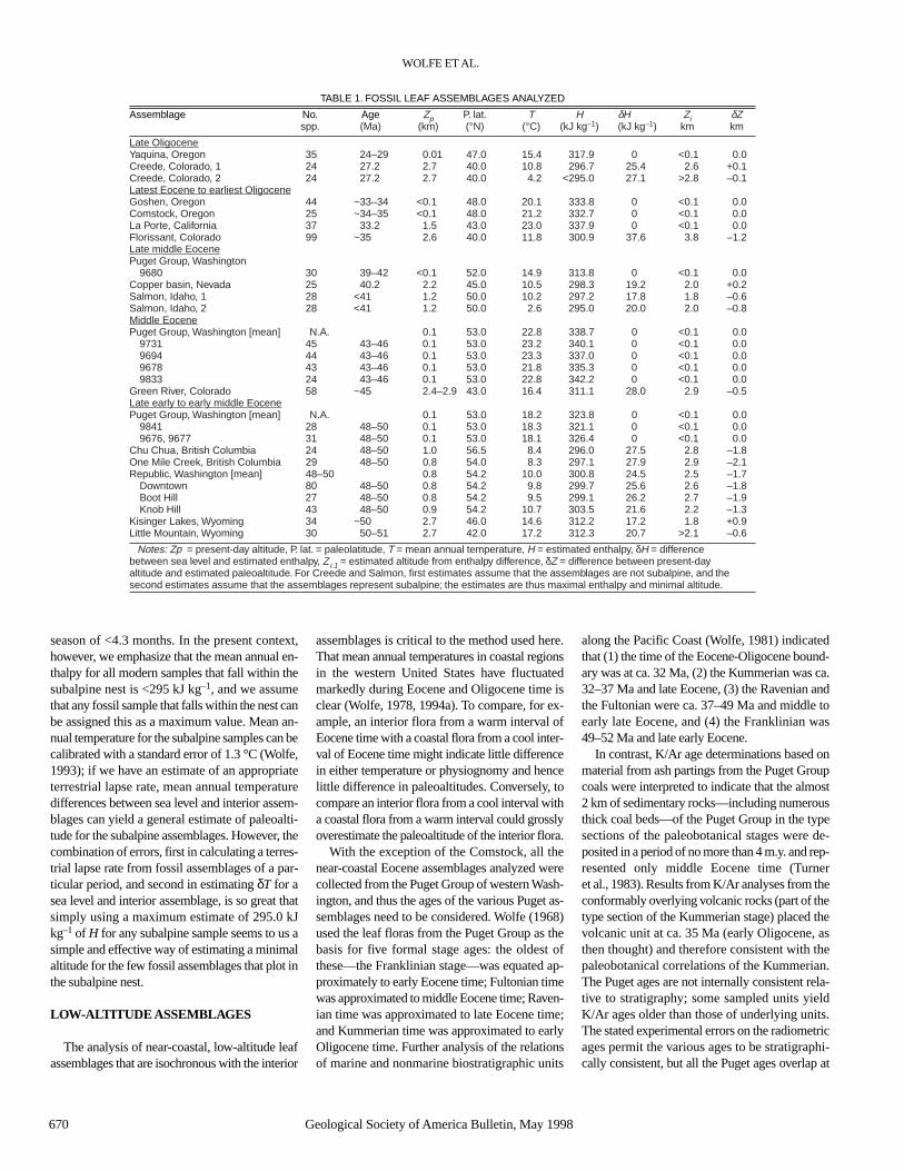
TABLE 1. FOSSIL LEAF ASSEMBLAGES ANALYZED
Assemblage No. Age Zp P. lat. T H δH Zi δZspp. (Ma) (km) (°N) (°C) (kJ kg–1) (kJ kg–1) km km
Late OligoceneYaquina, Oregon 35 24–29 0.01 47.0 15.4 317.9 0 <0.1 0.0Creede, Colorado, 1 24 27.2 2.7 40.0 10.8 296.7 25.4 2.6 +0.1Creede, Colorado, 2 24 27.2 2.7 40.0 4.2 <295.0 27.1 >2.8 –0.1Latest Eocene to earliest OligoceneGoshen, Oregon 44 ~33–34 <0.1 48.0 20.1 333.8 0 <0.1 0.0Comstock, Oregon 25 ~34–35 <0.1 48.0 21.2 332.7 0 <0.1 0.0La Porte, California 37 33.2 1.5 43.0 23.0 337.9 0 <0.1 0.0Florissant, Colorado 99 ~35 2.6 40.0 11.8 300.9 37.6 3.8 –1.2Late middle EocenePuget Group, Washington
9680 30 39–42 <0.1 52.0 14.9 313.8 0 <0.1 0.0Copper basin, Nevada 25 40.2 2.2 45.0 10.5 298.3 19.2 2.0 +0.2Salmon, Idaho, 1 28 <41 1.2 50.0 10.2 297.2 17.8 1.8 –0.6Salmon, Idaho, 2 28 <41 1.2 50.0 2.6 295.0 20.0 2.0 –0.8Middle EocenePuget Group, Washington [mean] N.A. 0.1 53.0 22.8 338.7 0 <0.1 0.0
9731 45 43–46 0.1 53.0 23.2 340.1 0 <0.1 0.09694 44 43–46 0.1 53.0 23.3 337.0 0 <0.1 0.09678 43 43–46 0.1 53.0 21.8 335.3 0 <0.1 0.09833 24 43–46 0.1 53.0 22.8 342.2 0 <0.1 0.0
Green River, Colorado 58 ~45 2.4–2.9 43.0 16.4 311.1 28.0 2.9 –0.5Late early to early middle EocenePuget Group, Washington [mean] N.A. 0.1 53.0 18.2 323.8 0 <0.1 0.0
9841 28 48–50 0.1 53.0 18.3 321.1 0 <0.1 0.09676, 9677 31 48–50 0.1 53.0 18.1 326.4 0 <0.1 0.0
Chu Chua, British Columbia 24 48–50 1.0 56.5 8.4 296.0 27.5 2.8 –1.8One Mile Creek, British Columbia 29 48–50 0.8 54.0 8.3 297.1 27.9 2.9 –2.1Republic, Washington [mean] 48–50 0.8 54.2 10.0 300.8 24.5 2.5 –1.7
Downtown 80 48–50 0.8 54.2 9.8 299.7 25.6 2.6 –1.8Boot Hill 27 48–50 0.8 54.2 9.5 299.1 26.2 2.7 –1.9Knob Hill 43 48–50 0.9 54.2 10.7 303.5 21.6 2.2 –1.3
Kisinger Lakes, Wyoming 34 ~50 2.7 46.0 14.6 312.2 17.2 1.8 +0.9Little Mountain, Wyoming 30 50–51 2.7 42.0 17.2 312.3 20.7 >2.1 –0.6
Notes: Zp = present-day altitude, P. lat. = paleolatitude, T = mean annual temperature, H = estimated enthalpy, δH = difference between sea level and estimated enthalpy, Z i.1 = estimated altitude from enthalpy difference, δZ = difference between present-day altitude and estimated paleoaltitude. For Creede and Salmon, first estimates assume that the assemblages are not subalpine, and the second estimates assume that the assemblages represent subalpine; the estimates are thus maximal enthalpy and minimal altitude.

about 43 Ma (Fig. 5), which could be evidence ofresetting by a single thermal event. The K/Aranalyses of the Puget ash partings (1) are strati-graphically and internally inconsistent, (2) are es-pecially variable in the lower part of the Pugetsection, (3) overlap at about 43 Ma, (4) are anom-alous relative to the thickness of the sequence (es-pecially considering the included thick bitumi-nous coals), requiring extremely high depositionalrates, and (5) are inconsistent with the paleo-botanical correlations. We conclude that the K/Aranalyses of the Puget Group ash partings only in-dicate a thermal event at ca. 43 Ma and that thesuggested paleobotanical correlations (Newman,1981; Wolfe, 1981) are approximately correct.
The Chalk Bluffs flora, which is the major cor-relative flora of the lowest (Franklinian) stage of
the Puget Group, was considered on the basis ofstratigraphic relations to marine units to be ca.49–52 Ma (Wolfe, 1981). The marine unit (IoneFormation) has been assigned to the Penutianstage of the benthic foraminiferal sequence, andthe Penutian is approximately equivalent toplanktic foraminiferal zone P8 (ca. 50–50.5 Ma).The Penutian, however, is time transgressive,ranging from 49 to 55 Ma (e.g., Miles, 1981).Palynostratigraphy of the lower Puget (Newman,1981) suggests that this section is no older than49 Ma. This suggests that the oldest known PugetGroup floras are no older than 48–49 Ma and arethus of early middle Eocene age.
The ages of the near-coastal floras of Kum-merian (late Eocene and earliest Oligocene) andlate Oligocene ages are unequivocal. The Com-
stock and stratigraphically higher Goshen assem-blages are from nonmarine lateral equivalents of the marine Spencer and Eugene Formations (Armentrout, 1981), which are overlain con-formably by a thin unit that has a K/Ar age of 31 Ma (Evernden and James, 1964). The LaPorte flora in California has been dated by K/Arat 33.4 Ma (corrected from the date reported byEvernden and James, 1964), although this assem-blage needs an age based on 40Ar/39Ar analyses.No radiometric ages are known from the lateOligocene Yaquina Formation, but the flora is present in a deltaic unit between the lower and upper marine tongues of the formation (McClammer, 1978), which is assigned to themarine Galvinian stage on the basis of marinefossils (ca. 24–29 Ma; Armentrout, 1981).
INTERIOR ASSEMBLAGES
The ages of most interior floras analyzed arebased on radiometric dating and/or a combinationof stratigraphy and radiometric dating (Fig. 6).Ages for the Creede, Florissant, Little Mountain,Kisinger Lakes, Green River, Copper basin, Re-public (including all three major assemblages), andOne Mile Creek (Princeton) assemblages are basedon K/Ar dating (see discussions in MacGinitie,1969, 1974; Wolfe and Tanai, 1987), although westress the need for new single-crystal 40Ar/39Ar dat-ing. No independent ages are known for the ChuChua assemblage, and all that is certainly knownfor the Salmon assemblage is that it is younger than41 Ma (M. L. Statz,in Wolfe and Tanai, 1987).
RESULTS
The inferences of the paleoaltitudes of the old-est Rocky Mountain leaf assemblages analyzeddepend in part on the ages of these assemblagesrelative to the Puget assemblages. As summa-rized in MacGinitie (1974), the Kisinger Lakesflora should be about 48.5 Ma using the old K/Arconstants, and about 49.8 Ma using current con-stants. Similarly, the Little Mountain flora wasassigned a K/Ar age of 49 Ma (Culbertson, citedin MacGinitie, 1974), which is 50.3 Ma usingcurrent constants. If so, then we suggest that theLittle Mountain and Kisinger Lakes floras areprobably ~1–2 m.y. older than the oldest ana-lyzed Puget leaf assemblage; in Table 1, there-fore, comparison is made only to the oldest Pugetassemblage (Fig. 7).
Because of the early Eocene thermal optimum,the older an assemblage within the early Eocene,the more probable that the enthalpy value at sealevel would be higher and, consequently, thegreater the altitude that would be estimated forinterior assemblages. This is particularly applic-able to the Little Mountain assemblage, which is
EOCENE AND OLIGOCENE PALEOALTITUDES
Geological Society of America Bulletin, May 1998 671
Figure 8. Abbreviated physiognomic profiles for some early middle Eocene (47–49 Ma) leafassemblages. The Puget assemblages represent lowland vegetation in western Washington, theChu Chua and One Mile Creek represent vegetation in southern British Columbia, and the re-maining assemblages represent the Republic vegetation in northeastern Washington. Analysesof the Puget assemblages are based on collections in the U.S. National Museum; analyses of theOne Mile Creek and Republic assemblages are based on collections in the University of Wash-ington Burke Museum; and analysis of the Chu Chua assemblage is based on collections now atthe University of Arizona but to be deposited in the Geological Survey of Canada collections. Al-though the physiognomies of both Puget assemblages indicate cooler temperatures than in thefour succeeding Puget assemblages, the interior assemblages have smaller leaf size, numerousspecies are lobed, and a preponderance of species that have regularly spaced teeth. L:W is thelength-to-width ratio.

from the lower part of the Green River Forma-tion, and has an estimated paleoaltitude of 2.1 ±0.8 km, which should be considered a minimalestimate. The CLAMP estimate of 1.8 ± 0.8 kmfor the Kisinger Lakes assemblage may also rep-resent a minimal estimate, but, being closer intime to the lowest Puget assemblage, may bevalid. The Kisinger Lakes assemblage was sig-nificantly higher than the 0.3 km estimate sug-gested by MacGinitie (1974).
Leaf physiognomy of the early middle Eoceneassemblages from northeastern Washington andsouthern British Columbia is markedly differentfrom physiognomy of the Puget assemblages(Fig. 8). These upland assemblages all indicatesubstantially higher (~2 km) altitudes duringEocene time than at present; the estimates for theRepublic assemblages are about the same as theestimate of 2.3 km made previously on the basisof temperature differences (Wolfe and Wehr,1991). The depositional settings for these assem-blages are lakes that occupied grabens followingthe initiation of normal faulting in these areas.Note that if these assemblages were older thanearly middle (possibly latest early) Eocene age(>49 Ma), they would have lived during the earlyEocene thermal optimum, when sea-level en-thalpy would have been even higher than that es-timated for the Puget Group. Thus, the inferredpaleoaltitudes would be substantially higher. Sim-ilarly high paleoelevations would be deduced ifthese assemblages lived later in middle Eocenetime and were thus isochronous with the next fourstratigraphically higher Puget assemblages.
For the warm interval of middle Eocene time,ca. 43–46 Ma, physiognomic differences betweenfour coastal floras and the one interior flora ana-lyzed are significant (Fig. 8), although some dif-ferences (e.g., leaf sizes and attenuate apices) maybe largely the result of differences in precipita-tional regimes. The physiognomies of the four as-semblages from the Puget Group all yield verysimilar estimates for both T and H; their plots farto the left in Figure 3 indicate abundant precipita-tion with no dry season. In contrast, the earlierPuget leaf assemblages (9676, 9841), although in-dicating moist conditions, are less wet; notewor-thy too are coals, which are thinner and fewerfrom the lower part of the Puget section than fromthe section containing these younger leaf assem-blages (9833, 9878, 9694, 9731).
The only interior flora of the middle middleEocene (43–46 Ma) interval that we have ana-lyzed is from the upper part of the Green RiverFormation, which is dated ca. 45 Ma by a com-bination of stratigraphy and radiometric data(MacGinitie, 1969). Traditionally, the GreenRiver lakes have been placed at low altitudes(e.g., Greenwood and Wing, 1995), partly be-cause consensus assigns large interior lakes to
low altitudes. Large lakes can persist in continen-tal interiors at high altitudes, as in the Andes andon the Tibetan Plateau. Compared to the Pugetassemblages (Fig. 8), the Green River assem-blage has fewer untoothed species that are linear,large, and have attenuate apices. Such differencesyield an estimated paleoaltitude of 2.9 km for theGreen River flora, which differs little from thepresent-day altitudes at the fossil localities.
For the succeeding cool interval of late middleEocene time (late Ravenian of Wolfe, 1968), wecombined the flora from three localities in thePuget Group in order to have a taxonomically di-verse sample. The combined Puget assemblagehas a high proportion of species that have leaveswith untoothed margins and are unlobed, large,and have attenuate apices; note that the Puget andthe interior assemblages all have moderate repre-
sentation of regularly toothed species (Fig. 9).From nearest living relatives,Axelrod (1966b) in-ferred the Copper basin flora to have lived at <1.2km compared to the present-day altitude of ~2.1km; however, the physiognomic differences im-ply that the Copper basin flora lived at ~2.0 km(Table 1), i.e., about the same as the fossil local-ity today. If the Copper basin were isochronouswith the older Puget flora from locality 9731 orwith the younger Comstock flora, the estimatedpaleoaltitude would be substantially higher.
The Salmon flora is not well dated. It is presentin lacustrine sediments deposited in a graben afterthe initiation of normal faulting of the Challis Vol-canics. The Salmon flora has some taxa in com-mon with the later Eocene floras in western Mon-tana, and, like Wolfe and Tanai (1987), weconsider the Salmon flora to be of late middle
WOLFE ET AL.
672 Geological Society of America Bulletin, May 1998
Figure 9. Abbreviated physiognomic profiles for some middle Eocene (ca. 43–46 Ma) leaf as-semblages. The Puget assemblages represent lowland vegetation in western Washington, and theGreen River assemblage represents vegetation in northwestern Colorado and adjacent Utah.Analysis of the Green River assemblage is based primarily on MacGinitie (1969), and analysesof the Puget Group assemblages is based on collections in the U.S. National Museum. The Pugetassemblages all have character states indicative of high temperature (species typically have noteeth and are unlobed) and rainfall (large leaf size and many species have attenuate apices), incontrast to the Green River physiognomy. Dryness in the Green River physiognomy is also in-dicated by the many species that have linear (“stenophyllous”) leaves (i.e., length-to-width ratio,L:W > 4:1).
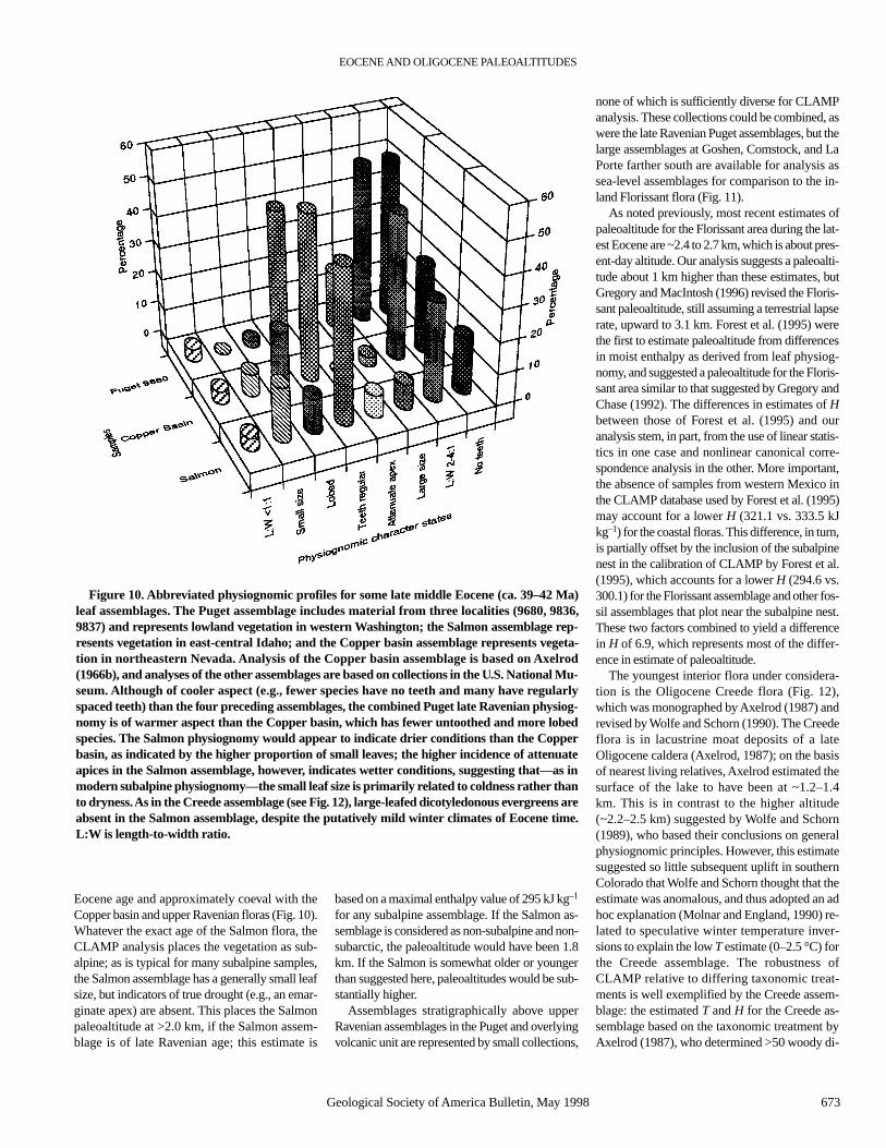
Eocene age and approximately coeval with theCopper basin and upper Ravenian floras (Fig. 10).Whatever the exact age of the Salmon flora, theCLAMP analysis places the vegetation as sub-alpine; as is typical for many subalpine samples,the Salmon assemblage has a generally small leafsize, but indicators of true drought (e.g., an emar-ginate apex) are absent. This places the Salmonpaleoaltitude at >2.0 km, if the Salmon assem-blage is of late Ravenian age; this estimate is
based on a maximal enthalpy value of 295 kJ kg–1
for any subalpine assemblage. If the Salmon as-semblage is considered as non-subalpine and non-subarctic, the paleoaltitude would have been 1.8km. If the Salmon is somewhat older or youngerthan suggested here, paleoaltitudes would be sub-stantially higher.
Assemblages stratigraphically above upperRavenian assemblages in the Puget and overlyingvolcanic unit are represented by small collections,
none of which is sufficiently diverse for CLAMPanalysis. These collections could be combined, aswere the late Ravenian Puget assemblages, but thelarge assemblages at Goshen, Comstock, and LaPorte farther south are available for analysis assea-level assemblages for comparison to the in-land Florissant flora (Fig. 11).
As noted previously, most recent estimates ofpaleoaltitude for the Florissant area during the lat-est Eocene are ~2.4 to 2.7 km, which is about pres-ent-day altitude. Our analysis suggests a paleoalti-tude about 1 km higher than these estimates, butGregory and MacIntosh (1996) revised the Floris-sant paleoaltitude, still assuming a terrestrial lapserate, upward to 3.1 km. Forest et al. (1995) werethe first to estimate paleoaltitude from differencesin moist enthalpy as derived from leaf physiog-nomy, and suggested a paleoaltitude for the Floris-sant area similar to that suggested by Gregory andChase (1992). The differences in estimates of Hbetween those of Forest et al. (1995) and ouranalysis stem, in part, from the use of linear statis-tics in one case and nonlinear canonical corre-spondence analysis in the other. More important,the absence of samples from western Mexico inthe CLAMP database used by Forest et al. (1995)may account for a lower H (321.1 vs. 333.5 kJkg–1) for the coastal floras. This difference, in turn,is partially offset by the inclusion of the subalpinenest in the calibration of CLAMP by Forest et al.(1995), which accounts for a lower H (294.6 vs.300.1) for the Florissant assemblage and other fos-sil assemblages that plot near the subalpine nest.These two factors combined to yield a differencein H of 6.9, which represents most of the differ-ence in estimate of paleoaltitude.
The youngest interior flora under considera-tion is the Oligocene Creede flora (Fig. 12),which was monographed by Axelrod (1987) andrevised by Wolfe and Schorn (1990). The Creedeflora is in lacustrine moat deposits of a lateOligocene caldera (Axelrod, 1987); on the basisof nearest living relatives, Axelrod estimated thesurface of the lake to have been at ~1.2–1.4 km. This is in contrast to the higher altitude(~2.2–2.5 km) suggested by Wolfe and Schorn(1989), who based their conclusions on generalphysiognomic principles. However, this estimatesuggested so little subsequent uplift in southernColorado that Wolfe and Schorn thought that theestimate was anomalous, and thus adopted an adhoc explanation (Molnar and England, 1990) re-lated to speculative winter temperature inver-sions to explain the low T estimate (0–2.5 °C) forthe Creede assemblage. The robustness ofCLAMP relative to differing taxonomic treat-ments is well exemplified by the Creede assem-blage: the estimated T and H for the Creede as-semblage based on the taxonomic treatment byAxelrod (1987), who determined >50 woody di-
EOCENE AND OLIGOCENE PALEOALTITUDES
Geological Society of America Bulletin, May 1998 673
Figure 10. Abbreviated physiognomic profiles for some late middle Eocene (ca. 39–42 Ma)leaf assemblages. The Puget assemblage includes material from three localities (9680, 9836,9837) and represents lowland vegetation in western Washington; the Salmon assemblage rep-resents vegetation in east-central Idaho; and the Copper basin assemblage represents vegeta-tion in northeastern Nevada. Analysis of the Copper basin assemblage is based on Axelrod(1966b), and analyses of the other assemblages are based on collections in the U.S. National Mu-seum. Although of cooler aspect (e.g., fewer species have no teeth and many have regularlyspaced teeth) than the four preceding assemblages, the combined Puget late Ravenian physiog-nomy is of warmer aspect than the Copper basin, which has fewer untoothed and more lobedspecies. The Salmon physiognomy would appear to indicate drier conditions than the Copperbasin, as indicated by the higher proportion of small leaves; the higher incidence of attenuateapices in the Salmon assemblage, however, indicates wetter conditions, suggesting that—as inmodern subalpine physiognomy—the small leaf size is primarily related to coldness rather thanto dryness. As in the Creede assemblage (see Fig. 12), large-leafed dicotyledonous evergreens areabsent in the Salmon assemblage, despite the putatively mild winter climates of Eocene time.L:W is length-to-width ratio.

cotyledon species, versus that of Wolfe andSchorn (1990), who reduced this number to 24,are within the standard errors for T and for H.
Creede T is estimated from (1) recognizing thatthe Creede sample plots in the subalpine zone(Fig. 4), and (2) regression of T for only the sub-alpine samples (see Wolfe, 1993). This CLAMPsubroutine yields an estimate of T of 4.2 °C. Theassociation of the Creede sample with the sub-alpine nest indicates that enthalpy was <295 kJkg–1 and paleoaltitude was >2.8 ± 0.8 km. If wetry to use δTof 10.6 °C between sea level and theCreede flora to estimate paleoaltitude, the result isan uncertain terrestrial lapse rate. At about 35 Ma,the Florissant T indicates a terrestrial lapse rate of2.9 °C/km ± and at 15.5–16.0 Ma, the estimatedterrestrial lapse rate between the coast and west-ern Nevada was 2.0–3.3 °C/km (Wolfe et al.,1997). Using the highest terrestrial lapse rate (3.3 °C/km) yet estimated for the time from 15 to35 Ma in western United States yields an estimateof ~3.9 km paleoaltitude for the Creede lake sur-face, and the volcanic plateau ~1 km above couldhave been ~5 km altitude. The higher-than-pres-ent paleoaltitudinal estimates for this area ofsouthern Colorado during late Oligocene timemight be expected, because of uplift due to under-plating of magma and therefore crustal thickeningassociated with the volcanism at the surface. Likemodern subalpine samples, the Creede assem-blage has generally small-leafed species, but onesthat are not emarginate, and a low incidence oflobed species; we thus think that the Creede plotsin the subalpine nest. Nevertheless, as with theSalmon, if the Creede leaf assemblage weretreated as non-subalpine and non-subarctic ratherthan subalpine, the enthalpy difference betweenthe Creede and Yaquina assemblages would indi-cate a paleoaltitude for the Creede of 2.6 ± 0.8km, approximately that of the present.
The uncertainty of terrestrial lapse rates inwestern North America during the Eocene andOligocene makes previous paleoaltitudinal esti-mates of uncertain validity when these are basedon an assumed particular lapse rate. The largelyindependent estimates of paleoaltitudes and of Tgiven in Table 1 allow gross estimates to bemade of past terrestrial lapse rates. On the basisof differences in Tbetween the Puget Group andthe uplands of Washington and southern BritishColumbia, estimated lapse rates for early mid-dle Eocene time are 3.4 °C/km (mean of allthree Republic assemblages), 3.5 °C/km (OneMile Creek), and 3.3 °C/km (Chu Chua). Therelations between the Puget and Green Riversuggest a lapse rate of 2.8 °C/km; relations be-tween the Puget and Copper basin suggest a rateof 3.3 °C/km; and relations between the coastalassemblages and Florissant suggest a rate of3.1 °C/km. These gross estimates are similar to
the empirically derived terrestrial lapse rate of~3.0 °C/km in present-day western NorthAmerica (Wolfe, 1992).
DISCUSSION AND CONCLUSIONS
Two basic processes lead to large changes inmean elevations (~1 km or more) over large areasin relatively short times (<10 m.y.). First, changesin crustal thickness will, via isostasy, yield changesin mean elevations of roughly 15% of the changein crustal thickness. Thus, crustal shortening or ex-tension at rates of a few millimeters per year overregions as wide as 100 km will yield elevationchanges of ~1 km in 10 m.y. Similarly, the additionof material by magmatic processes to the base ofthe crust should cause surface uplift of comparableamounts, ~15% of the thickness of added crustalmaterial. Second, an alteration of the thermalstructure of the upper mantle by mass transfer,
such as by delamination of the entire mantle litho-sphere (e.g., Bird, 1978, 1979) by convective re-moval of thickened, and therefore unstable, lowerlithosphere (e.g., England and Houseman, 1989;Houseman et al., 1981), or by heating by erosionof the basal lithosphere by the impingement of anewly developed zone of hot upwelling, can causerapid uplift of the Earth’s surface (1–2 km in a fewmillion years). Most other processes requirelonger periods for comparable elevation changes.Erosion lowers mean elevations on a longer timescale, because isostasy compensates for materialthat is removed. For a relatively high average ero-sion rate of 0.3 mm/yr, mean elevations should de-crease at 0.05 mm/yr, corresponding to 500 m ofsubsidence in 10 m.y. More typical erosion rates of0.1 mm/yr require proportionally longer periodsfor substantial lowering of the surface. Similarly,thermal alteration by conductive heating or cool-ing is a slow process, dictated by the thermal time
WOLFE ET AL.
674 Geological Society of America Bulletin, May 1998
Figure 11. Abbreviated physiognomic profiles for some late Eocene to earliest Oligocene (ca.33–35 Ma) leaf assemblages. The Comstock and Goshen assemblages represent lowland vegeta-tion in west-central Oregon, the La Porte assemblage represents vegetation in eastern California,and the Florissant assemblage represents vegetation in central Colorado. Analysis of the Goshenassemblage is based on Chaney and Sanborn (1933), analysis of the Comstock is based primarilyon Sanborn (1935), analysis of the La Porte is based on Potbury (1935), and analysis of the Floris-sant is based on MacGinitie (1953). The Florissant physiognomy is of both drier (e.g., small leafsize, few attenuate apices) and cooler (higher proportion of regularly toothed and lobed leaves)aspect than physiognomy of the near-coastal assemblages. L:W is length-to-width ratio.

constant of the lithosphere of 30 to 100 m.y., forlithosphere 100 to 200 km in thickness.
Recognizing that much of the western UnitedStates underwent crustal shortening in Late Cre-taceous and early Cenozoic time, we might ex-pect paleoelevations in general to be greater thanpresent-day elevations. Yet, because volcanismbecame widespread in both the Basin and Rangeprovince and in parts of the Rocky Mountains inCenozoic time (e.g.,Armstrong and Ward, 1991),we cannot ignore the possibility that the uppermantle beneath these areas was transformed fromrelatively cold to relatively hot, with the conse-quence that surface elevations increased duringCenozoic time.
With the exception of the Little Mountain and
Kisinger Lakes floras, all the interior floras ana-lyzed indicate paleoaltitudes at least as high as thepresent-day altitudes of the fossil localities. Asthese localities represent different tectonic set-tings, we treat them first spatially, and then con-sider the implication of the temporal evolution.
Many of the localities we studied are from re-gions that have undergone normal faulting andcrustal extension in Cenozoic time. These in-clude areas where normal faulting has ceased (oris very minor, e.g., Washington and British Co-lumbia) and others from the Basin and Rangeprovince, where active normal faulting is wide-spread and occurs rapidly compared with mostother continental settings.
Early middle Eocene (ca. 49–50 Ma) paleo-
altitudes in northeastern Washington and southernBritish Columbia appear to have been 1–2 kmhigher than those at present. These localities arewithin grabens that apparently formed just afterinitiation of normal faulting at about 55–50 Ma(e.g., Carr et al., 1987; Parrish et al., 1988; Wernicke et al., 1987). Thus, it appears that theseareas, which underwent Eocene crustal extensionafter a long period of crustal shortening (Burchfielet al., 1992; Parrish et al., 1988; Price and Mountjoy, 1970; Wernicke et al., 1987), were high,and therefore their tectonic setting was similar tothat of other high terrains of active normal faultingand crustal extension; i.e., the Basin and Rangeprovince farther south, the Tibetan Plateau (e.g.,Molnar and Tapponnier, 1978), and the Andes(e.g., Sébrier et al., 1985, 1988). Our results cannotaddress the elevation history that preceded the on-set of crustal extension, but they clearly supportthe contention that high terrains are susceptible toextension, or collapse. Moreover, our data fromWashington and British Columbia cannot definethe duration or rapidity of subsidence, but the pat-tern is similar to what we have determined for apart of the Basin and Range province (Wolfe et al.,1997), where rapid subsidence of a terrain as high3000 m occurred shortly after normal faulting be-gan at ca. 18 Ma. Thus, although the change inboundary conditions or internal state that initiatednormal faulting in the southern Canadian RockyMountains and Washington and therefore initiatedthe Eocene Tectonic Transition of Parrish et al.(1990), cannot be deduced with confidence, the results presented here demonstrate that a largesource of energy, gravitational potential energystored in thick crust, existed when the normalfaulting occurred.
The onset of normal faulting in a large highterrain (where shear traction on its base can beignored) requires a change of some kind (e.g.,England and Molnar, 1993). One candidate isconvective removal of some or all of the thick-ened mantle lithosphere beneath a region thathas undergone crustal thickening (England andHouseman, 1989). Thickening of mantle litho-sphere creates a convective instability that leadsto removal of relatively cold, dense material. Theresulting removal of a cold lithospheric root andreplacement by hotter asthenospheric mantleleads to uplift of the overlying crust and providesa trigger for the normal faulting. The distribu-tions of ages and compositions of volcanic rocksfrom the Basin and Range province permit suchan explanation for volcanism and the onset ofnormal faulting (e.g., Platt and England, 1994),but they do not require such an explanation.
The inferences from both Copper basin,Nevada, and Salmon, Idaho, suggest that paleo-altitudes were comparable to or higher thanpresent-day altitudes. The more reliable estimate
EOCENE AND OLIGOCENE PALEOALTITUDES
Geological Society of America Bulletin, May 1998 675
Figure 12. Abbreviated physiognomic profiles for some late Oligocene (ca. 24–27 Ma) leaf as-semblages. The Yaquina assemblage represents lowland vegetation in west-central Oregon, andthe Creede assemblage represents vegetation in the San Juan Mountains of south-central Col-orado. Analysis of the Yaquina assemblage is based on McClammer (1978), and analysis of theCreede assemblage is based on Wolfe and Schorn (1990). All physiognomic character states ofthe Yaquina assemblage indicate warmer and wetter conditions than the Creede. As in present-day subalpine environments, Creede physiognomy mimics physiognomy of dry, slightly warmenvironments (e.g., moderately small leaf size, a moderate proportion of untoothed species, anda moderate proportion of lobed species). The apparent dryness is, however, contradicted by gen-eral absence of emarginate (notched) apices, and the apparent warmth is contradicted by ab-sence of large-leafed dicotyledonous (“broad-leafed”) evergreens. L:W is length-to-width ratio.

is from Copper basin, where normal faulting isless active than elsewhere in the Basin and Rangeprovince; it implies little change in altitude sincemiddle Eocene time. The Salmon flora, inferredto be within the subalpine nest, suggests a higherpaleoelevation, perhaps as high as 4 km or more.
The other fossil localities that we studied arewithin the Rocky Mountains; the last phase ofmajor faulting occurred there in early Cenozoictime, before ca. 50 Ma (e.g., Wernicke et al.,1987; Burchfiel et al., 1992). Thus, in general, theonly obvious processes that might seem likely tohave affected elevations in such areas are erosionand transport of sediment away from the region.In the absence of other deeper process that af-fected isostatic balance, isostatic compensationof the rock removed by erosion and transportwould cause slow subsidence.
We examined floras from five sites from withinthe Rocky Mountains: the late early Eocene LittleMountain flora from southwestern Wyoming, theslightly younger Kisinger Lakes flora from north-western Wyoming, the middle Eocene GreenRiver flora from eastern Utah and northwesternColorado, the latest Eocene–earliest OligoceneFlorissant flora from central Colorado, and thelate Oligocene Creede flora from south-centralColorado. Three of these yield paleoelevationshigher than present, and all three are quite high.The inferred paleoaltitude of the Green Riverformation of 2.9 ± 0.8 km is higher than at presentand supports the inference of Norris et al. (1996),that mountains surrounding the lake were at ele-vations of 3 km or more. Moreover, as most of theGreen River Formation was deposited in largelakes within the Rocky Mountains, these resultsimply that a large area must have been at high el-evations at ca. 45–50 Ma. Similarly, the inferredpaleoelevations for Florissant (3.8 ± 0.8 km) andCreede (~4.2 [±?] km) imply that the SouthernRocky Mountains were significantly higher thanat present. It follows that these areas have sub-sided since 25–40 Ma. These paleoaltitudes can-not rule out the widespread belief that the RockyMountains underwent late Cenozoic uplift. Nev-ertheless, to be consistent with paleoaltitudesbased on moist enthalpy changes would requiresubstantial subsidence to precede such uplift.
What cannot be asserted with confidence isthat these three localities have merely subsidedbecause of erosion since high mountains formedin or surrounding these regions in Late Creta-ceous to early Eocene time. Yet, perhaps mostdiagnostic here is the recognition that isostaticcompensation of the present-day Rocky Moun-tains results not from thick crust, but from a hotupper mantle (Sheehan et al., 1995). The timethat cold mantle lithosphere was replaced byhotter material is not clear, but the abundantOligocene volcanism in Colorado indicates
thermal perturbation and therefore may mark aperiod of regional uplift, at least of the Floris-sant and Creede areas, associated with a markedthermal change of the underlying upper mantle.Subsequent subsidence would result from botherosion of surface material and cooling of man-tle lithosphere. If as much as 1000–1500 m ofsubsidence has occurred since 25–40 Ma, as thedifferences in paleoaltitudes and present-day al-titudes suggest, cooling of the upper mantlemust have played an important role.
An abrupt change in the thermal structure of theupper mantle may account for the one flora thatyields a lower paleoelevation than its present-dayelevation, the late early Eocene Kisinger Lakesflora from the Central Rocky Mountains of west-ern Wyoming, only ~50 km west-southwest ofYellowstone Lake. There seems little doubt thatthe volcanism and geothermal activity of the Yel-lowstone area are associated with localized up-welling in the underlying mantle plume beneathYellowstone. Yellowstone is commonly consid-ered to be typical of hotspot volcanism within acontinental region; upwelling beneath it is less vig-orous than beneath Hawaii, but comparable withthat beneath Iceland (Sleep, 1990). Brott et al.(1981) estimated that the underlying thermal struc-ture has caused an uplift of the Earth’s surface of~1 km, and Pierce and Morgan (1992) suggested0.5–1 km of such late Cenozoic uplift, both com-parable to that of other such hotspots (e.g., Sleep,1990). Thus, that the present-day elevation of suchan area is greater than paleoelevation should be nosurprise. The Little Mountain flora may also befrom an area that has undergone uplift, but the un-certainty of the valid coastal enthalpy at the timethe flora lived makes the paleoaltitudinal estimatea minimum; furthermore, the estimated paleoalti-tude is within the standard error and may indicatelittle, if any, altitudinal change.
The simplest deduction to be drawn from thiscomparison of present-day and paleoaltitudes isthat most of the western United States and south-ern Canada was higher in elevation in early Ceno-zoic time than now. Moreover, where normalfaulting has been intense, paleoelevations com-monly suggest a subsidence of the region. Thesparse distribution of localities and the differentages of the floras, however, call attention to thepossibility that such generalities oversimplify thepattern and obscure, or ignore, other processes. Inparticular, widespread volcanism in the westernUnited States implies that the upper mantle hasnot been cold and may have affected the elevationof the overlying crust. Correspondingly, thermalalteration of the upper mantle structure may haveaffected elevations in ways that our sparse datacannot expose. For example, some areas mighthave subsided substantially since the floras livedand then risen to their present-day elevations.
ACKNOWLEDGMENTS
We thank Kerry Emanuel (Massachusetts Insti-tute of Technology) for guidance in meteorologi-cal aspects of this work and Philip England (Oxford University) and Robert Spicer (OpenUniversity) for encouragement. Examination of collections in the University of California Museum of Paleontology was facilitated by Diane Erwin and Howard Schorn. The manu-script was considerably improved by suggestionsfrom D. R. Greenwood (Victoria University ofTechnology), K. M. Gregory (Columbia Univer-sity), and A. Raymond (Texas A & M University).
REFERENCES CITED
Armentrout, J. M., 1981, Correlation and ages of Cenozoicchronostratigraphic units in Oregon and Washington,inArmentrout, J. M., ed., Pacific Northwest Cenozoic bio-stratigraphy: Geological Society of America Special Pa-per 184, p. 137–148.
Armstrong, R. L., 1968, The Sevier orogenic belt in Nevadaand Utah: Geological Society of America Bulletin, v. 79,p. 429–458.
Armstrong, R. L., and Ward, P. L., 1991, Evolving geographicpatterns of Cenozoic magmatism in the North AmericanCordillera: The temporal and spatial association of mag-matism and metamorphic core complexes: Journal ofGeophysical Research, v. 96, p. 13201–13224.
Atwood, W. W., and Mather, K. F., 1932, Physiography andQuaternary geology of the San Juan Mountains, Col-orado: U.S. Geological Survey Professional Paper 16-C,176 p.
Axelrod, D. I., 1957, Late Tertiary floras and the Sierra Nevadauplift: Geological Society of America Bulletin, v. 68,p. 19–46.
Axelrod, D. I., 1966a, A method for determining the altitudesof Tertiary floras: The Palaeobotanist, v. 14, p. 144–177.
Axelrod, D. I., 1966b, The Eocene Copper Basin flora of north-eastern Nevada: University of California Publications inGeological Sciences, v. 59, 125 p.
Axelrod, D. I., 1987, The late Oligocene Creede flora, Col-orado: University of California Publications in Geologi-cal Sciences, v. 130, 235 p.
Axelrod, D. I., and Bailey, H. P., 1969, Paleotemperature analy-sis of Tertiary floras: Palaeogeography, Palaeoclimatol-ogy, Palaeoecology, v. 6, p. 163–195.
Axelrod, D. I., and Bailey, H. P., 1976, Tertiary vegetation, cli-mate, and altitude of the Rio Grande depression, NewMexico–Colorado: Paleobiology, v. 2, p. 235–254.
Axelrod, D. I., and Ting, W. S., 1960, Late Pliocene floras eastof the Sierra Nevada: University of California Publica-tions in Geological Sciences, v. 39, 188 p.
Axelrod, D. I., and Ting W. S., 1961, Early Pleistocene florasfrom the Chagoopa surface, southern Sierra Nevada: Uni-versity of California Publications in Geological Sciences,.v. 39, p. 119–194.
Barron, E. J., 1985, Explanations of the Tertiary global coolingtrend: Palaeogeography, Palaeoclimatology, Palaeoecol-ogy, v. 50, p. 45–61.
Bird, P., 1978, Initiation of intracontinental subduction in theHimalaya: Journal of Geophysical Research, v. 83,p. 4975–4987.
Bird, P., 1979, Continental delamination and the ColoradoPlateau: Journal of Geophysical Research, v. 84,p. 7561–7571.
Blackstone, D. L., 1975, Late Cretaceous and Cenozoic his-tory of Laramie Basin region, southeast Wyoming,inCurtis, B. F., ed., Cenozoic history of the SouthernRocky Mountains: Geological Society of America Mem-oir 144, p. 249–279.
Blackwelder, E., 1915, Post-Cretaceous history of the moun-tains of central western Wyoming: Journal of Geology,v. 23, p. 97–117, 193–217, 307–340.
WOLFE ET AL.
676 Geological Society of America Bulletin, May 1998

Blackwelder, E., 1934, Origin of the Colorado River: Geologi-cal Society of America Bulletin, v. 45, p. 551–566.
Bradley, W. H., 1929, The varves and climate of the GreenRiver epoch: U.S. Geological Survey Professional Paper158, p. 87–110.
Brott, C.A., Blackwell, D. D., and Ziagos, J. P., 1981, Thermaland tectonic implications of heat flow in the eastern SnakeRiver Plain, Idaho: Journal of Geophysical Research,v. 86, p. 11709–11734.
Burchfiel, B. C., Cowan, D. S., and Davis, G. A., 1992, Tec-tonic overview of the Cordillera orogen in the westernUnited States,in Burchfiel, B. C., Lipman, P. W., andZoback, M. L., eds., The Cordillera orogen, Contermi-nous U.S.: Boulder, Colorado, Geological Society ofAmerica, Geology of North America, v. G-3, p. 407–479.
Carr, S. D., Parrish, R. R., and Brown, R. L., 1987, Eocenestructural development of the Valhalla complex, south-eastern British Columbia: Tectonics, v. 6, p. 175–196.
Cerling, T. E., 1984, The stable isotopic composition of mod-ern soil carbonate and its relationship to climate: Earthand Planetary Science Letters, v. 71, p. 229–240.
Chaney, R. W., and Sanborn, E. I., 1933, The Goshen flora ofwest central Oregon: Carnegie Institution of WashingtonPublication 439, 103 p.
Christensen, M. N., 1966, Late Cenozoic crustal movements inthe Sierra Nevada of California: Geological Society ofAmerica Bulletin, v. 77, p. 163–182.
Dalrymple, G. B., 1963, Potassium-argon dates of some Ceno-zoic rocks of the Sierra Nevada: Geological Society ofAmerica Bulletin, v. 74, p. 379–390.
Deiss, C., 1943, Structure of central part of Sawtooth Range,Montana: Geological Society of America Bulletin, v. 54,p. 1123–1168.
Dettman, D. L., and Lohman, K. C., 1993, Seasonal change inPaleogene surface water δ18O: Fresh-water bivalves ofwestern North America,in Climate change in continentalisotopic records:American Geophysical Union Geophys-ical Monograph 78, p. 153–163.
Eaton, G. P., 1986, A tectonic redefinition of the southernRocky Mountains: Tectonophysics, v. 132, p. 163–193.
Eaton, G. P., 1987, Topography and evolution of the southernRocky Mountains and Alvarado Ridge,in Coward, M. P.,Dewey, J. F., and Hancock, P. L., eds., Continental exten-sional tectonics: Geological Society of London SpecialPublication 28, p. 355–369.
England, P. C., and Houseman, G. A., 1989, Extension dur-ing continental convergence, with application to the Ti-betan Plateau: Journal of Geophysical Research, v. 94,p. 17561–17579.
England, P., and Molnar, P., 1993, Cause and effect among thrustand normal faulting, anatectic melting and exhumation inthe Himalaya,in Treloar, P. J., and Searle, M. P., eds., Him-alayan tectonics, Geological Society [London] SpecialPublication 74, p. 401–411.
Epis, R. C., and Chapin, C. E., 1975, Geomorphic and tectonicimplications of the post-Laramide, late Eocene erosionsurface in the Southern Rocky Mountains,in Curtis, B. F.,ed., Cenozoic history of the Southern Rocky Mountains:Geological Society of America Memoir 144, p. 45–74.
Evernden, J. F., and James, G. T., 1964, Potassium-argon datesand the Tertiary floras of North America: American Jour-nal of Science, v. 262, p. 945–974.
Forest, C. E., Molnar, P., and Emanuel, K. A., 1995, Palaeoal-timetry from energy conservation principles: Nature,v. 374, p. 347–350.
Forrester, J. D., 1937, Structure of the Uinta Mountains: Geo-logical Society of America Bulletin, v. 48, p. 631–666.
Greenwood, D. R., and Wing, S. L., 1995, Eocene continentalclimates and latitudinal temperature gradients: Geology,v. 23, p. 1044–1048.
Gregory, K. M., and Chase, C. G., 1992, Tectonic significanceof paleobotanically estimated climate and altitude of thelate Eocene erosion surface, Colorado: Geology, v. 20,p. 581–585.
Gregory, K. M., and McIntosh, W. C., 1996, Paleoclimate andpaleoelevation of the Oligocene Pitch-Pannacle flora,Sawatch Range, Colorado: Geological Society of Amer-ica Bulletin, v. 108, p. 545–561.
Hallet, B., Hunter, L., and Bogen, J., 1996, Rates of erosion andsediment evacuation by glaciers: A review of field dataand their implications: Global and Planetary Change,v. 12, p. 213–235.
Hay, W. W., Shaw, C. A., and Wold, C. N., 1989, Mass-bal-anced paleogeographic reconstructions: GeologischesRundschau, v. 78, p. 207–242.
Houseman, G. A., McKenzie, D. P., and Molnar, P., 1981,Convective instability of a thickened boundary layer andits relevance for the thermal evolution of continentalconvergent belts: Journal of Geophysical Research,v. 86, p. 6115–6132.
Huber, N. K., 1981,Amount and timing of Late Cenozoic upliftand tilt of the Central Sierra Nevada, California—Evi-dence from the upper San Joaquin River basin: U. S. Ge-ological Survey Professional Paper 1197.
Hudson, F. S., 1960, Post-Pliocene uplift of the Sierra Nevada,California: Geological Society of America Bulletin, v. 71,p. 1547–1574.
Izett, G. A., 1975, Late Cenozoic sedimentation in northernColorado and adjoining areas,in Curtis, B. F., ed., Ceno-zoic history of the Southern Rocky Mountains: Geologi-cal Society of America Memoir 144, p. 179–209.
Jordan, T. E., Isacks, B. L., Allmendinger, R. W., Brewer, J. A.,Ramos,V.A., and Ando, C. J., 1983,Andean tectonics re-lated to geometry of subduction of Nazca plate: Geologi-cal Society of America Bulletin, v. 94, p. 341–361.
Keefer, W. R., 1970, Structural geology of the Wind RiverBasin, Wyoming: U.S. Geological Survey ProfessionalPaper 495-D, 35 p.
Koch, P. L., Zachos, J. C., and Dettman, D. L., 1995, Stable iso-tope stratigraphy and paleoclimatology of the PaleogeneBighorn Basin (Wyoming, USA): Palaeogeography,Palaeoclimatology, Palaeoecology, v 115, p. 61–89.
Lindgren, W., 1911, The Tertiary gravels of the Sierra Nevadaof California: U.S. Geological Survey Professional Paper73, 226 p.
Love, J. D., 1970, Cenozoic geology of the Granite Mountainsarea, central Wyoming: U.S. Geological Survey Profes-sional Paper 495-C, 154 p.
MacGinitie, H. D., 1953, Fossil plants from the Florissant beds,Colorado: Carnegie Institution of Washington Publication599, 198 p.
MacGinitie, H. D., 1969, The Eocene Green River flora ofnorthwestern Colorado and northeastern Utah: Universityof California Publications in Geological Sciences, v. 83,140 p.
MacGinitie, H. D., 1974, An early middle Eocene flora fromthe Yellowstone-Absaroka volcanic province, northwest-ern Wind River Basin, Wyoming: University of CaliforniaPublications in Geological Sciences, v. 108, 103 p.
Manabe, S., and Broccoli, A. J., 1990, Mountains and arid cli-mates of middle latitudes: Science, v. 247, p. 192–195.
McClammer, J. U., Jr., 1978, Paleobotany and stratigraphy ofthe Yaquina flora (latest Oligocene–earliest Miocene) ofwestern Oregon [Master’s thesis]: College Park, Univer-sity of Maryland, 302 p.
McKee, E. D., and McKee, E. H., 1972, Pliocene uplift of theGrand Canyon region—Time of drainage adjustment: Ge-ological Society of America Bulletin, v. 83, p. 1923–1932.
Meyer, H. W., 1986, An evaluation of the methods for estimat-ing paleoaltitudes using Tertiary floras from the RioGrande Rift vicinity, New Mexico and Colorado [Ph.D.dissert.]: Berkeley, University California, 217 p.
Meyer, H. W., 1992, Lapse rates and other variables applied toestimating paleoaltitudes from fossil floras: Palaeogeog-raphy, Palaeoclimatology, Palaeoecology, v. 99, p. 71–99.
Miles, G. A., 1981, Planktonic foraminifers of the lower Ter-tiary Roseburg, Lookingglass, and Flournoy Formations(Umpqua Group), southwest Oregon,in Armentrout,J. M., ed., Pacific Northwest Cenozoic biostratigraphy:Geological Society of America Special Paper 184,p. 85–103.
Molnar, P., and England, P. C., 1990, Late Cenozoic uplift ofmountain ranges and global climatic change: Chicken oregg?: Nature, v. 346, p. 29–34.
Molnar, P., and Tapponnier, P., 1978, Active tectonics of Tibet:Journal of Geophysical Research, v. 83, p. 5361–5375.
Newman, K. R., 1981, Palynologic biostratigraphy of someearly Tertiary nonmarine formations in central and west-ern Washington,in Armentrout, J. M., ed., Pacific North-west Cenozoic biostratigraphy: Geological Society ofAmerica Special Paper 184, p. 49–65.
Norris, R. D., Jones, L. S., Corfield, R. M., and Cartlidge, J. E.,1996, Skiing in the Eocene Uinta Mountains? Isotopic ev-idence in the Green River Formation for snow melt and
high mountains: Geology, v. 24, p. 403–406.Pardee, J. T., 1950, Late Cenozoic block faulting in western
Montana: Geological Society of America Bulletin, v. 61,p. 359–406.
Parrish, R. R., Carr, S. D., and Parkinson, D. L., 1988, Eoceneextensional tectonics and geochronology of the southernOmineca belt, British Columbia and Washington: Tecton-ics, v. 7, p. 181–212.
Parrish, R. R., Haugerud, R.A., and Price, R.A., 1990, PenroseConference report: The Eocene tectonic transition, Ore-gon to Alaska: GSA News and Information, May,p. 124–125.
Pierce, K. L., and Morgan, L. A., 1992, The track of the Yel-lowstone hot spot:Volcanism, faulting, and uplift,in Link,P. K., Kuntz, M. A., and Platt, L. B., eds., Regional geol-ogy of eastern Idaho and western Wyoming: GeologicalSociety of America Memoir 179, p. 1–53.
Platt, J. P., and England, P. C., 1994, Convective removal oflithosphere beneath mountain belts: Thermal and me-chanical consequences: American Journal of Science,v. 294, p. 307–336.
Potbury, S. S., 1935, The La Porte flora of Plumas County, Cal-ifornia: Carnegie Institution of Washington Publication465, p. 29–81.
Price, R. A., and Mountjoy, E. W., 1970, Geologic structure ofthe Canadian Rocky Mountains between Bow andAthabasca Rivers—A progress report: Geological Asso-ciation of Canada Special Paper 6, p. 7–25.
Ruddiman, W. F., and Kutzbach, J. E., 1989, Forcing of lateCenozoic Northern Hemisphere climate by plateau upliftin southern Asia and the American west: Journal of Geo-physical Research, v. 94, p. 18409–18427.
Ruddiman, W. F., and Raymo, M. E., 1988, Northern Hemi-sphere climate régimes during the past 3 Ma: Possible tec-tonic controls: Royal Society of London PhilosophicalTransactions, ser. B, v. 318, p. 411–430.
Ruddiman, W. F., Prell, W. L., and Raymo, M. E., 1989, LateCenozoic uplift in southern Asia and the American west:Rationale for general circulation modeling experiments:Journal of Geophysical Research, v. 94, p. 18379–18391.
Sanborn, E. I., 1935, The Comstock flora of west central Ore-gon: Carnegie Institution of Washington Publication 465,p. 1–28.
Scott, G. R., 1975, Cenozoic surfaces and deposits in the south-ern Rocky Mountains,in Curtis, B. F., ed., Cenozoic his-tory of the Southern Rocky Mountains: Geological Soci-ety of America Memoir 144, p. 227–248.
Seal, R. R., II, and Rye, R. O., 1993, Stable isotope study offluid inclusions in fluorite from Idaho: Implications forcontinental climates during the Eocene: Geology, v. 21,p. 219–222.
Sébrier, M., Mercier, J. L., Mégard, F., Laubacher, G., andCarey-Gailhardis, E., 1985, Quaternary normal and re-verse faulting and the state of stress in the central Andesof south Peru: Tectonics, v. 4, p. 739–780.
Sébrier, M., Mercier, J. L., Macheré, J., Bonnot, D., Cabrera, J.,and Blanc, J. L., 1988, The state of stress in an overridingplate situated above a flat slab: The Andes of central Peru:Tectonics, v. 7, p. 895–928.
Sheehan,A. F.,Abers, G.A., Jones, C. H., and Lerner-Lam,A. L.,1995, Crustal thickness variations across the Rocky Moun-tain front from teleseismic receiver functions: Journal ofGeophysical Research, v. 100, p. 20391–20404.
Sleep, N. H., 1990, Hotspots and mantle plumes: Some phe-nomenology: Journal of Geophysical Research, v. 95,p. 6715–6736.
Sloan, L. C., 1994, Equable climates during the early Eocene:Significance of regional paleogeography for North Amer-ican climate: Geology, v. 22, p. 881–884.
Sloan, L. C., and Barron, E. J., 1992, A comparison of Eoceneclimate model results to quantified palaeoclimatic inter-pretations: Palaeogeography, Palaeoclimatology, Palaeoe-cology, v. 93, p. 183–202.
Small, E. E., and Anderson, R. S., 1995, Geomorphically drivenlate Cenozoic rock uplift in the Sierra Nevada, California:Science, v. 270, p. 277–280.
Spicer, R.A., 1989, Physiological characteristics of land plantsin relation to climate through time: Royal Society of Ed-inburgh Transactions, v. 80, p. 321–329.
Suárez, G., Molnar, P., and Burchfiel, B. C., 1983, Seismicity,fault plane solutions, depth of faulting and active tectonicsof the Andes of Peru, Ecuador and southern Colombia:
EOCENE AND OLIGOCENE PALEOALTITUDES
Geological Society of America Bulletin, May 1998 677

Journal of Geophysical Research, v. 88, p. 10403–10428.ter Braak, C. J. F., 1992, CANOCO—A FORTRAN program
for canonical community ordination: Ithaca, New York,Microcomputer Power.
Trimble, D. E., 1980, Cenozoic tectonic history of the GreatPlains contrasted with that of the southern Rocky Moun-tains: A synthesis: The Mountain Geologist, v. 17,p. 59–69.
Turner, D. L., Frizzell, V. A., Triplehorn, D. M., and Naeser,C. W., 1983, Radiometric dating of ash partings in coal ofthe Eocene Puget Group, Washington: Implications forpaleobotanical stages: Geology, v. 11, p. 527–531.
Tweto, O., 1975, Laramide (Late Cretaceous–early Tertiary)orogeny in the southern Rocky Mountains,in Curtis,B. F., ed., Cenozoic history of the southern Rocky Moun-tains: Geological Society of America Memoir 144,p. 1–44.
Wahlstrom, E. E., 1947, Cenozoic physiographic history of theFront Range, Colorado: Geological Society of AmericaBulletin, v. 58, p. 551–572.
Wernicke, B. P., Christiansen, R. L., England, P. C., andSonder, L. J., 1987, Tectonomagmatic evolution ofCenozoic extension in the North American Cordillera,in Coward, M. P., Dewey, J. F., and Hancock, P. L.,eds., Continental extensional tectonics: Geological So-ciety of London Special Publication 28, p. 203–221.
Wolfe, J. A., 1968, Paleogene biostratigraphy of nonmarine
rocks in King County, Washington: U.S. Geological Sur-vey Professional Paper 571, 33 p.
Wolfe, J. A., 1978, A paleobotanical interpretation of Tertiaryclimates in the Northern Hemisphere:American Scientist,v. 66, p. 694–703.
Wolfe, J. A., 1979, Temperature parameters of humid to mesicforests of eastern Asia and their relation to forests of otherregions of the Northern Hemisphere and Australasia: U.S.Geological Survey Professional Paper 1106, 37 p.
Wolfe, J. A., 1981, A chronologic framework for Cenozoicmegafossil floras of northwestern North America and itsrelation to marine geochronology,in Armentrout, J. M.,ed., Pacific Northwest Cenozoic biostratigraphy: Geolog-ical Society of America Special Paper 184, p. 39–47.
Wolfe, J. A., 1990, Palaeobotanical evidence for a major tem-perature increase following the Cretaceous/Tertiaryboundary: Nature, v. 343, p. 153–156.
Wolfe, J. A., 1992, An analysis of present-day terrestrial lapserates in the western conterminous United States and theirsignificance to paleoaltitudinal estimates: U.S. Geologi-cal Survey Bulletin 1964, 35 p.
Wolfe, J. A., 1993, A method for obtaining climate parametersfrom leaf assemblages: U.S. Geological Survey Bulletin2040, 71 p.
Wolfe, J. A., 1994a, Tertiary climatic changes at middle lati-tudes of western North America: Palaeogeography,Palaeoclimatology, Palaeoecology, v.108, p. 195–205.
Wolfe, J. A., 1994b, An analysis of Neogene climates inBeringia: Palaeogeography, Palaeoclimatology, Palaeoe-cology, v. 108, p. 207–216.
Wolfe, J. A., 1995, Paleoclimatic estimates from Tertiary leafassemblages: Annual Review of Earth and Planetary Sci-ences, v. 23, p. 119–142.
Wolfe, J. A., and Schorn, H. E., 1989, Paleoecologic, paleocli-matic, and evolutionary significance of the OligoceneCreede flora, Colorado: Paleobiology, v. 15, p. 180–198.
Wolfe, J. A., and Schorn, H. E., 1990, Taxonomic revision ofthe Spermatopsida of the Oligocene Creede flora, Col-orado: U.S. Geological Survey Bulletin 1923, 40 p.
Wolfe, J. A., and Tanai, T., 1987, Systematics, phylogeny, anddistribution of Acer (maples) in the Cenozoic of westernNorth America: Journal of the Faculty of Science ofHokkaido University, v. 22, p. 1–246.
Wolfe, J.A., and Wehr, W. C., 1991, Significance of the Eocenefossil plants at Republic, Washington: Washington Geol-ogy, v. 19, no. 3, p. 18–24.
Wolfe, J. A., Schorn, H. E., Forest, C. E., and Molnar, P., 1997,Paleobotanical evidence for high altitudes in Nevada dur-ing the Miocene: Science, v. 276, p. 1672–1675.
MANUSCRIPTRECEIVED BY THESOCIETY JUNE 16, 1997MANUSCRIPTACCEPTEDSEPTEMBER25, 1997
WOLFE ET AL.
678 Geological Society of America Bulletin, May 1998
Printed in U. S. A.