
MITIGATING CLIMATE CHANGE THROUGH AGRICULTURE IN SOUTHEASTERN WISCONSIN
W I S C O N S I N G E O L O G I C A L A N D N A T U R A L H I S T O R Y S U R V E Y
U N I V E R S I T Y O F W I S C O N S I N - E X T E N S I O N
S O U T H E A S T E R N W I S C O N S I N R E G I O N A L P L A N N I N G C O M M I S S I O N
TECHNICAL REPORT NO. 47
GROUNDWATER
RECHARGE IN
SOUTHEASTERN
WISCONSIN
ESTIMATED BY
A GIS-BASED
WATER-BALANCE
MODEL

REGIONAL WATER SUPPLY PLANNING ADVISORY COMMITTEE
Kurt W. Bauer, Chairman .......... Executive Director Emeritus, SEWRPC Robert P. Biebel, Secretary ................... Special Projects Environmental
Engineer, SEWRPC Julie A. Anderson ................................ Director, Racine County Division
of Planning and Development Kenneth R. Bradbury .................... Hydrogeologist/Professor, Wisconsin
Geological and Natural History Survey Thomas J. Bunker ........................................ Representative, Water and
Wastewater Utility, City of Racine Douglas S. Cherkauer ................................. Professor of Hydrogeology,
University of Wisconsin-Milwaukee Lisa Conley ..................................... Representative, Town and Country
Resource Conservation and Development, Inc.
Michael P. Cotter ................... Director, Walworth County Land Use and Resource Management Department
Charles A. Czarkowski ........................ Regional Water Program Expert, Wisconsin Department of Natural
Resources, Southeast Region Daniel S. Duchniak .................................. General Manager, Waukesha
Water Utility, City of Waukesha Charles P. Dunning ........................ Hydrologist, U.S. Geological Survey Franklyn A. Ericson ......................................... Manager, Environmental
Operations & Central Services, S. C. Johnson & Son, Inc.
David Ewig ......................................................... Water Superintendent, City of Port Washington
Thomas M. Grisa ................ Director of Public Works, City of Brookfield Jeffrey A. Helmuth ...................... Hydrogeologist Program Coordinator,
Wisconsin Department of Natural Resources, Madison
Andrew A. Holschbach .................................. Director, Ozaukee County Planning, Resources, and Land
Management Department Eric J. Kiefer......................... Manager, North Shore Water Commission Terrence H. Kiekhaefer ................................... Director of Public Works,
City of West Bend Thomas J. Krueger .................... Water and Wastewater Utility Director,
Village of Grafton Carrie M. Lewis ..................... Superintendent, Milwaukee Water Works,
City of Milwaukee Mark Lurvey .......................................... Agricultural Business Operator,
Walworth and Waukesha Counties George E. Melcher ..................... Director, Kenosha County Department
of Planning and Development Matthew Moroney .................. Executive Director, Metropolitan Builders
Association of Greater Milwaukee Paul E. Mueller ................................. Administrator, Washington County
Planning and Parks Department Jeffrey Musche ............................... Administrator/Clerk, Town of Lisbon Michael P. Rau .................................... General Manager, We Energies-
Water Services Edward St. Peter .................................. General Manager, Water Utility,
City of Kenosha Dale R. Shaver ........................ Director, Waukesha County Department
of Parks and Land Use James Surfus ....................................... Senior Environmental Engineer,
MillerCoors, LLC George A. Torres .................... Director, Milwaukee County Department
of Transportation & Public Works Daniel S. Winkler ......................... Director of Public Works and Utilities,
City of Lake Geneva Steven N. Yttri .................... General Manager, Water and Sewer Utility,
City of Oak Creek
SOUTHEASTERN WISCONSIN REGIONAL PLANNING COMMISSION
KENOSHA COUNTY RACINE COUNTY Anita M. Faraone Susan S. Greenfield Adelene Greene Mary A. Kacmarcik Robert W. Pitts Michael J. Miklasevich MILWAUKEE COUNTY WALWORTH COUNTY William R. Drew, Richard A. Hansen, Treasurer Vice-Chairman Lee Holloway Gregory L. Holden George A. Torres Allen L. Morrison OZAUKEE COUNTY WASHINGTON COUNTY Thomas H. Buestrin, John M. Jung Chairman Daniel S. Schmidt William E. Johnson David L. Stroik Gustav W. Wirth, Jr., Secretary
WAUKESHA COUNTY James T. Dwyer Anselmo Villareal Paul G. Vrakas
STAFF FOR THE GROUNDWATER RECHARGE IN SOUTHEASTERN WISCONSIN ESTIMATED BY A GIS-BASED
WATER-BALANCED MODEL REPORT
SOUTHEASTERN WISCONSIN REGIONAL PLANNING COMMISSION
Philip C. Evenson, AICP ........................................... Executive Director Kenneth R. Yunker, PE ................................................. Deputy Director Kurt W. Bauer, PE, RLS, AICP ................... Executive Director Emeritus Michael G. Hahn, PE, PH ........................ Chief Environmental Engineer Robert P. Biebel, PE, PH ....... Special Projects Environmental Engineer Donald P. Simon, RLS .................................... Chief Planning Illustrator
WISCONSIN GEOLOGICAL AND NATURAL HISTORY SURVEY UNIVERSITY OF WISCONSIN-EXTENSION
James M. Robertson, PhD, PG ................. Director and State Geologist Kenneth R. Bradbury, PhD, PG ...................................... Hydrogeologist David J. Hart, PhD ......................................................... Hydrogeologist Peter R. Schoephoester .................... Geographic Information Specialist
TECHNICAL REPORT NUMBER 47
GROUNDWATER RECHARGE IN SOUTHEASTERN WISCONSIN ESTIMATED BY A GIS-BASED WATER-BALANCE MODEL
Prepared by the
Wisconsin Geological and Natural History Survey for the
Southeastern Wisconsin Regional Planning Commission
The primary authors of this report are David J. Hart, Peter R. Schoephoester, and Kenneth R. Bradbury
Wisconsin Geological and Natural History Survey University of Wisconsin-Extension
July 2008
$10.00

(This page intentionally left blank)

W239 N1812 ROCKWOOD DRIVE PO BOX 1607 WAUKESHA, WI 53187-1607
Serving the Counties of:
TELEPHONE (262) 547-6721
FAX (262) 547-1103
KENOSHA
MILWAUKEE
OZAUKEE
RACINE
WALWORTH
WASHINGTON
WAUKESHA
SOUTHEASTERN WISCONSIN REGIONAL PLANNING COMMISSION
July 17, 2008
In 2005, the Regional Planning Commission undertook the preparation of a regional water supply plan. Theplanning effort included the preparation of five supporting technical reports that provide an importantfoundation for the system planning that is to result in completion of a recommended regional water supplyplan. The technical reports were to address water law, the state-of-the-art of water supply practices,groundwater recharge, groundwater sustainability under varying land use scenarios, and groundwater budgetindicators for use in assessing alternative water supply plans. This report, the third such report to becompleted, provides technical information on groundwater recharge within the Southeastern WisconsinRegion.
Groundwater recharge is defined as water that crosses the water table and is added to the groundwater system.Recharge is thus the ultimate source of all groundwater. Understanding recharge and its distribution isimportant to making informed land-use and water supply management decisions in a technically andenvironmentally sound manner. This report describes the inputs, operation, and application of a mathematicalmodel developed under the Commission planning effort for use in estimating groundwater recharge insoutheastern Wisconsin. The amount of groundwater recharge varies across the seven-county Region. Thisvariation is due, among other factors, to spatial differences in land-use, soils, and topography. The rechargemodel was used to develop maps illustrating the groundwater recharge potential of various areas of theRegion.
The groundwater recharge modeling and the associated mapping were accomplished by the WisconsinGeological and Natural History Survey, working in cooperation with the Commission staff. The work wasoverseen by a Water Supply Planning Advisory Committee created by the Commission to guide the planningeffort. The membership of the Committee is listed on the inside of the front cover of this report.
The groundwater recharge report and the resulting mapping comprise an important part of the technicalfoundation for the assessment of aquifer performance under alternative and recommended water supply plansfor the Region. The report is also intended as a useful resource for public officials, planners, engineers, andwater utility managers involved in, or having interest in, groundwater recharge within the Region.
Respectfully Submitted,
Philip C. Evenson
STATEMENT OF THE EXECUTIVE DIRECTOR

(This page intentionally left blank)

v
TABLE OF CONTENTS
Page
Introduction ......................................................... 1 Purpose .......................................................... 1
Objectives ............................................... 1 Background ................................................... 1 Acknowledgements ...................................... 2
Methodology ....................................................... 2 Recharge Model
Description ................................................ 2 Model Input and Output ................................ 3 Comparison to
Other Methods ........................................... 4 Model Limitations ......................................... 6
Results and Applications ..................................... 8 Regional Recharge Potential ......................... 8 Recharge Areas of the
Deep Sandstone Aquifer ............................ 10
Page
Recharge Area Delineations for Surface Waters ..................................... 12
Example 1 - Jericho Creek Recharge Area ..................................... 12
Example 2 – Quaas Creek Recharge Area ..................................... 13
Example 3 – Paradise Springs Recharge Area ..................................... 14
Example 4 - Cedarburg Bog Recharge Area ..................................... 15
Summary - Recharge Area Delineation .......................................... 17
Land Use and Recharge ................................. 17 Climate and Recharge .................................... 21
Conclusions .......................................................... 21 References ............................................................ 23
LIST OF FIGURES
Figure Page
1 Precipitation and Soil-Water Balance Model Recharge for an Area in Southwestern Waukesha County: 1960-2000 ........................................................... 22
2 A Cross Plot of Precipitation Versus Soil-Water Balance for an Area in Southwestern Waukesha County: 1960-2000 ........................................................... 22
LIST OF MAPS Map Page
1 Shaded Relief Digital Elevation Model for Township 6 North, Range 18 East, Waukesha County, Wisconsin ................................................................................. 5
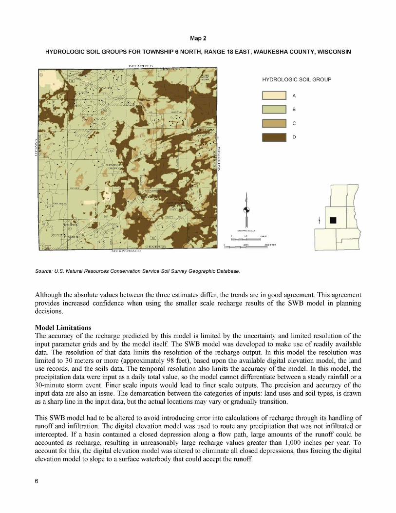
2 Hydrologic Soil Groups for Township 6 North, Range 18 East, Waukesha County, Wisconsin ................................................................................. 6
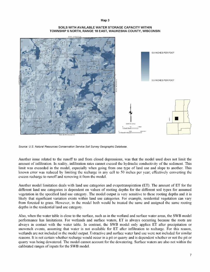
3 Soils with Available Water Storage Capacity within Township 6 North, Range 18 East, Waukesha County, Wisconsin .................................................. 7
4 Existing Land Use within Township 6 North, Range 18 East, Waukesha County, Wisconsin: 2000 ....................................................................... 8
5 Recharge Estimates for the Southeastern Wisconsin Region Using the Soil-Water Balance, Empirical Watershed, and U.S. Geological Survey Baseflow Estimation Methods ......... 9
6 Comparison of Recharge Estimates in Southeastern Wisconsin ...................................................... 10 7 Recharge Potential Map for the Southeastern Wisconsin Region .................................................... 11 8 Areas of Significant Downward Flow to the
Deep Sandstone Aquifer in Southeastern Wisconsin ...................................................................... 11 9 Recharge Areas for Jericho Creek Based on the
Watershed and on a Groundwater Flow Model ................................................................................ 13 10 Recharge Areas, Water Table Map, and Flow Lines Around Jericho Creek .................................... 14

vi
Map Page
11 Recharge Areas for Quaas Creek Based on the Watershed and on a Groundwater Flow Model ................................................................................ 15
12 Comparison Recharge Areas for Quaas Creek Based on Groundwater Model and the Watershed ........................................................................... 16
13 Paradise Springs Recharge Area Analyses ....................................................................................... 16 14 Cedarburg Bog with the Water Table and the Milwaukee River and Cedar Creek .......................... 17 15 Recharge Potential Around the Cedarburg Bog ............................................................................... 17 16 Land Use in the West-Central Area of Township 6 North,
Range 18 East, Waukesha County: 1963 and 2000 .......................................................................... 18 17 Recharge Dependence on Land Use in the West-Central Area of
Township 6 North, Range 18 East, Waukesha County: 1963 and 2000 ........................................... 19 18 Land Use, Soil Moisture Storage, and Recharge Potential for
Quaas Creek Area near West Bend, Washington County ................................................................ 20

INTRODUCTION
Purpose Groundwater recharge is defined as water that crosses the water table and is added to the groundwater system; recharge is thus the ultimate source of all groundwater. Understanding recharge and its distribution is important in making informed land use decisions so that the groundwater needs of society and the environment can continue to be met. Preservation of recharge will help to continue to provide groundwater for human use and natural systems that have groundwater inputs such as rivers, lakes, springs, and wetlands. However, in an urbanizing region, preservation of all recharge areas is not possible, and so a means to identify those areas that contribute more recharge to more sensitive natural systems is needed. This report describes the inputs, operation, and application of a soil-water balance (SWB) model used to estimate groundwater recharge in southeastern Wisconsin. The amount of groundwater recharge varies across southeastern Wisconsin. This variation is primarily due to spatial differences in land use, soils, and topography. Recharge also varies with climate and precipitation. Planning decisions cannot significantly alter the weather or geology, but can impact land use. This recharge model provides a groundwater management tool that can be used to help to guide land use decisions and increase understanding of recharge in southeastern Wisconsin. Objectives A soil-water balance model was used to estimate groundwater recharge over southeastern Wisconsin under historic climate and land use conditions. As input, the model uses readily available data on climate, soil charac-teristics, land use, and topography. The model output was used to estimate present day recharge and to illustrate how recharge may change with variations in land use or in climate. Specific applications of the model included:
• Preparation of a map of recharge potential across southeastern Wisconsin; Which areas provide the most recharge?
• Location of primary recharge areas to the deep sandstone aquifer; Are there significant surface water diversions to the deep sandstone aquifer?
• Delineation of higher recharge zones within recharge areas for surface water features; Which land should be left undeveloped, or developed in a manner which maintains the natural hydrology, to best maintain baseflow to a stream?
• Identification of recharge variations with land use; Will recharge be significantly reduced by a proposed urban development?
• Identification of recharge variations with climate; How much will recharge decrease during periods of drought?
Background Groundwater use in southeastern Wisconsin has increased as the population of southeastern Wisconsin has grown. Total groundwater use has increased from 72 to 96 million gallons per day (mgd) from 1985 to 2000 in the seven

2
southeastern Wisconsin counties served by the Southeastern Wisconsin Regional Planning Commission (SEWRPC) (Ellefson and others, 2002). Groundwater withdrawals from high capacity wells alone have increased from 26 to 64 mgd from 1965 to 2000 (SEWRPC, 2005). Due to concerns about future water supply and land use management, SEWRPC initiated a comprehensive regional water supply study (http://www.sewrpc.org/watersupplystudy/) in 2005 for the seven SEWRPC counties (the Region). One of the components of that study is the identification of recharge areas to be protected from incompatible development. This report addresses the recharge component. Groundwater withdrawals lower groundwater levels and reduce groundwater flow to surface waters. Groundwater levels in the deep sandstone aquifer have dropped by more than 500 feet in eastern Waukesha county and more than 150 feet over much of the SEWRPC Region. In addition to creating drawdown, these groundwater withdrawals have diverted groundwater from surface waters, reducing baseflows. In the past, most high capacity well groundwater withdrawal has been from the deep sandstone aquifer so that the diversion of groundwater from surface waters was widely distributed, mostly along the western limits of the extent of the Maquoketa shale and far from the pumping wells. A more recent trend has been for municipalities to place new wells in the shallow aquifer to avoid high levels of radium and total dissolved solids found in the deep sandstone aquifer. The groundwater diversions from surface waters due to these shallow wells will be more localized than those from pumping from the deep aquifer. These trends in groundwater use make it important to maintain recharge to the groundwater system. As pumping wells divert more groundwater, an effort should be made to sustain recharge to the groundwater system. Recharge modeling coupled with land use planning is a step toward that goal. Recharge has been mapped previously in the SEWRPC Region using several different methods and different scales. Using the method described in Cherkauer and Ansari (2005), recharge was estimated on a watershed or topographic basin scale (approximately 13 square miles) for all the basins in the SEWRPC Region (Feinstein and others, 2005). This watershed/basin scale recharge estimate was used in the regional groundwater flow model developed for SEWRPC by the U.S. Geological Survey, the Wisconsin Geological and Natural History Survey, the Wisconsin Department of Natural Resources, and the University of Wisconsin-Milwaukee, with support from the water utilities in southeastern Wisconsin using groundwater as a source of supply (SEWRPC, 2005). Gebert and others (2007) used baseflow separation on streamflow-gauging stations to estimate recharge for the major river basins in southeastern Wisconsin. The range of recharge values for the gauged basins varied from 2.5 to 9.3 inches per year. Braun and others (2003) created a GIS-based estimate of recharge potential (high to low) without any quantified values of recharge for Waukesha County. The soil-water balance (SWB) model described in this report has the advantages of fine scale resolution (80 acres) and quantified estimates of recharge. The fine scale is needed for land use planning. Comparison of the actual estimates from the SWB model to baseflow separation estimates provides confirmation of the SWB model recharge estimates. Acknowledgements This project was funded by the Southeastern Wisconsin Regional Planning Commission. The recharge model code was developed by W.R. Dripps (currently at Furman University) and modified by V.A. Kelson (Whitman Hydro Planning Associates, Bloomington, Indiana) and S.U. Westenbroek of the U.S. Geological Survey. Westenbroek was particularly helpful in answering questions about code execution and output. METHODOLOGY
Recharge Model Description This recharge model uses SWB accounting to determine that amount of precipitation that is recharged to the groundwater system. This method accounts for the various processes that divert precipitation from becoming recharge. The difference between the diverting processes, indicated by negative signs in the following equation, and precipitation is the recharge.

3
Equation 1. Recharge = Precipitation - Interception - Runoff - Evapotranspiration - (Total soil moisture storage capacity of the root zone - Antecedent soil moisture). The terms of Equation 1 are defined below. Each term is expressed with the same units of length divided by time, such as inches per year.
Recharge – The volumetric rate water entering the groundwater flow system over some area. Precipitation – The amount of water that falls to the earth as rain, sleet, snow, or hail. Interception – The amount of water that falls on the plant canopy and is used by the plants or evaporates, never reaching the ground surface. Runoff – The amount of water that flows across the land surface. Evapotranspiration – The quantity of water that is either evaporated or taken up by plants and transpired through their leaves. Total soil moisture storage capacity of the root zone – The amount of water that the soil can hold. Antecedant soil moisture – The amount of water previously stored in the soil.
The difference between these last two quantities is the amount of water that must be added to the soil before recharge occurs. The SWB recharge model operates on a geographic grid. The recharge for each cell of the grid is calculated using Equation 1 at a daily time step. The model calculates inputs and outputs to this primary water-balance equation from input data grids that relate soil and land use to the terms in Equation 1. Daily precipitation is input and the negative terms on the right hand side of the equation are calculated from the model inputs that vary in time and over the land surface. Recharge for that cell is calculated and stored in the output file. The runoff is placed on the next down-gradient cell and is subsequently partitioned between infiltration into that cell and runoff to be placed further downslope. The process is then repeated for each day of the model time period. The model is described in more detail in Dripps and Bradbury (2007) and Westenbroek and others (in review). Model Input and Output Input to the SWB model consisted of daily climate records for the model period, and four map data grids for the model extent: topography, soil hydrologic group, soil available water storage, and land use. The model extent included the seven-county Region as well as portions of surrounding counties. The spatial resolution of the model grid was 30 meters (approximately 98 feet), corresponding to the resolution of the elevation input data. Daily temperature and precipitation observations recorded in Milwaukee were tabulated for model input. While these climate parameters do vary across the Region, the Milwaukee climate data is representative of the Region on average. Also, based upon review of regional precipitation data, the two-year period 1968 through 1969 was selected to represent a recent “typical” climate regime (Corsi, 2008). The recharge model uses topographic data, in the form of surface water flow direction, to route runoff. A standard flow direction calculation was applied to a 30-meter (approximately 98 feet) digital elevation model (DEM) from the US Geological Survey’s National Elevation Dataset (NED). While more detailed elevation data are available for the Region, this was the highest-resolution contiguous DEM available. Because DEMs typically include erroneous depressions that can adversely influence surface flow routing, a standard fill routine was applied to the

4
DEM before the final calculation of the flow direction input grid. A sample of this grid showing the topographic details is shown below on Map 1 for a selected township in Waukesha County (Township 6 North, Range 18 East, Fourth Principal Meridian). This township includes the Town of Genesee and the Villages of North Prairie and Wales. Digital soil data from the U.S. Natural Resources Conservation Service (NRCS) Soil Survey Geographic (SSURGO) Database were used for two input datasets to the model, hydrologic group and available water storage. The hydrologic group is a classification of the infiltration potential of a soil map unit, and is used in the recharge model input to calculate runoff. A sample of the grid used in the model showing the hydrologic group classification is provided on Map 2 for the selected area in Waukesha County. Lighter colors show more infiltration and less runoff; darker colors show less infiltration and more runoff. Available water storage, a measure of the amount of water held in a specified soil thickness, is used by the model for soil-zone moisture accounting. A sample of this grid showing the soil moisture storage capacity is provided on Map 3 for the selected township in Waukesha County. Darker colors indicate higher soil water storage capacity; lighter indicate lower soil water storage capacity. Soil map unit data were acquired for each county within the model, merged to a regional dataset, and processed to obtain the two model input grids. Land use data were used in calculations of interception, runoff, evapotranspiration, and for determination of rooting zone depth. Regional land use data for 2000 were provided by SEWRPC. The SEWRPC land use categories were reclassified to match those used by the model, however, the category “extractive” was maintained to track the influence of pits and quarries. A sample of this grid showing the land use details is provided below on Map 4 for the selected area in Waukesha County. Seamless data grids for the four map inputs were generated from these source datasets for input to the model. Climate data was input as daily precipitation and temperature observations. The model was used to simulate two years of recharge, the first year being a “warm-up” for the second, with output reported as total annual recharge in inches per year. Unrealistic high values (recharge greater than 50 inches per year) were converted to 50, the remainder likely representing additional runoff to surface water features. Land use categories of extractive, wetland, and water were removed from further processing and labeled as undefined. These land uses are hydrologically complex and cannot be accurately represented in the SWB recharge model. The model output was then smoothed using a focal median method with a 19-cell (approximately 80-acre) area. Comparison to Other Methods The SWB recharge model was compared to the empirical watershed recharge estimates (Feinstein and others, 2005) and the USGS baseflow measurements (Gebert and others, 2007). Unlike the empirical watershed recharge estimates and the USGS baseflow measurements, the SWB model does not include any direct measurements of flow in the hydrologic system. The comparisons between the SWB recharge model and the other two methods provides a needed check of the SWB model. Map 5 shows the SWB, empirical watershed, and USGS baseflow recharge estimates in the same color scale of inches per year. There is reasonable agreement between the three recharge estimates with respect to relative recharge amounts, especially between the SWB and empirical watershed estimates. Where the empirical watershed and USGS baseflow estimates indicate higher recharge, the SWB model also indicates high recharge. For example, the Kettle Moraine area corresponds to the high recharge band running from southwestern Waukesha County up through central Washington County. In the central part of the SEWRPC Region, the recharge values gradually transition from high values in the Kettle Moraine to the low values in the Milwaukee metropolitan area. The SWB and empirical watershed estimates also show higher recharge values in western Racine and Kenosha counties and lower values in the central areas of those counties. Although the three estimates of recharge are in relative agreement, a comparison of the absolute values indicates some differences. Map 6 shows the differences between the recharge estimates when compared at the subbasin


9
EMPIRICAL WATERSHED RECHARGE
U.S. GEOLOGICAL SURVEY BASEFLOW ESTIMATION
Map 5
RECHARGE ESTIMATES FOR THE SOUTHEASTERN WISCONSIN REGION USING THE SOIL-WATER BALANCE, EMPIRICAL WATERSHED, AND U.S. GEOLOGICAL SURVEY BASEFLOW ESTIMATION METHODS
Source: U.S. Geological Survey and Wisconsin Geological and Natural History Survey.
SOIL-WATER BALANCE RECHARGE

10
COMPARISON BETWEEN SOIL-WATER BALANCE MODEL AND U.S. GEOLOGICAL SURVEY BASE FLOW ESTIMATES
Map 6
COMPARISON OF RECHARGE ESTIMATES IN SOUTHEASTERN WISCONSIN
NOTE: Red and tan colors show where the SWB recharge is less than empirical watershed or USGS baseflow estimates, light green shows
agreement and dark green and blue show where the SWB recharge is greater than the empirical watershed or USGS baseflow estimates.
Source: Source: U.S. Geological Survey and Wisconsin Geological and Natural History Survey. and high recharge values in the west in a generally north-south trend. This area of higher recharge corresponds to the Kettle Moraine, an area with sparse development and soils with low runoff potential and low water storage capacity. Recharge Areas of the Deep Sandstone Aquifer There are two main aquifers underlying southeastern Wisconsin, a shallow aquifer comprising glacial materials and a several hundred foot thick sequence of Silurian dolomite, and a deep sandstone aquifer. The two aquifers are separated by the Maquoketa shale, an aquitard that covers most of southeastern Wisconsin, except for the western edge of the Region. Water levels in the deep sandstone aquifer have dropped more than 500 feet since pumping began there more than 100 years ago. This decrease in water levels has diverted groundwater from the shallow aquifer downward towards the pumping wells in the deep sandstone aquifer. To reduce further water level decreases in the deep sandstone aquifer, it is necessary to maintain the inflow of water through protection of the recharge areas to the deep sandstone aquifer. The regional groundwater flow model (SEWRPC, 2005) was used to identify the areas of downward flow, or recharge, from the shallow aquifer to the deep sandstone aquifer. The model used flow simulated for Year 2000 into the top of the St. Peter sandstone from the upper aquifer to delineate the areas shown on Map 8. The
COMPARISON BETWEEN SOIL-WATER BALANCE MODEL AND EMPIRICAL WATERSHED MODEL

11
downward flow was categorized from less than 0.25 inch per year to more than one inch per year. The areas of less than 0.25 inch per year may also contain some upward flow as well. The areas of high downward flow, or recharge, to the deep sandstone aquifer correspond to the areas lying immediately to the west of the Maquoketa shale subcrop, shown as the grey line on Map 8. The Maquoketa shale, where present, limits the recharge to the deep aquifer to less than 0.25 inch per year. Also shown on Map 8 is the deep aquifer groundwater divide, shown as the black line. To the east of the divide, groundwater entering the flow system will travel toward wells pumping in the deep sandstone aquifer. To the west of the divide, groundwater will return to the shallow system and does not provide recharge to the deep sandstone aquifer beneath the SEWRPC Region. The position of the divide has some dependence on the pumping rate in the deep sandstone aquifer. This dependence is evident in a comparison of the location of the divide between 1950 and 2000 with the divide shifting to the west several miles in some locations. In that same period, the pumping rate in the deep sandstone doubled (Feinstein and others, 2005). The most important recharge areas to the deep sandstone aquifer in the SEWRPC Region lie between the Maquoketa subcrop and the deep sandstone aquifer groundwater divide. The areas of greatest recharge, or downward flow, to the deep sandstone aquifer in western Waukesha also happen to be located near areas of high groundwater recharge. This correspondence is due to coincidental geology; the Kettle Moraine occurs several miles to the west of the subcrop of the Maquoketa shale. The high recharge areas of the Kettle Moraine are located close to the edge of the Maquoketa shale, where water can more easily enter the deep system.
Map 7
RECHARGE POTENTIAL MAP FOR THE SOUTHEASTERN WISCONSIN REGION
Source: Wisconsin Geological and Natural History Survey.
Map 8
AREAS OF SIGNIFICANT DOWNWARD FLOW TO THE DEEP SANDSTONE AQUIFER IN
SOUTHEASTERN WISCONSIN
NOTE: The western extent of the Maquoketa shale is shown as
the dark grey line. The groundwater divide in the deepsandstone aquifer is shown as the black line.
Source: Wisconsin Geological and Natural History Survey.
12
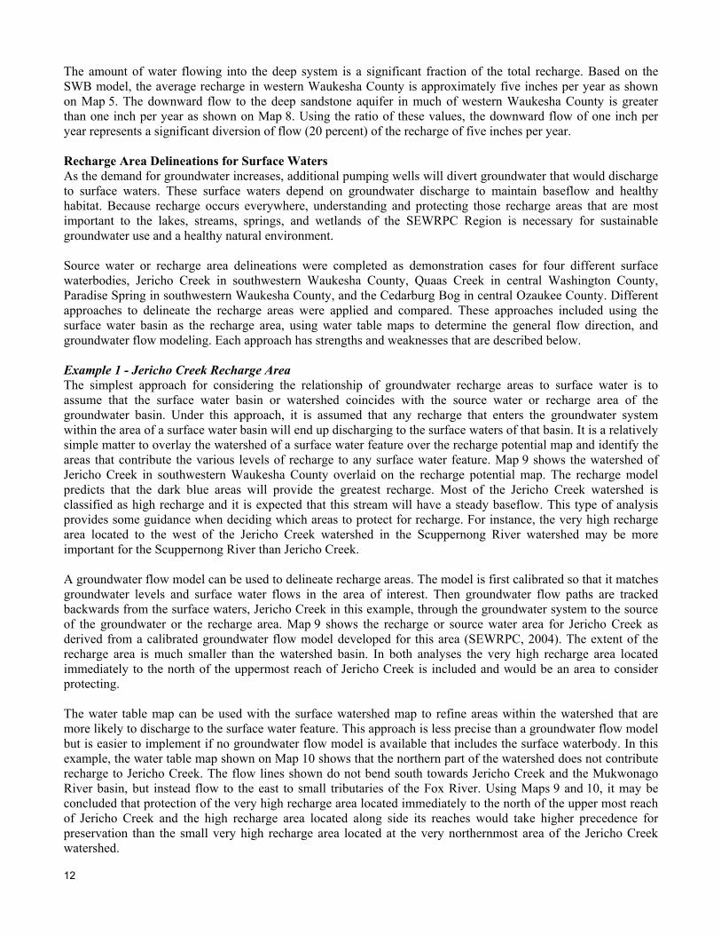
The amount of water flowing into the deep system is a significant fraction of the total recharge. Based on the SWB model, the average recharge in western Waukesha County is approximately five inches per year as shown on Map 5. The downward flow to the deep sandstone aquifer in much of western Waukesha County is greater than one inch per year as shown on Map 8. Using the ratio of these values, the downward flow of one inch per year represents a significant diversion of flow (20 percent) of the recharge of five inches per year. Recharge Area Delineations for Surface Waters As the demand for groundwater increases, additional pumping wells will divert groundwater that would discharge to surface waters. These surface waters depend on groundwater discharge to maintain baseflow and healthy habitat. Because recharge occurs everywhere, understanding and protecting those recharge areas that are most important to the lakes, streams, springs, and wetlands of the SEWRPC Region is necessary for sustainable groundwater use and a healthy natural environment. Source water or recharge area delineations were completed as demonstration cases for four different surface waterbodies, Jericho Creek in southwestern Waukesha County, Quaas Creek in central Washington County, Paradise Spring in southwestern Waukesha County, and the Cedarburg Bog in central Ozaukee County. Different approaches to delineate the recharge areas were applied and compared. These approaches included using the surface water basin as the recharge area, using water table maps to determine the general flow direction, and groundwater flow modeling. Each approach has strengths and weaknesses that are described below. Example 1 - Jericho Creek Recharge Area The simplest approach for considering the relationship of groundwater recharge areas to surface water is to assume that the surface water basin or watershed coincides with the source water or recharge area of the groundwater basin. Under this approach, it is assumed that any recharge that enters the groundwater system within the area of a surface water basin will end up discharging to the surface waters of that basin. It is a relatively simple matter to overlay the watershed of a surface water feature over the recharge potential map and identify the areas that contribute the various levels of recharge to any surface water feature. Map 9 shows the watershed of Jericho Creek in southwestern Waukesha County overlaid on the recharge potential map. The recharge model predicts that the dark blue areas will provide the greatest recharge. Most of the Jericho Creek watershed is classified as high recharge and it is expected that this stream will have a steady baseflow. This type of analysis provides some guidance when deciding which areas to protect for recharge. For instance, the very high recharge area located to the west of the Jericho Creek watershed in the Scuppernong River watershed may be more important for the Scuppernong River than Jericho Creek. A groundwater flow model can be used to delineate recharge areas. The model is first calibrated so that it matches groundwater levels and surface water flows in the area of interest. Then groundwater flow paths are tracked backwards from the surface waters, Jericho Creek in this example, through the groundwater system to the source of the groundwater or the recharge area. Map 9 shows the recharge or source water area for Jericho Creek as derived from a calibrated groundwater flow model developed for this area (SEWRPC, 2004). The extent of the recharge area is much smaller than the watershed basin. In both analyses the very high recharge area located immediately to the north of the uppermost reach of Jericho Creek is included and would be an area to consider protecting. The water table map can be used with the surface watershed map to refine areas within the watershed that are more likely to discharge to the surface water feature. This approach is less precise than a groundwater flow model but is easier to implement if no groundwater flow model is available that includes the surface waterbody. In this example, the water table map shown on Map 10 shows that the northern part of the watershed does not contribute recharge to Jericho Creek. The flow lines shown do not bend south towards Jericho Creek and the Mukwonago River basin, but instead flow to the east to small tributaries of the Fox River. Using Maps 9 and 10, it may be concluded that protection of the very high recharge area located immediately to the north of the upper most reach of Jericho Creek and the high recharge area located along side its reaches would take higher precedence for preservation than the small very high recharge area located at the very northernmost area of the Jericho Creek watershed.


14
table map shows that although it is possible to start at the western most end of the model groundwater basin and trace a flow path following down gradient water table contours to Quaas Creek, the flow path must pass beneath Little Cedar Lake and between a narrow groundwater valley or saddle. It is unlikely that sig-nificant amounts of groundwater follow this path. For this reason, when considering Quaas Creek, the high recharge zones between the two lakes should be assigned a lower priority for preservation than those located in both the surface watershed and the ground-water flow model recharge area. The high recharge areas to the west are likely more important for baseflow to Little Cedar Lake than they are to Quaas Creek. Example 3 – Paradise Springs Recharge Area The third example of comparison of approaches to delineate recharge areas was conducted for Paradise Springs, located approximately two miles northwest of the Village of Eagle, Waukesha County, and about four miles west of Jericho Creek. This spring complex supports a trout fishery and flows at about 500 gallons per minute or 1.1 cubic feet per second (WDNR, 2005), placing this spring in the protected category according to the groundwater quantity legislation, 2003 Wisconsin Act 310. Map 13 shows the location of Paradise Springs, an upper reach of Jericho Creek, the subbasin containing Paradise Springs, and water table contour lines. Although Paradise Springs is located near Jericho Creek, it is in another watershed as shown by the surface subbasin divide. It is also in a different groundwater basin as shown by the water table mound or high at the 920-foot water level contour.
The water table map and surface water basins were used to determine the recharge area for Paradise Springs. Near Paradise Springs, the groundwater flow direction is to the west. The flow lines were traced backward from Paradise Springs to the water table mound or high shown by the 920-foot water table elevation. The water table contour lines are drawn at too coarse a level to show all flow to the springs and provide only general flow directions. Using these contour lines, another flow line drawn slightly to the north would appear to miss Paradise Springs. Since there is more flow than would be seen if there was such a narrow recharge area, it is expected that the northerly area is also contributing to Paradise Springs. The recharge area can be reasonably broadened if the surface water basin corresponding to Paradise Springs is considered. That subbasin includes a band of high and very high recharge to the east and north of Paradise Springs, up-gradient on the water table map. This very high recharge area is the area that should be preserved to maintain baseflow to Paradise Springs. The very high recharge area located most directly up-gradient from the springs would have a higher priority for preservation than the areas located more side-gradient, those farther to the north and south. A similar recharge area for Paradise Springs was determined using a groundwater flow model (SEWRPC, 2004). The model recharge area is shown as the black outline on Map 13. That recharge area includes a portion of the very high recharge area located immediately to the north of Paradise Springs. The advantage of groundwater
Map 10
RECHARGE AREAS, WATER TABLE MAP, AND FLOW LINES AROUND JERICHO CREEK
Source: Wisconsin Geological and Natural History Survey.


16
The recharge area for the bog is located within the shallow surface water basin. Inside the basin, surface water will move towards the bog. There may be some local and shallow small-scale groundwater flow towards the bog as well. However, most of the groundwater flow will be away from the bog. In addition, the regional groundwater model (SEWRPC, 2005) indicates downward flow occurring beneath the bog, suggesting that there is no deep source of groundwater to the bog, e.g., an upwelling of groundwater from the underlying bedrock. It may seem that it would be unnecessary to protect recharge around a surface waterbody that is primarily discharging to the groundwater system rather than receiving groundwater. This is not the case. There is likely some local and shallow groundwater flow to the Cedarburg Bog and that can be maintained by protecting the recharge areas. In addition, reducing recharge around the Cedarburg Bog may cause flows out of the bog to increase. If the recharge is reduced around the bog, the gradient of the water table between the bog and the Milwaukee River and Cedar Creek and its tributary will increase causing increased flow from the bog. Map 15 shows the variation of recharge potential around the bog. Preservation of the areas of high and very high recharge to the west and northwest of the bog would be more important than preservation of the medium recharge to the east for maintaining flows into and out of the bog.
Map 12
COMPARISON RECHARGE AREAS FOR QUAAS CREEK BASED ON GROUNDWATER
MODEL AND THE WATERSHED
Source: Wisconsin Geological and Natural History Survey.
Map 13
PARADISE SPRINGS RECHARGE AREA ANALYSES
Source: Wisconsin Geological and Natural History Survey.
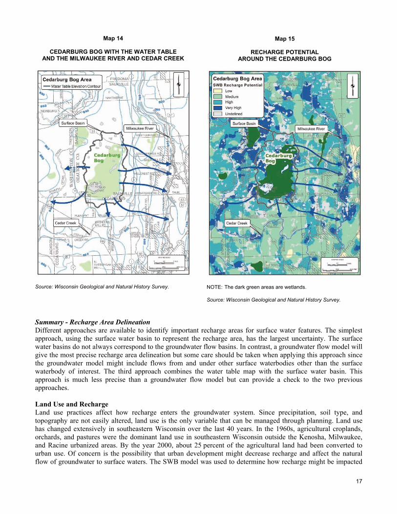
17
Summary - Recharge Area Delineation Different approaches are available to identify important recharge areas for surface water features. The simplest approach, using the surface water basin to represent the recharge area, has the largest uncertainty. The surface water basins do not always correspond to the groundwater flow basins. In contrast, a groundwater flow model will give the most precise recharge area delineation but some care should be taken when applying this approach since the groundwater model might include flows from and under other surface waterbodies other than the surface waterbody of interest. The third approach combines the water table map with the surface water basin. This approach is much less precise than a groundwater flow model but can provide a check to the two previous approaches. Land Use and Recharge Land use practices affect how recharge enters the groundwater system. Since precipitation, soil type, and topography are not easily altered, land use is the only variable that can be managed through planning. Land use has changed extensively in southeastern Wisconsin over the last 40 years. In the 1960s, agricultural croplands, orchards, and pastures were the dominant land use in southeastern Wisconsin outside the Kenosha, Milwaukee, and Racine urbanized areas. By the year 2000, about 25 percent of the agricultural land had been converted to urban use. Of concern is the possibility that urban development might decrease recharge and affect the natural flow of groundwater to surface waters. The SWB model was used to determine how recharge might be impacted
Map 14
CEDARBURG BOG WITH THE WATER TABLE AND THE MILWAUKEE RIVER AND CEDAR CREEK
Source: Wisconsin Geological and Natural History Survey.
Map 15
RECHARGE POTENTIAL AROUND THE CEDARBURG BOG
NOTE: The dark green areas are wetlands. Source: Wisconsin Geological and Natural History Survey.


21
capacity, and the recharge potential for the study area. A comparison between land use and recharge, Map 18, indicates that the recharge potential in the developed areas, shown in grey, is primarily medium or low, while the undeveloped areas have a recharge potential mostly of high and very high. For example, the lobe of residential land use in the center of Map 18 corresponds to a similarly distributed lobe of medium recharge potential on Map 18.
Secondary to land use in controlling recharge potential is the soil water storage, as shown on Map 18. A low soil water storage allows infiltration to quickly pass through the soil and become recharge while a high soil water storage holds the water longer, making it more available for transpiration. Where the soil water storage is medium in the developed areas, the recharge potential is more likely to be low. Where the soil water storage is low, the recharge potential is medium. The model suggests that development coupled with a medium or high soil water storage will significantly reduce recharge in this area.
This example also indicates the potential of land use planning for maintaining recharge potential. The high recharge area around the Milwaukee River in the north central part of the plot is due to the parkland surrounding it. If that parkland was removed and replaced with residential, commercial, and industrial development, it is likely that the recharge potential would decrease from high to medium.
Climate and Recharge Climate affects recharge, with recharge typically increasing when precipitation increases. In addition to this fundamental relationship, the timing and intensity of precipitation and temperature also have important impacts on recharge. These variables are incorporated into the model processes of runoff, infiltration, and evapotranspiration.
The SWB model was used to illustrate the relationship between climate and recharge. Figure 1 shows the variation of precipitation and recharge over time for an area in southwestern Waukesha County from 1960 to 2000 with the land use held constant to the 1963 distribution. The modeled area is the same one that was used to compare land use changes in southwestern Waukesha in the previous section. From 1960 to 2000, annual precipitation varied from 21.4 inches per year in 1963 to 45.8 inches per year in 2000 while recharge varied from 0.6 inches per year in 1963 to 11.8 inches per year in 1965 and 2000. The relationship between recharge and precipitation is also illustrated in Figure 2. The recharge is plotted versus precipitation. This plot indicates that as expected, higher precipitation is correlated to higher recharge. It also indicates the variation of recharge with similar precipitation. For instance, the range of recharge at the average annual precipitation of 33.4 inches per year extends from less than four inches per year to nearly 11 inches per year. That variation is due to the other climatic factors: the antecedent soil moisture, unmelted snow from the previous year’s precipitation, the strength and duration of rainfall, and the amount of evapotranspiration as controlled by the temperature.
CONCLUSIONS
Groundwater is an invaluable resource in southeastern Wisconsin. That resource can be managed for the future, in part, by maintaining its source, recharge. A soil-water balance (SWB) recharge model was constructed for the seven-county SEWRPC Region. Results from the application of that model are in reasonably good agreement with other recharge estimates with respect to relative amounts of recharge. The strength of the SWB model is its high resolution useful in land use planning. The recharge potential map was prepared on a scale of approximately 80 acres, much smaller than the subwatershed or watershed scale of previous estimates.
Baseflow and the ecological health of sensitive surface waters can be protected by identifying the recharge areas of those waters. Recharge areas can be delineated by using a groundwater flow model or, with less effort but also less accuracy, by combining water table maps and surface water basin maps with the recharge potential map.
Recharge is variable over time and space. Analyses conducted on a small portion of the model in southwestern Waukesha Co. gave results that varied from less than an inch per year to more than 10 inches per year. This temporal variation is caused by annual climatic variability. The variation of recharge in space depends on the land use, the soil type, and the land surface topography. Society most alters recharge by altering land use; the other inputs being less easily changed by human interaction. This gives land use planning an important role in protecting recharge areas.


23
REFERENCES
Bradbury, K.R. and D.J. Hart, 2006, Groundwater Flow Model for the City of West Bend, Washington County, Wisconsin, Report to the City of West Bend, Wisconsin. Wisconsin Geological and Natural History Survey Open-File Report 2006-05, p. 50.
Braun, G.M., N.S. Levine, S.J. Roberts, and A.N. Samel, 2003, A Geographic Information Systems Methodology for the Identification of Groundwater Recharge Areas in Waukesha, County, Wisconsin, Environmental and Engineering Geoscience, 9 no. 3: 267-278.
Cherkauer, D.S. and S.A. Ansari, 2005, Estimating Ground Water Recharge from Topography, Hydrogeology, and Land Cover, Ground Water, 43 no. 1: 102-112.
Corsi, S. R., 2008, Personal communication on letter from USGS to Roger Bannerman of the WDNR concerning data analysis of average rainfall for stormwater management practice and design.
Dripps, W.R. and K.R. Bradbury, 2007, A simple daily soil-water balance model for estimating the spatial and temporal distribution of groundwater recharge in temperate humid areas. Hydrogeology Journal, 15 no. 3: 433-444.
Ellefson, B.R., G.D. Mueller, and C.A. Buchwald, 2002, Water use in Wisconsin, 2000, U.S. Geological Survey Open-File Report 02-356, 1 plate.
Feinstein, D.T., Eaton, T.T., Hart, D.J., Krohelski, J.T., and Bradbury, K.R., 2005, A regional simulation model for southeastern Wisconsin. Report 1: Data collection, conceptual model development, numerical model construction, and model calibration, Report 2: Model results and interpretation: Southeastern Wisconsin Regional Planning Commission, Technical Report 41.
Gebert, W.A., M.J. Radloff, E.J. Considine, and J.L. Kennedy, 2007, Use of Streamflow Data to Estimate Base Flow/Ground-Water Recharge for Wisconsin, Journal of the American Water Resources Association, 43 no. 1: 220-236.
Gittings, H. E. (2005) Hydrogeologic controls on springs in the Mukwonago River watershed, SE Wisconsin, Masters Thesis, University of Wisconsin-Madison.
Southeastern Wisconsin Regional Planning Commission/Wisconsin Geological and Natural History Survey, 2002. Groundwater Resources of Southeastern Wisconsin. Southeastern Wisconsin Regional Planning Commission Technical Report 37. 203 p.
Southeastern Wisconsin Regional Planning Commission/Wisconsin Geological and Natural History Survey, 2004, Simulation of Shallow Groundwater Flow in the Vicinity of the Village of Eagle, Waukesha County, Wisconsin. Southeastern Wisconsin Regional Planning Commission Memorandum Report 167. 48 p.
Southeastern Wisconsin Regional Planning Commission, 2005. A Regional Aquifer Simulation Model for Southeastern Wisconsin. Southeastern Wisconsin Regional Planning Commission Technical Report 41. 165 p.
Westenbroek, S.M., V.A. Kelson, W.R. Dripps, R.J. Hunt, and K.R. Bradbury, In Review, SWB-A modified Thornthwaite Soil Water Balance code for estimating ground-water recharge. U.S. Geological Survey Open-File Report
Wisconsin Department of Natural Resources (WDNR), 2005. Paradise Springs self-guided nature trail (pamphlet). PUB-PR-228, Wisconsin Department of Natural Resources. 11 p.
Wisconsin Department of Natural Resources (WDNR), 2003. Wisconsin, Naturally - A Guide to 150 Great State Natural Areas, WDNR, Madison, WI. 184 p.