Ground-Water Resources of Tom Green County, Texas
104
Transcript of Ground-Water Resources of Tom Green County, Texas
~.' .
" .. '
..i ..•.
J.
. \.- ,~
'" ...;::..,.i/" . t..
-.'"
.t .
- .~.
"
I·
,;...
"y. 0:.'~'o' .•
.':':
- .~ ',:'.;
.'J
..·i-
.'-. l
.','."
'.. '
i -f· ~; •
. .~:.
.:~. .
'"
~/,.~.. .
," "
...... -;
..... ~···!··o·~.·
"~.,~ ....':~ ~ :;. . .:~ , ~.~ .· .· .· ..... . ......~ ..-,. .J:'._. -. _•• :". _._,.
~ .....
".' .
"':
• ~> -:.
..... ,"
, . ~
I'
t,""',.~ .";' ...:~-
:'
'-~repa':ed c~oper'ativejyby the Geol~gical S~rVey;'Unifed St~tesDep'artr~e;,t of the Interi,or"'. '.~ .. ' " .' .~ , ..
Septemb'er, 195.4'
T" ."
~~"'.~' .
',TEXAS, BOARO:OF wAfER ENGINEERS'.~%..~ '., "
.. ,H.- A'.,' ~·~~kwitti:. ChairiTian '\i"~ .'
.:'.,: 'A. 'P.··Rojli~s/Memb~r '.~'" 0> F. 'Oent,",.Membe'r·_
. :'~- . .' ...;.\ ~ .
. ~.
:-..... .....'"
'". ~ -, ..'.:
T't.\X)<:..
W-:1oo ....,t;~~<o
TEXAS ,BOARD OF WATERENGINE~RS
'H.;A.:Beckwith,·ChairmanA.' P.. Rollins" MemberO. F. Dent,;Member
BULLETIN 54'11'
GROUND~WATER 'RESOURCES OF TOM GREEN COUNTY • TEX'AS
By
Glrdon Wo Willis, Geologist
United States Geological Survey
Prep~red cooperatively by the Geological. Survey,. ,
Uni ted States Departm,~nt ,of the Interior
September 1954
n Do'c..'W 700,(
B 9 t>(Q
"YI.b, 5"'-\ l \
CON TEN T S
Page
Abstract' . " " ..........................•.............................................. 1Introduction " .. , '" ' , .' " , .. ". " 2
Purpose and scope' ~ ; ; .. ' " ., . . 2Location and extent of the county " ; ...•................ '" ':" 2Previous work : ' ' ' ; , " .. 2Acknowledgments ~ ' ; ,....... 3
Topography' ',' '. . . . . . . . . . . . . . . . . . . . . . . . . . . . . . . . . . . . . . . . . . . . . . . . . 4Relief, '" ; ,. 4Drainage' ; ..............................•. ;" . ; ; ,. . . . . . . . . . . . . 4
Climate " : ; , "0 • • 5Geclogy' ' ' , 0" '.. 8
Permian system , ; .. "' , ~ '" ' '" "' " .. . .. . .. .. . . . 8Clear Fork group ' '. "' " "... 8
Arroyo 'formation' , .. '" .. , " : '" .. , "'""" ',' 8Vale formation " , , , . 13Gloza formation ....••............. 0 • '" •••••••••••••• '•••••••••••• " ••• ", , '.' • • • • 13
Pease River group ." .. " " " ".. : " ; '. ; " ,. . . . 15San kJ.gelo sandstone' ',' "," , , .. , . , " . 15Blaine gypsum · ".. : , .. ",..... 15
Cretaceous system "" .. , '" ; ; , 0 ••• '•••••••••• " ••• , •• '" '" • • • • 15Comanche series' , , ' 1••...•...•. , , , ., " , 15
Trini ty group ".. , ".', ....•........... " , '....•. ; . , .. , " , 15Fredericksburg group' , ; ' ;", " , ,,,. . 17
Walnut clay. "'. "' "" ""0" .', '" ••••••• " •••••••••• "' " " 17Comanche Peak limestone ; ', ' '" i••• ',' •••••••••• '" .• '" ••• " " " 17"Edwards limestone., ; '; '....•.... ; .. ';;.; 0""" " 17
Washi ta group ' "' .' :. "' , " "".,,, 18Quaternary system .. "" " '" '" , '" .. 0 • ~ ; • '.";. ;" "" ,. 18
Pleistocene' series' ; , '" ' ' , " '" ;" '" . '" '" "", . 18Leona' formation. '" , ; '" '" '" ., '" , . '" . . 18
Recent· series '" '" '" '" .. '.' . " " . 20Occurrence 0 f ground' water ; , , , '" . '" ; . , , .. '" '" 20
Source' and' occurrence .. 0" ••• , : •• ; •• "' •••••••••••• , ••••••••••••••••••• " • ", ••••• , .: •••• ', 20Recharge ,," '" '" . " . " " . " " , o' •••••••••• ; • ',' " ••••••••••• , , ••••• " " ••• ; • , 0 " ••• , 22Discharge" "'''' .' ". " ".. "......• " . ; " ; , ; " ., "" , " . , : " '" . 22
Quali ty of water' "."", "', '. " .. " ", , " "'; "" "", .'.. ' ; , " .. " . . . 22Developmen t· of ground water .. " " " "";" " ,,, ,,.. 24Summary ." "."",.. "",."" '" , ; . " , " . " ; .' ,'....•. '.' :" . , 27 'References ;".""". '" , " " " ; , . " , ; " . , .. '" . " " . , ',' . " " . . 29

·ILLUSTRATIONS
Page
Plate 1. Map of Tom Green County, Tex; ,showing wells, springs, and ge()logic formations". 101
2, Geologic cross sections in Tom Green County, Tex. """"""'""" Opposite 12
Figure 1. Map of Texas showing location of Tom Green County................................ 3
2. Annual precipi tation at San Angelo, W98-'50 "".,,,.,,,,, .. "',,., .. ,, ..... ,, .. ,,"',, H • , , , 6
3. Average monthly precipitation and temperature at San Angelo and average.monUllyevaporation near' Big Spring" , , ' , ,... , , ., ...., ~ . " . , . , .. ; .. 'o, •••••• ~" •••••• , •• , • " : ' • 7
4. Maximum,' average, and minimum mon'WJ.1y precipi tation at San Angelo ." -.. , '. ". , . , , ... , 9
5. Chmulati ve departure from average precipitation at San Angelo .... ;" ; .. ,........ . . 10
6,' Bullwagon dolomi te member of the Vale formation, 3% miles west of Mereta" ....'."." : 14
7. San Angelo sandstone, west side of State Highway 70" 7 miles north of San Angelo. 16
8, Leona formation In and near San Angelo" , " .. " . ,,'.. " ..' , .. , . , " . , . , , .. , " , •. , , . " . 19
9. Hydrographs of observation wells in Tom Green County. :" '.0 ••• 0."" .:. 0 ",".,,,,,,, " •• "" 21
10. IITwin wells" H-79 and'H-80 ; '................. 25
lL Irrigation wells o,."." •• "" .••••• "."." •••.••• , , 0 0 0 o' 00" " 0.0 0 " • " 0 •• 0 " " .. " ; .. " •• 0.. 26
12. Well J-22 during development test ,:, " "."."".".; .. " 0••• " •• 0... 27
,
TABLES
. Table L Monthly precl.pl.tation at San Angelo, Tom Green County, Tex......•........ ",." ".. 5
2. Geologic formations' in Tom Green County """.""." "." ".",." "" ,, 11
3. Records·of wells and springs. in Tom Green County " ""." .. "" .. " ., "......... 30
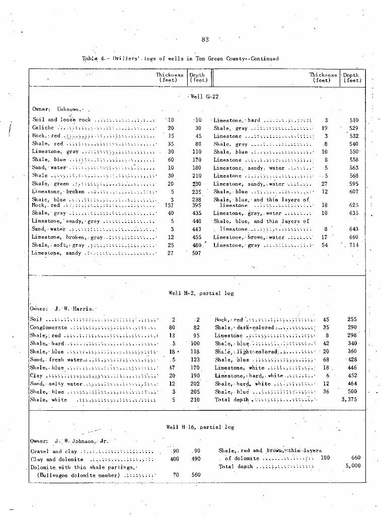
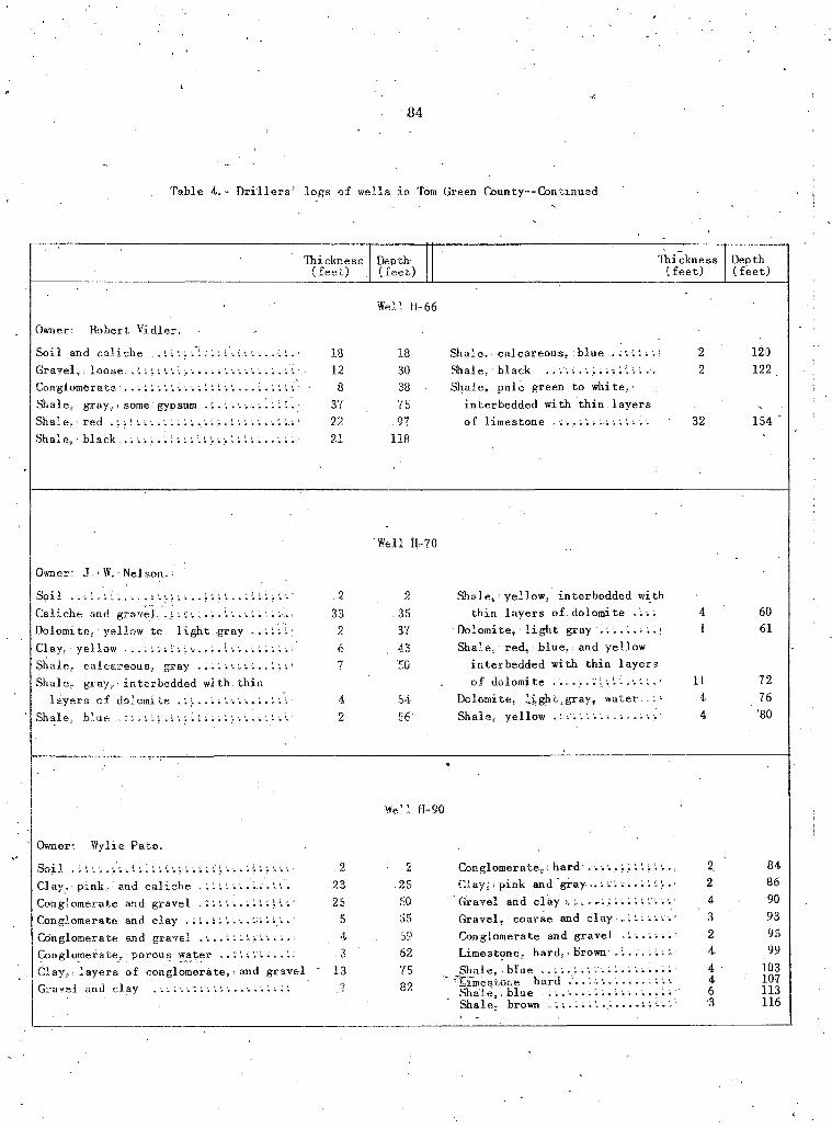
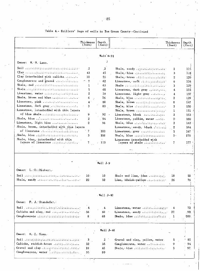
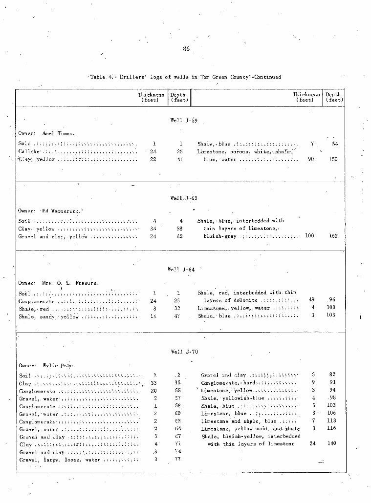
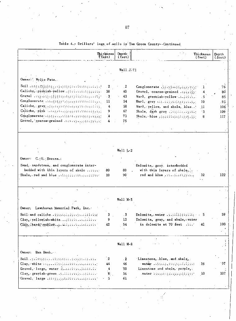
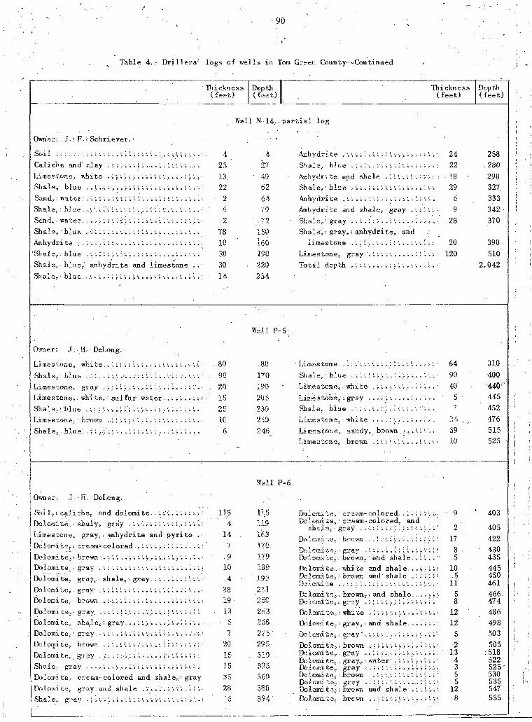
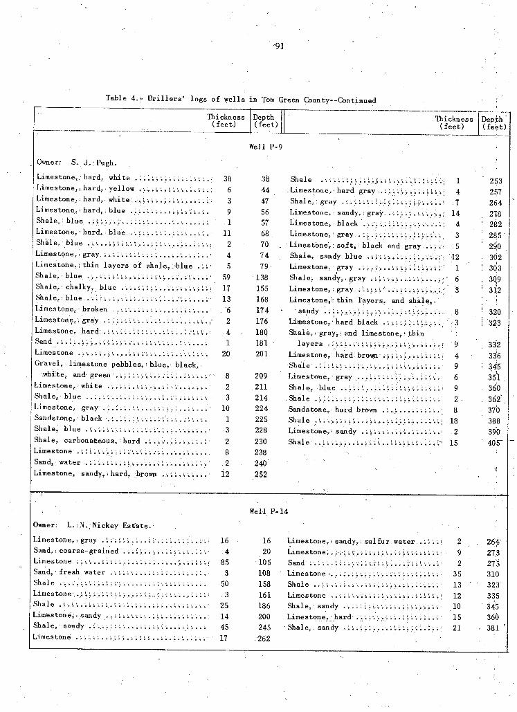
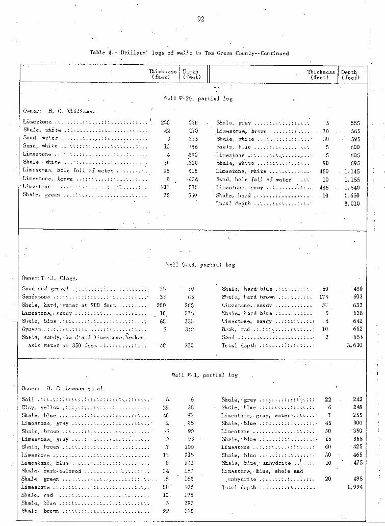
4. Drillers" logs of wells il1 Tom Green County' " , , " ,," ., .. , "" . 81
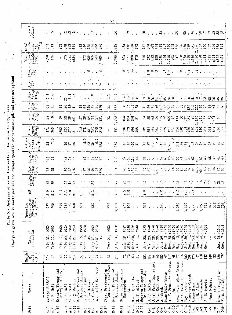
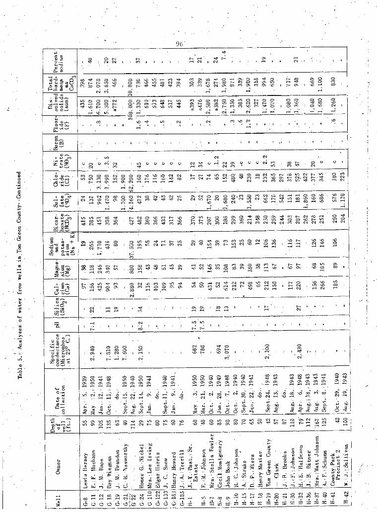
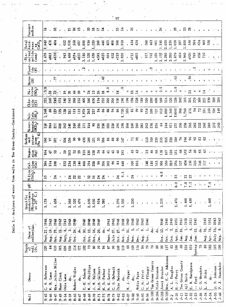
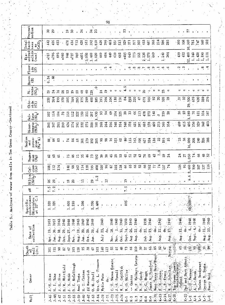
'5. Analyses of water from wells and springs l.n Tom Green County .; " "....... 94
GROUND-WATER RESOURCES OF TOM GREEN COUNTY,' TEXAS
By
C~rdon W. Willis, C~ologist
September 1954
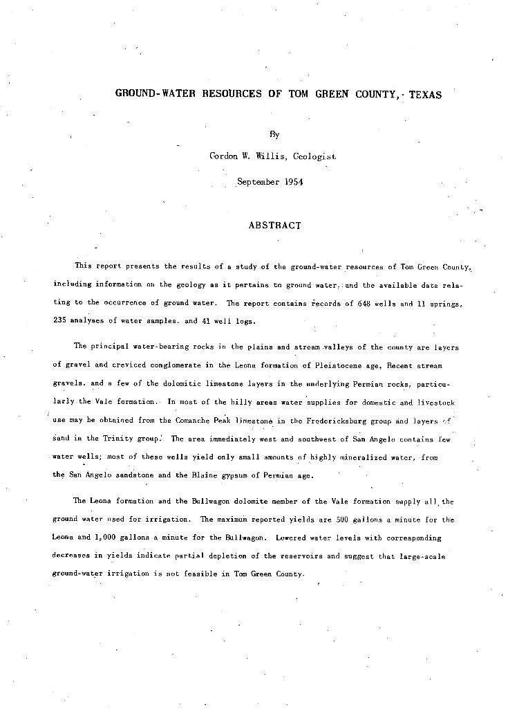
ABSTRACT
This report presents the results of a study of the ground-water resources of Tom Green County,
including information on the geology as it pertains to ground water,'and the available data rela
ting to the occurrence of ground water. The report contains records of 648 wells and 11 springs,
235 analyses of 'water samples, and 41 well logs.
The principal water-bearing rocks 1n the plains and stream.valleys of the county are layers
of gravel and creviced conglomerate 1n the Leona formation of Pleistocene age, Recent stream
gravels. and a few of the dolomitic limestone layers in the underlying Permian rocks, particu
larly the Vale formation. In most of the hilly areas water supplies for domestic and livestock
use may be obtained from the Comanche Peak limestone in the Fredericksburg group and layers of
sand in the Trinity group: The area immediately west and southwest of San Angelo contains few
water wells; most of these wells yield only small amounts of ,highly mineralized water, from
the San Angelo sandstone and the Blaine .gypsum of Permian age.
The Leona formation and the Bullwagon dolomite member of the Vale formation supply all, the
ground water used for irrigation. The maximum reported yields are 500 gallons a minute for the
Leona and 1,000 gallons a minute for the Bullwagon. Lowered water levels with corresponding
decreases 1n yields indicate partial depletion of the reservoirs and suggest that large-scale
ground-wat~r irrigation 1S not feasible 1n Tom Green County.

\ I
2
.INTRODUCTION
PURPOSE .AND SCOPE
The purpose of this report on the ground-water resources of Tom Green COunty, Tex., is
to present the results of the investigation relating to the occurrence of ground water in
the county and, to glve a brief description of the geology as it pertains to ground water.
The investigation of the ground~water resources of the county was made possible through co-
.~ operation between the Texas State Board of Water Engineers and the Uni ted Sta~es Geological
&1rvey. Field data were gathered from September 1948 through January 1949, from Febru~ry
1950 through January 1951; ~d in January 1952 The report contains records of 618 wells,
41 drillers' logs, 235' chemical analyses of water samples, cross sections showing water~
bearing rocks, climatological data, and maps showing locations of wells and spnngs and the
areal extent of geologic formations. (See pl. 1.)
The study was made under the general supernSlOn oIA, N.. Sayre, Chief, Ground Water.
Branch, United States Geological Survey, and under the direct supervision of R W, Sundstrom,
. District Engineer, Austin, Tex,
LOCATJION·AND EXTENT oIF' THlE COUNTY
Tom Green County is slightly west of the ~entral part of the State, (See fig,. L ) The
intersection of latitude 31°25' north and lorigtitude 1000 25' west i~ in the central part of
the county.. The county has an area of 1,829 square miles and, according to the United
States .Census, it had a population of 58,929 in 1950. San Angelo, the county seat, is the~. '_. "
largest ci ty and ·had a population of 51,889 in 1950, Other towns or communi ties in the county
are: Carlsbacl, 'Christoval, Harriett,. Knickerbocker, Mereta, Sanatorium, Tankersley, Vancourt,
Veribest, . Wall, and Water Valley. See. plate L
PREVilOUSWORK
An inventory of welts and springs ln Tom Green County was made in 1940-41, as a project
of the Work Proj ects Administration in cooperation wi th the Texas Ihard of Water Engineers
under the technical supervision of theU, S. Geological Survey, The 'records, including
analyses of water samples, were published in mimeographed form by the Texas Board of Water
Engineers in September 1941. Some of the'data from that release are included in this
publication.

3
FIGURE 1. - Map of Texas showing location of ,Tom" Green County.
"'George· Q. Henderson (1928) made a study_ of the geology of Tom Green County,. and' a report
on this study was published by the Bureau of Economic Geology of the University of Texas.
ACKNOWLEDGMENTS
The author expresses appreciation for the cooperation and assistance of oil companies,
well drillers, and "Yell owners in obtaining field data and to the ci tyof Sa.n Angelo for
furnishing office space during part of the time that 'field work was in progress. Thick
nesses of some geologic units and descriptions of some of the lithology were obtained fromth~ published report by :~~~djt~bJk(~-r9il3}':" ,,",j- - ;,;'" it, b,,:L-,-,:l '-"HW;:J(n,";'.')!l."''J ad:; 0 SHO,yt.-lq

, .4 >
TOPOGRAPHY
REUEF -
Hilly areas, plains, and r1ver valleys are the three types of topography present 1n
Tom Green County. Hilly remnants of a northward extension of the Edwards Plateau cover
much' of the northern, western, and southern parts of the coun~y, . Plains lie' east of sibAngelo from the northern boundary of the coun~y southward to the bas~ of the hills' of the
Edwards Plateau. That portion of the plains south of the Concho fliver is known as Lipan
Flat. (See pI. 1. r River-valley flats lie along the ~ncho Hiyer and its main tribu~
taries, the North, Middle, and South Concho Hivers. The highest point iii the county is
'near the southwest corner where the altitude is approximately 2,550 feet. The lowest'
point, is in the bed of the Concho Hi ver at the Tom Green-Concho County line, where the
altitude is' approximately 1,650 feet.,
The principal streams in the COWIty are the Concho Ri ver' and its main tributaries, the
North Concho, Middle Concho, ,and South Concho Rivers, lheConcho River is fonned by the
_ confluence of ~hese main tributaries in San Angelo.. Several tributaries. of the Middle Concho
, and the South Concho Rivers in the southwestern and southern parts of th~ county are fed by
springs that flow from crevices in Cretaceous limestone. The yields of these springs decrease
in droughts and in'crease after rainy seasons. Much of the water from the springs, sinks into, . ~.... .
gr:avel 'along the streams, and some of the water is retained in smal,l reseryoirs for Iivestock
use. Most of the tributaries of the rivers are dry during the greater part of the year,
Lak~ Naswor~hy 1S the reserVOH for the municipal water supply of San Angelo .. The lake
1S at the confiuence of the Middle and South Concho Rivers about 3 miles sOuth of the city
limits of San ~gelo. The nominal initial capacity of the lake was 14,040 acre-feet.' The
Soil, Conservation Ser~ice, ,in 1938, estimated that the average loss of storage from silta-.
,tion for a period of 8.2 years was L 26. I?ercent per year" 'On this basis about a quarter
percent of the reservoir was filled with silt betwe.en 1930 and 1950.
San Angelo Dam across the North Concho R,iver was constructed for flood control and
conservation of water.. The dam, which lies along the northwestern edge of San Angelo ,was
completed in 1951. The reservoir behind the dam. has' a capacity of 277,OQO acre~feet in the
flood-control pool, 80,400, acre-feet'in the' conservation pool, and 33,900 acre-feet in the• I" '
dead-storage pool. The total temporary capacity of'the reser~oir is 391,500 acre-feet. A
part of. the water in the conservation pool will be used as a supplementary supply for
municipal and industrial use in San Angelo.
. ,
CLIMATE
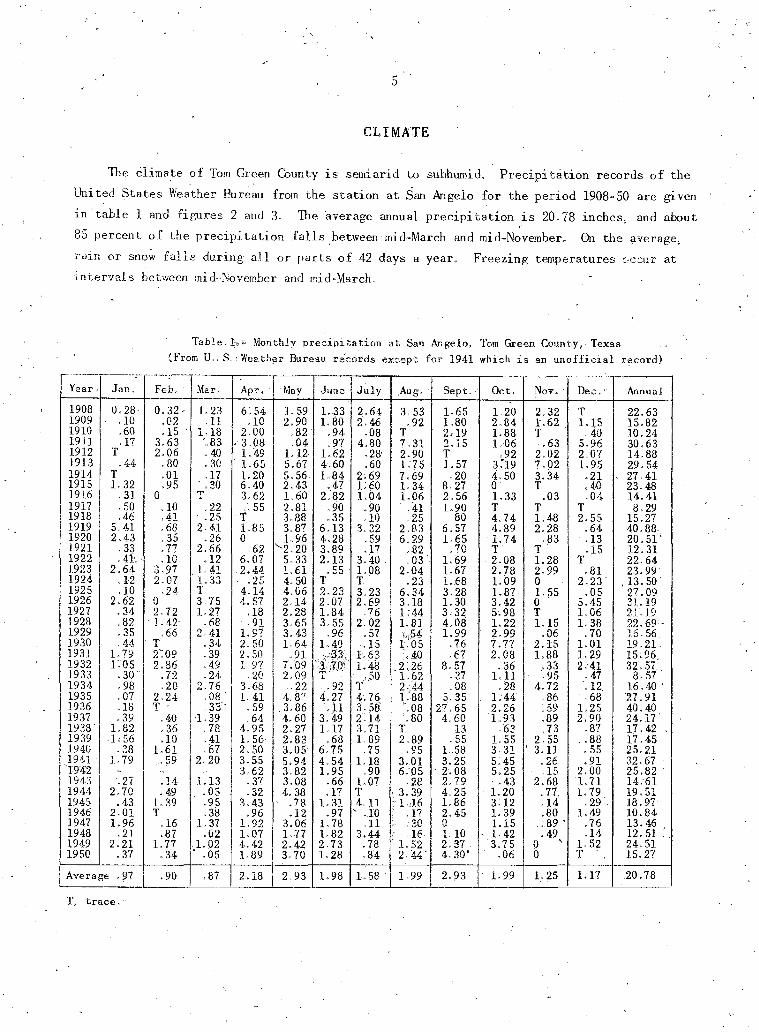
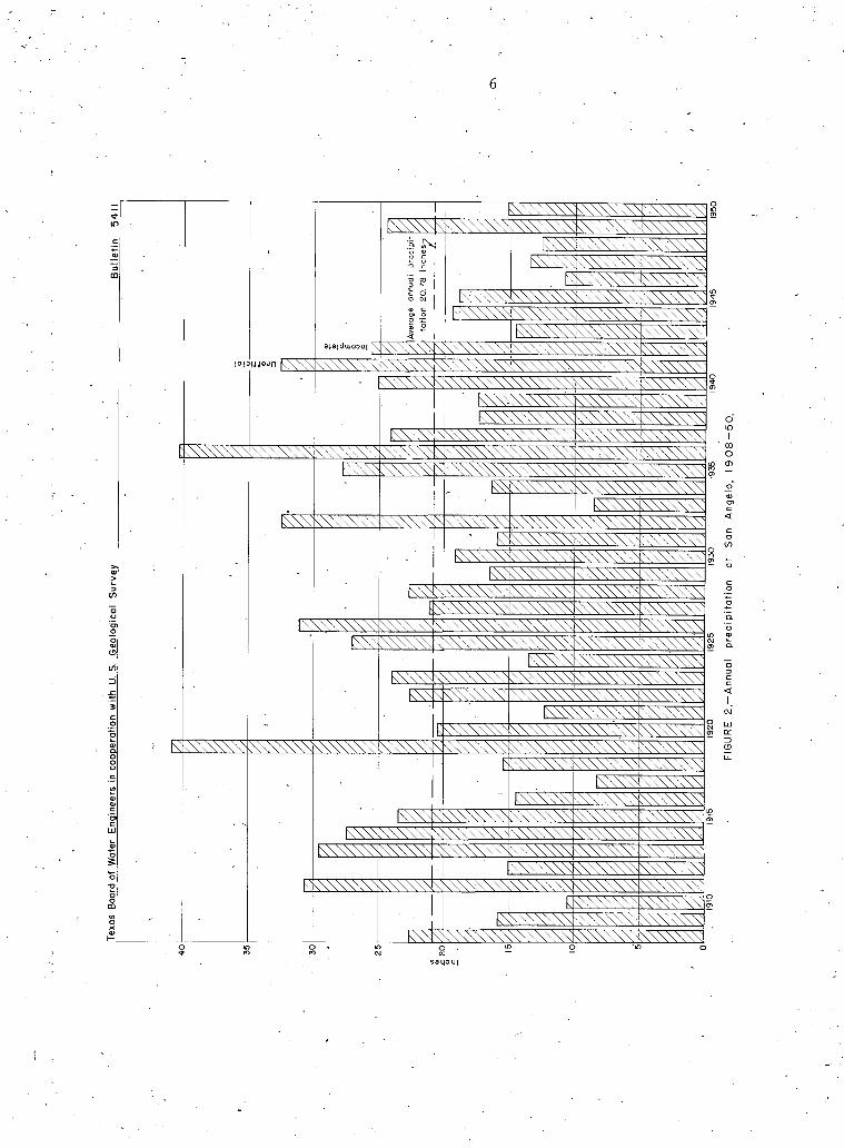
The climate of Tom Green County is semiarid to subhumid. Precipitation records of the
Uni ted States Weather Bureau from the station at San Angelo for the period 1908-50 are gJ. ven
in . table 1 and figures 2 and 3. The average annual precipi tation is 20.78 inches, and about,.
85 percent of the precipitation falls.betweenmid-March and mid-November. On the average,
rain or sno.:v falls during all or parts of 42 days a yeaL Freezing temperatures ~,c:~ur at
intervals between mid-November and !!lid-March ..
Table},,, Monthly precipitation at San Angelo, Tom Green County'.,. Texas
{From U. (S, We", th~r Bureau. racords except for 1941 which is an unofficial record)" •....._..._-----,_._-----;----- ...
Year. Jan" Feb" . Mar. Ap:~, May June J~ly .Aug. Sept. Oct. Nov. Dec. Annual-
1908 0.28· 0.32 .. 1.23 6.54 1.59 1.33 2.64 353 1.65 1.20 2.32 T 22.631909 .10 ,02 .n .10 2.90 1.80 2,46 .92 1.80 2,84 1.62 L15 15.821910 .60 .15 L18 2.00 .82 . ,94 .08 T 2;19 L88 T 40 10.241911 .17 3.63 ",83 " 3.08 .04 .n 4.80 7 31 2,15 1.06 .63 5,96 30.631912 T 2.06 ,40 1.49 1.12 1,62 ,28- 2.90 T .92 2.02 2.07 14.881913 .44 .80 .30 1.65 5.67 4.60 ,60 1.75 1,57 3:19 7.02 1.95 29.541914 T .01 ,17 L20 5.56 1,84 2~69 7.69 .20 4,50 3.34 .21 27.411915 1. 32 ,95 .. 20 6.40 2.43 ,47 1:60 1.34 8.27 0 T ,,40 23,481916 .31 0 T 3,62 1.60 2.82 1.04 1,06 2,56 1.33 .03 ,04 14.411917 .50 ,10 22 ,55 2.81 .90 .90 .41 L.90 T T T 8.291918 .46 41 .25 T 3.88 ,35 ,10 ,25 80 4,74 1,48 2.55 15,271919 5,41 .68 2.41 L85 3,87 6.13 3.32 2.83 6,57 4.89 2.28 .64 40.881920 2.4:1 ,35 ,26 0 L96 4.28 ,59 6.29 1.65 1,74 .. 83 .13 20.51'1921 .33 .77 2.66 ,62 '-2,20 3,89 .17 ,B2 ,70 T T .15 12.311922 ,41\ . . 10 ,12 6.07 5.33 2.13 3.40. ,03 '. 1. 69 2.08 1. 28 T 22.641923 2.64 :L 97 1 41 2.44 1,61 ,55 L08 2,04 I. 67 2.78 2.99 .81 23.991924 ,12 2.07 11.33 2" 4,50 T T' .23 1.68 L09 0 2,23 . .13.50. "1925 ,10 .24 T 4,14 4.06 2.23 3,23 6.34 3.28 1.87 1. 55 .05 27.091926 2.62 0 3, '75 4.57 2.14 2.,07 2.69 3,18 I. 30 3.42 0 5.45 31.191927 .34 2.72 1.27 .18 2,28 1.84 76 1:44 3,32 5.98 T L06 21.191928 .82 . 1.42' .6B .91 3.65 3.55 2.02 L81 4.08 L22 LIS I. 38 22.69·1929
I.35 .66 2,41 1.97 3.43 96 .57 (,54: 1.99 2.99 .06 .70 15.56
1930 .44 T .,34 2.50 1. 64 L40 .15 1',05 .76 7,77 2.15 1. 01 19.211931 1. 79 2~09 .39 I 2.50 .91 ,,33' L63 :.40 .67 2.08 1,88 1. 29 15;96.1932 LOS 2.86 .49 1. 97 7.09 "~5mf 1.48 .2:26 8.57 .36 .33 2,41 32.57.1933 .30 '. .72 .24 .20 2,09 , ' ..50 L62 ,37 L11 .95 .47 8.571934 .98 20 2.76 I 3.68 ,22 .92 T 2.,'44 .08 .28 4,72 ,12. 16.40 '1935 .07 2,24 .08 1.41 4, S'[ 4.27 4,76 1.88 5.35 1.44 .86 ,68 27.911936 .18 T 33' .59 3.86 .ll 3·Se .08 27.65 2.26 :59 1.25 40.401937 .39 .40 1. 39 ,64 4.60 3.49 2;14· .80 4.60 L93 .89 2.90 24.171938' 1.82 .36 .78 4.95 2,27 1.17 3,71· T .13 63 73 .87 17.421939 ·1; S6 .10 .41 1,56· 2.83 68 L89 2;89 .55 155 2.55 .88 17.451940 .38 1,61 .67 2.50 3,05 6· 75 ,75 ,95 158 3.31 3.n ,55 25.211941 1 79 , ;;9 2.20 3.55 i 5,94 454 1.18 3.01 3.25 5,45 ,26 .91 32.671942 ~ ~ ., 3.62 3,82 1,95 90 6:05 2.08 5.25 ,15 2,00 25.821943 .27 .14 1.13 ,37 3.08 .66 L07 28 2,79 ' .43 2.68 L71 14:611944 2.70 .49 ,05 32 4.. 38 .17 T ·3.39 4..25 L20 .n 1.79 19.511945 .43 1.39 .95 3.43 .78 1.31 4.ll L16 1.86 3,12 ,14 .29 18.971946 2.01 T .38 ,96 ,12 .97 ' .1.0 ,17 2,45 1-39 ,80 1.49 10.841947 1.96 ,16 1.37 1. 92 3.06 1.78 11 30 0 LIS ,89 .. .. 76 13.461948 .21 .87 .02 1.07 1.'(7 1,82 3.44 ,16 1,10 .. 1.42 .49 .14 12.511949 2.21 1.77 1.02 4,42 2.42 2.73 .78 1. 52 2,37 3,75 0 , 1.52 24.511950 .. 37 .34 .05 1.89 3.70 1.28 .84 24.4' 4.30' .06 0 T 15.27
Ayerage .97 ,90 .87 2.18 2.93 1.98 1.58 . 1.99 2.93 1.99 1.25 1.H 20.78_.~-~'--
T.. trace.
Texas Board of Water Enoineers in cooperation with U. S. Geological Survev Bulletin 5411
"
30
401 Z ~
~ ~~ ~~ , , 81 .~
35 't/ t/ ~ I
~ I (j ~~ [7. ~ B
7" ~ ,1/' ~ r;;; ,r/~ 7 v
~ V ~ ~ ~ ~ ~~~ ~r7 . ~ ~,. ~ 'V~· r; i
.1 ~ ~ ~ ~ t% ~ ~ ~ ~ , ~Ir~ I
25 ~ ~ r; ~ ~ fT ~ ~ . ~ ~ fj f7 ~ ~I~ Vj~ fj ~ fj ~ ~ [7 ~ . ~ ~ [7 '~ r;;; i;; ~ ~ r; ~ Average annual prcc'pi-~r;; r/ V r;;; r/ r/ 1/ r/ r;;; 1/ ~ V V; V r/ V ~ ~ ~ tatlOn 2078 inches? ~_
~ ~>---l7~ ~ r/ r7 - -~~ 1/ 17 1/ [// - -f/ - 1/ '/ '/ 17 f/ [7 - -- ----.J: --:; 20 . . ' r7 , [/ v;: -- V V V - - --~-- ~
~ ~ fj ~~~ 2:[; [;/~. ~~fj~ f/ ~ ~~~ l~~ BF7 ~~ . r; ~ fj ~ ~ ~. 'r; r;; ~ r; ~ ~ ~ . '~ . ~ ~ ~ [7 V ~ t/ ~ r:: ~ ~~rT ~ ~~~ : ~~~ ~fj [j~fj~[/~[7~ ~~~~~fjr::8'~ ~~ ~
5V r/ r/'V ·v 'r/ V r- 1/ r/ 1/ V r/ I/": V t/ r/ t/ VV V r/I/ r/ V 1/ r/ V r/ '17~ I:):!? r/[/..-I~ ~ ~ ~ ;;:; fj ~~. ~ fj r;; ~ ~ V ~ ~ t;; ~ fj ~ ~ t% b ~ ~ ~ ~ r; ~ fj ~ ~ ~ ~ [7 ~ VJ~~ ~~~~~~ ~~fjv~~fj~~~~~~~~ ~~~~~fj~~~~~~ ~~~~~fjr-~~~fj~~ fj~~~~~~~~~~r;~~~ ~~~~~~~~~~~~17~~~~°t/~~~~t/VVv t/1/t/VVt/t/V~~V[/t/VV t/V~~~~tl/vt~~t~~~~~~~~~fj~~~v~~~~~fjr;~~~~r;~~~~~~~~~~l/fj~~8'~~~~VVJfj~~~V~fj~~V~t/l/t~r;~~~~~r;~~~~~~~~~t/fjt/r::~~~~VV~~£~VV~t/t/VV~Vr;r;VVVVV~VVt/VVVVVVV~Vt/t/tt~~vVV~V~~~fj~r;r;~~~r;V;~fjr;r;r;~~r;r;r;r;r;~r;~~8'~~~8~fj~~~~~~~~~fjV~~~fj~~~~~r;~~~~~~~~~r;r;r;~~~~fj~~t/t/~~~~8'~vv~~t/~~~~fj~~~~r;r;~~~~~~~~~~t/I/~~~~~~~~~fj~S~~r::~~~fjJVVt/t/t/VVVVt/t/t/VVVVVVVVV~~VVVVl/vVVt/t/~1r~VVVt/vt/
1910 1915 1920 1925 1930' 1935 1940 1945 1950
FIGURE 2.-Annual preci pitation at San Angelo, 1908 -50.
\
0\
..
,
7
B d f W texas oar 0 a er Engineers in cooperation with U.S. Geological Survey Bulletin 5411
,
----- "-
/V
""I
. .\
Mrnnual air temperature 65.50~r----.- I--- I---- - -r--- '. - - -I--- ---- -r- -- --~
// .'\
r'\.,.,V". "-
Jan. Feb. Mar. Apr. May June July Aug. Sept. Oct·. Nov. Dec.
60
70
50
80
90 T
·40
Q)
..cc:
.Q).....c~
(f)
Q)Q)...0>Q)
'0
II.----____r-----r-~____r--_,_--__,,-~_,___--_,___--_r_--r__-___;.____-____r--__,
. !7r-:--t---t---+---l-",,~.p.,:-"~~"""~+-'-~"<-t---+---+---+----t
!6 1_'-'-j---
i '
I. I
~5r--.. I
4 r---I----
8 ---j----t-------_+__
VlQ)
..cuc:
Average monthly evaporation from watersurface of 72-inch land pan, U. S.
10 Department of Agriculture Field Ex-periment Station, Big Spring, 1946-50.
. I
FIGURE 3:- Average monthly precipitati'on and temperature at San Angelo'
a/nd average monthly evaporation near Big Spr.ing, Tex.<

8
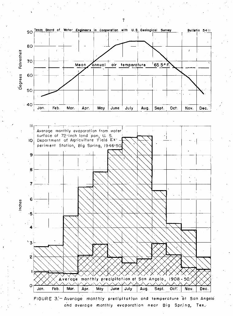
The records show' that May and September are the months in which the largest amounts of·
precipitation fall; however, even thot~gh 'the greater part of the precipitation falls during
'the crop-growing season, many individual rains are smalL The loss of soil moisture by
evaporation and transpiration of plants is rapid in the summer, especially when there are hot,
dry southwesterly winds. As a result of th~se conditiuns;supplemental irrigation 1.S desirab~eo
Figure 3 shows the average monthly precipi tation' and temperature at San Angelo and the average
monthly rate of evapo~ation' from a 72~inch land pan at the Do So Department of Agricultu~e's
Experiment Station near Big Spring, Tex" , which is about 80 miles northwest, of San Angelo.. The
average annual evaporation from the pan is 71.. 5 inches.
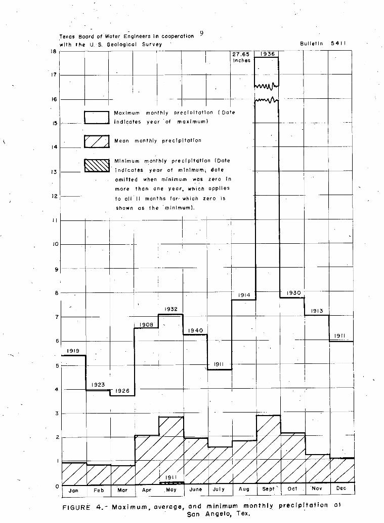
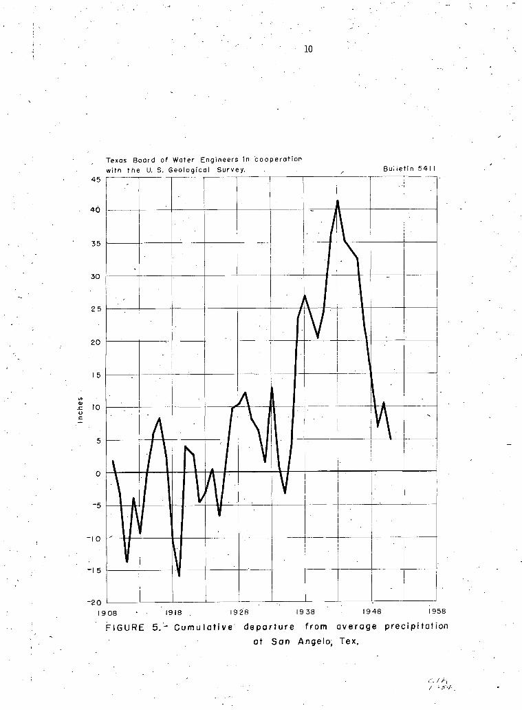
The maximum, average, and minimum monthly precipi tation 1.S shown 1.n figure 4" and the cumu-'
lative departure from average precipitation is shown in figure 5.
GEOLOGY
Rock formations exposed J.n Tom Green County a!re of sedimentary origin. The oldest. of these
beJpng to the Permian system and are exposed in some parts of the plains and riveJr~valley£areas
. of the county. The regional dip of the Permian rocks is westward approximately 50 feet to the-
mile. The hilly remnants of the Edwards Plateau are composed of rocks in the Cretaceous system,
which dip southeastward at a very low angle. Older Quaternary alluvium (the Leona formation)
covers the Permian rocks in most of the plains area." and younger Quaternary alluvium n.s present
in the stream valleys.
Rocks in the county older than those exposed are not known to contain potable watei':". No'\
water wells in the county penetrate these older rocks.
:_died~ogic form.a!:ions.,togeth~rwith the'ir chief chaJrac't.er:i.sti.c.,s~and water~bearingproperties,
1kre'sho~" in tabl~2. The'oU'::crops of geologic formations in Tom Green Count.y are shown:Ofi::;'::
plat~ 1, and cross sections of these formations along lines X~X', Y-Y', and Z-Z' are shown onIplate 2,, .
Armyo forrmati~h... The basal uni t of the Clear Fork group l.S the Arroyo fOrnJation. Accoriding
to Sellards (in Sellards, Adkins, and Pl:ummer, 1932) the thickness of the Anoyo formation is
260 feet at its 'type 'locality near Ballinger in Runnels County. The fOrnJation consists chiefly
. of light-to dark-gray and 'black shale" but it also contains beds of light-to dark-gray limestone,
generally 1 foot to 3 feet in tllicknes8. The upper 15 feet of the formation is the Standpipe
limestone membet, a yellowish and lighi~'gray marly limestone which it covered along·most of its
outcrop.,
27.65 19361nches
,'..A~,
....!--'---.. A . .-.-_..,----
I .,., ''''1\1''
0 Maximum monthly precipitation ( Date
indicates year of maximum)
0 Meon monthly precl pHatlon
-'~.Minimum m.onthly preclpltcition (Date
Indicates year of mInimum; date
omitted when minimum was zero in
more than one year, which applies---'
to all II months for' which zero is ,
shown as the minimum).
,
i
i,
i;
I; 1914 1930
/
,1932 1913
I 1908 ,
19401911
1919
i 1911 ._--
19231926 ,
,
~ V/:
'i~ 0 ~----.,
~ !//iiV7 ,
/ /
~~I~'iY/~ [/~V%C7'~/' 1911 ~ /;Jan Feb Mar Apr May June July Aug Sept' Oct Nov Dec
·."
18
17
16
15
14
13
12
II
10
9
8
7
6
5
4
3
2
o
.Texas Board of Water Engineers I n cooperation 9with the U.· S. Geological Survey Bulletin 5411
FIGURE 4.- Maximum, overage, and minimum monthly precipitation atSon Angelo, Tex. .
10
Bulietin 5411
r~i I
I
I:
-
Ii
I I II I
I
I
\I-I
I
J!\
III
1
, I
III
!I
i .
i
! I-- i- -I-t--V\--J'I-------j-I--~-·=_
-.,-+Hb-+---+-----+------+I-'--.\~----t------j! I'i
iI
II
I-II
, , II I iI I
IiI
I~IVII
I~.
JI\
A 'IS-I' " V\
II
II
I~ ~- !
I V
" V
--~1-------
\ ---_ ... -
Texas Board of Water Engineers in cooperation
with the U. S. Geological Survey. ,.45 r-T -~-- -,-----,,-------~,-------~---,--_,--_,--_____r
46
-:2 0 l--_--.----J__----l-__----L__---l-__----L,------_--l-__--"--__~----'------'
1908 1918 1928 1938 19481958
FIGURE 5.'- Cumulative' departure from average precipitation
at Son Angelo; Tex.
Cln,I ~ 5<7-_
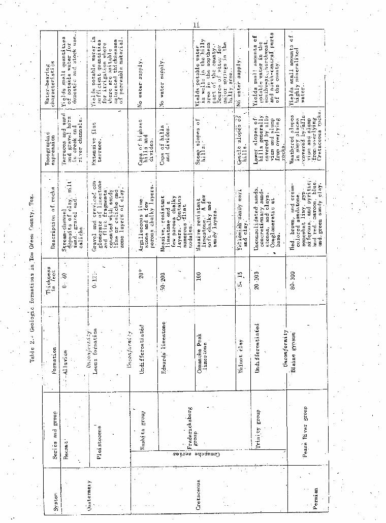
Table 2.~ Geologic formations in ,Tom Green County, Tex.
, System Series and group Formation"Thicknessin feet Description of, rocks
Topograt?hicexpreSSIon
t-"t-"'Yields potable water
in wells i,n the-hillyarea in the southernpart of thecoi.mty.,Source of wat,,:,,' formajor spnngs in thehi 11 y , area ..
No water supply.
Nd water supply.'
Steep slopes ofhills;
Gentle sibP~S 6£hills.
Massive resistantlimestone,' A fewsoft.' chalky andsandy layers.
YHil6~l~li:":'~julUYmadmd day;
100
,. 15
Comanche Peaklimestone
Walnut day
rIJOIl,,.,l-<OIl'rIJ!Fredericksburg~' group()
[;1.s
(3
()ia ternal:Y
Cretaceous
I"I' Recent·. I ." ··Alluvium --+ 0, 40 I S~t'eam:'chan~el, . " ' I Terraces and sand Yiel,ds ,S~~,ll quanti, t1es
. "'kpOSl tos 01 C-' '1y. ad t and gravel bars of potalne water for ,
"I " I slilld. gravel ai.d, , I, :en ,creek and domestic and 3tO,ck lise. I
,'. caliche :riyer channels. '
P:l' -- 1 - II -Le~~~o~:~:.::~t~n ~ -'0 l2':~-------'I'~ravel and 'ere,Vi,~ed",con.' Extensive flat Yi'elds PO, table w~ter~ln•elstocene , glomel'ate of limestone I terrace., 3ufficient quantitie3
• I I and flint fragments fell' in'lgadon where
~"'. cemeIt ted wi th s;mdy there are sui table'J , I Ii'me or caliche and . . saturated thicknesses
.1 " some' layer's of day: \ of peJ:'meable :na'te;ciaL1 -1 r < .. I
: " .•1 Washit~ group' lffi:'::::::::::e~' 20+ 'ArgillaCeOus lime~ I Caps of highest !No water supply,, , s '(;one and a few h:d 1sand
\
porous chalky layers. di vides.
Edwards' limestone 50~200 Massive., resistant I, Caps of hil'ls, limestone and a and divides.
few porous chl),lkylayers., Containsnumerous -£lin tnodules, ,
Yields small amounts ofhighly minerali'zedwater. '
Yields small amounts ofp,otable water in thescu,thwes t."ilOrthwes t,and noi:th'~(en,;,;rarpartsof the county. ' , .
Unconsolidated sands.concretionar.y sand~
s tones, and cl ays,~ Conglomeratic at
base.
20~103Un di fferen ti a ted Lower slopes ofhills generallycovered byallu ~
vium and slumpfrom ovedying
Unconformity rocks.
'Bl aine gypsum' 80- 300 Red,. brown, and cre'am· I Weathered slopescolored sandstone, ,in many placessomewhat limy. gyp~,"cqvered:by"inu"
siferous. and pyri tic; , vium and slumpand red.' maroon. blue, ':from'.::overl.yingand, green sandy clay'. Cretaceous r,ocks.
Trinity group
Peas~ Hi vel' group
Permian
'{
Table 2. ·"Geologic formations in Tom Green County--Clmtinued
System
Permian
Series and group
Pease River group
j
Formation
San Angelo salldstone
Unconformi ty
Choza formation
Bullwagon dolomitemember
/
\ '
Vale formation
Thickness'in feet
250
625
75
140
Descript~on of' rocks
Brick-r~dsandstone
clay.' Some 'thinwhite sandstoneseams.' somegypsum.'littleor no mica. ,andon,e thin fossiliferous dolomite.'Conglomeratic atbase.
Gray dolomiti<;. liillestone fossiliferous in places,red. green,. blueand yellow clay.Some silty claylayers.
Massive yellow~sh,togray dolomi t 1 {):ll);;e
stone, and 'greenand red 'shale y,,'"
layers. Two ofthe dolomiticlimestone layersabou t 10 feetthick are separated by about 3feet of greenshale.:: Lower layerof dolomitic limestone is an artesian aquifer.,:
'About 8 feet of greenish shale at thetop., R~d. sandy,and, gyp'si feroussha1e' and' thinstr~aksof greenShale:;',
Topogra(>hicexpre,SS10n
Low hills andsl,opes of 'hill s innorth-centralpart of thecounty.
PI aiD. coveredby Leonaformationsouth of theConcho Ri V(~r.Low hillsnorth of the'Concho 'Ri ver.,
Low ridge trendirig northsouth ac'rossLipan Flat.
I?lai~'cd'vered'by soil and'
al1uvium.
Water-bearingbharacteristi~s
~ields small amountsof highly mineralized water.,
Yi~lds ~mall amountsof highly mineralized water fromlayers of dolomiticlimestone. Sourceof water for a' fewsmall, irrigationwells.
Yields potable waterin amounts from 100
'to 1,000 gpm forirrigation in anarrow area west ofits outcrop.,
No watef supply.,
I-'l'-:)
Clear Fork,gro~p Standpipe lime''stone member
15(?) I Yellowish to lightgray marly lime~ ,stone. "
Plain generallycovered bysoil and,alluvl.um
Yields small, amountsl:it{fpotable wa,ter near 'C
its outcrop.,
,Arroyo formation 60+ Alternating light 'todark-gray and blacklaye'rs of shale andfossiliJerous limeston,e.
Plain ,cover'edhr sop a~da Juv1um.,'
Yields small amounts ofmoderately to hi~hlymin~rali~ed water "from layers of, lime- .stone.:" ,
13
\
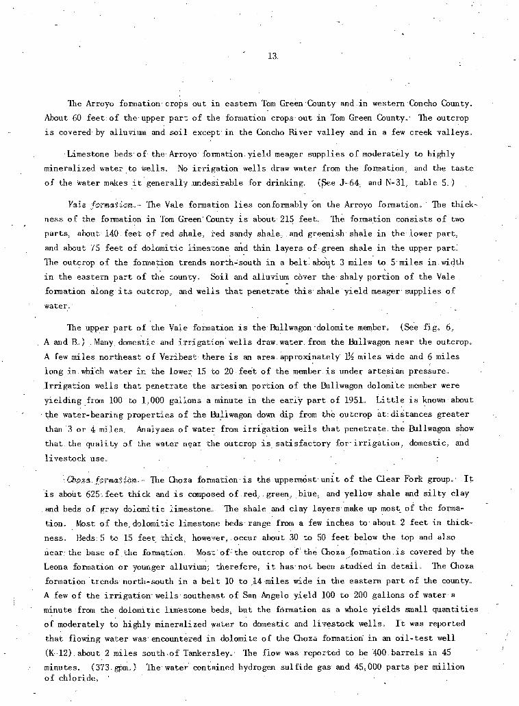
The Arroyo fonnation crops out 1n eastern Tom Green :Coun ty' and ,in western Concho County.
About 60 feet: of the upper part of the fonnation crops'out in Tom Green County. The outcrop
1S covered: by alluvium and soil except'in the Concho River valley and in a few creek valleys.
Limestone beds' of, the Arroyo fonnation, yield meager supplies of moderately to highly
mineralized water_to wells. No irrigation wells draw water from the fonnation, and the taste
of the water makes it generally ,undesirable for drinking, (~ee J-64, and N-31, table 5.)
Vde flf)Jrrl1lrfJ~ilf)J!!',,- The Vale fonnation lies conf~rmably 'on the Arroyo fonnation,' The thick~
ness of the fonnation in tom Green' County is about 215 feet. Th~ fonnation consists of two
parts" about 140. feet of red shale, red sandy shale" and greenish shale 1n the lower part,
and about 75 feet of dolomitic limestone ar'id thin layers of green shale 1ll the upper part:
The outcrop of the fonnation trendsnorth~south in a belt' abo~t 3 miles' ~ Smiles in. width .
in the eastern part of the county, Soil and alluvium cover the shaly p'ortion of the Vale
fonnation along its outcrop, and wells that penetrate this shale yield meager- supplies of
water"
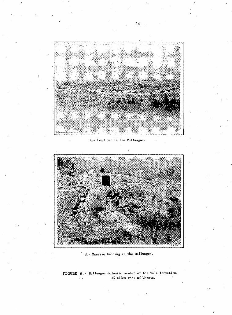
The upper part of the Vale formation is the Bullwagon 'dolomi te member. (Se'e fig. 6,
A and B.) Many. domestic and i~rigation wells draw. water from the Bullwagon near the outcrop.
A few miles northeast of VeJribest there is an area approxinately ill miles wide and 6 miles
long in which water in the lower: 15 to 20, feet of the, member is under artesian pressure"
Irrigation wells that pl:'..netlrate the artesian portion of the Bullwagon dolomite member were
yielding.from 100 to 1,000 gallons a minute in the early part of 1951. Little is known about
,the water-bearing properties of theBu~lwagon down dip from the outcrop at distances greater
than 3 or 4 miles" Analyses of water from irrigation wells that penetrate. the .Bullwagon show
that, the quality of tile water n~ar the outcrop is. satisfactory for' irrigation, domestic, and
Iivestock use"
'. Chou! j«)J!l':Il1dff,o!!,." The GlOza fonnation' is the uppennost· uni t of the Clear Fork group.' It
1S about 625', feet thick and is composed of red, ,green, blue, and yellow shale and silty clay
. and beds of gray dolomitic limestone",The shale ~d clay layers' 'make up most_ of the fonna
tioD. Most of the, dolomitic limestone beds' range from a few inches to· about 2 feet in thick
ness. Beds: 5 to 15 fee~ thick, however, ,occur about 30 to 50 feet below the top and also
,near. the base of, the formation.' Most of· the outcrop of'the Clloza)onnation ,is covered by the
Leona fonnation or younger alluvi~; therefore" it has' not been studied in. detaiL The alOza
fonnation trends north-south in a belt 10 to .14 miles wide in the eastern part of the county.
A few of the irrigation' wells' southeast of San Angelo yield 100 to 200 gallons of water a
minute from the dolomitic limestone beds, but the formation as a whole yields small qUantities
of moder~tely to highly mineralized water to domestic and Iivestock wells. It was reported
that flowing water was encountered in dolomite of the Choza formation in an oil-test well
(K-12).about 2 miles
minutes. (373. gprrio)of chioride.
south ,of Tankersleyo' The flow was reported to be 400 barrels in 45
The water' contained hydrogen sulfide gas and 45,000 parts per million
-',
14
A.- Road cut in the Bullwagon.
B.- Massive bedding in the Bullwagon.
FI GURE 6". - Bullwagon dolOllli te member of the Vale formation,, ( 3~ miles west of Mereta.
15
PE~SE RIV~R GROUP
San Angelo sandstone ... 'Ihe San Angelo sandstone IS the basal' formation In the Pease
River group and lies unq.ll1fornV:lbly on rocks in the Clear Fork group. (See fig. 7 A and B.)"
1he formation is about 250 feet thick in Tom Green County. ,The f,ormation is composed of, I
reddish~brown conglomerate at the base, brid<-red sandstone, a few thin' beds of white sand-
stone, re;J clay, and gypmlffi in'terhedded w:i,th, layers of 'clay.
'lb~,San Angelo sandstone is exposed in a belt half a,mile'to 4 miles wide extehding
north,:,so\lth 'through San Angelo, and the type locali ty (CUmmings and Lerch" 1891) of the for
mation is, the area adj acent to the southwestern part of San Angelo: 3See pI. 1.)
, Ground water in t.he sandy beds of the San Angelo sandstone generally is highly
mineralized. However, on the outcrop of the formation, or in places where the outcrop is
covered, by several feet of' alluvium" a few wells yield water that is 'sui table for livestoc!<.
Blaine gypsum. - 'The Blaine gypsum is the only other uni t of the Pease Pd. ver' group
exposCld in Tom Green County. Unconformities separate the,Blaine from the underlying San
Angelo sandstone and ov(~rlying younger rocks. TIH~£ormation ranges in thickness from 80 to {I
300 fMt and Is composed of red, broWl'l, and crefl\J1~colored.limy,_ gypsiferous, and py:t:i tie
sandstone beds, and hyers of red, mnrocm, blue, and green sandy~clayo lhe formation is
exposed northwest of Lnkf;1 Nasworthy, at Monumf;1nt'Mountilin south of Water Valley, and in
small draws l\lone the south bl1nk of the,North Concho Rivf;1r (see pL 1). Elsewhere in Tom
Green County the ,Bhin(~ gypsum is covered by younger rocks or is obscured by soil 'and
vegetation.. ,Wella that penet.rate the Blaine gypsum yield small quantities of highly
mineralized water,
CRETACEOUS SYSTEM'
COMANCHE SKU ES
lh~ Comanche senes IS the provincial series of Lower' and Upper ~re.tQceous rocks of
marin,eorigin present in the Southwestern States. TIle series consists' of the Trini ty,
Fredericksburg, end Washi ta groups.
TRINITY GROUP
'. 1he Trinity group in central Texas includes the Travis Peak formation, the Gle;n Rose
limestone, and the Paluxy. sando The r~cks in the Trinity group in ,Tom Green County, bow
. ever are not divisible into separate units. Henderson, (1928, p. 23-26) referred to the'
rocks in, th~ Trini ty group.. as the Trini ty division.

16
A.- San Angelo ••datoDe reatins _ ~&a f01'llation.
B ·.- Conglomerate near base of San Angelo sandStone.
,.
FIGURE 7. - San.Angelo SQndstone. west side of State Highway. 70,·7 miles north of San Angelo.

17
Rocks in the Trinity group lie unconfonnably on Permian rocks andunderl~,e ,rocks in the, .',', " " . . .,-' . '.
Fr~deri?k,sburggroup. From 20 to 103 feet of basal conglomerate,poorly,,,cons()lidated,sa~q,
concretionary sandstone, and clay, crop ,out on the lower slopes of the hilly area? ~n ~he .•
. county. The outcrop iscovered'by alluvium. and soil in many places, ,making it difficult to
trace .. An ~xposure-of sand, clay, and conglomerate about 2Yz miles southeast of the point
wher~ State Highway 277' crosses Pecan Creek, between San Angelo and Christoval was described
as the Trinity division ,by Henderson (.1928, p. 24)., qhe present writer found no other expo
sures in Tom Green County east of this point. Drillers' logs of. wells P-14 and Q-13 show 3;.' . , ' , ,," .
and ~5 fee~ of sand, respectively, at depth where rocks in, ,the Trinity group should he
present. Drillers' logs of wells R-land R,,4, however, show no sand at these depths.
Rocks in the Trini ty group yield ',Vater of good qu~li ty to domestic and livestock well~
throughout the hiliy areas in th~ weste~n part of th:e" county. Adequate supplies of water. / .
for domestic and~ivestock purposes are o,btained from the rocks above the Trini ty group m
the southern part of the county.
FREDERiCKSBURG'GROUP
Walnut'~l/ay::'~he Walnut clay is the basal formation of the Fredericksburg gro·;1t, and in
Tom GreenCo~ntyit 'consists of 5 to 15 feet of yellowish sandy marland day. Poor expo-
sur'es of the Walnut clay are present on thedower slopes of the hilly areas' in road cuts and
III the nar:rowvalleys of small draws. The formation yields' no water.
ComancHe Peak, limestone. - The Comanche,Peak lim~stone, 'which lies aboyethe Walnut clay,
,IS about 100, feet thick and is composed of soft yel~owi~h chalky and sandy limestone, in the
lower part ~nd massive, more resistant b~ds'of limestone In the upper part. The more resis~.; .. '
~ant ~eds of limestone form'the peaks of the lower hills In the hilly areas of the county.,
'The chalky layers in the' lower part of the formation and the underlying Walnut clay retard:
the dOWBward movement of ground water. The springs ih the southern part of the courity ar'~" '
contact spri'ngs that 'flow from cre'vices in the massive beds of limest,on:e,2;rabove th~ chaiky"
beds~:Many of the'wells fn the hilly :f-reas draw water from the massl. vebeds of :h~e'storie."" ;""--. ""- ,- ..
Water from th~Comanche Peak limestone contains less dissolved ;;olids than ,the water,,~ '; :", ~ ,-' . '.' ", -'. ~ ; ,: i..
from any of the other water-bearing strata in the county.
,Edwairds',limestone.- The Edwards limestone is the uppermost unit of theFredericksburg
g:r9UP.. Th~ formation ranges from about 50 feet, to 200 feet in thickness and co.n~~s.ts of
massiv;e, :r~sistant grayish limestone and a few beds of porous" chalky limest(:m~. ' 1h~ be?~
,of li~esi~necontain ~um~r~l,lsflint riodules, and, sone' of the beds we'ather into irI;egula~lyshaped honeycomb rocks., The Edwards limestone forms the caps and divides of many of the
hi~her parts of the hilly areas. Its topographic posi tion is high, and it has no imper
vious rocks at its base to prevent the downward movement of water 'through its crevices and
; ,
\. ,
18
</
joints into the'Comanclie Peak limestone; therefore, the Edwards limestone and the Comanche Peak
limestone are one hydrologic unit. The Edwards is porous and permeabie, and therefore, aids
in recharging the underlying ground-w~ter reservoir, 'but is itself of little importance asa
water'-bearing rock in Tom Green County:
, WASHITA GROUP
Rock strata in the Washi ta group consist of argillaceous limestone, chalky limestone,_ and
marl. Thin remnants of these strata, cap the highest hills and divides in the southern part
of the county. The Washita group does nbt contain water-bearing strata in Tom Green County,
QUATERNARY SYSTEM
~ ~
P~jISTOCENE SERIES
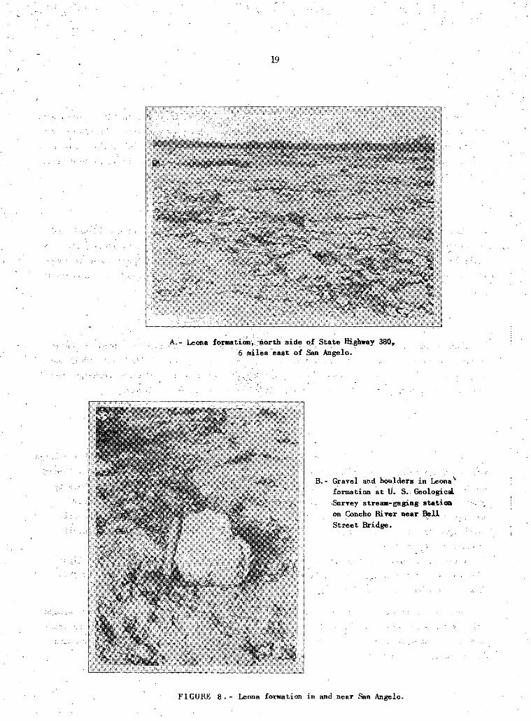
'Leonaform~tion~- lhe conglomerat~ along the Concho River and its'tributaries 'was
classified as Pleistocene by Henderson (1928, p. 32-33). The Pleistocene alluvium in Tom
Green County consistk, of rock materials derived principally from the Cretaceous rocks of'
the Edwards Plateau. The alluvium was deposited on the eroded surfaces of the Permian rocks
over about 400,scjuare miles in the plains areas of the county. The'thickness of the alluvium ~/
ranges from a few feet to about, 125 feet. The alluvium is composed of discontinuous beds of
poorly sorted, rounped to subangular gravel, conglomerate, sand, silty clay,- and caliche. The
particles of gravel are composed of limestone and flint, some of which contl:lin Jragments' of
Cretaceous fossils.
The deposits of Pleistocene alluvium in Tom Green County are similar in origin, composi 7
tion, and topographic position to the Leona formation of HilL and Vaughn 0898, Part n,p.
253-254, 275-276), which, is of Pleistocene age. The type locality of the Leona formation is,
along the Leona River in U~alde and Zavala Count~es1n the southern part of Te~as. According
t9 Plummer (in Sellards, Adkins, and Plummer, 1932, p. 796), the Leona formation is present
in terrace deposits' along the principal streams of Texas. The name, Leona formation is here
• considered to apply to the alluvium of Pleistocene' age in Tom Green County.'
The more prominent exposures of ~the Leona formation in Tom Green County are along the
northern edge of Lipan Flat on the south bank of the Concho River and along the banks of ,the
,North Concho River in San Angelo. (See fig. 8, A and B.) In these places the formation
is a conglomerate forming a terrace 5 to 50 feet above the younger deposits 1n the river
channels..
"
19
,A. - Leona formati~r.,:Jlorth side of State Highway 38G•.6 miles east of SaD. Angelo•.
B.- Gravel and~ld~rllin 'Leona \
f~rmation at U. S; Geological
,Survey s tream- gaging stati01lon Concho lliTer near BellStreet Bridge•
. ,
FI GURE 8. - Leona formation in and near San Angelo.
, .
. ! ~ '.
Most of the irrigation wellsin.the' vicinity of Wall and Veribest and in th,e; Lak~yiew area
. draw water from the more permeable layer,s of gravel and creviced conglomer:~,t~. Y~,elds of irri- "
gation wells in the vicini ty of Wall and Veribest range from abou't '100 to 700 gallons a minute". '.:' -.. :'" " ..,.
and in the Lakeview, area the yields range from about 50 to 200 g~llons a minute. Th~ qUality, -, " ..,
of the water is satisfactory for ,most purposes .
.' RECENT SERI ES
Thechannels of rivers and creeks in the cOUn'ty contain deposits of unconsolidated sand
and grav,el, that hav:e been deposit~d in Repent ,geologic time ,and,,' toa,~ertatll eX;tent, a;re
still being transported and redeposited by each flood. Thethi~kriess',9.!j,'t;~e~'~1,,<!~P?~it:s,:r~ge;c~>'from a,few feet to ,about 20 feeL, Domestic and livestock wells on tpe:'edg~s~,~::,these:,:'b,harinels'
yield potable, wa.ter.
.: -',
OCCURRENCE OF GROUNDWATE.R
Th~fund~~ntal hydrologic principles relating to undergr0tl!ld water h~:v,e:,been presented
·In numerous papers of the U. S. Geological Survey, ,by Meinzer (19'23a,1923b,.I,;3i;'>19'4'2)"and
,many others ."The following, discussion pertains to the sour.ce,and ;6<;:c;,urr.ence:;; "~echa~g~',and ;
discharg~of water in the important water':bearingstr,ata in TQm.'Greeri':(~uPty,:'> . ,t,; "
'. . . ~
SOURCE AND' OG<AURRENCE'
Ground water is cierived from precipitiition on the land' surface.Record~>shOw that, _a' large
part of.the precipitation at San Angelo(~llsill rainstorms of short: duratio~;fr~mMa;~hroughSeptember,; A part of the rainfall runs Q~f in streams, a part r~turns~o'the~tm6~ph,e~~Eby' .
evaporation and transpiratio~ through plants, and a _relati vely,~mall':pa~t mo~e,s:' do~wa'~~.. '
through. the soil and the openings in the rocks tp become ground' water, whichi~'eventuany:/;,
discharged by evapotranspiration or by seeping into str,eams.. w,pen .the perioq. ~,fJ(;'l.i~f~i'l:":-lasts for~ev:eral days, and the total amouJ.1t is several inches,' conditions, ,~r.e'm()r~ . _
favorable for recharge to the ground wate'r'reservoir.' For ,example" sev~ra.lwells ,:i~·{hp~. -. -. ..' ..-' , -,: ., . ' . " "
Flat had a slight rise or very little decline in water levels ,after the wet spring of ;1949.•, .
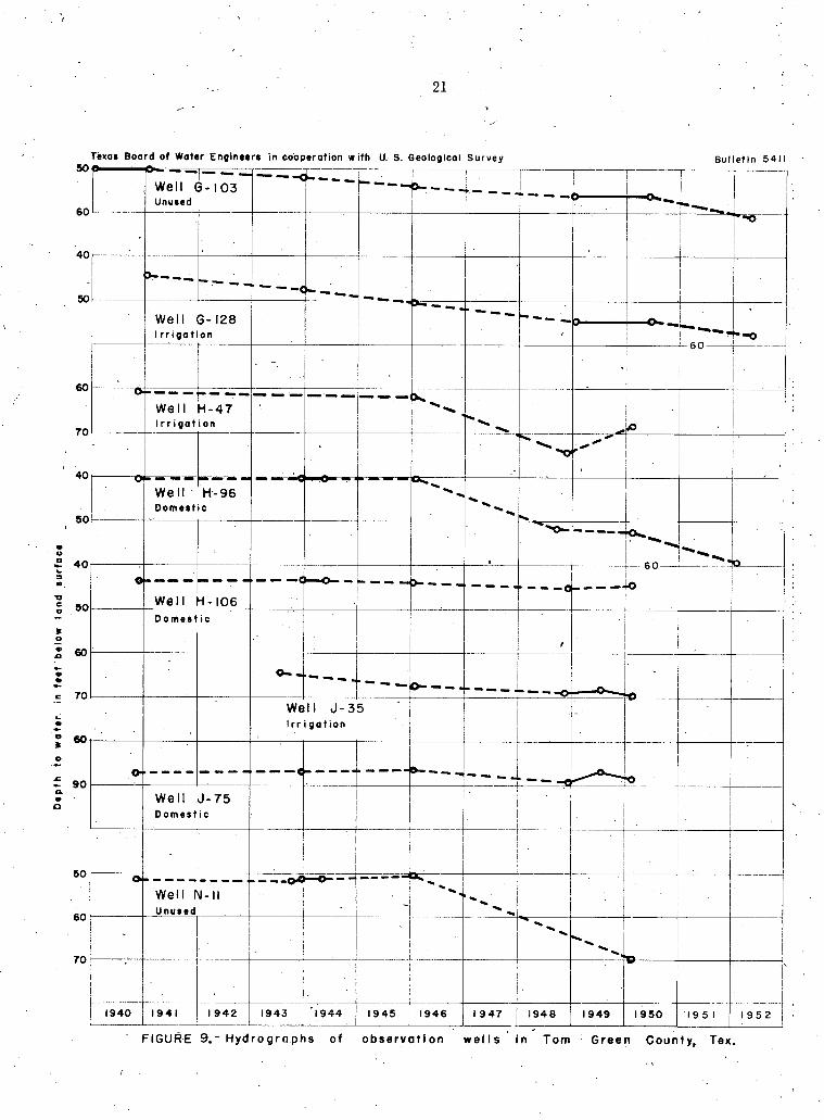
(See ~ell~ J-35, and J-75, fig. 9..}
Nearly all rocks that make up th~. Ol?-t,er crust of the earth contain s01Jle. qpenings.th,rough
,which~~t.e:r will pass. The beds of li~estone ..and beds of cong19~erat~'contain~ate:rtp.frac~
. t,ures, in spaces between beds, and in solution~l·channels. Beds of ~imd and gravel contain
water between the particles of rpck.
21
Bullefin 5411
Well G-128
Te.a. Boord of Water Engineer. in cooperation VI ith U. S. Geological Survey
50 ~-...,o.W"';"II=-;r;~-;;;;-~ 1-;;:~=-:3-=-~ - f=--=F ~-~--ii- -_~__-()---+--o..unused. --j- I,
60 .. .'--~~-+--~~--+I~~---1I~~~+--~~-+-~~-t-~~-
40['':'"'''''' ~~--+'--"-~-+~~+I~~_~-~-~-t-'~--t-I~~+-_----t-~~+-~-+~.0----1- .
~ :- - - - -- -ell-.50 ~,-~---~-+-.~~--j-~~,,--+---~--'-t---~-..._...~=--.--+-~~~-+----,-t--_+-__~.+-i'----t---j
----. I I- - - ... - - .-p----+--o-- _i I' .
r--~ .1~ -+-l__r~rt_'g~o_tt-ia_n__-t--__'---+ +---__-t--__-t -+---'-+---I-II__---+-1 6 0 _~: -o j
... ....,,-;;,~ ~:-:.;---~----t----ti.':-C .··!~-~-ll· ·1: !II.I
Irrigation I I "_ ioD
'.-----I-- -1---- -- ~-,~7~1--,I-, -~I--'------/
t-------c ,I i
60
70
40
50
•..0 40.....:>•'0<: 500-s0.. 60~....•...<: 70
.:•..0 60s0...t::
90..0-
•0
1940 1941 1942
FIGUR-E 9.- Hydrogrophs of observotion wells In Tom Green County, Tex.

22
:Recharge of groundwater 18 the process by which water 1S absorbed and added to the zone
of. saturation, Most of the water,· bearing rocks in the county receive recharge from local
precipitation after periods of above-nor~al rainfall, Water penetrates. the-soil and'porous
beds of rock exposed on the surface and in. the channels of streams.
Water in the zone, of saturation flows under the influence of gravity to some place of
discharge at· a lower altitude; a spnng, a seep, a £lowing well, or an area where the water
. can' evaporate or be d!~awn oat by plants" or a pumped welL O'ler a long period of time the
amount of water that enters the zone of: saturation i.s balanced by the amount that is discharged
from it.. Artificial withdrawal of ground water diverts water that otherwise would discharge
, na turally. Under certain condi tions the wi thdrawal from wells may provide an opportunity for
increas!?d replenishment as' well c~s decreased natural discha:rge~ To be permanent, holNever, any
ani fi.cial. withdrawaL e"fll'lntnafl.Y must be ballapced by decreased natural dis.char.ge;' increas'ed
recharge" or a cotiIbimition of the tW0.,";· .",
Natural discharge' takes place by evaporation ~nd \:Tfillspiration where the water table J.S
near the surface" Where the Lind surface intelrsectp the water table, water is discharged
"t'flrougfl springs and seepsu\
Water is withd;~awii fram we.l.ls in nearly all pa)~ts of the county; however, irrigation wells
:m the Lakeview' area and in :Lipan Flat aCcOlmt for :mnst of the purnpage from the ground-water
reservoirs of Tom Green fA.lunty, In general, the greater declines in water levels ha1le occurred
in the' irrigated areas,
.QUAllLTY OF WATER
r~emical analyses of water from 22R.wells and 7 springs ~n Tom Green County are given 1n
table 5. Analyses of groundwater Hre made to determine the dissolved mineral content so 'that
the users may determine whether the water is suitable for specific purposes.
Ground water for municipal supplies is commonly rated in accordance with the limits set by
the United States Public Health Service for water used by· common carriers in interstate commerce.
The average, individual can become adjusted to drinking water considerably higher in concentratio~
than set by thesestanda1:'ds, r:1.1though temporary physiological disturbances may result when such
water is first used. In many parts of western Texas wate~ that meets all these suggested limits
cannot be obtained, and many communities use ground water that contains certa~n,minerals far in
excess of the suggested standards. The suggested limits of the more important minerals COnIDl;mly
found in solution <ire as fonows~
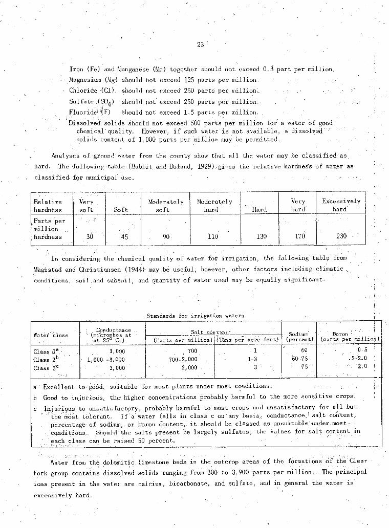
, J
Iron (Fe) and Manganese (Wb) together should not exceed 003 part per million,
.Magnesium (Mg) should not exceed 125 parts per million.
Otloride(Cl) should not exceed 250 parts per million.
Sulfate (SC)4) should ,not' exceed 250 parts per million.
Fluorid~;}(F) should not exceed L 5 parts per million.
Di~solYed solids should not exceed 500 parts per million for a water of goodchemical'quality .. However, if such water is ~ot available, a dissolvedsolids content of 1,000 parts per rnillion may be permitted.,
Analyses of'ground 'water from the, county show that all the water may be classified as
hard. The following 'table· (Habbi t and Doland, 1929) gi yes the relative hardness of water as
classified f<;>r municipal use .
.•_--_.,- -,
IRelative Very Moderately Moderately Very Excessively
,hardness soft' Soft soft hard Hard hard hard'-
Parts permillionhardness 30 45 90 110 130 170 230
;' .'
In considering the chemical quality of \vater for irrigatioll,. the following tabl<;l f~om
Magistad anl QJristiansen (l944) may be useful; however, other factors including climatic, ,
conditions, soil and subsoil, and quantity of water used may be equally significant.
I,
Standards for irrigation waters
700
700~2.000
2,000
, ConductanceWatei' 'Cl ass " (mi'crcimhos at Sal t c6nten!~=- ~.:-_~__--l
, a,t 250 C, J. (Parts per million)' {T0ns per ac~e~ foot)I----'~---'-~---'+--'-----'~--'-------+----''-'-'---------elass ;1a 1,000
Class2b It 000- 3.. 000
Class3'c 3.. 000:'. '~" ' j
Sodium'(percent)
6060~"l5
75
BorOli(parts per'million)
0.5
• 5~2.0
2.0
a' Excellent to good, suitable for most plants 'under most conditions,
b Good to injurious, the' higher concentrat:lons probably harmful to the more sensitive crops.
cln:5uri'9~s tounsatisfactory, probably harmful to most crops and unsatisfactory for all but',' the'ihost to'ler'ant, 'If'a'water falls in clas's c on'any basis, conductance,: salt content,
percentage of ~odiurn,or boron content, it should be classed as unsuitable'untier:,mostcondi~ions" ,Sh<;mld the salts present: be largely sulfates" the values for salt content 1rt
each class can be raised 50 percent.~"c... , , ";ii',.. __~--'-~--'-_~__--'- --'___'____~--'---'-~~--'--'-_~ _
,.'"Water from the dolomitic, limestone beds ln the outcrop areas of the formati~ns' ~f' the Clear
F?rk group contains dissolved solids ranging from 300 to 3,900 parts per million, The principal
lons present in the water are calcium, bicarbonate, and sulfate, and in general the water is'
excessively hard.

.24
The outcrop areas of formations in the' Pease River group contain water that ranges from
800 to about 52,000.parts per million in dissolved solids. In general, the water in the for .. ·
mations of the' Pease River group is highly mineralized.
Water i~ the formations of the Trinity and Fredericksburg groups contains dissolved solids
ranging from .200 to 300 parts per million. lbe water is hard, but m general it is better in
quality than other ground water in the county.
The Leonaformatio,:! contains water that ranges from 500 to 1, 400 parts' per million in
dissolved solids. The predominant ions in the water are calcium and bicarbonate, and in
general the' water is excessively hard,
The' water in the stream-channel deposits of Recent age contains approximately 200 to '300
. parts per million of dissolved solids,
The percentage of sodium is low in most 6f the ground-water samples in Torn Green County
for which it was calculated. Eleven analyses of water from the principal ~quifers show a
range of 0.18 to 0.77 part per million of boron, which 1S not excessive for most crops.
Analyses for fluoride were made on 67 samples of water and: the fluoride content ranges from
0.1 to 3~lparts per'ml11ion; however; most of the sam~les of potable. water' contain less than.
1 part per million o'f fluoride.
DEVELOPMENT OF GROUND .WATER
The first settlers in the territory that comprises the present-day Torn Green County
obtained water from springs, creeks, and rlvers. In places. where there. were no springs and
where the streams were dry several months of the year, wells were dug by h~nd into the uncon
solidated sand and gravel deposits in the stream valleys. In later years cable-tool drilling
. rigs that could drill wells faster and deeper were used to drill wells in areas remote from
shallow water supplies. Water was obtained from these early wells by bailing or by the use
of hand~operated pumps. Windmills also were u~ed at an early date and are still being used to
supply power to pump water for domestic and l~vestockuse on many ranches and farms.
About 1924. the Lakeview area north and northwest of San Angelo was developed into small
farms and truck gardens. Several irrigation wells were drilled into alluvium in this area
and equipped with 4-inch or 6-inch cylinder pumps powered by internal-combustion engines of
differeht types. Some of these wells were drilled in palrs, and the. pumps' were 'connected by
a line shaft operated by a single englne. (See fig. 10.) Several of these wells were still
ln operation in 1952, but some of them were powered with small electric motors.
,L

25
FIGURE 10" - "Twin wells" H-79 and H-80.
In 1940 about 120 irrigation wells were being used to irrigate approximately 800 acres.
The wells ranged in depth ,irom about 50 feet to 100 feet, and the average yield per well was
about 100 gallons: a minute. About 1942' hIgh-speed turbine pumps powered by internal- eom
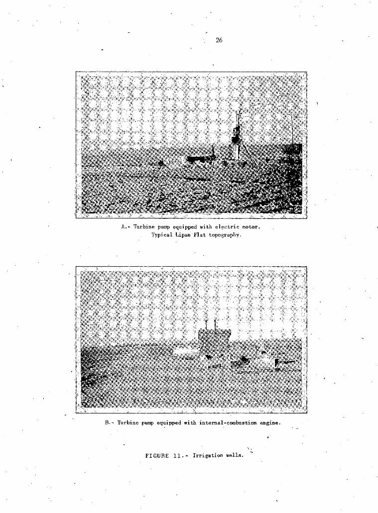
b'ustion engines ore'leetrie motors were installed in many of .the old wells. (See fig,. 11,
A and B.)
Slightly more than 330 wells had been drilled for irrigation by the end of 1950; however,
only about 120 wells Were used to irrigate approximately 3,700,acres in 1950, an.average of
about 30 acres per welL. Some of the wells that were dri.lled for irrigation did not yield
sufficient water and were abandoned; many other wells of small yield were abandoned after
being used for only a few. years. .The irrigation wells that we~e in use in 1950 ranged in. i
yield. from. about 100 to' about 700 gallons a minute. Most of the weBs had yields of less
than' 500gailon~'a minute. The average speci fie capacity of the irrigation wells 1n 1950
was 16 gallons a minute per foot of drawdoWn. It is estimated that approximately 4,000
acre-feet of ";"ate;, o~ a little mote dian 1 foot per acre, was used in 1950.
In Nov.ember·and D~cember 1950 and in the early months of 1951, about 25 irrigation wells
were drilled to the base of the BUllwagon dolomite member of the Vale formation, in an area
a few ~11es northeast of Veribest. lhe lower 15 to 20 feet of the Bullwagon is an artesianI
'aquifer in this area, In .the early spring of 1951, the irrigation wells that had been drilled
around the edges of the area had yields' ranging from about 100 to 200' gallons a minute, and
th6se. that had been drilled near the center of the area had yields ranging from about 300 to
1,000 gallons a minute.' (See fig. '12.) Water-level measurements made when the wells ,were not
26
A.- Turbine pump equipped with el~ctric motor.Typical Lipan Flat topography.
B.- Turbine pump equipped with internal-combustion engine.
\ ,
FI GURE 11. - Irrigation wells.
- I
27
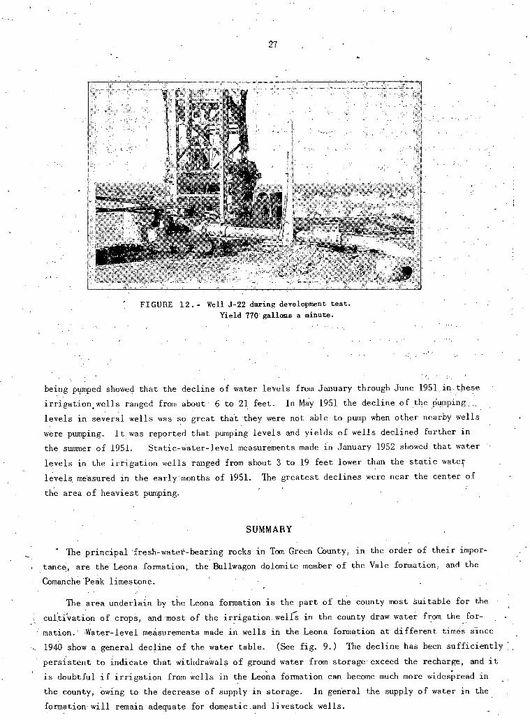
FIGURE 12. - Well J-22 during development test.
Yield 770 gallons a minute.
being pl;lmped showed that the decline of water levels from January through June 1951. w. these.
irrigation, wells ranged from about 6 to 21 feet. In May 1951 the decline of the pumping. ,
levels in several·wells was so great that they were not able to pump when other nearby wells
were pumping. It was reported that prnnping levels and yields of wells declined further in
the summer of 1951. Static-water-level measurements made in January 1952 showed that water
levels in the irrigation wells ranged from about 3 to 19 feet lower than the static watef
levels. measured in the early months of 1951. The greatest declines .were near the center of
th'e area of heaviest pump1ng.·
SUMMARY
.•. The p'rincipalfresh-water-bearing rocks in Tom Green County, . in the order of their impor
.tanc~, are the Leoria formation, the Bullwagon dolomite member of the Vale formation, and the
Comanche'Pe~limestone.
The area underlain by the Leona formation is the part of the county most suitable for the
cul~ivation of crops, and'most of the ir~igation.welr; in the county draw water from the for-
. mation.· -Water-level measurements made in wells in the Leona formation at different times since
" 1940 show a general decline of the water table.. (See fig. 9.) The decline has been sufficiently
persistent to indicate that withdrawa1~ of ground water from storage exceed the recharge, and it
is doubtful' if irrigation from wells w the·Leoila formation can become much more widespread in
the county, owing to the decrease of supply in storage. In general the supply of water in the
formation will remain adequate for domestic and livestock wells.

, '
j
28
The Bullwagondolomite member of the Vale formation yields water to several irrigation
wells of relatively large capacity 1n'the area'IX to 6 miles northeast of Veribest. Water
levels in these wells have declined appreciably since the early part of 1951. Records of
existi~g wells, test holes, and geologic data indicate the possibility of extending the ar~:a,. , "
'in wh~,:;h wells can be developed to include most of the area from 1 to 3 miles west of the C1}lt-, I
crop 6£ the Bullwagon in Tom Green County. The data do not indicate, however" that large- 'i .
capaci~y wells may be expected in the area west of the outcrop.
The Comanche Peak limestone yields water to domestic and livestock wells throughout the
hilly areas of the county. The springs,on the lower, slopes of the hilly area in the southern
part of the county flow-from the limestone.~ These springs are ,a source,of, water for domestic
and livestock use, and Anson Springs so~th of Christoval sustain a large part of the low flow
of the South Concho River. The terrain in the hilly areas is not suitable for the ,cultivation
of crops and irrigation; therefore no large-ca~acity wefls draw water from the Comanche Peak
'limestone'in the county.
Ground water suitable for domestic 'and stock uses may be obtained throughout most 'of the
county except in the eastern part where the'Arroyo formation crops ,out and in the plains area
west and southwest of San Angelo whereth~"Sari-:-Angelo sandstone and the Blaine gypsum crop out,.
In general, the ground-water reservoirs of Tom Green County are inadequate for sustained
large~scale irrigation, but will continue to supply water for domestic and stock use and for
supplemehtary irrigation.
29
REFERENCES
BABBIT.' H.." E:.' and DOLAN,· J. J>,' 1929, Water supply engineering: New York, McGraw~Hill Book Co.~
Inc.,;
CUMMINS,W.':F,; and LERCH,' 0., 1891, Remarks on the ge.ology of the Concho country. State of'Tex~s: Am. Geologist.'v.n, p"73~77, 320-325.
HENDERSON, GEORGE G." 1928. The geology of Tom Green Co~nty:Univ.'Texas Bull.: 2807.,102 p.
HILL.rR.IT.;! and VAUGHAN. T.rW;,: 1889,.,. Papers. chiefly of a theoretic nature: U.'S. Geol.Survey -18th Ann.; il;pt.,i pt.! 2,' p.; 253-254,: 275-276. .
MAGISTAD,i O. C•• ! and CHRISTIANSEN,r.J.·E;'i 1944, Saline soils: U. S.iDept.• Agr.,Circ.r707" p-c8-9. i
MEINZER" O.i:E•.~r 1923a, The occurrence of'ground,waterin the United States, 1 with a discussion ofprinciples: tL.; S. Geol.! Supey Water-Supply Paper 489.
1923b,iOutline of gz:ound-waterhydrology,:with definitions: U.rS. Geol.Survey~ater~Suppl~ Paper 494.[
.1931, Outline of methods !or estimatipg ground.-water supplies: U·. S. Geo.J.,'
Survey Water-.siIpply Paper 638-C" p.'99-145.'
SELLARDS.' E. K"lADKINS" W.iS.i,1. and PLUMMER.,! F.!,B•• , 1932, The geology of Tex~s" voL I."s"ft'at.igraphy: Univ. Texas Bull.j'3232,: 1007 poi
UNITED STATES PUBLIC HEALTH SJ':RVICE, 1946,: Drinking water standards: U.: Self Pub. Health Service,:V. 61,ino.ill,ip.• 371-384•
. .

Method of' ~~ft:Use of wliter:
Table: 3~~, Hecordsof wells, in' TOllI Green' County. Texas
Aliwe}~s are drilled ,~nlessotherwi8enoted' iIl:('l"em-.iiks column
C,' cylinder; D.,,: Diesel 01' oil; E,'electric;,'G" gasoline; a,' hand; Ng'i ,', na,tura~ gas; T, turbin/'!; W,' windmill.D" domestic; Irr,: irrigation; Nt i not used; P7'~~blic supply; S, st?C'i,'" ,
Numb~x, i,i1dic_ate~.horsepowert,,;,',.<"-'_~'-O"':'~'''''' •__ ';' ,'.::0 ,<;-~,_,_. ,'.-c,',-" ," .f;.' .,~~, " ..' -:c ,.:~.. :,..--.
'I"
Well Owner
/
Driller
1'I
D2te~ DepthCO!lI- 'of.pl~t. weU,
ea. ,(f... )
Diam~
et~l"
ofwell
, (in,)
:1<,. ,Aquifer::
WaterBelowland
surfacedatum(ft. )
level'Date of
measuremen tM"lthod
oflift
·Useof
water
Ram,arks
Sand at the: base of the Trinity group'.Bullwagon dOlomite melllher,of the Vale, Iormation.,
A~l ~orge Wedd~ll IA~2 do.
*A~3 do.
, A"4 J. O. Berry
*A-5 J.: E. HallIi'
A-6 George WeddEd!
A-7 J. T. Johnson Estate
A-8 W. : C. Weddell:t~.·>::
A~9 J. E. Hall
~A-10 Barbara Turner &Beatrice Atldlry'~'"
#A-ll J. E. Hall
A-12 W. ,C. Weddell
*A-13 E. ,V. Hall
A-14 do.'
*A-15 W.C. :Weddell
A-16 Barbara Turner &Beatrice Allday
A-17 I do~
88
103
19181' 72
87
125
1946\14.0
1949 209
1949 I 148
wo
,.
Steel casing.
Steel c~sing to 125 feet.Originally drilled to3,401 feet to test foroil',pl~gged back for water welL·'See log.
S
S
S
S
S
S
S
S
S " Temp. 690
F.
S
S
S,
S
D:S
S
S
D,S
C,W
CtW
C.W
C;W
C,W
C.W
C,W
c,w
C,w
C,W
C,W
C,W
C,W
C,W
C,W
,C,W
C.W
do.
July', 27,'1%6
Standpipe. limestone member of the.Af\-oyo formatioo.For chemical ~aly'se;:~eij t~b1e :5.:\ '
..~¥ ,-'- '-,,,";;: • --.' ,
~,-'-;::-":>-;-'-.
~iU.~
78.2
60;3 . do.
59:3 July 21 t 1950
97.6 July 25. 1950
1l0:7 do.
121. 9 July, 21, 1950
99;8 July20~ ~950
89.7 I July 7,' 1950
•80'do.
146;5 July' 6,' 1950
61,6 July 20, 1950
76 Ju~y 21, 1950, .
47.7 July 25: 1950
65.3 July 20, 1950
142 July 7. 1950
60;3 Juiy20,: 1950
£1,'*
6 !" ~l'1m, ty grou .
'6 db.
6 J do. '
6 do.
6 do.
6 do.
6 ,do.
6 do.'
6, do.
6 ' ,do;,
6 . do.
6 do;
6 do.
6 do.
6 do.
6 do.
6 do.125,.............,.,.--1926
1922 I 116I'
180
65
127
, 1940 1,60
'1900; 104
80
1946 165Park Hoit
~\-
Hobert: E. Penn
Park Holt
Park Holt
~~
-". ,

Table 3.- Records of wells in Tom Green County--Continued
Wt-'
.. . ., Water level. Well Owner Driller Date Depth Diam~ Aquifer Below Da'te':of .. ' Method Use Remarks
. , com-. of eter ... land measuremen t of ofplet- well of surface lift water. ed ( ft) well .;1 datum,
(in.) " (ft. ).~:;:~i.!,::,_~,,,,",:.,.....:~,. .- 0
A~18 Barbara Turn'er & -- 1905 70 6 Trini ty group'~ 44 "quly'>}: 1950 ' C,W S Temp. 70° F.Beatrice Allday . ,
"A-19 do. 'Park .Holt 1948 150 6 do. 109.7 do. C,W S
A~20 W.G,' .Weddell -" 1'922 143 I ·6 do., 112 July 21, 1950 :C,W S
B-1 .jake Z;' Harper -- Old 102 ' 6 do. 80.2 June 21, 1950 C,W S
B-2 Wi 11'i ani' B. ' Wi 1son = •.• Old '80 6 do. '39.3 June 16', 1950 C,W D,S
B"3 do. -- ,=,..> 134 6 . do. 40.7 Dec., 3, 1940 C,W , S
48.1 June 16:.1950
B,·4 J.ake Z"Harpe~& -,~ 1935 105 6 don 59.7 Dec. 4..1940 C,W SWilliam'B. Wilson .'
83.4 June ?3; 1950
"B~5 Jake Z,' Harper -- 1915 79 6 do, .- 54 Sept. 12, 1940 C,W, S,54.2 June 27 .. .1950
"B-6 Al vin Ma thus -- 1900 70 q Leona formation 46.7 Sept. 12, 1940 C.W D Galvanized iron, casing I;49.5 June 27, 1950, ~o 20 feet.
"B-7 J.O. : Berry . _.0 McCullough 1948 160 6 Trini ty group.iiJ 66.7 July 20,1950 C.W D.S Temp. 700 F.'
B-8 W.' H, Harris J. T., Goode 1937 66 6 Leona formatio~ 42.9 June 27, 1950 C,W D,Irr Galvanized iron casingto 66 feet. Irri gatessmall garden.' \
Tdni ty group~\
*B-9 . Julia Kennemer -- == 74 6 69.2 Nov. 29, 1940 t.W .S ' ~57 June 22;,1950 ..
I
*B-10 dei. 1925 163 6 . Blaine. gypsum 124.5 Nov. ; 29', 1940 C,W D,S,
'.'=
104.9 June 23, 1950
B·,11 do. - .~ 1909 84 6 . Leona formation 57.6 Dec. 2. 1940 C.. W D.. S63.9 june 20~ 1950
"
B·12 H~ C. 'Moreland -- -- 76 6 do. 56.1 June 20, 1950 C,W' S
"B-13 First Presbyterian =,", 1939 57 6 do .. 46 June 27, 1950 . t .. W D Temp:700 F·\
Church'of Carlsbad
*B-14 Barbara Turner & W. P. Holt . 1949 178 6- , Blaine gypsum' 152.3 . . July 6. 1950 C,W S Galvani zed iron casin'(;jBeatrice Allday ; .. to 178 feet.' Temp.; 70 F. .......
B-15 Maxwell Turner -- 1915 29 6 Leona. formation 24.3 July 7.. 1950 C,W D,S , .
B~16 State Tuberculosis =-GO 1938 71 240 do. ' ~~ = '¢,'''...., T,E" P Concrete casing to 20 feet. ,Sanatorium 40 Reported· weak. s'upp1y., Used. ' . as ·standby. welL, ..
0 ."
*B-17 do~. •• «=-= .1938 72. 240 do, 35.1 July. 7, 1950 T,E, ~P . Supplies hospi tal. Concrete
, .f. 40' casing to 22 feet. Reported,strong sURply.' :,See log.
0 .

.Table 3.~ Records of,wells in Tom Green County~-Continued
Water level
Well ~ Owner Driller Datecomplet-
ed
Depth01
well'(ft. )
oiam~
"eterof
well'(in~)
Aquifer Belowland
surfacedatum(ft. )
'Date ofmeasurement
Method, oflift
Useof,
water
'. Remarks
'*B-18 I ,Homer G.: Nickel D.' L.; Holliday 1935 53 6 : Bl aine gypsum 47;1 j'SeptiTO, 1940 I 'C W34.8 June 23, 1950
D Galvanized iron casing. to 53' feet. ,\
'B-19 I Julia Kennemer
B~22 I .J. : D.' Tullus
48.6 I June 23, 1950 l,c,W
do. '
Galvanized iron casingto 55 feet.
'Irrigates small garden.
S
D,S
D,S
D,S
C,W
C,W
C,w
46.7 Apr. 7,· 193955~3 June 22,,1950
52.8 .. Dec.. 4, 194047 'June 20," 1950
do. I 50.0 Dec... 4. 194051.6 June 22.;,1950
do. :
Leona formation
6
6
6
6
60
90
80
100
1928I
H.' C.' Moreland
H.' T. Allard
B-21
*B-20
B-23 I Jack Jones Earl Scott 1946 216 8 Leona formation andl 34.8 I June 22 .. 1950Blaine gypsum
None N Steel casin~ to 40feet. Orig1nallydrilled for irrigaticirt,well,' tested 100 gpm .,when drilled.
Leona formation !.U)dl 50.4 I June 30, 1950Trini ty group ~ ,
B-24 I Odie, Alexander
B-25 I William TurnerEstate
do. ' 1949
Old
91
73
6
6
Leona formation 42;8 do. C,W
C,W
ti, S
D,S
Galvanized iron casingto 91 feet. W
!'-:l
B-26 I .Maxwell Turner
*B-27 I Barbara Turner andBeatri ce Allday
Ross Whittmire
1912
1920
80
120
6
6
: do.
· Trini ty group~
43.7 IJuly 6,1950
82~ 3 June 28,' 1950
C,W
C.W
S
D Gal vani zed iron casin§ ..to 120 feet. Temp. 69 F.
. *C"2 I J. :F.' Sutton
*C-3 J. i Y. Rust, Sr.;. Estate
Leona formation lll)dl 14.6 I June 16, .. 1950 I ' c, WTrini ty group.Jli
S I' Galvanized iron casingto 80 feet.
D,S
D,S
C,W56' , Dec. 3, 194052.7 June 16, 1950
do. 1141. 6' June 15, \950 I C; W
. do.6
6
5
80
187
68
Oli ver Bros."
A.' MarchC-1
*C-4 I W.' L. "Matthews Oliver Bros.: 1928 63 6 do.' I 48.6 INov... 28, 1940 I C, W32.2 June 15,,1950
D,S
C"5 ·1 A. j March 1938 81 6 Trinity'group-!l 73.6 IDec; :4, 194055.9 June 20,1950
C;W D,S' Reported weak suppl y. :.
*C-6 do. Park Holt 1949 150 6 · Trini ty group..Y '1126.6 I june 20, 1950,and Blaine' gypsum
C,W ' S Galvanized iron casingto 150 feet.:
*C-7
C~8
*C-9
Moll y;Mayes
F. "J. i Von Rosenburg
J. i Y.', Ru s t, , Sr. , ..Estate
R.: Medlock
1900
'1940
67
125
117
6
6
6
· Leona'. formation
Trinity. group:J!I
Blaine: gypsum
46.1 do.'
93.3 June 16," 1950
63;5 . Nov;: 28, 1940. 79.2 June 16.' 1950, '
C"W
~,W
C;W
S
D,S
S Reported weak supply.'
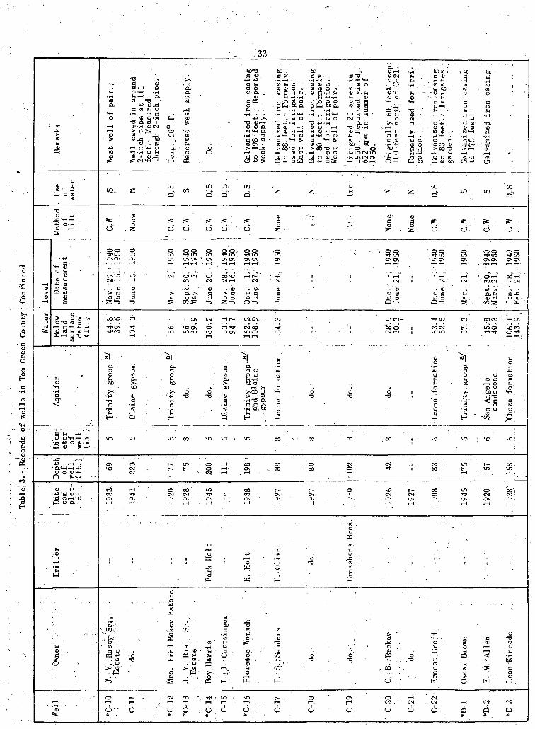
Table: 3.~,Records of wells in Tom Gree~ County--ccintinuedr
ww
Water level" "
Well ", Owner" , ,,'. Driller Date Depth Diam" Aquifer Below ' Date of , Method , Use Remarkscom- of eter' land measu remen t of ofplet- well, of surface 'lift watered (ft.) well' . datum
(in.) " (ft.)
"*C-I0 J., Y. ,Rust,'r-:'§N.,' -- 1933, 69 6 Ttini £ygroup~ 44.8 Nov.. 29.: 1940 C,W S West well of pair.,'
. Estate . ': 39.6 June 16, 1950
C-11 ' do. , -- 1941 223 6 Blaine gypsum 104.3 June 16, 1950 None N Well caved in around, 2-inch pipe at IIIfeet.' Measuredthrough 2-inchpipe.
*C-12 Mrs. Fred Baker Estate 1920 77 6 Trini ty group.Y 56 May 2,; 1950 i C,W D,S ' 0-- Temp,,68 F.
*C-13 J.Y., Rust, Sr., -- 1928 75 8 do. 36 Sep t. 30.,'1940 C,W S Reported weak supply.' ..'Estate 39.9 May. 2, 1~50
*C-14 ROY,Harris Park HoI It 1945 200 6 do. 180~2 June 20.· 1950 C,W D,S Do. , ,
'I·· I
C-15 I.;).: Curtsinger -- -~ 111 6 Blaine gypsum. 83~1 Nov. 28., 194,0 C,W D,S94.7 June 16.;1950 .
\
*C,16 Florence Womach H. Holt 1938 198,1 6 ' Trini ty group..!il 162.2 Oct ..: 1, :1940 c,W D,S Galvanized iron c.asing!Jrid Blaine 108:9 June 27,; 1950 to 198 feet. Reported
I~gypsum weak supply. .I
C-17 F. S" ,'Sanders E..Oliver 1927 88 8 Leona formation .54,3 June 21, 1950 None N .Galvanized iron casingto 88 feeL" Formed y.. used for irrigation;
. East well of pai',r. ' ,C-18 do,: do. 1927 80 8 do. ".",.. -- N Galvanized iron casing
to 80 feet.: Formedy
"'used for irrigation.West well of pair.,
C-19 do.,_ Grosshans Bro~. ,1950 -102 8 do. -- '" ~, T,G Irr Irrigated 25 acres in, ,, . ,
1950. Reported yield, 'I622' gpm in summer of
-1950 .. ... C-20 \ 0., B. : Brokaw =- 1926 42 8 do. 28'.9 Dec .. 5; 1940 None N. Originally 60 feet.deep;- 30.3 June' 21,·1950 100 feet north of C-21.
I
Cc 21 do. ~"- 1927 ..- co= -- -- -- None N Formerly used for irri~,gation.
C-22- Ernest 'Groff == . -1908 - 83 6 Leona ,formation 63.1 Dec. 5" 1940 C,W D.S Gal vani zed iron casin g :" 62.5_ June 21. 1950 to 83. feet., Irrigates
'garden.' ';
Trin~'ty. group~':
*0"1 Oscar Brown -- 1945 175 6 57.3 Mar .. 21, 19S0, C,W S Galvanized iron casingto l'tSfeet.
, '"0-2 E.M. 'Allen 1920 57 6 San Angelo 45;8 Sept. ,30 .. 1940 .C,W S Galvanized iron casing.sandstone 40.3 Mar;; 21,:1950
, *0,3 Leon 'Kincade -~ 1938\ 158 6 'Choza formation 106.1 Jan. 28. 1949 C,W D,S , - ._~...... ..., - -.. - . ~43:9 . Feb, 21;. 1950
, .

Table 3.",Records of wells in Tom Green'County'~~Continued
Water level
Well Owner Driller Datej' De,pthCOm- 'of,
'plet welled(ft. )
, Diam-'eterofwell(in. )
Aquifer Belowland
surfacedatum(ft. )
, Date' ofmeaf;uJ;f!menE '-
, Methodof
lift
Useof
water
Remarks
*1),.4 I A.~ S.! Harris Bill Burlison ~942 I 132 5 Cboza formation 87.6 I Oct. 7. 194888.1 July 29, 1950
C.W D.S Galvanized iron casingto 132, fee t .Al ti tu'deof land surface.· 1. 937feet. ..'
*D-5 I Edgar, McGuire 58;8 I Oct. 7,. ' 1948
*D~6
*D-7
*D-8
•do.'
Mrs.!J.'S.!Holland
W. :S.: Holland
J.' 0.' Donaldson
Tom Donaldson'
-- Obletree
Old
Old
1920
Old
140
82
120
79
5
5
6
5
" do.,
do.
do.
do ...
30'58.357.6
92.394.3
49.4
Feb. 14.· 1941Oct.' 7, 194.8Feb.' 21, 1950
Feb.' 14, 1941Feb.· 21, 1950
Oct.' 6, 1948
C,W
C,w
C,w
C;W
D,S
S
D,S
D,S
Altitude of land surface, 1.,947 feet.
Galvanized iron casingto 120 feet.
Altitude of land surface. 1,92.8 feet.'
*D-9 I Roy Holland Dan Cockburn 1948 79 10 ,do. ' 58.8 I Oct.' 6,,194864.4 July 28. 1950
T,E,10
Irr I' Not cased.' Irrigates40 acres.- Reportedyield 200 gpm in 1950.Altitude of land surface, 1,922 feet.
w,j!>.
1948: I ill
54. 5 'Feb. "14. 194164.8 Feb.:21; 1950
42.8 Oct.' 7., 194838.9 July 28; 1950
89.7 Dec. 15, 1950
D-IO IMrs.~-- Nord
*D-ll I Wallace Ramsey
D- 12 IL;'M"Keeling
*D-13 Oscar Brown
Donaldson
Dan Coberlin
1930
1925.
70
83
110
6
5
6
6
do. '
do. '
do.
do. 75.287.475.8
Mai.: 27, 1939Sept,. 30., 1940Jan .. 28" 1949
Ci W
C.w
C,W
C,W
D,S
D,S
D,S
D,P
Galvanized iron casingto 70 feet.
Altitude of land surface, 1,918 feet.
Galvanized iron casingto 80 feet.: Reportedweak supply.,
[)..14 I W.! I.: Marschall 127.5 I Mar.! 21, 1950
D-15
D-16 '
*1),.17
, do.
. do."
, do.:.
Old
148
109
93
135
6
6
6
6
San Angelosandstone
Trinity group ~
do.
San' Angelo'sandstone
94
57.5
108.2
do.
do. '
do.
C,W
C.W
t,wC,W
S
D.S
D
S
1907 I 125
Oct.' 6,.' 1948 I C, E,July 28. 1950 '%
Jan·"':t28 i Jo 194? I C, WOct;· 2. 1940 :Oct. 6'; 1948 I NoneFeb.: 21; 1950
Galvanized iron casing~ to 89 feet.. '
---
Not cased. Drilledfor irrigatton andtested40gpm:
N
D,S
D,S
D,S
-
C,Wdo.
-.
4848.6
65.3
67·9'. 6'1;9
47.446.2
do.
-.
do.
, do.
Cboza forma'tion
6
6
6
12
89
75
92
1930
1948
Olddo."
Dan CockburnD-20 I Albert Klattenhoff
D-18 1 L.:E.;Davis
*D-19 I ,C.! Cotton
*D-21 I do.

Table, 3,- Records of wells in Tom Green County~-Continued
:i->_. Water.i level
Well Owner Dr111er ' Date Depth. Diam- Aquifer Below Date of Method Use Remark~" '~com= of eter land measuremen t of . 0'£
p1et· well of surface lift water
~ed (ft. ) well datum
(in. ) . ,(ft. )'~1;:' .- ,,;.j•... -
*D~22 C.: Klattenhoff J. O. Donaldson '1928 116 6 'Choza formation 59.8 Feb~ 14., 1941 C.W D,S;'3,".1
, " 62.2 Oct. 7, 1948
•*D~23 L.; M. ,McGuire ,.- Old 100 6' do. 55.9· Jan.' 24, '1949 J,E D,S
*D-24 Cad Urban tke _..== 80 6 do. 58.3 Oct; 2;,1940 C;W D,S Reported weak supply.
63.3 Jan. 24. 194960.4 Feb. ' 21;, 1950, .
·0-25 .~E. Kiesling O. G. Donaldson 1908 104 6 do. 53.9 Oct, 7, 1950 G,W D,S Galvanized iron cas-, . ing to 100 feet .. Re-
ported weak supply., ,
, *0-26 S.'E., Parmer """" Old 57 6 do. 45;9 Oct. 6; 1948 C.W D,S45.6 Feb.: 21, 1950
. <0"27 M.,' S. ,Winston -- 1900 90 6 iJ,0. 69;8 OcL,' 2,; 1940 C,W D,S Galvanized iron cas-(
67.9 Dec. 15, 1950 ing to 20 feet.'
D-28 T. M.' Boykin ."Garmoh"BX'os. 1947 105 8 do. 64 Dec. 15,; 1950' T,E, 11'1' Iron casin~ to 100. ,;.; '. .
.7~ feet., Irngates- , 10 acres.
~D-29 -- Lies tman Entate -- 1919 45 5 do. 29 .. 9 Oct. 6, 1948 C,W D,S
D-30 0.' N. Dodson -- 1938 88 6 ' do. 42.2 OcL 7, 1948 'C.W D,.S Galvanized iron cas-41. 9 Feb.' 21 t 1950 ing to 88 feet.
0"31 B.' F. PeTry D. Oli 'fer 1925 98' ·10 do. 59.2 Dec. 15, 1950 C,G Irr Galvanized iron cas- ,, iny'to 100 feet.' EastI we 1 of two that irX'i-. gate 25 acres.
0 0 32 Walter Schumm do. 1925 95 10 Leona and Choza 24.8 do. None N fo~erly used forformadons ], rr1 ga t1 on.
E-l Ike Funk Estate -- Old U8 6 Trinity, group..Y 153.5 July 27, 1950 C,W S
E-2 ,Barbarll Turner and -- Old 145 . 6 ,do. ,', 116.3 July 5. 1950 C,W SBeatrice Allday
E-3 Percy Turner -- Old 60 . 6 , do .. 20.8 do. C;W S
"E~4 do. -- Old 80 6 do. 65.5 do, C,W ,S
*E·5 Ike Funk Es ta te 148 6!
do. 109.5 July 27, 1950 C,W SI
~- --E-6 do .. ,Mays 8. Sims 1935 1,452 -- -- -- -- None N Oil test. See log."
E-7 do. B, C.' Mann 1940 1,562 -- -- -- -" None N Oil test,· Altitude
of, land s'urface"2.,417 feet. See, log..
wCJl
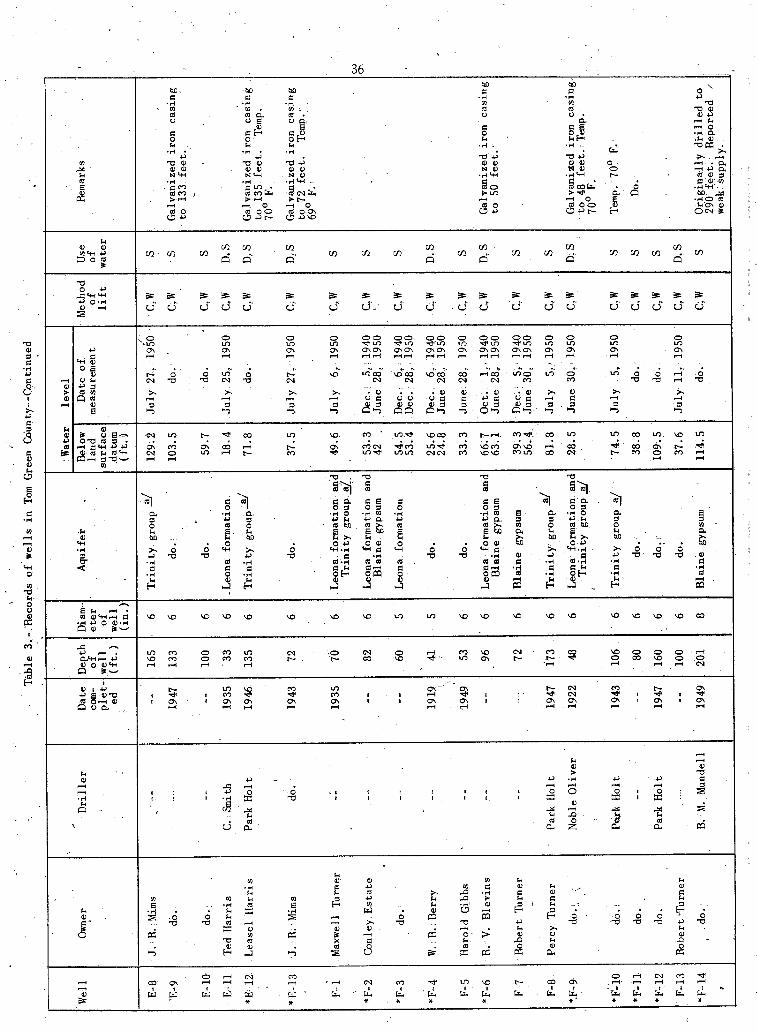
Table 3.-.'Records or'wells in Tom Green Cciunty--Continued
~ 'Water levelWell Owner Driller Date Depth Diam- Aquifer Below Date of Method Use Remarks
, com- of eter land measuremen t of ofplet- well of surface lift water- ed (ft. ) well ,datum
(in.) (ft. )
E-8J.R.Mims ,-- -- 165 6 Trinitygroup.!!l 129~2 July. 27, 19[0 C,W S
'E-9 do. -- 1947 133 6 do. 103.5 do.' C, W ' S Galvanized iron casing'to 133. feet.
E-10 do. -- -- 100 6 do. 59.7 do. C, W S
E-ll Ted Harris C.'5nith 1935 33 6 ,.Leona formation 18,4 July. 25., 1950 C,W D,S
*E-12 Lease1 Harris Park Holt 1946 135 6 Trinity group~ 71.8 do. C,W D,S Galvanized iron casingtoo135 feet. Temp.
I 70 F.
*E-13J. R. Mims do. 1943 72 6 do. 37.5 July 27, 1950 C,W D,S Galvanized iron casingto 72 feet. Temp.'690 F. -
F-1 Maxwell Turner -- 1935 70 6 Leon ll formation and 49.6 July 6.,,1950 C,W STrini ty group~.
*F-2 Conley, Estate -- -- 82 6. Leona formation and 53.3 Dec. 5,: 1940 C,W SBlaine gypsum 42 June 28, 1950 \
*F-3 do.' -- -- 60 5 Leona, formation 54.p Dec.; 6,1940 C,W S53.4 Dec., 28, 1950
*F-4. W. :R. Berry -- 1919 41 5 do. 25;6 Dec. 6, 1940 ,C, W D,SI 24.8 June 28, 1950
F-5 Harold Gibbs -- '1949 53 6 do.' 33.3 June 28, 1950C,W S
*F-6 'R. :V. Blevins -- -- 96 6 Leona' formation and 66.7 DcL 1" 1940 C. W D, S Galvanized iron' casingBlaine gypsum 63.1 June 28, 1950 to 50 feet.'
F-7 . Robert Turner -- -- 72 6 Blaine gypsum 39.3 'Dec;' 5;,1940 C,W S~ 56.~__ June 30, 1950
F-8 Percy Turner Park Holt 1947 i73 6 Trinity group ~ 81.8 July 5,,1950 C,W S
*F-9 do.,. \ Noble Dliver 1922 48 6 Leona formation and 28~5 June 30,,1950 C;W D.S Ga1vani~edironcasing.Trinity group ~ to 48 feet. Temp.
, ., 700 F.
*F~tO do.; Plirk Holt 1943 106 6 Trinity group.!! '74.5 July 5, 1950 C,W S Temp. '700 F.
*F-ll do. -- -- 80 6 do. 38.8 do.' C.W S Do.
*F-12 do. Park Holt 1947 160 6 do. 109.5 do. C.W S• I ' •
F-13 Robert-Turner -- -- 100 6 do. 37.6 July 11,' 1950 C,W D,S
*F-14 . do. B. ; M. Mundell 1949 201 8 Blaine gypsum 114.5 do., C, W S Dr:iginall y drilled to I290 fe,et. Reported /
, weak: supply..
W0\
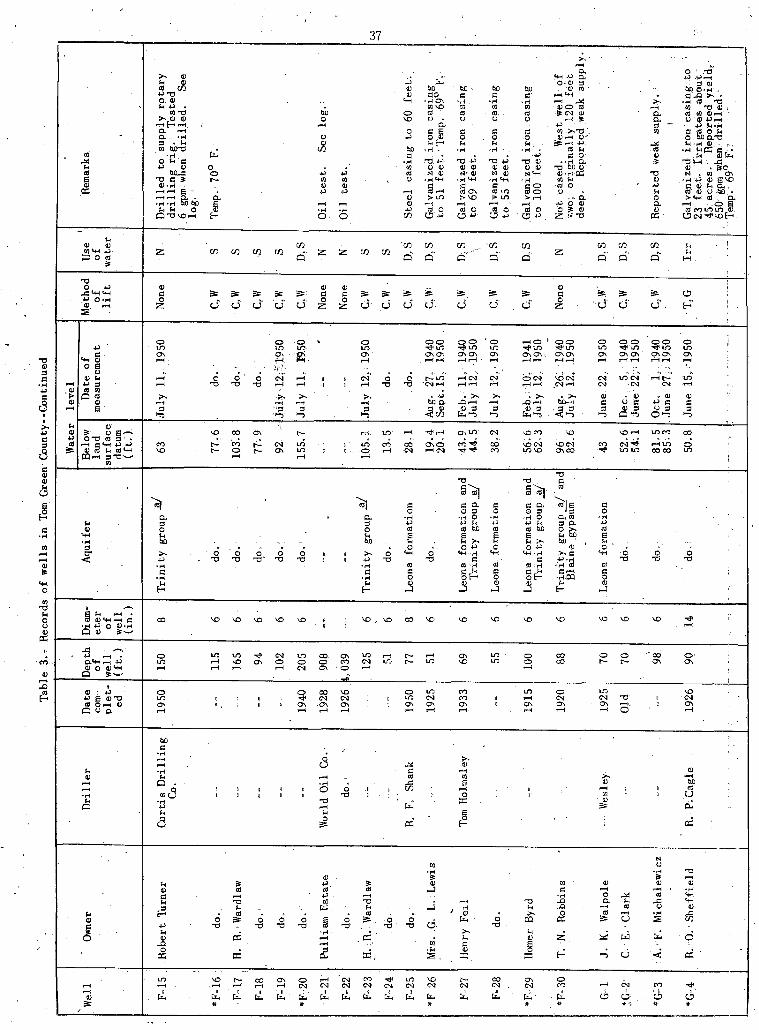
Table 3. - Records of wells in Tom Green County--Continued
,Water level
Well Owner Driller Date Depth Diam- Aquifer Below Date of MethodI
RemarksUsecom- of eter land measuremen t of ofplet- well of surface . lift water
ed (ft.) well .datum ,(in.) (ft. )
F~15 . Robert Turner autis Drilling 1950 150 8 Trini ty group ~ 63 July U. 1950 None N Drilled to supply rotary
Co. drilling ri~. Tested. 6 gpm when rilled.· Seelog.
'"F-16 . do. -- -- 115 6 do. 77.6 do. C,W S Temp. 700 F.
F-17 H.' R.' Wardl aw -- -- 165 6 do. 103.8 do. ' C,W S!
F-18 do. -- -- 94 6' qo, 77.9 do. C,W S
F-19 do. -- -- 102 6 do. 92··, j~ly,12,\1950 C;W S
*F-20 do. -- 1940 205 6 do. 155.7 July lL 1950, C,W D,S
F-21 Pulliam Estate World Oil Co.' 1928 ·908 ~- -- -- -- . None N Oil test . See log.'
F-22 do. do. , 1926 1".,039 -- -- -- -- None N Oil test.
F·~23 H., R.. Wardlaw -- -,,,. 125 6 Trini ty group ~ 105.1 July 12.,,1950 C,W S
F-24 do. ~-c'·= 51 6 do. 13·5 do. C,W S -
..F,·25 do. R. F.' Shank 1950 77 8 Leona formation 28.1 . do. C,W D.S ' Steel casing to 60 feet ..
*F~26 Mrs.G. L. Lewis -- 1925 51 6 do. 19.4 Aug. 27. 1940 C,W' D,S qalvanized.iron casigg20.1 Sept. 15, 1950 to 51 feeL' Temp. ·69 F..
"F-27 Henry Feil Tom Holmsley 1933 69 6 Leona formation and 43.9 Feb. 11. 1940 C"W D,S Galva..i~ed iron casing
Trini ty group.J!/ 44.5 July 12.;1950 \ to 69 feet."
F~28 do. -. -- 55 6 Leona. formation 38,2 July 12" 1950 C,W D,S Galvanized iron c~sing
to 55 feet.
*F-29 Homer Byrd 1915 100 6 Leona formation and 56.6 Feb. 10, 1941 C,W D,S .Galvanized iron casingTrini ty group .2/ 62.3 July 12, 1950 to 100 feet.
-'"F.. 30 T.N. Robbins -- 1920 88 6 Trinity group ai' and 96 AUf' '26~ 1940 None N Not cased. ' West well of
Blaine .gypsum 82.6 Ju y 12.; 1950 two; originally 120 feetdeep. Report1~weak supply.
G·l J. K. Walpole -- Wesley 1925 70 6 . Leona formation 43 June 22, 1950 c,W' D,S
~G-2' C. E. Clark == Old 70 6 do. 52.6 Dec. 5, 1940 C,W D,S'54; 1 June 22, 1950
A.' F. MichalewiczI
*G~3 -- ",= 98 6 do. : 81.5 Oct. 1, 1940 C,W D,S Reported weak supply. '85~3 . June 27, 1950 I
*G-.4 R.. O. Sheffield R. P;Cagle 1926 90 14 do. 50.8 June 15,d950 T,G Irr Galvanized iron'casing.to .23 feet. Irrigates about45. acres.. Heported yield,
:' - ;-: -- ,- ~ ~.
0 ..
' 650 gpm when· drilled. '
Ir • - _. ~ " ." - '-, _._-_.... ,,-_._. - -"" - ._--~ "". . - . Temp.' 69° F.'·- I
::j
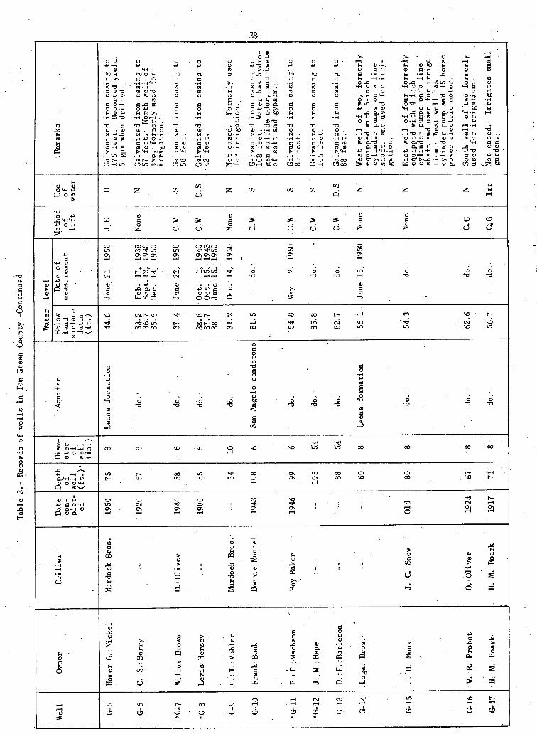
Table' 3." Records of wells in Tom Green County~-Continued
Water ,level.
Well Owner Driller Date Depth Diam- Aquifer Below Date of Method Use "Remarks ,com- of eter land measurement of of ,plet- well of surface lift water
ed (ft.) , well datum, (in. ) (ft. )
G-5 Homer G., Nickel Murdock Bros. 1950 75 8 Leona formation 44.6 June~ 21. 1950 J,E 0 Galvanized iron casing to175 feet. Reported yield"5 gpm when dnlled.,
G-6 C." S.'Berry '-- . 1920 57 8 do. ' 33.2 Feb. 17, 1938 None N Galvanized iron casing to36;7 Sept. 12, 1940 57 feet.' North well of35.6 Dec.' 14, 1950 ~wo:' fo~merly used for
:trr1'ga·t10n ..
*G-7 Wilbur Brown D.' Oliver 1946 58 , 6 do. 37.4 'June 22, 19'50 C,W S Galvanized iron casing to.. 58 feet.'
~G-B Lewis Hersey -- 1900 55 6 do. 38,.6 Oct. 1, 1940 C,W D,S Galvanized iron casing to37.7 Oct. IS, 1943 42 feet.38 June, IS, 1950
G-9 ,C.' T. : Mahler Murdock Bros.' -- 54 10 do. ' 31. 2 Dec. ' 14, 1950 None N Not cased. Formerly used
- for irrigation ..
'.G-10 . Frank, Book Bonnie Mundel 1943 108 6 San Angelo sandstone . 81. 5 do. ' C,W, S Galvanized iron casing to108 feet. Water has hydro-
" gen sulfide odor, and tasteof sal t and gypsum.
I
*G-ll E.IF. :Mach ann,
Roy Baker 1946 99 6 do. '54.8 May 2, 1950 ,C,W S Galvanized iron casing'to80 feet.
*G-12 J., M. iRape -- -- lOS 5Y. do. 85.8 do. . C,W S Galvanized iron casing to105 feet.
G-13 D. 'F. ,'Burleson -<> -- 88 5Y. do. 82.7 do. C,W D,S Galyanized iron casing to88 feet.'
,G-14 Logan Bros.· -- -- 60 8 Leona formation 56.1 June 15, 1950 None N West well of two,; formerly
equipped wi th 6einchcylinder pumps on a line
"shaft. and used for irri-gation. .
G-15 J. :'H.' Monk J.C. Snow,
Old 80 8 do. " 54.3 do. None N East well of four formerly
, . equipped wi th 4-inchcylinder pumps un'-a line '
- shaft and used for irriga-tion.' West well hascy I inder ,pump and 15 horse-powerelectrrc'motor.
G-16 W. JR.! Probst D.' Oli ver 1924 67 ,8 ,do. ' 62.6 do. C;G N South well of two' formerly, used for' irrigation....
71I
G-17 : H. :M. Roark- H. M.' Roark 1917 8 do. ' 56.7 do. ' C,G Irr Not cased.' Irrigates small~ garden. :
...... '
wco

Table' 3.- Records of wells in Tom Green, County--Continued
Water level I
, Well Owner Driller Date Depth Oiam- Aquifer Below Date of Method Use Remarkscom- , of eter , land measurement of 'ofplet- well of 5utface lift water
ed (ft. ) well ' datum(in.) (ft. ) ,
*G-18 Roy Wiegman ' -- .. 1948 135 8 Choza formation 69 Oct. 11. 1948 C;W S Steel casing to 60.\ feet.
*G-19 J. :·M. 'Brandon -- 1936 63 6 do. 52.4 Sept. 4,' 19.40 C;H D Galvanized iron56.6 Oct: 11.1948 tasing to 63: feet,"58.1 Mar. : 20; '1950 Altitude of land
surface, 1,859' feet ...
G-20 Otis M, 'Holiman -- 54 6 Leona formation 44.4 Sept. 15, 1950 C,W S
*G-21 C. R:.'Nas)Yofthy Shorty Cleveland 1940 40 6 San Angelo sandstone 31. 2 do. C,W D,S
*G-22 -- P1ymouthQ±1 Co. 19,34 714 10 San Anehlo, sandstone + -- Flows N Oil test. ' See. log.and' oza formation
,
G-23 Cland Lee -- Old -- -- . "- 73.9 Feb. 19,1941 None N Caved to depth of26 feet. '
*G~24 Homer G. "Nickel -- -- 29 6 San. Angelo sandstone 18.9 . Sept. 14, 1950 C,W D,S Temp. 690 F.
G-101 P. : S. 'Nickel D.' ali ver 1932 75 8 Leona formation 59.8 June' 9, 1950 T,E, Irr Galvanized iron cas- I
3 ing to 75 feet. Irri-gat~s 10 acres.,
G-I02 B. "B. '\Bledsoe Park Holt 1947 76 8 do. 56.5 June 8, 1950 T,E, Irr Galvanized iron cas-10 ing to 15 feet. Irri-
gates 30 acres. '
G-103 . do. D. aliver 1923 75 8 do. 51. 8 Sept. 10, 1943 ·T;E. N Galvanized iron cas-54 Jan. 23.; 1946 10 iny to 75 feet. 'South56.5 Jan. 1'17, 1949 we 1 of two formerly
• equipped with 6-inchI cylinder pumps and .
used for irrigation.:'North well hasturbine pump.,
G-104 R. ' R. Lowrance do. 1927 76 8 do. , 48.5 Jan. 20. 1941 T,E, Irr . Galvanized iron cas-55.8 June 8, 1950 5 ing to 10 feet. Irri-
gates 20 acres andsupplies swimming pool.
- Fo~merly eguipped with6-1nch-crl1nder pumps.West weI has turbinepump.
G-105 : Clara Woolworth _., 1939 80 6 do. 56.3 June 9, 1950 . C,W Irr Steel. casinto to 70' feet .Irrigates a ut one?half
, - acre. Formerly equippedwi th turbine p,ump "',
,G-106 . Clark Bros.' -- 1925 100 8 do. 56.9 do. T,E, N Not cased. West well of3 two' former! y equipped
with 6-inch cylinder'
- - ..puml?s'and"used for irri ~
. gat10n.
W\0
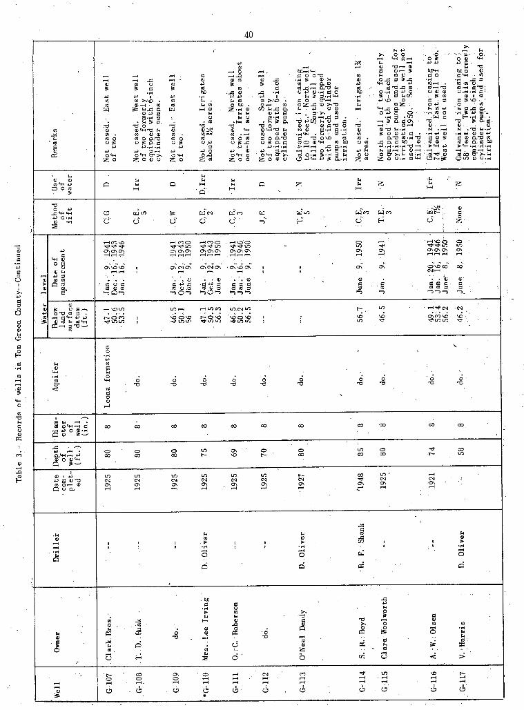
Table 3.~ Records of wells in Tom Green County~-Continued
Water level
Well Owner Driller Date, com~plet
ed
Depthof
well'(ft. )
, Diameterof
well(in~ )
Aquifer Belowland
surfacedatum(ft. )
Date ofm.easuremen t
Method'oflift
. Use'of
water
Rema"rks
G-I07 I, Clark Bros.' 1925 80 8 Leona formation 47.150.653:5
Jail.·' 9~' 1941Dec. 16.; 1943Jan. 16, 194,6
C;G D Not cased.' ,East wellof two.
G-I08 I T. D. Rusk 1925 80 8' do. e,E,5
Irr Not cased. West wellof two former1yequipped with'6~inch
cylinder pumps.'
G~109 I do.'
*<r 110 I Mrs .• Lee Irving
C,W I D
C~E, I D,Irr2
~
Not cased. Irrigatesabcu't 1Y. acres,
Not cased. North wellof two. Irrigates abou,tone-half acre.
Not cased. ,. East wellof two.
. Irr.C,E,3
Jan.' 9, 1941Oct. '12, 1943June 9, 1950
Jan. 9,' 1941Oct. 12, 1943June 9, 1950
'Jan. 9 .. 1941Jan.' 16: 1946June 9; 1950
46~ 550.156
4'{,1. 50~ 5
56.3
46; 550,256.5
do.
de.
do.
8
8
869
80
751925
1925
1925
D. O1iver
O.• C. 'Roberson, G-111
G~112 do. 1925 70 8 do. J,E D Not cased.' South wellof two fOI1llerl yequipped with6-inchcylinder pumps.
G-113 I O'Neal Dendy D. Oliver ,1927 80 8 do. T,E., 5' N Galvanized. iron casing
to 10 feet.' 'North wellfilled. South well oftwo formerly eguippedwith 6~inch cylinderpumps and used forirrigation.
~'114 IS., R.• Boyd
(F115 I Clara Woolworth
56.7 I June 9,,1950
46.5 I J~. 9., 1941
Not cased.' Irrigates 1%acres.
North well of two formerlyequipped with 6~inch
cylinder pumps and used forirrigation. North well notused in 1950.' South wellfilled. .
. Gal vani zed i ron casing to74 feet. East. well of two,·West well not used.
'N
Iri'
Irr:'C,E,3
T,E,3
Jan.: 20. 1941'1 C.E:Jan. 16; 1946 ' 7Y.June' 8, 1950' .....
49.153;456.2
do. '
do'. '
do.
8
8
885
80
741921
1925
'1948'R. ' F. ' Shank
A. :W.• OlsenG-116
~117 I V. "Harris D.' Oliver 58 8/
do. " 46~ 2 I June 8" 1950 None N Galvanized iron casing to)58' feet. Two wells formed yequipped, wi th. 6-inch "cylinder pumps' and used forirrigation:!' ,.,

I ,Table 3.- Records of wells in Tom ,Green County--Continued
.p..
......
, Water levelWell, , Owner Driller Date Depth Diam- " Aquifer Below Date, of , Meth~d ,Use Remarks
com- of eter land measuremen t of ofplet- well of surface lift water
ed (ft. ) well datum, (in.) (ft;. )
G-118 M.' W.' Carter D. Oliver 1927 " 64 10 Leona formation -'- J,E D Galvanized iron'cas-
• iny to 64 feet. 'North"
we 1 of two formerly,equipped with a 6-
"inch cylinder pump
'" and' used for irrigation. [
G-1l9 ' do.' do. , 1927 64 10 do. 42.4 Jan. 22, ,1941 ,C;E, Irr Galvanized iron casing, 45.1 Oct. 11. 1943 10 to 64 feet. Irrigates48.4 June 7;, 1950 one-fourth acre. ,South,
well of two.
G-120 Grady Brown Fred Scott 1947 88 6 do. 54.5 June 8, 1950 None N Steel casing to 10 feet.Formerly used for irri-
.. '
gation.Reported yieldwas 300 gpm.
G-121 do. Roy Baker 1949 87 8 do." 54 do. T/E, Irr Irrigates three acres.10 Reported rie1d, 300 gpm
when dril ed. ,*G-122
f
,Edgar Harris, D.'Oliver 1925 80 8 do. 44.3 Jan. 9. 1941 C;E" N Not cased. ' Two wells50.7 Jan. 16, 1946 10 formerly used for irri-55.8 June 9,. 1950 gation. '
G-123 O. ' R. ' Furgason -- 1927 70 10 do. 44.2 Jan. 21/ 1941 C,E D Galvanized iron casing47.4 Oct. 12, 1943 to 70 feet. Three wells
, 55.5 June 9, 1950 originallr equipped with4-inch cy inder pumpsand used for 'irrigation.South,well only one used.
G-124 " do. -- 1927 70:';' 8 , do. 43:7 Jail. 21. 1941 C,.G Irr Not cased.; 'Irrigates47.2 ' Oct. 12: 1943 garden. '55.1 June 9, 1950
G-125i A.' J. Harper -- 1927 75 8 do. ' 44.3 Jan.' 21. 1941 C.E. Irr Not cased., Irrigates ~49.7 Jan, 16>'1946 " io' acres.. Deepene'di\froms,65,:'.<"54.8 June 9, 1950 \ to 75 feet in 1947 by Roy
" Baker.
G-126 H. W.' Kennedy -- 1927 72 8 do. 44.3 Jan. 21. 1941 C,E, N Galvanized iron casing to47.7 Oct. 11; 1943 5 70 feet.' Two well s for-57.1 June 8, 1950 merly used for irrig~tion.
G-127 W. O.Gordon F.' W.' Grothe 1948 90 12 do. 56 June 9, 1950 T,E D,Irr Not cased. Not used insummer of 1950.:'
G-128 E.: W.Wilson D. 'Oliver 1927 79 8 do. 44.7 Jan. 20. 1941 C,E, Irr Galvanized iron' casinf to50;3 Jan. 16,; 1946 7Y. 10 feet. ' East, well 0 'two.52.8 June 8, 1950 'West well ,filled. Not
used in summer of 1950.,';
G-129 Emil Grosshans -- Old 63' 8 do. 39.6 Jan. 21, 1941 J,E, D Galvanized iron casin~ to,43.8 Oct. 11, ,19,43: \' Y.. 63 feet> Formerly equl.pped,
I, - ,. - -. " , .. , ,4,9, June 2, 1950 I with 3··inch cylinder pump,
and: used for' irrigation,
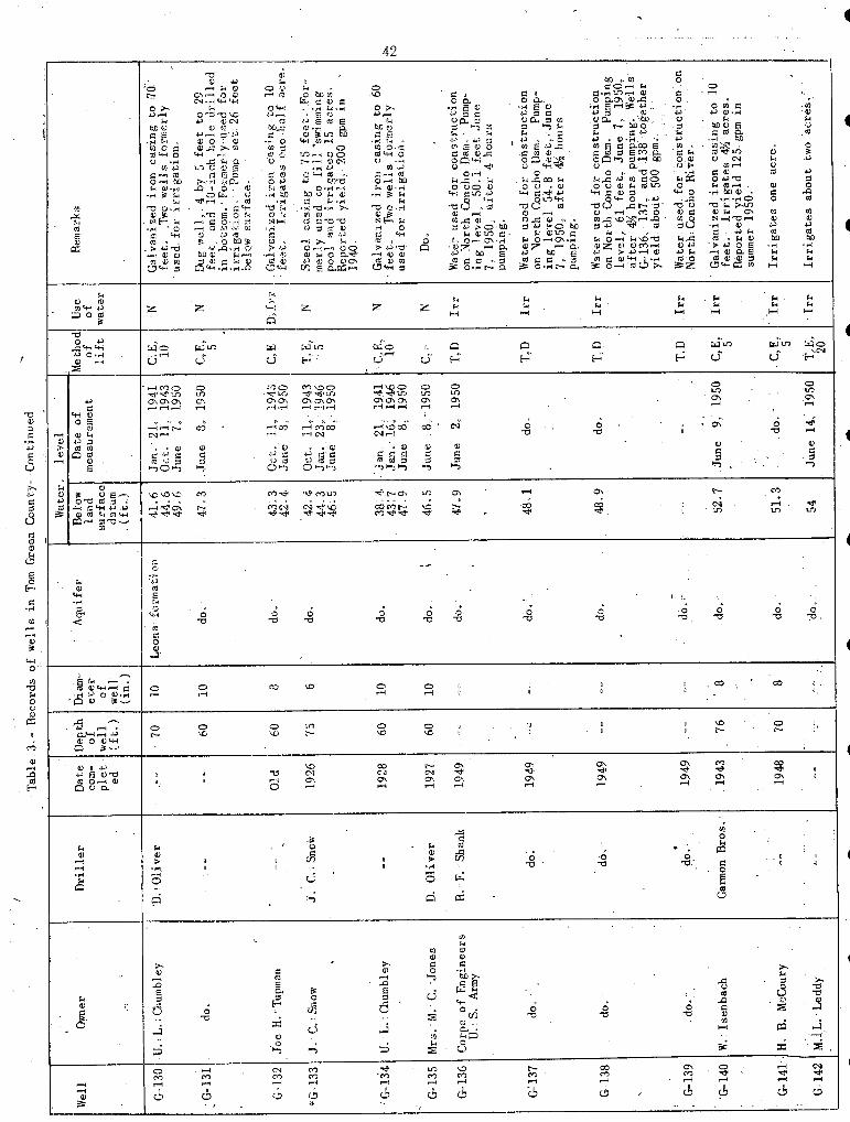
- .~":",,. <.
Water. level
Well Owner Driller Date Depth Diam~ Aquifer Below Date of Method Use Remarkscom= of e'Ge1' land measu remen t of ofplet~ well of surface lift water
ed (ft. ) well datum(in. ) , (ft.)
G·130 U., L. l Chumbley 'D.' O1iver ~ ~ 70 10 l.,eona' fOl:mat'iOi1 "'1.6 Jan.' 21, 1941 C;E, N Gal :"ani ~ed i!.'On casing to itO"44.6 Oct. If. 1943 10 feet. ,Two wells formerly49. G June 7; 1950 used, for irrigation.
, G~131 do. ~ ~ = .~ 60 10 do. ' 4,7.3 June 3, 1950 C,E, N Dug well, ' 4 by 5 feet to 295 feet ..: and 10 c inch hole drilled
in b01;\;om. For'merly,u:,ed fvrindgadon. Pump .'et,26 feet
r below s:H'face.
G~132 Joe H. 'Tupman ~- aId 60 8 do. '
I43.3 Oct. ll, 194::> C,E D,!l.'J: ,Galvanized iron c'asing to 10, 42.4 June 8, 1950 'feet. h"l:'igates oile"hal£ aCl'e'l
*G~ 133 I J.' C. : Snow J.' C.; Snow 1926 15 6 do. 4Vi Oct. H, "1943 T,E, N Steel casing to "{ 5 feet.' ,For~44.3 J;>~•• ,23,. 1946 5 mer I y used to fi 11 'swimming46.5 June 8" 1950 pool and irrigates 15 acres,
Reported yield" 200 gpm' in1940, '
"G~134 U.' L.: Chumbley ~- 1928 60 10 do. 384 'Jan, 21, 1941 ',C,E" N Gah'anized iron casing to 6043;7 "&1.' 16, 1946 10 'feet. Two wells formerly47.9 June 8, 1950 used for irrigation,
;
GoBS Mrs.' M.' C.Jones D. Oliver 1927 60 10 do, ,,
46.5 June B, 1950 C,o N Doo\
G~136 Corps of Engineers Ro F. Shank 1949 00 ~~ do. ' 47.9 June 2, 1950 T,D IrI" Wate~ used for constructionU.' S.' Army on North Concho Dam, ' Pump~
ing level, 50.1 feet June7, 1950, aitel" 4 houl'::!pumping:
-G~137 do. do; 1949 "" ,,~ -~ do. ' 48.1 do. T,D Irr Water uned for construction
on North Concho Dam. Pump-ing level 54.8 feet." June'7, 1950, after 4Y. hourspumping. '
G~138 do. do. " 1949 -- -- do. 48.9 do. ' T,D Irr Water used for constructionon North Concho Dam, Pumpinglevel, 61 fee c" June 7, 1950,
, after 4Y. hours pumping. WellsG-136, 137, and 138 togetheryield. about 500 gpm., " .' ,. -
, (;",139 ,do. :' do. ' 1949 -- =~, do. ' -- -- T.D Irr Water used forcorrstruction':onNorth-Concho'River.
0,
(;...140 W.: Isenbach Garmon Bros. ,1943 76 " 8 do. 52.7 June 9, 1950 C,E, Irr Gal vani zed i ron casing to 105 feet. Irrigates 4Y. acres.
Reported yield 125, gpm insummer 1950.
G-l41 ' H. B. 'McCoury ~- '1948 70 8 do. 51. 3 ,do. " " ,C, E, Irr Irrigates one acre.5 ,
G,142 MJL.' Leddy ~ , -- -~ 'do. 54 J~ne 14; 1950 t.iE, ' Irr Irrigates about two 'acres."
I20
..
'Table 3.~ Records of wells in Tom Green County~~Continued
- - - -
.,..~
.-

, ITable 3.- Records of wells in Tom Green County--Continued
Well Owner Driller Datecomplet-ed
De"th'of
well,(ft~ )
Diam~eterof
well(in. )
•:<.;., Aqui ferWater
Belowland
surfacedatum(ft~ )
levelDate of
measuremen t'Method
oflift
Use0'£
water
. Remarks
G-143 I 0.: E.'Ferguson
G-144 I B.M.· Jordan
Deyl e' Rogers
do.
1947 84
88
8
8
Leona formation
do.
53.9 I June 14. 1950
54.6 I'June 19" 1950
T,E.3
T,E.3
Irr
. Irr
Not· cased.' Two wellsirrigate abou~2 acres.
No't cased. Irrigates5Y2 acres. Reportedyield, 70 gpm in summerof 1950; pumping level,61 feet, June 13, 1950.
G··l45 I O'Neal Dendy 76 8 do •. 53.5 I June 13 .. 1950 I, None N Formerly used for 1rr1gation. "
55.1 I June 13.. 1950
Gr146 I F.:W. Kreidel
G-147 I H.Obercampf
G-148 I Mary E.Rogers
J. C.Snow
D. Oliver
1927
1914
75
72
70
10
8
8
do.
do.
do.
43.946.856
42.446.349.6
Jan. 21, 1941OCt., 11, 1943June 13, 1950
Jan. 9. 1941Dec., 16; 1943Dec. 24,. 1946
C.E.'7%
None
J"E
Irr
N
D
Galvanized iron casingto 75, feet. Two wellsirrigate about 5 acres.
North well, of two former I y equipped with 6inch cylinder pumps andused for irrigation.South well of the twowas drilled by H.Duckworth in 1925. __Wells not used for about,13 years.
Not cased. North well.oftwo formerly equippedwith6-inch cylinder pumpsand used for irrigation.
oJ:>.w
G-149 do. do. , 80 8 do. C,.E, Irr Not cased. Irrigates yard.South'well of two.
G-150 I S.: L.: Knight Robert Rogers 1920 80 8 do. 42.645.355.2
Jan. 9, 1941Oct.. 13'; , 1943June 13, 1950
,J,E D Not cased. East well oftwo formerly equipped with6-inch cylinder pumps andused for irrigation. Westwell filled. \
I G-151 I H.Obercampf - - / I 83 10 do. 56.2 I June 13, 1950 T,E,15
, Irr
G-153 I T.B.' Ellison
G-154 I H. Obercampf
,J,E, I'D,SY2 0
G·, 152 do. " D.' Oliver 1926
1925
80
80
.80
8
8
8
do.
do.
do.
56.6
42.155.9
57;6
,do .•
Jan. 9. 1941June 13: 1950
,June 13, 1950
None
T~E,5
N'
Irr
Not cased. Two wells for~
merly equipped with 6-inchcylinder pumps' and·usedfor irrigation.
Formerly used forirriga-- tion. .
~,
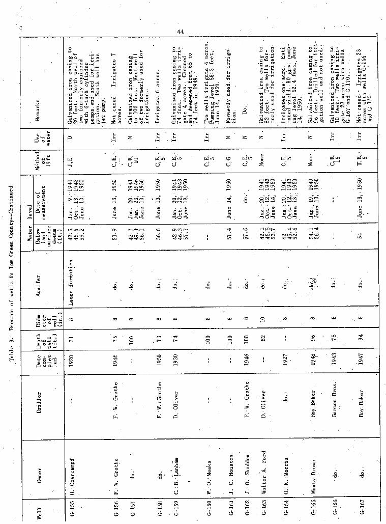
........
Table 3."' Records of wells in Tom Green Coun tY"~Con tinued
Water levelWell Owner Driller Date Depth Diam- , Aquifer Below Date of Method, Use Remarks
com- of eter' land measuremen t of of, plet- well of surface lift water
ed, Ht;) welt ,ila,.wm(in. ) (ft. )
G-155 H. ' Obercampf -- 1920 71 8 Leona formation 42~5 Jan; , 9:- 1941 ' J,E D Galvanized iron casing to45.6 Oct." 13, 1943 20 feet. North well of55;2 June 13, 1950 two formed y equipped
, with 6-inch cylinderpumps, and'used for irri-gation. : South well has
'jet pump.
G-156 F.'W. Grothe F. ,W. 'Grothe 1946 75 8 do. 51. 9 June 13, 1950 ,C,E,- ' 11'1' Not .cased. Irrigates 7, ,~- acres.
G-157 ,do. ' -- -- 100 8 do. ' . , 42.7 Jan. 20, 1941 C,E, N Galvanized iron casinr49.1' Jan. i 23~ 1946 10 to 100 feet. West, we 156.1 June 13" 1950 a f. two former l'y used for
i rriga tion.:, .
G-158 do. F.' W. rGrothe 1950 73 8 do.: 56.6 June 13, 1950 C,E" 11'1' Irrigates 6 acres.5.
G-159 C. B.' Lanham D.' Oliver 1930 74 8 do. : 42.9 Jan.' 20.: 1941 C,E" 11'1' Galvanized iron casing to46.3 Oct. 12,: 1943 5 74 feet. Two wells irri-
I 57.7 June 13~, 1950 gate 4 acres., CleanedI
,and deepened from 65' to74 feet'in 1949.
G-160 W.' 0.' Meeks -- -- 100 8 do. -- -- C:,E, 11'1' Two wells irrigate 4 acres.5 Pumping level 58; 3 feet"
June 14" 1950. .,G-161 J. 'C.' Houston -- -- 100 8 do. ' 57.4 June 14, 1950 C,G N Formerly used, for irriga'-
tion,
G-162 J. ,0. Shadden F. 'W.'Grothe 1946 108 8 do. " ~7 .6 do. ' C,E, N Do.'5
,G-163 Wal tel' A. For'd D.· Oliver -- 82 10 do. \ 42.1 Jan. 20, 1941 None N, Galvanized' iron casing to
45;5 Oct.' 12,;' 1943 82 feet. Two well s for-53.7 June 14, 1950 mer1y used for irrigation.
G-164 0 .. K. 'Morris do. , 1927 -- 8 do~ ; 42 Jan., 20, 1941 C,E, 11'1' Irrigates one acre., Esti-45.4 Oct.' 12
"1943 5 mated yield,' 80 gpm; pump-
52.6 .June 13,: 1950 ing level 62.4 feet"June14, 1950.. '
G-165 Monty Brown Roy Baker -1~48 , 96 8 54.1 Jan., 19, 1949 None N' Galvanized iron casing to\ . 5,6.4 June 13" 1950 96: feet. Drilled for irri-
gation well and not used.;
G-166 ' do., Garmon Bros.' 1943 75 8 do. i -- -- C,E,. liT Galvanized iron casing to.. 15 10 feet.' Two wells 'i1'ri- \
gate 23 acres wi th well sG-167 'and Go l70•. '
G-167 ,do. I Roy: Baker 1947 94 8 . do.' 54 June 13,. 1950 T;E,' ,11'1' N~t c~sed." Irrigates 235 acres with wells G-166
and G-170.
"

Table 3.- Records pf wells in Tom Green County--Continued
*'"c.n
Water' 1evelWell Owner Driller .Date Depth Diam- Aquif!lr Below· Date of Method , Use Remarks
'com- a! eter land measurement,. .of ofplet- well ' of surface . lift water
ed (ft. ) well datum(in. ) (ft~ )
G-168 A. E. Latson l. W.' G,rothe 1946 80 8 Leona formation 55.9 June 14, 1950 C,E, 11'1' Iriigates one acre.5
~169 do. do. ' 1941 80 6 ~
do .. J.,E D Galvanized iron casing to-- -- j
10 feet. Formerly equippedwith a 4-inch cylinder pump
I and used for irrigation.G-170 'Monty Bro~ Roy Baker 1949 90 -- do. .', -- C,E 11'1' Irrigates 23 acres wi tho
wells G-166 and G~167.
G-171 Lonnie Reed D.• Oli vel' -- 75 8 do. 40.8 Jan. 20, 1941 C,E" D,Irr Galvanized iron casing to, 47.4 Jan. 23. 1946 • 3 75 feet. Irrigates one-half
55.9 June 14; 1950 acre.; G-172 Cecil Hasty do. 1946 -- -- -- 54.5 Dec. 14,' 1950 C,G 11'1' Irrigates one-fourth acre.
G-173 do .. do. 1942 68 8 Leona formation 54.5 June 14, 1950 C,E, D G~lvanized iron casin¥ to 68, 1 feet. Formerly used orirrigation.
G-174 W.·O.Edginton do. ' 1942 67 8 do. 55 do. J,E D Galvanized iron casing to 5 ,feet. Formerly used for I
i rri gation.G-175 do. Roy Baker 1949 85 8 do. 55 do. C, E', ITr Not cased.. ,Irrigates 2Y2
3 acres.
G·176 J.A. 'Simpson Park Hal t -- 93 8 do. -- -- C,E, 11'1' Irrigat~s 2 acres.5
G-l77 W.' E. ,Addison A. F. Grothe -. 75 8 do. 55 June 13, 1950 C.E" 11'1' Not cased. Irrigates one3 acre.
G-178 T.V.'Sanders .do. .. 1947 79 6 do. 53.3 do. C,E,; 11'1' Not cased. Irrigates 1Y25 acres.
G-179 S. 'L. Knight Doyle Rogers 1947 80 8 do. 55.1 do.' T,E, N Not cased. Former!y. used for5 irrigation.
G·180 Jim B. Bradford Earl Scott 1948 ' 85 6 do .. 54.4 Jan.' 19, 1949 T.E, 11'1' Steel casing to 83 feet.5 Irrigates .one acre. "Reported
yield, 100 'gpm in 1950.
"G-181 Henry Howard D.' Oliver 1920 60 8 do. 41.4 Jan. 9, 1941 None N Not cased. . Two wells former-44.2 Oct. 13,· 1943 ly equipped with 6~inch
55.4 June 13, 1950 cylinder pumps and used forirrigation .. Original. depth,
/ 80 feet.G-182 Ci ty of San Angelo J. C.' Snow' 1947 96 6 I do.' 31 Feb. 17~ 1937 J;E. D,S. Steel casirg' Well on Fair
Fair Grounds Assn. 40.9 Oct., 1,'1940 iK P Grounds. ' irty feet south55.4 Jan. 19, 1949 of well used before 1947.
G-183 'Wilbur Jennings -- 1920 80 8 do. -- ' -- T,E, 11'1' East well 'of three formerly5 . equipped. with 6~inch cylinder
pumps and used for. irrigation.Center well filled.
G-184 do. 1920 80 8-
do. J,E . D West well of three.-- -- --I
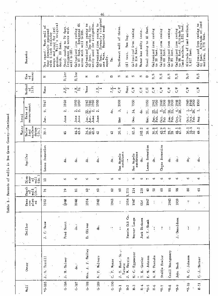
I
Table 3, c Records of wells in Tom Green Coun ty-,'Con tinued
..,.0'\
,,
, Water levelWell Owner Driller Date Deflth Diam- Aquifer Below Date of Method Use Remarks
com~ ,of eter , land measuremen t of ofplet~ well of surface lift water,
ed (ft. ) well datum(in,) (ft:) ,
~G~ 185 J .A. Terrill J. C.' Snow 1912 76 12 Leona formation 39.7 Jan. 9, 1941 None N Not cased.' West well offour formerly equippedwith 6-inch cylinde~
pumps and used for irri-
Igation. Well's 'originaldepth, 80 feet.
G-186 J. H,rHulsey Fred Scott ~948 79 6 do .. 45 June 2, 1950 J"E.,, D, Irr Steel casing to 79 feet,'2 Irrigates 4)1, acres wi th .
well G-187.G-187 do. do. , 1948 81 6 do. 44.3 June 2, 1950 JE. ' D.Irr Galvanized iron cas'ing
43.8 June 2, 1950 iK to 81 feet. Irrigates 4Y..acres with well G-186 .
G-188 Mrs.J.' F.' Bailey D. 'Oliver 1934 60 6 do. 34.4 Jan.' 22, 1941 None N Galvanized iron casing to. 38.9 Jan. 16;,1946 60 feet. Two well s fo r-42.8 June ,2, 1950 merly used for irrigation.
G-189 A.'F. Walters do. 1942 60 6 do. ' 42 June 2, 1950 J, E, D Galvanized iron casing to1 60 feet. Formerly irrigated ,
one acre. Reported weak 'supply.
G-190 C. F. Wynne,
1943 60 6 do,: 42 do. J"E., ' D Do.-.1
*H-1 J. "Y. Rust, Sr.,' -- -- 60 6 San A..gelo 20.3 May 3, 1950 C,W S Southwest well of three.Es ta te sandstonf;l
H-2 J. 'W. Harris Fannin Oil Co. 1914 ,375 -- -- -- None N Oil test. See log.'
H-3 H:' C. ' Eggemeyer Werner Lange 1947 114 6 San Angelo 82.3 Dec. 14c 1950 C,W S Galvanized iron casing; sandstone to 114 feeL
H-4 T. , H. ' Garner Jack Dickson Old 218 6 do. ' 102,2 do. ,C,E S Water has salty taste.'
*H-5 E. 'M. Johnson R. F.I Shank 1947 40 7 Leona formation 18.6 Mar. ' 21, I 1950 C,H D Steel casing to 40 feet.
H-6 A.: W.' Pusteka -- -- 50 6 do. ' 36.8 Jan. 22. 1941 C,W D,S Galvanized iron' casing36.5 Feb. 21, 1950 to 50 feet., '
*H-7 Stell a Fowler -. -- 60 6 Ch9,za formation 42.9 Oct. : 2., 1940 C,W D,S Galvanized iron casing14.3 Feb 21~, 1950 to ,60 feet.'
~H~8 Cecil Montgomery -. 1943 85 6 di>. 29.7 Jan.' 28" 1949 C,W D,.S Galvanized, iron casing28 Feb. 21,' 1950 to 85 feet.
*H~9 John Book J. "Donal dson 1939 98 6 do. ' 48.1 Oct. , 6" 1948 C,W D,S Gal vani zed iron casin,g ,47.9 July 28,: 1950 , to 98 feet.' Al ti tude of
'land surface, 1,831 feet.
*H-I0 R. 'C. 'Johnson -~ -- 80 6 do.. 36.5 Oct. L 1940 C,W D,S Al ti tude of land surface.,'33.5 Oct.: 1:, 1948 1.817 feet.'- 32 Feb. 20, 1950
H-ll C. ~'J. :'Horner -. .- 61 6 do. 49.2 Aug. 1, 1950 C,W D,S Gal vani zed iron casing to61 feet.' AI ti tude of land
i, surface, 1,776 feet.
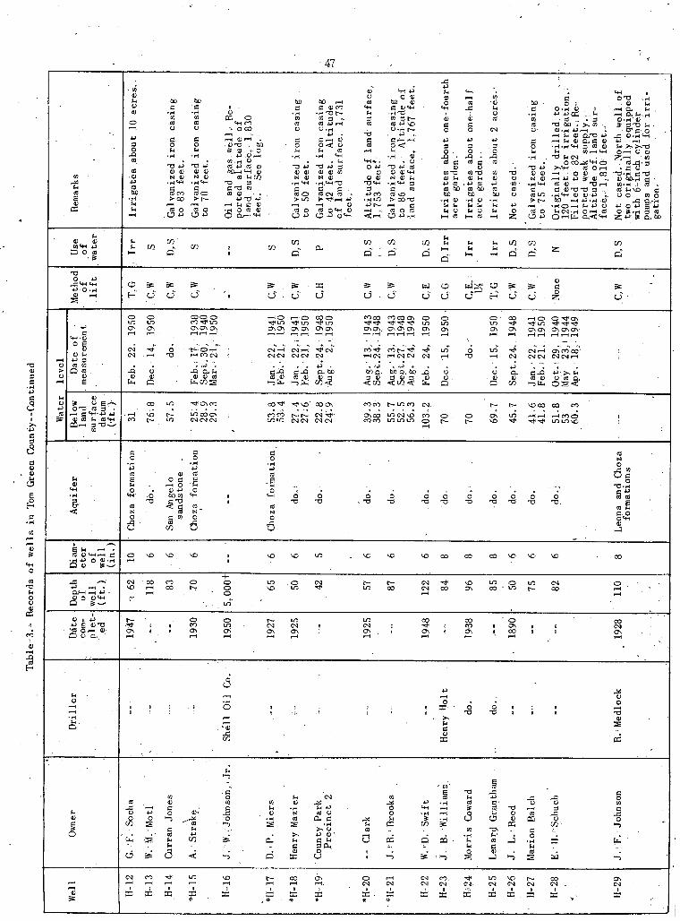
Table--3. ~ Records of wells in Tom Green County--Continued
Water level
Well Owner Driller Date De~th_com- ofplet- well
ed -(ft.)
Diameterof
well(in. )
Aquifer Below I Date of land _ meaSurement
surfacedatum{-ft.}
Methodof
_lift
Useof
water
Remarks
H-13 I W.-M.'Motl
H-16 I J.>W.,Johnson"Jr. 1950 I 5,000+' --
76; 8 I Dec.' 14, 1950 I C, W
Irrigates about 10 acres.,
Galvanized iron casingto 83 feet.
Galvanized iron casingto 70 feet.
Oil and yO-as. welL Reported a ti tude of .land surface.· L 830feet: See log.'
Irr
S
S
D,S
C,W
C,W
T,GFeb.' 22. 1950
do.
Feb.: IV 1938Sept. 30, 1940Mar,' 21!, 1950
31
57.5
25;428.929.3
do. '
Choza forma tion
San Angelosandstone
Choza formation6
10
6
6
70
"-,' 62
118
83
1930
1947
Shell 011 Co.
\A.' Strak,<_
CUrran Jones
G. "F.' Socha
H-14
H-12
"H-15
*H-17
*H-18
*H-·19-
D.' P. Miers
Henry Mazier
Countt ParkPrecinct 2
1927 -
1925
65
50
42
6
6
5
Choza formation'
do. :
do. ,-
53.853'.4
·27,427 :6,22.824'.9
Jan. 22. 1941Feb.' 21; 1950
Jan. 22.,1941Feb.. 21, 1950
Sept.24, 1948Aug, 2,,1950
C,W
C,w
C.H
S
D,S
P
Galvanized iron casingto 50 feet.
Galvanized iron casingto 42 feel, Al ti tudeof 1and surface. 1. 731feet.· ' .
~
Dec,'15, 1950,1 C,G
do," I C,E,IXDec. 15, 1950 T,G
*H-20
- "'H-21
H-22
H-2.3
H~24
H~25
-- Clark
J. 'R. ' Brooks
W. 'D. - Swift
J. B.William~_
Morris Coward
Lena:t:9 Gr_a~tham
Henry HoI t
do.
do.
1925
1948
19'38
57
87
122
84
96
85
6
6
6
8
8
8
do ..
do,
. do ..
do.
do.,
,do.
39.338.3
55,752.556.3
I 103.2
70
70
69.7
Aug.' 13,' 1943Sept.24" 1948
Aug... 13, 1943Sept.27, 1948
. Aug,· 24, 1949
Feb. 24. 1950
C,W
C,w
C,E
D,S
D,S
D,S
D.. Irr
Irr
11'1'
Altitude of land surface,1,753 feett' .
Galvanized iron' casingto 86 feet.· Altitude ofland surface, 1,767 feet .
Iri'igates about one-fourthacre garden.'
Irrigates about one-halfacre garden ..
Irrigates about 2 acres.'
H-26 I J.' L.'Reed 50 I '6 45.7 I Sept.24" 1948 I C,IV
H·27
H-28
H-29
Marion Bal ch
E.' H. '-Schuch
J .F. Johnson R.' Medlock
1890
1928
75
82
110
6
6
8
do. '
do.
do.;
Leona and DlOzaformations
41,64L851.85360.3
Jan.' 22,1941Feb. i 21,. 1950
Oct. ,29. 1940May 23; I 1944Apr. '1~" 1949
C.W
. None
C,W
D,S
D,S
N
D.S
Not cased.'
Galvanized iron casing't075 feet.; ,
Originally drilled~ to .120 feet,for irrigation.Filled to 82 feet.iReported weak supply.Al ti tude of. 1and surface,' 1,810 feet.,.-
Not cased .. Northwell.oftwo originally, equippedwith 6~inchcylinderpumps and used for irrigation •.
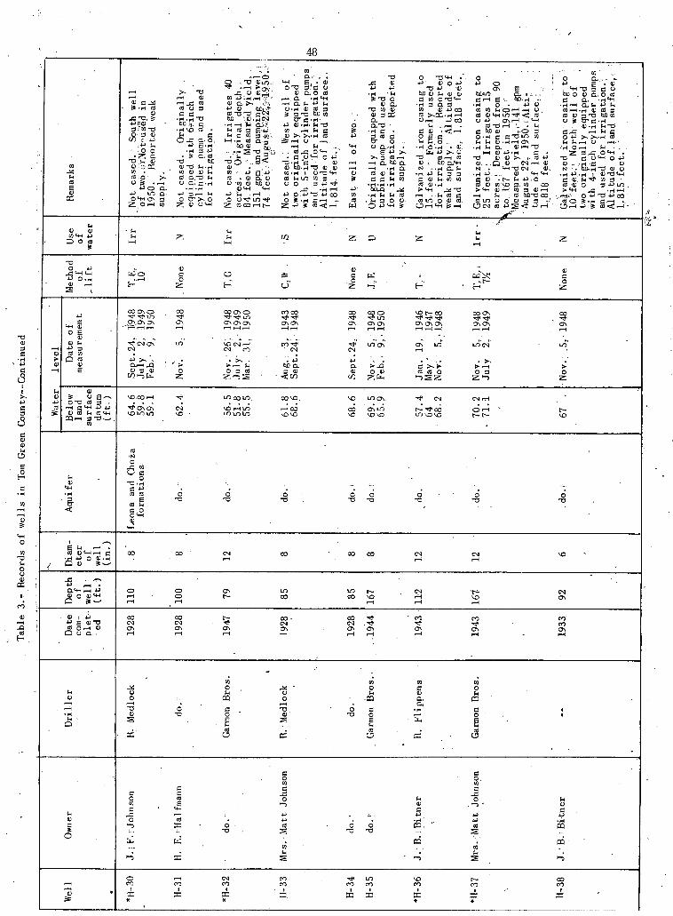
Table 3.~ Records of wells in Tom Green County~-Continued
5;
. -~•..-. ~.~ - , .,
''-Water level
Well Owner Driller Date Depth Diam- Aquifer Below Date of Method Use Remarkscom- o! eter land measuremen t of ofplet- well' of 'surface ,lift water: ed (ft. ) well datum. (in. ) (ft. )
*H-30 J. F. : Johnson R. Medlock 1928 no 8 Leona and Choza 64.6 Se1t.24, 1;948 T,E, Irr Not cased.' Sou th well- formations 59.8 Ju v 2. 1949 10 "of two.i.,tNoi"us·(;d in
59,1 Feb: ' 9, 1950 1950. Reported weak"
supply.
H-31 H. E.' Hal fmann do. " 1928 100 8 do. 62.4 Nov~ 5, 1948 , None N Not cased. Originallyequipped wi th 6"inchcylin der pump an d usedfor irrigati~n.
*H-32 do. ' Garmon Bros. 1947 79 12 do .. 56.5 Nov.'26~ 1948 T,G Irr Not cased. Irrigates 4051. 8 July' 2;· 1949 acres. Original depth,5"5.5 Mar. 31, 1950 84, feet.,' Measured yield, '
151 gpm and pumping level" ,• 74, feet',·Au,gust3<:-2·T.;··.·l-9.50./·
t'·" , , '
H~33 Mrs.'Matt Johnson R.Medlock 1928 85 8 do. 61. 8 Aug. 3. 1943 C,W S Not cased., West well of68.6 Sept. 24; 1948 two originall y equipped
wi th 5";in'ch cylinder pumpsIand used for irrigation-. i
Altitude of land'surfac'e:,1,814, feet.,
H-34 do .. do. ' 1928 85 8 do.! 68.6 Sept.24, 1948 None N East well of two. '
H-35 do.' Garmon Bros. .. 1944 167 8 di>. 69.5 Nov. 5. 1948 J,E D O~iginally equipped with65.9 Feb. , 9;, 1950 turbine pump and used
for irrigation .. Repoftedweak supply.:
*H-36 J.: B.' Bi tner H. Flippens 1943 U2 12 do. 57.4 Jan. 19, 1946 T, ~ N Galvanized.iron casing to64 May' 1947 15 feet.' Former! y used',68.2 Nov~' 5" 1948 for irrigati'on .. Reported
weak supply.' Altitude ofland surface, 1,818 feet.
*H-37 Mrs. "Matt Johnson Garmon Bros., 1943 167 12 do. : 70.2 Nov. 5. 1948 T,E" Irr' Galvanized iron casing to. 71.1 July 2; 1949 7Y2 25 feet.: Irrigates 15
.. ~ acres.: Deepened from 90,.'
~. to. 167 feet'in 1950.:'Measllred yield, ,,141 gpmAugust 22., 1950.: Al ti-tude of land surface.:'1,,818 feet. ' ~
. --"-'"
H-38 J.' B,! Bitner -- 1933 92 6 do.! 67 Nov.: ,5.1948 None N Ga'lvan i zed iron. casing to "10'feet. i North well of
. two ori~inally equipped ', with 4-1nch cylinder pumpsand used for irrigation.';Altitude of. land surface"1,815 feet.' ' ,
L'i ~:'"
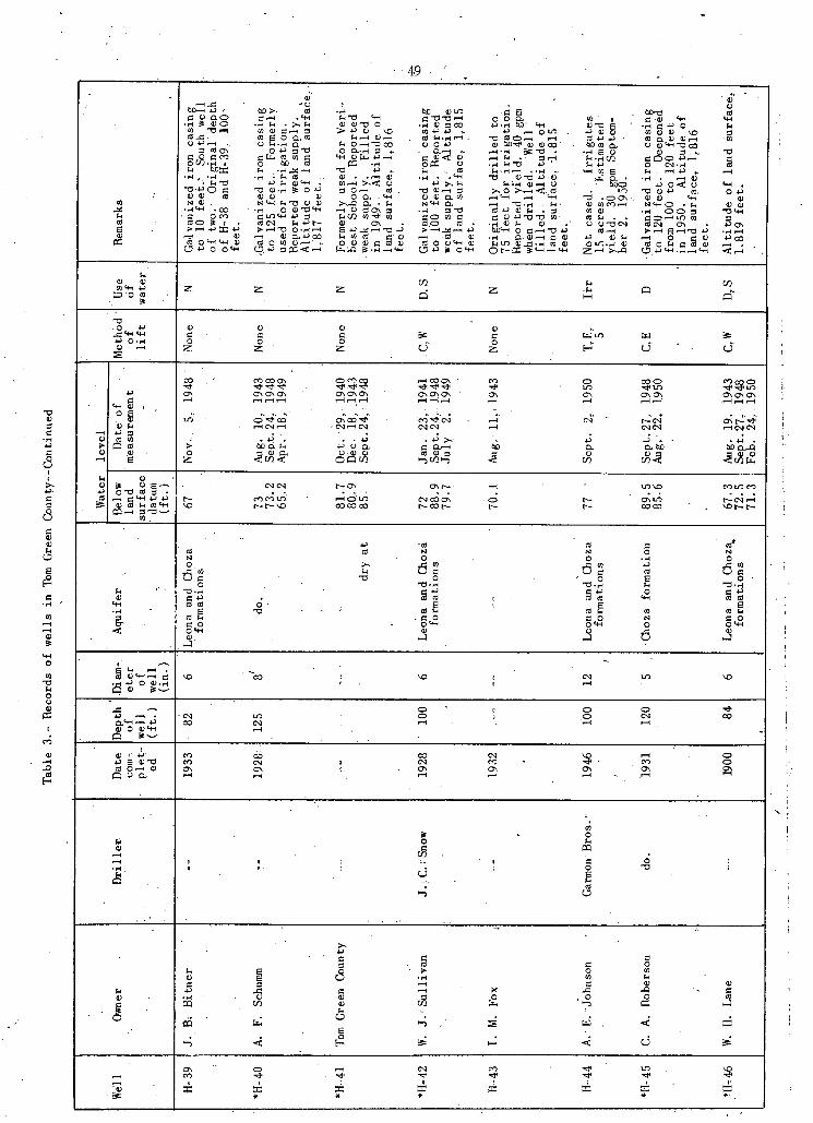
Table 3.- Records of wells in Tom Green County--Continued
Water levelI
Well Owner Driller Date Depth ,Diam- Aquifer Below Date' of Method' Use Remarkscom~ of eter land measurement of ofplet- well of surface lift water
ed (ft. ) well : datum "
(in. ) (ft. )
H-39 J. B. Bitner -- 1933 82 6 Leona and Choza 67 Nov., 5, 1948' None N GaJ.v~ized iron casinf' formations to 10 feet.' Sou th we 1
of two. Ori ginal' depthof H- 38 and H- 39, 100,feet.
*H-40 A. F. Schumm -- 1928 ' 125 8' do. 73 Aug. 10, 1943 None N ,Galvanized iron casing73.2 Sep,t. 24, ' 1948 to 125 feet. Formerly65,.2 Apr. 18. 1949 used for irrigation.
Reported weak supply., Al ti tude of 1and surfa~e"
1,;817 fee t.
*H-41 Tom Green County -- <>- -- -- ' -- 81.7 Oct. 29, 1940 None N Formerly used for Veri-80,.9 Dec. 18, .1943 best School. Reported
dry at 85 Sept. 24,. 1948 weak supply. Filledin 1949.' Altitude ofland surface, 1,816feet.
*H-42 W.J.' Sulli van J. ,i C. ;' Snow 1928 100 6 Leo~a and Choza 72 Jan. 23,.1941 ,C,W D,S Galv~nized iron' casingformations 88,9 Ser;.24, 1948 to 100 feet. RAforted
79.7 Ju y 2, 1949 weak supply.' titudeof land surface, 1.815feet.
H-43 1. M. Fox I -- 1932 ""n -- == 70.1 Aug. 11" 1943 None N Originally drilled to75 feet for irrigation.
, Reported yield, 40 gpmwhen drilled. Wellfilled .• Al ti tude ofland surface, -1,815feet. '
H-44 A.' E.'Johnson Garmon Bros.' 1946 100 12 Leona and DlOza 77 Sept. 2, 1950 T,E, Irr Not cased. Irrigatesformations 5 15 acres.' Estimated
I yield, 30 gpm Septem-.'
ber 2, 1950.
*H-45 C. A. Roberson do. 1931 120 5 'Choza formation 89.5 Sept.27, 1948 C,E D Galvanized iron casing85,6 Aug.' 22. 1950 to 120 feet. Deepened
from 100 to 120 feetin 1950. Al ti tude of
. ~
land surface.' 1,816feet.
*H-46 W. H.' Lane -- 1900 84 6 : Leona and Choza. 67.3 Aug. 19. 1943 C,W D,S Al ti tude of land surface',formations 72.5 Sept.27,' 1948 1. 819 feet.
71,3 Feb. 24" 1950,
~

Table 3. <. Records of wells in Tom Green County'""Continued
. -Water level
Well Owner Driller Date Depth Diam·· Aqui'fer D Below Date of Method Use Remarkscom~ of eter land measuremen t of ofplet~ weB of . sur.face . lift water
ed (ft. ) well datum(in. ) (ft. )
*H-47 Mrs.' Julius Miller -- Old no 8 ,Leona formation 60.8 Nov. 19,,1940 T,E,- Irr Steei, casing to 110 feet.74.2 Nov. 3. ' 1948 15 ,Irrigates 20' acres.: West68.1 Feb. : 9; , 1950 well of two .originally
. equipped,with 6~inch
cylinder pumps. Measuredyield, 266 gpm and pump-
, ing level, 73.3 feet Sep-tember 16., 1943.Reportedyield" ab~ut 325 gPm in1948. Estimated yield." ,
.'abou t 100 gpm Au gus t 23."1950. Altitude of landsurface, 1,822' feet.
H~48 do. ' -- Old no 8 do.: :74.5 Nov. 3, <1948 None N Not .cased. East well of, two. ,.
*H~49 Hope Clark -- 1928 105 8 Leona and Choza 60 Aug.; , 1943 e,w D,S South well of two origi-formations 74.2 Oct:' 18,. 1948 nally equipped with 6~
\ inch cylinder pumps and.used for irrigation.'
H-50 do. -- 1928 143 8 do. 59.7 Nov. 19, 1940 T.E. . Irr Not cased.':' Irrigates74.2 Oct. 18, 1948 15 about 20 acres ... North
well of two. 'Deepened. from 114 to 143 feet in1947. , Reported yiel d,250 gpm. Al ti tude of. land surface,' 1,821
- feet.
H-51 do. ' -~ 1928 91 6 Leona formation 58 Nov. 19" 1940 None N Galvanized iron casing69.7 Oct. ' 27" 1948 to 10 feet.' Two wells
originallr equipped with6~inch cy inder pumps
Iand used for irrigation.'North well. filled.'Alti-tude of land surface,<,1,819 feet.' '
H-52 Mrs. ,A. '·F.' Schumm Garmon Bros. i . ..,,_. 125 12 Leona and Choza 68.6 ,Aug. 9, 1943 T,E, Irr I rri ~a tes' 26'acres. (Mea-, formations 79.2 Oct. 18., 1948 10 surebield.. 247, rm .'
, . ,Septem er 14,j 194 and
I216 gpmAugust 22,; 1950.;Al ti tude of 1and surface,!1,817 feet.'
H-53 Otis. ).,an~ -~ 1928 79 ' 10 Leona formation 55.2 Nov.' 19, 1940 None N West weil of two origi-66.5 Oct. 18, 1948 nally equipped with 6-70.1 Aug.' 22" 1950 inch cylinder pumps and
used for irrigation.! .-Altitude of land surface,'
I1,817' feet.:
CJ1o

Table 3.- Records of wells in Tom Green County--Continued
c.n>--'
f;fl.~
, Water": level
Well Owner Driller Date Depth Diam- Aquifer Below Date of Method ' Use Remarkscom- of eter land measu remen t of of
I plet- well of surface lift watered (ft.) well datum
(in. ) (ft. )
'OH-54 Otis ,Lane -- 1928 126 10 Leona and Choza -- -- T,E, Irr Irrigates about 30 acres.,formations 10 East well of two.' Deep-
ened from 90 to 126 feetin 1946. Reported yield,180 gpm' in 1948.
H-55 do. : 1928 94 8 Leona formation"
67.6 Oct. 26, 1948 None N Galvanized iron casing to--10 feet.' East well of two
./ . originallr 'equipped wi th,6-inch cy inder pumps andused for irrigation: Westwell filled. Altitude of1and surface.. '1,819 feet.
H-56 W.' H.' Lane E. 'E. 'Kinsey 1928 73 8 do. 55.7 'Nov, 19,.' 1940 None N Not cased. East well of63.5 Oct.' 26, 1948 two originally equipped
wi th6-inch cylinderpumps and used for irri-. gation. Original depth,90 feet. Altitude of
I .1and surface, 1,816 feet. :
H-57 do. do. 1928 100 10 do. 57.9 ' Nov. 19, 1940 None N Galvanized iron casing to. 57.3 Oct. 14, 1943 10 feet. Northeast well63.7 Oct. 26, 1948 6f two originally equipped
wi th 6-incli cylinder pumpsand, used for irrigation ...Al ti tude of land surface ..1.,816 feet.;
H-58 do.; Garmon Bros.: 1945 142 12 Leona and 'Choza ,54.6 'Jan. 19,. 1946 T,E, ; Irr Not cased.' Irrigates 65formations 25 acres. Measured yield, '
348 gpm August 22" 1950.Al titude of land surface•. ,1,816 feet. ' ,
'OH-59 Otis Lane do. " 1946, 150 12 do. 71.4 Oct. 27, 1948 T,El
Irr' Galvanized iron casing to7Y. 100 feet. Irrigate's about
30 acres. Measured yi'eld,168 gpm; pumping'level,·100 feet August 24, 1950:.;
H-60 do.; do. 1943 70 8 Leona formation 57'.1 Jan; , 9, 1946 None N F~rmer16 ~s~d for irriga-dry Aug. 22.1950 t1.on.' rl.gJ.nal depth,'
93 feet.. . ",'
H..;61 Hope' Clark -- - 120 8 Leona and Choza 62.7 Oct.' 26, 1948 None N Not cased. North well,.cifformations three originally equippi~ .
wi tlj 6~ inchcylin~er;;p:UJ\JPs
and used for l.Tri g'li;ti~p'ff~'
H~62 do., -- -- 135 ,8 do. : 53.2 Nov. ;19, 1940 '~one N Not cased. Mid~le~el:l'...;6f·62;8 Oct., 26, 1948 three former! y used -',for"': '
I
.. : , ..... ,.':irrigation." Dee(l~n~(,:'(rom.12L to 135 feet 1.n19'49','. .. ,Reported yield after~agJp~I -- - - ._" . - ening,' 308gpm. "
-- \ I
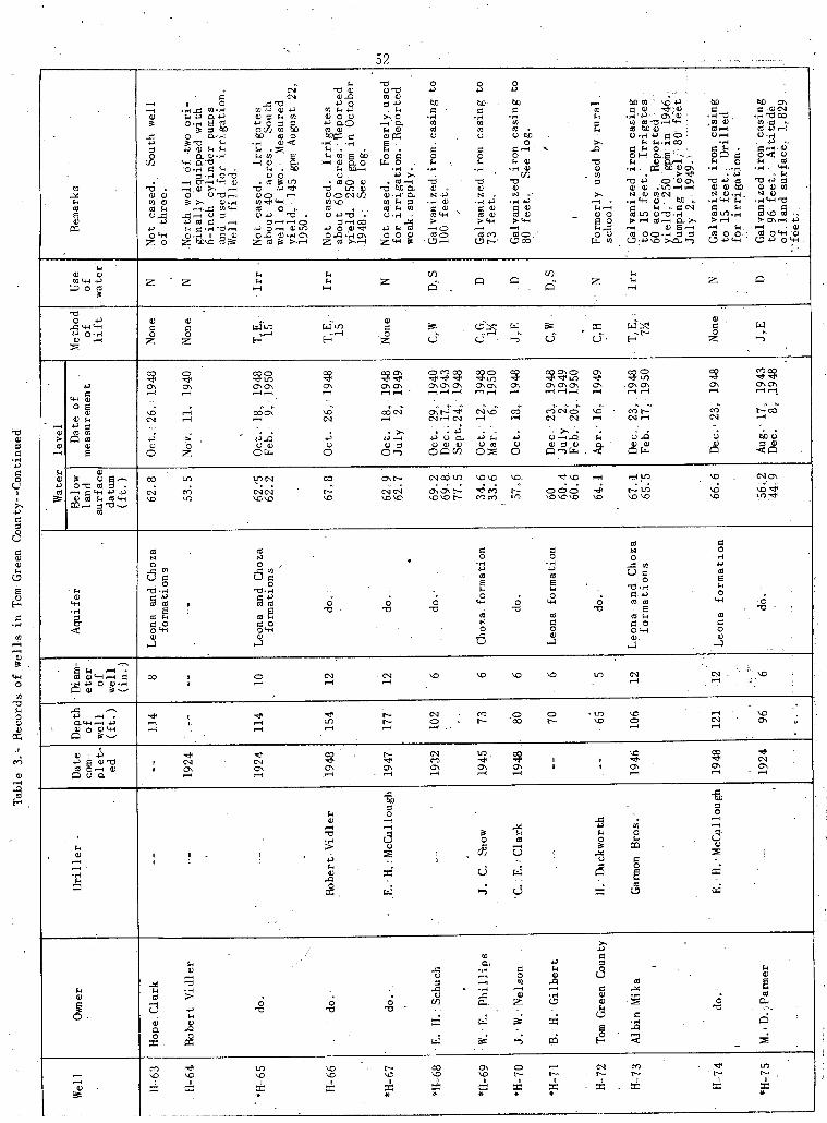
Table 3.~ Records of wells in Tom Green County~~Continued
Well
H-63
H-64
Owner
Hope,Clark
Robert Vidler
Driller· Datecom~
plet~
ed
1924
Depthof
well(ft. )
114
, mam~eterof
well(in. )
8
Aquifer
Leona and, Chozaformations
WaterBelowland
surfacedatum(ft. )
62.8
53.5
levelDate of
measuremen t
Oct.' 26, 1948
Noy. 11, 1940
Methodof
lift
None
None
Useof
, water
N
N
Remarks
Not cased. South wellof three.
,North well 61 two ori··gin all y 'equipped wi th '6~inch cylinder Dumpsand used for irrigation.Well filled.
*H-65 do. 1924 I 114 I 10 Leona and Chozaformations
62.'5 I' Oct. 18, 194862.2 Feb. 9.' 1950
T,E, '15
Irr Not cased. Irrigatesabout 40 acres. Southwell of two.' Measuredyield" 145 gpm August 22,1950.
H-66 do. ' Robert, Vidler 1948 I 154 12 do. 67,8 I Oct. 26" 1948 Ti~" Irr Not cased. Irrigatesabout 60 acres. ' Reportedyi'eld. : 250 gpm in October1948., See log.:
*H-67 do. ' E.' H.' McCullough I 1947 177 12 do. 62,9 'I Oct. 18" 194862.7 July 2. 1949
None N Not cased.' Formerly usedfor irrigation. Reportedweak. supply.;
U1t-.:l
*H-68 I 'E. H.: Schuch
*H-69 I,W.' E, Phillips
*H-70 I J.'W.'Nelson
*H~71 IB.H. Gilbert
J. C. Snow
'C.E.:Clark
1932
1945
1948
102
73
8'0
70
6
6
6
6
do.'
OlQza, formation
do.
Leona formation
69.269.8,n.534.633.6
57.6
6060.460.6
Oct. 29., 1940Dec.; 17~ 1943Sept. 24,' 1948
Oct.' 12. 1948Mar. 6; 1950
Oct. 18" 1948
Dec.' 23. 1948Jul y 2;, 1949Feb. 20" 1950
C,W
, c,G,1){
J,E
C,W,
D,S
D
D
D,S
Galvanized, iron. casing to100 feet.
Gal vani zed i ron casing to73 feet.
Galvanized iron casing to80 feet. See log.
H-72 I Tom Green County H.' Duckworth 65 5 do. ' 64.1 I Apr.' 16, 1949 C,H N Formerly used by ,ruralschool.
H-73 Albin Mika Garmon Bros.' 1946 106 12 Leona and Choza, formations
67.165.5
Dec. 23", 1948Feb. 17, 1950
,T,E"7Y.
Irr Galvanized iron casingto 15 feet.' Irrigates60 acres., Reported', 'yield,' 250gpin in 1946.Pumping level!, 80' fe'et "Jul y 2" 1949." '"
*H-75 I M.: D'iParmer
E.' H.' McCullough I 1948 I 121 112H-74 do. '
1924 I 96'"
6I
Leona formation
do.
66.6 I Dec.' 23, ' 1948
56;2 I Aug.' 17> 1943'44.9 Dec. 8, ,1948
None
J,E
N
D
Galvanized iron casingto 15 feet. Drilledfor irrigation.
Galvanized iron' casingto 96 feet.' Al ti tudeof, land surface. 1.829
','feet;, ."

Table 3." ~ecords of,wells in Tom Green County--Continued
Well . Owner... .Driller, '. Date' : •Depth Diain"c()m~.·· :.of eter'
.plet:i welL '. of ':ed.(£L) well
. . , (in.)
AqU:if~r
. Water'I .' Below
. landsurface
dlitum(It;)
level
Dat~ ofID!!asuf.ement.
MethOd:, Useof·', .oL .~
lift \w~ter
Remarks
I
H-76 I·.M.' D.' Palmer I --·1··.~~·J,-- I -- --' I I None' N
/
H~77 IN.·E.'Lester I . R.' Medlock I 19251- 86,1 8· Leona .for~a tion' -- --I
J,E;, I 01 .
*H-78 I do. I do.. I 1925:1 87 I 8 I do .. I 71.6 Aug..11" 1943 I T,G I Irr72;4 Oct.' 27,0 194870 July 2,',1949
*H_79 I· C·S. '.Bul:>eni~ I .. -'" I 1928 90 8 Leona and Cho'za 63.~ ·,Nov.. 19,)1940" I e.G. I Nformations . W.
H-80 . do.;,. -- 1928 90 8 do> 71 Nov.' 3, - 1948 C,G,; ·1 N10
-~-.
H~81 '. Otto Bubenik Garmon Bros.' 1946; , 100 10 do. ~. 70;;2 Oct; 27,·1948 T,E,. I Irr10,
*H~82. qo.; do.;' . 1946 100 10 do., 6~'9 do'.:,< ;:.
None N
;~H-83.1 ' do. " I -- I 1924 1119 I 8 I do .. I . 69.:2 Nov; .. 3,·.1948 C,W D
H~85 tH.,Mazier
".
57.}.... , N?v"18;, 1940.: I. None·55: l' July 27, ,1943. 65;'.i Nov.,! .9;.. ;1948
West 'well of two former! y equipped. wi th 6- ,inch cylinder' pumpsand:used for. irr~'gation.,
Galvanized' iron casingto 16 feet.. Irrigates60 acres.' East well oftwo. 'Reported yield, .about ~OO gpm in 1948..
Gal valli zEld, i ron casingt09 -feet. ,. North' welLof two formerly. usedfor' i rri ga tio!!, ;. Ic.n. . w
Galvanized iron . casingto 9 feet.. South' wellof two.,. . .
Not cased.' Irrigatesabou t '.15 acres.'" Reported yield" 100 gpmin.1948, .
Former!y equipped. withcylinder 'pump: arid usedforirrigatio.n .:'Wellfilled. . . .
No t· cas~d.:· Former! yused for irrigation. _
.R.e(:lOrted weak. supply..... .
N
North' well of two'o~igina~ly,equippedWIth 6-Inch.cyllnderpumps 'and,used forirrigation. 'Altitudeof..'landsurface,· 1,822
. fee):..' .. .
N I South well .of two ..',· Well,. fil~'ed: '
I rr I, Galv~i z'ed iron. casin gto.16 feet.CI~rigates I,,',·'about 20. acres.: Report~,
ed ,yield,"100 gpm ill 1950.;
Galvanized iron casing to·20. feet.' Two well S· ori~nally eqiJippedwith6:'Inch cylinder. pumps.' and' .
,used. fpr. irrigation.! Alti;"tude. of land surface,1,811l' feet.
T,G
None
66~~ !:ay, 't,>l950
do"
Leona formation
8
8
80
1924
1950.1~20Fred Scott
Garmon. Bros. "'.. - .' _..
do ...
. do::
I
f1~8'4
HQ.8~

Table: 3.," 'Records, of wells in Torn Green, Co,unty~~Continued
Water levelWell Owner Driller Date Depth Diam-. Aquifer Below Date of Method V'se Remarks I
com~ of eter land me asu remen t of of,plet~ well of surface lift water
: ed (ft; ) well da turn(in;) (ft. )
, "
*H~87 W.' J.' Drgac ~~ Old 60 5 Leona formation 50~9 Oct. 31, 1940 'J,E, ' D,S Galvanized·iron casingI 51.8 Aug.' 17, 1943 1 to 60 feeL Al ti tude
51 Jan. 18, 1946 of land surface,' 1. 818feet.
*H~88 do. : Garmon Bros., 1948 100 8 do. 58.8 Nov. 3,' 1948 ToE, Irr , Gal vani zed i ron casing45.4, Feb. 16, 1950 15 .,to 10 fee t. I rri ga tes ,
I -5Q" acres." Reportedyi:eld when tested. ·750, gpm, ~arch 1948. 'Mea-
/sured yield, 334 gpm"August 3, 1950., Al ti··tude of. land surface.
, 1,811 feet.'
H~89 : Wylie Pate do. 1943 ~--. .• -- 48:-1 Aug. 2, 1943 None N Yield reported insuffi-
ci en t for i rri ga tion.\ f Well filled.
·H~90 do. do. ' 1943 116 -- -- 48.6 do. ' ' None N Measured yield, 42 gpm;, pumping level., 986,' feet
, after one hour test., Well filled. See log.
H~91 W. -H. Lane . dO.i 1943 177 -- -- .58.9 do. ' None N Measured yield, 88 gpm;pumping level 153 fee't
, , after 38~hour test.,Wellfilled. See, log.
H-92 Victor Mika Grosshans' Bros.' 1948 90 12 Leona formation 43.5 Nov. 3, 1948 TiG.. Irr Galvanized iron casing to38 28 feet.. Irrigates 40
, acres.' Reported yield.,350 gpin when drilled..Yield decreased. after use.
H-93 do. R.' Medlock Old 98 -- -- 30.5 ,Nov; , 18;' 1940 None N Two wells originally30.6 Aug. 5.; 1943 equipped with 6-inch
, cy linder pumps and used forirrigation., Wells filled.
.. Altitude of land-surface.-\
1. 798 feet.' '
11-94 del. Garmon Bros.' 1947 88 10 Leona formation 38.6 Nov, 3,; 1948 None N Galvanized iron casing, to62 feet.: Drilled for irri-gation.! Reported yie14,360 gpm when. drilled. '.
, -"H~95 . C.' H. Feist Ben' Eggemeyer 1923 84 6 do. 48.2 Sept; 27" 1948 C,W D,S Galvanized iron casing, to'
I84 feet. Deepened from 52to 84 feet in'N6vemher'1948.Altitude of land surface,;1,811 feet.!
:"H'96 V. L. Pfluger -- -- 70 5 do.' 40.2 Nov. 1. ' 1940 ,C,W D,S ,Galvanized iron casing to
\ 40.2 Dec, 18: 1943 70 feet.' Al ti tude of. land":. . " . " \,v•. ,··, ...I. J.. _ ,52.5 Feh.' 16, 1950 surface. 1~ 821 feet;::'. ,
"
e.rt.....

Table 3. 0 Records of wells in Tom Green County-"Continued
Water leveiWell Owner ' Driller Date, Depth Diam~ Aquifer Below Date of 'Method Use' ' Remarks
com- of eter land measurement of of'plet~' well of surface lift water
ed (ft . .) well datum(in; ) (ft. )
H-97 c. H., Feist Walter Hester 1948 100 12 Leona formation 52.3, Nov. 10, 1948 T.G Irr ' I ~riga tes abou t 80 '
Iacres. Reported, yield, 230gpmwhen drilled.
, H-98 F. A. 'Braden Garmon Bros. . 1947 67 12 do. 45.5 Nov. 27, 1948 T,G.,· Irr Galvan1zed iron casing40;5 . July 1. 1949 16 to 24 feet. Irrigates42.7 Feb.; 16~ ,1950 40 acres. Reported
yield, 350 gpm whendrilled. Altitude ofland surface. 1,818
~ feet.
H-99 Einmi t t Leh r,
1923 65 6 do. ' 42.7 Aug. 26,' 1943 C.W D,S Galvanized iron casing--42.9 Aug: 4, 1950 ' .. to 65 feet. Altitude
of land surface, 1,823~. , feet.
*H-IOO Tom Green.County ~- -- 70 . 5 do. 51. 4 Nov. 1.. 1940 C,W S. Galvanized iron casing51. 2 Dec. 18. 1943 to 70 feet. Formerly51. 4 Jan. 19; 1946 used by rural school.
,H-I0l Mary Hasenak I -- 1909 73 5 do. 58,1 Dec, 22,,1948 'C,W D,S Altitude· of land sur~
57,7 -Aug. 9, ; 1950 face, 1,830 feet.
H-I02 K.H.· Weiss Ernest Higgins 1948 -- =<""> do. 60.9 Mar. 6, 1950 T.E.' Irr Irrigates about 40, 10' acres. Altitude of,1and surface, 1,834feet.
H-I03 W. R. Schwartz Garmon. Bros , 1935. 85 5 ' do. 48.5 Nov. 1. 1940 C,W D,S Galvanized iron casing". 49.5 Dec. 18; 1943 to 85 feet.
59,5 July 1, 1949
H-I04 .. - Pfluger -.. 1933 82 6 do. 66.8 Dec. 23, 1948 C.W S
H-I05 N.. C.Butt -- 1904 81 5 do. '. 59.5 Jan. 1, , 1949 C,W S Altitude of land sur-.. . , 58:8 Aug.; 9. 1950 face. 1. 8.46 feet. '
*H-I06 Viol a Korenek R. 'Olsak 1930 80 5 do 43.8 Nov. I 1940 C,W S Galvanized iron casingI 43.1 Dec. 18; 1943 to 80 feet.
45.1 Dec. 31, 1948
H-I07 do. V.; E. Psencik . 1948 106 10 Leona and QlOza 46.6 Dec. 31.; 1948 C,G Irr,S Galvanized iron casingformations - 46 July 1; 1949 • to 8 feet. Irri gates
45.8 Feb. 20,: 1950 about 10 acres ... Esti-mated yield,' ioo g'pm; .pumping level, 65 'feet. March 3~, 1950. Al ti:.:, tude of land surface,1,851 feet.
.*H-I08 Jewel Brand9n -- Old 80 6 OJ.oza formation 50.1 Octo 12, 1948 . C, W S Galvanized iron casing'to 80 feet," "
, ' . - . ..... ~ . - --- . ~ ~""'. --..- . ----' .. - ~ ". - .. .--_. _.-- - , - ... . ._-._-- ... ~. __ .- - ..'- .. -
c..nc..n
,
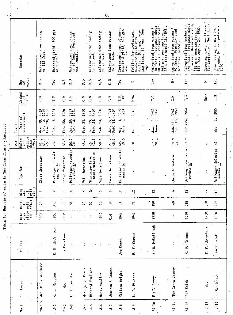
,Table 3.~'Records of wells in Tom Green.County~:Continued
Water, levelRemarks
Gal "an~ zed ir.on casingto 112 feet.
D,S
Useof
water
C,IV
Methodof
lift
Date ofmeasuremen t
Mar. 29., 1939Jan. 3, 1949Feb., 20,' 1950
Below,land
surface datum(,ft.) I II I I87.081.076.6
Aquifer
Choza formation6
Diam~
eterof
well(in. )
112
Depthof
well(ft. )
Datecom~
plet··ed
19~7
DrillerWell I' Owner
*H-I091 Mrs.·E.:C.'Adkinson
J-I A. I L.' Douglas E.' M. McCullough 1950 1 300 12 Bullwagon dolomi te I 48.6 rJan. 3" 1951member .y
T,.E Irr Reported rie1d, 300 gpmwhen d,ril"ed.
Bullwagon dolomitel 56.2 IJan. 29. 1941member.hi I 72 Jan .. 3, 1951
*J-2
J~3
do. :
L. 'J. -Jeschke
Joe Donelson 1938 85
85
6
6
Choza formation 41. 5 I Feb. 20,. 1950 C, \'/
J,E
,D,S
D,S I,Galvani~ed iron casingto 85 feet. Reportedweak suppi y.'
J·4
J-5
J-6
Mrs.' S.' E. Parmer
Richar~ Wendland
Henry Moeller 1915
70
50
70
6
5~
6
Vale formation
Standpipe lime"stone member sJ
Vale formationI
48.2 Feb. 28, 1950
45 Jan,'29, 194142.3 Feb.' 24, 1950
58.1 Feb. 24,' 1950
c,w
C,W
C,VI
,D,S
D.S
D,S
Galvanized,iron casingto 50' feet.,
. Galvanized iron casingto 70 feet.'
J-7 Jackson &Broome Old 50 6 Leona formation 37. 2 I Jan, 29.' 194140.9 -Feb: 24,,1950
C,W D,S Galvanized iron' casingto 50 feet.
U10\
J·8 Milburn Wright Joe Dusek 1948 71 12 Bu11wagon dolomite I 52<8member .y 59.6
May 1, 1950June 6, 1951
T,E,10
Irr, Irrigates about 20 acres,Reported rield, 600 gpmwhen dril~ed.
,J~9 L.' D., Richert R. :'F.• Garmon 1949 76 12 do. 50 Dec.' 1949 None N Drilled for irrigation.Reported yield whendrilled, 918 gpm; pump~
ing I eve!, 62 feet. See,log.
*Jo 10 I H.iJ.'Perry E. ·H.' McCullough 19501 180'1 12 do. 67, I I Jan. ' 3.' 195178.1 June 6; 1951
T,G Irr' I Galvanized iron casing to,40 feet., Irrigates about
80 acres.' Measured yield,963 gpin; pumping level,'85.4 feet Apri 1 18, ,'1951.
*J"ll,1 Tom Green County
*J·12 IAlf Smith R.' F.' Garmon 1949
60
218
6
12
Choza formation I 30,932
Bullwagon dolomite I 97,7member .hi,
Jan.: 16, 1941Feb., 24, 1950
Feb,; 24, 1950
C,H
, T,G
N.
Irr
Gal vanized iron casfng' to .60 feet. Formerl y usedfor rural school.
Ga.! v~ni zed,' iron casin g to170 feet: l Irrigates about80' acres.' Measured yield"642 gpm; pumping level"141 feet August 24" 1950.
1950 I' 202
J-13 I do.
J·14 I J.' G, ' Harris
F., P. - Grosshans
Henry Hudek
1950 300
12 Bullwagon dclomitel 49member l2/
May It' 1950
None
T,G
N
Irr
Reported yield insufficientfor irrigation. Well filled.'
Steel casing to 84 feet.'Not use'd 'for irrigation in1950.
'--
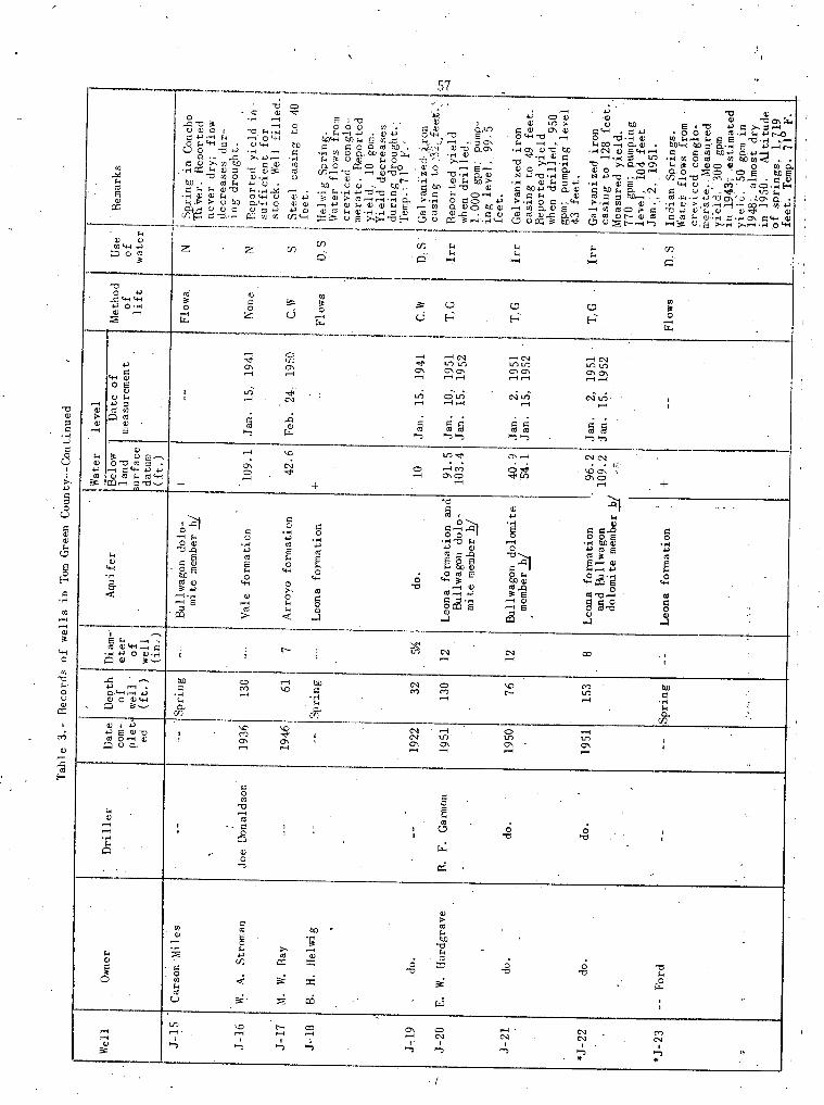
Table 3.- Records of wells in Tom Green County~-Continued
Remarks
T.G
C.W
10. 195115; 1952
15. 1941
42.6 I Feb. 24: 1950
109. 1 I Jail. 15,< 1941
10 IJan.
91. 5 I Jan.103.4. Jan.
+
Arroyo formation
Leona formation
IVale formation
I7
32 I 5% i do.
130 I "..
61 I
130 -, 12 I Leona formation andBullwagon dolo-mi te member y
Spr:i.11g I "O<wo
1946
1922
!1936
1951
Driller
Joe Donaldson
R. F. Garmon
do.
Owner
B. H. Helwig
E. W. Hardgrave
IV. A. Stroman
M. W. Ray
J~19
J o 18
J-17
J-20
J-16
Well II
I Water level
Date DeiJth IDiam-I Aquifer Below Date of I Method I Usecom-· of eter land measurement of ofiJlet well' of urface lift water I I
ed (ft.) Iwell I datum I I '(in.) (It.) I I I
I J-15 -, Carso~Miles I -- I -- Spring I ~- I Bul~wagon dolo- 1+ -- Flows N IS.(?..ring 'in Concho 1m1 te member y I 1hver. Repor ted !
, never dry; flow ii I decreases du r- "I I ing drought.
i None N IBeported yield in-1 I I sufficientfor Ijl I stock. Well filled. t
I! I
I e,. W S II Steel casing to 40 I! feet.
! Flows I D, S IHelwig Spring..j I Water flows from! -I I creviced conglo-j' I I merate. Reported
Iyield, 10 gpm.
I Yield decreasesI I during dbought.:I ITemp., 71 F.·
D. S Gal vaniz~d i,ron I, casing to'-3~;Jeet'_"'1U1
Irr IReported yield .----l
when dri 11 ed.1,000 gpm; pump-ing level. 99.5feet.
, I
*J-22 1 do.
*J-23 I -- Ford
19511 153 I 8
Irr I Gal vanized ironcasing to 49 feet.Reported yieldwhen drilled. 950gpm; pumping'level43 feet.
Irr I Galvanized ironcasing to 128 feet.Measured yiel d.770 gpm; pumpinglevel. 104 feetJan.; 2. 1951.
D. S 1 Indian Springs.\Vater flows fromcreviced conglo~erate. 'Measuredy{'eld.' 300 gpmin 1943; ,estimatedyield: 50 gpm in1948;_ almost dryin 1950. AI titudeof springs. 1,619feet. Temp. 71 F.
T..G
T,G
Flows
40,9' Jan. 2. 195154·1 Jan. 15. 1952
+
Bu11wagon dolomite, member.!Ei
Leona formation
Leona formation I, 96 ..21 Jan. 2. 1951and Bullwagon 109.2 Jan. IS,. 1952dolomite member.l!! _,~
1276
-- 'Spring' --
1950do.
do.
do.J-21
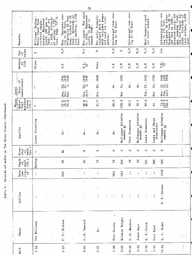
Table 3.'" Records of wells in Tom Green Countyn~Continued
I
Well I Owner Driller-~T:~te-
Icom~plet
I ed
~,,"'~"I'~-'"Depth Diam~ I
of eter Iwell of(ft. ,) Iwell
(in.)
Aqui ferWater
~-Below
landurfacedatum(ft.)
levelDate5 of
mea~urement
Methodof
Ii ft
Useof
wat;er
Remarks
Spring' ~~J,~ 24
J-25
Tom Williams
E.' P.! Dickson
1 ~e
II IlaId I
II
28 I 48I
Leon a fo rma ti on
db"
+
17.8 IJan.; 23, 194119.6 IDee. 17, 194323.4 I Dec. 9,· 1948
Flows
J,E
S
D,S
Wi Iii ams' ·'Spring. j
Water flows fromcreviced conglo~
mel'ate,'! Repor,ted 'yield" 100 gpm in1943; almost dryin 1950,' Altitudeof spring" 1.7~7feet,.,Temp.'71 F.:
Dug. Concrete cas~
ing to 20 feet.Originallr 35 feetdeep" £il ed to 28feeL' Altitude ofland surfacj, 1,738feet.r
51.17 IDec.'22,,1948
J-26
J-27
J-28
J.! W.:Tunnell
do. ,
Otto Strube Old
66
76
72
8
8
6
do. I
, do.'
do. '
48.849.:r
62.2
Dec.' 22,' 1948Jul y 3, 1949
do.
T,E, '10
None
J,E
Irr
N
D, S'
Not cased •• Not usedin 1950.' Reportedyield, 75 gpm,.insummer 1948.!
two wens formerlyequipped with 6inch cylinder pumpsand used'for irri~
ga tion.'
Galvanized iron cas~
ing to 72 feet.:
CJ100
J-29 Milburn Wright Old 162 6 Bu11wagondolomitemember .!!/
135.21May 31, 1950 C,W S
*J-30
J-31
J-32
J-33
*J-34
C.I O. Meadors
Frank Hurt
E.' F.: Holik
Carl Byrd
L.' J.! Si del R.' F.,'Garmon 1943
-
78
92
101
182
182
6
6
6
8
8
-
Vale formation
Bullwagon:dolomitemember -.Q/
Leona formation
Leona .and Chozaformations
Bullwagon dolomite,member l!J '
-
50; :r
39.9
92.6
61
71. 4121.9136.3
-
db. !
, do.-
Feb.! 27" 1950
May 31" 1950
Noy.' 10, 1948Feb~ 31, 1950July 15, '1952
-
C,W
C,W
c.w
C,W
T;E.,10
D,S
D,S
D,S
D,S
Irr
-
Galvanized iron casing to 78 feet.;
Well~formerly,usedfor rural school.'
Galvanized iron cas~
ing'to 170 feeL:Irrigates 50 acres.D~epen~d from 80 to182 feet in 1949.'Measured yield,! 4'31gpm; pumplng, level,132, feet August 24"
'1950'., Al ti tilde 0 fland surface. 1.809feet.· ..- .-
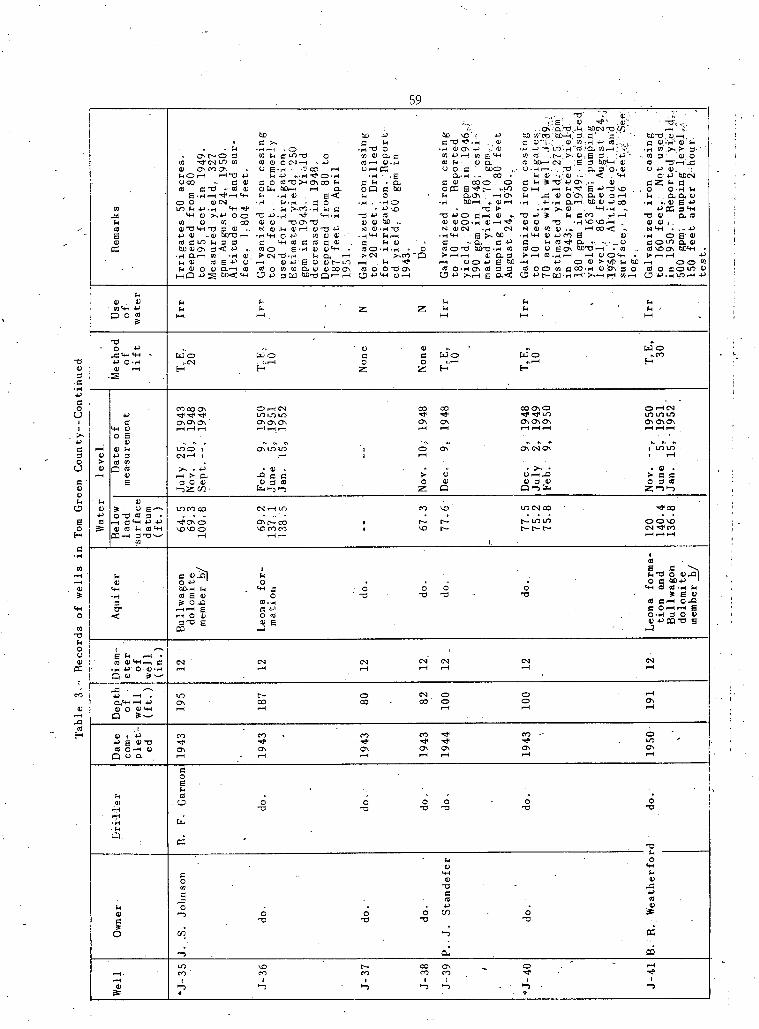
Table 30-' Records of wells in Tom Green,County~-ContiiJ.ued
Water 1evel.
Well Owner Di.+Her Datecom~
plet~
ed
Depthof
well(ft. )
Diam~
eterofwell(in. )
Aquifer Belowland
-surfacedatum(ft. )
Date ofmeasuremen t
Methodof
lift
Useof
water
Remarks
*J-35IJ..S. Johnson R. F. Garmonl 1943
J-36 do. do. 1943
195
187
12
12
Bullwagondolom1temember l!./
Leona for~
rna I;i Oil
64.569,3
100.8
69.?137.113805
July 25, 1943Nov. 10, 1948Sept. ~-, 1949
Feb. 9, 1950June 5, .1951Jan. 15, 1952
T, E,20
T;.E,10
11'1'
Irr
Irrigates 50 acres.'Deepened from 80to 195 feet in 1949.Measured yield, 327gpm August 24, 1950.
'Altitude of land sur~
face, 1,804 feet.Gal vanized iron casingto 20 feet.' Formerlyused fOT irrigation.Estimated yield, 250gpm in 1943. Yi~ld
decreased in 1948,Deepened from 80 to187 feet in April1951.
*J- 40 I do. '
J - 39 IP., J. 'Standefer
J-41IB. R. Weatherford
67.3 INov, 10,; 1948(Jl
\0
Galvanized iron casingto 10 feet. Reportedyield. 200 gpm in 1946~t190 gpm in 1948;esti~"
mated yield, 70 gpm.pumping level, 80 feetAugust 24, 19'50.,
Galvanized iron casingto 10 feet: Irrigat€i'\:70 acres W1 th well J~';39,.i
Estimated yield;: 275:'gpin'in 1943; reporte'dyi'e,l-d'180 gpm in 19'49;- ineasu'redyield, 163 gpm;piImpirigle.vel, 86 !eet Au,gust :24;,.;"19-50. s Alt1 tude, '? (1 ~!l:dsurface.' 1.,816 feet,.';: 'See'1
, ,,'0, • ,
og. ,Galvanized iron casingt6 160 feet. Not usedin 1950. ~ Reported yi'eld."500 gpll); pumping" level,? ,150 feet after 2~hol!r' "',test.
Galvanized iron casingto 20 feet.' Drilledfor irrigation. 'Reported yield, 60 gpm in1943.
I
Do.N
N
11'1'
11'1'
11'1'T, E,30
Tig,
None
T,E,10
None
9, 19482, 19499, 1950
Dec.JulyFeb.
Dec.' 9, 1948
Nov. --, 1950June 5,' 1951Jan. 15, '1952'
77.6
77.575.275.8
120140.4136.8
do. ,
do.
do.
do.
Leona formation andBullwagondolomitemember .1U'
12
12,
12
12
1280
191
100
82
100
1950
1943
1943
1944
1943
do.
do.
do.
do.
do.
do. '
do. '
J- 38
J-37
'or

Table 3"~ Records of wells in Tom Green County--Continued
-- _.-_.~.
. ..,.... _4. _ ... --,. -
,I ' I'-~--~'-
Water 1evel
Well Owner . Driller Date Depth Diam- Aquifer Below Date of Method Use Remarkscom- of eter land measuremen t of ofplet- well of surface lift water
ed (ft. ) well datum{in. ) (ft. )
J-42 B,'R.' Weatherford R. F., Garmon 1950 191 12 'Leona formation 120 Nov.' --, 1950 T,E, Irr Galv~ized 1ron casing toan? f3t;!llwagon 140.4 June 5. 1951 30 160 feet. Not used indo,wm1te 136,8 Jan. 15;' 1952 1950. Reported yield. 500member Y ~m; pumping level. 150
eet after 2-ho'ur test.
J-43 W. i H., Lane do. ' 1950 182 12 do. 120 June --,I 1950 T.E. Irr Galvanized iron casing40' from 90 to 182 feet. Irri-
gates about 80 acres., Re-ported yield., 680 gpm;pumping le.vel', '172 feetafter 2-hour test.,'
J-44 B.' R.' Weatherford do .. 1949 146 12 do. ' 120.7 Apr.' 18" 1951 None N Galvanized iron casing to123.8 Jan.: 15:: 1952 130. feet. Irrigated about
80 'acre's in 1950.. Northwell of two formerl h, equipped with 6-inc cylin-der pumps.' Redrilled 1n1949. Measured yield,: 515gpm August 23, 1950.
*J-45 J. H.: Sims do.' 1947 101 12 Leona formation 73.4 Nov,' 9, 1948 T,E" Irr Galvanized iron casing to75.1 July 3. 1949 25 6 feet., Irrigated 16574.4 Mar. ; 1.; 1950 acres with well J-48 in
1950.. Reported yield,' 800gpm in 1947; measured yield,- 532 gpm; pumping level, 92feet August 24.,1950.
*J-46 H.' 1. "Sims do.,' 1950 155 12 Bullwagon dolomite 112 Nov., -~, 1950 T,E, Irr Steel casing cemented frommember J!J 137. 5 May 31; , 1951 25 63 to 128 feet. Not used
131. 4 Jan.: 15,' 1952 in 1950. Repo~ted yield"850 gpm; pumping"leveL 117feet after '~?"llour test..
*J-47 J.'H.' Sims R. Medlock 1926 90 10 Leona forma tion 63.1 Aug;! 12, 1943 None N Two well s formerly equipped.71. 3 Nov.' 9,,1948 \with 6-inch cylinder pumps
and used for irrigation.,North well equipped wi th. turbine pump from 1943~1948.
IMeasu red yi el d, from northwell, 282 gpm Sept. 14,; 1953.
- 1 1943 Irrigates with well H-45. Re-J-48 H.' 1. : Sims R. F.' Garmon 97 10 do. 63.2 Aug. "18,' 1943 T,E, Irr72 Nov. 9, 1948 ' 15 ported yield: 325' grm ~~ 1943~'72.3 Mar. 1, 1950 and 250 gpm 1n 1948.Alt1tude··~:-
/ of, land surface, 1.804 feet.See log.· "
J-49 do. R. Medlock 1926 155 12 do. ' 60 Aug. '12., 1943 None N Drilled for irrigation. Re-68,9 Nov. 9, 1948 ported yield insufficient
for irngation.,
J-50 J, H,' Sims R. F.' Garmon 1946 92 8 do. 68.1 Nov. 9. 1948 T,E, Irr Gal vani zed i ron casing to6;;' 6 feet. ' Irrigates about 5
acres.' Reported yield, 150I ..
I ,_. -.t- _ gpm ·in 1948. c .---- _._--- .-
..-. ..-. ..-. .- .- .- .- -.
0\o
-.
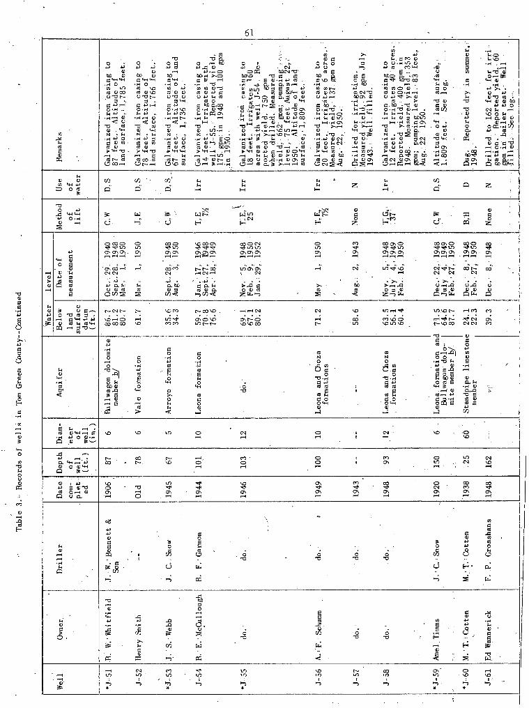
Table 3.~ Records of wells in Tom Green County~-Continued
Water level
OJ-51 lB. W;'Whitfield I D, S I Gal vani zed iron 'casing to87 feet., Altitude ofland surface, i 1,785 feet.'
, Well Owner Driller
J 0' W.· Bennett &Son
Datecom- ,plet
ed
1906
Depthof
well(ft". )
87
Diam'eter
ofwell(in. )
6
Aquifer
Bullwagon dolomitemember l!/
Belowland
surfacedatum(ft. )
86.781. 280.7
Date ofmeasu remen t
Oct .• 29, 1940Sept.28o 1948Mar. 1, 1950
Methodof
lift
CoW
Useof
water
Remarks
1, 1950J-52 I Henry Smith
oJ-53IJ,'S.'Webb J. C.. Snow
Old
1945
78
67
6
5
Vale formation
IArroyo for:nation I
61.7 .J Mar.
35.6 ISept. 28, . 194834.3 Aug. 3, 1950
J,E
e,w
D,S IGalvanized iron casing toi 78 feet. Al ti tude of
land surface", 1,766 feet.'
n, So ,I Gal vani zed i ron casing to, 67 feet. Altitudeofland
surface,' 1,736 feet.
J-54 I R.' E.' Mc~llough 1944 I 10.1
Irr*J- 55 do. '
R. F.' Garmon
do. 1946 103
10
12
Leona formation
do.
59.770.876.6
69.167.180;2
Jan.' 17, 1946Sept.27, 1948Apr.' 18, ' 1949
Nov. - 5. 1948Feb. 9: 1950Jan. 29; 1952
T,E7Y.
T;E. \25'
Irr I Galvanized iron casin~ to14 feet. Irrigatesw1thwell'J-55.' Reported yield,175 gpm in 1948 and 100 gpm
.in 1950.
Gal vani zed iron casing to18 feet. ' Irrigates 160acres wi th wel1 J ·54 Reported yi el do' 750 gpmwhen drilled.:Measuredyield;, 662: gpm; pumping' ",\,,!
level,. 75 feet August 22"1950. Al ti tude of landsurface, . 1,809 feet.' 0
0\
"""'
J-56 IA. "F. Schumm do. 1949 100 10 Leona and Chozaformations
71.2 May 1, 1950 T,E, '7Y.
Irr Galvanized iron casing to20 feet. Irrigates 6 acres.Measured yield,' 137 gpm onAug. 22, 1950.,
oJ-59 IAmel Timms
°J-60 I M.'T.: Cotten
J-57
J-58
J~61
do. '
do .•
Ed Wanneri ck
, do. i
, do.'
J. c.: Snow
M.' T.' Cotten
F. :,P .. Grosshans
1943
1948
... 1920
1938
1948
93
150
25
162
12
6
60
Leona and Chozaformations
Leona formation andBull.wagon· dolo- Imi te member 1?1
Standpipe, limestonemember
';';'
58.6
63.556.160.4
71.564.687.7
24.122.3
39.3
Aug.; 2,' 1943
Nov. 5,' 1948Jul y 4, ' 1949Feb.' 16, 1950
Dec.' 22,. 1948July 4, 1949Feb.' 27, 1950
Dec.' 8.' 1948Feb.!27; 1?50
Dec.' 8,,1948
None
T;G.,:'31
,e,w
B;H
None
N
Irr
D,S
D
N
Drilled for irrigation.Measured yield,. 92 gpm July1943.: Well, filled.
Galvanized iron casing to12 feet. Irrigates 40' acres. 'Reported yield" 400 gpm in1948. Measured yield, ~ 353gpm; pumping level" 83 feet,'Aug. 22 1950.
Al ti tude of land surface.'1,809 feet. ' See log. .
Dug. Report~d dry in summer", 1948.
Drilled to 162 feet for irrigation., Reported yield" 60
. gpm iIi, bailer test.' Wello filled.· See log. '.

Table 3. Records of wells in Tom Green County--Continued
I
I I Date Dep th IDi aJIl'
Water ,levelWell I Owner Driller Aq'ui fer Below I Date of IMethod I U~e I Remarks
. com~ of rctcr 1and measuremen t of 01DIet.. well of surface lift water. ed (ft.) well. datum .
(in. ) (ft.)"
'J-62 Ed Wanneri ck Tom Holmsl ey 1927 38 5 Standpipe lime- 28. '1 Oct. 29. 1940 J,E D,S I Galvanized iron casingstone" member to 38 feet.
·J-63 O. , M. ' Droll -- -- 67 5 do .. 44.2 Dec. B. 1948 C;W 041. 5 Feb.! 27;' 1950
'J-64 I Mrs.' O. L.' Frasure R' F.' Shank 1948 103 6 ,do. ' 36.9 Nov. 3;, 1948 C,W , S Galvanized iron casing35.5 Feb.' 27, I 1950 to 103 feet. Reported
weak supply.' See log.
J-65 I J.' P. ; Johnson I -- I Old I 74 I 6 IO!oza formation I 53.6 Dec.' 22; 1948 C,W D,S Galvanized iron casing. 47.7 July '~t' 1949 to 74 feet. Altitude52.5 Feb.' 27, ' 1950 of land surface, 1,183.
faet ...J .. 66 I Jeff JohnGon I R.' F.; Garmon I 19461 801 12 I Leona formation ! 57.4 I May 31, ' 1950 T.E" 11'1' Galvanize~ iron casing
10 to 10 feet. Irrigatesahou t ,1,0 acres wi thwells J -67. and J-68.·Reported weak supply.
J .. 67 I do. I do .. I 1946 I 81 I 12 I , do. ' I 56.9 I do. I T,E, I 11'1' Gal vani :!ed iron casin g I~10 to 10 feet. Reported
weak supply ••
J-68 I do. I do. I 1946\ 80 I 12 do. I 56.7 do. : Tt E.t I '11'1' DO.10
J-69 I Wylie Pate I do. ' I 1947 I 116 I' 12 Leona and Choza I 59.2 Nov. 5,' 1948 T,G, I 11'1' I I~rigates about 45 a7resformations 45 wl.,th well'Jc 70; Estl.-
mated yield,' 100 gpmAugust 2"1" 1950.
'J-70 I' do. I do. ·119431 140 I It,/ do.,. I 49.1 /Aug.. 2,,1943 IT8~' '/11'1' I Steel casing to 20 feet.
'Diameter of. well, 14,inchesctodehth of 116feet,: 12 inc es from
, , , depth of 116 to 123. feet,'/ , ,
, and 6 inches from depthof 123 feet to 140 feet.Measured yield, 450 gpm;pumping level, 54 ieetJ':Ilr 22" 1943., Rep~~ted
i I I I ! I Yl.e d,' 79 ~m Aug. "'~J
I 1950. Altl.tude of landsurface" 1,808 feet.See. log.
*J-71 I do. ' I do. ' I 1943 I 117 I 14 I do. ' I 46. ;) Aug. 2, 19,n T,G, N Steel casing to 20 feet.'56.3 Sebt. 27, 1948 80 Dri 11 ed for i rri ga tion. '54.9 Fe .' 16, 1950 Measured yield, 450 gpm;
pumping level, 53 feetJuly 26" 1943.' Reported
I I LLI II yield" insufficient for
l.rrigation. after 1948.
L Altitude of land surface,1,806 feet. - See log.
.- -- -- - - "

Table 3.~ Records of wells in Tom Green County~~Continued
'"
,0\W
Do.
Gal vani zed iron! casin gto 48' feet;, ..
Qrilled 'for irrigation.;.'
North well 'of two' for..;merly equipped with6~inchcylinder pumpsand used for irriga~
tion.' Southwelldrilled in 1928., Bothwells sealed and notused since 1942,"
Steel casing to 20feet."Alti tude oflanl~urface,. 1,799fee't,! .',
'Galvanized iron casingto 81 feet.' 'AI titudeof 1and surface. : 1.819feet> " " .. "
Not cased. Drilled foriDrigation~' Reported
, yield insu"fficilmt forirrigation,;
D,S
D,S
N
Irr
Irr I 'Reported weak supply in1951.;
D,S
Irr
. Irr
C,W
CrY{
T,G
T,G I I rr I Ga:lV'ani zed iron casillg, ~o no feet. ' ,
T,G Irr Steel casing to 121feet.
T,G Irr Steel ,'casing to 150feet..." "-"
IT,G I Irr
J.E
T;G
T,.G
T,G:
None
-T;G'~ITrr
Apr;, 18,' 1951jan. 15,: 1952
June 21,; 1951Jan. 15, 1952
May 1" 1951
Apr.' 19, 1951Jan" 15, 1952
Apr; 19,; 1951Jan.' 15,' 1952
June 5. 1951Jan. 15;, 1952
Aug,.y5. 1943Dec~:: 10,. 1948Jury, 4,-, 1949
Nov., i" 1940Dec~i 22; 1948
, Feb.; 27" 1950
24.,3 I Oct. ;31, ' 1940
67.169.268.4
115.9, I Jan.: 15, 1952
134~,~ IJune 6,: 195h130.9 Jan. 15,' 1952
Water levelBelow Da 7eof, " Method I Use,hind measur'ement, of of'lurface lift ,water:datum(ft. )
, 56" 7~V., '5, 1948 T3~'! I N,
30.2 I Noy.' 18, 1940 None I N'
136.6136.~
29.235;}
"'30'~:7
,:ieonafb~~Rtion.an
.:~.~t¥~~~if]j~/,3",go,-,L-.
1280,
5~
1924
Date Dtipth'I>iam~·com",'of?," 'et~rple~~well 0.£
ed lfC.} well', '" '" . (in;)
1924
'~' 1'1951 '-130"1--12 ~I -'-"d6.'
do.
Driller "
do. ; I 1951 I 186
wrtis Drilling I 1951 1170:' b12Co.
F. P,iGrossllans I 1951 I~~' 'IE1951148
R. F.:GaqRon
R. F. Garmon 1951
do. 1951
do. 1951'c
do. 1951
do. I 19511179
do.
, do,
,'O!Der;".,";
J~86'I'c:arl. Byrd"
J-83 I J; W.; Clark'
J~7i I Carson Miles
J';78 I R.' R.'Hoel scher
J-81.1 John Balch'
J~79 I Otto Strube
~~80
J~74
J-84 IPete Clark
'J-85 'B. rR. Weatherford
"J~82 I W. :B.' & G.· L.Weatherford
*J~751 J.·S.'Powell
*J~76 I W.·L.; Griffi th
*J-73 I C. E.; Mayes Estate I E. E. Kinsey
J~72 I Wylie Pate
Well.-;". J
'111, ;'31' Jimec
'2 1;-. 1951IlL 2 Jan., 15. 1952
I' I , I - I _~_,.__~. __;__ . ~__ .~_'-,,-_'______ J~_--,- '_·_..""""'-':'. __~ I__;... I J
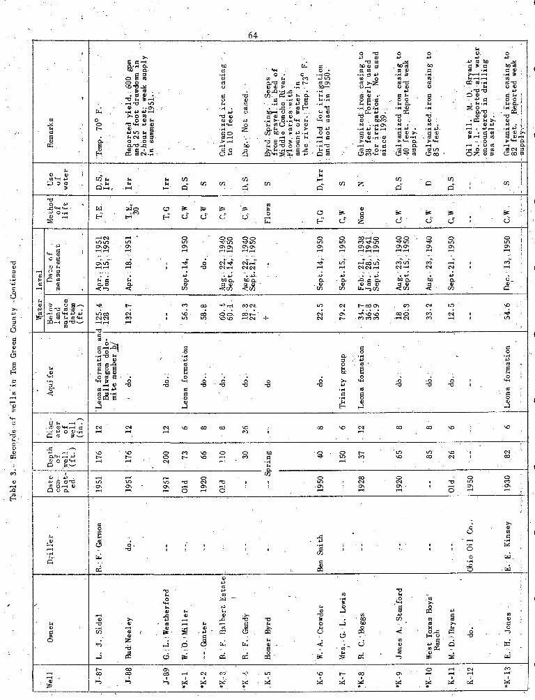
Table 3.'"Records of wells' in T6m GreenCounty~-Continued
RemarksUseof
water
Methodof
lift
Date ofmeasuremen t
, levelWaterBelowland
surfacedatum(ft. )
Dr-Urer(}wnerWell D;'. ID"~<h Dieo" I Aq.if.,
I~ I.' , ~l:~- 'vl~ll e~fr~,
ed· (ft.) well., (in.)
I J-87 L.J.I$del R.~I~~on ~51 1761; ,·L~e~o-n-a~f-or~·m-a-t-i-on~a-n+d--1-2-5.-4~~~-r-'-i-1-9-.-'1-9-5-1~~~~~~~~~~-e-m-p-.-7-0-0~F-.-:~~~~~~1Bullwagon dolo-j ,128 Jan.: 15, 1952mi te member .y
J-881 Bud Neeley do. 1951 1 176 12 do. 132.7 I Apr. 18., 1951 T,E,30
11'1' Reported yield,: 600 gpmand 25 foot drawdown in2-hour test; weak supplyin summer 1951. -
J-891 G.! L;: Weatherford 1951 I 200 12 do. T,G I. 11'1'
*K-l 1 W.IO. i Miller Old 73" 6 Leona formation 56.3 I Sept. 14, ' 1950 C,W D,S
*K-2 1 --- .Gunter 1920 66 8 do. 58.8 I do. c.,w S
*K-3 R. F. Halbe!'t EstateI
Old 110 8 dn. ' 60.460.1
.i\"ug. i 22, InOSept. 14,; 1950
G1 '!i S Gllivanized iron casingto no feet.
'*K~4 I R. F. Gandy 30 36 do. 18.3 I· Aug. 22,; 194027.2 Sept. 21, 1950
Gi'N I'D,S Dug. '.' Not cased.0\>f».
, K- 5 1 Homer Byrd ,.- Spring
K~6 W."A.' Crowder
~
Ben Smith 1950 40 8
do
do.
+
22.5 Sept. 14,: 1950
Flows
T,G
S
D,I'rr
Byrd, Spring. Seeps .from grayel. in' bed ofMiddle Concho, River.-Flow.varies·wi thamount of water inthe river. Temp.' 730 F.
Drilled 'for irrigation, and not used in 1950.
79.2 ISept.IS., 1950 I C,WK-7 IMrs,' G," L. Lewis
*K-8 R. C.'Boggs 1928
150
37
6
12
Trinity group
Leona formation 34.736.836.9
Feb: J 21, I 1938 I NoneJail. 28.,,1941Sept. IS, 1950
S
N Galvanized: iron. casing to38 feet. Fo~erlyused
{ for irrigation., Not usedsince 1939.
*K-9 James A. Stan'ford 1920 65 8 do. i820;8
Aug~' 23, 1940Sept. 15, "1950
C;W D,S Galvanized iron casing to.40 feet. Reported weaksupply.
*K-IO! West Texas Boys'Ranch
85 8 I do.' 33.2 I Aug. 23,' 1940 I C,W D Galvanized.iron casing to85 feet. '
K-ll I M.iD. Bryant Old, 26 '6 do. i 12.5 ISept.21,'1950 IC,W D,S
*Ko 131 E.' H., Jones
1950, --
·1
K-12 do. Ohio Oil Co. i
E. 'E. Kinsey 1930 82 1 6 . Leona formation 54.6 De,c. 13".1950 C"W
Oil well., M. D.,'SrrantNo.' 1. Reported al water
. encountered in drillingwas salty.
S I GalVanized iron casing to82 feet., .Reported weak
~- --, - ·supply-.-··-· ----.•
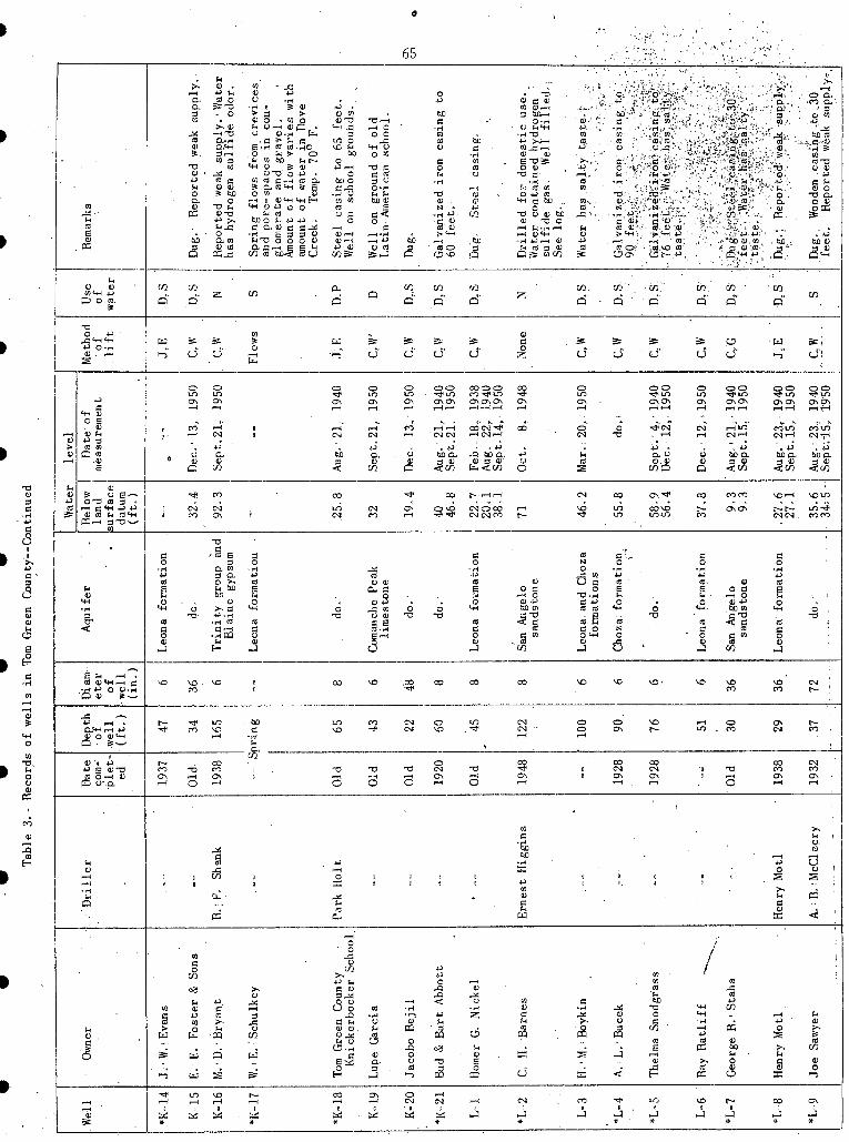
• • • • • • .. .. .. .. ..Table 3.~ Recor9s of wells in Tom Green County~~Continued
Well oWner ,"Driller0,ate IDeRthcom-' " of'plet~well, ed . (ft, )
lliamJeterof
'well(in. )
AquiferWater
Belowland
lSurfacedatum(ft. )
levelDate of
measu remen tMethod
oflift
Useof
water
Remarks
Trinity group ~ndl 92.3 I Sept.n. 1950Bl aine gypsum
*K~141 J,' W.' Evans
K~15 I E.' E. Foster & Sons
K~16 I M.· D.' Bryan,t R.: F. Sh9Ilk
1937
Old
1938
47
34
165
6
36
6
Leona formation
do. 32,4 I Dec.' 13, 1950
J;E
C,W
C,W
D,S
D,S
N
Dug. Reported weak supply.
Reported weak supply. ' Waterhas hydrogen sulf1de odor.
*K-17 I W.rE. 'Schulkey
*K-18 I Tom Green County I Park HoltKni ckerbocker School,
Old
Spring
65 8
Leona forma tiOH
do. '
+
25.8 I Aug.' 21, 1940
Flows
j,E
s
D.P
Spring flows from creV1cesan d po re- sp aces in COll
glomerate and gravel.Amount of flow varies withamount of water in DoveCreek, Temp, 700 F.
Steel casing to 65 feet.Well on school grounds.,
K-19 I Lupe Garcia Old 43 6 Comanche Peaklimestone
32 Sept.21, 1950 c, W' o Well on ground of oldLa tin-Aineri can school,
K~20 I Jacobo Bejil Old 22 48 do. ' 19.4 I Dec. 13,' 1950 C,W D"S Dug. 0\U1 G
1948
46,2 I Mar.: 20, 1950
*K-·211 Bud & Bart Abbott
L-l I Homer G. Nickel
*L-2 I C, H. 'Barnes
L-3 I H,'M.,BQykin
f ~=
Ernes t Hi ggins
1920 'I'
Old
I'
60
45
122
100
8
8
8
6
do.
Leona formation
San Angelosandstone
Leona, and Chozaformations
4046,8
22.720,138,1
71
Aug.' 21, 1940SepL 21, 1950
Feb .. 18, 1938Aug, 22, 1940Sept, 14" 1950
Oct. 8, 1948
C,V!
C,W
None
C,W
D7 S
D. <:'fr.J
N
D,S
Galvanized iron casing to60 feet.
Dug. St8el casing.
Drilled for domestic use.Wa ter con tained hrdrogen ':sulfide gas, 'WeI filled' iSee log.,
Water ~a:~ saJt,Y taste. '.,:':: .~- :~~}'.~: '.,
*L-4
*L-5
A.; L.· Bucek
Thelma Snodgr'ass
1928
1928
90
76
6
6
Choza, formation
. do.'
55.8 I do.!
58.9 I Sept.'4,' 194056.4 Dec. 12,; 1950
C,W
C,W
D,S,
D,S.
Ga.1 vani ,z~d .i ro!!' casing>:tp'
L-6
*L'7
*L-8
"L-9
Ray Ratliff
George R.' Staha
Henry Motl
Joe Sawyer
~.
Henry MotI
A. , B. : McCl eery
-~
Old
1938
1932
51
30
29
37
6
36
36
72
Leona formation
San Angelosandstone
Leona' formation
do.
37.8 I Dec.' 12, r 1950
9,3 I' Aug. , 21" 19409.3 Sept. 15. 1950
,27.6 Aug.:23,,194027.1 Sept.15, 1950
35.6 Aug.. 23, 194034,5, Sept;i5; '1950'
C,W
C,.G
J,E
C.W
D,S'
D,S
'D,S
S
·f'·
Dug.]
Dug., Wooden cas{hg .to ,30feet. Reported weak supply~,
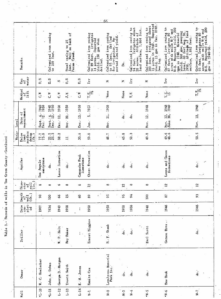
Table 3.~ Records of wells in Tom Green County~~Continued '
Remarks
Galvanized iron casingto 100 feet.
D,S
S
D,S
Useof
water
C,W
c,w
.C,W
Sept.. 4,0 1940Dec. 12" 1950
, 22.5 Sept.: 4, 194025; 3 Dec.' 12" 1950
32.2 Dec.' 12" 1950
do.· .
Leona formation6
8
661949
1934 I 100
Driller
W.' P.' Holt
Owner
W. ' C. ' Hoel scher
I Wat~r . level
0"'" I""'" II Diam.- '. AqUife.. r Below I Date of . Method. com' o':f Ic tar 1and me,asu r511en t ? fplet~ well of surface . hfted (ft.) well datum
I .I-+-~~~ ~~-+~'~~:)':'~~:~Angel:---'-r( ~~:~sand;stone '75.8
L-12 I George:D. \ Morgan
*L-IO
Well
*L-11 I John, A.' Debus
L-13 I Truett Smith Roy Baker 1950 2,5 8 do. 11 Mar.. 20,! 1950 J,E D,S I Steel casing to 25,feet. Well on bank ofPecan Creek.
L-14IE. H.:Jones 60 6 Comanche Peaklimestone
30.6 I Dec.' 13,.1950 C,W D,S
M-1 I Emmi tt Cox
M,· 2 I Lamhaven. MemorialPark Inc.'
Ernest Higgins
R.o; F. ' Shank
1950
1950
89
95
12
8
QlOze, formation
di>.
50.0 lJun. 5,,1951
48.7 I Mar. 31, 1950
T,E,7~
None
Irr
N
Gal vani ~ed iron casin gto 89 feet. Irrigates14 acres. Reportedyield, 150 gpm whendrilled.
, Gal vanized iron casingto 95 feet. Drilledfor irri!l'ation.· Reported hmi ted yield.'
~
•, M-3 do. do .. 1950 95 12 do. 45,8 do. ' None N Do.
M-4 do. ' do. , 1950 94 8 do. 50.3 do. ' T,E Irr Galvanized iron casing to94 feet. Irrigates about20 acres. Altitude ofland sU,rface~ 1,864 feet.:
*M- 6 I Ben- Book 12 I Leona and Chozaformations
N*M-5 do. ' Earl Scott
Garmon Bros.
1948
1946
100
87
8 do. ' 49.8 I Nov. 12, 1948
49.6 INov. 12; 194848. 6 Jiine 30~' 1949
None
T,E"15
Galvanized iron casing. to100 feet. Irrigated about15 acres in 1949.· .Reportedyield.,' 15 gpm in Dec. 1949.'See log. ,. .
Irr I Gal~anizediron casing to87 feet.' Irrigates 80
I acres. wi th well"s M-7 andi M-8. Reported yield,' 200i'-gpm in 1948., Measured
rield" 360 gpm; pumpingevel, 60 feet Aug. '30,.
1950. Altitul}'eof landsurface, 1,862 feet.'
M-7 do •. do. ' 1946 93 12 do. :
\
50. 5 I Nov. 12, 1948
\
T,EL I Irr7~
Gal vanized..iron casing to93 feet.' Irrifates 80 'acres wi'th weI s M-6 andM-8. Reported yield,. 200
. gpm in ·1948~50.
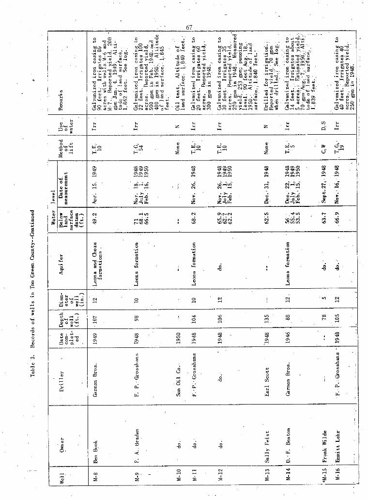
Table'3.~ Records of wells in Tom Green, County--Continued
---~--,---- , I I Water level " i
Well 1 Owner I Driller IDate Depth Diam- Aquifer Below Date of, IMethod IUse I Remarkscom- of eter land measurement of ofplet- well of surface lift water. ed (ft;) well datum
(in.) I (ft.)
M-8
M·9
Ben Book
F. A., Braden
Garmon 8ros.
F. P.' Grosshans
1949
1948
107
98
12 rLeona and QlOzaI '0='''='.II
10 ILeona formation
49.2
7168.166;5
Apr. 15. 1949
NOI. 18. 1948July 1~ 1949Feb. 16, 1950
T,E.10
T,G,, 54
11'1'
11'1'
Galvanized iron casing to90 feet; Irrifates 80acres wi th weI s. M-6 a,ldM-7. Reported yield, 200gpm Jan. 4,. 1949. Al ti··tude of land surface.1,862 feet. See log:
Galvanized iron casing to22 feet. In-igates 100acres. Reported yield,50'0 ,gpm in-Feb. 1948, and400 gpm in 19 50 ~ Al ti tudeof land surface.· 1. 845feet.' -,
M-I0
M-ll
do.
do.
Sun Oil Co.'
F.' p;. Grosshans
1950
1948 104 10 Leona formation 68.2 Nov. 26, 1948
None
'Ti5"N
11'1'
Oil test. Altitude ofland surface, 1.840 feet.'
Galv~qized iron casing to20 feet. Irrigates 60acres. Reported yield,300 gpin in 1948 ...
0\---l
M-12 I do.
M-131 Sally Feist
M-14 I D.' F.' Benton
*M-15 I Frank Wilde
do.
Earl Scott
Garmon Bros.
1948
1948
1946
106
135
88
78
12
12.
5
do.
Leona formation
do. '
65~ 962:762.2
62:5
5655;453.5
63.7
Nov. 26; 1948July 1, 1949Feb. 15, 1950
Dec., 31, 1948
Dec. 22~ 1948July 1; '1949Feb.' 15, 1950
Sept. 27" 1948
T:E,10
None
T,E,'; 5
c,w
11'1'
N
11'1'
D,S
Galvanized iron casing to30 feet. Irrigat~s 35acres. Reported' yield"270 gpm in 1948., Measured
rield,,253 gpm; pumping. evel, 90 feet Aug .. 18.,1950.- Altitude of landsurfa'c,e,,' 1. 840 "feet.;
Drilled for irrigation.,Reported yield,' 70 ,g'pin 'when drill,:d.J See log.;
Gal vanized iron' ~a~{ng to14 feet.: Irrigates about5 aCreS.i Estimated yield"70' gpm' 'Aug. '7, :,19,50',; Ai ti~·
. tude of land ·surface. '1',839 feet. ,,'
M-16 I Emmitt Lehr
I ' --
, F.' P., Grosshans -I 1948 105 12 do." ,66.9 Nov., 16,' 1948 T,G,'19
11'1' Galvanized iron casing ~o
40 feet., Irrigates 40acres., Reported yield"250 gpinin 1948.
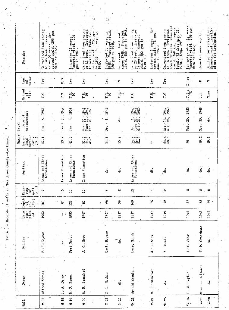
Table,3.~ Records of wells in Toni Gr~enCounty-~Continued
Galvanized iron casingto 145, feet. Irrigates 50 acres. Reported yield, ;200 gpmwhen drilled.
lrrLGLeona and Chozaformations
71811950R. F. G~l"monM-17 I Alfred Werner
'Well
~~. I " ,----,-'-1---'- iWater ,level
Owner I D:riller I Date Depth Diam"' ,AqllifeT, BelOW" Date of IMethoq I Use. I 'Remarl~scom" of IOlLer land meaSUi"ement I of ,of
, plet~ well I' of. SU i'fa. ..::e lift watered (ft.) well datum
I • (in.) (ft.) I I' I - I I I I IT·
57. I I Jan., 4. 1951
M" 18 IJ.' A.' Debus, 87 5 Leona formation 53.9 I Jan." 3, 1949 C,W DtS
M-19 IR.' F. Brown Fred Scott 1950 I 120 10 Leona and QlOzaformations
48.4 I Jan. 4,,1951 T,E,10
Irr Irrigates 25 acres.Reported yield" 200
'gpm in 1950.
M-20 IR. E. Stanford J. C.. Snow 1947 82 10 Choza formation 52.344.645;7
Noy. 30> 1948June 30', 1949Feb. 20, 1950
T,E,10
Irr Galvanized iron casingto 81 feet. Irr-igated15 acres in 19,18.' [\e-'ported yield, 250. gpmin 1948. Not used in1950. '
M·,21
M,22
Ie.
I
L. Boykin
.do.
Doyle Rogers
tdo.
, 1947
1947
'?6
98
8
8
do.
do. '
54~2
55.2
Dac. 1, 194.8
do .
T,G,10
T,E,5
II"!.'
N
Irrigat~d 25 acres in1948., Reported yield,250gpm in 1948.
Not cased. Notlusedsince 1948. Reported,yield, 100 gpm in 1948.
0\00 '
*M~23 IArnold Brenik Henry Hudek 1947 100 13 Leona and Chozaformations
54.252.552.8
Dec. 1. 1948June 30; 1949Mar.i20, 1950
T,G lrr Galvan1zed'iron casingto 20 feet., Irrigates69'acres. Reportedyield"300 gpm in1948- 50.
M-24 IW.: F.' Stanford J.' C.' Snow 1941 I 75I
8 do. T,E,5
Irr Irrigates 6 acres. Reported yield., 75 gpmJan. 1, 1949.
TtG I Irr
T,E; I D,lrr7~
*M~25 I do.
*M-26 IR.'W. Taylor
M-27 IMrs.! -- Halfmann
A. 'Brenik
J. C.' Snow
F., P. Grosshans
1949
1940
,1947
92
75
68
12
8 II
8
I
do.
do.
do.
64.4 IApr.' 15. 194968.6 AUg. 28; 1950
50 I Feb. 20, i 1950
49.3 I Nov. ?Ot' 1948 JtE D
Galvanized iron casingto 15 feet., Irrigatesabou t 60 acres. Measuredyield., 460 gpm; pumpinglevel" 72 feet ~g. 28 t1950.' Temp. 69 F.
Irrigates about 12 acres.Reporteq yield, 250' gpmwhen drilled.,
Reported weak supply.
M-28 do. do. 1947 69 8 , do. 49.3 do. None N Drilled for i~rigation.
Reported yield insufficilmt for irrfgation. ,
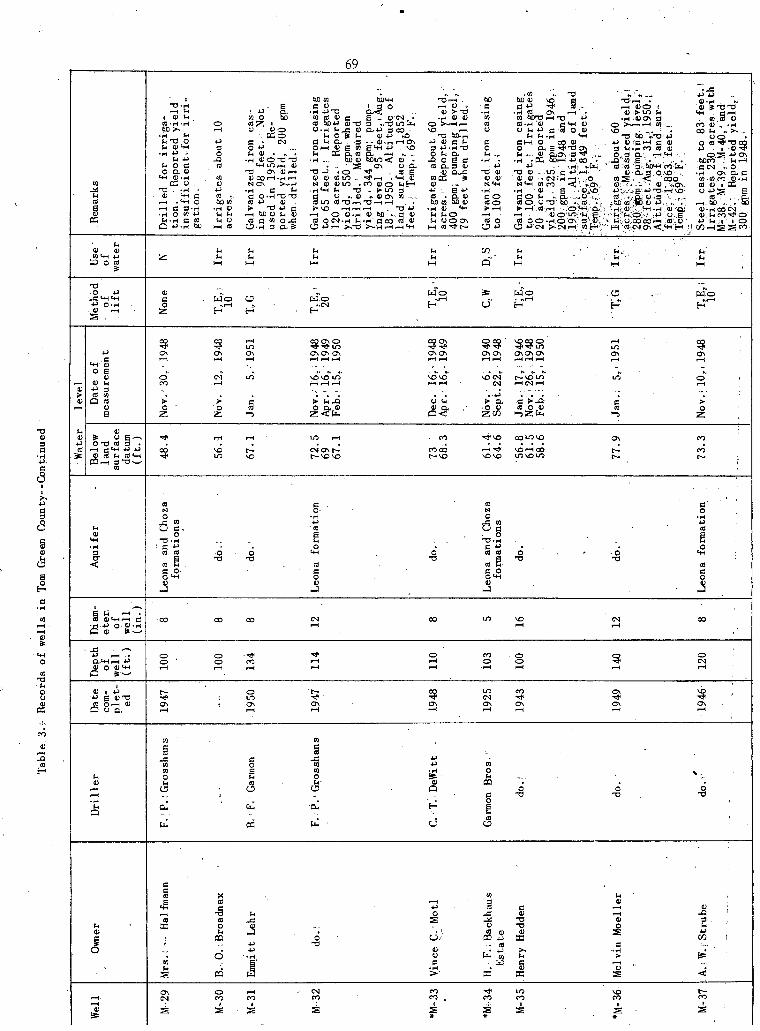
Table. 3.~ Records of wells in Tom Green County~-Continued
, Water level
Well Owner Driller Datecom~
plet, ed
Depthof
well'(ft, )
Diameter.of
well(in. j
Aquifer Belowland
surfacedatum(ft. )
Date ofmeasuremen t
Methodof
lift
Us'e'of
water
,Remarks
M-29 I Mrs.: -~ Halfmann F.! P.: Grosshans 1947 100 8 Leona and QlOzaformations
48.4 I Nov.! 30,' 1948 None N Drilled for irrigation. Reported yield'insufficient. for irri~
gation.'
M-30 I B.·, O. : Broadnax
M-31 I Emmitt Lehr R.· F.' Garmon
100
·1950 I 134
8
8
do. '
'. do.'
56.1 I Nov.' 12, 1948
67.1 I Jan. 5,:1951
T,E,.!10
T,G
Irr I Irrigates about 10acres,.
I rr I Gal vani zed i ron casing to 98 feet.' Notused in 1950.' Reported yield, 200 gpmwhen. drill ed. !
*M-33 I Vince C.' Motl Irr
M~32 do. ! F. ; P. ' Grosshans
C. 'T:' DeWi tt
1947
1948
114
110
12
8
Leona formati(:m
do. ;
72.56967.1
7368;3
Nov.; 16.; 1948Apr.! 16; 1949Feb.' 15,: 1950
Dec.: 16;! 1948Apr.! 16,· 1949
T,E, '20
Ti~"
Irr I Galvanized iron casingto 65 feet.! Irrigates120 acres.' Reportedyield, 550 'gpmwhendrilled.! Measuredy~eld" 344 gpm; pumprng level 95 feet,1 Aug.'18,- 1950.! AI ti tude of
.land surface,' 1.852feet.! Temp. 69°·F.
Irrigates about 60acres." Reported rield,. i400 gpm; pumping evel,' f79 feet when drilled.'
0\\()
*M~34 I H. F.; BackhausEstate
Garmon Bros.' 1925 I i03 5 Leona and Chozaformations
61.4 INov.' 6.;,194064.6 Sept.22,! 1948
C,W D, S I Gal vani zed i ron casingto .100 feet. j
M-35 I Henry Hedden
·M~36 I Melv1n Moeller
M-37 I A.: W.! Strube
do.!
do.
.-do.
1943
1949
·1946
100
140
120
16
12
8
do.
do.
Leona formation
'56.861.558.6
77 .9
73.3
Jail. 17,: 1946Nov; 26" 1948Feb. 15,. 1950
,Jan. : 5,! 1951
Nov.! 10.! 1948
T;E, ,10
T;G
T.E.:10
Irr
"lrr,
Irr
Galvanized iron casingto' 100feet. ~ Irrigates20 acres; , Reportedyield,! 325. gpm in 1946, j
,20Q,'gpm in' 1948 and19~9d ., A~t!tude of .land,:'suif~i::,El;;ol,849 feet.'. T.e~p ./.69 .F..';,_ ..;;~ " ,~~-::". ... ..-
... i;ri}ates .~bou t 60
:~~~~~t:M~i~~i:~ r~~;t:'98~:; !e~t'Aug.·31.: 1950. (Al·tr tude '9fl and ,sur'face; ,1~863:,feet.1
:1 Teinp.; 69°F.,~;~..Steel casing to 83: feet. IIrhgates 230. acres withM~38;" M-39,.,M~40"and·
M-42.: Reported yield,300 gpm in 1948.'

Table 3. ~ Records of wells in Tom Green O:lUnti.... Qmtinued
Water level
Well I Owner Driller Datecam"plet-
ed
Depth9f
well(ft. )
Diam~
eterofwell(in. )
Aquifer Belowland
surface'datum(ft. )
Date ofmeasurement
Methodj Useof of
lift water
Remarks,
~.. ,1948
.. ~ -1948
do. 11946
du. 11945
D
-'-Jo
Steel casin g to 83feet. Measured yield..455 gpm; pumping level,115 feet Aug. 29, 1950..Steel casing to 120·feet .. Reported yield,'335 gpm in 1948,·Alti-'·tude of land SUI.' f;; ce.1,868 feet. Temp.' 700 F.Steel casing to 120 feet .Reported .yield, 515 gpmin 1948.: Measu red yi el d,477 gpm; pumping leyeJ.9~ feet Aug. 29, 1950.Steel casing to 72 feet.Reported yield, 300 gpmin 1948. Not used in1949- 50. ..C-.al )rani ~ed iron casin gto 53 feet. Measuredyid d, 243 gpm~. ,pumpinglevel, 95 feet Aug. 29,1950.Irrigates 140 acres wi thwell M.. 44. Measured yi el d,260.. gpm; pumping leyeL94feet Aug. 28, 1950.Irrigates 1'40 acres wi thwell M~43. Measuredyiel.d, ·463 gpm; pumpinglevel, 92 feet Aug, 29,1950. AI ti tude of landsurface, 1,863 feet.Galvanized iron casing to117 feet. Irrigates 50acres. Reported yield.,350 gpm in Mar. 1948.Measured yield, 281 gpm.pumping level 100 feetAug. 28, 1950.' Al ti ..tude of land surface, 0
1,861 feet. Temp. 68 F.
T;'£' I'ftt
T.. E, I N15
\~. I 11'1'
T,E, 1 1:-1'10
T, E,' I 11'1'15
T, E,' I 11'1'10
T, E, I 11'1'10
T,E, 1 Irr20
Nov. 10, 1948
Jan. 16,,1946No·;;lQ', 1948Feb. 16., 1950.
Nay. 10, 1948
Apr. 18 .. 1949
Jao.16, 1946Nay. 10, 1948
N.ctv. 19, 1948f'eb,. 16. 1950·
Noy. 19. 1948Aug. 4~ 1950
Nay. 19. 1948
73.9
78.5
68.963.2
66.6
68.978.4
71,372,5
70.~
69 •77.67109
do.
do.
do.
do.
do.
do.
.do ..
Leon a fa rma ti on8
8
8
8
12
10
12
12
120
124
122
105
120
103
117
130
1945
1946
do.
F. p" Grosshaos 11949
Garmon Bros.
Garmon Bros. 11946
M-41 I do.
M-38IA.'W. Strube
M~4O I do.
M-44 I do.
M·43 I E.'·S. Kubela
M.. 42 I do.;
M- 39 I do.
*M-45 I c. L. Beao
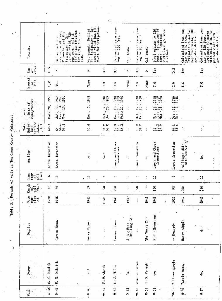
-'
Table 3.- Records of wells in Tom Green County~~~~tinued
,"
Water level
Well Owner Driller "Date Depth Diam- Aquif~r Beio;V ,', ',. Date of Method Use Remarks, . com- of' eter llind' ' meas,u r'emen t, • of of
plet- well of surface' lift watered (ft~ ) wel1' datum
(in. ) (ft. )
M-46 E. iG. ; Koci ch -- 1922 88 6 DlOza formation 62.4 Mar.' 20, 1950 C,W D.S
M-47 W. ! E.' Mikulik Garmon Bros.! 1945 80 10 Leona formation 56 Jan.! 17"" 1946 None N Gal vani zed, iron64.6 Dec. 3" 1948 casing to 20 feet.59,4 Mar.l 10, f 1950 Formerly used for
irrigat1on. Re~
ported yield., 720gpm when drilled.Yield insufficientfor irrigation in1946.
M-48 do. ; Henry Hudec 1948 89 10 do .. 65.~ Dec. , 3" 1948 None N Not cased.! Drilledfor irrigation.! Re-ported yield insuffi~
cient for irrigation.:
*M-49 W.I W.rJanek -- Old 98 6 do. ; 57.2 Oct.,: 17, I 1940 C,W D,S64.8 Jan~ 28.: 1949
M-50 E. I J.' Wilde 'Garmon Bros. 1946 120 6 Leona and' Choza 62.3 Dec. 23,: 1948 C,W D,S Galvanized iron cas-formations 65.1. June 30; >1949 ing to 120 feet.'
511.3 Feb.: 20. 1950
M-51 do. J.' M.' West 1949 -- -. -- -- -- None N Oil test.,Drilling Co.:
OM-52 Mrs.! -- Gates -- -- 90 6 Leona formation 65.9 Oct. '22, 1940 c.W D,S Galvanized iron cas-68.2 Feb.! 20",1950 ing to 90 feet.'
M~53 R.: S.: Crouch The Texas Co., 1945 -~ -- ","" -- -- None N Oil test.;,
M~54 dO<. F.' p.. i Grosshans 1947, 150 10 Leona and Choza 81 Nov.' 24 .• 1948 T,G Irr Steel casing to 126formations 79: 3 June 30;, 1949 feet.' Irrigates ,54'
76.9 Mar. 1 31, 1950 acres.: Reported'yi el d, i 450 gpm whendrilled. '
#*M~,55 William Hipple .' "- Kenn,edy 1928 95 6 ,Leona formation 89.3 Oct.: 22. i 1940 c.,W 'D,S'
83.6 Dec.' 9;.1948
~.t5-6 Ripple Bros.,i Henry Ripple 1949 260 12 Bullwagon dolo~ -- -- T,G Irr Gal vani zed iron cas-mi te member ,lI ing tb 125 feet. i. '
, I rri gates 75 acres; i
Reported yield., ~OO
gpm/when, drilled.,'. ,--'
M~57 dO.1 do.: 1949 ' ~40 12 do.: -- -- T.G Irr Gal vani zed iron cas~
ing to 120 feet.;Irrigates 90,acres
-'-with, well M·58.!Re-
- ,- ,ported yield,1 250" , - gpm' when' drilled.'
'_·~L__
--l......

Table 3.~ Records of wells in Tom Green Countyo·<·Continued
-..;t'o:>
~o [ I ., Water level~~__~oo,_.~~"_"~_____o_
Well Owner DrillerD." Ilk''" I Oi.m~ I Aquifer Below I Date'of Method Use Remarkscom~ .of et(;i" 1ar.d I rrieasu~cmcn t of of
I' pl,'!t~ well of . surface Ii it Iwater
cd (ft.) well datumI (in;) (fL)1-'
*M-58 Ripple' Bros. i Henry Ripple 1949 214 12 Bull wagon dolo- 106 'Apr.: 16, 11949 T,G Irr Galvanized iron cas-mite memberN 99.7 June 30" 1949 ing to·114. feet.' Re-
ported yield,! 250 ~mwhen drilled.' See og.
*M-59 Henry H.' Rippfe Garmon Bros.' 1941 95 6 QlOza formation 74.4 Sept. 22, , 1948 C,E D;S Galvanized iron: cas-85.8 Aug.' 7,' 1950 ing to 95 feet.' Re-
ported yield,. 40 ~mwhen dnlled.; Al t1·tudeof land surface,i 1,867.feet.' .
·M-60 do. Henry Ripple 1948 207 12 Bullwagon doIo- 91 Dec., 23,. 1948 T,G Iq Irrigates 50 acres. Imi te memberJd 38.9 Apr. i 16, 1949 Measured yield,: 220 gpm;
pumping level, I 147 feet, i, Nov. '29" 1948.' A1ti-
Itude of 1and. surface,1,880 feet. See. log.
·M~61 J,IJ.I Schiller Garmon Broos.· , 1937 118 5 Dwza fOUlllJ.tion 82.5 I No~. l~" 19"10 ! C,VI I D,S Gilhanlzed iron casing to,82; 7 Scpt~ 27, 1948 ! .95 feet. I Al ti tude of I
93.5 Aug., a" 1950 land surface, 1,894. feet.' .
M-62 Louis Wilde F.' P.I Grosshans 1949 148 8 Bullwagon dolo·· I 103 Apr.' 15; 1949 T,E, ' 11'1' I Galvanized iron' c~singmi te member.JJ 99.3 June 30, 1949 10 to 134. feet.: Irl'1gates
99.9 Mar. 10.,,1950 20 acres.; Reportal,yield, 160 gpm whendrilled.' Measured yield.,'103 gpm AUf" 30, 1950.-Al ti tude 0 land .surface,1,911 feet.- See log.'
*M-63 Viola Donovan -- Old 117 5 Choza formation 100.5 Nov.' 14,1940 C,W S Galvanized iron casing99 Sept. 27.,· 1948 to 117 feet. I AI ti tude 0 f95.8 Aug. 1 7,i 1950 1and surface~' 1,920· feet. i
.,*M-64 Luther Wood -- 1920 104 6 do. 59.4 Oct.! 22,,1940 'C; 'N D,S Galvanized iron' casing
89~2 Mar. 31,,1950 to 148 fee t.-
*M-65 R.! V.; Allison Garmon Bros.' 1946 128 12 Leona forma tion 91. 4 Nov., 23,·1948 T,G rrr Steei casin6 to 100 feet;.90.3 Apr., 16> 1949 Irrigates 6 acres.!Mea-'86 Mar.! 31" 1950 sured yield" 466 gpm
I , Aug.: 28, 1 1950. Temp. 1700 F.'
*M-66 R. ' L. : Ol sovsky -- ..lS9D 10l"l: 6 I do.; 65.3 Oct.' 17. 1940 r,.,W D,S66.6 Feb. : 20~, 1950
M~67 A.' Prospicha1 -- 109 6 Choza formation 69.8 Dec.! 3" 1948 C,W n,s73.4 Mar.' 10,,1950 ' .
M-68 R.' Walling -- -- . -- is do. I 102 Mar.; 10, i'l950~ C,W S
M~69 Otto Noack -- Old 128 6 . do. I 97.3 Dec.: 3; 1948 C,W D,S90.6 Mar.1 10;, 1950 .
- ._._--

Table. 3.~Records.ofwells in Tom Green~CountYQ~Continued. .
,~ I I '---j---~---~-~-_._'.~.-'... '--.
Aquifer. Well OwneJ;: . Driller Datecom Q
plete>e'd
Depthof
well(ft. )
Diameterof
well. (in.)
~- --~----"----- I Water 1evel I 'I Below Date Of~ Method
land measurement ofsurface lift
datum(fL)
. Useof
water
Remarks
M··70 I R.' W.' Glass
M-7l I R.'V,'Allison
.... Davis
Garmon Bros.'
1946 100
112
6
8
DlOza formation
Leona a.nd O1ozaformations
87.6 I Mar. 10" 1950
98.4 I Nov .. : 23.,' 1948
C,W'
None
D,S
·N
Galvanized iron' casingto 100 feet.· .
Steel casing to 100feet.' Drilled forirrigation .. Reportedyield insufficientfor irrigation.'
M-72 I John' Edwards
M··73 I L' W.'Kent
*MQ 741·H.' Upton
F.' P. ,'Grosshans
Garmon Bros,
D. I Oli'l'er
1948 105
46
126
6
8
6
O1oza·formation
Leona formation
O1oza: formation
95.1
26.915.7
102.8114105.9
do. !
Nov;· 22., 1948Mar. 6~' 1950
Feb.: 22,.' 1938Oct"15;, 1940Mar,' 10, 1950
C,W
C,W
C.W
D
S
D,S
Gal vani zed iron casin g· to 105 feet.· Reported
weak supply.' I
Steel casing to 46· feet,,'Reported yield,· 40 gpmwhen d:dlled" I'
Gal'l'anized iron casingto 126 feet"
M-751 W. Hendricks
M-76 I Jeff Scherz
M-77 I J.'W.! Green PI ymou th Oil Co.!
Old
1948
138
20
6
48
. do.'
. Leona. formation.
123.1 Oct. 15~ 1940115.8 Mar.: 10, 1950
2.3 Mar. 1 20. 1950
CzW
C,G
D,S
D,S Dug.'
Oil well. Altitude of· land surface; 4~ H2 fe\31;~·
,--.lw
QQ Spring*M-78
M~79
N-l
N-2
N-3
H.' S. I Waring
Arnold Brenik
Ed Cervenka
do.'
do.
Ci ties ServiceOil Co.
Garmon Bros.
do. '
do.
1952
1948
. 1948 '
1948
86
74
75
12
12
12
Comanche PeakHmest;one ---
Leona and O1ozaformations
. do.r
do •.
+~:,
47.6
46.845.7.
46.6
Dec.: 22,. 1948
Dec. ' 22;, 1948Feb.' IS,' 1950
Dec.': 22,' 1948
Flows
T,E
T,E
None
D,S
Irr
Irr
N
Li'pan Spring. ~ Measuredflow 135. gpm 'on May.. 9"1950.· . Reported'neverdry" but yield decreasesduring drought. Alti Q
tude of. land surface ..'7.048 feeL'Te~p;'680 F.:
Oil test; ( . Al'ti tude of'land surface,' 1;873 feet.:
.f Iirigates about 40 acres. with we'll N~2.iRepor~ed ,
yield.•. 150 gpm when .· drilled.' Measured yield"ll? gpm Aug•..· 18.: 1950. i' .
. ~
Measured yield,' 120. gpm;'pumping level" 64.feetAug.; 18, d950.,
Drilled. for irrigation~!
Reported yield,. 150 gpmwhen. drilled. i Not used'in 1949- 50. I
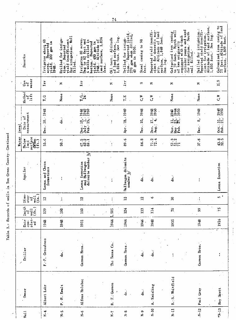
Table 3.~ Records, of wells in Tom Green County-~COntinued
"
--..)
ot:>-
. -.......-""'-"-=oow~-=--....=, __
"- Water level
Well Owner Driller Date' Depth 'Diem- . Aquifel': Below Date of Method Use Remarkscom- of eter .. land measuremen t of ofplet- well of surface lift watered (ft. ) , well trnUm
(in. ) (ft; )-
N-4 Albert Lehr F. I P. I Grosshans 1948 129 12 Leona. and O1oza 55.6 Dec. ; 10,,' 1948 T,G Irr Irrigates abou~ 60formations acres. Reported ,
yield, 300 gpm in1948.' "
N-5 P.,P. Ewalt do. ! 1948 ·100 . -- -- 50.7 do. ! None N Drilled 'for irriga-tion.' Reported,yield insufficientfor irrigation., Wellfilled. '
0,
N-6 Alfons Holubec Garmon, Bros.; 1931 150 12 Leona formation 67.5 Dec.; 10" 1948 T,G. Irr I rriga tea 80 acres;and Bullwagon . 62~2 July 1,; 1949 24· ,Dug to 62 feet anddolcmite memberE( 69.1 Feb.! 15, 1950 4 wells' drilled in
bottom.! Reported- yield, 400: gpm in1948.; Al titude ofland Durface,. 1,834feet.1 '
N-7 R.: F.r Garmon The Texas Co. I 1944 ).505 -- -~ -- -- None I N . Oil, tect.: Altitude
'. . of land surface" '.1,824. feet. See log.
N-8 do. Garmon Bros. 1944 124 12· Bullwagon, dolomite 89.6 Apr.; 18. i 1949 T,E Irr Drilled, for irriga_member !!J tion .• Rehorted rield.,
270 gpm w en dri led,l40 gpm in 1950.
N-9 do.! ,do. ' 1946 133 12 do. I. 84.8 Dec., 10, 1948 CoW S Steel casing to 98 .feet.
N-10 A. Keisling . do. i 1948 114 6 d6.1 71. 2 Dec. 17,· 1948 CoW N Reported yield insuffi-72.4 .Aug.; 4, 1950 cient for domestic sup-
- ply. Alti~ude of landsurface, 1,849 feet.,
, See. log.
N-ll R.' S.! Whi tfield -- 1935 70 10 d6.' 51. 3 Nov. ; 11, 1940 ' None N Galvanized iron casinf51. 2 Mat '.23., 1944 to 70 feet.' North we 171 Fe. !'.7" 1950 of 'two ori~nally
,equipped.w1th 6-inch, cylinder pumps, and used
- ,for irrifation., Southwell fil edt I-
.N-12 Paul Gray Garmon Bros.' 1948 99 -- -- 37.6 Dec.' 8,' 1948 None N Drilled for irrigation.!'Reported yield insuffi-cient for irrigation.!Altitudeof,land surface,'1,810 feet. See log.•
*N-13I
Leona, formation OCt. I 31, I 1940 CoW D,S
IGalvanized,iron casinr toRoy SCott -- 1916 '75 5 43.8. 32.5 Feb.! 27, 1950 I75 feet.; Al ti tude of, andsurface,: 1,809' feet.:
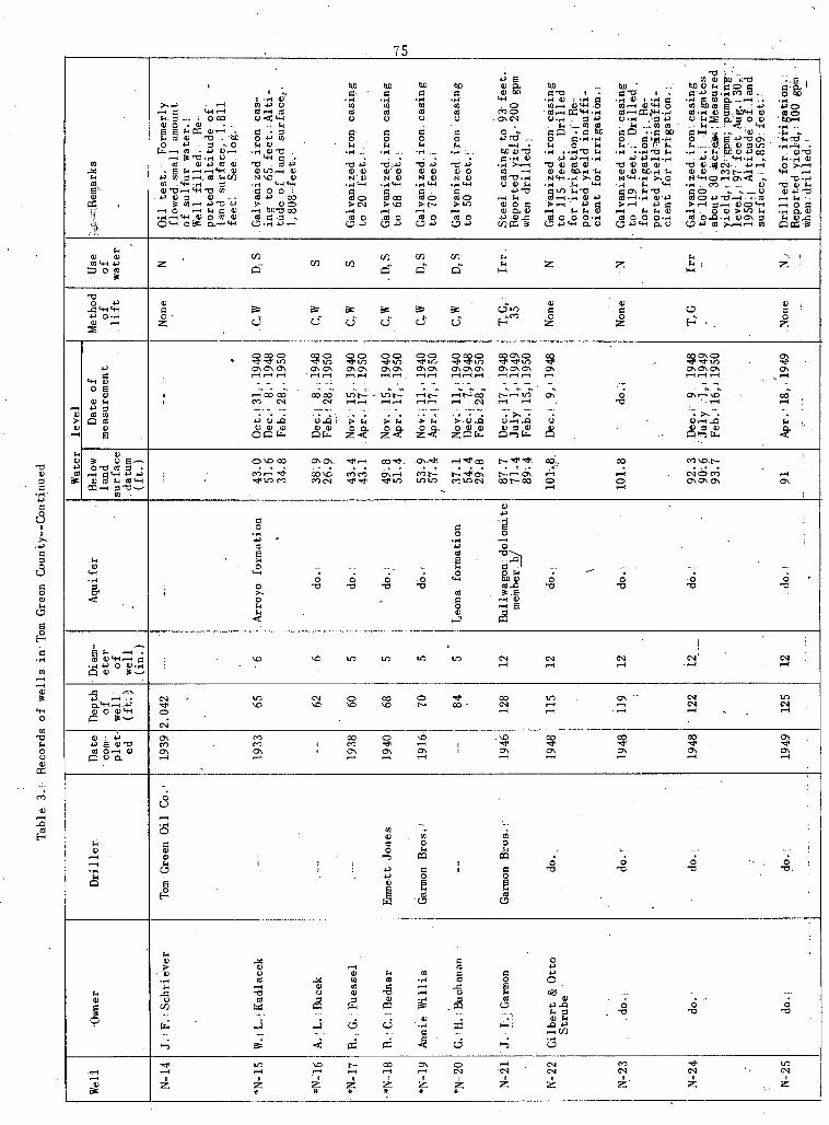
Table 3.~ Records of wells in Tom Green County--Continued
Water level
Well 'Owner Driller Datecomplet
ed
Depthof
well(ft~ <)
, Diam~eterof
well. (in.)
Aquifer Belowland
surface, da tuin(ft. )
Date ofmeasuremen t
Methodof
, lift
. Useof
water
~,,,,.'.~;ReIJ.larks
N~14 1 J.' F.I Schriever Tom Green Oi 1 Co. 193912,042 None N Oil test." Formerlyflowed. small amountof sulfur water.:Well filled.! Re~
ported altitude of'land surface.- 1.811feeL, See log.;
*N-15 I W.ILolKadlacek
*N~16 I A.·L.:Bucek
1933 65
62
6
6
. Arroyo. fornation
do.
43.051. 634,8
38,926.9
Oct.: 31, ' 1940Dec.; 8,; 1948Feb. i. 28, 1950
Dec;i 8. 1948Feb.l 28., ;.1950
C. W
C,W
D,S
S
Galvanized iron casing to 65 feet.:Alti~
tilde of 1and surface. I
1, 808· feet. . .
. *N-17 I R.; G. ' Fuessel
'*N~18 I R.'C.: Bednar
*N-19 I Annie Willis
Fmme·tt· Jones
Garmon Bros.!
1938
1940
1916
60
68
70
5
5
5
do.!
do.
dOol
43.4 Nov:: 15" 194043.1 Apr.: 17.,. 1950
49;8 Nov.115~, 194051. 4 Apr.' 17.' 1950
53.9 No:v:,l1,,194057.4 Apr.117,:1950
,C.W
C,W
C,W
S
. D,S
D,S
Galvanized iron casi~gto 20 fe'et.:
Galvanized,iron casingto 68 feeL i
Galvanized. iron. casingto 70' feet.l
-.)
VI
*N-20 I G. i H. i Buchanan
N-211 J.!!'. : Garmon
N-22 I Gilbert &OttoStrube
Garmon Bros"
do.
1946
1948
84
128
115
5
12
12
Leona formation
Bullwagon: dolomitemeinber"y
do.;
. 37.154.429.8
87.771.4B9~4
10L~
Nov: 11, i 1940Dec.! 7,,1948Feb.: 28, 1950
Dec. i 17" 1948July 1" 1949Feb.! IS, I 1950
Dec.; .9,: 1948
C,W
T,G,'35
None
D,S
Irr.
N
Gal vani zed i ron cas~ngto 50 feet. I
Steel casing to 93 feet.Reported rie1d" 200 gpmwhen dri 1 ed.
Galvanized iron' casingto 115 feet. Drilledfor 'irri ~ation.1' Reported,Y1eld'insuffident for irrigation. I
N-23 do. i do. r 19481 119 12 do. 101.8 do.! None N Galvanized iron' casingto 119 feet." Drilled.for irrigation.(,He~
portedyiel d->iiisti1'fi ~dent for irrigation.:
19481 . 122N-24
N-25
do.
do. !
do.
do. , 1949 125
12
12
do. !
. do. i
92.390:693.7
91
Dec./ 9 1948.' Ju1y'1,1 1949Feb.1 16" 1950
Apr. 1 18,,1949
T,G
.None
Irr
N/
Galvanized iron casingto 100' feet. I Irriga tes
, abou t 30 .acre&; I Measuredyield,! 13~"gpm; "pumpin-g'"level,! 97 feet Aug. i 30,,'1950d Altitude ~Llandsurface, i 1,859: feet; i
Drilled fo~ iti-igation,:. Reported peld" 100 gpm
when: drilled. < -

Tablp. 3,~ Reco:i'ds of wellB in Tom Gx'eer.. Cot1nty~~Continued
-.l0\
- i-·.-r-:l \
Du, llle!,. lli~j~ter ~evel
WeB Owne~ Driller.' Aqnifcr B"low i Date of Method Use Remal'k"
com~ o~rland measuremen t of of
ple~~ we,~l of , slIJrface , lift. water'ed (f~.~ well. datum
(in.) (ft. )._- --- I-~_._-_. -
*N-26 R.; D.' Barron. R.' Medlock 1923 125 -- -. 60.7 Feb. i 15; i 1938 None N Two wells originally59.8 Oct.' 3" 1940 used. fol.' irrigation.:
Wel'ls fi lied.'
*N-27 do. 1 do. ' 1926 -- -- 60.3 Feb;, 15,; 1938 None N for~erly used for$':6 Oct. i 3,; 1940 1rngat10n.
N-28 do.' Garmon Bros.' 1949 140 12 Bullwagon dolomite 88. ? Apr. i 18;, 1949 T,G Irr Galvanized iron cas-member EI ing to 107 feet. i
Irrigates 40' acres.!Measured yield" 246gpm Aug., 30, 1950.' ,
N-29 C.,' S. i Cell ahar. do. i 1915 29
I
36 Leollt! fc,.'mc:tion and 16.6 Nov.: 14, i 1940 C,'N D;S Repo~ted wea~ supply.~ll?lagon do~~- 2103 Inc. ~ 7., 1948,
IIDlte membe:t£l 16.8 F~b.j 28,1 1950
,~N".30 Tom G:reY3l1 ('olin. ty ... .,. 71 6 LeGt~~ .fCTITIHZ:r:cn 4 1" ("I :r'sb.' 15", 1938
IC!. Vl , N FoY-r;lc:!·J.y l.3G~~d :for
I I_.•):6
I
I53:;:: Dec .. ! 7,,' 1948 VanCOUR't SchooL,
I39.2 FeD. i 28,; 19S0-
*N~3l J. ' S. ' Powell TOIi! HolmBley 1926 78 6 ,A7~OYO fo~ma~ion 60,1 No". i 15" 1940 C,VI S Gal '(Ian1zed. L:-on cas~ I
59.7· Dec.: 7~i 1948 ing to' 78 feet.!53 . Feb.' 28,' 1950
".*N-32 do.' ~- -~ 80 5 do.. ; 51.8 Nov: ' 15,; 1940 C.W S
39 Apr.: 17,1 1950
*N-34 Mary Wilde -- -- 98 5 Standpipe' lime- 80.5 Dec. ' 7.' 1948 C.W D,Sstone member.d 66.7 Feb.. 28~, 1950
N~36 ~E;; J.: Ullte=eyer Garmon.Bros. ' 1937 70 6 Bullwagon dolomite 45.1 Nov;' 19,; 1948 C;'lI D,S Galvanized iron' cas-member'J2/ 45.7
I,Mar. 10,., 1950 ing to 70 feet.,
.N·,37 L.' W., Kent do. ! -- . 118 6 do. ' . 72.2 Noy.' 22,; 1948 C,VI S
71.6 Mar. ; 6, I 1950 ,N-38 Albci"t Kotrla Tom Holmllley 1936 91 6 Leona formation 52.2 Nov., 14, 1940 C,W D,S Gal vani zed iron cas-
46.7 Mar.. 13,' 1950 • ing to 80 feet..N-39 J.' Y.' Rust;, Sr." Garmon Bros.' 1933 80 5 Standbipe;limestone 54.1 Jan.; 20,11949 C.W S Su~plied~y a recharge
Estate me1m er s/ 51. 5 Feb.: 28; , 1950 we 1 on the. bank ofSnake' Creek.'
*0-1 A.I F.' Joslin Roy Baker 1948 60 6 i Trinity group ~ 40.2 Sept. 21, i 1950 C,W I D Galvanized iron casingI to 60 feet.:
*0-2 A. i M. Tweedy -- 1910 25 8 Leona 'forma tion 21.6 Aug. 127; 1940 C,W D,S ·Steel. casing to 25Estilte 19.2 Sept~ 21.' 1950 ' feet.
. 0-3 Charles Atkinson -. Old 52 6 Trinity; group.~ 32~8 Aug.! 21 1940 C,W S Not cased. i
37.5 Sept; 21, 11950
0-4 E.; H., Jones B.. M. : Mundell 1949 73 6 do. " 8.8 Dec.! 13., 1950 C.W S
*0-5 - -C.: D.! &C..iL.j Atki!!.s_ -- 1933 177 6 do. ' 127.9 May 19" 1950 C,W S Galvanized iron casing. --. to 33 feet.''-'-,-- " -

,
Tabl e. 3. ~Records of well s in Torri' Green Coun tye -Con tinued
Water level
Well Owner _ DrillerD..ate·IDe.pth...com- ofplet- well. ed . (ft.)
01ameterof
well(in.)
Aquifer. I Below .land
surface.datum( (t.)
'Date ofm.easureme9.t
Methodor. lift.
Us~. ofwater
Rema~ks
*0~6 W.iJemeyson.Estate Old 1270 6 Trinity' group ~ 206.9and San Angelo"sandstone
Oct.,14, 1940 G,W D,~ Water has. slight· hydrogen. sulfide odor.:
P-2 I E. H. i Jones
*P-8 I R.! W, i Rawls
*P-4 I J.'H.iDeLong.
-..j-..j'
Oil test. i See,. log..;
Temp. i 690. F: i
Do.
Do.
Dug.
Do.,
Well at clinic.iWaterhas hydrogen suI fideodor and sal ty taste.!Reported te~p. i 75°F:.:'
O~l test.: See. log.
Oil test. i Flows 's8,l tywater heavilychar~dwi th'hydrogen .'ilu1fl.i:legas;, Measured·.flq~;r
. 45 gpm M,ay l8.JI950J}
S
S
S
N
N
N
D,S
D,S
None:
C.- W.
C••W
C,W
C,W
C,W
Flows I N
None'
..None:'
Dec~i 3" 19.48 I.GtYi,G'1 .PSan Angelo sands~o!,-e 20
.Trinity group ~. ",106.--8 1May 19, ' 1950
dO.i 45.7 Dec.' 13, 1915
Comanche Peak 31.,5 do.limestone'
Trinity group 39.6 Feb. 16, 193836.8' Oct. 20,., 1940'38.5 Dec. 13.! 1950
. "
'- --Trini ty group I 25 May 18" 1950
6
6
30
54Old
1905 I 46
Old 1148
-Old 1108
J.'.F.. , Jacobs I 193,5·1 525
Dave.Elder et .al. I 19.39 555
Old 60 6.
1920 387 8
L. i D.,! Gl.!:Json 19391405
Wil ey Jameson 1912 . 700
do .
do.
do.
,.Pe3
P-6
P-9 I Mrs ..' S. i J. i Pugh
. P-5
*P-IO I J. D.:Robertson
*P-7 I T. i D.: & S. V..Easterwood
*P-l I C. 1·0. i & C. L:: Atkins
P-ll 1Wylie Jemeyson Estate 1 -- I Old I· 41 I 6 I Comanche Peaklimestone
*P-12 I do. ! . I Jack ~~kson 11940 1 57 I 6 I .do.! .
*P- 13 I d6.j Old 1160 I "6 I do.
P-16 1J. +M.l Lea
P-151 Wilbur BroWll, i Jr.
P-141 L.iN.jNickey.Estate
.\
Oil test. rSee log. i.' . - ... '., - '" >.i'.~'
Temp. 690 F;.',
Not cased.!
30.6 IMay Hi"),9S0 I h~t~ I S
'~44:·,~· d~"J.
)~:I:11,33.1 do,;
~- I ~-. -I None I N..
21.,1 Dec·1 3.-' 1948 .1 N~ne I N
40.'3 IDec.. i 2.! 194.-8 I .C,W. I 's40.? May 16. 1950
. ....:_I_u9.·J_-;I'O£t.~J.2-~k J9j,o":"'I_J;;...w I..:. Q,~.~I ..llo..t ~~.d,,-./._.
do.,
Comanche' Peaklimestone
6
550
1927 1381v
1946 1 33
. '~-':~>19_22 ._1.140. -I.. _6:..- t .. _. do.,.
Doyle Rogers
T.rE. JacobLei al
Edwin ~'BroWll*P·17
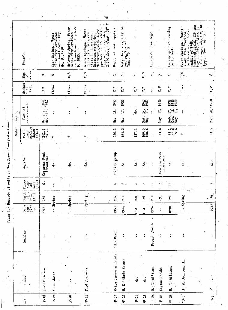
Tabie 3.,: Records of wells. in Tom Green County~~Continued
./
--Jco
Dot.e I""",IDi~oWater level_.:,:
Well.- Owner Driller Aquifer Below Date of Method Use RemarksCOID= of _ ete~ . land meariuremen t ' of ofplet o well of surface . lift ' watered (ft. ) well datum
(in,.) (ft. )
p-ui .Mrs:' W. Anson ~- Old 270 6. CDmanche' Peak 242;5 Dec.;' 2,,1948 c,W Slimestone 241. 2. . May' 16, 1950
P-19 W. rC. I Jones -- . -- Spring -- do. + -- Flows S Cave Spring. Water
Iflows from crevicesand small cave;' Dry
•May 9, 1950.' ,
,P-20 -- ~- Spring -- do. ' + -- Flows D,S McCarthy Spring. I Water
Iseels from crevices
I in imestone~ Dry May9, 1950.; . .
*P-21 Ford Boulware . =- -- Spring ="" ~ do .. + ~- Flows n, S Anson' Springs., Vla'/;",rflows from many cre-vices in Ilmestane.Reported l'e~e!' dry~i~,1easui"ed y~.eld, 4,;0-1,0gpm May 8.,,' 1950:·iAlti~
I*P~22tIlde of 3pd.ngs:.ab(>~t
, 2,050 feet; ;;f.emp.; 680 F.' ,
Wylie Jemerson Estate 'Roy Ba.1{er 1950 259 6 T,'ini ty gl'OUp' 220>1 May 18 1950 C,W' S Reported weak.supp!y.
*P-23 H. ! K: Hinde Estate -- 1944 . 210 6 do 161. 2 May 17. 1950 C,W S Water has slight hydro-gen'sulfide odor.Temp. 700 F.·
P-24 do. -- Old 201 6 do. 137.1 do. i C,W S
*P-25 do. -- Old1
121 6 ' do. 109.9 Oct. I 14, 1940 C,W D,S108.5 May 17, 1950
P-26 H., C. ;'Williams Robert Fields 1926 3..010 ,- - -- .- -. -- Oil· test. See.1og.1
P-27 Kartoll' Jacobs -~ -~ ·91' 6 Comanche Peak 71.8 May 17-, 1950 C,W Slimestone
*P-28 H. C.! Williams -- 1898 120 15 do. 43;1 Feb. i 17. 1938 C,W S GalYlU)..i~ed i ron casing45.6 Oct. . 3: I 1940 . to, 15: feet. .59.5 May 17.; i 1950
*Q-1 J, W. Johnson,rJr. i -- -- Spring c= = I do. ; + -- Flows D,~S Pecan ·Springs.· Water.I . flow's from crevices,I in~ fimestone.' Dry in
I summer 6fH948.·'
/
Measuredyie1d, 139 ~pmMay 9,. 1950 .~A1titu . .e
. of 'sp~ings, abogt 2,048feet., Temp.: 68 F.:
Q-2 / do.: -~ 1944 70 6 do. ! 41.5 Mar.: 20. 1950 C,W . S==~,,,,.,.,,,,.= ,-"-...~,~,,,.- _ .. -----_....__._--~ ~~ ..>-(-....:-

Table 3.c·Records.ofwells.in Tom.Green,County~-Continued
, .
Water level
Well Owner Driller Date ,Depth Diam- .Aquifer Below Date of Method 'Use Remarkscom~ of eter land measu remen t of ofplet," well of surface . lift water
ed (ft. ) well dat,um(in. ) (ft. )
I
Q:3 J .. Do' Robert.son PI ymou th Oil Co, 1949 = ..... ~ ~ -- ~~ -- None N ' Oil welL'
~4 W.' G.' Cnrrie Hiawatha Oil & 1950 ~~ == -~ ,"- ~ - None N Do.:Gas Co. .
Qo 5 J,' W.: Johnson,' Jr.' -~ 1920 128 6 Comanche Peak 87,1 Oct. 10,' 1940 C,W D,S Steel casing to 86limestone 73.3 Mai'.· 20, 1950 feeL
*Q··6 W" A. West ..,,~ 1920 200 6 do, 150 Mar.' 20, 1950 C,W S,
Q~7 do. -- 1920 144 6 do, 129,9 do. ' C.W D;S
Q~8
~
1945 214 6 199.4 C,W Sdo .. -~ do. do,
Q-9 Ed S.:Hobbs =c'"' 0= 280 5 do •. 221 Dec .• 2., 1948 C,W D,S Temp.:.69° F.,235.7 May 16:· 1950
Q-I0 do. , ~- OId 228 6 . do. 196.1 Dec. 2.· 1948 C,W S Do.16t\,~ 7 May 16~' 1950
,
-Q~ll W,' C.' Jones C. L.· Norsworthy 1949 ~~ ~~ -~ -~ =", None N Oil. test. Altitude
of land surface," '2, 243''{eet.; . '
Q~12 R.1L.' Stansberry -~ ""= 292 6 Comanche Peak 23Ll Dec. 2, 1948 C,W D,S1il\le:s tooe;", 275.3 .May 16, 1950
Q~13 T.' J. Clegg San Diego & Texas 1921 3,630 -- ~.>0_ "" '.~ None N Oil test. See log.;
Oil Co.:
R~l R.; C.! Lawson et al ,Min tex Oil Co.' 1930 1.994 C'n "-'> •. , 00
__None N Do,'.J
*R~2 J.·Y.,Rust,' Sr,,; -- ",c= Spring -- Comanche Peak + -- Flows D Rust Sprinf~; Seeps,-,'.Estate ,limestone' ' from grave . and '
crevices' in 'lime o
'" stone. " Estimatedyield,; 10 gP,I11,Jan.20, 1949. AIJ;J,tll\le:_ .
"ofspdng:~~~~"';'~ .~,g4~ feet.. ..P:,
I8 .' .' ... ,. ,
,~R-3
Ido. '
_0Old 55 6 do. 186 Oct. 18,' 1940 C,W D,S Steel casing to 50
- 1807 Janol'20: 1949 feet.--
-\
--..)\0
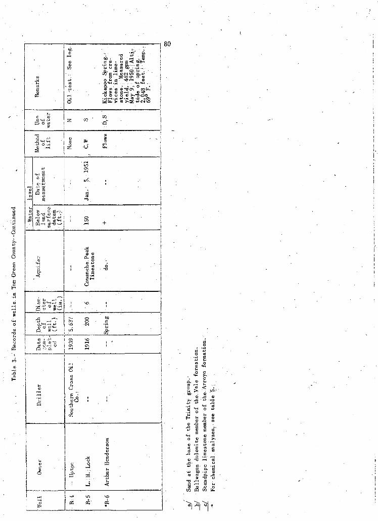
Table 3.-' Records. of wells in Tom Green County--Con~inued
See log.
Remarks
N
Useof
watel:'
None
Me~hod
oflift
level
Date ofmeasu r:emen t
Water
A 'f w lSCIOWDiam- qlll e. hmdet~r surfe~e
OJ: datum ,well (ft. ) t I I { ,~ucJ_~. . .- _..-+--- ------, Oil 'test
DrillerOwner
Up t 911R~4
Well rDate ~I Depth
I com-' ofplet-i well
Led I(f~1---+ : -..----. ---- -
Southern Cross oi111939 h,637Co.l
R-5 I L. H. Lock 1916 200 6 Comanche Peaklimestone
150 Jan.' 5, 1951 C,W s
*R-6 I Arthur Henderson Spring do. + Flows I D,S Ki ckapoo Spring.'Flows from. crevices' in 'lime~
stone.. Measuredyield, . 462 gpmMay 9, 1950.iAlt~~
tude of spdngt · .
2.048 feet . .i Temp ..690 F. . .
I \, ~ ~.__. ~~~_~,.!-, ", -,-,_.,..~_,_~~_••_~__. ~.__~ ~_,.~~~,~,,-.~ __~..~~w_,....__._,_,~_~.-_~,,~~~...~,~J••~,....._~~_= '__'~_~~'_"__~~~'--""-_~~ __'__~_"' I
00o
~/ Sand at the base of the Trinity group .
..l!./ .Bullwagon dolomite member of the. Vale formation.'
-EL Standpipe limestone member of the Arroyo formation.
* For' chemical anaiyses,. see table :~:'; ,

81
Table 4,~ Drillers' logs 'of wells 1n Tom Green C~unty, Tex.'
!. J
1
;1
3101t
320;
335L445:,
II
515'3,,401
25
1015
llO
, 70
Thickness(feet)
Shale t blue . ~ ... I~ •• ~' •• ~-~'''. ~ ~ '~. ~ ,.
-Limestone,: whi te ,.;,;, '; .. ;~ ';;~.
Limestone. light-colored .,,;;;
Shal e. whi te .;, '. ; •. ; ; . '; '; ; • :;; •
Shal e in terbeddecY wi th' thinlayers of limestone .;;;.;;;;
Total depth .,; '; ; '; ; ; , . , ; ; ; ; . ; '; •
60
70120
140180
205
250
285
Well A-17, partial log.
Thickness(feet)
Owner: BarbaraTurnerandBeatric~ Allday,
Limes ton e . ~ ; ; .. ; ; ; ; . ; . 0 ; • : • ; • ; 0 ; • • 60Rock, red ..,.;~;.,,;;;; ; ;;; '.; n ; . ; . 0 • • 10
Limestone" .. ; ;;.; ~;; ;,~;;;;;;;;; '. '... 50
Limestone" hole ·fullof water .;;;. 20Clay, yellow.'; '. :.'; ';'. ~ '; ';;;.; ;'.'; . ';.. . 40
, ' ,
Rock, red'. ~ '; " ; ..... ; ; .; •. ; ;; ; . ; .. ,25
Limestone,. sandy, whi te . '0 •.;; ;,~'; ;'. 45Shale, light-colored ..... ; ..;;,.;.... 35
Depth!( feet~
t---~----------'-------~---------'--~--Il--------,-'--~--------------.l--"----'J-
I
Well. B~17'
owp',er: State ,Tuberculosis Sa~,atorium.:
·1Ii
Soil . ,;, '; ".;; ;~l ; ;, ,"; ;;, ;, ; ;, ,... 12 12 Conglomerate" water at '4,0 feet '46 . 68:
I
I Gravel,'water ,',";;;0'''';';,;;'';'' 10 22 Clay, yellow .;·.·.;;;;;;;·.;;:;.i 4 72',
.~.~~----",--~'lWeil E~6, partial log
I. ~er: Ike Funk Estate.
Soil and loose rock .. "L;·;;;".;,
Cl ay . '; ; '; . '; ; '; '; ; , ; '; , ; . '; ; ; ; ; ..: '; .. ; '"
Limestone '.:;;.;.;;;;;;; ;;,;~;.;;;I
Shal e '; '; -; , , '; '; ; .; , ';" '. ; , , , '; , '; '; , . ; ;.
Limestone .";·,,,;;;·.,;~d , •.•.;;.:;~.
Shal e .;,;;: '; '; ; '; , ; ; . ; , . ; ( .; ;;, ;: :, . ; '; ! .Sand•. fresh water ,;. ~ .' , ; , .. , . '; .; .
.Slwll~o . ,;.;., :;; ; .: • ; ; '.. ', . .'. "';,.:, : ';:'.' .
Sand, fresh water .,; '.",:. :.• ', ~;;', ... ;;
Sh al e .. '. ; '. ; .; i. '; '. ;;: " !; l , " ... ; ';; '.. ;; ..
11,'9
94612'
63
22
830
70
ll'20 .
2975
87150
172
180210280
Sand, fresh water .•.•..••. , .•.Shale.; .;;.;;;;;;;;.;;,.'.... ';:;.,'.'
Limestone ';;;;';'.;;;.:';;;;;;Shale ... ;; '; . ; ; . i ; ; , ' ; :: ; ( , '; : ;.; .
Anhydri te .,,;;';;;:; .. ;. '. ;'.. ; ;,Shal e' . ; .. ; ; ;; ; : .. , ; ; ;,,:, ; . ;;'; ., ;,'..
Shale, sandy.; " .. ; ". , .. ; ';.; ;;';'
Sand.' unconsolidated .; ,,;,
Shale, sandy .•...,.,:. ;; " ; .•Total depth ;, ; .• ;;~. ;'
-'
30301030
4738lP.l:10
25
i310' "
340
350:380'
'427!J
465~475I
485,510)
1,452j
Well E-7. partial log
I------------:-~-------------------------~----.--~--~-___,.r-jII,,.
Limestone .. ; .. ;,;;;:..;.; .• ; ... ;.
Shale..,. blue~ '. ;.:.~ ~.~ ~'~'. :.-~' ~'.~'.~'., ~
'~~:~e. ~ ':: ~ ~,~ ..~ ~~: '; ~;~;/ ~.; ;;; ~':,Limestone ;;,;;;; n:; ;, '; :;:; ;.: : ':Shale, blue .;;:. ;.: ;, •. ;;; , ;;.Limestone.;;.; ;'.; :.;;.;;;;:;;; ;.:
" '.Limestone, broken .~ '; ';. ; .;;; ;;.Limestone .;;;.;;.;; .;; ;, ; ;; : ..
,'.' I '{ (.;~ e .. '" <. .. " ........ '", ....... ~ ..
Owner: Ike 'Funk. Esfta te .,0
Soil and loose rock •. ";;;; .,,',.;.;;Limestone. ;, ; ; ; ; .• ; ; . ; ; , ; . '; ;" ; , ; . ;; .,
. Limestone, broken, i water .. '.;;: ';;;,;,', .
Limestone .; ;.: ;~;; ~;;:;,;, ~ ii; '. ',"';".' ;;;,
Sand .. ; ;; ~ ; ; ~ ; .; d , n" ;'; ; l ; ; " \ ';', : ':.. . .. ,. . '. - .Shale, i blue.;; ,; ;;;,; ';:";;;:';-;;',Rock,,T red.'; ; ;';:; ;; ; ';;; :'•• ; ,;', ;';;; ;;.
Shale, blue . '. ; ;:;; ';,; ; ; ;; ; , ,; '. , ; ; '..•. ; ; ,
. Shal El, red .. ; '; ';.:, l '.~ ; ~" ~; • ; ,; '•• ; ••Shale, . blue . i; ,:;; : ; :y; : ;" i ; ; , ;, ; ;;,'
213
1752010
1711
220
10
215
1~0
210220
237.24?250
270
280·'
Sand
. Total· depth ." j-i-.f· ,·,,·,·,·:-t ;-"j-""",i ,";.. ~ ~,,, ,. ." , ..
20
105
45151080
201020
I3003d31~,36d
I375
I38~
465J
485t
4951
515"
1,562I,
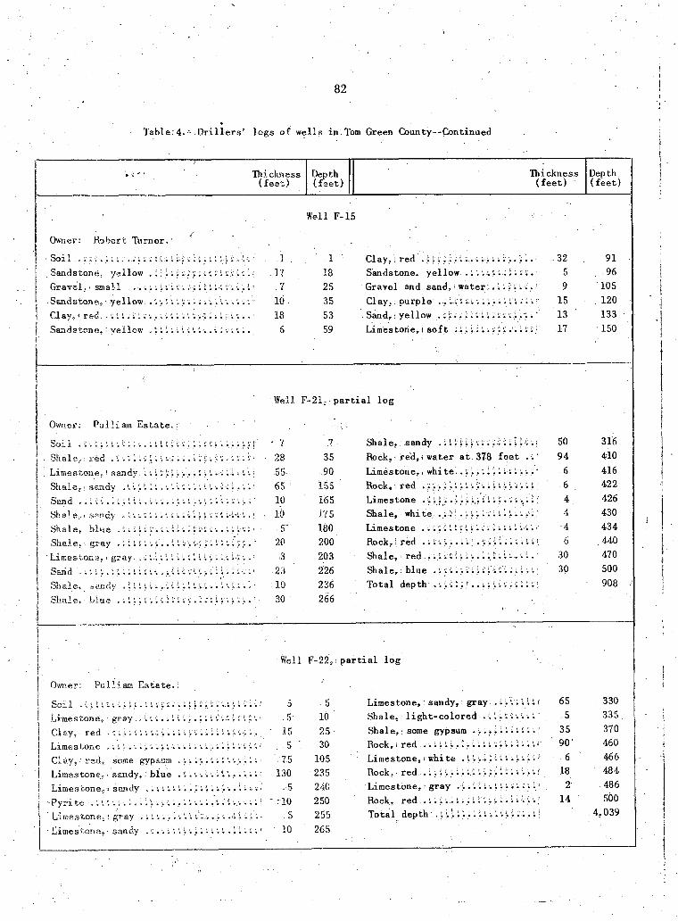
82
.Table,4.~Drillers' logs of wells 1n Tom Green County--Continued
" '
Thickness(feet)
Depth(feet)
Thickness( feet)
Depth(feet)
Well F-15
O.mer: Robert Turner.',,
Sandstone." yellow. t '.:;" ,", ;, :.';'. t.
'WeH f·21 z partial log
Sandstone, yellow.: ;; (L t:: ; ~'; '. :: ,i. ;"I Gravel, I small .. L; .;;; n::; ;'. t; t ,,; ;;i-:.::
I Sandston",.' yellow .; ~ ". '.::'. ;;::.~ ;'. '.,;::'
I Cl ay.~ fred. ... ,~ .~ ~ ~ t ~ ~. '~ ,~ '~ ~. !. ~i~ ,~ ~ :: _~ ~ ~ ,i~ ;~ ~ ,~. ~ ~ !
I
IOwner: Pulliam Estate.,
Soil .J;;;, i, " '; ; , :: , , ; :: ; : t : n'.; '; ;;;,;' '; nShal e., 1 loed .: '. : ; , '; ,; :: '; ;.;; :: , ; t,,,: :" " l 'Limes,t,one'r t sandy ..~ '~ ~ ~ ~ :.~. ~t' :~ ".~,j~ '~'~ ~ ~ : ~
Shale, iHUldy ,'. i. ';; ,; '. '. '. ';:.:: '•• '.: '. '. '; J.t ; '. :1 Sand.; ';; L , • ; 'it ; '.• '; ; ; ; :: , ). ; .. : '.: t "•.: ; L J; ; ,I Shale" sendy .;; '; ; ; ; ;. ';; ; '.; ; : ; ; t
i Shale, blue.;,;;; ;';::;: L. ,; n; ,;,; U·;'; Shale" gr'ay .'.;;(;;;;:.;;;.;';~;;;;L:;:,;
Ii 'Limeston'''7'gray .;:l;;'L;;.:;;;"'~;';"'": Sand ~. :~ ~ ~ '~ t ~ ~ ~ ~: ~' ;.. ~ ~ ~"(~-~: ~- i. t.~ ~ 0.~. ,~~~ ,~.~ I
'I' Shale" 8<"ndy ,~;;,;; '.,; '; ; ,; Lq'.'. '. ': '. ". >I Sh.l0, .b•. '.,,,,,,, "'''', ,~" ,>' '.,,'
1 1',17 18
7 2510 3518 53
6 59
-7 728 3555 9065 ' 15510 lEiS10 175,5" 1802G 200
3 20323 22610 23630 266
Clay~ 'f red .. ~ ~'~<,~ ~~"~"~;~ ~.~ ~'~ ~c.~'~ ,~:,
Sandstone,' yellow. '. '. ::'~" ; ;",;.
Gravel and sand, water. ~,; ~; ','Clay,' purple.:. '.n,;:,; ,; ;;:;;; ,Scind, yellow. ',:" ;, q ;;:: ;,:, '"Limestone.! soft ;, ,;:, '.;: ~;;;",
Shal e. sandy .;:;;;,;" ,; : , ; : '; ; :
Rock., red., water at 378 feet,.,
Limestone., whi te',.: '.:; i:, :';;;, ,;':Rock. red .; H '; ';;" ~ '; '.; :: ,; '. ".: "Limestone ., ,; ~; :,;" ;;;;;;/; ;
Shale~ whit'e,.. ,"": .... '~ ~ ~~"~"~:: ~ ~ .'~'.i
Limestone ..., ~ ~ .I~ ~ ~'~'~~' ~~:~' ~,~ ~,~ ~ '~>~~.!'
Rock. red .;,,~; ;;;: . ,;: i,"";~
Shale. red.:: d L ; ;; : ; ; ; i : .;( ;Shale., blue .,; '. ;,;'; ,; ;,': ;'( ;;: •. '.:
Total depth .;~~;:! .. ,:;';;;;;;;
32
5,9
15
1317
5094
664
4
4
630
30
9196
105120
133150
316410
416
422426430
434,440
470
500908
iIj
·1IIf
IIjI
1i
II
li,
Clay.; red" some gypsum ,,;, ~'.' '."~ '. ',," ~,
Limestone" 'sandy, biue • ,; '.';;; ,.,'J.;;, '," i
Limestone~. sandy .,', '. ~;,; '. n,~,:;:.;";'
~r::::~~~: ~ ~~~~. ~ ~'.~ ~:: ~<::: :~,~:: :~\'~ ~',: i
'Limestone" sandy .,."'~;;; ,: ; , ; , ; " , ( '. ; :
Well F-22.!pattial log
I
i,t
'II1
330335,370460466484
486500
.4.039
655
3590'
618
214
Limestone.; sandy. gray .~,d;:,i;:(
Shale. I light~colored • '.;,'; ;'.;:'
Shale.; some gypsum .. ;;:;:;:::;Rock, red .,;;;;;;; '. '. '.;, : : , ; : i '. r
Limestone., whi te ':.'': ,; L: \'.;;;; i
Rock,. red. L , '; (,; J.: (( (;; ( (:; ;,>. (!
Liine~tonet t gray' .~,~ ~ ~,~;~ ~ ~,~,~ ~',~: ~..~
Rock, red.,;: u;; .. : i:,; ;; i
Tot~l depth.: ~ t:: '. ,::t ,;: '. q ,;;;
5102.530
105, 235240250255
26510
5.515
75130
.5- ~10
5
Pulliam Estate.Owner:
IIII1
II'I
1
I
i"