GROUND WATER INFORMATION BOOKLET SOUTH GOA …
31
GOVERNMENT OF INDIA MINISTRY OF WATER RESOURCES CENTRAL GROUND WATER BOARD GROUND WATER INFORMATION BOOKLET SOUTH GOA DISTRICT, GOA STATE SOUTH WESTERN REGION BENGALURU MARCH 2013
Transcript of GROUND WATER INFORMATION BOOKLET SOUTH GOA …

GOVERNMENT OF INDIA MINISTRY OF WATER RESOURCES CENTRAL GROUND WATER BOARD
GROUND WATER INFORMATION BOOKLET SOUTH GOA DISTRICT, GOA STATE
SOUTH WESTERN REGIO N BENGALURU M ARCH 2013

i
Foreword
The State of Goa is covered by rocks of Dharwar Super group with a small patch of Deccan
basalts overlain by quaternary alluvium. Ground water occurs under unconfined and semi-
confined conditions in these formations with spatial variability depending on the
hydrogeological environment existing in each region. Scientific management of water
resources is the need of the hour in the face of rising groundwater exploitation and pollution
in the State of Goa. Central Ground Water Board has carried out various hydrogeological
investigations in the State and joint studies on the water resources of Goa with the water
resources department of Goa. The data generated from such studies could be effectively used
in the preparation of this brochure.
Central Ground Water Board is providing all technical input for effective management of
ground water resources in the state. The groundwater scenario compiled on administrative
divisions gives a better perspective for planning various ground water management measures
by local administrative bodies. With this objective, Central Ground Water Board is publishing
the revised groundwater information booklet for all the districts of the state.
I do appreciate the efforts of Dr. K.Md.Najeeb, Regional Director and his fleet of dedicated
Scientists of South Western Region, Bangalore and unit office, Belgaum for bringing out this
booklet. I am sure these brochures will provide a portrait of the groundwater resources in each
district for planning effective management measures by the administrators, planners and the
stake holders.
Sushil Gupta CHAIRMAN
ii
PREFACE
Ground water contributes to about eighty percent of the drinking water requirements
in the rural areas, fifty percent of the urban water requirements and more than fifty
percent of the irrigation requirements of the nation. Central Ground Water Board has
decided to bring out district level ground water information booklets highlighting the
ground water scenario, its resource potential, quality aspects, recharge – discharge
relationship, etc., for all the districts of the country. As part of this, Central Ground
Water Board, South Western Region, Bangalore, is preparing such booklets for the
two districts of Goa state.
The South Goa district Ground Water Information Booklet has been prepared based
on the information available and data collected from various state and central
government organisations by several hydro-scientists of Central Ground Water Board
with utmost care and dedication. This booklet has been prepared by Dr.J. Davithuraj,
Scientist ‘B’, Central Ground Water Board, Unit Office, Belgaum. The figures were
prepared by Sri. J.Sivaramakrishnan, Assistant Hydrogeologist. The efforts of Report
processing section in finalising and bringing out the report in this format are
commendable.
I take this opportunity to congratulate them for the diligent and careful compilation
and observation in the form of this booklet, which will certainly serve as a guiding
document for further work and help the planners, administrators, hydrogeologists and
engineers to plan the water resources management in a better way in the district.
(Dr. K.Md. Najeeb)
Regional Director

iii
SOUTH GOA DISTRICT AT A GLANCE
Sl. No.
Items
Statistics
1. General Information (i) Geographical area (sq. km.) 1,966 (ii) Administrative Division (as on 2005 - 06) (a) Number of Taluks 5, (Sanguem, Canacona, Quepem,
Salcete, Marmugao) (b) Number of Villages 359 (iii) Population (as per 2011 Census) 639962 (iv) Average Annual Rainfall (mm) 3369.36 mm
2. Geomorphology (i) Major physiographic units Coastal plain, vast strech of plain
towards the east, low dissected denudational hills and table land & deeply dissected high western ghat denudational hills occurring all along the eastern part.
(ii) Major Drainage Principal perennial river is Galjibagh. Non-perennial rivers viz. Sal, Saleri & Talpona.
3. Land Use (i) Forest area (ha) 90,431 (ii) Net area sown (ha) 51,679
4. Major soil types Lateritic soil, Saline soil, Marshy soil, Alluvial soil (along north western & western part).
5. Area under principal crops (as on 2009-2010) Crops Area (ha) Paddy 20,215
Cereals millets/ pulses & oil seeds
1,001
Sugarcane 757 Coconut 14,376 Arecanut 257
Cashew nut 15,146 6. Irrigation by different sources (Area (ha) & Number of
structures) (As per Third Census of Minor Irrigation Schemes 2000-01)
Area irrigated (ha) Number
(i) Dug wells 1239.17 ha 1261 (ii) Tube wells (Shallow; Deep) 43 ha (34.5 ha; 8.5 ha) 19 (16; 3) (iii) Tanks / Ponds - 161 (iv) Canals 6454 ha 3 (v) Other sources: (a) Lift Irrigation Schemes (b) Surface Flow irrigation
(a) 2031.25 ha (b) 2451.45 ha
(a) 539 (b) 982
(vi) Net irrigated area 12,218.87 ha 7. Number of ground water monitoring wells of Central Ground Water Board (as on
31.03.2007) (i) Dug wells 19 (ii) Piezometers 34

iv
8. Predominant Geological Formations (a) Mainly formations of Goa Group, comprising: Schist (major part), Greywacke with conglomerate, and Metabasalt. (b) Formations of Peninsular Gneissic Complex, comprising: Granite gneiss & Granite (small patches). Beach sand (thin strip towards western coastal part of the district). Vast portion of the rocks (viz. schist, greywacke with conglomerate & metabasalts) is lateritised.
9. Hydrogeology (i) Major water bearing formation Laterite, Alluvium, Granite,
Granite Gneiss, Meta volcanics & Meta sedimentaries.
(ii) Pre - monsoon depth to water level during May 2011 (in m bgl) 2.39 to 18.64 (iii) Post – monsoon depth to water level during Nov. 2011 (in m bgl) 1.20 to 14.52 (iv) Long term water level trend in 10 years (2001 – 2010) (in m/year) (a) Pre – monsoon water level trends range from a decline of 0.03 m to rise of 2.07m. (b) Post – monsoon – water level trends range from a decline of 0.06 m to rise of 8.24 m.
10. Ground water exploration by Central Ground Water Board (as on 31.03.07) (i) Number of wells drilled
(a) Exploratory Drilling Programme (b) Deposit well construction (Under Caboraj Niwas & Western
Ghat Development Programme of Goa State) (c) Hydrology Project Phase - II
(a) 30EW; 11 OW; Total - 41 (b) 12 (c) 27 PZ
(ii) Depth Range (m bgl) (a) Exploratory Drilling Programme (b) Deposit well construction (Under Caboraj Niwas & Western Ghat Development Programme of Goa State) (c) Hydrology Project Phase - II
(a) 12.40 - 202 m bgl (b) 28.20 – 126.50 m bgl (c ) 42.70-100
(iii) Discharge (litres per second) (a) Exploratory Drilling Programme (b) Deposit well construction (Under Caboraj Niwas & Western
Ghat Development Programme of Goa State) (c ) Hydrology Project Phase - II
(a) 0.18 – 10.0 lps (b) 0.35 – 7.80 lps (c )<1.00-6.73
(iv) Sp. Capacity (m3/day/m) (a) Exploratory Drilling Programme (b) Deposit well construction (Under Caboraj Niwas & Western
Ghat Development Programme of Goa State) (c) Hydrology Project Phase - II
(a) 0.46 – 200.78 (b) – Not computed (c ) 3.26-31.48 (lpm/m/dd)
(v) Transmissivity (m2/day) (a) Exploratory Drilling Programme (b) Deposit well construction (Under Caboraj Niwas & Western
Ghat Development Programme of Goa State) (c ) Hydrology Project Phase - II
(a) 0.19 - 1216 (b) Not computed (c) 3.99-27.0
11. Ground water quality

v
(i) Presence of chemical constituents more than permissible limit Saline due to seawater ingress in inland aquifers along tidal river courses. Ground water in general is of good quality and free from fluoride, nitrate & alkali hazards.
(ii) Type of water Calcium – Bicarbonate Type 12. Dynamic ground water resource (2009)
(i) Net ground water availability (ham) 5473 (ii) Total Annual Ground Water Draft (ham) 1837 (iii) Projected demand for domestic & industrial uses upto 2025 (ham)
1639
(iv) Stage of ground water development (%) 34 % (SAFE) 13. Awareness & Training activity
(i) Mass awareness programmes organized 1, On “Hydrological Information System” – under Hydrology Project – II.
(a) Date (i) 27.11.2008 (b) Place (i) Madgaon, South Goa (ii) Training Programmes organized 1, On “Hydrological Information
System” – under Hydrology Project – II, on 27.11.2008, Madgaon, South Goa.
14. Artificial recharge & rainwater harvesting
(i) Projects completed by CGWB (No. & amount spent) Nil
15. Ground water control & Regulation
(i) Number of OE blocks Nil
(ii) Number of Critical blocks
Nil
(iii) Number of blocks notified
Nil
16. Major ground water problems & issues Scarcity of ground water is observed during summer months as a result of high sub – surface and surface run off due to hilly topography and highly permeable nature of phreatic aquifer system. This results in lowering of water levels or drying of wells in some areas in summer months.

vi
Seawater ingress: Water table aquifers around Marmugao, especially locations close to and in the vicinity of creeks shows high electrical conductivity & chloride indicating brackish to saline nature of ground water.
In areas confined to the vicinity of creeks of Sal River, ground water is brackish and unsuitable for drinking. Salinity is more pronounced during May when fresh water flow is minimum and maximum seawater ingress takes place.

1
1.0 Introduction 1.1 Location
Goa state lies along the west coast of India. The state is sub – divided into two districts, North & South Goa district. South Goa district lies in the southern part of Goa state. The geographical area of the district is 1966 sq.km, and is situated between north latitudes 14o 54’ 00 & 15o 29’ 30”” and between east longitudes 73o 47’ 00” & 74o 20’ 30”. The district is bounded by Tiswadi, Ponda and Satari taluks of North Goa district in the north, Uttara Kannada district of Karnataka in the east & south, and in the west by the Arabian Sea.
1.2 Administrative set up Madgaon is the district headquarters of South Goa district. The district comprises of 5 taluks namely, Sanguem, Canacona, Quepem, Salcete and Marmugao (Figure 1). There are 359 villages and 17 towns, out of which, 7 are Municipal towns.
1.3 Population
Population of the district (as per 2011 Census) is 639962 with a population density of 326 persons per sq. km.
1.4 Physiography & Drainage
Physiographically South Goa district can be broadly divided into four distinct morphological units from west to east namely, (i) Coastal plain with marine land forms on the west, (ii) Vast stretch plains adjoining the coastal plain, (iii) Low dissected denudational hills & tablelands towards the east, and (iv) Deeply dissected high Western Ghats denudational hills along the eastern
most part of the district. Principal Perennial River draining through the district is Galjibagh and non – perennial (seasonal) rivers are Sal, Saleri & Talpona. The river basin of westerly flowing Galjibagh river originate from Western Ghats and drain in the Arabian Sea in the west under estuarine environment. Primarily the underlying rocks govern the drainage system in the area. The drainage pattern is generally dendritic type. The river valley is ‘V’ shaped in the western high hill ranges, but broadens in central midlands and become ‘U’ shaped in the low lands and coastal plains.

2
3
1.5 Crops & Irrigation practices Agriculture is one of the important economic activities in the district. Rice is the stable food and paddy is the principal agricultural crop. Gross cropped area under paddy in 2009 –10 was 20215 ha, accounting for nearly 33.13% of the Gross Cropped Area (61004 ha). Other crops grown are cereals, millets, pulses & oil seeds, which constitute an area of 1001 ha (1.64%), sugarcane 757 ha (1.24%), coconut 14376 ha (23.57%), arecanut 257 ha (0.42%) and cashewnut 15146 ha (24.82%).
Irrigation potential created as on March 2000 by the Salauli Irrigation Project was 4614 ha in Sanguem, Quepem and Salcete taluks of South Goa district. Irrigation by different sources, as per Third Census of Minor Irrigation Schemes 2000 – 01 is illustrated in Table 1.
Table 1: Irrigation by different sources (As per Third Census of Minor Irrigation Schemes 2000 – 01)
Sl. No. Irrigation source No. of schemes Area irrigated (ha) 1. Dug wells 1261 1239.17 2. Shallow tube wells 16 34.50 3. Deep tube wells 3 8.50 4. Lift irrigation schemes 539 2031.25 5. Surface flow irrigation 982 2451.45
TOTAL 2801 5764.87
1.6 Activities carried out by Central Ground Water Board (CGWB)
Twenty four deposit wells were constructed in Goa State for Caboraj Niwas and Western Ghat Development Programme, by CGWB, during the Field Season Programme (1984 – 86). Out of 24 deposit wells, 12 nos. were constructed in South Goa district, 5 nos. in Canacona and 7 nos. in Sanguem taluks respectively. Under Exploratory Drilling Programme of CGWB, 30 exploratory wells & 11 observation wells were drilled to study hydrogeological conditions, aquifer parameters and update ground water regime & quality in the district. Monitoring of spatial and temporal change in ground water level in the district is being done by CGWB, South Western Region, four times annually (viz. May, September, November & January), through an established network of 26 monitoring stations (19 dug wells and 7 piezometers). World Bank aided Hydrology Project for Peninsular States started during 1995 – 96, with a mandate to bring together all departments dealing with water under one umbrella. The sole objective of the Project was to deliver a reliable and functional Hydrological Information System. The Project is implemented in Karnataka, with CGWB, South Western Region, identified as one of the member and nodal agency dealing with ground water related issues. Under Phase – II of Hydrology Project, 27 nos. of piezometers have been constructed in South Goa district. One mass awareness and one training programme have been organized on “Hydrological Information System” in the district.

4
2.0 Climate & Rainfall
Due to maritime influence, the diurnal range of temperature during the day is not large. The diurnal range is the least being 4 to 6o C during monsoon season and increases to the maximum of 10 to 20oC during December & January. May is the hottest month where the mean daily temperature increases to 30oC. January is the coolest with mean daily temperature of about 23oC. It is noted that the day temperature is the lowest in monsoon months of July and August and not in the cool winter months of December and January. The temperature is highest (around 33oC) in pre – monsoon months of April & May and again in post monsoon months of November & January. Due to proximity to the Arabian Sea, humidity throughout the year is more than 60% with range from 80 to 90% during monsoon period. As a result of orographic influence, rainfall increases towards the Western Ghat, with average annual rainfall 2875 mm (in Salcete taluk) & 2466 mm (Marmugao taluk) respectively to 3825 mm (in Sanguem taluk). Over 90% of annual rainfall occurs during monsoon months of June to September. About 32% of the annual rainfall is received during July.
3.0 Soil Type
Soils of the district can be classified into 4 types namely (i) Laterite soil (ii) Saline soil (iii) Marshy soil and (iv) Alluvial soil: (i) Lateritic soil is the major soil type in the district. It is highly porous &
permeable, slightly acidic with low pH values, low in organic matter, Calcium and Phosphorus.
(ii) Saline soil in the district occurs in the flood plains of Zuari, Sal, Saleri, Talpona and Galjibagh rivers in Salcete, Marmugao, Quepem and Canacona taluks. It also occurs to a very limited extent in Sanguem taluk. The soil is deep, poorly drained and less permeable. It is saline, high in pH and contains humus and organic matter.
(iii) Marshy soil occurs to a large extent in Salcete taluk and towards the western part of Canacona taluk. It also occurs in Marmugao taluk. This type of soil occurs in low-lying water logged and tidal affected areas.
(iv) Alluvial soil occurs as very thin strip along the coastline towards western part of Salcete taluk and also a limited exposure occurs in Canacona taluk. It is reddish brown to yellowish, coarse grained and confined to narrow valleys of rivers. It is well drained, acidic with low pH and organic content.
4.0 Geology 4.1 Stratigraphy
The stratigraphic succession of rocks in South Goa district is given in Table-2.
4.2 Distribution of rock types South Goa district is dominantly covered by the formation of Goa Group belonging to Dharwar Super Group of Archaean to Proterozoic age.

5
The Goa Group comprises of metamorphic rocks of green schist facies, and is divided into Barcem, Sanvordem, Bicholim and Vageri formation in the ascending order of superposition. The Goa Group of rocks has been intruded by granite gneiss, feldspathic gneiss, hornblende gneiss and porphyritic granite, followed by basic intrusive.
Table 2: STRATIGRAPHY OF SOUTH GOA DISTRICT AGE GROUP FORMATION ROCK TYPE
Quaternary Beach Sand Cenozoic Laterites Upper Cretaceous to Eocene
Deccan Trap Basalt
Lower Proterozoic
Clospet Granite
Granite
Peridotite, Gabbro, Norite
Pyroxenite, Peridotite, Serpentinite, Gabbro
Archaean to Lower Proterozoic
Goa Group Vageri Formation Carbonate-quartz-chlorite schist with Greywacke
Bicholim Formation
Dolomitic limestone Quartz- Sericite schist Banded iron formation Chert and quartzite Quartz-chlorite-biotite schist with layers of chert, iron oxide, carbonate, metabasalt and meta gabbro
Sanvordem Formation
Greywacke with conglomerate Quartzite
Barcem Formation
Quartz-chlorite schist Meta-acid volcanics Metabasalt Orthoquartzite
Archaean Peninsular Gneissic complex
Granite Gneiss, Migmatites and Granites
Metabasalts are also extensively exposed in Canacona and Marmugao taluks and also as small outcrops in Salcete & Sanguem Taluks.Exposures of greywacke with conglomerate are found to occur in Quepem, Canacona and Sanguem taluks. Granite gneiss is found to occur in large portion of Salcete taluk and limited exposures are in Quepem, Canacona and Sanguem taluks. Small outcrops of granite are found to occur in Canacona and Sanguem taluks. During the Sub – Recent and Recent times, the rocks have been subjected to lateritisation of varying thickness. Thus, laterite occurs extensively covering almost all the formations in South Goa district. Coastal alluvium occurs as thin strip along the coastal plains in western part of Salcete taluk. It consists of fine to coarse sands with intercalations of sandy loam, silt and clay.
4.3 Structural geology
The Goa group of rocks is disposed in a general NW – SE direction. The rock types indicate three cycles of folding. The straight coastline suggests the major fault along the west coast. Associated with this fault a number of weak

6
planes have developed. Western Ghat, which extends in NS to NNW – SSE direction represent a prominent fault zone. Even though the rock types of Goa Group have suffered considerable faulting, all the faults are not exposed on surface owing to the extensive cover of laterite. On account of various tectonic movements, the rocks have developed many fractured and joint zones up to 30 to 50 m bgl, as evident from borehole sections at Quepem. In Sacordem area in the district, NE – SW trending faults are exposed in Sacordem Iron Ore deposit along fold axis.
5.0 Ground water scenario 5.1 Hydrogeology
Occurrence and movement of ground water depends upon the type of rock formation, structure, topography, rainfall, recharge etc. Ground water in the district occurs in rocks having primary porosity & permeability or in those having secondary porosity acquired due to weathering, leaking, tectonics, solutions etc. Ground water bearing formations in the district are laterite, alluvium, granite, granite gneiss, metavolcanics and metasedimentaries. Hydrogeological map is illustrated in Figure 2.
5.1.1 Occurrence of ground water and aquifer characteristics of various formations.
Laterites
Laterites are the important water bearing formations. Laterites are of two types, viz. insitu, occurring in plateau areas or of detrital origin generally occupying valley portions. Besides inherent porosity, the laterites are highly jointed and fractured, which control their water bearing capacity. The topographic settings of laterites control its ground water potential. The thickness of laterites extends up to 30 m. Ground water occurs under water table condition in lateritic formation. In the plateau area and high grounds, depth of wells range from 9.40 to 26.60 m bgl and depth to water level varies between 8.20 – 21.90 m bgl, whereas wells located in topographic lows range in depth from 3.10 – 11.95 m bgl and depth to water level varies from 1.5 – 8.40 m bgl. Specific capacities varies between 1.73 to 3205 m3/day/m. Promising ground water bearing areas are located near Kasapural area in Sanguem and Arelm area in Salcete taluk.

7
Alluvium

8
Alluvium constitutes good aquifers and is restricted to banks of rivers. Thickness of the coastal alluvium varies from 5 – 22 m, and comprises of fine to coarse sand with intercalations of sandy loam, silt and clay. Depth range of 1.42 to 7.7 m bgl is being tapped by dug wells. Exploratory tube wells constructed in alluvium vary in depth from 15.50 – 22m. Depth to water level in these formations varies from 1.4 to 5.85 m bgl. The discharges recorded from these aquifers are between 1.88 & 3.00 lps. Specific capacities vary between 27.10 & 200.78 m3/day/m and transmissivity varies from 25.44 – 177.50 m2/day. Granite and Granite Gneiss
Ground water occurs under unconfined, semi – confined and confined conditions in weathered and fractured zones of granite and granite gneiss. Depth to water level in these formations in open wells varies from 3.8 to 6.25 m bgl, and specific capacities between 14.4 to 77.30 m3/day/m. Exploratory bore wells and Pz bore wells drilled in granite and granitic gneiss are in the depth range of 70.70 to 124 m bgl. Discharge recorded is between 0.77 to 8.8 lps. Specific capacities in exploratory wells recorded, vary from 2.27 to 43 m3/day/m and transmissivity from 0.87 to 34.60 m2/day. Metavolcanics
In unaltered state, metavolcanics are very poor in ground water. However, ground water is found to occur in zones having secondary porosity and permeability imparted due to weathering, joints and fractures. Ground water occurs both under water table and confined conditions. Water bearing zones extend up to depth of 40 to 100 m.
Irrigation dug wells having diameter from 2.2 to 6.1 m are found to tap the weathered zone up to 9.25 m bgl. Depth to water level in dug wells varies from 1.48 to 6.26 m bgl. Specific capacity varies from 10.60 to 228.70 m3/day/m.
Exploratory wells, Pz bore wells and deposit wells drilled by CGWB in this formation range in depth from 37.20 to 200.75 m bgl and the discharges recorded range from 0.18 to 25 lps. Productive zones were encountered even up to 119 m bgl. Specific capacities recorded from boreholes tested varied from 0.46 to 988.47 m3/day/m and transmissivity varied from 0.25 to 346.10 m2/day.
Studies have indicated that bore holes drilled in metavolcanics with thick lateritic cover in the plateau areas and close to lineaments have yields ranging from 2 to 5 lps. Metasedimentaries
Metasedimentaries comprise shales, phyllites, schists, metagreywackes, argillites and quartzites. The irrigation dug wells tapping weathered zones extending from 8.5 to 19.85 m bgl in these rock units with varying well diameters from 2.2 to 6.1 m. Depth to water level during post and pre – monsoon periods are recorded respectively in the range between 0.48 to 12.06 m bgl and 1.79 to 14.88 m bgl with fluctuations between 0.86 to 8.0 m. Specific capacities vary from 0.85 to 82.80 m3/day/m.
5.1.2 Depth to water level

9
The Central Ground Water Board has established 26 hydrograph stations, and are measured four times a year, i.e. in January, May, August and November. Depth to water level varies within the area depending on the hydrogeological setup, incidence of rainfall, topographic setting and stage of groundwater development. i) Pre-Monsoon of 2011:
In order to study the summer ground water regime of the district, depth to water level map has been prepared based on pre-monsoon (May 2011) water level data and presented in Figure 3. The Depth to water level ranged from 2.39 to 18.64 m bgl. A map showing the depth to water level in the range of <2, 2 to 5, 5 to 10 and 10 to 20 m bgl. The map shows water level is in the range of less than 2 to 20 m bgl. Water level in the range of 10 to 20 m bgl is seen as small pockets in Salcete, Canacona & Sanguem taluks.
i) Post-Monsoon of 2011:
Depth to water level map has been prepared based on post-monsoon (November 2011) water level data and presented in Figure-4.The Depth to water level ranged from 1.20 to 14.52 m bgl. The depth to water level in the range of <2, 2 to 5, 5 to 10 and 10 to 20 m bgl are shown . The map shows water level is in the range of 2 to 20 m bgl. Water level depicted in the range of <2 – 2 m bgl occur in small pockets of Canacone, Marmugao and Sanguem taluks, 2 – 5 m bgl occur in major portions of Marmugao, Quepem & Canacona taluks, 5 – 10 m bgl occur in Salcete, Sanguem & Canacona taluks. Water level in the range of 10 – 20 m bgl occurs as a small pocket in Canacona taluk.
5.1.3 Seasonal ground water level fluctuation
Water levels from 18 stations were compared to know the change in water level between pre-monsoon and post monsoon of 2011. While 16 stations recorded rise in water levels, 2 station recorded fall in water level.
5.1.4 Long – term water level trend Ground water is a renewable resource it gets depleted when the aquifer is over drafted. The aquifer gets recharged during monsoon period. Rainfall is the main source of recharge to ground water. In order to study the long-term trends of ground water level in the district, water level data has been analyzed for NHS observation wells for pre monsoon and post-monsoon established by Central Ground Water Board, for the periods from 2001-2010. Talukwise long-term water level trend data of south Goa district is presented in Table-3.

10
Fig-3

11
Fig-4

12
Fig-5

13
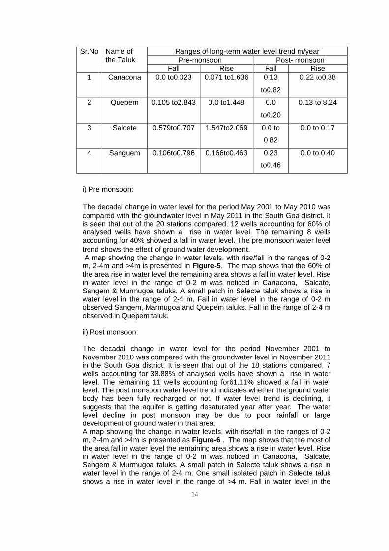
Table.3. Talukawise Long Term Water Level Trend of South Goa district
Fig-6
14
Sr.No Name of the Taluk
Ranges of long-term water level trend m/year Pre-monsoon Post- monsoon
Fall Rise Fall Rise 1 Canacona 0.0 to0.023 0.071 to1.636 0.13
to0.82
0.22 to0.38
2 Quepem 0.105 to2.843 0.0 to1.448 0.0
to0.20
0.13 to 8.24
3 Salcete 0.579to0.707 1.547to2.069 0.0 to
0.82
0.0 to 0.17
4 Sanguem 0.106to0.796 0.166to0.463 0.23
to0.46
0.0 to 0.40
i) Pre monsoon: The decadal change in water level for the period May 2001 to May 2010 was compared with the groundwater level in May 2011 in the South Goa district. It is seen that out of the 20 stations compared, 12 wells accounting for 60% of analysed wells have shown a rise in water level. The remaining 8 wells accounting for 40% showed a fall in water level. The pre monsoon water level trend shows the effect of ground water development. A map showing the change in water levels, with rise/fall in the ranges of 0-2 m, 2-4m and >4m is presented in Figure-5. The map shows that the 60% of the area rise in water level the remaining area shows a fall in water level. Rise in water level in the range of 0-2 m was noticed in Canacona, Salcate, Sangem & Murmugoa taluks. A small patch in Salecte taluk shows a rise in water level in the range of 2-4 m. Fall in water level in the range of 0-2 m observed Sangem, Marmugoa and Quepem taluks. Fall in the range of 2-4 m observed in Quepem taluk. ii) Post monsoon: The decadal change in water level for the period November 2001 to November 2010 was compared with the groundwater level in November 2011 in the South Goa district. It is seen that out of the 18 stations compared, 7 wells accounting for 38.88% of analysed wells have shown a rise in water level. The remaining 11 wells accounting for61.11% showed a fall in water level. The post monsoon water level trend indicates whether the ground water body has been fully recharged or not. If water level trend is declining, it suggests that the aquifer is getting desaturated year after year. The water level decline in post monsoon may be due to poor rainfall or large development of ground water in that area. A map showing the change in water levels, with rise/fall in the ranges of 0-2 m, 2-4m and >4m is presented as Figure-6 . The map shows that the most of the area fall in water level the remaining area shows a rise in water level. Rise in water level in the range of 0-2 m was noticed in Canacona, Salcate, Sangem & Murmugoa taluks. A small patch in Salecte taluk shows a rise in water level in the range of 2-4 m. One small isolated patch in Salecte taluk shows a rise in water level in the range of >4 m. Fall in water level in the

15
range of 0-2 m observed Canacona, Quepem and Murmugoa taluks.
5.2 Aquifer system encountered in the district
Under ground water exploration programme of CGWB, in South Goa district, attempt has been made to study aquifer geometry & parameters through drilling of exploratory bore wells. The selection of sites of all such bore wells was done based on detailed hydrogeological investigations and geophysical surveys.
The major aquifers encountered in the district during exploratory drilling are in granite, granite gneiss, metabasalts, metasedimentaries and alluvium. Formation wise aquifer parameters recorded during exploratory drilling in the district is illustrated in Table 4.
Table 4: Formation wise aquifer parameters in South Goa district
Formation/ Aquifers
Yield (lps)
Drawdown (m)
Sp. Capacity (m3/d/m)
Transmissivity (m2/day)
1. Granites & Gneisses
0.34 – 8.8 17.68 – 34.61 0.27 – 43.00 0.2 – 30.6
2. Metabasalts 0.18 – 9.9 1.9 – 33.78 0.46 – 141.20 0.2 – 232 3. Meta-sedimentaries
0.22 – 10 1.32 – 34.40 0.47 – 159.60 0.12 – 346
4. Alluvium 1.8 – 2.5 0.87 – 9.1 27 - 200 21 - 1776
5.3 Ground water resources Ground water resource potential of the district estimated by CGWB, South Western Region, Bangalore and Water Resources Department of Goa, based on the recommendations of Ground Water Resources Estimation Methodology – 97 (2008-2009) is mentioned in Table 5.
The Status of groundwater utilization in South Goa district as on March-2009 is presented in Figure-7. It is observed from Figure-7 that entire district comes under safe category and is good scope of ground water exploitation.
5.4 Unit area annual groundwater recharge Sustainability of groundwater resource depends mainly on two factors viz. Annual groundwater recharge and annual groundwater draft. The annual groundwater recharge depends on the quantity and intensity of rain fall, the infiltration characteristics of the soil, the depth to groundwater level, the slope of the area and the geomorphology. The groundwater recharge is assessed separately for the monsoon and non monsoon period due to rainfall as well as due to other sources. The annual groundwater recharge includes all the above.
Table 5: Ground water resource potential of South Goa district, Goa.
GROUND WATER RESOURCES OF NORTH GOA DISTRICT

16
SL N
o Taluk
Net
Gro
und
wat
er
Ava
ilabi
lity
(HA
M)
Irrig
atio
n dr
aft (
HA
M)
Dom
estic
and
indu
stria
l dra
ft (H
AM
) To
tal a
nnua
l gro
und
wat
er
draf
t (H
AM
) Pr
ojec
ted
dom
estic
and
in
dust
rial d
raft
2025
(HA
M)
Gro
und
wat
er a
vaila
bilit
y fo
r fu
ture
irrig
atio
n** (
HA
M)
Stag
e of
dev
elop
men
t (%
) STAGE OF DEVELOPMENT
As on March-2009
SAFE
AR
EA
(%)
SEM
I-CR
ITIC
AL
AR
EA (%
) C
RIT
ICA
L A
REA
(%
) O
E A
REA
(%)
1 Sanguem 1162 260 144 404 178 724 35 100 - - - 2 Cancona 488 103 99 202 122 263 41 100 - - - 3 Quepem 1029 70 166 237 206 753 23 100 - - - 4 Salcete 1507 48 589 637 729 730 42 100 - - - 5 Marmugao 1286 32 326 357 403 851 28 100 - - - Total 5473 513 1323 1837 1639 3320 34 100 - - - The recharge from other sources includes return seepage from irrigated area, seepage from canals, seepage from water bodies, seepage from influent rivers etc. The recharge can be expressed in metres. The unit area recharge is grouped into three categories viz. 0.025-0.10m, 0.10-0.15m and 0.15-0.25m. In South Goa district the unit area annual recharge is in the range of 0.025-0.10m in Canacona and Sanguem taluks, 0.10-0.15m in Salcete& Quepem taluks and in the range of 0.15-0.25m in Murmugoa taluk (Figure 8. )
5.5 Ground water quality
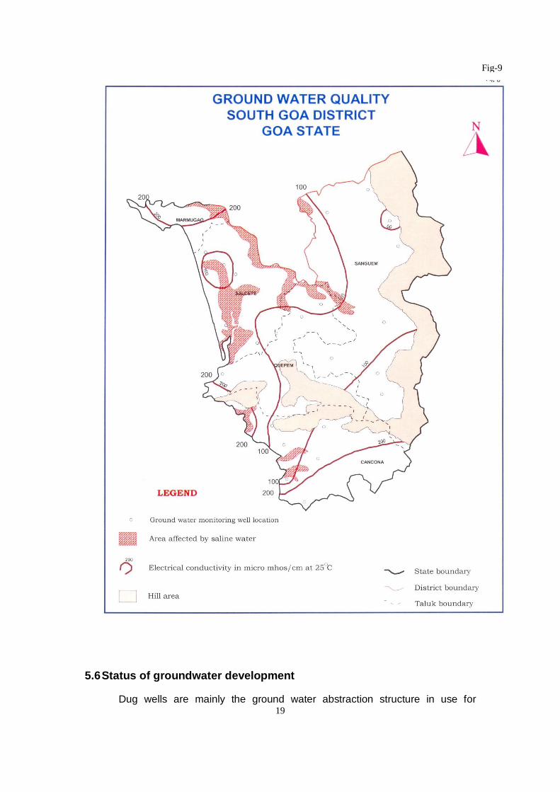
Ground water of the district is free from fluoride, nitrate and alkali hazards. In general the quality is good and potable. However, water table aquifers around Marmugao, especially locations close to and in the vicinity of creeks shows high electrical conductivity & chloride indicating brackish to saline nature of ground water. This can be attributed to seawater ingress in inland water table aquifers. In addition to this in areas confined to the vicinity of creeks of Sal River, ground water is brackish and unsuitable for drinking. The spatial distribution of saline water is given in Figure 9.

17
Fig-7

18
Fig-8
19
5.6 Status of groundwater development
Dug wells are mainly the ground water abstraction structure in use for
Fig-9

20
irrigation purposes in all the taluks. Shallow and deep tube wells are not much in use for irrigation purposes. Surface water irrigation is extensively prevalent in all the taluks of the district. Lift irrigation schemes are also being executed extensively in Sanguem and Quepem taluks. The details of ground water abstraction structures constructed under various minor irrigation schemes in South Goa district are mentioned in Table 6. Table 6: Taluk wise ground water abstraction structures constructed under
various minor irrigation schemes in South Goa district. Sl. No. Taluk Dug
wells Shallow
tube wells Deep tube wells
Surface flow
irrigation
Lift irrigatio
n
1. Sanguem 405 5 1 314 388 2. Quepem 173 1 - 237 100 3. Salcete 88 - - 164 26 4. Marmugao 109 - - 73 1 5. Canacona 486 10 2 194 24
TOTAL 1261 16 3 982 539 Source: IIIrd Census of Minor Irrigation Schemes 2000 – 01
6.0 Ground water management strategy 6.1 Ground water development
Stage of ground water development in the district is 34% as a whole and the district falls in SAFE category. There is lot of scope for further development of ground water resource. Due to complexities of formations, structure and morphological control, bore wells have to be properly located with respect to lineaments. The areas having pre - monsoon water levels less than 9 m and fluctuations less than 6 m have been recommended for dug well development and in areas having greater than 9m pre – monsoon water levels and greater than 6m fluctuations, bore wells have been suggested for resource development
Bore wells of 150 to 200m dia may be drilled from 45 to 150m depths as per local hydrogeological conditions.
Deeper ground water abstraction structures should be at least 0.5 km away from creeks and 400m away from coastline in low-lying areas to avoid quality problems.
6.2 Water conservation & artificial recharge Due to thin soil cover and highly rugged topography, in spite of heavy rainfall, the drainage system tends to be lean during summer months. Likewise due to steep hydraulic gradient and highly permeable phreatic aquifers, the dynamic ground water resource also gets depleted quickly rendering scarcity even for drinking water during summer months. Therefore, there is need for augmenting recharge by construction of water harvesting structures like bhandaras, sub – surface dykes, percolation ponds etc., so that these surface water bodies will help in augmenting ground water resources. Area suitable for artificial recharge in South Goa district is shown in Fig-10 In this regard, Department of Water Resources, Govt. of Goa, has taken up various projects pertaining to inter linking of rivers in the district, post –
21
monsoon water harvesting and canals. 7.0 Ground water related issues & problems
Water table aquifers around Marmugao, especially locations close to and in the vicinity of creeks shows high electrical conductivity & chloride indicating brackish to saline nature of ground water. This can be attributed to seawater ingress in inland water table aquifers. In addition to this in areas confined to the vicinity of creeks of Sal River, ground water is brackish and unsuitable for drinking. Salinity is more pronounced during May when fresh water flow is minimum and maximum seawater ingress takes place. Scarcity of ground water is observed during summer months as a result of high sub – surface and surface run off due to hilly topography and highly permeable nature of phreatic aquifer system. This results in lowering of water levels or drying of wells in some areas in summer months.
8.0 Awareness & Training Activity
8.1 Awareness Programme on “Hydrological Information System” under Hydrology Project - II, organized by Central Ground Water Board
Awareness Programme on “Hydrological Information System”, was organized under Hydrology Project – II, on 27.11.2008 at Madgaon, South Goa. The programme was attended by the representatives of State Govt. departments and members of Hydrology Project user group.
8.2 Training Programme on “Hydrological Information System” under
Hydrology Project - II, organized by Central Ground Water Board Training programme on “Hydrological Information System”, was organized under Hydrology Project – II, on 27.11.2008, at Madgaon, South Goa. Basic objective of the training programme was to train the members of Hydrology Project user group on the modules of Hydrological Information System developed under Hydrology Project.
8.3 Presentations and lectures delivered in public forum
Lectures on various aspects of ground water development, management and “Hydrological Information System”, were delivered by the scientists of CGWB on occasions of mass awareness and training programmes, organized in South Goa district.

22
9.0 Areas notified by Central Ground Water Authority
Fig-10
23
(CGWA)
Based on status of ground water utilization and available ground water resource, the entire district is categorized as SAFE from the point of view of ground water development. Therefore, no area has been considered for notification by CGWA.
10.0 Recommendations
(i) Due to thin soil cover and highly rugged topography, in spite of heavy rainfall, the drainage system tends to be lean during summer months. Likewise due to steep hydraulic gradient and highly permeable phreatic aquifers, the dynamic ground water resource also gets depleted quickly rendering scarcity even for drinking water during summer months. Therefore, there is need for augmenting recharge by construction of water harvesting structures like bhandaras, sub – surface dykes, percolation ponds etc., so that these surface water bodies will help in augmenting ground water resources.
(ii) Due to complexities of formations, structure and morphological control,
bore wells have to be properly located with respect to lineaments. The areas having pre - monsoon water levels less than 9 m and fluctuations less than 6 m have been recommended for dug well development and in areas having greater than 9m pre – monsoon water levels and greater than 6m fluctuations, bore wells have been suggested for resource development.
(iii) The depth of the dug wells, which can be, developed in this district
range between 8 to 15 m bgl depending upon topographic setup and thickness of the weathered zone. The depth of the well may be decided more precisely by referring to the depth to water level (Fig-3).
(iv) Bore wells of 150 to 200 mm diameter may be drilled from 45 to 150 m
depth depending upon local hydrogeological conditions.
(v) Investigations have revealed that water table aquifers around Marmugao, especially locations close to and in the vicinity of creeks shows high electrical conductivity & chloride indicating brackish to saline nature of ground water. This can be attributed to seawater ingress in inland water table aquifers. In addition to this in areas confined to the vicinity of creeks of Sal River, ground water is brackish and unsuitable for drinking. Thus it is recommended that ground water abstraction structures should be at least 0.5 km away from creeks and 400m away from coastline in low-lying areas to avoid quality problems.

CENTRAL GROUND WATER BOARD MåüÇSìÏrÉ pÉÔÍqÉ eÉsÉ oÉÉåQïû
SOUTH WESTERN REGION, SͤÉhÉ mÉͶÉqÉ ¤Éå§É, 27TH MAIN, 7TH CROSS, SECTOR I,
27uÉÉ qÉælÉ, 7uÉÉ ¢üÉxÉ, xÉåYOûU I HSR LAYOUT, BENGALURU-560102
LcÉ LxÉ AÉU sÉå AÉEOû, oÉåÇaÉsÉÔÂ- 560102 PH – 080-22586965 FAX – 080-22586940
VISIT US AT – www.cgwb.gov.in