GROUND WATER INFORMATION BOOKLET JAINTIA HILLS …cgwb.gov.in/District_Profile/Meghalaya/Jaintia...
15
GOVERNMENT OF INDIA MINISTRY OF WATER RESOURCES CENTRAL GROUND WATER BOARD GROUND WATER INFORMATION BOOKLET JAINTIA HILLS DISTRICT, MEGHALAYA North Eastern Region Guwahati September, 2013 No: 49/2011-12 Technical Report Series: D
Transcript of GROUND WATER INFORMATION BOOKLET JAINTIA HILLS …cgwb.gov.in/District_Profile/Meghalaya/Jaintia...
GOVERNMENT OF INDIA MINISTRY OF WATER RESOURCES
CENTRAL GROUND WATER BOARD
GROUND WATER INFORMATION BOOKLET
JAINTIA HILLS DISTRICT, MEGHALAYA
North Eastern Region
Guwahati
September, 2013
No: 49/2011-12 Technical Report Series: D
GROUND WATER INFORMATION BOOKLET
JAINTIA HILLS DISTRICT, MEGHALAYA
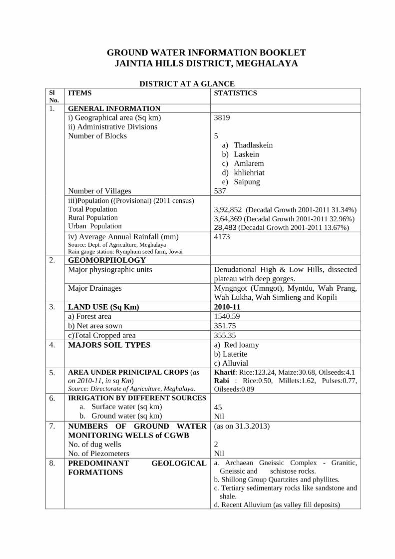
DISTRICT AT A GLANCE
Sl
No. ITEMS STATISTICS
1. GENERAL INFORMATION
i) Geographical area (Sq km)
ii) Administrative Divisions
Number of Blocks
Number of Villages
3819
5
a) Thadlaskein
b) Laskein
c) Amlarem
d) khliehriat
e) Saipung
537
iii)Population ((Provisional) (2011 census)
Total Population
Rural Population
Urban Population
3,92,852 (Decadal Growth 2001-2011 31.34%)
3,64,369 (Decadal Growth 2001-2011 32.96%)
28,483 (Decadal Growth 2001-2011 13.67%)
iv) Average Annual Rainfall (mm) Source: Dept. of Agriculture, Meghalaya
Rain gauge station: Rymphum seed farm, Jowai
4173
2. GEOMORPHOLOGY
Major physiographic units Denudational High & Low Hills, dissected
plateau with deep gorges.
Major Drainages Myngngot (Umngot), Myntdu, Wah Prang,
Wah Lukha, Wah Simlieng and Kopili
3. LAND USE (Sq Km) 2010-11
a) Forest area 1540.59
b) Net area sown 351.75
c)Total Cropped area 355.35
4. MAJORS SOIL TYPES a) Red loamy
b) Laterite
c) Alluvial
5. AREA UNDER PRINICIPAL CROPS (as
on 2010-11, in sq Km) Source: Directorate of Agriculture, Meghalaya.
Kharif: Rice:123.24, Maize:30.68, Oilseeds:4.1
Rabi : Rice:0.50, Millets:1.62, Pulses:0.77,
Oilseeds:0.89
6. IRRIGATION BY DIFFERENT SOURCES
a. Surface water (sq km)
b. Ground water (sq km)
45
Nil
7. NUMBERS OF GROUND WATER
MONITORING WELLS of CGWB No. of dug wells
No. of Piezometers
(as on 31.3.2013)
2
Nil
8. PREDOMINANT GEOLOGICAL
FORMATIONS
a. Archaean Gneissic Complex - Granitic,
Gneissic and schistose rocks.
b. Shillong Group Quartzites and phyllites.
c. Tertiary sedimentary rocks like sandstone and
shale.
d. Recent Alluvium (as valley fill deposits)
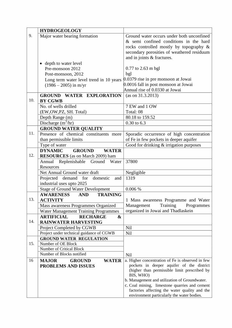
9.
HYDROGEOLOGY
Major water bearing formation
depth to water level
Pre-monsoon 2012
Post-monsoon, 2012
Long term water level trend in 10 years
(1986 – 2005) in m/yr
Ground water occurs under both unconfined
& semi confined conditions in the hard
rocks controlled mostly by topography &
secondary porosities of weathered residuum
and in joints & fractures.
0.77 to 2.63 m bgl
bgl
0.0379 rise in pre monsoon at Jowai
0.0016 fall in post monsoon at Jowai
Annual rise of 0.0330 at Jowai
10. GROUND WATER EXPLORATION
BY CGWB
(as on 31.3.2013)
No. of wells drilled
(EW,OW,PZ, SH. Total)
7 EW and 1 OW
Total: 08
Depth Range (m) 80.18 to 159.52
Discharge (m3/hr) 0.30 to 6.3
11. GROUND WATER QUALITY
Presence of chemical constituents more
than permissible limits
Sporadic occurrence of high concentration
of Fe in few pockets in deeper aquifer
Type of water Good for drinking & irrigation purposes
12. DYNAMIC GROUND WATER
RESOURCES (as on March 2009) ham
Annual Replenishable Ground Water
Resources
37800
Net Annual Ground water draft Negligible
Projected demand for domestic and
industrial uses upto 2025
1319
Stage of Ground Water Development 0.006 %
13. AWARENESS AND TRAINING
ACTIVITY
1 Mass awareness Programme and Water
Management Training Programmes
organized in Jowai and Thadlaskein Mass awareness Programmes Organized
Water Management Training Programmes
14. ARTIFICIAL RECHARGE &
RAINWATER HARVESTING
Project Completed by CGWB Nil Project under technical guidance of CGWB Nil
15. GROUND WATER REGULATION
Nil
Number of OE Block
Number of Critical Block
Number of Blocks notified
16 MAJOR GROUND WATER
PROBLEMS AND ISSUES
a. Higher concentration of Fe is observed in few
pockets in deeper aquifer of the district
(higher than permissible limit prescribed by
BIS, WHO)
b. Management and utilization of Groundwater.
c. Coal mining, limestone quarries and cement
factories affecting the water quality and the
environment particularly the water bodies.
GROUND WATER INFORMATION BOOKLET
JAINTIA HILLS DISTRICT, MEGHALAYA
1.0 Introduction
The Jaintia Hills district is the easternmost district of Meghalaya and covers a total
geographical area of 3819 sq. km. It lies between North latitude 24058’ and 26
003’ and
East longitude 91059’ and 92
051’and covers about 17 percent of the total area of
Meghalaya. The population is 299108 as per 2001 census. It is hilly and tribal and is
bounded by Karbi Anglong district (Assam) in northern, North Cachar Hills district
(Assam) in eastern part, East Khasi hills district in the west and Cachar Hills district
(Assam) and Bangladesh in the south.
As per provisional 2011 census, Jaintia Hills has a population of 3,92,852 of which male
and female were 1,95,641 and 1,97,211 respectively (1008 females per 1000 males. There
was change of 31.34 percent in the population compared to population as per 2001.
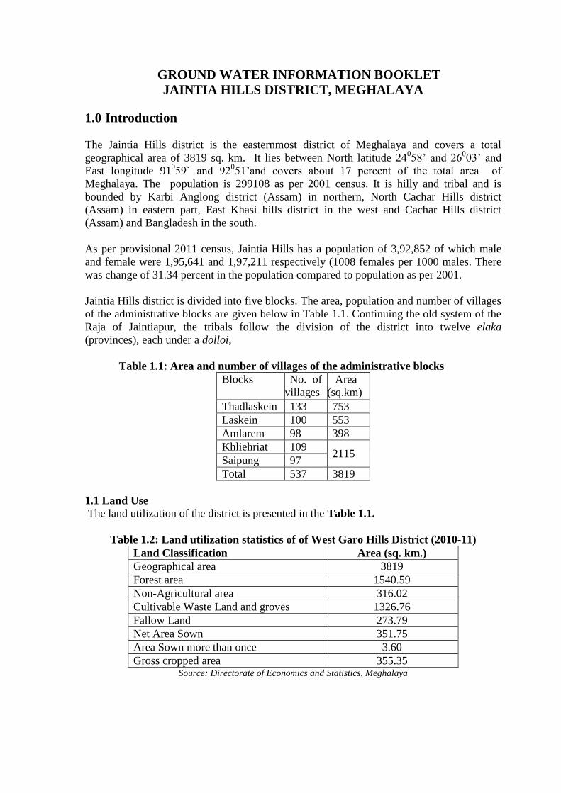
Jaintia Hills district is divided into five blocks. The area, population and number of villages
of the administrative blocks are given below in Table 1.1. Continuing the old system of the
Raja of Jaintiapur, the tribals follow the division of the district into twelve elaka
(provinces), each under a dolloi,
Table 1.1: Area and number of villages of the administrative blocks
Blocks No. of
villages
Area
(sq.km)
Thadlaskein 133 753
Laskein 100 553
Amlarem 98 398
Khliehriat 109 2115
Saipung 97
Total 537 3819
1.1 Land Use The land utilization of the district is presented in the Table 1.1.
Table 1.2: Land utilization statistics of of West Garo Hills District (2010-11)
Land Classification Area (sq. km.)
Geographical area 3819
Forest area 1540.59
Non-Agricultural area 316.02
Cultivable Waste Land and groves 1326.76
Fallow Land 273.79
Net Area Sown 351.75
Area Sown more than once 3.60
Gross cropped area 355.35 Source: Directorate of Economics and Statistics, Meghalaya
The district has a forest area of 1540.6 sq. km., i.e. about 40% of the total geographical
area. The net area sown is 351.75 sq. km. and the total cropped area is 355.35 sq. km.
Fallow land covers about 4%, net area sown is about 9%, while the total cropped area is
also about 9%.
The mainstay of the district is agriculture. However due to the abundance of limestone,
plenty of cement factories have been set up in the district. Coal mining in Khliehriat block
at sites like Ladrymbai, is also one of the major activities. Coal mined here is mostly
exported to Bangladesh and Assam.
In the district there are no major or medium irrigation projects, hence the agricultural
development in the area is dependent on minor irrigation schemes. The existing irrigation
schemes are based only on surface water and the source is mainly through non-monsoon
base flow. The total command area as on 31/03/2004 is 4545.29 ham in the district. Piped
water supply schemes and spot source water schemes are the main source of water supply
schemes and play a major role for the water requirement of the people especially in the
rural areas. Piped water supply schemes are categorized into (i) Gravity Feed Schemes and
(ii) River Pumping Schemes. Spot source water supply scheme are classified into (i) Hand
pump, (ii) Spring tapped chamber and (iii) Well (dug, ring) maintained by Public Health
Engineering Department, Meghalaya (PHED).
1.2 Rainfall & Climate
The climate of the district is directly controlled by the southwest monsoon originating from
the Bay of Bengal and the Arabian Sea. The climate shows a variation from the warm,
humid tropical in the plains in the eastern and southern part and temperate climate is
experienced in the western part around the district headquarter Jowai. The climatic
conditions vary substantially from place to place due to wide differences in altitude.
Therefore, according to the prevailing weather condition over the years, the district can be
grouped into four conspicuous seasons namely winter season, pre-monsoon season,
monsoon season and retreating season.
The average annual rainfall in the district is 4173 mm recorded at Rymphum seed farm in
Jowai. The district receives a fairly high rainfall throughout the year. Most of the
precipitation occurs between April and October. The monthly maximum rainfall of 2655.80
mm was recorded in June 1995 at the same rain gauge station. The lowest annual rainfall
was recorded in 2009 with 2623 mm and the highest annual rainfall was recorded in 1995
with 7695 mm..
Central Ground Water Board has carried out water supply investigations, Ground Water
Exploration and District Ground Water Management Studies in the district. Of late, during
Annual Action Plan 2004-05, District Ground Water Management Studies was carried out
in the district. Further, Ground Water exploration has been carried out during the year
2005-06.
2.0 Geomorphology & Soil Type:
2.1 Geomorphology
Geomorphologically, the district is an undulatory one, comprising dissected plateau,
denudational high and low hills with deep gorges. The district represents a remnant of
ancient plateau of Indian Peninsular shield uplifted to its present height due to tectonic
activities in the past and deeply dissected suggesting several geotectonic and structural
deformities that the plateau has undergone. The southern parts form a platform on which
Tertiaries were deposited in the post- cretaceous period. Topography varies from gently
rolling type to highly undulating type. The highest point of 1627m above MSL is observed
at Maryngksin, in eastern part and the lowest point is 76m above MSL at Dawki.
Broadly, the district can be differentiated into four major geomorphic units.
Alluvial plain in the southern part of the district bordering Bangladesh.
Area having denudo-structural hills and highly undulating topography.
Area showing more or less flat topography with rolling mounds representing plateau
Area containing denudational hills and less dissected topography.
2.2 Drainage
The drainage system of the district is controlled by topography. Broadly, there are mainly
two watershed in the district, one river flowing in the northern direction toward the
Brahmaputra and the other in the south, towards the Surma valley in Bangladesh. The
important rivers flowing to the Brahmaputra are Kopili, Myntang and Mynriang and the
main rivers flowing to the Surma valley are Myngngot (Umngot), Myntdu, Wah Prang,
Wah Lukha and Wah Simlieng. The drainage pattern is sub parallel to parallel. It is being
controlled by joints and faults as indicated by the straight courses of the rivers and streams
with deep gorges.
2.3 Soil Type
The district shows different types of soils as the provenance differs widely. The loamy soil
is the most prevalent one. They vary from sandy to clayey-loam in Jowai and Nongbah.
Reddish lateritic soil is observed in the hill slope in Sonapur and alluvial soil occurs in the
southern periphery of the district eg Dawki, Muktapur, Lakroh etc. The soil is acidic in
nature, with low percentage of phosphorous and high organic carbons.
3.0 Geological Set-up
The district area falls mainly within the Shillong or Meghalaya Plateau which is constituted
mainly of Precambrian rocks of gneissic composition in which granites, schists,
amphibolits, calc-silicate rocks occur as inclusions of various dimensions.
The gneisses form the Basement Complex for the overlying Shillong Group of rocks and is
separated from the later by an unconformity indicated at places by the occurrence of a
conglomerate bed. The presence of primary structures like current bedding, ripple marks
etc. indicated that quartzites of the Shillong Group are of sedimentary derivative later
metamorphosed to quartzites. These occur mostly as thick layers. Grainite Plutons occur as
isolated patches in the district , intruding the Basement Gneissic complex and Shillong
Group of rocks.The Granites occur as intrusive body in the Basement Gneissic complex.
Both Porphyritic and fine-grained pink granite occur in the area.
The Shella Formation of Jaintia Group consists of alteration of sandstone and limestone
occurs in the south-central and south-western part of the district.
The shelf facies of Barail Group, consists of fairly coarse grained sandstone, shale,
carbonaceous shale with streaks and minor seams of coal and occupy the south-eastern part
of the District.
The Quaternary fluvial sediments occur as valley-fill deposits and in the extreme southern
plain of the district bordering Bangladesh.
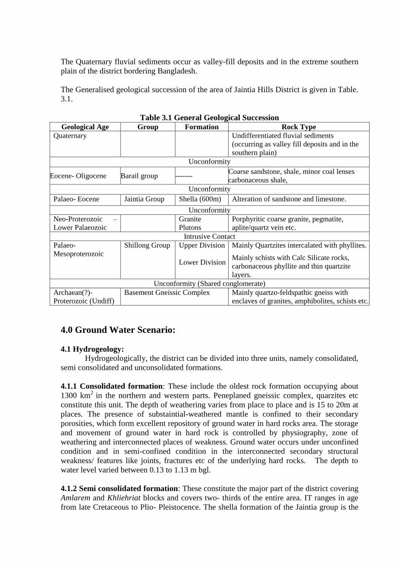
The Generalised geological succession of the area of Jaintia Hills District is given in Table.
3.1.
Table 3.1 General Geological Succession
Geological Age Group Formation Rock Type
Quaternary Undifferentiated fluvial sediments
(occurring as valley fill deposits and in the
southern plain)
Unconformity
Eocene- Oligocene Barail group ------- Coarse sandstone, shale, minor coal lenses
carbonaceous shale,
Unconformity
Palaeo- Eocene Jaintia Group Shella (600m) Alteration of sandstone and limestone.
Unconformity
Neo-Proterozoic –
Lower Palaeozoic
Granite
Plutons
Porphyritic coarse granite, pegmatite,
aplite/quartz vein etc.
Intrusive Contact
Palaeo-
Mesoproterozoic
Shillong Group Upper Division
Lower Division
Mainly Quartzites intercalated with phyllites.
Mainly schists with Calc Silicate rocks,
carbonaceous phyllite and thin quartzite
layers.
Unconformity (Shared conglomerate)
Archaean(?)-
Proterozoic (Undiff)
Basement Gneissic Complex Mainly quartzo-feldspathic gneiss with
enclaves of granites, amphibolites, schists etc.
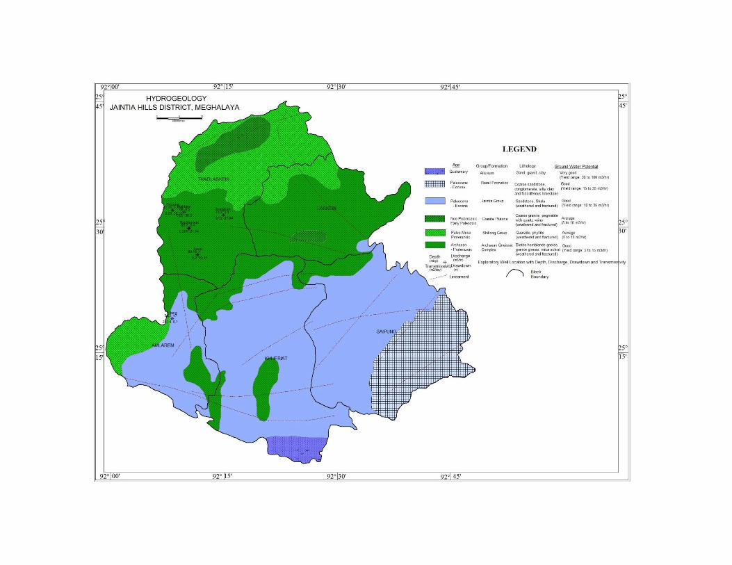
4.0 Ground Water Scenario:
4.1 Hydrogeology:
Hydrogeologically, the district can be divided into three units, namely consolidated,
semi consolidated and unconsolidated formations.
4.1.1 Consolidated formation: These include the oldest rock formation occupying about
1300 km2
in the northern and western parts. Peneplaned gneissic complex, quarzites etc
constitute this unit. The depth of weathering varies from place to place and is 15 to 20m at
places. The presence of substaintial-weathered mantle is confined to their secondary
porosities, which form excellent repository of ground water in hard rocks area. The storage
and movement of ground water in hard rock is controlled by physiography, zone of
weathering and interconnected places of weakness. Ground water occurs under unconfined
condition and in semi-confined condition in the interconnected secondary structural
weakness/ features like joints, fractures etc of the underlying hard rocks. The depth to
water level varied between 0.13 to 1.13 m bgl.
4.1.2 Semi consolidated formation: These constitute the major part of the district covering
Amlarem and Khliehriat blocks and covers two- thirds of the entire area. IT ranges in age
from late Cretaceous to Plio- Pleistocence. The shella formation of the Jaintia group is the

most conspicuous. Ground water in this formation occurs under unconfined to semi
confined conditions due to primary porosities of the semi consolidated formations as well
as in the secondary porosities like caverns, open fractures and joints. The formations shows
both isolated hammocky topography to highly undulating topography with steeply rising
hills and deep gorges. The karst topography is observed in areas of Letein, Latyrk, Litang
etc. occupied by the cavernous limestone. The depth to water level lies between 0.30 and
1.13 m bgl.
4.1.3: Unconsolidated formation: The unconsolidated formation is mainly represented by
recent alluvium occurs near the southern fringe of the district and is the continuation of the
alluvial plain of Bangladesh. It constitute about 67 km2 representing about 2% of the total
area.
4.2 Ground Water Exploration:
The ground water development is yet to be picked up in the district. As part of ground
water exploration programme of CGWB, the Board had drilled seven exploratory wells and
one observatory well in the district. The depth of the exploratory well ranges from 80.18 m
to 159.52 m below ground level. The depth to water level of the wells ranges from 5.15 to
14.18 m below ground level. The ground water discharge varies from 0.30 m3/hr at
Tyrsang E/W to 6.3 m3/hr at Thadlaskein, Diet and the Transmissivity lies between 0.02
m2/day to 3.65 m
2/day respectively. The summarised details of Ground Water Exploration
carried out in the district are given in Table 4.1.
Table 4.1: Summarised Details of Ground Water Exploration S.
No
Location Depth
drilled
(m)
Aquifer type Aquifer zones tapped
(m.below ground level)
SWL
(m.bgl)
Discharge
(m3/hr)
DD
(m)
T
(m2/day)
1 Litang 80.3 Limestone 10-12,20-25,30.4-31.4,37.6-38.6,44.7-
46.7,51.8-53.8,78.2-79.2
9.36 17 8.1 287.4
2 Thadlaskein
Diet
120.4 Quartzite 22.4-25,80.7-84.1 10.24 6.3 1.12 3.65
3 Thadlaskein 159.52 Quartzite 10.12-16.22,61.92-68.02,80.22-86.32,
104.62-110.72,116.82-122.92
6.9 5.56 12.75 2.68
4 Jowai 80.18 Quartzite 23.19-24.19,31.39-32.39,40.49-41.49,
47.59-49.69,55.79-56.79,76.89-77.34
14.8 1 33.11 0.2
5 Wahlajer 88 Sandstone,
shale
21.45-22.45,30-30.5,39.75-40.75,52.95-
53.95,64.65-65.15
5.51 0.5 30.3 0.92
6 Thadlaskein 85.7 Quartzite 32.62-34,36-37.5,43.5-44.5,64.5-
66.5,75-76
4.95 0.4 27.84 0.205
7 Nongbah 74.2 Quartzite 27.4-29.4,31.5-35.5 4.95 0.4 27.84 0.02
8 Tyrsang 82.35 Sandstone,
shale
22.35-23.35,27.45-28.45,31.55-
32.55,59.95-60.95
6.14 0.3 39.55 2.28
4.3 Ground Water Resources
The dynamic ground water resources have been assessed based on Ground Water
Resources Estimation methodology of 1997 (GEC 97). In this methodology two
approaches are recommended water level fluctuation method and rainfall infiltration
method. As the data on ground water level is insufficient, the rainfall infiltration method is
used for calculating the resource estimation of the district. Moreover, hilly area having
slope of more than 20% are not taken into consideration as they are not worthy of recharge.
Hence, the remaining area is delineated into command and non command area and
assessment is done for both monsoon and non-monsoon seasons. As per the Rainfall
Infiltration Factor method, recharge from rainfall is given by the following formula:
(Rf ) = RIF *A * NMR
Where RIF = rainfall infiltration factor
A = Area of computation for recharge.
NMR = Normal monsoon rainfall
Recharge from sources other than rainfall, ground water irrigation, recharge from
ponds and tanks, check dams nalla bunds is taken as nil for the district and only surface
water irrigation is taken into account. The total annual recharge is obtained as the
arithmetic sum of recharge from rainfall and the recharge from sources other than rainfall.
Thus Ground water Resource Potential (as on March 2009) in ham is as follows.
Table: 4.2 Net ground water availability (ham)
Annual Replenishable GW resources Total annual ground water recharge
Natural discharge during non-monsoon season
Net ground water availability Monsoon season Non-monsoon season
Rainfall recharge
Recharge from other source
Recharge from rainfall
Recharge from other source
30750 Nil 7050 Nil 37800 3780 34020
Table 4.3: Categorization of ground water resources
Net Ground water availability
Annual GW draft Domestic and industrial uses upto 2025
Ground water availability for future irrigation
Stage of ground water development (%)
Categorization
Irrigation Domestic and industrial uses
Total
34020 Nil 1.98 1.98 1319 32701 0.006 Safe
As per the ground water resource and the stage of development computed, it can be seen
that, ground water development is yet to be picked up in the area. The stage of development
during the last decade is negligible and the district can be developed further by utilizing the
abundant ground water resources available in the district.
4.3 Ground Water Quality
In order to study the chemical quality of ground water representative water samples from
select borewells, dug wells and springs were collected during the course of field work and
the parameter analysed are pH, EC, TDS, CO3, Cl, SO4, F, Ca, Mg, TH and Fe.
It was observed that spring water is by and large slightly alkaline rather than acidic. Overall
the chemical constituent present in the ground water is within permissible limit set by BIS
and WHO except the concentration of Iron in few pockets in deeper aquifer, which is
higher than permissible limit. Removal of the Iron is best effected by aeration process
followed by sedimentation and filtration. Potassium permanganate or chlorine/chloride may
be employed to oxidize the iron, which is then filtered from the waters. The process is
applicable very much when bacteria is present in the water. Iron can also be removed by the
addition of a mixture of sodium carbonate and sodium phosphate to precipitate iron as
insoluble, followed by settling and filtration.
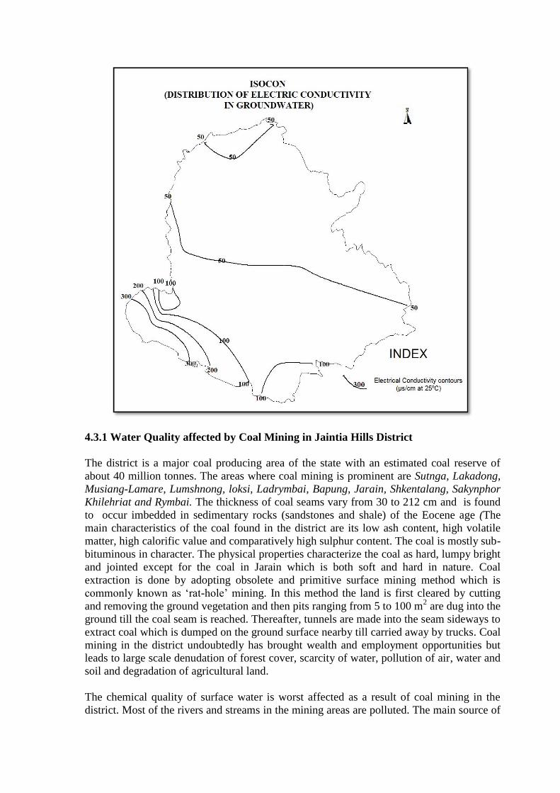
4.3.1 Water Quality affected by Coal Mining in Jaintia Hills District
The district is a major coal producing area of the state with an estimated coal reserve of
about 40 million tonnes. The areas where coal mining is prominent are Sutnga, Lakadong,
Musiang-Lamare, Lumshnong, loksi, Ladrymbai, Bapung, Jarain, Shkentalang, Sakynphor
Khilehriat and Rymbai. The thickness of coal seams vary from 30 to 212 cm and is found
to occur imbedded in sedimentary rocks (sandstones and shale) of the Eocene age (The
main characteristics of the coal found in the district are its low ash content, high volatile
matter, high calorific value and comparatively high sulphur content. The coal is mostly sub-
bituminous in character. The physical properties characterize the coal as hard, lumpy bright
and jointed except for the coal in Jarain which is both soft and hard in nature. Coal
extraction is done by adopting obsolete and primitive surface mining method which is
commonly known as ‘rat-hole’ mining. In this method the land is first cleared by cutting
and removing the ground vegetation and then pits ranging from 5 to 100 m2 are dug into the
ground till the coal seam is reached. Thereafter, tunnels are made into the seam sideways to
extract coal which is dumped on the ground surface nearby till carried away by trucks. Coal
mining in the district undoubtedly has brought wealth and employment opportunities but
leads to large scale denudation of forest cover, scarcity of water, pollution of air, water and
soil and degradation of agricultural land.
The chemical quality of surface water is worst affected as a result of coal mining in the
district. Most of the rivers and streams in the mining areas are polluted. The main source of
this pollution in the mining area is “Acid Mines Drainage” originating from mines and
spoils, leaching of metals from soil and rocks, organic enrichment, silting etc. The waters
of the mining areas have been found containing sulphate concentration between 16 to 161
mg/L. The high concentration of sulphates is mainly due to presence of iron sulphide in
coal and rocks and its reaction with water and oxygen. On the other hand, water of the non
mining areas very low concentration of sulphates. Water pollution is exhibited by the
colour of the water in mining areas which varies from brownish to reddish colour. Other
parameters which characterized the degradation of water quality are low pH, high
conductivity, high concentration iron and toxic metals, low dissolved oxygen and high
BOD.
5.0 Ground Water Management Strategy
5.1 Ground Water Development
Development of ground water in the district is practically negligible. As the district is
characterized by undulatory terrain, the scope for development of ground water lies in low
lying depression, and valley fills which hold good prospects for ground water development.
More over, in the district all the minor irrigation scheme are executed by the surface water
only and as per Ground water resources estimation, the stage of ground water development
is only 0.006% which leaves a greater scope for ground water development.
Ground water development is being done through dugwell and borewell in the
intermontane valley and linear ridges. The development of spring is seen mainly along the
foothills. The ground water is mainly used for domestic purposes such as washing and
drinking. Therefore, there is ample scope for future development of ground water in the
area.
The peneplanied surfaces, buried pediments and the valley fills are the most favorable
localitions for the development of ground water. The fractured and lineament too hold
prospect for the development of ground water. Structures like ring wells, shallow as well
as deep tube wells are the feasible ground water structures. The fractured, fissured rocks
and the intersection of faults /lineaments hold good prospects for ground water. As ground
water is poorly developed/ exploited, dugwells are the preferred structures as of now in
low-lying areas and valleys. The shallow water level conditions gives scope to maintain
sufficient water column in the dug wells.
Ground water manifests itself at the surface as springs. This can plays an important role in
rural water supply scheme in the district and a proper and scientific approach is required to
augment the existing water supply scenario in the district.
6.0: Ground Water Related Issues and Problems
In few pockets of the district higher concentration of Iron in deeper aquifer is found which
is beyond permissible limit set by BIS and WHO. In area where iron content is beyond
permissible limit, iron removal plant or other suitable devices should be installed.
The district is well known for large production of coal with Khliehriat sub division as its
main coal belt area. It can be seen that unscientific method of coal mining coupled with
limestone quarry undertaken by cement factories has affected the environment particularly

the water bodies in various part of the district. Hence scientific mining is suggested as a
preventive measures. Government of Meghalaya can take up right steps in this direction.
7.0: Recommendations
Springs play a major role of water requirement for the people in rural areas. It is found that
the location of the spring is mainly restricted to foothills and intermontane valleys. The
spring water is of excellent quality and is suitable for drinking purposes as per BIS
standard. As the people in rural areas are totally dependent on spring, there is an urgent
need for scientific approach for proper development and management of this precious
resource. It may be recommended that the development of springs having high discharge
will help in mitigating the water requirement of the people to a great extent.
As development of ground water is still in nascent stage, there is ample scope for future
development of ground water in the district. It is being done through dug wells and bore
wells in the intermontane valleys and linear ridges. In the foothills where most of the
precipitation get wasted as surface runoff, rain water harvesting should be promoted by
constructing structures such as gully plugs, check weirs and check dams and also roof-top
rain water harvesting structures. In doing so, the water level on the upstream can be raised
to a considerable extent. For roof-top rain water harvesting, rainwater can be collected from
the PVC/GI or concrete rooftops through bamboo, GI or PVC gutters and pipes. This water
can be used for domestic uses including drinking purposes after treatment. The rainwater
harvesting structures are simple, economical and eco-friendly multi-purpose measures,
mutually complementary and conducive to soil and water conservation, afforestation and
increased agricultural productivity. The structures commonly suited to hilly areas are bench
terracing, contour bunds / trenches, gully plugs, nalah bunds / Gabion structures, check
dams and percolation ponds as also roof-top rain water harvesting for buildings.
Fig. 1. Schematic Diagram of Contour Bund/Trenches Fig. 2. Schematic Diagram of a Gabion Bund
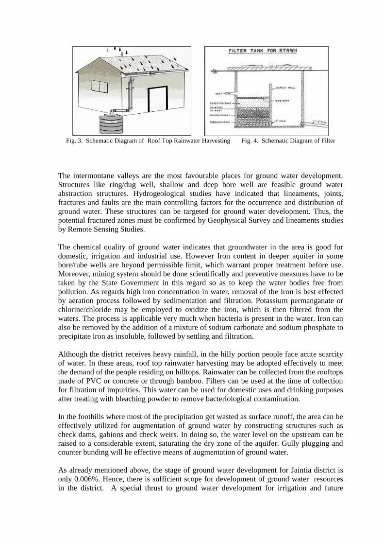
Fig. 3. Schematic Diagram of Roof Top Rainwater Harvesting Fig. 4. Schematic Diagram of Filter
The intermontane valleys are the most favourable places for ground water development.
Structures like ring/dug well, shallow and deep bore well are feasible ground water
abstraction structures. Hydrogeological studies have indicated that lineaments, joints,
fractures and faults are the main controlling factors for the occurrence and distribution of
ground water. These structures can be targeted for ground water development. Thus, the
potential fractured zones must be confirmed by Geophysical Survey and lineaments studies
by Remote Sensing Studies.
The chemical quality of ground water indicates that groundwater in the area is good for
domestic, irrigation and industrial use. However Iron content in deeper aquifer in some
bore/tube wells are beyond permissible limit, which warrant proper treatment before use.
Moreover, mining system should be done scientifically and preventive measures have to be
taken by the State Government in this regard so as to keep the water bodies free from
pollution. As regards high iron concentration in water, removal of the Iron is best effected
by aeration process followed by sedimentation and filtration. Potassium permanganate or
chlorine/chloride may be employed to oxidize the iron, which is then filtered from the
waters. The process is applicable very much when bacteria is present in the water. Iron can
also be removed by the addition of a mixture of sodium carbonate and sodium phosphate to
precipitate iron as insoluble, followed by settling and filtration.
Although the district receives heavy rainfall, in the hilly portion people face acute scarcity
of water. In these areas, roof top rainwater harvesting may be adopted effectively to meet
the demand of the people residing on hilltops. Rainwater can be collected from the rooftops
made of PVC or concrete or through bamboo. Filters can be used at the time of collection
for filtration of impurities. This water can be used for domestic uses and drinking purposes
after treating with bleaching powder to remove bacteriological contamination.
In the foothills where most of the precipitation get wasted as surface runoff, the area can be
effectively utilized for augmentation of ground water by constructing structures such as
check dams, gabions and check weirs. In doing so, the water level on the upstream can be
raised to a considerable extent, saturating the dry zone of the aquifer. Gully plugging and
counter bunding will be effective means of augmentation of ground water.
As already mentioned above, the stage of ground water development for Jaintia district is
only 0.006%. Hence, there is sufficient scope for development of ground water resources
in the district. A special thrust to ground water development for irrigation and future

utilization is recommended. Creating public awareness for effective use of water resources
is essential for proper management of ground water resources. Hence, the co-operation of
public is as important as the technical or administrative considerations.
Depletion of forest cover, pollution of air, water and soil, degradation of agricultural fields,
and scarcity of water and other natural resources are some major environmental issues of
the coal mining areas. The rivers in the district are the greatest victims of the coal mining.
Hence there is urgent need for initiating activities for ecorestoration of the affected areas.
Following measures can be taken up to mitigate the environmental problem and
improvement of water quality.
Preservation of non polluted water sources: Most of the water bodies in the mining
areas barring a few springs have been polluted. Hence these springs should be preserve
against pollution.
Scientific method of coal mining and disposal of mine water as well as spoils.
Filling of mine pits, channelling of seepage water for checking “Acid Mines Drainage”
contamination of water bodies.
Extensive afforestation and vegetation on coal mines areas is an important step of
ecorestoration.
Conservation of top soil is essential for plant growth and agricultural productivity.
The villager needs to educated about the damage that coal mining activities causes to
the adjoining areas


![A Review on Ethnomedicinal, Phytochemical and ......Uttranchal and Khasi, Jaintia, Naga and Lushai Hills of Meghalaya in between 900-2100 m above the sea level[27-29]. Apart from India,](https://static.fdocuments.net/doc/165x107/609c1eb6ff2f5a500b4c95f9/a-review-on-ethnomedicinal-phytochemical-and-uttranchal-and-khasi-jaintia.jpg)
![[XLS] · Web viewDeoghar Bangalore Urban Idukki Ashoknagar Amravati Chandel Jaintia Hills Kolasib Kohima Bhadrak Bathinda Banswara North Sikkim Coimbatore Hyderabad South Tripura](https://static.fdocuments.net/doc/165x107/5ae2e1b67f8b9a097a8d8160/xls-viewdeoghar-bangalore-urban-idukki-ashoknagar-amravati-chandel-jaintia-hills.jpg)