
European Environment State and outlook – 2005 European Environment Agency.

Issue Date: December 2008 UNCLASSIFIED DIRECTORATE MAJOR PROJECT
Issue No: 2
7. Ground Conditions Mensa Environmental Appraisal Volume 1
Uncontrolled Copy when Printed 7-1
UNCLASSIFIED
7. GROUND CONDITIONS
7.1 Introduction
This chapter describes the geological, hydrological, hydrogeological, and potential land contamination aspects of the Application Site.
An assessment has been undertaken to ascertain whether, and to what extent, the Proposed Development and the environment will be impacted by the current ground conditions within the Application Site. This will include the assessment of potential radiological, explosive and chemical ground contamination from either current or historical uses of the Application Site. This assessment has enabled the refinement of the Conceptual Site Model (CSM), which reviews potential sources, pathways and receptors for identified contaminants and allow the determination of the significance of any potential impacts for the Application Site. Furthermore, risks to future site users and environmental receptors have been concluded, and assessments of residual and cumulative impacts of the Proposed Development have been made.
This chapter refers to, draws information from, and summarises the Ground Conditions Technical Report located in Technical Appendix A of Volume II of this Environmental Appraisal (EA).
This chapter has been written by RPS Planning and Development (RPS).
7.1.1 Proposed Development
The Application Site and Proposed Development have been outlined in detail in Chapter 1: Introduction and Chapter 5: Proposed Development of this Environmental Appraisal (EA). The Proposed Development will comprise three main components, as follows:
1) The permanent proposed facilities located within the centre of AWE Burghfield include: the Main Process Facility and Support Building with 14 lightning conductor towers; a Plant Building with two lighting conductor towers; two gatehouses; two vehicle inspection bays; two electrical substations; two Sustainable Drainage Systems (SuDS) lagoons; associated access roads and an operational vehicle waiting area. Permanent features which will be located at Pingewood Gate in the north-east of the Application Site include a primary intake sub-station and a SuDs lagoon.
2) The temporary construction enclave, implemented in order to isolate construction activities from the main AWE Burghfield site. Further details of the construction enclave, can be found in Chapter 6: Construction Phase of this EA.
3) A temporary car park and HGV marshalling area will be built at Pingewood Gate in the north-east of the Application Site. This area will enable vehicular access and egress to the construction enclave during the construction phase of the development. Further details of the Pingewood Gate car park and HGV marshalling area, can be found in Chapter 6: Construction Phase of this EA.
4) Landscaping and biodiversity proposals, details can be found within Chapter 13: Landscape and Visual Impacts.
It is proposed that the Application Site will be surrounded with a security fence to separate the construction works from the rest of AWE Burghfield. This fence line will traverse the eastern most extent of the Former Site Tip, located in the north eastern reaches of AWE Burghfield (see Figure 7-1).
7.2 Legislation and Planning Policy Context
Re-development of brownfield land must take into account the regulatory context of the proposal site and development, provide information that is fit for purpose and be in accordance with UK good practice. An environmental assessment of the condition of the site must not only consider the potential receptors of human health and controlled waters but also include a review of the relevant legislation and planning policy that applies to the site and its immediate environs. Further information with regards to local and regional planning policy can be found in Chapter 3: Planning Policy Context of this EA.
7.2.1 Legislation
There are three key legislative drivers for dealing with risks to human health and the environment from historical land contamination, namely:
• Part IIA of the Environmental Protection Act (EPA) 1990 (the “contaminated land” regime) (Ref. 7-1);
• The Water Resources Act 1991 (Ref. 7-2); and
• The Town and Country Planning Act, 1990 (Ref. 7-3).
In the UK, Part IIA of the EPA, as introduced by Section 57 of the Environment Act 1995 (Ref. 7-1), provides the legislative framework within which site data is to be assessed. Under Part IIA of the EPA, sites are identified as “contaminated land” if they are causing significant harm or if there is a significant possibility of significant harm or if the site is causing, or could cause, pollution of Controlled Waters. Controlled waters are defined as including both surface waters and groundwater. The Water Act 2003 (Ref. 7-2) introduced a revision to the wording of the EPA, which now requires that a site is causing, or could cause, significant pollution of Controlled Waters in order to be determined as Contaminated Land.
Once a site is determined to be “Contaminated Land” then remediation is required to render significant pollutant linkages (i.e. the source-pathway-receptor relationships that are associated with significant harm and/or significant pollution of controlled waters) insignificant, subject to a test of reasonableness.
The Building Act 1984 (Ref. 7-4) and the Building Regulations 2000 (Ref. 7-5) are the two key legislative drivers when considering structural and design aspects of a development in terms of geotechnical properties of the ground. The Regulations require that buildings are constructed so that ground movement caused by swelling, shrinkage, freezing, landslip or subsidence of the sub-soils will not impair the stability of any part of the building.
7.2.2 National Planning Policy
7.2.2.1 Planning Policy Statement (PPS) 23: Planning and Pollution Control
Land contamination and its risk to health is a material consideration under planning and development control, and applies to the intended use of the site. Existing guidance on assessing risks to health under the Town and Country Planning Acts is limited to the amended Planning Policy Statement (PPS) 23: ‘Planning and Pollution Control’ (Ref. 7-6), which more clearly aligns the requirements under planning with those under Part IIA. This is consistent with the practical requirements that a site under planning for its intended or proposed use should not fail the requirements of Part IIA when the site is occupied and in use.
7.2.2.2 Planning Policy Guidance (PPG) 14: Development on Unstable Land
National Planning Policy Guidance on the geotechnical condition of soils is defined in Planning Policy Guidance Note (PPG) 14: ‘Development on Unstable Land’ (Ref. 7-7). PPG14 identifies the situations that can result in and arise from the development of unstable ground. The guidance aims to:
• Minimise the risks and effects of land instability on property, infrastructure and the public;
• Help to ensure that various types of development are not placed in unstable locations without appropriate precautions;
• Bring unstable land, wherever possible, back into productive use; and
• Assist in safeguarding public and private investment through a full appreciation of site conditions and necessary precautionary measures.
7.2.3 Regional Planning Policy
Policy Q6 of the Regional Planning Guidance for the South East (RPG9) (Ref. 7-8) dated March 2001 provides general guidance for development planning throughout the Region. It states that local authorities and key agencies can play a role in improving the local environment, and public health and safety, including restoring derelict and contaminated land. RPG9 will be replaced by the South East Plan, which will become the adopted Regional Spatial Strategy for the South East in due course.
Issue Date: December 2008 UNCLASSIFIED DIRECTORATE MAJOR PROJECT
Issue No: 2
7. Ground Conditions Mensa Environmental Appraisal Volume 1
Uncontrolled Copy when Printed 7-2
UNCLASSIFIED
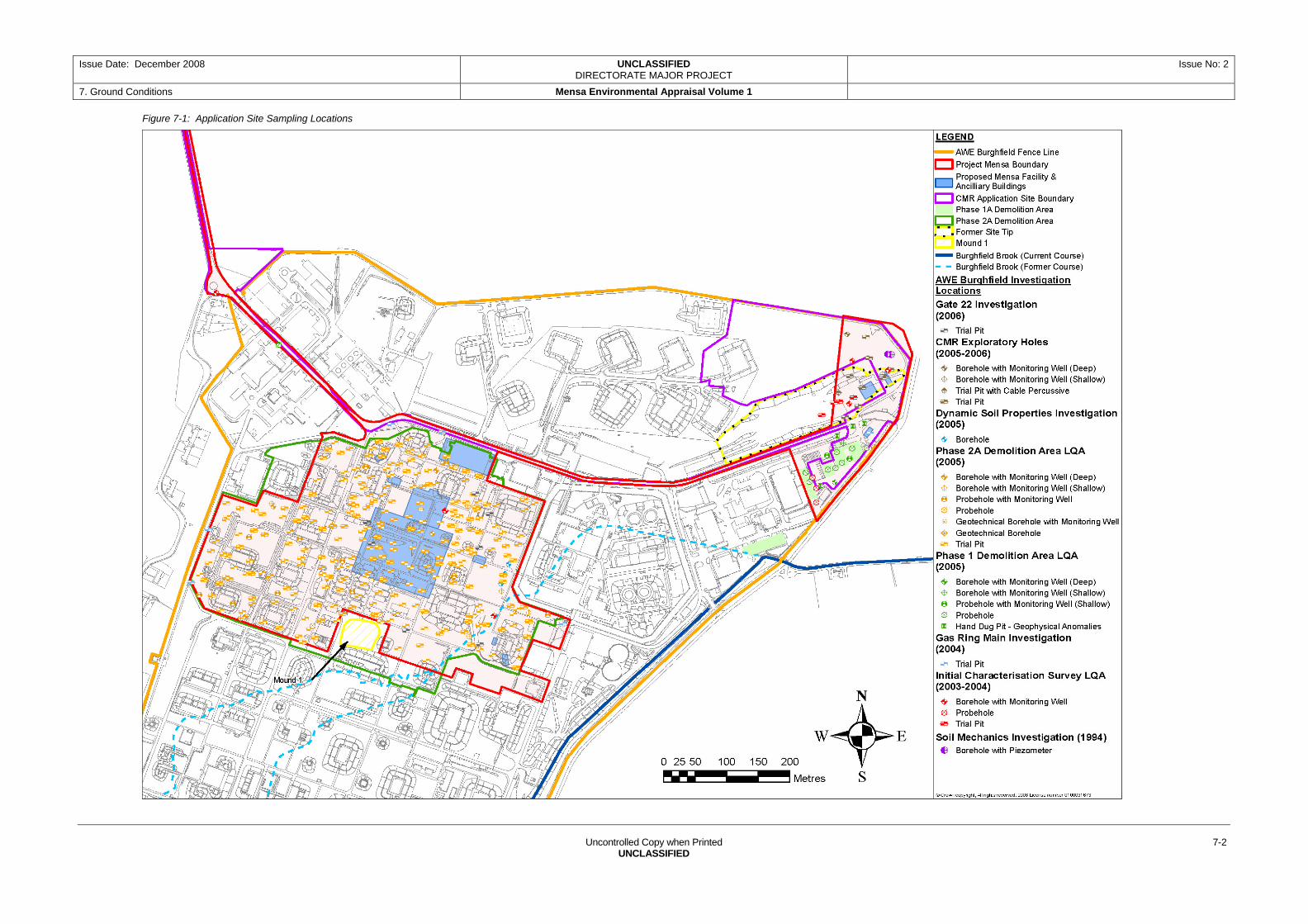
Figure 7-1: Application Site Sampling Locations

Issue Date: December 2008 UNCLASSIFIED Issue No: 2 DIRECTORATE MAJOR PROJECT
7. Grou d Conditions n Mensa Environmental Appraisal Volume 1
Uncontrolled Copy when Printed 7-3
UNCLASSIFIED
7.2.4 Local Planning Policy
The following local planning documents do not contain any specific policies relating to land contamination:
• The Berkshire Structure Plan 2001-2016 (Ref. 7-9), which contains policies of relevance to Local Authorities including West Berkshire Council in preparing their own development plans;
• The adopted West Berkshire District Local Plan 1991-2006 Saved Policies (Ref. 7-10); and
• The newly evolving local development framework, including documents that will inform the West Berkshire Planning Strategy.
It is therefore considered that the overriding policy document that sets the context for this chapter is PPS 23.
However, West Berkshire Council in association with neighbouring Local Authorities, has produced a document entitled, The Berkshire Guide to Developing Potentially Contaminated Land (Ref. 7-11). This document guides developers in the content of contaminated land reports submitted to local planning authorities within the area. Under the Town and Country Planning regime, the responsibility for providing information on whether a site is contaminated rests primarily with the developer.
7.3 Assessment Methodology and Significance Criteria
7.3.1 General
The assessment of ground conditions has involved the review and collation of readily available information pertaining to the current condition of the soils and groundwater beneath the Application Site. This existing information has been used to develop a baseline condition for the Application Site. The information has been reviewed in the context of the Proposed Development to evaluate the short, medium and long term, direct and indirect, permanent and temporary, adverse and beneficial impacts associated with the Proposed Development.
The assessment has involved the review of the following data sources:
• 26 desk-top studies and intrusive investigations carried out at the site between 2004 and 2008 (Refs 7-10 to Ref. 7-35);
• Historical Maps dated 1913, 1942, 1961, 1972 and 1976; Solid & Drift Geology, 1:50,000 scale;
• Sheet 268 (Reading); British Geological Survey (2000), 1:10,000 scale;
• Geology Map “SU66NE” British Geological Survey;
• Ordnance Survey 1:25,000 ‘Explorer’ Map ‘Reading Wokingham & Pangbourne’;
• Ordnance Survey Site Centred 1:10,000 topographical map;
• Borehole data provided by the British Geological Survey;
• Hydrogeological Map (Sheet 7) of South West Chilterns, 1:100,000 scale;
• Sheet 7, SW Chilterns, Berkshire and Marlborough Downs; Groundwater Vulnerability Map of Upper Thames & Berkshire Downs. Sheet 38. 1:100,000 (Environment Agency);
• Environment Agency (Environment Agency) publication ‘The Physical Properties of Minor Aquifers in England and Wales’, 2000;
• Environment Agency website, DEFRA website; and,
• Anecdotal information from AWE employees.
The Application Site has recently undergone a programme of demolition, clearance and remediation. The majority of site investigation data, used to establish the current baseline, was gathered prior the remedial works. However, current baseline ground conditions described within this chapter are those found at the Application Site post remediation.
The data from the Technical Appendix A, along with the outlined previous investigation reports and other listed data sources form the basis of this Chapter of the EA.
7.3.2 Baseline Assessment Methodology
The baseline conditions regarding chemical, radiological and explosive residue contamination, was established using the aforementioned information and the following assessment methods.
7.3.2.1 Human Health Risk Assessment of Soil
Soil assessment criteria were derived utilising regulatory approved computer modelling software and current UK guidance (including Contaminated Land Report (CLR) 7 – 11 (Ref. 7-36 to Ref.7-40)). Published Soil Guideline Values (SGVs) (Ref. 7-41) were adopted based on the proposed end use scenario of the Application Site as commercial / industrial, and compared against soil sample results for various contaminants. Generic Assessment Criteria (GAC) were generated using the Contaminated Land Exposure Assessment (CLEA) United Kingdom (UK) model and exposure parameters for elevated contaminants in soils where no SGV is available.
The short-term risks of construction worker exposure to contaminants was not assessed using the risk model, as they are dealt with through the application of the Construction (Design and Management) Regulations (CDM 2007) (Ref 7-42) and the adoption of Safe Systems of Work (SSoW).
7.3.2.2 Assessment of Groundwater Quality
UK guidance on groundwater specifies that controlled waters should not be impacted by contamination. When pollution has occurred the risks from the pollutants are assessed on a site-specific basis using risk assessment tools.
Groundwater quality was initially assessed using a Tier 1 ‘screening’ risk assessment which was carried out in line with published guidance (Ref. 7-43). The Tier 1 screening involves an assessment of contaminants of concern (COC),
based on compliance or non-compliance with water quality standards. The water quality standards used within this assessment are as follows:
• Environmental Quality Standards (EQS) (Ref. 7-44) for the assessment of water quality with respect to impact upon freshwater life in Burghfield Brook and other nearby surface water courses;
• Revised Drinking Water Standards (DWS) (Ref. 7-45) (Water Supply (Water Quality) Regulations (2000)) are used for the evaluation of potential human health risks associated with the ingestion of either groundwater or surface water; and,
• Where no DWS or EQS standards are available, WHO drinking water guidelines are applied (Ref. 7-46), although these values should only be used as guidelines rather than as acceptable limiting values.
Where groundwater concentrations exceed the criteria there is a risk that controlled waters are being unacceptably polluted. Where exceedances have been encountered these are discussed, summarised and recommendations are made.
Tier 2 and Tier 3 risk assessments are undertaken to refine any significant risks identified within the Tier 1 assessment, to develop site-specific remedial goals. This would typically include approved computer modelling software packages (e.g. Environment Agency Risk Assessment worksheet version 3.1, ConSim (Ref. 7-47)).
It is important to recognise that the presence of a detectable concentration of any particular contaminant does not necessarily indicate a risk to human health or the environment.
7.3.2.3 Radiological Assessment of Soils and Groundwater
Radiological assessments of soils and groundwater must adhere to current UK guidance and legislation including the Nuclear Installations Act 1965 (Ref. 7-48), Radioactive Substances Act 1993 (RSA 1993) (Ref. 7-49), the Radioactive Substances (Substances of Low Activity (SoLA) (Ref. 7-50) and Phosphatic Substances, Rare Earths etc) Exemption Orders (Ref. 7-51), and Ionising Radiation Regulations 1999 (Ref. 7-52).
AWE considers background gross alpha and beta radioactivity to be 0.7 Becquerels per gram (Bq/g) at AWE Burghfield. Taking into account the 0.4 Bq/g level given by the SoLA Exemption Order, a contamination screening level of 1.1 Bq/g is used by AWE for the Burghfield site. Samples with a radioactivity of greater than 1.1 Bq/g require further detailed analysis and assessment to determine the risk and suitable mitigation measures.
When assessing radioactivity in groundwater, AWE has adopted ‘Threshold Levels’ for gross alpha (40 Bq/m3) and gross beta (500 Bq/m3) radioactivity based on AWE’s RSA 1993 arrangements for environmental monitoring for radioactivity within and around AWE sites. Any noted exceedances undergo plutonium and uranium isotopes analysis; detection of elevated levels requires Environment Agency notification. The World Health Organisation (WHO) drinking water standards (Ref. 7-46) screening levels for gross alpha radioactivity is 500Bq/m3

Issue Date: December 2008 UNCLASSIFIED DIRECTORATE MAJOR PROJECT
Issue No: 2
7. Ground Conditions Mensa Environmental Appraisal Volume 1
Uncontrolled Copy when Printed 7-4
UNCLASSIFIED
and gross beta radioactivity is 1000Bq/m3, which are both higher and therefore less stringent than AWE’s threshold screening levels.
7.3.2.4 Explosive Assessment of Soil and Groundwater
Currently there are no regulations or legislation in the UK for the assessment of land contaminated by explosive residues or explosive compounds in soil and groundwater and the risk of any explosive event is considered to be limited by the concentration of explosives present within the ground. This assessment has therefore adopted the AWE threshold screening levels given in Table 7-1 for classifying whether or not materials are considered to present an explosives hazard.
Table 7-1: Explosive Materials Threshold Concentrations
Total Explosive Concentration
Description Remedial Action
>0.1 % (>1000 ppm) or >1000 mg/kg
Potential for Explosive Hazard (PFEH)
Further analysis/delineation required
<0.1 % (<1000 ppm) or <1000 mg/kg
Free From Explosive Hazard (FFEH)
No further action required
Note: Elevated explosive residue concentrations identified above laboratory limit of detection (LOD) would be compared against RPS derived human health Generic Acceptance Criteria (GAC), to assess whether concentrations would be deemed significant.
7.3.3 Impact Assessment Methodology
The baseline conditions were reviewed in the context of the Proposed Development to evaluate the nature of any potential impacts associated with the Proposed Development. In order to highlight potential impacts, magnitude of each impact was assessed prior to consideration of any mitigation measures, as set out Table 7-3. Following this, the significance of residual impacts were assessed in line with criteria in Table 7-4. Residual impacts reflect the incorporation of mitigation measures.
7.3.3.1 Assessment of Impact Magnitude
An assessment of impact magnitude was carried out using a ‘worst-case’ scenario for the construction and operational phases of the Proposed Development. The magnitudes of potential impacts during the operational and construction phases of the Proposed Development were assessed using the descriptions detailed in Table 7-2.
Table 7-2: General Methodology for Assessing Impact Magnitude
Impact Magnitude*
Criteria Example / Description
High Results in loss of attribute and likely to cause exceedance of statutory objectives and / or breaches of legislation.
Contamination of a potable groundwater source of abstraction.
Medium Results in impact on integrity of attribute or loss of part of attribute possibly with / without exceedance of statutory objectives or with / without breaches of legislation.
Reduction in the value of the feature.
Impact Magnitude*
Criteria Example / Description
Low Results in minor impact on attribute. Measurable changes in attribute, but of limited size and / or proportion.
Negligible Results in no discernible change or an impact on attribute of insufficient magnitude to affect the use / integrity.
Discharges to watercourse but no significant loss in quality of the feature.
Note:* The scale of residual impacts will be rated as local, regional or national.
7.3.4 Assessing Significance Criteria
The assessment of impact significance considers the impact magnitude and the importance or sensitivity of the receptors. This includes mitigation measures that will be implemented as part of the development proposals (i.e. an assessment of residual impacts). Impact significance descriptions are provided in Table 7-3.
Table 7-3: General Methodology for Assessing Impact Significance
Significance Description
Beneficial: Advantageous or positive impact to an environmental resource or receptor that may be:
Minor: Slight, very short term or highly localised impact of no significance;
Moderate: Limited impact (by extent, duration or magnitude) that may be considered significant; and,
Major: Considerable impact (by extent, duration or magnitude) of more than local significance.
Negligible: Imperceptible impacts to an environmental resource or receptor.
Adverse: Detrimental, or negative impacts to an environmental resource or receptor which may be
Minor: Slight, very short term or highly localised impact of no significance;
Moderate: Limited impact (by extent, duration or magnitude) that may be considered significant; and
Major: Considerable impact (by extent, duration or magnitude) of more than local significance, or in breach of recognised acceptability, legislation, policy or standards.
7.4 Baseline Conditions
Baseline conditions described within this chapter are the ground conditions currently present at the Application Site. Current ground conditions are the result of a parallel demolition and remediation programme, which has recently be undertaken at the site (further information on the demolition and remedial works is summarised in section 7.4.2.2). Additional information relating to the current baseline conditions is contained within Technical Appendix A of this ES.
7.4.1 Existing Site Uses
The Application Site is currently a cleared site with some remaining areas of grass. The majority of the Application Site is situated in the central area of AWE Burghfield but includes an area of land to the north-east. This is shown in Figure 7-1, which also displays all the discussed land areas within this section. The Application Site covers an area of 21.2 hectares (ha).
The main area of the Application Site is known as the Phase 2A Demolition Area within the chapter (see Figure 7-1). This area is where the construction enclave will be located. This area has been cleared of buildings and various areas of identified contamination has been remediated (see section 7.4.2.2). Currently it comprises predominantly of flat open bare earth with some areas of grassland and is surrounded by a double perimeter fence.
The north-eastern area of the Application Site, located to the south-west of Pingewood Gate, is known as Phase 1A Demolition Area within this chapter (see Figure 7-1). It is connected to Phase 2A demolition Area via Trident Way and has also undergone building demolition and remedial work. Remaining areas are relatively flat, open and predominantly grassed. This is the proposed location of the Pingewood Gate car park.
The eastern extent of a Former Site Tip encroaches onto the Application Site in the north-east of AWE Burghfield by Pingewood Gate (see Figure 7-1). The Former Site Tip comprises an undulating mound approximately 250m by 80m in area, which in places is up to 4m higher than the surrounding land. It is currently covered in grass which is regularly mown. Weather monitoring equipment is located on top of the mound to the west of this area of the Application Site. A number of young to middle age trees are located on the northern and southern section of the mound running parallel with the Trident Way.
7.4.2 Site History
Historical maps from 1911 to 1976, aerial photographs, site archives and interviews with AWE staff have been assessed. The Application Site is located within AWE Burghfield which occupies the former site of a Royal Ordnance Factory (ROF), dating from 1940. Since the 1950s AWE Burghfield has been used to support the UK national security interests.
Prior to demolition and remedial works, the construction enclave area of the Application Site contained approximately 80 buildings surrounded by grass-landscaped areas interspersed with trees, concrete access roads and paths. The buildings and structures were used for a variety of purposes including offices, laboratories and testing facilities for the production of explosives and explosive devices, fuel and chemical storage, maintenance and workshops.
The proposed Pingewood Gate car park area comprised approximately 10 buildings surrounded by grass-landscaping and concrete access roads. Building usage ranged from offices to plant workshops, timber workshops, Ministry of Defence (MoD) component stores, testing laboratories, explosives laboratories and machine houses.

Issue Date: December 2008 UNCLASSIFIED DIRECTORATE MAJOR PROJECT
Issue No: 2
7. Ground Conditions Mensa Environmental Appraisal Volume 1
Uncontrolled Copy when Printed 7-5
UNCLASSIFIED
A railway line, connecting AWE Burghfield to the Reading - Basingstoke main line, historically occupied the north-eastern area of the Application Site by Pingewood Gate. The railway was used to transport raw materials and finished munitions to and from AWE Burghfield. The location of the railway cutting was indicated in the 1964 and 1972 historical maps with tipping evident in the 1971, 1976 and 1981 aerial photographs. Mapping shows this area was grassed over by 1991. The tipped railway cutting is known as the Former Site Tip.
7.4.2.1 Recent Remedial Works
The key aspects of the demolition and remedial works recently undertaken within the Application Site are summarised below and are outlined in further detail in Technical Appendix A, Section 3.3.2.
Buildings located within both Phase 2A and Phase 1A Demolition Areas were recently demolished under Part 31, Class A of the Town and Country Planning (General Permitted Development) Order 1995 (Ref. 7-53). Phase 2A Demolition Area remedial works were carried out in line with the RPS’ Phase 2A Demolition Area Land Remediation Specification (Ref. 7-54). This included the removal of approximately 55 identified shallow hotspots of asbestos and chemical soil contamination. In addition, explosively contaminated soils identified within French Drains, which were located adjacent to explosive process buildings in the western area of the Phase 2A Demolition Area, were removed (Ref. 7-55). A small area of land, located in the south-east of the Phase 2A Demolition Area (known as Gate 22), associated with creosote soaked wooden posts has also been remediated to remove creosote contaminated soils (Ref. 7-56).
Similarly, the Phase 1A Demolition Area remedial works were carried out in line with the Phase 1A Demolition Area Land Remediation Specification (Ref. 7-57). This included the removal of identified hotspots of shallow soil contamination (including asbestos and elevated metal concentrations).
The ‘earth bunds’ which surrounded many of the former buildings, following the removal of any contaminant hotspots, have been utilised as ‘backfill’ material for any voids created following building demolition and slab removal (i.e. a ‘cut and fill’ operation), as well as for general ground levelling within the Application Site.
7.4.2.2 Surrounding Area History
The majority of the land surrounding the Application Site falls within the AWE Burghfield facility and its historical land uses have therefore been similar. The existing facility ‘Assembly’ area is located to the east of the proposed Main Process Facility. The ‘Assembly’ area has been present since circa 1960, and has been subject to two phases of development; an initial phase from 1959 – 1963, followed by an extension in 1985 – 1989.
The most pertinent potential source of contamination from outside the Application site is considered to be Mound 1, in which previous investigations have established it contains demolition and construction waste, including fibrous asbestos. The age of Mound 1 cannot be confirmed but it is present on the 1960s aerial photographs of the site.
A large part of the Former Site Tip is also present outside of the Application Site boundary and represents a potential offsite source contamination.
7.4.3 Environmental Setting
7.4.3.1 Geological Setting
The geological sequence across the Application Site is consistent with the published regional geology but includes a variable thickness of Made Ground and / or Topsoil. A summary of the geological sequence, based on the published geology and former investigation data, is presented in Table 7-4. A detailed description of the geological sequences is provided within Technical Appendix A, Section 3.
Table 7-4: General Geological Sequence
Soil Type Typical Description Likely Thickness
Made Ground
Generally comprised re-worked natural clay soils with occasional bricks, gravel and clinker.
Made Ground encountered within the Former Site Tip comprised non-putrescible waste infill materials in a matrix of firm to stiff sandy gravely clay, sand and gravel. Waste infill materials included ash, clinker, metal, plastic, asbestos with rare occurrences of drums / tins.
Along the northern side of the main mound area (up to 2.5m deep) reworked natural soils were encountered, comprising very stiff light brown slightly sandy clay.
Up to 1 - 2m,
0.3 - 3.8m
Up to 1m
Alluvium A channel of silts, sands and clays deposited along the former course of the Burghfield Brook that used to run to the east of the Proposed Development in a south-west to north-east direction (shown in Figure 7-1).
Up to 3m (along former course of Burghfield Brook only)
London Clay
Stiff grey clays overlying beds of silty sands, clayey sands, clays and sandy clays.
4.4 -13m
Reading Formation (Lambeth Group)
Grey and brown sands and sandy clays. >12.5m
Upper Chalk
Soft white nodular chalk with flint seams. 90-130m
Note: Further geological information can be viewed within the Technical Appendix A, Drawing JER3860-GCTR-007a Indicative Geological Cross Section.
7.4.3.2 Hydrogeology
According to the Environment Agency the soils beneath the Mensa Application Site are classified as a non-aquifer, which relates to the underlying London Clay Formation. Shallow excavations (less than 6m deep) were typically dry throughout their advance. However, a shallow groundwater body was encountered during monitoring of groundwater levels in boreholes within the Weathered London Clay and overlying Alluvium / Made Ground (where present). This is considered to represent a perched water table.
Groundwater strikes were typically encountered, beneath a 6-8m thickness of stiff grey clays, within the sandier units of the London Clay and Reading Formation (typically encountered at 10 – 12 mbGL). The Chalk below the Reading Formation is classed as a major aquifer. Groundwater within the Reading Formation and basal beds of the London Clay are considered to be in continuity with the major aquifer. In most boreholes the water level was noted to rise by 1-2m within twenty minutes of a water strike.
It is considered that the London Clay acts as an aquitard between the shallow groundwater and the deeper aquifer of the Reading Formation/Upper Chalk. However, it is likely that there is some limited vertical movement of groundwater from the upper table to the lower, within more permeable bands of the London Clay. Therefore, it is considered that the London Clay should not strictly be regarded as an aquiclude i.e. the London Clay deposit retards but does not preclude groundwater movement between the upper and lower water tables.
The published regional direction of groundwater flow in the Chalk and overlying Basal Sands aquifer (i.e. the Reading Formation) is to the South-South East. This direction was confirmed locally in the Basal Sand aquifer.
7.4.3.3 Groundwater Uses and Licensed Abstractions
The Burghfield Pumping Station, developed in the 1940s, is the only licensed groundwater abstraction within 1 km of AWE Burghfield and is located approximately 500 metres east of the Application Site boundary. The abstraction is operated by the MoD. The groundwater is used for several uses following treatment including potable supply.
The Application Site and AWE Burghfield are located within the ‘Inner Protection’ Zone of a groundwater Source Protection Zone (SPZ), which is related to the MoD licensed abstraction discussed above.
There were no other identified groundwater abstractions located within 1 Kilometre (km) of AWE Burghfield.
7.4.4 Assessment of Site Data
The site data assessments are reported in detail in the Technical Appendix A. A summary is provided below.
7.4.4.1 Soil Chemical Analysis Results
Chemical soil testing results from over 300 exploratory holes within the Application Site have been reviewed. The following chemical testing suites were undertaken as part of the assessment of soil chemical contamination:
• Metals (including CLEA priority determinants);
• Speciated Total Petroleum Hydrocarbon (TPH) (C5-C40);
• Volatile Organic Compounds (VOCs);
• Semi VOCs (SVOCs);
• Polychlorinated Biphenyls (PCBs);
• Polyaromatic Hydrocarbons (PAH) (USEPA 16);
Issue Date: December 2008 UNCLASSIFIED DIRECTORATE MAJOR PROJECT
Issue No: 2
7. Ground Conditions Mensa Environmental Appraisal Volume 1
Uncontrolled Copy when Printed 7-6
UNCLASSIFIED
• Biocides; and
• pH, cyanide, Fraction of Organic Content, phosphorous, potassium, sulphate, sulphide, and sulphur.
No exceedances of SGVs or CLEA UK derived GAC were detected and therefore, based on the available data, there is not considered to be a requirement for remediation.
However, the Former Site Tip has been subject to historic tipping activities which would have comprised construction and demolition waste material including asbestos. The perimeter fence and clearance zone for the HGV marshalling area is proposed to run north-south through the eastern part of the Former Site Tip, and also run east-west along much of the southern edge. There is a risk that previously unidentified asbestos contaminated soils within the Former Site Tip could be disturbed during construction of the HGV access/ inspection areas, during tree removal or planting and during erection of perimeter fencing and construction of the clearance zone.
Although no exceedances of SGVs or CLEA UK derived GAC were detected within the Application Site, further investigation has recently been carried out in the footprints of former buildings 8S2W and 8S2E (located in the footprint of the proposed Plant Building) and in the vicinity of the former buildings 8F2 and 8F3B (located in the south-eastern area of the Application Site within the ‘construction enclave). This was due to lack of coverage in exploratory locations within these areas. Laboratory analysis is awaited at this time.
Wider AWE Burghfield Soil Contamination Risks
Trial pits excavated within Mound 1, south of the Application Site identified waste materials including demolition, construction, and fibrous asbestos at depths as shallow as 0.2mbGL (e.g. soil sample TPA 102Av2 located within Mound 1).
7.4.4.2 Groundwater Chemical Analysis Results
Groundwater monitoring boreholes were installed on-site and typically, have been monitored on three occasions. Groundwater within the Application Site has been analysed for the following chemical testing suites:
• Metals;
• TPH (Speciated);
• PAH (Speciated);
• VOC;
• SVOCs;
• Biocides;
• PCBs (12 congeners (i.e. contaminant types / versions );
• Phenols; and,
• Other water quality indicators including; alkalinity, ammonia, biochemical oxygen demand (BOD), chemical oxygen demand (COD), calcium, chloride, cyanide, nitrate, nitrite, pH, phosphate, sodium, sulphide, sulphur, sulphate, and total organic carbon (TOC).
Results of the chemical analysis from over fifty boreholes groundwater samples have been reviewed and a screening exercise was completed. The groundwater Tier 1 assessment identified various organic and inorganic determinants detected above groundwater screening criteria (as outlined in Section 7.3.2.2). Further quantitative (‘Tier 2 and 3’) assessment was undertaken for the key contaminants of concern (as per CLR-8 Ref. 7-37) from the list of contaminants identified from the Tier 1 assessment (iron, chloride, fluoride, manganese, mercury, ammoniacal nitrogen, nitrite, sodium, TPH C10-C12 aromatic hydrocarbons, xylene, pp-DDD, and pp-DDT). Following this assessment it was concluded that none of the modelled contaminants are likely to present an unacceptable risk to Burghfield Brook, the shallow waters outside the Application Site boundary, or the deeper aquifer.
However, Trichloroethene (TCE) in shallow groundwater and surface drains was identified in the extreme western extent of the Phase 1A Demolition area (the proposed Pingewood Gate car park). The source of TCE is unclear but it is considered that contaminants may originate from activities within the former nearby buildings. Further investigation has been undertaken and additional monitoring wells have been installed for additional groundwater sampling and analysis. Supplementary monitoring of surface water drainage and outfalls has also been undertaken. Once the further monitoring and analysis has been completed, a detailed risk assessment will be carried out to determine if the TCE presents a risk to Burghfield Brook or other pertinent receptors and, if necessary, to design a remediation strategy.
7.4.4.3 Radiological Contaminants in Soils and Groundwater
Soils analysed for gross alpha and beta activity, both within Made Ground and natural ground, displayed respective activity levels of <LOD - 2.12Bq/g and <LOD - 3.79Bq/g. Activity levels were generally greater in natural ground strata than within the Made Ground.
Some soil samples exceeded the AWE threshold screening criteria of 1.1Bq/g for gross alpha and beta activity, for which additional assessment, in the form of radiochemistry and gamma spectroscopy, was undertaken. This additional analysis assessed whether the gross alpha and beta activity levels were due to naturally occurring radioactive material (‘NORM’) or from anthropogenic sources (i.e. artificial sources). The activity levels identified were most likely to be due to naturally occurring radionuclides (Ref. 7-58) such as natural uranium and its daughter isotopes (i.e. radioactive decay products) and potassium-40 which are commonly found in the type of clay deposits underlying the site. Based upon the levels of background radioactivity encountered, the exposure to current and future site users is not considered to represent a risk to health.
Some groundwater samples analysed displayed gross alpha and beta activities up to 1.8Bq/L and 2.0Bq/L respectively, which exceeded the AWE ‘threshold screening levels’ and WHO standards. Additional radiochemistry testing has indicated that the activities do not appear to be attributable to contamination by current or historical operations at the site and the activities are from naturally occurring radioactivity. The further radiochemistry testing for uranium and plutonium isotopes indicate the activities do not represent a risk to human health.
No tritium activity in groundwater was identified as exceeding WHO drinking water guidelines (10,000Bq/L)), the highest tritium value recorded originated from Borehole BH121 at 20Bq/L (± 5 Bq/L).
Slightly elevated uranium activities were identified during routine monitoring of Outfall 7, which is located beyond the Application Site to the north-east. However, the activity levels were not above the WHO Guidelines. The origin of the elevated uranium activity at the outfall is considered by AWE to be from groundwater ingress into broken drains rather than from contaminated surface water, as the isotopic composition of the outfall water is similar to that identified in groundwater samples collected from the area.
Overall, the levels of radioactivity encountered in the soil or groundwater at the Application Site are not considered to represent a radiological risk to human health or the environment. All radioactivity encountered is considered to be from natural sources.
7.4.4.4 Buried Explosive Ordnance
AWE Burghfield has historically been used for the manufacture of ordnance, ammunition and explosives, and consequently there is the possibility of live small arms munitions being dropped during routine security and/or training exercise. Two empty ammunition cases have been identified within the Phase 2A Demolition Area and five misfired rounds were found at the surface, to the north-east of the Main Process Facility and Support Building within the Application Site.
No unexploded ordnance was encountered by the attendant Explosive Ordnance Detection Engineers, during previous ground investigations.
7.4.4.5 Explosive Residues in Soils and Groundwater
Small concentrations of explosive residues were identified in Made Ground samples within trial pits, mostly located within the Phase 2A Demolition Area site investigations. Compounds detected included <LOD – 8.0mg/kg cyclotetramethylene - tetranitramine (HMX), <LOD – 2.5mg/kg cyclotrimethylene - trinitramine (RDX), <LOD – 27.8 mg/kg TNT, and <LOD – 0.5mg/kg picric acid.
All concentrations of explosive compounds measured were significantly below the AWE threshold levels. Based on site investigation information the risk from explosion associated with explosive residues in soils is deemed to be negligible and the chemo-toxic human health risks are considered to be low.
One hundred and eighty eight groundwater samples were recovered from boreholes during previous ground investigations, two of which contained detectable concentrations of explosive compounds. Borehole BH2A018S located in the south east of the Application Site, contained 95ug/L of HMX. Borehole 1AWS10 W2 located centrally in the Pingewood Gate car park, contained 73ug/L of RDX. No other borehole groundwater samples analysed within the Application Site exhibited explosive residues above the respective LOD.
7.4.4.6 Soil Gas
The monitoring results of 58 boreholes located within the Application Site area identified the following soil gas concentrations:

Issue Date: December 2008 UNCLASSIFIED DIRECTORATE MAJOR PROJECT
Issue No: 2
7. Ground Conditions Mensa Environmental Appraisal Volume 1
Uncontrolled Copy when Printed 7-7
UNCLASSIFIED
Table 7-5: Summary of Application Site Borehole Soil Gas Concentrations
Soil Gas Description Concentration Range
Borehole with Maximum
Concentration
Recorded Flow Rates (l/hr)
VOCs 0 – 174ppm PH173 0
Methane (CH4) 0 – 1% BH2A021S -0.3
Carbon Dioxide (CO2) 0 – 14.9% BH2A021S 0.91
No hydrogen sulphide (H2S) soil gas concentrations were detected during monitoring of boreholes.
The data indicates that there is minimal evidence of a significant soil gas source beneath the Application Site that could impact upon the proposed buildings. Based on the concentrations found, the Construction Industry Research and Information Association (CIRIA) document C665 (Ref. 7-59) would classify risks for the site as low. Further gas monitoring is being undertaken in order to refine the understanding of the soil gas regime for the Proposed Development. However based on available data in accordance with C665 (Ref. 7-57), the development will incorporate simple protection measures such as seals on all joints, under floor venting and gas impermeable membranes.
Elevated VOCs have been identified in Borehole PH173 located within the Pingewood Gate car park area (shown in Drawing JER3860-GCTR-002a within the Technical Appendix A). It is considered likely that this is associated with the TCE detected within groundwater samples from this vicinity.
Previous gas monitoring rounds have not identified elevated concentrations of methane or carbon dioxide within the Former Site Tip. However, a detailed soil gas risk assessment will be undertaken during the Waste Pre-classification Investigation (see Section 7.7).
7.5 Refined Conceptual Site Model
In line with CLR-11 (Ref. 7-39) a refined CSM has been developed, which identifies potential contaminative sources, receptors and pollutant linkages, based on the baseline ground investigation data gathered for the Application Site.
7.5.1 Potential Contaminant Sources
The following potential on site contaminant sources have been identified:
• Unknown buried unexploded ordnance, especially within Made Ground;
• Soil gases (principally CO2, and limited VOCs );
• Asbestos within the Former Site Tip; and,
• Localised previously unidentified contamination, including asbestos that could be encountered within proposed excavations, especially within Made Ground.
The following potential off-site contaminant sources have been identified:
• Asbestos in Mound 1, immediately south of the Application Site, represents an off site contaminant source, if disturbed.
• TCE contamination was identified adjacent to the west of the Phase 1A Demolition Area, offsite of the Application Site.
7.5.2 Potential Key Sensitive Receptors
Potential receptors that may be at risk from contamination in soils and groundwater at the Application Site are the following:
• AWE staff and site visitors;
• Construction staff;
• Groundwater (shallow and deep);
• Surface waters fed by groundwater (including Burghfield Brook);
• Groundwater aquifers situated down gradient of the Application Site; and,
• The groundwater abstraction located east of AWE Burghfield at Burghfield Pumping Station.
7.5.3 Potential Pathways / Potential Pollution Linkages
Table 7-6 outlines potential pollutant linkages identified in the detailed risk assessments and the likely risks associated with the pollutant linkages occurring have been qualitatively assessed.
Table 7-6: Summary of Potential Pollutant Linkages and Risk Level associated with the Application Site
Potential Pollutant Linkage Risk Comments
Inhalation of asbestos fibres within the Former Site Tip by construction workers
Moderate -
Inhalation of asbestos fibres within the Former Site Tip by future site users
Low to Moderate
-
Inhalation, dermal contact and ingestion of previously unidentified chemical contaminants in soils by future site occupiers and users
Negligible to Low
-
Inhalation, dermal contact and ingestion of previously unidentified contaminants in soils by construction staff
Low Low to Moderate during disturbances associated with the Former Site Tip
Inhalation of asbestos fibres from soils within Mound 1 by future site occupiers and users
Low to Moderate
This is based on potential disturbance of shallow lying soils within Mound 1 potentially releasing asbestos
Leaching of contaminants in soils by infiltrating rainfall and migration into shallow groundwater
Negligible to Low
-
Contaminants within the shallow groundwater migrating into the Burghfield Brook
Negligible to Low
Moderate in the western area of the Pingewood Gate car park associated with TCE contamination
Vertical migration of contaminants into the deeper aquifer
Negligible to Low
-
Migration of contaminants in groundwater to private groundwater abstractions (namely the AWE abstraction immediately east of AWE Burghfield) and surface waters off-site
Negligible to Low
-
Buried ordnance exploding during ground excavations
Low Low to Moderate within the Former Site Tip
Migration and accumulation of soil gas within the foundations of the Proposed Development, posing a risk to future site users
Low -
Asphyxiation from VOCs associated with TCE in groundwater in the vicinity of the Pingewood Gate car park
Negligible Permanent structures are not proposed in the Pingewood Gate car park, therefore there are no risks to future site users from VOC ingress
Migration and accumulation of soil gas within the foundations of the Proposed Development, posing a risk to future site users
Low -
Although several potential pollutant linkages between contaminant sources and sensitive receptors have been identified, the risks are considered negligible to low in many cases and mitigation would not be required. Mitigation measures have been proposed in Section 7.7 to manage with the following risks:

Issue Date: December 2008 UNCLASSIFIED DIRECTORATE MAJOR PROJECT
Issue No: 2
7. Ground Conditions Mensa Environmental Appraisal Volume 1
Uncontrolled Copy when Printed 7-8
UNCLASSIFIED
• Risk of asbestos and other contaminants within the Former Site Tip impacting construction workers and future site users;
• Residual risk of encountering previously unidentified live ordnance and explosive contamination within the Application Site during earthworks activities;
• Risk of TCE polluting Burghfield Brook and other water bodies;
• Risk of soil gas (principally CO2) identified from soil gas monitoring from Borehole BH2A021S and surrounding boreholes impacting the Proposed Development;
• Residual risk of encountering previously unidentified contamination during construction;
• Re-assurance groundwater monitoring; and
• Risks to construction workers from contaminants in soils.
Although Mound 1 is not within the Application Site, mitigation measures are considered necessary to avoid risks associated with disturbing potentially asbestos contaminated soils.
7.6 Potential Impacts and Mitigation Measures
Based on the development proposal and the Refined CSM, an assessment of the potential impacts of the Proposed Development has been completed. Mitigation measures have been derived to reduce the significance of the potential impacts from land contamination and other relevant site activities during construction and operational phases.
7.6.1 Construction Phase
During the site construction phase there are a number of potential impacts, relating to the geology, hydrogeology or contaminated land, that may have a direct or an indirect impact on sensitive receptors. The potential impacts during construction will generally relate to the construction period itself and will be temporary in nature. The principal impacts and the required mitigation measures are discussed in the following sections.
7.6.1.1 Soil Contamination
There were no exceedances of the CLEA UK derived GACs for the Application Site. Therefore, the impact magnitude of current soil conditions (excluding Mound 1 and the Former Site Tip) on human health from disturbance by construction activities is assessed as negligible to low. Similarly, the impact magnitude of any contaminants in soil and groundwater disturbed by construction activity on controlled waters (groundwater and surface waters) is assessed as negligible to low.
Asbestos fibres were detected within parts of the Former Site Tip, given the heterogeneous nature of the infill material, there is a potential risk of uncovering asbestos fibres within the Former Site Tip, located within the Application Site. The magnitude of the impact of disturbing asbestos contaminated soils associated with the Former Site Tip and releasing fibrous asbestos is considered
to be high. However, a Waste Pre-classification Investigation has been undertaken on soils in this area. The findings of the Waste Pre-classification Investigation will be reported on within a Risk Assessment report and any necessary remediation or mitigation measures will be undertaken. A Remediation Method Statement will be prepared detailing the remediation implementation and verification plans for works associated with the on-site portion of the Former Site Tip, including waste handling requirements during construction.
The recently completed investigations carried out in the footprints of former buildings 8S2W and 8S2E and in the vicinity of the former buildings 8F2 and 8F3B, will be reported on and any necessary remediation will be incorporated into the Remediation Method Statement. The Remediation Method Statement will also capture the validation of the remedial works previously mentioned within section 7.4.2.1.
No significantly elevated radiological activity, explosive or chemical contamination that could pose a risk to human health was identified.
It is considered unlikely that significant amounts of previously unidentified contamination will be encountered, due to the comprehensive coverage of ground investigation work completed at the Application Site. Therefore, the magnitude of disturbed contamination during construction impacting on construction workers, AWE operatives and persons off-site, is considered to be low.
The Remediation Method Statement will set out requirements to address and control any potential hazards associated with disturbance of previously unidentified contaminated soils. The SSoW will include measures such as, placing any contaminated soils upon a geotextile and sampling of the underlying soils following movement for treatment or off-site disposal, in line with the Draft Code of Practice for the Sustainable Use of Soils on Construction Sites, Associated Resources (Ref. 7-60). Verification analysis will also be undertaken once contaminated soils are remediated.
Precautionary measures will also be put in place to protect any construction workers involved in earthworks. This will be delivered through the Health and Safety Plan in accordance with Construction, Design and Management (CDM) Regulations 2007 (Ref 7-42), which require the implementation of safe working procedures to prevent exposure to contaminated soils during construction works. Additionally, health physics monitoring will also be undertaken during any excavations within the Former Site Tip to further mitigate potential risks to construction workers.
The magnitude of the impact of Mound 1 being disturbed is considered high. The extent of contaminated soils associated with Mound 1 has been delineated through undertaking a supplementary investigation. Therefore, in agreement with the LPA it is proposed that Mound 1 will not be disturbed and will be protected by fencing with appropriate signage. It is also proposed that Mound 1 will be regularly inspected to ensure the integrity of the protective fencing and any bare earth areas are capped.
7.6.1.2 Groundwater Contamination
The magnitude of the impact of current groundwater conditions on controlled waters (groundwater and surface waters) due to disturbance from construction activities is assessed as negligible to low.
The magnitude of the impact on controlled waters from TCE contamination as a result of disturbances from construction related activity is assessed as moderate within the western area of the Pingewood Gate car park. Although the area has been subject to previous ground investigations, supplementary characterisation and risk assessment of drains, soils and groundwater is to be undertaken to determine the need for any remediation. If remediation is required, a Remediation Method Statement shall be prepared and agreed with the LPA.
The disturbance of previously unidentified areas of contaminated soils during construction could result in the mobilisation of contaminants into groundwater and surface waters. Very limited piling activities are proposed for the Application Site and no significant intrusive construction works that could introduce preferential pathways for identified contaminants on-site. No exceedances of screening criteria were identified within the Application Site and therefore the magnitude of the impact created from the disturbance of contamination during construction is considered to be negligible to low.
In order to provide re-assurance against potential impacts posed to groundwater, monitoring will be undertaken both during and post construction. This will be outlined in detail within the Remediation Method Statement. Monitoring will also include sampling and analysis from Outfall 7.
During any site construction works any outfalls linked to drains / channels will be blocked or controlled to prevent releases of higher concentrations of contaminants that could breach AWE’s consents to discharge to Burghfield Brook. Storage of Potentially Contaminating Materials and Accidental Spillage
7.6.1.3 Storage of Potentially Contaminating Materials and Accidental Spillage
There is potential for accidental spillage of chemicals from vehicles, equipment and construction materials. This could detrimentally impact soil and groundwater quality, which could subsequently impact sensitive receptors such as surface waters. The impact magnitude on the land from accidental spillage of chemicals, such as fuels from construction vehicles, is dependent on the frequency and size of the spillage, but is likely to be low to moderate.
To alleviate the potential impact from accidental fuel and chemical spills, mitigation measures will be employed, including storage within bunded areas to contain chemical spillages during construction. Appropriate site-specific method statements for the works would cover storage and use of chemicals and fuels during construction. Emergency procedures would include the use of spill kits and booms to deal with fuel and chemical spillages in accordance with regulatory guidance (e.g. Environment Agency pollution prevention guidelines). These issues are covered in AWE’s Code of Construction Practice (Ref. 7-61). It is proposed that standard duties of care are employed within the Application Site with regards to delivery, use and storage of potentially contaminating materials

Issue Date: December 2008 UNCLASSIFIED DIRECTORATE MAJOR PROJECT
Issue No: 2
7. Ground Conditions Mensa Environmental Appraisal Volume 1
Uncontrolled Copy when Printed 7-9
UNCLASSIFIED
and liquids (bunded storage platforms, control of substances hazardous to health (COSHH) assessments and safety inductions etc).
7.6.1.4 Disturbance of Dust and Silt
Dust and silt emission may result from ground disturbance during construction activities, such as the movement of soil by construction machinery. This could result in the silting up of surface waters or may have adverse effects on the health of construction workers and the general public through dust inhalation. The impacts from disturbance would be further increased if the dust and silt were contaminated.
There is also a risk of encountering asbestos in soils from construction works within the Former Site Tip. Therefore, the potential impact magnitude is high within the Former Site Tip area. The potential impact magnitude is also high outside the Former Site Tip, however the likelihood of occurrence is much lower. Additional control measures will be implemented through the use of SSoW, which will be included within the Remediation Method Statement.
Mitigation of potential dust impacts that will be implemented are discussed in further detail in Chapter 10: Air Quality of this EA. During construction these will include covering or damping down of dusty surfaces during dry weather, and wheel washing of vehicles exiting the site. It is also prudent to note that any temporary storage of materials will incorporate appropriate risk control measures (e.g. stockpiles will be appropriately fenced off in designated areas and covered or damped down if likely to generate dust).
7.6.1.5 Dewatering
The proposed foundation design for the building development consists of a ‘raft structure’. It is therefore possible, but unlikely, that significant dewatering will be required during foundation installation. However, given the lack of use of the shallow groundwater as a resource, e.g. for local abstractions, it is therefore considered that the impact magnitude of this activity is low.
No specific mitigation measures are envisaged for dewatering on the basis that there is a low likelihood of significant dewatering being required. The position will nevertheless be closely monitored and any water which is required to be uplifted from excavations will be appropriately sampled prior to disposal. This is further discussed in Chapter 8: Water Resources.
7.6.1.6 Buried Unexploded Ordnance and Explosive Residues
Based upon site investigation data, the impacts of the risk posed by potentially unexploded ordnance is considered low, although it is considered that excavations within the Former Site Tip is likely to pose a greater risk (moderate impact).
Prior to undertaking any excavation works, an experienced Explosive Ordnance Detection (EOD) Engineer will give an unexploded ordnance briefing to construction staff. Any arisings will be checked for explosive residues so that waste materials can be treated where necessary or disposed of appropriately. An EOD Engineer will be required to supervise any works which may potentially disturb material within Made Ground, such as during the construction of the
perimeter fence line through the Former Site Tip. Full details of the explosive management strategy will be provided within a Remediation Method Statement.
7.6.1.7 Alteration of Groundwater Flow
The groundwater assessment also established that there is only limited hydraulic continuity between groundwater at the Application Site, the Burghfield Brook and other surface waters. Therefore the proposed construction work activities are considered to present a negligible to low risk to a change in ‘baseflow’ of water within the Burghfield Brook.
Minor ground alterations during the construction phase may include removal of soft landscaped areas and replacement with clean crushed stone type material. This is not considered to represent any significant impact to the current groundwater regime for the area, and is considered to be of negligible to low impact magnitude.
The use of raft foundations will also avoid the need for significant excavations and piling operations. Furthermore any limited piling activity should be localised and within the London Clay, which is a low permeability layer, and unlikely to impact flow during the construction period.
Further information regarding construction phase works for the Application Site can be found within Chapter 6: Construction Phase.
7.6.2 Operational Phase
The primary operational concerns, resulting from the operation of the Proposed Development are detailed under the following sub-headings.
7.6.2.1 Soil Contamination
Excluding Mound 1 and the Former Site Tip, the magnitude of the potential impact from current soil conditions from all sources (radiological and non-radiological) on human health is generally considered to be negligible. No remedial action to protect human health of future site users is required based on the result of previous investigations and the operation of the Proposed Development.
The magnitude of the potential impact from Mound 1 is considered high. Therefore, in agreement with the LPA it is proposed that Mound 1 will not be disturbed and will be protected by fencing with appropriate signage. It is also proposed that Mound 1 will be regularly inspected to ensure the integrity of the protective fencing and to ensure any bare earth areas of the mound resulting from erosion are capped.
The magnitude of the impact from the Former Site Tip is considered high and mitigation is considered necessary to prevent the potential risk of airborne asbestos fibre release. The Waste Pre-Classification Investigation of the Former Site Tip, will enable a remediation strategy to be designed to mitigate any unacceptable risks to future site users and to the environment. A Remediation Method Statement will be prepared detailing the remediation implementation and verification plans for works associated with the on-site portion of the Former Site Tip.
Certain contaminants have the potential to adversely impact the integrity or performance of some building materials. Elevated sulphate and pH are typical examples of factors that must be considered in foundation design, particularly with respect to use of concrete and steel whilst, under some conditions, plastic water pipes and electrical cable insulation may be vulnerable to certain organic contaminants. Based on the generally low levels of contaminant concentrations recorded in soils and shallow groundwater, the impact magnitude is considered to be negligible to low in relation to impacts on materials.
Concentrations of certain soil constituents will be considered in detail in the final specification and, if necessary, will be mitigated using particular forms of concrete and other building materials that can tolerate specific chemical conditions. Contamination in shallow soils and groundwater is not regarded as being sufficiently extensive to require consideration of organic compound-resistant water pipe or electrical cable material. Should further contamination be identified during the course of ongoing monitoring, during development, there will be a refinement of specific remediation measures / material specifications, if deemed necessary. This will be outlined in more detail within the Remedial Method Statement.
Once the Proposed Development is completed, the site will continue to be monitored in the context of the normal operational environmental management of the AWE Burghfield site as a whole.
7.6.2.2 Groundwater Contamination
With the exception of the TCE contamination within the western area of the Pingewood Gate car park, the magnitude of any impact of current groundwater conditions on controlled waters (groundwater and surface waters) during operation of the Proposed Development has been assessed as negligible. The magnitude of the impact on controlled waters from TCE contamination within the western area of the Pingewood Gate car park during the operation of the site is considered moderate. Supplementary characterisation and risk assessment of drains, soils and groundwater is to be undertaken to determine the need for any remediation based on the Proposed Development. Re-assurance groundwater monitoring will be undertaken for 6 months following cessation of construction activities.
7.6.2.3 Storage of Potentially Contaminating Materials and Accidental Spillage
There is a potential for spillage of oil, diesel or petrol from vehicles associated with the Proposed Development. Land and groundwater could be contaminated via surface water runoff from areas of hardstanding including roads and the operational vehicle waiting area. The potential magnitude of this impact is assessed as low to moderate.
Run-off from the access roads and hardstanding areas around the building will be discharged through an oil / water separator before entering a surface water receptor, SuDs ponds or alternative discharge point.
Any chemicals, oils or fuels stored onsite during operation could leak or be spilled and enter the sub-surface. The potential magnitude of impact is considered to be

Issue Date: December 2008 UNCLASSIFIED DIRECTORATE MAJOR PROJECT
Issue No: 2
7. Ground Conditions Mensa Environmental Appraisal Volume 1
Uncontrolled Copy when Printed 7-10
UNCLASSIFIED
low. Where chemicals or fuels are stored on site, drip trays and double skinned bunded tanks on bunded impermeable surfaces will be used in accordance with regulatory guidance i.e. Environment Agency Pollution Prevention Guidelines (Ref. 7-62), AWE’s CoCP (Ref. 7-61), and The Control of Pollution (Oil Storage) (England) Regulations (Ref. 7-63).
In case of an accidental spill polluting the SuDs storage ponds, the storage ponds will either be located within an appropriate thickness of low permeability clay or will incorporate an impermeable lining to ensure that the pond is capable of being isolated. In addition, pollution shut-off valves will be placed downstream of all storage ponds.
7.6.2.4 Soil Gas
The migration of soil gas into buildings would have a negative impact on the Proposed Development e.g. elevated carbon dioxide can present an asphyxiant risk under some conditions. Assessment of the soil gas data available indicates minimal evidence of migrating soil gas, and therefore the potential magnitude of the impact is considered to be low.
Monitoring is on-going at selected boreholes to refine the understanding of the soil gas regime and appropriate gas protection measures. However, based on our current monitoring data as a precautionary measure, simple gas protection measures should be considered for the Proposed Development. Design of the gas protection measures will be provided in the Remediation Method Statement
7.6.2.5 Buried Unexploded Ordnance
The impact posed from buried ordnance is considered to be negligible to the operation of the Proposed Development.
7.6.2.6 Alteration of Groundwater Flow
The raft foundations of the Proposed Development may have some permanent impact on the flow of groundwater. Given the thickness of low permeability clays at the Application Site, the raft foundations of the Proposed Development is unlikely to enter the saturated zone. Therefore, the impact magnitude of the raft foundations on groundwater flow is considered to be negligible. The use of raft foundations will also avoid the need for significant excavations and piling operations.
Groundwater levels beneath the site may change through increased hardstanding and building cover. These developments are likely to reduce infiltration and recharge of shallow groundwater. There may also be a limited impact on the ‘baseflow’ of the Burghfield Brook. Therefore, overall the magnitude of impact to groundwater flow beneath the site for the Proposed Development is considered to be low to negligible.
The Proposed Development includes SuDS that will assist groundwater recharge and ensure that the recharge to Burghfield Brook is maintained at current levels, for further details see Chapter 8: Water Resources.
7.7 Residual Impact Assessment
Table 7-7 outlines the potential impacts, mitigation and residual impacts arising from the construction works and operation of the Proposed Development. In addition, the residual impact significance associated with the operational phase of the Proposed Development, following implementation of mitigation measures, is outlined. The assessment included considerations of the extent, duration and magnitude of impact and cumulative impacts (outlined in more detail in Chapter 2: EIA Methodology).
The overall significance of the residual impact of the Proposed Development with respect to ground conditions, following mitigation, is assessed to be negligible.

Issue Date: December 2008 UNCLASSIFIED DIRECTORATE MAJOR PROJECT
Issue No: 2
7. Ground Conditions Mensa Environmental Appraisal Volume 1
Uncontrolled Copy when Printed 7-11
UNCLASSIFIED
Table 7-7 Summary of Potential Impacts During, and Residual Impacts associated with Construction and Operation Phase
Potential Impact/Known Receptors Potential magnitude of Impact (pre mitigation) Mitigation Scale Residual impact significance
(post mitigation)
Construction Phase
Mobilisation of existing contamination during construction activities impacting on construction workers.
Low to negligible
(High within the Former Site Tip)
Mound 1: Mound 1 will not be disturbed. It will be fenced off with appropriate signage. The fencing and the surface of Mound 1 will be regularly inspected for integrity.
Former Site Tip: Completion of risk assessment report following the results of the waste pre-classification investigation. Implementation of Remediation Method Statement including SSoWs to enable remediation and management of any waste soils identified in the HGV marshalling area.
Verification of Baseline Conditions: Verification that the remediation works described in Section 7.4.2.1 have been completed, namely:
- Remediation of Phase 2A Demolition Area was completed as per the Land Remediation Specification (Ref. 7-52);
- Remediation of Phase 1A Demolition Area was completed as per the Land Remediation Specification (Ref. 7-53);
- Confirm that Mound 1 was not disturbed during Phase 2A demolition and remediation works; and,
- The circa 80 old wooden posts were removed and any associated contaminated soils removed.
Ongoing Investigation: The analysis and risk assessment of investigation data collected from the footprints of former buildings 8S2W and 8S2E and in the vicinity of the former buildings 8F2 and 8F3B will be reported and any necessary remediation works will be incorporated into the Remediation Method Statement.
Remediation Method Statement: Detailed mitigation measures and SSoW will be set out in the Remediation Method Statement. The Remediation Method Statement will be implemented to protect the health of workers from known and unknown contamination, including adherence to CDM 2007 (Ref. 7‐42), and AWE CoCP (Ref. 7-61).
Local Minor Beneficial
Presence of existing contamination in soils and groundwater impacting on controlled waters.
Low to negligible
(Moderate associated with TCE contamination located within the western area of the Pingewood Gate car park)
Protection of Surface Waters: Outfalls to Burghfield Brook blocked or controlled during construction.
TCE contamination: Further investigation and assessment and remediation/ mitigation of TCE contamination associated with buildings located within and adjacent to the western area of the Pingewood Gate car park.
Assurance Groundwater Monitoring: Assurance groundwater monitoring for Application Site during construction phase to confirm there is no impact on controlled waters.
Remediation Method Statement: Detailed mitigation measures and SSoW will be set out in the Remediation Method Statement. The Remediation Method Statement will be implemented to protect the health of workers from known and unknown contamination, including adherence to CDM 2007 (Ref. 7‐42), and AWE CoCP (Ref. 7-61).
Local/District
Negligible
Presence of unexploded buried ordnance in shallow soils impacting upon construction.
Low
(Moderate in the Former Site Tip)
Remediation Method Statement: Detailed mitigation measures and SSoW will be set out in the Remediation Method Statement. Implementation of SSoW within the Remediation Method Statement, with regards to risk of encountering hazards including buried ordnance and appropriate mitigation for construction on parts of the Former Site Tip, including adherence to CDM 2007 (Ref. 7-42) and AWE CoCP (Ref. 7-61).
Local
Negligible to Minor Adverse
Accidental spillage of contaminants (fuels or chemicals) from vehicles / building materials impacting construction workers or controlled waters.
Low to moderate Preparation of an Environmental, Safety and Health Plan prior to construction and adopt good site working practices.
Storage of fuels and chemicals in appropriately bunded areas with impermeable bases. Storage and use will be undertaken in accordance with site-specific method statements and in line with Environment Agency guidelines.
Availability of emergency spill kits.
Local Negligible
Disturbance of contaminated dust and silt and impacts on human health and controlled waters.
Low
(High within the Former Site Tip and Mound 1 if disturbed)
Mound 1 will not be disturbed. It will be fenced off with appropriate signage. The fencing and the surface of Mound 1 will be regularly inspected for integrity.
Former Site Tip: Completion of risk assessment report following the waste pre-classification investigation. Implementation of Remediation Method Statement including SSoWs to enable remediation and management of any waste soils identified in the HGV marshalling area.
Provision of wheel washing facilities.
Damping down of soil surface in accordance with method statement and a geotextile membrane/ DPM sheet will be used on which to place any soil waste arisings, to prevent cross contamination.
Remediation Method Statement: Detailed mitigation measures and SSoW will be set out in the Remediation Method Statement. The Remediation Method Statement will be implemented to protect the health of workers from known and unknown contamination, including adherence to CDM 2007 (Ref. 7‐42), and AWE CoCP (Ref. 7-61).
Local Negligible to Minor Adverse
Lowering of water table through construction procedures.
Negligible None proposed although groundwater level monitoring will be undertaken during construction. Local Negligible

Issue Date: December 2008 UNCLASSIFIED DIRECTORATE MAJOR PROJECT
Issue No: 2
7. Ground Conditions Mensa Environmental Appraisal Volume 1
Uncontrolled Copy when Printed 7-12
UNCLASSIFIED
Potential Impact/Known Receptors Potential magnitude of Impact (pre mitigation) Mitigation Scale Residual impact significance
(post mitigation)
Mobilisation of contaminates due to changes in infiltration rates
Low to Negligible Groundwater assurance monitoring.
Remediation Method Statement: Will contain full detail of the groundwater assurance monitoring.
Local/District Negligible
Operational Phase (prior to mitigation)
Presence of existing contamination in soils and groundwater impacting human health
Negligible
(High within the Former Site Tip and Mound 1)
Former Site Tip: Completion of risk assessment report following the waste pre-classification investigation. Implementation of Remediation Method Statement including SSoWs to enable remediation and management of any waste soils identified in the HGV marshalling area.
Mound 1 will not be disturbed and it will be fenced off with appropriate signage. The fencing and the surface of Mound 1 will be regularly inspected for integrity.
Remediation Method Statement: Detailed mitigation measures and SSoW will be set out in the Remediation Method Statement. The Remediation Method Statement will be implemented to protect the health of workers from known and unknown contamination, including adherence to CDM 2007 (Ref. 7‐42), and AWE CoCP (Ref. 7-61).
Local Negligible to Minor Beneficial
Presence of existing contamination in soils and groundwater impacting controlled waters
Low to negligible
(Moderate in TCE contaminated 10A building area)
Groundwater Assurance monitoring.
Further investigation and risk assessment of TCE contamination and design of remediation strategy, if required.
Detailed mitigation measures will be set out in the Remediation Method Statement.
Local Negligible to Minor Beneficial
Impacts of existing contamination in soil and groundwater on development – fabric of structures/ services etc
Low to negligible Use of appropriate concrete.
Use of appropriate materials (pipes etc) in contaminated soils.
Detailed mitigation measures will be set out in the Remediation Method Statement.
Local Negligible
Impacts to groundwater flow due to the Proposed Development Footprint
Low to moderate Implementation of appropriate foundation design measures including shallow foundations (raft type).
Groundwater Assurance monitoring.
Incorporation of SuDS.
Local/District Negligible
Impacts on soils and groundwater from vehicle spillage and runoff
Low to moderate Incorporation of SuDS, and surface water runoff into appropriate treatment systems.
Surface water from roads and parking areas to be passed through oil/ water separator.
All storage ponds will have pollution shut of valves.
Local Negligible
Storage and use of chemicals / fuels Low Where chemicals or fuel are stored on-site, drip trays and double skinned bunded tanks on bunded impermeable surfaces will be used. Local Negligible
Soil gas migration impacting the Proposed Development
Low Ongoing gas monitoring from boreholes within and surrounding the Proposed Development, principally from and around Borehole BH2A021S (located within the footprint of the Mensa Process Facility
Design and installation of gas protective measures.
Detailed gas protection measures will be set out in the Remediation Method Statement.
Local Negligible
Impacts from buried unexploded ordnance Negligible Any future excavations will require the adoption of a SSoW in line with AWE’s CoCP (Ref. 7-61) and the Remediation Method Statement. Local Negligible
Mobilisation of contaminants due to changes in infiltration rates
Low to negligible Groundwater Assurance monitoring.
Detailed mitigation measures will be set out in the Remediation Method Statement.
Local/District Negligible to Minor Adverse

Issue Date: December 2008 UNCLASSIFIED Issue No: 2 DIRECTORATE MAJOR PROJECT
7. Ground Conditions Mensa Environmental Appraisal Vol. 1
Uncontrolled Copy when Printed 7-13
UNCLASSIFIED
7.8 Conclusions
A detailed assessment of the ground conditions baseline has been undertaken for the Proposed Development. The assessment involved an in-depth review of the Application site’s history, geology and hydrogeology. In addition, a review and assessment of a series of intrusive ground investigations within the boundary of the Application Site has been conducted.
Based on available information, the soil and groundwater contamination on site is not considered to represent unacceptable risks to human health or the environment, provided that appropriate remediation is undertaken in specific areas of the site. Table 7-7 summarises the Potential / Residual Impacts arising from the development following implementation of mitigation measures.
The Application Site is considered to exhibit forms and general levels of contamination that are broadly typical of sites that have been in long term ‘industrial’ type use. The underlying geology and associated hydrological context of the site does not suggest that, in general terms, these levels of contamination raise any particular issues of concern in relation to mitigation of any potential health and environmental risks. It is therefore considered that the Proposed Development can be implemented without significant adverse impacts. As the Proposed Development offers the opportunity to better understand ground conditions and to deal with any individual cases of contamination, there are beneficial impacts for the ground at the Application Site.
However, it is recognised that provision must be made for unforeseen situations and the fact that the inevitable disturbance of land associated with construction can lead to changes that may affect the way in which contaminants interact with the environment. Appropriate SSoW must be in place to mitigate the risks of encountering previously unidentified contamination such as unexploded ordnance, gross soil contamination and asbestos contaminated soils. The Remediation Method Statement will address in detail the following mitigation measures:
• TCE contamination assessment associated with land around the buildings at the western end of the Pingewood Gate car park, including remediation, if deemed necessary;
• Completion of risk assessment report following the waste pre-classification investigation of the Former Site Tip. Implementation of any remedial works as detailed in the Remediation Method Statement;
• The analysis and risk assessment of investigation data collected from the footprints of former buildings 8S2W and 8S2E and in the vicinity of the former buildings 8F2 and 8F3B will be reported and any necessary remediation works will be incorporated into the Remediation Method Statement;
• Soil gas monitoring from boreholes within and surrounding the Proposed Development, principally from and around Borehole BH2A021S (located within the footprint of the Mensa Process Facility) and subsequent design of gas protection measures if deemed necessary;
• Implementation of groundwater assurance monitoring programme;
• Surface water controls;
• The verifying / validation of remediation works from the previous demolition programme (detailed in section 7.4.2.1);
• Fencing, signage and inspection of Mound 1 (south of the Application Site);
• Implementation of an explosives and ordnance safety management systems during construction; and,
• Strategy for managing unexpected and unidentified contamination during construction, including minimising risks to construction workers, and preparing a methodology for remediation.
7.9 Cumulative Impact Assessment
The assessment of the cumulative impacts for the Proposed Development is based on information contained within the Site Development Context Plan 08 (SDCP08) (Ref. 7-64) and also considers the potential combined impacts from on and offsite developments.
As schemes come forward for development, the land planned for development and any new and unanticipated soil contamination will undergo assessment to evaluate risks and the significance of impacts posed by the development. Following this assessment, any identified requirement for remediation should be completed prior to the start of, or as a justified part of, the construction phase.
It is understood that there are five developments proposed within AWE Burghfield, namely Mensa, Octans, SSCMF, CMR and Libra. Proposed off site developments i.e. outside of the AWE Burghfield site boundary include residential (housing and apartments) and commercial (business premises, new railway station, bus interchange, car parks, hotels) developments. Assuming the land proposed for on and off site development is adequately assessed, remediated and mitigated, it is considered that cumulative impacts posed to the Proposed Development will be of Negligible to Moderate Beneficial significance overall.
7.10 References
Ref. 7-1 Her Majesty’s Stationary Office (HMSO) (1990). Environmental Protection Act. HMSO. London.
Ref. 7-2 HSMO (1991). Water Resources Act. HMSO. London.
Ref. 7-3 HSMO (1990). Town and Country Planning Act. HMSO. London.
Ref. 7-4 The Stationary Office (TSO) (1984). Building Act. TSO. London.
Ref. 7-5 TSO (2000). Building Regulations. TSO. London.
Ref. 7-6 Office of the Deputy Prime Minister (ODPM) (2004). Planning Policy Statement 23 (PPS 23): Planning and Pollution Control, as amended in May 2008. HMSO. London.
Ref. 7-7 ODPM (1990). Planning Policy Guidance 14 (PPG 14): Development on Unstable Land. HMSO. London.
Ref. 7-8 Government Office for the South East (2006). ‘Draft South East Plan for Submission to Government’. TSO
Ref. 7-9 Berkshire Unitary Authorities’ Joint Strategic Planning Unit (2005). ‘Berkshire Structure Plan 2001 – 2016’.
Ref. 7-10 West Berkshire Council (June 2007). ‘West Berkshire District Local Plan 1991 – 2006 Saved Policies’.
Ref. 7-11 Berkshire Contaminated Land Group (Unknown). The Berkshire Guide to Developing Potentially Contaminated Land. Berkshire Council. Newbury.
Ref. 7-12 Taylor Woodrow Management and Engineering Ltd. (September 1994). Final Report for Burghfield Site Tip Survey (Ref: M050), Southall, Taylor Woodrow Management and Engineering Ltd.
Ref. 7-13 RPS (August 2004). Gas Ring Main Investigation Factual Report, AWE Burghfield, Chepstow: RPS.
Ref. 7-14 RPS (December 2004), Geophysics Report for Phase 1A & 1B Sites, AWE Burghfield, Rev 1 (JER3058/P1/L2), Chepstow: RPS.
Ref. 7-15 RPS (March 2005), Initial Characterisation Survey (Land Quality Assessment) Factual Report for Groundwater Monitoring Boreholes, Rev 1 (JER2763/S2/F/F), Cardiff: RPS.
Ref. 7-16 RPS (March 2005), Initial Characterisation Survey (Land Quality Assessment) Factual Ground Investigation Report for Mounds and Other Areas of Interest (Section 3) at AWE Burghfield for AWE Plc, (JER2763/S3/F/F), Cardiff: RPS.
Ref. 7-17 RPS (March 2005), Land Quality Assessment (LQA) Desk Study of Phase 2A Demolition Area at Group Zone 1 at AWE Burghfield, DCC (EDMSI/800AA302/B/SR403), Cardiff: RPS.
Ref. 7-18 RPS (March 2005), Land Quality Assessment (LQA) Geophysics Report Phase 2A Demolition Area at Group Zone 1 at AWE Burghfield, DCC (EDMSI/800AA303/B/SR403), Cardiff: RPS.
Ref. 7-19 RPS (April 2005), Geo-environmental Ground Investigation Plan P2A/L3, (EDMS1/800AF6FB/B/SR403),
Ref. 7-20 RPS (June 2005), Phase 1A & 1B Site Investigation Factual Report, AWE Burghfield, Rev 1 (JER3058/P1/L4/F), Cardiff: RPS.
Ref. 7-21 RPS (November 2004), Phase 1A & 1B Land Quality Assessment Desk Top Study, AWE Burghfield, Rev 1 (JER3058/P1/L1), Chepstow: RPS.
Ref. 7-22 RPS (August 2005), Dynamic Soil Properties, Factual Site Investigation Report, AWE Burghfield, Rev 1 (JER3238/F/Rev 1), Cardiff: RPS.
Ref. 7-23 RPS (November 2005), Factual Geo-environmental Ground Investigation Report, Phase 2A Demolition Area, Zone 1, AWE Burghfield (JER3058/P2A/L5/F), Cardiff : RPS.

Issue Date: December 2008 UNCLASSIFIED DIRECTORATE MAJOR PROJECT
Issue No: 2
7. Ground Conditions Mensa Environmental Appraisal Vol. 1
Uncontrolled Copy when Printed 7-14
UNCLASSIFIED
Ref. 7-24 RPS (March 2006), Phase 2A Demolitions Area, Zone 1 at AWE Burghfield. Interpretative Geo-Environmental Ground Investigation Report (JER3058/P2A/L6/I), Cardiff: RPS.
Ref. 7-25 RPS (April 2006), LQA Desk Top Study, at Proposed CMR Facility (Option 5), AWE Burghfield (JER2763/CMR/DTS), Cardiff: RPS.
Ref. 7-26 RPS (June 2007), Interpretative Geophysics Report. Proposed CMR Facility, Option 5 AWE Burghfield for AWE plc, (JER2763/CMR/Geophys), Cardiff: RPS.
Ref. 7-27 RPS (June 2006), Land around Buildings 8A1, 8A2 and 8T15 Addendum Report. Interpretative Geo-Environmental Ground Investigation Report at Phase 2A Demolition Area, Zone1, AWE Burghfield (JER3058/P2A/L6/Addendum), Cardiff: RPS.
Ref. 7-28 RPS (July 2006), Gate 22 Hydrocarbon Remediation Plan. Phase 2A Demolition area (JER3058/P2/Gate22/RP), Cardiff: RPS.
Ref. 7-29 RPS (December 2006), Gate 22 Land Contamination and Remediation Report (JER3058/P2A/GATE22/RVR), Cardiff: RPS.
Ref. 7-30 RPS (January 2007), 10A Area TCE Monitoring Factual Report at AWE Burghfield for AWE plc (JER2763/TCE/GW/F), Cardiff: RPS.
Ref. 7-31 RPS (January 2007), CMR Facility Option 5 Factual Ground Investigation Report AWE Burghfield for AWE Plc (JER2763/CMR/GI/F), Cardiff: RPS.
Ref. 7-32 AWE plc (April 2007), Completion Report for the Characterisation and Removal of Potential for Explosive Surface Water Drainage within Phase 2A Demolition Area, Zone 1, AWE Burghfield, Aldermaston: AWE plc.
Ref. 7-33 RPS (September 2007), Supplementary LQA, AWE Burghfield Factual Quarterly Groundwater Monitoring Report (JER2763/QGM/F), Cardiff: RPS.
Ref. 7-34 RPS (November 2007), Proposed CMR Facility, LQA. Geo-Environmental Ground Investigation Plan, AWE plc (JER2763/CMR/GIP), Cardiff: RPS.
Ref. 7-35 RPS (February 2008), 10A Area TCE Monitoring Interpretative Report at AWE Burghfield for AWE Plc (JER2763/TCE/GW/I), Cardiff: RPS.
Ref. 7-36 DEFRA and Environment Agency (March 2002). CLR 7; Assessment of Risks to Human Health from Contamination. An overview of the development of soil guideline values and related research. Bristol: Environment Agency.
Ref. 7-37 DEFRA and Environment Agency (March 2002). CLR 8; Potential Contaminants for the Assessment of Land, Bristol: DOE/Environment Agency.
Ref. 7-38 DEFRA and Environment Agency (April 2002). CLR 9; Contaminants in Soils; Collection of Toxicological Data and Intake Values for Humans, Bristol: Environment Agency.
Ref. 7-39 DEFRA and Environment Agency (January 2002). CLR 10; The Contaminated Land Exposure Assessment (CLEA) Model: Technical Basis and Algorithms, Bristol: Environment Agency.
Ref. 7-40 DEFRA and Environment Agency (2004). CLR 11; Model Procedures for the Management of Land Contamination. Environment Agency, Bristol.
Ref. 7-41 DEFRA and Environment Agency (2002). Soil Guideline Values (various publications, arsenic, cadmium chromium, nickel, lead, naphthalene etc), Bristol: Environment Agency.
Ref. 7-42 HMSO (April 2007). Statutory Instrument No. 320, Construction Design Management Regulations (CDM), London: HMSO.
Ref. 7-43 Environment Agency (2006), Remedial Targets Methodology: Hydrogeological Risk Assessment for Land Contamination, Bristol: Environment Agency.
Ref. 7-44 Environment Agency (1976), EQS for Dangerous List 1 and 2 substances; Dangerous Directive Substances Directive (76/464/EEC) and Daughter Directives, Bristol: Environment Agency.
Ref. 7-45 HMSO (1989), UK Drinking Water Standards taken from Statutory Instruments No. 1147), Water Supply (Water Quality) Regulations 1989/2000. London: HMSO.
Ref. 7-46 World Health Organisation (2006), Guidelines for Drinking Water Quality, Geneva, WHO.
Ref. 7-47 Golder Associates (2004), ConSim Version 2, London: Golder Associates.
Ref. 7-48 HMSO (1965), Statutory Instrument No. 2746, The Nuclear Installations Act, London: HMSO.
Ref. 7-49 HMSO (1993), Statutory Instrument C.12, The Radioactive Substances Act, London: HMSO.
Ref. 7-50 HMSO (1986 and 1992), Statutory Instrument No. 1002 and No.647 (Amendment), The Radioactive Act (Substances of Low Activity) Exemption Order, SoLA., London: HMSO.
Ref. 7-51 HMSO (1962), Statutory Instrument No. 2648, The Radioactive Substances (Phosphatic Substances, Rare Earths, etc) Exemption Order. PSRE., London: HMSO.
Ref. 7-52 HMSO (1999), Statutory Instrument No. 3232, Ionising Radiation Regulations London: HMSO.
Ref. 7-53 HMSO (1995). Part 31, Class A of the Town and Country Planning (General Permitted Development) Order 1995. HMSO. London.
Ref. 7-54 RPS (March 2006), Phase 2A Demolitions Area. Land Remediation Specification, AWE Burghfield. (EDMSI/800CCB6/B/SR403/ JER3058/P2/L7), Cardiff, RPS.
Ref. 7-55 AWE (2007). Completion Report for the Characterisation and Removal of Potential for Explosive Surface Water Drainage within Phase 2A Demolition Area, Zone 1, AWE Burghfield. AWE.
Ref. 7-56 RPS (December 2006). Gate 22 Land Contamination Remediation Report. AWE plc JER3058/P2A/GATE22/RVR, Cardiff, RPS.
Ref. 7-57 RPS (March 2006), Land Remediation Specification, Phase 1A/1B Demolition Area (JER3058/P1/L6), Cardiff: RPS.
Ref. 7-58 Smedley, P.L., Smith, B., Abesser, C. and Lapworth, (D. 2006), Uranium occurrence and behaviour in British groundwater. British Geological Survey Commissioned Report, CR/06/050N, Keyworth, BGS.
Ref. 7-59 CIRIA (2008), Document C665; Assessing Risks Posed by Hazardous Gases to Buildings, London, CIRIA.
Ref. 7-60 DEFRA (2008). Draft Code of Practice for the Sustainable Use of Soils on Construction Sites, Associated Resources. HMSO. London.
Ref. 7-61 AWE plc (May 2006), AWE Code of Construction Practice, Issue 1 (EDMS1/800D99C7/B/SD4003), Aldermaston: AWE plc.
Ref. 7-62 Environment Agency: http://www.environment-agency.gov.uk /business/444251/444731/ppg/
Ref. 7-63 Her Majesty’s Stationery Office (2001), Statutory Instrument No.2954, The Control of Pollution (Oil Storage) (England) Regulations, London: HMSO.
Ref. 7-64 AWE plc (2008), AWE Aldermaston & Burghfield: Site Development Context Plan 2005-2015, Aldermaston: AWE plc.


