Gretna Substation to Ewe Hill and Newfield Windfarms 132kV ... · Gretna Substation to Ewe Hill...
58
Gretna Substation to Ewe Hill and Newfield Windfarms 132kV Transmission Line Public Consultation Report
Transcript of Gretna Substation to Ewe Hill and Newfield Windfarms 132kV ... · Gretna Substation to Ewe Hill...

Gretna Substation toEwe Hill and Newfield Windfarms
132kV Transmission Line
Public Consultation Report

Gretna Substation to Ewe Hill and Newfield Windfarms 132kV Transmission Line

Gretna Substation to Ewe Hill and Newfield Windfarms 132kV Transmission Line
Contents
Section 1: Introduction
1.1 Background1.2 Purpose of Consultation Document1.3 Scope1.4 Statutory Consent Procedures
Section 2: Project Description
2.1 Government Policy and Targets for Renewables2.2 Renewal Generation Application2.3 The Project2.4 SPT Transmission System2.5 Design, Construction and Maintenance
Section 3: Study Approach and Methodology
3.1 Overview3.2 Detailed methodology
Section 4: Baseline Information
4.1 Introduction4.2 Landform4.3 Landscape character4.4 Landscape designations4.5 Nature conservation designations4.6 Archeology and Cultural Heritage4.7 Geology and Soils4.8 Climate and Exposure4.9 Development and Planning4.10 Agriculture and Forestry4.11 Recreation and Tourism4.4 Water Quality4.8 Settlements4.9 Individual Residential Receptors4.10 Infrastructure
Section 5: Gretna to Ewe Hill Corridor Options,Corridor Appraisal and Preferred Route Alignment
5.1 Corridor Options5.2 Corridor Appraisal5.3 Preferred Route Alignment
Section 6: Ewe Hill to Newfield Corridor Options,Corridor Appraisal and Preferred Route Alignment
6.1 Corridor Options6.2 Corridor Appraisal6.3 Preferred Route Alignment
Section 7: Next Steps
7.1 The Next Steps

Gretna Substation to Ewe Hill and Newfield Windfarms 132kV Transmission Line
List of Figures
Figure 1: Project Context Plan
Figure 2: Typical Wood Pole Images
Figure 3: Typical Wood Pole Construction Images
Figure 4: Study Area and Buffer Area
Figure 5: Highest and High Amenity Constraints
Figure 6a: Constraints Map – Gretna to Ewe Hill
Figure 6b: Constraints Map – Ewe Hill to Newfield
Figure 7: SNH Landscape Character Types
Figure 8: Gillespies Landscape Character Areas
Figure 9a: Gretna to Ewe Hill – Landscape Constraints
Figure 9b: Ewe Hill to Newfield – Landscape Constraints
Figure 10: Gretna to Ewe Hill – Narrow Corridors
Figure 11a: Section AA – Narrow Route Corridor Selection B/C
Figure 11b: Section BB – Narrow Route Corridor Selection B/C
Figure 11c: Section CC – Narrow Route Corridor Selection B/C
Figure 11d: Section DD – Narrow Route Corridor Selection B/C
Figure 12: Gretna to Ewe Hill – Preferred Alignment
Figure 13: Ewe Hill to Newfield – Narrow Corridors
Figure 14: Ewe Hill to Newfield – Preferred Alignment
Figure 15: Overview of Preferred Alignments
APPENDICES
1 The Holford Rules
2 Glossary
Gretna Substation to Ewe Hill and Newfield Windfarms 132kV Transmission Line
Preface
Proposal
SP Transmission Ltd (SPT) intends to connect the proposed Ewe Hill and Newfield windfarmsto its existing grid substation at Gretna, via two new overhead transmission lines; a northernline connecting the proposed Newfield and Ewe Hill substations and a southern line betweenthe proposed Ewe Hill substation and the existing substation at Gretna. Given the loadexpected to be generated from each windfarm, SPT have concluded that new single circuit132,000 volt (132kV) transmission line will be required.
Consultation Document
This document has been prepared in order to inform those with an active interest in selectionof the preferred routes for the Gretna Substation to Ewe Hill and Newfield Windfarmconnections. Once consultation is concluded and opinions collated, SPT will make aninformed decision and found upon proposed routes.
Preferred Route Options
SPT has identified preferred routes to Ewe Hill and Newfield. This involved consultation witha range of authorities and other interested parties to identify constraints in the study area.The examination of alternative routes and analysis and evaluation of the preferred routeoptions against a range of established criteria and methodology is set out in this document.
The preferred routes seek to minimise the environmental impact on a range of physical,environmental and socio-economic considerations (including the landscape, woodland, floraand fauna, agriculture, people, settlements, properties and historical features) whilstremaining economically and technically viable.
Consent Procedure
SPT intends to prepare and submit an application for each of the two routes to the ScottishMinisters under Section 37 of the Electricity Act 1989. These applications will beaccompanied by an Environmental Statement.
Consultation
Copies of the Consultation Document have been sent to a number of key consultees whoinclude:Dumfries and Galloway Council (DGC)Scottish Natural Heritage (SNH)Historic Scotland (HS)Scottish Environment Protection Agency (SEPA).
A public exhibition, where copies of this document will be available for public review anddetails of the project will be on display, at Waterbeck Hall between August 31st andSeptember 3rd 2009.
Gretna Substation to Ewe Hill and Newfield Windfarms 132kV Transmission Line
Section 1: Introduction
1.1 BackgroundSP Transmission Ltd (SPT), are responsible for the transmission network from theEnglish/Scottish border to just north of Stirling, an area of some 23,000 square kilometres. Asthe licence holder, SPT is required under the Electricity Act 1989 “to develop and maintain anefficient, co-ordinated and economical system of electricity transmission.”
SPT proposes to construct a heavy duty wood pole 132kV overhead transmission linebetween Gretna Substation and the proposed Ewe Hill Windfarm Substation, with asubsequent wood pole connection to the proposed Newfield Windfarm Substation, refer toFigure 1 for locations. The transmission line project is required under SPT’s duties toconnect the two proposed windfarms into the national grid.
The construction of the lines will be dependent upon the success of the two windfarmsreceiving planning consent. The developer of the Ewe Hill Windfarm site submitted a planningapplication in June 2006 and the developer of the Newfield Windfarm is in the process ofpreparing its application. In the event that the Ewe Hill Windfarm application is unsuccessful,but the Newfield Windfarm application is approved, then SPT would be required to construct atransmission line directly from Gretna Substation to the Newfield Windfarm Substation,however, in the event that Newfield’s application is unsuccessful, the line will terminate atEwe Hill. This project has been based on the assumption that both windfarms will beapproved.
A routeing study has been prepared which considers the two route sections separately. Thecorridor options and preferred routes have been described in this report from south to northi.e. the south section (Gretna to Ewe Hill) and the north section (Ewe Hill to Newfield). Thereport is separated after Section 4 to discuss the corridor options, corridor options appraisaland preferred route corridor for each alignment in Section 5, for Gretna to Ewe Hill, andSection 6 for Ewe Hill to Newfield.
1.2 Purpose of Consultation DocumentThis Consultation Document has been prepared in order to set out the steps taken inidentifying the preferred routes of the wood pole 132kV overhead transmission line betweenGretna Substation and the proposed Ewe Hill and Newfield windfarms.
Its purpose is to allow statutory and other interested parties the opportunity to comment onthe preferred routes and any other matters in order to inform the selection of the proposedroutes. Comments will also inform the preparation of an Environmental Statement for the twolines, which will accompany the applications for consent to construct and operate the lines.
SPT will hold a public exhibition in Dumfries and Galloway, where the background,methodology and evaluation of the preferred options will be on display for stakeholders andthe general public to make comment and discuss with members of the professional team. Inaddition further information on the project can be obtained from a dedicated project emailaddress ([email protected]).

Gretna Substation to Ewe Hill and Newfield Windfarms 132kV Transmission Line
1.3 ScopeThe Consultation Document is divided into seven sections which cover:
Section 1 – introduction and background to the requirement for and purpose of this document
Section 2 – a description of the project and a summary of government policy and targets forrenewables.
Section 3 – outlines methodologies adopted in the appraisal process for the selection of thepreferred routes.
Section 4 – describes baseline landscape and environmental features which are presentwithin the study area and the technical, environmental and landscape constraints that theserepresent with regard to the identification of route corridor options.
Section 5 – presents the corridor options, appraises the corridor options and presents theselection of a preferred route for the Gretna to Ewe Hill route.
Section 6 – presents the corridor options, appraises the corridor options and presents theselection of a preferred route for the Ewe Hill to Newfield route.
Section 7 - the final section outlines the next steps which will be undertaken followingcompletion of the consultation exercise regarding the preferred route alignments.
1.4 Statutory Consent Procedures
1.4.1 Section 37 ApplicationUnder Section 37 of the Electricity Act 1989, SPT is required to seek consent from thenecessary decision making body for the construction of any non-exempted overhead lineoperating at a voltage greater than 20kV. Two separate applications (one for eachconnection) will be made by SPT to the Scottish Ministers for Section 37 consent under theAct and at the same time, a request for deemed planning permission will be made underSection 57 of the Town and Country Planning (Scotland) Act 1997.
The development of the proposed overhead lines is defined by the Electricity Works(Environmental Impact Assessment) (Scotland) Regulations 2000 (amended 2008) as a‘Schedule 2 Development’ as it is “an electric line installed above ground with a voltage of 132kilovolts or more, the installation of which (or the keeping installed of which) will require aSection 37 consent but which is not Schedule 1 development.”
Due to the nature and size of the proposal, it is recognised that the development has thepotential to have significant effects on the environment, and on this basis SPT proposes tosubmit an Environmental Statement with the application for consent for each connection. Inaccordance with regulation 3(2), this intention to submit an Environmental Statement confirmsthe development as an EIA development.

Gretna Substation to Ewe Hill and Newfield Windfarms 132kV Transmission Line
Section 2: Project Description
2.1 Government Policy and Targets for RenewablesThe Energy White Paper sets out the government targets for renewable energy productionand states that 10% of electricity supplies within the United Kingdom should be generatedfrom renewable sources by 2010. Depending on the renewable technology employed, thiscould require installation of up to 10,000 MW of additional renewable energy generation. InScotland, the Scottish Parliament has set a target that 18% of electricity supplies in Scotlandshould be generated from renewable resources by 2010. Furthermore, the Scottish Ministershave recently adopted a target to generate 40% of our energy needs from renewable sourcesby 2020. If these targets are to be met the necessary electrical transmission infrastructurerequires to be put in place.
2.2 Renewable Generation ApplicationFollowing the announcement of the Government targets for renewable energy, a considerablevolume of connection applications from renewable generators has been received by theelectricity transmission utilities. The following table outlines the electricity generating capacityof the two proposed windfarms which would be linked to the national grid through the project,assuming both projects obtain development consent and the output levels currently proposedare not altered:
Windfarm OutputEwe Hill 44MWNewfield 78MW
2.3 The ProjectGillespies and WSP Environmental Ltd (WSPE) were commissioned by SPT in June 2008 toundertake an options appraisal exercise for the proposed 132kV overhead transmission linesin Dumfries and Galloway which would connect Gretna Substation with two proposedwindfarms at Ewe Hill and Newfield.
The appraisal has been based on identification and assessment of the baseline landscapeand environmental features present within a defined study area, which have formed the keydrivers in the identification and analysis of route corridor options and preferred routes. Thesepreferred route alignments have been considered, based on a balanced assessment of arange of factors to have the least overall impact on the natural and built environment.
2.4 SPT’s Transmission System
2.4.1 SPT’s Statutory DutiesSP Transmission Ltd (SPT) is responsible for the transmission network from theEnglish/Scottish border to just north of Stirling, an area of some 23,000 square kilometers.SPT is required under the Electricity Act 1989 “to develop and maintain an efficient,coordinated and economical system of electricity transmission”. For SPT to comply with itslicence obligations, it must provide all new forms of electricity generation with access to theelectricity network.
All transmission licence holders are required by Schedule 9 of the 1989 Act to take account ofthe following factors in formulating proposals for the installation of overhead transmissionlines:
“(a) to have regard to the desirability of preserving natural beauty, of conserving flora, faunaand geological or physiographical features or special interest and of protecting sites, buildingsand objects of architectural, historic or archaeological interest; and

Gretna Substation to Ewe Hill and Newfield Windfarms 132kV Transmission Line
(b) to do what he reasonably can to mitigate any effects which the proposals would have onthe natural beauty of the countryside or any such flora, fauna, features, sites, buildings orobjects.”
As a result, a licence holder is required to consider then balance technical, economic andenvironmental issues, through the application of a logical process. The exercise ofprofessional judgment involved in weighing the issues results in routes which, on balance,best meet the stated ‘routeing objective’. That routeing commitment requires to reflect thelicence holder’s statutory duties. This is discussed in further detail in Section 3: StudyApproach and Methodology.
2.5 Design, Construction and Maintenance
2.5.1 Design
Following identification of the proposed route for the new line, a detailed topographical surveywill be carried out. This is required to identify the proposed positions and heights of eachindividual pole.
The proposed heavy duty wood pole will support three conductors (wires) in a horizontal flatformation (Figure 2). Additionally there is an earth conductor suspended beneath the mainconductors in order to provide lightning protection. This also includes fibre optic cores forcommunication purposes.
The proposed design for both connections is the heavy duty wood pole, refer to Figure 2 fordetails. The nominal height of the poles is likely to be in the range 15m and the spacingbetween towers will vary depending on topography and altitude, with towers being closertogether at higher altitudes to counteract the effects of greater exposure to high winds andother weather events. The height and distance between towers will therefore be determinedafter the detailing line survey but will be in the range of 90m.
There are basically two main types of pole, a 'line' pole and an 'angle' pole, refer to Figure 2The angle pole as its name suggests is used where the line changes direction.
Site surveys will be carried out at proposed tower positions where required to examine thesubsoil conditions in order that the tower foundations, can be designed.
2.5.2 Construction
Line construction typically follows a standard sequence of events which are:
• Prepare access• Install pole foundations• Erect poles• String conductors• Reinstate pole sites and remove temporary accesses
It is preferred to have vehicular access to every pole site for foundation excavation andinstallation. Additionally, the conductors are winched to/pulled from angle structures and thusaccess to these sites is required for conductor drums and winch tensioner.
Access can take various forms and is dependent on ground conditions. In poorer conditionsmore access works may be required which can vary from laying temporary wooden oraluminium matting to, in some cases, installing crushed stone roads. Helicopters may also beused to facilitate access in sensitive or remote areas.
Wood Pole Foundations
Pole foundations are typically 2-3m deep with excavation carried out by mechanicalexcavator. Prior to excavation the foundations for each tower site will be securely fenced offto ensure the safety of members of the public and livestock.

Gretna Substation to Ewe Hill and Newfield Windfarms 132kV Transmission Line
Once the poles are placed in the excavation this will be back-filled using the original materialin layers. Any surplus material is removed from site.
Conductor (wire) stringing
Once a number of sections of poles are erected, conductor stringing can commence,installing conductors between section poles via the line poles. Conductor drums are set up atone end of the section with a winch tensioner at the other end and the conductors pulled fromone end to the other utilising a winch bond. This bond can either be pulled by hand or by theuse of a low ground pressure vehicle such as a quad bike.
Prior to stringing the conductors, roads and railways which are to be crossed by the powerline have to be protected by building a scaffold tunnel through which vehicles/trains can pass.Other obstacles such as existing power lines have to be either switched off, deviated orprotected using “live line” scaffolds.
Materials required for construction are transported around the site by general purpose cross-country vehicles fitted with a lifting device. Excavators are generally of the tracked type toreduce likely damage to, and compaction of, the ground. Materials are delivered to sitestorage/assembly areas by conventional road transport and then transferred to tower sites byeither smaller four-wheel drive lorries or in some cases helicopter.
In all cases every effort is made to cause least disturbance to landowners and local residentsduring construction. The route of the line is selected to avoid as far as possible communitiesand individual dwellings. Any ground disturbance during construction of the new line will bereinstated.
2.5.3 Maintenance
In general a transmission line requires very little maintenance. It is periodically inspected toidentify any unacceptable deterioration of components so that they can be replaced. Fromtime to time inclement weather, storms or lightning, can cause damage to either the insulatorsor the conductors. If conductors are damaged short sections may have to be replaced andthat would involve winching to or from section towers. Insulators and conductors are normallyreplaced after about 40 years.

Gretna Substation to Ewe Hill and Newfield Windfarms 132kV Transmission Line
Section 3: Study Approach and Methodology
3.1 OverviewThe following has been taken into account in the routeing study:
• SPT’s Project Design Requirements (Ewe Hill & Newfield);• SPT (2002) Overhead Transmission Lines - Routeing and Environmental Assessment;• The Holford Rules: Guidelines for the Routeing of New High Voltage Overhead
Transmission Lines with NGC 1992 and SHETL 2003 Notes;• Section 9 of the Electricity Act 1989;• Forestry Authority/Forestry Commission (1994) Forest Landscape Design Guidelines, 2nd
Edition;• Forestry Authority (1998) Forest Design Planning – A Guide to Good Practice.
3.2 Detailed Methodology
3.2.1 SPT’s Routing CommitmentIn developing and maintaining an efficient and coordinated technically and economicallyviable transmission system in accordance with the licence agreement, SPT is committed tolimiting disturbance to people and the environment by its operations.
3.2.2 The Project Routeing Objective“To identify a technically feasible and economically viable route for an overhead transmissionline that meets the technical requirements of the electricity network and causes, on balance,the least disturbance to the environment and the people who live, work and recreate with init.”
3.2.3 Defining the Study AreaThe first stage in the routeing assessment process was to establish and define the areas ofsearch for the key environmental and technical constraints. For this project, the following twokey areas were defined.
Firstly, a study area was defined. This is the area within which it would be feasible toconstruct the transmission lines, and to consider alternative alignments, whilst taking intoaccount major topographical and infrastructure constraints such as high ground, ridgelines,slope gradients, settlements or existing transmission lines.
Secondly, a wider buffer area was identified which represents a distance of 5km from theoutside of the study area, in which it was recognised that there is potential for thetransmission line to indirectly impact upon important designated areas, landscapes and views.This wider buffer area was taken into consideration when defining route corridor options.Refer to Figure 4 for the study and buffer area extents.
3.2.4 Data CollectionOnce the study and buffer areas were defined, the next stage of the process was to identifyand collate the baseline for these areas. This process began with initial stakeholderconsultation to identify relevant environmental, land use and landscape data and to obtainearly views from consultees on constraints and potential effects of the transmission lines.
Baseline information was also obtained from a number of other sources including localauthority plans and policies (including local and regional plans), digital datasets, OrdnanceSurvey maps and site visits.

Gretna Substation to Ewe Hill and Newfield Windfarms 132kV Transmission Line
3.2.5 Constraints AnalysisAnalysis of constraints in the study area which have been defined for the project (see Section4: Baseline Information) is crucial to the understanding of potential environmental effects ofroute options, and in defining options which avoid areas of highest constraint. Constraintsanalysis has been used throughout the process, including at the following stages:
• In determining a study area within which potential corridor options can be identified;• In gathering of high level environmental baseline information relating to the study area;• In the identification of areas of least constraint which were selected as broad corridors
and then narrow route corridors as part of the environmental sieving process; and• In assessing the potential for corridor options to overlap with, and/or impact upon, areas
of environmental constraint.
The constraints identification and analysis process has focused on technical, environmentaland landscape constraints in the study area. This has included designated and sensitiveareas which have been identified and defined according to a series of guidelines known asthe Holford Rules and which has become a commonly accepted means of guidingtransmission line routeing studies. The Holford Rules are included in Appendix 1, at the endof this report.
The Holford Rules, which form the basis for this routeing study, refer to a hierarchycomprising ‘major areas of the highest amenity value’ (Rule 1) and smaller areas of ‘highamenity value’ (Rule 2). No specific guidance is provided on what constitutes major orsmaller areas but the rules set out a series of potential designations which may be consideredas environmental and landscape constraints. Supplementary notes to the Holford Rulesprepared by the National Grid in 1992 (and subsequently reviewed and clarified by ScottishHydro-Electric Transmission Ltd and Scottish Power Transmission in 2003) also identifyresidential areas as being important on the grounds of ‘general amenity’. It is unclear how‘general amenity’ ranks in relation to the terms ‘highest’ and ‘high’ amenity which are used todescribe features of the natural and cultural environment. Based on the project team’sexperience with other transmission line projects, particularly for issues of proximity of linesduring construction and operation, in this study, residential areas of 5 or more house havebeen considered in the category of ‘highest’ amenity for the environment.
The analysis of constraints presented in Section 4: Baseline Information reviews the extent ofthe areas of highest and high amenity value which have been identified in the project studyarea. For this project, the analysis of constraints identified that there were relatively fewareas of highest (or high) amenity value in the study area, and the approach has thereforerequired a more detailed analysis of constraints which might not otherwise have beenrequired in more constrained corridors. Hence the study adopted a focus on ‘lesser’ areas ofconstraint and, due to the relatively limited numbers of designations and environmentalconstraints in the area, the approach has drawn very closely on landscape and visualconstraints which were identified at an early stage as being significant in the context of thestudy area and which were likely to provide the basis for a reasonable comparison of thepotential impacts of corridor options.
The Holford Rules 3 to 7 refer to the identification of route alignments and where these shouldbe located to minimise environmental impact. These rules, and the accompanying guidance,have been taken into account in the process of identification of a preferred route alignmentwithin the two preferred route corridors.
Gretna Substation to Ewe Hill and Newfield Windfarms 132kV Transmission Line
Section 4: Baseline Information
4.1 IntroductionThe purpose of the baseline analysis was to highlight the key landscape, visual andenvironmental constraints and to identify technical constraints such as steep slopes.Collation of this information included identification of designated and sensitive sites, in orderto provide a hierarchy of areas which should be avoided by the transmission line alignments.Collation and assessment of the constraints data at this stage was undertaken with regard tothe levels of importance presented within the Holford Rules and referred to as areas ofHighest and High Amenity (see Section 3: Study Approach and Methodology).
As the study progressed, an increasing level of detail in baseline information was used toinform the analysis. During the study, it was noted that there are a limited number of HighestAmenity sites within the study area but that it contains a significant number of High Amenitysites, refer to Figures 5, 6a and 6b. This has informed the approach adopted in theidentification and appraisal of route corridors. Analysis of the constraints data wasundertaken using Geographical Information Systems (GIS) to allow the digital data to bemapped and to assist in identification of alternative corridors which provide the necessaryenvironmental, landscape and technical balance.
4.2 LandformThe southern section of the study area, from Gretna Substation to Ewe Hill Windfarm, isgenerally characterised by flat, agricultural land developing into gently undulating hills as onemoves north. Ewe Hill windfarm is located in the higher upland area to the north of thissection. The northern section, from Ewe Hill Windfarm to Newfield Windfarm, is more uplandin nature and generally comprises gently undulating topography with more varied topographyaround the incised valleys of the Water of Milk and Corrie Water which dissect the northernpart of the study area.
4.3 Landscape CharacterThe study area broadly falls within three landscape character types within the Dumfries andGalloway Landscape Character Assessment (Scottish Natural Heritage Review No. 94, dated1998). The extents of each Landscape Character Type (LCT) are shown on Figure 7, theyare:• Flow Plateau LCT• Upland Fringe LCT• Foothills LCT
The southern section falls mainly within the Flow Plateau Landscape Character Type which ischaracterised by low lying ground, often in a waterlogged condition, which creates extensivemarshy pastures. Areas of higher ground retain rough and improved pastures characterisedby hedgerows and tree lined enclosures. This landscape has the following keycharacteristics:
• Mostly flat and gently rolling topography with an incline towards the Solway;• Occasional long views over the Solway;• Waterlogged pastures - ochre, green and brown;• Large fields with hedgerows in poor condition and fences;• Cattle grazing;• Shelterbelts and small informally shaped plantations;• Riparian woodlands; and• Scattered farmsteads.
“The flat nature of this landscape can make vertical structures visually very obtrusive with fewopportunities for screening”. However due to the uninhabited nature, limited structures maybe accommodated where careful design and siting allows a fit with the landscape.
To the north of the Flow Plateau LCT, the study area is dissected by a narrow band of theUpland Fringe LCT, which predominantly lies in altitudes between 120m to 170m above sea
Gretna Substation to Ewe Hill and Newfield Windfarms 132kV Transmission Line
level. This is characterised by high, gently rolling pastures with an uneven topography andnumerous minor valleys, ridges and hollows. This landscape type has the following keycharacteristics:
• Elevated rolling pastures;• Improved and rough grassland in close proximity;• Hedgerow banks and tree lines along roads in some lower areas;• Dry stone dikes;• Squared forest blocks, increasing forestation evident;• Contrast between wide open areas and more intimate landform;• Panoramic views over valley lowlands;• Small bridges over incised burns; and• Iron-age fortifications.
“There is limited potential for large scale development due to this areas high visibility fromsurrounding settled lowlands. Opportunities may exist for small scale developments to uselocal topography to be screened behind main visual horizons and in local depressions wheremaximum back clothing and screening effect could be gained”.
The majority of the northern section of the study area falls within the Foothills LandscapeCharacter Type. The foothills are generally found at altitudes between 170 and 250m and arecharacterised by a generally undulating landform with gently rounded summits and craggierpeaks in places. This landscape has the following key characteristics:
• Foothills dissected by incised valleys;• Semi improved pasture enclosed in medium - large fields by stone walls, grazed by sheep
and cattle, some rough pasture and heath on higher ground;• Trees in sheltered pockets with some copses on top of hills;• Many scattered farmsteads and small settlements;• Network of minor roads; and• Numerous archaeological sites particularly Iron Age defensive and Roman monuments.
The scale of this landscape could accommodate the proposed development, however “theelevation and relief is such that sites may be highly visible.” In addition, “in this landscapecharacter type ‘wild land’ values and experience can be very important locally” anddevelopment of this nature may compromise this.
In addition to the above, the study area includes small areas of the Coastal Flats, Foothillswith Forest and Southern Uplands Landscape Character Types. The report does not containa description of these latter three Landscape Character Types, as the existing GretnaSubstation is already located within the Coastal Flats LCT and less than 9km of the proposedoverhead transmission line would pass through it. Although the study area encompasses asmall part of the Southern Uplands and Foothills with Forest LCTs, none of the route optionspass through it, therefore there are no direct impacts. In addition, route option sF was ruledout on landscape grounds and therefore there are also no indirect impacts on this landscapecharacter type.
For the purposes of this routing study Gillespie’s have further sub-divided up the studycorridor into the following Local Landscape Character Areas (LCA). These are shown onFigure 8.
Lowland Farmland LCALocated to the south of the study area, crossing in part over the English border, thislandscape is characterised by its flat topography, scattered farmsteads, minor road network,woodland copses and field boundaries. Due to its low lying nature the land is of a higheragricultural quality than the rest of the study area and the majority of the land cover isimproved grassland with some arable fields. Views around the area are fragmented due to thefield boundaries which typically consist of managed hedgerows. A notable feature within this

Gretna Substation to Ewe Hill and Newfield Windfarms 132kV Transmission Line
landscape is the historic feature of Scots’ Dike which has a belt of mature native woodlandplanting.
Transitional Farmland LCALocated within a central band of the study area this landscape is a transitional landscapetaking characteristics from the lowland farmland and upland pasture landscape characterareas. The topography is more undulating in nature however there are numerous smalltributaries and watercourses which create localised incised valleys. Settlements are generallyisolated farmsteads with the notable exceptions of the villages of Corrie Common, Kirtletonand Waterbeck. The predominant land cover is rough pasture with some semi-improvedareas. There has also been significant commercial woodland activity over the years andplantation woodland blocks at varying stages of growth characterise this area. Due to itsupland nature longer distance views are obtainable, however these are dependant on thetopography and woodland cover which can vary greatly as one moves around the area.
Upland Heath LCAThis landscape character area is located to the east of the study area and broadly replicatesthe coverage of the SNH Foothills Landscape Character Type. The landscape is upland andundeveloped and the majority of the land cover is heath with some scattered locations ofunimproved grassland. The topography is varied and due to the elevated, undeveloped natureof the area panoramic long distance views are available from the summits and plateaux.
Plantation Woodland LCALocated to the centre and the north of the study area these landscape character areas aregenerally characterised by a monoculture of commercial woodland. There are access tracksfor recreation and forestry workers within these extensive swathes of woodland, however dueto the nature of these areas, views are enclosed and limited to the surrounding woodland.Areas of clear felling are apparent in both woodland areas.
Upland Pasture LCALocated towards the centre of the study area this landscape character area is sparsely settledand the majority of the land is characterised by rough pasture. The topography is varied witha range of approximately 100m and the landform is undulating with gently rounded summitsand rolling valleys. Woodland cover is limited to small isolated pockets of plantation woodlandwhich provide shelter for sheep, grazing this area. As a result of the topography, limitedwoodland cover and a lack of development, views from this area are elevated and longdistance. However, due to the lack of access most views are not available to the public.Notable features upon the summits within this landscape are the hill forts associated with IronAge settlers.
Intimate River Corridor LCALocated to the north west of the study area, this landscape character area is focused aroundthe Water of Milk and Corrie Water river valleys. The landscape is characterised by incisedvalleys, broadleaf woodlands and meandering watercourses. These areas are reasonablywell settled due to the sheltered nature of this landscape and there is a comprehensive minorroad network which follows the lower ground within the river floodplains. Views from individualproperties are enclosed by the topography and woodland cover creating a sense of isolatedintimacy.
4.3.1 Landscape Fit and ConstraintsLandscape fit considers the landform of the study area and how it can be used to providenatural screening through sensitive siting. Areas where locating a power line would conflictwith the existing landform are consequently avoided. Examples of these include avoidingsummits, plateaus and ridgelines where power lines would be highly visible from surroundingareas. In addition, where possible, traversing valleys and steep slopes at right angles hasbeen avoided where locating transmission lines and towers would adversely effect how thesefeatures are read at ground level. Points of conflict with the landform occur throughout thestudy area and the narrow corridors have been located to respond in a positive manner to thelandform as far as possible. In addition, the routes will need to consider double climbing,

Gretna Substation to Ewe Hill and Newfield Windfarms 132kV Transmission Line
areas designated as special interest (whether scenically or of natural or cultural value),geological or climatic constraints.
4.3.2 Upland LandscapesUpland landscape areas have been identified as a key constraint. These areas are generallyabove 200m altitude and undeveloped in nature. The landscape cover is dominated by heathmoorland which contributes to a distinct landscape character within the context of the studyarea. Due to their upland, exposed and undeveloped nature it is considered that adevelopment of this nature could have a significant negative effect on the character of theseareas in addition to the visual effects associated with the prominent location. The mainconcentration of this landscape character type is located to the east of the large plantationwoodland near Kirtleton. Refer to Figure 9a for locations.
4.3.3 Intimate LandscapesThe area directly to the south and southeast of Bow Hill (the location of the proposedNewfield Windfarm), between Gillenbie and the B7068, has been identified as an intimate,enclosed landscape. These landscapes are characterised by varied topography, extensivenative broadleaf woodland and a higher number of scattered individual properties. Theseelements combine to create enclosed views from residential receptors where the introductionof a power line is deemed to have a significant visual impact. Refer to Figures 9a-b forlocations.
4.3.4 Double ClimbingDouble climbing is defined as areas where a proposed route would need to cross contours asopposed to following the contours to get from point A to point B when there are obviousopportunities to avoid this. As a general rule, and in accordance with the Holford Rulesguidelines, we would seek to route along the lower ground to help minimise views of powerlines on the horizon so where climbing upland can be avoided it is anticipated to benefit thereceiving environment. Areas which have been identified as unnecessary areas of ‘doubleclimbing’ include the high ground to the south of the B7068 and around Newland Hill. Furtherareas are indicated on Figures 9a-b.
4.4 Landscape DesignationsRegional Scenic Areas (RSA) are areas of scenically valued landscape which formrecognisable and comprehensible geographic units and the siting and design of anydevelopment should respect the special nature of these areas. The Langholm Hills RegionalScenic Area falls within the study area and is located to the north east, centred on thecombination of upland glens and other attractive valley landscapes of Eskdale and the EwesWater valley, and the adjacent Southern Uplands. The inter-visibility between this area andthe proposals is considered as part of the assessment of landscape and visual effects due tothe effects a development of this nature would have on the setting of this RSA. Refer toFigures 9a for locations.
4.5 Nature Conservation DesignationsBells Flow Site of Special Scientific Interest (SSSI) covers an area of approximately 70hectares and is designated due to its status as an intermediate bog which supports severalspecies of Sphagnum and the nationally scarce bog rosemary (Andromeda polifolia). It islocated in the southern section of the study area, to the north of Chapelknowe. There are alsotwo local wildlife sites, both of which are registered as lowland raised bog inventory sites, inthe south section. One of these is located to the northeast of Chapelknowe and the other tothe north of the Gretna Substation.
Consultation with local wildlife groups indicates that red squirrel, which is a protected species,may be present within the study area. Given the range of habitats, including woodland,hedgerows and watercourses, there is also considered to be potential for other protectedspecies, such as otters, badgers and bats, to be present. Winterhope Reservoir may form ahabitat resource for wildfowl, although consultation with local and national ornithologicalgroups has not identified it as an important habitat.
Gretna Substation to Ewe Hill and Newfield Windfarms 132kV Transmission Line
4.6 Archaeology and Cultural HeritageThere are several Scheduled Ancient Monuments located throughout the study area. Thesecomprise mainly former hill forts and are therefore mainly found in the upland areas. Thereare also 19 Category B and 21 Category C(s) listed buildings within the study area. Thelocations of these are indicated on Figure 6a-b
4.7 Geology and SoilsGeological maps indicate that there are several areas of peat within the study area. There arealso several rock outcrops at and near the summits of hills in the upland areas. Soils of areasonable agricultural quality are indicated to be present in the flatter farmland in thesouthern part of the south section, near and beyond the border with England.
4.8 Climate and ExposureThe degree of wind exposure and climatic conditions are important considerations in thedesign of a transmission line. High winds and ice can affect line construction, maintenanceand reliability of supply. Therefore, exposed ridgelines and summits at high altitudes, whichby their very nature tend to have greater wind speeds and lower temperatures, should beavoided wherever possible when routeing transmission lines.
4.9 Development and PlanningThere are two local authorities responsible for the development plans within the study area:
• Dumfries and Galloway Council (most of the study area); and• Cumbria County Council (for a very small part of the southern end of the study area).
Dumfries and Galloway Council
Structure PlanThe current Dumfries and Galloway Structure Plan was approved in 1999. It aims to“encourage the growth and development of sustainable communities in Dumfries andGalloway.” The policies contained within the structure plan focus on supporting thedevelopment of the local economy, supporting urban and rural communities, protecting thenatural and built environment and making the best use of services and facilities.
The quality of the natural and built environment is recognised as “one of Dumfries andGalloway’s greatest assets, making an important contribution to the local economy throughtourism and by supporting farming, forestry, fishing and the extraction of minerals. Some ofthese activities are going through a period of significant change leading to the examination ofdiversification opportunities in farming, while the scale of past forestry planting could provideopportunities for further wood processing activities. The quality of the local environment isalso important to the quality of life of local people”.
The structure plan recognises the importance of good service infrastructure which includeselectricity to meet the needs of individuals, communities and businesses. It outlines that“proposals for major infrastructure provision on land not allocated for such uses, will berequired to satisfy the Council on the following matters:
• the reason for selecting the site or route;• impact on the landscape and the environment;• discharges to air and water;• traffic impact;• safety, security and noise implication; and• impact on the amenity of the area.”
Local PlansThe Dumfries and Galloway Council area is covered by 4 adopted Local Plans. The currentadopted plan relevant to the study area is the Annandale & Eskdale Local Plan which wasapproved in 2006. The Finalised Local Plan for Annandale & Eskdale has been prepared

Gretna Substation to Ewe Hill and Newfield Windfarms 132kV Transmission Line
within the framework of the Dumfries and Galloway Structure Plan and provides detail policyto support the general principles of the Structure Plan.
4.10 Agriculture and ForestryThe land uses in both sections are predominantly livestock farming. In addition, there areseveral areas used for shooting. There are several stands of commercial woodland withinthe study area, with the main stands being located to the east of Kirtleton and to the northeastof Corrie Common. However, it has been noted during site visits that there is significanttimber cutting activity occurring, including the felling of a stand indicated as ancient woodlandto the south of Little Whitriggs, Several stands of commercial forestry have been felled andsome areas replanted in the Kirtleton and Corrie Common. There are also several smallstands of ancient woodland, principally Cadgill Wood, near Chapelknowe and Corriehills, tothe south of Corrie Common.
4.11 Recreation and TourismA caravan site is indicated on maps as being located to the north of Kirtleton and a picnicarea is indicated to be located adjacent to woodland to the northeast of Corrie Common. Thelatter was noted, during a site visit, to be located within a former quarry at the end of aforestry access track and appears to be little used.
A few woodland walks and cycle trails are also indicated on maps, although several site visitshave confirmed that there is fairly limited use of these.
4.12 Water QualityThere are several watercourses flowing throughout the study area, the main ones including:
• River Sark;• Kirtle Water;• Pokeskine Sike;• Byre Cleuch;• Water of Milk;• Stidriggs Burn; and• Corrie Water.
SEPA has introduced new water monitoring and classification systems that will provide thedata to support the aim of the WFD that all water bodies are of good ecological status, orsimilar objective, by 2015. The WFD introduces a holistic approach to monitoring for a rangeof different pressures. The new classification system covers all rivers, lochs, transitional,coastal and groundwater bodies, and is based on a new ecological classification system withfive quality classes; High, Good, Moderate, Poor and Bad. It has been devised following EUand UK guidance and is underpinned by a range of biological quality elements, supported bymeasurements of chemistry, hydrology (changes to levels and flows) and morphology(changes to the shape and function of water bodies).
The status of these watercourses ranges from Poor to Good with a number of unclassifiedwatercourses.
4.13 SettlementsThe main settlements within the south section of the study area include Chapelknowe,Evertown, Kirtleton and Waterbeck. The main settlement in the northern section is CorrieCommon.
4.14 Individual Residential ReceptorsDue to the fixed nature and interest in their surrounding environment, individual residentialreceptors represent a key landscape and visual constraint to be considered in theassessment of a development of this nature. There are numerous residential receptorslocated throughout the study area. To minimise the significance of impacts on these receptorsa 150m buffer was placed around each property order to establish a zone of influence and toaid in the assessment of likely effects of each corridor. The 150m buffer zone was established

Gretna Substation to Ewe Hill and Newfield Windfarms 132kV Transmission Line
through field work, which determined that this distance would be the minimum acceptable interms of encroachment of the route, within the vicinity of any residential receptor. In additionthe viewing orientation and localised screening around each property is assessed throughfield work and referred to where appropriate.
4.15 InfrastructureThe main roads within the study area are the B6357, B722 and B7068. A high pressure gasmain passes from southeast to northwest through the study area. Various minor electricitydistribution lines and telephone lines cross the study area.

Gretna Substation to Ewe Hill and Newfield Windfarms 132kV Transmission Line
Section 5: Gretna to Ewe Hill Corridor Options, CorridorAppraisal and Preferred Route Alignment
5.1 Corridor Options
5.1.1 Definition of Route OptionsConsideration of corridor route options connecting the Gretna and Ewe Hill Windfarmsubstations and the Ewe Hill and Newfield Windfarm Substations have been discussedseparately and have been referred to as the south section and north section respectively.Section 5 is concerned with the south section (Gretna to Ewe Hill) only.
5.1.2 Broad Corridor SelectionFollowing the identification of the study area constraints listed in Section 4: BaselineInformation, broad route corridors were initially defined between Gretna Substation and EweHill Windfarm, which excluded all areas of Highest Amenity. It was considered that thesebroad corridors could be used as an intermediate stage prior to the identification of apreferred route alignment, by identifying the parts of the study corridor where the line couldpotentially be constructed whilst avoiding and/or minimising impact on the highest levelconstraints.
However, whilst these broad corridors did allow certain parts of the study area to bediscounted as unsuitable due to the potential effect of the project on identified constraints, theidentification and analysis of broad corridors did not reveal any clear preferences for routealignments.
Although this method of assessment was found to be inconclusive in identifying a preferredroute alignment, the process used in identifying the broad corridors was repeated at a morelocalised level in the identification of the narrow corridors. This sieving process proved to bemore successful and these narrow corridor options are described below.
5.1.3 Narrow Corridor IdentificationThe process for defining the narrow corridors adopted a similar methodology to that for thebroad corridors, however High Amenity constraints were also considered to provide a ‘secondtier’ of constraints to be avoided as far as possible in defining the corridor options. Thisprocess also specifically took account of guidance in the Holford Rules, particularly Rules 3 to7 which require the following issues to be considered:
• Avoiding sharp changes of direction;• Considering topography, particularly visual effects, associated with hills, ridges and
skylines;• Following open valleys where possible;• Avoiding other transmission lines; and• Avoiding recreational and residential land.
Each narrow corridor option is approximately 400m wide, where topographical constraintsallow, which was considered to be a sufficient width to route a transmission line allowing fordeviations around localised constraints. In certain areas of topographical constraint, however,the nominal 400m corridor had to be widened to accommodate more options for detailedrouteing to avoid Highest and High Amenity areas. These corridors sought to avoid areas ofHighest Amenity, and although some sections of the corridors crossed small parts of variousHighest Amenity areas, it was considered that these could be avoided through detailedrouteing of the alignment within the corridors. The identification of these corridors also soughtto avoid, where practicable, High Amenity constraints including landscape features such assummits, steep slopes, ridgelines and intimate landscapes. However, given the nature of thetopography, ground cover and land uses within the study area, it was not possible tocompletely avoid all of these constraints, but rather to identify a corridor which balanced allthe criteria being considered.

Gretna Substation to Ewe Hill and Newfield Windfarms 132kV Transmission Line
As a result of this process, six narrow corridor options were identified between GretnaSubstation and Ewe Hill Windfarm.
These corridor options (sA to sF) are described in the following section. For the locations ofthe narrow corridors, refer to Figure 10.
5.1.4 Gretna to Ewe Hill Narrow CorridorsRoute sAThis route leaves Gretna Substation from the north, through a landscape dominated by thepresence of existing pylons and heads north through agricultural land, passing scatteredindividual residential premises. It crosses the B6357 between the population concentrations ofMilltown and Chapelknowe before turning northwest towards the southern tip of Bells FlowSSSI. The route briefly heads west to avoid new plantations at Solwaybank, before againcontinuing northwest through undulating pastureland with scattered tree cover and plantationwoodland, towards High Stenries, dipping and climbing as it passes the northern side of HighStenries through a landscape characterised by its undulating land form, before climbing up tosome immature plantation woodland around High Muir. It then dips down into the Kirtle Watervalley and crosses the B722 to the south of West Linnbridgeford. The route then heads north,passing over open and exposed pasture to the west of Kirtleton, and crosses the B7068 westof Fallford. The route continues to head northwest, following the alignment of the Byre Cleuchburn before climbing over upland pasture and the ridge of Kirtlehead Hill and then droppingdown to the location of the proposed Ewe Hill Substation, by Crawthat Hill.
Route sBThis route follows the alignment of Route sA before deviating at a point north of HighStenries, where it heads in a more north-northwesterly direction, passing through a landscapeof scattered tree cover and rough pasture. It then passes to the east of Kirtleton, skirting thewestern edges of a large plantation. To the northeast of Kirtleton it begins to head northwest,crossing the B7068 to the northeast of Setthorns. The route then continues, northwest,following the alignment of Route sA, to the Ewe Hill Substation.
Route sCThis route follows the alignment of Route sA before deviating at a point north of HighStenries, where it heads in a more northerly direction, climbing up into the large plantationwoodland to the northeast of Chapelhill. The route continues north-northwest, climbing ontohigher ground until mid way through the woodland where it begins to drop down, crossing thePokeskine Sike and exiting the woodland before crossing the B7068 to the north of Megsfield,through a gap between two groups of woodland planting, adjacent to the Gas Governorbuilding. The route then heads to the northwest, over the summit of Ley Hill, before droppingdown towards the Winterhope Reservoir access road and then finally following the alignmentof Route sA.
Route sDThis route follows the alignment of Route sA before deviating to the east of High Stenries.The route then continues north, passing to the east of Allfornought, and over an upland,exposed and undeveloped landscape, characterised by heath ground cover. The routetraverses three hills and passes through a section of plantation woodland. The route thenheads northeast, crossing the B7068 to the south of Callisterhall. It climbs over the northernface of Ley Hill before dropping down to the west and towards the Winterhope Reservoiraccess road where it continues to follow the alignment of Route sA, to the Ewe HillSubstation.
Route sEThis route follows the alignment of Route sA before deviating to the northeast at the B6357near Milltown. It then passes through open farmland until it reaches the east of Bogray whereit heads north-northwest following the alignment of the River Sark. The landscape ischaracterised by pasture and is more enclosed along this section of the river and the routepasses in close proximity to a number of residential properties and scattered groups ofestablished native woodland. To the north of Barnglieshead, the route turns northwest

Gretna Substation to Ewe Hill and Newfield Windfarms 132kV Transmission Line
passing through an exposed upland landscape with very little development. The route thenfollows the alignment of route sD at the point southeast of Callisterhall to WinterhopeReservoir, before continuing along the route of sA to Ewe Hill substation.Route sFThis route leaves Gretna Substation from the northeast, through a flat pasture landscape andpassing to the east of Staffer before crossing the River Sark. It continues to cross flat pastureand then crosses Scots’ Dike, an historic (and scheduled) linear earthwork, consisting of asubstantial earth mound covered in a belt of mature woodland and forming a dominant featurein the surrounding flat landscape. The route continues through flat farmland, before crossingthe B6357 to the east of Beckhall, where the route turns to the northwest. The route continuesthrough a landscape characterised by plantation woodland, scattered isolated properties andbogs before following the alignment of route sE at the point north of Barnglieshead.
5.2 Corridor Appraisal
5.2.1 Corridor AssessmentFollowing a review of the constraints data it was considered that the most appropriateapproach to appraising each of the narrow corridor options was through a high levelassessment against environmental, landscape and visual, technical and economical criteria inorder to filter out less favourable options.
The assessment was recorded using a simple matrix/framework approach. This allowed for astraightforward comparative assessment of the options once the assessment had beencompleted for each, and a concise means of recording the work undertaken.
This appraisal was undertaken qualitatively but employing professional judgement of therelevant specialists in each case and drawing upon knowledge of the study area and itsbaseline landscape and environmental conditions.
The following section presents a summary of the appraisal of the narrow corridors for thesouth section. As previously discussed, the process of identification of narrow corridorssought to avoid Highest Amenity and, where possible, High Amenity constraints. Since thereare relatively few environmental constraints in the study area, the options analysis was basedpredominantly on landscape and visual effects. For the location of the narrow corridors inrelation to landscape constraints refer to Figure 10.
5.2.2 Gretna to Ewe Hill Corridor AppraisalAll of the route options in the southern section converge to the southwest of WinterhopeReservoir before continuing north east to connect to the proposed location of the Ewe HillSubstation, by Crawthat Hill. Consultation was undertaken with ornithological organisations toidentify if the area around the reservoir was a significant habitat for wildfowl and thereforewhether there may be ecological impacts associated with a transmission line crossing thisarea. However, no significant issues were raised during this consultation process.
For the purposes of this section, as Routes sF and sE had the greatest number of constraintsthese will be discussed first.
Route sF crosses through the Upland Heath LCA as it passes to the east and north of thelarge plantation woodland within this area at Collin Hags. Whilst this LCA is less denselypopulated than the more southerly part of the study area, which is likely to lead to fewerresidential receptors being affected, routeing the transmission line through this upland,exposed and undeveloped landscape is anticipated to lead to significant landscape and visualimpacts, including poor landscape fit, loss of the locally important wild character and thepotential for ‘skylining’ by the wood poles. As this landscape character type is unique to thestudy area and opportunities exist to preserve this character, it was considered that routeingthrough this area would be inappropriate.
Furthermore, Route sF crosses the alignment of Scots’ Dike, on the English border. This isboth a Scheduled Ancient Monument and striking earthwork feature with a mature belt of

Gretna Substation to Ewe Hill and Newfield Windfarms 132kV Transmission Line
broadleaf woodland. The proposed alignment is likely to result in removing a section ofwoodland which would significantly detract from the historical integrity and visual character ofthis landscape feature. For these reasons, Route sF was not considered any further.
Route sE also crosses through part of the Upland Heath LCA. In addition, it is anticipated thatthis route will have significant impacts on the properties, including listed buildings, aroundBarnglieshead and on the numerous scattered individual properties as the route follows thealignment of the River Sark, where the topography and woodland cover create a localisedenclosed and intimate landscape. For these reasons Route sE was not considered anyfurther.
The narrow corridors sA to sD all follow the same alignment before diverging at a point east ofHigh Stenries. From here the routes deviate offering alternative routes between Kirtleton andCallisterhall.
Route sA passes to the west of Kirtleton and whilst the majority of Kirtleton sits within thevalley of the Kirtleton Water, potentially screening views of any transmission lines along thisalignment, the route crosses the B722 and the landscape in this area is on an open andexposed plateau, and the effects of any power lines on the nearby visual receptors areanticipated to be significant.
Route sB, which uses the plantation woodland as a backdrop, and Route sC, which uses thewoodland as a screen, both avoid the Upland Heath LCA and are therefore considered to bethe routes of least landscape and visual impact within this section. It has been noted duringsite visits that felling has taken place within the plantation woodland and further felling maytake place in the future. To ascertain the preferred route a number of viewpoints and crosssections were taken through this area, refer to Figure 11a-d. (While in the short term anyoverhead transmission lines within corridor sC would be largely screened by the woodland,should this area be felled (which is considered likely following consultation with the woodlandmanager), then the transmission line would be clearly visible, over a wider area, and many ofthe wood poles would skyline’ on the horizon. Furthermore, consultation with wildlife groupshas indicated that red squirrel, which is a protected species, may use any remainingwoodland as habitat. The sections also demonstrate that the optimum location for siting atransmission line with regard to the key view from the settlement of Kirtleton is broadly in linewith route sB, as the trees are approximately the same height as the transmission line andwould therefore provide a good backdrop.
Route sD also uses the plantation woodland as a screen for viewers from Kirtleton, however,as it passes through the Upland Heath LCA it is likely to result in an poor landscape fit, loss ofwild character and ‘skylining’ due to its elevated nature. This option was, therefore, notconsidered further.
For the reasons set out above, Route sB is considered to be the route with leastenvironmental and landscape impacts for the southern section.
There are also environmental and economic benefits associated with this corridor withregards to retaining the plantation woodland and limiting impacts on forestry operations.Furthermore, the Holford Rules recommends that all “other things being equal” it is preferableto “choose the most direct line” to reduce the need for sharp changes in direction andtherefore requiring fewer angle poles. Route sB is the most direct of all the optionsconsidered.
5.3 Preferred Route Alignment
5.3.1 Gretna to Ewe Hill Preferred Route Alignment CriteriaThe criteria used to identify these alignments was based on Rules 3 to 7 of the Holford Rulesand with due regard to the localised landform and topography within the preferred corridors.

Gretna Substation to Ewe Hill and Newfield Windfarms 132kV Transmission Line
This was an iterative process which involved design, high level assessment and re-design toarrive at an appropriate route within the preferred narrow corridor and the following designprinciples were considered:
• avoiding where possible shorter than required distances between poles (i.e. minimisingthe total number of poles on the route alignment);
• minimising the number of changes in direction to reduce the number of angle polesrequired (which are more complex in design and more visually intrusive as there will bemore stays and more pole top steelwork);
• considering the location of each individual pole in an attempt to distance them as far aspossible from nearby residential receptors on the route alignment;
• using detailed routing to avoid woodland copses and other landscape features wherepossible; and
• using detailed routing to avoid encroaching on the 150m trigger zone of individualresidential properties within the narrow corridors.
This is not an exhaustive list and the proposed route alignment considered a number ofenvironmental, landscape and visual constraints to arrive at a balanced selection. Anoverview of the design of each alignment is discussed below.
5.3.2 Gretna to Ewe Hill Preferred Route AlignmentThe approximate length of this route alignment is 15 kilometres, refer to Figure 12. As onetravels from south to north the detailed routing attempts to minimise adverse impacts by:
• following a consistent offset of 80m where the proposed route runs parallel to the existingScotland – England inter-connector transmission line to help minimise localisedcumulative visual impacts in this area;
• avoiding the new plantation at Solwaybank• avoiding the small summits and high ground as far as possible in the mid section of the
route near High Stenries to minimise visual impacts on nearby residential receptors;• aligning the powerline close to the plantation woodland, to the east of Kirtleton, to
minimise visual impacts on this settlement and West Linnbridge; and• following the Byre Cleuch burn (i.e. the low ground) as the alignment travels upland to
meet the Ewe Hill Substation tie in by Crawthat Hill to achieve the best landscape fit.

Gretna Substation to Ewe Hill and Newfield Windfarms 132kV Transmission Line
Section 6: Gretna to Ewe Hill Corridor Options, CorridorAppraisal and Preferred Route Alignment
6.1 Corridor Options
6.1.1 Definition of Route OptionsConsideration of corridor route options connecting the Gretna and Ewe Hill Windfarmsubstations and the Ewe Hill and Newfield Windfarm Substations have been discussedseparately and have been referred to as the south section and north section respectively.Section 5 is concerned with the north section (Ewe Hill to Newfield) only.
6.1.2 Broad CorridorsFollowing the identification of the study area constraints listed in Section 4: BaselineInformation, broad route corridors were initially defined between Ewe Hill Windfarm andNewfield Windfarm, which excluded all areas of Highest Amenity. As discussed in Section5.1.2, the identification and analysis of broad corridors did not reveal any clear preferencesfor route alignments.
Although this method of assessment was found to be inconclusive in identifying a preferredroute alignment, the process used in identifying the broad corridors was repeated at a morefind grained level in the identification of the narrow corridors. This sieving process provedmore successful and these narrow corridors are described below.
6.1.3 Narrow Corridor IdentificationAs discussed in Section 5.1.3 the process for defining the narrow corridors adopted a similarmethodology to that for the broad corridors. As a result of this process five options wereidentified between Ewe Hill Windfarm and Newfield Windfarm.
These corridor options (nA to nE) are described in the following section. For the locations ofthe narrow corridors refer to Figure 13.
6.1.4 Ewe Hill to Newfield Narrow Corridors
Route nAThis route leaves Ewe Hill Substation from the northwest before turning southwest on thenorthern side of the summit of Crawthat Hill. It then descends steeply, passing to the south ofa hill fort, on Newhall Hill, where it begins to head west into open farmland and crosses theB7068 to the south of Paddockhole. The route continues west, following the alignment of theWater of Milk through a steep sided valley covered in established native woodland. The routethen turns northwest and crosses the Water of Milk, to the north of Linnhall, and climbsthrough undulating, bleak, pastoral farmland characterised by stone dikes and smalltributaries. It passes to the southwest of a hill fort on the summit of Pyatshaws Rig, beforedescending into the valley between Corrie Common and Corriehalls. It passes through someimmature plantation woodland before beginning to descend, skirting to the south ofestablished plantation woodland. The route continues to descend through open pastoralfarmland into the floodplain of the Corrie Water. From this point the route would pass throughopen pastoral farmland to the location of the proposed Newfield Substation, at Hogg Hill.
Route nBThis route leaves Ewe Hill Substation from the west-northwest through a natural dip in thelandscape and descends to the north of Crawthat Hill through open pastoral farmland. Theroute passes Milton House, a listed building, and crosses belts of established nativewoodland associated with other properties in the vicinity. The route then turns to thenorthwest and crosses the Water of Milk, before climbing steeply up the side of the rivervalley. At the top of the slope, the route crosses a narrow road and then passes through awoodland shelter belt before crossing the lower ridgeline north of Birsca and then descendingdown to Stidriggs Burn. On the western side of the burn, the route begins to climb up through

Gretna Substation to Ewe Hill and Newfield Windfarms 132kV Transmission Line
bleak pastoral farmland and over the plateau of Pyatshaws Rig, with a hill fort located to thesouth. The route then follows the alignment of Route nA from the base of Pyatshaws Rig.
Route nCThis route leaves Ewe Hill Substation from the northwest, following the alignment of a smallburn down the side of Crawthat Hill, passing to the north of Pearsby Hall and through someestablished belts of native woodland. It then follows the alignment of the contours ofCraighousesteads Hill before descending down into the river valley of the Water of Milk. Theroute crosses the Water of Milk to the south of the meeting point with Booths Burn, beforeclimbing steeply out of the valley. The route then continues to climb through a bleak pastorallandscape, passing to the north of the properties at Stidrigg, before it crosses establishedplantation woodland and skirts the high ground to the north of Corrie Common. The routefollows the hillside down towards the floodplain of the Corrie Water to the west, past someestablished plantation woodland to the north and some recently felled woodland to the south.On the western side of the Corrie Water, it would follow up the side of the hill and over a smallroad to the Newfield Substation.
Route nDThis route heads north from the substation, for a short distance, passing to the west of MidHill and then follows the line of an existing farm track around to the north-northwest and overthe northern side of Craighousesteads Hill, before descending down into the river valley of theWater of Milk. The valley sides of the Water of Milk are less pronounced in this area than inthose described previously, with gentler slopes on the western side. The route crosses theWater of Milk, north of Craighousesteads, and continues in a westerly direction forapproximately 1.5km, before following route nC to the north and east of Corrie Common.
Route nEThis route leaves Ewe Hill Substation from the north before descending to low ground throughpastoral upland farmland. On the eastern side of Pike Knowe, the route turns to the northwestand follows the Capel Burn downwards through a transitional landscape of upland heath andscattered trees to pastoral farmland. The route then follows the base of Newland Hill to thenorthwest and crosses the Capel Burn and Water of Milk to the north of Capelfoot. The routeturns west to the north of Upper Whitcastles and then crosses the ridgeline to the south ofWhitcastles. The route then crosses the pronounced valley of Booths Burn, before crossingestablished plantation woodland and emerging to the south of a picnic area. The routecontinues to descend to the southwest and follows the alignment of route nC and nD at apoint west of the established plantation woodland, by Corrie Common.
6.2 Corridor Appraisal
6.2.1 Corridor AssessmentAs discussed in Section 5.2.1, following a review of the constraints data it was consideredthat the most appropriate approach to appraisal each of the narrow corridors options wasthrough a high level assessment against environmental, landscape and visual and technicalcriteria in order to filter out less favourable options.
The following section presents a summary of the appraisal of the narrow corridors for thenorth section. The process of identification of narrow corridors sought to avoid HighestAmenity and, where possible, High Amenity constraints. Since there are relatively fewenvironmental constraints in the study area, the options analysis was based predominantly onlandscape and visual effects. For the location of the narrow corridors in relation to landscapeconstraints refer to Figure 13.
6.2.2 Ewe Hill to Newfield Corridor AppraisalRoute nA would impact on views from Corrie Common, which are primarily focused to thesouth, as it passes to the south of this settlement through an open valley. In addition, RoutenA could potentially impact on the setting of two Scheduled Hill Forts at Pyatshaws Rig and tothe south of Newhall. There are also a concentration of potential landscape and visualconstraints as the route passes through the Intimate River Corridor LCA, near Paddockhole,

Gretna Substation to Ewe Hill and Newfield Windfarms 132kV Transmission Line
including loss of native broadleaved woodland and impacts on close range, enclosed viewsfrom properties within this area.
Similarly, Route nB impacts on views from Corrie Common, traverses the edge of twoplateaus upon which hill forts are located and contributes to potential landscape and visualeffects as it crosses the Water of Milk flood plain. As Corrie Common is the significantsettlement within this section and avoiding impacts on views from it is considered a priority,and due to the deeply incised valley sides around the Water of Milk which make achieving alandscape fit with the proposed route difficult, routes nA and nB are not considered viable.
Route nC crosses the Water of Milk at a section where the topography presents difficulties infinding an acceptable landscape fit, due to the steeply incised valley sides, as well as passingin close proximity to three individual properties. Furthermore, the focus of views for propertiesaround the Water of Milk is to the south, resulting in the alignment of this route potentiallyimpacting on views from a number of farmsteads and dwellings further upstream. AlthoughRoute nC also passes close to the north of Corrie Common, and a number of the propertiesdo have views to the north, these views are of commercial forestry plantations, including alarge area that has recently been felled and replanted. However, due to the section whichgives rise to topographical difficulties, this corridor has not been considered further.
Route nD presents fewer topographical conflicts than Route nC, but as the route deviates tothe north of Route nC, it crosses the plateau of Craighousesteads Hill which has a hill fort atits summit. However, this area has a number of other man-made interventions in thelandscape, including a phone mast, overhead power lines and views of the Minsca Windfarm.Despite the proximity of the proposed route to the setting of the hill fort, this feature is neithervisible nor accessible by the public. Between Ewe Hill Substation and the hill fort, Route nDpasses through a valley with stands of mixed woodland, before passing between properties atCapelfoot and Craighousesteads, but at distances of approximately 0.5km and theseproperties benefit from localised screening by existing stands of mature, mixed tree planting.As the route passes to the north of Corrie Common, the issues are the same as set out forRoute C, however, the proposed line would be approximately 1km away from the propertiesand eventually back-dropped, again, by coniferous plantations, following re-planting . Theproperty at Little Whitriggs would experience direct and close views of the proposed route,although this could be alleviated by routeing the line as far back as is possible and therecently re-planted mixed woodland will eventually, provide a backdrop to the line. Despite theissues regarding the proximity to Corrie Common and Little Whitriggs, this route does presenta reasonable landscape fit and is more direct than Route nE.
Route nE takes a longer route through an open and attractive upland landscape, whichcurrently has no other significant overhead lines or infrastructure. Shortly after leaving theEwe Hill Substation the route passes between Newland Hill (with remains of an ancient hillfort) and Pike Knowe which could give rise to some technical constraints due to the steepnessof the slopes and the proximity of the gas main. The route also passes to the north ofproperties at Capelfoot, Upper Whitcastles and Whitcastles, all of which would have closeviews of the proposed overhead line. The route passes through plantation woodland butconsultation with the woodland manager indicates that this section of the woodland is likely tobe felled in the near future, so any screening from Corrie Common would be lost (until thenew trees had matured sufficiently). This alignment also passes through areas accessible tothe public for walking and picnicking and would start to impact on views from properties atCowburn, Burnfoot Cottage and Wynholm. The same issues as set out for Route nD,regarding Little Whitriggs would also apply to Route nE. The issues regarding the propertiesat Capelfoot, Upper Whitcastles and Whitcastles would be mitigated by local screening ofgroups of trees views from Upper Whitcastles and Capelfoot are orientated south.
Both Route nD and Route nE have similar and reasonably equal issues regardingenvironmental and landscape impacts and both are considered further although othertechnical constraints are likely to also influence the final selection of the northern route.

Gretna Substation to Ewe Hill and Newfield Windfarms 132kV Transmission Line
6.3 Preferred Route Alignment
6.3.1 Preferred Route Alignment CriteriaTwo route alignments were identified for further consideration, within the north section,utilising the same criteria as set out in Section 5.3.1.
6.3.2 Ewe Hill to Newfield Preferred Route AlignmentThe approximate length of Route nD is 8km and Route nE is approximately 9.5km. As onetravels from east to west the detailed routing for Route nD attempts to minimise adverseimpacts through:
• following the valley between Craighousesteads Hill and Pike Knowe and takingadvantage of the groups of trees for screening to achieve a good landscape fit;
• routeing the overhead line away from as many properties as possible;• routeing the overhead line through recently felled coniferous plantation rather than mature
woodland groups;• taking the shortest route practicable.
For Route nE, attempts to minimise adverse impacts were considered by:
• following the low ground as far as possible as the alignment heads towards Capel Burn toachieve a good landscape fit;
• following the direction of the contours as far as possible as the alignment passes throughCapel Burn valley to achieve the best landscape fit;
• avoiding the small blocks of plantation woodland to the south of Whitcastles to minimisethe effects on landscape features;
• passing through the plantation woodland north of Corrie Common at its narrowest sectionto minimise the clear felled area required to accommodate the power line thus reducinglandscape impacts; and
• using the breadth of the narrow corridor to distance the alignment as far as possible fromCorrie Common to minimise visual impacts on this settlement.
After very careful deliberation of all the technical constraints, Route nD (refer to Figure 14)was considered, on balance, to be the preferred route, for the following reasons:
• fewer and reduced visual impacts from residential properties;• route avoids having to cross the gas pipeline, which represents a significant technical and
economic constraint;• route avoids public walking areas within forestry plantation;• route avoids introducing this form of manmade intervention into an area of upland
landscape character which currently has minimal interventions within it;• shortest route
The preferred route alignments, for both the north and south sections, as shown on Figure 15have attempted to select a route of least environmental, landscape, visual and technicalconstraints based on the information assessed to date. The following section goes on tooutline how the preferred routes will become proposed routes following the public consultationprocess.

Gretna Substation to Ewe Hill and Newfield Windfarms 132kV Transmission Line
Section 7: Next Steps
7.1 The Next Steps
7.1.1 Selection of the Proposed RoutesAt the conclusion of the consultation process, proposed routes will be selected by SPT afterconsideration of:
• all the comments and responses made by statutory and other interested partiesduring the consultation process;
• the appraisal of options on both route corridors;• having regard to all other matters that SPT consider to be relevant.
7.1.2 ScopingFollowing consultation, it is SPT’s intention to submit a Scoping Report to the ScottishMinisters with a written request under Regulation 7 of the Electricity Works (EnvironmentalImpact Assessment) (Scotland) Regulations 2000 for their opinion as to the information to beprovided in the Environmental Statement that SPT intends to prepare. The Scoping Reportwill set out the proposed structure and content of the Environmental Statement and identifythe possible effects on the environment of the proposed route alignments. The scoping reportwill reference this Consultation Document.
7.1.3 Detailed StudiesFurther detailed studies including technical studies will be undertaken for the preparation ofthe Section 37 application and the Environmental Impact Assessment (EIA). TheEnvironmental Statement, which reports the findings of the EIA, will provide a detailed visualand environmental assessment of the proposed routes and will include all appropriatemitigation measures. Computer aided techniques will be used to assist the evaluation of thevisual effects of the proposed routes.
7.1.4 Statutory processesThe Environmental Statement will assess the environmental impact of the proposed routealignments, which will be developed from the preferred route alignments identified in thisConsultation Document following public consultation. It is envisaged that this process willidentify the main environmental considerations. The Environmental Statement willincorporate relevant information from this document and the consultation process. Followingfurther detailed environmental and technical assessment, it may identify localised deviationsfrom the proposed route alignments in order to mitigate local impacts. The EnvironmentalStatement will identify and describe in detail the environmental effects of line construction andoperation and will identify all appropriate mitigation measures.

Gretna Substation to Ewe Hill and Newfield Windfarms 132kV Transmission Line

Gretna Substation to Ewe Hill and Newfield Windfarms 132kV Transmission Line
FIGURES

Gretna Substation to Ewe Hill and Newfield Windfarms 132kV Transmission Line

! (
! (
! (
GretnaSubstation
EweHillWindfarmSubstation
NewfieldWindfarmSubstation
Figure1
ProjectContextPlan
GretnaSubstationtoEweHill
andNewfieldWindfarms
Legend
¯
12.08.09
- ARSI
Scale:
Project:
Size:
A3
ThisproductincludesmappingdatalicensedfromOrdnanceSurvey®.©Crowncopyrightand/ordatabaseright2009.Licensenumber0100031673
Notes
Date:
Revision:
Drawnby:
Checkedby:
Substations
NottoScale
05
10
2.5
Kilometres

Figure2
TypicalHeavyDutyWoodPole
ConstructionImages
GretnaSubstationtoEweHill
andNewfieldWindfarms
Legend
17.08.09
- ARSI
Scale:
Project:
Size:
A3
Notes
Date:
Revision:
Drawnby:
Checkedby:
NottoScale
Straightlinepoles
20-30degreeanglepoles
Terminalstructure

Figure3
TypicalHeavyDutyWoodPole
ConstructionImages
GretnaSubstationtoEweHill
andNewfieldWindfarms
Legend
12.08.09
- ARSI
Scale:
Project:
Size:
A3
Notes
Date:
Revision:
Drawnby:
Checkedby:
NottoScale

Figure4
StudyAreaandBufferArea
GretnaSubstationtoEweHill
andNewfieldWindfarms
Legend
¯
12.08.09
- ARSI
Scale:
Project:
Size:
A3
ThisproductincludesmappingdatalicensedfromOrdnanceSurvey®.©Crowncopyrightand/ordatabaseright2009.Licensenumber0100031673
Notes
Date:
Revision:
Drawnby:
Checkedby:
StudyArea
NottoScale
05
10
2.5
Kilometres
BufferArea

! (
! (
! (
´
GretnaSubstation
EweHillSubstation
NewfieldSubstation
Figure5
HighestandHighAmenity
Constraints
GretnaSubstationtoEweHill
andNewfieldWindfarms
Legend
12.08.09
- ARSI
Scale:
Project:
Size:
A3
Notes
Date:
Revision:
Drawnby:
Checkedby:
StudyArea
NottoScale
BufferArea
¯
05
10
2.5
Kilometres
! (SubstationLocations
HighestAmenityConstraints
HighAmenityConstraints
ThisproductincludesmappingdatalicensedfromOrdnanceSurvey®.©Crowncopyrightand/ordatabaseright2009.Licensenumber0100031673

# *
# * # *
# *
# *
# *# *
# *
# *
# *
# * # *
# *
# *
# * # *
# *
# *# *
# *
# *# *# *
# *
# *
# *
# *# *
# *# *
# * # *# *# *# * # *# * # * # *# *
# *
# *# *
# *# *
# *
# *# *
# *
# *
# *
# *
# *
# *# *
# *
# *# *# *# * # * # * # * # *
# * # * # *
# *
# *# *
# *# *# *
# *
# *# *
# *# *
# *# *
# *# *# *# *# *# *# * # *# *
# *
# *# *
# *
# *# * # *
# * # *
# * # *
# *# *
# *
# *# *# *
# *# *# *# *
# *
# *# *# *
# *
# *
# * # *
# *
# *# *# *
# *# *# *
# *
# *
# *# *
# *
# *
# *# *
# * # *# *
# *
# *
# *
# *
# *
# *# *
# *# * # * # *
# *
# *
# *
# * # *
# *
# *# *# *
# *
# *# *
# *
# *# *
# *
# *
# *
# * # *
# *
# *
# *# *# *
# *
# *# * # *
# *# *
# *
# *
# *
# *# *
# *
# *
# *
# *# *# *
# *
# *# *
# *# *# * # *# *
# *# *
# *# *
# *
# *# *
# *
# *# * # *
# *
# *# *# *
# *
# *# *
# *
# *# *# *# *
# *
# *# *
# *# *
# *
# *
# * # *# *
# *
# *
# *
# *# *
# * # * # *# *
# *# *
# *
# *
# *
# *
# *# * # *
# *# *# *
# *
# *
# *
# *
# *
# *
# *
# *# *
# *
# *
# *
# *
# *# *
GretnaSubstation
EweHillWindfarmSubstation
Figure6a
GretnatoEweHill-ConstraintsMap
GretnaSubstationtoEweHill
andNewfieldWindfarms
Legend
¯
12.08.09
- ARSI
Scale:
Project:
Size:
A3
ThisproductincludesmappingdatalicensedfromOrdnanceSurvey®.©Crowncopyrightand/ordatabaseright2009.Licensenumber0100031673
Notes
Date:
Revision:
Drawnby:
Checkedby:
StudyArea
NottoScale
02.5
51.25
Kilometres
Substation
! (
ProposedWindTurbine
! ?
ExistingTransmissionLines
SiteofSpecialScientificInterest
AncientWoodlandInventorySite
LocalWildlifeSite
IntermediateBogInventorySite
BlanketBog
Bog/Mire
ScheduledAncientMonument
CategoryAListedBuilding
! (
CategoryBListedBuilding
! (
CategoryCListedBuilding
! (
Non-InventoryDesignated
Landscape
RegionalScenicArea
ResidentialProperty
# *
RightofWay
LandscapeofCountyImportance
(CumbriaCountyCouncil)

# *
# *
# *# *
# *
# *
# *# *
# *
# *
# *
# *
# *
# *
# *
# *
# *
# *
# *
# *# *# *
# *# * # *
# *# *# *# *
# *# *
# *
# *
# *# *
# *
# *# *
# *# *# *
# *# *
# *# *
# *
# *# *
# * # *# *# *# *
# *
# *
# * # *
# *
# *
# * # *
# *
# *
# *# *
# *
# *# * # *# *
# *# *
# *
# *
# *# *
# *
# *
# *# *# *
# *
# *# *
# *
# *
# *
# *
# *
# * # *
# *
# *# * # *
# *# *# *
# *# *
# *
# * # *
# *
# *
# *# *# *# *
# *# *# *
# *
# *# *
# *# *
# *
# *
# *
EweHillWindfarmSubstation
NewfieldWindfarmSubstation
Figure6b
EweHilltoNewfield-
ConstraintsMap
GretnaSubstationtoEweHill
andNewfieldWindfarms
Legend
¯
12.08.09
- ARSI
Scale:
Project:
Size:
A3
ThisproductincludesmappingdatalicensedfromOrdnanceSurvey®.©Crowncopyrightand/ordatabaseright2009.Licensenumber0100031673
Notes
Date:
Revision:
Drawnby:
Checkedby:
StudyArea
NottoScale
02.5
51.25
Kilometres
Substation
! (
ProposedWindTurbine
! ?
ExistingTransmissionLines
SiteofSpecialScientificInterest
AncientWoodlandInventorySite
LocalWildlifeSite
IntermediateBogInventorySite
BlanketBog
Bog/Mire
ScheduledAncientMonument
CategoryAListedBuilding
! (
CategoryBListedBuilding
! (
CategoryCListedBuilding
! (
Non-InventoryDesignated
Landscape
RegionalScenicArea
ResidentialProperty
# *
RightofWay

! (
! (
! (
GretnaSubstation
EweHillWindfarmSubstation
NewfieldWindfarmSubstation
Figure7
SNHLandscapeCharacterTypes
GretnaSubstationtoEweHill
andNewfieldWindfarms
Legend
¯
14.08.09
- ARSI
Scale:
Project:
Size:
A3
ThisproductincludesmappingdatalicensedfromOrdnanceSurvey®.©Crowncopyrightand/ordatabaseright2009.Licensenumber0100031673
Notes
Date:
Revision:
Drawnby:
Checkedby:
Substations
NottoScale
05
10
2.5
Kilometres
FlowPlateauLCA
FoothillswithForestLCA
UplandFringeLCA
SouthernUplandsLCA
FoothillsLCA
CoastalFlatsLCA

! (
! (
! (
GretnaSubstation
EweHillWindfarmSubstation
NewfieldWindfarmSubstation
Figure8
GillespiesLandscapeCharacter
Types
GretnaSubstationtoEweHill
andNewfieldWindfarms
Legend
¯
14.08.09
- ARSI
Scale:
Project:
Size:
A3
ThisproductincludesmappingdatalicensedfromOrdnanceSurvey®.©Crowncopyrightand/ordatabaseright2009.Licensenumber0100031673
Notes
Date:
Revision:
Drawnby:
Checkedby:
Substations
NottoScale
05
10
2.5
Kilometres
LowlandFarmland
IntimateRiverCorridor
TransitionalFarmland
UplandPasture
UplandHeath
PlantationWoodland

! (
! (
Figure9a
GretnatoEweHill-
LandscapeConstraints
GretnaSubstationtoEweHill
andNewfieldWindfarms
Legend
¯
14.08.09
- ARSI
Scale:
Project:
Size:
A3
ThisproductincludesmappingdatalicensedfromOrdnanceSurvey®.©Crowncopyrightand/ordatabaseright2009.Licensenumber0100031673
Notes
Date:
Revision:
Drawnby:
Checkedby:
Substations
NottoScale
02.5
51.25
Kilometres
(Residentialreceptor(150mbuffer)
Impactonviewsfromsettlements
Impactonsettingofhistoricfeatures
Variedtopographyandslopes
Uplandlandscape
'Doubleclimbing'
Ridgelines,summitsandplateaushavenot
beenannotatedbuthavebeenconsidered,
asreadofftheOSbasemapping.
RegionalScenicArea
Intimatelandscape
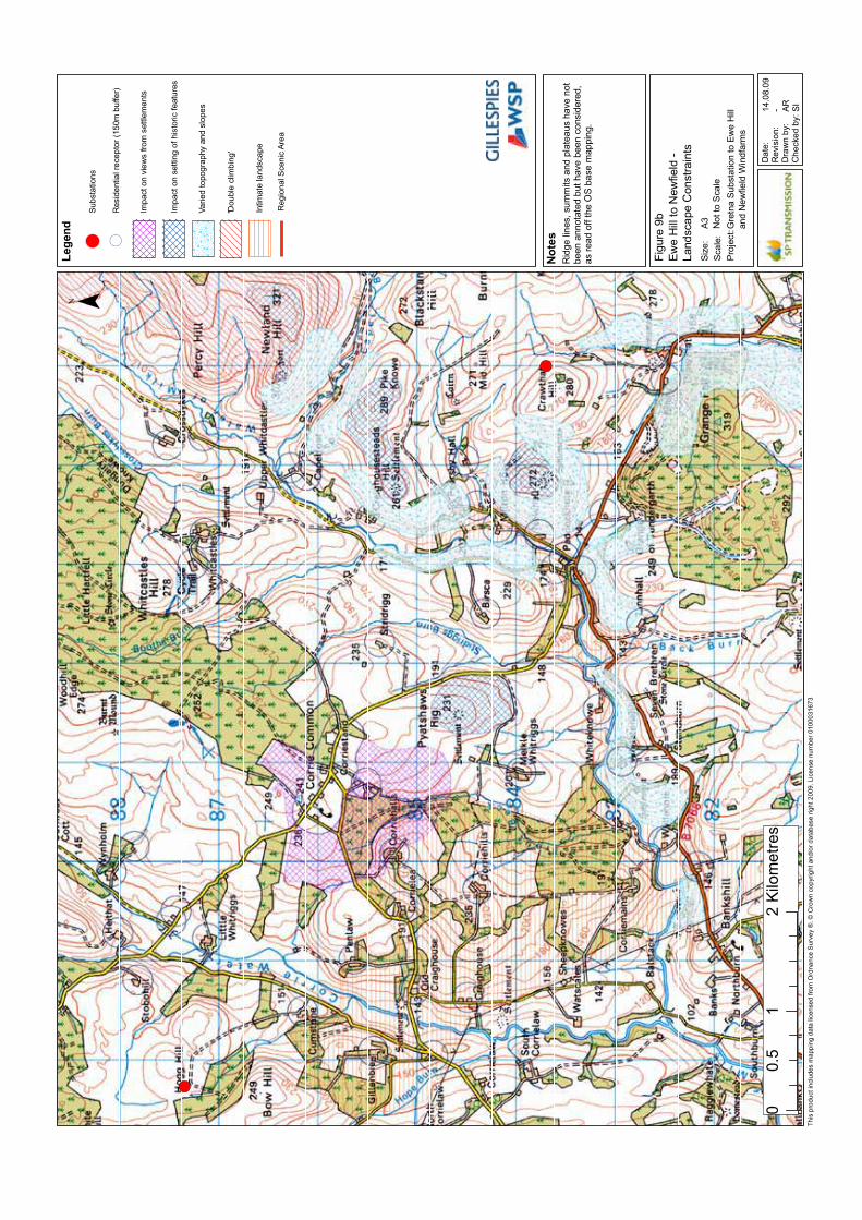
! (
! (
Figure9b
EweHilltoNewfield-
LandscapeConstraints
GretnaSubstationtoEweHill
andNewfieldWindfarms
Legend
¯
14.08.09
- ARSI
Scale:
Project:
Size:
A3
ThisproductincludesmappingdatalicensedfromOrdnanceSurvey®.©Crowncopyrightand/ordatabaseright2009.Licensenumber0100031673
Notes
Date:
Revision:
Drawnby:
Checkedby:
Substations
NottoScale
01
20.5
Kilometres
(Residentialreceptor(150mbuffer)
Impactonviewsfromsettlements
Impactonsettingofhistoricfeatures
Variedtopographyandslopes
'Doubleclimbing'
Ridgelines,summitsandplateaushavenot
beenannotatedbuthavebeenconsidered,
asreadofftheOSbasemapping.
RegionalScenicArea
Intimatelandscape

! (
! (
´
Figure10
GretnatoEweHill-
NarrowCorridors
GretnaSubstationtoEweHill
andNewfieldWindfarms
Legend
17.08.09
- ARSI
Scale:
Project:
Size:
A3
Notes
Date:
Revision:
Drawnby:
Checkedby:
StudyArea
NottoScale
¯
02.5
51.25
Kilometres
! (SubstationLocations
ThisproductincludesmappingdatalicensedfromOrdnanceSurvey®.©Crowncopyrightand/ordatabaseright2009.Licensenumber0100031673
Impactonviewsfromsettlements
Impactonsettingofhistoricfeatures
Variedtopographyandslopes
Uplandlandscape
'Doubleclimbing'
NarrowCorridor
Intimatelandscape
Highestamenityconstraints
Highamenityconstraints
Ridgelines,summitsandplateaushavenot
beenannotatedbuthavebeenconsidered,
asreadofftheOSbasemapping.
sA
sB
sC
sD
sE
sF

Figure11a
SectionAA-NarrowRoute
CorridorSelectionsB/sC
GretnaSubstationtoEweHill
andNewfieldWindfarms
Legend
12.08.09
- ARSI
Scale:
Project:
Size:
A3
Notes
Date:
Revision:
Drawnby:
Checkedby:
NottoScale

Figure11b
SectionBB-NarrowRoute
CorridorSelectionsB/sC
GretnaSubstationtoEweHill
andNewfieldWindfarms
Legend
12.08.09
- ARSI
Scale:
Project:
Size:
A3
Notes
Date:
Revision:
Drawnby:
Checkedby:
NottoScale

Figure11c
SectionCC-NarrowRoute
CorridorSelectionsB/sC
GretnaSubstationtoEweHill
andNewfieldWindfarms
Legend
12.08.09
- ARSI
Scale:
Project:
Size:
A3
Notes
Date:
Revision:
Drawnby:
Checkedby:
NottoScale

Figure11d
SectionDD-NarrowRoute
CorridorSelectionsB/sC
GretnaSubstationtoEweHill
andNewfieldWindfarms
Legend
12.08.09
- ARSI
Scale:
Project:
Size:
A3
Notes
Date:
Revision:
Drawnby:
Checkedby:
NottoScale

! (
! (
´
Figure12
GretnatoEweHill-
PreferredAlignment
GretnaSubstationtoEweHill
andNewfieldWindfarms
Legend
17.08.09
- ARSI
Scale:
Project:
Size:
A3
Notes
Date:
Revision:
Drawnby:
Checkedby:
StudyArea
NottoScale
¯
02.5
51.25
Kilometres
! (SubstationLocations
ThisproductincludesmappingdatalicensedfromOrdnanceSurvey®.©Crowncopyrightand/ordatabaseright2009.Licensenumber0100031673
Impactonviewsfromsettlements
Impactonsettingofhistoricfeatures
Variedtopographyandslopes
Uplandlandscape
'Doubleclimbing'
NarrowCorridor
Intimatelandscape
Highestamenityconstraints
Highamenityconstraints
PreferredRouteAlignment
Ridgelines,summitsandplateaushavenot
beenannotatedbuthavebeenconsidered,
asreadofftheOSbasemapping.

! (
! (
´
Figure13
EweHilltoNewfield-
NarrowCorridors
GretnaSubstationtoEweHill
andNewfieldWindfarms
Legend
17.08.09
- ARSI
Scale:
Project:
Size:
A3
Notes
Date:
Revision:
Drawnby:
Checkedby:
StudyArea
NottoScale
¯
01
20.5
Kilometres
! (SubstationLocations
ThisproductincludesmappingdatalicensedfromOrdnanceSurvey®.©Crowncopyrightand/ordatabaseright2009.Licensenumber0100031673
Impactonviewsfromsettlements
Impactonsettingofhistoricfeatures
Variedtopographyandslopes
'Doubleclimbing'
NarrowCorridor
Intimatelandscape
Highestamenityconstraints
Highamenityconstraints
nA
nB
nC
nD
nE
Ridgelines,summitsandplateaushavenot
beenannotatedbuthavebeenconsidered,
asreadofftheOSbasemapping.

! (
! (
´
Figure14
EweHilltoNewfield-
PreferredAlignment
GretnaSubstationtoEweHill
andNewfieldWindfarms
Legend
17.08.09
- ARSI
Scale:
Project:
Size:
A3
Notes
Date:
Revision:
Drawnby:
Checkedby:
StudyArea
NottoScale
¯
01
20.5
Kilometres
! (SubstationLocations
ThisproductincludesmappingdatalicensedfromOrdnanceSurvey®.©Crowncopyrightand/ordatabaseright2009.Licensenumber0100031673
Impactonviewsfromsettlements
Impactonsettingofhistoricfeatures
Variedtopographyandslopes
'Doubleclimbing'
NarrowCorridor
Intimatelandscape
Highestamenityconstraints
Highamenityconstraints
Ridgelines,summitsandplateaushavenot
beenannotatedbuthavebeenconsidered,
asreadofftheOSbasemapping.
PreferredRouteAlignment

! (
! (
! (
´
GretnaSubstation
EweHillSubstation
NewfieldSubstation
Figure15
PreferredAlignments
GretnaSubstationtoEweHill
andNewfieldWindfarms
Legend
12.08.09
- ARSI
Scale:
Project:
Size:
A3
Notes
Date:
Revision:
Drawnby:
Checkedby:
StudyArea
NottoScale
GretnatoEweHill
PreferredAlignment
¯
05
10
2.5
Kilometres
! (SubstationLocations
ThisproductincludesmappingdatalicensedfromOrdnanceSurvey®.©Crowncopyrightand/ordatabaseright2009.Licensenumber0100031673
EweHilltoNewfield
PreferredAlignment

Gretna Substation to Ewe Hill and Newfield Windfarms 132kV Transmission Line
APPENDICES

Gretna Substation to Ewe Hill and Newfield Windfarms 132kV Transmission Line

Gretna Substation to Ewe Hill and Newfield Windfarms 132kV Transmission Line
APPENDIX 1 - THE HOLFORD RULES
The Holford Rules were formulated by the late Lord Holford, Professor of Town Planning,University College, London in 1959 and published by the Royal Society of Arts. The HolfordRules remain the starting point for routeing electricity transmission lines in the UK. Since theRules apply English designations, they require some interpretation to match them tocircumstances in Scotland. The Holford Rules are a product of a specific time and set ofcircumstances. At the time the Holford Rules were written, the area of land designated foramenity value was far smaller than now and the design of routes to avoid such areas waseasier as a result. In Scotland, land designated for amenity value is largely confined to areasof land with sparse population. The Holford Rules give no guidance on how to reconcilerouteing to avoid areas of amenity value where this would have a greater visual intrusion dueto the proximity of the line to people. This limitation of the Rules is clarified in the NationalGrid Company’s (NGC’s) Supplementary Notes to their Guidelines for the Routeing of NewHigh Voltage Overhead Transmission Lines.
A central premise of the Holford Rules is that the extent of the visual effect of an overheadtransmission line can be reduced by careful routeing. The Holford Rules provide a valuablebasis for an approach to transmission line routeing, but require adaptation to meet presentday circumstances. The routeing practice followed by SP Transmission plc is derived from theHolford Rules and takes account of the National Grid Company’s Guidelines for the Routeingof New High Voltage Overhead Transmission Lines.
1. “Avoid altogether, if possible, the major areas of highest amenity value, by so planning thegeneral route of the line in the first place, even if the total mileage is somewhat increased inconsequence.
2. Avoid smaller areas of high amenity value, or scientific interest by deviation; provided thatthis can be done without using too many angle towers, i.e. the more massive structures whichare used when lines change direction.
3. Other things being equal, choose the most direct line, with no sharp changes of directionand thus fewer angle towers.
4. Choose tree and hill backgrounds in preference to sky backgrounds wherever possible;and when the line has to cross a ridge, secure this opaque background as long as possibleand cross obliquely when a dip in the ridge provides an opportunity. Where it does not, crossdirectly, preferably between belts of trees.
5. Prefer moderately open valleys with woods where the apparent height of towers will bereduced, and views of the line will be broken by the trees.
6. In country which is flat and sparsely planted, keep the high voltage lines as far as possibleindependent of smaller lines, converging routes, distribution poles and other masts, wires andcables, so as to avoid a concatenation or ‘wirescape’.
7. Approach urban areas through industrial zones, where they exist; and when pleasantresidential and recreation land intervenes between the approach line and the substation, gocarefully into the comparative costs of under-grounding, for lines other than those of thehighest voltage.”
The National Grid Company (NGC) reviewed the Holford Rules in 1992 (refer Appendix 3)and confirmed them as an invaluable tool in selecting and assessing line routeing options aspart of the environmental assessment process. As a result of this review, the Rules have hadsome supplementary notes added to them by NGC.
In 2004 a further review was carried out by Scottish Hydro-Electric Transmission Limited inconjunction with Scottish Power Transmission Limited (refer Appendix 3) and their reviewconfirmed the relevance of “Rules” in overhead Line routeing.

Gretna Substation to Ewe Hill and Newfield Windfarms 132kV Transmission Line
APPENDIX 2 - Glossary
Angle Poles: Poles erected to allow for a change in direction of the line.
Conductor: The name given to the metallic wires strung from pole to pole to carry electriccurrent. These are generally made of aluminium.
Earth Conductor: A wire under slung on a wood pole. These are used for protection againstlightning strikes but can also contain fibre optic cores for communication purposes.
Insulators: Materials that are very poor conductors of electricity. Air exists as naturalinsulation around conductors, but at supports, an insulator string (or strings) is required toprevent live contact with the wood pole body. Glass, polymeric or porcelain insulators can beused.
Insulator Strings: Insulator units assembled in articulated strings between the pole steelworkand conductors.
Kilovolt (kV): 1,000 volts.
Megawatt (MW): 1,000,000 watts.
The National Grid: The electricity transmission network of the UK.
Overhead Transmission Line: An electric line installed above ground usually supported byheavy duty wooden poles.
Substation: Controls the flow and voltage of power by means of transformers andswitchgear, with facilities for control, fault protection and communications.
Volts: The international system unit of electric potential and electromotive force.
Watt: The unit of electric power.

Gretna Substation to Ewe Hill and Newfield Windfarms 132kV Transmission Line

Ewe Hill and Newfield Project ManagerScottish Power Energy Networks
New Alderston HouseDove Wynd
Strathclyde Business ParkBellshillML4 3FF
GILLESPIES