Greetings from Jakarta: Postcards of a Capital 1900-1950
36
-
Upload
equinox-publishing -
Category
Documents
-
view
227 -
download
4
description
Greetings from Jakarta: Postcards of a Capital 1900-1950 is the most comprehensive visual record of Jakarta ever published covering the first half of the twentieth century which was also the last half century of colonial rule. Four hundred and sixty postcards from the author's own collection are brought together here to reveal a city that has largely vanished and is barely recognizable even to most life-long residents. Three hundred and sixty-two of the postcards have individually researched captions and are linked to period maps which enable the reader to identify the precise location of the each image.
Transcript of Greetings from Jakarta: Postcards of a Capital 1900-1950


JAKARTAP o s t c a r d s o f a C a p i t a l 1 9 0 0 - 1 9 5 0
S C O T T M E R R I L L E E S

Equinox Publishing (Asia) Pte. Ltd.
www.EquinoxPublishing.com
Greetings from Jakarta: Postcards of a Capital 1900-1950
ISBN 978-979-3780-88-7
Copyright © 2011 Scott Merrillees
All Rights Reserved. Reproduction or electronic transmission of any part without the author’s permission is prohibited.
Printed in the People’s Republic of China
Front Jacket .............................................Postcard 274Endpapers ................................. Postcards 84 and 120Back Jacket ..............................................Postcard 256
All postcards and maps are from the collection of Scott Merrillees.
Note on Place Names and Spelling
Jakarta was known as Batavia from 1619-1942 (although the Dutch might argue that Batavia was the city’s name until 1949) at which point it became Djakarta. With the new spelling for
the Indonesian language introduced in 1972, Djakarta became Jakarta.
The concept of “Indonesia” as we know it today didn’t exist during the VOC era (1619-1799), when the focus was predominantly on Java and the “spice islands” of the Moluccas. From
1800, as the Dutch government gradually expanded and consolidated authority over its colony through until the beginning of the Japanese occupation in 1942, Indonesia was known as the
Netherlands-Indies or as Netherlands-India.
Most streets in colonial Jakarta had Dutch names which were then given Indonesian names after independence. A list of the old names and their modern equivalents applicable to the postcards in
this book appears in Appendix III.
For ease of recognition by the reader, I have throughout this book used only Jakarta (instead of Batavia), Indonesia (instead of the Netherlands-Indies or Netherlands-India) and used only the modern street names, unless it was felt especially relevant for any particular postcard to refer to
the colonial era names.

Foreword ........................................................................................................... 9
Introduction .................................................................................................... 11
chapter one: 1900 to 1920
The Old Jakarta in the North ...................................... 19
chapter two: 1900 to 1920
The New Jakarta in the South ..................................... 57
chapter 3: 1920 to 1950
The End of the Colonial Era ...................................... 149
appendix i
People, Work and Entertainment ............................................................. 215
appendix ii
The Earliest Picture Postcards of Jakarta ................................................ 233
appendix iii
Selected Old and New Street Names ........................................................ 242
Index .............................................................................................................. 243
Selected Bibliography .................................................................................. 246
Acknowledgements ..................................................................................... 248
CONTENTS

10
Jakarta in 1903

11
The map of Jakarta from 1903 on the opposite page shows
a city that is barely recognizable to any modern resident
or visitor. It reveals (coloured orange) a long narrow city
that stretches almost thirteen kilometres from north to southeast.
Jakarta at that time had two very distinct districts. There was the
old city in the north near the coast which included Kota, Kali Besar,
Taman Fatahillah, Glodok, the old port at Sunda Kelapa and Pasar
Ikan. There was also the new city in the south which developed
around Medan Merdeka (which appears on this map as the large
white Koningsplein or King’s Square), Lapangan Banteng, Jalan
Juanda, Jalan Veteran, Pasar Senen, Prapatan, Tanah Abang and
Kebon Sirih. These two districts were connected by a straight three-
kilometre long canal called the Molenvliet (Mill Way) with roads on
either side that are now Jalan Gajah Mada (previously Molenvliet
West) and Jalan Hayam Wuruk (Molenvliet Oost or Molenvliet
East).
In the first half of the 20th century, the old city in the north was
known as the oude stad (old city), oud Batavia (old Batavia), and/
or benedenstad (downtown) as can be seen printed of several of the
postcards in chapter one. It was sometimes also called the lower town.
The old city included the oude havenkanaal (old port), to distinguish
it from the much larger new port at Tanjung Priok which was
completed in 1886, and there was also Jakarta’s largest Chinatown at
Glodok. Until the end of the colonial era the old city would remain
the commercial heart of Jakarta with many European business
houses located in the vicinity of Kali Besar and Taman Fatahillah,
while the vibrant Chinese trading hub at Glodok centred on Pintu
Kecil and Toko Tiga.
the old city in the north
The old city in the north was the creation of the Vereenigde Oost-
Indische Compagnie (Dutch East Indies Trading Company or
VOC), which founded Batavia (Jakarta) in 1619 and controlled it
until just a few years before their charter expired in 1799. Jakarta
during this period was therefore a “company town” under the
authority of a Board of Directors (sometimes known as the
“Gentlemen Seventeen”) in Amsterdam. The VOC never envisaged
Jakarta becoming a major and important city. They just needed an
outpost on Java to be a supply base for the highly profitable spice
trade route between Europe and the Moluccas in north-eastern
Indonesia so that their ships could be repaired and replenished with
food and water and so their crews could rest on dry land. With
hostile neighbours threatening them from Banten and Central Java,
the VOC built a stone wall around their tiny settlement during the
1630s and 1640s, thus making Jakarta a walled city complete with a
castle in the north-eastern corner.
Under the VOC, Jakarta reached its peak in the 1730s when it
was famously known as the “Queen City of the East”, but then went
into decline through to the end of the 18th century due to disease,
corruption and the loss of monopoly profits from the spice trade. So
high was the mortality rate in the second half of the 18th century that
the “Queen of the East” soon became the “Graveyard of Europeans”
or the “Graveyard of Dutchmen”.
the new city in the south
The new city in the south was the bovenstad (uptown or the
upper town). But it was best known as Weltevreden, meaning
INTRODUCTION

greetings from jakarta
12
Jakarta in 1910

introduction
13
“well contented” after a large private estate that was built near Pasar
Senen, on the site of what is now the Gatot Subroto Army Hospital,
in the 18th century and which survived until around 1820. The
name Weltevreden appears on many of the postcards in Chapter
Two. It also sometimes appears as “Batavia (Weltevreden)” and
also as “Weltevreden – Batavia” to reflect the general understanding
that, while Batavia was the overall name for the capital city of the
Netherlands Indies, Weltevreden was a very distinct and identifiable
district of Batavia in its own right. From the 1930s the name
Weltevreden gave way to Batavia Centrum (Central Batavia) and
this is reflected in some of the postcards in Chapter Three upon
which Batavia-Centrum or Batavia-C is printed.
The new city in the south was born against a backdrop of the
Napoleonic wars in Europe. Emperor Louis Napoleon of Holland
(the younger brother of Napoleon Bonaparte) appointed Marshal
Herman Willem Daendels to be governor-general of Java in 1808
with a mandate to prevent a British invasion. Arriving in Jakarta,
Daendels was appalled by the decaying condition of Jakarta’s walled
city and castle in the north, and promptly ordered the walls to be
demolished so they could be used as building materials for the new
city he would create at the southern end of the Molenvliet.
The invading British forces duly landed in Jakarta in August
1811 and comfortably defeated the combined French-Dutch troops
in battles near Jatinegara in the same month, ushering in the brief
British rule of Java from 1811-1816 under Lieutenant-Governor
Thomas Stamford Raffles. Raffles would later go on to found
Singapore in 1819. After the treaty of Vienna, Java was returned to
the Dutch in 1816, who then proceeded to turn the southern suburbs
of Weltevreden into the new European heart of Jakarta with elite
residential districts, government offices, social clubs, a learned
society, churches, hotels and even a theatre, exactly as Daendels
would have wanted.
The old city in the north survived as Jakarta’s business and
commercial centre while the new city in the south at Weltevreden
would be where Europeans would have their spacious homes and
tropical gardens and allow themselves to be entertained. The only
inconvenience for European businessmen and company employees
was the daily commute along the Molenvliet between their offices in
the north and their homes in the south. But during the second half
of the 19th century, a tramway service was established along this route
and, of course, there was also the option of horse drawn carriages.
From early in the 20th century the automobile would also appear.
For most of the 19th century, the notions of old Batavia as
downtown and Weltevreden as uptown were informal concepts
but well understood by Jakarta’s residents. However, in 1905, with
the creation of the Gemeente Batavia (Jakarta City Council), the
distinction between the two areas was formalized. The city was
formally divided into two administrative districts with the northern
one called Batavia and the southern one called Weltevreden.
A third administrative district, Meester Cornelis (now Jatinegara),
was also established at the same time but would not come under
the control of the Jakarta City Council until 1935. This is the lower
narrow orange part of the map on page 10 heading southeast from
Weltevreden, and which includes what are now Jalan Kramat Raya,
Jalan Salemba Raya and Jalan Matraman Raya before arriving at
Jatinegara. This was also the important road to Buitenzorg (Bogor)
where the governors-general had often chosen to reside because of
its cooler climate.
the population explosion
The map from 1903 on page 10 shows us a city which had a
population of only 116,000 people in 1900. Two years later, at the
time of the creation of the Jakarta City Council in 1905, Jakarta
covered an area of 125 square kilometres.

greetings from jakarta
14
Jakarta in the late 1930s
introduction
15
By 1912, the population had risen an impressive 40% to an
official figure of 162,126, which was still only a tiny 1.7% of the total
population that would be tallied by the census almost a century later
in 2010 of 9,588,198. In the racially stratified colonial city, records
were also kept of the ethnic background of each inhabitant. The
162,126 inhabitants of Jakarta in 1912 were 70.7% Indonesian,
18.5% Chinese, 1.1% Arab, 0.1% Indian and 0.1% Japanese, while
the European rulers made up only 9.5% of the population. It was
also noted in the same year that the inhabitants of the city were
53.7% male and only 46.3% female. The most significant gender
imbalance was among the Chinese where there were 19,583 males
but only 10,380 females.
By 1926, the population of Jakarta had more than doubled
from 1912 to reach 354,737 and then climbed again to an estimated
435,000 in 1930. With the Jakarta City Council’s annexation of the
Meester Cornelis (Jatinegara) administrative district in 1935, the
size of Jakarta became 182 square kilometres and the population
increased to just over half a million.
But the most dramatic surge in Jakarta’s population took place
between 1945 and 1949, when the number of inhabitants more than
doubled from 623,343 to 1,340,625 only four years later. This was
during the so-called “transition” period between the declaration of
Indonesian independence on 17 August 1945 and the international
recognition of Indonesian sovereignty on 27 December 1949, when
the guerilla war between the pro-independence Indonesian forces
and the Dutch troops who were trying to reclaim their colony after
the end of the Second World War, caused hundreds of thousands of
people to flee to the relative safety of Jakarta. However, the surge in
population and the shortages of food and textiles during those years
saw a massive rise in poverty as the city could barely cope. This is
most sadly and poignantly evident in this book by the tragic scene of
the poverty-stricken and homeless little boy in postcard number 360.
Indeed, a recurring theme in Jakarta’s history during the 20th
century was the continual struggle of the city to keep up with
population growth and provide basic services for a rapidly growing
number of inhabitants and an ever increasing population density. In
1900, there were only 928 people per square kilometre in Jakarta but
by 1949 this had jumped to 7,366 people. By 2010, the density had
increased more than fifteen-fold from 1900 reaching 14,505 people
per square kilometre, if the official census population figure in that
year of 9,588,198 people can be believed, or 18,154 people per square
kilometre if the more likely population figure of 12 million is used.
It is no wonder that the postcards in this book, especially those in
Chapters One and Two which cover the period 1900 – 1920, show
a more rustic, tranquil and countrified Jakarta than we could ever
imagine today.
Looking at the map on page 12 from the late 1930s, the basic
shape of Jakarta did not change significantly during the first half of
the 20th century. But it did “fatten” out as the population increased.
Areas east of Jalan Hayam Wuruk such as Mangga Besar (Large
Mango), Sawah Besar (Large Rice Field) and Kebon Jeruk (Citrus
Garden), and from where the source of those names was derived can
easily be guessed, became more developed for residential purposes,
as did Petojo and Ketapang west of Jalan Gajah Mada. In the south,
Jalan Wahid Hasyim opened up for housing between Prapatan and
Tanah Abang. But perhaps the most striking difference between
Jakarta in 1900 and Jakarta half a century later was the creation
of Menteng in the south from 1910 as the city’s first attempt at
comprehensive urban planning that incorporated infrastructure
needs such as water, electricity, asphalted roads, parks and flood
control within a single master plan, all designed according to the
latest ideas in early 20th century European urban planning. Menteng
was built exclusively for Jakarta’s rapidly rising population of
European civil servants and company employees, and was one of the

greetings from jakarta
18
61 5
7
8
26 2523
12
13
14
272930
28
15
2221
229228
20
17
19
18
1624
9
3
10
11
4
2

19
At the dawn of the 20th century, “old Batavia” or the “downtown” or the “lower
town” in the north around Kota and Glodok was the business, banking,
insurance and trading heart of Jakarta. The European business district
centred around Kali Besar, Pintu Besar and Taman Fatahillah, while bustling Glodok
nearby was Jakarta’s largest Chinatown and main Chinese commercial hub.
Entering the new century, there was good reason for Jakarta’s business community
to feel optimistic about the future. The sugar crisis which had caused a twenty year
economic malaise from 1884 until 1903 was coming to an end. The sugar industry, for
so long the backbone of the colonial economy, was finally recovering. Coffee, tea, pepper,
copra, tin, rubber and timber were also important export commodities. Indonesian
exports doubled between 1902 and 1911 and then quadrupled between 1911 and 1919.
But it wasn’t only exports. There were rising volumes of imported consumer goods as
well for the rapidly growing European population in Jakarta. Cottons and other fabrics,
wines & spirits, books, pianos, sporting equipment, curios from Japan, cigars & cigarettes
from Cuba and Manila and the latest fashions from Europe were all in great demand.
The completion of the new port at Tanjung Priok in 1886 (postcards 56-61) —
replacing the tiny and inadequate old port of Sunda Kelapa which had been in use
since the 17th century (postcards 1-7) — was a major milestone in Jakarta’s history and
brought the city into the steamship era. Combined with the opening of the Suez Canal
in 1869, travelling times between Europe and Indonesia were reduced from several
months to only a matter of weeks. The surge in shipping traffic that followed provided
many opportunities for Jakarta’s business houses to expand their services as shipping,
insurance and forwarding agents, as well as in ship-chandlery and stevedoring – all
towards supporting the rapid growth of the import-export trade.
The buoyant economy in the early years of the 20th century brought with it investment
in new factories and business premises in Jakarta, reflecting a renewed confidence in the
future. The Dutch-style Hongkong Bank building (postcard 20) was completed in 1910,
followed by the imposing new headquarters of the largest colonial bank, the Java Bank,
CHAPTER ONE1900 to 1920 – The Old Jakarta in the North
Not on map: 55, 64-65

greetings from jakarta
20
5437 42 41 40
3635
44
48
43
45
49
53
46
51
47
52
3334
3831
39
32
50
chapter one: 1900 to 1920 – the old jakarta in the north
21
(postcard 15) in 1912 (which now houses the Bank Indonesia Museum). The OLVEH
life insurance company moved into their new premises in 1912 (postcard 23), as did the
leading trading firms of Lindeteves-Stokvis in 1910 (postcard 43) and E. Dunlop & Co.
in 1913 (postcard 24). These new symbols of prosperity stood side-by-side with the old
18th and 19th century offices, shops and homes which still existed in abundance in Jakarta
in the early years of the 20th century (postcards 14, 16-17, 21-22 and 25-26). Some of them
still survive today (although usually in poor condition).
Glodok was, and still is, the vibrant hub of Jakarta’s Chinese business community,
especially around Glodok Plain (postcards 35-36), Pintu Kecil (postcards 31-34 and 39),
Toko Tiga (postcard 40) and Perniagaan Raya (postcard 41). The Chinese were admired
or envied for their industriousness and business acumen and were active in rice-milling,
sugar exporting, arak brewing, ship-chandlery, pawn-shops and as shopkeepers, tailors,
tradesmen and merchants of almost every item imaginable.
By 1900, the VOC era of 1619-1799 was already a distant memory but there were
still reminders of Jakarta’s earliest years to be found in the city. The old Town Hall
on Taman Fatahillah (postcard 12), completed in 1710, was still an important public
building in the early 1900s, just as it is today, functioning now as the popular Jakarta
History Museum. The distinctive old Amsterdam Gate (postcards 9-11) was a prominent
landmark throughout the first half of the 20th century until it was demolished in 1950.
The Gereja Zion church from 1695 (postcard 52) and the gruesome skull-topped Pieter
Erberveld monument from 1722 (postcard 48) were there to give Jakarta’s citizens a link
to an earlier era. Some of the old VOC warehouses (postcards 6 and 8) also survived into
the 20th century as did the drawbridge across Kali Besar (postcard 18).
But while the old city of Jakarta was a bustling hive of activity during the day, it
was often noted how quiet and eerily empty it seemed to be in the evenings. European
businessmen worked in their offices in Kota during the day but when the work was
done, they rode in their horse-drawn carriages or took the popular steam trams back to
the European residential suburbs of Jakarta’s newer southern environs in Weltevreden,
where they lived and sought their entertainment. Most Chinese both lived and worked in
or near Glodok in their aptly named shophouses but for the Europeans, there was a clear
distinction between their homes and their places of work. But wherever one slept, the
times were good and dreams could be sweet and full of hopes for continued prosperity. Q
63
62
56
5760
58
5961

greetings from jakarta
221 | The Old Port of Sunda Kelapa (1) | Publisher: F. B. Smits | Postmarked: 16 July 1900
2 | The Old Port of Sunda Kelapa (2) | Publisher: F. B. Smits | Circa: 1905
Looking over the old port of Sunda Kelapa from the Culemborg Tower (postcard 3). The VOC founded their trading port of Batavia (Jakarta) here at the mouth of the Ciliwung River in 1619 and the long canal in the centre was gradually extended over the next 200 years to try and overcome silting problems. Sunda Kelapa was Jakarta’s main entry point by sea until the new Tanjung Priok port was completed in 1886 and thus its glory days were already over by the time this postcard was posted in 1900.
Another view of Sunda Kelapa port from the Culemborg Tower (postcard 3). The large building in the centre is the old Pasar Ikan (fish market) which no longer exists (postcard 5). Sunda Kelapa had posed problems for ships that called there from the beginning of the colonial era. The main canal seen here on the right was too narrow and too shallow and ships had to anchor outside at sea and then ferry passengers and cargo to shore in smaller vessels. This was time consuming, expensive and often treacherous in bad weather.

chapter one: 1900 to 1920 – the old jakarta in the north
23
3 | The Culemborg Tower at Sunda Kelapa | Publisher: Tio Tek Hong | Circa: 1910
4 | Interior of the Culemborg Tower | Publisher: F. B. Smits | Circa: 1900
Looking south towards the Culemborg Tower from where the photographs in postcards 1 and 2 were taken. The tower was built in 1839 as a lookout and for sending signals to ships. A blue flag, for example, indicated danger (such as disease) and meant that ships were not allowed to disembark their passengers. The tower appears to be leaning to the right which suggests that the pronounced lean it has today had already begun more than a century ago. The old drawbridge on the left no longer exists.
Two Indonesian and three European or Eurasian men at the top of the Culemborg Tower (postcard 3) looking north over the old port of Sunda Kelapa with one man peering intently through a telescope. They would have been looking out over a view very similar to what we can see in postcards 1 and 2. This observation room has barely changed since this photograph was taken and visitors today can still climb the old wooden steps to reach it. The step ladder on the far left leading to the roof also remains unchanged.
greetings from jakarta
245 | The Pasar Ikan (Fish Market) | Publisher: F. B. Smits | Circa: 1910
6 | The Westside Warehouses | Publisher: F. B. Smits | Circa: 1905
The front of the Pasar Ikan (fish market) building can be seen here with its entrance in the centre. This is the same prominent structure we can see at the side and in the centre of postcards 1 and 2. Built in 1846, it served as Jakarta’s main fish market until at least the 1930s. Here many small sailing boats bring their fish to the front steps of the market which was especially busy early in the mornings. The Pasar Ikan building no longer exists but many people today still refer to the Sunda Kelapa area as Pasar Ikan.
A view from the southern end of the eastern bank of the main canal at the Sunda Kelapa port. The many small boats in the foreground are possibly supplying fish to the nearby Pasar Ikan (postcard 5). The large buildings on the right were the old “Westside Warehouses” of the VOC, the oldest of which dates back to the 1650s, that were used for storage of valuable commodities such as cloves, nutmeg, mace, pepper, coffee and tea. These warehouses still exist and have been used as the Museum Bahari (Maritime Museum) since 1977.

chapter one: 1900 to 1920 – the old jakarta in the north
257 | Drawbridge at Sunda Kelapa | Publisher: Tio Tek Hong | Circa: 1910
8 | Old VOC Warehouses | Publisher: Tio Tek Hong | Circa: 1910
Until the latter years of the 19th century there were still three old Dutch-style drawbridges remaining in Jakarta, including this one which crossed over the canal between Jalan Krapu and Jalan Tongkol. Passengers arriving at the Sunda Kelapa port would cross over this drawbridge and head south into the suburbs of Jakarta. This old drawbridge and the one in postcards 1 and 3 were demolished long ago. The only surviving colonial era drawbridge in Jakarta can be seen in postcard 18.
The bridge we can see here in the foreground is part of what is today Jalan Tongkol and the canal below it was formerly the southern leg of the moat that surrounded the VOC’s second castle in Jakarta that existed from 1627 until around 1808. Sometime after 1920 the moat was filled in and the bridge demolished. The old VOC warehouses on the left and right no longer exist. But the warehouses in the centre in the distance on Jalan Kakap still stand and were partially restored in the 1990s and early 2000s to be reborn as restaurants.
56
81
82
66
68
67
69
78
79
7776
74 75
80
92
90 91
94
132131
130
140134
139
151
133
143
141
135
137
149150
142
138136
152
129
123
125 122
212
93109-116
70-73
97-100
101-104
105-108
145-148
85
119
120
117
118
124128
127126
121
8988
9686
8395
84
87

57
While the commercial and banking hub of Jakarta was “old Batavia”
in the north around Kota and Glodok, it was “Weltevreden” or the
“uptown” or the “upper town” in the leafy southern environs of Medan
Merdeka, Lapangan Banteng, Jalan Juanda and Jalan Veteran that were the centre of the
government and military administration and also the modern residential, entertainment
and shopping heart of the city – at least for the European population – if for nobody else.
Visitors often noted that the new Jakarta seemed very much like a European town
in a tropical setting. Indeed the European population of Jakarta grew rapidly in the
early years of the 20th century as both the government and private sector expanded. The
number of Europeans more than doubled between 1905 and 1917 from 13,805 to 29,228
and then climbed further to 35,260 by 1927, while never being more than 10% of the
total population. It was therefore natural that the colonial capital should be developed to
cater for their needs. However, the profile of the average European also changed from the
wealthy merchants and planters of the 19th century who lived in spacious white columned
homes on large plots of land (postcards 181-182) to company employees and civil servants,
for whom more modest housing was required.
Accordingly, it was a particularly important milestone for Jakarta when Menteng
was developed from 1910 (postcards 153-156) as the city’s first suburb to be designed
according to the principles of modern urban planning, complete with comprehensive
infrastructure. Similar modern European-style homes were also built elsewhere in the
city at the same time including around Medan Merdeka (postcards 183-184).
Indeed, the Dutch were proud of their modern infrastructure in Jakarta. This
included the telephone system (postcards 228-231), drinking water from artesian wells
(postcards 226-227), gas for street lighting (postcards 224-225) and, of course, the popular
steam and electric tramways which feature prominently in many postcards in this book.
Governors-general enjoyed two fine palaces on Jalan Medan Merdeka Utara (postcard
80) and Jalan Veteran (postcard 81) while numerous government departments were
located nearby including the Ministry of Finance building (postcards 135-136). There
CHAPTER TWO1900 to 1920 – The New Jakarta in the South
144
Not on maps: 172-174, 181-182 and 222-223Numbers 228-229 appear on map on page 18Number 234 appears on map on page 148Numbers 175-176, 193, 196 and 215 appear on map on page 150
greetings from jakarta
84
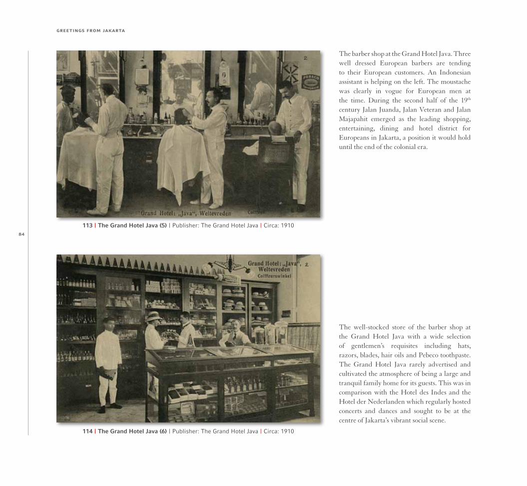
113 | The Grand Hotel Java (5) | Publisher: The Grand Hotel Java | Circa: 1910
114 | The Grand Hotel Java (6) | Publisher: The Grand Hotel Java | Circa: 1910
The barber shop at the Grand Hotel Java. Three well dressed European barbers are tending to their European customers. An Indonesian assistant is helping on the left. The moustache was clearly in vogue for European men at the time. During the second half of the 19th century Jalan Juanda, Jalan Veteran and Jalan Majapahit emerged as the leading shopping, entertaining, dining and hotel district for Europeans in Jakarta, a position it would hold until the end of the colonial era.
The well-stocked store of the barber shop at the Grand Hotel Java with a wide selection of gentlemen’s requisites including hats, razors, blades, hair oils and Pebeco toothpaste. The Grand Hotel Java rarely advertised and cultivated the atmosphere of being a large and tranquil family home for its guests. This was in comparison with the Hotel des Indes and the Hotel der Nederlanden which regularly hosted concerts and dances and sought to be at the centre of Jakarta’s vibrant social scene.

chapter two: 1900 to 1920 – the new jakarta in the south
85115 | The Grand Hotel Java (7) | Publisher: The Grand Hotel Java | Circa: 1910
116 | The Grand Hotel Java (8) | Publisher: The Grand Hotel Java | Circa: 1910
The hotel’s kantoor (office) was surprisingly open to the elements with no external walls on two sides and only what seems to be canvas blinds that could be rolled down when it rained. Behind the European man in the centre, an Indonesian man appears to be talking on the large wall mounted telephone. The telegraph was a common means of making hotel reservations a century ago and hotels had their own code to simplify the process for guests. For example, the letters “ALBA” meant “reserve one single-bedded room”.
The carriage garage at the Grand Hotel Java. In 1909 an account of the hotel observed that there are “large and well-appointed livery stables where horses and plain or rubber-tyred carriages may always be obtained. The hotel is quite close to the Weltevreden railway stations, and ‘runners’ and carriages meet all trains, as well as the boats at Tandjong Priok.” The age of the motor car would just have been dawning when this postcard was published but here there is not yet an automobile in sight.

greetings from jakarta
86117 Pasar Baru (1) | Publisher: The Netherlands Indies Publicity Bureau | Circa: 1910
118 Pasar Baru (2) | Publisher: G. Kolff & Co. | Circa: 1910
Looking north into the entrance of Jalan Pasar Baru. Pasar Baru (new market) dates back to the 1820s and was indeed the “new” market in Jakarta’s newly developing southern suburbs at Weltevreden in the first half of the 19th century. The name was clearly meant to invite comparison with the two older southern Jakarta markets of Pasar Senen and Pasar Tanah Abang which both date back to 1735. The Pasar Baru district is centred around Jalan Pasar Baru seen here and also Jalan Pintu Air nearby.
The distinctly Chinese architectural character of the shops and shophouses that we can see here along Jalan Pasar Baru has almost completely disappeared. However, there still remains to this day one original 19th-century double-storey Chinese shophouse on Jalan Pasar Baru which has survived almost unchanged from when it was first built around the second half of the 19th century. It trades as Toko Kompak at Jalan Pasar Baru No. 18A and is similar to the shophouse on the far right hand side of this postcard.

chapter two: 1900 to 1920 – the new jakarta in the south
87119 Pasar Baru (3) | Publisher: Tio Tek Hong | Circa: 1905
120 Pasar Baru (4) | Publisher: Probably Tio Tek Hong | Circa: 1910
Tio Tek Hong was born in Pasar Baru in 1877 and opened his own retail business in 1902 at Jalan Pasar Baru No. 93, which is the building we can see here in this decorative postcard. He sold a wide variety of merchandise including air rifles and ammunition, gramophone records, sporting goods, musical equipment, watches, clocks and also very importantly, picture postcards. Tio Tek Hong was one of the four most important postcard publishers in colonial Jakarta and 78 of his postcards appear in this book. See also postcards 120, 312 and 314.
Looking north along Jalan Pasar Baru. The premises of leading postcard publisher, Tio Tek Hong, at Jalan Pasar Baru No. 93 (see also the postcard above), are in the centre just behind the electric power pole. A little further north, although not clearly visible, is the firm of Lee Ie Seng, stationers and paper merchants, at Jalan Pasar Baru No. 119, which was established in 1873 and is today run by the great-grandson of the founder as perhaps the oldest family-owned business still operating on Jalan Pasar Baru.

greetings from jakarta
128
201 | The Saint Maria School (1) | Publisher: Tio Tek Hong | Postmarked: 19 July 1911
202 | The Saint Maria School (2) | Publisher: F. B. Smits | Postmarked: 30 December 1901
In the early 1850s, the Apostolic Vicar of Jakarta, Monsignor Vrancken, invited the Ursuline order of nuns in Holland to establish a presence in Indonesia because of his concern regarding the low priority that the Dutch colonial authorities had given to education. Seven Ursuline sisters were chosen and they arrived in Jakarta in February 1856 with a particular focus on education for girls. This large house on Jalan Juanda became their convent and school and it is still run by the Ursuline order today as the Saint Maria School.
The educational work of the Ursuline sisters at the Saint Maria School developed quickly. The dormitory received its first three girls on 13 May 1856 and by the end of the same year there were 62 students in the kindergarten and 295 in the primary school. The ornate interior of the front gallery of the school can be seen here. Tragically five of the original seven Ursuline sisters who arrived in Jakarta in 1856 had died by 1863. One of them was only 23 years old. Cholera and typhus were the main killers.

chapter two: 1900 to 1920 – the new jakarta in the south
129203 | The Saint Maria School (3) | Publisher: Tio Tek Hong | Circa: 1920
204 | The Saint Maria School (4) | Publisher: Unknown | Circa: 1910
During the final decades of colonial rule, the Saint Maria School was known as the Koningin Emma School (Queen Emma School) after Queen Emma (1858-1934), the second wife of King Willem III and mother of Queen Wilhelmina. It offered a boarding school for Catholic girls and a two-year training course for female teachers. The day school was open for all religions and included a kindergarten for both girls and boys as well as a primary school with a seven-year course for girls and a high school with a three-year course for girls.
The Saint Maria School also offered courses for young ladies in typing, stenography, bookkeeping, English and sewing (as can be seen here). Also available was training for exams in plain and artistic needlework as well as courses in batik and painting. The Saint Maria School is the oldest surviving school in Jakarta today with a continuous history of more than 150 years of providing education for girls. Its sister school is the Saint Ursula School on Jalan Pos which can be seen in postcards 205-207.

148
241242
240
243
272
249248
246 257
259
262
260
264266
268
253252244
251250
255
265
270247
271
267
269
254
245
261263
273
256
278
277
276
284285
296
286274
298
288
294
292
287290295
293
297
360299
289
300291
361 302303
301347
320
323
319315
318317
308362
310
309
314 311
312313 344
279
258
356
358
359
280-283
304-307

149
The 1920s began in Jakarta with the same buoyant economy and optimism for
the future that had prevailed throughout the first two decades of the century.
Exports were healthy and there was ample new investment both from foreign
and domestic sources. However, the good times reached their peak in 1925 at which point
the economy entered a gradual decline through to the onset of the Great Depression at the
end of 1929. The years 1931-35 were particularly bleak for Indonesia as it suffered from the
worst effects of the depression. Exports in 1931 were less than half the level of 1928 and
wouldn’t bottom out until 1935. Lower spending power and a collapse of investment saw
imports in 1935 reach only a quarter of 1929 levels. Foreign investment was almost zero
from 1931-35 and recovered to only a trickle during the second half of the decade.
If the 1930s were bad, the 1940s were much worse. The Japanese occupation from
March 1942 until August 1945 was especially brutal. Food shortages were common as basic
necessities were diverted to support the Japanese war effort. Random violence and forced
labour added to the misery of the Indonesian population at the hands of the Japanese even
if Jakarta suffered relatively less than in rural areas. It was a daily battle to survive.
Indonesian independence was declared by President Sukarno on 17 August 1945 but
the Dutch wouldn’t accept the loss of their colony and a four-year guerilla war ensued as
the Dutch used military force to try and reestablish their authority. This included the two
so-called “police actions” of July 1947 and December 1948 that were essentially Dutch
military campaigns against the newly independent nation. The consequences for Jakarta
were severe. Apart from the chaos and bloodshed, there were also critical shortages of
food, fuel and clothing caused by blockades of the city by pro-independence forces who
controlled the countryside. They were targeting the Dutch but the Indonesian population
of Jakarta also suffered terribly (see postcard 360). It wouldn’t be until 27 December 1949
that Indonesian sovereignty finally gained international recognition.
The physical development of Jakarta during the period 1920-50 closely mirrored the
wider economic and political backdrop. The 1920s witnessed something of a building
boom reflecting the underlying prosperity that prevailed during much of the decade.
CHAPTER THREE1920 to 1950 – The End of the Colonial Era
354
357
Not on map: 275, 342-343, 345

greetings from jakarta
164264 | Jalan Pancoran | Publisher: Unknown | Circa: 1940
265 | Corner of Jalan Pintu Kecil and Jalan Toko Tiga | Publisher: Probably K. K. BergenCirca: 1935
Looking west along Jalan Pancoran towards the corner of Jalan Toko Tiga and Jalan Pintu Kecil near the top right hand corner. The tall white building in the centre was the premises of the Thian Seng Tek Roemah Obat Tionghoa, one of many Chinese toko obat (pharmacy) on Jalan Pancoran. Just to the left of Thian Seng Tek is the small shop of Tian Liong, founded in 1935 as a purveyor of kitchen equipment and household wares. Tian Liong prospered over the years and still exists today at the same location but in a much larger store.
A busy scene looking northwest along Jalan Pintu Kecil from the corner of Jalan Toko Tiga on the left where the Kleermaker Merk Tek Seng (Tek Seng Brand Tailor) is located. The Kali Besar canal is on the right but not visible here. This is a close-up view of the top right hand corner of the postcard above which shows Jalan Pancoran heading towards Jalan Pintu Kecil. Jalan Toko Tiga and Jalan Pintu Kecil are still among the busiest parts of Glodok today. This is a rare Norwegian postcard of Jakarta (the only one in this book).

chapter three: 1920 to 1950 – the end of the colonial era
165266 | The Chung Hoa Cinema | Publisher: G. Kolff & Co. | Circa: Late 1940s
267 | The Tiong Hoa Restaurant | Publisher: The Tiong Hoa Restaurant | Circa: 1940
The Chung Hoa Bioscoop (cinema) was located at Jalan Pancoran No. 42A just along from the Tiong Hoa Restaurant in the postcard below. From the 1940s until the mid-1960s, Jalan Pancoran was a popular cinema district for Chinese language films. The Shanghai, Luna Park and Orion cinemas were also located nearby. Around 1972, the Chung Hoa Cinema was demolished and replaced by the Gloria supermarket and shopping centre, which in turn was destroyed by fire in August 2009.
The Tiong Hoa Restaurant was a popular Chinese restaurant located at Jalan Pancoran No. 46 and was founded in 1928. It was advertised as “The Well Known Dining & Refreshment Room of Batavia” and later “of Djakarta” after independence. Unlike most restaurants, the Tiong Hoa was a great survivor and was still operating in 1973, when it was described as a “Chinese restaurant specializing in Hakka and Cantonese food, deliciously mouth-watering and inexpensive.” Sadly, the Tiong Hoa Restaurant no longer exists.

greetings from jakarta
204
344 | The Globe Cinema | Publisher: The Globe CinemaCirca: 1930
An advertising postcard for the Globe Cinema which was situated on Jalan K. H. Samanhudi near the corner of Jalan Pasar Baru. It was one of Jakarta’s most enduring cinemas, already in existence in 1911 and only closing around 2009 after it struggled to compete with the large modern cineplexes. The rundown shell of the Globe Cinema still exists today (although not the building seen here which was replaced by a multi-storey structure). It was at the Globe Cinema where the first “talking movie” was played in Jakarta, possibly in 1929.
345 | The China Film Co. | Publisher: The China Film Co.Circa: Late 1920s
The first two feature length films produced in Indonesia were Loetoeng Kasaroeng and Eulis Atjih in 1926 and 1927 re-spectively, both with screenplays by L. Heuveldorp. Howev-er, the vast majority of films screened in Jakarta in the 1920s and 1930s were imported from Hollywood and Shanghai. The China Film Co. was an early importer and already in business in 1926. This postcard advertises in Chinese that “Shanghai’s leading actress, Xi Fang Qing, is appearing in films in Jakarta presented by the China Film Co.”

chapter three: 1920 to 1950 – the end of the colonial era
205346 | The Kramat Theatre | Publisher: Unknown | Circa: Early 1930s
347 | The Capitol Theatre | Publisher: Unknown | Circa: Early 1930s
The Kramat Theatre still exists today as the Grand Cinema on the corner of Jalan Kramat Bunder and Jalan Kramat Raya. It was already operating in 1926. By 1936, it had become the Rex Theatre and by 1950 had been renamed the Grand Cinema. With the closing of the Globe Cinema in Pasar Baru (postcard 344) around 2009, the Grand Cinema is now Jakarta’s oldest surviving cinema although it is in poor condition. The movie being shown here is Hell’s Angels, directed by Howard Hughes in 1930 and starring Jean Harlow.
This theatre was built around 1920 at the southern end of Jalan Pintu Air as the successor to the Elite Cinema (postcard 212) and was also initially called the Elite. In 1927, it was known as the Rembrandt and by the early 1930s had become the Capitol. It was also famous for its popular restaurant. In 1936, it was owned by a European and was one of the few cinemas in Jakarta at the time that was not Chinese-owned. Showing here is the German film Liebeswalzer made in 1930, with Puttin’ on the Ritz, also from 1930, a forthcoming attraction.

greetings from jakarta
218
372 | GardenerPublisher: F. B. SmitsCirca: 1900
374 | Indonesian SalesmanPublisher: F. B. SmitsCirca: 1900
373 | Vegetable SellerPublisher: F. B. SmitsCirca: 1900
375 | Chinese SalesmanPublisher: F. B. SmitsCirca: 1900

appendix i: people, work and entertainment
219
376 | Fruit SellerPublisher: Visser & Co.Circa: 1900
377 | Fruit SellerPublisher: Visser & Co.Circa: 1905
378 | Indonesian SalesmanPublisher: Visser & Co.Circa: 1905
379 | Iced Drink SellerPublisher: Hotel des IndesCirca: 1910