Green Spaces Review Board and the Cabinet’s responses to ... · 3 The method used to identify...
78
1 Knowsley Council’s Identification of Public Parks and Green Space Land for Sale Purpose The purpose of this document is to provide the following information:- a) The method used by Knowsley Council to identify parkland for sale; b) The parkland sites / areas of sites that have been selected for sale; c) The measures currently available to alleviate for these losses of parkland; and d) The anticipated future mitigation steps available when the parkland site is re-developed. Recommendation That the parks and green spaces identified in Table 1 below are sold by Knowsley Council over the course of the next 15 years for new development e.g. housing, social care and commercial use. This will take place in accordance with the recommendations of the Knowsley Parks and Green Spaces Review Board and the Cabinet’s responses to them (28 November 2017).
Transcript of Green Spaces Review Board and the Cabinet’s responses to ... · 3 The method used to identify...

1
Knowsley Council’s Identification of Public Parks and Green Space Land for Sale
Purpose The purpose of this document is to provide the following information:- a) The method used by Knowsley Council to identify parkland for sale; b) The parkland sites / areas of sites that have been selected for sale; c) The measures currently available to alleviate for these losses of parkland; and d) The anticipated future mitigation steps available when the parkland site is re-developed. Recommendation That the parks and green spaces identified in Table 1 below are sold by Knowsley Council over the course of the next 15 years for new development e.g. housing, social care and commercial use. This will take place in accordance with the recommendations of the Knowsley Parks and Green Spaces Review Board and the Cabinet’s responses to them (28 November 2017).

2
Table 1: The Parks and Green Space Identified for Sale (listed in alphabetical order)
Site
Number
Site Name Ward Current Site
Area
(Hectares)
% Loss of
Site Area for
Sale
Re-provision of green space on
development (Hectares)
% loss of green space
after re-provision
1 Alt Park Page Moss 3.65 71% 0 71%
2 Broad Lane Playing Fields Northwood 3.02 100% 0 100%
3 Copthorne Whitefield 3.35 100% 0 100%
4 Court Hey Park Roby 14.00 34% 0 34%
5 Cowper Way St. Gabriel’s 1.6 100% 0 100%
6 Field Lane Cherryfield 1.22 100% 0 100%
7 Finch Wood Halewood South 3.96 100% 0 100%
8 Frederick Lunt Playing Fields Halewood North 3.84 100% 0 100%
9 Grace Park Halewood South 4.58 100% 0 100%
10 Halewood Doorstep Green Halewood South 14.85 42% 0 42%
11 KGV Playing Fields Prescot Prescot North 6.95 100% 1 86%
12 Pool Hey Playing Fields Stockbridge 13.07 100% 1 92%
13 Roby Playing Fields Swanside 5.8 100% 1 82%
14 Spring Wood St. Gabriel’s 2.64 100% 0 100%
15 St. Johns Millennium Green St. Gabriel’s 2.16 100% 0 100%
16 Syders Grove Prescot North 5.52 16% 0 16%
17 Westview St. Gabriel’s 1.11 100% 0 100%
= Knowsley parish and town council leased site from Knowsley Council

3
The method used to identify parks and green spaces for sale The following approach has been used to select the parkland identified in Table 1. This required a pragmatic balancing of the following factors to enable a viable solution to be identified:- a) The need for parkland development value to fund a £40million endowment; b) The application of the Review Board’s Recommended Strategic Criteria for Site Selection; c) The application of the feedback to the Review Board’s market research and public consultation; and d) Not selling more than 10% of the existing parkland area.
The application of the Review Board’s Recommended Strategic Criteria for Site Selection and feedback from the market research / public consultation Table 2 below outlines the six overarching measures that have been developed by the Council to undertake the assessment of all 161 public parks and green spaces in Knowsley. This has been used to inform the selection of parkland for sale. The measures are supported by 18 indicators, with a scoring system of one to three being applied to each one. The maximum total score a park or green space can secure is 51. The lower the score, the more suitable the site is for consideration for disposal. Evidence has been used to inform the scores allocated to each indicator by the Council. This has been based on a broad range of qualitative and quantitative information; ranging from the Council’s Performance Management Indicators, to Green Space Strategy functionality assessment and central Government databases.

4
Table 2: The Measures, Indicators and Evidence Base
Assessment Measure
Assessment Indicator
Assessment Score 1 2 3
Assessment Evidence Base
(1) Community
Measure To assess the value that park provides to the local community
Community and informal leisure usage
Low Use (less than 100,000 visits per annum; no public events)
Medium use (between 100,000 and 200,000 visits per annum; ad-hoc public events)
High Use (in excess of 200,000 visits per annum; regular public events)
Parks User Survey Report (2014) Knowsley Council KPI’s (e.g. events,
activities, participant demographics) Operational feedback (e.g. litter levels) Friends of Group / Volunteer Data
Green Flag status of the site
No Green Flag
No Green Flag (but quality score at Green Flag Standard)
Green Flag Accredited
Annual Quality Score; Green Flag Accreditation Management Plans
Ease of access to the site (i.e. public transport links)
No immediate transport links
Transport link nearby
Good transport links
Desk based interrogation of current transport routes (e.g. nearest bus/rail drop-off points to sites)
Contribution to the Knowsley Green Space Strategy
Functionality Score is Low
Functionality Score is Medium
Functionality Score is High
Green Space Strategy Green Space Strategy Technical
Paper / Action Plan Green Space Ranger Programme
The historical and or cultural value the site offers to the local community
No Known historic or cultural interest
Local heritage or cultural significance (e.g. site is valued for historic or cultural reasons by a local community)
Regional or national cultural or heritage significance (e.g. nationally designated)
Merseyside Historic Environment Records
Register of Historic Parks and Gardens / List of Buildings of Special Architectural or Historic Interest
Data held by http://www.parksandgardens.org/
Historic OS mapping / ‘Local Green Space’ designations
Local Heritage Listing Advice Note 7
(Historic England)
Knowsley Local Plan; Archival sources and information
compiled for grant making bodies
(2) Recreational
Measure
Sports and formal leisure usage
Negligible or Low Value
Medium Value (some informal training takes place)
High Value (Home to a registered sports
Playing Pitch Strategy 2012 (Evidence based assessment taking account of quality, quantity and accessibility by

5
Table 2: The Measures, Indicators and Evidence Base
Assessment Measure
Assessment Indicator
Assessment Score 1 2 3
Assessment Evidence Base
To assess the recreational value that park provides to the local community
club / regular sporting events)
using a methodology endorsed by Sport England)
Does the site offer sustainable travel routes
No designated routes near to the site
Designated routes near to the site
Designated routes on the site
Merseyside Cycling Strategy 2005 (to be superseded by the Shorter Journeys Strategy);
Merseyside Pedestrian Strategy; Rights of Way Improvement Plan 2008
- 2018
(3) Biodiversity
Measure To assess the contribution the site provides to local biodiversity
Is the site a Green Corridor for wildlife migration
The site does not form part of a green corridor for wildlife / habitat
N/A The site forms part of a green corridor for wildlife / habitat
Woodland Management Plans; data held by Merseyside Biobank (includes data held by local wildlife groups and the Merseyside Environmental Advisory Service);
Knowsley Council Tree Database; Local wildlife site designations DEFRA Magic (national database of
all significant species/habitats and spatial relationships)
The biodiversity and wildlife value of the site
Negligible or Low Value
No notable species or habitats (with
regard to the North West Biodiversity
Action Plan or section 41, Natural Environment and
Rural Communities Act, 2006)
Medium Value Some priority
species or habitats (with regard to the
North West Biodiversity Action Plan or section 41,
Natural Environment and
Rural Communities Act, 2006)
High Value Priority species or
habitats (with regard to the North West Biodiversity
Action Plan or section 41, Natural Environment and
Rural Communities Act, 2006)
North West Biodiversity Action Plan or section 41, Natural Environment and Rural Communities Act, 2006;
Woodland Management Plans; Merseyside Biobank (includes data
held by local wildlife groups and the Merseyside Environmental Advisory Service);
Knowlsey Council Tree Database; Local Wild Life site designations DEFRA Magic (national database of
all significant species/habitats and spatial relationships)
Joint Nature Conservancy Council Guidelines (2010)
(4) Green Space
Provision Measure
Does the site for part of a park network or a green corridor
No Connection The site is not connected to any other significant green spaces that
Partial Connection Partial connectivity with other significant green
Connection The site connects to other green spaces / forms part of a key green corridor
Spatial and demographic information compiled within the Green Space Strategy / Technical Documents;
Knowsley Local Plan

6
Table 2: The Measures, Indicators and Evidence Base
Assessment Measure
Assessment Indicator
Assessment Score 1 2 3
Assessment Evidence Base
To assess the wider green space offer within the community
allows easy movement of people between sites
spaces that allows some movement of people between sites
allowing easy movement of people
Are there other parks and green space in close proximity to the site
Several There are several sites in the agreed accessibility distances
Limited There is one site in the agreed accessibility distance
None There are no sites in the agreed accessibility distance
Green Space Audit Data (surplus / deficit Substantial Residential Area and Community Area data)
Accessibility standard maps
(5) Amenity
Value Measure
To assess the visual amenity value the site provides and its relationship with neighbouring properties
Does the site provide visual landscape / amenity value
No visual amenity
Limited visual amenity
High visual amenity
Visual audit Grounds maintenance quality
inspection data
Is the site overlooked or in close proximity to residential properties
Limited proximity A small number of properties impacted upon / The loss would have minimal visual impact
Some properties (either front facing or rear facing the site. The loss would have limited visual impact
High proximity The site is surrounded by properties. The loss would have significant visual impact
Desk based interrogation of databases held on the council's mapping information system
Visual audit data
(6) Development
Potential Measure
To assess the likelihood of the site being developed
Is the site suitable for a alternative use e.g. for housing or commercial development
The site is suitable
Potential to be suitable (with mitigation measures in place)
The site is unsuitable
Local Plan Designation of neighboring sites / land (i.e. primarily residential area)
Ease of access to the site Its existing use / previous use
Does the site offer a technical function (e.g. it provides s sustainable drainage system)
No technical function
N/A Key technical function
United Utility drainage data Knowsley planning authority data Asset Management Plans

7
Table 2: The Measures, Indicators and Evidence Base
Assessment Measure
Assessment Indicator
Assessment Score 1 2 3
Assessment Evidence Base
Is the site attractive to a potential developer
Very Attractive Moderately Attractive
Unattractive Desk based review of databases held on the council's mapping software in relation to access, planning history, planning policy designation and market conditions.
Does the site provide a high financial contribution to the Endowment
High Land Value (£0.700m per Ha +)
Medium Land Value (£0.400m - £0.700m per Ha)
No / Limited Land Value (0 - £0.400m per Ha)
Site appraisals Estimated land valuations
Is the site designated as Green Belt land
Not in Green Belt Land
Is in Green Belt Land
Knowsley Local Plan
Applying the Measures, Indicators and Evidence Base In accordance with the method described above each of Knowsley’s parks and green space sites has been assessed by appropriate officers of Knowsley Council. All 161 parks and green spaces have been assessed and allocated a score and these range between 17 and 51. Table 3 below provides the scores that the Council has allocated to the 17 sites identified for sale.

8
Table 3: Site Assessment Table
SITE
Com
mun
ity U
se
Gre
en
Fla
g S
tatu
s
Access b
y p
ublic
tra
nsp
ort
Gre
en
Sp
ace
Str
ate
gy
His
torical /
Cultu
ral V
alu
e
Recre
atio
na
l va
lue
Su
sta
ina
ble
Tra
vel
Rou
tes
Gre
en
Co
rrid
or
for
Wild
life
Bio
div
ers
ity /
wild
life
va
lue
Pa
rk N
etw
ork
/ G
ree
n
Corr
ido
r
Pa
rks in
clo
se
pro
xim
ity
Am
en
ity V
alu
e
Ove
rlo
oke
d/
clo
se
to
resid
en
tia
l p
rop
ert
ies
Su
ita
bili
ty F
or
Alte
rna
tive
Use
Te
chn
ica
l U
se
Att
ractive t
o D
eve
lop
er
Hig
h C
on
trib
utio
n t
o th
e
En
do
wm
en
t
Gre
en
Be
lt lan
d
TO
TA
L S
CO
RE
Community Criteria Recreational
Criteria Biodiversity
Criteria
Green Space Provision Criteria
Amenity Value Criteria
Development Potential Criteria
Alt Park 1 1 3 2 1 1 1 3 1 3 1 1 2 1 1 1 2 N 26
Broad Lane Playing Fields 1 1 2 1 1 1 1 1 1 1 1 2 2 1 1 1 1 N 20
Copthorne Walk Playing Fields 2 1 2 1 1 1 2 1 1 2 1 2 2 1 1 1 2 N 24
Court Hey Park 3 3 3 3 2 3 3 1 2 1 2 3 2 1 3 1 1 N 37
Cowper Way 1 1 2 1 1 1 1 1 1 1 1 2 2 1 1 1 1 N 20
Field Lane 2 1 2 1 1 1 2 1 1 1 2 2 3 1 1 2 2 N 26
Finch Wood 1 1 1 2 1 1 1 1 2 1 1 1 1 1 1 1 1 N 19
Frederick Lunt Playing Fields 2 1 2 1 1 2 1 1 1 1 1 2 2 1 1 1 1 N 22
Grace Park (Wood Road) 1 1 3 2 1 1 1 1 1 1 1 1 2 1 1 1 1 N 21
Halewood Doorstep Green 2 1 2 2 1 1 3 1 2 3 1 2 2 1 1 1 1 N 27
KGV (Prescot) Playing Fields 3 1 2 2 1 3 3 1 1 2 1 2 2 1 1 1 1 N 28
Pool Hey Playing Fields 2 1 2 1 1 1 1 1 1 1 1 1 1 1 1 1 2 N 20
Roby Playing Fields 2 1 1 1 1 1 1 1 1 1 1 2 2 1 1 1 1 N 20
Spring Wood 1 1 2 2 1 1 1 1 1 1 2 1 2 1 1 1 1 N 21
St. Johns Millennium Green 1 1 2 1 1 1 1 1 1 1 1 1 1 1 1 1 1 N 18
Syders Grove 1 1 2 2 1 1 1 1 2 1 1 2 2 1 1 1 1 N 22
Westview 1 1 2 1 1 2 1 1 1 1 1 2 3 1 1 1 1 N 22

9
The measures available to alleviate for the losses of parkland identified in Table 1
There are a number of measures, set out in a range of policy documents, within Knowsley’s Local Plan: Core Strategy to ensure mitigation measures are put in place to promote a better quality of place and promote the creation of attractive sustainable neighbourhoods that protect local amenity. This includes Green Infrastructure planning to safeguard existing parks, green spaces and ecosystem services and create new areas where needed.
Any new development must be served by Green Infrastructure to meet the needs of new residents and the local environment in a manner which will:-
a) Contribute to the creation of a high quality residential environment;
b) Provide access to high quality open space for leisure and recreational purposes;
c) Seek to protect, maintain and where possible enhance biodiversity within and around new developments;
d) Provide adequate mitigation and/or compensation for Green Infrastructure or biodiversity loss, in circumstances where harm from the development is otherwise unavoidable; and
e) Mitigation for the loss of each parkland site will be undertaken on a site by site basis (section 4 summarises what mitigation measures will need to be considered).
Knowsley’s Local Plan: Core Strategy sets out a range of quantitative, qualitative and accessibility standards for different types of public green space. The impact upon these standards from the loss of the 17 identified sites will be considered on a site by site basis. If mitigation and/or compensation for green space / biodiversity loss cannot be provided on the development site, off site opportunities for mitigation will be considered (e.g. sites within the immediate locality or within identified nature improvement areas).
It is estimated that the 17 sites identified for sale could secure approximately £3million via Section 106 legal agreements from housing developers. This £3million would be used as mitigation funding to offset the loss of Green Infrastructure, for example provide replacement green space and/or enhance existing green space.
It is estimated that at least 3 hectares of new green space will be created as part of any housing development programme to mitigate against loss.

10
Information on each of the Parks and Green Spaces Identified for Sale An assessment for each of the parkland sites identified in Table 1 is provided below. This offers the following information for each site:-
a) An overview of the site as it is currently and the impact of the identified parkland sale; b) A description of the findings from applying the measures, indicators and evidence base; and c) The identification of potential mitigation measures for the loss of the parkland.

11
Alt Park | Huyton | L36 3YE

12
Site Area: 3.65Ha
Site Area for Release: 2.6Ha
Typology: Parks and Gardens
Ward: Page Moss
SRA: 10
Site Information
Alt Park is located adjacent to the River Alt
Resource Centre on Woolfall Heath Avenue
and forms part of the River Alt Corridor.
Children’s play spaces are located next to the
Resource Centre.

13
Site 1 - Alt Park
Site description 3.65 Ha local park in Page Moss Ward, Huyton
Proposal for release 2.6 Ha which equates to 71% of the site
Why the site was selected?
Community Measure
Overall the site has low community use. The park is mainly used by local residents and does not host any community events / activities or volunteering programmes. The main community use is associated with the toddler / junior play area. Mitigation – It is only a partial site release, the 1 Ha site that will be retained will include the play area. In addition a new public open space (800m/10 minutes walk) is being developed at Hillside which will include new play provision.
Recreational Measure
The site does not host any formal or informal sporting activities. The walking / cycle route between Woolfall Heath and South Alt Greenway will not be impacted by this proposal. Mitigation – Woolfall Heath Playing Fields (opposite to the site) can host sporting activities. In addition Lord Derby Playing Fields, Huyton KGV and Jubilee Park are all sporting hubs within the Community Area. The sustainable route through the Alt Valley Corridor is protected.
Biodiversity Measure
The River Alt Corridor is the main section of the site which supports local biodiversity and wildlife movement. The majority of the site is amenity green space which is regularly cut and has very limited or no biodiversity value. Mitigation for amenity grassland – The River Alt Corridor will be protected. No immediate mitigation is required for intensively managed amenity grasslands (Joint Nature Conservation Committee, 2010, section J1.2). However, every effort will be made to improve biodiversity on sites within the local area.
Green Space Provision Measure
2.6 Ha of green space would be lost. Mitigation – Only a partial site loss. Substantial Residential Area 10 is in overall surplus for Public Open Space.
Within the accessibility standard of 800m/10 minutes walk from Alt Park, the local community has access to 22.61 Ha of green space. This includes:- Woolfall Heath Playing Fields, Woolfall

14
Heath Meadow, South Alt Greenway, Wastlebridge Park, Jubilee Park and Lord Derby Playing Fields.
Within the wider Community Area (2.4km/30 minutes walk) there is a further 108.36 Ha of green space. This includes:- KGV Huyton, Bowring Park, Huyton Wetlands, The Sanctuary, Oak Plantation, Carr Lane Woods, Boodcroft Doorstep Green and Stadt Moers Park.
Amenity Value Measure
A number of residential properties along Endmoor Road face onto Alt Park. Endmoor Road is not however a main road and has limited vehicle use. Therefore the impact of a partial loss of the site will mainly impact the immediate 20+ properties. Mitigation – Not all of the site will be sold. The Section 106 developer funding could be secured from any proposed housing development on this site. This could be reinvested into the remaining section of parkland to improve visual amenity.
Development Potential Measure
The site is located within North Huyton, which is currently undergoing a significant programme of housing development. The section of the site to be released benefits from a highway connection (Cartmel Road) and is located close to Liverpool Road (a main arterial route) and potential has good connectivity into utilities. The estimated land value provides a valuable contribution to the Endowment.

15
Broad Lane Playing Fields | Kirkby | L32 6QE

16
Site Area: 3.02 Ha
Site Area for Release: 3.02 Ha
Typology: Outdoor Sports
Ward: Northwood
SRA: 6
Site Information
Broad Lane Playing Fields, a former school site,
comprises a large area of amenity mown grass.

17
Site 2 – Broad Lane Playing Fields
Site description 3.02 Ha outdoor sports green space in Northwood, Kirkby
Proposal for release 3.02 Ha which equates to 100% of the site
Why the site was selected?
Community Measure
Overall the site has very low community use. The site was a former school site, which was only created in 2014. It does not host any events / activities or volunteering programmes. Mitigation – The local parks, Webster Park (a Green Flag Site) and Memorial Park are both within the accessibility standard of 800m / 10 minutes walk. Both parks offer a range of events and activities that for the local community.
Recreational Measure
Although the site is classed as outdoor sport typology, it does not host any formal or informal football activities. Mitigation – There are a number of sporting hums within the community area. Eddie McArdle Playing Fields have recently been identified for a substantial development programme to improve the community sporting facilities for the local area. In addition Kirkby Leisure Centre has recently benefited from the installation of a new 3G playing pitch and All Saints High School have proposals to develop a new 3G pitch over the coming 12 months.
Biodiversity Measure
The site is an amenity green space regularly cut with very limited or no biodiversity value. Mitigation – No mitigation is required for intensively managed amenity grasslands (Joint Nature Conservation Committee, 2010, section J1.2). However, every effort will be made to improve biodiversity on sites within the local area. Acornfield Plantation, Knowsley’s only designated Local Nature Reserve, is within 1.2km / 15 minutes walk of the site. This important site will be protected for the local area.
Green Space Provision Measure
3.02 Ha of green space would be lost. Mitigation - Substantial Residential Area 6 is in overall surplus for Public Open Space.
Within the accessibility standard of 800m/10 minutes walk from site, the local community has access to 8.55 Ha of green space. This includes: - Memorial Park and Webster Park (Green Flag Site).
Within the wider Community Area (2.4km/30 minutes walk) the community has access to a further

18
59.27 Ha of green space. This includes:- Mill Dam Park, Millbrook Millennium Green (Green Flag Site), St Chad’s (Green Flag Site), Valley Meadows, Acornfield Plantation (Green Flag Site), Northwood Forest Hills and Old Rough .
Amenity Value Measure
A number of residential properties along Lindby Road and Broad Lane face onto the site. However the site is a green space with a palisade fence around the perimeter with very low amenity value. Mitigation – The Section 106 developer funding secured from any proposed housing development on the site could be reinvested to improve visual amenity on neighbouring green space land (e.g. County Road). Any new housing development would require a landscaping scheme.
Development Potential Measure
The site is located on a former school site and benefits from service connections. The estimated value of the site provides a valuable contribution to the Endowment.

19
Copthorne Walk | Kirkby | L32 4SW
20
Site Area: 3.35Ha
Site Area for Release: 3.35Ha
Typology: Amenity Green Space
Ward: Whitefield
SRA: 4
Site Information
Copthorne Walk is a large area of Amenity
Green Space located adjacent to the M57. The
site is connected to the surrounding areas by
Copthorne Woods and a right of way to the
Southney Close. The Copthorne Centre and
play area are also located within the site.

21
Site 3 – Copthorne Walk
Site description 3.35 Ha amenity green space in Whitefield, Kirkby
Proposal for release 3.35 Ha which equates to 100% of the site (Noting the Community Centre is not included in the area identified for surrender)
Why the site was selected?
Community Measure
Overall the site has limited community use. The main community use relates to the play area and Copthorne Community Centre (which are subject to a separate lease agreement). The site does not host any community events / activities or support any volunteering programmes. The community centre has some cultural significance with the immediate community. But overall the wider site has limited value. Mitigation – Any new development could retain the Play Area as part of the development. Mill Dam, a local borough park, offers a range of activities and events for the local community. Mill Dam will be retained.
Recreational Measure
Although the site has previously been used for informal football use, it does not currently host any formal or informal football activities. Mitigation – Within the community area there are a number of sporting hubs, they include the community sports pitches at Kirkby High School and Bluebell School together with the new 3G playing pitch at Kirkby Leisure Centre.
Biodiversity Measure
The site is predominately amenity green space which is regularly cut and has very limited or no biodiversity value. However, the adjacent Copthorne Woods is a linear woodland compartment along the M57 offer opportunities for wildlife and connects to the surrounding sites via a right of way to Southey green space. Mitigation – No mitigation is required for intensively managed amenity grasslands (Joint Nature Conservation Committee, 2010, section J1.2). However, every effort will be made to improve biodiversity on sites within the local area. The linear Copthorne Woods would be retained. In addition Valley Meadows (and Kirkby Brook), a key wildlife corridor in the local area will be protected.
Green Space Provision Measure
3.35 Ha of green space would be lost.

22
Mitigation - Substantial Residential Area 4 is in a healthy surplus for Public Open Space.
Within the accessibility standard of 800m/10 minutes walk from site, the local community has access to 8.63 Ha of green space. This includes: Southerly amenity green space and Copthorne woods
Within the wider Community Area (2.4km/30 minutes walk) the local community has further access to 73.06 Ha of green space. This includes:- Mill Dam Park, Millbrook Millennium Green (Green Flag Site), St Chad’s (Green Flag Site), Valley Meadows, Webster Park (Green Flag Park), Memorial Park, the new Tower Hill Park and Old Rough .
There are also neighbouring parks and green spaces within Liverpool’s boundary that the community can access (e.g. Adlam Park, Fazakerley Hall Recreation Ground)
Amenity Value Measure
The neighbouring residential properties all back onto the green space. There is very limited visibility of the green space from the highway network. Mitigation - The Section 106 developer funding secured from the development on the site could be reinvested to improve visual amenity on neighbouring amenity green space land. Any new housing development would need to consider a landscaping proposal to enhance visual amenity.
Development Potential Measure
The estimated land value provides a valuable contribution to the Endowment.

23
Court Hey Park | Huyton | L16 3NA

24
Site Area: 14.00Ha
Site Area for Release: 4.79Ha
Typology: Parks and Garden
Ward: Roby
SRA: 18
Site Information
Court Hey Park is designed within the Knowsley
Green Space Strategy as a Borough Park and
holds Green Flag Status. The Park is the home
of the Whitefield Cricket Club and benefits from
a broad range of facilities including a car park,
cricket pitch, bowling green and children’s play
space.

25
Site 4 – Court Hey Park
Site description 14 Ha a borough park in Roby, Huyton
Proposal for release 4.79 Ha which equates to 34% of the site
Why the site was selected?
Community Measure
This site is a Green Flag Site with extremely high community use, attracting visitors from across the borough (and the wider Liverpool City Region). It hosts regular events and activities ranging from weekly walking and cycling programmes to the annual Knowsley flower show. The Friends of Court Hey Park are based at the site and undertake a range of volunteering activities. The site has significant historical and cultural value. It was once the grounds of the Gladstone Manor House, with a walled garden and stable block. More recently the site housed the National Wildflower Centre. The closure of the National Wildflower Centre has resulted in the need to identify a new solution for this site (as a number of the community facilities have now closed). Mitigation – 66% of the site will be retained as a public park, this includes the play areas, the network of paths, the sunken garden and the Gladstone Fields (which host a range of activities and events). However the loss of the car park will restrict the sites ability to host large scale / borough events. Within 800 metres is Bowring Park, a large park currently undergoing a £2.6m transformation. The National Wildflower Centre has now closed and this cultural offer cannot be replaced. It should be noted that neighbouring Bowring Park also has significant historical and cultural significance for the local community, this site is subject to a major restoration programme.
Recreational Measure
Whitefield Cricket Club are based on the site and currently occupy the section of the site identified for disposal. The site also contains a bowling green facility. Mitigation – The bowling green facilities will be retained. However consideration will need to be given to re-home the cricket club either elsewhere on the site (e.g. the Gladstone Fields) or at an alternative location. It is estimated that a Section 106 developer contribution of £0.194m from this development could fund these enhancements.
Biodiversity Measure
The Merseyside BioBank (the Local Environmental Records Centre for Merseyside) is based at the site and their volunteers undertake numerous surveys of the site as part of their training programme. The site is comprehensively surveyed several times each year producing a significant database of flora and fauna and as such sections of the park have been designated as a local wildlife site. Of significance is the watercourse that runs through the site.

26
Mitigation – It is a partial site sale, the watercourse will be protected. Any development will need to protect as much of the habitat as possible. However it is likely that biodiversity mitigation measures will be required to ensure that there will be a net gain in biodiversity elsewhere on the site or within the local area.
Green Space Provision Measure
4.79 Ha of green space would be lost. This site is on the boundary with Liverpool City Council, with many regular park users residing in neighbouring Childwall. Mitigation – This is a partial site loss, with 9.21Ha being retained. Substantial Residential Area 4 is in a healthy surplus for Public Open Space.
Within the accessibility standard of 800m/10 minutes walk from site, the local community has access to 49.69 Ha of green space at Bowring Park, a historical park currently undergoing a £2.6m improvement programme. In addition the site is in close proximity to the Trans Pennine Trail (which runs through a number of green spaces)
Within neighbouring Liverpool’s boundary, there are a number of green spaces within close proximity; these include John Alderman Village Gardens, KGV Memorial Fields, Lyndene Park, Score Lane Gardens and Belle Vale Park.
Amenity Value Measure
The park offers a high level of amenity value, two properties are located within the park, but the majority of the neighbouring residential properties all have their backs to the park with limited views of the site from Roby Road. There are several entrances into the park from the surrounding housing estates. Mitigation - The Section 106 developer funding secured from the development on the site could be reinvested back into the site to improve visual amenity.
Development Potential Measure
The estimated land value provides a significant contribution to the Endowment.

27
Cowper Way | Huyton | L36 0TP

28
Site Area: 1.60Ha
Site Area for Release: 1.60Ha
Typology: Amenity Green Space
Ward: St. Gabriel’s
SRA: 22
Site Information
Cowper Way is a raised area of amenity grass
surrounded by a metal knee-rail.

29
Site 5 – Cowper Way
Site description 1.60 Ha amenity green space in St Gabriel’s, Huyton
Proposal for release 1.60 Ha which equates to 100% of the site
Why the site was selected?
Community Measure
Overall the site has low community use. The main community use relates to dog walking and informal play. The site does not host any community events / activities or support any volunteering programmes. Mitigation – The local community have access to McGoldrick Park and Sawpit Park (both Green Flag Sites) which are both within the accessibility standard of 800m/10 minutes walk from site. Both sites host a range of events and activities that benefit the local community.
Recreational Measure
Although the site contains areas that can be used for an informal kick about, it does not host any formal football activities. Mitigation – Within the wider community area are a number of sporting hubs including the sports pitches at KGV Huyton and Lord Derby Academy community sports facilities.
Biodiversity Measure
The site is an amenity green space which is regularly cut and has very limited or no biodiversity value. Mitigation – No mitigation is required for intensively managed amenity grasslands (Joint Nature Conservation Committee, 2010, section J1.2). However, every effort will be made to improve biodiversity on sites within the local area. Neighbouring green space, Stadt Moers Park, has significant biodiversity value, providing a key green corridor for wildlife movement. This site will be protected.
Green Space Provision Measure
1.60 Ha of green space would be lost. Mitigation - Substantial Residential Area 4 is in overall surplus for Public Open Space.
Within the accessibility standard of 800m/10 minutes walk from site, the local community has access to 71.61 Ha of green space. This includes: McGoldrick Park (Green Flag Site), Sawpit Park (Green Flag Site) and Stadt Moers Park.
Within the wider Community Area (2.4km/30 minutes walk) the local community has further access to 86.25 Ha of green space. This includes:- Bowring Park, Cyril Cook Park, Ten Acre Pitts (Green Flag Site), Huyton Wetlands, KGV Huyton (Green Flag Site), Jubilee Park (Green Flag

30
Site), South Alt Greenway, Wastlebridge Park and Carr Lane Woods.
Amenity Value Measure
The site provides some amenity value to the neighbouring residential properties on Cowper Way, Manor Farm Road and Kipling Avenue. Mitigation - The Section 106 developer funding e secured from housing development could be reinvested to improve visual amenity on neighbouring amenity green space land.
Development Potential Measure
New residential properties have recently been developed along Kipling Avenue. The estimated land value provides a valuable contribution to the Endowment.

31
Field Lane | Kirkby | L10 4XH

32
Size: 1.22Ha
Available for release: 1.22Ha
Typology: Amenity Green Space
Ward: Cherryfield
SRA: 7
Site Information
Field Lane Field Lane is designated within the
Knowsley Green Space Strategy as an amenity
green space. The site comprises areas of
amenity grass with some trees, and contains a
children’s play space.

33
Site 6 – Field lane
Site description 1.22 Ha local park in Cherryfield Ward, Kirkby
Proposal for release 1.22 Ha which equates to 100% of the site
Why the site was selected?
Community Measure
This site is relatively well used by the local community, particularly the play area. However the site does suffer from relative high levels of anti social behaviour (e.g. regular fire damage of the park assets, damage to residential boundary fences). As a result many residents have requested that the numerous entrance points into the park are closed. Mitigation – Mill Dam Park, the borough park for Kirkby offers a range of community events and activities. This site and its wider community offer will be retained.
Recreational Measure
Although the site contains areas that can be used for an informal kick about, it does not host any formal football activities. Mitigation –Within the community area are the community sports pitches at Kirkby High School, Bluebell School and Kirkby Leisure Centre.
Biodiversity Measure
The site is amenity green space which is regularly cut and has very limited or no biodiversity value. Mitigation – No mitigation is required for intensively managed amenity grasslands (Joint Nature Conservation Committee, 2010, section J1.2). However, any tree loss will be replaced on a 2:1 basis on either nearby sites or within the local area. Every effort will be made to improve biodiversity on sites within the local area. The neighbouring Lime Tree Woods site would be retained; this site offers a greater biodiversity offer.
Green Space Provision Measure
1.22 Ha of green space would be lost. Mitigation - Substantial Residential Area 7 is in overall surplus for Public Open Space.
Within the accessibility standard of 800m/10 minutes walk from site, the local community has access to 2.90 Ha of green space. This includes: Lime Tree Woods and Kirby Valley Golf Course.
Within the wider Community Area (2.4km/30 minutes walk) the local community has further access to 33.78 Ha of green space. This includes: - Millbrook Millennium Green (Green Flag

34
Site), St Chad’s (Green Flag Site), Valley Meadows, Webster Park (Green Flag Site) and Memorial Park.
In close proximity to the site (within Liverpool) is Fazakerley Hall Recreation Ground and Adlam Park.
Amenity Value Measure
The site has a large number of housing that either back on or side onto the park. Although the park is well maintained and provides a good level of visual amenity, it does unfortunately suffer from high levels of anti social behaviour. Mitigation - The Section 106 developer funding secured from any housing development on the site could be reinvested to improve visual amenity on neighbouring amenity green space land.
Development Potential Measure
A residential development on this site could help address existing design issues of the surrounding properties. The estimated land value provides a limited contribution to the Endowment.

35
Finch Wood | Halewood | L26 0UA

36
Site Area: 3.96Ha
Site Area for Release: 3.96Ha
Typology: Natural Space
Ward: Halewood South
SRA: N/A
Site Information
Designated within the Knowsley Green Space
Strategy as a natural and semi-natural habitat,
this is a community woodland planted during
1980’s/90’s by the Merseyforest. The site has
no formal pathways, however, a right of way
passes through it.

37
Site 7 – Finch Wood
Site description 3.96 Ha a woodland site in Halewood South Ward
Proposal for release 3.96 Ha which equates to 100% of the site
Why the site was selected?
Community Measure
This site has limited public access and has relatively low levels of community use. The site does not host any community events / activities or support any volunteering programmes. Mitigation – Halewood Park (Green Flag Site) is a borough park that hosts a range of activities and events for the local community. This site and the programme of community events will be retained.
Recreational Measure
The woodland does not accommodate any formal or informal sporting activities. Mitigation – Halewood Leisure Centre is opposite the site and provides opportunities for a range of outdoor sporting activities. The Trans Pennine Trail is a sustainable travel route that runs through neighbouring Halewood Park and will be retained for the local community.
Biodiversity Measure
As a natural site, it does support local wildlife and provides a good biodiversity offer. Mitigation –This site will need to be considered alongside the wider Oakfield Development, however, mitigation measures will need to be developed and implemented to ensure that there is a net gain in biodiversity elsewhere in the local area. The significant woodland areas within the neighbouring Halewood Park have a high biodiversity value and will be protected.
Green Space Provision Measure
3.96 Ha of green space would be lost. Mitigation – This site is currently within the area of land identified for the Oakfield Master Plan for new housing. As part of this development new Public Open Space would be required.
Within the accessibility standard of 800m/10 minutes walk from site, the local community has access to 10.83 Ha of green space. This includes:- New Hutte Woods, Halewood Leisure Centre and the playing fields.
Within the wider Community Area (2.4km/30 minutes walk) the local community has further access to 59.95 Ha of green space. This includes:- Halewood Park (Green Flag Site), Arncliffe

38
Playing Fields, Halewood Doorstep Green, The Hollies, Church Road Woods, Court Farm Woods (Green Flag Site) and the new green space at Bridgefield Forum.
Amenity Value Measure
The site has limited visual amenity value, a primary school and a couple of houses obscure any view of the site from the highway. Mitigation – The Oakfield Development will create new green space with good amenity value. The Section 106 developer funding that could be secured from any proposed housing development on the site could be reinvested to improve visual amenity on this new green space.
Development Potential Measure
The Oakfield Development enables this site to be considered for alternative use. This site could therefore be included within the wider master planning exercise (for which there is already interest from housing developers). The estimated land value provides a significant contribution to the Endowment.

39
Frederick Lunt Playing Fields | Halewood |L25 9RH

40
Site Area: 2.68Ha
Site Area for Release: 2.68Ha
Typology: Outdoor Sports
Ward: Halewood North
SRA: 32
Site Information
Frederick Lunt Playing Fields is an area of
amenity green space comprising a large area of
amenity grassland which is used by local football
teams. The site is leased to Halewood Town
Council.

41
Site 8 – Fredrick Lunt Playing Fields
Site description 2.68 Ha playing pitch site in Halewood North Ward
Proposal for release 2.68 Ha which equates to 100% of the site
Why the site was selected?
Community Measure
This site has relatively low levels of community use. It is mainly used by footballers and dog walkers. The site does not host any community events / activities or support any volunteering programmes. Mitigation – Halewood Park (Green Flag Site) is a borough park that hosts a range of activities and events for the local community. This site and the programme of community events will be retained.
Recreational Measure
The site is used by a local football team. Mitigation – The sporting hubs of Arncliffe Playing Fields are within 800 metres of the site. In addition Halewood Leisure Centre is within the community area provides opportunities for a range of outdoor sporting activities. Other sites (e.g. Halewood Doorstep Green) could be developed to accommodate future sporting activities and mitigate the loss of this site.
Biodiversity Measure
The site is amenity green space that is regularly cut and has very limited or no biodiversity value. Mitigation – No mitigation is required for intensively managed amenity grasslands (Joint Nature Conservation Committee, 2010, section J1.2). However, every effort will be made to improve biodiversity on sites within the local area. The site borders Halewood Park, a key green corridor that supports a high diversity of species and habitats – this site will be preserved.
Green Space Provision Measure
2.68 Ha of green space would be lost. Mitigation – Substantial Residential Area 32 is in overall surplus for Public Open Space.
Within the accessibility standard of 800m/10 minutes walk from site, the local community has access to 22.8 Ha of green space. This includes:- Halewood Park (Green Flag Site), Arncliffe Playing Fields, Halewood Doorstep Green, Frensham Park and Torcross Amenity Green Space.
Within the wider Community Area (2.4km/30 minutes walk) the local community has further access to 161 Ha of green space. This includes:- is Halewood Leisure Centre, New Hutte Woods,

42
The Hollies, Church Road Woods, Court Farm Woods (Green Flag Site) and the new green space at Bridgefield Forum.
Amenity Value Measure
The site offers limited visual amenity value to the properties along Abberley Road and Arncliffe Road that back onto the playing fields. The site cannot be seen from the highway. Mitigation – The Section 106 developer funding secured from the housing development on the site could be reinvested to improve visual amenity on this new green space.
Development Potential Measure
To the north of the site, a parcel of green space has recently been developed for housing (Elder Pace), this section of land could be an extension to this development. The estimated land value provides a good contribution to the Endowment.

43
Grace Park (Wood Road) | Halewood | L26 1XY

44
Site Area: 4.58Ha
Site Area for Release: 4.58Ha
Typology: Parks and Gardens
Ward: Halewood South
SRA: 36
Site Information
Grace Park is a large area of amenity green
space comprising a green gym and two play
areas that provide play provision for children and
young people. The site is leased to Halewood
Town Council.

45
Site 9 – Grace Park
Site description 4.58 Ha local park in Halewood South Ward
Proposal for release 4.58 Ha which equates to 100% of the site
Why the site was selected?
Community Measure
This site has some community use. The play area is relatively well used, but the remainder of the site does not have any formal path infrastructure, therefore the site is mainly used by dog walkers and informal play. The site does not host any community events / activities or support any volunteering programmes. Mitigation – Halewood Park (Green Flag Site) is a borough park that hosts a range of activities and events for the local community. This site (and the programme of community events) will be retained.
Recreational Measure
The site can accommodate informal use (e.g. for a football kick-about) but does not have any football pitches. Mitigation – Greengates Playing Fields border this site. The sporting hub Halewood Leisure Centre is within 800 metres / 10 minutes walking distance of the site whilst Arncliffe Playing Fields are within the wider community area.
Biodiversity Measure
The site is amenity green space that is regularly cut and has very limited or no biodiversity value. Mitigation – No mitigation is required for intensively managed amenity grasslands (Joint Nature Conservation Committee, 2010, section J1.2). However, every effort will be made to improve biodiversity on sites within the local area. The site borders Halewood Park, a key green corridor that supports a high diversity of species and habitats – this site will be preserved.
Green Space Provision Measure
4.58 Ha of green space would be lost. Mitigation – Substantial Residential Area 36 is in overall surplus for Public Open Space.
Within the accessibility standard of 800m/10 minutes walk from site, the local community has access to 47.53 Ha of green space. This includes:- Halewood Park (Green Flag Site), Greengates Playing Field, New Hutte Woods, The Hollies and Halewood Leisure Centre.
Within the wider Community Area (2.4km/30 minutes walk) the local community has further

46
access to 12.98 Ha of green space. This includes:- Arncliffe Playing Fields, Frensham Park, Torcross Amenity Green Space, Court Farm Wood (Green Flag Site), Church Road Woods, Court Farm Woods (Green Flag Site) and the new green space at Bridgefield Forum.
Amenity Value Measure
The site does offer good visual amenity along Wood Road, to residents of the numerous properties along Wood Road as well as the pedestrians and drivers using this route. Mitigation –The Section 106 developer funding secured from the housing development on the site could be reinvested to improve visual amenity on this new green space. As part of any new development, good quality landscaping along the front of the development would help to offset the loss of amenity value.
Development Potential Measure
The estimated land value provides a good contribution to the Endowment.
47
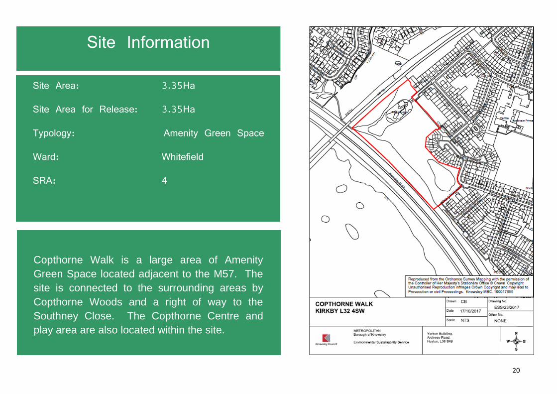
Halewood Doorstep Green | Halewood | L25 0QH

48
Site Area: 14.85Ha
Site Area for Release: 7.32Ha
Typology: Amenity Green Space
Ward: Halewood South
SRA: 38
Site Information
Halewood Doorstep Green is designated within Knowsley Green Space Strategy as a high level amenity green space. The site contains a children’s play space, informal football area, pond, meadow and woodland habitats. The site also forms part of the green corridor containing a section of the Trans Pennine Trail.

49
Site 10 – Halewood Doorstep Green
Site description 14.85 Ha local park in Halewood South Ward
Proposal for release 7.32 Ha which equates to 50% of the site
Why the site was selected?
Community Measure
This site is relatively well used, particularly the Trans-Pennine trail cycle route and the play area. The site does not host any community events / activities or support any volunteering programmes. Mitigation – The 7.32 Ha identified for disposal is the section of the site that requires significant infrastructure development. The sections of the site that have the higher levels of community use (i.e. the play areas / cycle routes etc) will be retained. In addition Halewood Park (Green Flag Site) is a borough park that hosts a range of activities and events for the local community. This site (and the programme of community events) will be retained.
Recreational Measure
The site does have large amenity grassed areas that can support recreational use. It does not support any formal sporting use at this time, but could do in the future. Mitigation – Greengates Playing Fields, Halewood Leisure Centre, the community pitches at Halewood Academy and Arncliffe Playing Fields are within the community area (1,200 metres). The Section 106 developer contributions secured from the housing development could be used to develop the site for sporting use.
Biodiversity Measure
The 7.32 Ha identified for potential disposal is the more natural section of the site which includes meadowland and woodland areas with a biodiversity value. Mitigation –To offset the loss of habitat, mitigation measures will be required to ensure a net gain in biodiversity within the local area. The adjacent part of the site to the south of this site will be retained as public open space that can be developed further to enhance its biodiversity offer.
Green Space Provision Measure
7.32 Ha of green space would be lost. Mitigation – 50% of the site will be retained as a public park. Substantial Residential Area 38 is in a healthy surplus for Public Open Space.
Within the accessibility standard of 800m/10 minutes walk from site, the local community has

50
access to 38.18 Ha of green space. This includes:- Halewood Park (Green Flag Site and New Hutte Woods.
Within the wider Community Area (2.4km/30 minutes walk) the local community has further access to 19.48 Ha of green space. This includes:- Arncliffe Playing Fields, Frensham Park, Torcross Amenity Green Space, Court Farm Wood (Green Flag Site), Church Road Woods, Court Farm Woods (Green Flag Site), Halewood Leisure Centre and the new green space at Bridgefield Forum.
Amenity Value Measure
The site does offer good visual amenity, there are a number of properties along Boundary Farm Road that face onto the park. The section identified for disposal (Blackburn Drive) is bounded by properties rear facing the site. Mitigation – The main section of the site that offers good visual amenity will be retained and could be developed further to improve the amenity value. The Section 106 developer funding secured from any housing development could support enhancement work.
Development Potential Measure
To the north of the site, a parcel of land has recently been developed for housing (Persimmon). The estimated land value provides a significant contribution to the Endowment.

51
King George V Playing Fields | Prescot | L34 1NU

52
Site Area: 6.95Ha
Site Area for Release: 6.95Ha
Typology: Outdoor Sports
Ward: Prescot North
SRA: 25
Site Information
Designated within the Knowsley Green Space Strategy as Outdoor Sports Provision, KGV Prescot contains two informal grass football pitches (with changing facilities and storage). The majority of the site is mown amenity grass. There is also children’s play areas on the site. The site is leased to Prescot Town Council.

53
Site 11 – King George V Playing Fields (Prescot)
Site description 6.95 Ha playing fields in Prescot North Ward
Proposal for release 6.95 Ha – Noting that any development would result in 1 hectare of green space being re-provided as part of the development, therefore the overall loss would be 86%
Why the site was selected?
Community Measure
This site is a well used site, particularly the play areas and the playing fields which are used by dog walkers and for exercise. In addition, the site supports a number of community events (e.g. the Prescot Carnival). Mitigation – A new green space (approx 1ha in size) would be created as part of any new housing development. Stadt Moers is the local Borough Park that supports a range of community events and activities. This community offer will be retained. Carr Lane Woods is directly opposite the site and could accommodate local dog walking activities. In addition new green space (including new play provision and a cycle link into Stadt Moers Park) will be created at Prescot Park within 800 metres walking distance from this site.
Recreational Measure
The site supports a range of informal and formal recreational activities. Mitigation – Sporting hubs in the local community area include KGV playing fields in Huyton, the community pitches at Prescot High School, Prescot Soccer Centre, Two Butt Playing Fields and Windy Arbour Playing Fields. Section 106 developer contributions secured from the housing development could be used to develop these sites to enhance the sporting offer.
Biodiversity Measure
The majority of this site is amenity green space that is regularly cut and has very limited or no biodiversity value. There are some isolated stands of trees on the site. Mitigation – No mitigation is required for intensively managed amenity grasslands (Joint Nature Conservation Committee, 2010, section J1.2). However, every effort will be made to improve biodiversity on any housing development sites within the local area (i.e. 2:1 tree replacement). Carr Lane Woods and the green wildlife corridor from Prescot to Cronton will be retained.
Green Space Provision Measure
6.95 Ha of green space would be lost. Mitigation – approx 1 Ha of new green space would be developed as part of a new housing development.

54
Substantial Residential Area 25 is in a healthy surplus for Public Open Space.
Within the accessibility standard of 800m/10 minutes walk from site, the local community has access to 75.15 Ha of green space. This includes:- Carr Lane Woods, Prescot Cemetery, Stadt Moers Park and the new green space being developed at Prescot Park.
Within the wider Community Area (2.4km/30 minutes walk) the local community has further access to 40.91Ha of green space. This includes:- Eaton Street Park (Green Flag Site), Henley Park (Green Flag Site), KGV Huyton (Green Flag Site), Sawpit Park (Green Flag Site), McGoldrick Park (Green Flag Site), Huyton Wetlands, Two Butt Playing Fields, Windy Arbour Playing Fields and Lord Derby Playing Fields.
Amenity Value Measure
The site does offer good visual amenity, there are a number of properties along South Avenue that face onto the park. In addition pedestrians and vehicles using Carr Lane benefit from the high quality landscaping. Mitigation – The Section 106 developer funding secured from the housing development could be reinvested to improve visual amenity on this new green space. Any new development should include good quality landscaping along the front of the development would help to offset the loss of amenity value.
Development Potential Measure
The estimated land value provides a significant contribution to the Endowment.

55
Pool Hey Playing Fields | Stockbridge Village | L28 4ER

56
Site Area: 7.40Ha
Site Area for Release: 7.40Ha
Typology: Outdoor Sports
Ward: Stockbridge
SRA: 9
Site Information
Designated within the Knowsley Green Space Strategy as Outdoor Sports Provision, Pool Hey is a large area of mown grass that in previous years has been used for informal football games. The site is leased to Knowsley Town Council.

57
Site 12 – Pool Hey Playing Fields
Site description 7.40 Ha playing fields in Stockbridge Ward
Proposal for release 7.40 Ha – Noting that any development would result in 1 hectare of green space being re-provided as part of the development, therefore the overall loss would be 92%
Why the site was selected?
Community Measure
This site has some community use, but has a limited community offer. It is mainly used for dog walking and informal sporting use. The site does not host any community events / activities or support any volunteering programmes. Mitigation – Any new housing development would create new green space (approx 1 Ha). Neighbouring Littlewood (Green Flag Site) supports a range of events and activities for the local community.
Recreational Measure
The site supports a range of informal and formal recreational activities. Mitigation – local sporting hubs include Lord Derby Playing Pitches, Woolfall Heath Playing Pitch and the community pitches at Christ The King College which are all in close proximity. The Section 106 developer contributions secured from the housing development could be used to develop these sites to enhance the sporting offer.
Biodiversity Measure
The site is amenity green space which is regularly cut and has very limited or no biodiversity value. The woodland compartment alongside the M57 would be retained. Mitigation – No mitigation is required for intensively managed amenity grasslands (Joint Nature Conservation Committee, 2010, section J1.2). However, every effort will be made to improve biodiversity on sites within the local area. Littlewood and the Gellings link is a crucial green space corridor that will be retained.
Green Space Provision Measure
7.40 Ha of green space would be lost. Mitigation – 1 Ha of new green space would be developed as part of a new housing development.
Within the accessibility standard of 800m/10 minutes walk from site, the local community has access to 29.44 Ha of green space. This includes:- Boodecroft Doorstep Green, Littlewood, The Sanctuary, Oak Plantation and Stockbridge Play Area.
Within the wider Community Area (2.4km/30 minutes walk) the local community has further

58
access to 24.36 Ha of green space. This includes:- is Woolfall Heath, KGV Huyton (Green Flag Site), Wastlebridge Park, Knowsley Village Recreation. In addition, Croxteth Park, a large park in Liverpool is in close proximity.
Amenity Value Measure
The site offers some visual amenity, particularly to the high rise flats, however the majority of the residential properties rear face onto the site. The site is not visible from the highway. Mitigation – The Section 106 developer funding secured from any housing development on the site. This could be reinvested to improve visual amenity on this new green space. Any new development should include good quality landscaping.
Development Potential Measure
The estimated land value provides a significant contribution to the Endowment.

59
Roby Playing Fields | Huyton | L36 4PL

60
Site Area: 5.8Ha
Site Area for Release: 5.8Ha
Typology: Outdoor Sports
Ward: Swanside
SRA: 13
Site Information
Roby Playing Fields is a large area of amenity green space with junior play provision located on site.

61
Site 13 – Roby Playing Fields
Site description 5.8 Ha playing fields in Swanside Ward, Huyton
Proposal for release 5.8 Ha - Noting that any development would result in 1 hectare of green space being re-provided as part of the development, therefore the overall loss would be 82%
Why the site was selected?
Community Measure
This site is not a particularly well used site, with limited community facilities. The Play area has some use. The site is mainly used for dog walking and informal sporting use. The site does not host any regular community events / activities, however over recent months some local volunteering activities have been undertaken in the wider Swanside Ward. Mitigation – A new housing development would be required to create new green space (approx 1Ha). Jubilee Park (Green Flag Site) and Bowring Park are both within 800 metres walking distance of the site. Both sites support a range of events and activities for the local community.
Recreational Measure
The site can accommodate informal recreational activities, but is not home to any registered clubs or used for club football. Mitigation – Local sporting hubs include Jubilee Park (home of Huyton Juniors Football Club), KGV playing fields in Huyton, Lord Derby Academy community playing pitches and Woolfall Heath Playing Pitch are all in close proximity. Section 106 developer contributions secured from the housing development could be used to develop these sites to enhance the sporting offer.
Biodiversity Measure
The site is amenity green space which is regularly cut and has very limited or no biodiversity value. Mitigation – No mitigation is required for intensively managed amenity grasslands (Joint Nature Conservation Committee, 2010, section J1.2). However, every effort will be made to improve biodiversity on sites within the local area.
Green Space Provision Measure
5.8 Ha of green space would be lost. Mitigation – Approx 0.75 Ha of new green space would be developed as part of a new housing development.
Within the accessibility standard of 800m/10 minutes walk from site, the local community has access to 56.64 Ha of green space. This includes:- Jubilee Park (Green Flag Site), Bowring Park, and Cyril Cook Park.

62
Within the wider Community Area (2.4km/30 minutes walk) the local community has further access to 43.84 Ha of green space. This includes: Court Hey Park (Green Flag Site), McGoldrick Park (Green Flag Site), Ten Acre Pitts (Green Flag Site), Sawpit Park (Green Flag Site), Woolfall Heath, KGV Huyton (Green Flag Site), Wastlebridge Park.
Amenity Value Measure
The site offers some visual amenity to the residential properties that face onto the site. Mitigation – The Section 106 developer funding could be secured from the housing development on the site could be reinvested to improve visual amenity on this new green space. Any new development should include good quality landscaping.
Development Potential Measure
The estimated land value provides a significant contribution to the Endowment.

63
Spring Wood | Huyton | L36 0SD

64
Site Area: 2.64Ha
Site Area for Release: 2.64Ha
Typology: Natural Space
Ward: St. Gabriel’s
SRA: 20
Site Information
Designated within the Knowsley Green Space
Strategy as a natural and semi-natural habitat,
this area of woodland has a network of informal
footpaths and is popular site with dog walkers.
65
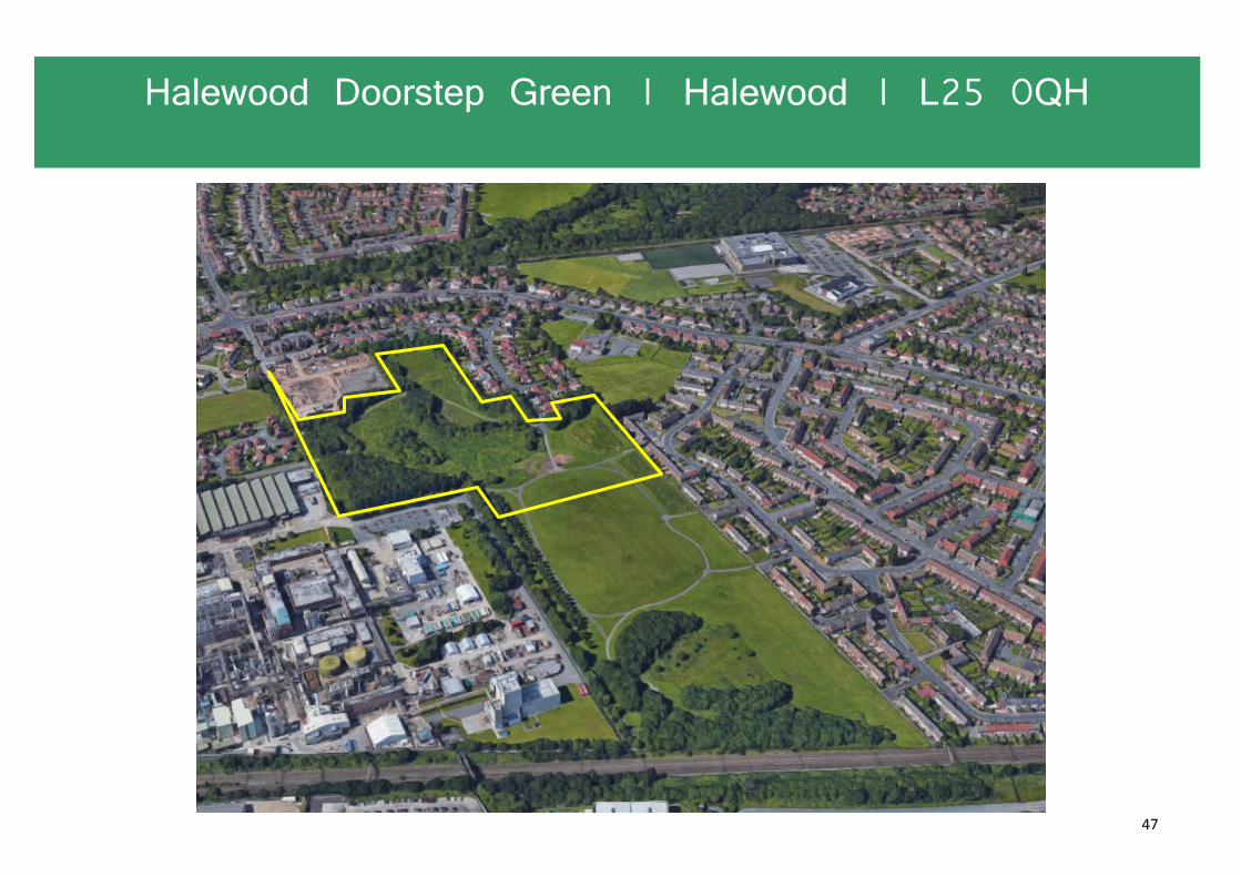
Site 14 – Spring Wood
Site description 2.64 Ha natural space in St Gabriel’s Ward, Huyton
Proposal for release 2.64 Ha which equates to 100% of the site
Why the site was selected?
Community Measure
This site is not a particularly well used site, with limited community facilities. The site is mainly used for dog walking. The site does not host any regular community events / activities or support any volunteering programmes. Mitigation –McGoldrick Park (Green Flag Site), Ten Acre Pits (Green Flag Site) and Sawpit Park (Green Flag Site) are all in relatively close proximity of the site. These sites support a range of events and activities for the local community.
Recreational Measure
The site is a natural site and is not used for any formal recreational purposes.
Biodiversity Measure
As a natural site, it does support local wildlife and provides a good biodiversity offer. Mitigation –tree planting (2 for 1 ratio) would be required (either on or off site) as part of any future development. Measures will need to be developed and implemented to ensure that there is a net gain in biodiversity elsewhere in the local area. The significant areas of woodland within the neighbouring Stadt Moers Park has a high biodiversity value and will be protected.
Green Space Provision Measure
2.64 Ha of green space would be lost. Mitigation –The Substantial Residential Area 20 is in overall surplus.
Within the wider Community Area (2.4km/30 minutes walk) the local community has further access to 142.07 Ha of green space. This includes: Bowring Park, McGoldrick Park (Green Flag Site), Ten Acre Pitts (Green Flag Site), Sawpit Park (Green Flag Site), Huyton Wetlands, Stadt Moers Park and KGV Huyton (Green Flag Site).
Amenity Value Measure
The site offers some visual amenity to the residential properties and pedestrians / vehicles using Tarbock Road. Mitigation – The Section 106 developer funding secured from the housing development on the site could

66
be reinvested to improve visual amenity on this new green space. Any new development should include good quality landscaping.
Development Potential Measure
The estimated land value of provides a good contribution to the Endowment.

67
St. John’s Millennium Green | Huyton | L36 0UB

68
Site Area : 2.16Ha
Site Area for Release: 2.16Ha
Typology: Amenity Green Space
Ward: St. Gabriel's
SRA: 22
Site Information
St John’s Millennium Green is designated within
the Knowsley Green Space Strategy as an
amenity green space. The site has a formal
looped footpath, green gym equipment and a
children’s play area.

69
Site 15 – St Johns Millennium Green
Site description 2.16 Ha a local park in St Gabriel’s Ward, Huyton
Proposal for release 2.16 Ha which equates to 100% of the site
Why the site was selected?
Community Measure
This site has relatively low levels of community use. The play area has some community use with the site mainly used for dog walking and childrens play. The site does not host any regular community events / activities or support any volunteering programmes. Mitigation –McGoldrick Park (Green Flag Site) and Sawpit Park (Green Flag Site) are all within 800 metres/10 minute walk of the site. These sites support a range of events and activities for the local community.
Recreational Measure
The site has limited recreational use. Mitigation – Local sporting hubs include KGV Playing Fields and Lord Derby Academy. McGoldrick Park also offers opportunities for informal recreation.
Biodiversity Measure
The site is amenity green space regularly cut with very limited or no biodiversity value. There are some isolated trees on site. Mitigation – No mitigation is required for intensively managed amenity grasslands (Joint Nature Conservation Committee, 2010, section J1.2). However, every effort will be made to improve biodiversity on sites within the local area. Tree planting (2:1ratio) would be required (either on or off site) as part of any future development.
Green Space Provision Measure
2.16 Ha of green space would be lost. Mitigation –The Substantial Residential Area 22 is in overall surplus.
Within the accessibility standard of 800m/10 minutes walk from site, the local community has access to 72.36 Ha of green space. This includes:- McGoldrick Park (Green Flag Site) Sawpit Park (Green Flag Site) and Stadt Moers Park.
Within the wider Community Area (2.4km/30 minutes walk) the local community has further access to 83.87 Ha of green space. This includes: Bowring Park, Ten Acre Pitts (Green Flag Site), Huyton Wetlands, Carr Lane Woods, Cyril Cook Park, South Alt Greenway, Wastlebridge

70
Park and KGV Huyton (Green Flag Site).
Amenity Value Measure
The site offers limited amenity value, the neighbouring residential properties are all rear facing to the site, there are no views of the site from the highway as the site is located behind the shopping parade. Mitigation – The Section 106 developer funding secured from the housing development on the site could enhance local green spaces. Any new development should include good quality landscaping.
Development Potential Measure
Housing development has commenced to the North of the site. The estimated land value provides a good contribution to the Endowment.

71
Syders Grove | Knowsley Village | L34 0EW

72
Site Area: 0.88Ha
Site Area for Release: 0.88Ha
Typology: Amenity Green Space
Ward: Prescot North
SRA: 8
Site Information
Designated within the Knowsley Green Space Strategy as a natural and semi-natural habitat, this woodland area lies in the heart of Knowsley Village. It is a mature wood dominated by Sycamore, with some mature specimens of Oak, Ash and other native trees. The site is leased to Knowsley Town Council.

73
Site 16 – Syders Grove
Site description 5.52 Ha a natural site in Prescot North Ward
Proposal for release 0.88 Ha which equates to 16% of the site
Why the site was selected?
Community Measure
This site has relatively low levels of community use. The site does not host any regular community events / activities. Mitigation – The majority of the site will be retained and remain accessible for dog walkers and for informal leisure. In addition, Knowsley Recreation, Shop Road Woods and Mill Lane Playing Fields are all within 800 metres/10 minutes walk of the site.
Recreational Measure
The site has limited informal / formal recreational use. Mitigation – Neighbouring Mill Lane playing fields can support sporting activities.
Biodiversity Measure
The majority of the area being offered for development is largely comprised of amenity green space which is regularly cut and has very limited or no biodiversity value. However, some small stands of young trees may be lost Mitigation – No mitigation is required for intensively managed amenity grasslands (Joint Nature Conservation Committee, 2010, section J1.2, However, every effort will be made to improve biodiversity on sites within the local area. Tree planting (2:1 ratio) would be required (either on or off site) as part of any future development.
Green Space Provision Measure
0.88 Ha of green space would be lost. Mitigation –The Substantial Residential Area 8 is in overall surplus.
Within the accessibility standard of 800m/10 minutes walk from site, the local community has access to 4.32 Ha of green space. This includes:- Knowsley Recreation, Shop Road Woods, Pinfold Woods, Mill Lane Playing Fields.
Within the wider Community Area (2.4km/30 minutes walk) the local community has further access to 29.2 Ha of green space. This includes: The Sanctuary, Littlewood (Green Flag Site), Clint Eastwood, Oak Plantation, Lord Derby Playing Fields. In addition Croxteth Park within Liverpool.

74
Amenity Value Measure
The site offers limited amenity value, the neighbouring residential properties are all rear facing to the site, there are no views of the site from the highway. Mitigation – The Section 106 developer funding secured from housing development on the site could support enhancements to the remaining section of the site. Any new development should include good quality landscaping.
Development Potential Measure
The estimated land value provides a good contribution to the Endowment.

75
Westview | Huyton | L36 6DB

76
Site Area: 1.11Ha
Site Area for Release: 1.11Ha
Typology: Amenity Green Space
Ward: St. Gabriel's
SRA: 23
Site Information
Westview is an amenity green space. The site is mostly use by dog walkers, although informal football training sessions do take place on the site.

77
Site 17 – Westview
Site description 1.11 Ha a amenity green space in St Gabriel’s Ward in Huyton
Proposal for release 1.11 Ha which equates to 100% of the site
Why the site was selected?
Community Measure
This site has relatively low levels of community use. The site does not host any regular community events / activities or support any volunteering programmes. Mitigation –Stadt Moers and Saw Pitt Park (Green Flag Site) are both within 800 metres/10 minutes walk of the site. Both sites host a range of activities / events and support volunteering programmes. This community offer will be retained at these sites.
Recreational Measure
The site has some recreational use (e.g. informal football) but it does not support any formal leisure activities. Mitigation – Within the wider community area are the following sporting hubs:- KGV Huyton playing fields, the community playing pitches at Lord Derby Academy. If required, new sporting provision could be developed on Stadt Moers (Westview) utilising Section 106 developer contributions.
Biodiversity Measure
The site is amenity green space which is regularly cut and has very limited or no biodiversity value. There are some isolated trees on the site. Mitigation – No mitigation is required for intensively managed amenity grasslands (Joint Nature Conservation Committee, 2010, section J1.2). However, every effort will be made to improve biodiversity on sites within the local area.
Green Space Provision Measure
1.11 Ha of green space would be lost. Mitigation –The Substantial Residential Area 23 is in overall surplus.
Within the accessibility standard of 800m/10 minutes walk from site, the local community has access to 67.59 Ha of green space. This includes:- Stadt Moers Park and Sawpit Park (Green Flag Site).
Within the wider Community Area (2.4km/30 minutes walk) the local community has further access to 87.07 Ha of green space. This includes: Bowring Park, Ten Acre Pitts (Green Flag Site), Huyton Wetlands, Carr Lane Woods, Cyril Cook Park, South Alt Greenway, Wastlebridge

78
Park, KGV playing fields Huyton (Green Flag Site) and Windy Arbour Playing Fields.
Amenity Value Measure
The site offers limited amenity value to the immediate neighbouring residential properties that face the site. Mitigation – The Section 106 developer funding secured from the housing development on the site could fund enhancements to local green spaces. Any new development should include good quality landscaping.
Development Potential Measure
The estimated land value provides a good contribution to the Endowment.