Green River Watershed Section 729 Initial Watershed Assessment · • Select a strategy or broad...
97
Green River Watershed Section 729 Initial Watershed Assessment November 2011
Transcript of Green River Watershed Section 729 Initial Watershed Assessment · • Select a strategy or broad...

Green River Watershed
Section 729 Initial Watershed Assessment
November 2011

Green River Initial Watershed Assessment Page ii
TABLE OF CONTENTS
EXECUTIVE SUMMARY .......................................................................................................................... v 1. STUDY AUTHORITY, GUIDANCE, PROCESS AND FUNDING ..................................................... 1
1.1 Authority ............................................................................................................................................ 1 1.2 Guidance ............................................................................................................................................ 1 1.3 Study Process ..................................................................................................................................... 2 1.4 Green River Initial Watershed Assessment Key Activities ................................................................ 3 1.5 Funding .............................................................................................................................................. 4
2. STUDY PURPOSE .................................................................................................................................. 4 3. CONGRESSIONAL DISTRICTS ........................................................................................................... 4 4. STUDY AREA ........................................................................................................................................ 6
4.1 Introduction ........................................................................................................................................ 6 4.2 Major Tributaries in the Green River Watershed ............................................................................... 8 4.3 Hydrologic Unit Codes (HUC) ........................................................................................................ 10 4.4 State, County, City and Population Features ................................................................................... 11 4.5 Land Cover and Land Use ............................................................................................................... 12
5. REPORTS, PROJECTS, AND ACTIONS IN THE WATERSHED..................................................... 14 5.1 Existing Reports ................................................................................................................................ 14 5.2 Existing Projects ............................................................................................................................... 17
5.2.1 Reservoirs/Lakes ........................................................................................................................ 17
5.2.2 Ecosystem Restoration, Clearing and Snagging and Streambank Erosion Projects .................. 19
5.2.3 Local Flood Protection Projects ................................................................................................. 21
5.2.4 Navigation Projects .................................................................................................................... 21
6. EXISTING CONDITIONS .................................................................................................................... 22 6.1 Aquatic Fauna .................................................................................................................................. 22 6.2 Terrestrial Fauna .............................................................................................................................. 24 6.3 Threatened and Endangered Species ................................................................................................ 24 6.4 Physiography and Geology .............................................................................................................. 27 6.5 Wetlands .......................................................................................................................................... 32 6.6 Water Quality ................................................................................................................................... 33 6.7 Climate ............................................................................................................................................. 37 6.8 Precipitation ..................................................................................................................................... 38 6.9 Water Supply and Low Water Flows ............................................................................................... 39 6.10 Historic Storms and Floods ............................................................................................................ 40

Green River Initial Watershed Assessment Page iii
6.11 Highwater Marks ........................................................................................................................... 41 6.12 Hydrologic Conditions .................................................................................................................... 41 6.13 Hydraulic Conditions ...................................................................................................................... 42 6.14 Recreation ....................................................................................................................................... 42 6.15 Transportation ................................................................................................................................. 43
7. PROBLEMS AND OPPORTUNITIES ................................................................................................. 45 7.1 Problems .......................................................................................................................................... 45 7.2 Opportunities.................................................................................................................................... 46
8. FORECAST OF WATERSHED CONDITIONS .................................................................................. 47 9. INTERESTED AGENCIES AND ORGANIZATIONS ....................................................................... 48 10. FEDERAL AND NON-FEDERAL INTEREST, NON-FEDERAL SPONSORSHIP ........................ 51
10.1 Interest............................................................................................................................................ 51 10.2 Non-Federal Sponsorship ............................................................................................................... 51
11. SCOPE AND OBJECTIVE OF FINAL WATERSHED ASSESSMENT .......................................... 51 12. MILESTONES FOR WATERSHED STUDY .................................................................................... 52 13. POTENTIAL ISSUES AFFECTING INITIATION OF WATERSHED ASSESSMENT ................. 53 14. RECOMMENDATIONS ..................................................................................................................... 53 15. REFERENCES .................................................................................................................................... 54 APPENDIX A - Authority ......................................................................................................................... 56 APPENDIX B – Green River Watershed Stakeholder List ....................................................................... 58 APPENDIX C – Green River Watershed Interview Responses ................................................................ 67 APPENDIX D Green River Watershed - Letter of Introduction and Interview ........................................ 85 APPENDIX E – Kentucky Waterways Alliance Letter Of Intent ............................................................. 90 APPENDIX F – The Nature Conservancy Letter of Intent ........................................................................ 91
LIST OF FIGURES Figure 1. Map of Green River Watershed Congressional Districts............................................................... 5 Figure 2. Map of Green River Watershed Study Area .................................................................................. 7 Figure 3. HUC8 Sub-Watersheds................................................................................................................ 11 Figure 4. Map of General Land Cover in the Study Area ........................................................................... 13 Figure 5. Map of Lake Projects in the Study Area ...................................................................................... 17 Figure 6. Kentucky Physiographic Provinces ............................................................................................. 28 Figure 7. Generalized Geologic Map of the Study Area ............................................................................. 29 Figure 8. Physiographic Map with Generalized Geologic Cross Section ................................................... 30 Figure 9. Map of Karst Topography in the Study Area .............................................................................. 31

Green River Initial Watershed Assessment Page iv
Figure 10. Hydric Soils in the Green River Watershed .............................................................................. 33 Figure 11. Map of Mining Activity in the Green River Watershed ............................................................ 35 Figure 12. Map of 303(d) Impaired Streams listen 2010 Kentucky State Water Quality Report ............... 36 Figure 13. Map of Average Annual Temperatures in the Green River Watershed ..................................... 37 Figure 14. Map of Average Annual Precipitation in the Green River Watershed ...................................... 38 Figure 15. Map of Aquifers in the Green River Watershed ........................................................................ 39 Figure 16. Map of Primary Recreation Centers in the Green River Watershed .......................................... 43
LIST OF TABLES Table 1. Drainage Area of Major Tributaries of the Green River Watershed ............................................... 8
Table 2. Green River Land Cover ............................................................................................................... 12
Table 3. Federal and State Listed Species in the Green River Watershed .................................................. 26
Table 4. Wetland Acres by HUC8 .............................................................................................................. 32
Table 5. Location of River Ferries in the Green River Watershed ............................................................. 44
Table 6. Commodity by Tonnage at Green River Lock and Dam 1 and 2.................................................. 45

Green River Initial Watershed Assessment Page v
EXECUTIVE SUMMARY
The Green River Watershed, with a drainage area of 9,230 square miles, is located in west-central Kentucky with a small portion in north-central Tennessee. The Green River is one of the most significant freshwater aquatic ecosystems in North America. It supports 71 species of freshwater mussels, 151 fish species (as many as Europe) and is home to Mammoth Cave National Park. Many species present in the Green River are endangered and some occur nowhere else in the world. Topography in the watershed varies from gently rolling in the east to moderately rugged Western Kentucky coalfields region and then into extensive broad and nearly flat alluvial flood plain as the Green joins the Ohio near Henderson, Kentucky. The social and economic landscape of the watershed is as diverse as the topography with a mix of rural, undeveloped woodland, agriculture, and small urban and industrial areas. Moreover, the Green River Watershed represents an exceptional aquatic and terrestrial ecosystem and has received national attention for conservation and restoration efforts in the upper reaches of the watershed. Still, there is much work to be done to coordinate planning efforts and translate successes in the upper Green River to the entire watershed. The subsequent report is an Initial Watershed Assessment (IWA) of the Green River. The IWA was prepared under the authority of Section 729 of the Water Resources Development Act of 1986 as amended, and the IWA describes problems and opportunities identified through stakeholder outreach and a review of previous studies in the watershed. From incompatible agricultural practices in the lower watershed to increased recreational pressure and development in the middle and upper portion of watershed, numerous locations in the watershed’s ecosystem are under stress. Specifically, the predominant problems identified throughout the planning process were riparian buffer alteration, agricultural inputs, altered stream flows, sedimentation, inadequate land use planning and municipal water supply. Conversely, there are also numerous opportunities in the watershed to coordinate conservation efforts and engage the community in order to address these problems and enhance current positive conditions in the basin.The Green River IWA also identifies existing conditions within the watershed, highlights the major water resource problems of the watershed and discusses the potential scope and objective of a Final Watershed Assessment (FWA) based on a shared vision for the watershed. The FWA will focus on addressing water resource problems in a holistic manner that reflects the interdependency of water uses, competing demands and the desires of a wide range of stakeholders. The purpose is to undertake planning in a broad, integrated systems approach instead of focusing on single purpose projects. The conclusion of the IWA recommends drafting a watershed assessment management plan to define the objectives of the final watershed assessment. The Kentucky Chapter of The Nature Conservancy and Kentucky Waterways Alliance were identified as a potential non-federal sponsors, interested in cost sharing the Final Watershed Assessment.

Green River Initial Watershed Assessment Page 1
1. STUDY AUTHORITY, GUIDANCE, PROCESS AND FUNDING
1.1 Authority
This Initial Watershed Assessment (IWA) of the Green River Watershed is authorized by Section 729 of the Water Resources Development Act (WRDA) of 1986 as amended.
(a) The Secretary, in coordination with the Secretary of the Interior and in consultation with appropriate Federal, State, and local agencies, is authorized to study the water resources needs of river watersheds and regions of the United States… (b) In carrying out the studies authorized under subsection (a) of this section, the Secretaries shall consult with State, interstate, and local governmental entities.
Section 729 of WRDA of 1986 has since been amended by Section 202 of WRDA 2000 to provide the Secretary discretionary authority to assess the water resources needs of watersheds of the United States, including needs relating to ecosystem protection and restoration; flood damage reduction; navigation and ports; watershed protection; water supply; and drought preparedness. It also establishes cost sharing provisions and defines cooperation and consultation requirements. The most recent amendment of Section 729 of WRDA of 1986 is contained in Section 2010 of WRDA 2007. This section includes priority river watersheds and modifies the non-federal cost sharing for assessments. The full authorization language for Section 729 of WRDA of 1986 and related amendments is located in Appendix A.
1.2 Guidance
This report was prepared in accordance with the legal procedures and technical requirements of US Army Corps of Engineers (USACE) Engineering Regulation ER 1105-2-100 Planning Guidance Notebook, dated 22 April 2000. The supporting source of guidance for conducting USACE watershed assessments is Engineer Circular (EC) 1105-2-411, Watershed Plans, dated 15 January 2010. The purpose of EC 1105-2-411 is to provide guidance for conducting watershed planning. In the past, USACE has focused on problem solving and decision making for specific sites and projects. USACE has since recognized the need to undertake planning in a broader, integrated systems approach instead of focusing on single purpose projects. In particular, watershed planning is an approach for managing water resources within particular watersheds and addressing problems in a holistic manner that reflects the interdependency of

Green River Initial Watershed Assessment Page 2
water uses, competing demands and the desires of a wide range of stakeholders in addressing watershed problems and opportunities. The planning process should identify and characterize systems of interest to the current and future needs of the watershed. Public involvement is essential to the success of watershed planning. Additional guidance regarding watershed planning efforts was derived from USACE Planning Guidance Letter # 61 – Application of Watershed Perspective to Corps of Engineers Civil Works Programs and Activities, dated 27 January 1999.
1.3 Study Process
The watershed planning process requires the establishment of a collaborative partnership both within and outside of the USACE. The USACE led watershed assessment process consists of two phases: IWA and Final Watershed Assessment (FWA) and ultimately results in the creation of a watershed management plan. The process generally follows the USACE six-step Civil Works planning process and adheres to watershed principles. The following elements referenced in EC 1105-2-4111 are critical to facilitating an effective watershed planning process:
• Define the Study Area • Identify Problems and Opportunities • Inventory and Forecast Conditions • Evaluation and Comparison of Alternative Approaches • Strategy Selection
The IWA is conducted at 100 percent federal cost and limited to $100,000. It has the following purposes:
• Define the study area by identifying an appropriate watershed. • Identify problems and opportunities within the watershed through stakeholder
engagement. • Identify a non-Federal cost-sharing partner for the second phase of watershed planning
which will include development of a FWA. • Negotiate and execute a cost-share agreement with the identified non-Federal partner. • Define the scope and objective of the FWA. • Prepare a WAMP (similar to a Project Management Plan that is developed for a
traditional feasibility study).
The FWA results in a comprehensive watershed management plan and is conducted in collaboration with multiple stakeholders throughout the watershed. The costs of the FWA are shared with a Non-Federal Sponsor. The following elements will be fully developed in the second phase of assessment based on stakeholder and non-Federal sponsor interest.

Green River Initial Watershed Assessment Page 3
• Inventory and forecast conditions based on the stakeholder needs identified within the watershed.
• Evaluate and compare alternative approaches to address the identified needs within the watershed.
• Select a strategy or broad plan based on the shared vision of the stakeholders and partners that can be implemented to address significant identifiable watershed problems.
1.4 Green River Initial Watershed Assessment Key Activities USACE Louisville District met in November 2010 with the Kentucky Chapter of The Nature Conservancy (TNC) to develop a process and schedule to complete the first phase of the Green River IWA. The process was designed to address the following goals: (1) define the study area; (2) identify problems and opportunities; and (3) develop a process to move towards a shared vision for the watershed. USACE and TNC identified a core group of stakeholders active in the basin. The stakeholders were divided into nine categories: agriculture, recreation, tourism, academia, industry, local government, state government, federal government, and non-governmental organizations /non-profit. Specific stakeholders were identified for each category. From that list specific individuals who have a known interest (personal or agency) in the watershed were identified. A complete list of stakeholders is located in Appendix B. Subsequently, it was determined that stakeholders in the Green River Watershed should be engaged through a series of outreach meetings and a watershed interview. The interview was designed to gather input from additional stakeholders that span the regional and sector diversity that is present in the Green River Watershed. The goal of the interview was to identify key problems and opportunities, as well as recommend a process for moving towards a shared vision for the watershed. The interview was approved by the Office of Management and Budget (OMB) in the summer of 2011 and was distributed to approximately 175 agencies and individuals in the Green River Watershed by USACE through mail, telephone, and email. The interviews were targeted at representatives from industry, recreation, agriculture, non-governmental organizations, as well as federal, state, and local officials. A copy of the watershed interview is located in Appendix C. In February 2011, USACE, in coordination with TNC, invited the core group to a working meeting at Campbellsville University. This meeting included representatives from federal and state agencies and local organizations involved in various activities throughout the Green River Watershed. The goal for the February meeting was to: (1) identify additional stakeholders; (2) identify existing planning efforts in the watershed; and (3) refine the watershed interview. Following the meeting, the Green River interview was finalized and submitted to OMB for review.

Green River Initial Watershed Assessment Page 4
Interviewees were asked about their specific experiences in the watershed, their knowledge of collaborative projects already underway, their relationship to on-going visioning and planning processes, and their suggestions for ways to design a process that will accommodate the vast diversity that is present in the Green River Watershed. The key themes and insights that emerged from the interviews were used to develop the IWA. A total of 33 interviews were completed and returned; the generalized responses can be found in Appendix C.
1.5 Funding The Green River IWA is funded as part of the Ohio River Basin Comprehensive Study (ORBCS). The ORBCS is the overarching watershed study that identified five priority watersheds in the Ohio River Valley. The initial Federal amount of $100,000 was received in Fiscal Year 2010 to initiate the IWA.
2. STUDY PURPOSE
The purpose of this IWA is to identify and document water resource related problems, needs, and opportunities in the Green River Watershed. The IWA focuses on defining the study area, describing existing conditions, and identifying the opportunities for addressing the watershed needs. The IWA will also describe the coordination efforts to date with other agencies and identify potential non-Federal sponsor(s) to share the cost of a full watershed assessment. This IWA will serve as the basis for a comprehensive FWA and development of a WAMP, which will provide strategic guidance to watershed restoration from a systems-wide perspective. The WAMP is analogous to a Project Management Plan (PMP) that is prepared for all USACE studies and projects. The WAMP will outline, in considerable detail, tasks and costs associated with conducting a detailed watershed assessment of the Green River Watershed.
3. CONGRESSIONAL DISTRICTS
The study area lies within the geographic area of the following Congressional interests and Districts (Figure 1):

Green River Initial Watershed Assessment Page 5
Kentucky Tennessee Representative Brett Guthrie (KY - R) 2nd Representative Diane Black (TN - R) 6th Representative Edward Whitfield (KY - R) 1st Senator Bob Corker (TN-R) Senator Mitch McConnell (KY-R) Senator Lamar Alexander (TN-R) Senator Rand Paul (KY-R)
Figure 1. Map of Green River Watershed Congressional Districts

Green River Initial Watershed Assessment Page 6
4. STUDY AREA
4.1 Introduction
The Green River Watershed is located in west-central Kentucky and extends into north-central Tennessee (Figure 2). The largest of the twelve river watersheds in Kentucky, the Green River encompasses approximately 9,230 square miles and drains all or portions of thirty-one counties in Kentucky and three counties in Tennessee. The Green River, originating in Lincoln and Casey counties, Kentucky, flows in a northwesterly direction for 330 miles to its confluence with the Ohio River near Henderson, Kentucky. Elevations range from over 1,050 feet mean sea level (msl) at the source to approximately 337 feet msl at the Ohio River pool. Averaged river gradient is 1.9 feet per mile and ranges from four feet per mile at the initial reach to 0.25 feet per mile where it enters the Ohio River. The portion of the Green River traversing the Mammoth Cave National Park has been designated an Outstanding Resource Water and a Kentucky Wild River by the Kentucky Division of Water (KDOW).

Green River Initial Watershed Assessment Page 7
Figure 2. Map of Green River Watershed Study Area

Green River Initial Watershed Assessment Page 8
4.2 Major Tributaries in the Green River Watershed
The major tributaries of the Green River include the Barren River, Rough River, Bear Creek, Nolin River, Pond Creek, and Mud River. Table 1 shows drainage areas for the major rivers within the Green River Watershed.
Table 1. Drainage Area of Major Tributaries of the Green River Watershed
Tributary
Green River Drainage Areas (Square Miles)
Green River @ Green River Lake 682 Green River above Nolin River 2031 Nolin River @ Nolin Lake 703 Nolin River @ mouth 727 Green River including Nolin River 2758 Green River above Barren River 3140 Barren River @ Barren River Lake 940 Barren River mouth 2262 Green River Including Barren River 5402 Green River above Rough River 6429 Rough River @ Rough River Lake 454 Rough River @ mouth 1081 Green River including Rough River 7510 Green River above Pond Creek 7623 Pond Creek @ mouth 799 Green River including Pond Creek 8422 Green River @ mouth 9229
Green River The Green River is one of the top four river systems in the United States in terms of its aquatic biodiversity; few streams rival the 151 species of fishes and 71 species of freshwater mussels. Among these, there are 12 endemic species and more than 35 aquatic species that are considered imperiled. The mineral dissolution of the watershed's underlying limestone bedrock makes the Green River a natural companion to the Mammoth – Flint Ridge Cave System, the world's longest mapped cave system, and home to a popular national park. Other rare, threatened or endangered plants and animals depend on the river and its tributaries for their survival. Examples include the eastern hellbender (Cryptobranchus alleganiensis), American eel (Anguilla rostrata) , gray bat (Myotis grisescens)and Indiana bat (Myotis sodalis). The segment of the Green River that flows between Green River Lake Dam and Mammoth Cave National Park is the

Green River Initial Watershed Assessment Page 9
location of the 1350 square mile Green River Bioreserve. A Bioreserve, also referred to as biosphere reserve, is an international designation from the United Nations Educational, Scientific and Cultural Organization (UNESCO) to promote sustainable development and the preservation of biodiversity. 109 of the Green River’s 151 fish species are found within the Green River Bioreserve. Seven of these species are found only in Kentucky, and at least 12 fishes are considered globally rare (Kentucky Department of Environmental Protection, 2001). Consequently, this stretch of stream has received TNC’s highest biodiversity rating and is the focus of multiple conservation efforts including the USDA Kentucky Green River Conservation Reserve Enhancement Program (CREP). Additional detail on CREP is located in Section 5.2.2. Barren River The Barren River lies in south-central Kentucky and north-central Tennessee, and includes an area of 2,262 square miles, of which 1,852 are in Kentucky and 410 in Tennessee. It is bounded on the north and west by the watershed of Green River and on the south and east by the Cumberland River Watershed. The drainage area of Barren River comprises 40 percent of the area in the Green River Watershed above the confluence of the two streams (Green River Mile 149.6) and about 25 percent of the entire drainage area. The Barren River Watershed is roughly triangular in shape, about 55 miles long by 40 miles wide. Barren River is formed by the confluence of Line Creek and East Fork in Monroe County, Kentucky, and flows in a generally northwesterly direction for 139 miles until its junction with Green River at Woodbury Kentucky, 149 miles upstream from the Ohio River. It drains part or all of eight counties in Kentucky and three in Tennessee. The principal tributaries are Drakes Creek, Skaggs Creek, and Gasper River. The remaining tributaries are much smaller and descend rapidly from their headwaters to the main stream, each draining an area less than 150 square miles. The topography of the Barren River Watershed is relatively rugged to rolling with the more gently rolling area near the center of the watershed and the more rugged areas in the headwaters and near the mouth. The northwest-central portion of the watershed is traversed by a belt of cavernous limestone, in which subterranean drainage has developed to an advanced stage. A decommissioned lock and dam, know as Brown’s Lock and Mill Dam 1, is located at Greencastle, River Mile 15. Rough River Rough River is the second largest tributary of Green River and drains 1,081 square miles, including major parts of Breckinridge, Grayson, Hardin, and Ohio Counties, KY. This comprises approximately 12 percent of the Green River Watershed. Rough River flows 141 miles in a westerly direction from its headwaters in west central Hardin County to its confluence with the Green River in McLean County at Green River Mile 71.3. Many small tributary streams to Rough River lie both above and below Rough River Lake. Major tributaries which drain into the lake include the North Fork Rough River, Rough Creek, and Clifty Creek. Rock Like Creek, Adams Fork, Halla Creek and Caney Creek enter the Rough River downstream from the lake. The Rough River watershed is rural in nature, with the major land use being agriculture.

Green River Initial Watershed Assessment Page 10
Pond Creek Pond Creek is the third largest tributary of Green River and drains 799 square miles, entering Green River at Mile 55 near Jewel City, KY. No flood control or navigational dams are present on the Pond Creek. The upper section of Pond Creek is relatively healthy and contains a good representation of plants and animals. The lower section of Pond Creek is impaired due to acid mine runoff. Drakes Creek is one of the most impaired tributaries of Pond Creek. Nolin River Nolin River is the fourth largest tributary of Green River and drains 727 square miles, entering Green River at Mile 183.5. The confluence is 1.8 miles upstream of Green River Lock and Dam 6 in Edmonson County, KY. Nolin River Watershed encompasses portions of Edmonson, Grayson, Hardin, Hart and Larue Counties. KY.
4.3 Hydrologic Unit Codes (HUC)
A watershed is defined as an area of land that drains all surface water and rainfall to a common outlet. The term watershed is sometimes used interchangeably with drainage watershed and a larger watershed may contain many smaller watersheds. The United States Geological Survey (USGS) organizes watersheds into a hydrologic system that divides and subdivides the United States into successively smaller watersheds. These levels of subdivision, used for organization of hydrologic data, are called hydrologic units. Each hydrologic unit is identified by a unique hydrologic unit code (HUC) consisting of two to twelve digits based on the six levels of classification:
• 2‐digit HUC first‐level (region) • 4‐digit HUC second‐level (subregion) • 6‐digit HUC third‐level (accounting unit) • 8‐digit HUC fourth‐level (cataloguing unit) • 10‐digit HUC fifth‐level (watershed) • 12‐digit HUC sixth‐level (subwatershed)
The Green River Watershed is a HUC 4 cataloging unit which is the defined study area for this IWA. The Green River Watershed is identified by the hydrologic unit code 0511. The first two digits (HUC 2) together identify the water-resources region (Ohio River) and the four digits (HUC 4) together identify the sub-region (Green River). The Green River Watershed contains six HUC 8 sub-watersheds, as seen on Figure 3 below. These include the Barren River, Upper Green, Middle Green, Rough River, Pond Creek and Lower Green watersheds.

Green River Initial Watershed Assessment Page 11
4.4 State, County, City and Population Features The population of the watershed is approximately 630,000, with major population centers located on the periphery of the watershed. The developed landscape ranges from small cities and towns to sparsely populated rural areas. Bowling Green, which is located in the HUC8 Barren River Watershed, is the third largest city in Kentucky. According to the 2010 U.S Census, it is also the largest city in the Green River Watershed with a population of 58,067. The second largest city in the Green River Watershed is Owensboro, which is located in the Lower Green River Watershed adjacent to the Ohio River. In 2010 the population of Owensboro was 57,265. Elizabethtown, located at the northern portion of the HUC8 Upper Green River Watershed, is the third largest city in the watershed with a population of 28,531.
Figure 3. HUC8 Sub-Watersheds

Green River Initial Watershed Assessment Page 12
4.5 Land Cover and Land Use
The National Land Cover Data 2001 (NLCD 2001) datasets were used to identify variations in land cover throughout the Green River Watershed. Approximately 93 percent of the Green River Watershed is either used for agriculture or is forested (Table 2). The predominant land use in the watershed is agriculture and livestock operations have become more prevalent. According to the Kentucky Department of Environmental Protection (KDEP) Green and Tradewater Basin Status Report (2001), 69 percent of the Kentucky’s Concentrated Animal Feeding Operations (CAFOs) and 46 percent of its Animal Feeding Operations (AFOs) are located in the watershed. The Environmental Protection Agency (EPA) defines an AFO as a feed lot or facility where animals are confined and maintained for a 45 days or more for a 12 month period. During confinement animals are fed by methods other than grazing. CAFOs satisfy the definition of an AFO, and contain an additional number of animals at the site. A facility is considered a CAFO if the operation contains more than 300 Animal Units confined and there is a discharge to the “waters of the Commonwealth” or if there are more than 1000 Animal Units confined. The majority of operations in Kentucky qualify as CAFOs because they have more than 1000 Animal Units (KDEP, 2001).
The majority of urban development present in the watershed is concentrated around the three major population centers: Bowling Green, Owensboro and Elizabethtown. These developed areas are highlighted as red in Figure 4 below.
Table 2. Green River Land Cover
Green River Land Cover Acres Sq Miles % of Basin Barren Land - Acres 5,939 9 0.1% Cultivated Crops - Acres 882,577 1,379 15% Deciduous Forest - Acres 2,581,798 4,034 44% Developed - High Intensity - Acres 5,353 8 0.1% Developed - Low Intensity - Acres 35,882 56 1% Developed - Medium Intensity - Acres 14,580 23 0.2% Developed - Open Spaces - Acres 288,875 451 5% Emergent Herbaceous Wetlands - Acres 22,688 35 0.4% Evergreen Forest - Acres 127,217 199 2% Grassland/Herbaceous - Acres 192,722 301 3% Mixed Forest - Acres 20,964 33 0.4% Open Water - Acres 59,381 93 1% Pasture/Hay - Acres 1,624,106 2,538 28% Shrub/Scrub - Acres 11,413 18 0.2% Woody Wetlands - Acres 31,222 49 1% Total Area 5,905,718

Green River Initial Watershed Assessment Page 13
In the watershed agricultural crops include tobacco, corn, and wheat on the high quality soils in floodplain areas. This is illustrated in Figure 4 below, especially in the Lower Green. Forests are mainly composed of secondary oak-hickory forest, with ash (Fraxinus americana), poplar (Liriodendron tulipifera), sugar maple (Acer saccharum), and elm (Ulmus Americana) as associated species. Although clearing has eliminated the majority of the virgin forests in the area, small tracts classified as near original vegetation may be found in the region, specifically in Mammoth Cave National Park. Forested, scrub-shrub, and emergent wetlands are found in the lower portion of the watershed. Black willow (Salix nigra), baldcypress (Taxodium distichum), swamp (Populus heterophylla) and eastern cottonwood (Populus deltoids), oaks (Quercus spp.), river birch (Betula nigra) and silver maple (Acer saccharinum) occur in the wetland areas in the western portion of the watershed.
Figure 4. Map of General Land Cover in the Study Area
Green River Initial Watershed Assessment Page 14
5. REPORTS, PROJECTS, AND ACTIONS IN THE WATERSHED
5.1 Existing Reports
Numerous Federal and non-Federal studies and reports have been conducted in the Green River Watershed. A complete discussion of all reports and actions is beyond the scope of this IWA. The following paragraphs discuss pertinent reports and actions underway or completed by USACE, other federal agencies, and non-Federal interests in the watershed. 1953 Review of Prior Reports on Green and Barren Rivers, Kentucky for Navigation - The Survey recommended modernization of the lower 103 miles of the Green River consisting of (a) reconstruction of Lock l and Lock 2, (b) reconstruction of Dam 2, (c) partial rehabilitation of Dam 1, (d) widening the channel to 200 feet and deepening it to 9 feet, and (e) the addition of guide fenders and cells at restricted bridge openings. As a result of this favorable report, the lower river modernization was authorized and construction completed in 1956. 1960's Studies - Pursuant to study authorities provided by resolution of Committee on Public Works of the United States Senate and House of Representatives, a review of the Green River Navigation system was undertaken. Studies conducted during this time frame investigated various alternatives for replacement and modernization of Green River Locks and Dams 3, 4, and 5, and Barren River Lock and Dam1 including the provision for a 9-foot deep channel. Consideration was also given to construction of a multipurpose reservoir near Rochester, Kentucky. Estimated benefit/cost ratios ranged from 0.54 to 1.0, and significant opposition to Rochester Lake developed. The Rochester Lake Project was never implemented. Commodity and market studies conducted during this time frame included a coal market study by the Paul Weir Company of Chicago, Illinois with stages 1 and 2 of the study completed in 1966 and studies conducted by the Battle Memorial Institute of Columbus, Ohio, which addressed primarily commodities other than coal. 1965 Failure of Dam 4 - In July 1965, a report on the failure of Dam 4 on the Green River was completed and concluded that insufficient economic justification existed for repair of Dam 4, which had failed on 24 May 1965. 1968 Rehabilitation of Dam 1 - a 1968 Report of Rehabilitation of Dam 1 on the Green River recommended that a new concrete filled cellular sheet pile dam be constructed just downstream of the existing structure. The work was completed in 1970. 1975 Green and Barren Rivers Environmental Impact Statement - Completed in December 1975, the Final Environmental Impact Statement, Continued Operation and Maintenance, Green and Barren Rivers, Kentucky was completed pursuant to the National Environmental Policy Act of 1969.

Green River Initial Watershed Assessment Page 15
1978 Preliminary Feasibility Report, Green and Barren Rivers, Kentucky - This study, curtailed due to termination of funding, investigated numerous alternatives for restoring navigation to the Upper Green River System, including the previously considered Rochester Lake Alternative. Major improvements and restoration to navigation to the upper system were found to be marginal and studies were terminated. 1990 Reconnaissance Study, Green and Barren Rivers Navigation – This reconnaissance study was completed in March 1990 and focused on reestablishing nine-foot draft navigation to Bowling Green, Kentucky by replacing Lock and Dam 3 at Rochester, Lock and Dam 4 at Woodbury on the Green River; and renovating Lock and Dam 1 on the Barren River to reach Bowling Green with Ohio River-type four barge tows. Navigation-only and multi-purpose lake projects with navigation were evaluated. The reconnaissance study concluded that replacement of the Lock and Dam 3 at Rochester was the only potentially economically feasible alternative. 1993 Feasibility Study for Navigation Improvements to the Green River - This study focused on improvements to the existing facilities located at Lock and Dam 3 at Rochester, Kentucky. The study found that there were insufficient benefits from commercial navigation operations to support any type of improvement. 1994 Green and Barren Rivers Flood Control Reconnaissance Study - This screening level study effort was conducted to determine any possible candidate sites for further study under the Corps of Engineers Continuing Authorities Program. No sites were identified. 1995 - Green River - McLean County Kentucky Reconnaissance Study - This study evaluated flooding problems in McLean County, Kentucky and its county seat located at Calhoun. No structural improvements were identified, but the study did produce additional flood and stream data and new flood plain mapping through McLean County. This new data was provided to the local sponsors (Office of the McLean County Judge Executive) in the form of a Geographical Information System (GIS) computer database. 2001 – Green and Tradewater Watersheds – Status Report - This report has been produced as part of Kentucky’s Watershed Management Framework, which is a cooperative approach to improving the health of the state’s watersheds. The year 2000 was the first year of a five-year planning and management cycle for the Green and Tradewater Rivers Watershed. 2001 – 2002 Strategic Monitoring Plan Green & Tradewater Rivers Watershed Management Unit, Kentucky - The Green River Watershed Watch Project is a cooperative nonprofit umbrella organization covering volunteer samplers from the project area of 18 counties. The mission of the project, which began in 2001, is to recruit and train volunteers to monitor water quality in the community.
2004- Green River Locks and Dams 3, 4, 5 and 6 and Barren River Lock and Dam 1 Disposition Study - The study evaluated current uses of the pools formed by these dams and the impacts on

Green River Initial Watershed Assessment Page 16
those uses if the pools were to be lost, either through deliberate demolition or failure of the locks and/or dams. The study assessed the condition and safety of the structures. 2006- Conceptual Master Plan Whitewater Course, Barren River – This study developed a conceptual master plan for a whitewater course along the waterfront development of the Barren River in Bowling Green, Kentucky. The whitewater course would utilize turbulence caused by the Bowling Green Municipal Utilities Dam at the Municipal Waterworks facility. The Conceptual Master Plan integrated the Barren River with the city’s waterfront by making strong connections among people, city neighborhoods, and the downtown waterfront. 2009 - Ohio River Watershed Comprehensive Reconnaissance Study - The Ohio River Watershed Comprehensive Reconnaissance Study is based upon the U.S. Senate Committee on Public Works Study Resolution, dated 16 May 1955, and is a USACE planning effort at the reconnaissance study level. The last time USACE studied the Ohio River Watershed was in 1968. Many aspects of American life and people’s needs and expectations of the existing system of dams, reservoirs and levees and floodwalls have changed since that time. This study was meant to assess what those new needs are and to forge a pathway forward for making the system reliable and relevant to the region and the nation for the future. The study process did not result directly in construction of any new projects or rehabilitation of existing projects. Rather, the study captured the existing conditions of the watershed, many issues that plague the watershed, and opportunities for improvement of the water resources that service the region and the nation. 2010 - Integrated Water Quality Monitoring and Assessment Report - Kentucky Division of Water has produced a Draft Integrated Water Quality Monitoring and Assessment Report in 2010. Integrated Water Quality Monitoring and Assessment Reports are the new reporting method used by the EPA which combines the 303(d) impaired stream listing and 305(b) overall assessment of a state’s waters. 2011 – Economic Impact Analysis of Reoperation of Green River Lake - The Recreation Economic Assessment System (REAS) model was utilized to determine the economic impacts of the reoperation of Green River Lake. The analysis found that since reoperation was initiated in 2002, total visitation to the project site has increased by 6.29 percent over an eight year time frame. From a regional economic impact standpoint, total visitor spending, total sales, jobs supported, and labor income generated from the lake have all increased by 15.7 percent over an eight year time frame. The report concludes that the reoperation of Green River Lake had no adverse impacts on recreation and its associated regional economic activity. 2011 Green River Lock and Dam 3 (Rochester Dam) - Rochester Dam is no longer required for the authorized purpose of commercial navigation on the Green River. However, pool three above the dam is the primary water supply for several communities in the area. This study developed three dam stabilization options for local governments to consider. Other work for the study included an in-depth environmental analysis of the river habitat which included mussel identification and a search for any endangered species which could potentially be impacted by any future construction.

Green River Initial Watershed Assessment Page 17
5.2 Existing Projects
5.2.1 Reservoirs/Lakes For the Green River Watershed, a series of USACE lakes protect many communities and farmlands from devastating floods along many of the streams and rivers within this basin. These USACE lakes include Green River, Barren River, Nolin River, and Rough River. Since the operation of these four lakes began, it is estimated that they have reduced damages for the basin by about $514 million based upon 2008 computations. No other methods of flood control, such as levees and walls, exist for authorized USACE projects that would change hydraulic conditions..
Figure 5. Map of Lake Projects in the Study Area
Green River Initial Watershed Assessment Page 18
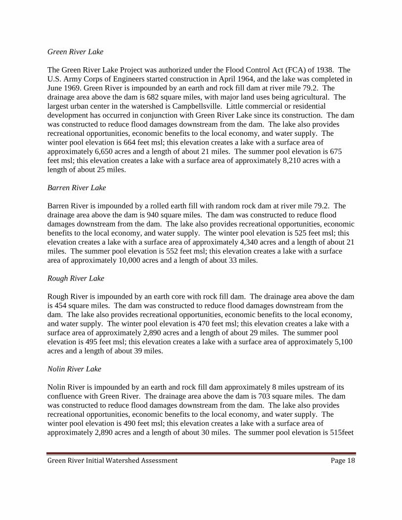
Green River Lake The Green River Lake Project was authorized under the Flood Control Act (FCA) of 1938. The U.S. Army Corps of Engineers started construction in April 1964, and the lake was completed in June 1969. Green River is impounded by an earth and rock fill dam at river mile 79.2. The drainage area above the dam is 682 square miles, with major land uses being agricultural. The largest urban center in the watershed is Campbellsville. Little commercial or residential development has occurred in conjunction with Green River Lake since its construction. The dam was constructed to reduce flood damages downstream from the dam. The lake also provides recreational opportunities, economic benefits to the local economy, and water supply. The winter pool elevation is 664 feet msl; this elevation creates a lake with a surface area of approximately 6,650 acres and a length of about 21 miles. The summer pool elevation is 675 feet msl; this elevation creates a lake with a surface area of approximately 8,210 acres with a length of about 25 miles. Barren River Lake Barren River is impounded by a rolled earth fill with random rock dam at river mile 79.2. The drainage area above the dam is 940 square miles. The dam was constructed to reduce flood damages downstream from the dam. The lake also provides recreational opportunities, economic benefits to the local economy, and water supply. The winter pool elevation is 525 feet msl; this elevation creates a lake with a surface area of approximately 4,340 acres and a length of about 21 miles. The summer pool elevation is 552 feet msl; this elevation creates a lake with a surface area of approximately 10,000 acres and a length of about 33 miles. Rough River Lake Rough River is impounded by an earth core with rock fill dam. The drainage area above the dam is 454 square miles. The dam was constructed to reduce flood damages downstream from the dam. The lake also provides recreational opportunities, economic benefits to the local economy, and water supply. The winter pool elevation is 470 feet msl; this elevation creates a lake with a surface area of approximately 2,890 acres and a length of about 29 miles. The summer pool elevation is 495 feet msl; this elevation creates a lake with a surface area of approximately 5,100 acres and a length of about 39 miles. Nolin River Lake Nolin River is impounded by an earth and rock fill dam approximately 8 miles upstream of its confluence with Green River. The drainage area above the dam is 703 square miles. The dam was constructed to reduce flood damages downstream from the dam. The lake also provides recreational opportunities, economic benefits to the local economy, and water supply. The winter pool elevation is 490 feet msl; this elevation creates a lake with a surface area of approximately 2,890 acres and a length of about 30 miles. The summer pool elevation is 515feet

Green River Initial Watershed Assessment Page 19
msl; this elevation creates a lake and a surface area of approximately 2,890 acres with a length of about 39 miles.
5.2.2 Ecosystem Restoration, Clearing and Snagging and Streambank Erosion Projects Cypress Creek Channel Clearing and Cleaning (Sec. 208) Under the authority of Section 208 of the FCA of 1954, the Corps may study and construct in-stream clearing and snagging projects to reduce damages caused by overbank flooding. The Cypress Creek project consisted of clearing an average 120-minimum width from the mouth of Cypress Creek at Pond River to Mile 18.4. The project was completed in November 1963. Panther Creek Channel Clearing and Cleaning (Sec. 205) Under the authority of Section 205 of the FCA of 1948, the Corps may study and construct works (structural and non-structural) to reduce damages caused by overbank flooding. The Panther Creek project consisted of clearing, snagging, and cleaning the channel and a berm on each side averaging 20 feet in width from the mouth at Green River upstream to the confluence of the two forks at Mile 22.6, upstream 13 miles on the North Fork and upstream 10 miles on the South Fork. The projects were completed in 1968. Green River-Calhoun-Streambank Erosion (Sec. 14) Section 14 of the FCA of 1946 provides authority to stabilize riverbank erosion where that erosion is threatening public facilities. Two separate Section 14 projects have been completed in this area. Both projects are located on the right bank of the Green River at Calhoun, just upstream of Green River Lock and Dam 2. The first involved the placement of riprap on the bank to protect a sewer line running parallel to the bank. The second project was upstream of the first, and consisted of the placement of riprap on the bank to protect the City of Calhoun’s municipal water intake. The projects were completed in 1994. Green River Handy Riparian Restoration Project (Sec. 1135) Section 1135 (b) of WRDA 1986, provides USACE the authority to plan, design and build modifications to existing USACE projects, or areas degraded by USACE projects, as well as to restore aquatic habitats for fish and wildlife. Green River Lake eliminated out-of-bank flooding in the project area. Prior to impoundment, the project area experienced out-of-bank flooding with each 5-year storm event. Today, out-of-bank flooding occurs only with an approximate 100-year event. In the thirty plus years of Green River Lake’s existence, there has been no flooding of the bottomlands. This severely restricts natural recruitment and reforestation, as floods are the primary method of seed dispersal for many bottomland hardwood trees. Without this regeneration the riverbanks have lost natural protection against wind and wave action, runoff and other factors contributing to erosion. In order to restore this natural process, approximately

Green River Initial Watershed Assessment Page 20
800 linear feet of riverbank was stabilized using a combination of plantings, rock protection, and two bendway weirs. These weirs were specifically designed for this location to intercept flow from Russell Creek and redirect it toward the middle of Green River. The project was completed in 2003. Green River Lake Reoperation (2000 MOU between TNC and USACE) Green River Lake Reoperation became the first Corps project to receive approval for permanent operation for ecological benefits downstream of a Corps reservoir as part of the Sustainable Rivers Project (SRP), a joint effort of USACE and TNC. The SRP is being carried out under a Memorandum of Understanding (MOU) between USACE and the Conservancy signed in 2000, and was sparked by an initial collaboration to restore native biodiversity of the Green River in Kentucky by changing the water release schedule from Green River Dam. In 2002 USACE began a three year trial period of the reoperation of the Green River Lake Dam to mimic natural events in the basin. In 2005 the reoperation was made permanent. Kentucky Green River Conservation Reserve Enhancement Program The Conservation Reserve Enhancement Program (CREP) was initiated by the United States Department of Agriculture (USDA) to address issues related to erosion and soil losses on cropland, as well as the destruction of wildlife habitat due to the conversion of fallow land to production. In exchange for retiring highly erodible or environmentally sensitive cropland from production, CREP offered farm owners, operators or tenants annual rentals plus payments for establishing a permanent conservation land cover, such as grasses or trees. The Kentucky CREP involves the restoration of riparian habitat and other vital natural habitats to protect Mammoth Cave National Park and the Green River. In 2001, the Commonwealth of Kentucky and USDA entered into an agreement to target the restoration of up to 100,000 acres of environmentally sensitive land in the Green River Watershed. Producers can enroll land in any part of the watershed below the Green River Lake Dam into CREP. Eligible acreage also includes areas adjacent to streams and rivers, surrounding sinkholes and other lands that meet CREP eligibility requirements. Green River Corridor Protection Prioritization Project The Green River Corridor Protection Prioritization Project is a collaborative effort to better understand the stretch of the Green River that falls between Green River Lake dam to the east and Mammoth Cave National Park to the west. Prior to this study little information was available to conservation professionals that would show the location of prime areas of river habitat for these priority species with regard to potential threats and potential opportunities. Representatives from The Nature Conservancy, Kentucky State University, Kentucky Fish & Wildlife, Kentucky State Nature Preserves Commission and Western Kentucky University cooperated to create a dynamic GIS map that would highlight certain aspects of this stretch of the Green River:

Green River Initial Watershed Assessment Page 21
• The Active River Area of the Green River and its tributaries within the project area. This area was calculated at an impressive 153,405 acres.
• The location of 31 priority species within the river was documented and mapped at 197 sites along the river.
• Areas already in a protected conservation status along the river were identified. • Potential threats to priority species were identified and incorporated into the map. These
threats included proposed new developments, existing roadways and infrastructure, areas of documented high-bank erosion, and areas along the river where the riparian zone was thinly vegetated.
5.2.3 Local Flood Protection Projects
Barnett Creek Channel Improvement The project was authorized by the FCA of 1944. Work consisted of about nine miles of clearing, snagging and straightening of the creek channel. The project was accepted by the local authorities for operation and maintenance in July 1961. Rough River Channel Improvement The project was authorized by the FCA of 1944. Work consisted of about nine miles of clearing the channel and the banks of the lower 64 miles of the river. The project was turned over to local authorities for operation and maintenance in July 1961.
5.2.4 Navigation Projects
The navigation system consists of structures located on Green, Barren and Rough Rivers. Locks and Dams 1 to 4 on the Green River and the Lock and Dam on the Barren River were built by the Commonwealth of Kentucky prior to 1886 and purchased by the U. S. Government under authorization of the Rivers and Harbor Act of 11 August 1888. Facilities were added at Green River Lock and Dam 5 and Lock and Dam 6 and on the Rough River upstream to Hartford, Kentucky. The system was modified and improved by the United States Government to provide slack water navigation from the mouth to Bowling Green at mile 30 on Barren River, mile 8 on Nolin River and Bear Creek, and to Hartford at mile 29 on Rough River. The improvements consisted of six locks and dams on Green River, one lock and dam on Barren River, and one lock and dam on Rough River. The locks and dams on the Green and Barren Rivers are considered eligible for the National Register of Historic Places, which is authorized by the National Historic Preservation Act. The required level of recordation needed on these navigational facilities remains to be coordinated with the Kentucky State Historic Preservation Officer. Prior to any federal disposal of these

Green River Initial Watershed Assessment Page 22
properties, and or removal of structures, appropriate documentation for each site including history and photographs of each lock, dam and associated structures may need to be provided for review to the Kentucky Heritage Council. To date, USACE has completed a preliminary historical overview of the Green and Barren rivers navigational system and prepared archival quality photo documentation of all extant structures. A report containing this information was completed in July 2000. USACE expects that these facilities will be determined eligible for inclusion in the National Register of Historic Places and will require additional research and documentation. The Green River Lock and Dam 1 is located near Henderson, Kentucky, at mile 9.1. The Navigation locks are located on the right descending bank of the Green River. The upper extends upstream for a distance of 54 miles to Green River Lock and Dam 2. These are the only two Lock and Dam structures on the Green River that remain operational. Green River Lock and Dam 2 is located near Calhoun, Kentucky, at mile 63.1. The pool extends upstream for a distance of 45.4 miles to Lock and Dam 3, which is now inactive, near Rochester, Kentucky. The facilities at Green River Lock and Dam 3 through 6, and Barren River Lock and Dam 1 in west central Kentucky have been decommissioned and are no longer used for commercial navigation. Decline in commercial navigation and continued deterioration at the facilities led to the decommissioning, which was reinforced with the failure of Green River Dam 4 and loss of the navigation pool in 1965. All navigation upstream of Green River Lock and Dam 3 was discontinued with its closure in 1981. USACE completed a study in 1993 that analyzed the feasibility of facility improvements along the Green and Barren Rivers. The study concluded that there were insufficient economic benefits from commercial navigation to support any improvements. The USACE is considering disposal of Federal interests in the facilities at Green River Lock and Dam 3 through 6, and Barren River Lock and Dam 1
6. EXISTING CONDITIONS
6.1 Aquatic Fauna The fishes of the Green River are among the most diverse in Kentucky and are nationally important in terms of fish zoogeography, i.e., distribution, and need for conservation (Cicerello and Hannan, 1991). Kentucky waters support 226 native species or about one fourth of all North American freshwater fish fauna. Two-thirds (151 species) are known from the Green River and its tributaries.

Green River Initial Watershed Assessment Page 23
Prior to the last ice age, the Green River was a smaller, more isolated, headwater tributary of the ancestral Ohio River. In part because of this isolation, the main-stem of the Green River supports the most unusual fish fauna in the lower Ohio-upper Mississippi watershed, including five endemics (on the main stem of the Green River), one species exclusively shared with the Kentucky River, three species of cave fishes, and an admixture of Coastal Plain and upland fauna. The Green River also served as an important refuge for northern species displaced by Pleistocene glaciers that did not extend south into Kentucky, thus allowing these species to later invade streams created during the retreat of the glaciers. Construction of the locks and dams on the Green and Barren Rivers changed aquatic habitats from those associated with cool free-flowing rivers to slower-flowing warm water communities. Riffle and shoal areas with sand and gravel substrates were eliminated and replaced with permanently inundated pools with finer sediments and silt bottoms. Subsequently, the species composition within the reaches of the Green and Barren Rivers affected by the pools were altered as well. Although many of the same species are still found in the study area, especially in the Green River system above River Mile 199 and above Bowling Green. Both of these areas are outside the influence of the navigation pools. Construction of the locks and dams also altered species composition within the pools to that of a slower, warmer water system. Some native species increased in numbers while many more declined, as they were not as well adapted to the change in habitat. This changed habitat also resulted in an increase in rough fishes, some of which represent commercially important species within the Green and Barren rivers.
The Green River Watershed is home to over 150 different fish species. Some of the popular sport fishes found in the watershed include: largemouth bass (Micropterus salmoides), smallmouth bass (M. dolomieu), white crappie (Pomoxis annularis), black crappie (P. nigromaculatus), channel catfish (Ictalurus punctatus), longear (Lepomis megalotis), redear (L. microlophus), and green sunfish (L. cyanellus), walleye (Sander vitreus), sauger (S. canadensis), rock bass (Ambloplites rupestris), , white bass (Morone chrysops), and striped bass (M. saxatilis). Another game species found naturally occurring in the Green and Barren rivers is the muskellunge (Esox masquinongy) (Clay 1975).
The Green River and its tributaries are recognized as supporting one of the most diverse mussel faunas in North America (Stansbery 1965, Isom 1974). Seventy-one of the 104 species found in Kentucky are known from the Green River Watershed. More than one-third of the species inhabiting the Green and Barren Rivers are considered rare, threatened or endangered at the state or Federal level, mostly due to changes in aquatic habitat caused by human alteration of land and water features (Cicerello and Hannan 1990). Fifty-seven of these 71 species of mussels are found within the Green River from Mumfordville, Kentucky (Green River Mile 225), to the upper reaches of Pool 6 in Mammoth Cave National Park. The most significant factor in the absence of the 14 missing species is the reduction in mussel habitat associated with construction of the locks and dams on the Green and Barren Rivers.

Green River Initial Watershed Assessment Page 24
6.2 Terrestrial Fauna
A variety of large and small mammals occurs within the study area. Typically, species composition is that which is associated with eastern hardwood forests, slope forests, and wet bottomland hardwoods. Mammalian fauna within the study area include, but are not limited to, white-tailed deer (Odocoileus virginianus), red fox (Vulpes vulpes), gray fox (Urocyon cinereoargenteus), raccoon (Procyon lotor), Virginia opossum (Didelphis virginiana), woodchuck (Marmota monax), beaver (Castor Canadensis), eastern cottontail rabbit (Sylvilagus floridanus), spotted skunk (Spilogale putorius), Deer Mouse(Peromyscus maniculatus), eastern chipmunk (Tamias striatus), gray squirrel (Sciurus carolinensis), and fox squirrel (S.niger). Over 200 bird species occur within the study area (Widlak, 1999). Wintering populations of the bald eagle (Haliaeetus leucocephalus), as well as nesting pairs may be found in the study area. Nesting by bald eagles has been confirmed in areas to the west of the study area and may spread to the Green River and Barren River drainages as this species continues to expand its range (Widlak, 1999). Game species include bobwhite quail (Colinus virginianus), mourning dove (Zenaida macroura), American woodcock (Scolopax minor), eastern wild turkey (Meleagris gallopavo), and waterfowl. Reptiles and amphibians found within the study area include, but are not limited to, the eastern hellbender (Cryptobranchus alleganiensis), spotted salamander (Ambystoma maculatum), green frog (Rana clamitans), snapping turtle (Chelydra serpentina), eastern box turtle (Terrapene carolina), red-ear turtle (Trachemys scripta), ringneck snake (Diadophis punctatus), eastern hognose snake (Heterodon platirhinos) and northern water snake (Nerodia sipedon). Karst features within the study area provide habitat for cave-dwelling species such as bats, including the gray bat and the Indiana bat, which are federally endangered species.
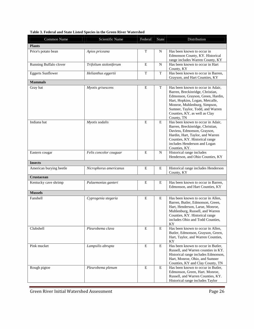
6.3 Threatened and Endangered Species Threatened and endangered species are found within the Green and Barren rivers, as well as in terrestrial habitat adjacent to the rivers (Table 3). The federally endangered Kentucky cave shrimp (Palaemonias ganteri) is endemic to the Mammoth Cave system. Populations of this endangered species have been impacted by the impoundment of Green River behind Dam 6. The pool has changed the base level for the cave system. The operation of Green River Lake has changed both the periodicity and magnitude of seasonal flood events from that which would be expected under natural conditions. These changes have affected sedimentation and food supply, among other parameters, within the subterranean environment. The United States Fish and Wildlife Service (USFWS) has designated portions of the Roaring River passage of the Flint-Mammoth Cave system in the Edmonson County portion of Mammoth Cave National Park as critical habitat for the Kentucky cave shrimp.
Caves in the watershed also provide habitat for the federally endangered gray bat (Myotis grisescens) and Indiana (M. sodalis) bat, which use the caves primarily as hibernacula. One cave

Green River Initial Watershed Assessment Page 25
within the study area is known to support a gray bat maternity colony (Widlak, 1999). In addition, suitable habitat for Indiana bat maternity colonies exists within the study area.
The Federally endangered American peregrine falcon (Falco peregrinus anatum) also occurs as a migrant or transient in the study area. Endangered freshwater mussels within the study area include the rough pigtoe (Pleurobema plenum), orange-footed pearly mussel (Plethobasus cooperianus), northern riffleshell (Epioblasma torulosa rangiana), pink mucket pearly mussel (Lampsilis abrupta ) and the fanshell (Cyprogenia stegaria). Fresh-dead specimens of the ring pink (Obovaria retusa) indicate that these species persist in the Green River (Widlak, 1999). Other listed mussel species that may still occur in the study area are the fat pocketbook (Potamilus capax), white warty back (P. cicatricosus), tuberculed-blossom pearly mussel (Epioblasma torulosa torulosa), cracking pearly mussel (Hemistena lata), scaleshell (Leptodea leptodon), and purple catspaw pearly mussel (E.obliquata perobliqua). None of the federally listed threatened or endangered mussel species were found in the pool behind Dam 6 during a three year survey of mussels in Mammoth Cave National Park (Cicerello and Hannan, 1990). These species have been reported from the free flowing section of the river upstream of the influence of Dam 6 or in the free flowing sections of the Green and Barren rivers downstream of Dam 5 which was created by the failure of Dam 4. Federally threatened plants that may be found in the study area include Price’s potato bean (Apios priceana), running buffalo clover (Trifolium stoloniferum), and Eggert’s sunflower (Helianthus eggertii). Other uncommon species that are potential Federal candidates for listing as threatened or endangered may be found in or around the Green and Barren Rivers. These include the southeastern bat (Myotis austroriparius), Rafinesque’s big-eared bat (Corynorhinus rafinesquii), eastern small-footed bat (Myotis leibii), eastern woodrat (Neotoma floridana), Bachman’s sparrow (Peucaea aestivalis), eastern sand darter (Ammocrypta pellucid), northern cave fish (Amblyopsis spelaea), southern cave fish (Typhlichthys subterraneus), longhead darter (Percina macrocephala), blue sucker (Cycleptus elongates), hellbender (Cryptobranchus alleganiensis), Kirtland’s water snake (Clonophis kirtlandii), copperbelly water snake (Nerodia erythrogaster neglecta), spectacle case pearly mussel (Cumberlandia monodonta), Kentucky creekshell mussel (Villosa ortmanni), rabbits foot pearly mussel (Quadrula cylindrica cylindrica), purple liliput pearly mussel (Toxolasma lividus), pale false foxglove (Agalinis skinneriana), royal catchfly (Silene regia), and Gattinger’s lobelia (Lobelia appendiculata var. Gattingeri). Any of these species could be listed in the future if their numbers decline and threats to their survival continue.
Green River Initial Watershed Assessment Page 26
Table 3. Federal and State Listed Species in the Green River Watershed
Common Name Scientific Name Federal State Distribution
Plants Price's potato bean Apios priceana T N Has been known to occur in
Edmonson County, KY. Historical range includes Warren County, KY
Running Buffalo clover Trifolium stoloniferum E N Has been known to occur in Hart County, KY
Eggerts Sunflower Helianthus eggertii T T Has been known to occur in Barren, Grayson, and Hart Counties, KY
Mammals Gray bat Myotis grisescens E T Has been known to occur in Adair,
Barren, Breckinridge, Christian, Edmonson, Grayson, Green, Hardin, Hart, Hopkins, Logan, Metcalfe, Monroe, Muhlenburg, Simpson, Sumner, Taylor, Todd, and Warren Counties, KY, as well as Clay County, TN
Indiana bat Myotis sodalis E E Has been known to occur in Adair, Barren, Breckinridge, Christian, Daviess, Edmonson, Grayson, Hardin, Hart, Taylor, and Warren Counties, KY. Historical range includes Henderson and Logan Counties, KY.
Eastern cougar Felis concolor couguar E N Historical range includes Henderson, and Ohio Counties, KY
Insects American burying beetle Nicrophorus americanus E E Historical range includes Henderson
County, KY Crustacean Kentucky cave shrimp Palaemonias ganteri E E Has been known to occur in Barren,
Edmonson, and Hart Counties, KY Mussels Fanshell Cyprogenia stegaria E E Has been known to occur in Allen,
Barren, Butler, Edmonson, Green, Hart, Henderson, Larue, Monroe, Muhlenburg, Russell, and Warren Counties, KY. Historical range includes Ohio and Todd Counties, KY
Clubshell Pleurobema clava E E Has been known to occur in Allen, Butler, Edmonson, Grayson, Green, Hart, Taylor, and Warren Counties, KY
Pink mucket Lampsilis abrupta E E Has been known to occur in Butler, Russell, and Warren counties in KY. Historical range includes Edmonson, Hart, Monroe, Ohio, and Sumner Counties, KY and Clay County, TN
Rough pigtoe Pleurobema plenum E E Has been known to occur in Butler, Edmonson, Green, Hart. Monroe, Russell, and Warren Counties, KY. Historical range includes Taylor

Green River Initial Watershed Assessment Page 27
Common Name Scientific Name Federal State Distribution
County, KY.
Fat pocketbook Potamilus capax E E Has been known to occur in Henderson County, KY. Historic range: Butler, Edmonson, Green, Hart,Taylor, and Warren Counties, KY
Ring pink Obovaria retusa E E Has been known to occur in Butler, Hart, Henderson, and Warren counties in KY. Historical range includes Edmonson, Monroe, Russell, and Todd Counties, KY.
Orangefoot pimpleback Plethobasus cooperianus E E Has been known to occur Butler, Hancock, Monroe, and Warren Counties, KY. Historical range includes Grayson, Ohio, and Russell Counties, KY, as well as Clay County, TN
Purple cat's paw Epioblasma obliquata obliquata E E Has been known to occur in Butler, Hart, Henderson, Muhlenburg, and Warren Counties, KY. Historical range includes Ohio County, KY
Tuberculed-blossom pearly mussel Epioblasma torulosa torulosa E E Historical range includes Edmonson, Green, Hart, Henderson, Taylor, and Warren Counties, KY
Cracking pearly mussel Hemistena lata E E Historical range includes Edmonson, Hart, Monroe, and Russell Counties, KY
Northern riffleshell Epioblasma torulosa rangiana E E Has been known to occur in Edmonson, Grayson, Hart, and Warren Counties, KY. Historical range includes Green and Taylor Counties, KY
Scaleshell Leptodea leptodon E N Historical range includes Hart and Russell Counties, KY
White wartyback Plethobasus cicatricosus E E Historical range includes Henderson County, KY
E-Endangered, T-Threatened, SC- Special Concern, N-None
6.4 Physiography and Geology
Physiography of the Green River Watershed - The Green River flows from east to west through three distinct physiographic provinces of Kentucky: the Mississippian Plateau (also refered to as the Pennyroyal) Province, the Dripping Springs Escarpment, and the Western Coal Field (Figure 6). From its headwaters in Lincoln County to the Munfordville area in Hart County, the Green River flows through the Mississippian Plateau Physiographic Province (Pennyroyal). The plateau is an upland region underlain by Mississippian rocks (mostly limestones) and typified by karst topography and residual soils of varying thicknesses from the weathering of the carbonate rocks.

Green River Initial Watershed Assessment Page 28
From the Munfordville area to the Mammoth Cave area in Edmunson County, the Green River flows through the Dripping Springs Escarpment. Situated between the Western Coal Field and the Mississippian Plateau, this escarpment area is characterized by a system of westward dipping cuestas. Collapsed topography, sinking streams, and extensive cave networks are common to the area. West of the Dripping Springs Escarpment, the Green River flows through the Western Coal Field to its confluence with the Ohio River in Henderson County. This area is characterized as a hilly upland of low to moderately high relief dissected by streams occupying wide, poorly drained and often swampy valleys (McGrain, 1983). Geology of the Green River Watershed - A generalized geologic map of Kentucky is presented as Figure 7. As the physiographic landforms present today owe their existence to the underlying bedrock geology, the following descriptions have been prepared respective of their location within the physiographic provinces of the Green River Valley.
Figure 6. Kentucky Physiographic Provinces

Green River Initial Watershed Assessment Page 29
The Mississippian (or Pennyroyal) Plateau of south–central and western Kentucky is an upland area underlain by Mississippian age limestone, siltstones, and shale. Structurally, the eastern portion of the basin lies on the western flank of the Cincinnati Arch where the bedrock surface dips to the northwest at approximately 54 feet per mile. A physiographic map and generalized geologic cross section is presented below in Figure 8 (McGrain, 1983). The eastern portion of the Mississippian Plateau province is underlain by limestones, shales and siltstones of the Mississippian Age Salem, Warsaw and Fort Payne Formations. The Fort Payne Formation is the lowest stratigraphic unit of this group and is composed of gray to black
Figure 7. Generalized Geologic Map of the Study Area

Green River Initial Watershed Assessment Page 30
dolomitic siltstone and cherty, dolomitic limestone. Warsaw and Salem Formations are hard to differentiate and are often considered as a single unit. They are composed of a mixture of argillaceous, crossbedded skeletal limestone and dark dolomitic siltstone and shale. The western portion of the province and the Dripping Springs Escarpment are underlain by the upper Mississippian Age limestone of the St Louis and St Genevieve Formations and are characterized by sinkholes, caves, and subsurface channels into which streams disappear. Figure 9 presents a generalized distribution of karst (topography formed over limestone characterized by sinkholes and caves) features in the watershed.
Figure 8. Physiographic Map with Generalized Geologic Cross Section

Green River Initial Watershed Assessment Page 31
The St. Louis limestone is a very fine grained, somewhat cherty argillaceous and dolomitic limestone with some beds of skeletal limestone formed on a shallow marine shelf. Separating the St. Louis and St. Genevieve is a zone of calcarenite cemented chert breccia. The overlying St. Genevieve is a light gray, crossbedded and massive oolitic to skeletal limestone with intermediate calcareous sandstone and shale beds formed as sandbars and shoals on a shallow marine shelf (McDowell et al, 1984). Bedrock of the Western Coal field is nearly entirely strata of Pennsylvanian Age. Structurally, the Western Coal Field lies in an east west trending synclinal structure (Moorman Syncline) and is cut by the Rough Creek and Pennyrile fault systems. These fault zones are made up of numerous high angle normal faults and less common reverse faults bounding a series of grabens and horsts. Bedrock stratigraphy of the Western Coal field consists of alternating sequences of
Figure 9. Map of Karst Topography in the Study Area

Green River Initial Watershed Assessment Page 32
shale, sandstone, limestone, and coal. Deposition of these sediments occurred mainly in stream channel and deltaic complexes resulting in most of the lithologic units being laterally discontinuous and not traceable for more than several miles (McDowell et al, 1984).
6.5 Wetlands
While only a portion of wetlands exist from what was estimated to have occurred historically in the Commonwealth of Kentucky (1.5 million acres), loss of wetland acreage has slowed with federal and state regulations and disincentives in place for altering wetlands (The Kentucky Environmental Commission, 1995). By river watershed, the Green River has the largest proportion of remaining wetland acres in Kentucky U.S. Department of the Interior, National Wetlands Inventory (NWI) maps, were reviewed to determine the presence of wetlands within the Green River Watershed. The NWI maps showed approximately 54,000 acres of wetlands in the watershed. This represents approximately one percent of the total land area in the watershed. Wetland systems include palustrine (swamp-like), lacustrine (lake-like) and riverine (associated with surface water) with water regimes ranging from temporarily flooded to permanently flooded. Wetlands adjacent to the major tributaries in the watershed include small forested, scrub-shrub, or emergent wetlands in the floodplains, to riverine systems associated with the larger tributaries. The larger more definable wetland systems are located in the western portion of the watershed which contains the broader floodplains. The Pond Creek Watershed, located in the western portion of the Green River Watershed, contains the largest percentage of wetlands (Table 4)
Table 4. Wetland Acres by HUC8
HUC8 Name Acres %
HUC8 Barren River 1,019 0.07% Lower Green 11,322 1.92% Middle Green 14,653 2.23% Upper Green 2,307 0.11% Pond Creek 19,717 3.86% Rough River 4,892 0.71% TOTAL 53,911
U.S. Department of Agriculture, Natural Resources Conservation Service (NRCS) soil survey information was reviewed for the watershed. There is variation in soils across the entire watershed. Similar to the NWI maps, the highest concentration of hydric soils is located in the western portion of the watershed. In this location the floodplain expands as the Green River

Green River Initial Watershed Assessment Page 33
approaches the confluence with the Ohio (Figure 10). The two predominant hydric soils mapped by the NRCS were the melvin and karnak series, and both are listed in Hydric Soils of the United States, U.S. Department of Agriculture, Revised October 1990.
6.6 Water Quality Typically, three kinds of water quality problems affect surface and groundwater supplies in the basin: 1) municipal and industrial point sources; 2) mine drainage; and 3) runoff from the land (non-point sources). Significant progress has been made in the basin in addressing municipal and industrial water quality problems. The majority of municipal wastewater treatment facilities in the basin provide secondary treatment or better. A majority of the significant industrial dischargers are in
Figure 10. Hydric Soils in the Green River Watershed

Green River Initial Watershed Assessment Page 34
compliance with National Pollution Discharge Elimination System (NPDES) permit limitations. Responsibility for compliance with NPDES permit limitations for both municipal and industrial dischargers and water quality standards rests with the individual states. Serious acid and sediment mine drainage problems occur largely in the western portion of the basin (Figure 11). While the newly-mined areas are being regulated by the Surface Mine Control and Reclamation Act of 1977, runoff and erosion from orphan-mined lands are producing serious acid and sediment mine drainage problems. Efforts to correct these problems in specific areas in the basin, and to inventory all abandoned mined lands, are underway through the Kentucky Division of Abandoned Mine Lands (AML). AML programs are federally funded and implemented by the state. The federal government collects fees on each ton of coal produced by mining operations nationwide and then distributes those fees back to the state AML programs in the form of a grant. AML administers several programs to stabilize environmental conditions at abandoned mine sites including a bond forfeiture reclamation program, acid mine drainage program, and water supply replacement program (KDEP, 2001). There are also a several limestone quarries distributed across the watershed which pose a threat through altered water pH, flow patterns, and through contamination of surface drainage. A proposed limestone quarry located in Hart County was identified by the USDA (2006) as a possible threat to the expansion of the Green River CREP.

Green River Initial Watershed Assessment Page 35
There are four basic sources of non-point source pollution in the basin: mining runoff from both active and abandoned mines, runoff from agricultural and forested lands, runoff from urban areas, and stream bank erosion. Control of a portion of this runoff can be maintained by the application of best management practices for agriculture and silviculture operations. Excess surface and subsurface water and poor surface drainage in the karst areas contribute to non-point pollution of groundwater from farms and feedlots and disposal of untreated or poorly treated wastewater in sinkholes. In the Lower portion of the watershed CAFOs that raise poultry and hogs produce large quantities of waste that is either spread or broadcast onto fields, stored where runoff can pollute streams and water supplies, or can be inundated by floodwaters. Cattle AFOs are predominant in the upper portion of the watershed have significant impacts on the Green River streams and physical damage to stream banks where cattle are unfenced (KDEP, 2001).
Figure 11. Map of Mining Activity in the Green River Watershed

Green River Initial Watershed Assessment Page 36
Overall, water quality is good in the Green River Basin. However, according to the 2010 303(d) List of Waters for Kentucky, approximately 330 stream miles have been identified on the 303(d) list of impaired streams for pH, dissolved solids, and excessive fecal coliform. Streams and rivers are evaluated for their support of four important uses of these waterways; aquatic life, swimming, drinking water, and fish consumption. In accordance with the Clean Water Act, Section 303(d), Kentucky has developed use support data for each stream monitored. These data are presented in the Kentucky Division of Water report called the List of Waters. The purpose of this report is not only to list and prioritize impacted waters, but also to describe possible sources of impairment and efforts that have been implemented to address problems in the water listed in previous 303(d) reports. Figure 12 illustrates streams listed as impaired in 2010 state water quality report.
Figure 12. Map of 303(d) Impaired Streams listen 2010 Kentucky State Water Quality Report

Green River Initial Watershed Assessment Page 37
6.7 Climate
The Green River Watershed has a temperate climate with relatively cold winters and hot, humid summers. The mean annual temperature for the Bowling Green area is 57.1 degrees F, with extremes ranging from about 25 degrees below zero to slightly greater than 100 degrees. Average monthly temperatures range from about 78.5 degrees F in July to about 34.2 degrees F in January (Figure 13).
Figure 13. Map of Average Annual Temperatures in the Green River Watershed

Green River Initial Watershed Assessment Page 38
6.8 Precipitation
Precipitation in the Green River Watershed is fairly well distributed throughout the year. For Bowling Green, the annual precipitation averages about 51.6 inches with a monthly average ranging from 3.17 inches in October to 5.36 inches in May (Figure 14).
Figure 14. Map of Average Annual Precipitation in the Green River Watershed

Green River Initial Watershed Assessment Page 39
6.9 Water Supply and Low Water Flows Water supply is a key issue important to water resources planning in the Green River Watershed and has been so for a number of years. Surface waters provide most of the watershed's municipal, industrial and domestic supplies, while groundwater serves most of the rural population. Groundwater quality is generally good except in the karst and coal mining areas in the western portion of the watershed (KDEP, 2001).
The location, availability, and quality of the groundwater within the project study area vary depending upon local geologic and hydrologic factors (Figure 15). Groundwater can be divided into two regions within the project study area. Those two regions coincide with two distinct geologic regions of south central Kentucky, the Western Coal Field and the Mississippian Plateau. The Western Coal Field, which includes the counties of Ohio, Butler, and Muhlenberg,
Figure 15. Map of Aquifers in the Green River Watershed

Green River Initial Watershed Assessment Page 40
is an area of rolling uplands and alluvial terraces of low relief. The Mississippian Plateau, which contains Edmonson and Warren counties, is a limestone area with considerable subsurface drainage. Most groundwater found in the Western Coal Field in shallow aquifers is characterized by the presence of sodium or calcium bicarbonate, while that found in deeper aquifers in more highly mineralized with sodium chloride. Most groundwater is this region is soft to moderately hard, but may contain objectionable quantities of iron. Groundwater of the Mississippian Plateau is generally of the calcium bicarbonate type and ranges from moderately to very hard depending upon its source. Sodium chloride and hydrogen sulfide present the major problems in waters of this region. Nitrate may also be a problem in significant amounts in some shallow groundwater. While adequate water supply sources exist in the watershed to meet existing and projected needs, there are a number of communities and rural areas experiencing water supply problems. These problems are primarily the result of inadequate storage and distribution facilities and inferior quality. These management problems are in part being met by the development of central water systems that have the capacity to meet regional needs. Specifically, recent droughts, occurring in 1999 and 2007, created water shortages in parts of the Green River Watershed. A number of water supply systems were in crisis response due to a severe shortage of water. A review of reservoir operations at the four multipurpose lake projects during various times of the year to address competing water resources need was identified through the Green River Watershed Interview.
6.10 Historic Storms and Floods
The flood of January 1937 was the greatest of record in the major part of the Green River Watershed and was particularly severe in the lower 150 miles, where it was aggravated by backwater from the Ohio River extending up the Green River for about 130 miles. Moderate to heavy rains during the latter part of December 1936 produced saturated conditions with a general rise in streams throughout the watershed. Before the rise subsided, the unprecedented rains in January began. During the period from 27 December through 31 January, the average rainfall over the Green River Watershed exceeded 20 inches with a maximum of 24.6 inches recorded within the watershed. The second highest flood in general in the Green River Watershed occurred in January 1913. Rainfall during the month of January ranged from 10 inches to more than 16 inches for this watershed with 6 to 12 inches falling in the first 13 days. At many sites, the 1913 flood crested higher than the 1937 flood, particularly in the upper and middle reaches of the watershed.
Green River Initial Watershed Assessment Page 41
For the flood of March 1964, two distinct rainfall periods in early March, both producing high intensity rainfalls, contributed to extensive flooding along Green River. Rains of March 3-5 averaged 5.5 inches through the middle third of the Green River Watershed and 4 inches in the lower third. A second storm of March 8-10 averaged about 7 inches over the lower third of the Green River Watershed and about 4.5 inches over the upper two thirds. A maximum of over 4.7 inches was recorded during one 24 hour period within the watershed. However, due to the impoundments of Nolin lake and Barren River lake, the flooding effects for this event were not as great as they would have been if the lakes were not in place. More recent flood events have occurred in March 1997, May 2010, and April 2011. The March 1997 event was mainly a lower Green River Watershed flood with heavy rainfall occurring at the beginning of March. At Green River Lock and Dam 2 at Calhoun, the peak discharge was the fourth highest on record at that time with a flow value of 86,000 cubic feet per second (cfs). The May 2010 flood was more of a watershed wide event with rainfall occurring throughout the entire watershed. At Bowling Green, KY, over 11.8 inches of rain fell during the month of April with much of the watershed under flooding conditions for that month. The April 2011 flood was also more of a watershed wide event. At the four USACE lakes (Green River, Nolin, Barren River, and Rough River) rainfall totals of over 10.4, 14.3, 10.4, and 18.0 inches fell over these lakes respectively with flows entering the spillway of Rough River lake by over 3 feet while Nolin lake was within 0.3 feet of entering the spillway.
6.11 Highwater Marks Highwater marks are available for many of the streams and rivers for numerous historic floods that occurred within the Green River basin. These highwater marks are available in the USACE Louisville District's Hydrology & Hydraulic Design Section.
6.12 Hydrologic Conditions Both the regulated and unregulated streams within the Green River Watershed show a wide variety of seasonal variation, with the highest flows generally occurring from December through May, although it is possible for major floods to occur at any time of the year. For this Green River Watershed, major floods have occurred in March 1913, January 1937, January 1950, March 1962, March 1964, May 1984, March 1997, May 2010, and April 2011. The discharges for these streams are often negligible in the late summer and early fall with low flows generally expected during this period. As mentioned previously, for the Green River basin, a series of USACE lakes (Green River Lake, Barren River Lake, Nolin River Lake, and Rough River Lake) protect many communities and farmlands from devastating floods along many of the streams and rivers within this basin. Reduced flows downstream of these USACE lakes correspond to reduced flood damages for all highwater events that have occurred since construction and operation of these lakes. The

Green River Initial Watershed Assessment Page 42
average annual flood control benefits for these four lakes since their beginning of operation is over $11 million based upon 2008 computations. As for actual discharges, both for streams with natural flows as well as for those modified by Corps lakes, the Louisville District's Hydrology & Hydraulic Design Section may have records available. The Kentucky Division of Water should also have flow values available for many of the streams within this Green River basin.
6.13 Hydraulic Conditions
Historical records for both stream flow and highwater data have generally been available since the early 1900's. The hydraulic conditions of the Green River Watershed have been modified due to development within the basin and construction of USACE lakes. These hydraulic conditions do affect the stream flows and highwater data. While development within the basin tends to increase the flows along the various streams, the USACE lakes have the opposite effect in tending to reduce discharges during flooding events. All studies that have been performed to date or will be conducted in the future should take into account these changing conditions. No other methods of flood control such as levees and walls exist, for authorized USACE projects, that would change these hydraulic conditions. Very few hydraulic studies within the Green River basin have been performed by the Louisville District. Consequently, limited studies include Floodplain Information Studies (FPIS) and Flood Insurance Studies (FIS) which only utilize HEC-2 for development of the frequency profiles. In addition to these frequency profiles, historic profiles for many of the streams and rivers within the basin are also available. These profiles include the flood of record and may also include many other historic floods. The Hydrology & Hydraulic Design Section in the Louisville District has this information for analysis and information. It should be noted that other studies performed by other agencies or Architect-Engineer firms may be available. These can be located by checking with other State and Federal agencies such as Kentucky Division of Water and the Federal Emergency Management Agency.
6.14 Recreation
The Green River Watershed contains almost 185,000 acres of publically owned land. Mammoth Cave National Park represents the largest portion of this land, with over 50,000 acres above ground and nearly 390 miles of passageways below. The national park typically receives between 5,000 and 7,000 visitors a day during peak summer dates and more than 2 million visitors come to the park each year. Canoeing and fishing may be found anywhere in the Green River Watershed, but this activity occurs most frequently in the Mammoth Cave National Park. Three canoe liveries offer services within Mammoth Cave National Park. In addition, all four

Green River Initial Watershed Assessment Page 43
USACE Lake projects are popular with recreational boaters and provide camping, hiking, fishing, and picnicking opportunities (Figure 16).
6.15 Transportation
Roadways Interstate 65, William Natcher Parkway, Western Kentucky Parkway and Cumberland Parkway are the primary highways that traverse the Green River Watershed. Currently there are no plans by the Kentucky Department of Transportation (KDOT) to extend or expand the current interstate routes in the basin. A TNC study published in the Green River Bioreserve Strategic
Figure 16. Map of Primary Recreation Centers in the Green River Watershed

Green River Initial Watershed Assessment Page 44
Plan, (1998), pointed out contamination of both surface and groundwater in the watershed by hazardous materials is possible from traffic accidents. These materials can disperse relatively quickly through complex underground conduits underlying the watershed to contaminate underground streams and/or emerge from springs to contaminate surface streams far from the source. Because of traffic volume, and the variety and volume of materials transported, Interstate 65, other major highways, and railroads are potential sites of hazardous materials spills. Railways
The freight rail system in the Green River Watershed comprises one Class I railroads that parallels Interstate 65 and a Class II railroad adjacent to the Western Kentucky Parkway. Three of these railroads transect the basin, connecting major population centers with larger metropolitan areas of Louisville, Bowling Green and Paducah, Kentucky. The majority of trains passing through the basin carry freight Ferries There are four ferries operating in the navigation pools of the Green River (Table 5). The ferries’ approaches at all of these locations are also used for boat ramps by recreational boaters.
Table 5. Location of River Ferries in the Green River Watershed Location/River Mile Road Served Private or Public Operation Pool
Rochester River Mile 108.9
Highway 369 Private Green L&D 3
Reeds Ferry River Mile 123.2
Highway 269 Public (county) Green L&D 3
Houchins Ferry River Mile 185.1
Houchins Ferry Road Public (National Park Service) Green L&D 6
Green River Ferry River Mile 197.2
North Entrance Road/ Green River Ferry Road
Public (National Park Service) Green L&D 6
Navigation As mentioned in Section 5.2 4, there are only two Lock and Dam structures on the Green River that remain operational. Green River Lock and Dam 1 is located near Henderson at mile 9.1 and Lock and Dam 2 is located near Calhoun, Kentucky, at mile 63.1. By a large margin, coal is the primary commodity that moves through both locks followed by crude materials and farm products (Table 6). Recreation boaters account for almost one third of annual lockages on Green River Lock and Dam 1 and a negligible number on Green River Lock and Dam 2.

Green River Initial Watershed Assessment Page 45
Table 6. Commodity by Tonnage at Green River Lock and Dam 1 and 2 Coal Crude Materials Manufactured Goods Farm Products
Lock and Dam 1 8,260,000 340,000 124,100 30,000
Lock and Dam 2 5,632,000 6,000 600 31,500
Average Up-bound and Down-bound Tonnage 12/05/2005-12/05/2006
7. PROBLEMS AND OPPORTUNITIES
The subsequent section offers a preliminary outline of problems and opportunities present in the Green River Watershed study area. A “problem” is defined as a generally existing undesirable condition. An “opportunity” relates to a future action that can be undertaken to solve a problem or enhance a current condition. Identifying the problems and opportunities in the watershed ensures a common purpose among stakeholders and provides a focal point in the planning process. The outline was developed through a review of existing reports as well as stakeholder outreach. Specifically, stakeholder outreach included the Green River Watershed Interview (Appendix D), and outreach meetings in Campbellsville and Bowling Green Kentucky. Section 1.3, Study Process, contains more detailed information on stakeholder outreach.
7.1 Problems Generally, the lower third of the watershed, with both the richest agricultural lands and the most populated areas, has more flooding problems due to the relatively level flood plain terrain. The middle third, especially tributaries, is greatly impacted by acid mine drainage from orphaned mine lands and by current coal mining and petroleum extraction activities. Threats to the upper third, the area of the Green River Bioreserve, Mammoth Cave National Park and the most pristine stretch of river, include agricultural runoff primarily from beef cattle operations, timbering, and subdivision of family farms into weekend and/or retirement retreats. Barren River is being counted on as the primary source of water supply for Bowling Green, Kentucky, a fast growing urban area on a karst plain about an hour north of Nashville, Tennessee. Both the river and Barren River Lake are major sources of recreation for the region. Rough River is heavily laden with sediments from runoff from row cropped agricultural lands, as is the smaller Nolin River. The lower half of Rough River is also impacted by past and present strip-mining activities. Pond Creek, in the coalfields region, has long-term water quality problems relating to past disposal of polychlorinated biphenyls (PCB’s). The following list outlines problems identified through the Green River Watershed Interview; the complete list of responses can be found in Appendix C. The problems identified are listed in order of frequency;

Green River Initial Watershed Assessment Page 46
• Riparian zone conservation/ streambank erosion; • Sedimentation associated with current land use and agricultural practices; • Agricultural inputs from CAFOs; • Lack of education regarding non-point source pollution; • Altered river flows (especially at Green River Lock and Dam 6); • Municipal water supply shortages; • Insufficient water quality monitoring/stream flow gauging; • Need for additional river access for recreation; • Inadequate land use planning; • Flood damages, especially in the lower portion of the watershed; • Decrease in CREP enrollment/reenrollment.
7.2 Opportunities There are multiple Federal, state and non-governmental organizations actively working in the Green River Watershed. The problems identified in the watershed present opportunities for collaboration on comprehensive strategies to address watershed needs. Numerous stakeholders, agencies and organizations are actively involved in the Green River Watershed and their expertise and knowledge of the area will be of value in identifying specific opportunities and sites for applying Best Management Practices (BMPs). Specific strategies and management approaches best suited for particular sites and objectives will be identified during the detailed FWA phase. Below is a preliminary list of opportunities identified through this IWA.
• Provide assistance/education to the small communities in the watershed to promote green infrastructure ordinances.
• An inventory of land use practices, water quality data, stakeholder involvement, and other relevant information would provide a basis for moving toward a shared vision for the watershed.
• The removal of Green River Dam 6 would enhance the Mammoth Cave ecosystem by restoring the river’s natural condition in the cave, enhance the ecosystem of the river by returning it to its former free-flowing state, and enhance recreational opportunities available through canoeing, kayaking, and camping. Habitat for threatened and endangered species will be restored as well. Without the dam, approximately 11 miles of additional mussel habitat could be developed.
• There are opportunities to improve the river during various times of the year by providing more natural flows and natural temperatures below USACE lakes in the watershed.
• In general, proactive management of water resources is necessary to address competing uses and priorities of the watershed.
• A clean concise methodology is needed to address public water supply issues in the watershed that streamlines funding and actions.
• Increased recreation through the development of waterfront parks and whitewater parks.

Green River Initial Watershed Assessment Page 47
• Engage county health departments in surveying for and eliminating untreated discharge of human waste from houses adjacent to area lakes and rivers.
• Work with electric companies to require certified septic system before electric service is connected.
• Cooperation with local agencies in to cleanup of illegal dump sites. • Ensure future water needs for growing communities within the watershed (like Bowling
Green) are addressed in a thoughtful, sustainable fashion.
8. FORECAST OF WATERSHED CONDITIONS Despite the four USACE lakes and multiple navigation projects the Green River remains an exceptional biological resource. As a result, there are numerous ongoing activities throughout the watershed led by stakeholder agencies and organizations that aim at improving current conditions. Over the years various partnerships were formed resulting in successful programs, including the reoperation of Green River Lake and the Green River CREP (see Section 5.2.1 for additional detail). However, all these ongoing efforts may not be enough to sustain success as continued growth and urbanization in the region is expected to place additional stress on the watershed. The watershed will continue to face water supply and water quality challenges, especially in fast growing urban areas such as Bowling Green. Encroachment on riparian zones, fueled by inadequate land use planning and increased commodity crop prices will increase erosion and sedimentation contributing to further aquatic habitat degradation. Continued water impairments will likely result in suppression and reduction of aquatic and terrestrial biodiversity. Highly sensitive endangered species, such as mollusks, will be put at further risk. In the absence of system-wide planning, the current condition is likely to worsen in the future. With a comprehensive watershed management plan in place, the Green River can remain a biological treasure while accommodating the sustainable growth of the region Of particular concern are the future effects of anticipated climate change on the land and water resources of the watershed and its population. Current climate model predictions indicate that climatic changes in this region may include higher temperatures in summer and winter with measurably less annual rainfall, but more intensive rainfall events when they do occur. Higher summer temperatures would generate greater rates of evaporation at Corps reservoirs and greater water supply needs for irrigation and potable water from those same shrinking resources. Higher summer temperatures raise the threat of reduced recreation usage on the waterways and reservoirs and higher temperatures throughout the year increase the threat of migration northward of warm-weather invasive terrestrial and aquatic species. The increase of both floral and faunal invasive species could wreak havoc on watershed and reservoir ecosystems and endanger potential ecosystem restoration projects. Higher winter temperatures coupled with more intense rainfall would also likely mean increased and northern migration of new populations of plant pathogens to the region. Consequently, this would have a direct impact on commodity crops and result in additional pesticide application.

Green River Initial Watershed Assessment Page 48
Decreases in annual precipitation could endanger aquatic ecosystems and threaten groundwater supplies and conservation pools at reservoirs. The potential threat to aquatic ecosystems from sustained drought conditions would be increased for all watersheds in the basin. Increased intensity of rainfall events would raise the risks of flash flooding (and associated loss of life risks) in the sub-watersheds in the Lower Green River and increase the frequency of channel-modifying, bank full flows – flows that lead to bank instability, armoring and channel instability. Riparian resources throughout the basin could be threatened by these larger flows and their effects on the stream channel environment.
9. INTERESTED AGENCIES AND ORGANIZATIONS There are multiple Federal, state, and local agencies that have an interest in the water resources of the Green River Watershed. There is also a wide assortment of organizations that have formed to address various water resource issues in the watershed. A central component of watershed planning includes coordinating planning efforts promoting interagency cooperation and leveraging of resources and programs. Also, aggressively pursuing public input in water resources development and management to address water resources problems in an integrated and sustainable manner is critical in addressing competing water resource needs and interests. Although, TNC and KWA were identified as the potential non-Federal sponsors for the FWA all stakeholders in the watershed will be actively engaged throughout the FWA and development of a Watershed Plan. The following is a listing of some of these groups and agencies and their specific interest in the watershed. U.S. Army Corps of Engineers (USACE) USACE has limited authorities that address aquatic ecosystem restoration, streambank erosion, flood risk management, and water supply. As a result of this Watershed Assessment, a Watershed Management Plan may identify opportunities for applying these authorities. U.S. Geological Survey (USGS) USGS has been involved in water quantity, water quality, and sediment data collection within the watershed. Natural Resource Conservation Service (NRCS) NRCS has a long history of working with private landowners in the watershed by providing technical and financial assistance to improve natural resource conditions. In recent years, NRCS developed conservation plans that provided the technical guidance needed to implement over 100,000 acres of the Conservation Resevere Enhancement Program (CREP). NRCS develops comprehensive conservation plans with landowners that address resource concerns on their operation including water quality. The conservation practices and systems implemented as part of a conservation plan with a landowner reduce pollutants that enter the Green River and its’ tributaries; improve upland, wetland, and aquatic habitats; and improve the soil resources within the watershed. NRCS would like to be invloved in the visioning process and would be able to

Green River Initial Watershed Assessment Page 49
provide information regarding available technical, financial, and resource information available through NRCS. U.S. Fish and Wildlife Service (USFWS) The Fish and Wildlife Service interests and involvement in the Green River centers on its importance as a biodiversity resource. It has a high level of endemic species, and the watershed is known to contain populations of many federally listed species, including bats, freshwater mussels, and the Kentucky Cave shrimp. As such, conservation, protection, and restoration of the watershed is an important part of the Service's mission in Kentucky. The Service is involved in research, monitoring, habitat assessment, restoration, species assessment, and other activities associated with the Green River's waterways. The Nature Conservancy (TNC) The Kentucky chapter’s work within the Green River Watershed has primarily focused on the reach below the Green River Lake to Mammoth Cave. Their efforts in the Green have been heavily supported through a broad set of partnerships that have focused on (1) modifying flows from the Green River Lake Dam such that the flows more closely match the historic flow regime; (2)conserving/restoring riparian and karst areas through acquisition, conservation easement, and through enrollment in the CREP. Kentucky Divison of Conservation (KDC) On 29 August 2001, the U.S. Department of Agriculture and the Commonwealth of Kentucky agreed to Implement a CREP on a section of the upper Green River to restore up to 100,000 acres. This agency is the lead agency for the Commonwealth in the implementation of this CREP in the 14 county area around Mammoth Cave National Park. As of the fall of 2009, all 100,000 acres allotted for this program have been ulilized. Kentucky Waterways Alliance (KWA) Kentucky Waterways Alliance (KWA) is a statewide nonprofit organization whose mission is to protect and preserve Kentucky’s waterways. KWA works to improve the state’s implementation of the Clean Water Act by improving Water Quality Standard regulations. Working through a 319 grant KWA organized a citizen’s group, the Bacon Creek Watershed Council, in 2001 and has worked to keep the group active and engaged in working to develop a Watershed-Based Plan. The first draft of the plan was completed under a 319(h) grant; a new improved Plan, under a 2010 grant including some funding for implementation of Best Management Practicess, is currently being prepared. KWA is also a leader and fiscal sponsor for the Upper Green Watershed Watch a citizen’s volunteer monitoring program that educates citizens about the watershed, trains them in taking field chemistry, and grab samples several times each year. This program has been active with between 50-100 sampling locations since 2001. University of Kentucky Cooperative Extension Service The University of Kentucky Cooperative Extension Service has offices in each county included in the Green River Watershed. The county agents interact with residents, landowners, and producers who make management decisions that can affect the watershed. The Extension Service

Green River Initial Watershed Assessment Page 50
can share the perspective of production agriculture as well as experience in watershed-based projects. Mammoth Cave National Park (NPS) Mammoth Cave National Park is concerned with Green River Watershed issues associated with the management of the Park. Specifically, scientific research projects associated with flow, water quality, water quantity, sedimentation, endangered species, and aquatic species. Mammoth Cave National Park also has two operational ferries that operate on the Green River to transport vehicles. Lincoln Trail Area Development District (LTADD) Any visioning that includes discussion of factors that will affect water & wastewater treatment in the Green River Watershed should include the LTADD's Water Coordinators. LTADD can provide insight into issues facing local utilities, needs of the region in terms of infrastructure and economic development, and help disseminate information to relevant parties. Bowling Green Municipal Utilities (BGMU) BGMU withdraws and treats water for public consumption from the Big Barren River at Bowling Green (consumption includes the City of Bowling Green and all of Warren County via Warren County Water District - i.e. 18 percent of the Green River Watershed population). Wastewater is also treated and discharged to the Barren River downstream from the BGMU Water Treatment Plant (WTP) intake. BGMU is otherwise involved with and interacts in activities and plans that impact water flow and quality in the Barren River. BGMU currently partners with the City of Bowling Green to fund a USGS gauging station on the Barren River at the US 68/80 highway bridge. Kentucky Divison of Water Quality (KDWQ) The Water Quality Branch (WQB) is responsible for monitoring and assessing the quality of water in the state's streams, lakes and wetlands. The WQB revises water quality standards and criteria, classifies surface waters for designated uses, and interprets standards for Kentucky Pollutant Discharge Elimination System permit decisions. The WQB also serves as the scientific advisors for the Division of Water on many water topics related to environmental emergencies (spills), evaluation of technical and scientific reports/data, and emerging issues such as specific conductivity and selenium criteria Big Rivers Electric Corporation (BREC) Big Rivers Electric Corporation desires to participate in this visioning process, and looks forward to supporting the development of shared vision for the Green River Watershed. Butler County Water System (BCWS) Butler County Water System operates a water treatment plant on Green River in Morgantown and therefore is very interested in the Green River Watershed.

Green River Initial Watershed Assessment Page 51
Perdue Farms Perdue Farms Inc is a fully integrated Poultry Processing Operation that began operating in the Green River Watershed in 1995. The Watershed encompasses their producers, hatchery, feed mill, granaries, and processing plant. Perdue operates their own water treatment plant, withdrawing water from the Green River and supplying their processing plant with potable water to process their product. Once completed, their wastewater plant treats and returns the water to the Green River. The water plant was also designed to supply Ohio County Water District with up to 1 MGD of potable water. In additon, their producers use the water supplied by several different sources in raising the birds. Tradewater/Lower Green Watershed Watch In 1997, the Kentucky Division of Water launched its watershed management program. This program was a public outreach effort to promote the new watershed management plan and enlist volunteers to help in the assessment of the water ways in Kentucky. The Tradewater/ Lower Green Watershed Watch has been sampling waterways in Breckinridge, Butler, Caldwell, Christian, Crittenden, Daviess, Grayson, Hancock, Hardin, Henderson, Hopkins, Livingston, Logan, McLean, Muhlenberg, Ohio, Todd, Union, and Webster counties since 2000.
10. FEDERAL AND NON-FEDERAL INTEREST, NON-FEDERAL SPONSORSHIP
10.1 Interest Based on meetings and initial coordination with multiple Federal and state agencies and local organizations involved in various activities throughout the Green River Watershed, there is significant interest to participate in a collaborative Watershed Assessment that would result in a comprehensive Watershed Management Plan.
10.2 Non-Federal Sponsorship The Kentucky Waterways Alliance (KWA) and The Kentucky Chapter of The Nature Conservancy (TNC) are the potential Non-Federal sponsors for the cost shared phase of the Watershed Assessment and expressed their interests via Letters of Intent (26 July 2011 – KWA, 19 July 2011 – TNC). The Letters of Intent are located in Appendix E and Appendix F.
11. SCOPE AND OBJECTIVE OF FINAL WATERSHED ASSESSMENT As defined in EC 1005-2-411, the specific goals and objectives of a USACE led Watershed Assessment, resulting in a Watershed Management Plan, are:
• To address problems, needs, and opportunities within a watershed or regional context;

Green River Initial Watershed Assessment Page 52
• To achieve integrated water resources management (IWRM); • To develop general, non-project specific, holistic plans or strategies to address watershed
needs; • Where applicable, to recommend programs and the initiation of site-specific project
implementation studies.
The Final Watershed Assessment of the Green River Watershed will address the water resources needs described throughout the IWA and detail recommendations for sustainable projects, policy, guidelines and initiatives that support the future ecological sustainability of the watershed. This will be dependent on a collaborative evaluation of a range of potential solutions to water resource issues through public involvement and collaboration with other Federal and non-Federal organizations. Specifically, water resources infrastructure, basin hydrology, and problems and opportunities for ecologically and economically sustainable improvements will be further evaluated during the FWA. Potential Outputs may include: identification of physical improvements to USACE reservoir system, guidance to local governments in meeting present and future water resources issues and/or challenges, including environmental restoration, flood risk management, water supply, and recreation. Additional investigation during the FWA may include an examination of surface and groundwater hydrology, river hydraulics and sediment transport, reservoir system analysis, planning analysis, real-time water control management, and ecosystem flow modeling.
12. MILESTONES FOR WATERSHED STUDY The next step in planning for a detailed Section 729 Watershed Assessment is to prepare and negotiate with a Non-Federal sponsor a Cost Share Agreement and WAMP. The primary purposes of the WAMP are outlined below:
• Working together with a Non-Federal sponsor, develop a detailed Scope of Work for the Watershed Assessment.
• Develop a detailed schedule, including appropriate milestones, for the Watershed Assessment.
• Develop a detailed Work Breakdown Structure for the Watershed Assessment. • Develop a detailed cost-estimate for the Watershed Assessment. • Determine what Work-In-Kind efforts, done by the Non-Federal sponsor, would be
applicable to their 25percent share of the Watershed Assessment. • Develop WAMP associated plans such as Quality Control Plans, Communication Plans,
Risk Management Plans, Safety Plans, Closeout Plans, and Acquisition Strategies as required by USACE Guidance.
• Develop a Review Plan for the FWA in collaboration with the appropriate Planning Center of Expertise

Green River Initial Watershed Assessment Page 53
• Develop, negotiate and execute a detailed Watershed Assessment cost-sharing agreement with the Non-Federal sponsor.
13. POTENTIAL ISSUES AFFECTING INITIATION OF WATERSHED ASSESSMENT Continuation of this study into the cost-shared phase is contingent upon an executed Section 729 Assessment Agreement. Issues that could impact the initiation of the cost-shared Watershed Assessment phase include sponsor’s capability and willingness to sign the agreement and availability of federal funding.
14. RECOMMENDATIONS Based upon this Initial Watershed Assessment and strong sponsor and stakeholder support, I recommend that a Watershed Assessment Management Plan (WAMP) be developed and negotiated with a Non-Federal sponsor. Further, I recommend that if the WAMP and associated cost-sharing agreement is successfully negotiated, that the U.S. Army Corps of Engineers, Louisville District participate in a comprehensive watershed assessment of the Green River and its tributary streams as discussed in this report. _______________ ______________________________ DATE Luke T. Leonard Colonel, Corps of Engineers Commanding

Green River Initial Watershed Assessment Page 54
15. REFERENCES
Cicerello, Ronald R. and Richard R. Hannon. 1991. Survey and Review of the Fishes of Mammoth Cave National Park, Kentucky. Kentucky State nature Preserves Commission, Frankfort, Kentucky.
Cicerello, Ronald R. and Richard R. Hannon. 1990. Survey of the Freshwater Unionids (Mussels) (Bivalvia: Margaritiferidae and Unionidae) in the Green River in Mammoth Cave National Park, Kentucky. Kentucky State Nature Preserves Commission, Frankfort, Kentucky.
Clay, W. M. 1975. The Fishes of Kentucky. Kentucky Department of Fish and Wildlife Resources. Frankfort, Kentucky.
Isom, B.G. 1974. Mussels of the Green River, Kentucky. Transactions of the KentuckyAcademy of Science 35(1-2):55-57.
Kentucky Chapter of The Nature Conservancy. 1998. Green River Bioreserve Strategic Plan. Frankfort, Kentucky.
Kentucky Department of Environmental Protection. 2001. Division of Water. Green and Tradewater Basins Status Report. Frankfort, Kentucky.
Kentucky Energy and Environment Cabinet. Division of Water. 2010. 2010 303(d) List of Waters for Kentucky. Frankfort, Kentucky.
Kentucky Environmental Quality Commission. 1995. The State of Kentucky’s Environment: 1994 Status Report. Frankfort, Kentucky.
McDowell, Robert C., et al. 1984. The Geology of Kentucky-A Text to Accompany the Geologic Map of Kentucky, U.S. Geological Survey Professional Paper 1151-H (online publication).
McGrain, Preston. 1983. The Geologic Story of Kentucky, Kentucky Geological Survey Special Publication No. 8.,73p.
Stansbery, D.H. 1965. The Naiad Fauna of the Green River at Munfordville, Kentucky. Bulletin of theAmerican Malacological Union Annual Reports for 1964:13-14. Columbus, Ohio.
U.S. Army Corps of Engineers. 1993. Water Resources Development in Kentucky, Louisville District. U.S. Army Corps of Engineers, Louisville, Kentucky.

Green River Initial Watershed Assessment Page 55
U.S. Army Corps of Engineers. 1990. Interim Green and Barren Rivers Navigation Reconnaissance Study, Vol. 1. Louisville District, U.S. Army Corps of Engineers, Louisville, Kentucky.
U.S. Army Corps of Engineers, Louisville, District. 1990. Green and Barren Rivers Kentucky and Tennessee Navigation Reconnaissance Report, Vol. 2. Louisville, Kentucky.
U.S. Census Bureau. 2010. State & County Quickfacts: Kentucky. Retrieved 5 October 2011, from http://quickfacts.census.gov.
U.S. Environmental Protection Agency. 2011. General Information on Concentrated Animal Feeding Operations. Retrieved 19 September 2011, from http://cfpub.epa.gov/npdes/afo/info.cfm?program_id=7.
Widlak, James C. 1999. Fish and Wildlife Coordination Act Report for the Green and Barren
Rivers Disposition Study. U.S. Fish and Wildlife Service, Ecological Services Field Office, Cookeville, Tennessee.

Green River Initial Watershed Assessment Page 56
APPENDIX A - Authority
WATER RESOURCES DEVELOPMENT ACT OF 1986: PUBLIC LAW 99-662
SEC. 729. STUDY OF WATER RESOURCES NEEDS OF RIVER BASINS AND REGIONS. (a) The Secretary, in coordination with the Secretary of the Interior and In consultation with appropriate Federal, State, and local agencies, is authorized to study the water resources needs of river basins and regions of the United States. The Secretaries shall report the results of such study to Congress not later than October 1, 1988. (b) In carrying out the studies authorized under subsection (a) of this section, the Secretaries shall consult with State, interstate, and local governmental entities. (c) There is authorized to be appropriated $5,000,000 for fiscal years beginning after September 30, 1986, to carry out this section.
WATER RESOURCES DEVELOPMENT ACT OF 2000: PUBLIC LAW 106–541
SEC. 202. WATERSHED AND RIVER BASIN ASSESSMENTS. Section 729 of the Water Resources Development Act of 1986 is amended to read as follows: ‘‘SEC. 729. WATERSHED AND RIVER BASIN ASSESSMENTS. ‘‘(a) IN GENERAL.—The Secretary may assess the water resources needs of river basins and watersheds of the United States, including needs relating to—
‘‘(1) ecosystem protection and restoration; ‘‘(2) flood damage reduction; ‘‘(3) navigation and ports; ‘‘(4) watershed protection; ‘‘(5) water supply; and ‘‘(6) drought preparedness.
‘‘(b) COOPERATION.—An assessment under subsection (a) shall be carried out in cooperation and coordination with—
‘‘(1) the Secretary of the Interior; ‘‘(2) the Secretary of Agriculture; ‘‘(3) the Secretary of Commerce; ‘‘(4) the Administrator of the Environmental Protection Agency; and ‘‘(5) the heads of other appropriate agencies.
‘‘(c) CONSULTATION.—In carrying out an assessment under subsection (a), the Secretary shall consult with Federal, tribal, State, interstate, and local governmental entities. ‘‘(d) PRIORITY RIVER BASINS AND WATERSHEDS.—In selecting river basins and watersheds for assessment under this section, the Secretary shall give priority to—
‘‘(1) the Delaware River basin; ‘‘(2) the Kentucky River basin;

Green River Initial Watershed Assessment Page 57
‘‘(3) the Potomac River basin; ‘‘(4) the Susquehanna River basin; and ‘‘(5) the Willamette River basin.
‘‘(e) ACCEPTANCE OF CONTRIBUTIONS.—In carrying out an assessment under subsection (a), the Secretary may accept contributions, in cash or in kind, from Federal, tribal, State, interstate, and local governmental entities to the extent that the Secretary determines that the contributions will facilitate completion of the assessment. ‘‘(f) COST-SHARING REQUIREMENTS.—
‘‘(1) NON-FEDERAL SHARE.—The non-Federal share of the costs of an assessment carried out under this section shall be 50 percent. ‘‘(2) CREDIT.—
‘‘(A) IN GENERAL.—Subject to subparagraph (B), the Secretary may credit toward the non-Federal share of an assessment under this section the cost of services, materials, supplies, or other in-kind contributions provided by the non-Federal interests for the assessment.
‘‘(B) MAXIMUM AMOUNT OF CREDIT.—The credit under subparagraph (A) may not exceed an amount equal to 25 percent of the costs of the assessment.
‘‘(g) AUTHORIZATION OF APPROPRIATIONS.—There is authorized to be appropriated to carry out this section $15,000,000.’’. WATER RESOURCES DEVELOPMENT ACT OF 2007: PUBLIC LAW: 110-114 SEC. 2010. WATERSHED AND RIVER BASIN ASSESSMENTS. Section 729 of the Water Resources Development Act of 1986 is amended. (1) in subsection (d)--
(A) by striking `and' at the end of paragraph (4); (B) by striking the period at the end of paragraph (5) and inserting a semicolon; and (C) by adding at the end the following:
(6) Tuscarawas River Basin, Ohio; (7) Sauk River Basin, Snohomish and Skagit Counties, Washington; (8) Niagara River Basin, New York; (9) Genesee River Basin, New York; and (10) White River Basin, Arkansas and Missouri.';
(2) by striking paragraph (1) of subsection (f) and inserting the following: (1) NON-FEDERAL SHARE- The non-Federal share of the costs of an assessment carried out under this section on or after December 11, 2000, shall be 25 percent.'; and
(3) by striking subsection (g).

Green River Initial Watershed Assessment Page 58
APPENDIX B – Green River Watershed Stakeholder List
Organization Name Position Type
Campbellsville University Richie Kessler Professor Academic
Eastern Kentucky University Guenter Schuster Professor Academic
Southern Illinois University Academic
Tennessee Technical University Jim Layzer Professor Academic
University of Louisville Dr. Art Parola Professor Academic
Western Kentucky University Albert Meier Professor Academic
Western Kentucky University Dr. Rezaul Mahmoud Professor Academic
Western Kentucky University Dr. Steve Spencer Professor Academic
Western Kentucky University Ouida Meier Professor Academic
Western Kentucky University Scott Grubbs Professor Academic
Archer Daniel Midlands (ADM) Agriculture
Ben Cundiff Ben Cunduff Agriculture
Mosaic John Eurtin Superintendent Agriculture
Green River Cattle Co-op (Upper Green CREP) Agriculture
Ky Cattlemen's Association Dave Maples Executive Vice President Agriculture
KY Corn Growers Association Laura Knoth Executive Director Agriculture
KY Farm Bureau David S. Beck Executive Vice President Agriculture
KY Fertilizer & Ag Chemical Association Todd Griffin Committee Chair Agriculture
Perdue Farms Inc Jim Booth Operations Manager agriculture
Tyson Foods (Chicken Feed Mill) Raymond Nichols Manager Agriculture
Tyson Foods (Hatchery) Robert Long Manager Agriculture Tyson Foods (Poultry complex, chicken processing/further-processing plant, animal protein facility) Shannon Fancher Plant Manager Agriculture
Adair County, KY Ann Melton Judge/Executive County Government
Allen County Johnny Hobdy Judge/Executive County Government
Barren County, KY Davie Greer Judge/Executive County Government
Breckinridge County Maurice D. Lucas Judge/Executive County Government
Butler County David Fields Judge/Executive County Government

Green River Initial Watershed Assessment Page 59
Organization Name Position Type
Casey County, KY Ronald Wright Judge/Executive County Government
Christian County Steve Tribble Judge/Executive County Government
Clay County, TN Joe Lewis Asher Judge/Executive County Government
Daviess County Al Mattingly Judge/Executive County Government
Edmonson County N.E. Reed Judge/Executive County Government
Grayson County Gary Logsdon Judge/Executive County Government
Green County, KY Misty N. Edwards Judge/Executive County Government
Hancock County Jack B. McCaslin Judge/Executive County Government
Hardin County Vicki Brackett County Engineer County Government
Hart County Terry L. Martin Judge/Executive County Government
Henderson County Hugh McCormick Judge/Executive County Government
Henderson County Randy Tasa Codes Administrator County Government
Hopkins County Donald Carroll Judge/Executive County Government
Larue County Tommy Turner Judge/Executive County Government
Lincoln County, KY Jim W. Adams Jr. Judge/Executive County Government
Logan County Logan Chick Judge/Executive County Government
Macon County, TN Ken Witcher Judge/Executive County Government
McLean County Kelly Thurman Judge/Executive County Government
Metcalfe County, KY Greg Wilson Judge/Executive County Government
Monroe County, KY Tommy Willett Judge/Executive County Government
Muhlenberg County Rick Newman Judge/Executive County Government
Ohio County David L. Johnson Judge/Executive County Government
Russell County, KY Gary Robertson Judge/Executive County Government
Simpson County Jim Henderson Judge/Executive County Government
Sumner County, TN C L "Buck" Judge/Executive County

Green River Initial Watershed Assessment Page 60
Organization Name Position Type
Rogers Government
Taylor County, KY Eddie Rogers Judge/Executive County Government
Todd County Daryl Greenfield Judge/Executive County Government
Warren County Mike Buchanon Judge/Executive County Government
Webster County Jim Townsend Judge/Executive County Government
Environmental Protection Agency Federal Government
Federal Congressional District 1 Edward Whitfield Congressman Federal Government
Federal Congressional District 2 Brett Guthrie Congressman Federal Government
Federal Energy Regulatory Commission (hydropower) Jon Wellinghoff Chairman
Federal Government
Federal Management Agency- Region 4 Marc Dumas n/a Federal Government
Federal Senate Mitch McConnell Senator Federal Government
Federal Senate Rand Paul Senator Federal Government
FSA-USDA Lexington (CREP) Faye Brown GIS State Coordinator Federal Government
GSA-Federally owned properties Federal Government
Mammoth Cave NP Timothy Pinion Federal Government
Mammoth Cave NP Bobby Carson Acting Head (Resource Admin)
Federal Government
MRBL Deena Wheby NRCS-Study Coordinator
Federal Government
National Park Service - Mammoth Cave Pat Reed Federal Government
U.S. Army Corps of Engineers Andrea O'Bryan Park Ranger Federal Government
U.S. Army Corps of Engineers Deryck Rodgers Lead Park Ranger - Nolin
Federal Government
U.S. Army Corps of Engineers Lori Brewster Park Ranger Federal Government
U.S. Army Corps of Engineers Nathan Moulder Community Planner Federal Government
U.S. Army Corps of Engineers Pat Hull n/a Federal Government
U.S. Department of Agriculture Federal Government
U.S. Department of Transportation Federal Government

Green River Initial Watershed Assessment Page 61
Organization Name Position Type
U.S. Fish & Wildlife Services Lee Andrews Field Office Supervisor Federal Government
U.S. Geological Survey Angie Crain Water Quality Federal Government
U.S. Geological Survey (Kentucky Water Science Center) Michael Griffin Deputy Director
Federal Government
USDA - Farm Services Agency Faye Brown Agricultural Program Specialist
Federal Government
USDA - Natural Resources Conservation Service Anita Arends RC&D GR coordinator Federal Government
USDA _ Natural Resources Conservation Service Mason Howell State Biologist
Federal Government
USDA _ Natural Resources Conservation Service Ruth Pike
RC&D Mamoth Cave coordinator
Federal Government
USDA-NRCS Kathy Hodges Soil Conservatist Federal Government
Amazon Mary Deacon Administrative Assistant Industry
Big Rivers Electric Corporation Mark Bailey President Industry
Bowling Green Assembly Plant (GM) Industry
Brown Forman LLC Paul Varga CEO Industry
Campbellsville Cabinetry Industry
City of Bowling Green Municipal Utilities Mike Gardner Director Industry Green river Generating Station (Kentucky Utilities) Industry
Houchens Industries Industry
Industrial Development Boards? Industry
Paradise Fossil Plant (TVA) Industry
Western Kentucky Coal Association Industry
Barren River ADD Rodney Kirtley Executive Director Local Government
City of Bowling Green Public Works Jeff Lashlee City Engineer Local Government
City of Campbellsville Local Government
City of Greensburg Local Government
City of Greensburg Chamber of Commerce Local Government
City of Munfordville Local Government
City of Owensboro Joe Schepers City Engineer Local Government
Green River ADD Jiten Shah Executive Director Local Government

Green River Initial Watershed Assessment Page 62
Organization Name Position Type
Lake Cumberland ADD Donna Diaz Executive Director Local Government
Lincoln Trail ADD Wendell Lawrence Executive Director
Local Government
Pennyrile ADD Local Government
Warren County Public Schools Local Government
American Rivers - Southeast Region Non-profit
Ducks Unlimited U Non-profit
Friends of Nolin Lake Glenna Black President Non-profit
Kentucky Natural Lands Trust Hugh Archer Director Non-profit Kentucky Ornithological Society (additional birding organizations) Non-profit
Kentucky Waterways Alliance Judy Peterson Executive Director Non-profit
National Wild Turkey Federation Jadd Campbell Regional Director Non-profit
Quail Unlimited Dave Howell Regional Director Non-profit
Sierra Club - Cumberland Chapter Non-profit
Southeast Watershed Forum Christine Olsenius Exceutive Director Non-profit
The Nature Conservancy Jeff Sole Director of Conservation Non-profit
The Nature Conservancy Michael Hensley Green River Project Director Non-profit
The Nature Conservancy Terry Cook Director Non-profit
Trout Unlimited John Spence President Non-profit
Silver Muskie Club Harold G. Cunningham President Non-profit
Southern KY Quail Forever Chapter Brian Melloan President Non-profit
Water Watch Groups (volunteer supported) Non-profit
American Cave Association David Foster Executive Director Recreation
Bardstown Boaters Spalding Hurst President Recreation
Barren River Lake State Park & Marina Lisa Davis Park Manager Recreation
Big Buffalo Crossing Canoe & Kayak Barry Turner Owner Recreation
Bowling Green Canoe & Kayak "Meet-up" Club Mary Ellen Lohr Science Teacher Recreation
Bowling Green Canoe & Kayak club John Beaver Member Recreation
Bowling Green River Front Foundation Paul Ress President Recreation
Canoe Kentucky Ed Councill Owner Recreation
Derby City Fly Fishers Mark Vincent President Recreation Emerald Isle Marina & Resort (Green River Lake) Terry Brown Owner Recreation

Green River Initial Watershed Assessment Page 63
Organization Name Position Type
Green River Canoeing, Inc. Joel and Barbara Davis Owner Recreation
Green River Lake Marina & Resort (Green River Lake) Mark Blakeman Owner Recreation
Hart County Tourism Melody Chanley Director Recreation Holmes Bend Marina and Resort (Green River Lake) David Butler Owner Recreation
Kentucky Canoe Tours LLC Bill Carter Owner Recreation
Kentucky River Runners Dan McMillin Recreation
KY League of Sportsman - District 2 Greg Slone Director District 2 Recreation
KY League of Sportsman - District 4 Lou Ortega Director District 4 Recreation
M & D's Marina (Nolin) Misk Buskill Owner Recreation
Mammoth Cave Canoe & Kayak Larry & Becky Bull Owner Recreation
Mountardier Resort & Marina (Nolin) Phillip Lamb Owner Recreation
Narrow's Marina (Barren) Mike Bartlett Owner Recreation
Nick's Boat Dock (Rough) Recreation
Peninsula Marina (Barren) Tim and Marty Craycroft Recreation
Ponderosa Motel & Restaurant (Nolin) Harold McKinley President Recreation
River City Canoe and Kayak Doug Davis Owner Recreation
Walnut Creek Marina (Barren) Wayne Sheldon Owner Recreation
Wax Marina (Nolin) Ronnie Wheeler Owner Recreation
Green River Lake State Park Sharion Abney Park Manager State Government
Kentucky Cabinet for Economic Development Mandy Lambert Executive Director State Government
Kentucky Cabinet for Tourism State Government
Kentucky Department of Fish & Wildlife Resources Benjy Kinman Biologist
State Government
Kentucky Department of Natural Resources - Conservation Steve Coleman Director
State Government
Kentucky Department of Natural Resources - Nature Preserves Don Dott Director
State Government
Kentucky Department of Tourism State Government
Kentucky Department of Transportation Kellie Watson HR Manager State Government
Kentucky Division of Forestry Leah MacSwords Director State Government
Kentucky Division of Water Dale Reynolds GR Basin Coordinator State Government
Green River Initial Watershed Assessment Page 64
Organization Name Position Type
Kentucky Governor's Office Steve Beshear Governor State Government
Kentucky State House 10 Ben Waide (R) Representative State Government
Kentucky State House 11 David Watkins (D) Representative
State Government
Kentucky State House 12 Jim Gooch (D) Representative State Government
Kentucky State House 13 Jim Glenn (D) Representative State Government
Kentucky State House 14 Tommy Thompson (D) Representative
State Government
Kentucky State House 15 Brent Yonts (D) Representative State Government
Kentucky State House 16 Martha Jane King (D) Representative
State Government
Kentucky State House 17 C. B. Embry (R) Representative State Government
Kentucky State House 18 Dwight D. Butler (R) Representative
State Government
Kentucky State House 19 Michael Meredith (R) Representative
State Government
Kentucky State House 20 Jody Richards (D) Representative State Government
Kentucky State House 21 Jim DeCesare (R) Representative State Government
Kentucky State House 22 Wilson Stone (D) Representative State Government
Kentucky State House 23 Johnny Bell (D) Representative State Government
Kentucky State House 24 Terry Mills (D) Representative State Government
Kentucky State House 25 Jimmie Lee (D) Representative State Government
Kentucky State House 26 Tim Moore (R) Representative State Government
Kentucky State House 51 John "Bam" Carney (R) Representative
State Government
Kentucky State House 53 James R. Comer (R) Representative
State Government
Kentucky State House 7 John A. Arnold (D) Representative
State Government
Kentucky State House 80 Danny Ford (R) Representative State Government
Kentucky State House 83 Jeff Hoover (R) Representative State Government
Kentucky State House 9 Myron Dossett ® Representative State Government
Kentucky State Parks State

Green River Initial Watershed Assessment Page 65
Organization Name Position Type
Government
Kentucky State Senate 10 Dennis Parrett (D) Senator State Government
Kentucky State Senate 14 Jimmy Higdon (R) Senator
State Government
Kentucky State Senate 15 Vernie McGaha (R) Senator
State Government
Kentucky State Senate 16 David L. Williams (R) Senator
State Government
Kentucky State Senate 3 Joey Pendleton (D) Senator
State Government
Kentucky State Senate 32 Mike Wilson (R) Senator State Government
Kentucky State Senate 34 Jared Carpenter (R) Senator
State Government
Kentucky State Senate 4 Dorsey Ridley (D) Senator State Government
Kentucky State Senate 5 Carroll Gibson (R) Senator
State Government
Kentucky State Senate 6 Jerry P. Rhoads (D) Senator
State Government
Kentucky State Senate 8 Joe Bowen (R) Senator State Government
Kentucky State Senate 9 David Givens (R) Senator State Government
Ky Association of Counties Vince Lang Executive Director State Government
KY Department of Agriculture John Ballard Environmental Services State Government
KY Department of Agriculture Lonnie Anderson Environmental Services State Government
KY Department of Fish & Wildlife David Wyffels Biologist State Government
KY Department of Fish & Wildlife Eric Cummins Biologist State Government
KY Department of Fish & Wildlife Matthew Thomas n/a State Government
KY Department of Fish & Wildlife Ron Brooks Director of Fisheries State Government
KY Rural Water Association Gary Larimore Executive Director State Government
Nolin River Lake State Park Tammie Honeycutt Park Manager
State Government
Rough River Dam State Resort Park Chuck Tempfer Park Manager State Government
UK Cooperative Extension Jimmy Henning Associate Dean State Government
Wendell H. Ford Regional Training Center-National Guard
LTC William McDaniel
Training Site Commander
State Government

Green River Initial Watershed Assessment Page 66
Organization Name Position Type
Wendell H. Ford Regional Training Center-National Guard Steve Nave
Fish and Wildlife Manager
State Government

Green River Initial Watershed Assessment Page 67
APPENDIX C – Green River Watershed Interview Responses
1. What is the nature of your interest/involvement/history in the Green River Watershed?
• Data Manager • Volunteer Coordinator • Recreation User • Recreation Operator • Potable and Wastewater planning / coordination • Lake operations • Electric power generation • Water quantity and quality for treatment and wastewater • Protection/ conservation / farm conservation practices • Political Representative • Tourism development • Drinking Water Supply • Land Use Planning / Flood Plain Management • Research /Water Sampling • Commerce / Industrial water supply
2. In what manner do you interact with waterways in the Green River Watershed?
Education /Research/Conservation
Recreation/ Tourism
Water Supply/discharge
Transportation
Landuse Planning
17 16 10 2 3
• Outreach/ Community Organization • Recreation: canoeing, kayaking, swimming, sight-seeing, walking, hiking, picnicking, hunting and fishing • Transportation (Green River Ferries) • Research associated with flow, water quality, water quantity, sedimentation, endangered species, and
aquatic species. • Water and wastewater project review • FSA practices do serve to protect and/or improve water quality • Cooling water / Service water • Water utilized for fire protection • Transportation mode for fuel and pollution control reagents • Water withdrawal for public consumption (drinking water) • Wastewater discharge • Working with landowners to educate and implement BMPS to reduce soil erosion • Cultural connection to the river • Outreach/education/ volunteer coordinator • Species assessment / habitat assessment / water quality monitoring • Conservation collaboration / Restoration • Measure and sample the rivers and streams • Floodplain management/ Land Use planning

Green River Initial Watershed Assessment Page 68
• Tourism development
4. What do you think about the need for a shared vision for the Green River Watershed?
• To the extent that agencies and groups could agree on a shared vision, it would be ideal. Short of attaining total consensus on a watershed vision, emphasis should be put on coordinated information sharing and collaborative efforts. Agencies and groups should have a forum (such as the Green River Watershed Team) where they can share data, project plans, and request assistance. We are all being forced to seek new ways to partner with others to make our budgets go farther.
• This would be a positive position for sharing resources and ideas as well as providing a forum for presenting a shared vision of the Green River Watershed with various partners.
• A shared vision if achievable among the interests would be beneficial as it would foster more effective partnerships and collaboration in the watershed.
• Certainly, the region shares a lot of physical and social characteristics that should be taken into account in any vision for the future of the area. It is important to keep in mind that the boundaries of the watershed are not necessarily coterminous with political or social boundaries. This can be an obstacle to shared planning.
• Extremely important to formulate a vision that takes in many and varied stakeholders’ interests to ultimately protect the watershed from degradation.
• We would support a broad vision for the Green River Watershed that recognizes all the benefits, needs, and uses and opportunities to work more effectively to protect this resource.
• We believe the U.S. Army Corps of Engineers, the U.S. Coast Guard, and the Kentucky Division of Water Quality are uniquely qualified to manage the watershed district.
• To the extent possible, given the varied interests, practices and uses of and within the Green River Watershed, a shared vision is desirable. From a practical standpoint we recognize that some issues or desires of interested parties may conflict and at the end of the day complete consensus on a shared vision may be difficult.
• We support the need for a better coordinated landscape management approach to address the resource concerns with in this watershed.
• It can only help to protect this valuable resource.
• Best effort should be made to keep affected members of the public informed.
• If by a "shared vision" it is meant that entities intending on using the Green for development, commerce, and for disposal of industrial, municipal, or agricultural effluvients would accept responsibility for anti-degradation policy and adhere to the Clean Water Act, then yes, I think this would be a good thing. If however the thrust of such "shared vision" would result in compromising the quality of our waterways, then no, I would not think it to be anything but social and environmental heresy.
• It's very difficult to have a shared vision for an entire watershed as stakeholder priorities will vary; however, it may be possible if the vision is diverse or has several primary foci.

Green River Initial Watershed Assessment Page 69
• I think it is important for all interests to develop and live by such a shared vision. Large scale conservation can only occur when private citizens, businesses, government, and NGO's all agree on the intrinsic value of the watershed and what steps can and should be taken to protect it and use our land/water resources in a sustainable manner.
• It is always a benefit to share the ideas and concerns for such a resource.
• I support it, if one can be developed. Research needs should be addressed and coordinated so that effective management can occur.
• Very important to get all USACE considered as important.
• Anytime you get people together from different counties for the same purpose/goals it is beneficial. Needs are because of question number two - Health/Safety - hunting, fishing, boating, and recreation such as canoeing.
• Agreed bad funding for study efforts has and will be a challenge.
• There needs to be a shared vision for all waterways to ensure we have clean water & to help protect wildlife.
• I believe that it would be important due to the past flooding that Henderson County has had with the Green River.
• Typical government “speak,” to meet participation objectives of stakeholders.
• A shared vision for the watershed would help county agents deliver a consistent message and provide research-based information to landowners and producers in the Green River Watershed.
• I think it is imperative.
• It is needed due to problems concerning our marina
• We need it for long term planning. We need it to plan ahead and plan new water sources such as Howardstown dam and lake. New supply lakes for Marion County
5. from your perspective, what are the most urgent problems/needs for the Green River Watershed?
• Improve/connect the riparian zones along the Green River and its tributaries. Reduce sediment contributions.
• Based on increasing commodity crop prices, many acres in the watershed that have been in long term pasture are being converted to cropland. Many CREP acres that are expiring are not being reenrolled; approximately 22,000 acres throughout the state will expire on September 30, 2011 and will not be reenrolled. In addition, CREP acreage will begin to expire in 2012 and there may not be an opportunity to reenroll the over 100,000 acres currently enrolled. High bank erosion along the main stem and several larger tributaries continues to worsen and degrade aquatic habitats through sedimentation.
• A concerted campaign to educate the public, visually monitor, and them investigate sedimentation loading of our streams (just based on visual observations). If all of the watershed residents understood why sedimentation is a problem, that agencies were watching and reacting, and there was a coordinated effort to

Green River Initial Watershed Assessment Page 70
provide volunteer help (technical, advisory, financial) to correct the causes of the sedimentation, a significant improvement could be realized. Any reduction in sedimentation will also reduce other pollutants that are attached to the sediment.
• Development of whitewater park in BG below Warren Co. Utility Dam on Barren Not Result: Multiple tourism attraction little or no stream degradation and tremendous economic impact.
• Water Supply - especially near Hanson Kentucky
• A major concern for Mammoth Cave National Park from is Lock and Dam 6 which pools water into the park. Without the dam approximately 11 miles of additional mussel habitat could be developed. Other issues include agricultural/industrial/urban inputs to the sinkhole plane that drains into Mammoth Cave National Park.
• Because of the region's unique geography (karst topography), it is important to continue to educate community leaders and citizens about the water system and the need to keep it pollution free as a critical resource in many facets (drinking water, recreation, economic development, etc.).
• Runoff from agricultural lands requires more widespread education and incentives to use best management practices to protect water quality. Better enforcement of ATV use to confine it to developed trails and prevent damage to sensitive ecosystems caused by erosion and siltation. Engage county health departments in surveying for and eliminating untreated discharge of human waste from houses adjacent to area lakes and rivers. Work with electric companies to require certified septic system before electric service is connected. Cooperation with local agencies in cleanup of dump sites.
• It is important to ensure adequate maintenance on infrastructure in respect to transportation (locks and dams).
• Dams, impoundments, and alteration of river flows; 2. Landuse changes that contribute to increase runoff
and sedimentation; and 3. Excessive input of nutrients, fertilizers, pesticides, etc.
• Proactive management of the water resource to address uses and priorities of the watershed, including public water supply. In particular, a clean concise methodology is needed to address public water supply issues in the watershed that streamlines funding and actions by the USACE. Agricultural practices and their impact on water quality. Good balanced oversight of issues by regulatory agencies.
• Reducing soil erosion and nutrients delivery to the waters and the protection of riparian buffer zones along
the rivers.
• More riparian buffer. In many places the buffer is only 1 tree or several trees deep. Also in part because of the major flood in 2010 but maybe for other reasons, there has been a lot of bank sloughing and collapsing into the river.
• I think most of the river has relatively good water quality, which we need to protect but does have some
pathogen and sediment problems. (This is especially true in most of the section between the Green River dam and Lock & Dam #6 in Brownsville)
• Another thing which is urgently needed is assistance/education to the small communities in the watershed
so they can adopt green infrastructure ordinances. We have a limited window now before more development happens to make sure new development doesn’t cause widespread harm to the river. CAFOs and AFOs especially in the lower part of the watershed are also a threat.

Green River Initial Watershed Assessment Page 71
• We are constantly finding that our waters are endangered by siltation from development and agricultural runoff, from herbicides from agricultural and occasionally urban lawn applications, from acidic waters containing a range of metals and toxics flowing from mining projects, abandoned and active, and from packaging plants and similar results of human habitation. Dams on the Green ought to be removed if no longer needed. CAFOS and similar operations must not be allowed to treat the rivers and streams as private toilets for toxic wastes.
• Land use needs to be improved so that aquatic habitat does not degrade and can improve. This would
involve reforesting marginal agricultural lands; having mandatory riparian buffers, etc. and helping landowners achieve these types of goals.
• Reduce non-point pollution and sediment making its way into the Green River and its tributaries by
improving agricultural practices throughout the region; 2. Continue Sustainable Rivers partnership with the Corps and expand the model of operation at the Green River lake dam to other USACE dams within the watershed; 3. Ensure future water needs for growing communities within the watershed (like Bowling Green) are addressed in a thoughtful, sustainable fashion.
• Assure the quality and quantity of water
• Shared vision is one of these- continued engagement of local communities; enhanced awareness of the
Green River
• Local education about resource conservation
• Pollution both point source and agricultural runoff as well as urban surface run off.
• Maintain health standards and control pollution from poultry houses in the watershed.
• There is not enough real time streamflow data. There is a need for real time water quality and some effort with sediment data collection.
• Farmers are causing some of the biggest problems with erosion runoff, use of pesticide, herbicides, & other
chemicals. Each waterway needs to have a buffer zone where nothing can be planted to help with runoff & bank stabilization.
• To minimize flooding.
• An inventory of land use practices, water quality data, stakeholder involvement, and other relevant
information would provide a basis for moving toward a shared vision for the watershed. If all of this information is available and well-organized, the next step would be moving toward a balanced vision that accommodates the needs/desires for the stakeholders.
• Educate the public on the importance of keeping the Green river Clean; 2. River Bank Erosion.
• The bank erosion that has occurred over the past few years is by far the most pressing concern to all who
own land along Green River below the Taylor County Dam
• 1. Silt and 2. Water level needs to be held higher because of silt
• Water Supply
• We need to maintain the integrity of the lake for continued use as a water source

Green River Initial Watershed Assessment Page 72
• Flood Control and future Water Supply
6. What are any institutional arrangements, legal frameworks, other issues that you think present opportunities or constraints to development of a shared vision?
• Lack of long-term planning to protect environmental resources at the county level (could use tax incentives to pay landowner - county reimbursed by state/fed).
• The KY Div. of Water, as the lead enforcement agency for water quality is important to any mission, but they have not been a leader in development of any vision or shared planning.
• The Area Development Districts and the KY Infrastructure Authority have tried to take this role with limited success since they have little authority - either carrots or sticks.
• It has been the norm to seek legislation that punishes polluters; however, such laws lead to increased litigation, prolonged wrangling, and unwillingness to prosecute unless it is unavoidable. Instead of relying solely on punitive legislation to solve our pollution problems by trying to force polluters to pay for cleanups, could we devise a program (as described in item 5) that raises public concern (peer-pressure) and facilitates landowner and volunteer efforts to improve the situation, and then hype the cooperation of the landowner and cooperation of the various groups. This should, given time, tend to change attitudes in the watershed and make it stand out as an area that comes together to make good things happen.
• In terms of Mammoth Cave National Park we have the enabling legislation of the park, the Organic Act of 1916, the Clean Water Act, and Endangered Species Act that present both opportunities and constraints
• 2000 Senate Bill 409 (Water Planning legislation) provides a great framework for further activities to develop a vision for sustainable development of the region. The KY Div. of Water, as the lead enforcement agency for water quality is important to any mission, but they have not been a leader in development of any vision or shared planning. The Area Development Districts and the KY Infrastructure Authority have tried to take this role with limited success since they have little authority - either carrots or sticks. Western KY University can also be a partner in any discussions.
• Establishing communications between busy agencies. Finding people who want to get involved. Taking care not to step on jurisdictional toes. Need greater involvement between the Corps and Mammoth Cave National Park. Find more opportunities to cooperate in environmental education and use complimentary resources.
• History of strong partnerships (CREP); 2. Mammoth Cave National Park; 3. Lower Green identified as a MRSI watershed
• We believe that a good relationship with the U.S. Army Corps of Engineers, the U.S. Coast Guard, and the Kentucky Division of Water Quality present opportunities to develop a shared vision.
• Outdated regulations relative to ownership of water within impoundments (i.e. Public Law 85-500, Title III - Water Supply). Institutionalized thinking on how the water resource is managed. Rigid framework for funding and launching studies by the USACE (e.g. requiring federal funding when earmarks are not acceptable)."
• Memorandum of Agreement between partners willing to work together
• Everyone is so busy and has additional priorities and schedules.

Green River Initial Watershed Assessment Page 73
• Well, I suppose it would be impolitic to say that the coal industry is not often interested in developing a shared vision because such a thing would involve reduction of profitability or complete inability to perform continued operations. It is not the case, either, that the existing governmental structures appear evenly balanced in their approaches toward resource use. Nonetheless, these entities are less interested in sharing than they are in profitability. No surprise in that, either.
• Lack of landowner and local political support for change is a significant constraint as is the funding necessary to implement meaningful change.
• The existing (tough) economy makes it that much harder for stakeholders (with sometimes conflicting agendas) to come to common agreement. There is less money available for conservation needs ... there is more pressure on businesses to produce while continuing to cut expenses ... good government programs are also at risk due to budget concerns.
• I think continuing the Upper Green River Aquatic Fauna Symposium is a good idea on at least an every other year basis. We did not have It In 2011.
• Informal cooperatives of local county governments
• Lots of entities but not always on the same page - coming together as group for a shaved vision won’t do nothing but help health & safety recreation issues.
• Funding, Science Direction
• Need to help establish green space & buffer zone a long all waterways to help keep water clean, help prevent suspended sediments from entering water & help with bank stabilization.
• Green River CREP project, community stormwater (MS4) permits/plans Cooperative Extension Service offices in each county.
• The Competing interests of controlling the water level at the Green River Lake versus the damage caused by that objective on Green River banks below the dam is a serious issue that needs to be addressed. I realize from recent discussions that there are also serious equipment limitations at the dam that limit the ability of the Corps to release water as they would normally desire.
• The shared vision would need to be mandated. It would never work as a volunteer group.
• Army Corps holding back development of additional lakes.
7. Do you know of existing places or examples where stakeholders/interests are already effectively collaborating within the Green River Watershed?
• TNC has been successful in employing collaboration to structure the long-range plan for their Green River Conservation Center.
• The Sustainable Rivers Program (USACE and TNC) is a great model for the rest of the country to show how environmental considerations can be blended into the other facets for dam operation (recreation, flood control, etc.) The Green River Watershed Team (RBT) has been a point of collaboration among agencies and groups to foster and partner in projects within the Green River Watershed.
• Green River CREP was a collaboration of NRCS, KDOC, DOW, and TNC to reduce pollution between the Corps dams and Mammoth Cave National Park. 100,000 acres were put into conservation contracts as a result of this collaboration. Successful implementation of CREP in the upper Green River Watershed was

Green River Initial Watershed Assessment Page 74
possible due to the committed and diverse partnership that included federal, state, and local agencies and organizations and local landowners.
• Bacon Creek Watershed Council was instrumental in pushing for CBDG grants and a loan to eliminate well over 100 straight pipes and failing septic systems in Bonneville by installing a sewer system that discharged into the Caveland Environmental Authority infrastructure. In addition, it has been responsible for getting a Watershed Plan written and approved. Currently, work is underway to implement some of the recommended Best Management Practices.
• Habitat for Humanity has received a grant to demonstrate the use of green infrastructure in a new mixed income development. This project enjoys a wide range of partners, including WKU Center for Sustainability, City of Bowling Green, Service One Credit Union, Bluegrass Pride, and more.
• Friends of Lost River Cave have a history of bring together partners to restore the cave and valley, and build education facilities and programs for visitors and students from all over the state and nation. They have recently worked with WKU,
• KY Transportation Cabinet and the City of Bowling Green to create a working wetland to treat runoff from the adjacent 31W expansion. Currently they are awaiting approval to proceed on a 319 Grant funded project to install interactive educational signage around the wetland and through the valley.
• City of Owensboro collaborated with NRCS, Daviess County Schools, and the Regional Water Resource Authority to apply for a 319 grant for a green infrastructure project that will be a demonstration and education facility as well as a functioning part of the city infrastructure.
• Friends of Nolin Lake have begun work on a grant proposal, in partnership with the Corps, to improve landowner cooperation within the restricted development areas surrounding the lake.
• Green River Watershed Watch groups train and equip volunteer water samplers by partnering with other groups and agencies
• (UGRWW - Virginia Environmental Endowment, City of Bowling Green, Warren County, Mammoth Cave Sierra Club, and Columbia Rotary Club. TLGWW - Sierra Club Sentinels, and Daviess County Fiscal Court.)
• We believe the Mammoth Cave Biosphere Reserve designation may offer opportunities for developing a shared vision.
• The Barren River Area Development District may offer additional opportunities. Conservation Reserve Enhancement Program
• Through its permitting process the Kentucky Division of Water Quality is a good example where stakeholders/interests are already effectively collaborating within the Green River Watershed.
• • BGMU and Warren County Water District have collaborated on several joint planning processes within the
watershed. These include a Wastewater Facility Plan for Bowling Green and Warren County, and Water Supply Plan for Bowling Green and Warren County.
• The presence of local conservation districts in each of the 14 counties that are served by the Conservation Reserve Enhancement Program.
• Daviess County has supported the Trade Lower Green Watershed Watch (TGWW) to the extent that they have granted $1,000 for 3 or more years, annually. TGWW has worked with Ohio River Valley Water Sanitation Commission (ORSANCO) on different projects, though that connects us with an exterior group.

Green River Initial Watershed Assessment Page 75
• The US Army Corp of Engineers, Judge Executives, Water Districts and others have collaborated in examining the effect and integrity of the Rochester Dam.
• Upper Green Symposium- USDA agencies have worked with farmers/and owners In the past via field days, workshops, etc and sometimes that involved other state, federal and non-governmental partners.
• Warren County Blueways, Water Watch programs
• Perdue working with EPA on making sure poultry waste does not become issue. Quail unlimited working with Fish/Wildlife creating Bob White Quail opportunities. Rough River Blockage Hwy 919 and EWP working with OC Fiscal Court. FEMA and Highview Park on Green River Blockage.
• Breckenridge County electric company who has refused to provide permanent electric service to habitable structures in flowage easement at Rough.
• The 'Friends' groups at each of the four lakes are doing a great job of promoting the lakes and could become involved in a larger effort to utilize and protect the Green River Watershed.
• Marion and Taylor county are ready to pipe water from Taylor County to Marion County
8. Do you have suggestions for the kind of process(s) that will accommodate regional differences, integrate multiple competing interests/needs, and take into account political realities? Can you suggest examples of collaborative processes that could provide useful lessons?
• Annual watershed roundtable meetings where invited speakers, agencies, and local groups talk about their successes/problems and have discussions with other decision makers (local officials, agency representatives). I believe that these interactions both inform decision makers about what is possible and allow for free-wheeling collaboration that opens minds to new ways of looking at how to live sustainably within our watershed. These roundtables would probably need to be funded by multiple agencies. We might be able to re-institute them for the first 3 years using 319(h) funding.
• From my viewpoint, the Green and Tradewater River Watershed Team is a good established entity for overall collaboration.
• While it is a creation of KDOW, it functions independently, and focuses on issues that are of importance to the team members.
• Consider developing a Green River Working Group that contains representatives of all interests and stakeholders to identify concerns and priorities and strategies to address them.
• We have seen some examples were competing interest groups come together for a common goal. The Southern Appalachian Mountains Initiative (SAMI) which brought multiple Federal/State/Local government agencies, non-governmental organizations, private individual stakeholders together for a common goal of protecting the Southern Appalachian Mountains from air pollution. The group had voting and non-voting members with equal representation on committees. It was consensus based but provided an opportunity for multiple viewpoints and discussion.
• The Water Management Planning Councils managed by the Area Development Districts and KIA are well designed to accommodate multiple interests and have practiced collaborative review processes
• Maintain open communication with congressional offices, develop those relationships and keep them up to date on controversial issues. This has proved to be essential for the lakes when dealing with public

Green River Initial Watershed Assessment Page 76
complaints. One excellent collaborative relationship is that between LRL's ED-Water Management office and Rough's downstream farmers. They work together to solve problems such as looking at discharges required by the reservoir regulation plan in relation to needs of the farmers to till, plant and harvest crops and protect that land from erosion and siltation - excellent working relationship.
• The Mississippi River has engaged in a process over the last 2-3 years that is designed to bring a diverse set of stakeholders together that range across a broad geographic area to develop a set of share aspirations. There are many well known examples from the Puget Sound to the Chesapeake Say and the Everglades. There are smaller less-know examples as well.
• We have no specific suggestions for this kind of process
• Address issues by categorical interest first to identify specific concerns and issues. For example, meet with all Public water supplies within the watershed. Then meet with Ag interests within the watershed, etc. This format will allow open discussion of the interests and concerns within each categorical interest, but without the immediate defensiveness in an open forum. Then competing needs can be identified and common ground sought out. Avoid discussions solely based on political boundary orientation (Le. City or County) that introduces man made boundaries.
• I think you will need to host multiple meetings throughout the watershed. I would suggest setting up Go to Meetings or Webinars to allow participants to have access without traveling to all meetings.
• Just keeping as many affected entities informed about what's going on
• I believe that only strong and enlightened leadership, which brooks no silliness from special interests, is the only way through the quagmire of competing interests. I do not believe that a plan for compromise will produce much of value
• I'm sure there are good examples and many people and groups are trained to do that sort of thing but none come directly to mind.
• In any situation where decisions are being made that could affect the health of the watershed, a cross-section of stakeholders should be given an opportunity to provide input from the earliest stages. I think it is always easier for a diverse group to come to an eventual consensus when they begin communicating earlier rather than later.
• I believe that the collaboration of stakeholders that came up with the Kentucky Agriculture Water Quality Act would be a good road map. Another is: ""The Future of Rowan Creek Watershed"" 2003.
• Watershed Councils or other group(s) for the entire watershed or by sub-watersheds? I also like the Habitat Conservation Plan of the USFWS.
• Cut the BS bureaucratic red tape and make something happen. USACE is so tied up in process & protocol that they waste time & money in order to maintain their place in the "food chain."
• Come to the ADD offices and make a presentation
• Regional meetings with several counties together such as (GRADD) are most effective - getting people together from different groups from each county.
• TNC, COE, USGS to get some temperature data collected below the reservoirs. Problem is the probes are starting to fail, no funds to replace them.

Green River Initial Watershed Assessment Page 77
• State should purchase property along waterways and declare it s state nature preserve. Would be hard to keep farmers from planting along those areas and we already have to pay them for loss of crops from flooding in those areas.
• Look at other successful watershed projects, develop a comprehensive watershed-based plan
• I would hope if more people are made aware of the severe bank erosion that Is occurring below the dam that the intelligence and expertise present within this group will be able to determine definite steps to prevent further damage, while maintaining enjoyable waterways for all involved."
• Allow the government to get involved to help solve water level and silt problems
• Resurrect the Howardstown Lake Project
9. How would you suggest best integrating this effort with other on‐going visioning and planning processes?
• Open, well publicized planning sessions that are endorsed by associations such as the League of Cities.
• Invite representatives of those processes to attend River Watershed Team meetings. Keep an open line of communication with the groups via on-going efforts in the Green River Watershed.
• We are very supportive of a Green River Watershed summit to develop a framework for managing the watershed with common and competing interests.
• An understanding of the current amalgam of federal, state, regional, & local planning and regulatory processes is key to developing a useful tool for integrating policy. It may be that there are overlapping processes or gaps that could be filled through better coordination or redesigned existing policies.
• I don't have much information on ongoing visioning in the area other than that of TNC and proposals to develop hydropower at one or more of the area's lakes. This survey and maintaining open and 'open minded' communication go a long way.
• Related efforts may be in the Mississippi and the Ohio River/Watershed. There may be some logical integration with each of those efforts.
• Ensure all entities with planning objectives in the watershed are given to opportunity to participant in, assist with and contribute to the effort.
• We would suggest inviting the Kentucky Division of Water Quality to join in this effort to integrate their ongoing visioning and planning processes into the development of a shared vision initiative.
• This process has to be real, it has to be open, it has to allow all interests to have a voice. But it should be defined and concise in time frame and duration (i.e. no dragging out or lingering of the process). No entity should be able to ""take hostages"". And, at the end of the day someone needs to make a decision.
• Steering committee to work together in developing a common vision and work plan.
• I would suggest working closely with the Green River Watershed Team (KDOW).
• Prayer?

Green River Initial Watershed Assessment Page 78
• It will be difficult because it's such a large area, and the issues are different as you go from the headwaters to the confluence with the Ohio River. I'm not sure there are existing planning processes going on in all portions of the watershed.
• Within the watershed, a list of stakeholders/experts representing a manageable # of well-defined interests could be made available to local municipalities, decision makers, etc. with the idea that when those groups or individuals are at the very earliest stage of thinking about a project(s) that might impact the watershed, they would easily be able to contact a representative from each of the major interest groups to seek input and possible involvement in any planning process.
• Key stakeholders that represent the various factions who could meet, prioritize, and disseminate –information to their respective groups.
• Have this group meet to review responses and go from there.
• Allow more flexibility & less "turf" protection with respect to development
• Work with the ADD's County Fiscal Courts and State Senators and Representatives
• Making sure all interests are represented and they have an effective voice.
• Regional meetings such as GRADD from various counties. Several people (Sub) from different backgrounds in each county. Using people that have direct interest/stake in GR Watershed.
• Allow more flexibility and less tact protection with respect to development
• My hope is that the new research center in Hart County will bring the attention of various experts (hydrologists, conservationists, etc.) together so that the data they gather and the
• Studies they perform can prevent future negative impacts on our waterways and help resolve existing issues. Another great outcome of this project would be to help educate stakeholders to the various needs and issues of other areas above and below their general area, so that we can all work together to help each other when possible to achieve the best outcomes possible for the Green river
• Gather info and plan a meeting
• Again, any programs with local governments would have to be mandated.
• I feel sure Ducks Unlimited would like to work with the state and local agencies.
• Get all counties involved. Talk about shared resources
10. Do you have suggestions for getting beyond “feel good” initiatives and activities?
• This always takes a long time, since you need to educate and demonstrate that “new practices” are effective, economically beneficial, and locally implementable.
• It will take upper management buy-in, and commitment. It will also take serious collaboration of programs, goals, and plans.
• With declining resources it is imperative that we work with all interested partners, organizations, and individuals to determine the best approach for protecting the Green River Watershed. We would anticipate

Green River Initial Watershed Assessment Page 79
the Green River Watershed Summit being an opportunity to discuss various initiatives and activities that will provide the most benefit for the watershed.
• Real action has to be tied to short-term and long-term goals. Incentives for participation (funding assistance, regulatory / compliance assistance), must be part of any initiative to insure that participants follow through.
• I think it is important to identify critical issues first and then determine opportunities to work together"
• This starts with the USACE. You, for good, bad or indifferent, are in the driver’s seat in conducting a worthwhile study.
• We badly need to find common ground between these competing interests, and that would require intelligent and open consideration of the issues--instead of purely a matter of locating greatest gain for ""my side"" of the debate.
• Need to identify projects and programs that result in on the ground changes. Projects identified should have a clear direction and pathway that leads to the on-the-ground improvement.
• I think that the state tourism department needs to weigh in on the value of keeping pristine lands and super-clean waterways.
• It takes a strong political champion or someone with the political ties to make it happen. One or more wealthy benefactors would also help overcome the funding problem.
• Good effective leadership; well defined scope of what is to be accomplished.
• Again--it will take something coming out of this process with multiple partners not sure if other agencies might have some mechanism for this or not- Watershed Council(s),"
• Most of these "feel good" initiatives are pure govt. time wasters that provide something for bureaucrats to justify their existence
• Real life situations - when you get together and you hear others speak form other counties - telling real life situations/problems. It is more effective.
• Look at the facts and what harm we are causing to our water, wildlife, and potentially our lives.
• Most of these are pure govt. time wasters that provide something for a bureaucrat to justify their existence.
• Provide consistency in personnel staffing the project/process. Staff associated with the project should be visible, approachable, and non-threatening and convey a consistent message.
• Mandates.
• Start moving dirt
11. What are other barriers and challenges to this kind of collaborative process for the Green River Watershed – and how best to overcome them?
• The biggest barriers are property rights and economic considerations, since they are at the base of all resistance to change practices or regulations. All outreach efforts need to focus on the benefits to the landowners and the local economy.

Green River Initial Watershed Assessment Page 80
• The biggest challenge is to obtain agency /group commitment to the process. To overcome that challenge, we will need to layout the financial benefits to them and then deliver measurable results. Additionally, it will be difficult to mesh the goals and objectives from each group into a document that will engage and motivate action. Meaningful and frequent communication can overcome this issue.
• Getting "buy-in" from local jurisdictions, utilities, and oversight agencies will be difficult. Demonstrated gain will be necessary to encourage full participation.
• It may be difficult to gain input from some important stakeholders as they may feel this effort will lead to increased monitoring and possibly regulation. It will likely take more effort to find a representative of such stakeholders.
• Greatest challenge beyond basic agreement that the Green River Watershed is a unique and valuable resource is the diversity of self interests. Also motives and willingness to compromise and the lack of fiscal support for new or changed initiatives.
• I think the first barriers will be that some stakeholders will be unfamiliar with other stakeholders. But I believe the idea of a healthy and productive watershed can help folks realize we have many values in common.
• Politicians should not be controlling this process. They should bless a good plan, developed by the interested parties that work together to form the plan. Also, environmental issues are important, but they too should take into account cost-benefit considerations.
• Limitation would be that of reduced program funds and limited staff
• One obvious barrier is that it is a very large watershed.
• Just keep working at it.
• There is a regular mantra of ""jobs, jobs, jobs"" that overwhelms the cry for sustainability and long-term solutions to our economic needs. That kind of short-sightedness needs to be stopped and replaced with smarter and more lasting opportunities.
• Must communicate often, clearly, and in a way that is inclusive to all viewpoints.
• Funding concerns at all levels---government, businesses, non-profit alike---are a major consideration. Another challenge within the watershed involves the rising price of grains. This will lead to heavy pressure to increase the production of row crops within the watershed. That is not necessarily a problem if the agricultural activity follows the best management practices available in order to ensure a sustainable harvest and protection of the watershed.
• Time commitments of stakeholders (good leadership is already busy).
• I think data sharing and availability is a big one (from a science perspective, at least).
• Old hack dams - blow them or convert each to a white water park
• None I know of (other than inertia)
• Not listening
• Getting/together and working together as a team.

Green River Initial Watershed Assessment Page 81
• Partnerships are a challenge because certain organizations think they should be in control
• Politics - no way around it
• Old hock
• Differences of opinion in terms of land use (e.g. conservation vs. production agriculture); making the process transparent so that there are no hidden agendas will help to avoid conflict.
• One of the main challenges will be the strong personalities and confidence in beliefs of the various individuals that are involved. Good data and education should be the best way to overcome ingrained beliefs and give aII of us a better understanding of the risks and opportunities that are present.
• Nobody has the extra money to fund such events. All works take money
• It is very difficult to build new reservoirs because of environmental concerns
12. How you might see your involvement in a visioning process going forward?
• I am willing to attend/facilitate/help plan any such future event. It is part of my job.
• I intend to be an integral partner in formulating and promoting the vision, coordinating efforts between the Corps and KDOW, as well as providing assistance for the implementation of the plan
• We would participate as a Green River Watershed partner.
• Any visioning that includes discussion of factors that will affect water & wastewater treatment in the Green River Watershed should include the ADD's Water Coordinators. We can provide insight into issues facing local utilities, needs of the region in terms of infrastructure and economic development, and help disseminate information to relevant parties.
• I'm willing to participate as I can but I have less ability to develop a vision than I do in getting a specific mission accomplished.
• Would be a supporter and actively involved
• We wish to participate in this process going forward.
• BGMU would like to be at the table. The health and well being of the Bowling Green and Warren
• County is at stake, along with the rest of the entities within the watershed area.
• Working to coordinate and to keep local conservation districts informed on new programs or efforts.
• I will actively participate to the extent that I have the time. I can help be a liaison to some of the groups I’ve mentioned. KWA can help publicize efforts.
• Keeping my constituents informed
• Advise and counsel.
• The Service will assist in any way it can.

Green River Initial Watershed Assessment Page 82
• "My organization (TNC) will continue to be an active partner with the USACE as we move forward.
• Sit on a panel of stakeholders representing industry
• I would like to be able to share both scientific Expertise and conservation experience with the group/process as it continues.
• I am very cynical about government interaction. Essentially after Recreation, I see USACE as an impediment to river improvement. Quit damming! Let rivers flow.
• Any encouragement you need.
• A Voice
• City and County governments, Division of water, Division of Fish/Wildlife, Division of Soil Conservation, Perdue, Armstrong Coal, Ohio Co. Schools
• We are here to help with any monitoring that is required.
• The Extension Service can share the perspective of production agriculture as well as experience in watershed-based projects.
• Attending and encouraging others to attend public meetings /forums
• I am interested in learning more about how I can help. It makes me so sad to see the river in its current condition. I do not understand exactly why it occurred, and I am willing to be open minded and listen to those who have the training and expertise to help us with our current issue. I would also like to know as much as possible about how we preserve the current animal and plant life and the general beauty of our waterways. Specifically, I can help by organizing meetings In our area and even host small group meetings at my office in Munfordville, if the need arises. I would definitely be open to other ways that my time and effort might be beneficial attending meetings for discussions
• Provide the funding and the mandates to meet and we can move forward.
• Would like to be involved. Water and flood control are every important to the future
13. Who are key groups and leaders that we should be talking to?
• Representatives of: local/state/federal agencies; environmental educators; environmental groups, outfitters; elected officials; agricultural groups; and MS4s.
• Everyone who is already involved with this collaboration plus: Dr. Ouida Meier - WKU's Upper Green River Biological Preserve; Dr. Chris Groves - WKU Karst expert; Dr. Art Parola - U of L Stream Institute; Dr. Brian Lee - UK's Kentucky Land Education and Research; Judy Petersen - Executive Director, KY Waterways Alliance
• Federal agencies, State Agencies, Area Development Districts, Mammoth Cave Biosphere Reserve, Universities, County Fiscal Courts.
• Certainly community leaders, state agency management, utility representatives and major land managers (farm & agricultural leaders) should be part of most discussions.

Green River Initial Watershed Assessment Page 83
• Look at your replies to this survey and work with those who take the time to make a reply. Those are ones who are interested in getting involved.
• Key stakeholders would include business, government, agriculture, local communities, tourism and environmental
• We believe that the Kentucky Division of Water Quality is a key agency that should be invited to join this shared vision initiative for the Green River Watershed
• Public water supplies, agriculture, recreation, KY Division of Water, KY Fish and Wildlife, Environmental Groups with a direct stake in the watershed.
• Local conservation districts, other farm organizations and agencies, and landowners
• Your excel sheet had a good start.
• Conservation agencies, fish and wildlife, local officials, and community members.
• Kentuckians for the Commonwealth (though their interests are focused toward the eastern and urban centers), Sierra Club, Kentucky Resources Council, Western Kentucky U, Colleges in Owensboro, Madisonville, and Hopkinsville, Brescia and Kentucky Wesleyan.
• Lee and Aloma Dew, Kentucky Waterways Alliance, Watershed Watch for Kentucky.
• Should develop multiple scale contact lists such as - e.g., (a) for political list: voter, magistrate, county judge, state rep/senator, U.S. rep/senator, governor or (b) for cattle interests: landowner, local conservation district, state Division of Conservation, NRCS/FSA, etc.
• This group of stakeholders is a good start
• Judge Executives, Division of Water, KY-TN Rural Water Association, KY-TN Chamber of Commerce, NRCS, USEPA, Western Kentucky University
• Everyone we listed at earlier meetings--from landowners to community leaders, industry, schools, non-profits, govt. agencies, academia and others.
• BG Riverfront Foundation INC.
• Mayors, County Judges, ADD officials, local state elected officials.
• Fishermen, Farmers, Tourist, County Governments, Industry and Utilities.
• Same as above Mayors/ Judge Executive leaders from #12 listed above
• Congressional staggers, Private Inventory - Coal Companies, Ag Businesses
• Forestry Department Division of Water, Conservation, Officers, Biologists.
• County Extension Councils, Conservation District Boards
• Farm Bureau, all other agri-groups, Chamber of Commerce, tourism groups, local governments, water companies, civic groups, educational institutions, etc.
• County Judges. tourism members, professors and interested land owners representatives /corps officials

Green River Initial Watershed Assessment Page 84
• Ducks Unlimited and all local and state legislators.
• Local governments
14. Anything else to help inform our thinking about the most effective process possible?
• Keep doing what you are doing – spread a wide net to bring in as many stakeholders as possible.
• Development of realistic short-term goals that follow into long-term environmental responsibility should be the focus.
• I see this initiative as a very positive step for the future of the unique environment of the Green River Watershed.
• We should invest in good science to aid our conversations and actions. We should also consider establishing a good set of measures to determine if this approach is having intended results.
• Stay focused to avoid being overly bureaucratic. Do not let this process drag on (beyond 12 months).
• What are the anticipated outcomes of this project?
• Be clear on this point: what is good for the coal industry is what is bad for Kentucky.
• To work, this will have to be long-term commitment.
• May want to decrease size of area (i.e., upper vs. lower watershed) depending on goals
• Thank you for taking the time to work on this on behalf of the watershed.
• Continue to be open and inclusive.
• Our government, not just local, but all levels spend millions of dollars on bank stabilization, flood loss, crop loss, cleaning efforts etc. Along waterways such as this one. In the long run it may be more economical to buy these properties along waterways and make green space. This will help with numerous problems.
• The process should be efficient, transparent, and inclusive of as many land use perspectives as possible.
• Time is of the essence! Do not allow this visioning process to go on for years, set a time frame schedule and follow it to a timely conclusion
• Do studies and visual inspections when water level is at winter pool.
• Money and Mandates.
• Prevent road blocks by EPA etc.

Green River Initial Watershed Assessment Page 85
APPENDIX D Green River Watershed - Letter of Introduction and Interview
U.S. Army Corps of Engineers, Louisville District
Green River Watershed, Kentucky Section 729 Initial Watershed Assessment
Watershed Stakeholder Interview
Target Audience: Government, Agencies, Organizations, Businesses, Universities, Land Owners and Industries which are located or interact with the Green River Watershed
Statement of Purpose
The U.S. Army Corps of Engineers, Louisville District in cooperation with The Nature Conservancy, Kentucky Department of Fish And Wildlife Resources, U.S. Fish and Wildlife Service and Kentucky Waterways Alliance are conducting an interview of stakeholders in the Green River Watershed in order to evaluate the current conditions, problems and opportunities in the watershed. Information compiled through the watershed interview will be incorporated into an Initial Watershed Assessment, which will detail recommendations for sustainable projects, policy, guidelines and initiatives that support the future ecological sustainability of the Green River Watershed. Information collected through the interview will also be will be used to structure a Green River Watershed Summit in the winter of 2011.
You have been selected to participate because you are located or interact with the Green River Watershed. Participation in this interview is completely voluntary and all information you provide will be kept strictly confidential. Should you choose to provide your name, title, and e-mail address, this information will be used only to contact you regarding your input.
All responses and comments provided will only be shared with Louisville District staff. Interview results will be aggregated and will not be attributed to any individual or business when they are published in the Initial Watershed Assessment. The information collected will be managed in accordance with AR 25-400-2 records retention requirements. The data will be kept in the Louisville District until project closeout (but no longer than six years) and will then be destroyed.
Green River Initial Watershed Assessment Page 86
If you have any questions about the Green River Watershed, Section 729 Initial Watershed Assessment or the Green River Watershed Interview please contact the Project Manager, Nathan Moulder at (502) 315-6776.
GREEN RIVER WATERSHED INTERVIEW
(Personal Interview)
OMB Control Number: 0910-0001
The public report burden for this information collection is estimated to average 40 minutes per response, including the time for reviewing instructions, searching existing data sources, gathering and maintaining data needed, and completing and reviewing the collection of information. Send comments regarding this burden estimate or any other aspect of this data collection, including suggestions for reducing this burden, to Department of Defense, Washington Headquarters Services, Executive Services Directorate, Information Management Division, and the Office of Information and Regulatory Affairs, Office of Management and Budget, Washington, D.C. 20503, Attn.: Desk Officer for U.S. Army Corps of Engineers. Respondents should be aware that notwithstanding any other provision of law, an agency may

Green River Initial Watershed Assessment Page 87
not conduct or sponsor, and a person is not required to respond to, a collection of information unless it displays a currently valid OMB control number. Please DO NOT RETURN your completed form to either of these offices.

Green River Initial Watershed Assessment Page 88
Green River Watershed Interview A watershed is a geographic area in which all sources of water, including lakes, rivers, estuaries, wetlands, and streams, as well as ground water, drain to a common surface water body.
The Green River Watershed is located in west-central Kentucky and north-central Tennessee. It has a drainage area of more than 9,300 square miles, which drains to the Ohio River near Owensboro, Kentucky. The Green River Watershed covers all or part of 30 counties and has a total population of approximately 630,000.
1. What is the nature of your interest/involvement/history in the Green River Watershed?
2. In what manner do you interact with waterways in the Green River Watershed?
3. Is your involvement with a specific location or the entire Green River Watershed

Green River Initial Watershed Assessment Page 89
4. What do you think about the need for a shared vision for the Green River Watershed?
5. From your perspective, what are the most urgent problems/needs for the Green River Watershed?
6. What are any institutional arrangements, legal frameworks, other issues that you think
present opportunities or constraints to development of a shared vision?
7. Do you know of existing places or examples where stakeholders/interests are already effectively collaborating within the Green River Watershed?
8. Do you have suggestions for the kind of process(s) that will accommodate regional
differences, integrate multiple competing interests/needs, and take into account political realities? Can you suggest examples of collaborative processes that could provide useful lessons?
9. How would you suggest best integrating this effort with other on-going visioning and
planning processes?
10. Do you have suggestions for getting beyond “feel good” initiatives and activities?
11. What are other barriers and challenges to this kind of collaborative process for the Green River Watershed – and how best to overcome them?
12. How you might you see your involvement in a visioning process going forward?
13. Who are key groups and leaders that we should be talking to?
14. Anything else to help inform our thinking about the most effective process possible?

Green River Initial Watershed Assessment Page 90
APPENDIX E – Kentucky Waterways Alliance Letter Of Intent

Green River Initial Watershed Assessment Page 91
APPENDIX F – The Nature Conservancy Letter of Intent

Green River Initial Watershed Assessment Page 92