Green Burn Wind Farm Woodlands Wind Farm Wind Farm December 2013 ... Green Burn Wind Farm...
12
Woodlands Wind Farm December 2013 Environmental Statement Non-Technical Summary Green Burn Wind Farm September 2015
Transcript of Green Burn Wind Farm Woodlands Wind Farm Wind Farm December 2013 ... Green Burn Wind Farm...

Woodlands Wind Farm
December 2013
Environmental Statement
Non-Technical Summary
Green Burn Wind Farm
September 2015
Green Burn Wind Farm Environmental Statement | Non-technical Summary
NTS-1
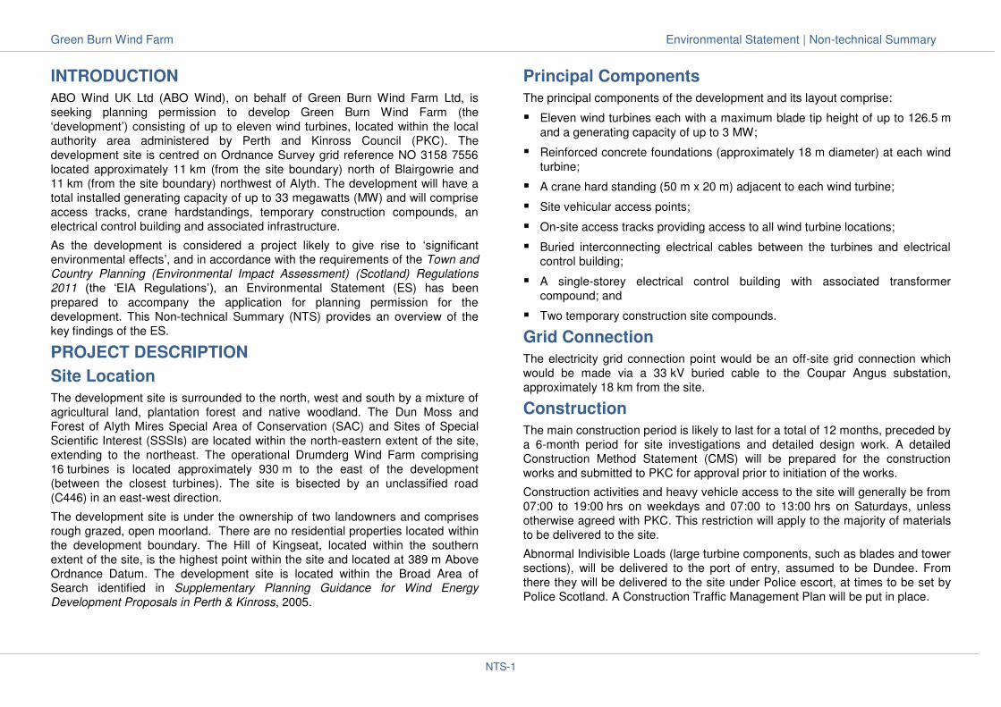
INTRODUCTION
ABO Wind UK Ltd (ABO Wind), on behalf of Green Burn Wind Farm Ltd, is
seeking planning permission to develop Green Burn Wind Farm (the
‘development’) consisting of up to eleven wind turbines, located within the local
authority area administered by Perth and Kinross Council (PKC). The
development site is centred on Ordnance Survey grid reference NO 3158 7556
located approximately 11 km (from the site boundary) north of Blairgowrie and
11 km (from the site boundary) northwest of Alyth. The development will have a
total installed generating capacity of up to 33 megawatts (MW) and will comprise
access tracks, crane hardstandings, temporary construction compounds, an
electrical control building and associated infrastructure.
As the development is considered a project likely to give rise to ‘significant environmental effects’, and in accordance with the requirements of the Town and
Country Planning (Environmental Impact Assessment) (Scotland) Regulations
2011 (the ‘EIA Regulations’), an Environmental Statement (ES) has been
prepared to accompany the application for planning permission for the
development. This Non-technical Summary (NTS) provides an overview of the
key findings of the ES.
PROJECT DESCRIPTION
Site Location
The development site is surrounded to the north, west and south by a mixture of
agricultural land, plantation forest and native woodland. The Dun Moss and
Forest of Alyth Mires Special Area of Conservation (SAC) and Sites of Special
Scientific Interest (SSSIs) are located within the north-eastern extent of the site,
extending to the northeast. The operational Drumderg Wind Farm comprising
16 turbines is located approximately 930 m to the east of the development
(between the closest turbines). The site is bisected by an unclassified road
(C446) in an east-west direction.
The development site is under the ownership of two landowners and comprises
rough grazed, open moorland. There are no residential properties located within
the development boundary. The Hill of Kingseat, located within the southern
extent of the site, is the highest point within the site and located at 389 m Above
Ordnance Datum. The development site is located within the Broad Area of Search identified in Supplementary Planning Guidance for Wind Energy
Development Proposals in Perth & Kinross, 2005.
Principal Components
The principal components of the development and its layout comprise:
Eleven wind turbines each with a maximum blade tip height of up to 126.5 m
and a generating capacity of up to 3 MW;
Reinforced concrete foundations (approximately 18 m diameter) at each wind
turbine;
A crane hard standing (50 m x 20 m) adjacent to each wind turbine;
Site vehicular access points;
On-site access tracks providing access to all wind turbine locations;
Buried interconnecting electrical cables between the turbines and electrical
control building;
A single-storey electrical control building with associated transformer
compound; and
Two temporary construction site compounds.
Grid Connection
The electricity grid connection point would be an off-site grid connection which
would be made via a 33 kV buried cable to the Coupar Angus substation,
approximately 18 km from the site.
Construction
The main construction period is likely to last for a total of 12 months, preceded by
a 6-month period for site investigations and detailed design work. A detailed
Construction Method Statement (CMS) will be prepared for the construction
works and submitted to PKC for approval prior to initiation of the works.
Construction activities and heavy vehicle access to the site will generally be from
07:00 to 19:00 hrs on weekdays and 07:00 to 13:00 hrs on Saturdays, unless
otherwise agreed with PKC. This restriction will apply to the majority of materials
to be delivered to the site.
Abnormal Indivisible Loads (large turbine components, such as blades and tower
sections), will be delivered to the port of entry, assumed to be Dundee. From
there they will be delivered to the site under Police escort, at times to be set by
Police Scotland. A Construction Traffic Management Plan will be put in place.

Green Burn Wind Farm Environmental Statement | Non-technical Summary
NTS-2
Site Location and Turbine Delivery Route
Operation
Once operational, the site will require scheduled service visits approximately
once or twice per week by operations staff in light vehicles. Extended visits for
servicing, typically every six months, and unscheduled maintenance may also be
required. It may be necessary to transport equipment and materials to the site
during some maintenance works.
Decommissioning
On completion of its operational lifetime, which is anticipated to be 25 years, the
development would be decommissioned and the site restored to a standard
required by PKC. A detailed Decommissioning Method Statement (DMS) will be
prepared for the decommissioning works and submitted to PKC for approval prior
to initiation of the works. Preparation of the DMS near to the time of
decommissioning will allow the operator to take advantage of advancements in
technology and best site practices at that time.
EXISTING ENVIRONMENT
Landscape and Visual Amenity
The site occupies just over 269 hectares (ha) and lies across the two hilltops of
Kingseat and Saebeg. It comprises of two adjacent parcels of land which are
separated by the C446 road. The landform is a smooth plateau with a general
trend of northeast to southwest, gradually descending towards Black Water to the
northwest.
The study area (which is 35 km radius from the outer turbines) contains five
nationally protected areas comprising one National Park and four National Scenic
Areas, two Wild Land Areas and 33 Gardens and Designed Landscapes and five
local landscape designations. However, the development is not located within
any one of these areas.
There are eight different landscape character types/areas (LCT/LCA) which
would experience theoretical visibility of the development. Of these are the
Highland Summits and Plateaux (TAY3) Forest of Alyth LCA, in which the
development is located, and the Lower Highland Glens (TAY1) Glen Shee LCA,
which abuts the western boundary of the development site.
There are 24 wind energy developments that are currently operational,
consented or in the planning process within the 35 km radius cumulative study
area.
Noise
The proposed development lies in a rural area, however, the operational
Drumderg Wind Farm is approximately 930 m (between the closest turbines) east
of the proposed development. There are several working farms in the
surrounding area and agricultural noise from machinery and livestock is therefore
a major component of the ambient noise environment. The closest A/B road is
the A93, approximately 1 km west of the site, running parallel with Black Water.
Noise from the Black Water and road traffic are audible at properties close to the
A93 and on the eastern slopes of Glen Shee. These noise sources are not
audible on elevated areas of the site due to acoustic screening afforded by the
intervening topography.
Repro
duced f
rom
Ord
nance S
urv
ey m
appin
g w
ith p
erm
issio
n o
f th
e c
ontr
olle
r of
H
er
Maj
esty
’s
Sta
tione
ry
offic
e.
©
Cro
wn
Cop
yrig
ht.
Licence
Num
ber
0100031673.
Green Burn Wind Farm Environmental Statement | Non-technical Summary
NTS-3
Cultural Heritage
Sixteen sites of historic environmental interest have been identified within the
proposed application boundary and a further 35 sites were identified within 1 km
of the site boundary. There are no Scheduled Monuments or Listed Buildings
within the development site and no part of the development would lie within a
Conservation Area, Inventory Garden and Designed Landscape or Inventory
Historic Battlefield.
Ecology and Birds
The development area and its immediate surroundings are located within an area
of unimproved acid grassland, semi-improved neutral grassland, wet heath, dry
acid heath, marsh/marshy grassland, acid/neutral flush, blanket and raised bog.
Ground water dependent ecosystems are widespread within the site area,
especially over the west and south.
The closest protected areas designated for ecology are the Dun Moss and Forest
of Alyth Mires Special Area of Conservation (SAC) and Dun Moss Site of Special
Scientific Interest (SSSI) which both lie immediately adjacent to the development
site and share the same 19.3 ha area within the development boundary. The SAC site is designated for its active raised bog, an ‘Annex I’ habitat. Both Dun
Moss SSSI and Forest of Alyth Mires SSSI are also designated for their active
raised bog. The Forest of Alyth Mires SSSI is 825 m northeast of the
development boundary. It should be noted that no development infrastructure is
proposed within the SSSI or SAC.
The closest protected area designated for birds is at Forest of Clunie Special
Protection Area (SPA) and SSSI (approximately 8 km west), designated for breeding hen harrier Circus cyaneus, osprey Pandion haliaetus, short-eared owl
Asio flammeus and merlin Falco columbarius and is nationally-important for black
grouse. There are a further four SPAs between 11 km and 18 km from the site,
some of which are also SSSI or Ramsar sites. There is one additional SSSI
approximately 20 km from the site.
The bird species on site are typical of the habitats present, and generally
comprise common and widespread species. However, there were a number of
Schedule 1/Annex I raptor species recorded, including: merlin, marsh harrier Circus aeruginosus, hen harrier, osprey, peregrine Falco peregrinus and short-
eared owl. Redwing Turdus iliacus and fieldfare Turdus pilaris were also
recorded; these are Schedule 1 breeding species (with very small numbers
breeding in Scotland), but are very commonly occurring wintering birds throughout the UK. A number of species of ‘red conservation concern’ (Eaton et
al., 2009) were also recorded, namely: herring gull Larus argentatus, skylark
Alauda arvensis, song thrush Plectrophenax nivalis, linnet Carduelis cannabina,
lapwing Vanellus vanellus and cuckoo Cuculus canorus. Black grouse were
observed using the site and a number of lekking areas documented. A small
number of goose, swan and other wildfowl flights were recorded through the
survey period between May 2011 and April 2015.
Hydrology, Hydrogeology and Geology
The available British Geological Survey drift geology map of the study area
shows that much of the site is underlain by Glacial Till which is overlain in the far
east of the site by peat deposits. Across the hilltops of the Hill of Kingseat the Till
is absent, with bedrock present at the surface. An area of alluvium, comprising
clay, silt, sand and gravel, is recorded in the northwest of the site surrounding a
number of minor surface watercourses. The eastern extent of the development
boundary is located within the boundary of the Dun Moss SSSI and the Dun
Moss and Forest of Alyth Mires SAC, designated for their matrix of raised and
intermediate bogs with associated marginal fen. It should be noted that no
development infrastructure is proposed within the SSSI or SAC.
The Black Water flows in a southerly direction, approximately 800 m to the west
of the site boundary at its closest point. The Black Water has a confluence with
the River Ericht near Bridge of Cally, approximately 4 km downstream from the
development boundary. The River Ericht subsequently flows through Blairgowrie
and joins the River Isla, which in turn joins the River Tay near Kinclaven Bridge.
The published Scottish Environment Protection Agency (SEPA) flood map
(www.sepa.org.uk) illustrates that the site is outwith the 200-year flood event and
as such is considered by SEPA to be at low flood risk.
Potential groundwater dependent terrestrial ecosystems are widespread on site,
especially over the west and south, where much of the low lying ground is
flushed with acid/neutral to distinctly calcareous waters. This gives rise to a
number of poor and rich fens and flushes depending on the degree of mineral enrichment. The most distinctive of these ecosystems are the M11 Carici-
Saxifragetum aizoides flush and M8 Carex-Sphagnum warnstorfii mire, both of
which are potential high ground water dependent terrestrial ecosytems.
Transport and Access
The most suitable port of entry for turbine components bound for the site was
identified as the Port of Dundee. From the Port, loads would follow the A90 west
towards Perth, turn onto the A85 and then follow the A94 towards Meigle. At
Meigle, loads would turn left on the B954, left onto the A926, right onto the B952
Green Burn Wind Farm Environmental Statement | Non-technical Summary
NTS-4
and then follow the B952 through Alyth, departing northwards on Bamff Road
and the C466 to approach the site from the southeast.
Tourism, Land Use and Recreation
A survey undertaken by VisitScotland, indicated that the top reason for choosing
to visit Perth and Kinross was for the scenery and landscape of the area (29 %).
The historic environment, consisting of ancient monuments, archaeology sites
and landscape, historic buildings, townscapes, parks gardens and designed
landscapes and other statutory and non-statutory designated sites is also a key
aspect of the area’s tourism and leisure industry. The site is located within an area of open moorland. The current principal land
use is sheep grazing.
An examination of the available resources has indicated that there are no public
paths within the site. No Sustrans Routes are found within the study area and
according to the British Horse Society database no rides will be affected by the
proposed development.
Several core paths are located within the study area to the west and south.
Those to the south are related to the Blairgowrie Paths Network, consisting of
five paths varying from 3 to 12 km within the area surrounding Blairgowrie.
Shadow Flicker
Ten residential properties lie within the study area for shadow flicker, one of
which – the Corb - is theoretically affected by shadow flicker from the operational
Drumderg Wind Farm, but within the guideline limits.
Climate and Air Quality
There are no existing significant sources of CO2 emissions within the area.
The main source of air emissions in the vicinity of the development site are road
traffic emissions, principally from traffic on the A93 to the west, and connecting
roads bisecting the site. No other significant sources of atmospheric emissions
have been identified in the vicinity of the site.
Aviation and Telecommunications
The existing aviation environment has been determined from the published
aeronautical charts and data on radar locations and coverage.
Radars identified as falling within the 100 km radius study area are as follows:
NATS En Route Perwinnes Hill and Lowther Hill primary surveillance radars;
RAF Leuchars primary surveillance radar;
Edinburgh Airport primary surveillance radar;
Kincardine primary surveillance radar; and
Cumbernauld primary surveillance radar.
Other aviation and defence-related facilities identified as falling within the 100 km
radius study area are as follows:
Perth Aerodrome;
the Perth aeronautical radio navigation beacon; and
Drumshade gliding site.
The development site is located in Low Flying Area 14, part of the UK Military
Low Flying system.
The existing telecommunications environment was determined from a map
search and consultation with Ofcom, the Joint Radio Company (JRC) and
WS Atkins. Ofcom advised that there is a fixed radio link operated by the JRC
with the potential to be affected by the development. WS Atkins has advised that
there are no water industry scanning telemetry facilities in the area.
Television subscribers in the area receive their signals from the Angus
transmitter, 28 km southeast of the development site. A television re-broadcast
link from the Angus television transmitter to the Blair Atholl local transmitter
passes approximately 2 km southwest of the development site.
ENVIRONMENTAL IMPACT ASSESSMENT
The objectives of the EIA are to:
identify likely environmental effects of the development on local environmental
sensitivities, the characteristics of the development and the views of
stakeholders and interested parties;
evaluate the extent and significance of these effects;
identify measures to avoid or reduce significant effects;
identify residual effects following mitigation; and
identify opportunities to enhance or otherwise benefit the existing environment
through the development.
Green Burn Wind Farm Environmental Statement | Non-technical Summary
NTS-5
Consultations
Consultation has played an important role in the design process of the
development. Consultations have been carried out with a wide range of parties
including political and community stakeholders. The aim was to ensure that their
views have been sought and taken into account in the development process.
Important issues to be addressed in the ES were identified as a result of this
consultation process.
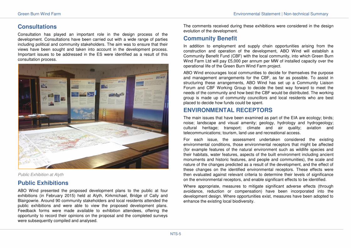
Public Exhibition at Alyth
Public Exhibitions
ABO Wind presented the proposed development plans to the public at four
exhibitions (in February 2015) held at Alyth, Kirkmichael, Bridge of Cally and
Blairgowrie. Around 90 community stakeholders and local residents attended the
public exhibitions and were able to view the proposed development plans.
Feedback forms were made available to exhibition attendees, offering the
opportunity to record their opinions on the proposal and the completed surveys
were subsequently compiled and analysed.
The comments received during these exhibitions were considered in the design
evolution of the development.
Community Benefit
In addition to employment and supply chain opportunities arising from the
construction and operation of the development, ABO Wind will establish a
Community Benefit Fund (CBF) with the local community, into which Green Burn
Wind Farm Ltd will pay £5,000 per annum per MW of installed capacity over the
operational life of the Green Burn Wind Farm project.
ABO Wind encourages local communities to decide for themselves the purpose
and management arrangements for the CBF, as far as possible. To assist in
structuring these arrangements, ABO Wind has set up a Community Liaison
Forum and CBF Working Group to decide the best way forward to meet the
needs of the community and how best the CBF would be distributed. The working
group is made up of community councillors and local residents who are best
placed to decide how funds could be spent.
ENVIRONMENTAL RECEPTORS
The main issues that have been examined as part of the EIA are ecology; birds;
noise; landscape and visual amenity; geology, hydrology and hydrogeology;
cultural heritage; transport; climate and air quality; aviation and
telecommunications; tourism, land use and recreational access.
For each issue, the assessment undertaken considered the existing
environmental conditions, those environmental receptors that might be affected
(for example features of the natural environment such as wildlife species and
their habitats, water features, aspects of the built environment including ancient
monuments and historic features, and people and communities), the scale and
nature of the changes predicted as a result of the development, and the effect of
these changes on the identified environmental receptors. These effects were
then evaluated against relevant criteria to determine their levels of significance
on the environmental receptors, and enable significant effects to be identified.
Where appropriate, measures to mitigate significant adverse effects (through
avoidance, reduction or compensation) have been incorporated into the
development design. Where opportunities exist, measures have been adopted to
enhance the existing local biodiversity.
Green Burn Wind Farm Environmental Statement | Non-technical Summary
NTS-6
MITIGATION AND ENHANCEMENT
The design of the development has evolved with the EIA process to mitigate
potentially significant environmental effects of the development. This involved
changes in design to avoid or reduce potentially significant environmental effects
through:
avoidance of black grouse leks;
water courses and drainage channels and private water supplies: a 50 m
buffer was considered around water courses; and a 250 m buffer was
considered around private water supplies;
avoidance of on-site cultural heritage (archaeology) assets;
avoidance of areas of Ground Water Dependent Terrestrial Ecosystems;
avoidance of protected species;
avoidance of areas of sensitive habitats (peat, blanket bogs, raised bogs),
SACs and SSSIs;
reducing visual impacts on nearby residential properties, and on surrounding
settlements and landscapes; and
consideration of other technical factors.
Other applied mitigation measures will include the preparation of specific
environmental management plans during construction works, the adoption of
best practice measures to ensure pollution prevention and pre-construction
surveys.
KEY FINDINGS
Landscape and Visual Amenity
The proposed development would be located immediately to the west of
Drumderg Wind Farm with which it would be visible from most locations where
the proposed development would be seen. The proposed development has been
designed to minimise additional visibility from the surrounding area. The
cumulative zone of theoretical visibility of the proposed development with
Drumderg Wind Farm demonstrates that there would be minimal areas of new
visibility of turbines from sensitive landscape or visual receptors in the study area
including the Cairngorms National Park, National Scenic Areas, Wild Land Areas
and registered Garden and Designed Landscapes. There would be some
significant effects upon landscape character and visual amenity as a result of the
introduction of the proposed turbines at distances of up to approximately 8 km.
Significant effects on landscape and visual amenity arising from the proposed
turbines would be confined to areas to the north, west and south of the site
where the additional turbines would extend the horizontal angle of turbines seen
in close proximity and in parts of Glen Shee where the proposed development
would be seen on its own. This would include three landscape character types,
eight viewpoints, one sequential route receptor and twenty-four properties.
There would be no significant effects on designated landscapes in the study
area.
There would be a change to the landscape and visual amenity on some of the
high ground in the northern part of the study area which is well frequented by
walkers. It is not anticipated that this would give rise to significant effects at
distances of over approximately 10 km from the wind turbines.
While significant effects on residential visual amenity are predicted to occur at 28
of the 89 residential properties within 5 km of the development, the effects are
not considered overbearing.
Noise
Baseline noise monitoring was undertaken at four receptor locations. Operational
noise has been considered across a range of operational wind speeds based on
manufacturer supplied noise data. Predicted operational noise levels from the
development at 21 of the 33 receptors included in this assessment are below the
amenity hours lower fixed limit set by PKC. Predicted operational noise levels
from the development at the remaining 12 receptors are below the noise limits
adopted for this assessment and are considered to be acceptable. Significant
effects from operational noise are therefore not expected to occur.
The potential for adverse effects from low frequency noise and infrasound, or
aerodynamic modulation from the operational turbines have also been
considered with reference to published research on each phenomenon. It is
considered that it is unlikely that any of the phenomena will occur on the
development site, thus no significant effects are predicted.
The assessment of construction noise considered typical noise emissions from
anticipated construction plant during each stage of the construction and
decommissioning phases of the development. The predicted levels of
construction noise are substantially below the construction noise limit adopted for
this assessment, hence construction levels are anticipated to be not significant.
Therefore, no significant noise effects are expected during the construction or
decommissioning phase of the development.

Green Burn Wind Farm Environmental Statement | Non-technical Summary
NTS-7
Cultural Heritage
Considerable design was undertaken to minimise the direct effects on most of
the known cultural heritage sites within the development boundary, however a
direct effect was predicted on one known site, a group of seven hut circles of
both single-walled and double-walled Dalrulzion type through which a turbine
access track would pass. Micro-siting of the access track during construction
should avoid the majority of the cairns, and this would not be a significant effect.
There is the potential for unknown buried archaeological remains to be found
during the construction process. If archaeological remains are uncovered during
construction that cannot be avoided and preserved in-situ then archaeological
recording will offset, but not reduce, the significance of effect.
Of the statutorily protected cultural heritage sites within 10 km (including C-Listed
Buildings within 5 km only), a significant effect, including cumulative effect, on the
setting of the Corb prehistoric settlement (SM 4703) was identified, while setting
effects on two Parkneuk stone circles (SM 1505) and Dalrulzion settlement
(SM 5777) were assessed as not significant.
The cumulative effects of the addition of the development in the views of the
other cumulative developments from these receptors were assessed as being no
greater than that of the development alone.
Birds
During the survey period there were no breeding Schedule 1/Annex I raptors on
the site, and no Schedule 1/Annex I species regularly using the site for foraging
or commuting. Whilst a number of species were recorded throughout the survey
period, these were only occasional, sporadic records, with no regular use of the
site by any Schedule 1/Annex I raptor species. Disturbance would be short term
(i.e. during the construction phase) and not significant.
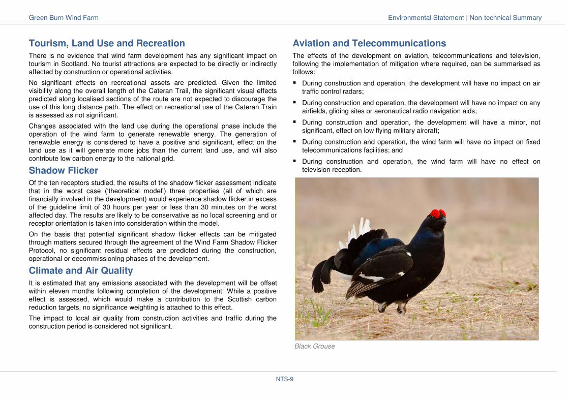
The site and surrounding area is of ‘regional’ value to black grouse. At least
20 males are believed to regularly lek on the site and up to 750 m of the site
boundary and therefore constitute 1.3 % of the regional population. Lekking black
grouse are sensitive to disturbance, in particular in the peak activity period
between March and May and therefore there is potential for disturbance to
lekking black grouse during construction. However, with the committed mitigation
measures in place, disturbance effects will be minimised.
There are breeding waders present on the site; predominantly curlew (with seven
pairs within the site boundary), lapwing (two pairs within the site boundary), and
possible breeding by a pair of snipe. The breeding wader interests within the site
are assessed to be of ‘site’ level value. Foraging habitat loss during construction
will be small and not significant.
The site is not used by geese, swans or other wildfowl for either roosting or
feeding, and is not on any regularly used commuting routes between roosting or
feeding areas. There have been occasional flights through the site by a number
of species, including pink-footed goose, greylag goose and whooper swan, as
well as mallard. Therefore, the site is assessed to be of ‘negligible’ value for geese, swans and other wildfowl.
Both buzzard and kestrel are considered likely or confirmed breeders close to the
site, with both species recorded regularly during vantage point surveys. Red
grouse are present throughout the areas of heather within the development
boundary.
Of the six designated ornithological sites within 20 km of the site, none of the
qualifying features of these designated sites regularly uses the habitats at the
proposed development site for breeding, feeding or roosting. Therefore, no
habitat loss or disturbance to designated site ornithological qualifying features
will occur.
Ecology
Due to the proximity of the River Tay SAC and Dun Moss and Forest of Alyth
Mires SAC/SSSIs, there will be strict adherence to the Construction Method
Statement and other Environmental Management Plans across the site to ensure
no run-off of silt onto sensitive habitats or into watercourses and dust pollution.
An outline of mitigation measures are included within the ES, including for
surface water management and prevention of the spread of dust.

Green Burn Wind Farm Environmental Statement | Non-technical Summary
NTS-8
Using design layouts to avoid areas of known ecological sensitivity and
incorporating best practice construction management measures, no significant
effects are predicted for any of the ecological receptors in the study area, which
comprised bats, badgers, pine marten, otters, red squirrel, water vole, herptiles
(reptiles and amphibians), invertebrates and habitats.
The largest areas of habitat lost during construction will be 1.2 ha of dry, acid
heath, just over 1 ha of unimproved acid grassland and just under 1 ha of dry
heath/acid grassland. Small areas of semi-improved acid grassland, marshy
grassland, wet heath and acid/neutral flush will also be lost.
The implementation of a habitat management plan at the site will result in a
permanent positive effect on key habitats such as modified bog.
Cumulative effects are assessed as being not significant when considered
alongside other wind farm developments.
Hydrology, Hydrogeology and Geology
The site layout has been designed to ensure that no infrastructure is located within
the surface water catchment area of the Dun Moss and Forest of Alyth Mires SAC
and Dun Moss SSSI. The qualifying interests of the raised bog habitats of the Dun
Moss and Forest of Alyth Mires SAC and Dun Moss SSSI are sustained by
rainwater, and the effect will be negligible and not significant.
The development has also been designed to ensure that infrastructure, comprising
the wind turbines, crane hardstandings, access tracks, electrical control building
and temporary construction compounds are located at least 50 m away from
watercourses, surface water drainage features or ponds.
The layout of the access tracks have been designed to ensure that no new
watercourse crossings are required.
The presence of peat within the site boundary formed a key consideration in the
design of the development. Peat probing has ensured that no wind turbines and
associated infrastructure are within areas of deep peat (greater than 0.5 m in
thickness). No sensitive geological receptors were identified for inclusion in this
assessment and, therefore, no significant effects on peat, peat stability, soils or
other geological resources on the site are predicted.
Transport and Access
The sensitivity of the local road network to the increase in vehicle movements
associated with the construction phase, in which the greatest volume of traffic
would be generated, was the focus of the traffic assessment. The A926, B954 and
B952 are local A or B class roads, capable of regular use by HGV traffic and are
therefore considered to be receptors of medium sensitivity. The C446 is a minor
rural road, not constructed to accommodate frequent use by HGVs, and is
therefore considered a receptor of high sensitivity.
During the construction phase, the increase in ‘total’ traffic movements, including
HGVs, predicted on the A926 and B954 roads and on the B952 through Alyth is
less than 5%. Compared with the current low levels of traffic, the ‘total’ traffic
movements are anticipated to increase by 58.71 % on the C446 in the vicinity of
the site access junctions. While the assessed effects of these increases were not
significant against guideline criteria, a Construction Traffic Management Plan will
be put into effect to reduce the effects of traffic on motorised and non-motorised
users of the C446 in particular.
Green Burn Wind Farm Development Site (looking north from Saebeg)
Green Burn Wind Farm Environmental Statement | Non-technical Summary
NTS-9
Tourism, Land Use and Recreation
There is no evidence that wind farm development has any significant impact on
tourism in Scotland. No tourist attractions are expected to be directly or indirectly
affected by construction or operational activities.
No significant effects on recreational assets are predicted. Given the limited
visibility along the overall length of the Cateran Trail, the significant visual effects
predicted along localised sections of the route are not expected to discourage the
use of this long distance path. The effect on recreational use of the Cateran Train
is assessed as not significant.
Changes associated with the land use during the operational phase include the
operation of the wind farm to generate renewable energy. The generation of
renewable energy is considered to have a positive and significant, effect on the
land use as it will generate more jobs than the current land use, and will also
contribute low carbon energy to the national grid.
Shadow Flicker
Of the ten receptors studied, the results of the shadow flicker assessment indicate
that in the worst case (‘theoretical model’) three properties (all of which are financially involved in the development) would experience shadow flicker in excess
of the guideline limit of 30 hours per year or less than 30 minutes on the worst
affected day. The results are likely to be conservative as no local screening and or
receptor orientation is taken into consideration within the model.
On the basis that potential significant shadow flicker effects can be mitigated
through matters secured through the agreement of the Wind Farm Shadow Flicker
Protocol, no significant residual effects are predicted during the construction,
operational or decommissioning phases of the development.
Climate and Air Quality
It is estimated that any emissions associated with the development will be offset
within eleven months following completion of the development. While a positive
effect is assessed, which would make a contribution to the Scottish carbon
reduction targets, no significance weighting is attached to this effect.
The impact to local air quality from construction activities and traffic during the
construction period is considered not significant.
Aviation and Telecommunications
The effects of the development on aviation, telecommunications and television,
following the implementation of mitigation where required, can be summarised as
follows:
During construction and operation, the development will have no impact on air
traffic control radars;
During construction and operation, the development will have no impact on any
airfields, gliding sites or aeronautical radio navigation aids;
During construction and operation, the development will have a minor, not
significant, effect on low flying military aircraft;
During construction and operation, the wind farm will have no impact on fixed
telecommunications facilities; and
During construction and operation, the wind farm will have no effect on
television reception.
Black Grouse
Green Burn Wind Farm Environmental Statement | Non-technical Summary
NTS-10
FURTHER INFORMATION
The ES is available for inspection throughout the consultation period as noted
below:
Perth and Kinross Council, Pullar House, 35 Kinnoull Street, Perth, PH1 5GD Monday to Friday from 8.45am – 5pm
Alyth Library, Airlie Street, Alyth, PH11 8AJ Thursday from 12.30pm – 4.30pm; 5pm – 8pm Friday from 9am – 1pm; 2pm – 5pm Saturday from 9.30am – 12.30pm
Blairgowrie Library, 46A, Leslie Street, Blairgowrie, PH10 6AW Tuesday to Thursday from 10am – 7pm Friday from 10am – 1pm Saturday from 9.30am – 12.30pm
Bridge of Cally Post Office, Bridge of Cally, Blairgowrie, PH10 7JG Monday, Tuesday, Thursday and Friday from 7.30am – 5.30pm Wednesday from 7.30am – 1pm Saturday from 7.45am – 1pm Sunday from 8.30am – 1pm
Kirkmichael Village Shop, Main Street, Kirkmichael, Blairgowrie, PH10 7NT Monday to Saturday 8am – 6pm Sunday 10am – 4pm
The ES is also available for viewing on the PKC website:
http://www.pkc.gov.uk
The NTS is also available free on request, or can be downloaded from the
Council’s website or the Green Burn Wind Farm website:
http://www.greenburnwindfarm.co.uk
Further hard copies of the ES are available at a cost of £975. DVD copies of the
ES are also available at a cost of £25.
To obtain a copy of the ES, please contact
ABO Wind UK Ltd
1 Houstoun Interchange
Livingston
EH54 5DW
0800 066 5631
www.abo-wind.co.uk
Representations on the ES and the planning application should be made directly to
Perth and Kinross Council.

ABO Wind UK Ltd
1 Houstoun Interchange · Livingston · EH54 5DW
Phone: 0800 066 5631
www.greenburnwindfarm.co.uk