
Green 4th Study
21
DISTRICT SYSTEMS & GREEN FOURTH CONCEPTS GREEN th PPERRIA SEPTEMBER, 2014
Transcript of Green 4th Study
DISTRICT SYSTEMS & GREEN FOURTH CONCEPTS
GREEN
thPPERRIA
SEPTEMBER, 2014

Cuningham Group Evergreen EnergySRF Consulting Group, Inc.Barr EngineeringKimley Horn and Associates, Inc.
The Mississippi Watershed Management Organization (MWMO)
PPERRIA Neighborhood and Prospect Park 2020
The Cornerstone Group
City of Minneapolis – CPEDCity of Minneapolis – Public WorksUniversity of MinnesotaDesign Center for Sustainable Building ResearchMetropolitan Design CenterTrust for Public LandSaint Paul Water Resources GroupLISC
Green Fourth Study Team: Cuningham Group and the rest of the Green Fourth Study Team would like to thank the following participants:
2522 Marshall Street NE Minneapolis, Minnesota 55418(612) 465-8780 (612) 465 8785 faxwww.mwmo.org
District Systems & Green Fourth Concepts
PPERRIA
FUNDING PARTNERS AND ACTIVE ROLE IN STUDY DIRECTION / CONTENT
COOPERATION AND ASSISTANCE

DISTRICT SYSTEMS & GREEN FOURTH CONCEPTS
A NEW DEFINITION FOR ‘STREET’ AND PUBLIC PLACEMAKING WITHIN THE PROSPECT NORTH DISTRICT

GREEN 4TH
MISSISSIPPI RIVER
PROSPECT PARK NEIGHBORHOOD
CITY OF ST. PAUL
UNIVERSITY OF MINNESOTA
DOWNTOWNMPLS
TO MIDTOWN GREEN WAY
MISSING LINK TO GRAND ROUNDS
29TH LRT STATION
STUDY PURPOSE + APPROACH
Prospect North will be a vibrant, walkable district characterized by an inviting framework of parks, plazas, trails, walkways and other public realm elements that support neighborhood activities and link with the world-renowned Grand Rounds National Scenic Byway and other regional systems.
Fourth Street presents a unique opportunity to convert a neglected, car dominated corridor into a green oasis and pedestrian magnet in the heart of the district. While future parks and the potential to complete the last piece of the Grand Rounds (the ‘missing link’) are included in long range plans, there is heightened interest to promote Fourth Street as the first significant public green space, and new signature residential address, north of University Avenue – with growing urgency to get it built as soon as possible.
▪ Support the City of Minneapolis application for the Metropolitan Council Livable Communities Grant application (TOD Award approved by Met Council 12/11/2013)
▪ Refine the overall vision for Green Fourth, but at the same time provide the quantified basis (math and science) for ongoing discussion and implementation of ‘district systems’ that will support future build-out of the overall Prospect Park 2020 Vision Plan. Evaluation and definition of district systems will include district stormwater management, district utilities, district traffic and parking, and district energy (heating, cooling and some thoughts about energy production).
▪ Help clarify and coordinate preliminary design work needed to support City of Minneapolis Public Works efforts to proceed with the reconstruction of Fourth Street as a priority project.
Toward that end, the primary objectives for the District Systems + Green Fourth Concepts Study include:
A series of stakeholder meetings took place in 2013, resulting in a Joint Agreement between the Mississippi Watershed Management Organization, the Prospect Park Neighborhood and the Cornerstone Group to provide necessary funding and leadership to facilitate the study process. These meetings also provided the forum for presentation of analysis data, review of design alternatives and set the direction for conclusions and recommendation contained in this document.
P. 4 District Systems & Green Fourth Concepts

PROCESS
PO
LIC
Y
SC
HE
DU
LE
BU
DG
ET
CO
ST
S
TRAFFIC AND PARKING STORM WATER
MANAGEMENT
PUBLIC UTILITIES DISTRICT ENERGYDISTRICT SYSTEMS
FINDINGS & DIAGRAMS
DISTRICT FRAMEWORK
CONTEXT & INFORMANTS
PROSPECT PARK
2020 VISION
METROPOLITAN DESIGN
CENTER STUDY
CITY OF MINNEAPOLIS
DESIGN CRITERIA
BOESER PHASE I
CONCEPT DESIGN
ADDITIONAL INPUTS
CONCEPTS & IMPLEMENTATION
BACKED UP WITH MATH AND SCIENCE
GREEN FOURTH / DESIGN CONCEPT IMPLEMENTATION / RECOMENDATIONS
MWMO
BARR
SRFSRF KIMLEY HORN EVERGREEN
PUBLIC REALM
PR
OG
RA
M
CGA
+
=INFORMS
▪ MPLS CPED
▪ MPLS

DISTRICT FRAMEWORK CONTEXT & INFORMANTS
PROSPECT PARK 2020THE CORNERSTONE GROUP
CITY OF MINNEAPOLIS
Representatives from both CPED and Public Works have provided ongoing meeting participation and helpful context related to existing city policy, zoning code, subdivision regulation, street/utility design standards and other regulatory criteria. As the Lead Agency for the 2013 Metropolitan Council LCDA grant application and the project lead for future Fourth Street improvements, their input is critical to the success of these major components in support of Prospect North redevelopment.
Cuningham Group Landscape Architects, Urban Designers and Architects worked with Cornerstone Group to explore conceptual design ideas for the Boeser Property, Harris Site and Green Fourth Street. These preliminary studies included both building and site program elements. Plan diagrams, 3-D drawings and photo-precedents illustrated various scenarios for building massing, unit count/phasing, site layout, public realm framework and bicycle/pedestrian connections.
Cornerstone Group has provided more recent design concepts and other studies provided by CLOSE Associates, Cermak Rhoades and Coen and Partners.
Central Corridor light rail line Minneapolis
2020 developMent FraMework (MarCh 2012)
METROPOLITAN DESIGN CENTER
“The Urban Design Framework encompassed an in depth environmental inventory of the University District and a detailed inventory of the critical ‘Contested Territories’ found within the district . . . using a series of public meetings and workshops, the Metropolitan Design Center developed a vision for the District outlining specific proposals for reflection and action. Using known design and research methods in the fields of landscape and urban ecology, the proposals should serve as a regenerative force to re-establish a new outlook . . . based on urban greenways, green infrastructure and low-impact design approaches.” (excerpt from the Urban Design Framework)
• In depth environmental inventory• Public meetings and workshops• Specific proposals for urban greenways,
green infrastructure and low impact design approaches
Contextual background, design concepts, research data and other background information.
• Development concept• District zoning recommendation• Market analysis and suggested land use mix• Public realm diagram
• Existing city policy, code and regulations• CPED and Public Works Staff participation• Leadership for specific public projects within
the district
• Property owner within the district• Conceptual development studies test district
principles• Advocates for district systems approach
University distriCt allianCe
Urban design FraMework (greenways and green inFrastrUCtUre – aUgUst 2012)
There is a library of relevant information that provides both overall context and valuable detailed information in the form of reports, inventories, assessments, master plans, site designs, cost spreadsheets and many others to numerous to list here.
“The purpose of the project is to craft a pre-development Framework through the hands-on involvement of businesses, landowners and the community . . . The Framework is intended to maximize the potential of the station area in alignment with the community vision for a diverse, vibrant, accessible, affordable, sustainable, walkable and connected mixed-use transit-oriented urban neighborhood.” (excerpt from the SRF Consulting Group 2020 Framework)

MWMO
CITY OF MINNEAPOLIS CITY OF MINNEAPOLIS
UNIVERSITY OF MINNESOTA BIOMEDICAL DISCOVERY ZONE UNIVERSITY OF MINNESOTA
CITY OF MINNEAPOLIS
Extensive library of additional information including studies related to Bridal Veil Creek, the Granary Corridor, U of M Campus Plan, University District Alliance studies, Stadium Village studies and much more.
This background information was critical in providing a solid platform for further study and conceptual design at both a district and project/site development scale. This report focuses on the relationship between potential district systems (parking, stormwater management, heating/cooling etc.) and future improvements within the 4th Street corridor.
Bridal Veil Creek: Urban Subwatershed Stormwater Retrofit Assessment MWMO Watershed Bulletin: 2011-6. Prepared for the MWMO by: Ramsey Conservation District, with assistance from The Metro Conservation Districts
Granary Corridor Study
SEMI Access with Extended Greenway
2-Lane
3-Lane
SEMI Access Roadway
25th Avenue SE (constructed 2011)
Extended Greenway
Bike Path
Light Rail (existing and future)
Central Corridor light rail transit
hiawatha light rail transit
NOVEMBER 5 , 2012
MINNEAPOLIS | MINNESOTA
Prospec t Park
Gre
en S
tree
tLi
ving
Str
eet
Act
ive
Stre
etN
eigh
borh
ood
Stre
et
- tree lined street - on-street parking - access to properties - streetscape amenities
- stormwater collection and treatment - urban agriculture - energy production
- bike and pedestrian first - “car is a guest” - flexible spaces - linear park-like character - intentional and spontaneous uses
- context with each block - defined by buildings - residential amenities - public - semipublic - private
Green FourthBuilding a Great Neighborhood Street
+
+
+
image from Prospect Park 2020 Plan
image from Metropolitain Design Center
This diagram illustrates the opportunity to integrate multiple (stacked) systems within GREEN FOURTH.
District Systems & Green Fourth Concepts P. 7

PUBLIC REALM
P
PUBLIC REALM FRAMEWORK
Great placemaking pays for itself in many ways – financial (rents/sales prices, property values/taxes, stable tenancies), environmental (recycle land/infrastructure, more efficient, lower carbon footprint), and social (more housing options, services, gathering places, community identity).
1. GREEN FOURTH 2. SIGNATURE PARK 3. GRAND ROUNDS

Apendix
DISTRICT PUBLIC REALM FRAMEWORK
P
District Systems & Green Fourth Concepts P. 9
The Prospect Park 2020 Framework and other planning documents created a vision and guiding principles that promote authenticity and vitality resulting from a mix of land uses, variety of architecture, location of parks and squares, and orientation and scale of streets that, together, form a whole fabric and create valued, memorable places.
To become a highly successful local and regional amenity, the Prospect North District must evolve into a place that gives primacy to the pedestrian. Development of a high-quality public realm is paramount, and in the short term will focus on these three projects:
Although we remain an auto-centric culture, there is a dramatic increase in the development of more balanced places that offer safe, vital and engaging pedestrian environments and vastly improved bicycle systems. In many instances, spaces that had once been given over to the car are now being reclaimed for redevelopment with the creation of “complete streets” and ‘car as guest’ approaches for a much more cohesive urban setting. The Prospect North District vision promotes these outcomes as foundational thinking for ongoing projects at both district and site development scale.
LRT Station
Park
Park
Granary corridor
29th LRT station
TCF Bank Stadium
University Ave.
Green Fourth
27th Ave.
27th Ave.
1. GREEN 4TH
3. REGIONAL PARK
2. SIGNATURE PARK
1. GREEN FOURTH
2. SIGNATURE PARK IN THE HEART OF THE
DISTRICT
3. LINKS TO THE GRAND ROUNDS
2. CENTRALLY LOCATED PUBLIC PARK/PLAZA BECOMES THE SIGNATURE FOR THE DISTRICT
1. GREEN FOURTH MIGHT LOOK SOMETHING LIKE THIS
3. CONNECT TO REGIONAL PARK, TRAIL AND OPEN SPACE SYSTEMS SUCH AS THE GRAND ROUNDS
Public Realm Framework
Green 4th
University Avenue
Distric Icon
Granary CorridorBridal Veil Creek Partial Daylighting
Park
Pedestrian network
Pedestrian network
Pedestrian Node
Pedestrian Node
Pedestrian Node
Surly site
Park
Pedestrian Node
Pedestrian Node
Pedestrian Node
Pedestrian Node
Pedestrian Node
Blue & Green Connection to Mississippi River
IconicBuilding
27th. Avenue
GREEN 4TH CONCEPT
P
CELEBRATION OF SEASONS
HYDRAULIC PERFORMANCE
Cherry blossom avenue, Bonn, Alemania
Raingarden Tree Trench
Cornerstone Site Stormwater Analysis - Treatment System Precedent Illustra onsMississippi Watershed Management Organiza onMinneapolis, MinnesotaPrepared by Barr Engineering - 04/03/2013
Raingarden Tree Trench
Cornerstone Site Stormwater Analysis - Treatment System Precedent Illustra onsMississippi Watershed Management Organiza onMinneapolis, MinnesotaPrepared by Barr Engineering - 04/03/2013
Illustration by Barr Engineering
HISTORY, ART & CULTURE
SIT & MINGLE
EAT & DRINK
Brighton, UKPhoto by Gehl Architects
The Park in Prague, Czech Republicby Cigler Marani
Mill City Museum Photo by John Schroeder
LIGHTS TO DEFINE SPACE
ENERGY GENERATION
The Digital Aurora Borealis (The Place in China) by Trey Ratcliff
Pavegen
Stationsstraat / Sint-Niklaas by Grontmij Belgium
The Marquette and 2nd StreetMinneapolis
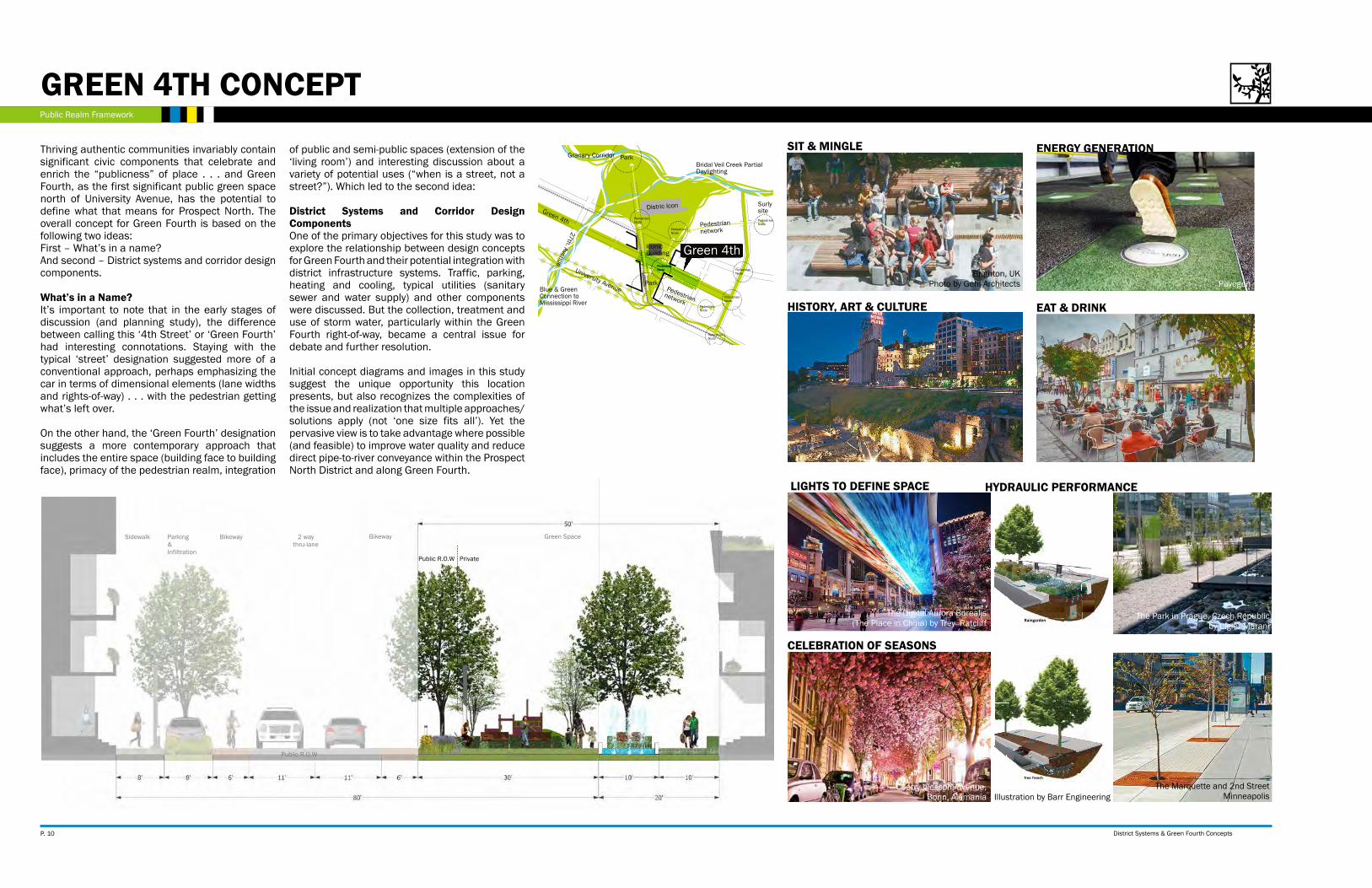
Thriving authentic communities invariably contain significant civic components that celebrate and enrich the “publicness” of place . . . and Green Fourth, as the first significant public green space north of University Avenue, has the potential to define what that means for Prospect North. The overall concept for Green Fourth is based on the following two ideas:First – What’s in a name?And second – District systems and corridor design components.
What’s in a Name?It’s important to note that in the early stages of discussion (and planning study), the difference between calling this ‘4th Street’ or ‘Green Fourth’ had interesting connotations. Staying with the typical ‘street’ designation suggested more of a conventional approach, perhaps emphasizing the car in terms of dimensional elements (lane widths and rights-of-way) . . . with the pedestrian getting what’s left over.
On the other hand, the ‘Green Fourth’ designation suggests a more contemporary approach that includes the entire space (building face to building face), primacy of the pedestrian realm, integration
of public and semi-public spaces (extension of the ‘living room’) and interesting discussion about a variety of potential uses (“when is a street, not a street?”). Which led to the second idea:
District Systems and Corridor Design ComponentsOne of the primary objectives for this study was to explore the relationship between design concepts for Green Fourth and their potential integration with district infrastructure systems. Traffic, parking, heating and cooling, typical utilities (sanitary sewer and water supply) and other components were discussed. But the collection, treatment and use of storm water, particularly within the Green Fourth right-of-way, became a central issue for debate and further resolution.
Initial concept diagrams and images in this study suggest the unique opportunity this location presents, but also recognizes the complexities of the issue and realization that multiple approaches/solutions apply (not ‘one size fits all’). Yet the pervasive view is to take advantage where possible (and feasible) to improve water quality and reduce direct pipe-to-river conveyance within the Prospect North District and along Green Fourth.
Parking &Infiltration
BikewayBikeway 2 waythru-lane
Green SpaceSidewalk
Public R.O.W
Public R.O.W
Private
Private
Green 4th
P. 10 District Systems & Green Fourth Concepts

Public Realm Framework
Infiltration Garden
Residential and Office Mix
Commercial &Office Residential
Water Recirculation
Playground
U of M Stadium
PavegenEnergy Generation
Permeable Paver
Parking
Overflow
P
CHARACTER STUDY OF POTENTIAL GREEN FOURTH COMPONENTS
EXISTING 4TH STREET
District Systems & Green Fourth Concepts P. 11

Public Realm Framework
P
SIGNATURE PARK IN THE HEART
Green 4thUniversity Avenue
Distric Icon
Granary Corridor
Bridal Veil Creek Partial Daylighting
Park
29th LRT StationPlaza
Pedestrian network
Pedestrian network
Pedestrian Node
Pedestrian Node
Pedestrian Node
Surly site
Pedestrian Node
Pedestrian Node
Pedestrian Node
Pedestrian Node
Pedestrian Node
IconicBuilding
27th. Avenue
PUBLIC REALM CONCEPT DIAGRAM
SIGNATURE PARK
From the earliest settlements to our largest cities, we have recognized the importance of public places. The village green, town square and a rich variety of urban parks and plazas have all contributed to our understanding of city form and human scale. These unique places express history, define district identity and invite civic interaction as an important mediator between buildings (types/uses) and the spaces in between.
However, the opportunity to create a signature public park in the heart of the Prospect North District goes well beyond a conventional definition of placemaking. Contemporary thinking, and extensive research, confirms that a high quality public realm can be transformative and has the potential to become a major influence in terms of land value, district infrastructure design (stacked systems), local/regional destination uses and many others layers of modern city-building.
Currently there is little, or no, publicly held property (outside of street rights-of-way), that could potentially be reserved for public park designation. But, with support from property owners and through future development team design proposals, the concept for a signature park (perhaps near the LRT station) could become reality.
P. 12 District Systems & Green Fourth Concepts

DISTRICT SYSTEMS
P
Roofdeck Event center
Public art
Solar Panel roof
Kiosk
Harvested water from roof
Anchor building
Hotel
Rock climbing wall
Screen Projection & Mural
Rooftop yard
Cafe
Residential
29th LRT Station
Restaurant
Connection to park
EXISTING 29TH AND UNIVERSITY AVENUE
District Systems & Green Fourth Concepts P. 13

Public Realm Framework
The potential to connect Prospect North District public spaces and other amenities with City/Regional systems is not a new idea. Completing the ‘Missing Link’ of the Grand Rounds, while providing access to other facilities within the world-renowned Minneapolis park system, has been discussed for several decades.
More recent studies have explored both conceptual design and potential projects for implementation related to the Granary Road Corridor, Bridal Veil Creek and other initiatives within and adjacent to the District.
While we recognize that some of these concepts have a much longer time horizon (in terms of process, design, funding, permits and construction), there are a variety of implications and tangible impacts/influences that will help inform short-term design decisions for Green Fourth and the Signature Park.
REGIONAL PUBLIC REALM
P. 14 District Systems & Green Fourth Concepts
GREEN 4TH

Public Realm Framework
GRANARY CORRIDOR BRIDAL VEIL CREEK MISSING LINK
Image credit: Metropolitan Design Center
Image credit: Metropolitan Design Center
Image credit: Metropolitan Design Center
Image credit: Dinkytown Greenway
Photo credit: Landschaftspark Duisburg Nord by Latz + Partner
Photo credit: 1911 Civic Celebration postcard
Saw Mill River in downtown Yonkers Photo credit: Zach YoungermanPhoto credit: Parco Dora by Latz + Partner
There is a wealth of existing information and precedent research that promotes a thoughtful integration of local and regional systems including park/trail/open space networks, stormwater management/ surface drainage patterns, natural habitat corridors, energy production, waste handling, urban agriculture and many more.
District Systems & Green Fourth Concepts P. 15

P
DISTRICT SYSTEMS
PPP
PSTORMWATERHEATING & COOLINGTRAFFIC & PARKING PUBLIC UTILITIES

DISTRICT SYSTEMS
DISTRICT BUILD-OUT PLAN
Prospect Park June 13, 2013
MINNEAPOLIS MINNESOTA
Minneapolis st. Paul
scale: 1” = 400’
surly destination brewer y-brewer y
- events center- restaurant
-bar-b eer garden
mixed use25,000sq. f t . - gro cer y125,000 sq. f t . - retai l
100,000 sq. f t . - educ ation supp or t125 key hotel
1,150 units - M ixed / multi family
mixed use300 residential units
mixed use50,000 sq. f t . - c l inic
200,000 sq. f t . - off ice200,000 sq. f t . - medic al supp or t
125 key hotel1,100 units - M ixed / multi family
UofMBio discover y
D istr ic t
MN I nnovation park700,000 sq. f t . - research
MN I nnovation park100,000 sq. f t . - research
MN I nnovation park200,000 sq. f t .
Univers i t y Enterpr ise
Laborator ies
UofMTCF
Stadium
UofMAmbulator yCare Center
Glendaleto be
re - imagined
P
P
P
P
P
P
legend
ProsPeCt ParK 2020distriCt BUild-oUt Chart
Mixed use with emphasis on commercial, retail, & office
Mixed use with emphasis on housing
Mixed use with emphasis on enterprise innovation uses
structured parking
residential ------------------------grocery ----------------------------other retail ------------------------hotels ------------------------------Clinic -------------------------------Office ------------------------------Mn innovation Park ------------
2,550 units 25,000 sq. ft 125,000 sq. ft 250 rooms 50,000 sq. ft 200,000 sq. ft1,000,000 sq.ft
The Prospect North District Build-Out Plan highlighted on these two pages provided a rough estimate of various land use types (square footage, unit count, general location), from which the Green Fourth Study Team could base their district systems analysis and conclusions. The Jim McComb Market Study, included in the 2020 Framework Plan prepared by the SRF Consulting Group Team, offers a much more detailed look at potential uses within the district, but for the purposes of this report, we have made the following assumptions:
Prospect Park June 13, 2013
MINNEAPOLIS MINNESOTA
Minneapolis st. Paul
scale: 1” = 400’
surly destination brewer y-brewer y
- events center- restaurant
-bar-b eer garden
mixed use25,000sq. f t . - gro cer y125,000 sq. f t . - retai l
100,000 sq. f t . - educ ation supp or t125 key hotel
1,150 units - M ixed / multi family
mixed use300 residential units
mixed use50,000 sq. f t . - c l inic
200,000 sq. f t . - off ice200,000 sq. f t . - medic al supp or t
125 key hotel1,100 units - M ixed / multi family
UofMBio discover y
D istr ic t
MN I nnovation park700,000 sq. f t . - research
MN I nnovation park100,000 sq. f t . - research
MN I nnovation park200,000 sq. f t .
Univers i t y Enterpr ise
Laborator ies
UofMTCF
Stadium
UofMAmbulator yCare Center
Glendaleto be
re - imagined
P
P
P
P
P
P
legend
ProsPeCt ParK 2020distriCt BUild-oUt Chart
Mixed use with emphasis on commercial, retail, & office
Mixed use with emphasis on housing
Mixed use with emphasis on enterprise innovation uses
structured parking
residential ------------------------grocery ----------------------------other retail ------------------------hotels ------------------------------Clinic -------------------------------Office ------------------------------Mn innovation Park ------------
2,550 units 25,000 sq. ft 125,000 sq. ft 250 rooms 50,000 sq. ft 200,000 sq. ft1,000,000 sq.ft
Mixed use with emphasis on commercial, retail, and office
Mixed use with emphasis on housing Mixed use with emphasis on enterprise innovation users
Source: Eco Boulvard Ecosystema urbanoSource: Via Verde, Bronx NY Photo: David SundbergSource: 222 Hennepin, Minneapolis MN Excelsior Group
District Systems & Green Fourth Concepts P. 17

DISTRICT SYSTEMS
riVer rd e
UniVersitY aVe se
oaK
st s
e
27th
aV
e se
interCaMPUs transitwaY
onta
rio s
t se
erie
st s
e
esseX st se
orlin aVe se
eMer
ald
st
FUlton st se
arthUr aVe se
4th st se
delaware st se
Yale aVeMalColM aVe se
seY
MoU
r aV
e se
25th
aV
e se
MelBoUrne aVe se
29th
aV
e se
Barton aV
e se
ClarenC
e aVe se
sain
t Mar
Ys
aVe
26th
aV
e se
Bed
For
d st
se
23rd
aV
e se
sidneY Pl
thor
nton
st s
e
30th
aV
e se
Mal
Col
M a
Ve
se
BeaCon st se
dartMoUth Pl
ProsPeCt ter
Brid
al V
eil C
ir
saint MarYs Pl
arthUr P
l se
4th st se
5th st se
27th
aV
e se
27th
aV
e se
delaware st se
Mal
Col
M a
Ve
se
Bed
For
d st
se
LRT
LRT
PHASE 1: 7-10 YEARS
P
*All data related to traffic has not been approved by City of Minneapolis Public Works. Before moving forward this will need formalization, validation, and approval.
2,810 TRIP
1,185 TRIP
10,515 TRIP
1,515 TRIP
riVer rd e
UniVersitY aVe se
oaK
st s
e
27th
aV
e se
interCaMPUs transitwaY
onta
rio s
t se
erie
st s
e
esseX st se
orlin aVe se
eMer
ald
st
FUlton st se
arthUr aVe se
4th st se
delaware st se
Yale aVeMalColM aVe se
seY
MoU
r aV
e se
25th
aV
e se
MelBoUrne aVe se
29th
aV
e se
Barton aV
e se
ClarenC
e aVe se
sain
t Mar
Ys
aVe
26th
aV
e se
Bed
For
d st
se
23rd
aV
e se
sidneY Pl
thor
nton
st s
e
30th
aV
e se
Mal
Col
M a
Ve
se
BeaCon st se
dartMoUth Pl
ProsPeCt ter
Brid
al V
eil C
ir
saint MarYs Pl
arthUr P
l se
4th st se
5th st se
27th
aV
e se
27th
aV
e se
delaware st se
Mal
Col
M a
Ve
se
Bed
For
d st
se
LRT
LRT
FULLBUILD OUT: 15 YEARS
11,952 TRIP
475 TRIP
950TRIP
3,320 TRIP
10,830TRIP
1,295 TRIP
INFORMS
The project technical advisory committee developed a land use plan based on anticipateddevelopment in the project area over the next seven to 10 years. The land use assumptions shown in Map 1 are characterized as Phase 1 land use conditions. The land use assumptions forPhase 1 were compared against the land use types/sizes proposed as part of the Prospect ParkMaster Plan, by the Cuningham Group, which represents the Full Build-Out land use plan for thearea. The land use assumptions under Phase 1 and Full Build-Out conditions are shown in Table 1.
PROSPECT PARK NEIGHBORHOOD AND GREEN FOURTH
P
P
P
P
P. 18 District Systems & Green Fourth Concepts
ITE = 435 SPACES CITY = 375
SPACES
250,000 sF oFFiCe & residential
MiXed Use
350 dU apartMent
650 dU apartMent
ITE = 680 SPACES CITY = 585
SPACES
ITE = 1,750 SPACES CITY = 1,270
SPACES
DEVELOPMENT TRIPS
▪ 55% MODAL REDUCTION (RESIDENTIAL)
▪ 35% MODAL REDUCTION (OFFICE/RETAIL)
▪ 10% MULTIUSE REDUCTION
MIXED USE750 DU APARTMENT
125 ROOM HOTEL
150 ROOM HOTEL
150 KSF OFFICE
150 KSF RETAIL
50 KSF ARTS/CULTURAL
ITE = 366 SPACES CITY = 315
SPACES
TRAFFIC & PARKING
ITE = Institute of Transportaion Engineers
City = City of Minneapolis
ITE = 1,860 SPACES CITY = 1,440
SPACES
ITE = 1,220 SPACES CITY = 1,050 SPACES
700,000 s.F. researCh & developMent
oFFiCe
200,000 s.F. researCh & developMent
oFFiCe
350 dU apartMent
MiXed Use
MiXed Use
ITE = 175 SPACES CITY = 150 SPACES
100,00 s.F. researCh & developMent oFFiCe
ITE = 2,235 SPACES CITY = 1,820 SPACES
ITE = 350 SPACES CITY = 300 SPACES
MIXED USE25,000 S.F GROCERY
125,000 S.F. RETAIL
100,000 S.F. EDUCATIONAL SUPPORT
125 KEY HOTEL
1,150 UNITS MIXED/MULTIFAMILY
MIXED USE50,000 S.F. CLINIC
200,000 S.F. OFFICE
200,000 S.F. MEDICAL SUPPORT
125 KEY HOTEL
1,100 UNITS MIXED/MULTIFAMILY
ITE = 366 SPACES CITY = 315
SPACES
P
P
P
P
P
P

DISTRICT SYSTEMS
PARKING ANALYSISTRAFFIC FORECASTS
TRIP GENERATION ESTIMATES ▪ Trip generation estimates on a daily basis were developed using the ITE Trip Generation Manual, 9th Edition and are summarized in Table 2 for each block.
▫ A 35 percent modal reduction was applied to the ITE parking requirements to account for customers arriving via transit services and for those that are walking, biking, or carpooling to the developments.
▫ A 10 percent multi-use reduction was applied to the retail and office land uses to account for customers visiting more than one development with their initial trip.*
AVERAGE DAILY TRAFFIC VOLUMES
▪ Existing average daily traffic (ADT) volumes were reviewed, which are made available by the Minnesota Department of Transportation (MnDOT).
▪ A background growth rate of one-half percent was applied to the existing daily traffic volumes to obtain forecast traffic volumes for the future conditions, which is consistent with historical growth trends in the area.
▪ Trip generation estimates for Phase 1 and Full Build-Out conditions were distributed throughout the study area based on the directional distribution shown in Attachment 4.
▪ The existing and resultant Phase 1 (year 2023) and Full Build-Out (year 2028) condition traffic volumes are shown in Table 3.
▫ Since future development access along 4th Street is unknown at this time, a daily traffic volume range along 4th Street was provided for future conditions. The lower traffic volume represents a condition with limited access along 4th Street.
▪ Based on planning level corridor capacity thresholds, no future capacity issues are expected within the study area.*
▪ The City of Minneapolis parking code was reviewed to estimate the parking requirements under Phase 1 and Full Build-Out conditions for each block.
▪ The parking demand for each block under Phase 1 and Full Build-Out conditions was calculated based on the ITE Parking Manual.
▫ Since the project site is located in a Pedestrian Oriented (PO) overlay district, a 10 percent reduction was applied to off-street parking requirements for residential land uses and 25 percent reduction was applied to off-street parking requirements for non-residential land uses.
▫ A 35 percent modal reduction was applied to the ITE parking requirements to account for customers arriving via transit services and for those that are walking, biking, or carpooling to the developments.
▫ A 10 percent multi-use reduction was applied to the retail and office land uses to account for
▫ customers visiting more than one development.
▪ Results of the parking analysis are summarized in Table 4 and shown in Attachment 5 and Attachment 6 under Phase 1 and Full Build-Out conditions, respectively.*
*All data related to traffic has not been approved by City of Minneapolis Public Works. Before moving forward this will need formalization, validation, and approval.
District Systems & Green Fourth Concepts P. 19

DISTRICT SYSTEMSGREEN 4TH STREET DESIGN OPTION
E N G I N E E R S
P L A N N E R S
D E S I G N E R SConsulting Group, Inc.September 24, 2013GREEN FOURTH STREET
State Aid Minimum Requirements with Parking Zone
B1 B2
Section View
Plan View
B1 B20 10
Pedestrian ZonePedestrian Zone Thru LaneThru Lane ParkingParking21’21’ 11’11’ 8’8’
80’ Right-of-Way
E N G I N E E R S
P L A N N E R S
D E S I G N E R SConsulting Group, Inc.September 24, 2013GREEN FOURTH STREET
State Aid Minimum Requirements with No Parking Zone
Section View
Plan View
DRAFT
A1 A2
A1 A2
0 10
Pedestrian ZonePedestrian Zone Thru LaneThru Lane27’27’ 13’13’
80’ Right-of-Way
FIGURE 1: STATE AID MINIMUM REQUIREMENTS WITHOUT PARKING BAYS
FIGURE 2:STATE AID MINIMUM REQUIREMENTS WITH PARKING BAYS
Prepared by SRF Consulting Group, Inc.
P
State Aid minimum requirements and Access Minneapolis design guidelines informed the possible scenarios for a typical local street with 80 ft R.O.W. Typical street sections, both with and without a parking bay, still allow adequate sidewalk space, but not enough to maximize occupiable pedestrian space for diverse civic uses and stormwater treatment.
Working with the current standard, the scenario seen in fig. 3 was developed to show how parking, as well as infiltration basins, is accomodated while providing 20 feet of sidewalk width on both sides.Furthermore, the current policy allows asymetric configuration of the street section that can allow different width of the sidewalks.
The next chapter will introduce further exploration of the Green 4th street design scenarios that maximize pedestrian space for multiple programs that enliven the life of the street.
P. 20 District Systems & Green Fourth Concepts

DISTRICT SYSTEMS
State Aid minimum requirements and Access Minneapolis design guidelines informed the possible scenarios for a typical local street with 80 ft R.O.W. Typical street sections, both with and without a parking bay, still allow adequate sidewalk space, but not enough to maximize occupiable pedestrian space for diverse civic uses and stormwater treatment.
Working with the current standard, the scenario seen in fig. 3 was developed to show how parking, as well as infiltration basins, is accomodated while providing 20 feet of sidewalk width on both sides.Furthermore, the current policy allows asymetric configuration of the street section that can allow different width of the sidewalks.
The next chapter will introduce further exploration of the Green 4th street design scenarios that maximize pedestrian space for multiple programs that enliven the life of the street.
FIGURE 3:GREEN 4TH ALTERNATIVE (STILL SITHIN MSA STANDARDS)
Prepared by SRF Consulting Group, Inc.
P
District Systems & Green Fourth Concepts P. 21


