GRASS 5.0 Programmer's Manual · written by Olga Waupotitsch and Michael Shapiro (CERL), Bill Brown...
531
GRASS Development Team GRASS 5.0 Programmer’s Manual Geographic Resources Analysis Support System 30th January 2004
Transcript of GRASS 5.0 Programmer's Manual · written by Olga Waupotitsch and Michael Shapiro (CERL), Bill Brown...

GRASS Development Team
GRASS 5.0 Programmer’s ManualGeographic Resources Analysis Support System
30th January 2004


Edited by
Markus Neteler
Member of GRASS Development Team
ITC-irst
Istituto per la Ricerca Scientifica e Tecnologica
Via Sommarive, 18
38050 Povo (Trento), Italy
�
GMS Laboratory
University of Illinois-Champaign, Urbana, Illinois
Center of Applied Spatial Research
Baylor University, Waco, Texas
�
30th January 2004, Draft Version
�
Based on preliminary programming notes on GRASS 5
written by Olga Waupotitsch and Michael Shapiro (CERL),Bill Brown (GMSL) and Darrel McCauley (Purdue)
and the former
GRASS 4.2 Programmer’s Manual
edited by Steve Clamons, Bruce Byars (Baylor University)and basically written by
Michael Shapiro, James Westervelt, Dave Gerdes, Majorie Larson, andKenneth R. Brownfield (CERL)

ABSTRACT
GRASS (Geographical Resources Analysis Support System) is a comprehensive GIS with raster,topological vector, image processing, and graphics production functionality. This manual in-troduces the reader to the Geographic Resources Analysis Support System version 5.0 from theprogramming perspective. Design theory, system support libraries, system maintenance, andsystem enhancement are all presented. Standard GRASS 4.x conventions are still used in muchof the code. This work is part of ongoing research being performed by the GRASS Develop-ment Team coordinated at ITC-irst, Trento, Italy), a worldwide programmer’s team (see below),the GMS Laboratory at University of Illinois-Champaign (U.S.A.) and the Center of AppliedGeographic and Spatial Research at Baylor University (U.S.A.). GRASS module authors arecited within their module’s source code and the contributed manual pages.
30th January 2004
c�
2000 Markus Neteler / GRASS Development Team
Published under GNU Free Documentation License (GFDL)http://www.fsf.org/copyleft/fdl.html(see C GNU Free Documentation License (p. 499))
This manual comes with ABSOLUTELY NO WARRANTY.
The development of GRASS software and this manual is kindly supported by Intevation GmbH,Osnabrück, Germany, who provide the GRASS CVS repository.
European Headquarters: http://grass.itc.it
Unites States Headquarters: http://www3.baylor.edu/grass/

Foreword
This manual represents documentation for the third revision to the Geographic Resources Anal-ysis Support System (GRASS) Geographic Information System (GIS) with version 4.x beingreplaced with 5.0.
This work was originally performed by the Environmental Division (EN) of the U.S. ArmyConstruction Engineering Research Laboratory (USACERL). In August, 1997, GRASS devel-opment was taken up by the GRASS Development Team at Baylor University. From Summer1999 to Summer 2001 the GRASS project was coordinated at University of Hannover, Germany,since Summer 2001 at ITC-irst, Trento, Italy.
Original Authors of the GRASS 4.x Programmer’s Manual are Michael Shapiro, James West-ervelt, Dave Gerdes, Majorie Larson, and Kenneth R. Brownfield. It is upon their work thatthis is based, and we wish for full acknowledgement to go to them for their efforts. Dr. JamesWestervelt has provided valuable insight into GRASS for this project. Dr. Robert Lozar ofUSA-CERL has also been instrumental in the release of the GRASS 4.2 manual.
The upgrade to GRASS 5 programming API is based on comprehensive notes written in 1995by Olga Waupotitsch and Michael Shapiro (CERL), Bill Brown (GMSL) and Darrel McCauley(Purdue University). Their documents have been written in HTML and were merged intothis manual. Further core designers of GRASS 5 libraries and modules have been RomanWaupotitsch, James Westervelt, David Gerdes, Helena Mitasova, Jaro Hofierka and Lubos Mi-tas.
A rather complete list of GRASS programmers can be found online:
http://grass.itc.it/grasscredits.html
http://www3.baylor.edu/grass/grasscredits.html
Please notify us in case of contributors missing in this list.
Other Related Materials in the GRASS 5.0 Series
GRASS 5.0 Command Reference
NOTE: This manual is far from being completely updated. Please send your useful commentsto Markus Neteler ([email protected]).
i

GRASS 5 Core Team Members
(Status: 10/2000)
Roger Bivand (Norway), Radim Blazek (Czechia), Bill Brown (U.S.A.), Huidae Cho (South Ko-rea), David D. Gray (U.K.), Jaro Hofierka (Slovak), Justin Hickey (Thailand), John Huddleston(U.S.A.), Bill Hughes (U.S.A.), Andreas Lange (Germany), Pierre de Mouveaux (France), Lu-bos Mitas (U.S.A.), Helena Mitasova (U.S.A.), Eric G. Miller (U.S.A.), Eric Mitchell (U.S.A.),Markus Neteler (Germany), Bernhard Reiter (Germany), Alexander Shevlakov (Russia), FrankWarmerdam (U.S.A.), Michel Wurtz (France), Lisa Zygo (U.S.A.)
Get latest list here:
http://freegis.org/cgi-bin/viewcvs.cgi/~checkout~/grass/AUTHORS
ii

Book status and History
Note: This page will disappear when the book is finished.
This page reflects the current status of the "GRASS 5.0 Programmer’s Manual" and needs to beupdated regularly by book authors.
[$Id: status.tex,v 1.23 2001/04/05 17:20:32 markus Exp $]
Current status:
Markus Neteler 4/2001:* added HTML web pages, converted to Latex:
- FP added, but needs to be merged furtherly within existing text- datetime added, but function definitions missing (?, ask Bill Brown)- sites API added- g3d API added
* comments are in [] like [GRASS 5: ...] Here further updatesare required.
* added small PROJ4/GRASS API
Contributions fromDavid D. Gray (vector)Eric G. Miller (sites)
File list:
progmangrass50.tex -> head of documentprogmangrass50.sty -> layout parameters, \Gfunc and Gprog environment are
defined here
chapter1.tex: "Introduction"- latex updated
chapter2.tex: "Development Guidelines"- latex updated
chapter3.tex: "Multilevel"- latex updated
chapter4.tex: "Database Structure"- latex updated- added 121 projections
chapter5.tex: "Raster Maps"- latex updated
chapter6.tex: "Vector Maps"- latex updated- 64 bit support needs to be included (Bill Hughes?)
chapter7.tex: "Point Data: Site List Files"- latex updated
iii
chapter8.tex: "Image Data: Groups"- latex updated
chapter9.tex: "Region and Mask"- latex updated- is window/region terminology clear?
chapter10.tex: "Environment Variables"- latex updated- several new variables missing
chapter11.tex: "Compiling and Installing GRASS Modules"- Auto-conf is not yet explained
chapter12a.tex: "GIS Library 1"- latex updatedReference for function definition in Latex!!
chapter12b.tex: "GIS Library 2"- latex updated for new 5.x functions
chapter12c.tex: "GIS Library 3"- latex updated- added new parser functionality (implemented by Huidae Cho
<[email protected]>)- added unix sockets (Eric G. Miller)
chapter13.tex: "Vector Library"- latex updated
chapter14.tex: "Imagery Library"- latex updated
chapter15.tex: "Raster Graphics Library"- latex updated
chapter16.tex: "Display Graphics Library"- latex updated- added new functions:
* D_set_dig_name(name)* sets the name of the dig file currently displayed** D_get_dig_name(name)* returns the name of the dig file currently displayed
implemented by Huidae Cho <[email protected]>
chapter17.tex: "Lock Library"- latex updated
chapter18.tex: "Rowio Library"- latex updated
chapter19.tex: "Segment Library"- latex updated
chapter20.tex: "Vask Library"- latex updated
iv

proj_datum.tex: "coordinate conversion library"- latex updated- added supported proj list- added PROJ4/GRASS API
grid3d.tex: "GRID3D voxel format"- latex updated
chapter21.tex: "DateTime Library"- latex updated%% Original Chapter 21 is outdated and belongs to GRASS 4.0/v.digit2.% replaced by DateTime description
gsurf.tex: "gsurf Library for OpenGL programming"- latex updated
gui.tex: "tcltkgrass and XML/Python GUI programming"- added
chapter22.tex: "Digitizer/Mouse/Trackball Files (.dgt)"
gmath.tex: "Numerical math interface to LAPACK/BLAS"- added, latex o.k.
chapter23.tex: "Writing a Graphics Driver"chapter24.tex: "Writing a Paint Driver"chapter25.tex: "Writing GRASS Shell Scripts"chapter26.tex: "GRASS CVS repository"appendix.tex:- index available now, generated by makeindex
---------------Contributions:
- David D Gray <[email protected]>:G__write_cats returns 1 on successful completion
- affects at least: G_write_cats, G_write_vector_catsFixed.
Numerical math interface to LAPACK/BLASadded
- Andreas Lange <[email protected]>:CC-doc.tex completely written
- Eric G. Miller:G_readsites_xyz
v

TODO list - Errata
G_tokenize() G_number_of_tokens() and G_free_tokens() are missing(see libes/gis/token.c)
------
From: Glynn Clements <[email protected]>Date: Mon, 30 Apr 2001 00:16:23 +0100
1. XDRIVER now supports the RGB_RASTER operation natively; if it’susing a TrueColor or DirectColor visual, it uses logical operations toconvert the data (tested on a 5:6:5 display). No Colormaps,lookup-tables or similar.
2. libdisplay contains some new functions for RGB raster operations:
D_draw_raster_RGBD_draw_d_raster_RGBD_draw_f_raster_RGBD_draw_c_raster_RGBD_draw_cell_RGBD_cell_draw_setup_RGBD_raster_of_type_RGBD_set_colors_RGB
These are all more or less analogous to the corresponding functionswithout the _RGB suffix, the main difference being that they takethree sets of raster data instead of one.
These functions all use the RGB_RASTER operation, so there are nocolour tables involved. The CELL/FCELL/DCELL values are converted tobytes using the appropriate channel[1] from the specified colour table(typically the one from the layer).
[1] I.e. the red components are used for the red layer, etc. If thelayers have suitable grey-scale colour tables, that’ll work.
----------------------------------------------------------------------Date: Sat, 16 Dec 2000 14:03:43 -0700From: "William L. Baker" <[email protected]>Subject: [GRASS5] Programming manual or GIS library corrections?
Hello,
Am working on revision of r.le and not very knowledgeable aboutthe grass5 revisions in general, so please excuse if I miss somethingobvious.
I think the following are just little mistakes in the programming manual:1. G_zero_raster_row is listed on p. 143 of latest (Nov.) revision ofprogramming manual, but this does not seem to be the correct name.It seems that it is G_zero_raster_buf.
2. G_read_fp_range on p. 156. I think the correct order of the parameters
vi
is: (char *name, char *mapset, struct FPRange). The manual listsstruct FPRange first.
3. p. 160 lists G_quant_truncate twice, but I think the second caseshould be G_quant_round as that one works OK in my program, andthe description mentions rounding.
The following may be either errors in the programming manual or maybethe GIS library?1. G_read_raster_range is listed on p. 156, but does not work at all.The old G_read_range works fine for CELL, and G_read_fp_rangeworks for float and double.
2. G_get_colors_min_max() is listed on p. 153, but does not work at all.This one seems useful and I don’t know what the substitute would be?
Bill BakerUniv. of Wyoming
----------------------------------------
Modified Files:parser.c
Log Message:added xml output of command parameters when issuing flag--interface-description
chapter12c.tex:\subsection{Parser Routines}
add to gui.tex chapter---------------------------------------------------Add:
"description"see examples in all raster modules:
[...]module = G_define_module();module->description =
"Finds the average of values in a cover map within ""areas assigned the same category value in a ""user-specified base map.";
[... parm definition]
---------------------------------------------------Markus/David mailed:> Maybe we> can change this to common GIS vocabulary for GRASS 5.1?> There was a sort of discussion on this recently.> Maybe> 5.0 5.1> category number -> index> category label -> attribute
Yes. I think that hits the nail on the head.
---------------------------------------------------R_pad_list();R_pad_error();
vii

R_pad_select();R_pad_get_item();R_pad_freelist();R_pad_list_items();R_pad_append_item();R_pad_delete_item();R_pad_set_item();R_pad_create();R_pad_current();R_pad_delete();R_pad_invent();
see d.savediese Funktionen sind in src/libes/raster unter item_*.c, pad_*.c,lists.c und perror.c.
---------------------------------------------------
Add info aboutXDriver/fifos etc.
(compare html/drivers.html)
---------------------------------------------------
Add in grid3d.tex:G_find_grid3 (name, mapset)
src/libes/g3d/find_grid3.c
viii

Contents
1 Introduction 3
1.1 Background . . . . . . . . . . . . . . . . . . . . . . . . . . . . . . . . . . 3
1.2 Objective . . . . . . . . . . . . . . . . . . . . . . . . . . . . . . . . . . . . 3
1.3 Approach . . . . . . . . . . . . . . . . . . . . . . . . . . . . . . . . . . . . 4
1.4 Scope . . . . . . . . . . . . . . . . . . . . . . . . . . . . . . . . . . . . . . 5
1.5 Mode of Technology Transfer . . . . . . . . . . . . . . . . . . . . . . . . . 5
1.6 GRASS Information Center . . . . . . . . . . . . . . . . . . . . . . . . . . 6
2 Development Guidelines 7
2.1 Intended GRASS Audience . . . . . . . . . . . . . . . . . . . . . . . . . . 7
2.2 Programming Standards . . . . . . . . . . . . . . . . . . . . . . . . . . . . 8
2.3 Documentation Standards . . . . . . . . . . . . . . . . . . . . . . . . . . . 10
3 Multilevel 11
3.1 General User . . . . . . . . . . . . . . . . . . . . . . . . . . . . . . . . . . 11
3.2 GRASS Programmer . . . . . . . . . . . . . . . . . . . . . . . . . . . . . . 12
3.3 Driver Programmer . . . . . . . . . . . . . . . . . . . . . . . . . . . . . . 14
3.4 GRASS System Designer . . . . . . . . . . . . . . . . . . . . . . . . . . . 15
4 Database Structure 17
4.1 Programming Interface . . . . . . . . . . . . . . . . . . . . . . . . . . . . 17
4.2 GISDBASE . . . . . . . . . . . . . . . . . . . . . . . . . . . . . . . . . . 17
4.3 Locations . . . . . . . . . . . . . . . . . . . . . . . . . . . . . . . . . . . . 18
ix

Contents
4.4 Mapsets . . . . . . . . . . . . . . . . . . . . . . . . . . . . . . . . . . . . 18
4.5 Mapset Structure . . . . . . . . . . . . . . . . . . . . . . . . . . . . . . . . 19
4.5.1 Mapset Files . . . . . . . . . . . . . . . . . . . . . . . . . . . . . . 19
4.5.2 Elements . . . . . . . . . . . . . . . . . . . . . . . . . . . . . . . . 20
4.6 Permanent Mapset . . . . . . . . . . . . . . . . . . . . . . . . . . . . . . . 21
4.7 Database Access Rules . . . . . . . . . . . . . . . . . . . . . . . . . . . . 22
4.7.1 Mapset Search Path . . . . . . . . . . . . . . . . . . . . . . . . . . . 22
4.7.2 UNIX File Permissions . . . . . . . . . . . . . . . . . . . . . . . . . 22
4.8 Supported Projections . . . . . . . . . . . . . . . . . . . . . . . . . . . . . 23
5 Raster Maps 27
5.1 What is a Raster Map Layer? . . . . . . . . . . . . . . . . . . . . . . . . . 27
5.2 Raster File Format . . . . . . . . . . . . . . . . . . . . . . . . . . . . . . . 28
5.3 Raster Header Format . . . . . . . . . . . . . . . . . . . . . . . . . . . . . 29
5.3.1 Regular Format . . . . . . . . . . . . . . . . . . . . . . . . . . . . . 30
5.3.2 Reclass Format . . . . . . . . . . . . . . . . . . . . . . . . . . . . . 31
5.4 Raster Category File Format . . . . . . . . . . . . . . . . . . . . . . . . . . 32
5.5 Raster Color Table Format . . . . . . . . . . . . . . . . . . . . . . . . . . . 33
5.6 Raster History File Format . . . . . . . . . . . . . . . . . . . . . . . . . . . 35
5.7 Raster Range File Format . . . . . . . . . . . . . . . . . . . . . . . . . . . 36
5.8 Raster Maps: Floating-Point / NULL support (draft, needs to be merged intotutorial!) . . . . . . . . . . . . . . . . . . . . . . . . . . . . . . . . . . . . 36
5.8.1 Objectives . . . . . . . . . . . . . . . . . . . . . . . . . . . . . . . . 36
5.8.2 Design decisions . . . . . . . . . . . . . . . . . . . . . . . . . . . . 36
6 Vector Maps 41
6.1 What is a Vector Map Layer? . . . . . . . . . . . . . . . . . . . . . . . . . 41
6.2 Ascii Arc File Format . . . . . . . . . . . . . . . . . . . . . . . . . . . . . 42
x
Contents
6.2.1 Header Section . . . . . . . . . . . . . . . . . . . . . . . . . . . . . 42
6.2.2 Arc Section . . . . . . . . . . . . . . . . . . . . . . . . . . . . . . . 44
6.3 Vector Category Attribute File . . . . . . . . . . . . . . . . . . . . . . . . . 45
6.4 Vector Category Label File . . . . . . . . . . . . . . . . . . . . . . . . . . 46
6.5 Vector Index and Pointer File . . . . . . . . . . . . . . . . . . . . . . . . . 46
6.6 Digitizer Registration Points File . . . . . . . . . . . . . . . . . . . . . . . 47
6.7 Vector Topology Rules . . . . . . . . . . . . . . . . . . . . . . . . . . . . . 47
6.8 Importing Vector Files Into GRASS . . . . . . . . . . . . . . . . . . . . . . 48
7 Point Data: Site List Files 49
7.1 What is a Site List? . . . . . . . . . . . . . . . . . . . . . . . . . . . . . . 49
7.2 GRASS 5 Site File Format . . . . . . . . . . . . . . . . . . . . . . . . . . . 49
7.3 Programming Interface to Site Files . . . . . . . . . . . . . . . . . . . . . . 51
8 Image Data: Groups 53
8.1 Introduction . . . . . . . . . . . . . . . . . . . . . . . . . . . . . . . . . . 53
8.2 What is a Group? . . . . . . . . . . . . . . . . . . . . . . . . . . . . . . . 53
8.2.1 A List of Cell Files . . . . . . . . . . . . . . . . . . . . . . . . . . . 54
8.2.2 Image Registration and Rectification . . . . . . . . . . . . . . . . . . 54
8.2.3 Image Classification . . . . . . . . . . . . . . . . . . . . . . . . . . 54
8.3 The Group Structure . . . . . . . . . . . . . . . . . . . . . . . . . . . . . . 55
8.3.1 The REF File . . . . . . . . . . . . . . . . . . . . . . . . . . . . . . 55
8.3.2 The POINTS File . . . . . . . . . . . . . . . . . . . . . . . . . . . . 56
8.3.3 The TARGET File . . . . . . . . . . . . . . . . . . . . . . . . . . . 57
8.3.4 Subgroups . . . . . . . . . . . . . . . . . . . . . . . . . . . . . . . . 57
8.4 Imagery Modules . . . . . . . . . . . . . . . . . . . . . . . . . . . . . . . 58
8.5 Programming Interface for Groups . . . . . . . . . . . . . . . . . . . . . . 59
xi

Contents
9 Region and Mask 61
9.1 Region . . . . . . . . . . . . . . . . . . . . . . . . . . . . . . . . . . . . . 61
9.2 Mask . . . . . . . . . . . . . . . . . . . . . . . . . . . . . . . . . . . . . . 63
9.3 Variations . . . . . . . . . . . . . . . . . . . . . . . . . . . . . . . . . . . 63
10 Environment Variables 65
10.1 UNIX Environment . . . . . . . . . . . . . . . . . . . . . . . . . . . . . . 65
10.2 GRASS Environment . . . . . . . . . . . . . . . . . . . . . . . . . . . . . 66
10.3 Difference Between GRASS and UNIX Environments . . . . . . . . . . . . 67
11 Compiling and Installing GRASS Modules 69
11.1 gmake5 . . . . . . . . . . . . . . . . . . . . . . . . . . . . . . . . . . . . . 69
11.2 Gmakefile Variables . . . . . . . . . . . . . . . . . . . . . . . . . . . . . . 70
11.3 Constructing a Gmakefile . . . . . . . . . . . . . . . . . . . . . . . . . . . 72
11.3.1 Building modules from source (.c) files . . . . . . . . . . . . . . . . 72
11.3.2 Include files . . . . . . . . . . . . . . . . . . . . . . . . . . . . . . . 73
11.3.3 Building object libraries . . . . . . . . . . . . . . . . . . . . . . . . 74
11.3.4 Building more than one target . . . . . . . . . . . . . . . . . . . . . 74
11.4 Compilation Results . . . . . . . . . . . . . . . . . . . . . . . . . . . . . . 75
11.4.1 Multiple-Architecture Conventions . . . . . . . . . . . . . . . . . . . 75
11.4.2 Compiled Command Destinations . . . . . . . . . . . . . . . . . . . 76
11.5 Notes . . . . . . . . . . . . . . . . . . . . . . . . . . . . . . . . . . . . . . 77
11.5.1 Bypassing the creation of .o files . . . . . . . . . . . . . . . . . . . . 77
11.5.2 Simultaneous compilation . . . . . . . . . . . . . . . . . . . . . . . 77
12 GIS Library 79
12.1 Introduction to GIS Library . . . . . . . . . . . . . . . . . . . . . . . . . . 79
12.2 Library Initialization . . . . . . . . . . . . . . . . . . . . . . . . . . . . . . 79
xii

Contents
12.3 Diagnostic Messages . . . . . . . . . . . . . . . . . . . . . . . . . . . . . . 80
12.4 Environment and Database Information . . . . . . . . . . . . . . . . . . . . 81
12.5 Fundamental Database Access Routines . . . . . . . . . . . . . . . . . . . 84
12.5.1 Prompting for Database Files . . . . . . . . . . . . . . . . . . . . . . 84
12.5.2 Fully Qualified File Names . . . . . . . . . . . . . . . . . . . . . . . 86
12.5.3 Finding Files in the Database . . . . . . . . . . . . . . . . . . . . . . 87
12.5.4 Legal File Names . . . . . . . . . . . . . . . . . . . . . . . . . . . . 87
12.5.5 Opening an Existing Database File for Reading . . . . . . . . . . . . 88
12.5.6 Opening an Existing Database File for Update . . . . . . . . . . . . . 88
12.5.7 Creating and Opening a New Database File . . . . . . . . . . . . . . 89
12.5.8 Database File Management . . . . . . . . . . . . . . . . . . . . . . . 90
12.6 Memory Allocation . . . . . . . . . . . . . . . . . . . . . . . . . . . . . . 90
12.7 The Region . . . . . . . . . . . . . . . . . . . . . . . . . . . . . . . . . . . 92
12.7.1 The Database Region . . . . . . . . . . . . . . . . . . . . . . . . . . 93
12.7.2 The Active Module Region . . . . . . . . . . . . . . . . . . . . . . . 94
12.7.3 Projection Information . . . . . . . . . . . . . . . . . . . . . . . . . 96
12.8 Latitude-Longitude Databases . . . . . . . . . . . . . . . . . . . . . . . . . 97
12.8.1 Coordinates . . . . . . . . . . . . . . . . . . . . . . . . . . . . . . . 97
12.8.2 Raster Area Calculations . . . . . . . . . . . . . . . . . . . . . . . . 99
12.8.3 Polygonal Area Calculations . . . . . . . . . . . . . . . . . . . . . . 100
12.8.4 Distance Calculations . . . . . . . . . . . . . . . . . . . . . . . . . . 102
12.8.5 Global Wraparound . . . . . . . . . . . . . . . . . . . . . . . . . . . 103
12.8.6 Miscellaneous . . . . . . . . . . . . . . . . . . . . . . . . . . . . . . 104
12.9 Raster File Processing . . . . . . . . . . . . . . . . . . . . . . . . . . . . . 105
12.9.1 Prompting for Raster Files . . . . . . . . . . . . . . . . . . . . . . . 105
12.9.2 Finding Raster Files in the Database . . . . . . . . . . . . . . . . . . 107
12.9.3 Opening an Existing Raster File . . . . . . . . . . . . . . . . . . . . 107
xiii

Contents
12.9.4 Creating and Opening New Raster Files . . . . . . . . . . . . . . . . 108
12.9.5 Allocating Raster I/O Buffers . . . . . . . . . . . . . . . . . . . . . 109
12.9.6 Reading Raster Files . . . . . . . . . . . . . . . . . . . . . . . . . . 110
12.9.7 Writing Raster Files . . . . . . . . . . . . . . . . . . . . . . . . . . 111
12.9.8 Closing Raster Files . . . . . . . . . . . . . . . . . . . . . . . . . . 112
12.10 Raster Map Layer Support Routines . . . . . . . . . . . . . . . . . . . . . . 112
12.10.1 Raster Header File . . . . . . . . . . . . . . . . . . . . . . . . . . . 113
12.10.2 Raster Category File . . . . . . . . . . . . . . . . . . . . . . . . . . 114
12.10.3 Raster Color Table . . . . . . . . . . . . . . . . . . . . . . . . . . . 116
12.10.4 Raster Range File . . . . . . . . . . . . . . . . . . . . . . . . . . . . 122
12.10.5 Raster Histograms . . . . . . . . . . . . . . . . . . . . . . . . . . . 123
12.11 GRASS 5 raster API [needs to be merged into above sections] . . . . . . . . 125
12.11.1 Changes to "gis.h" . . . . . . . . . . . . . . . . . . . . . . . . . 125
12.11.2 New NULL-value functions . . . . . . . . . . . . . . . . . . . . . . 126
12.11.3 New Floating-point and type-independent functions . . . . . . . . . . 128
12.11.4 Upgrades to Raster Functions (comparing to GRASS 4.x) . . . . . . 134
12.11.5 Color Functions (new and upgraded) . . . . . . . . . . . . . . . . . . 136
12.11.6 Range functions (new and upgraded) . . . . . . . . . . . . . . . . . . 145
12.11.7 New and Upgraded Cell_stats functions . . . . . . . . . . . . . . . . 148
12.11.8 New Quantization Functions . . . . . . . . . . . . . . . . . . . . . . 148
12.11.9 Categories Labeling Functions (new and upgraded) . . . . . . . . . . 153
12.11.10 Range functions (new and upgraded) . . . . . . . . . . . . . . . . . . 154
12.11.11 Library Functions that are Deprecated . . . . . . . . . . . . . . . . . 160
12.11.12 Guidelines for upgrading GRASS 4.x Modules . . . . . . . . . . . . 160
12.11.13 Important hints for upgrades to raster modules . . . . . . . . . . . . 161
12.12 Vector File Processing . . . . . . . . . . . . . . . . . . . . . . . . . . . . . 161
12.12.1 Prompting for Vector Files . . . . . . . . . . . . . . . . . . . . . . . 161
xiv

Contents
12.12.2 Finding Vector Files in the Database . . . . . . . . . . . . . . . . . . 163
12.12.3 Opening an Existing Vector File . . . . . . . . . . . . . . . . . . . . 164
12.12.4 Creating and Opening New Vector Files . . . . . . . . . . . . . . . . 164
12.12.5 Reading and Writing Vector Files . . . . . . . . . . . . . . . . . . . 165
12.12.6 Vector Category File . . . . . . . . . . . . . . . . . . . . . . . . . . 165
12.13 Site List Processing (GRASS 5 Sites API) . . . . . . . . . . . . . . . . . . 166
12.13.1 Part 2 of a Site Record: Attributes . . . . . . . . . . . . . . . . . . . 166
12.13.2 Header and Comment Record Format . . . . . . . . . . . . . . . . . 167
12.13.3 TimeStamp GISlib functions for sites . . . . . . . . . . . . . . . . . 168
12.13.4 Record Structure and Definitions . . . . . . . . . . . . . . . . . . . . 171
12.13.5 Function Prototypes . . . . . . . . . . . . . . . . . . . . . . . . . . 171
12.13.6 Sites Programming Examples . . . . . . . . . . . . . . . . . . . . . 179
12.14 General Plotting Routines . . . . . . . . . . . . . . . . . . . . . . . . . . . 183
12.15 Temporary Files . . . . . . . . . . . . . . . . . . . . . . . . . . . . . . . . 185
12.16 Command Line Parsing . . . . . . . . . . . . . . . . . . . . . . . . . . . . 186
12.16.1 Description . . . . . . . . . . . . . . . . . . . . . . . . . . . . . . . 186
12.16.2 Structures . . . . . . . . . . . . . . . . . . . . . . . . . . . . . . . . 187
12.16.3 Parser Routines . . . . . . . . . . . . . . . . . . . . . . . . . . . . . 188
12.16.4 Parser Programming Examples . . . . . . . . . . . . . . . . . . . . . 189
12.16.5 Full Structure Members Description . . . . . . . . . . . . . . . . . . 194
12.16.6 Common Questions . . . . . . . . . . . . . . . . . . . . . . . . . . . 200
12.17 String Manipulation Functions . . . . . . . . . . . . . . . . . . . . . . . . 201
12.18 Enhanced UNIX Routines . . . . . . . . . . . . . . . . . . . . . . . . . . . 204
12.18.1 Running in the Background . . . . . . . . . . . . . . . . . . . . . . 204
12.18.2 Partially Interruptible System Call . . . . . . . . . . . . . . . . . . . 205
12.18.3 ENDIAN test . . . . . . . . . . . . . . . . . . . . . . . . . . . . . . 206
12.19 Unix Socket Functions . . . . . . . . . . . . . . . . . . . . . . . . . . . . . 206
xv

Contents
12.19.1 Trivial Socket Server Example . . . . . . . . . . . . . . . . . . . . . 208
12.20 Miscellaneous . . . . . . . . . . . . . . . . . . . . . . . . . . . . . . . . . 210
12.21 GIS Library Data Structures . . . . . . . . . . . . . . . . . . . . . . . . . . 212
12.21.1 struct Cell_head . . . . . . . . . . . . . . . . . . . . . . . . . . . . . 212
12.21.2 struct Categories . . . . . . . . . . . . . . . . . . . . . . . . . . . . 212
12.21.3 struct Colors . . . . . . . . . . . . . . . . . . . . . . . . . . . . . . 213
12.21.4 struct History . . . . . . . . . . . . . . . . . . . . . . . . . . . . . . 213
12.21.5 struct Range . . . . . . . . . . . . . . . . . . . . . . . . . . . . . . . 214
12.22 Loading the GIS Library . . . . . . . . . . . . . . . . . . . . . . . . . . . . 214
12.23 Timestamp functions . . . . . . . . . . . . . . . . . . . . . . . . . . . . . . 214
12.24 GRASS GIS Library Overview . . . . . . . . . . . . . . . . . . . . . . . . 217
13 Vector Library 219
13.1 Introduction to Vector Library . . . . . . . . . . . . . . . . . . . . . . . . . 219
13.1.1 Include Files . . . . . . . . . . . . . . . . . . . . . . . . . . . . . . 219
13.1.2 Vector Arc Types . . . . . . . . . . . . . . . . . . . . . . . . . . . . 219
13.1.3 Levels of Access . . . . . . . . . . . . . . . . . . . . . . . . . . . . 220
13.2 Changes in 4.0 from 3.0 . . . . . . . . . . . . . . . . . . . . . . . . . . . . 220
13.2.1 Problem . . . . . . . . . . . . . . . . . . . . . . . . . . . . . . . . . 220
13.2.2 Solution . . . . . . . . . . . . . . . . . . . . . . . . . . . . . . . . . 221
13.2.3 Approach . . . . . . . . . . . . . . . . . . . . . . . . . . . . . . . . 221
13.2.4 Implementation . . . . . . . . . . . . . . . . . . . . . . . . . . . . . 221
13.3 Opening and closing vector maps . . . . . . . . . . . . . . . . . . . . . . . 222
13.4 Reading and writing vector maps . . . . . . . . . . . . . . . . . . . . . . . 223
13.5 Data Structures . . . . . . . . . . . . . . . . . . . . . . . . . . . . . . . . . 225
13.6 Data Conversion . . . . . . . . . . . . . . . . . . . . . . . . . . . . . . . . 225
13.7 Miscellaneous . . . . . . . . . . . . . . . . . . . . . . . . . . . . . . . . . 226
xvi

Contents
13.8 Routines that remain from GRASS 3.1 . . . . . . . . . . . . . . . . . . . . 230
13.9 Loading the Vector Library . . . . . . . . . . . . . . . . . . . . . . . . . . 230
14 Imagery Library 233
14.1 Introduction to Imagery Library . . . . . . . . . . . . . . . . . . . . . . . . 233
14.2 Group Processing . . . . . . . . . . . . . . . . . . . . . . . . . . . . . . . 233
14.2.1 Prompting for a Group . . . . . . . . . . . . . . . . . . . . . . . . . 234
14.2.2 Finding Groups in the Database . . . . . . . . . . . . . . . . . . . . 235
14.2.3 REF File . . . . . . . . . . . . . . . . . . . . . . . . . . . . . . . . 235
14.2.4 TARGET File . . . . . . . . . . . . . . . . . . . . . . . . . . . . . . 237
14.2.5 POINTS File . . . . . . . . . . . . . . . . . . . . . . . . . . . . . . 237
14.3 Loading the Imagery Library . . . . . . . . . . . . . . . . . . . . . . . . . 238
14.4 Imagery Library Data Structures . . . . . . . . . . . . . . . . . . . . . . . 239
14.4.1 struct Ref . . . . . . . . . . . . . . . . . . . . . . . . . . . . . . . . 239
14.4.2 struct Control_Points . . . . . . . . . . . . . . . . . . . . . . . . . . 240
15 Raster Graphics Library 243
15.1 Introduction . . . . . . . . . . . . . . . . . . . . . . . . . . . . . . . . . . 243
15.2 Connecting to the Driver . . . . . . . . . . . . . . . . . . . . . . . . . . . . 244
15.3 Colors . . . . . . . . . . . . . . . . . . . . . . . . . . . . . . . . . . . . . 244
15.4 Basic Graphics . . . . . . . . . . . . . . . . . . . . . . . . . . . . . . . . . 246
15.5 Poly Calls . . . . . . . . . . . . . . . . . . . . . . . . . . . . . . . . . . . 248
15.6 Raster Calls . . . . . . . . . . . . . . . . . . . . . . . . . . . . . . . . . . 249
15.7 Text . . . . . . . . . . . . . . . . . . . . . . . . . . . . . . . . . . . . . . . 250
15.8 GRASS font support . . . . . . . . . . . . . . . . . . . . . . . . . . . . . . 252
15.9 User Input . . . . . . . . . . . . . . . . . . . . . . . . . . . . . . . . . . . 252
15.10 Loading the Raster Graphics Library . . . . . . . . . . . . . . . . . . . . . 253
xvii

Contents
16 Display Graphics Library 255
16.1 Introduction . . . . . . . . . . . . . . . . . . . . . . . . . . . . . . . . . . 255
16.2 Library Initialization . . . . . . . . . . . . . . . . . . . . . . . . . . . . . . 255
16.3 Frame Management . . . . . . . . . . . . . . . . . . . . . . . . . . . . . . 256
16.4 Frame Contents Management . . . . . . . . . . . . . . . . . . . . . . . . . 258
16.5 Coordinate Transformation Routines . . . . . . . . . . . . . . . . . . . . . 260
16.6 Raster Graphics . . . . . . . . . . . . . . . . . . . . . . . . . . . . . . . . 263
16.7 Window Clipping . . . . . . . . . . . . . . . . . . . . . . . . . . . . . . . 265
16.8 Pop-up Menus . . . . . . . . . . . . . . . . . . . . . . . . . . . . . . . . . 266
16.9 Colors . . . . . . . . . . . . . . . . . . . . . . . . . . . . . . . . . . . . . 266
16.10 Loading the Display Graphics Library . . . . . . . . . . . . . . . . . . . . 267
16.11 Vector Graphics / Plotting Routines . . . . . . . . . . . . . . . . . . . . . . 267
16.11.1 DISPLAYLIB routines . . . . . . . . . . . . . . . . . . . . . . . . . 268
17 Lock Library 271
17.1 Introduction . . . . . . . . . . . . . . . . . . . . . . . . . . . . . . . . . . 271
17.2 Lock Routine Synopes . . . . . . . . . . . . . . . . . . . . . . . . . . . . . 271
17.3 Loading the Lock Library . . . . . . . . . . . . . . . . . . . . . . . . . . . 272
18 Rowio Library 273
18.1 Introduction . . . . . . . . . . . . . . . . . . . . . . . . . . . . . . . . . . 273
18.2 Rowio Routine Synopses . . . . . . . . . . . . . . . . . . . . . . . . . . . 273
18.3 Rowio Programming Considerations . . . . . . . . . . . . . . . . . . . . . 276
18.4 Loading the Rowio Library . . . . . . . . . . . . . . . . . . . . . . . . . . 276
19 Segment Library 277
19.1 Introduction . . . . . . . . . . . . . . . . . . . . . . . . . . . . . . . . . . 277
19.2 Segment Routines . . . . . . . . . . . . . . . . . . . . . . . . . . . . . . . 278
xviii

Contents
19.3 How to Use the Library Routines . . . . . . . . . . . . . . . . . . . . . . . 280
19.4 Loading the Segment Library . . . . . . . . . . . . . . . . . . . . . . . . . 282
20 Vask Library 283
20.1 Introduction . . . . . . . . . . . . . . . . . . . . . . . . . . . . . . . . . . 283
20.2 Vask Routine Synopses . . . . . . . . . . . . . . . . . . . . . . . . . . . . 283
20.3 An Example Program . . . . . . . . . . . . . . . . . . . . . . . . . . . . . 286
20.4 Loading the Vask Library . . . . . . . . . . . . . . . . . . . . . . . . . . . 287
20.5 Programming Considerations . . . . . . . . . . . . . . . . . . . . . . . . . 288
21 Projection and Datum support 291
21.1 Supported projections . . . . . . . . . . . . . . . . . . . . . . . . . . . . . 291
21.2 GRASS and the PROJ4 projection library . . . . . . . . . . . . . . . . . . . 293
21.2.1 Include Files . . . . . . . . . . . . . . . . . . . . . . . . . . . . . . 293
21.2.2 Initialization . . . . . . . . . . . . . . . . . . . . . . . . . . . . . . 294
21.2.3 Projection of coordinate pairs . . . . . . . . . . . . . . . . . . . . . 294
21.2.4 Programming Example . . . . . . . . . . . . . . . . . . . . . . . . . 295
21.3 Coordinate Conversion Library (coorcnv) . . . . . . . . . . . . . . . . . . . 296
21.3.1 Introduction to the Coordinate Conversion Library . . . . . . . . . . 296
21.3.2 Future plans for enhanced map datum support . . . . . . . . . . . . . 297
21.3.3 Datum-shift related functions . . . . . . . . . . . . . . . . . . . . . . 300
21.3.4 Latitude-Longitude related functions . . . . . . . . . . . . . . . . . . 304
21.3.5 Projection and inverse projection, UTM, Transverse Mercator . . . . 308
21.3.6 changes to gislib . . . . . . . . . . . . . . . . . . . . . . . . . . . . 310
22 Grid3D raster volume library 313
22.1 Directory Structure . . . . . . . . . . . . . . . . . . . . . . . . . . . . . . . 313
22.2 Data File Format . . . . . . . . . . . . . . . . . . . . . . . . . . . . . . . . 313
xix

Contents
22.2.1 Transportability of data file . . . . . . . . . . . . . . . . . . . . . . . 314
22.2.2 Tile Data NULL-values . . . . . . . . . . . . . . . . . . . . . . . . . 314
22.2.3 Tile Data Compression . . . . . . . . . . . . . . . . . . . . . . . . . 314
22.2.4 Tile Cache . . . . . . . . . . . . . . . . . . . . . . . . . . . . . . . 315
22.2.5 Header File . . . . . . . . . . . . . . . . . . . . . . . . . . . . . . . 316
22.2.6 Region Structure . . . . . . . . . . . . . . . . . . . . . . . . . . . . 317
22.2.7 Windows . . . . . . . . . . . . . . . . . . . . . . . . . . . . . . . . 317
22.2.8 Masks . . . . . . . . . . . . . . . . . . . . . . . . . . . . . . . . . . 318
22.2.9 Include File . . . . . . . . . . . . . . . . . . . . . . . . . . . . . . . 319
22.3 G3D Defaults . . . . . . . . . . . . . . . . . . . . . . . . . . . . . . . . . 319
22.3.1 Cache Mode . . . . . . . . . . . . . . . . . . . . . . . . . . . . . . 319
22.3.2 Compression . . . . . . . . . . . . . . . . . . . . . . . . . . . . . . 320
22.3.3 Tiles . . . . . . . . . . . . . . . . . . . . . . . . . . . . . . . . . . . 321
22.3.4 Setting the window . . . . . . . . . . . . . . . . . . . . . . . . . . . 322
22.3.5 Setting the Units . . . . . . . . . . . . . . . . . . . . . . . . . . . . 322
22.3.6 Error Handling: Setting the error function . . . . . . . . . . . . . . . 322
22.4 G3D Function Index . . . . . . . . . . . . . . . . . . . . . . . . . . . . . . 323
22.4.1 Opening and Closing G3D Files . . . . . . . . . . . . . . . . . . . . 323
22.4.2 Reading and Writing Tiles . . . . . . . . . . . . . . . . . . . . . . . 325
22.4.3 Reading and Writing Cells . . . . . . . . . . . . . . . . . . . . . . . 326
22.4.4 Loading and Removing Tiles . . . . . . . . . . . . . . . . . . . . . . 328
22.4.5 Write Functions used in Cache Mode . . . . . . . . . . . . . . . . . 329
22.4.6 Locking and Unlocking Tiles, and Cycles . . . . . . . . . . . . . . . 330
22.4.7 Reading Volumes . . . . . . . . . . . . . . . . . . . . . . . . . . . . 332
22.4.8 Allocating and Freeing Memory . . . . . . . . . . . . . . . . . . . . 333
22.4.9 G3D Null Value Support . . . . . . . . . . . . . . . . . . . . . . . . 334
22.4.10 G3D Map Header Information . . . . . . . . . . . . . . . . . . . . . 334
xx

Contents
22.4.11 G3D Tile Math . . . . . . . . . . . . . . . . . . . . . . . . . . . . . 336
22.4.12 G3D Range Support . . . . . . . . . . . . . . . . . . . . . . . . . . 338
22.4.13 G3D Color Support . . . . . . . . . . . . . . . . . . . . . . . . . . . 338
22.4.14 G3D Categories Support . . . . . . . . . . . . . . . . . . . . . . . . 339
22.4.15 G3D Mask Support . . . . . . . . . . . . . . . . . . . . . . . . . . . 340
22.4.16 G3D Window Support . . . . . . . . . . . . . . . . . . . . . . . . . 342
22.4.17 G3D Region . . . . . . . . . . . . . . . . . . . . . . . . . . . . . . 344
22.4.18 Miscellaneous Functions . . . . . . . . . . . . . . . . . . . . . . . . 345
22.5 Sample G3D Applications . . . . . . . . . . . . . . . . . . . . . . . . . . . 346
23 DateTime Library 349
23.1 Introduction . . . . . . . . . . . . . . . . . . . . . . . . . . . . . . . . . . 349
23.1.1 Relative vs. Absolute . . . . . . . . . . . . . . . . . . . . . . . . . . 349
23.1.2 Calendar Assumptions . . . . . . . . . . . . . . . . . . . . . . . . . 349
23.2 DateTime library functions . . . . . . . . . . . . . . . . . . . . . . . . . . 352
23.2.1 ASCII Representation . . . . . . . . . . . . . . . . . . . . . . . . . 352
23.2.2 Initializing, Creating and Checking DateTime Structures . . . . . . . 353
23.2.3 Getting & Setting Values from DateTime Structure . . . . . . . . . . 356
23.2.4 DateTime Arithmetic . . . . . . . . . . . . . . . . . . . . . . . . . . 358
23.2.5 Utilities . . . . . . . . . . . . . . . . . . . . . . . . . . . . . . . . . 363
23.2.6 Error Handling . . . . . . . . . . . . . . . . . . . . . . . . . . . . . 364
23.2.7 Example Application . . . . . . . . . . . . . . . . . . . . . . . . . . 365
24 gsurf Library for OpenGL programming (ogsf) 367
24.1 Overview . . . . . . . . . . . . . . . . . . . . . . . . . . . . . . . . . . . . 367
24.2 Naming Conventions . . . . . . . . . . . . . . . . . . . . . . . . . . . . . . 368
24.3 Public function prototypes . . . . . . . . . . . . . . . . . . . . . . . . . . . 368
24.3.1 Function Prototypes for gsurf Library . . . . . . . . . . . . . . . . . 368
xxi

Contents
24.3.2 Public include file gsurf.h . . . . . . . . . . . . . . . . . . . . . . . 380
24.3.3 Public include file keyframe.h . . . . . . . . . . . . . . . . . . . . . 380
24.3.4 Public color packing utility macros rgbpack.h . . . . . . . . . . . . . 381
24.3.5 Private types and defines gstypes.h . . . . . . . . . . . . . . . . . . . 381
24.3.6 Private utilities gsget.h . . . . . . . . . . . . . . . . . . . . . . . . . 381
25 Numerical math interface to LAPACK/BLAS 383
25.1 Implementation . . . . . . . . . . . . . . . . . . . . . . . . . . . . . . . . 383
25.2 Matrix-Matrix functions . . . . . . . . . . . . . . . . . . . . . . . . . . . . 383
25.3 Matrix-Vector functions . . . . . . . . . . . . . . . . . . . . . . . . . . . . 386
25.4 Vector-Vector functions . . . . . . . . . . . . . . . . . . . . . . . . . . . . 387
25.5 Notes . . . . . . . . . . . . . . . . . . . . . . . . . . . . . . . . . . . . . . 388
25.6 Example . . . . . . . . . . . . . . . . . . . . . . . . . . . . . . . . . . . . 389
26 GUI programming: Graphical user interfaces 391
26.1 TclTkGRASS . . . . . . . . . . . . . . . . . . . . . . . . . . . . . . . . . 391
26.1.1 TclTkGRASS Programming . . . . . . . . . . . . . . . . . . . . . . 391
26.2 XML/Python . . . . . . . . . . . . . . . . . . . . . . . . . . . . . . . . . . 394
27 Digitizer/Mouse/Trackball Files (.dgt) 395
27.1 Rules for Digitizer Configuration Files . . . . . . . . . . . . . . . . . . . . 395
27.2 Digitizer Configuration File Commands . . . . . . . . . . . . . . . . . . . . 396
27.2.1 Setup . . . . . . . . . . . . . . . . . . . . . . . . . . . . . . . . . . 396
27.2.2 Startrun, Startpoint, Startquery, Stop, Query . . . . . . . . . . . . . . 398
27.2.3 Format . . . . . . . . . . . . . . . . . . . . . . . . . . . . . . . . . 401
27.3 Examples of Complete Files . . . . . . . . . . . . . . . . . . . . . . . . . . 404
27.3.1 Example 1 . . . . . . . . . . . . . . . . . . . . . . . . . . . . . . . 404
27.3.2 Example 2 . . . . . . . . . . . . . . . . . . . . . . . . . . . . . . . 406
xxii

Contents
27.4 Digitizer File Naming Conventions . . . . . . . . . . . . . . . . . . . . . . 408
28 Writing a Graphics Driver 409
28.1 Introduction . . . . . . . . . . . . . . . . . . . . . . . . . . . . . . . . . . 409
28.2 Basics . . . . . . . . . . . . . . . . . . . . . . . . . . . . . . . . . . . . . 409
28.3 Basic Routines . . . . . . . . . . . . . . . . . . . . . . . . . . . . . . . . . 409
28.3.1 Open/Close Device . . . . . . . . . . . . . . . . . . . . . . . . . . . 410
28.3.2 Return Edge and Color Values . . . . . . . . . . . . . . . . . . . . . 410
28.3.3 Drawing Routines . . . . . . . . . . . . . . . . . . . . . . . . . . . . 411
28.3.4 Colors . . . . . . . . . . . . . . . . . . . . . . . . . . . . . . . . . . 411
28.3.5 Mouse Input . . . . . . . . . . . . . . . . . . . . . . . . . . . . . . 412
28.3.6 Panels . . . . . . . . . . . . . . . . . . . . . . . . . . . . . . . . . . 413
28.4 Optional Routines . . . . . . . . . . . . . . . . . . . . . . . . . . . . . . . 414
29 Writing a Paint Driver 415
29.1 Introduction . . . . . . . . . . . . . . . . . . . . . . . . . . . . . . . . . . 415
29.2 Creating a Source Directory for the Driver Code . . . . . . . . . . . . . . . 415
29.3 The Paint Driver Executable Program . . . . . . . . . . . . . . . . . . . . . 416
29.3.1 Printer I/O Routines . . . . . . . . . . . . . . . . . . . . . . . . . . 416
29.3.2 Initialization . . . . . . . . . . . . . . . . . . . . . . . . . . . . . . 417
29.3.3 Alpha-Numeric Mode . . . . . . . . . . . . . . . . . . . . . . . . . 418
29.3.4 Graphics Mode . . . . . . . . . . . . . . . . . . . . . . . . . . . . . 418
29.3.5 Color Information . . . . . . . . . . . . . . . . . . . . . . . . . . . 420
29.4 The Device Driver Shell Script . . . . . . . . . . . . . . . . . . . . . . . . 421
29.5 Programming Considerations . . . . . . . . . . . . . . . . . . . . . . . . . 423
29.6 Paint Driver Library . . . . . . . . . . . . . . . . . . . . . . . . . . . . . . 424
29.7 Compiling the Driver . . . . . . . . . . . . . . . . . . . . . . . . . . . . . 424
29.8 Creating 125 Colors From 3 Colors . . . . . . . . . . . . . . . . . . . . . . 426
xxiii

Contents
30 Writing GRASS Shell Scripts 427
30.1 Use the Bourne Shell . . . . . . . . . . . . . . . . . . . . . . . . . . . . . 427
30.2 How a Script Should Start . . . . . . . . . . . . . . . . . . . . . . . . . . . 427
30.3 g.ask . . . . . . . . . . . . . . . . . . . . . . . . . . . . . . . . . . . . . . 428
30.4 g.findfile . . . . . . . . . . . . . . . . . . . . . . . . . . . . . . . . . . . . 429
31 GRASS CVS repository 431
A Appendix 433
A.1 Appendix A: Annotated Gmakefile Predefined Variables . . . . . . . . . . . 433
A.2 Appendix B: The CELL Data Type . . . . . . . . . . . . . . . . . . . . . . 436
A.3 Appendix C: Index to GIS Library . . . . . . . . . . . . . . . . . . . . . . 438
A.4 Appendix D: Index to Vector Library . . . . . . . . . . . . . . . . . . . . . 447
A.5 Appendix E: Index to Imagery Library . . . . . . . . . . . . . . . . . . . . 448
A.6 Appendix F: Index to Display Graphics Library . . . . . . . . . . . . . . . 449
A.7 Appendix G: Index to Raster Graphics Library . . . . . . . . . . . . . . . . 452
A.8 Appendix H: Index to Rowio Library . . . . . . . . . . . . . . . . . . . . . 453
A.9 Appendix I: Index to Segment Library . . . . . . . . . . . . . . . . . . . . 454
A.10 Appendix J: Index to Vask Library . . . . . . . . . . . . . . . . . . . . . . 454
A.11 Appendix K: Index to Grid3D Library Subroutines . . . . . . . . . . . . . . 455
A.12 Appendix L: Index to DateTime Library Subroutines . . . . . . . . . . . . . 457
A.13 Appendix M: Permuted Index for Library Subroutines . . . . . . . . . . . . 459
B Newindex 483
C GNU Free Documentation License 499
1

Contents
2

1 Introduction
1.1 Background
The Geographic Resources Analysis Support System (GRASS) is a geographic informationsystem (GIS) originally designed and developed by researchers at the U.S. Army Construc-tion Engineering Research Laboratory (USACERL) and now supported and enhanced by theGRASS Development Team headquartered at ITC-irst, Trento (Italy) and Baylor University,Waco (U.S.A.). GRASS provides software capabilities suitable for organizing, portraying andanalyzing digital spatial data.
Since the first release of GRASS software in 1985, the number of users and applications hasrapidly grown. Because GRASS is distributed with source code und GNU General Public Li-cense, user sites (including many government organizations, educational institutions, and pri-vate firms) are able to customize and enhance GRASS to meet their own requirements. Whileresearchers at ITC-irst, University of Illinois-Champaign and Baylor University maintain andsupport GRASS with worldwide contributions, as well as develop and organize new versions ofGRASS for release, programmers at numerous sites work directly with GRASS source code.
The release of GRASS 5 under GNU General Public License (GPL) in October 1999 protectsthe various authors from misuse of their developments, especially in other proprietary systems.For the general user the open source model offers full insights into the system. Users can analysethe methods internally used, understand their functionality, modify methods to their purpose, er-ror check and, in case required, correct or update methods. The speed to fix problems is usuallymuch higher than in commercial systems. GRASS 5 is quite stable now and offers many newfeatures comparing to GRASS 4.x. Another general purpose of the open-source release underGPL is the opportunity for users to implement their own ideas or to suggest modifications whichcould be implemented by everyone familar with programming. Currently GRASS 5 is in thetop-ten list of biggest open-source programs available (http://www.codecatalog.com).
1.2 Objective
Those who work with GRASS source code need detailed information on the structure and orga-nization of the software, and on procedures and standards for programming and documentation.The objective of this manual is to provide the necessary information for programmers to under-stand and enhance GRASS software.
3

1 Introduction
1.3 Approach
GRASS software is continuously updated and improved. In the past, software enhancementshave been developed at various sites, and submitted to USACERL to be shared with other sitesand included in future releases of GRASS. Since CERL announced that it would not developany more GRASS releases, the GRASS Development Team at ITC-irst and Baylor Universityhave taken over development, support, and enhancement of the current GRASS version. Version5.0 is currently the latest release, and is built largely on the GRASS 4.x source, with the majorenhancement in raster floating point support, the new sites format, the datetime functions andthe new GRID3D raster volume format being incorporation of contributed modules and codes.
With each new release of GRASS, more and more sites have begun working directly withGRASS source code. Sites are encouraged to use standard procedures in development of newGRASS capabilities. Sites that develop GRASS software are encouraged to learn and useGRASS programming libraries, and to use standard procedures for coding, commenting anddocumenting software. The use of GRASS libraries and conventions will:
1. Eliminate duplication of functions that already exist in GRASS libraries;
2. Increase the capability of multiple sites to share enhancements;
3. Reduce problems in adapting contributed GRASS capabilities to new data structures andnew versions of GRASS software;
4. Provide some common elements (such as documentation and user interfaces) for userswho use code contributed from multiple sites, and reduce the learning curve associatedwith each contributed capability.
The first GRASS Programmer’s Manual was developed for GRASS 2.0 (released in 1987). TheGRASS Programmer’s Reference Manual for GRASS 3.0 (released in 1988) was completelyrewritten due to the numerous and fundamental changes made in GRASS 3.0. The GRASS 4.1Programmer’s Manual was published in 1993 to reflect further code changes. The GRASS 4.2Programmer’s Manual was an update of the 4.1 manual and published in 1998.
Because much of GRASS has remained consistent from 3.0 to 4.0 and 4.1 USACERL re-searchers elected to upgrade the 3.0 Programmer’s Manual to reflect the changes that haveturned GRASS 3.0 into GRASS 4.0. This GRASS 5.0 manual is build on top of GRASS 4.2manual incorporating the fundamental changes and new functions from GRASS 5.0.
The approach used in the development of this manual involves a systematic effort to describeGRASS development guidelines, user interfaces, data structures, programming libraries andperipheral drivers. Since it is based on the GRASS 4.x Programmer’s Manuals, users shouldalready be familiar with the conventions used here.
4

1.4 Scope
1.4 Scope
Information in this manual is valid for GRASS version 5.0, first time released in Spring 1999.As changes are made to GRASS libraries, data structures, and user interfaces, elements in thismanual will require updating. Plans to perform updates, and the availability of these updates,will be announced on the GRASS web sites, in the GRASS mailing list and other GRASSinformation forums.
1.5 Mode of Technology Transfer
Federal organizations provide distribution and support services for GRASS within their ownagencies, and several educational institutions and private firms also provide distribution, trainingand support services for GRASS. Current information on the status and availability of servicesfor GRASS can be obtained from the GRASS Development Team located at either the ITC-irst,Italy, or the Baylor University, Waco, Texas1 .
This manual should prove to be a valuable resource facilitating GRASS software developmentefforts at the numerous government agency, educational institutions and private firms that nowuse GRASS and plan to modify, enhance or customize the software. Sites that develop newanalytical capabilities or peripheral drivers for GRASS are encouraged to share their productswith others in the GRASS/GIS user community. To facilitate this sharing process among user,support and development sites, several forums have been established. These include the follow-ing:
The GRASS Information Center,
An annual GRASS/GIS User Group Meeting,
GRASS Internet sites with an electronic mailing lists and software retrieval forum.
The GRASS Information Center maintains: (1) a set of publications on GRASS and GRASS-related items, (2) updated information on locations that distribute and support GRASS softwareand on training courses for GRASS, (3) the mailing list for user discussion, and (4) updatedinformation on the status of GRASS user group meetings and software releases.
The annual GRASS / GIS User Group Meeting is hosted by one of the member agencies ofthe Coordinating Committee. Papers, demonstrations, and discussion panels present GRASSapplications and software development issues. The meeting provides opportunities for currentand potential users to share and demonstrate new GRASS software.
GRASSNET is an electronic mail forum that provides a mechanism through which GRASSuser and development sites can exchange messages. It can be reached via Internet.2
1See 1.6 GRASS Information Center (p. 6) for phone numbers and mail addresses2http://grass.itc.it/support.html
5

1 Introduction
1.6 GRASS Information Center
Sites wishing to contribute code to GRASS GIS, or wanting to participate in any of theseGRASS/GIS user community forums, should contact one of the GRASS Information Centers,either at ITC-irst or Baylor University at:
GRASS Development TeamInstitute of Physical Geography and LandscapeEcologyITC-irstMPA/SSIVia Sommarive, 1838050 Trento (Povo), Italyemail: [email protected]://grass.itc.it
GRASS Development TeamCenter for Applied Geographic andSpatial ResearchBaylor UniversityP.O. Box 97351Waco, Texas 76798-7351
email: [email protected]://www.baylor.edu/~grass
6

2 Development Guidelines
GRASS continues its development with several key objectives as a guide. The programmershould be aware of these and strive to write code that blends well with existing capabilities. Allobjectives are based on an understanding of the needs of the end users of GRASS.
2.1 Intended GRASS Audience
GRASS is a general purpose geographic information system. Its intended users are regional landplanners, ecologists, geologists, geographers, archeologists, and landscape architects. Used toevaluate broad land use suitability, it is ideal for siting large projects, managing parks, for-est, and range land, and evaluating impacts over wide areas. These users are generally NOTequipped to write modules or design a system. In many cases they have never used a computeror even a keyboard.
REGIONAL PLANNING TOOL – GRASS is designed for planning at the county, park, forest,or range level. It is suitable for planning at a macro scale where the land uses are larger than30 meters (or so, depending on the database resolution). As yet, no GRASS tools exist for themodeling and simulation of traffic, electrical, water, and sewage infrastructure loads, or for theprecise positioning of urban structures.
UTM REFERENCED – To facilitate area calculations, a planimetric projection was desired forinitial GRASS development. Funding was provided through Army military installations whichwere familiar with the Universal Transverse Mercator (UTM) projection. Due to these factors,GRASS developed around the UTM coordinate system. The UTM projection allows GRASSto assume equal area cells anywhere in the database. It also makes distance calculations simpleand straightforward.
LATITUDE-LONGITUDE REFERENCING – It has been recognized that the UTM projectionhas limitations that make it awkward if not impossible to use for regions that span two (ormore) UTM zones. Significant capabilities have been added to support latitude-longitude refer-enced data bases that will support analyses over large regions as well global analysis. However,the development is incomplete, especially on the vector side [GRASS 5 ????]. The programmerwill find some routines in the libraries which are specifically designed to support this projection.
7

2 Development Guidelines
OTHER PROJECTIONS – Due to the spreading of GRASS usage around the globe it was re-quired to introduce further projections and coordinate systems into GRASS GIS. GRASS 5.0is coming along with 121 projections and supporting all important systems worldwide. [seeAppendix of supported projections]
INTERACTIVE – GRASS has a strong interactive component. Its multilevel design allowsusers to work either at a very user friendly level, at a more flexible command level, or at a pro-gramming level. Beside the GRASS command line several graphical user interfaces (GUI) areavailable.
GRAPHIC ORIENTED – Many of the functions can be accompanied by graphic output results.
FOR NONPROGRAMMER – Users of GRASS are often first-time users of a GIS. To this end,it is important that the programmer take the extra time to provide on-line help, clear prompts,and user tutorials.
INEXPENSIVE – GRASS can run on personalcomputers in the under-$2,000 range. Higher-costequipment should be necessary only for providing faster analyses, and more disk and memoryspace. It might be required for data-intense analysis. The software itself is freely availableunder GNU General Public License.
PORTABLE – This system is intended to be as portable as possible. Groups interested inGRASS resoundingly stated that portability is the number one concern, ranking firmly abovespeed and user friendliness. GRASS code must run on a wide variety of hardware configura-tions. GRASS 5.0 was tested in 32bit environment as well as on 64bit platforms. The "auto-configure" tool allows to guess system specific parameters automatically for the compilation ofthe GRASS source code package.
2.2 Programming Standards
Programming is done within the following guidelines.
UNIX ORIENTED – Primarily for the purpose of portability, GRASS will continue its devel-opment under the UNIX operating system environment. Programmers should write code inANSI-C style [GRASS 5: is that correct??]. Optionally it is intended to fully compile GRASSon WINDOWS-based platforms.
C LANGUAGE – All code is written in the C programming language. Some Fortran 77 codehas occasionally been adopted into the system, but problems with portability, efficiency, and
8

2.2 Programming Standards
legibility have resulted in most Fortran modules being rewritten in C.
FUNCTION LEVELS – GRASS is designed within a functional level scheme. Each level isdesigned to perform particular functions. Programming must be done within this scheme.
Briefly, these levels are as follows:
Specialized Interface Level – The new and occasional user would work at this level. It isexpected that specialized models, natural language interfaces, graphic pop-up menu front-ends, and fancier menus will be developed in the future. GRASS modules developed atthis level may be specifically designed for one hardware arrangement. [GRASS 5: ??]
Command Level – This is the level most used. Using the user’s login shell, GRASS com-mands are made available through internal modification of the PATH variable. Help andon line manual commands are available as well as the graphical user interface "tcltkgrass".
In version 2.0, GRASS modules included both user interface and module function capa-bilities and were highly interactive. GRASS 3.0 introduced complementary command-line versions of these functions in which the information required by the module wasprovided by the user on the command line or in the standard input stream (with noprompting). This provided the advanced user greater flexibility and the system analysta high-level GIS programming language in concert with other UNIX utilities. However,this resulted in a doubling of the number of commands: one for the interactive form,another for the command-line form.
Since GRASS 4.1 the interactive and command-line versions of a module have been"merged" into a single module (as far as the user is concerned). This merging shouldbe understood by programmers developing new code. It is described in 11 Compilingand Installing GRASS Modules (p. 69). A standard command-line interface has beendeveloped to complement the existing interactive interface, and an attempt has been madeto standardize the command names.
Programming Level – For even greater flexibility in the application of GRASS, a user hasthe opportunity to module GRASS functions in the C language. The main restrictions hereare that the programmer is to use the existing GRASS function libraries to the greatestextent possible.
Library Level – Work at the library level should be done with the cooperation and approvalof one group. At this writing, that group is the GRASS programming staff from GRASSDevelopment Team and worldwide contributors. The most critical functions are thosethat manipulate data. It is believed that these functions will be more permanent than thedatabase structure. Though the database structure may change, these functions (and theprogramming environment) will not. Code management is centralized in CVS system(see 31 GRASS CVS repository (p. 431)).
9

2 Development Guidelines
2.3 Documentation Standards
GRASS is a system under terms of GNU General Public License. While such systems are inex-pensive to new sites wishing to adopt them, costs incurred in putting up the system, modifyingthe code, and understanding the product can be very high. To minimize these costs, GRASSmodules shall be thoroughly documented at several levels.
Source code – The source code for the functions should be accompanied by liberal amountsof descriptive variables, algorithm explanations, and function descriptions.
On-line help – Brief help/information will be available for the new user of a module.
Online manual – Manual entries in the style of the UNIX manual entries will also beavailable to the user. Additionally these manual entries are published online in HTMLformat.
Tutorial – The tools that are more involved or difficult to use shall be accompanied bytutorial documents which teach a user how to use the code. These have been written innroff/troff using the ms macro package 1 or in LATEX format. Final documents have beenkept separate from the GRASS directories, though it is suggested that they appear withappropriate "makefiles" under $GISBASE/tutorials.2 [GRASS 5: ???]
1This package, invoked with the -ms option to nroff, is documented in section 7 of its UNIX manual.2$GISBASE is the directory where GRASS is installed. See 10.1 UNIX Environment (p. 65) for details.
10
3 Multilevel
As introduced in the previous section, the overall GRASS design incorporates several levels:
� Specialized Interfaces
� Command Level
� Programming Level
� Library Level
Each level is associated with a different type of user interface.
3.1 General User
The general GRASS user is someone with a skill in some resource area (e.g., planning, biology,agronomy, forestry, etc.) in which GRASS can be used to support spatial analysis. Such usershave no significant computer skills, know nothing of UNIX, and may struggle with the learningcurve for GRASS. Such users should select a Specialized Interface, if available, where they areguided through the GRASS system or a specific application in a friendly way. Programs writtenat this level may take many forms in the future. The promise of a natural language capabilitymay take form here. Current success with graphic menu systems in other applications will leadto pleasant graphic screens with pull-down menus. Interfaces developed at this level (and thislevel only) may be hardware specific. GRASS may take the form of a voice-activated systemwith fancy AI capabilities on one machine, while it is driven by a pull-down menu system whichis also tightly interfaced to an RDBMS on another [GRASS 5 ???]. All versions, however, willrely heavily on the consistent commands available at the Command Level. It is anticipated thatspecialized analysis models using little or no user input will be developed shortly, making useof UNIX shell scripts and Command Level programs. These models will be written by systemanalysts and will require no knowledge of C programming. Until improvements in speed andcost of hardware and flexibility of software are made available, most general users of GRASSwill interface the system through the Command Level.
The Command Level requires some knowledge of UNIX. The user starts up the GRASS toolsindividually through the UNIX shell (commonly Bash, Bourne or Csh). Once a GRASS tool isstarted, the user either enters a very friendly and interactive environment or provides informationto the tool in the form of arguments on the command line. Users are not prompted throughgraphics. Prompting is restricted to written interaction.
11

3 Multilevel
3.2 GRASS Programmer
The GRASS programmer, using an array of programming libraries, writes interactive tools andcommand line tools. Programmers must keep in mind that Special Interfaces tools will be:
a. Written for the occasional user;
b. Verbose in their prompting;
c. Accompanied by plenty of help; and
d. Give the user few options.
The programmer also writes Command Level tools. These:
a. Can run in batch (background) mode;
b. Take input from the command line, standard input, or a file;
c. Can run from a shell; and
d. Operate with a standard interface.
GRASS programmers should keep the following design goals in mind:
a. Consistent user interface;
b. Consistent database interface;
c. Functional consistency;
d. Installation consistency; and
e. Code portability.
As much as possible, interaction with the user (e.g., prompting for database files, or full screeninput prompting) must not vary in style from module to module. All GRASS modules must ac-cess the database in a standard manner. Functional mechanisms (such as automatic resamplinginto the current region and masking of raster data) which are independent of the particular al-gorithm must be incorporated in most GRASS programs. Users must be able to install GRASS(data, programs, and source code) in a consistent manner. Finally, GRASS modules must com-pile and run on most (if not all) versions of UNIX. To achieve these goals, all programmingmust adhere to the following guidelines:
Use C language – This language is quite standard, ensuring very good portability. All of theGRASS system libraries are written in C. With very few exceptions, GRASS modules are also
12

3.2 GRASS Programmer
written in C. While UNIX machines offer a Fortran 77 compiler, experience has shown that F77code is not as portable or predictable when moved between machines. Existing Fortran codehas occasionally been adopted, but programmers often prefer to rewrite the code in C.
Use Bourne shell – GRASS also makes use of the UNIX command interpreter to implementvarious function scripts, such as menu front-ends to a suite of related functions, or applicationmacros combining GRASS command level tools and UNIX utilities. Portability requires thatthese scripts be written using the Bourne Shell (/bin/sh) and no other. See 30 Writing GRASSShell Scripts (p. 427).
Do not access data directly – The GRASS database is NOT guaranteed to retain its existingorganization and structure. These have changed in the past; however, the library function callsto the data have remained more consistent over time. Plans do exist to significantly change thedata organization. While the programmer should be aware of the data capabilities and limita-tions, it should not be necessary to open and read data files directly.
Use GRASS Compilation Procedures – GRASS code is compiled using a special procedure 1which is a front-end to the UNIX make utility. This procedure allows the programmer to con-struct a file with make rules containing instructions for making the binary executables, manualand help entries, and other items from the directory’s contents. However, there are no hardcodedreferences to other GRASS programs, libraries, or directories. Variables defining these itemsare provided by the procedure and are used instead. This allows the compilation and installationprocess to remain identical from system to system. This procedure is described in detail in 11Compiling and Installing GRASS Modules (p. 69).
Use GRASS libraries – Use of the existing GRASS programming libraries speeds up pro-gramming efforts. While user and data interface may make up a large part of a new module,the programmer, using existing library functions, can concentrate primarily on the analysis al-gorithms of the new tool. Such modules will maintain a consistency in data access and (moreimportantly) a degree of consistency in the user interface. The libraries are listed briefly below.
GIS Library. This library contains all of the routines necessary to read and write theGRASS raster data layers and their support files. General GRASS database access rou-tines are also part of this library. A standardized method to prompt the user for mapnames is available. The library also provides some general purpose tools like memoryallocation, string analysis, etc. Nearly all GRASS modules use routines from this library.See 12 GIS Library (p. 79).
Vector Library. GRASS was developed primarily as a raster map analysis and display sys-tem, but got vector capabilities. The principal uses of GRASS vector files are to generateraster maps and to plot base maps on top of raster map displays. Further developmentslike vector based network analysis are in progress.
However, it is anticipated that additional analysis and data import capabilities will beadded to the vector database. Many vector formats exist in the GIS world, but GRASS
13
3 Multilevel
has chosen to implement its own internal vector format. The format is a variant of arc-node. The Vector Library provides access to the GRASS vector database. See 13 VectorLibrary (p. 219).
Segment Library. For modules that need random access to an entire map layer, the seg-ment library provides an efficient paging scheme for raster maps. While virtual memoryoperating systems perform paging, this library sometimes provides better control and ef-ficiency of paging for raster maps. See 19 Segment Library (p. 277).
Vask Library. This screen-oriented user interface is widely used in the GRASS programs.It provides the programmer with a simple means for displaying a particular screen layout,with defined fields where the user is prompted for answers. The user, using the carriagereturn (or line-feed), Cursor keys and Ctrl-k keys, moves from prompt to prompt, fillingan answer into each field. When the ESC-RETURN keys are struck, the answers are pro-vided to the module for analysis. Users have found this interface pleasant and consistent.See 20 Vask Library (p. 283).
Graphics Libraries. Graphics design has been a difficult issue in GRASS development.To ensure portability and competitive bidding, GRASS has been designed with graphicsflexibility in mind. This has meant restricting graphics to a minimal set of graphics prim-itives, which generally do not make full use of the graphics capabilities on all GRASSmachines. Two libraries, displaylib and rasterlib, are involved in generating graphics.The rasterlib contains the primitive graphics commands used by GRASS. At run time,modules using this library communicate (through fifo files) with another module whichtranslates the graphics commands into graphics on the desired device. Each time themodule runs, it may be talking to a different graphics device. Functions available in therasterlib include color setting and choosing, line drawing, mouse access (with three typesof cursor), raster drawing operations, and text drawing. Generally, this library is used inconjunction with the displaylib. The displaylib provides graphics frame managementroutines, coordinate conversion capabilities, and raster data to raster graphic conversions.See 16 Display Graphics Library (p. 255) and 15 Raster Graphics Library (p. 243).
3.3 Driver Programmer
GRASS modules are written to be portable. To this end, a tremendous amount of modularity isdesigned into the system. Throughout its development, GRASS modules have become increas-ingly specialized. The original monolithic approach continues to fragment into ever smallerpieces. Smaller pieces will allow future developers and users ev er more variability in themixing of the tools. This modularity has been manifested in the graphics design. A graphics-oriented tool connects, at run time, to a graphics driver (or translator) module. This separateprocess understands the standard graphics commands generated by the GRASS tool, and makesthe appropriate graphics calls to a particular graphics device. Each graphics device available toa user is accompanied by a driver module, and each module understands the graphics calls ofthe application module. Porting of GRASS to a new system primarily means the developmentof one new graphics driver. See 28 Writing a Graphics Driver (p. 409).
14

3.4 GRASS System Designer
Those sites using the digitizing software of GRASS must also provide driver routines for theirdigitizer. These routines, unlike the above graphics calls, are compiled directly into the digitiz-ing modules. See 27 Digitizer/Mouse/Trackball Files (.dgt) (p. 395). Similarly, GRASS sitesmay wish to write code to support different hardcopy color printers (inkjet, thermal, etc.). See29 Writing a Paint Driver (p. 415).
3.4 GRASS System Designer
GRASS system design has mostly been done at one location: USACERL. However, in August,1997, the GRASS Development Team at Baylor University took over development of GRASS.From 1998 onwards the University of Hannover and worldwide programmers and groups joinedthe team. One, and only one group must be responsible for the design of the system at thedatabase and fundamental library level. As the software is released under terms of GNU GeneralPublic License, sites are free to do their own work. However, the strength of future GRASSreleases depends on cooperation and sharing of software. Therefore, it is strongly encouragedthat database design and database library development be fully coordinated with GRASSDevelopment Team headquartered at University of Hannover and Baylor University. Theteam members can be reached over internet, mail, FAX and phone.
15

3 Multilevel
16

4 Database Structure
This chapter presents the programmer interested in developing new applications with an ex-planation of the structure of the GRASS databases, as implemented under the UNIX operatingsystem.
4.1 Programming Interface
GRASS Programmers are provided with the GIS Library, which interfaces with the GRASSdatabase. It is described in detail in 12 GIS Library (p. 79). Programmers should use thislibrary to the fullest extent possible. In fact, a programmer will find that use of the library willmake knowledge of the database structure almost unnecessary. GRASS modules are not writtenwith specific database names or directories hardcoded into them. The user is allowed to selectthe database or change it at will. The database name, its location within the UNIX file sys-tem, and other related database information are stored as variables in a hidden file in the user’shome directory. GRASS modules access this information via routines in the 12 GIS Library (p.79). The variables that specify the database are described briefly below; see 10 EnvironmentVariables (p. 65) for more details about these and other environment variables.
Note. These GRASS environment variables may also be cast into the UNIX environment tomake them accessible for shell scripts.1 In the discussion below, these variables will appearpreceded by a dollar sign ($). However, C programs should not access the GRASS environmentvariables using the UNIX getenv( ) since they do not originate in the UNIX environment. GISLibrary routines, such as G_getenv, must be used instead.
4.2 GISDBASE
The database for GRASS makes use of the UNIX hierarchical directory structure. The top leveldirectory is known as GISDBASE. Users specify this directory when entering GRASS. Thefull name of this directory is contained in the UNIX environment variable $GISDBASE, and isreturned by library routine G_gisdbase.
1using g.gisenv; see 30 Writing GRASS Shell Scripts (p. 427)
17
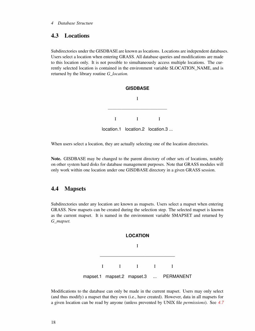
4 Database Structure
4.3 Locations
Subdirectories under the GISDBASE are known as locations. Locations are independent databases.Users select a location when entering GRASS. All database queries and modifications are madeto this location only. It is not possible to simultaneously access multiple locations. The cur-rently selected location is contained in the environment variable $LOCATION_NAME, and isreturned by the library routine G_location.
GISDBASE
I
—————————————
I I I
location.1 location.2 location.3 ...
When users select a location, they are actually selecting one of the location directories.
Note. GISDBASE may be changed to the parent directory of other sets of locations, notablyon other system hard disks for database management purposes. Note that GRASS modules willonly work within one location under one GISDBASE directory in a given GRASS session.
4.4 Mapsets
Subdirectories under any location are known as mapsets. Users select a mapset when enteringGRASS. New mapsets can be created during the selection step. The selected mapset is knownas the current mapset. It is named in the environment variable $MAPSET and returned byG_mapset.
LOCATION
I
————————————————–
I I I I I
mapset.1 mapset.2 mapset.3 ... PERMANENT
Modifications to the database can only be made in the current mapset. Users may only select(and thus modify) a mapset that they own (i.e., have created). However, data in all mapsets fora given location can be read by anyone (unless prevented by UNIX file permissions). See 4.7
18

4.5 Mapset Structure
Database Access Rules (p. 22) for more details. When users select a mapset, they are actuallyselecting one of the mapset directories.
Note. The full UNIX directory name for the current mapset is
$GISDBASE/$LOCATION_NAME/$MAPSETand is returned by the library routine G_location_path.
Note. Each location will have a special mapset called PERMANENT that contains non volatiledata for the location that all users will use. However, it also contains some information aboutthe location itself that is not found in other mapsets. See 4.6 Permanent Mapset (p. 21).
4.5 Mapset Structure
Mapsets will contain files and subdirectories, known as database elements. In the diagrambelow, the elements are indicated by a trailing /.
MAPSET
I
———————————————————————–
I I I I I I I
SEARCH_PATH WIND cats/ cell/ paint/ windows/ ...
4.5.1 Mapset Files
The following is a list of some of the mapset files used by GRASS programs:
files functionGROUP current imagery groupSEARCH_PATH mapset search pathWIND current region
This list may grow as GRASS grows. The GROUP file records the current imagery groupselected by the user, and is used only by imagery functions. The other two files are fundamentalto all of GRASS. These are WIND and SEARCH_PATH.
19

4 Database Structure
WIND is the current region.2 This file is created when the mapset is created and is modified bythe g.region command. The contents of WIND are returned by G_get_window. See 9.1 Region(p. 61) for a discussion of the GRASS region.
SEARCH_PATH contains the mapset search path. This file is created and modified by theg.mapsets command. It contains a list of mapsets to be used for finding database files. Whenusers enter a database file name without specifying a specific mapset, the mapsets in this searchpath are searched to find the file. Library routines that look for database files follow and usethe mapset search path. See 4.7.1 Mapset Search Path (p. 22) for more information about themapset search path.
4.5.2 Elements
Subdirectories under a mapset are the database elements. Elements are not created when themapset is created, but are created dynamically when referenced by the application programs.3
Mapset data reside in files under these elements.
The dynamic creation of database elements makes adding new database elements simple sinceno reconfiguration of existing mapsets is required. However, the programmer must be awareof the database elements already used by currently existing modules when creating new ele-ments. Furthermore, as development occurs outside USACERL, guidelines must be developedfor introducing new element names to avoid using the same element for two div erse purposes.
Programmers using shell scripts must exercise care. It is not safe to assume that a mapset hasall, or any, database elements (especially brand new mapsets). Certain GRASS commands au-tomatically create the element when it is referenced (e.g., g.ask). In general, however, elementsare only created when a new file is to be created in the element. It is wise to explicitly check forthe existence of database elements.
Here is the list of some of the elements used by GRASS modules written at USACERL:
element functioncell binary raster file (INT)fcell binary raster file (FLOAT/DOUBLE)cellhd header files for raster mapscats category information for raster mapscolr color table for raster mapscolr2 secondary color tables for raster mapscell_misc miscellaneous raster map support files (projection etc.)hist history information for raster maps
dig binary vector datadig_ascii ascii vector datadig_att vector attribute support
2Under GRASS 3.0 this was called the database ”window”. However, the term ”window” has many meanings.For clarity this term has been replaced by the term ”region”. The database files and programming interfaces,however, hav e not been renamed. Thus WIND now contains the current region.
3See 12.5.7 Creating and Opening a New Database File (p. 89).
20

4.6 Permanent Mapset
dig_cats vector category label supportdig_plus vector topology supportreg digitizer point registration
arc ascii ARC/INFO ungenerate files (for data exchange)bdlg binary dlg files (for data exchange)dlg ascii dlg files (for data exchange)dxf ascii DXF files (for data exchange)
camera camera specification files used by i.ortho.photoicons icon files used by p.mappaint label and comment files used by p.mapgroup imagery group support datasite_lists site lists for sites related moduleswindows predefined regions
COMBINE r.combine scriptsWEIGHT r.weight scripts
Note. The mapset database elements can be simple directory names (e.g., cats, colr) or mul-tilevel directory names (e.g., paint/labels, group/xyz/subgroup/abc). The library rou-tines thatcreate the element will create the top level directory and all subdirectories as well.
4.6 Permanent Mapset
Each location must have a PERMANENT mapset. This mapset not only contains original rasterand vector files that must not be modified, but also several special files that are only found inthis mapset. The files MYNAME and DEFAULT_WIND and are never modified by GRASSsoftware. The
MYNAME contains a single line descriptive name for the location. This name is returned bythe routine G_myname.
DEFAULT_WIND contains the default region for the location. The contents of this file arereturned by G_get_default_window. This file is used to initialize the WIND file when GRASScreates a new mapset. and can be used by the user as a reference region at any time.
PROJ_INFO contains detailed projection parameters.
PROJ_UNITS contains the projection units information.
21

4 Database Structure
4.7 Database Access Rules
GRASS database access is controlled at the mapset level. There are three simple rules:
1. A user can select a mapset as the current mapset only if the user is the owner of the mapsetdirectory (see 4.4 Mapsets (p. 18)).
2. GRASS will create or modify files only in the current mapset.
3. Files in all mapsets may be read by anyone (see 4.7.1 Mapset Search Path (p. 22)) unlessprohibited by normal UNIX file permissions (see 4.7.2 UNIX File Permissions (p. 22)).
4.7.1 Mapset Search Path
When users specify a new data file, there is no ambiguity about the mapset in which to createthe file: it is created in the current mapset. However, when users specify an existing data file, thedatabase must be searched to find the file. For example, if the user wants to display the ”soils”raster map, the system looks in the various database mapsets for a raster file named ”soils.” Theuser controls which mapsets are searched by setting the mapset search path, which is simply alist of mapsets. Each mapset is examined in turn, and the first ”soils” raster file found is the onethat is displayed. Thus users can access data from other users’ mapsets through the choice ofthe search path.
Users set the search path using the g.mapsets command.
Note. If there were more than one ”soils” file, the mapset search mechanism returns the first onefound. If the user wishes to override the search path, then a specific mapset could be specifiedalong with the file name. For example, the user could request that ”soils@PERMANENT” bedisplayed.
4.7.2 UNIX File Permissions
GRASS creates all files with read/write permission enabled for the owner and read only foreveryone else; directories are created with read/write/search permission enabled for the ownerand read/search only for everyone else.4 This implies that all users can read anyone else’s datafiles. Read access to all files in a mapset can be controlled by removing (or adding) the read andsearch permissions on the mapset directory itself using the GRASS g.access command, withoutadversely affecting GRASS programs. If read and search permissions are removed, then noother user will be able to read any file in your mapset.
4This means -rw-r–r–for files, and drwxr-xr-x for directories. It is accomplished by setting the umask to 022 in allGRASS programs.
22

4.8 Supported Projections
Warning. Since the PERMANENT mapset contains global database information, all users musthave read and search access to the PERMANENT mapset directory5 . Do not remove the readand search permissions from PERMANENT.
4.8 Supported Projections
GRASS Projection software is based on PROJ4 from USGS.
New site since 2000: http://www.remotesensing.org/proj/
ll -- Lat/Lonutm -- Universe Transverse Mercatorstp -- State Planeaea -- Albers Equal Arealcc -- Lambert Conformal Conicmerc -- Mercatortmerc -- Transverse Mercatorleac -- Lambert Equal Area Coniclaea -- Lambert Azimuthal Equal Areaaeqd -- Azimuthal Equidistantairy -- Airyaitoff -- Aitoffalsk -- Mod. Stererographics of Alaskaapian -- Apian Globular Iaugust -- August Epicycloidalbacon -- Bacon Globularbipc -- Bipolar conic of western hemisphereboggs -- Boggs Eumorphicbonne -- Bonne (Werner lat_1=90)cass -- Cassinicc -- Central Cylindricalcea -- Equal Area Cylindricalchamb -- Chamberlin Trimetriccollg -- Collignoncrast -- Craster Parabolic (Putnins P4)denoy -- Denoyer Semi-Ellipticaleck1 -- Eckert Ieck2 -- Eckert IIeck3 -- Eckert IIIeck4 -- Eckert IVeck5 -- Eckert Veck6 -- Eckert VIeqc -- Equidistant Cylindrical (Plate Caree)eqdc -- Equidistant Coniceuler -- Eulerfahey -- Faheyfouc -- Foucautfouc_s -- Foucaut Sinusoidalgall -- Gall (Gall Stereographic)gins8 -- Ginsburg VIII (TsNIIGAiK)
5PERMANENT has the DEFAULT_WIND and MYNAME files. This is a minor design flaw. Global databaseinformation should be kept in the database, but not in any of the mapsets. All mapsets could then be treatedequally.
23

4 Database Structure
gn_sinu -- General Sinusoidal Seriesgnom -- Gnomonicgoode -- Goode Homolosinegs48 -- Mod. Stererographics of 48 U.S.gs50 -- Mod. Stererographics of 50 U.S.hammer -- Hammer & Eckert-Greifendorffhatano -- Hatano Asymmetrical Equal Areaimw_p -- International Map of the World Polyconickav5 -- Kavraisky Vkav7 -- Kavraisky VIIlabrd -- Labordelagrng -- Lagrangelarr -- Larriveelask -- Laskowskilee_os -- Lee Oblated Stereographicloxim -- Loximuthallsat -- Space oblique for LANDSATmbt_s -- McBryde-Thomas Flat-Polar Sine (No. 1)mbt_fps -- McBryde-Thomas Flat-Pole Sine (No. 2)mbtfpp -- McBride-Thomas Flat-Polar Parabolicmbtfpq -- McBryde-Thomas Flat-Polar Quarticmbtfps -- McBryde-Thomas Flat-Polar Sinusoidalmil_os -- Miller Oblated Stereographicmill -- Miller Cylindricalmpoly -- Modified Polyconicmoll -- Mollweidemurd1 -- Murdoch Imurd2 -- Murdoch IImurd3 -- Murdoch IIInell -- Nellnell_h -- Nell-Hammernicol -- Nicolosi Globularnsper -- Near-sided perspectivenzmg -- New Zealand Map Gridob_tran -- General Oblique Transformationocea -- Oblique Cylindrical Equal Areaoea -- Oblated Equal Areaomerc -- Oblique Mercatorortel -- Ortelius Ovalortho -- Orthographicpconic -- Perspective Conicpoly -- Polyconic (American)putp1 -- Putnins P1putp2 -- Putnins P2putp3 -- Putnins P3putp3p -- Putnins P3’putp4p -- Putnins P4’putp5 -- Putnins P5putp5p -- Putnins P5’putp6 -- Putnins P6putp6p -- Putnins P6’qua_aut -- Quartic Authalicrobin -- Robinsonrpoly -- Rectangular Polyconicsinu -- Sinusoidal (Sanson-Flamsteed)somerc -- Swiss. Obl. Mercatorstere -- Stereographictcc -- Transverse Central Cylindricaltcea -- Transverse Cylindrical Equal Area
24

4.8 Supported Projections
tissot -- Tissottpeqd -- Two Point Equidistanttpers -- Tilted perspectiveups -- Universal Polar Stereographicurm5 -- Urmaev Vurmfps -- Urmaev Flat-Polar Sinusoidalvandg -- van der Grinten (I)vandg2 -- van der Grinten IIvandg3 -- van der Grinten IIIvandg4 -- van der Grinten IVvitk1 -- Vitkovsky Iwag1 -- Wagner I (Kavraisky VI)wag2 -- Wagner IIwag3 -- Wagner IIIwag4 -- Wagner IVwag5 -- Wagner Vwag6 -- Wagner VIwag7 -- Wagner VIIweren -- Werenskiold Iwink1 -- Winkel Iwink2 -- Winkel IIwintri -- Winkel Tripel
25

4 Database Structure
26

5 Raster Maps
This chapter provides an explanation of how raster map layers are accommodated in the GRASSdatabase1 .
5.1 What is a Raster Map Layer?
GRASS raster map layers can be conceptualized, by the GRASS programmer as well as theuser, as representing information from a paper map, a satellite image, or a map resulting fromthe interpretation of other maps. Usually the information in a map layer is related by a commontheme (e.g., soils, or landcover, or roads, etc.). GRASS raster data are stored as a matrix ofgrid cells. Each grid cell covers a known, rectangular (generally square) patch of land. Eachraster cell is assigned a single integer attribute value called the category number. For example,assume the land cover map covers a state park. The grid cell in the upper-left corner of themap is category 2 (which may represent prairie); the next grid cell to the east is category 3 (forforest); and so on.
land cover
2 3 3 3 4 42 2 3 3 4 42 2 3 3 4 41 2 3 3 3 41 1 1 3 3 41 1 3 3 4 4
1 = urban 3 = forest
2 = prairie 4 = wetlands
In addition to the raster file itself, there are a number of support files for each raster map layer.The files which comprise a raster map layer all have the same name, but each resides in adifferent database directory under the mapset. These database directories are:
1The descriptions given here are for GRASS 5.x data formats only. Previous formats, still supported by GRASSbut no longer generated, are described in documents from earlier releases of GRASS.
27
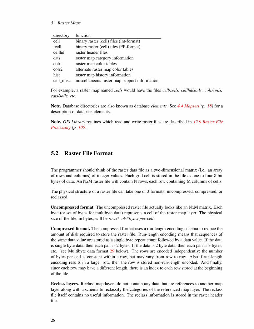
5 Raster Maps
directory functioncell binary raster (cell) files (int-format)fcell binary raster (cell) files (FP-format)cellhd raster header filescats raster map category informationcolr raster map color tablescolr2 alternate raster map color tableshist raster map history informationcell_misc miscellaneous raster map support information
For example, a raster map named soils would have the files cell/soils, cellhd/soils, colr/soils,cats/soils, etc.
Note. Database directories are also known as database elements. See 4.4 Mapsets (p. 18) for adescription of database elements.
Note. GIS Library routines which read and write raster files are described in 12.9 Raster FileProcessing (p. 105).
5.2 Raster File Format
The programmer should think of the raster data file as a two-dimensional matrix (i.e., an arrayof rows and columns) of integer values. Each grid cell is stored in the file as one to four 8-bitbytes of data. An NxM raster file will contain N rows, each row containing M columns of cells.
The physical structure of a raster file can take one of 3 formats: uncompressed, compressed, orreclassed.
Uncompressed format. The uncompressed raster file actually looks like an NxM matrix. Eachbyte (or set of bytes for multibyte data) represents a cell of the raster map layer. The physicalsize of the file, in bytes, will be rows*cols*bytes-per-cell.
Compressed format. The compressed format uses a run-length encoding schema to reduce theamount of disk required to store the raster file. Run-length encoding means that sequences ofthe same data value are stored as a single byte repeat count followed by a data value. If the datais single byte data, then each pair is 2 bytes. If the data is 2 byte data, then each pair is 3 bytes,etc. (see Multibyte data format 29 below). The rows are encoded independently; the numberof bytes per cell is constant within a row, but may vary from row to row. Also if run-lengthencoding results in a larger row, then the row is stored non-run-length encoded. And finally,since each row may have a different length, there is an index to each row stored at the beginningof the file.
Reclass layers. Reclass map layers do not contain any data, but are references to another maplayer along with a schema to reclassify the categories of the referenced map layer. The reclassfile itself contains no useful information. The reclass information is stored in the raster headerfile.
28

5.3 Raster Header Format
Multibyte data format. When the data values in the raster file require more than one byte, theyare stored in big-endian format2, which is to say as a base 256 number with the most significantdigit first.
Examples:
cell value base 256 stored as868 = 3*256 + 100 3 100137,304 = 2*256 � + 24*256 + 88 2 24 88174,058,106 = 10*256 � + 95*256 � + 234*256 + 122 10 95 234 122
Negative values are stored as a signed quantity, i.e., with the highest bit set to 13:
cell value base 256 stored as1 = -(1) 1 0 0 0 1868 = -(3*256 + 100) 1 0 0 3 100137,304 = -(2*256 � + 24*256 + 88) 1 0 2 24 88174,058,106 = -(10*256 � + 95*256 � + 234*256 + 122) 1 10 95 234 122
All data values in a given row are stored using the same number of bytes. This means that if thevalue 868, which uses 2 bytes, occurred in a row that uses 3 bytes to represent the largest datavalue, 868 would be stored as 0 3 100 .
Also, one row may only require 2 bytes to store its data values, another 4 bytes, and yet another1 byte. The rows are stored independently and would be stored using 2 bytes, 4 bytes, and 1byte respectively.
File portability. The multibyte format described above is (except possibly for negative values)machine independent. If raster files are to be moved to a machine with a different cpu, oraccessed using a heterogeneous network file system (NFS), the following guidelines should bekept in mind. All 5.0 format 4 raster files will transfer between machines, with two restrictions:(1) if the file contains negative values, the size of an integer on the two machines must be thesame; and (2) the size of the file must be within the seek capability of the lseek() call5.
5.3 Raster Header Format
The raster file itself has no information about how many rows and columns of data it contains,or which part of the earth the layer covers. This information is in the raster header file. The
2The fact that the values are stored big-endian should not be construed to mean that the machine architecture mustalso be big-endian. The programs which read raster files perform the necessary arithmetic to construct the value.They do NOT assume anything about byte ordering in the cpu.
3This means that the value is stored using as many bytes as required by an integer on the machine (usually 4).4The raster file format did not change from 3.0 to 4.x.5This usually means that the size of a long integer on the two machines is the same.
29

5 Raster Maps
format of the raster header depends on whether the map layer is a regular map layer or a reclasslayer.
Note. GIS Library routines which read and write the raster header file are described in 12.10.1Raster Header File (p. 113).
5.3.1 Regular Format
The regular raster header contains the information describing the physical characteristics of theraster file. The raster header has the following fields:
raster header
proj: 1zone: 18north: 4660000south: 4570000east : 770000west : 710000e-w resol: 50n-s resol: 100rows: 900cols: 1200format : 0compressed: 0
proj, zone The projection field specifies the type of cartographic projection6 :
� 0 is unreferenced x,y (imagery data)� 1 is UTM� 2 is State Plane� 3 is Latitude-Longitude� 99 other (see the PERMANENT/PROJ_INFO file for detailed definition)
Others may be added in the future. The zone field is the projection zone. In the exampleabove, the projection is UTM, the zone is 18.
north, south, east, west The geographic boundaries of the raster file are described by the north,south, east, and west fields. These values describe the lines which bound the map at itsedges. These lines do NOT pass through the center of the grid cells at the edge of themap, but along the edge of the map itself.
6State Plane is not yet fully supported in GRASS and Latitude-Longitude is still under development [GRASS5:???]
30

5.3 Raster Header Format
n-s resol, e-w resol The fields e-w resol and n-s resol describe the size of each grid cell in themap layer in physical measurement units (e.g., meters in a UTM database). They are alsocalled the grid cell resolution. The n-s resol is the length of a grid cell from north tosouth. The e-w resol is the length of a grid cell from east to west. As can be noted, cellsneed not be square.
rows, cols The fields rows and cols describe the number of rows and columns in the rastermatrix.
format The format field describes how many bytes per cell are required to represent the rasterdata. 0 means 1 byte, 1 means 2 bytes, etc. The value -1 indicates that it is a floatingpoint raster map which is stored in fcell/ subdirectory instead if cell/ subdirectory.
compressed The compressed field indicates whether the raster file is in compressed format ornot: 1 means it is compressed and 0 means it is not. If this field is missing, then the rasterfile was produced prior to GRASS 3.0 and the compression indication is encoded in theraster file itself.
Note. If the rows and columns of the raster matrix are not stored in the raster header, they arecomputed from the geographic boundaries as follows:
rows = (north - south) / (ns resol)
cols = (east - west) / (ew resol)
If the rows and columns of the raster matrix are stored in the raster header, the resolution valuesare computed from the geographic boundaries as follows:
ns resol = (north - south) / (rows)ew resol = (east - west) / (cols)
5.3.2 Reclass Format
If the raster file is a reclass file, the raster header does not have the information mentionedabove. It will have the name of the referenced raster file and the category reclassification table.
reclass header
31

5 Raster Maps
reclassname: countymapset: PERMANENT#5 first category in reclass1 5 is reclassified to 10 6 is reclassified to 01 7 is reclassified to 10 8 is reclassified to 02 9 is reclassified to 2
In this case, the library routines will use this information to open the referenced raster file inplace of the reclass file and convert the raster data according to the reclass scheme. Also, thereferenced raster header is used as the raster header.
5.4 Raster Category File Format
The category file contains the largest category value which occurs in the data, a title for the maplayer, an automatic label generation capability, and a one line label for each category.
category file
# 5 categoriestitle for map layer<automatic label format><automatic label parameters>0:no data1:description for category 12:description for category 23:description for category 35:description for category 5
The number which follows the # on the first line is the largest category value in the rasterfile. The next line is a title for the map layer. The next two lines are used for automatic labelgeneration. They are used to create labels for categories which do not have explicit labels. (Theautomatic label capability is not normally used in most map layers, in which case the formatline is a blank line and the parameters line is: 0.0 0.0 0.0 0.0.) Category labels follow on theremaining lines. The format is cat : label.
The first four lines of the file are required. The remaining lines need only appear if categoriesare to be labeled.
32

5.5 Raster Color Table Format
Note. GIS Library routines which read and write the raster category file are described in 12.10.2Raster Category File (p. 114).
GRASS 5.x category table file
� The Categories table file is now upgraded to support floating-point ranges of values forfp maps. So instead of
cat1:description
the format is the same for integer maps, but in addition the new format for floating pointmap is supported.
val1:val2:description
or
val1:description
where value1 and value2 are floating-point numbers.
� All support functions (e.g. range, cell_stats, colors) should assume that the data hasembedded NULL values.
5.5 Raster Color Table Format
The GRASS raster color tables and associated programming interface have undergone a fairlymajor revision to resolve problems presented by raster maps that have a large range of datavalues. The previous design7 used arrays to store a color for each data value between theminimum and maximum values in the raster map. This array structure was also reflected inthe format of the color table file–each color stored as a single line in the color file. BecauseGRASS raster maps can have data values in the range � 21474836478 this method of storingcolor information is clearly untenable.
Since GRASS 4.x the above problem is solved by representing color tables as linear rampsfor intervals of data values. Colors are specified (and stored) for the endpoints of each interval.Colors for values between endpoints are not stored but are computed using a linear interpolationscheme.
The following is an example 4.x color file:
4.x color table file
% 1387 1801
7GRASS 3.x8These values are for 32-bit architectures.
33

5 Raster Maps
1387:255:85:851456:170:170:0
colors for categories1387-1456
1456:170:170:01525:85:255:85
colors for categories1456-1525
1525:85:255:851594:0:170:170
colors for categories 15251594
1594:0:170:1701663:85:85:255
colors for categories1594-1663
1663:85:85:2551732:170:0:170
colors for categories1663-1732
1732:170:0:1701801:255:85:85
colors for categories1732-1801
The first line is a % character (to indicate that this is a 4.x format color file) and two numbersindicating the minimum and maximum data values which have colors. The rest of the file arethe color descriptors. In this example, the minimum and maximum values are 1387 and 1801.Looking at the first color line, the color for category 1387 is red=255, green=85, blue=85;the color for category 1456 is red=170, green=170, blue=0.9 The color for category 1400 iscalculated from the colors for categories 1387 and 1456:
red= interpolate(255,170) = 239
green = interpolate(85,170) = 101
blue = interpolate(85,0) = 69
There are other formats which are simply variants of this format. For example, if the red, green,and blue intensities are all the same, then only the ”red” value appears. This next exampledefines a gray scale color table:
4.x color table file
% 1387 1801
1387:0 1801:255
Also, if the starting and ending categories are the same, only the first appears:9The colors are represented as levels of red, green, and blue, where 0 represents the lowest intensity and 255
represents the highest intensity
34

5.6 Raster History File Format
4.x color table file
%1 6
1:34:179:112
2:233:110:15
3:127
4:43:135:33
5:70:7:52
6:93:210:163
Note. GIS Library routines which read and write the raster color table are described in 12.10.3Raster Color Table (p. 116).
GRASS 5.x color table file
� All support functions (e.g. range, cell_stats, colors) should assume that the data has em-bedded NULL values.
� The color table file is now upgraded to support floating-point ranges of values. So insteadof
cat1:red:grn:blu cat2:red:grn:blu
the format is now
value1:red:grn:blu value2:red:grn:blu
where value1 and value2 are floating-point numbers. Also now color table file cancontain entries of the form
*:red:grn:blu
default color (this sets the rgb for all values for which no explicit rgb values were definedin the color table)
nv:red:grn:blu
(this sets color for drawing "no data" cells
5.6 Raster History File Format
The history file contains historical information about the raster map: creator, date of creation,comments, etc. It is generated automatically along with the raster file. In most applications,
35

5 Raster Maps
the programmer need not be concerned with the history file. Occasionally a module might putinformation into this file not known or readily available to the user, such as information abouta satellite image: sun angles, dates, etc. The GRASS r.info module allows the user to view thisinformation, and the r.support module allows the user to update it. It is the user’s responsibilityto maintain this file.
Note. GIS Library routines which read and write the raster history file are described in 12.10.3.4.1Raster History File (p. 121).
5.7 Raster Range File Format
The range file contains the minimum and maximum values which occur in a raster file. Itis generated automatically for all new raster files. This file lives in the cell_misc element as”cell_misc/name/range” where name is the related raster file name. It contains one line with fourinteger values. These represent the minimum and maximum negative values, and the minimumand maximum positive values in the raster file. If there are no negative values, then the first pairof numbers will be zero. If there are no positive values, then the second pair of numbers will bezero.
Note. GIS Library routines which read and write the raster range file are described in 12.10.4Raster Range File (p. 122).
5.8 Raster Maps: Floating-Point / NULL support (draft, needs tobe merged into tutorial!)
FP-AUTHORS:
Michael ShapiroOlga Waupotitsch
5.8.1 Objectives
� Provide support for floating point values in raster maps in a cpu-independent format withlittle or no loss of precision.
� Provide an explicit NULL value, for both integer and floating point raster maps, that isdistinct from any number (e.g. different than zero).
5.8.2 Design decisions
This subsection describes some of the design decisions that have been made so far.
36

5.8 Raster Maps: Floating-Point / NULL support (draft, needs to be merged into tutorial!)
5.8.2.1 Floating-point maps
� Sun’s eXternal Data Representation (XDR) format and the vendor supplied XDR C-APIwill be used to read and write floating point numbers to disk.
� Floating-point data will be written to a file in a new fcell directory and an empty filecreated in the cell directory.
� for each operation on raster data that there will be one generic routine with 3 specific rou-tines: G_something_raster (..., void *raster, RASTER_MAP_TYPE type, ...) G_something_c_raster(..., CELL *cell, ...) G_something_f_raster (..., FCELL *fcell, ...) G_something_d_raster(..., DCELL *dcell, ...) For null-related operations on raster data the functions will be:G_something_null_value (..., void *raster, RASTER_MAP_TYPE type, ...) G_something_c_null_value(..., CELL *cell, ...) G_something_f_null_value (..., FCELL *fcell, ...) G_something_d_null_value(..., DCELL *dcell, ...) For null-related operations on raster data the functions will
� When programs write floating-point maps and they do not explicitly specify the storagetype, the storage type defaults to float, unless the user sets the Unix environment vari-able GRASS_FP_DOUBLE, which changes the default to double.
� Any map can be read either as floating-point or as integer, independently of the actualstorage type, with the following rules for type conversion:
– Conversion from int to float or to double will be by C-language promotion.
– Conversion from double to float will be by C-language demotion (with subse-quent loss of precision)
– Conversion from float or double to int will be by a flexible on-the-fly quan-tization.
� Any map can be written using floating-point or integer buffers. Any of the C-languagenumber types (int, float, double) can be used to write to the raster map, but ifthe type doesn’t match the resultant storage type (which is determined when the map isopened), the following rules apply:
– Conversion from int to float or to double will be by C-language promotion.
– Conversion from double to float will be by by C-language demotion (withsubsequent loss of precision)
– Conversion from float or double to int will be by C-language truncation tointeger.
� Allow storing floating-point either as 4-byte floats or 8-byte doubles. The usershould have some control as to whether floating-point values are be written as doubles(greater precision at higher disk use) or floats (less precision as lower disk use).
� Provide an interface to determine the storage type (int, float, double)
� Provide two methodologies for accessing NULL values when reading maps:
– Embedding the NULL value in the raster data buffers
– Reading a buffer of NULL value booleans flags.
37

5 Raster Maps
� All support functions (e.g. range, cell_stats, colors) should assume that the data hasembedded NULL values.
� The color table file is now upgraded to support floating-point ranges of values. So insteadof
cat1:red:grn:blu cat2:red:grn:blu
the format is now
value1:red:grn:blu value2:red:grn:blu
where value1 and value2 are floating-point numbers. Also now color table file cancontain entries of the form
*:red:grn:blu
default color (this sets the rgb for all values for which no explicit rgb values were definedin the color table)
nv:red:grn:blu
(this sets color for drawing "no data" cells
� The Categories table file is now upgraded to support floating-point ranges of values forfp maps. So instead of
cat1:description
the format is the same for integer maps, but in addition the new format for floating pointmap is supported.
val1:val2:description
or
val1:description
where value1 and value2 are floating-point numbers.
� Support files needed for floating-point maps will be under the cell_misc directory:
cell_misc/<map>/f_format This ascii file contains information about the formatof the floating point data: float/double, compression, XDR indicator. For example:
type: floatbyte_order: xdrlzw_compression_bits: 9
This file is read and written using the Key_Value functions in the GISLIB. Thebyte_order and lzw_compression are write-only and are for documentation (and fu-ture upgrades). The type is one of float or double and indicates the storage typefor the floating-point values in the map.
cell_misc/<map>/f_range This binary file contains the range (minimum and max-imum) of the floating point data written to the map.
cell_misc/<map>/f_quant This ascii file contains rules specifying how to quan-tize the floating point values into integers. The format is, one rule per line:
38

5.8 Raster Maps: Floating-Point / NULL support (draft, needs to be merged into tutorial!)
value1:value2:cat1:cat2
where value1 and value2 are a range of floating point values, with * indicating(positive or negative) infinity; cat1 and cat2 are a range of integer values, with cat2optional. The rule is a linear interpolation from a floating-point value in the range[value1,value2] to an integer in the range [cat1,cat2].
5.8.2.2 NULL-values
� The NULL values will not be written to the raster map itself; a zero will be written as aplace holder. NULL value flags will be written as a separate file under the cell_miscdirectory as cell_misc/<map>/null. This file will be a bitmap with ones indicatingthat the corresponding cell contains valid data, and zeros indicating that the correspondingcell contains a NULL value.
� Internally within programs, the NULL value can either be processed as a special bit pat-tern embedded in the raster data, or as a separate char array of flags. The bit pattern usedfor integer is the largest positive integer. The bit pattern for floating point number is one(of many) NaN bit patterns. This bit pattern will never be written to the raster data file.
� For maps which do not have a NULL bitmap file, zeros are translated to NULL whenthe map is read. (NOTE: is this behaviour is not desirable, use G_get_map_row() theold "read row" function. It reads all 0’s and nulls as 0’s) See REF description forG_get_map_row() for more info.
� In addition to NULL values within the raster file, NULL values are be generated auto-matically by both the MASK and the region (if the region extends beyond the extent ofthe raster map).
39

5 Raster Maps
40

6 Vector Maps
This chapter provides an explanation of how vector map layers are accommodated in the GRASSdatabase.
6.1 What is a Vector Map Layer?
GRASS vector maps are stored in an arc-node representation, consisting of curves called arcs.An arc is stored as a series of x,y coordinate pairs.1 The two endpoints of an arc are callednodes. Tw o consecutive x,y pairs define an arc segment.2
The arcs, either singly, or in combination with others, form higher level map features: lines3
(e.g., roads or streams) or areas 4 (e.g., farms or forest stands). Arcs that form linear featuresare sometimes called lines, and arcs that outline areas are called area edges or area lines.5
Each map feature is assigned a single integer attribute value called the category number. Forexample, assume a vector file contains land cover information for a state park. One area may beassigned category 2 (perhaps representing prairie); another is assigned category 3 (for forest);and so on. Another vector file which contains road information may have some roads assignedcategory 1 (for paved roads); other roads may be assigned category 2 (for gravel roads); etc. See5.1 What is a Raster Map Layer? (p. 27) for more information about GRASS category values.
A vector map layer is stored in a number of data files. The files which comprise a single vectormap layer all have the same name, but each resides in a different database directory under themapset.6 These database directories are:
directory functiondig binary arc file
1For this reason arcs are also called vectors.2Arc segments are sometimes called line-segments.3A line here does not mean a straight line between two points. It only means a linear feature.4Areas are also called polygons. The GRASS vector format does not store the polygons explicitly. They are
constructed by finding the particular arcs which form the polygon perimeter.5Obviously, there is some confusion in the GIS vector terminology. This is partly due to use of terms that have a
common meaning as well as a mathematical meaning. Vector terminology is a subject for much debate in theGIS world.
6Database directories are also called elements. See 4.4 Mapsets (p. 18) for a description of database elements.
41

6 Vector Maps
dig_ascii ascii arc filedig_att vector category attribute filedig_cats vector category labelsdig_plus vector index/pointer filereg digitizer registration points
For example, a map layer named soils would have the files dig/soils, dig_att/soils, dig_plus/soils,dig_ascii/soils, dig_cats/soils, reg/soils, etc.
paste vect.xfig diagram here [GRASS 5: missing since 1993]
Note. Vector files are also called digit files, since they are created and modified by the GRASSdigitizing module v.digit.
Note. When referring to one of the vector map layer files, the directory name is used. Forexample, the file under the dig directory is called the dig file.
Note. Library routines which read and write vector files are described in 13 Vector Library (p.219).
6.2 Ascii Arc File Format
The arc information is stored in a binary format in the dig file. The format of this file is reflectedin the ascii representation stored in the dig_ascii file. It is the ascii version which is describedhere.7
The dig_ascii file has two sections: a header section, and a section containing the arcs.
6.2.1 Header Section
The header contains historical information, a description of the map, and its location in the uni-verse. It consists of fourteen entries. Each entry has a label identifying the type of information,followed by the information. The format of the header is:
label format description
7The programs v.import, v.in.ascii, and v.out.ascii convert between the ascii and binary formats.
42

6.2 Ascii Arc File Format
ORGANIZATION: text (max 29 characters)* organization that digitized the dataDIGIT DATE: text (max 19 characters)* date the data was digitizedDIGIT NAME: text (max 19 characters)* person who digitized the dataMAP NAME: text (max 40 characters)* title of the original source mapMAP DATE: text (max 10 characters)* date of the original source mapOTHER INFO: text (max 72 characters)* other comments about the mapMAP SCALE: integer scale of the original source mapZONE: integer zone of the map (e.g., UTM zone)WEST EDGE: real number (double) western edge of the entire mapEAST EDGE: real number (double) eastern edge of the entire mapSOUTH EDGE: real number (double) southern edge of the entire mapNORTH EDGE: real number (double) northern edge of the entire mapMAP THRESH: real number (double) digitizing resolutionVERTI: (no data) marks the end of the header section
* Currently, GRASS modules which read the header information are not tolerant of text fieldswhich exceed these limits. If the limits are exceeded, the ascii to binary conversion will probablyfail.
++The edges of the map describe a region which should encompass all the data in the vectorfile.
+++The MAP THRESH is set by the v.digit module. If the data comes from outside GRASS,this field can be set to 0.0.
The labels start in column 1 and continue through column 14. Labels are uppercase, left justi-fied, end with a colon, and blank padded to column 14. The information starts in column 15.For example:
ORGANIZATION: GRASS Development Team
DIGIT DATE: 03/18/99
DIGIT NAME: grass
MAP NAME: Urbana, IL.
MAP DATE: 1975
OTHER INFO: USGS sw/4 urbana 15’ quad. N4000-W8807.5/7.5
MAP SCALE: 24000
ZONE: 16
WEST EDGE: 383000.00
EAST EDGE: 404000.00
43

6 Vector Maps
SOUTH EDGE: 4429000.00
NORTH EDGE: 4456000.00
MAP THRESH: 0.00
VERTI:
6.2.2 Arc Section
The arc information appears in the second section of the dig_ascii file (following VERTI:which marks the end of the header section). Each arc consists of a description entry, followedby a series of coordinate pairs. The description specifies both the type of arc (A for area edge,or L for line8 ), and the number of points (coordinate pairs) in the arc. Then the points follow.
For example:
A 5
4434456.04 388142.16
4434446.65 388202.64
4434407.49 390524.38
4434107.06 390523.59
4433326.51 390526.48
L 3
4434862.31 392043.33
4434872.42 394662.14
4434871.44 398094.75
A 3
4454747.38 396579.60
4454722.69 393539.73
4454703.68 390786.90
In this example, the first arc is an area edge and has 5 points. The second arc is part of a linearfeature and has 3 points. The third arc is another area edge and has 3 points.
8Other types may be added in the future.
44

6.3 Vector Category Attribute File
The arc description has the letter A or L in the first column, followed by at least one space, andfollowed by the number of points.9
Point entries start with a space, and have at least one space between the two coordinate values.10
Note. The points are stored as y,x (i.e., north, east), which is the reverse of the way GRASSusually represents geographic coordinates.
Note. If the v.digit module has deleted an arc, the arc type will be represented using a lowercase letter (i.e., l instead of L, a instead of A ). Of course, this will only be manifest when abinary dig file with a deleted arc is converted to the ascii dig_ascii file.
6.3 Vector Category Attribute File
As was mentioned in 6.1 What is a Vector Map Layer? (p. 41), each feature in the vector maplayer has a category number assigned to it. The category number for each map feature is notstored in the dig file itself, but in the dig_att file. The dig_att file is an ascii file that has multipleentries, each with the same format. Each entry refers to one map feature, and specifies thefeature type (area or line), an x,y marker, and a category number.
For example:
A 389668.32 4433900.99 7
L 395103.96 4434881.19 2
In this example, an area feature is assigned category 7, and a linear feature is assigned category2.
The x,y marker is used to find the map feature in the dig file. It must be located so that ituniquely identifies its related map feature. In particular, an area marker must be inside the area,and a line marker must be closer to its related line than to any other line (preferably on the line)and not at a node.
If multiple entries identify the same map feature, only one will be used (currently thee lastentry).
A map feature which has no entry in this file is considered to be unlabeled. This means thatduring the vector to raster conversion (i.e., v.to.rast), unlabeled areas will convert as categoryzero, and unlabeled lines will be ignored.
The format of this file is rather strict, and is described in the following table:
columns Data1 Type of map feature (A or L)*
9This can be written with the Fortran format: A1,1X,I4.10These can be written with the Fortran format: 2(1X,F12.2).
45

6 Vector Maps
2-3 Spaces4-15 Easting (x) of the marker, right justified
16-17 Spaces18-29 Northing (y) of the marker, right justified30-31 Spaces32-39 Category number, right justified40-49 Spaces
50 Newline �
* Other types, such as point, may be allowed in the future.
� UNIX text files are terminated with a newline. Therefore, each entry will appear as 49 char-acters. The entire file size should be a multiple of 50.
This format is required by modules which modify the vector map (e.g., v.digit). Programs whichonly read the vector map accept a looser format: the feature type must start in column 1; theitems must be separated by at least one space; and the entries must be less than 50 characters.Also, the module v.support will convert the looser format to this stricter format.
Note. The marker is specified as x,y (i.e., east, north), which is the way GRASS usually repre-sents geographic coordinates, but which is reverse of the way the arcs are stored in the dig_asciifile.
6.4 Vector Category Label File
Each category in the vector map layer may have a one-line description. These category labelsare stored in the dig_cats file. The format of this file is identical to the raster category filedescribed in 12.10.2 Raster Category File (p. 114), and the reader is referred to that section fordetails.
Note. The module v.support allows the user to enter and modify the vector category labels. Themodule v.to.rast copies the dig_cats file to the raster category file during the vector to rasterconversion.
Note. Library routines which read and write the dig_cats file are described under 12.12.6 VectorCategory File (p. 165).
6.5 Vector Index and Pointer File
The dig_plus file contains information that accelerates vector queries. It is created by the mod-ule build.vect (which is run by v.digit when a vector file is created or modified, and by v.support
46

6.6 Digitizer Registration Points File
at user request) from the data in the dig and dig_att files. For this reason, and since the internalstructure of the dig_plus file is complex, the format of this file will not be described.
6.6 Digitizer Registration Points File
The reg file is an ascii file used by the v.digit module to store map registration control points.Each map registration point has one entry with the easting and northing of the map controlpoint. For example:
383000.000000 4429000.000000
383000.000000 4456000.000000
404000.000000 4456000.000000
404000.000000 4429000.000000
Note. This file is used by v.digit only. It is not used by any other module in GRASS.
6.7 Vector Topology Rules
The following rules apply to the vector data:
1. Area edges should not cross each other (i.e., arcs which would cross must be split at theirintersection to form distinct arcs), otherwise topology for the map may not be build correctly.
2. Arcs which share nodes must end at exactly the same points (i.e., must be snapped together).This is particularly important since nodes are not explicitly represented in the arc file, but onlyimplicitly as endpoints of arcs.
3. Common boundaries should appear only once (i.e., should not be double digitized).
4. Areas must be explicitly closed. This means that it must be possible to complete each area byfollowing one or more area edges that are connected by common nodes, and that such tracingsresult in closed areas.
5. It is recommended that area features and linear features be placed in separate layers. Howeverif area features and linear features must appear in one layer, common boundaries should bedigitized only once. An area edge that is also a line (e.g., a road which is also a field boundary),should be digitized as an area edge (i.e., arc type A ) to complete the area. The area featureshould be labeled as an area (i.e., feature type A in the dig_att file). Additionally, the commonboundary arc itself (i.e., the area edge which is also a line) should be labeled as a line (i.e.,feature type L in the dig_att file) to identify it as a linear feature.
47

6 Vector Maps
Note that planar enforcement is not present on vector library level, and both line and area edgefeature may be written to the vector so that cross themselves in the same file. To get correcttopology for area edges, required above, cleaning modules must be applied on the vector file.
6.8 Importing Vector Files Into GRASS
The following files are required or recommended for importing vector files from other systemsinto GRASS:
dig_ascii
The dig_ascii file, described in 6.2 Ascii Arc File Format (p. 42), is required.
dig_att
The dig_att file, described in 6.3 Vector Category Attribute File (p. 45), is essentially required.While the dig_ascii file alone is sufficient for simple vector display, the dig_att file is requiredfor vector to raster conversion, as well as more sophisticated vector query.
dig_cats
The dig_cats file, described in 6.4 Vector Category Label File (p. 46), while not required, allowsmap feature descriptions to be imported as well.
Note. The dig_plus file, described in 6.5 Vector Index and Pointer File (p. 46), is created by theGRASS module v.import when converting the dig_ascii file to the binary dig file.
48

7 Point Data: Site List Files
Chapter status: Needs further updates!
This chapter describes how point data is currently accommodated in the GRASS database.
7.1 What is a Site List?
Point data is currently stored in ascii files called site lists or site files. These files are used by thesites modules. The site list files were designed for use by these modules, but have since becomethe principal data structure for point data.
7.2 GRASS 5 Site File Format
Site files are ascii files stored under the site_lists database element.1 The format of a site file isbest explained by two examples:
name � sample
desc � sample site list
728220 � 5182440 � #27 %1.34 %23.13 @"pH 7.1"
727060 � 5181710 � #28 %2.32 %22.21 @"pH 6.8"
725500 � 5184000 � #29 %4.73 %17.34 @"pH 5.5"
719800 � 5187200 � #30 %3.65 %27.79 @"pH 6.2"
name � sample
desc � sample site list
728220 � 5182440 � 10 � #27 %1.34 %23.13 @"string 1a" @"string 2a"
728220 � 5182440 � 20 � #28 %1.52 %32.81 @"string 1b" @"string 2b"
1See 4.5.2 Elements (p. 20) for an explanation of database elements.
49

7 Point Data: Site List Files
728200 � 5182440 � 30 � #29 %0.23 %43.54 @"string 1c" @"string 2c"
717060 � 5181710 � 10 � #30 %2.32 %22.21 @"string 1d" @"string 2d"
[GRASS 5: date field!!!]
name This line contains the name of the site list file, and is printed on all the reports generatedby the s.menu module. The word name must be all lower case letters.
It is permissible for this line to be missing, since the s.menu module will add a namerecord using the name of the site list file itself.
desc This line contains a description of the site list file, and is printed on all the reports gener-ated by the s.menu module. The word desc must be all lower case letters.
It is also permissible for this line to be missing, in which case the site list will have nodescription.
points The remaining lines are point records. Each site is described by a point record.
The format for this record is:2
east|north[|dim]...|#cat %double [%double] @string [@string]
or specifying a date/time record:
east|north[|dim]...|time %double [%double]
The east and north fields represent the geographic coordinates (easting and northing) ofthe site.
The description field holds a single integer and is compulsory. Please read 12.13 Site ListProcessing (GRASS 5 Sites API) (p. 166) for further details. The new sites format inGRASS 5.0 allows multiple dimensions and multiple attributes with strings and decimalssupport.
Examples:
name|soildesc|form|||%labels|Easting|Northing|%No Label3566177.5|5763062.5|%161.19 @clay3566182.5|5763062.5|%161.19 @"sandy soil"3566187.5|5763062.5|%160.53 @clay
name|timedesc|Example of using time as an attributetime|Mon Apr 17 14:24:06 EST 199510.8|0|9.8|Fri Sep 13 10:00:00 1986 %31.411|5.5|9.9|Fri Sep 14 00:20:00 1985 %36.45.1|3.9|10|Fri Sep 15 00:00:30 1984 %28.4
2The pipe character (" � ") is used to separate the dimension fields in the records, blank spaces are used to separatedecimal and string descriptions.
50

7.3 Programming Interface to Site Files
This data has three dimensions (assume easting, northing, and elevation), five string at-tributes, and one decimal attribute.
comments Blank lines, and lines beginning with #, are accepted (and ignored).
7.3 Programming Interface to Site Files
The programming interface to the site list files is described in 12.13 Site List Processing (GRASS5 Sites API) (p. 166) and the programmer should refer to that section for details.
51

7 Point Data: Site List Files
52
8 Image Data: Groups
Chapter status: Needs further updates!
This chapter provides an explanation of how imagery data are accommodated in the GRASSdatabase.
8.1 Introduction
Remotely sensed images are captured for computer processing by satellite or airborne sen-sors by filtering radiation emanating from the image into various electromagnetic wavelengthbands, converting the overall intensity for each band to digital format, and storing the values oncomputer compatible media such as magnetic tape. Color and color infrared photographs areoptically scanned to convert the red, green, and blue wavelength bands in the photograph into adigital format as well.
The digital format used by image data is basically a raster format. GRASS imagery modules1
which extract image data from magnetic tape extract the band data into raster cell files in aGRASS database. Each band becomes a separate cell file, with standard GRASS data layersupport, and can be displayed and analyzed just like any other cell file. However, since theband files are extracted as individual cell files, it is necessary to have a mechanism to maintain arelationship between band files from the same image as well as cell files derived from the bandfiles. The GRASS group database structure accomplishes this goal.
8.2 What is a Group?
The group is a database mechanism which provides the following:
1. A list of related cell files,
2. A place to store control points for image registration and rectification, and
3. A place to store spectral signatures, image statistics, etc., which are needed by imageclassification procedures.
1See 8.4 Imagery Modules (p. 58) for a list of the major GRASS imagery modules.
53

8 Image Data: Groups
8.2.1 A List of Cell Files
The essential feature of a group is that it has a list of cell files that belong in the group. Thesecan be band data extracted from the same data tape, or cell files derived from the original bandfiles.2 Therefore, the group provides a convenient "handle" for related image data; i.e., referringto the group is equivalent to referring to all the band files at once.
8.2.2 Image Registration and Rectification
The group also provides a database mechanism for image registration and rectification. Theband data extracted from tapes are usually unregistered data. This means that the GRASS soft-ware does not know the Earth coordinates for pixels in the image. The only coordinates knownat the time of extraction are the columns and the rows relative to the way the data was stored onthe tape.
Image registration is the process of associating Earth coordinates with pixels on the image. Im-age rectification is the process of converting the image files to the new coordinate system basedon the registration.
Image registration is applied to a group, rather than to individual cell files. The user displaysany of the cell files in a group on the graphics monitor and then marks control points on theimage, assigning Earth coordinates to each control point. The control points are stored in thegroup, allowing all related group files to be registered in one step rather than individually.
Image rectification is applied to individual cell files, with the control points for the group usedto control the rectification. The rectified cell files are placed into another database3 known asthe target database. Rectification can be applied to any or all of the cell files associated with agroup.
8.2.3 Image Classification
Image classification methods process all or a subset of the band files as a unit. For example,a clustering algorithm generates spectral signatures which are then used by a maximum likeli-hood classifier or other algorithm to produce a landcover map.
Sometimes only a subset of the band files are used during image classification. The signaturesmust be associated only with the cell files actually used in the analysis. Therefore, within a
2Derived cell files can be the results of image classification procedures such as clustering and maximum likelihood,or band ratios formed using r.mapcalc, etc.
3Either a projected database, such as UTM, or an unregistered database (xy), if the image is being registered toanother image.
54

8.3 The Group Structure
group, subgroups can be formed which list only the band files to be "subgrouped" for classifica-tion purposes. The signatures are stored with the subgroup. Multiple subgroups can be createdwithin a group, which allows different classifications to be run with different combinations ofband files.
8.3 The Group Structure
Groups live in the GRASS database under the group database element.4 The structure of agroup can be seen in the following diagram. A trailing / indicates a directory.
group/
I
——————————————————————-
I I I I I
tm.may90/ nhap.jun98/ nhap.oct98/ tm.apr99/ ...
tm.apr99/
I
———————————————————
I I I I
REF POINTS TARGET subgroup/
In this example, the groups are named tm.may90 , nhap.jun98 , etc.5 Note that each groupis itself a directory. Each group contains some files (REF , POINTS ,and TARGET), and asubdirectory (subgroup).
8.3.1 The REF File
The REF file contains the list of cell files associated with the group. The format is illustratedbelow:
4See 4.5.2 Elements (p. 20) for an explanation of database elements.5The group names are chosen by the user.
55

8 Image Data: Groups
tm.apr99.1 grasstm.apr99.2 grasstm.apr99.3 grasstm.apr99.4 grasstm.apr99.5 grasstm.apr99.7 grass
Each line of this file contains the name and mapset of a cell file. In this case, there are sixcell files in the group: tm.apr99.1 , tm.apr99.2 , tm.apr99.3 , tm.apr99.4 , tm.apr99.5 andtm.apr99.7 without thermal tm.apr99.6 in mapset grass. (Presumably these are bands 1-5 and7 from an April 99 Landsat Thematic Mapper image.)
8.3.2 The POINTS File
The POINTS file contains the image registration control points. This file is created and modifiedby the i.points module. Its format is illustrated below:
# image target status# east north East north (1=ok)
#504.00 -2705.00 379145.30 4448504.56 1458.00 -2713.00 378272.67 4448511.67 1
2285.80 -2296.00 415610.08 4450456.17 12397.00 -2564.00 417043.22 4444757.65 02158.00 -2944.00 411037.79 4438210.97 12148.00 -2913.00 410834.61 4438656.18 02288.80 -2336.20 415497.19 4449671.77 1
The lines which begin with # are comment lines. The first two columns of data (under image )are the column (i.e., east ) and row (i.e., north6 ) of the registration control points as marked onthe image. The next two columns (under target ) are the east and north of the marked points inthe target database coordinate system (in this case, a UTM database). The last column (understatus ) indicates whether or not the control point is well placed.7 (If it is ok, then it will be usedas a valid registration point. Otherwise, it is simply retained in the file, but not used.)
6Note that the row values are negative. This is because GRASS requires the northings to increase from south tonorth. Negative values accomplish this while preserving the row value. The true image row is the absolute value.[GRASS 5: ?????????]
7The user makes this decision in i.points.
56

8.3 The Group Structure
8.3.3 The TARGET File
The TARGET file contains the name of the target database; i.e., the GRASS database mapsetinto which rectified cell files will be created. The TARGET file is written by i.target and hastwo lines:
spearfishgrass
The first line is the GRASS location (in this case spearfish ), and the second is a mapset withinthe location (in this case grass ).
8.3.4 Subgroups
The subgroup directory under a group has the following structure:
subgroup/
I
—————————————————-
I I I I
123/ 234/ 1357/ ...
1357/
I
—————–
I I
REF sig/
I
—————–
I I
cluster.1 cluster.2
57

8 Image Data: Groups
In this example, the subgroups are named 123, 234, 1357, etc.8 Within each subgroup, there isa REF file and a sig directory. The REF file would list a subset of the cell files from the group.In this example, it could look like:
tm.apr99.1 grasstm.apr99.3 grasstm.apr99.5 grasstm.apr99.7 grass
indicating that the subgroup is composed of bands 1, 3, 5, and 7 from the April 1999 TM scene.The files cluster.1 and cluster.2 9 under the sig directory contain spectral signature information(i.e., statistics) for this combination of band files. The files were generated by different runs ofthe clustering module i.cluster.
8.4 Imagery Modules
The following is a list of some of the imagery modules in GRASS, with a brief description ofwhat they do. Refer to the GRASS 5 User’s Reference Manual for more details.
image extraction
i.tape.mss Landsat Multispectral Scanner data
i.tape.tm Landsat Thematic Mapper data
i.tape.spot SPOT Satellite data
i.tape.other other formats, such as scanned aerial photography or SPOT satellite data
i.in.pri ERS1/2 CEOS RADAR reader for PRI products
i.in.gtc ERS1/2 CEOS RADAR reader for GTC products
image rectification
i.ortho.photo ortho photo generation
i.points image registration (assign control points) to raster reference
i.vpoints image registration (assign control points) to vector reference
i.rectify image rectification (linear)
i.rectify2 image rectification (polynomial)
8The subgroup names are chosen by the user (hopefully reflecting the contents of the subgroup).9Again, these file names are chosen by the user.
58

8.5 Programming Interface for Groups
image classification
i.cluster unsupervised clustering
i.maxlik maximum likelihood classifier
i.smap sequential maximum a posteriori classifier
other
i.group image group management
i.target establish target database for the group
8.5 Programming Interface for Groups
The programming interface to the group data is described in 14 Imagery Library (p. 233) andthe reader is referred to that chapter for details.
59

8 Image Data: Groups
60

9 Region and Mask
Chapter status: Needs further updates!
GRASS users are provided with two mechanisms for specifying the area of the earth in which toview and analyze their data. These are known in GRASS as the region and the mask. The user isallowed to set a region which defines a rectangular area of coverage on the earth, and optionallyfurther limit the coverage by specifying a "cookie cutter" mask. The region and mask are storedin the database under the user’s current mapset. GRASS modules automatically retrieve onlydata that fall within the region. Furthermore, if there is a mask, only data that fall within themask are retained. modules determine the region and mask from the database rather than askingthe user.
9.1 Region
The user’s current database region is set by the user using the GRASS g.region, or d.zoom com-mands. It is stored in the WIND file in the mapset. This file not only specifies the geographicboundaries of the region rectangle, but also the region resolution which implicitly grids the re-gion into rectangular "cells" of equal dimension.
Users expect map layers to be resampled into the current region. This implies that raster mapsmust be extended with no data for portions of the region which do not cover the map layer,and that the raster map data be resampled to the region resolution if the raster map resolution isdifferent. Users also expect new map layers to be created with exactly the same boundaries andresolution as the current region.
The WIND file contains the following fields:
WIND
61

9 Region and Mask
north: 4660000.00south: 4570000.00east : 770000.00west : 710000.00e-w resol: 50.00n-s resol: 100.00rows: 900cols: 1200proj: 1zone: 18
north, south, east, west
The geographic boundaries of the region are given by the north, south, east, and westfields. Note: these values describe the lines which bound the region at its edges. Theselines do NOT pass through the center of the grid cells which form the region edge, butrather along the edge of the region itself.
rows, cols
These values describe the number of rows and columns in the region.
e-w resol, n-s resol
The fields e-w resol and n-s resol (which stand for east-west resolution and north-southresolution respectively) describe the size of each grid cell in the region in physical mea-surement units (e.g., meters in a UTM database). The e-w resol is the length of a grid cellfrom east to west. The n-s resol is the length of a grid cell from north to south. Note thatsince the e-w resol may differ from the n-s resol, region grid cells need not be square.
proj, zone
The projection field specifies the type of cartographic projection: 0 is unreferenced x,y(imagery data), 1 is UTM, 2 is State Plane,1 3 is Latitude Longitude.2 Others may beadded in the future. The zone field is the projection zone. In the example above, theprojection is UTM, the zone 18.
Note. The format for the region file "WIND" is very similar to the format for the raster headerfiles. See 5.3 Raster Header Format (p. 29) for details about raster header files.
1 State Plane is not yet fully supported in GRASS.2Latitude Longitude is a nonplanimetric projection and is only partially supported in GRASS.
62

9.2 Mask
9.2 Mask
[GRASS 5] Note: Floating point masks are not supported...
In addition to the region, the user may set a mask using the r.mask command. The mask isstored in the user’s current mapset as a raster file with the name MASK.3 The mask acts likean opaque filter when reading other raster files. No-data values in the mask (i.e., category zero)will cause corresponding values in other raster files to be read as no data (irrespective of theactual value in the raster file).
The following diagram gives a visual idea of how the mask works:
input MASK output3 4 4 0 1 1 0 4 43 3 4 + 1 1 0 = 3 3 02 3 3 1 0 0 2 0 0
9.3 Variations
If a GRASS module does not obey either the region or the mask, the variation must be noted inthe user documentation for the module, and the reason for the variation given.
3The r.mask module creates MASK as a reclass file because the reclass function is fast and uses less disk space,but it does not actually matter that MASK is a reclass file. A regular raster file can be used. The only thing thatreally matters is that the raster file be called MASK.
63

9 Region and Mask
64

10 Environment Variables
Chapter status: Needs further updates!
GRASS modules are written to be independent of which database the user is using, where thedatabase resides on the disk, or where the modules themselves reside. When modules need thisinformation, they get some of it from UNIX environment variables, and the rest from GRASSenvironment variables.
10.1 UNIX Environment
The GRASS start-up command grass5.0 sets the following UNIX environment variables:1
GISBASE top level directory for the GRASS modules
GIS_LOCK process id of the start-up shell script
GISRC name of the GRASS environment file
GISBASE is the top level directory for the GRASS programs. For example, if GRASS wereinstalled under /opt/grass, then GISBASE would be set to /opt/grass. The command directorywould be /opt/grass/bin, the command support directory would be /opt/grass/etc, the sourcecode directory would be /opt/grass/src, the on-line manual would live in /opt/grass/man, etc.
GISBASE, while set in the UNIX environment, is given special handling in GRASS code. Thisvariable must be accessed using the GIS Library routine G_gisbase.
GIS_LOCK is used for various locking mechanisms in GRASS. It is set to the process id ofthe start-up shell so that locking mechanisms can detect orphaned locks (e.g., locks that wereleft behind during a system crash).
1Any interface to GRASS must set these variables.
65

10 Environment Variables
GIS_LOCK may be accessed using the UNIX getenv() routine.
GISRC is set to the name of the GRASS environment file where all other GRASS variables arestored. This file is .grassrc5 in the user’s home directory.
10.2 GRASS Environment
All GRASS users will have a file in their home directory named .grassrc52 which is used tostore the variables that comprise the environment of all GRASS programs. This file will alwaysinclude the following variables that define the database in which the user is working:
GISDBASE toplevel database directory
LOCATION_NAME location directory
MAPSET mapset directory
The user sets these variables during GRASS start-up. While the value of GISDBASE will berelatively constant, the others may change each time the user runs GRASS. GRASS modulesaccess these variables using the G_gisdbase, G_location, and G_mapset routines in the GISLibrary. See 4.2 GISDBASE (p. 17) for details about GISDBASE, 4.3 Locations (p. 18) fordetails about database locations, and 4.4 Mapsets (p. 18) for details about mapsets.
Other variables may appear in this file. Some of these are:
MONITOR currently selected graphics monitor
PAINTER currently selected paint output device
DIGITIZER currently selected digitizer
These variables are accessed and set from C programs using the general purpose routinesG_getenv and G_setenv. The GRASS module g.gisenv provides a command level interfaceto these variables.
2GRASS modules do not have this file name built into them. They look it up from the UNIX environment variableGISRC. Note the similarity in naming convention to the .cshrc and .exrc files.
66

10.3 Difference Between GRASS and UNIX Environments
10.3 Difference Between GRASS and UNIX Environments
The GRASS environment is similar to the UNIX environment in that modules can access infor-mation stored in "environment" variables. However, since the GRASS environment variablesare stored in a disk file, it offers two capabilities not available with UNIX environment vari-ables. First, variables may be set by one module for later use by other programs. For example,the GRASS start-up sets these variables for use by all other GRASS application programs. Sec-ond, since the variables remain in the file unless explicitly removed, they are available fromsession to session. Also, several GRASS environment variables are used as defaults each timea GRASS session is initiated.
67

10 Environment Variables
68

11 Compiling and Installing GRASS Modules
GRASS modules are compiled and installed using the GRASS gmake5 front-end to the UNIXmake command: gmake5 reads a file named Gmakefile to construct a make.rules file (see 11.4.1Multiple-Architecture Conventions (p. 75) for more information,) and then runs make. TheGRASS compilation process allows for multiple-architecture compilation from a single copyof the source code (for instance, if the source code is NFS mounted to various machines withdiffering architectures.) This chapter assumes that the programmer is familiar with make andits accompanying makefiles.
Explain ”auto-conf”....
To compile enter following:
./configuremake install
Then the code will be compiled into "/usr/local/grass-5.0b" directory. The start script "grass5.0beta"and the module compilation scripts "gmake5" and "gmakelinks5" will be placed into "/usr/local/bin".
Optionally other target directories can be specified while "configuring":
./configure --prefix=/opt/grass5.0 --with-bindir=/usr/binmake install
This will store the GRASS binaries into the directory "/opt/grass5.0" and the script mentionedabove into "/usr/bin".
The script "gmake5" is required to compile single modules, the user has to run "gmakelinks5"afterwards to set internal links for this new module. The compilation process and requirementsare discussed in more detail now.
11.1 gmake5
The GRASS gmake5 utility allows make compilation rules to be developed without having tospecify machine and installation dependent information. gmake5 combines predefined variablesthat specify the machine and installation dependent information with the Gmakefile, to create a
69

11 Compiling and Installing GRASS Modules
makefile. (The predefined variables and the construction of a Gmakefile are described in 11.2Gmakefile Variables (p. 70)).
gmake5 is invoked as follows:1
gmake5 [source directory] [target]
If run without arguments, gmake5 will run in the current directory, build a makefile from theGmakefile found there, and then run make. If run with a source directory argument, gmake5 willchange into this directory and then proceed as above. If run with a target argument as well, thenmake will be run on the specified target.
11.2 Gmakefile Variables
The predefined Gmakefile variables which the GRASS programmer must use when writing aGmakefile specify libraries, source and binary directories, compiler and loader flags, etc. Themost commonly used variables will be defined here. Examples of how to use them follow in11.3 Constructing a Gmakefile (p. 72). The full set of variables can be seen in A.1 AppendixA: Annotated Gmakefile Predefined Variables (p. 433). Variables marked with (-) are not com-monly used.
GRASS Directories: The following variables tell gmake5 where source code and module di-rectories are:
SRC (-) This is the directory where GRASS source code lives.
BIN This is the directory where user-accessible GRASS modules live.
ETC This is the directory where support files and modules live. These support files and modulesare used by the $(BIN) programs, and are not known to, or run by the user.
LIBDIR (-) This is the directory where most of the GRASS libraries are kept.
INCLUDE_DIR (-) This is where include and header files live. For example, ”gis.h” can befound here. gmake5 automatically specifies this directory to the C compiler as a place to findinclude files.
GRASS Libraries. The following variables name the various GRASS libraries:
GISLIB This names the GIS Library, which is the principal GRASS library. See 12 GIS Library(p. 79) for details about this library, and 12.22 Loading the GIS Library (p. 214) for a sampleGmakefile which loads this library.
VASKLIB This names the Vask Library, which does full screen user input.1When GRASS is installed, gmake5 is placed into a directory which is in your $PATH (e.g. /usr/local/bin). You
should be able to run gmake5 without having to specify its full path name. This path can be defined differentlywith parameter to "configure".
70
11.2 Gmakefile Variables
VASK This specifies the Vask Library plus the UNIX curses and termcap libraries needed to usethe Vask Library routines. See 20 Vask Library (p. 283) for details about this library, and 20.4Loading the Vask Library (p. 287) for a sample Gmakefile which loads this library.
SEGMENTLIB This names the Segment Library, which manages large matrix data. See 19Segment Library (p. 277) for details about this library, and 20.4 Loading the Vask Library (p.287) for a sample Gmakefile which loads this library.
RASTERLIB This names the Raster Graphics Library, which communicates with GRASSgraphics drivers. See 15 Raster Graphics Library (p. 243) for details about this library, and15.10 Loading the Raster Graphics Library (p. 253) for a sample Gmakefile which loads thislibrary.
DISPLAYLIB This names the Display Graphics Library, which provides a higher level graphicsinterface to $(RASTERLIB). See 16 Display Graphics Library (p. 255) for details about thislibrary, and 16.10 Loading the Display Graphics Library (p. 267) for a sample Gmakefile whichloads this library.
UNIX Libraries: The following variables name some useful UNIX system libraries:
MATHLIB This names the math library. It should be used instead of the -lm loader option.
CURSES This names both the curses and termcap libraries. It should be used instead of the-lcurses/-lncurses and -ltermcap loader options. Do not use $(CURSES) if you use $(VASK).
TERMLIB This names the termcap library. It should be used instead of the -ltermcap or -ltermlib loader options. Do not use $(TERMLIB) if you use $(VASK) or $(CURSES).
Compiler and loader variables. The following variables are related to compiling and loadingC programs:
CC This variable specifies what compiler/loader to use. This should always be referenced, asopposed to ”cc”. See 11.3.1 Building modules from source (.c) files (p. 72) for the proper useof the CC variable.
AR This variable specifies the rule that must be used to build object libraries. See 11.3.3Building object libraries (p. 74) for details.
CFLAGS (-) This variable specifies all the C compiler options. It should never be necessary touse this variable - gmake5 automatically supplies this variable to the C compiler.
EXTRA_CFLAGS This variable can be used to add additional options to $(CFLAGS). It hasno predefined values. It is usually used to specify additional -I include directories, or -D pre-processor defines.
GMAKE This is the full name of the gmake5 command. It can be used to drive compilation insubdirectories.
71

11 Compiling and Installing GRASS Modules
LDFLAGS This specifies the loader flags. The programmer must use this variable when loadingGRASS modules since there is no way to automatically supply these flags to the loader.
MAKEALL This defines a command which runs gmake5 in all subdirectories that have aGmakefile in them.
11.3 Constructing a Gmakefile
A Gmakefile is constructed like a makefile. The complete syntax for a makefile is discussed in theUNIX documentation for make and will not be repeated here. The essential idea is that a target(e.g. a GRASS module) is to be built from a list of dependencies (e.g. object files, libraries,etc.). The relationship between the target, its dependencies, and the rules for constructing thetarget is expressed according to the following syntax:
target : dependencies
actions
more actions
If the target does not exist, or if any of the dependencies have a newer date than the target (i.e.,have changed), the actions will be executed to build the target. The actions must be indentedusing a TAB. Make is picky about this. It does not like spaces in place of the TAB.
11.3.1 Building modules from source (.c) files
To build a module from C source code files, it is only necessary to specify the compiled object(.o) files as dependencies for the target module, and then specify an action to load the objectfiles together to form the module. The make utility builds .o files from .c files without beinginstructed to do so.
For example, the following Gmakefile builds the module xyz and puts it in the GRASS moduledirectory.
OBJ = main.o sub1.o sub2.o sub3.o
$(BIN)/xyz: $(OBJ) $(GISLIB)
$(CC) $(LDFLAGS) -o $@ $(OBJ) $(GISLIB) $(XDRLIB)
$(GISLIB): # in case of library changes
The target xyz depends on the object files listed in the variable $(OBJ), the $(GISLIB) and the$(XDRLIB) library. The action runs the C compiler to load xyz from the $(OBJ) files, the$(GISLIB) and the $(XDRLIB).
72

11.3 Constructing a Gmakefile
$@ is a make shorthand which stands for the target, in this case xyz. Its use should be encour-aged, since the target name can be changed without having to edit the action as well.
$(CC) is the C compiler. It is used as the interface to the loader. It should be specified as $(CC)instead of cc. Make may define $(CC) as cc, but using $(CC) will allow other C-like compilersto be used instead.
$(BIN) is a gmake5 variable which names the UNIX directory where GRASS commands live.Specifying the target as $(BIN)/xyz will cause gmake5 to build xyz directly into the $(BIN)directory.
$(LDFLAGS) specify loader flags which must be passed to the loader in this manner.
$(GISLIB) is the GIS Library. $(GISLIB) is specified on the action line so that it is includedduring the load step. It is also specified in the dependency list so that changes in $(GISLIB)will also cause the module to be reloaded. Note that no rules were given for building the .o filesfrom their related .c files. In fact, the GRASS programmer should never giv e an explicit rulefor compiling .c files. It is sufficient to list all the .o files as dependencies of the target. The .cfiles will be automatically compiled to build up-to-date .o files before the .o files are loaded tobuild the target module.
Also note that since $(GISLIB) is specified as a dependency it must also be specified as a target.Make must be told how to build all dependencies as well as targets. In this case a dummy ruleis given to satisfy make.
11.3.2 Include files
Often C code uses the # include directive to include header files in the source during compila-tion. Header files that are included into C source code should be specified as dependencies aswell. It is the .o files which depend on them:
OBJ = main.o sub1.o sub2.o
$(BIN)/xyz: $(OBJ) $(GISLIB)
$(CC) $(LDFLAGS) -o $@ $(OBJ) $(GISLIB)
$(OBJ): myheader.h
$(GISLIB): # in case library changes
In this case, it is assumed that ”myheader.h” lives in the current directory and is included ineach source code file. If ”myheader.h” changes, then all .c files will be compiled even thoughthey may not have changed. And then the target module xyz will be reloaded.
If the header file ”myheader.h” is in a different directory, then a different formulation can beused:
73

11 Compiling and Installing GRASS Modules
EXTRA_CFLAGS = -I..
OBJ = main.o sub1.o sub2.o
$(BIN)/xyz: $(OBJ) $(GISLIB)
$(CC) $(LDFLAGS) -o $@ $(OBJ) $(GISLIB) $(XDRLIB)
$(GISLIB): # in case of library changes
$(EXTRA_CFLAGS) will add the flag -I.. to the rules that compile .c files into .o files. This flagindicates that #include files (i.e., ”myheader.h”) can also be found in the parent (..) directory.
Note that this example does not specify that ”myheader.h” is a dependency. If ”myheader.h”were to change, this would not cause recompilation here. The following rule could be added:
$(OBJ): ../myheader.h
11.3.3 Building object libraries
Sometimes it is desirable to build libraries of subroutines which can be used in many programs.gmake5 requires that these libraries be built using the $(AR) rule as follows:
OBJ = sub1.o sub2.o sub3.o
lib.a: $(OBJ)
$(AR)
All the object files listed in $(OBJ) will be compiled and archived into the target library lib.a.The $(OBJ) variable must be used. The $(AR) assumes that all object files are listed in $(OBJ).
Note that due to the way the $(AR) rule is designed, it is not possible to construct more than onelibrary in a single source code directory. Each library must have its own directory and relatedGmakefile.
11.3.4 Building more than one target
Many target : dependency lines many be giv en. However, it is the first one in the Gmakefilewhich is built by gmake5. If there are more targets to be built, the first target must explicitly orimplicitly cause gmake5 to build the others.
The following builds two programs, abc and xyz directly into the $(BIN) directory:
74

11.4 Compilation Results
ABC = abc.o sub1.o sub2.o
XYZ = xyz.o sub1.o sub3.o
all: $(BIN)/abc $(BIN)/xyz
$(BIN)/abc: $(ABC) $(GISLIB)
$(CC) $(LDFLAGS) -o $@ $(ABC) $(GISLIB) $(XDRLIB)
$(BIN)/xyz: $(XYZ) $(GISLIB)
$(CC) $(LDFLAGS) -o $@ $(XYZ) $(GISLIB) $(XDRLIB)
$(GISLIB): # in case library changes
If it is desired to run the compilation in various subdirectories, a Gmakefile could be constructedwhich simply runs gmake5 in each subdirectory. For example:
all:
$(GMAKE) subdir.1
$(GMAKE) subdir.2
$(GMAKE) subdir.3
11.4 Compilation Results
This section describes the results of the GRASS compilation process for two separate subjects.
11.4.1 Multiple-Architecture Conventions
The following conventions allow for multiple architecture compilation on a machine that uses acommon or networked GRASS source code directory tree.
Object files and library archives are compiled into subdirectories that represent the architec-ture that they were compiled on. These subdirectories are created in the $(SRC) directory asOBJ.arch and LIB.arch, where arch represents the architecture of the compiling machine. Thus,for example, $(SRC)/OBJ.sun4 would contain the object files for Sun/4 and SPARC architec-tures, and $(SRC)/LIB.Linux would contain library archives for Linux architectures. Likewise,$(SRC)/OBJ.Linux would contain the object files for Linux architectures, and $(SRC)/LIB.Linuxwould contain library archives for Linux architectures.
Note that ’arch’ is defined for a specific architecture during setup and compilation of GRASS,it is not limited to sun4 or any specific string.
75

11 Compiling and Installing GRASS Modules
gmake5 produces a make.rules file in the $(SRC)/OBJ.arch directory instead of a makefile toallow for multiple-architecture compilation.
11.4.2 Compiled Command Destinations
GRASS V.5 merges the command-line and interactive versions of a function under the samename. This merging happens in one of two methods:
1. The programmer writes a single module which uses the new parser capability (see 12.16Command Line Parsing (p. 186)). The parser has both a command-line and a rudimentaryprompt-based interactive interface.
2. The programmer writes a command-line version using the parser, but also provides an inter-active version as a separate module to override the parser’s interactive interface.
The second method requires that both the command-line module and the interactive module besomehow merged into one module. This is accomplished by placing both modules in separatedirectories under $(GISBASE)/etc/bin and creating a link (as described below) in $(BIN).
There are six directories where modules are placed. These, along with their respective Gmake-file variables, are:
etc/bin/main/inter $(BIN_INTER)
Interactive versions of the primary GRASS commands.
etc/bin/main/cmd $(BIN_CMD)
Command-line versions of the primary GRASS commands.
To merge the command-line and interactive versions of a command, the compilation processcreates a link in $(BIN) to $(GISBASE)/etc/front.end. This link has the same name as thecommand, and causes execution of the command to be passed to a front-end. The behavior ofthe front.end command is shown in the figure below using the command r.reclass as an example.
paste front.end.xfig diagram here (not existing.. 2/2000)
The front.end module will call the interactive version of the command if there were no command-line arguments entered by the user. Otherwise, it will run the command-line version. If onlyone version of the specific command exists (for example, there is only a command-line versionavailable,) that one existing command is executed.
76

11.5 Notes
11.5 Notes
11.5.1 Bypassing the creation of .o files
If a module has only one .c source file, it is tempting to compile the module directly from the.c file without creating the .o file. Please do not do this. There have been problems on somesystems specifying both compiler and loader flags at the same time. The .o files must be builtfirst. Once all the .o files are built, they are loaded with any required libraries to build themodule.
11.5.2 Simultaneous compilation
The compilation process may be run on only one machine at a time. If you try to compile thesame source directory on two machines simultaneously, things will not turn out properly. Thisis your responsibility–gmake5 cannot detect simultaneous compilations.
77

11 Compiling and Installing GRASS Modules
78

12 GIS Library
12.1 Introduction to GIS Library
The GIS Library is the primary programming library provided with the GRASS system. Pro-grams must use this libary to access the database. It contains the routines which locate,create, open, rename, and remove GRASS database files. It contains the routines which readand write raster files. It contains routines which interface the user to the database, includingprompting the user, listing available files, validating user access, etc. It also has some generalpurpose routines (string manipulation, user information, etc.) which are not tied directly todatabase processing.
It is assumed that the reader has read 4 Database Structure (p. 17) for a general descriptionof GRASS databases, 5 Raster Maps (p. 27) for details about raster map layers in GRASS,and 9 Region and Mask (p. 61) which discusses regions and masks. The routines in the GISLibrary are presented in functional groupings, rather than in alphabetical order. The order ofpresentation will, it is hoped, provide a better understanding of how the library is to be used,as well as show the interrelationships among the various routines. Note that a good way tounderstand how to use these routines is to look at the source code for GRASS modules whichuse them. Most routines in this library require that the header file "gis.h" be included in any codeusing these routines.1 Therefore, programmers should always include this file when writingcode using routines from this library:
#include "gis.h"
Note. All routines and global variables in this library, documented or undocumented, start withthe prefix G_. To avoid name conflicts, programmers should not create variables or routines intheir own modules which use this prefix.
An alphabetic index is provided in A.3 Appendix C: Index to GIS Library (p. 438).
12.2 Library Initialization
It is mandatory that the system be initialized before any other library routines are called.
1The GRASS compilation process, described in 11 Compiling and Installing GRASS Modules (p. 69), automati-cally tells the C compiler how to find this and other GRASS header files.
79

12 GIS Library
intinitialize gislibrary G_gisinit (char *program_name)
This routine reads the user’s GRASS environment file into memory and makes surethat the user has selected a valid database and mapset. It also initializes hiddenvariables used by other routines. If the user’s database information is invalid, anerror message is printed and the module exits. The program_name is stored forlater recall by G_program_name. It is recommended that argv[0] be used for theprogram_name:
int main (int argc, char **argv){G_gisinit(argv[0]);}
12.3 Diagnostic Messages
The following routines are used by other routines in the library to report warning and errormessages. They may also be used directly by GRASS programs.
intprint errormessage and
exitG_fatal_error (char *message, ...)
intprint warningmessage and
continueG_warning (char *message, ...)
These routines report errors to the user. The normal mode is to write the messageto the screen (on the standard error output) and wait a few seconds. G_warning( )will return and G_fatal_error( ) will exit.If the standard error output is not a tty device, then the message is mailed to theuser instead.If the file GIS_ERROR_LOG exists (with write permission), in either the user’shome directory or in the $GISBASE2 directory, the messages will also be loggedto this file.
While most applications will find the normal error reporting quite adequate, there will be timeswhen different handling is needed. For example, graphics modules may want the messagesdisplayed graphically instead of on the standard error output. If the programmer wants to handlethe error messages differently, the following routines can be used to modify the error handling:
intchange errorhandling 2$GISBASE is the directory where GRASS is installed. See 10.1 UNIX Environment (p. 65) for details.
80

12.4 Environment and Database Information
G_set_error_routine (int (*handler)( ))
This routine provides a different error handler for G_fatal_error( ) andG_warning( ). The handler routine must be defined as follows:
int handler (char *message, int fatal)
where message is the message to be handled and fatal indicates the type of error:1 (fatal error) or 0 (warning).Note. The handler only provides a way to send the message somewhere other thanto the error output. If the error is fatal, the module will exit after the handler returns.
int reset normalerror handlingG_unset_error_routine (void)
This routine resets the error handling for G_fatal_error and G_warning back to thedefault action.
int sleep on error?G_sleep_on_error (int flag)
If flag is 0, then no pause will occur after printing an error or warning message.Otherwise the pause will occur.
int suppresswarnings?G_suppress_warnings (int flag)
If flag is 0, then G_warning will no longer print warning messages. If flag is 1,then G_warning( ) will print warning messages.
Note. This routine has no effect on G_fatal_error.
12.4 Environment and Database Information
The following routines return information about the current database selected by the user. Someof this information is retrieved from the user’s GRASS environment file. Some of it comes fromfiles in the database itself. See 10 Environment Variables (p. 65) for a discussion of the GRASSenvironment.
The following four routines can be used freely by the programmer:
81

12 GIS Library
char * current locationnameG_location (void)
Returns the name of the current database location. This routine should be used bymodules that need to display the current location to the user. See 4.3 Locations (p.18) for an explanation of locations.
char *current mapsetname G_mapset (void)
Returns the name of the current mapset in the current location. This routine isoften used when accessing files in the current mapset. See 4.4 Mapsets (p. 18) foran explanation of mapsets.
char *location titleG_myname (void)
Returns a one line title for the database location. This title is read from the fileMYNAME in the PERMANENT mapset. See also 4.6 Permanent Mapset (p. 21)for a discussion of the PERMANENT mapset.
char *top levelmodule
directoryG_gisbase (void)
Returns the full path name of the top level directory for GRASS programs. Thisdirectory will have subdirectories which will contain modules and files required forthe running of the system. Some of these directories are:
bin commands run by the useretc modules and data files used by GRASS
commandstxt help filesmenu files used by the grass3 menu interface
The use of G_gisbase( ) to find these subdirectories enables GRASS modules tobe written independently of where the GRASS system is actually installed on themachine. For example, to run the module sroff in the GRASS etc directory:
char command[200];
sprintf (command, "%s/etc/sroff", G_gisbase( ) );system (command);
82

12.4 Environment and Database Information
The following two routines return full path UNIX directory names. They should be used onlyin special cases. They are used by other routines in the library to build full UNIX file names fordatabase files. The programmer should not use the next two routines to bypass the normaldatabase access routines.
char * top leveldatabasedirectory
G_gisdbase (void)
Returns the full UNIX path name of the directory which holds the database loca-tions. See 4.2 GISDBASE (p. 17) for a full explanation of this directory.
char * current locationdirectoryG_location_path (void)
Returns the full UNIX path name of the current database location. For example, ifthe user is working in location spearfish in the /usr/grass5/data database directory,this routine will return a string which looks like/home/user/grassdata/spearfish.
These next routines provide the low-level management of the information in the user’s GRASSenvironment file. They should not be used in place of the higher level interface routinesdescribed above.
int query GRASSenvironmentvariable
G_getenv (char *name)
int query GRASSenvironmentvariable
G_ _getenv (char *name)
These routines look up the variable name in the GRASS environment and return itsvalue (which is a character string). If name is not set, G_getenv( ) issues an errormessage and calls exit( ). G_ _setenv( ) just returns the NULL pointer.
int set GRASSenvironmentvariable
G_setenv (char *name, char *value)
int set GRASSenvironmentvariable
G_ _setenv (char *name, char *value)
83

12 GIS Library
These routines set the the GRASS environment variable name to value. If valueis NULL, the name is unset.
Both routines set the value in module memory, but only G_setenv( ) writes the new value to theuser’s GRASS environment file.
12.5 Fundamental Database Access Routines
The routines described in this section provide the low-level interface to the GRASS database.They search the database for files, prompt the user for file names, open files for reading or writ-ing, etc. The programmer should never bypass this level of database interface. These routinesmust be used to access the GRASS database unless there are other higher level library rou-tines which perform the same function. For example, routines to process raster files (12.9Raster File Processing (p. 105)), vector files (12.12 Vector File Processing (p. 161)), or sitefiles (12.13 Site List Processing (GRASS 5 Sites API) (p. 166)), etc., should be used instead.
In the descriptions below, the term database element is used. Elements are subdirectories withina mapset and are associated with a specific GRASS data type. For example, raster files live inthe "cell" and "fcell" element. See 4.5.2 Elements (p. 20) for more details.
12.5.1 Prompting for Database Files
The following routines interactively prompt the user for a file name from a specific databaseelement. (See 4.5.2 Elements (p. 20) for an explanation of elements.) In each, the promptstring will be printed as the first line of the full prompt which asks the user to enter a file name.If prompt is the empty string "" then an appropriate prompt will be substituted. The name thatthe user enters is copied into the name buffer.3 The short (one or two word) label describingthe element is used as part of a title when listing the files in element.
The user is required to enter a valid file name, or else hit the RETURN key to cancel the request.If the user enters an invalid response, a message is printed, and the user is prompted again. Ifthe user cancels the request, the NULL pointer is returned. Otherwise the mapset where the filelives or is to be created is returned. Both the name and the mapset are used in other routines torefer to the file.
An example will be given here. The G_ask_old( ) routine used in the example is described a bitlater. The user is asked to enter a file from the "paint/labels" element:
char name[50];char *mapset;mapset = G_ask_old ("", name, "paint/labels", "labels");if (mapset = = NULL)exit(0); /* user canceled the request */
3The size of name should be large enough to hold any GRASS file name. Most systems allow file names to bequite long. It is recommended that name be declared char name[50].
84

12.5 Fundamental Database Access Routines
The user will see the following:
Enter the name of an existing labels fileEnter ’list’ for a list of existing labels filesHit RETURN to cancel request 4
>
char * prompt forexistingdatabase file
G_ask_old (char *prompt, char *name, char *element, char *label)
The user is asked to enter the name of an existing database file.Note. This routine looks for the file in the current mapset as well as other mapsets.The mapsets that are searched are determined from the user’s mapset search path.See 4.7.1 Mapset Search Path (p. 22) for some more details about the search path.
char * prompt for newdatabase fileG_ask_new (char *prompt, char *name, char *element, char *label)
The user is asked to enter the name of a new file which does not exist in the currentmapset.Note. The file chosen by the user may exist in other mapsets. This routine does notlook in other mapsets, since the assumption is that name will be used to create anew file. New files are always created in the current mapset.
char * prompt forexistingdatabase file
G_ask_in_mapset (char *prompt, char *name, char *element, char *label)
The user is asked to enter the name of an file which exists in the current mapset.Note. The file chosen by the user may or may not exist in other mapsets. Thisroutine does not look in other mapsets, since the assumption is that name will beused to modify a file. GRASS only permits users to modify files in the currentmapset.
char * prompt for anyvalid file nameG_ask_any (char *prompt, char *name, char *element, char *label, int warn)
4This line of the prompt can be modified using G_set_ask_return_msg.
85

12 GIS Library
The user is asked to enter any leg al file name. If warn is 1 and the file chosenexists in the current mapset, then the user is asked if it is ok to overwrite the file. Ifwarn is 0, then any leg al name is accepted and no warning is issued to the user ifthe file exists.
intset HitRETURN msg G_set_ask_return_msg (char *msg)
The "Hit RETURN to cancel request" part of the prompt in the prompting routinesdescribed above, is modified to "Hit RETURN msg."
char *get HitRETURN msg G_get_ask_return_msg (void)
The current msg (as set by G_set_ask_return_msg) is returned.
12.5.2 Fully Qualified File Names
All GRASS routines which access database files must be given both the file name and the mapsetwhere the file resides. Often the name and the mapset are 2 distinct character strings. However,there is a need for a single character string which contains both the name and the mapset (e.g.,for interactive interfacing to command-line programs). This form of the name is known as thefully qualified file name and is built by the following routine:
char *fully qualifiedfile name G_fully_qualified_name (char *name, char *mapset)
Returns a fully qualified name for the file name in mapset. Currently this stringis in the form name@mapset, but the programmer should pretend not to know thisand always call this routine to get the fully qualified name.The following example shows how an interactive version of d.rast interfaces withthe command-line version of d.rast:
#include "gis.h"int main(char *argc, char **argv){char name[100], *mapset, *fqn;;char command[1024];G_gisinit(argv[0]);mapset = G_ask_cell_old ("", name, "");if (mapset = = NULL) exit(0);fqn = G_fully_qualified_name (name, mapset);sprintf (command, "d.rast map=’%s’", fqn);system(command);}
86

12.5 Fundamental Database Access Routines
12.5.3 Finding Files in the Database
Noninteractive modules cannot make use of the interactive prompting routines described above.For example, a command line driven module may require a database file name as one of thecommand arguments. In this case, the programmer must search the database to find the mapsetwhere the file resides.
The following routines search the database for files:
char * find a databasefileG_find_file (char *element, char *name, char *mapset)
Look for the file name under the specified element in the database. The mapsetparameter can either be the empty string "", which means search all the mapsets inthe user’s current mapset search path,5 or it can be a specific mapset, which means. look for the file only in this one mapset (for example, in the current mapset).If found, the mapset where the file lives is returned. If not found, the NULL pointeris returned.If the user specifies a fully qualified file name, (i.e, a name that also contains themapset; see 12.5.2 Fully Qualified File Names (p. 86)) then G_find_file( ) modifiesname by eliminating the mapset from the nameFor example, to find a "paint/labels" file anywhere in the database:
char name[50];char *mapset;if ((mapset = G_find_file("paint/labels",name,""))
== NULL)/* not found */
To check that the file exists in the current mapset:
char name[50];if (G_find_file("paint/labels",name,G_mapset( ))
== NULL)/* not found */
12.5.4 Legal File Names
Not all names that a user may enter will be legal files for the GRASS databases. The routineswhich create new files require that the new file have a leg al name. The routines which promptthe user for file names (e.g., G_ask_new) guarantee that the name entered by the user will belegal. If the name is obtained from the command line, for example, the programmer must checkthat the name is legal. The following routine checks for legal file names:
int check for legaldatabase filenames
5See 4.7.1 Mapset Search Path (p. 22) for more details about the search path
87

12 GIS Library
G_legal_filename (char *name)
Returns 1 if name is ok, -1 otherwise.
12.5.5 Opening an Existing Database File for Reading
The following routines open the file name in mapset from the specified database element forreading (but not for writing). The file name and mapset can be obtained interactively usingG_ask_old, and noninteractively using G_find_file.
intopen adatabase file
for readingG_open_old (char *element, char *name, char *mapset)
The database file name under the element in the specified mapset is opened forreading (but not for writing).The UNIX open( ) routine is used to open the file. If the file does not exist, -1 isreturned. Otherwise the file descriptor from the open( ) is returned.
FILE *open adatabase file
for readingG_fopen_old (char *element, char *name, char *mapset)
The database file name under the element in the specified mapset is opened forreading (but not for writing).The UNIX fopen( ) routine, with "r" read mode, is used to open the file. If the filedoes not exist, the NULL pointer is returned. Otherwise the file descriptor from thefopen( ) is returned.
12.5.6 Opening an Existing Database File for Update
The following routines open the file name in the current mapset from the specified database ele-ment for writing. The file must exist. Its name can be obtained interactively using G_ask_in_mapset,and noninteractively using G_find_file.
intopen adatabase file
for updateG_open_update (char *element, char *name)
The database file name under the element in the current mapset is opened forreading and writing.The UNIX open( ) routine is used to open the file. If the file does not exist, -1 isreturned. Otherwise the file is positioned at the end of the file and the file descriptorfrom the open( ) is returned.
88

12.5 Fundamental Database Access Routines
int open adatabase filefor update
G_fopen_append (char *element, char *name)
The database file name under the element in the current mapset is opened forappending (but not for reading).The UNIX fopen( ) routine, with "a" append mode, is used to open the file. If thefile does not exist, the NULL pointer is returned. Otherwise the file is positioned atthe end of the file and the file descriptor from the fopen( ) is returned.
12.5.7 Creating and Opening a New Database File
The following routines create the new file name in the current mapset6 under the specifieddatabase element and open it for writing. The database element is created, if it does not alreadyexist.
The file name should be obtained interactively using G_ask_new. If obtained noninteractively(e.g., from the command line), G_legal_filename should be called first to make sure that nameis a valid GRASS file name. Warning. It is not an error for name to already exist. However,the file will be removed and recreated empty. The interactive routine G_ask_new guaranteesthat name will not exist, but if name is obtained from the command line, name may exist. Inthis case G_find_file could be used to see if name exists.
int open a newdatabase fileG_open_new (char *element, char *name)
The database file name under the element in the current mapset is created andopened for writing (but not reading).The UNIX open( ) routine is used to open the file. If the file does not exist, -1 isreturned. Otherwise the file is positioned at the end of the file and the file descriptorfrom the open( ) is returned.
FILE * open a newdatabase fileG_fopen_new (char *element, char *name)
The database file name under the element in the current mapset is created andopened for writing (but not reading).The UNIX fopen( ) routine, with "w" write mode, is used to open the file. If thefile does not exist, the NULL pointer is returned. Otherwise the file is positioned atthe end of the file and the file descriptor from the fopen( ) is returned.
6GRASS does not allow files to be created outside the current mapset; see 4.7 Database Access Rules (p. 22).
89

12 GIS Library
12.5.8 Database File Management
The following routines allow the renaming and removal of database files in the current mapset.7
intrename adatabase file G_rename (char *element, char *old, char *new)
The file or directory old under the database element directory in the current mapsetis renamed to new.Returns 1 if successful, 0 if old does not exist, and -1 if there was an error.Bug. This routine does not check to see if the new name is a valid database filename.
intremove adatabase file G_remove (char *element, char *name)
The file or directory name under the database element directory in the currentmapset is removed.Returns 1 if successful, 0 if name does not exist, and -1 if there was an error.Note. If name is a directory, everything within the directory is removed as well.
Note. These functions only apply to the specific element and not to other "related" elements.For example, if element is "cell", then the specified raster file will be removed (or renamed),but the other support files, such as "cellhd" or "cats", will not. To remove these other files aswell, specific calls must be made for each related element.
12.6 Memory Allocation
The following routines provide memory allocation capability. They are simply calls to theUNIX suite of memory allocation routines malloc( ), realloc( ) and calloc( ), except that if thereis not enough memory, they print a diagnostic message to that effect and then call exit( ).
Note. Use the G_free( ) routine to release memory allocated by these routines.
intfree the memoryallocated G_free(void *buf)
Free the memory allocated by the GRASS malloc routines.7These functions only apply to the current mapset since GRASS does permit users to modify things in mapsets
other than the current mapset; see 4.7 Database Access Rules (p. 22).
90

12.6 Memory Allocation
void * memoryallocationG_malloc (int size)
Allocates a block of memory at least size bytes which is aligned properly for alldata types. A pointer to the aligned block is returned.
void * memoryallocationG_realloc (void *ptr, int size)
Changes the size of a previously allocated block of memory at ptr and returns apointer to the new block of memory. The size may be larger or smaller than theoriginal size. If the original block cannot be extended "in place", then a new blockis allocated and the original block copied to the new block.Note. If ptr is NULL, then this routine simply allocates a block of size bytes. Thisroutine works around broken realloc( ) routines, which do not handle a NULL ptr.
void * memoryallocationG_calloc (int n, int size)
Allocates a properly aligned block of memory n*size bytes in length, initializes theallocated memory to zero, and returns a pointer to the allocated block of memory.Note. Allocating memory for reading and writing raster files is discussed in 12.9.5Allocating Raster I/O Buffers (p. 109).
double * memoryallocationG_alloc_vector(int n)
Allocate a vector (array) of n doubles initialized to zero.
float * memoryallocationG_alloc_fvector(int n)
Allocate a vector (array) of n floats initialized to zero.
double ** memoryallocationG_alloc_matrix(int rows, int cols)
Allocate a matrix of rows by cols doubles initialized to zero.
91

12 GIS Library
float ** memoryallocationG_alloc_fmatrix(int rows, int cols)
Allocate a matrix of rows by cols floats initialized to zero.
intmemorydeallocation G_free_vector(double *v)
Deallocate a vector (array) of doubles or floats.
intmemorydeallocation G_free_matrix(double **m)
Deallocate a matrix of doubles.
intmemorydeallocation G_free_fmatrix(float **m)
Deallocate a matrix of floats.
12.7 The Region
The region concept is explained in 9.1 Region (p. 61). It can be thought of as a two-dimensionalmatrix with known boundaries and rectangular cells.
There are logically two different regions. The first is the database region that the user has setin the current mapset. The other is the region that is active in the module. This active moduleregion is what controls reading and writing of raster file data and sites files. The vector mapexport does not take care for the active region settings.
The routines described below use a GRASS data structure Cell_head to hold region information.This structure is defined in the "gis.h" header file. It is discussed in detail under 12.21 GISLibrary Data Structures (p. 212).
92

12.7 The Region
12.7.1 The Database Region
Reading and writing the user’s database region8 are done by the following routines:
int read thedatabase regionG_get_window (struct Cell_head *region)
Reads the database region as stored in the WIND file in the user’s current mapsetinto region.An error message is printed and exit( ) is called if there is a problem reading theregion.Note. GRASS applications that read or write raster files should not use this routinesince its use implies that the active module region will not be used. Programs thatread or write raster file data (or vector data) can query the active module regionusing G_window_rows and G_window_cols..
int write thedatabase regionG_put_window (struct Cell_head *region)
Writes the database region file (WIND) in the user’s current mapset from region.Returns 1 if the region is written ok. Returns -1 if not (no diagnostic message isprinted).Warning. Since this routine actually changes the database region, it should onlybe called by modules which the user knows will change the region. It is probablyfair to say that under GRASS 3.0 only the g.region, and d.zoom modules shouldcall this routine.
There is another database region. This region is the default region for the location. The defaultregion provides the user with a "starting" region, i.e., a region to begin with and return to as areference point. The GRASS modules g.region allow the user to set their database region fromthe default region. (See 4.6 Permanent Mapset (p. 21) for a discussion of the default region.)The following routine reads this region:
int read the defaultregionG_get_default_window (struct Cell_head *region)
Reads the default region for the location into region.An error message is printed and exit( ) is called if there is a problem reading thedefault region.
8Previous versions of GRASS called this the "window". Due to overuse of this term (database window, graphicswindow, etc.), the term was changed to "region". However, to maintain compatibility with existing programs,library routine names were not changed - hence the term "window" is used in the routine name (where "region"should probably be used instead.)
93

12 GIS Library
12.7.2 The Active Module Region
The active module region is the one that is used when reading and writing raster file data. Thisregion determines the resampling when reading raster data. It also determines the extent andresolution of new raster files.
Initially the active module region and the user’s database region are the same, but the program-mer can make them different. The following routines manage the active module region.
intnumber of rowsin active region G_window_rows (void)
intnumber ofcolumns in
active regionG_window_cols (void)
These routines return the number of rows and columns (respectively) in the activemodule region. Before raster files can be read or written, it is necessary to knownhow many rows and columns are in the active region. For example:
int nrows, cols;int row, col;nrows = G_window_rows( );ncols = G_window_cols( );for (row = 0; row < nrows; row++){read row ...for (col = 0; col < ncols; col++){process col ...}}
intset the activeregion G_set_window (struct Cell_head *region)
This routine sets the active region from region. Setting the active region does notchange the WIND file in the database. It simply changes the region for the durationof the module.9 A warning message is printed and -1 returned if region is not valid.Otherwise 1 is returned.Note. This routine overrides the region as set by the user. Its use should be verylimited since it changes what the user normally expects to happen. If this routineis not called, then the active region will be the same as what is in the user’s WINDfile.
9However, the new region setting is not retained across the UNIX exec( ) call. This implies that G_set_window( )cannot be used to set the region for a module to be executed using the system( ) or popen( ) routines.
94

12.7 The Region
Warning. Calling this routine with already opened raster files has some side ef-fects. If there are raster files which are open for reading, they will be read into thenewly set region, not the region that was active when they were opened. However,CELL buffers allocated for reading the raster files are not automatically reallocated.The module must reallocate them explicitly. Also, this routine does not change theregion for raster files which are open for writing. The region that was active whenthe open occurred still applies to these files.
int get the activeregionG_get_set_window (struct Cell_head *region)
Gets the values of the currently active region into region. If G_set_window hasbeen called, then the values set by that call are retrieved. Otherwise the user’sdatabase region is retrieved.Note. For modules that read or write raster data, and really need the full re-gion information, this routine is preferred over G_get_window. However, sinceG_window_rows and G_window_cols return the number of rows and columns inthe active region, the programmer should consider whether or not the full regioninformation is really needed before using this routine.
char * align tworegionsG_align_window (struct Cell_head *region, struct Cell_head *ref)
Modifies the input region to align to the ref region. The resolutions in regionare set to match those in ref and the region edges (north, south, east, west) aremodified to align with the grid of the ref region.The region may be enlarged if necessary to achieve the alignment. The north isrounded northward, the south southward, the east eastward and the west westward.This routine returns NULL if ok, otherwise it returns an error message.
double column toeastingG_col_to_easting (double col, struct Cell_head *region)
Converts a column relative to a region to an easting;Note. col is a double: col+0.5 will return the easting for the center of the column;col+0.0 will return the easting for the western edge of the column; and col+1.0 willreturn the easting for the eastern edge of the column.
double row to northingG_row_to_northing (double row, struct Cell_head *region)
95

12 GIS Library
Converts a row relative to a region to a northing;Note. row is a double: row+0.5 will return the northing for the center of the row;row+0.0 will return the northing for the northern edge of the row; and row+1.0will return the northing for the southern edge of the row. double G_easting_to_col(east, region) easting to column double east; struct Cell_head *region;Converts an easting relative to a region to a column.Note. The result is a double. Casting it to an integer will give the column number.
doublenorthing to rowG_northing_to_row (double north, struct Cell_head *region)
Converts a northing relative to a region to a row.Note. the result is a double. Casting it to an integer will give the row number.
12.7.3 Projection Information
The following routines return information about the cartographic projection and zone. See 9.1Region (p. 61) for more information about these values.
intquerycartographic
projectionG_projection (void)
This routine returns a code indicating the projection for the active region. Thecurrent values are:0 unreferenced x,y (imagery data)1 UTM2 State Plane3 Latitude-Longitude10
Others may be added in the future. HINT GRASS 5: 121 projections!!
char *querycartographic
projectionG_database_projection_name (int proj)
Returns a pointer to a string which is a printable name for projection code proj (asreturned by G_projection). Returns NULL if proj is not a valid projection.
char *database unitsG_database_unit_name (int plural)10Latitude-Longitude is not yet fully supported in GRASS.
96

12.8 Latitude-Longitude Databases
Returns a string describing the database grid units. It returns a plural form (eg.feet) if plural is true. Otherwise it returns a singular form (eg. foot).
double conversion tometersG_database_units_to_meters_factor (void)
Returns a factor which converts the grid unit to meters (by multiplication). If thedatabase is not metric (eg. imagery) then 0.0 is returned.
int querycartographiczone
G_zone (void)
This routine returns the zone for the active region. The meaning for the zonedepends on the projection. For example zone 18 for projection type 1 would beUTM zone 18.
12.8 Latitude-Longitude Databases
GRASS supports databases in a longitude-latitude grid using a projection where the x coordi-nate is the longitude and the y coordinate is the latitude. This projection is called the EquidistantCylindrical Projection.11 ECP has the property that where am I and row-column calculationsare identical to those in planimetric grids (like UTM12). This implies that normal GRASS reg-istration and overlay functions will work without any special considerations or modifications toexisting code. However, the projection is not planimetric. This means that distance and areacalculations are no longed Euclidean.
Also, since the world is round, maps may not have edges in the east-west direction, especiallyfor global databases. Maps may have the same longitude at both the east and west edges ofthe display. This feature, called global wraparound, must be accounted for by GRASS modules(particularly vector based functions, like plotting.) What follows is a description of the GISLIBlibrary routines that are available to support latitude-longitude databases.
12.8.1 Coordinates
Latitudes and longitudes are specified in degrees. Northern latitudes range from 0 to 90 degrees,and southern latitudes from 0 to -90. Longitudes have no limits since longitudes s360 degreesare equivalent.
11Also known as Plate Carree.12Universal Transverse Mercator Projection.
97

12 GIS Library
Coordinates are represented in ASCII using the format dd:mm:ssN or dd:mm:ssS for latitudes,ddd:mm:ssE or ddd.mm.ssW for longitudes, and dd.mm.ss for grid resolution. For example,80:30:24N represents a northern latitude of 80 degrees, 30 minutes, and 24 seconds. 120:15Wrepresents a longitute
120 degrees and 15 minutes west of the prime meridian. 30:15 represents a resolution of 30degrees and 15 minutes. These next routines convert between ASCII representations and themachine representation for a coordinate. They work both with latitude-longitude projectionsand planimetric projections.
Note. In each subroutine, the programmer must specify the projection number. If the projectionnumber is PROJECTION_LL,13 then latitude-longitude ASCII format is invoked. Otherwise, astandard floating-point to ASCII conversion is made.
inteasting toASCII G_format_easting (double east, char *buf, int projection)
Converts the double representation of the east coordinate to its ASCII representa-tion (into buf).
intnorthing toASCII G_format_northing (double north, char *buf, int projection)
Converts the double representation of the north coordinate to its ASCII represen-tation (into buf).
intresolution toASCII G_format_resolution (double resolution, char *buf, int projection)
Converts the double representation of the resolution to its ASCII representation(into buf).
intASCII eastingto double G_scan_easting (char *buf, double *easting, int projection)
Converts the ASCII "easting" coordinate string in buf to its double representation(into easting).
intASCII northingto double 13 Defined in "gis.h".
98

12.8 Latitude-Longitude Databases
G_scan_northing (char *buf, double *northing, int projection)
Converts the ASCII "northing" coordinate string in buf to its double representation(into northing).
int ASCIIresolution todouble
G_scan_resolution (char *buf, double *resolution, int projection)
Converts the ASCII "resolution" string in buf to its double representation (intoresolution).
The following are examples of how these routines are used.
double north ;char buf[50] ;G_scan_northing(buf, north, G_projection( )); /* ASCII to double
*/G_format_northing(north, buf, G_projection( )); /* double to
ASCII */G_format_northing(north, buf, -1); /* double to ASCII *//* This last example forces floating-point ASCII format */
12.8.2 Raster Area Calculations
The following routines perform area calculations for raster maps., They are based on the factthat while the latitude-longitude grid is not planimetric, the size of the grid cell at a given latitudeis constant. The first routines work in any projection.
int begin cell areacalculationsG_begin_cell_area_calculations (void)
This routine must be called once before any call to G_area_of_cell_at_row. It canbe used in either planimetric projections or the latitude-longitude projection. Itreturns 2 if the projection is latitude-longitude, 1 if the projection is planimetric,and 0 of the projection doesn’t hav e a metric (e.g. imagery.) If the return value is1 or 0, all the grid cells in the map have the same area. Otherwise the area of a gridcell varies with the row.
double cell area inspecified rowG_area_of_cell_at_row (int row)
99

12 GIS Library
This routine returns the area in square meters of a cell in the specified row. Thisvalue is constant for planimetric grids and varies with the row if the projection islatitude-longitude.
intbegin areacalculations for
ellipsoidG_begin_zone_area_on_ellipsoid (double a, double e2, double s)
Initializes raster area calculations for an ellipsoid, where a is the semi-major axisof the ellipse (in meters), e2 is the ellipsoid eccentricity squared, and s is a scalefactor to allow for calculations of part of the zone (s=1.0 is full zone, s=0.5 is halfthe zone, and s=360/ew_res is for a single grid cell).Note. e2 must be positive. A negative value makes no sense, and zero implies asphere.
doublearea betweenlatitudes G_area_for_zone_on_ellipsoid (double north, double south)
Returns the area between latitudes north and south scaled by the factor s passedto G_begin_zone_area_on_ellipsoid.
intinitializecalculations for
sphereG_begin_zone_area_on_sphere (double r, double s)
Initializes raster area calculations for a sphere. The radius of the sphere isr and s is a scale factor to allow for calculations of a part of the zone (seeG_begin_zone_area_on_ellipsoid).
doublearea betweenlatitudes G_area_for_zone_on_sphere (double north, double south)
Returns the area between latitudes north and south scaled by the factor s passedto G_begin_zone_area_on_sphere.
12.8.3 Polygonal Area Calculations
These next routines provide area calculations for polygons. Some of the routines are specificallyfor latitude-longitude, while others will function for all projections.
100

12.8 Latitude-Longitude Databases
However, there is an issue for latitude-longitude that does not occur with planimetric grids.Vector/polygon data is described as a series of x,y coordinates. The lines connecting the pointsare not stored but are inferred. This is a simple, straight-forward process for planimetric grids,but it is not simple for latitude-longitude. What is the shape of the line that connects two pointson the surface of a globe?
One choice (among many) is the shortest path from x1,y1 to x2,y2, known as the geodesic.Another is a straight line on the grid. The area routines described below assume the latter.Routines to work with the former have not yet been developed.
int begin polygonareacalculations
G_begin_polygon_area_calculations (void)
This initializes the polygon area calculation routines. It is used both for planimetricand latitude-longitude projections.It returns 2 if the projection is latitude-longitude, 1 if the projection is planimetric,and 0 if the projection doesn’t hav e a metric (e.g. imagery.)
double area in squaremeters ofpolygon
G_area_of_polygon (double *x, double *y, int n)
Returns the area in square meters of the polygon described by the n pairs of x,y co-ordinate vertices. It is used both for planimetric and latitude-longitude projections.Note. If the database is planimetric with the non-meter grid, this rou-tine performs the required unit conversion to produce square meters. doubleG_planimetric_polygon_area (x, y, n) area in coordinate units double *x, *y ;int n ;Returns the area in coordinate units of the polygon described by the n pairs of x,ycoordinate vertices for planimetric grids. If the units for x,y are meters, then thearea is in square meters. If the units are feet, then the area is in square feet, and soon.
int begin areacalculationsG_begin_ellipsoid_polygon_area (double a, double e2)
This initializes the polygon area calculations for the ellipsoid with semi-major axisa (in meters) and ellipsoid eccentricity squared e2.
double area of lat-longpolygonG_ellipsoid_polygon_area (double *lon, double *lat, int n)
101

12 GIS Library
Returns the area in square meters of the polygon described by the n pairs oflat,long vertices for latitude-longitude grids.Note. This routine assumes grid lines on the connecting the vertices (as opposed togeodesics.)
12.8.4 Distance Calculations
Two routines perform distance calculations for any projection.
intbegin distancecalculations G_begin_distance_calculations (void)
Initializes the distance calculations. It is used both for the planimetric and latitude-longitude projections.It returns 2 if the projection is latitude-longitude, 1 if the projection is planimetric,and 0 if the projection doesn’t hav e a metric (e.g. imagery.)
doubledistance inmeters G_distance (double x1, y1, x2, y2)
This routine computes the distance, in meters, from x1,y1 to x2,y2. If the projectionis latitude-longitude, this distance is measured along the geodesic. Two routinesperform geodesic distance calculations.
intbegin geodesicdistance G_begin_geodesic_distance (double a, double e2)
Initializes the distance calculations for the ellipsoid with semi-major axis a (in me-ters) and ellipsoid eccentricity squared e2. It is used only for the latitude-longitudeprojection.
doublegeodesicdistance G_geodesic_distance (double lon1, double lat1, double lon2, double lat2)
Calculates the geodesic distance from lon1,lat1 to lon2,lat2 in meters.The calculation of the geodesic distance is fairly costly. These next three routinesprovide a mechanism for calculating distance with two fixed latitudes and varyinglongitude separation.
102

12.8 Latitude-Longitude Databases
intset geodesicdistance lat1 G_set_geodesic_distance_lat1 (double lat1)
Set the first latitude.
int set geodesicdistance lat2G_set_geodesic_distance_lat2 (double lat2)
Set the second latitude.
double geodesicdistanceG_geodesic_distance_lon_to_lon (double lon1, double lon2)
Calculates the geodesic distance from lon1,lat1 to lon2,lat2 in meters, where lat1was the latitude passed to G_set_geodesic_distance_latl and lat2 was the latitudepassed to G_set_geodesic_distance_lat2.
12.8.5 Global Wraparound
These next routines provide a mechanism for determining the relative position of a pair oflongitudes. Since longitudes of s360 are equivalent, but GRASS requires the east to be biggerthan the west, some adjustment of coordinates is necessary.
double returns eastlarger thanwest
G_adjust_easting (double east, struct Cell_head *region)
If the region projection is PROJECTION_LL, then this routine returns an equiva-lent east that is larger, but no more than 360 degrees larger, than the coordinate forthe western edge of the region. Otherwise no adjustment is made and the originaleast is returned.
double adjust eastlongitudeG_adjust_east_longitude (double east, double west)
This routine returns an equivalent east that is larger, but no more than 360 largerthan the west coordinate.This routine should be used only with latitude-longitude coordinates.
103

12 GIS Library
int shortest waybetweeneastings
G_shortest_way (double *east1, double *east2)
If the database projection is PROJECTION_LL, then east1,east2 are changedso that they are no more than 180 degrees apart. Their true locations are notchanged. If the database projection is not PROJECTION_LL, then east1,east2are not changed.
12.8.6 Miscellaneous
char *return ellopsoidname G_ellipsoid_name (int n)
This routine returns a pointer to a string containg the name for the nth ellipsoid inthe GRASS ellipsoid table; NULL when n is too large. It can be used as follows:
int n ;char *name ;for ( n=0 ; name=G_ellipsoid_name(n) ; n++ )fprintf(stdout, "%s n", name);
intget ellipsoid byname G_get_ellipsoid_by_name (char *name, double *a, double *e2)
This routine returns the semi-major axis a (in meters) and eccentricity squared e2for the named ellipsoid. Returns 1 if name is a known ellipsoid, 0 otherwise.
intget ellipsoidparameters G_get_ellipsoid_parameters (double *a, double *e2)
This routine returns the semi-major axis a (in meters) and the eccentricity squarede2 for the ellipsoid associated with the database. If there is no ellipsoid explicitlyassociated with the database, it returns the values for the WGS 84 ellipsoid.
doublemeridionalradius of
curvatureG_meridional_radius_of_curvature (double lon, double a, double e2)
Returns the meridional radius of curvature at a given longitude:
�� �������� ���������� ������� ��� �"!#� ��$��
104

12.9 Raster File Processing
double transverseradius ofcurvature
G_transverse_radius_of_curvature (double lon, double a, double e2)
Returns the transverse radius of curvature at a given longitude:
%&� ������� ���'��� � �(�"!#�') $��
double radius ofconformaltangent sphere
G_radius_of_conformal_tangent_sphere (double lon, double a, double e2)
Returns the radius of the conformal sphere tangent to ellipsoid at a given longitude:
*+� �������� � � ) $��������� ������� � � �,!#�
int pole in polygonG_pole_in_polygon (double *x, double *y, int n)
For latitude-longitude coordinates, this routine determines if the polygon definedby the n coordinate vertices x,y contains one of the poles.Returns -1 if it contains the south pole; 1 if it contains the north pole; 0 if it containsneither pole.Note. Use this routine only if the projection is PROJECTION_LL.
12.9 Raster File Processing
Raster files are the heart and soul of GRASS. Because of this, a suite of routines which processraster file data has been provided. The processing of raster files consists of determining whichraster file or files are to be processed (either by prompting the user or as specified on the modulecommand line), locating the raster file in the database, opening the raster file, dynamicallyallocating i/o buffers, reading or writing the raster file, closing the raster file, and creatingsupport files for newly created raster files.
All raster file data is of type CELL14 , which is defined in "gis.h".
12.9.1 Prompting for Raster Files
The following routines interactively prompt the user for a raster file name. In each, the promptstring will be printed as the first line of the full prompt which asks the user to enter a raster file14See A.2 Appendix B: The CELL Data Type (p. 436) for a discussion of the CELL type and how to use it (and avoid
misusing it).
105

12 GIS Library
name. If prompt is the empty string "" then an appropriate prompt will be substituted. Thename that the user enters is copied into the name buffer15 These routines have a built-in ’list’capability which allows the user to get a list of existing raster files.
The user is required to enter a valid raster file name, or else hit the RETURN key to cancel therequest. If the user enters an invalid response, a message is printed, and the user is promptedagain. If the user cancels the request, the NULL pointer is returned. Otherwise the mapsetwhere the raster file lives or is to be created is returned. Both the name and the mapset are usedin other routines to refer to the raster file.
char *prompt forexisting raster
fileG_ask_cell_old (char *prompt, char *name)
Asks the user to enter the name of an existing raster file in any mapset in thedatabase.
char *prompt forexisting raster
fileG_ask_cell_in_mapset (char *prompt, char *name)
Asks the user to enter the name of an existing raster file in the current mapset.
char *prompt for newraster file G_ask_cell_new (char *prompt, char *name)
Asks the user to enter a name for a raster file which does not exist in the currentmapset.
Here is an example of how to use these routines. Note that the programmer must handle theNULL return properly:
char *mapset;char name[50];mapset = G_ask_cell_old("Enter raster file to be processed",
name);if (mapset = = NULL)return(0);
15The size of name should be large enough to hold any GRASS file name. Most systems allow file names to bequite long. It is recommended that name be declared char name.
106

12.9 Raster File Processing
12.9.2 Finding Raster Files in the Database
Noninteractive modules cannot make use of the interactive prompting routines described above.For example, a command line driven module may require a raster file name as one of the com-mand arguments. GRASS allows the user to specify raster file names (or any other databasefile) either as a simple unqualified name, such as "soils", or as a fully qualified name, such as"soils@mapset", where mapset is the mapset where the raster file is to be found. Often only theunqualified raster file name is provided on the command line.
The following routines search the database for raster files:
char * find a raster fileG_find_cell (char *name, char *mapset)
Looks for the raster file name in the database. The mapset parameter can eitherbe the empty string "", which means search all the mapsets in the user’s currentmapset search path,16 or it can be a specific mapset name, which means look forthe raster file only in this one mapset (for example, in the current mapset). If found,the mapset where the raster file lives is returned. If not found, the NULL pointer isreturned.If the user specifies a fully qualified raster file which exists, then G_find_cell( )modifies name by removing the "@mapset".For example, to find a raster file anywhere in the database:
char name[50];char *mapset;if ((mapset = G_find_cell(name,"")) = = NULL)/* not found */
To check that the raster file exists in the current mapset:
char name[50];if (G_find_cell(name,G_mapset( )) = = NULL)/* not found */
12.9.3 Opening an Existing Raster File
The following routine opens the raster file name in mapset for reading.
The raster file name and mapset can be obtained interactively using G_ask_cell_old or G_ask_cell_in_mapset,,and noninteractively using G_find_cell
int open anexisting rasterfile
G_open_cell_old (char *name, char *mapset)16See 4.7.1 Mapset Search Path (p. 22) for more details about the search path.
107

12 GIS Library
This routine opens the raster file name in mapset for reading. A nonnegative filedescriptor is returned if the open is successful. Otherwise a diagnostic messageis printed and a negative value is returned. This routine does quite a bit of work.Since GRASS users expect that all raster files will be resampled into the currentregion, the resampling index for the raster file is prepared by this routine after thefile is opened. The resampling is based on the active module region.17 Preparationrequired for reading the various raster file formats18 is also done.
12.9.4 Creating and Opening New Raster Files
The following routines create the new raster file name in the current mapset19 and open itfor writing. The raster file name should be obtained interactively using G_ask_cell_new. Ifobtained noninteractively (e.g., from the command line), G_legal_filename should be calledfirst to make sure that name is a valid GRASS file name.
Note. It is not an error for name to already exist. New raster files are actually created astemporary files and moved into the cell directory when closed. This allows an existing rasterfile to be read at the same time that it is being rewritten. The interactive routine G_ask_cell_newguarantees that name will not exist, but if name is obtained from the command line, name mayexist. In this case G_find_cell could be used to see if name exists.
Warning. However, there is a subtle trap. The temporary file, which is created using G_tempfile,is named using the current process id. If the new raster file is opened by a parent process whichexits after creating a child process using fork( ),20 the raster file may never get created since thetemporary file would be associated with the parent process, not the child. GRASS managementautomatically removes temporary files associated with processes that are no longer running. Iffork( ) must be used, the safest course of action is to create the child first, then open the rasterfile. (See the discussion under G_tempfile for more details.)
FILE *open a newraster file
(sequential)G_open_cell_new (char *name)
Creates and opens the raster file name for writing by G_put_map_row which writesthe file row by row in sequential order. The raster file data will be compressed as itis written.A nonnegative file descriptor is returned if the open is successful. Otherwise adiagnostic message is printed and a negative value is returned.
FILE *open a newraster file(random)
G_open_cell_new_random (char *name)17See also 12.7 The Region (p. 92).18See 5.2 Raster File Format (p. 28) for an explanation of the various raster file formats.19GRASS does not allow files to be created outside the current mapset. See 4.7 Database Access Rules (p. 22).20See also G_fork.
108

12.9 Raster File Processing
Creates and opens the raster file name for writing by G_put_map_row_randomwhich allows writing the raster file in a random fashion. The file will be createduncompressed.21
A nonnegative file descriptor is returned if the open is successful. Otherwise adiagnostic message is printed and a negative value is returned.
FILE * open a newraster file(uncompressed)
G_open_cell_new_uncompressed (char *name
Creates and opens the raster file name for writing by G_put_map_row which writesthe file row by row in sequential order. The raster file will be in uncompressedformat when closed.A nonnegative file descriptor is returned if the open is successful. Otherwise awarning message is printed on stderr and a negative value is returned.General use of this routine is not recommended.22 This routine is provided so ther.compress module can create uncompressed raster files.
12.9.5 Allocating Raster I/O Buffers
Since there is no predefined limit for the number of columns in the region,23 buffers which areused for reading and writing raster data must be dynamically allocated.
CELL * allocate araster bufferG_allocate_cell_buf (void)
This routine allocates a buffer of type CELL just large enough to hold one row ofraster data (based on the number of columns in the active region).
CELL *cell;cell = G_allocate_cell_buf(void);
If larger buffers are required, the routine G_malloc can be used.If sufficient memory is not available, an error message is printed and exit() is called.
int zero a rasterbufferG_zero_cell_buf (CELL *buf)
21Nor will the file get automatically compressed when it is closed. If a compressed file is desired, it can be com-pressed explicitly after closing by a system call: system("r.compress name").
22At present, automatic raster file compression will create files which, in most cases, are smaller than if they wereuncompressed. In certain cases, the compressed raster file may be larger. This can happen with imagery data,which do not compress well at all. However, the size difference is usually small. Since future enhancementsto the compression method may improve compression for imagery data as well, it is best to create compressedraster files in all cases.
23See A.3 to find the number of columns in the region.
109

12 GIS Library
This routines assigns each member of the raster buffer array buf to zero. It assumesthat buf has been allocated using G_allocate_cell_buf.
12.9.6 Reading Raster Files
Needs updating for GRASS 5!! See later in this file.
Raster data can be thought of as a two-dimensional matrix. The routines described below readone full row of the matrix. It should be understood, however, that the number of rows andcolumns in the matrix is determined by the region, not the raster file itself. Raster data is alwaysread resampled into the region.24 This allows the user to specify the coverage of the databaseduring analyses. It also allows databases to consist of raster files which do not cover exactly thesame area, or do not have the same grid cell resolution. When raster files are resampled into theregion, they all "look" the same.
Note. The rows and columns are specified "C style", i.e., starting with 0.
THIS FUNCTION IS DEPRECATED IN GRASS 5! SEE NEXT CHAPTER!
intread a rasterfile G_get_map_row (int fd, CELL *cell, int row)
This routine reads the specified row from the raster file open on file descriptorfd (as returned by G_open_cell_old) into the cell buffer. The cell buffer must bedynamically allocated large enough to hold one full row of raster data. It can beallocated using G_allocate_cell_buf.This routine prints a diagnostic message and returns -1 if there is an error readingthe raster file. Otherwise a nonnegative value is returned.
intread a rasterfile (without
masking)G_get_map_row_nomask (int fd, CELL *cell, int row)
This routine reads the specified row from the raster file open on file descriptor fdinto the cell buffer like G_get_map_row( ) does. The difference is that masking issuppressed. If the user has a mask set, G_get_map_row( ) will apply the mask butG_get_map_row_nomask( ) will ignore it.This routine prints a diagnostic message and returns -1 if there is an error readingthe raster file. Otherwise a nonnegative value is returned.
24The GRASS region is discussed from a user perspective in 9.1 Region (p. 61) and from a programmer perspectivein 12.7 The Region (p. 92) . The routines which are commonly used to determine the number of rows andcolumns in the region are G_window_row and G_window_cols.
110

12.9 Raster File Processing
Note. Ignoring the mask is not generally acceptable. Users expect the mask tobe applied. However, in some cases ignoring the mask is justified. For example,the GRASS modules r.describe, which reads the raster file directly to report alldata values in a raster file, and r.slope.aspect, which produces slope and aspectfrom elevation, ignore both the mask and the region. However, the number ofGRASS modules which do this should be minimal. See 9.2 Mask (p. 63) for moreinformation about the mask.
12.9.7 Writing Raster Files
Needs updating for GRASS 5!! See later in this file.
The routines described here write raster file data.
int write a rasterfile (sequential)G_put_map_row (int fd, CELL *buf)
This routine writes one row of raster data from buf to the raster file open on filedescriptor fd. The raster file must have been opened with G_open_cell_new.The cell buf must have been allocated large enough for the region, perhaps usingG_allocate_cell_buf.If there is an error writing the raster file, a warning message is printed and -1 isreturned. Otherwise 1 is returned.Note. The rows are written in sequential order. The first call writes row 0, thesecond writes row 1, etc. The following example assumes that the raster file nameis to be created:
int fd, row, nrows, ncols;CELL *buf;fd =G_open_cell_new(name);if (fd < 0) ERROR}buf = G_allocate_cell_buf();ncols =G_window_cols();nrows = G_window_rows();for (row = 0; row < nrows; row++){/* prepare data for this row into buf *//* write the data for the row */G_put_map_row(fd, buf);}
int write a rasterfile (random)G_put_map_row_random (int fd, CELL *buf, int row, int col, int ncells)
111

12 GIS Library
This routine allows random writes to the raster file open on file descriptor fd. Theraster file must have been opened using G_open_cell_new_random. The rasterbuffer buf contains ncells columns of data and is to be written into the raster file atthe specified row, starting at column col.
12.9.8 Closing Raster Files
All raster files are closed by one of the following routines, whether opened for reading or forwriting.
intclose a rasterfile G_close_cell (int fd)
The raster file opened on file descriptor fd is closed. Memory allocated for rasterprocessing is freed. If open for writing, skeletal support files for the new raster fileare created as well.Note. If a module wants to explicitly write support files (e.g., a specific color table)for a raster file it creates, it must do so after the raster file is closed. Otherwisethe close will overwrite the support files. See 12.10 Raster Map Layer SupportRoutines (p. 112) for routines which write raster support files.
intunopen a rasterfile G_unopen_cell (int fd)
The raster file opened on file descriptor fd is closed. Memory allocated for rasterprocessing is freed. If open for writing, the raster file is not created and the tem-porary file created when the raster file was opened is removed (see 12.9.4 Creatingand Opening New Raster Files (p. 108)).This routine is useful when errors are detected and it is desired to not create thenew raster file. While it is true that the raster file will not be created if the moduleexits without closing the file, the temporary file will not be removed at module exit.GRASS database management will eventually remove the temporary file, but thefile can be quite large and will take up disk space until GRASS does remove it. Usethis routine as a courtesy to the user.
12.10 Raster Map Layer Support Routines
GRASS map layers have a number of support files associated with them. These files are dis-cussed in detail in 5 Raster Maps (p. 27). The support files are the raster header, the categoryfile, the color table, the history file, and the range file. Each support file has its own datastructure and associated routines.
112

12.10 Raster Map Layer Support Routines
12.10.1 Raster Header File
The raster header file contains information describing the geographic extent of the map layer,the grid cell resolution, and the format used to store the data in the raster file. The format ofthis file is described in 5.3 Raster Header Format (p. 29). The routines described below use theCell_head structure which is shown in detail in 12.21 GIS Library Data Structures (p. 212).
int read the rasterheaderG_get_cellhd (char *name, char *mapset, struct Cell_Head *cellhd)
The raster header for the raster file name in the specified mapset is read into thecellhd structure.If there is an error reading the raster header file, a diagnostic message is printedand -1 is returned. Otherwise, 0 is returned.
Note. If the raster file is a reclass file, the raster header for the referenced raster file is readinstead. See 5.3.2 Reclass Format (p. 31) for information about reclass files, and G_is_reclassfor distinguishing reclass files from regular raster files.
Note. It is not necessary to get the raster header for a map layer in order to read the raster filedata. The routines which read raster file data automatically retrieve the raster header informationand use it for resampling the raster file data into the active region.25 If it is necessary to readthe raster file directly without resampling into the active region,26 then the raster header can beused to set the active region using G_set_window.
char * adjust cellheaderG_adjust_Cell_head (struct Cell_Head *cellhd, int rflag, int cflag)
This function fills in missing parts of the input cell header (or region). It alsomakes projection-specific adjustments. The cellhd structure must have its north,south, east, west, and proj fields set. If rflag is true, then the north-south resolutionis computed from the number of rows in the cellhd structure. Otherwise the numberof rows is computed from the north-south resolution in the structure, similarly forcflag and the number of columns and the east-west resolution. This routine returnsNULL if execution occurs without error, otherwise it returns an error message.
char * write the rasterheaderG_put_cellhd (char *name, struct Cell_Head *cellhd)
This routine writes the information from the cellhd structure to the raster headerfile for the map layer name in the current mapset.
25 See 12.7 The Region (p. 92).26But see 9 Region and Mask (p. 61) for a discussion of when this should and should not be done.
113

12 GIS Library
If there was an error creating the raster header, -1 is returned. No diagnostic isprinted. Otherwise, 1 is returned to indicate success.
Note. Programmers should have no reason to use this routine. It is used by G_close_cell togiv e new raster files correct header files, and by the r.support module to give users a means ofcreating or modifying raster headers.
intreclass file?G_is_reclass (char *name, char *mapset, char r_name, char **r_mapset)
This function determines if the raster file *name in mapset is a reclass file. If it is,then the name and mapset of the referenced raster file are copied into the r_nameand r_mapset buffers.Returns 1 if name is a reclass file, 0 if it is not, and -1 if there was a problemreading the raster header for name.
intget child reclassmaps list G_is_reclassed_to (char *name, char *mapset, int *nrmaps, char ***rmaps)
This function generates a child reclass maps list from the cell_misc/reclassed_tofile which stores this list. The cell_misc/reclassed_to file is written byG_put_reclass().G_is_reclassed_to() is used by g.rename, g.remove and r.reclass to prevent acci-dentally deleting the parent map of a reclassed raster map.
12.10.2 Raster Category File
GRASS map layers have category labels associated with them. The category file is structuredso that each category in the raster file can have a one-line description. The format of this file isdescribed in 5.4 Raster Category File Format (p. 32).
The routines described below manage the category file. Some of them use the Categories struc-ture which is described in 12.21 GIS Library Data Structures (p. 212).
12.10.2.1 Reading and Writing the Raster Category File
The following routines read or write the category file itself:
intread rastercategory file G_read_cats (char *name, char *mapset, struct Categories *cats)
114

12.10 Raster Map Layer Support Routines
The category file for raster file name in mapset is read into the cats structure. Ifthere is an error reading the category file, a diagnostic message is printed and -1 isreturned. Otherwise, 0 is returned.
int write rastercategory fileG_write_cats (char *name, struct Categories *cats)
Writes the category file for the raster file name in the current mapset from the catsstructure.Returns 1 if successful. Otherwise, -1 is returned (no diagnostic is printed).
char * get raster maptitleG_get_cell_title (char *name, char *mapset)
If only the map layer title is needed, it is not necessary to read the entire categoryfile into memory. This routine gets the title for raster file name in mapset directlyfrom the category file, and returns a pointer to the title. A legal pointer is alwaysreturned. If the map layer does not have a title, then a pointer to the empty string"" is returned.
char * change rastermap titleG_put_cell_title (char *name, char *title)
If it is only desired to change the title for a map layer, it is not necessary to readthe entire category file into memory, change the title, and rewrite the category file.This routine changes the title for the raster file name in the current mapset directlyin the category file. It returns a pointer to the title.
12.10.2.2 Querying and Changing the Categories Structure
The following routines query or modify the information contained in the category structure:
char * get a categorylabelG_get_cat (CELL n, struct Categories *cats)
This routine looks up category n in the cats structure and returns a pointer to astring which is the label for the category. A legal pointer is always returned. If thecategory does not exist in cats, then a pointer to the empty string "" is returned.Warning. The pointer that is returned points to a hidden static buffer. Successivecalls to G_get_cat( ) overwrite this buffer.
115

12 GIS Library
char *get title fromcategory
structure structG_get_cats_title (Categories *cats)
Map layers store a one-line title in the category structure as well. This routinereturns a pointer to the title contained in the cats structure. A legal pointer isalways returned. If the map layer does not have a title, then a pointer to the emptystring "" is returned.
intinitializecategorystructure
G_init_cats (CELL n, char *title, struct Categories *cats)
To construct a new category file, the structure must first be initialized. This routineinitializes the cats structure, and copies the title into the structure. The number ofcategories is set initially to n.For example:
struct Categories cats;G_init_cats ( (CELL)0, "", &cats);
intset a categorylabel G_set_cat (CELL n, char *label, struct Categories *cats)
The label is copied into the cats structure for category n.
intset title incategorystructure
G_set_cats_title (char *title, struct Categories *cats)
The title is copied into the cats structure.
intfree categorystructurememory
G_free_cats (struct Categories *cats)
Frees memory allocated byG_read_cats, G_init_cats and G_set_cat.
12.10.3 Raster Color Table
GRASS map layers have colors associated with them. The color tables are structured so thateach category in the raster file has its own color. The format of this file is described in 5.5 RasterColor Table Format (p. 33).
The routines that manipulate the raster color file use the Colors structure which is described indetail in 12.21 GIS Library Data Structures (p. 212).
116

12.10 Raster Map Layer Support Routines
12.10.3.1 Reading and Writing the Raster Color File
The following routines read, create, modify, and write color tables.
int read map layercolor tableG_read_colors (char *name, char *mapset, struct Colors *colors)
The color table for the raster file name in the specified mapset is read into thecolors structure.If the data layer has no color table, a default color table is generated and 0 isreturned. If there is an error reading the color table, a diagnostic message is printedand -1 is returned. If the color table is read ok, 1 is returned.
int write map layercolor tableG_write_colors (char *name, char *mapset, struct Colors *colors)
The color table is written for the raster file name in the specified mapset from thecolors structure.If there is an error, -1 is returned. No diagnostic is printed. Otherwise, 1 is returned.The colors structure must be created properly, i.e., G_init_colors to initialize thestructure and G_add_color_rule to set the category colors.27
Note. The calling sequence for this function deserves special attention. Themapset parameter seems to imply that it is possible to overwrite the color tablefor a raster file which is in another mapset. However, this is not what actuallyhappens. It is very useful for users to create their own color tables for raster filesin other mapsets, but without overwriting other users’ color tables for the sameraster file. If mapset is the current mapset, then the color file for name will beoverwritten by the new color table. But if mapset is not the current mapset, thenthe color table is actually written in the current mapset under the colr2 element as:colr2/mapset/name.
12.10.3.2 Lookup Up Raster Colors
These routines translates raster values to their respective colors.
int lookup an arrayof colorsG_lookup_colors (CELL *raster, unsigned char *red, unsigned char *green, unsigned
char *blue, set, int n, struct Colors *colors)
27These routines are called by higher level routines which read or create entire color tables, such asG_read_colorsor G_make_ramp_colors.
117

12 GIS Library
Extracts colors for an array of raster values. The colors for the n values in theraster array are stored in the red, green, and blue arrays. The values in the setarray will indicate if the corresponding raster value has a color or not (1 means itdoes, 0 means it does not). The programmer must allocate the red, green, blue,and set arrays to be at least dimension n.Note. The red, green, and blue intensities will be in the range 0 - 255.
intget a categorycolor G_get_color (CELL cat, int *red, int *green, int *blue, struct Colors *colors)
The red, green, and blue intensities for the color associated with category cat areextracted from the colors structure. The intensities will be in the range 0 - 255.
12.10.3.3 Creating and/or Modifying the Color Table
These routines allow the creation of customized color tables as well as the modification ofexisting tables.
intinitialize colorstructure G_init_colors (struct Colors *colors)
The colors structure is initialized for subsequent calls to G_add_color_ruleandG_set_color.
intset colorsG_add_color_rule (CELL cat1, int r1, int g1, int b1, CELL cat2, int r2, int g2, int b2,struct Colors *colors)
This is the heart and soul of the new color logic. It adds a color rule to the col-ors structure. The colors defined by the red, green, and blue values r1,g1,b1 andr2,g2,b2 are assigned to cat1 and cat2 respectively. Colors for data values betweencat1 and cat2 are not stored in the structure but are interpolated when queried byG_lookup_colors and G_get_color. The color components r1,g1,b1 and r2,g2,b2must be in the range 0 – 255.For example, to create a linear grey scale for the range 200 – 1000:
struct Colors colr;G_init_colors (&colr);G_add_color_rule ((CELL)200, 0,0,0, (CELL)1000,
255,255,255);
118

12.10 Raster Map Layer Support Routines
The programmer is encouraged to review 5.5 Raster Color Table Format (p. 33)how this routine fits into the 5.x raster color logic.Note. The colors structure must have been initialized by G_init_colors. See12.10.3.4 Predefined Color Tables (p. 119) for routines to build some predefinedcolor tables.
int set a categorycolorG_set_color (CELL cat, int red, int green, int blue, struct Colors *colors)
The red, green, and blue intensities for the color associated with cate-gory cat are set in the colors structure. The intensities must be in therange 0 - 255. Values below zero are set as zero, values above 255 areset as 255.Use of this routine is discouraged because it defeats the new colorlogic. It is provided only for backward compatibility. Overuse can cre-ate large color tables. G_add_color_rule should be used whenever pos-sible.Note. The colors structure must have been initialized by G_init_color.
int (G_get_color_range
C
ELL *min, CELL *max, struct Colors *colors)
get color rangeGets the minimum and maximum raster values that have colors associated withthem.
int free colorstructurememory
G_free_colors (struct Colors *colors)
The dynamically allocated memory associated with the colors structure is freed.Note. This routine may be used after G_read_colors as well as after G_init_colors.
12.10.3.4 Predefined Color Tables
The following routines generate entire color tables. The tables are loaded into a colors structurebased on a range of category values from min to max. The range of values for a raster map canbe obtained, for example, using G_read_range. Note. The color tables are generated withoutinformation about any particular raster file.
These color tables may be created for a raster file, but they may also be generated for loadinggraphics colors.
These routines return -1 if min is greater than max, 1 otherwise.
119

12 GIS Library
int make aspectcolorsG_make_aspect_colors (struct Colors *colors, CELL min, CELL max)
Generates a color table for aspect data.
intmake colorramp G_make_ramp_colors (struct Colors *colors, CELL min, CELL max)
Generates a color table with 3 sections: red only, green only, and blue only, eachincreasing from none to full intensity. This table is good for continuous data, suchas elevation.
intmake colorwave G_make_wave_colors (struct Colors *colors, CELL min, CELL max)
Generates a color table with 3 sections: red only, green only, and blue only, eachincreasing from none to full intensity and back down to none. This table is goodfor continuous data like elevation.
intmake lineargrey scale G_make_grey_scale_colors (struct Colors *colors, CELL min, CELL max)
Generates a grey scale color table. Each color is a level of grey, increasing fromblack to white.
intmake rainbowcolors G_make_rainbow_colors (struct Colors *colors, CELL min, CELL max)
Generates a "shifted" rainbow color table - yellow to green to cyan to blue to ma-genta to red. The color table is based on rainbow colors. (Normal rainbow colorsare red, orange, yellow, green, blue, indigo, and violet.) This table is good forcontinuous data, such as elevation.
intmake randomcolors G_make_random_colors (struct Colors *colors, CELL min, CELL max)
Generates random colors. Good as a first pass at a color table for nominal data.
120

12.10 Raster Map Layer Support Routines
intmakered,yellow,green
colorsG_make_ryg_colors (struct Colors *colors, CELL min, CELL max)
Generates a color table that goes from red to yellow to green.
int makegreen,yellow,redcolors
G_make_gyr_colors (struct Colors *colors, CELL min, CELL max)
Generates a color table that goes from green to yellow to red.
int makehistogram-stretched greycolors
G_make_histogram_eq_colors (struct Colors *colors, struct Cell_stats *s)
Generates a histogram contrast-stretched grey scale color table that goes fromthe ,histogram information in the Cell_stats structure s. (See 12.10.5 RasterHistograms (p. 123)).
12.10.3.4.1 Raster History File The history file contains documentary information aboutthe raster file: who created it, when it was created, what was the original data source, whatinformation is contained in the raster file, etc. This file is discussed in 5.6 Raster History FileFormat (p. 35)
The following routines manage this file. They use the History structure which is described in12.21 GIS Library Data Structures (p. 212).
Note. This structure has existed relatively unmodified since the inception of GRASS. It is inneed of overhaul. Programmers should be aware that future versions of GRASS may no longersupport either the routines or the data structure which support the history file.
int read rasterhistory fileG_read_history (char *name, char *mapset, struct History *history)
This routine reads the history file for the raster file name in mapset into the historystructure.A diagnostic message is printed and -1 is returned if there is an error reading thehistory file. Otherwise, 0 is returned.
int write rasterhistory fileG_write_history (char *name, struct History *history)
121

12 GIS Library
This routine writes the history file for the raster file name in the current mapsetfrom the history structure.A diagnostic message is printed and -1 is returned if there is an error writing thehistory file. Otherwise, 0 is returned.Note. The history structure should first be initialized using G_short_history.
intinitializehistory
structureG_short_history (char *name, char *type, struct History *history)
This routine initializes the history structure, recording the date, user, module nameand the raster file name structure. The type is an anachronism from earlier versionsof GRASS and should be specified as "raster".Note. This routine only initializes the data structure. It does not write the historyfile.
12.10.4 Raster Range File
The following routines manage the raster range file. This file contains the minimum and maxi-mum values found in the raster file. The format of this file is described in 5.7 Raster Range FileFormat (p. 36).
The routines below use the Range data structure which is described in 12.21 GIS Library DataStructures (p. 212).
intread rasterrange G_read_range (char *name, char *mapset, struct Range *range)
This routine reads the range information for the raster file name in mapset into therange structure.A diagnostic message is printed and -1 is returned if there is an error reading therange file. Otherwise, 0 is returned.
intwrite rasterrange file G_write_range (char *name, struct Range *range)
This routine writes the range information for the raster file name in the currentmapset from the range structure.A diagnostic message is printed and -1 is returned if there is an error writing therange file. Otherwise, 0 is returned.
122

12.10 Raster Map Layer Support Routines
The range structure must be initialized and updated using the following routines:
int initialize rangestructureG_init_range (struct Range *range)
Initializes the range structure for updates by G_update_range andG_row_update_range.
int update rangestructureG_update_range (CELL cat, struct Range *range)
Compares the cat value with the minimum and maximum values in the range struc-ture, modifying the range if cat extends the range.
int update rangestructureG_row_update_range (CELL *cell, int n, struct Range *range)
This routine updates the range data just like G_update_range, but for n valuesfrom the cell array.
The range structure is queried using the following routine:
int get range minand maxG_get_range_min_max (struct Range *range, CELL *min, CELL *max)
The mininum and maximum CELL values are extracted from the range structure.
12.10.5 Raster Histograms
The following routines provide a relatively efficient mechanism for computing and querying ahistogram of raster data. They use the Cell_stats structure to hold the histogram information.The histogram is a count associated with each unique raster value representing the number oftimes each value was inserted into the structure.
These next two routines are used to manage the Cell_stats structure:
int initialize cellstatsG_init_cell_stats (struct Cell_stats *s)
123

12 GIS Library
This routine, which must be called first, initializes the Cell_stats structure s.
intfree cell statsG_free_cell_stats (struct Cell_stats *s)
The memory associated with structure s is freed. This routine may be called anytime after callingG_init_cell_stats.
This next routine stores values in the histogram:
intadd data to cellstats G_update_cell_stats (CELL *data, int n, struct Cell_stats *s)
The n CELL values in the data array are inserted (and counted) in the Cell_statsstructure s.
Once all values are stored, the structure may be queried either randomly (ie. search for a specificraster value) or sequentially (retrieve all raster values, in ascending order, and their relatedcount):
intrandom queryof cell stats G_find_cell_stat (CELL cat, long *count, struct Cell_stats *s)
This routine allows a random query of the Cell_stats structure s. The count asso-ciated with the raster value cat is set. The routine returns 1 if cat was found in thestructure, 0 otherwise.
Sequential retrieval is accomplished using these next 2 routines:
intreset/rewindcell stats G_rewind_cell_stats (struct Cell_stats *s)
The structure s is rewound (i.e., positioned at the first raster category) so that sortedsequential retrieval can begin.
intretrieve sortedcell stats G_next_cell_stat (CELL *cat, long *count, struct Cell_stats *s)
124

12.11 GRASS 5 raster API [needs to be merged into above sections]
Retrieves the next cat,count combination from the structure s. Returns 0 if thereare no more items, non-zero if there are more.For example:
struct Cell_stats s;CELL cat;long count;.. /* updating s occurs here */.G_rewind_cell_stats(&s);
while (G_next_cell_stat(&cat,&count,&s)fprintf(stdout, "%ld %ld n", (long) cat, count);
12.11 GRASS 5 raster API [needs to be merged into abovesections]
12.11.1 Changes to "gis.h"
The "gis.h" contains 5 new items:
typedef float FCELLtypedef double DCELLtypedef int RASTER_MAP_TYPE;#define CELL_TYPE 0#define FCELL_TYPE 1#define DCELL_TYPE 2
Also "gis.h" contains the definitions for new structures:
struct FPReclass;struct FPRange;struct Quant;
Some of the old structures such as
struct Categoriesstruct Cell_stats;struct Range;struct _Color_Rule_;struct _Color_Info_;struct Colors;
were modified, so it is very important to use functional interface to access and set elements ofthese structures instead of accessing elements of the structures directly. Because some formerelements such as for example (struct Range range.pmin) do not exist anymore. It
125

12 GIS Library
was made sure non of the former elements have different meaning, so that the programs whichdo access the old elements directly either do not compile or work exactly the same way as priorto change.
12.11.2 New NULL-value functions
intSet NULL valueG_set_null_value (void *rast, int count, RASTER_MAP_TYPE data_type)
If the data_type is CELL_TYPE, calls G_set_c_null_value((CELL *) rast, count);If the data_type is FCELL_TYPE, calls G_set_f_null_value((FCELL *) rast,count);If the data_type is DCELL_TYPE, calls G_set_d_null_value((DCELL *) rast,count);
intSet CELLNULL value G_set_c_null_value (CELL *cell, int count)
Set the count elements in the cell array to the NULL value (the largest positiveinteger).
intSet FCELLNULL value G_set_f_null_value (FCELL *fcell, int count)
Set the count elements in the fcell array to the NULL value (a bit pattern for afloat NaN - 32 bits of 1’s).
intSet CELLNULL value G_set_d_null_value (DCELL *dcell, int count)
Set the count elements in the dcell array to the NULL value - which (a bit patternfor a double NaN - 64 bits of 1’s).
intInsert NULLvalue G_insert_null_values (void *rast, char *flags, int count, RASTER_MAP_TYPE
data_type)
126

12.11 GRASS 5 raster API [needs to be merged into above sections]
If the data_type is CELL_TYPE, calls G_insert_c_null_values ((CELL *) rast,flags, count);If the data_type is FCELL_TYPE, calls G_insert_f_null_values ((FCELL *) rast,flags, count);If the data_type is DCELL_TYPE, calls G_insert_d_null_values ((DCELL *) rast,flags, count);
int Insert CELLNULL valueG_insert_c_null_values (CELL *cell, char *flags, int count)
For each of the count flags which is true(!=0), set the corresponding cell to theNULL value.
int Insert FCELLNULL valueG_insert_f_null_values (FCELL *fcell, char *flags, int count)
For each of the count flags which is true(!=0), set the corresponding fcell to theNULL value.
int Insert DCELLNULL valueG_insert_d_null_values (DCELL *dcell, char *flags, int count)
For each for the count flag which is true(!=0), set the corresponding dcell to theNULL value.
intG_is_null_value (void *rast, RASTER_MAP_TYPE data_type)
If the data_type is CELL_TYPE, calls G_is_c_null_value ((CELL *) rast);If the data_type is FCELL_TYPE, calls G_is_f_null_value ((FCELL *) rast);If the data_type is DCELL_TYPE, calls G_is_d_null_value ((DCELL *) rast);
intG_is_c_null_value (CELL *cell)
Returns 1 if cell is NULL, 0 otherwise. This will test if the value cell is the largestint.
127

12 GIS Library
intG_is_f_null_value (FCELL *fcell)
Returns 1 if fcell is NULL, 0 otherwise. This will test if the value fcell is a NaN.It isn’t good enough to test for a particular NaN bit pattern since the machine codemay change this bit pattern to a different NaN. The test will be
if(fcell==0.0) return 0; if(fcell>0.0) return 0;if(fcell<0.0) return 0; return 1;
or (as suggested by Mark Line)
return (fcell != fcell);
intG_is_d_null_value (DCELL *dcell)
Returns 1 if dcell is NULL, 0 otherwise. This will test if the value dcell is a NaN.Same test as in G_is_f_null_value().
char *G_allocate_null_buf()
Allocate an array of char based on the number of columns in the current region.
intG_get_null_value_row (int fd, char *flags, int row)
Reads a row from NULL value bitmap file for the raster map open for read onfd. If there is no bitmap file, then this routine simulates the read as follows: non-zero values in the raster map correspond to non-NULL; zero values correspond toNULL. When MASK exists, masked cells are set to null. flags is a resulting arrayof 0’s and 1’s where 1 corresponds to "no data" cell.
12.11.3 New Floating-point and type-independent functions
inttest for currentmask G_maskfd(void)
returns file descriptor number if MASK is in use and -1 if no MASK is in use.
128

12.11 GRASS 5 raster API [needs to be merged into above sections]
intG_raster_map_is_fp(char *name, char *mapset)
Returns true(1) if raster map name in mapset is a floating-point dataset; false(0)otherwise.
intG_raster_map_type(char *name, char *mapset)
Returns the storage type for raster map name in mapset: CELL_TYPE (int);FCELL_TYPE (float); or DCELL_TYPE (double).
intG_open_raster_new[_uncompressed](char *name, RASTER_MAP_TYPE map_type)
If map_type == CELL_TYPE, calls G_open_map_new[_uncompressed](name);If map_type == FCELL_TYPE, calls G_set_fp_type (FCELL_TYPE);G_open_fp_map_new[_uncompressed](name);If map_type == DCELL_TYPE, calls G_set_fp_type (DCELL_TYPE);G_open_fp_map_new[_uncompressed](name);The use of this routine by applications is discouraged since its use would overrideuser preferences (what precision to use).
intG_set_fp_type (RASTER_MAP_TYPE type)
This controls the storage type for floating-point maps. It affects subsequent callsto G_open_fp_map_new(). The type must be one of FCELL_TYPE (float) orDCELL_TYPE (double). The use of this routine by applications is discouragedsince its use would override user preferences.
intG_open_fp_map_new (char *name)
Opens a new floating-point raster map (in .tmp) and returns a file descrip-tor. The storage type (float or double) is determined by the last call toG_set_fp_type() or the default (float - unless the Unix env variableGRASS_FP_DOUBLE is set).
129

12 GIS Library
void *G_allocate_raster_buf(RASTER_MAP_TYPE data_type)
Allocate an array of CELL, FCELL, or DCELL (depending on data_type) basedon the number of columns in the current region.
CELL *G_allocate_c_raster_buf()
Allocate an array of CELL based on the number of columns in the current region.
FCELL *G_allocate_f_raster_buf()
Allocate an array of FCELL based on the number of columns in the current region.
DCELL *G_allocate_d_raster_buf()
Allocate an array of DCELL based on the number of columns in the current region.
void *G_incr_void_ptr (void *ptr, int size)
Advances void pointer by n bytes. returns new pointer value. Usefull in raster rowprocessing loops, substitutes
CELL *cell; cell += n;
Now
rast = G_incr_void_ptr(rast,G_raster_size(data_type))
(where rast is void* and data_type is RASTER_MAP_TYPE can be used insteadof rast++.) very usefull to generalize the row processing - loop (i.e. void * buf_ptr+= G_raster_size(data_type)
intG_raster_size (RASTER_MAP_TYPE data_type)
130

12.11 GRASS 5 raster API [needs to be merged into above sections]
If data_type is CELL_TYPE, returns sizeof(CELL)If data_type is FCELL_TYPE, returns sizeof(FCELL)If data_type is DCELL_TYPE,q returns sizeof(DCELL)
intG_raster_cmp (void *p, *q, RASTER_MAP_TYPE data_type)
Compares raster vlues p and q. Returns 1 if p > q or only q is null value -1 if p < qor only p is null value 0 if p == q or p==q==null value
intG_raster_cpy (void *p, void *q, int n, RASTER_MAP_TYPE data_type)
Copies raster values q into p. If q is null value, sets q to null value.
intG_set_raster_value_c (void *p, CELL val, RASTER_MAP_TYPE data_type)
If G_is_c_null_value(val) is true, sets p to null value. Converts CELL val todata_type (type of p) and stores result in p. Used for assigning CELL values toraster cells of any type.
intG_set_raster_value_f (void *p, FCELL val, RASTER_MAP_TYPE data_type)
If G_is_f_null_value(val) is true, sets p to null value. Converts FCELL val todata_type (type of p) and stores result in p. Used for assigning FCELL valuesto raster cells of any type.
intG_set_raster_value_d (void *p, DCELL val, RASTER_MAP_TYPE data_type)
If G_is_d_null_value(val) is true, sets p to null value. Converts DCELL val todata_type (type of p) and stores result in p. Used for assigning DCELL values toraster cells of any type.
CELLG_get_raster_value_c (void *p, RASTER_MAP_TYPE data_type)
131
12 GIS Library
Retrieves the value of type data_type from pointer p, converts it to CELL type andreturns the result. If null value is stored in p, returns CELL null value. Used forretreiving CELL values from raster cells of any type. NOTE: when data_type !=CELL_TYPE, no quantization is used, only type conversion.
FCELLG_get_raster_value_f (void *p, RASTER_MAP_TYPE data_type)
Retrieves the value of type data_type from pointer p, converts it to FCELL typeand returns the result. If null value is stored in p, returns FCELL null value. Usedfor retreiving FCELL values from raster cells of any type.
DCELLG_get_raster_value_d (void *p, RASTER_MAP_TYPE data_type)
Retrieves the value of type data_type from pointer p, converts it to DCELL typeand returns the result. If null value is stored in p, returns DCELL null value. Usedfor retreiving DCELL values from raster cells of any type.
intG_get_raster_row (int fd, void *rast, int row, RASTER_MAP_TYPE data_type)
If data_type is CELL_TYPE, calls G_get_c_raster_row(fd, (CELL *) rast, row);If data_type is FCELL_TYPE, calls G_get_f_raster_row(fd, (FCELL *) rast, row);If data_type is DCELL_TYPE, calls G_get_d_raster_row(fd, (DCELL *) rast,row);
intG_get_raster_row_nomask (int fd, FCELL *fcell, int row, RASTER_MAP_TYPEmap_type)
Same as G_get_f_raster_row() except no masking occurs.
intG_get_f_raster_row (int fd, FCELL fcell, int row)
Read a row from the raster map open on fd into the float array fcell performingtype conversions as necessary based on the actual storage type of the map. Mask-ing, resampling into the current region. NULL-values are always embedded infcell (never converted to a value).
132

12.11 GRASS 5 raster API [needs to be merged into above sections]
intG_get_f_raster_row_nomask (int fd, FCELL *fcell, int row)
Same as G_get_f_raster_row() except no masking occurs.
intG_get_d_raster_row (int fd, DCELL *dcell, int row)
Same as G_get_f_raster_row() except that the array dcell is double.
intG_get_d_raster_row_nomask (int fd, DECLL *dcell, int row)
Same as G_get_d_raster_row() except no masking occurs.
intG_get_c_raster_row (int fd, CELL buf, int row)
Reads a row of raster data and leaves the NULL values intact. (As opposed to thedeprecated function G_get_map_row()which converts NULL values to zero.)NOTE. When the raster map is old and null file doesn’t exist, it is assumed that all0-cells are no-data. When map is floating point, uses quant rules set explicitly byG_set_quant_rules or stored in map’s quant file to convert floats to integers.
intG_get_c_raster_row_nomask (int fd, CELL buf, int row)
Same as G_get_c_raster_row() except no masking occurs.
intG_put_raster_row (int fd, void *rast, RASTER_MAP_TYPE data_type)
If data_type is CELL_TYPE, calls G_put_c_raster_row(fd, (CELL *) rast);If data_type is FCELL_TYPE, calls G_put_f_raster_row(fd, (FCELL *) rast);If data_type is DCELL_TYPE, calls G_put_d_raster_row(fd, (DCELL *) rast);
133

12 GIS Library
intG_put_f_raster_row (int fd, FCELL *fcell)
Write the next row of the raster map open on fd from the float array fcell, per-forming type conversion to the actual storage type of the resultant map. Keep trackof the range of floating-point values. Also writes the NULL-value bitmap from theNULL-values embedded in the fcell array.
intG_put_d_raster_row (int fd, DCELL *dcell)
Same as G_put_f_raster_row() except that the array dcell is double.
intG_put_c_raster_row (int fd, CELL buf)
Writes a row of raster data and a row of the null-value bitmap, only treating NULLas NULL. (As opposed to the deprecated function G_put_map_row() whichtreats zero values also as NULL.)
intG_zero_raster_row (void *rast, RASTER_MAP_TYPE data_type)
Depending on data_type zeroes out G_window_cols() CELLs, FCELLs, orDCELLs stored in cell buffer.
12.11.4 Upgrades to Raster Functions (comparing to GRASS 4.x)
These routines will be modified (internally) to work with floating-point and NULL-values.
Changes to GISLIB:
intG_close_cell()
If the map is a new floating point, move the .tmp file into the fcell element,create an empty file in the cell directory; write the floating-point range file; writea default quantization file quantization file is set here to round fp numbers (thisis a default for now). create an empty category file, with max cat = max value(for backwards compatibility). Move the .tmp NULL-value bitmap file to thecell_misc directory.
134

12.11 GRASS 5 raster API [needs to be merged into above sections]
intG_open_cell_old()
Arrange for the NULL-value bitmap to be read as well as the raster map. If noNULL-value bitmap exists, arrange for the production of NULL-values based onzeros in the raster map.If the map is floating-point, arrange for quantization to integer forG_get_c_raster_row(), et. al., by reading the quantization rules for the mapusing G_read_quant().If the programmer wants to read the floating point map using uing quant rules otherthan the ones stored in map’s quant file, he/she should call G_set_quant_rules()after the call to G_open_cell_old().
intG_get_map_row()
If the map is floating-point, quantize the floating-point values to integer using thequantization rules established for the map when the map was opened for reading(this quantization is read from cell_misc/name/f_quant file, but can be reset afteropening raster map by G_set_quant_rules()).NULL values are converted to zeros.This routine is deprecated!!
intG_put_map_row()
Zero values are converted to NULLs. Write a row of the NULL value bit map.This routine is deprecated!!
Changes to D_LIB:
intDcell()
If the map is a floating-point map, read the map using G_get_d_map_row()and plot using D_draw_d_cell(). If the map is an integer map, read the mapusing G_get_c_raster_row() and plot using D_draw_cell().
135

12 GIS Library
12.11.5 Color Functions (new and upgraded)
12.11.5.1 Upgraded Colors structures
struct _Color_Rule_structDCELL value;unsigned char red,grn,blu;low, high;struct _Color_Rule_ *next;struct _Color_Rule_ *prev; ;
struct _Color_Info_struct _Color_Rule_ *rules;int n_rules;structunsigned char *red;unsigned char *grn;unsigned char *blu;unsigned char *set;int nalloc;int active;lookup;structDCELL *vals;/* pointers to color rules corresponding to the intervals between
vals */struct _Color_Rule_ **rules;int nalloc;int active;fp_lookup;DCELL min, max;;
struct Colorsint version; /* set by read_colors: -1=old,1=new */DCELL shift;int invert;int is_float; /* defined on floating point raster data? */int null_set; /* the colors for null are set? */unsigned char null_red, null_grn, null_blu;int undef_set; /* the colors for cells not in range are set?
*/unsigned char undef_red, undef_grn, undef_blu;struct _Color_Info_ fixed, modular;DCELL cmin, cmax;;
12.11.5.2 New functions to support colors for floating-point
Changes to GISLIB:
136

12.11 GRASS 5 raster API [needs to be merged into above sections]
intG_lookup_raster_colors (void *rast, char *r, char *g, char *b, char *set, int n, structColors *colors, RASTER_MAP_TYPE cell_type)
If the cell_type is CELL_TYPE, calls G_lookup_colors((CELL *)cell, r, g, b, set,n, colors);If the cell_type is FCELL_TYPE, calls G_lookup_f_raster_colors(FCELL *)cell,r, g, b, set, n, colors);If the cell_type is DCELL_TYPE, calls G_lookup_d_raster_colors(DCELL *)cell,r, g, b, set, n, colors);
intG_lookup_c_raster_colors (CELL *cell, char *r, char *g, char *b, char *set, int n, structColors *colors)
The same as G_lookup_colors(cell, r, g, b, set, n, colors).
intG_lookup_f_raster_colors (FCELL *fcell, char *r, char *g, char *b, char *set, int n, structColors *colors)
Converts the n floating-point values in the fcell array to their r,g,b color compo-nents. Embedded NULL-values are handled properly as well.
intG_lookup_d_raster_colors (DCELL *dcell, char *r, char *g, char *b, char *set, int n,struct Colors *colors)
Converts the n floating-point values in the dcell array to their r,g,b color compo-nents. Embedded NULL-values are handled properly as well.
intG_add_raster_color_rule (void *v1, int r1, int g1, int b1, void *v2, int r2, int g2, int b2,struct Colors *colors, RASTER_MAP_TYPE map_type)
If map_type is CELL_TYPE, calls G_add_c_raster_color_rule ((CELL *) v1, r1,g1, b1, (CELL *) v2, r2, g2, b2, colors);If map_type is FCELL_TYPE, calls G_add_f_raster_color_rule ((FCELL *) v1, r1,g1, b1, (FCELL *) v2, r2, g2, b2, colors);If map_type is DCELL_TYPE, calls G_add_d_raster_color_rule ((DCELL *) v1,r1, g1, b1, (DCELL *) v2, r2, g2, b2, colors);
137

12 GIS Library
intG_add_c_raster_color_rule (CELL *v1, int r1, int g1, int b1, CELL *v2, int r2, int g2, intb2, struct Colors *colors)
Calls G_add_color_rule(*v1, r1, g1, b1, *v2, r2, g2, b2, colors).
intG_add_f_raster_color_rule (FCELL *v1, int r1, int g1, int b1, FCELL *v2, int r2, int g2,int b2, struct Colors *colors)
Adds the floating-point rule that the range [v1,v2] gets a linear ramp of colors from[r1,g1,b1] to [r2,g2,b2].If either v1 or v2 is the NULL-value, this call is converted intoG_set_null_value_color (r1, g1, b1, colors)
intG_add_d_raster_color_rule (DCELL *v1, int r1, int g1, int b1, DCELL *v2, int r2, int g2,int b2, struct Colors *colors)
Adds the floating-point rule that the range [v1,v2] gets a linear ramp of colors from[r1,g1,b1] to [r2,g2,b2].If either v1 or v2 is the NULL-value, this call is converted intoG_set_null_value_color (r1, g1, b1, colors)
intG_get_raster_color (void *v, int *r, int *g, int *b, struct Colors *colors,RASTER_MAP_TYPE data_type)
Looks up the rgb colors for v in the color table colors
intG_get_c_raster_color (CELL *v, int *r, int *g, int *b, struct Colors *colors)
Calls G_get_color(*v, r, g, b, colors).
intG_get_f_raster_color (FCELL *v, int *r, int *g, int *b, struct Colors *colors)
138

12.11 GRASS 5 raster API [needs to be merged into above sections]
Looks up the rgb colors for v in the color table colors
intG_get_d_raster_color (DCELL *v, int *r, int *g, int *b, struct Colors *colors)
Looks up the rgb colors for v in the color table colors
intG_set_raster_color (void *v, int r, int g, int b, struct Colors *colors,RASTER_MAP_TYPE data_type)
calls G_add_raster_color_rule (v, r, g, b, v, r, g, r,colors, data_type);
intG_set_c_raster_color (CELL *v, int r, int g, int b, struct Colors *colors)
Calls G_set_color(*v, r, g, b, colors).
intG_set_f_raster_color (FCELL *v, int r, int g, int b, struct Colors *colors)
Inserts a rule that assigns the color r,g,b to v. It is implemented as:G_add_f_raster_color_rule (v, r, g, b, v, r, g, r,colors);
intG_set_d_raster_color (DCELL *v, int r, int g, int b, struct Colors *colors)
Inserts a rule that assigns the color r,g,b to v. It is implemented as:G_add_d_raster_color_rule (v, r, g, b, v, r, g, r,colors);
intG_mark_colors_as_fp (struct Colors *colors)
139

12 GIS Library
Sets a flag in the colors structure that indicates that these colors should only belooked up using floating-point raster data (not integer data).In particular if this flag is set, the routine G_get_colors_min_max() shouldreturn min=-255 � and max=255 � .
These routines are in the DISPLAYLIB:
intD_raster_of_type (void *rast, int ncols, int nrows, struct Colors *colors,RASTER_MAP_TYPE data_type)
If map_type is CELL_TYPE, calls D_raster((CELL *) rast, ncols, nrows, colors);If map_type is FCELL_TYPE, calls D_f_raster((FCELL *) rast, ncols, nrows, col-ors);If map_type is DCELL_TYPE, calls D_d_raster((DCELL *) rast, ncols, nrows,colors);
intD_f_raster (FCELL *fcell, int ncols, int nrows, struct Colors *colors)
Same functionality as D_raster() except that the fcell array is type FCELL.This implies that the floating-point interfaces to the colors are used by this routine.
intD_d_raster (DCELL *dcell, int ncols, int nrows, struct Colors *colors)
Same functionality as D_raster() except that the dcell array is type DCELL.This implies that the floating-point interfaces to the colors are used by this routine.
intD_color_of_type (void *value, struct Colors *colors, RASTER_MAP_TYPE data_type)
If the data_type is CELL_TYPE, calls D_color((CELL *value, colors);If the data_type is FCELL_TYPE, calls D_f_color((FCELL *value, colors);If the data_type is DCELL_TYPE, calls D_d_color((DCELL *value, colors);
intD_f_color (FCELL *value, struct Colors *colors)
140

12.11 GRASS 5 raster API [needs to be merged into above sections]
Same functionality as D_color() except that the value is type FCELL. This im-plies that the floating-point interfaces to the colors are used by this routine.
intD_d_color (DCELL *value, struct Colors *colors)
Same functionality as D_color() except that the value is type DCELL. This im-plies that the floating-point interfaces to the colors are used by this routine.
intD_lookup_raster_colors (void *rast, int *colornum, int n, struct Colors *colors,RASTER_MAP_TYPE data_type)
If the data_type is CELL_TYPE, calls D_lookup_c_raster_colors((CELL *) rast,colornum, n, colors);If the data_type is FCELL_TYPE, calls D_lookup_f_raster_colors((FCELL *) rast,colornum, n, colors);If the data_type is DCELL_TYPE, calls D_lookup_d_raster_colors((DCELL *)rast, colornum, n, colors);
intD_lookup_c_raster_colors (CELL *cell, int *colornum, int n, struct Colors *colors)
Same functionality as D_lookup_colors() except that the resultant colornumbers are placed into a separate colornum array (which the caller must allocate).
intD_lookup_f_raster_colors (FCELL *fcell, int *colornum, int n, struct Colors *colors)
Same functionality as D_lookup_colors() except that the fcell array is typeFCELL and that the resultant color numbers are placed into a separate colornumarray (which the caller must allocate).
intD_lookup_d_raster_colors (DCELL *dcell, int *colornum, int n, struct Colors *colors)
Same functionality as D_lookup_colors() except that the dcell array is typeDCELL and that the resultant color numbers are placed into a separate colornumarray (which the caller must allocate).
141

12 GIS Library
intD_draw_cell_of_type(int A_row, DCELL *xarray, struct Colors *colors,RASTER_MAP_TYPE map_type)
If map_type is CELL_TYPE, calls D_draw_cell (A_row, (CELL *) xarray, colors);If map_type is FCELL_TYPE, calls D_draw_f_cell (A_row, (FCELL *) xarray,colors);If map_type is DCELL_TYPE, calls D_draw_d_cell (A_row, (DCELL *) xarray,colors);
intD_draw_f_cell (int A_row, FCELL *xarray, struct Colors *colors)
Same functionality as D_draw_cell() except that the xarray array istype FCELL which implies a call to D_f_raster() instead of a call toD_raster().
intD_draw_d_cell (int A_row, DCELL *xarray, struct Colors *colors)
Same functionality as D_draw_cell() except that the xarray array istype DCELL which implies a call to D_d_raster() instead of a call toD_raster().
12.11.5.3 New functions to support a color for the NULL-value
intG_set_null_value_color (int r, int g, int b, struct Colors *colors)
Sets the color (in colors) for the NULL-value to r,g,b.
intG_get_null_value_color (int *r, int *g, int *b, struct Colors *colors)
Puts the red, green, and blue components of the color for the NULL-value intor,g,b.
142

12.11 GRASS 5 raster API [needs to be merged into above sections]
12.11.5.4 New functions to support a default color
intG_set_default_color (int r, int g, int b, struct Colors *colors)
Sets the default color (in colors) to r,g,b. This is the color for values which do nothave an explicit rule.
intG_get_default_color (int *r, int *g, int *b, struct Colors *colors)
Puts the red, green, and blue components of the "default" color into r,g,b.
12.11.5.5 New functions to support treating a raster layer as a color image
intG_get_raster_row_colors(int fd, int row, struct Colors *colors, unsigned char *red, un-signed char *grn, unsigned char *blu, unsigned char *nul)
Reads a row of raster data and converts it to red, green and blue components ac-cording to the colors parameter.This provides a convenient way to treat a raster layer as a color image withouthaving to explictly cater for each of CELL, FCELL and DCELL types
12.11.5.6 Upgraded color functions
intG_read_colors()
This routine reads the rules from the color file. If the input raster map is is afloating-point map it calls G_mark_colors_as_fp().
intG_write_colors()
143

12 GIS Library
The rules are written out using floating-point format, removing trailing zeros (pos-sibly producing integers). The flag marking the colors as floating-point is not writ-ten.
intG_get_colors_min_max()
If the color table is marked as "float", then return the minimum as -(255 � *128) and the maximum as (255 � * 128). This is to simulate a very large range sothat GRASS doesn’t attempt to use colormode float to allow interactive toggling ofcolors.
intG_lookup_colors()
Modified to return a color for NULL-values.
intG_get_color()
Modified to return a color for the NULL-value.
12.11.5.7 Changes to the Colors structure
Modifications to the Colors structure to support colors for floating-point data and the NULL-value consist of
� the _Color_Rule_ struct was changed to have DCELL value (instead of CELL cat) tohave the range be floating-point values instead of integer cats.
� a color for NULL was added
� the special color for zero was eliminated
� a default color for values which have no assigned color was added
� a flag was added to the Colors structure to indicate if either the map itself is floating-point(If the map is integer and the floating point functions are used to lookup colors, the valuesare checked to see if they are integer, and if they are, the integer mechanism is used)
� fp_lookup - a lookup table for floating point numbers is added. It orders the end points offp intervals into array with a pointer to a color rule for each inteval, and the binary searchis then used when looking up colors instead of linearly searching through all color rules.
144

12.11 GRASS 5 raster API [needs to be merged into above sections]
12.11.5.8 Changes to the colr file
� The rules are written out using floating-point format, removing trailing zeros (possiblyproducing integers). For example, to ramp from red to green for the range [1.3,5.0]:
1.3:255:0:0 5:0:255:0
� The NULL-value color is written as:
nv:red:grn:blu
� The default color (for values that don’t have an explicit rule) is written as:
*:red:grn:blu
12.11.6 Range functions (new and upgraded)
12.11.6.1 Modified range functions
intG_read_range()
Old range file (those with 4 numbers) should treat zeros in this file as NULL-values.New range files (those with just 2 numbers) should treat these numbers as real data(zeros are real data in this case).An empty range file indicates that the min, max are undefined. This is a valid case,and the result should be an initialized range struct with no defined min/max.If the range file is missing and the map is a floating-point map, this function willcreate a default range by calling G_construct_default_range().
intG_init_range()
Must set a flag in the range structure that indicates that no min/max have beendefined - probably a "first" boolean flag.
intG_update_range()
NULL-values must be detected and ignored.
intG_get_range_min_max()
145

12 GIS Library
If the range structure has no defined min/max (first!=0) there will not be a validrange. In this case the min and max returned must be the NULL-value.
intG_write_range()
This routine only writes 2 numbers (min,max) to the range file, instead of the 4(pmin,pmax,nmin,nmax) previously written. If there is no defined min,max, anempty file is written.
12.11.6.2 New range functions
intG_construct_default_range (struct Range *r)
Sets the integer range r to [1,255]
intG_read_raster_range (void *r, char *name, char *mapset,RASTER_MAP_TYPEmap_type)
If map_type is CELL_TYPE, calls G_read_range((struct Range *) r, name,mapset); otherwise calls G_read_fp_range((struct FPRange *) r, name, mapset);
intG_read_fp_range (struct FPRange *r, char *name, char *mapset)
Read the floating point range file f_range. This file is written in binary usingXDR format. If there is no defined min/max in r, an empty f_rangefile is created.An empty range file indicates that the min, max are undefined. This is a valid case,and the result should be an initialized range struct with no defined min/max.If the range file is missing and the map is a floating-point map, this function willcreate a default range by calling G_construct_default_range().
intG_init_raster_range (FPRange *r, RASTER_MAP_TYPE map_type)
146

12.11 GRASS 5 raster API [needs to be merged into above sections]
If map_type is CELL_TYPE, calls G_init_range(struct Range *) r); otherwise callsG_init_fp_range((struct FPRange *) r);
intG_init_fp_range (FPRange *r)
Must set a flag in the range structure that indicates that no min/max have beendefined - probably a "first" boolean flag.
intG_update_f_range (FPRange *r, FCELL *fcell, int n)
Updates the floating-point range r from the n FCELL values in fcell NULL-valuesmust be detected and ignored.
intG_update_d_range (FPRange *r, DCELL *dcell, int n)
Updates the floating-point range r from the n DCELL values in dcell NULL-valuesmust be detected and ignored.
intG_get_fp_range_min_max (FPRange *r, DCELL *min, DCELL *max)
Extract the min/max from the range structure r.If the range structure has no defined min/max (first!=0) there will not be a validrange. In this case the min and max returned must be the NULL-value.
intG_write_fp_range (FPRange *r)
Write the floating point range file f_range. This file is written in binary usingXDR format. If there is no defined min/max in r, an empty f_rangefile is created.
147

12 GIS Library
12.11.7 New and Upgraded Cell_stats functions
Modified Cell_stats functions to handle NULL-values:
intG_init_cell_stats()
Set the count for NULL-values to zero.
intG_update_cell_stats()
Look for NULLs and update the NULL-value count.
intG_next_cell_stat()
Do not return a record for the NULL-value
intG_find_cell_stat()
Allow finding the count for the NULL-value
intG_get_stats_for_null_value(int *count, struct Cell_stats *s)
Get a number of null values from stats structure. Note: when reporting val-ues which appear in a map using G_next_cell_stats(), to get stats for null, callG_get_stats_for_null_value() first, since G_next_cell_stats() does not report statsfor null.
12.11.8 New Quantization Functions
New functions to support quantization of floating-point to integer:
intG_write_quant (char *name, char *mapset, struct Quant *q)
148

12.11 GRASS 5 raster API [needs to be merged into above sections]
Writes the f_quant file for the raster map name from q.if mapset==G_mapset() i.e. the map is in current mapset, then the originalquant file in cell_misc/map/f_quant is written. Otherwise q is written intoquant2/mapset/name (much like colr2 element). This results in map@mapset be-ing read using quant rules stored in q from G_mapset(). See G_read_quant() fordetailes.
intG_set_quant_rules (int fd, struct Quant *q)
Sets quant translation rules for raster map opened for reading. fd is a file descriptorreturned by G_open_cell_old(). After calling this function, G_get_c_raster_row()and G_get_map_row() will use rules defined by q (instead of using rules defined inmap’s quant file) to convert floats to ints.
intG_read_quant (char *name, char *mapset, struct Quant *q)
reads quantization rules for "name" in "mapset" and stores them in the quanti-zation structure "quant". If the map is in another mapset, first checks for quant2table for this map in current mapset.Return codes:-2 if raster map is of type integer-1 if (! G__name_is_fully_qualified ())0 if quantization file does not exist, or the file is empty or has wrong format.1 if non-empty quantization file exists.
intG_quant_init (struct Quant *q)
Initializes the q struct.
intG_quant_free (struct Quant *q)
Frees any memory allocated in q and re-initializes q by callingG_quant_init().
intG_quant_truncate (struct Quant *q)
149

12 GIS Library
sets the quant for q rules to perform simple truncation on floats.
intG_quant_truncate (struct Quant *q)
sets the quant for q rules to perform simple rounding on floats.
intG_quant_organize_fp_lookup (struct Quant *quant)
Organizes fp_lookup table for faster (logarithmic) lookup timeG_quant_organize_fp_lookup() creates a list of min and max for each quantrule, sorts this list, and stores the pointer to quant rule that should be usedinbetween any 2 numbers in this list Also it stores extreme points for 2 infiniterules, if exist After the call to G_quant_organize_fp_lookup() instead of linearlysearching through list of rules to find a rule to apply, quant lookup will perform abinary search to find an interval containing floating point value, and then use therule associated with this interval. when the value doesn’t fall within any interval,check for the infinite rules.
intG_quant_add_rule (struct Quant *q, DCELL dmin, DCELL dmax, CELL cmin, CELLcmax)
Add the rule that the floating-point range [dmin,dmin] produces an integer in therange [cmin,cmax] by linear interpolation.Rules that are added later have higher precedence when searching.If any of of dmin, dmax cmin, or cmax is the NULL-value, this rule is not addedand 0 is returned. Otherwise return 1. if the fp_lookup is organized, destroy it.
intG_quant_set_positive_infinite_rule (struct Quant *q, DCELL dmax, CELL c)
Set the rule that values greater than or equal to dmax produce the integer c. If dmaxor c is the NULL-value, return 0 and don’t set the rule. Otherwise return 1.This rule has lower precedence than rules added with G_quant_add_rule().
intG_quant_get_positive_infinite_rule (struct Quant *q, DCELL *dmax, CELL *c)
150

12.11 GRASS 5 raster API [needs to be merged into above sections]
Sets dmax and c to the positive "infinite" rule in q if there is one and returns1. If there is no such rule, it just returns 0. if the fp_lookup is organized, updatesinfinite limits.
intG_quant_set_negative_infinite_rule (struct Quant *q, DCELL dmin, CELL c)
Set the rule that values less than or equal to dmin produce the integer c. If dminor c is the NULL-value, return 0 and don’t set the rule. Otherwise return 1. if thefp_lookup is organized, updates infinite limits.This rule has lower precedence than rules added with G_quant_add_rule().
intG_quant_get_negative_infinite_rule (struct Quant *q, DCELL *dmin, CELL *c)
Sets dmin and c to the negative "infinite" rule in q if there is one and returns1. If there is no such rule, it just returns 0.
intG_quant_get_limits (struct Quant *q, DCELL *dmin, DCELL *dmax, CELL *cmin,CELL *cmax)
Extracts the minimum and maximum floating-point and integer values from allthe rules (except the "infinite" rules) in q into dmin, dmax, cmin, and cmax.Returns 1 if there are any explicit rules. If there are no explicit rules, (this includescases when q is set to truncate or round map), it returns 0 and sets dmin, dmax,cmin, and cmax to NULL.
intG_quant_nrules (struct Quant *q)
Returns the number of rules in q, excluding the negative and positive"infinite" rules.
intG_quant_get_rule (struct Quant *q, int n, DCELL *dmin, DCELL *dmax, CELL *cmin,CELL *cmax)
151

12 GIS Library
Get the nth rule from q. If 0 <= n < nrules(q), extract the rule and return 1.Otherwise return 0. This function can’t be used to get the "infinite" rules.The order of the rules returned by increasing n is the order in which the rules areapplied when quantizing a value - the first rule applicable is used.
CELLG_quant_get_cell_value (struct Quant *q, DCELL value)
Returns a CELL category for the floating-point value based on the quantizationrules in q. The first rule found that applies is used. The rules are searched in thereverse order they are added to q. If no rule is found, the value is first tested againstthe negative infinite rule, and finally against the positive infinite rule. if none ofthese rules apply, the NULL-value is returned.NOTE. See G_quant_organize_fp_lookup() for details on how the values arelooked up from fp_lookup table when it is active. (Right now fp_lookup is au-tomatically organized during the first call to G_quant_get_cell_value()
intG_quant_perform_d (struct Quant *q, DCELL *dcell, CELL *cell, int n)
Performs a quantization of the n DCELL values in the dcell array and puts theresults into the cell array.
intG_quant_perform_f (struct Quant *q, FCELL *fcell, CELL *cell, int n)
Performs a quantization of the n FCELL values in the fcell array and puts theresults into the cell array.
These next two functions are convenience functions to allow applications to easily create quan-tization rules other than the defaults:
intG_quantize_fp_map (char *name, CELL cmin, CELL cmax)
Writes the f_quant file for the raster map name with one rule. The rule isgenerated using the floating-point range in f_range producing the integer range[cmin,cmax].
152

12.11 GRASS 5 raster API [needs to be merged into above sections]
intG_quantize_fp_map_range (char *name, DCELL dmin, DCELL dmax, CELL cmin,CELL cmax)
Writes the f_quant file for the raster map name with one rule. The rule is gen-erated using the floating-point range [dmin,dmax] and the integer range [min,max].This routine differs from the one above in that the application controls the floating-point range. For example, r.slope.aspect will use this routine to quantize the slopemap from [0.0, 90.0] to [0, 90] even if the range of slopes is not 0-90. The aspectmap would be quantized from [0.0, 360.0] to [0, 360].
12.11.9 Categories Labeling Functions (new and upgraded)
12.11.9.1 Upgraded Categories structure
All the new programs which are using Categories structure directly have to be modified to useAPI functions to update and retrieve info from Categories structure. Both new and old APIfunction can be used, since old functions still have exact same functionality (even though inter-nally they are implemented very differently). New function names end with raster_cats(); oldfunction names end with _cats().
We made sure that all old fields in Categories structure are either missing in new Categoriesstructure or have exactly the same meaning. We did it so that the modules using Categoriesstructure directly either do not compile with new gis library or work exactly the same asbnefore. A programmer might want to read the data in a floating point map in a way thateach cell value stores index of it’s category label and data range. The way to do it is to callG_set_quant_rules(fd, &pcats->q) after openning the map.
This is helpful when trying to collect statistics (how many cells of each category are in the map.(although there is another new mechanism to collect such stats - see G_mark_raster_cats()).Another reason to get a category index instead of fp values is that this index will be the FID intoGRASS-DBMS link. Also he can use G_get_ith_raster_cat() to get the category informationfor each cell using this index.
Here is the new Categories structure defined in "gis.h":
struct CategoriesCELL ncats ; /* total number of categories */CELL num ; /* the highest cell values. Only existsfor backwards compatibility = (CELL)max_fp_values in quant rules */char *title ; /* name of data layer */
153

12 GIS Library
char *fmt ; /* printf-like format to generate labels */float m1 ; /* Multiplication coefficient 1 */float a1 ; /* Addition coefficient 1 */float m2 ; /* Multiplication coefficient 2 */float a2 ; /* Addition coefficient 2 */struct Quant q ; /* rules mapping cell values to index inlist of labels */char **labels ; /* array of labels of size num */int * marks ; /* was the value with this label was used? */int nalloc;int last_marked_rule ;;
12.11.9.2 Changes to the cats file
The format of explicit label entries is the same for integer maps.
cat:description
In addition label entries of new format is supported for floating point maps.
val:descr (where val is a floating point number)
or
val1:val2:descr (where val1, val2 is a floating point range)
Internally the labels are stored for fp ranges of data. However when the cats file is written, allthe decimal zeros are stripped so that integer values appear as integers in the file. Also if valuesare the same, only 1 value is written (i.e. first format).
This way even though the old cats files will be processed differently internally, the user orapplication programmer will not notice this difference as long as the proper api is used and theelements of Categories structure are not accessed directly without API calls.
12.11.10 Range functions (new and upgraded)
12.11.10.1 New Functions to read/write access and modify Categories structure.
intG_read_raster_cats (char *name, *mapset, struct Categories *pcats)
154

12.11 GRASS 5 raster API [needs to be merged into above sections]
Is the same as existing G_read_cats()
intG_copy_raster_cats (struct Categories *pcats_to, struct Categories*pcats_from)
Allocates NEW space for quant rules and labels n pcats_to and copies all info frompcats_from cats to pcats_to cats.returns:0 if successful-1 on fail
char *G_get_raster_cat (void *val, struct Categories *pcats, RASTER_MAP_TYPE data_type)
given a raster value val of type data_type Returns pointer to a string describingcategory.
char *G_get_c_raster_cat (CELL *val, struct Categories *pcats)
given a CELL value val Returns pointer to a string describing category.
char *G_get_d_raster_cat (DCELL *val, struct Categories *pcats)
given a DCELL value val Returns pointer to a string describing category.
char *G_get_f_raster_cat (FCELL *val, struct Categories *pcats)
given a FCELL value val Returns pointer to a string describing category.
intG_set_raster_cat (void *rast1, void *rast2, struct Categories *pcats,RASTER_MAP_TYPE data_type)
155

12 GIS Library
Adds the label for range rast1 through rast2 in category structure pcats.
intG_set_c_raster_cat (CELL *rast1, CELL *rast2, struct Categories *pcats)
Adds the label for range rast1 through rast2 in category structure pcats.
intG_set_f_raster_cat (FCELL *rast1, FCELL *rast2, struct Categories *pcats)
Adds the label for range rast1 through rast2 in category structure pcats.
intG_set_d_raster_cat (DCELL *rast1, DCELL *rast2, struct Categories *pcats)
Adds the label for range rast1 through rast2 in category structure pcats.
int *G_number_of_raster_cats (pcats)
Returns the number of labels. DO NOT use G_number_of_cats() (it returns maxcat number)
char *G_get_ith_raster_cat (struct Categories *pcats, int i, void *rast1, void *rast2,RASTER_MAP_TYPE data_type)
Returns i-th description and i-th data range from the list of category descriptionswith corresponding data ranges. Stores end points of data interval in rast1 andrast2 (after converting them to data_type.
char *G_get_ith_c_raster_cat (struct Categories *pcats, int i, CELL *rast1, CELL *rast2)
Returns i-th description and i-th data range from the list of category descriptionswith corresponding data ranges. end points of data interval in rast1 and rast2.
156

12.11 GRASS 5 raster API [needs to be merged into above sections]
char *G_get_ith_f_raster_cat (struct Categories *pcats, int i, FCELL *rast1, FCELL *rast2)
Returns i-th description and i-th data range from the list of category descriptionswith corresponding data ranges. end points of data interval in rast1 and rast2.
char *G_get_ith_d_raster_cat (struct Categories *pcats, int i, DCELL *rast1, DCELL *rast2)
Returns i-th description and i-th data range from the list of category descriptionswith corresponding data ranges. end points of data interval in rast1 and rast2.
char *G_get_raster_cats_title (struct Categories *pcats)
Returns pointer to a string with title.
intG_unmark_raster_cats (struct Categories *pcats)
Sets marks for all categories to 0. This initializes Categories structure for subse-quest calls to G_mark_raster_cats (rast_row,...) for each row of data, where non-zero mark for i-th label means that some of the cells in rast_row are labeled withi-th label and fall into i-th data range.These marks help determine from the Categories structure which labels were usedand which weren’t.
intG_get_next_marked_raster_cat(struct Categories *pcats, void *rast1, void *rast2, long*stats, RASTER_MAP_TYPE data_type)
Finds the next label and corresponding data range in the list of marked categories.The category (label + data range) is marked by G_mark_raster_cats (). End pointsof the data range are converted to data_type and returned in rast1, rast2. the numberof times value from i-th cat. data range appeared so far is returned in stats. SeeG_unmark_raster_cats(), G_rewind_raster_cats() and G_mark_raster_cats ().
intG_get_next_marked_c_raster_cat(struct Categories *pcats, CELL *rast1, CELL *rast2,long *stats)
157

12 GIS Library
Finds the next label and corresponding data range in the list of marked categories.The category (label + data range) is marked by G_mark_raster_cats (). End pointsof the data range are converted to data_type and returned in rast1, rast2. the numberof times value from i-th cat. data range appeared so far is returned in stats. SeeG_unmark_raster_cats(), G_rewind_raster_cats() and G_mark_raster_cats ().
intG_get_next_marked_f_raster_cat(struct Categories *pcats, FCELL *rast1, FCELL*rast2, long *stats)
Finds the next label and corresponding data range in the list of marked categories.The category (label + data range) is marked by G_mark_raster_cats (). End pointsof the data range are converted to data_type and returned in rast1, rast2. the numberof times value from i-th cat. data range appeared so far is returned in stats. SeeG_unmark_raster_cats(), G_rewind_raster_cats() and G_mark_raster_cats ().
intG_get_next_marked_d_raster_cat(struct Categories *pcats, DCELL *rast1, DCELL*rast2, long *stats)
Finds the next label and corresponding data range in the list of marked categories.The category (label + data range) is marked by G_mark_raster_cats (). End pointsof the data range are converted to data_type and returned in rast1, rast2. the numberof times value from i-th cat. data range appeared so far is returned in stats. SeeG_unmark_raster_cats(), G_rewind_raster_cats() and G_mark_raster_cats ().
intG_mark_raster_cats (void *rast_row, int ncols, struct Categories *pcats,RASTER_MAP_TYPE data_type)
Looks up the category label for each raster value in the rast_row (row of raster cellvalue) and updates the marks for labels found.NOTE: non-zero mark for i-th label stores the number of of raster cells read so farwhich are labeled with i-th label and fall into i-th data range.
intG_mark_c_raster_cats (CELL *rast_row, int ncols, struct Categories *pcats)
Looks up the category label for each raster value in the rast_row and updates themarks for labels found.NOTE: non-zero mark for i-th label stores the number of of raster cells read so farwhich are labeled with i-th label and fall into i-th data range.
158
12.11 GRASS 5 raster API [needs to be merged into above sections]
intG_mark_f_raster_cats (FCELL *rast_row, int ncols, struct Categories *pcats)
Looks up the category label for each raster value in the rast_row and updates themarks for labels found.NOTE: non-zero mark for i-th label stores the number of of raster cells read so farwhich are labeled with i-th label and fall into i-th data range.
intG_mark_d_raster_cats (DCELL *rast_row, int ncols, struct Categories *pcats)
Looks up the category label for each raster value in the rast_row and updates themarks for labels found.NOTE: non-zero mark for i-th label stores the number of of raster cells read so farwhich are labeled with i-th label and fall into i-th data range.
intG_rewind_raster_cats (struct Categories *pcats)
after call to this function G_get_next_marked_raster_cat() returns the first markedcat label.
intG_init_raster_cats (char *title, struct Categories *pcats)
Same as existing G_init_raster_cats() only ncats argument is missign. ncats hasno meaning in new Categories structure and only stores (int) largets data value forbackwards compatibility.
intG_set_raster_cats_fmt (char *fmt, float m1, a1, m2, a2, struct Categories*pcats)
Same as existing G_set_cats_fmt()
intG_set_raster_cats_title (char *title, struct Categories *pcats)
Same as existing G_set_cats_title()
159

12 GIS Library
intG_write_raster_cats (char *name, struct Categories *pcats)
Same as existing G_write_cats()
intG_free_raster_cats (struct Categories *pcats)
Same as existing G_free_cats()
12.11.11 Library Functions that are Deprecated
These functions are deprecated, since they imply that the application that uses them has notbeen upgraded to handle NULL-values and should be eliminated from GRASS code.
� G_get_map_row():
To be replaced by G_get_c_raster_row().
� G_get_map_row_nomask():
To be replaced by G_get_c_raster_row_nomask().
� G_put_map_row():
To be replaced by G_put_c_raster_row().
These functions are deprecated, since they can not be upgraded to support NULL-values, andshould be eliminated from GRASS code.
� G_open_map_new_random()
� G_put_map_row_random()
Also, no support for random writing of floating-point rasters will be provided.
12.11.12 Guidelines for upgrading GRASS 4.x Modules
� Modules that process raster maps as continuous data should read raster maps as floating-point. Modules that process raster maps as nominal data should read raster maps asinteger.
Exception: Modules that process raster colors or the modules which report on rastercategories labels should either always read the maps as floating-point, or read the mapsas integer if the map is integer and floating-point if the map is floating-point.
160

12.12 Vector File Processing
� The quantization of floating-point to integer should NOT change the color table. Thecolor lookup should have its own separate quantization.
� The quantization of floating-point to integer should NOT change the Categories table.The Categories structure should have its own separate quantization.
� Modules that read or write floating-point raster maps should use double (DCELL) arraysinstead of float (FCELL) arrays.
� Modues should process NULL values in a well defined (consistent) manner. Modules thatprocessed zero as the pseudo NULL-value should be changed to use the true NULL-valuefor this and process zero as normal value.
� Modules should process non-NULL values as normal numbers and not treat any particularnumbers (e.g. zero) as special.
12.11.13 Important hints for upgrades to raster modules
In general modules that use G_get_map_row(). should use G_get_c_raster_row()instead.
Modules that use G_put_map_row(). should use G_put_c_raster_row() instead.
12.12 Vector File Processing
Authors:
Written by CERL, with contributions from David D. Gray.
The GIS Library contains some functions related to vector file processing. These includeprompting the user for vector files, locating vector files in the database, opening vector files,and a few others.
Note. Most vector file processing, however, is handled by routines in the Vector Library, whichis described in 13 Vector Library (p. 219).
12.12.1 Prompting for Vector Files
The following routines interactively prompt the user for a vector file name. In each, the promptstring will be printed as the first line of the full prompt which asks the user to enter a vectorfile name. If prompt is the empty string ”” then an appropriate prompt will be substituted. The
161

12 GIS Library
name that the user enters is copied into the name buffer.28 These routines have a built-in ’list’capability which allows the user to get a list of existing vector files.
The user is required to enter a valid vector file name, or else hit the RETURN key to cancel therequest. If the user enters an invalid response, a message is printed, and the user is promptedagain. If the user cancels the request, the NULL pointer is returned. Otherwise the mapsetwhere the vector file lives or is to be created is returned. Both the name and the mapset are usedin other routines to refer to the vector file.
char *prompt for anexisting vector
fileG_ask_vector_old (char *prompt, char *name)
Asks the user to enter the name of an existing vector file in any mapset in thedatabase.
char *prompt for anexisting vector
fileG_ask_vector_in_mapset (char *prompt, char *name)
Asks the user to enter the name of an existing vector file in the current mapset.
char *prompt for anew vector file G_ask_vector_new (char *prompt, char *name)
Asks the user to enter a name for a vector file which does not exist in the currentmapset.
Here is an example of how to use these routines. Note that the programmer must handle theNULL return properly:
char *mapset;char name[50];mapset = G_ask_vector_old(”Enter vector file to be processed”,
name);if (mapset = = NULL)exit(0);
28The size of name should be large enough to hold any GRASS file name. Most systems allow file names to bequite long. It is recommended that name be declared char name.
162

12.12 Vector File Processing
12.12.2 Finding Vector Files in the Database
Noninteractive modules cannot make use of the interactive prompting routines described above.For example, a command line driven module may require a vector file name as one of the com-mand arguments. GRASS allows the user to specify vector file names (or any other databasefile) either as a simple unqualified name, such as ”roads”, or as a fully qualified name, such as”roads in mapset”, where mapset is the mapset where the vector file is to be found. Often onlythe unqualified vector file name is provided on the command line.
The following routines search the database for vector files:
int find a vector fileG_find_vector (char *name, char *mapset)
int find a vector fileG_find_vector2 (char *name, char *mapset)
Look for the vector file name in the database. The mapset parameter can eitherbe the empty string ””, which means search all the mapsets in the user’s currentmapset search path,29 or it can be a specific mapset name, which means look forthe vector file only in this one mapset (for example, in the current mapset). Iffound, the mapset where the vector file lives is returned. If not found, the NULLpointer is returned.
The difference between these two routines is that if the user specifies a fully qualified vectorfile which exists, then G_find_vector2( ) modifies name by removing the ”in mapset” whileG_find_vector( ) does not.30 Normally, the GRASS programmer need not worry about qualifiedvs. unqualified names since all library routines handle both forms. However, if the programmerwants the name to be returned unqualified (for displaying the name to the user, or storing it in adata file, etc.), then G_find_vector2( ) should be used.
For example, to find a vector file anywhere in the database:
char name[50];char *mapset;if ((mapset = G_find_vector(name,” ”)) = = NULL)/* not found */
29See 4.7.1 Mapset Search Path (p. 22) for more details about the search path.30Be warned that G_find_vector2( ) should not be used directly on a command line argument, since modifying
argv[ ] may not be valid. The argument should be copied to another character buffer which is then passed toG_find_vector2( ).
163

12 GIS Library
To check that the vector file exists in the current mapset:
char name[50];if (G_find_vector(name,G_mapset( )) = = NULL)/* not found */
12.12.3 Opening an Existing Vector File
The following routine opens the vector file name in mapset for reading.
The vector file name and mapset can be obtained interactively using G_ask_vector_old orG_ask_vector_in_mapset, and noninteractively using G_find_vector( ) or G_find_vector2( ).
FILE *open anexisting vector
fileG_fopen_vector_old (char *name, char *mapset)
This routine opens the vector file name in mapset for reading. A file descriptoris returned if the open is successful. Otherwise the NULL pointer is returned (nodiagnostic message is printed).The file descriptor can then be used with routines in the Dig Library to read thevector file. (See 13 Vector Library (p. 219)).Note. This routine does not call any routines in the Dig Library ; No initializationof the vector file is done by this routine, directly or indirectly.
12.12.4 Creating and Opening New Vector Files
The following routine creates the new vector file name in the current mapset31 and opens itfor writing. The vector file name should be obtained interactively using G_ask_vector_new.If obtained noninteractively (e.g., from the command line), G_legal_filename should be calledfirst to make sure that name is a valid GRASS file name.
Warning. If name already exists, it will be erased and re-created empty. The interactive rou-tine G_ask_vector_new guarantees that name will not exist, but if name is obtained from thecommand line, name may exist. In this case G_find_vector could be used to see if name exists.
FILE *open a newvector file G_fopen_vector_new (char *name)
Creates and opens the vector file name for writing.A file descriptor is returned if the open is successful. Otherwise the NULL pointeris returned (no diagnostic message is printed).
31GRASS does not allow files to be created outside the current mapset. See 4.7 Database Access Rules (p. 22).
164

12.12 Vector File Processing
The file descriptor can then be used with routines in the Dig Library to write thevector file. (See 13 Vector Library (p. 219).)Note. This routine does not call any routines in the Dig Library; No initializationof the vector file is done by this routine, directly or indirectly. Also, only the vectorfile itself (i.e., the dig file), is created. None of the other vector support files arecreated, removed, or modified in any way.
12.12.5 Reading and Writing Vector Files
Reading and writing vector files is handled by routines in the Dig Library. See 13 Vector Library(p. 219) for details.
12.12.6 Vector Category File
GRASS vector files have category labels associated with them. The category file is structuredso that each category in the vector file can have a one-line description.
The routines described below read and write the vector category file. They use the Categoriesstructure which is described in 12.21 GIS Library Data Structures (p. 212).
Note. The vector category file has exactly the same structure as the raster category file. In fact,it exists so that the module v.to.rast can convert a vector file to a raster file that has an up-to-datecategory file.
The routines described in 12.10.2.2 Querying and Changing the Categories Structure (p. 115)which modify the Categories structure can therefore be used to set and change vector categoriesas well.
int read vectorcategory fileG_read_vector_cats (char *name, name *mapset, struct Categories *cats)
The category file for vector file name in mapset is read into the cats structure. Ifthere is an error reading the category file, a diagnostic message is printed and -1 isreturned. Otherwise, 0 is returned.
int write vectorcategory fileG_write_vector_cats (char *name, struct Categories *cats)
Writes the category file for the vector file name in the current mapset from the catsstructure.Returns 1 if successful. Otherwise, -1 is returned (no diagnostic is printed).
165

12 GIS Library
12.13 Site List Processing (GRASS 5 Sites API)
Authors:Darrell McCauley and Bill Brown ([email protected])
Site files contain records describing punctual information. Records are limited to files con-taining only characters from the US-ASCII character set. Records are separated by a newlinecharacter (ASCII 0x0a). There are three types of records: comment records, header records,and data records. The formats of each these types of records are described in the followingsections.
A site record in the GRASS Sites Format is divided into two parts, each with a different fieldseparator. Part 1 contains location in 2 or more dimensions and part 2 optionally containsattribute information for this location. Both types of fields (and thus site records) are variablelength.
12.13.0.1 Part 1 of a Site Record: Location
Part 1 of a site record gives information about location. The field separator in part 1 of the siterecord is a "pipe" (ASCII 0x7c) character. The last (non-escaped) pipe signifies the end ofpart 1 (an escaped character is defined as one prefixed by a "backslash" (ASCII 0x5c)). Anyadditional fields are considered attribute information.
Each field in part 1 indicates a coordinate in some space. There must be at least two fields inpart 1: the first describing a geographic easting and the second describing a geographic northing.These may be in either decimal or degrees-minutes-second format.
Additional fields in part 1 are optional but must be stored in decimal format. They should onlybe used to represent coordinate information about some space (e.g., elevation, time; dependingupon how a space is defined).
12.13.1 Part 2 of a Site Record: Attributes
Part 2 contains attribute information for the location given in part 1. The field separator in part2 of the site record is a "space" character (ASCII 0x20), except when the space character iscontained in double quotes (ASCII 0x22). The three types of attributes are: category, decimal,and string. These attributes may be in any order. Each of these attributes have an associatedidentifier tag defining the type of attribute in a field: # (ASCII 0x23), % (ASCII 0x25), and @(ASCII 0x40), for category, decimal, and string, respectively. No space character may immedi-ately follow an identifier tag.
166

12.13 Site List Processing (GRASS 5 Sites API)
12.13.1.1 Category Attributes
Categories are a special kind of attribute. They are used to represent vector or raster categorieswhen sites are transformed into these different data formats. There may be only one categoryfield per record and it must be prefixed with a "pound" or "number" symbol (#). Categoriesmust be integers.
12.13.1.2 Decimal Attributes
Decimal attributes include both integers and floating-point numbers. They are prefixed with a"percent" symbol (%). There may be be zero, one, or more decimal attributes in a site record.
12.13.1.3 String Attributes
String attributes are fields that contain possibly non-numeric information and are prefixed withthe "at" or "each" symbol (@). There may be be zero, one, or more string attributes in asite record. String attributes may contain space (ASCII 0x20) characters if the entire attribute,not including the attribute tag (@), is contained within pairs of "double quotes" ("). Stringattributes may also contain double quotes if they are escaped by prefixing a "backslash" ( - ).
12.13.1.4 Default
If no identifier tag is prefixed (i.e., none of #, %, or @), the type of attribute defaults to string.
12.13.2 Header and Comment Record Format
In addition to the data record format, the site file may contain comment lines (records containinga pound symbol, 0x23, in the first column) and header lines, both of which are optional. Headerrecords must precede all data records while comment records may occur anywhere within asites data file.
There are five types of header records: (1) name, (2) description, (3) timestamp, (4) label, and(5) format.
name A name record contains the string "name|" beginning in column 1 and optionally speci-fies the name of the database file.
description A description record contains the string "desc|" beginning in column 1 and op-tionally describes the database file (metadata).
timestamp A timestamp record is special type of metadata that contains the string "time|"beginning in column 1 and optionally gives a time and date associated with the entiresites file. GRASS timestamps may be a single date/time or a range (begin/end).
167
12 GIS Library
Valid timestamp strings should be formatted using the routine G_format_timestamp,after creating a valid TimeStamp structure using G_set_timestamp or G_set_timestamp_range.Similar routines exist for reading (see: 23 DateTime Library (p. 349))
The GRASS DateTime utility library (see 23 DateTime Library (p. 349)) may be used toeasily and accurately perform DateTime arithmetic. A possible future upgrade would beto specify a particular format identifier tag to indicate a DateTime. Currently, to store aDateTime for each site record, you must specify it as a string and your application mustknow to expect a DateTime.
label A label record describes what each dimension and attribute field in site data records rep-resent. It contains the string "labels|" beginning in column 1 and optionally contains fielddescriptions. No special formatting is required since this record is for user convenienceonly.
format A format record describes the format of site data records. It contains the string "form|"beginning in column 1 and a special sample data record beginning in column 6. Thespecial sample data record is a site data record (as describe above) containing only fieldseparators and identifier tags (i.e., all data removed).
All header records are optional. If present in a sites data file, header records must occur in thebefore any data records in a site file.
12.13.3 TimeStamp GISlib functions for sites
#include "gis.h"#include "site.h"
This structure is defined in gis.h, but there should be no reason to access its elements directly:
struct TimeStamp {DateTime dt[2]; /* two datetimes */int count;
};
Using the G_*_timestamp routines reads/writes a timestamp file in the cell_misc/rastername ordig_misc/vectorname mapset element.
A TimeStamp can be one DateTime, or two DateTimes representing a range. When preparingto write a TimeStamp, the programmer should use one of:
intG_set_timestamp
to set a single DateTime
168

12.13 Site List Processing (GRASS 5 Sites API)
intG_set_timestamp_range
to set two DateTimes.
intG_read_raster_timestamp (char *name, char *mapset, struct TimeStamp *ts)
Returns 1 on success. 0 or negative on error.
intG_read_vector_timestamp (char *name, char *mapset, struct TimeStamp *ts)
Returns 1 on success. 0 or negative on error.
intG_get_timestamps (struct TimeStamp *ts, DateTime *dt1, DateTime *dt2, int *count)
Use to copy the TimeStamp information into Datetimes, so the members of structTimeStamp shouldn’t be accessed directly.count=0 means no datetimes were copiedcount=1 means 1 datetime was copied into dt1count=2 means 2 datetimes were copied
intG_init_timestamp (struct TimeStamp *ts)
Sets ts->count = 0, to indicate no valid DateTimes are in TimeStamp.
intG_set_timestamp (struct TimeStamp *ts, DateTime *dt)
Copies a single DateTime to a TimeStamp in preparation for writing. (overwritesany existing information in TimeStamp)
intG_set_timestamp_range (struct TimeStamp *ts, DateTime *dt1, DateTime *dt2)
169

12 GIS Library
Copies two DateTimes (a range) to a TimeStamp in preparation for writing. (over-writes any existing information in TimeStamp)
intG_write_raster_timestamp (char *name, struct TimeStamp *ts)
Returns: 1 on success-1 error - can’t create timestamp file-2 error - invalid datetime in ts
intG_write_vector_timestamp (char *name, struct TimeStamp *ts)
Returns: 1 on success-1 error - can’t create timestamp file-2 error - invalid datetime in ts
intG_format_timestamp (struct TimeStamp *ts, char *buf)
Returns: 1 on success-1 error
intG_scan_timestamp (struct TimeStamp *ts, char *buf)
Returns: 1 on success-1 error
intG_remove_raster_timestamp (char *name)
Only files in current mapset can be removed Returns: 0 if no file1 if successful-1 on fail
intG_remove_vector_timestamp (char *name)
170

12.13 Site List Processing (GRASS 5 Sites API)
Only files in current mapset can be removed Returns: 0 if no file1 if successful-1 on fail
12.13.4 Record Structure and Definitions
typedef struct{double east, north;double *dim;int dim_alloc;RASTER_MAP_TYPE cattype;CELL ccat;FCELL fcat;DCELL dcat;int str_alloc;char **str_att;int dbl_alloc;double *dbl_att;
} Site;
#define MAX_SITE_STRING 1024 The maximum length of a string attribute.
#define MAX_SITE_LEN 4096 The maximum length of a site record (i.e., the maximumnumber of characters per line). This is the same value used in GRASS 4.x.
typedef struct{
char *name, *desc, *form, *labels, *stime;struct TimeStamp *time;
} Site_head;
12.13.5 Function Prototypes
12.13.5.1 Prompting for Site List Files
The following routines interactively prompt the user for a site list file name. In each, theprompt string will be printed as the first line of the full prompt which asks the user to en-ter a site list file name. If prompt is the empty string "" then an appropriate prompt will besubstituted. The name that the user enters is copied into the name buffer. (The size of nameshould be large enough to hold any GRASS file name. Most systems allow file names to bequite long. It is recommended that name be declared char name[50].) These routines havea built-in "list" capability which allows the user to get a list of existing site list files.
The user is required to enter a valid site list file name, or else hit the RETURN key to cancel therequest. If the user enters an invalid response, a message is printed, and the user is promptedagain. If the user cancels the request, the NULL pointer is returned. Otherwise the mapset
171

12 GIS Library
where the site list file lives or is to be created is returned. Both the name and the mapset areused in other routines to refer to the site list file.
char *G_ask_sites_old (char *prompt, char *name)
Asks user to input name of an existing site list file in any mapset in the database.
char *G_ask_sites_in_mapset (char *prompt, char *name)
Asks user to input name of an existing site list file in the current mapset.
char *G_ask_sites_new (char *prompt, char *name)
Asks user to input name for a site list file which does not exist in the current mapset.
Here is an example of how to use these routines. Note that the programmer must handle theNULL return properly.
char *mapset;char name[50];mapset = G_ask_sites_old("Enter site list file to be processed",
name);if (mapset == NULL)exit(0);
12.13.5.2 Opening Site List Files
The following routines open site list files:
FILE *G_sites_open_new (char *name)
Creates an empty site list file name in the current mapset and opens it for writing.Returns an open file descriptor is successful. Otherwise, returns NULL.
172

12.13 Site List Processing (GRASS 5 Sites API)
FILE *G_sites_open_old (char *name, char *mapset)
Opens the site list file name in mapset for reading.Returns an open file descriptor is successful. Otherwise, returns NULL.
12.13.5.3 Site Memory Management
Sites routines require the use of a Site structure. Routines to allocate and deallocate memoryare provided, as well as a routine which describes the format of a site list, helpful in determiningthe amount of memory to be allocated.
Site *G_site_new_struct (RASTER_MAP_TYPE c, int n, int s, int d)
Allocates and returns pointer to memory for a Site structure for storing n di-mensions (including easting and northing; must be > 1), an optional category c,s string attributes, and d decimal attributes. The category c can be CELL_TYPE,FCELL_TYPE, DCELL_TYPE (as defined in gis.h), or -1 (indicating no cate-gory attribute). Returns a pointer to a Site structure or NULL on error.
intG_site_describe (FILE *fd, RASTER_MAP_TYPE n, int *c, int *s, int *d)
Guesses the format of a sites list (the dimensionality, the presence and type ofa category, and the number of string and decimal attributes) by reading the firstrecord in the file. The type of category will be CELL_TYPE, FCELL_TYPE (asdefined in gis.h), or -1 (indicating no category attribute). Reads fd, rewinds it,and returns:0 on success,-1 on EOF, and-2 for any other error.
voidG_site_free_struct (Site *site)
Free memory for a site struct previously allocated using G_site_new_struct.
Here is an example of how to use these routines.
173

12 GIS Library
int dims,cat,strs,dbls;FILE *fp;Site *mysite;
/* G_site_describe should be called immediately after the* file is opened or at least before any seeks are done* on the file.*/
if (G_site_describe (fp, &dims, &cat, &strs, &dbls)!=0)G_fatal_error("failed to guess format");
/** Allocate enough memory, according to the output* of G_site_describe(~)*/
mysite = G_site_new_struct (cat, dims, strs, dbls);
G_site_free_struct (mysite);
12.13.5.4 Reading and Writing Site List Files
intG_site_get (FILE *fd, Site *s)
Reads one site record from fd and returns:0 on success-1 on EOF-2 on fatal error or insufficient data1 on format mismatch (extra data)
intG_site_put (FILE *fd, Site *s)
Writes a site to file pointed to by fd.
char *G_site_format (Site *s, char *fs, int id)
Returns a string containing a formatted site record, with all fields separated by fs.If fs is NULL, a space character is used. If id is non-zero, attribute identifiers (#,%, and @) are included.
174

12.13 Site List Processing (GRASS 5 Sites API)
intG_site_get_head (FILE *fd, Site_head *head)
Reads the header from fd and stores it in head. If a type of header record is notpresent in fd, the corresponding element of head is returned as NULL.
intG_site_put_head (FILE *fd, Site_head *head)
Writes header information stored in head to fd. Only non-NULL fields of headstruct are written.
intG_site_in_region (Site *site, struct Cell_head *region)
Returns 1 if site is contained within region, 0 otherwise.
intG_site_c_cmp (void *a, void *b)
compare category attributes
intG_site_d_cmp (void *a, void *b)
compare first decimal attributes
intG_site_s_cmp (void *a, void *b)
compare first string attributes
Comparison functions for sorting an array of Site records using qsort. See examples.
175

12 GIS Library
12.13.5.5 GRASS 5: Reading sites with G_readsites_xyz( )
[Written by Eric G . Miller <[email protected]>]
intG_readsites_xyz (FILE *fdsite, int type, int index, int size, struct Cell_head *region,SITE_XYZ *xyz)
Read a chunk of a site file into a SITE_XYZ array setting the Z dimension fromthe specified attribute. The fdsite parameter is the FILE * for the sites file;type is the attribute type to use for the z variable value; the index is the 1–basedindex value for the attribute; the size is the size of the SITE_XYZ array passed tothe function; the region is a pointer to a struct Cell_head for the currentregion or NULL; and, finally, xyz is a pointer to an array of SITE_XYZwhich willbe populated. The return value is the number of records read or EOF.
SITE_XYZ *G_alloc_site_xyz (size_t num)
Allocate an array of SITE_XYZ with size num.
voidG_free_site_xyz (SITE_XYZ *xyz)
Free a previously allocated array of SITE_XYZ.
Constants and the structure used by G_readsites_xyz( ).
#define SITE_COL_NUL 0#define SITE_COL_DIM 1#define SITE_COL_DBL 2#define SITE_COL_STR 3
typedef struct {double x, y, z;RASTER_MAP_TYPE cattype;union {
double d;float f;int c;
} cat ;} SITE_XYZ;
176
12.13 Site List Processing (GRASS 5 Sites API)
The G_readsites_xyz( ) function, and its related memory management functions G_alloc_site_xyz( )and G_free_site_xyz( ), allows the user to process a site_list when a third dimension is wanted,but the other attributes aren’t needed. The third dimension can come from one of the n-dims,a numeric attribute, or a string attribute (provided it can be converted to a double). The cat-egory value is also read into the SITE_XYZ struct array when it is available. If the re-gion [window] parameter is not NULL, then the site_list will be filtered based on the region.G_readsites_xyz( ) can be used to get just the easting, northing and category value (if avail-able) by passing SITE_COL_NUL for the field parameter.
A different idea about the indexing of n-dims is used by G_readsites_( ) as compared to func-tions operating on a struct Site. The easting and northing are not counted, so the index is2 less. Index values are 1–based; that is, the value passed to G_readsites_xyz( ) for the indexshould be 1 or greater (it can be anything if type == SITE_COL_NUL).
G_readsites_xyz( ) makes it possible to process large site_lists in memory as less space isneeded for a SITE_XYZ struct versus a Site struct. Still, the user should choose a reasonablysized array and use a looping call structure to prevent out of memory errors. The function willdie with a fatal error under the following conditions:
� Failure to “guess” the site_list structure using G_site_describe( ).� Asking for an unknown attribute type (use the #define’s above).
� The site_list does not have a consistent number and type of attributes for every record.
� The Z-dimension is requested from a non-existent attribute type or the index is out ofrange for the attribute type.
� Failure to convert a string attribute to a double.
The return value of G_readsites_xyz( ) will either be EOF (which is typically -1) or the numberof records read. If the number of records returned is less than the size of the SITE_XYZ array,then it is safe to assume there are no more records. Subsequent calls will return EOF. WARN-ING: Never make read calls on the site_list file stream in between calls to G_readsites_xyz( )without first saving the file position and then restoring it. G_readsites_xyz( ) assumes thefile stream is at the position left by previous calls.
The following is a simple program showing the use of the functions. It assumes a site_list filewith the name “test” in the PERMANENTmapset.
/* Test the new G_readsites_xyz() interface */
#include <stdio.h>#include <stdlib.h>#include "gis.h"#include "site.h"
int main (void){
177

12 GIS Library
int i, num, ret_code, index, type;SITE_XYZ *mysites;struct Cell_head *region;FILE *site_file;
G_gisinit("test_readsites");
site_file = G_sites_open_old("test", "PERMANENT");
if(!site_file) {fprintf(stderr, "Failed to open test file\n");exit(EXIT_FAILURE);
}
region = (struct Cell_head *) G_malloc(sizeof(struct Cell_head));G_get_set_window(region);num = 100;if(NULL == (mysites = G_alloc_site_xyz(num))) {
fprintf(stderr, "Failed to allocate site array!\n");exit(EXIT_FAILURE);
}
type = SITE_COL_DIM;index = 1;ret_code = G_readsites_xyz(site_file, type, index, num,
region, mysites);printf("First Run: num = %d, type = %d, index = %d\n",
num, type, index);printf("Returned: ret_code = %d\n", ret_code);printf("Values --->\n");for (i = 0; i < ret_code; i++) {
printf ("X: %f, Y: %f, Z: %f ",mysites[i].x, mysites[i].y, mysites[i].z);
switch (mysites[i].cattype) {case CELL_TYPE:
printf("Cat: %d\n", mysites[i].cat.c); break;case FCELL_TYPE:
printf("Cat: %f\n", mysites[i].cat.f); break;case DCELL_TYPE:
printf("Cat: %f\n", mysites[i].cat.d); break;default:
printf("Cat: (nil)\n");}
}printf("\n");
G_free(region);G_free_site_xyz(mysites);
return 0;}
178

12.13 Site List Processing (GRASS 5 Sites API)
12.13.6 Sites Programming Examples
12.13.6.1 Time as String Attributes
(TODO: change to use TimeStamps or DateTime library as a single string)
In this example, we will work with the following site list:
name|timedesc|Example of using time as an attributetime|Mon Apr 17 14:24:06 EST 199510.8|0|9.8|Fri Sep 13 10:00:00 1986 %31.411|5.5|9.9|Fri Sep 14 00:20:00 1985 %36.45.1|3.9|10|Fri Sep 15 00:00:30 1984 %28.4
This data has three dimensions (assume easting, northing, and elevation), five string attributes,and one decimal attributes.
Now follow along in this skeleton C program. Remember that in real code, you should alwayscheck return values.
#include "gis.h" /* includes stdio.h for file I/O */#include "site.h" /* include definitions and prototypes */
int main (int argc, char **argv)\{
int dims=0,strs=0,dbls=0;RASTER_MAP_TYPE map_type;Site *mysite; /* pointer to Site */Site_head info;FILE *fp;char *mapset;
/* find mapset that site list is in and open the site list */mapset = G_find_file ("site_lists", parm.input->answer, "");
fp = G_fopen_sites_old (parm.input->answer, mapset);
/* G_site_describe should be called immediately after the* file is opened or at least before any seeks are done* on the file.*/if (G_site_describe (fp, &dims, &map_type, &strs, &dbls)!=0)G_fatal_error("failed to guess format");
fprintf(stdout,"Guessed %d %d %d %d (should be 3 5 1 0)\n",dims, strs, dbls, cat);
/** Read header fields first, then write to stderr.* This step is optional since the first call to G_site_get(~)* would skip over any comment or header records.*/G_site_get_head(fp,&info);
179
12 GIS Library
G_site_put_head(stderr,&info);
/** Allocate enough memory, according to the output* of G_site_describe(~)*/mysite = G_site_new_struct (fp, &dims, &map_type, &strs, &dbls);
/** G_site_get(~) returns -1 on EOF, -2 on error. This code ignores* all records following the first invalid one.*/while ((err=G_site_get (fp, mysite)) == 0)\{/* do something useful with time information */
/* write the site to stderr instead of output file */G_site_put(stderr,mysite);
\}\}
Running our sample program, we get:
Mapset <PERMANENT> in Location <temporal>GRASS 5.0 > s.egtime time-hname|timedesc|Example of using time as an attributetime|Mon Apr 17 14:24:06 EST 199510.8|0|9.8|%31.4 @Fri @Sep @13 @10:00:00 @198611|5.5|9.9|%36.4 @Fri @Sep @14 @00:20:00 @19855.1|3.9|10|%28.4 @Fri @Sep @15 @00:00:30 @1984
Compare the above output to the input site list given earlier.
In this example, we read "time" as five string attributes. Using the GRASS DateTime library,we could convert this to GRASS DateTimes and do sometime more useful with this information.We also could have used the TimeStamp GISlib functions to format a single standard GRASSTimeStamp string instead of requiring 5 separate strings.
12.13.6.2 Key Points
After studying the above, you should:
� Understand the difference between dimensions and attributes;
� Understand how untagged attributes are interpreted (as string attributes);
� Know when to call G_site_get_fmt( ) and how to get all fields from a site record;and
� Know how to read and write a site file.
180

12.13 Site List Processing (GRASS 5 Sites API)
12.13.6.3 Example 2: Sorting Arrays and Selective Reads
In this example, we will work again with the site list from the Time Attribute Example:
name|timedesc|Example of using time as an attributetime|Mon Apr 17 14:24:06 EST 199510.8|0|9.8|Fri Sep 13 10:00:00 1986 %31.411|5.5|9.9|Fri Sep 14 00:20:00 1985 %36.45.1|3.9|10|Fri Sep 15 00:00:30 1984 %28.4
Recall that the data has three dimensions, five string attributes, and one decimal attributes.However, in this example we are writing a program which only uses two dimensional attributesand one decimal attribute.
Follow along in this skeleton C program and remember that, in real code, you should alwayscheck return values!
#include "gis.h" /* includes stdio.h for file I/O */#include "site.h" /* include definitions and prototypes */
int main (argc, argv)char **argv;int argc;
{int sites_alloced=5, n=0;Site **mysite; /* pointer to pointer to Site */
/** We allocate memory for an array of Site structs.*/mysites=(Site **) G_malloc(sites_alloced*sizeof(Site *));
/** Here we only allocate space for 2 dimensions and one decimal attribute.* Thus any calls to G_site_get(~) will ingore dimensional fields* past the first two, any category attribute, and all string attributes*/mysites[n] = G_site_new_struct (2, 0, 1);
while ((i=G_site_get (fp, mysites[n])) != EOF){/** (we should test for i==2 and deal with appropriately)*/
G_site_put(stdout,mysites[n++],0);/** This snippet could have been left out for compactness since* it is not critical to this example. However, this shows how* to read an unknown number of sites in a robust fashion.*/
if (n==sites_alloced)
181

12 GIS Library
{sites_alloced+=100;mysites=(Site **) G_realloc(mysites, sites_alloced*sizeof(Site *));if (mysites==NULL)
G_fatal_error("memory reallocation error");}
/** We must call G_site_new_struct(~) for each element* in this array. Doing this inside the while loop instead of* before the while loop saves memory (since we are only allocating* on an as-needed basis).*/
mysites[n] = G_site_new_struct (2, 0, 1);}G_free(mysites[n]); /* We did not need the last one */fprintf(stdout, "\n");
/* sort the array of sites into ascending order */qsort (mysites, n, sizeof (Site *), G_site_d_cmp);
/* write the sorted array to standard output */for(i=0;i<n;++i)G_site_put(stdout,mysites[i],0);
fprintf(stdout, "\n");
/* write only dimensional fields and no attributes */for(i=0;i<n;++i){mysites[i]->dbl_alloc=0;G_site_put(stdout,mysites[i],0);
}
return 0;}
Running our sample program, we get:
Mapset <PERMANENT> in Location <temporal>GRASS 5.0 > s.egsort time-h10.8|0|%31.411|5.5|%36.45.1|3.9|%28.4
5.1|3.9|%28.410.8|0|%31.411|5.5|%36.4
5.1|3.9|10.8|0|11|5.5|
Compare the above output to the input site list given earlier. We read only the first two dimen-sional attributes and the first decimal attribute–all others were safely ignored.
182

12.14 General Plotting Routines
The resulting site list is sorted into ascending order according to the first decimal attribute.Similar functions exist for sorting by the first string attribute or by category attribute. For sortingby second or third specific fields, you may write your own qsort comparison functions usingthese examples.
We can selectively write some or none of attribute fields by altering the Site structure. Forsituations requiring writing of variable attributes (more complex than this example), pointermanipulation may be necessary.
In this example, we read selectively read dimension and attribute fields,
12.13.6.4 Key Points
After studying the above, you should:
� Understand memory allocation for selective reads;
� Understand how to re-allocate memory for vectors so that static limits are not necessary;
� Know how to sort an array of Site structs by certain attributes.
� Know how to selectively write attributes to a site file.
12.14 General Plotting Routines
The following routines form the foundation of a general purpose line and polygon plottingcapability.
int Bresenham linealgorithmG_bresenham_line (int x1, int y1, int x2, int y2, int (*point)( ) )
Draws a line from x1,y1 to x2,y2 using Bresenham’s algorithm. A routine to plotpoints must be provided, as is defined as:point(x, y) plot a point at x,yThis routine does not require a previous call to G_setup_plot to function correctly,and is independent of all following routines.
int initializeplottingroutines
G_setup_plot (double t, double b, double l, double r, nt (*Move)( ), int (*Cont)( ))
Initializes the plotting capability. This routine must be called once before callingthe G_plot_*( ) routines described below.
183

12 GIS Library
The parameters t, b, l, r are the top, bottom, left, and right of the output x,y coor-dinate space. They are not integers, but doubles to allow for subpixel registrationof the input and output coordinate spaces. The input coordinate space is assumedto be the current GRASS region, and the routines supports both planimetric andlatitude- longitude coordinate systems.Move and Cont are subroutines that will draw lines in x,y space. They will becalled as follows:Move(x, y) move to x,y (no draw)Cont(x, y) draw from previous positionto x,y. Cont( ) is responsible for clipping
intplot linebetween latlon
coordinatesG_plot_line (double east1, double north1, double east2, double north2)
A line from east1,north1 to east2,north2 is plotted in output x,y coordinates (e.g.pixels for graphics.) This routine handles global wrap-around for latitude-longitudedatabases.
See G_setup_plot (A.3 Appendix C: Index to GIS Library (p. 445)) for the required coordinateinitialization procedure.
intplot filledpolygon with n
verticesG_plot_polygon (double *east, double *north, int n)
The polygon, described by the n vertices east,north, is plotted in the output x,yspace as a filled polygon.
See G_setup_plot (A.3 Appendix C: Index to GIS Library (p. 445)) for the required coordinateinitialization procedure.
intplot multiplepolygons G_plot_area (double **xs, double **ys, int *npts, int rings)
Like G_plot_polygon, except it takes a set of polygons, each with npts[i] vertices,where the number of polygons is specified with the rings argument. It is especiallyuseful for plotting vector areas with interior islands.
intx,y to east,northG_plot_where_en (int x, int y, double *east, double *north)
The pixel coordinates x,y are converted to map coordinates east,north.
184

12.15 Temporary Files
See G_setup_plot (A.3 Appendix C: Index to GIS Library (p. 445)) for the required coordinateinitialization procedure.
int east,north to x,yG_plot_where_xy (double *east, double *north, int *x, int *y)
The map coordinates east,north are converted to pixel coordinates x,y.
See G_setup_plot (A.3 Appendix C: Index to GIS Library (p. 445)) for the required coordinateinitialization procedure.
int plot f(east1) tof(east2)G_plot_fx (double (*f)( ), double east1, double east2)
The function f(east) is plotted from east1 to east2. The function f(east) must returnthe map northing coordinate associated with east.
See G_setup_plot (A.3 Appendix C: Index to GIS Library (p. 445)) for the required coordinateinitialization procedure.
12.15 Temporary Files
Often it is necessary for modules to use temporary files to store information that is only usefulduring the module run. After the module finishes, the information in the temporary file is nolonger needed and the file is removed. Commonly it is required that temporary file names beunique from invocation to invocation of the module. It would not be good for a fixed name like”/tmp/mytempfile” to be used. If the module were run by two users at the same time, they woulduse the same temporary file. The following routine generates temporary file names which areunique within the module and across all GRASS programs.
char * returns atemporary filename
G_tempfile ( )
This routine returns a pointer to a string containing a unique file name that can beused as a temporary file within the module. Successive calls to G_tempfile( ) willgenerate new names.Only the file name is generated. The file itself is not created. To create the file,the module must use standard UNIX functions which create and open files, e.g.,creat( ) or fopen( ).The programmer should take reasonable care to remove (unlink) the file before themodule exits. However, GRASS database management will eventually remove all
185

12 GIS Library
temporary files created by G_tempfile( ) that have been left behind by the moduleswhich created them.
Note. The temporary files are created in the GRASS database rather than under /tmp. This isdone for two reasons. The first is to increase the likelihood that enough disk is available for largetemporary files since /tmp may be a very small file system. The second is so that abandonedtemporary files can be automatically removed (but see the warning below).
Warning. The temporary files are named, in part, using the process id of the module. GRASSdatabase management will remove these files only if the module which created them is no longerrunning. However, this feature has a subtle trap. Programs which create child processes (usingthe UNIX fork( )32 routine) should let the child call G_tempfile( ). If the parent does it and thenexits, the child may find that GRASS has removed the temporary file since the process whichcreated it is no longer running.
12.16 Command Line Parsing
The following routines provide a standard mechanism for command line parsing. Use of the pro-vided set of routines will standardize GRASS commands that expect command line arguments,creating a family of GRASS modules that is easy for users to learn. As soon as a GRASS userfamiliarizes himself with the general form of command line input as defined by the parser, itwill greatly simplify the necessity of remembering or at least guessing the required commandline arguments for any GRASS command. It is strongly recommended that GRASS program-mers use this set of routines for all command line parsing. With their use, the programmer isfreed from the burden of generating user interface code for every command. The parser willlimit the programmer to a pre-defined look and feel, but limiting the interface is well worth theshortened user learning curve.
12.16.1 Description
The GRASS parser is a collection of five subroutines which use two structures that are definedin the GRASS ”gis.h” header file. These structures allow the programmer to define the optionsand flags that make up the valid command line input of a GRASS command.
The parser routines behave in one of three ways:
(1) If no command line arguments are entered by the user, the parser searches for a completelyinteractive version of the command. If the interactive version is found, control is passed overto this version. If not, the parser will prompt the user for all programmer-defined options andflags. This prompting conforms to the same standard for every GRASS command that uses theparser routines.
(2) If command line arguments are entered but they are a subset of the options and flags that theprogrammer has defined as required arguments, three things happen. The parser will pass an32See also G_fork.
186

12.16 Command Line Parsing
error message to the user indicating which required options and/or flags were missing from thecommand line, the parser will then display a complete usage message for that command, andfinally the parser cancels execution of the command.
(3) If all necessary options and flags are entered on the command line by the user, the parserexecutes the command with the given options and flags.
12.16.2 Structures
The parser routines described below use two structures as defined in the GRASS ”gis.h” headerfile.
This is a basic list of members of the Option and Flag structures. A comprehensive descriptionof all elements of these two structures and their possible values can be found in 12.16.5 FullStructure Members Description (p. 194).
12.16.2.1 Option structure
These are the basic members of the Option structure.
struct Option *opt; /* to declare a command line option */
Structure Member Description of Member
opt->key Option name that user will useopt->description Option description that is shown to the useropt->type Variable type of the user’s answer to the optionopt->required Is this option required on the command line? (Boolean)
12.16.2.2 Flag structure
These are the basic members of the Flag structure.
struct Flag *flag; /* to declare a command line flag */
Structure Member Description of Member
flag->key Single letter used for flag nameflag->description Flag description that is shown to the user
187

12 GIS Library
12.16.3 Parser Routines
Associated with the parser are five routines that are automatically included in the GRASSGmakefile process. The Gmakefile process is documented in 11 Compiling and InstallingGRASS Modules (p. 69).
struct Option *returns Optionstructure G_define_option ( )
Allocates memory for the Option structure and returns a pointer to this memory (oftype struct Option *).
struct Flag *return Flagstructure G_define_flag ( )
Allocates memory for the Flag structure and returns a pointer to this memory (oftype struct Flag *).
intparse commandline G_parser (int argc, char *argv[ ])
The command line parameters argv and the number of parameters argc from themain( ) routine are passed directly to G_parser ( ). G_parser ( ) accepts the com-mand line input entered by the user, and parses this input according to the inputoptions and/or flags that were defined by the programmer.G_parser ( ) returns 0 if successful. If not successful, a usage statement is displayedthat describes the expected and/or required options and flags and a non-zero valueis returned.
intcommand linehelp/usage
messageG_usage ( )
Calls to G_usage ( ) allow the programmer to print the usage message at any time.This will explain the allowed and required command line input to the user. This de-scription is given according to the programmer’s definitions for options and flags.This function becomes useful when the user enters options and/or flags on the com-mand line that are syntactically valid to the parser, but functionally invalid for thecommand (e.g. an invalid file name.)For example, the parser logic doesn’t directly support grouping options. If twooptions be specified together or not at all, the parser must be told that these options
188

12.16 Command Line Parsing
are not required and the programmer must check that if one is specified the othermust be as well. If this additional check fails, then G_parser will succeed, but theprogrammer can then call G_usage ( ) to print the standard usage message and printadditional information about how the two options work together.
int turns offinteractivecapability
G_disable_interactive ( )
When a user calls a command with no arguments on the command line, the parserwill enter its own standardized interactive session in which all flags and optionsare presented to the user for input. A call to G_disable_interactive( ) disables theparser’s interactive prompting.
Note: Displaying multiple answers default values (new in GRASS 5, see d.pan for example).
char *def[] = "One", "Two", "Last", NULL;opt->multiple = YES;opt->answers = def;G_parser( );
The programmer may not forget last NULL value.
12.16.4 Parser Programming Examples
The use of the parser in the programming process is demonstrated here. Both a basic step bystep example and full code example are presented.
12.16.4.1 Step by Step Use of the Parser
These are the four basic steps to follow to implement the use of the GRASS parser in a GRASScommand:
(1) Allocate memory for Flags and Options:
Flags and Options are pointers to structures allocated through the parser routines G_define_optionand G_define_flag as defined in 12.16.3 Parser Routines (p. 188).
#include ”gis.h” ; /* The standard GRASS include file */struct Option *opt ; /* Establish an Option pointer for each
option */struct Flag *flag ; /* Establish a Flag pointer for each option
*/
189

12 GIS Library
opt = G_define_option( ) ; /* Request a pointer to memory foreach option */flag = G_define_flag( ) ; /* Request a pointer to memory for
each flag */
(2) Define members of Flag and Option structures:
The programmer should define the characteristics of each option and flag desired as outlined bythe following example:
opt->key = ”option”; /* The name of this option is ”option”.*/opt->description = ”Option test”; /* The option description
is ”Option test” */opt->type = TYPE_STRING; /* The data type of the answer to the
option */opt->required = YES; /* This option *is* required from the user
*/flag->key = ’t’; /* Single letter name for flag */flag->description = ”Flag test”; /* The flag description is
”Flag test” */
Note.There are more options defined later in 12.16.5.1 Complete Structure Members Table (p.194).
(3) Call the parser:
int main(argc,argv) char *argv[ ]; /* command line args passedinto main( ) */G_parser(argc,argv); /* Returns 0 if successful, non-zero otherwise
*/
(4) Extracting information from the parser structures:
fprintf(stdout, ”For the option ”%s ” you chose: <%s> n”,opt->description, opt->answer );fprintf(stdout, ”The flag ”-%s ” is %s set. n”, flag->key,
flag->answer ? ”” : ”not” );
(5) Running the example program
Once such a module has been compiled (for example to the default executable file a.out , exe-cution will result in the following user interface scenarios. Lines that begin with # imply userentered commands on the command line.
190

12.16 Command Line Parsing
# a.out help
This is a standard user call for basic help information on the module. The command line options(in this case, ”help”) are sent to the parser via G_parser. The parser recognizes the ”help”command line option and returns a list of options and/or flags that are applicable for the specificcommand. Note how the programmer provided option and flag information is captured in theoutput.
a.out [-t] option=name
Flags:
-tFlag test
Parameters:
option Option test
Now the following command is executed:
# a.out -t
This command line does not contain the required option. Note that the output provides thisinformation along with the standard usage message (as already shown above.)
Required parameter <option> not set (Option test).
Usage:
a.out[-t] option=name
Flags:
-t Flag test
Parameters:
option Option test
The following commands are correct and equivalent. The parser provides no error messagesand the module executes normally:
# a.out option=Hello -t
# a.out -t option=Hello
For the option ”Option test” you chose: Hello
The flag ”-t” is set.
191

12 GIS Library
If this specific command has no fully interactive version (a user interface that does not use theparser), the parser will prompt for all programmer-defined options and/or flags.
User input is in italics, default answers are displayed in square brackets [ ].
# a.out
OPTION: Option test
key: option
required: YES
enter option > Hello
You have chosen:
option=Hello
Is this correct? (y/n) [y] y
FLAG: Set the following flag?
Flag test? (y/n) [n] n
You chose: <Hello>
The flag is not set
12.16.4.2 Full Module Example
The following code demonstrates some of the basic capabilities of the parser. To compile thiscode, create this Gmakefile and run the gmake command (see 11 Compiling and InstallingGRASS Modules (p. 69).
sample: sample.o
$(CC) $(LDFLAGS) -o $@ sample.o $(GISLIB)
The sample.c code follows. You might experiment with this code to familiarize yourself withthe parser.
Note. This example includes some of the advanced structure members described in 12.16.5.1Complete Structure Members Table (p. 194).
#include ”gis.h”
main( argc , argv )
int argc ;
192

12.16 Command Line Parsing
char *argv ;
{
struct Option *opt ;
struct Option *coor ;
struct Flag *flag ;
double X , Y ;
int n ;
opt = G_define_option( ) ;
opt->key = ”debug” ;
opt->description = ”Debug level” ;
opt->type = TYPE_STRING ;
opt->required = NO ;
opt->answer = ”0” ;
coor = G_define_option( ) ;
coor->key = ”coordinate” ;
coor->key_desc = ”x,y” ;
coor->description = ”One or more coordinates” ;
coor->type = TYPE_STRING ;
coor->required = YES ;
coor->multiple = YES ;
/* Note that coor->answer is not given a default value. */
flag = G_define_flag( ) ;
flag->key = ’v’ ;
flag->description = ”Verbose execution” ;
/* Note that flag->answer is not given a default value. */
193

12 GIS Library
if (G_parser( argc , argv ))
exit( -1 );
fprintf(stdout, ”For the option - ”%s - ” you chose: <%s> - n”, opt->description, opt->answer );
fprintf(stdout, ”The flag - ”-%s - ” is: %s set - n”, flag->key, flag->answer ? ”” : ”not”);
fprintf(stdout, ”You specified the following coordinates: - n”);
for ( n=0 ; coor->answers[n] != NULL ; n+=2 )
{
G_scan_easting ( coor->answers[n ] , &X , G_projection( ) );
G_scan_northing ( coor->answers[n+1] , &Y , G_projection( ) );
fprintf(stdout, ”%.31f,%.21f - n”, X , Y );
}
}
12.16.5 Full Structure Members Description
There are many members to the Option and Flag structures. The following tables and descrip-tions summarize all defined members of both the Option and Flag structures.
An in-depth summary of the more complex structure members is presented in 12.16.5.2 Descriptionof Complex Structure Members (p. 196).
12.16.5.1 Complete Structure Members Table
struct Flag
structuremember
C type required default description and example
key char YES none Key char used on command lineflag->key = ’f’ ;
Description char * YES none String describing flag meaningflag->description = ”run in fastmode” ;
answer char NO NULL Default and parser-returned flagstates.
194
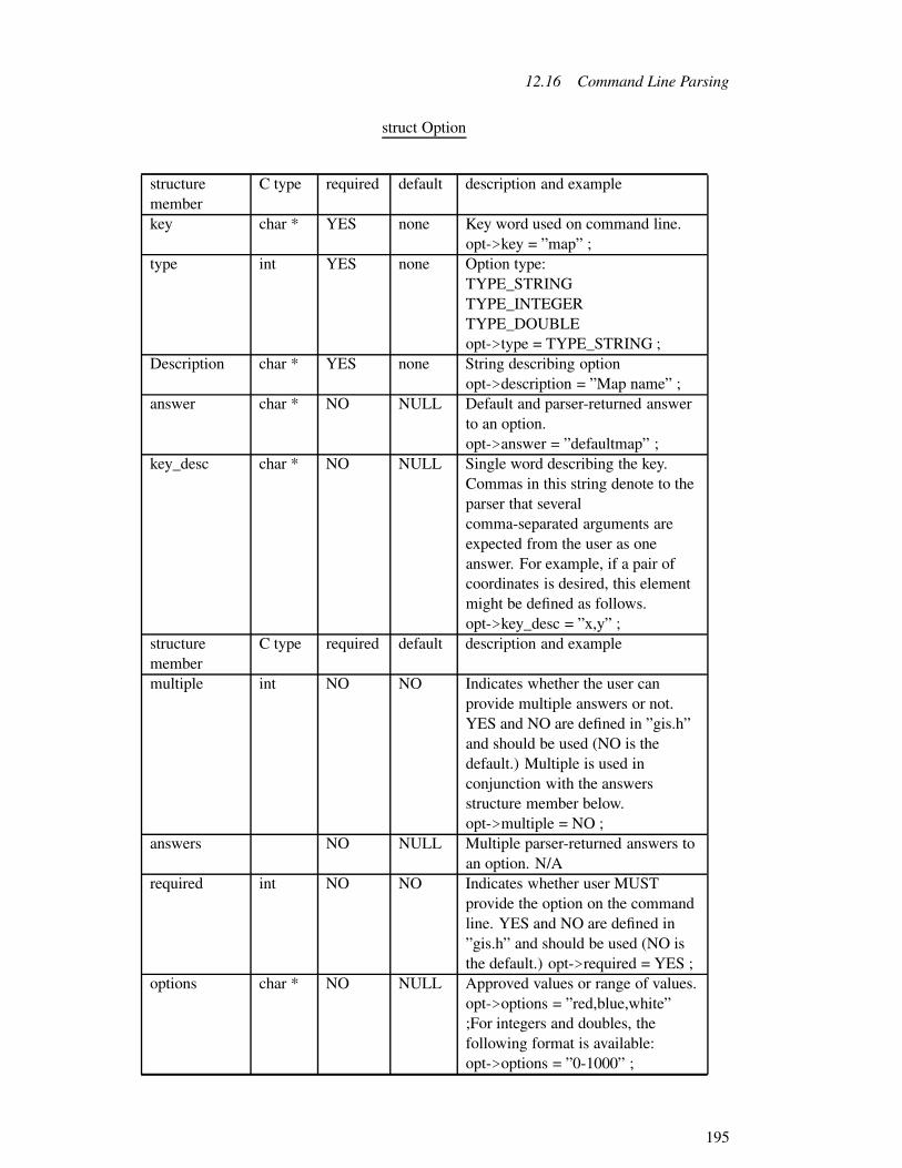
12.16 Command Line Parsing
struct Option
structuremember
C type required default description and example
key char * YES none Key word used on command line.opt->key = ”map” ;
type int YES none Option type:TYPE_STRINGTYPE_INTEGERTYPE_DOUBLEopt->type = TYPE_STRING ;
Description char * YES none String describing optionopt->description = ”Map name” ;
answer char * NO NULL Default and parser-returned answerto an option.opt->answer = ”defaultmap” ;
key_desc char * NO NULL Single word describing the key.Commas in this string denote to theparser that severalcomma-separated arguments areexpected from the user as oneanswer. For example, if a pair ofcoordinates is desired, this elementmight be defined as follows.opt->key_desc = ”x,y” ;
structuremember
C type required default description and example
multiple int NO NO Indicates whether the user canprovide multiple answers or not.YES and NO are defined in ”gis.h”and should be used (NO is thedefault.) Multiple is used inconjunction with the answersstructure member below.opt->multiple = NO ;
answers NO NULL Multiple parser-returned answers toan option. N/A
required int NO NO Indicates whether user MUSTprovide the option on the commandline. YES and NO are defined in”gis.h” and should be used (NO isthe default.) opt->required = YES ;
options char * NO NULL Approved values or range of values.opt->options = ”red,blue,white”;For integers and doubles, thefollowing format is available:opt->options = ”0-1000” ;
195

12 GIS Library
Gisprompt char * NO NULL Interactive prompt guidance. Thereare three comma separated parts tothis argument which guide the useof the standard GRASS file nameprompting routines.opt->gisprompt = ”old,cell,raster” ;
Checker char*( )
NO NULL Routine to check the answer to anoptionm opt->checker = my_routine( ) ;
12.16.5.2 Description of Complex Structure Members
What follows are explanations of possibly confusing structure members. It is intended to clarifyand supplement the structures table above.
12.16.5.2.1 Answer member of the Flag and Option structures. The answer structuremember serves two functions for GRASS commands that use the parser.
(1) To set the default answer to an option:
If a default state is desired for a programmer-defined option, the programmer may define theOption structure member ”answer” before calling G_parser in his module. After the G_parsercall, the answer member will hold this preset default value if the user did not enter an optionthat has the default answer member value.
(2) To obtain the command-line answer to an option or flag: After a call to G_parser, theanswer member will contain one of two values:
(a) If the user provided an option, and answered this option on the command line, the defaultvalue of the answer member (as described above) is replaced by the user’s input.
(b) If the user provided an option, but did not answer this option on the command line, thedefault is not used. The user may use the default answer to an option by withholding mention ofthe option on the command line. But if the user enters an option without an answer, the defaultanswer member value will be replaced and set to a NULL value by G_parser.
As an example, please review the use of answer members in the structures implemented in12.16.4.2 Full Module Example (p. 192).
12.16.5.2.2 Multiple and Answers Members The functionality of the answers structuremember is reliant on the programmer’s definition of the multiple structure member. If the
196

12.16 Command Line Parsing
multiple member is set to NO, the answer member is used to obtain the answer to an option asdescribed above.
If the multiple structure member is set to YES, the programmer has told G_parser to capturemultiple answers. Multiple answers are separated by commas on the command line after anoption.
Note. G_parser does not recognize any character other than a comma to delimit multiple an-swers.
After the programmer has set up an option to receive multiple answers, these the answers arestored in the answers member of the Option structure. The answers member is an array thatcontains each individual user-entered answer. The elements of this array are the type specifiedby the programmer using the type member. The answers array contains however many comma-delimited answers the user entered, followed (terminated) by a NULL array element.
For example, here is a sample definition of an Option using multiple and answers structuremembers:
opt->key =”option” ;
opt->description = ”option example” ;
opt->type = TYPE_INTEGER ;
opt->required = NO ;
opt->multiple = YES ;
The above definition would ask the user for multiple integer answers to the option. If in responseto a routine that contained the above code, the user entered ”option=1,3,8,15” on the commandline, the answers array would contain the following values:
answers[0] = = 1
answers[1] = = 3
answers[2] = = 8
answers[3] = = 15
answers[4] = = NULL
12.16.5.2.3 key_desc Member The key_desc structure member is used to define the formatof a single command line answer to an option. A programmer may wish to ask for one answerto an option, but this answer may not be a single argument of a type set by the type structure
197

12 GIS Library
member. If the programmer wants the user to enter a coordinate, for example, the programmermight define an Option as follows:
opt->key =”coordinate” ;
opt->description = ”Specified Coordinate” ;
opt->type = TYPE_INTEGER ;
opt->required = NO ;
opt->key_desc = ”x,y”
opt->multiple = NO ;
The answer to this option would not be stored in the answer member, but in the answers member.If the user entered ”coordinate=112,225” on the command line in response to a routine thatcontains the above option definition, the answers array would have the following values afterthe call to G_parser:
answers[0] = = 112
answers[1] = = 225
answers[2] = = NULL
Note that ”coordinate=112” would not be valid, as it does not contain both components of ananswer as defined by the key_desc structure member.
If the multiple structure member were set to YES instead of NO in the example above, theanswers are stored sequentially in the answers member. For example, if the user wanted to enterthe coordinates (112,225), (142,155), and (43,201), his response on the command line would be”coordinate=112,225,142,155,43,201”. Note that G_parser recognizes only a comma for boththe key_desc member, and for multiple answers.
The answers array would have the following values after a call to G_parser:
answers[0] = = 112 answers[1] = = 225
answers[2] = = 142 answers[3] = = 155
answers[4] = = 43 answers[5] = = 201
answers[6] = = NULL
Note. In this case as well, neither ”coordinate=112” nor ”coordinate=112,225,142” would bevalid command line arguments, as they do not contain even pairs of coordinates. Each answer’sformat (as described by the key_desc member) must be fulfilled completely.
198

12.16 Command Line Parsing
The overall function of the key_desc and multiple structure members is very similar. Thekey_desc member is used to specify the number of required components of a single optionanswer (e.g. a multi-valued coordinate.) The multiple member tells G_parser to ask the userfor multiple instances of the compound answer as defined by the format in the key_desc struc-ture member.
Another function of the key_desc structure member is to explain to the user the type of infor-mation expected as an answer. The coordinate example is explained above.
The usage message that is displayed by G_parser in case of an error, or by
G_usage on programmer demand, is shown below. The Option ”option” for the command a.outdoes not have its key_desc structure member defined.
Usage:
a.out option=name
The use of ”name” is a G_parser standard. If the programmer defines the key_desc structuremember before a call to G_parser, the value of the key_desc member replaces ”name”. Thus,if the key_desc member is set to ”x,y” as was used in an example above, the following usagemessage would be displayed:
Usage:
a.out option=x,y
The key_desc structure member can be used by the programmer to clarify the usage message aswell as specify single or multiple required components of a single option answer.
12.16.5.2.4 gisprompt Member The gisprompt Option structure item requires a bit moredescription. The three comma-separated
(no spaces allowed) sub-arguments are defined as follows:
First argument:
”old” results in a call to the GRASS library subroutine G_ask_old, ”new” to G_ask_new, ”any”to G_ask_any, and ”mapset” to G_ask_in_mapset.
Second argument:
This is identical to the ”element” argument in the above subroutine calls. It specifies a directoryinside the mapset that may contain the user’s response.
Third argument:
Identical to the ”prompt” argument in the above subroutine calls. This is a string presented tothe user that describes the type of data element being requested.
199

12 GIS Library
Here are two examples:
gisprompt arguments Resulting call
”new,cell,raster” G_ask_new(””, buffer, ”cell”, ”raster”)
”old,dig,vector” G_ask_old(””, buffer, ”dig”, ”vector”)
12.16.6 Common Questions
”How is automatic prompting turned off?”
GRASS 4.0 introduced a new method for driving GRASS interactive and non-interactive mod-ules as described in 11 Compiling and Installing GRASS Programs. Here is a short overview.
For most modules a user runs a front-end module out of the GRASS bin directory which inturn looks for the existence of interactive and non-interactive versions of the module. If aninteractive version exists and the user provided no command line arguments, then that versionis executed.
In such a situation, the parser’s default interaction will never be seen by the user. A programmerusing the parser is able to avoid the front-end’s default search for a fully interactive version ofthe command by placing a call to G_disable_interactive before calling G_parser (see 12.16.3Parser Routines (p. 188) for details.)
”Can the user mix options and flags?”
Yes. Options and flags can be given in any order.
”In what order does the parser present options and flags?”
Flags and options are presented by the usage message in the order that the programmer definesthem using calls to G_define_option and G_define_flag .
”How does a programmer query for coordinates?”
For any user input that requires a set of arguments (like a pair of map coordinates,) the pro-grammer specifies the number of arguments in the key_desc member of the Option structure.For example, if opt->key_desc was set to ”x,y”, the parser will require that the user enter apair of arguments separated only by a comma. See the source code for the GRASS commandsr.drain or r.cost for examples.
”Is a user required to use full option names?”
No! Users are required to type in only as many characters of an option name as is necessaryto make the option choice unambiguous. If, for example, there are two options, ”input=” and”output=”, the following would be valid command line arguments:
#command i=map1 o=map2
200

12.17 String Manipulation Functions
# command in=map1 out=map2
”Are options standardized at all?”
Yes. There are a few conventions. Options which identify a single input map are usually”map=”, not ”raster=” or ”vector=”. In the case of an input and output map the convention is:”input=xx output=yy”. By passing the ’help’ option to existing GRASS commands, it is likelythat you will find other conventions. The desire is to make it as easy as possible for the user toremember (or guess correctly) what the command line syntax is for a given command.
12.17 String Manipulation Functions
This section describes some routines which perform string manipulation. Strings have the usualC meaning: a NULL terminated array of characters.
These next 3 routines copy characters from one string to another.
char * copy stringsG_strcpy (char *dst, char *src)
Copies the src string to dst up to and including the NULL which terminates the srcstring. Returns dst.
char * copy stringsG_strncpy (char *dst, char *src, int n)
Copies at most n characters from the src string to dst. If src contains less than ncharacters, then only those characters are copied. A NULL byte is added at the endof dst. This implies that dst should be at least n+1 bytes long. Returns dst. Note.This routine varies from the UNIX strncpy( ) in that G_strncpy( ) ensures that dstis NULL terminated, while strncpy( ) does not.
char * concatenatestringsG_strcat (char *dst, char *src)
Appends the src string to the end of the dst string, which is then NULL terminated.Returns dst.
These next 3 routines remove unwanted white space from a single string.
201

12 GIS Library
char * removeunnecessarywhite space
G_squeeze (char *s)
Leading and trailing white space is removed from the string s and internal whitespace which is more than one character is reduced to a single space character. Whitespace here means spaces, tabs, linefeeds, newlines, and formfeeds. Returns s.
voidremove lead-ing/trainingwhite space
G_strip (char *s)
Leading and trailing white space is removed from the string s. White space heremeans only spaces and tabs. There is no return value.
char *G_chop (char *s)
Chop leading and trailing white spaces: space, - f, - n, - r, - t, - v - returns pointer tostring
The next routines replaces character(s) from string.
char *replacecharacter(s) G_strchg (char *bug, char character, char new)
Replace all occurencies of character in string bug with new. Returns changed string
This next routine copies a string to allocated memory.
char *copy string toallocated
memoryG_store (char *s)
This routine allocates enough memory to hold the string s, copies s to the allocatedmemory, and returns a pointer to the allocated memory.
The next 2 routines convert between upper and lower case.
char *convert stringto lower case G_tolcase (char *s)
202

12.17 String Manipulation Functions
Upper case letters in the string s are converted to their lower case equivalent. Re-turns s.
char * convert stringto upper caseG_toucase (char *s)
Lower case letters in the string s are converted to their upper case equivalent. Re-turns s.
And finally a routine which gives a printable version of control characters.
char * printableversion ofcontrolcharacter
G_unctrl (unsigned char c)
This routine returns a pointer to a string which contains an English-like represen-tation for the character c. This is useful for nonprinting characters, such as controlcharacters. Control characters are represented by ctrl-C, e.g., control A is rep-resented by ctrl-A. 0177 is represented by DEL/RUB. Normal characters remainunchanged.
This routine is useful in combination with G_intr_char for printing the user’s interrupt charac-ter:
char G_intr_char( );char *G_unctrl( );fprintf(stdout, ”Your interrupt character is %s n”, G_unctrl(G_intr_char( )));
Note. G_unctrl( ) uses a hidden static buffer which is overwritten from call to call.
FOLLOWING new FUNCTIONS need to be merged into the text:
int trimG_trim_decimal (char *buf)
this routine remove trailing zeros from decimal number for example: 23.45000would come back as 23.45
char * delimiterG_index (str, delim)
203

12 GIS Library
position of delimiter
char *???G_rindex (str, delim)
???
intG_strcasecmp(char *a, char *b
string compare ignoring case (upper or lower) returns: -1 if a<b0 if a==b1 if a>b
char *G_strstr(char *mainString, char *subString)
Return a pointer to the first occurrence of subString in mainString, or NULL if nooccurrences are found
char *G_strdup(char *string)
Return a pointer to a string that is a duplicate of the string given to G_strdup. Theduplicate is created using malloc. If unable to allocate the required space, NULLis returned.
12.18 Enhanced UNIX Routines
A number of useful UNIX library routines have side effects which are sometimes undesirable.The routines here provide the same functions as their corresponding UNIX routine, but withdifferent side effects.
12.18.1 Running in the Background
The standard UNIX fork( ) routine creates a child process which is a copy of the parent process.The fork( ) routine is useful for placing a module into the background. For example, a module
204

12.18 Enhanced UNIX Routines
that gathers input from the user interactively, but knows that the processing will take a longtime, might want to run in the background after gathering all the input. It would fork( ) to createa child process, the parent would exit( ) allowing the child to continue in the background, andthe user could then do other processing.
However, there is a subtle problem with this logic. The fork( ) routine does not protect childprocesses from keyboard interrupts even if the parent is no longer running. Keyboard interruptswill also kill background processes that do not protect themselves.33 Thus a module which putsitself in the background may never finish if the user interrupts another module which is runningat the keyboard.
The solution is to fork( ) but also put the child process in a process group which is differentfrom the keyboard process group. G_fork( ) does this.
pid_t create aprotected childprocess
G_fork ( )
This routine creates a child process by calling the UNIX fork( ) routine. It alsochanges the process group for the child so that interrupts from the keyboard do notreach the child. It does not cause the parent to exit( ).G_fork( ) returns what fork( ) returns: -1 if fork( ) failed; otherwise 0 to the child,and the process id of the new child to the parent.Note. Interrupts are still active for the child. Interrupts sent using the kill command,for example, will interrupt the child. It is simply that keyboard-generated interruptsare not sent to the child.
12.18.2 Partially Interruptible System Call
The UNIX system( ) call allows one program, the parent, to execute another UNIX commandor module as a child process, wait for that process to complete, and then continue. The problemaddressed here concerns interrupts. During the standard system( ) call, the child process inheritsits responses to interrupts from the parent. This means that if the parent is ignoring interrupts,the child will ignore them as well. If the parent is terminated by an interrupt, the child will bealso.
However, in some cases, this may not be the desired effect. In a menu environment wherethe parent activates menu choices by running commands using the system( ) call, it would benice if the user could interrupt the command, but not terminate the menu module itself. TheG_system( ) call allows this.
int run a shell levelcommand33Programmers who use /bin/sh know that programs run in the background (using & on the command line) are not
automatically protected from keyboard interrupts. To protect a command that is run in the background, /bin/shusers must do nohup command &. Programmers who use the /bin/csh (or other variants) do not know, or forgetthat the C-shell automatically protects background processes from keyboard interrupts.
205

12 GIS Library
G_system (command)
The shell level command is executed. Interrupt signals for the parent module areignored during the call. Interrupt signals for the command are enabled. The inter-rupt signals for the parent are restored to their previous settings upon return.G_system( ) returns the same value as system( ), which is essentially the exit statusof the command. See UNIX manual system(1) for details.
12.18.3 ENDIAN test
To test if the user’s machine is little or big ENDIAN, the following function is provided:
inttest littleENDIAN G_is_little_endian()
Test if machine is little or big endian.Returns:1 little endian0 big endian
12.19 Unix Socket Functions
The following provide a simplified interface for interprocess communication via Unix sockets.The caller need only be concerned with the path to the socket file and the various file descriptorsfor socket connections. The caller does not need to worry about handling socket structures –which, unlike internet sockets, have little utility once a file descriptor has been opened on aconnection. All socket functions in the GIS library have a G_sock prefix. One should keep inmind that unix sockets connections can both be read from and written to. Also, it is possiblefor calls to read() and write() to read or write fewer bytes than specified. Hence, looping callsmay be required to read or write all of the data. The read() will still normally block if thereis nothing to read, so a zero byte return value typically means the connection has been closed.The write() function typically returns immediately. 34
char *makes fullsocket path G_sock_get_fname (char *name)
Takes a simple name for a communication channel and builds the full path for asockets file with that name. The path as of this writing (2000-02-18) is locatedin the temporary directory for the user’s current mapset (although this will likelychange). A NULL pointer is returned if the function fails for some reason. The
34see W. Richard Stevens. 1997. UNIX network programming: Volume 1 2 .0/ edition. Prentice Hall
206

12.19 Unix Socket Functions
caller is responsible for freeing the memory of the returned string when it is nolonger needed.
int does the socketexistG_sock_exists (char *name)
Takes the full path to a unix socket; determines if the file exists; and if the file existswhether it is a socket file or not. Returns a non-zero value if the file exists and is asocket file. Otherwise it returns zero.
int binds the socketG_sock_bind (char *name)
Takes the full path to a unix socket and attempts to bind a file descriptor to the pathname. If successful it will return the file descriptor. Otherwise, it returns -1. Thesocket file must not already exist. If it does, this function will fail and set the globalerrno to EADDRINUSE. Other error numbers may be set if the call to bind() fails.Server programs wishing to bind a socket should test if the socket file they wish touse already exists. And, if so, they may try to connect to the socket to see if it isin use. If it is not in use, such programs may then call unlink() or remove() todelete the file before calling G_sock_bind(). It is important that server processesdo not just delete existing socket files without testing the connection. Doing somay make another server process unreachable (i.e. you will have hijacked the otherserver’s communication channel). Server processes must call G_sock_bind() priorto calling G_sock_listen() and G_sock_accept().
int listen on asocketG_sock_listen (int fd, unsigned int queue)
Takes the file descriptor returned by a successful call to G_sock_bind() and thelength of the the listen queue. A successful call will return 0, while a failed callwill return -1. The global errno will contain the error number corresponding to thereason for the failure. The queue length should never be zero. Some systems mayinterpret this to mean that no connections should be queued. Other systems mayadd a fudge factor to the queue length that the caller specifies. Servers that don’twant additional connections queued should close() the listening file descriptor aftera successful call to G_sock_accept(). This function is a simple wrapper around thesystem listen() function.
int accept aconnection onthe listeningsocket
G_sock_accept (int fd)
207

12 GIS Library
Takes the file descriptor returned by a successful call to G_sock_bind(), for whicha successful call to G_sock_listen() has also been made, and waits for an incomingconnection. When a connection arrives, the file descriptor for the connection isreturned. This function normally blocks indefinitely. However, an interrupt likeSIGINT may cause this function to return without a valid connection. In this case,the return value will be -1 and the global error number will be set to EINTR.Servers should handle this possibility by calling G_sock_accept() again. A typicalserver might have a call to fork() after a successful return from G_sock_accept().A server might also use select() to see if an a connection is ready prior to callingG_sock_accept(). This function is a simple wrapper around the system’s accept()function, with the second and third arguments being NULL.
intmake aconnection to aserver process
G_sock_connect (char *name)
Takes the full path to a socket file and attempts to make a connection to a serverlistening for connections. If successful, the file descriptor for the socket connectionis returned. Otherwise, -1 is returned and the global errno may be set. This func-tion and G_sock_get_fname() are the only functions a client program really needsto worry about. If the caller wants to be sure that the global error number was setfrom an unsuccessful call to this function, she should zero errno prior to the call.Failures due to a non-existent socket file or a path name that exceeds system limits,will not change the global error number.
12.19.1 Trivial Socket Server Example
#include <stdio.h>#include <stdlib.h>#include <errno.h>#include "gis.h"
int main (int argc, char *argv[]){
int listenfd, rwfd;char *path;pid_t pid;
/* Path is built using server’s name */if (NULL == (path = G_sock_get_fname (argv[0])))
exit (EXIT_FAILURE);
/* Make sure another instance isn’t running */if (G_sock_exists (path)){
if ((listenfd = G_sock_connect (path)) != -1){
close (listenfd);
208

12.19 Unix Socket Functions
exit (EXIT_FAILURE);}remove (path);
}
/* Bind the socket */if ((listenfd = G_sock_bind (path)) < 0)
exit (EXIT_FAILURE);
/* Begin listening on the socket */if (G_sock_listen (listenfd, 1) != 0)
exit (EXIT_FAILURE);
/* Loop forever waiting for connections */for (;;){
if ((rwfd = G_sock_accept (listenfd)) < 0){
if (errno == EINTR)continue;
}else
exit (EXIT_FAILURE);
/* Fork connection */if ((pid = fork()) == 0){
char c;/* child closes listenfd */close (listenfd);while (read (rwfd, &c, 1) > 0)
write (rwfd, &c, 1);close (rwfd);return 0;
}else if (pid > 0){
/* parent closes rwfd* a well behaved server would limit* the number of forks.*/close (rwfd);
}else
exit (EXIT_FAILURE);
}G_free (path);return 0;
}
209

12 GIS Library
12.20 Miscellaneous
A number of general purpose routines have been provided.
char *current dateand time G_date ( )
Returns a pointer to a string which is the current date and time. The format is thesame as that produced by the UNIX date command.
char *get a line ofinput (detect
ctrl-z)G_gets (char *buf)
This routine does a gets ( ) from stdin into buf. It exits if end-of-file is detected. Ifstdin is a tty (i.e., not a pipe or redirected) then ctrl-z is detected. Returns 1 if theread was successful, or 0 if ctrl-z was entered.
Note. This is very useful for allowing a module to reprompt when a module is restarted afterbeing stopped with a ctrl-z. If this routine returns 0, then the calling module should reprint aprompt and call G_gets ( ) again. For example:
char buf[1024];dofprintf(stdout, ”Enter some input: ”) ;while ( ! G_gets(buf) ) ;
char *user’s homedirectory G_home ( )
Returns a pointer to a string which is the full path name of the user’s home directory.
charreturn interruptchar G_intr_char ( )
This routine returns the user’s keyboard interrupt character. This is the characterthat generates the SIGINT signal from the keyboard.
210

12.20 Miscellaneous
See also G_unctr for converting this character to a printable format.
intprint percentcompletemessages
G_percent (int n, int total, int incr)
This routine prints a percentage complete message to stderr. The percentage com-plete is (n/ total)*100, and these are printed only for each incr percentage. This isperhaps best explained by example:
# include <stdio.h>int row;int nrows;nrows = 1352; /* 1352 is not a special value -example only */fprintf (stderr, ”Percent complete: ”);for (row = 0; row < nrows; row++)G_percent (row, nrows, 10);
This will print completion messages at 10% increments; i.e., 10%, 20%, 30%, etc.,up to 100%. Each message does not appear on a new line, but rather erases theprevious message. After 100%, a new line is printed.
char * return modulenameG_program_name ( )
Routine returns the name of the module as set by the call to G_gisinit.
char * user’s nameG_whoami ( )
Returns a pointer to a string which is the user’s login name.
int ask a yes/noquestionG_yes (char *question, int default)
This routine prints a question to the user, and expects the user to respond eitheryes or no. (Invalid responses are rejected and the process is repeated until the useranswers yes or no.)The default indicates what the RETURN key alone should mean. A default of 1indicates that RETURN means yes, 0 indicates that RETURN means no, and -1indicates that RETURN alone is not a valid response.The question will be appended with ”(y/n) ”, and, if default is not -1, with ”[y] ”or ”[n] ”, depending on the default.G_yes ( ) returns 1 if the user said yes, and 0 if the user said no.
211

12 GIS Library
12.21 GIS Library Data Structures
Some of the data structures, defined in the ”gis.h” header file and used by routines in this library,are described in the sections below.
12.21.1 struct Cell_head
The raster header data structure is used for two purposes. It is used for raster header informationfor map layers. It also used to hold region values. The structure is:
struct Cell_head{int format; /* number of bytes per cell */int compressed; /* compressed(1) or not compressed(0) */int rows, cols; /* number of rows and columns */int proj; /* projection */int zone; /* zone */double ew_res; /* east-west resolution */double ns_res; /* north-south resolution */double north; /* northern edge */double south; /* southern edge */double east; /* eastern edge */double west; /* western edge */};
The format and compressed fields apply only to raster headers. The format field describes thenumber of bytes per raster data value and the compressed field indicates if the raster file iscompressed or not. The other fields apply both to raster headers and regions. The geographicboundaries are described by north, south, east and west. The grid resolution is described byew_res and ns_res. The cartographic projection is described by proj and the related zone for theprojection by zone. The rows and cols indicate the number of rows and columns in the rasterfile, or in the region. See 5.3 Raster Header Format (p. 29) for more information about rasterheaders, and 9.1 Region (p. 61) for more information about regions.
The routines described in 12.10.1 Raster Header File (p. 113) use this structure.
12.21.2 struct Categories
The Categories structure contains a title for the map layer, the largest category in the map layer,an automatic label generation rule for missing labels, and a list of category labels.
The structure is declared: struct Categories .
This structure should be accessed using the routines described in 12.10.2 Raster Category File(p. 114).
212

12.21 GIS Library Data Structures
12.21.3 struct Colors
The color data structure holds red, green, and blue color intensities for raster categories. Thestructure has become so complicated that it will not be described in this manual.
The structure is declared: struct Colors .
The routines described in 12.10.3 Raster Color Table (p. 116) must be used to store and retrievecolor information using this structure.
12.21.4 struct History
The History structure is used to document raster files. The information contained here is for theuser. It is not used in any operational way by GRASS. The structure is:
# define MAXEDLINES 50# define RECORD_LEN 80struct History{char mapid[RECORD_LEN];char title[RECORD_LEN];char mapset[RECORD_LEN];char creator[RECORD_LEN];char maptype[RECORD_LEN];char datsrc_1[RECORD_LEN];char datsrc_2[RECORD_LEN];char keywrd[RECORD_LEN];int edlinecnt;char edhist[MAXEDLINES][RECORD_LEN];};
The mapid and mapset are the raster file name and mapset, title is the raster file title, creatoris the user who created the file, maptype is the map type (which should always be ”raster”),datasrc_1 and datasrc_2 describe the original data source, keywrd is a one-line data descriptionand edhist contains edlinecnt lines of user comments.
The routines described in 12.10.3.4.1 Raster History File (p. 121) use this structure. However,there is very little support for manipulating the contents of this structure. The programmer mustmanipulate the contents directly.
Note. Some of the information in this structure is not meaningful. For example, if the rasterfile is renamed, or copied into another mapset, the mapid and mapset will no longer be correct.Also the title does not reflect the true raster file title. The true title is maintained in the categoryfile.
Warning. This structure has remained unchanged since the inception of GRASS. There is agood possibility that it will be changed or eliminated in future releases.
213

12 GIS Library
12.21.5 struct Range
The Range structure contains the minimum and maximum values which occur in a raster file.
The structure is declared: struct Range .
The routines described in 12.10.4 Raster Range File (p. 122) should be used to access thisstructure.
12.22 Loading the GIS Library
The library is loaded by specifying $(GISLIB) in the Gmakefile. The following example is acomplete Gmakefile which compiles code that uses this library:
Gmakefile for $(GISLIB)OBJ = main.o sub1.o sub2.o
pgm: $(OBJ) $(GISLIB)$(CC) $(LDFLAGS) -o $@ $(OBJ) $(GISLIB)$(GISLIB): # in case the library changes
See 11 Compiling and Installing GRASS Modules (p. 69) for a complete discussion of Gmake-files.
12.23 Timestamp functions
#include "gis.h"
This structure is defined in gis.h, but there should be no reason to access its elements directly:
struct TimeStampDateTime dt[2]; /* two datetimes */int count;;
Using the G_*_timestamp routines reads/writes a timestamp file in the cell_misc/rastername ordig_misc/vectorname mapset element.
A TimeStamp can be one DateTime, or two DateTimes representing a range. When preparingto write a TimeStamp, the programmer should use one of:
G_set_timestamp to set a single DateTime
G_set_timestamp_range to set two DateTimes.
214

12.23 Timestamp functions
int Read rastertimestampG_read_raster_timestamp (char *name, char *mapset, struct TimeStamp *ts)
Returns 1 on success. 0 or negative on error.
int Read vectortimestampG_read_vector_timestamp (char *name, char *mapset, struct TimeStamp *ts)
Returns 1 on success. 0 or negative on error.
int copyTimeStamp intoDatetimes
G_get_timestamps (struct TimeStamp *ts, DateTime *dt1, DateTime *dt2, int *count)
Use to copy the TimeStamp information into Datetimes, so the members of structTimeStamp shouldn’t be accessed directly.count=0 means no datetimes were copiedcount=1 means 1 datetime was copied into dt1count=2 means 2 datetimes were copied
intG_init_timestamp (struct TimeStamp *ts)
Sets ts->count = 0, to indicate no valid DateTimes are in TimeStamp.
intG_set_timestamp (struct TimeStamp *ts, DateTime *dt)
Copies a single DateTime to a TimeStamp in preparation for writing. (overwritesany existing information in TimeStamp)
intG_set_timestamp_range (struct TimeStamp *ts, DateTime *dt1, DateTime *dt2)
Copies two DateTimes (a range) to a TimeStamp in preparation for writing. (over-writes any existing information in TimeStamp)
215

12 GIS Library
intG_write_raster_timestamp (char *name, struct TimeStamp *ts)
Returns:1 on success.-1 error - can’t create timestamp file-2 error - invalid datetime in ts
intG_write_vector_timestamp (char *name, struct TimeStamp *ts)
Returns:1 on success.-1 error - can’t create timestamp file-2 error - invalid datetime in ts
intG_format_timestamp (struct TimeStamp *ts, char *buf)
Returns:1 on success-1 error
intG_scan_timestamp (struct TimeStamp *ts, char *buf)
Returns:1 on success-1 error
intG_remove_raster_timestamp (char *name)
Only timestamp files in current mapset can be removedReturns:0 if no file1 if successful-1 on fail
216

12.24 GRASS GIS Library Overview
intG_remove_vector_timestamp (char *name)
Only timestamp files in current mapset can be removedReturns:0 if no file1 if successful-1 on fail
int read grid3timestampG_read_grid3_timestamp (char *name,char *mapset, struct TimeStamp *ts)
Returns 1 on success. 0 or negative on error.
int remove grid3timestampG_remove_grid3_timestamp (char *name)
Only timestamp files in current mapset can be removedReturns:0 if no file1 if successful-1 on fail
int write grid3timestampG_write_grid3_timestamp (char *name, struct TimeStamp *ts)
Returns:1 on success.-1 error - can’t create timestamp file-2 error - invalid datetime in ts
See 23 DateTime Library (p. 349) for a complete discussion of GRASS datetime routines.
12.24 GRASS GIS Library Overview
Contents of directory src/libes/:
217
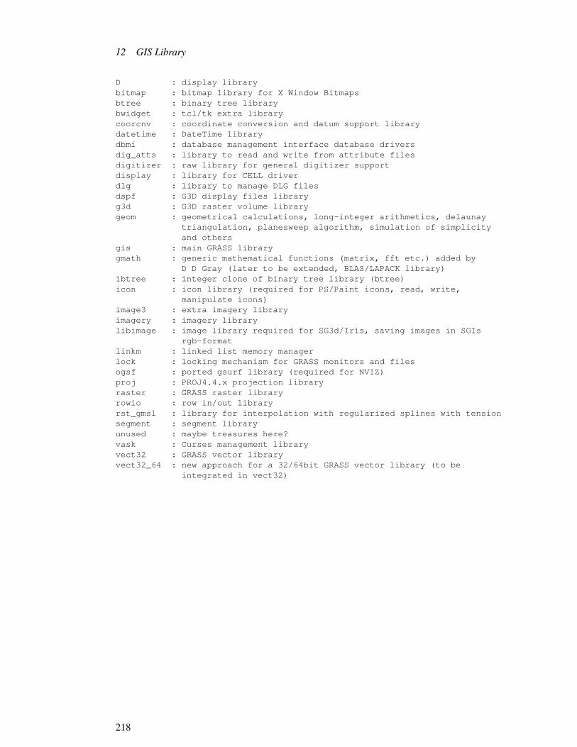
12 GIS Library
D : display librarybitmap : bitmap library for X Window Bitmapsbtree : binary tree librarybwidget : tcl/tk extra librarycoorcnv : coordinate conversion and datum support librarydatetime : DateTime librarydbmi : database management interface database driversdig_atts : library to read and write from attribute filesdigitizer : raw library for general digitizer supportdisplay : library for CELL driverdlg : library to manage DLG filesdspf : G3D display files libraryg3d : G3D raster volume librarygeom : geometrical calculations, long-integer arithmetics, delaunay
triangulation, planesweep algorithm, simulation of simplicityand others
gis : main GRASS librarygmath : generic mathematical functions (matrix, fft etc.) added by
D D Gray (later to be extended, BLAS/LAPACK library)ibtree : integer clone of binary tree library (btree)icon : icon library (required for PS/Paint icons, read, write,
manipulate icons)image3 : extra imagery libraryimagery : imagery librarylibimage : image library required for SG3d/Iris, saving images in SGIs
rgb-formatlinkm : linked list memory managerlock : locking mechanism for GRASS monitors and filesogsf : ported gsurf library (required for NVIZ)proj : PROJ4.4.x projection libraryraster : GRASS raster libraryrowio : row in/out libraryrst_gmsl : library for interpolation with regularized splines with tensionsegment : segment libraryunused : maybe treasures here?vask : Curses management libraryvect32 : GRASS vector libraryvect32_64 : new approach for a 32/64bit GRASS vector library (to be
integrated in vect32)
218

13 Vector Library
13.1 Introduction to Vector Library
The Vector Library provides the GRASS programmer with routines to process the binary vectorfiles. It is assumed that the reader has read 4 Database Structure (p. 17) for a general descriptionof GRASS databases, and 6 Vector Maps (p. 41) for details about vector file formats in GRASS.
The routines in the Vector Library are presented in functional groupings, rather than in alpha-betical order. The order of presentation will, it is hoped, provide a better understanding of howthe library is to be used, as well as show the interrelationships among the various routines. Notethat a good way to understand how to use these routines is to look at the source code for GRASSmodules which use them.1
Note. All routines and global variables in this library, documented or undocumented, startwith one of the following prefixes Vect_ or V1_ or V2_ or dig_.2 To avoid name conflicts,programmers should not create variables or routines in their own modules which use this prefix.3
An alphabetic index is provided in A.4 Appendix D: Index to Vector Library (p. 447).
13.1.1 Include Files
The following file contains definitions and structures required by some of the routines in thislibrary. The programmer should therefore include this file in any code that uses this library:4 .
#include ”Vect.h”
13.1.2 Vector Arc Types
A complete discussion of GRASS vector terminology can be found in 6.1 What is a Vector MapLayer? (p. 41) and the reader should review that section. Briefly, vector data are stored as arcsrepresenting linear, area, or point features. These arc types are coded as LINE, AREA, and DOT
1Some of these programs are v.in.ascii, v.out.ascii, v.to.rast, d.vect, p.map, and v.patch.2All names beginning with V#_ (where # is any primary number) are also reserved for future use.3Warning. There are also four additional global variables and/or routines which do NOT begin with these prefixes:
debugf, Lines_In_Memory, Mem_Line_Ptr, and Mem_curr_position.4The GRASS compilation process, described in 11 Compiling and Installing GRASS Modules (p. 69), automati-
cally tells the C compiler how to find this and other GRASS header files. But also see 13.9 Loading the VectorLibrary (p. 230)
219

13 Vector Library
respectively, (and are # defined in the file ”dig_defines.h”, which is automatically included bythe file ”Vect.h”).
13.1.3 Levels of Access
There are two levels of read access to these vector files:
Level One provides simple access to the arc information contained in the vector files. There isno access to category or topology information at this level.5
Level Two provides full access to all the information contained in the vector file and its supportfiles, including line, category, node, and area information. This level requires more from theprogrammer, more memory, and longer startup time.6
Note. Higher levels of access are planned, so when checking success return codes for a partic-ular level of access (when calling Vect_open_old( ) for example), the programmer should use >= instead of = = for compatibility with future releases.
13.2 Changes in 4.0 from 3.0
[GRASS 5: Can we remove this or shorten?]
The 4.0 Vector Library changed significantly from the Dig Library used with GRASS 3.1.Below is an overview of why the changes were made, and how to module using the new VectLibrary.
13.2.1 Problem
The Digit Library was a collage of subroutines created for developing the map developmentprograms. Few of these subroutines were actually designed as a user access library. Theyrequired individuals to assume too much responsibility and control over what happened to thedata file. Thus when it came time to change vector data file formats for GRASS 4.0, manymodules also required modification. By using the FILE * structure as the tag for files, there wasno means of expansion since the FILE * structure is not modifiable by GRASS. For example,there was no way to open supporting files since all that was passed in to dig_init( ) was a FILE* which had no file name associated with it.
The two different access levels for 3.0 vector files provided very different ways of calling thelibrary; they offered little consistency for the user.
5The category information is available through the dig_att library, but there are no data structures to link them tothe spatial features at this level.
6The routines in this library which process arcs are named using the word line. They should be named using theword arc instead. Since that would require modifying a lot of existing code, the names have not been changed.
220

13.2 Changes in 4.0 from 3.0
The Digit Library was originally designed to only have one file open for read or write at atime. Although it was possible in some cases to get around this, one restriction was the globalhead structure. Since there was only one instance of this, there could only be one copy of thatinformation, and thus, only one open vector file.
13.2.2 Solution
The solution to these problems was to design a new user library as an interface to the vec-tor data files. This new library was designed to provide a simple consistent interface, whichhides as much of the details of the data format as possible. It also can be extended for futureenhancements without the need to change existing programs.
13.2.3 Approach
A new [new in GRASS 4.x] library VECTLIB has been created. It provides routines for open-ing, closing, reading, and writing vector files, as well as several support functions. The DigitLibrary has been removed, so that all existing modules will have to be converted to use thenew library. Those routines that existed in the Digit Library and were not affected by thesechanges continue to exist in unmodified form, and are now included in the VECTLIB. Most ofthe commonly used routines have been discarded, and replaced by the new Vector routines.
The token that is used to identify each map is the Map_info structure. This structure was usedby level two functions in GRASS 3.1. It maintains all information about an individual open file.This structure must be passed to most Vector subroutines. The head structure has gone away,as has the global instance of it which was also called head. All modules which used this globalstructure must now create their own local version of it. The structure that replaced struct headis struct dig_head.
There are still two levels of interface to the vector files (future releases may include more).Level one provides access only to arc (i.e. polyline) information and to the type of line (AREA,LINE, DOT). Level two provides access to polygons (areas), attributes, and network topology.There is now only one subroutine to open a file for read, Vect_open_old( ) and one for write,Vect_open_new( ). Vect_open_old( ) attempts to open a vector file at the highest possible levelof access. It will return the number of the level at which it opened. Vect_open_new( ) alwaysopens at level 1 only. If you require that a file be opened at a lower level (e.g. one), you can callthe routine Vect_set_open_level(1); Vect_open_old( ) will then either open at level one or fail.If you instead require the highest level access possible, you should not use Vect_set_open_level(), but instead check the return value of Vect_open_old( ) to make sure it is greater than or equalto the lowest level at which you need access. This allows for future levels to work without needfor module change.
13.2.4 Implementation
There are two macros set up for use in the Gmakefile to support the Vector library:
221

13 Vector Library
EXTRA_CFLAGS = $(VECT_INCLUDE)
must exist in the Gmakefile for any module which uses the Vector library. NOTE: GRASS 3.1required the line -I$(DIG_INCLUDE); do NOT use -I with VECT_INCLUDE.
$(VECTLIB)
is to be used on the link statement to include the vector library.7 This basically replaces the$(DIGLIB) macro from 3.1. Currently this macro represents two different libraries which arein directories: src/mapdev/Vlib and src/mapdev/diglib. These will probably change in the futureand are given only for aid in looking up include files or functions.
The basic format of a module that reads a vector file is:
#include ”Vect.h” /* new include file */struct Map_info Map; /* Map info */struct line_pnts *Points; /* Poly-Line data */G_gisinit (argv[0]); /* init GIS lib */if (0 > Vect_open_old (&Map, name, mapset)) /* open file */G_fatal_error (”Cannot open vector file”);Points = Vect_new_line_struct ( h’|209350u’);while (0 < Vect_read_next_line (&Map, Points)) /* loop reading
*/{/* each line *//* do something with Points */}Vect_destroy_line_struct (Points); /* remove allocation */Vect_close (&Map); /* close up */
All Vect_ routines work in the same way on any lev el of access unless otherwise noted. Routinesthat are designed for one level of access or another have the naming convention V#_ where # isan integer (currently 1 or 2). For example: V2_line_att ( ) is only valid with level 2 or higheraccess, and will return the attribute number for a specified line.
13.3 Opening and closing vector maps
intopen existingvector map Vect_open_old (struct Map_info *Map, char *name, char *mapset)
This routine opens the vector map name in mapset for reading. It returns the levelof successful open, or a negative value on failure.
intopen newvector map 7Because there are two libraries involved and there are some cross-dependencies, it may occasionally be necessary
to specify $(VECTLIB) twice on the link statement in order to resolve all references.
222

13.4 Reading and writing vector maps
Vect_open_new (struct Map_info *Map, char *name)
This routine opens the vector map name in the current mapset for writing. It returnsthe level of successful open which must be one, or a negative value on failure.
int specify level foropening mapVect_set_open_level (int level)
This routine allows you to specify at which level the map is to be opened. It isrecommended that it only be used to force opening at level one(1). There is noreturn value.
int close a vectormapVect_close (struct Map_info *Map)
This routine closes an open vector map and cleans up the structures associated withit. It MUST be called before exiting the module. When used in conjunction withVect_open_new, it will cause the final writing of the vector header before closingthe vector map. The header data is in the structure Map->head, which also changedin 4.0 to be an instance of the structure (struct dig_head head) instead of a pointer(struct dig_head *head).
13.4 Reading and writing vector maps
int read next vectorlineVect_read_next_line (struct Map_info *Map, struct line_pnts *Points)
This is the primary routine for reading through a vector map. It simply reads thenext line from the map into the Points structure. This routine should not be used inconjunction with any other read_line routine. Return value is type of line, or-2 on EOF-1 on Error (generally out of memory)
This routine is modified by:Vect_rewind()Vect_set_constraint_region()Vect_set_constraint_type()
This routine normally only reads lines that are ”alive” (as opposed todead or deleted) from the vector map. This can be overridden usingVect_set_constraint_type(Map,-1).
223

13 Vector Library
intrewind vectormap for
re-readingVect_rewind (struct Map_info *Map)
This routine will reset the read pointer to the beginning of the map. This onlyaffects the routineVect_read_next_line.
intset restrictedregion to read
vector arcsfrom
Vect_set_constraint_region (struct Map_info *Map, double n, double s, double e, doublew)
This routine will set a restriction on reading only those lines which fall entirelyor partially in the specified rectangular region. Vect_read_next_line is currentlythe only routine affected by this, and it does NOT currently cause line clipping.Constraints affect only the Map specified. They do not affect any other Maps thatmay be open.
intspecify types ofarcs to read Vect_set_constraint_type (struct Map_info *Map, int type)
This routine will set a restriction on reading only those lines which match the typesspecified. This can be any combination of types bitwise OR’ed together. Forexample: LINE | AREA would exclude any DOT (or future NEAT) line types.Vect_read_next_line is currently the only routine affected by this. If type is set to-1, all lines will be read including deleted or dead lines. An example of this ex-ists in v.out.ascii, where it is desirable to include all lines, (ie. not exclude deletedlines).Constraints affect only the Map specified. They do not affect any other Maps thatmay be open.
intunset anyvector readconstraints
Vect_remove_constraints (struct Map_info *Map)
Removes all constraints currently affecting Map.
longwrite out arc tovector map Vect_write_line (struct Map_info *Map, int type, struct line_pnts *Points)
This routine will write out a line to a vector map which has previously been openedfor write by Vect_open_new. The type of line is one of: AREA, LINE, DOT Itreturns the offset into the file where the line started. If this number is negative or 0,there was an error.
224

13.5 Data Structures
int read vector arcby specifyingoffset
V1_read_line (struct Map_info *Map, struct line_pnts *Points, long offset)
This routine will read a line from the vector map at the specified offset in the file.This function is available at level 1 or higher.Return value is the same as Vect_read_next_line.
int read vector arcby specifyingline id
V2_read_line (struct Map_info *Map, struct line_pnts *Points, int line)
This routine will read a line from the vector map at the specified line index in themap. Refer to V2_num_lines for number of lines in the map. This function isavailable at level 2 or higher.Return value is the same as Vect_read_next_line.
13.5 Data Structures
struct line_pnts * create newinitialized linepoints structure
Vect_new_line_struct (void)
This routine MUST be used to initialize any and all line_pnts structures. You can-not simply create a line_pnts structure and pass its address to routines. It must firstbe initialized. The correct procedure is: struct line_pnts *Points;
Points = Vect_new_line_struct( );
This routine will print an error message and exit with an error on out of memorycondition.
int deallocate linepoints structurespace
Vect_destroy_line_struct (struct line_pnts *Points)
This routine will free any memory created for a line_pnts structure. You can usethis when you are done with a line_pnts struct or when you need to free up unusedmemory. The structure must have been created by Vect_new_line_struct.
13.6 Data Conversion
int convert xyarrays toline_pntsstructure
Vect_copy_xy_to_pnts (struct line_pnts *Points, double *x, double *y, int n)
225

13 Vector Library
Since all Vector library routines require the use of the line_pnts structure, and manymodules out there work with X and Y arrays of points, this routine was to createdto copy n data pairs from x,y arrays to a line_pnts structure Points. It handles allmemory management.
intconvertline_pnts
structure to xyarrays
Vect_copy_pnts_to_xy (struct line_pnts *Points, double *x, double *y, int *n)
Since all Vector library routines require the use of the line_pnts structure, and manymodules out there work with X and Y arrays of points, this routine was to createdto copy data from a line_pnts structure Points into user supplied x,y arrays. Thex,y arrays MUST each be large enough to hold Points.n_points doubles or memorycorruption will occur. No bounds checking is done. Upon return n will contain thenumber of points copied.
intcopy vectorheader struct
dataVect_copy_head_data (struct dig_head *from, struct dig_head *to)
This routine should be used to copy data from one dig_head struct to another.For example, if a 3.1 module used to fill in a local dig_head struct and thencalled dig_write_head_binary( ) (which no longer exists), you would now callVect_copy_head_data (local_head, &Map.head) to copy the data into the Mapstructure which would then be written out when Vect_close was called. This routinemust used because there are now other fields in the head structure which applica-tions programmers should not touch, and this module copies only those fields whichare available to the programmer.
13.7 Miscellaneous
intget point insidearea and
outside allislands
Vect_get_point_in_area (struct Map_info *Map, int area, double *X, double *Y)
This routine examines the area with index value area in a vector map and places inX and Y, the X- and Y- positions respectively of a suitable area point.The method is as follows: Take a line and intersect it with the polygon and anyislands. Sort the list of X values from these intersections. This will be a list ofsegments alternating IN/OUT/IN/OUT of the polygon. Pick the largest IN segmentand take the midpoint.Note. This function, works only for level 2 or higher. It returns 0 on success or -1on error.
226

13.7 Miscellaneous
int get point insidepolygonVect_get_point_in_poly (struct line_pnts *Points, double *X, double *Y)
This routine finds a suitable area point in the ring described by the line struct Points,but without reference to any islands that may be present inside the area. This rou-tine is useful where prior topological information on an area is not available.The return value is 0 on success, -1 on failure.
int get point insidepolygon butoutside theislandsspecifiled inIPoints.
Vect_get_point_in_poly_isl (struct line_pnts *APoints, struct line_pnts **IPoints, intn_isles, double *X, double *Y)
This routine finds a suitable area point in the ring described by the line structAPoints and the interior islands specified in the array of line structs IPoints. Thisroutine is useful where prior topological information on an area is not available, asfor example in import filters.The method for finding the area point is as follows: Take a line and intersect it withthe polygon and any islands. Sort the list of X values from these intersections. Thiswill be a list of segments alternating IN/OUT/IN/OUT of the polygon. Pick thelargest IN segment and take the midpoint.The return value is 0 on success, -1 on failure.
int find if a givenpoint in an areais inside anisland.
Vect_point_in_islands (struct Map_info *Map, int area, double x, double y)
This routine determines if the given point (x,y) is located inside an island of areawith index area.The return value is 0 (false) if this condition is not met, 1 (true) if it is, and -1 if theprocedure fails.Note. This function, works only for level 2 or higher.
int get definingpoints for areapolygon
Vect_get_area_points (struct Map_info *Map, int area, struct line_pnts *Points)
This routine replaces dig_get_area( ). It will fill in the Points structure with thelist of points which describe an area in clockwise order. Points at the junction ofconstituent lines are included only once.Note. This function, works only for level 2 or higher. It returns the number ofpoints or -1 on error.
int get definingpoints for isleperimeter
Vect_get_isle_points (struct Map_info *Map, int isle, struct line_pnts *Points)
227

13 Vector Library
This routine fills in the Points structure with the list of points which describe theperimeter of a primary island in counter-clockwise order. Points at the junction ofconstituent lines are included only once.Note. This function, works only for level 2 or higher. It returns the number ofpoints or -1 on error.
intget number ofarcs in vector
mapV2_num_lines (struct Map_info *Map)
Return total number of lines in the vector Map.Note. The line indexes are numbers from 1 to n, where n is the number of lines inthe vector map, as returned by this routine.
intget number ofareas in vector
mapV2_num_areas (struct Map_info *Map)
Return total number of areas in the vector Map.Note. The area indexes are numbers from 1 to n, where n is the number of areas inthe vector map, as returned by this routine.
intget number ofislands in
vector mapV2_num_islands (struct Map_info *Map)
Return total number of islands in the vector Map.Note. The islands indexes are numbers from 1 to n, where n is the number ofislands in the vector map, as returned by this routine.
intget attributenumber of arc V2_line_att (struct Map_info *Map, int line)
Given arc index n, return its attribute number.Returns 0 if not labeled or on error.
intget attributenumber of area V2_area_att (struct Map_info *Map, int area)
Given area index n, return its attribute number.Returns 0 if not labeled or on error.
228

13.7 Miscellaneous
intget area infofrom id V2_get_area (struct Map_info *Map, int n, P_AREA **pa)
Given area index n, the P_AREA information for the area is read into a privatestructure. A pointer to this structure is placed in pa. The pointer pa is valid untilthe next call to this routine. Note that *pa does not need to point to anything onentry. Returns 0 if found, or negative on error.
int get boundingbox of areaV2_get_area_bbox (struct Map_info *Map, int area, double *n, double *s, double *e, dou-
ble *w)
Given area index n, set n (north, s (south), e (east), and w (west) to the values ofthe bounding box for the area.Returns 0 if ok, or -1 on error.
int get boundingbox of arcV2_get_line_bbox (struct Map_info *Map, int line, double *n, double *s, double *e, double
*w)
Given arc index n, set n (north, s (south), e (east), and w (west) to the values of thebounding box for the arc.Returns 0 if ok, or -1 on error.
int print headerinfo to stdoutVect_print_header (struct Map_info *Map)
This routine replaces dig_print_header( ), and simply displays selected informationfrom the header. Namely organization, map name, source date, and original scale.
int get open levelof vector mapVect_level (struct Map_info *Map)
This routine will return the number of the level at which a Map is opened at or -1if Map is not opened.8
8The levels correspond to the 3.1 level 1 and level 2 accesses.
229

13 Vector Library
13.8 Routines that remain from GRASS 3.1
intfind which areapoint is in dig_point_to_area (struct Map_info *Map, double x, double y)
Returns the index of the area containing the point x,y, or 0 if none found.
doubleis point inarea? dig_point_in_area (struct Map_info *Map, double x, double y, P_AREA *pa)
Given a filled P_AREA structure pa, determine if x,y is within the area. The struc-ture pa can be filled with V2_get_area.Returns 0.0 if x,y is not in the area, the positive minimum distance to the nearestarea edge if x,y is inside the area, or -1.0 on error.
intfind which arcpoint is closest
todig_point_to_line (struct Map_info *Map, double x, double y, char type)
Returns the index of the arc which is nearest to the point x,y. The point x,y mustbe within the arc’s bounding box. Set type to a combination of LINE, AREA, orDOT (eg. LINE | AREA), or (char) -1 if you want to search all arc types.
intfind distance ofpoint to line dig_check_dist (struct Map_info *Map, intn, double x, double y, double *d)
Computes d, the square of the minimum distance from point x,y to arc nR. Returnsthe number of the segment that was closest, or -1 on error. The segment number,in combination with V2_read_line can be used to determine the endpoints of theclosest line-segment in the arc.
13.9 Loading the Vector Library
The library is loaded by specifying $(VECTLIB) in the Gmakefile. The following example is acomplete Gmakefile which compiles code that uses this library:
Gmakefile using $(VECTLIB)
230

13.9 Loading the Vector Library
OBJ = main.o sub1.o sub2.o
EXTRA_CFLAGS = $(VECT_INCLUDE)
$(BIN_MAIN_CMD)/pgm: $(OBJ) $(VECTLIB) $(GISLIB)
$(CC) $(LDFLAGS) -o $@ $(OBJ) $(VECTLIB) $(GISLIB)
$(VECTLIB): # in case the library changes
Note. EXTRA_CFLAGS tells the C compiler where additional # include files are located. Thisis necessary since the required # include files do not currently live in the normal GRASS #include directory. Notice that -I must not be provided before the $(VECT_INCLUDE)
Note. Because $(VECTLIB) currently references two distinct libraries, on occasion it may benecessary to specify it twice on the link command because of library cross-references.
See 11 Compiling and Installing GRASS Modules (p. 69) for a complete discussion of Gmake-files.
231

13 Vector Library
232

14 Imagery Library
14.1 Introduction to Imagery Library
The Imagery Library was created for version 3.0 of GRASS to support integrated image pro-cessing directly in GRASS. It contains routines that provide access to the group database struc-ture which was also introduced in GRASS 3.0 for the same purpose.1 It is assumed that thereader has read 4 Database Structure (p. 17) for a general description of GRASS databases, 8Image Data: Groups (p. 53) for a description of imagery groups, and 5 Raster Maps (p. 27)for details about map layers in GRASS. The routines in the 14 Imagery Library (p. 233) arepresented in functional groupings, rather than in alphabetical order. The order of presentationwill, it is hoped, provide a better understanding of how the library is to be used, as well as showthe interrelationships among the various routines. Note that a good way to understand how touse these routines is to look at the source code for GRASS modules which use them.2 Mostroutines in this library require that the header file ”imagery.h” be included in any code usingthese routines.3 Therefore, programmers should always include this file when writing codeusing routines from this library:
#include ”imagery.h”
This header file includes the ”gis.h” header file as well.
Note. All routines and global variables in this library, documented or undocumented, start withthe prefix I_. To avoid name conflicts, programmers should not create variables or routines intheir own modules which use this prefix.
An alphabetic index is provided in A.5 Appendix E: Index to Imagery Library (p. 448)
14.2 Group Processing
The group is the key database structure which permits integration of image processing in GRASS.
1Since this is a new library, it is expected to grow. It is hoped that image analysis functions will be added tocomplement the database functions already in the library.
2See 8.4 Imagery Modules (p. 58) for a list of some imagery programs.3The GRASS compilation process, described in 11 Compiling and Installing GRASS Modules (p. 69), automati-
cally tells the C compiler how to find this and other GRASS header files.
233

14 Imagery Library
14.2.1 Prompting for a Group
The following routines interactively prompt the user for a group name in the current mapset.4
In each, the prompt string will be printed as the first line of the full prompt which asks the userto enter a group name. If prompt is the empty string ””, then an appropriate prompt will besubstituted. The name that the user enters is copied into the group buffer.5 These routines havea built-in ’list’ capability which allows the user to get a list of existing groups.
The user is required to enter a valid group name, or else hit the RETURN key to cancel therequest. If the user enters an invalid response, a message is printed, and the user is promptedagain. If the user cancels the request, 0 is returned; otherwise, 1 is returned.
intprompt for anexisting group I_ask_group_old (char *prompt, char *group)
Asks the user to enter the name of an existing group in the current mapset.
intprompt for newgroup I_ask_group_new (char *prompt, char *group)
Asks the user to enter a name for a group which does not exist in the currentmapset.
intprompt for anyvalid group
nameI_ask_group_any (char *prompt, char *group)
Asks the user to enter a valid group name. The group may or may not exist in thecurrent mapset.
Note. The user is not warned if the group exists. The programmer should use I_find_group todetermine if the group exists.
Here is an example of how to use these routines. Note that the programmer must handle the 0return properly:
char group[50];if ( ! I_ask_group_any (”Enter group to be processed”, group))exit(0);
4This library only works with groups in the current mapset. Other mapsets, even those in the user’s mapset searchpath, are ignored.
5The size of group should be large enough to hold any GRASS file name. Most systems allow file names to bequite long. It is recommended that name be declared char group.
234

14.2 Group Processing
14.2.2 Finding Groups in the Database
Sometimes it is necessary to determine if a given group already exists. The following routineprovides this service:
int does groupexist?I_find_group (char *group)
Returns 1 if the specified group exists in the current mapset; 0 otherwise.
14.2.3 REF File
These routines provide access to the information contained in the REF file for groups and sub-groups, as well as routines to update this information. They use the Ref structure, which isdefined in the ”imagery.h” header file; see 14.4 Imagery Library Data Structures (p. 239).
The contents of the REF file are read or updated by the following routines:
int read group REFfileI_get_group_ref (char *group, struct Ref *ref)
Reads the contents of the REF file for the specified group into the ref structure.Returns 1 if successful; 0 otherwise (but no error messages are printed).
int write groupREF fileI_put_group_ref (char *group, struct Ref *ref)
Writes the contents of the ref structure to the REF file for the specified group.Returns 1 if successful; 0 otherwise (and prints a diagnostic error).Note. This routine will create the group, if it does not already exist.
int read subgroupREF fileI_get_subgroup_ref (char *group, char *subgroup, struct Ref *ref)
Reads the contents of the REF file for the specified subgroup of the specifiedgroup into the ref structure.Returns 1 if successful; 0 otherwise (but no error messages are printed).
235

14 Imagery Library
int write subgroupREF fileI_put_subgroup_ref (char *group, char *subgroup, struct Ref *ref)
Writes the contents of the ref structure into the REF file for the specified subgroupof the specified group.Returns 1 if successful; 0 otherwise (and prints a diagnostic error).Note. This routine will create the subgroup, if it does not already exist.
These next routines manipulate the Ref structure:
intinitialize Refstructure I_init_group_ref (struct Ref *ref)
This routine initializes the ref structure for other library calls which require a Refstructure. This routine must be called before any use of the structure can be made.Note. The routines I_get_group_ref and I_get_subgroup_ref call this routine auto-matically.
intadd file name toRef structure I_add_file_to_group_ref (char *name, char *mapset, struct Ref *ref)
This routine adds the file name and mapset to the list contained in the ref structure,if it is not already in the list. The ref structure must have been properly initialized.This routine is used by programs, such as i.maxlik, to add to the group new rasterfiles created from files already in the group.Returns the index into the file array within the ref structure for the file after inser-tion; see 14.4 Imagery Library Data Structures (p. 239).
intcopy Ref listsI_transfer_group_ref_file (struct Ref *src, int n, struct Ref *dst)
This routine is used to copy file names from one Ref structure to another. The nameand mapset for file n from the src structure are copied into the dst structure (whichmust be properly initialized).For example, the following code copies one Ref structure to another:
struct Ref src,dst;int n;/* some code to get information into src */...I_init_group_ref (&dst);for (n = 0; n < src.nfiles; n++)I_transfer_group_ref_file (&src, n, &dst);
236

14.2 Group Processing
This routine is used by i.points to create the REF file for a subgroup.
int free RefstructureI_free_group_ref (struct Ref *ref)
This routine frees memory allocated to the ref structure.
14.2.4 TARGET File
The following two routines read and write the TARGET file.
int read targetinformationI_get_target (char *group, char *location, char *mapset)
Reads the target location and mapset from the TARGET file for the specifiedgroup. Returns 1 if successful; 0 otherwise (and prints a diagnostic error). Thisroutine is used by i.points and i.rectify and probably should not be used by otherprograms.Note. This routine does not validate the target information.
int write targetinformationI_put_target (char *group, char *location, char *mapset)
Writes the target location and mapset to the TARGET file for the specified group.Returns 1 if successful; 0 otherwise (but no error messages are printed).This routine is used by i.target and probably should not be used by other programs.Note. This routine does not validate the target information.
14.2.5 POINTS File
The following routines read and write the POINTS file, which contains the image registrationcontrol points. This file is created and updated by the module i.points,and read by i.rectify.
These routines use the Control_Points structure, which is defined in the ”imagery.h” header file;see 14.4 Imagery Library Data Structures (p. 239).
Note. The interface to the Control_Points structure provided by the routines below is incom-plete. A routine to initialize the structure is needed.
int read groupcontrol pointsI_get_control_points (char *group, struct Control_Points *cp)
237

14 Imagery Library
Reads the control points from the POINTS file for the group into the cp structure.Returns 1 if successful; 0 otherwise (and prints a diagnostic error).Note. An error message is printed if the POINTS file is invalid, or does not exist.
intadd new controlpoint I_new_control_point (struct Control_Points *cp, double e1, double n1, double e2, double
n2, int status)
Once the control points have been read into the cp structure, this routine adds newpoints to it. The new control point is given by e1 (column) and n1 (row) on theimage, and the e2 (east) and n2 (north) for the target database. The value of statusshould be 1 if the point is a valid point; 0 otherwise.6
intwrite groupcontrol points I_put_control_points (char *group, struct Control_Points *cp)
Writes the control points from the cp structure to the POINTS file for the specifiedgroup.Note. Points in cp with a negative status are not written to the POINTS file.
14.3 Loading the Imagery Library
The library is loaded by specifying $(IMAGERYLIB) in the Gmakefile. The following exampleis a complete Gmakefile which compiles code that uses this library:
Gmakefile for $(IMAGERYLIB)
OBJ = main.o sub1.o sub2.o
pgm: $(OBJ) $(IMAGERYLIB) $(GISLIB)
$(CC) $(LDFLAGS) -o $@ $(OBJ) $(IMAGERYLIB) $(GISLIB)
$(IMAGERYLIB): # in case the library changes
$(GISLIB): # in case the library changes
Note. This library must be loaded with $(GISLIB) since it uses routines from that library. See12 GIS Library (p. 79) or details on that library. See 11 Compiling and Installing GRASSModules (p. 69) for a complete discussion of Gmakefiles.
6Use of this routine implies that the point is probably good, so status should be set to 1.
238

14.4 Imagery Library Data Structures
14.4 Imagery Library Data Structures
Some of the data structures in the ”imagery.h” header file are described below.
14.4.1 struct Ref
The Ref structure is used to hold the information from the REF file for groups and subgroups.The structure is:
struct Ref
{
int nfiles; /* number of REF files */
struct Ref_Files
{
char name[30]; /* REF file name */
char mapset[30]; /* REF file mapset */
} *file;
struct Ref_Color
{
unsigned char *table; /* color table for min-max values */
unsigned char *index; /* data translation index */
unsigned char *buf; /* data buffer for reading color file */
int fd; /* for image i/o */
CELL min, max; /* min,max CELL values */
int n; /* index into Ref_Files */
} red, grn, blu;
};
The Ref structure has nfiles (the number of raster files), file (the name and mapset of each file),and red,grn,blu (color information for the group or subgroup 7 ).
7The red,grn,blu elements are expected to change as the imagery code develops. Do not reference them. Pretendthey do not exist.
239

14 Imagery Library
There is no function interface to the nfiles and file elements in the structure. This means that theprogrammer must reference the elements of the structure directly.8 The name and mapset forthe i th file are file[i].name, and file[i].mapset.
For example, to print out the names of the raster files in the structure:
int i;
struct Ref ref;
.
..
/* some code to get the REF file for a group into ref */
..
for (i = 0; i < ref.nfiles; i++)
fprintf(stdout, ”%s in %s - n”, ref.file[i].name, ref.file[i].mapset);
14.4.2 struct Control_Points
The Control_Points structure is used to hold the control points from the group POINTS file.The structure is:
struct
Control_Points
{
int count; /* number of control points */
double *e1; /* image east (column) */
double *n1; /* image north (row) */
double *e2; /* target east */
double *n2; /* target north */
int *status; /* status of control point */
};
The number of control points is count.
8The nfiles and file elements are not expected to change in the future.
240

14.4 Imagery Library Data Structures
Control point i is e1 [i], n1 [i], e2 [i], n2 [i], and its status is status [i].
241

14 Imagery Library
242

15 Raster Graphics Library
15.1 Introduction
The Raster Graphics Library provides the programmer with access to the GRASS graphics de-vices. All video graphics calls are made through this library (directly or indirectly). Nostandard/portable GRASS video graphics module drives any video display directly. This li-brary provides a powerful, but limited number of graphics capabilities to the programmer. Thetremendous benefit of this approach is seen in the ease with which GRASS graphics applica-tions modules port to new machines or devices. Because no device-dependent code exists inapplication programs, virtually all GRASS graphics modules port without modification. Eachgraphics device must be provided a driver (or translator program). At run-time, GRASS graph-ics modules rendezvous with a user-selected driver module. Two significant prices are paid inthis approach to graphics: 1) graphics displays run significantly slower, and 2) the programmerdoes not have access to fancy (and sometimes more efficient) resident library routines that havebeen specially created for the device.
This library uses a couple of simple concepts. First, there is the idea of a current screen location.There is nothing which appears on the graphics monitor to indicate the current location, butmany graphic commands begin their graphics at this location. It can, of course, be set explicitly.Second, there is always a current color. Many graphic commands will do their work in thecurrently chosen color. The programmer always works in the screen coordinate system. Unlikemany graphics libraries developed to support CAD, there is no concept of a world coordinatesystem. The programmer must address graphics requests to explicit screen locations. This isnecessary, especially in the interest of fast raster graphics.
The upper left hand corner of the screen is the origin. The actual pixel rows and columns whichdefine the edge of the video surface are returned with calls to R_screen_left, R_screen_rite,R_screen_bot, and R_screen_top.
Note. All routines and global variables in this library, documented or undocumented, start withthe prefix R_. To avoid name conflicts, programmers should not create variables or routines intheir own modules which use this prefix.
An alphabetic index is provided in A.7 Appendix G: Index to Raster Graphics Library (p. 452).
243

15 Raster Graphics Library
15.2 Connecting to the Driver
Before any other graphics calls can be made, a successful connection to a running and selectedgraphics driver must be made.
intinitializegraphics R_open_driver ( )
Initializes connection to current graphics driver. Refer to GRASS User’s Manualentries on the d.mon command. If connection cannot be made, the applicationmodule sends a message to the user stating that a driver has not been selected orcould not be opened. Note that only one application module can be connected to agraphics driver at once.After all graphics have been completed, the driver should be closed.
intterminategraphics R_close_driver ( )
This routine breaks the connection with the graphics driver opened byR_open_driver( ).
15.3 Colors
GRASS is highly dependent on color for distinguishing between different categories. Nographic patterning is supported in any automatic way. There are two color modes. Fixed colorrefers to set and immutable color look-up tables on the hardware device. In some cases thisis necessary because the graphics device does not contain programmer definable color look-uptables (LUT). Floating colors use the LUTs of the graphics device often in an interactive modewith the user. The basic impact on the user is that under the fixed mode, multiple maps canbe displayed on the device with apparently no color interference between maps. Under floatmode, the user may interactively manipulate the hardware color tables (using modules such asd.colors). Other than the fact that in float mode no more colors may be used than color registersavailable on the user’s chosen driver, there are no other programming repercussions.
intselect fixedcolor table R_color_table_fixed ( )
Selects a fixed color table to be used for subsequent color calls. It is expected thatthe user will follow this call with a call to erase and reinitialize the entire graphicsscreen.Returns 0 if successful, non-zero if unsuccessful.
244

15.3 Colors
int select floatingcolor tableR_color_table_float ( )
Selects a float color table to be used for subsequent color calls. It is expected thatthe user will follow this call with a call to erase and reinitialize the entire graphicsscreen.Returns 0 if successful, non-zero if unsuccessful.
Colors are set using integer values in the range of 0-255 to set the red, green, and blue intensi-ties. In float mode, these values are used to directly modify the hardware color look-up tablesand instantaneously modify the appearance of colors on the monitor. In fixed mode, these val-ues modify secondary look-up tables in the devices driver module so that the colors involvedpoint to the closest available color on the device.
int define singlecolorR_reset_color (unsigned char red, unsigned char green, unsigned char blu, int num)
Sets color number num to the intensities represented by red, green, and blue.
int define multiplecolorsR_reset_colors (int min, int max, unsigned char *red, unsigned char *green, unsigned
char *blue)
Sets color numbers min through max to the intensities represented in the arraysred, green, and blue.
int select colorR_color (int color)
Selects the color to be used in subsequent draw commands.
int select standardcolorR_standard_color (int color)
Selects the standard color to be used in subsequent draw commands. The colorvalue is best retrieved using D_translate_color. See 16 Display Graphics Library(p. 255).
int select colorR_RGB_color (int red, int green, int blue)
245

15 Raster Graphics Library
When in float mode (see R_color_table_float), this call selects the color mostclosely matched to the red, green, and blue intensities requested. These valuesmust be in the range of 0-255.
15.4 Basic Graphics
Several calls are common to nearly all graphics systems. Routines exist to determine screendimensions, as well as routines for moving, drawing, and erasing.
intbottom ofscreen R_screen_bot ( )
Returns the pixel row number of the bottom of the screen.
inttop of screenR_screen_top ( )
Returns the pixel row number of the top of the screen.
intscreen left edgeR_screen_left ( )
Returns the pixel column number of the left edge of the screen.
intscreen rightedge R_screen_rite ( )
Returns the pixel column number of the right edge of the screen.
intmove currentlocation R_move_abs (int x, int y)
Move the current location to the absolute screen coordinate x,y. Nothing is drawnon the screen.
246
15.4 Basic Graphics
intmove currentlocation R_move_rel (int dx, int dy)
Shift the current screen location by the values in dx and dy:
Newx = Oldx + dx;Newy = Oldy + dy;
Nothing is drawn on the screen.
int draw lineR_cont_abs (int x, int y)
Draw a line using the current color, selected via R_color, from the current locationto the location specified by x,y. The current location is updated to x,y.
int draw lineR_cont_rel (int dx, int dy)
Draw a line using the current color, selected via R_color, from the current locationto the relative location specified by dx and dy. The current location is updated:
Newx = Oldx + dx;Newy = Oldy + dy;
int fill a boxR_box_abs (int x1, int y1, int x2, int y2)
A box is drawn in the current color using the coordinates x1,y1 and x2,y2 as oppo-site corners of the box. The current location is updated to x2,y2.
int fill a boxR_box_rel (int dx, int dy)
A box is drawn in the current color using the current location as one corner andthe current location plus dx and dy as the opposite corner of the box. The currentlocation is updated:
Newx = Oldx + dx;Newy = Oldy + dy;
247

15 Raster Graphics Library
int erase screenR_erase ( )
Erases the entire screen to black.
intflush graphicsR_flush ( )
Send all pending graphics commands to the graphics driver. This is done automat-ically when graphics input requests are made.
intsynchronizegraphics R_stabilize ( )
Send all pending graphics commands to the graphics driver and cause all pendinggraphics to be drawn (provided the driver is written to comply). This routine doesmore than R_flush and in many instances is the more appropriate routine fo the twoto use.
15.5 Poly Calls
In many cases strings of points are used to describe a complex line, a series of dots, or a solidpolygon. Absolute and relative calls are provided for each of these operations.
intdraw a series ofdots R_polydots_abs (int *x, int *y, int num)
Pixels at the num absolute positions in the x and y arrays are turned to the currentcolor. The current position is left updated to the position of the last dot.
intdraw a series ofdots R_polydots_rel (int *x, int *y, int num)
Pixels at the num relative positions in the x and y arrays are turned to the currentcolor. The first position is relative to the starting current location; the succeedingpositions are then relative to the previous position. The current position is updatedto the position of the last dot.
248

15.6 Raster Calls
intdraw a closedpolygon R_polygon_abs (int *x, int *y,int num)
The num absolute positions in the x and y arrays outline a closed polygon whichis filled with the current color. The current position is left updated to the positionof the last point.
int draw a closedpolygonR_polygon_rel (int *x, int *y, int num)
The num relative positions in the x and y arrays outline a closed polygon whichis filled with the current color. The first position is relative to the starting currentlocation; the succeeding positions are then relative to the previous position. Thecurrent position is updated to the position of the last point.
int draw an openpolygonR_polyline_abs (int *x, int *y, int num)
The num absolute positions in the x and y arrays are used to generate a multiseg-ment line (often curved). This line is drawn with the current color. The currentposition is left updated to the position of the last point.Note. It is not assumed that the line is closed, i.e., no line is drawn from the lastpoint to the first point.
int draw an openpolygonR_polyline_rel (int *x, int *y, int num)
The num relative positions in the x and y arrays are used to generate a multisegmentline (often curved). The first position is relative to the starting current location; thesucceeding positions are then relative to the previous position. The current positionis updated to the position of the last point. This line is drawn with the current color.Note. No line is drawn between the last point and the first point.
15.6 Raster Calls
GRASS requires efficient drawing of raster information to the display device. These calls pro-vide that capability.
int draw a rasterR_raster (int num, int nrows, int withzero, int *raster)
249

15 Raster Graphics Library
Starting at the current position, the num colors represented in the raster arrayare drawn for nrows consecutive pixel rows. The withzero flag is used to indicatewhether 0 values are to be treated as a color (1) or should be ignored (0). If ignored,those screen pixels in these locations are not modified. This option is useful forgraphic overlays.
intinitializegraphics R_set_RGB_color (unsigned char red[256], unsigned char green[256], unsigned char
blue[256])
The three 256 member arrays, red, green, and blue, establish look-up tables whichtranslate the raw image values supplied in R_RGB_raster to color intensity valueswhich are then displayed on the video screen. These two commands are tailor-madefor imagery data coming off sensors which give values in the range of 0-255.
intdraw a rasterR_RGB_raster (int num, int nrows, unsigned char *red, unsigned char *green, unsignedchar *blue, int withzero)
This is useful only in fixed color mode (see R_color_table_fixed). Starting at thecurrent position, the num colors represented by the intensities described in the red,green, and blue arrays are drawn for nrows consecutive pixel rows. The raw valuesin these arrays are in the range of 0-255. They are used to map into the intensitymaps which were previously set with R_set_RGB_color. The withzero flag is usedto indicate whether 0 values are to be treated as a color (1) or should be ignored(0). If ignored, those screen pixels in these locations are not modified. This optionis useful for graphic overlays.
15.7 Text
These calls provide access to built-in vector fonts which may be sized and clipped to the pro-grammer’s specifications.
intset text clippingframe R_set_window (int top, int bottom, int left, int right)
Subsequent calls to R_text will have text strings clipped to the screen frame definedby top, bottom, left, right.
intchoose font
250

15.7 Text
R_font (char *font)
Set current font to font. Available fonts are:
Font Name Descriptioncyrilc cyrillicgothgbt Gothic Great Britain triplexgothgrt Gothic German triplexgothitt Gothic Italian triplexgreekc Greek complexgreekcs Greek complex scriptgreekp Greek plaingreeks Greek simplexitalicc Italian complexitaliccs Italian complex smallitalict Italian triplexromanc Roman complexromancs Roman complex smallromand Roman duplexromanp Roman plainromans Roman simplexromant Roman triplexscriptc Script complexscripts Script simplex
int set text sizeR_text_size (int width, int height)
Sets text pixel width and height to width and height.
int write textR_text (char *text)
Writes text in the current color and font, at the current text width and height, start-ing at the current screen location.
int get text extentsR_get_text_box (char *text, int *top, int *bottom, int *left, int *right)
The extent of the area enclosing the text is returned in the integer pointers top,bottom, left, and right. No text is actually drawn. This is useful for capturingthe text extent so that the text location can be prepared with proper background orborder.
251

15 Raster Graphics Library
15.8 GRASS font support
The current mechanism of GRASS 5.0 font support is this (all files are in the directory src/display/devices/libunless stated otherwise):
1. A client calls R_font(), which sends the filename ($GISBASE/fonts/font_name) to thedisplay driver using the FONT command. See src/libes/raster/Font.c.
2. The display driver receives the FONT command and the filename. See command.c.
3. It passes the filename to Font_get() (Font_get.c), which passes it to init_font() (font.c),which reads the file into memory.
4. A client draws text by calling R_text (src/libes/raster/Text.c), which sends the string tothe display driver using the TEXT command.
5. The display driver receives the TEXT command and the string. See command.c (again).
6. It passes the string to Text() (Text.c) which calls soft_text() with the string and severalstored parameters.
7. soft_text() (Text2.c) calls drawchar() (same file), to draw each character.
8. drawchar() calls get_char_vects() (font.c) to retrieve the actual vector definitions. Itthen draws the character using text_move() and text_draw() (same file), which use theMove_abs() and Cont_abs() functions (these are implemented separately by each displaydriver, e.g. XDRIVER).
15.9 User Input
The raster library provides mouse (or other pointing device) input from the user. This can beaccomplished with a pointer, a rubber-band line or a rubber-band box. Upon pressing one ofthree mouse buttons, the current mouse location and the button pressed are returned.
intget mouselocation using
pointerR_get_location_with_pointer (int *nx, int *ny, int *button)
A cursor is put on the screen at the location specified by the coordinate found at thenx,ny pointers. This cursor tracks the mouse (or other pointing device) until oneof three mouse buttons are pressed. Upon pressing, the cursor is removed from thescreen, the current mouse coordinates are returned by the nx and ny pointers, andthe mouse button (1 for left, 2 for middle, and 3 for right) is returned in the buttonpointer.
252

15.10 Loading the Raster Graphics Library
intget mouselocation using a
lineR_get_location_with_line (int x, int y, int *nx, int *ny, int *button)
Similar to R_get_location_with_pointer except the pointer is replaced by a linewhich has one end fixed at the coordinate identified by the x,y values. The otherend of the line is initialized at the coordinate identified by the nx,ny pointers. Thisend then tracks the mouse until a button is pressed. The mouse button (1 for left, 2for middle, and 3 for right) is returned in the button pointer.
int get mouselocation using abox
R_get_location_with_box (int x, int y, int *nx, int *ny, int *button)
Identical to R_get_location_with_line except a rubber-band box is used instead ofa rubber-band line.
15.10 Loading the Raster Graphics Library
The library is loaded by specifying $(RASTERLIB) in the Gmakefile. The following exampleis a complete Gmakefile which compiles code that uses this library:
Gmakefile for $(RASTERLIB)
OBJ = main.o sub1.o sub2.o
pgm: $(OBJ) $(RASTERLIB) $(GISLIB)
$(CC) $(LDFLAGS) -o $@ $(OBJ) $(RASTERLIB) $(GISLIB)
$(RASTERLIB): # in case the library changes
$(GISLIB): # in case the library changes
Note. This library must be loaded with $(GISLIB) since it uses routines from that library.See 12 GIS Library (p. 79) for details on that library. This library is usually loaded with the$(DISPLAYLIB). See 16 Display Graphics Library (p. 255) for details on that library.
See 11 Compiling and Installing GRASS Modules (p. 69) for a complete discussion of Gmake-files.
253

15 Raster Graphics Library
254

16 Display Graphics Library
16.1 Introduction
This library provides a wide assortment of higher level graphics commands which in turn usethe graphics raster library primitives. It is highly recommended that this section be used tounderstand how some of the GRASS graphics commands operate. Such modules like d.vect,d.graph, and d.rast demonstrate how these routines work together. The routines fall into fourbasic sets: 1) frame1 creation and management, 2) coordinate conversion routines, 3) special-ized efficient raster display routines, and 4) assorted miscellaneous routines like pop-up menusand line clipping.
Note. All routines and global variables in this library, documented or undocumented, start withthe prefix D_. To avoid name conflicts, programmers should not create variables or routines intheir own modules which use this prefix.
An alphabetic index is provided in A.6 Appendix F: Index to Display Graphics Library (p. 449).
16.2 Library Initialization
The following routine performs a required setup procedure. Its use is encouraged and simplifiesthe use of this library.
int initialize/createa frameD_setup (int clear)
This routine performs a series of initialization steps for the current frame. It alsocreates a full screen frame if there is no current frame. The clear flag, if set to 1,tells this routine to clear any information associated with the frame: graphics aswell as region information.This routine relieves the programmer of having to perform the following idiomaticfunction call sequence
struct Cell_head region;
1In previous versions of GRASS, these were called graphic windows. To reduce ambiguity for users, these are nowcalled graphic frames. However, for backward compatiblity (and general programmer confusion) the routinesdescribed here still retain their original names - the word ”window” is still used in the naming of these routines.
255

16 Display Graphics Library
char name[128];int T,B,L,R;/* get current frame, create full_screen frame if no current
frame */if (D_get_cur_wind(name)) {T =R_screen_top( );B =R_screen_bot( );L =R_screen_left( );R =R_screen_rite( );strcpy (name, ”full_screen”);D_new_window (name, T, B, L, R);}if (D_set_cur_wind(name)) G_fatal_error(”Current graphics frame
not available”) ;if (D_get_screen_window(&T, &B, &L, &R)) G_fatal_error(”Getting
graphics coordinates”) ;/* clear the frame, if requested to do so */if (clear) {D_clear_window( );R_standard_color(D_translate_color(”black”));R_box_abs (L, T, R, B);}/* Set the map region associated with graphics frame */G_get_set_window (®ion);if (D_check_map_window(®ion)) G_fatal_error(”Setting graphics
coordinates”); if(G_set_window (®ion) < 0) G_fatal_error (”Invalidgraphics region coordinates”);/* Determine conversion factors */if (D_do_conversions(®ion, T, B, L, R)) G_fatal_error(”Error
calculating graphics-region conversions”)/* set text clipping, for good measure, and set a starting location
*/R_set_window (T,B,L,R);R_move_abs(0,0);D_move_abs(0,0);
16.3 Frame Management
The following set of routines create, destroy, and otherwise manage graphic frames.
intcreate newgraphics frame D_new_window (char *name, int top, int bottom, int left, int right)
Creates a new frame name with coordinates top, bottom, left, and right. If nameis the empty string ”” (i.e., *name = = 0), the routine returns a unique string inname.
256

16.3 Frame Management
int set currentgraphics frameD_set_cur_wind (char *name)
Selects the frame name to be the current frame. The previous current frame (ifthere was one) is outlined in grey. The selected current frame is outlined in white.
int identify currentgraphics frameD_get_cur_wind (char *name)
Captures the name of the current frame in string name.
int outlines currentframeD_show_window (int color)
Outlines current frame in color. Appropriate colors are found in $GIS-BASE/src/D/libes/colors.h2 and are spelled with lowercase letters.
int retrieve currentframecoordinates
D_get_screen_window (int *top, int *bottom, int *left, int *right)
Returns current frame’s coordinates in the pointers top, bottom, left, and right.
int assign/retrievecurrent mapregion
D_check_map_window (struct Cell_head *region)
Graphics frames can have GRASS map regions associated with them. This routinepasses the map region to the current graphics frame. If a GRASS region is alreadyassociated with the graphics frame, its information is copied into region for useby the calling module. Otherwise region is associated with the current graphicsframe.Note this routine is called by D_setup.
int resets currentframe positionD_reset_screen_window (int top, int bottom, int left, int right)
Re-establishes the screen position of a frame at the location specified by top, bot-tom, left, and right.
2$GISBASE is the directory where GRASS is installed. See 10.1 UNIX Environment (p. 65) for details.
257

16 Display Graphics Library
intgive currenttime to frame D_timestamp ( )
Timestamp the current frame. This is used primarily to identify which frames areon top of other, specified frames.
interase currentframe D_erase_window ( )
Erases the frame on the screen using the currently selected color.
intremove a frameD_remove_window ( )
Removes any trace of the current frame.
intclearsinformation
about currentframe
D_clear_window ( )
Removes all information about the current frame. This includes the map region andthe frame content lists.
16.4 Frame Contents Management
This special set of graphics frame management routines maintains lists of frame contents.
intadd commandto frame
display listD_add_to_list (char *string)
Adds string to list of screen contents. By convention, string is a command stringwhich could be used to recreate a part of the graphics contents. This should be donefor all screen graphics except for the display of raster maps. The D_set_cell_nameroutine,the D_set_dig_name routine and the D_set_site_name routine are used forthis special case.
intadd raster mapname to display
listD_set_cell_name (char *name)
258

16.4 Frame Contents Management
Stores the raster3 map name in the information associated with the current frame.
int retrieve rastermap nameD_get_cell_name (char *name)
Returns the name of the raster map associated with the current frame.
int add vector mapname to displaylist
D_set_dig_name (char *name)
Stores the vector map name in the information associated with the current frame.
int retrieve vectormap nameD_get_dig_name (char *name)
Returns the name of the vector map associated with the current frame.
int add site mapname to displaylist
D_set_site_name (char *name)
Stores the site map name in the information associated with the current frame.
int retrieve sitemap nameD_get_site_name (char *name)
Returns the name of the site map associated with the current frame.
Note: R_pad_freelist( ) should be called to free memory allocated before.
int clear framedisplay listsD_clear_window ( )
Removes all display information lists associated with the current frame.3As with the change from window to frame, GRASS 4.0 changed word usage from cell to raster. For compatibility
with existing code, the routines have not changed their names.
259

16 Display Graphics Library
16.5 Coordinate Transformation Routines
These routines provide coordinate transformation information. GRASS graphics modules typi-cally work with the following three coordinate systems:
Coordinate system Origin
Array upperleft (NW)
Display screen upper left (NW)
Earth lower left (SW)
Display screen coordinates are the physical coordinates of the display screen and are referredto as x and y. Earth region coordinates are from the GRASS database regions and are referredto as east and north. Array coordinates are the columns and rows relative to the GRASS regionand are referred to as column and row. The routine D_do_conversions is called to establishthe relationships between these different systems. Then a wide variety of accompanying callsprovide access to conversion factors as well as conversion routines.
intinitializeconversions D_do_conversions (struct Cell_head *region, int top, int bottom, int left, int right)
The relationship between the earth region and the top, bottom, left, and rightscreen coordinates is established, which then allows conversions between all threecoordinate systems to be performed.Note this routine is called by D_setup.
In the following routines, a value in one of the coordinate systems is converted to the equivalentvalue in a different coordinate system. The routines are named based on the coordinates systemsinvolved. Display screen coordinates are represented by d, array coordinates by a, and earthcoordinates by u (which used to stand for UTM).
doubleearth to array(north) D_u_to_a_row (double north)
Returns a row value in the array coordinate system when provided the correspond-ing north value in the earth coordinate system.
doubleearth to array(east D_u_to_a_col (double east)
260

16.5 Coordinate Transformation Routines
Returns a column value in the array coordinate system when provided the corre-sponding east value in the earth coordinate system.
double array to screen(row)D_a_to_d_row (double row)
Returns a y value in the screen coordinate system when provided the correspondingrow value in the array coordinate system.
double array to screen(column)D_a_to_d_col (double column)
Returns an x value in the screen coordinate system when provided the correspond-ing column value in the array coordinate system.
double earth to screen(north)D_u_to_d_row (double north)
Returns a y value in the screen coordinate system when provided the correspondingnorth value in the earth coordinate system.
double earth to screen(east)D_u_to_d_col (double east)
Returns an x value in the screen coordinate system when provided the correspond-ing east value in the earth coordinate system.
double screen to earth(y)D_d_to_u_row (double y)
Returns a north value in the earth coordinate system when provided the correspond-ing y value in the screen coordinate system.
double screen to earth(x)D_d_to_u_col (double x)
261

16 Display Graphics Library
Returns an east value in the earth coordinate system when provided the correspond-ing x value in the screen coordinate system.
doublescreen to array(y) D_d_to_a_row (double y)
Returns a row value in the array coordinate system when provided the correspond-ing y value in the screen coordinate system.
doublescreen to array(x) D_d_to_a_col (double x)
Returns a column value in the array coordinate system when provided the corre-sponding x value in the screen coordinate system.
intreset rastercolor value D_reset_color (CELL data, int r, int g, int b)
Modifies the hardware colormap, provided that the graphics are not using fixedmore colors. The hardware color register corresponding to the raster data value isset to the combined values of r,g,b. This routine may only be called after a call toD_set_colors. D_reset_color is for use by modules such as d.colors. Returns 1 ifthe hardware colormap was updated, 0 if not. A 0 value will result if either a fixedcolor table transition is in effect, or because the data is not in the color range set bythe call D_set_colors.
intverify a rangeof colors D_check_colormap_size (CELL min, CELL max, int *ncolors)
This routine determines if the range of colors fits into the hardware colormap. If itdoes, then the colors can be loaded directly into the hardware colormap and colortoggling will be possible. Otherwise a fixed lookup scheme must be used, and colortoggling will not be possible.If the colors will fit, ncolors is set to the required number of colors (computed asmax-min+2) and 1 is returned. Otherwise ncolors is set to the number of hardwarecolors and 0 is returned.
voidchange tohardware color D_lookup_colors (CELL *data, int n, struct Colors *colors)
262
16.6 Raster Graphics
The n data values are changed to their corresponding hardware color number. Thecolors structure must be the same one that was passed to D_set_colors.
void select rastercolor for lineD_color (CELL cat, struct Colors *colors)
D_color specifies a raster color to use for line drawing. See R_color for a relatedroutine.
16.6 Raster Graphics
The display of raster graphics is very different from the display of vector graphics. While vectorgraphics routines can efficiently make use of world coordinates, the efficient rendering of rasterimages requires the programmer to work within the coordinate system of the graphics device.These routines make it easy to do just that. The application of these routines may be inspectedin such commands as d.rast, r.combine and r.weight which display graphics results to the screen.
int establish rastercolors forgraphics
D_set_colors (struct Colors *colors)
This routine sets the colors to be used for raster graphics. The colors structure mustbe either be read using G_read_colors or otherwise prepared using the routinesdescribed in 12.10.3 Raster Color Table (p. 116).Return values are 1 if the colors will fit into the hardware color map; 0 otherwise(in which case a fixed color approximation based on these colors will be applied).These return codes are not error codes, just information.Note. Due to the way this routine behaves, it is not correct to assume thata raster category value can be used to index the color registers. The routinesD_lookup_colors or D_color must be used for that purpose.
int prepare forraster graphicD_cell_draw_setup (int top, int bottom, int left, int right)
The raster display subsystem establishes conversion parameters based on the screenextent defined by top, bottom, left, and right, all of which are obtainable fromD_get_screen_window for the current frame.
int render a rasterrowD_draw_cell (int row, CELL *raster, struct Colors *colors)
263

16 Display Graphics Library
The row gives the map array row. The raster array provides the categories for eachraster value in that row. The colors structure must be the same as the one passed toD_set_colors.This routine is called consecutively with the information necessary to draw a rasterimage from north to south. No rows can be skipped. All screen pixel rows whichrepresent the current map array row are rendered. The routine returns the map arrayrow which is needed to draw the next screen pixel row.
intconfigure rasteroverlay mode D_set_overlay_mode (int flag)
This routine determines if D_draw_cell draws in overlay mode (locations with cat-egory 0 are left untouched) or not (colored with the color for category 0). Set flagto 1 (TRUE) for overlay mode; 0 (FALSE) otherwise.
intlow level rasterplotting D_raster (CELL *raster, int n, int repeat, struct Colors *colors)
This low-level routine plots raster data. The raster array has n values. The rasteris plotted repeat times, one row below the other. The colors structure must be thesame one passed to D_set_colors.Note. This routine does not perform resampling or placement. D_draw_cell doesresampling and placement and then calls this routine to do the actual plotting.
Here is an example of how these routines are used to plot a raster map. The input parametersare the raster map name and mapset and an overlay flag.
#include <stdlib.h>
#include "gis.h"#include "raster.h"#include "display.h"
void plot_raster_map(char *name, char *mapset, int overlay){
struct Colors colors;CELL *raster;int row, fd, top, bottom, left, right;
/* perform plotting setup */D_setup(0);D_get_screen_window(&top, &bottom, &left, &right);
if (D_cell_draw_setup(top, bottom, left, right))G_fatal_error("D_cell_draw_setup");
264

16.7 Window Clipping
raster = G_allocate_cell_buf();
/* open raster map, read and set the colors */if((fd = G_open_cell_old(name, mapset)) < 0)
G_fatal_error("G_open_cell_old");if (G_read_colors(name, mapset, &colors) < 0)
G_fatal_error("G_read_colors");D_set_colors(&colors);
/* plot */D_set_overlay_mode(overlay);for (row=0; row >= 0; ){
if (G_get_map_row(fd, raster, row) < 0)G_fatal_error("G_get_map_row");
row = D_draw_cell(row, raster, &colors);}G_close_cell(fd);G_free_colors(&colors);G_free(raster);
}
int main(int argc, char **argv){
char name[] = "elevation.dem";char *mapset;
G_gisinit(argv[0]);
mapset = G_find_cell2(name, "");
if (R_open_driver() != 0)G_fatal_error("R_open_driver");
plot_raster_map(name, mapset, 0);
R_close_driver();
return 0;}
16.7 Window Clipping
This section describes a routine which is quite useful in many settings. Window clipping is usedfor graphics display and digitizing.
int clip coordinatesto windowD_clip (double s, double n, double w, double e, double *x, double *y, double *c_x, double
*c_y)
265

16 Display Graphics Library
A line represented by the coordinates x, y and c_x, c_y is clipped to the windowdefined by s (south), n (north), w (west), and e (east). Note that the followingconstraints must be true:w <es <nThe x and c_x are values to be compared to w and e. The y and c_y are values tobe compared to s and n.The x and c_x values returned lie between w and e. The y and c_y values returnedlie between s and n.
16.8 Pop-up Menus
intpop-up menuD_popup (int bcolor, int tcolor, int dcolor, int top, int left, int size, char *options[])
This routine provides a pop-up type menu on the graphics screen. The bcolorspecifies the background color. The tcolor is the text color. The dcolor specifiesthe color of the line used to divide the menu items. The top and left specify theplacement of the top left corner of the menu on the screen. 0,0 is at the bottomleft of the screen, and 100,100 is at the top right. The size of the text is givenas a percentage of the vertical size of the screen. The options array is a NULLterminated array of character strings. The first is a menu title and the rest are themenu options (i.e., options[0] is the menu title, and options[1], options[2], etc., arethe menu options). The last option must be the NULL pointer.The coordinates of the bottom right of the menu are calculated based on the top leftcoordinates, the size, the number of options, and the longest option text length.If necessary, the menu coordinates are adjusted to make sure the menu is on thescreen.D_popup( ) does the following:
1. Current screen contents under the menu are saved.2. Area is blanked with the background color and fringed with the text color.3. Menu options are drawn using the current font.
4. User uses the mouse to choose the desired option.5. Menu is erased and screen is restored with the original contents.6. Number of the selected option is returned to the calling module.
16.9 Colors
intset colors indriver D_reset_colors (struct Colors *colors)
266

16.10 Loading the Display Graphics Library
Turns color information provided in the colors structure into color requests to thegraphics driver. These colors are for raster graphics, not lines or text. See 12.10.3Raster Color Table (p. 116) for GIS Library routines which use this structure.
int color name tonumberD_translate_color (char *name)
Takes a color name in ascii and returns the color number for that color. Returns0 if color is not known. The color number returned is for lines and text, not rastergraphics.
16.10 Loading the Display Graphics Library
The library is loaded by specifying $(DISPLAYLIB), $(RASTERLIB) and $(GISLIB) in theGmakefile. The following example is a complete Gmakefile which compiles code that uses thislibrary:
Gmakefile for $(DISPLAYLIB)
OBJ = main.o sub1.o sub2.o
pgm: $(OBJ) $(DISPLAYLIB) $(RASTERLIB) $(GISLIB)
$(CC) $(LDFLAGS) -o $@ $(OBJ) $(DISPLAYLIB) -$(RASTERLIB) $(GISLIB)
$(DISPLAYLIB): # in case the library changes
$(RASTERLIB): # in case the library changes
$(GISLIB): # in case the library changes
Note. This library uses routines in $(RASTERLIB). See 15 Raster Graphics Library (p. 243)for details on that library. Also $(RASTERLIB) uses routines in $(GISLIB). See 12 GIS Library(p. 79) for details on that library. See 11 Compiling and Installing GRASS Modules (p. 69) fora complete discussion of Gmakefiles.
16.11 Vector Graphics / Plotting Routines
This section describes routines in GISLIB and the DISPLAYLIB libraries to support plotting ofvector data. The best source for an example of how they are used is the GRASS d.vect module.
267

16 Display Graphics Library
16.11.1 DISPLAYLIB routines
intgraphics framesetup D_setup (int clear)
Performs a full setup for the current graphics frame: 1) Makes sure there is a currentgraphics frame (will create a full-screen one, if not); 2) Sets the region coordinatesso that the graphics frame and the active module region agree (may change ac-tive module region to do this); and 3) performs graphic frame/region coordinateconversion initialization.If clear is true, the frame is cleared (same as running d.erase.) Otherwise, it is notcleared.
intset clippingwindow D_set_clip_window (int top, int bottom, int left, int right)
Sets the clipping window to the pixel window that corresponds to the currentdatabase region. This is the default.
intset clippingwindow to map
windowD_set_clip_window_to_map_window ( )
Sets the clipping window to the pixel window that corresponds to the currentdatabase region. This is the default.
intline to x,yD_cont_abs (int x, int y)
Draws a line from the current position to pixel location x,y. Any part of the linethat falls outside the clipping window is not drawn.Note. The new position is x,y, even if it falls outside the clipping window. Returns0 if the line was contained entirely in the clipping window, 1 if the line had to beclipped to draw it.
intline to x,yD_cont_rel (int x, int y)
Equivalent to D_cont_abs(curx+x, cury+y) where curx, cury is the current pixellocation.
268

16.11 Vector Graphics / Plotting Routines
int move to pixelD_move_abs (int x, int y)
Move without drawing to pixel location x,y, even if it falls outside the clippingwindow.
int move to pixelD_move_rel (int x, int y)
Equivalent to D_move_abs(curx+x, cury+y) where curx, cury is the current pixellocation.
269

16 Display Graphics Library
270

17 Lock Library
17.1 Introduction
This library provides an advisory locking mechanism. It is based on the idea that a process willwrite a process id into a file to create the lock, and subsequent processes will obey the lock ifthe file still exists and the process whose id is written in the file is still running.
17.2 Lock Routine Synopes
int create a locklock_file (char *file, int pid)
This routine decides if the lock can be set and, if so, sets the lock. If file does notexist, the lock is set by creating the file and writing the pid (process id) into thefile. If file exists, the lock may still be active, or it may have been abandoned. Todetermine this, an integer is read out of the file. This integer is taken to be theprocess id for the process which created the lock. If this process is still running, thelock is still active and the lock request is denied. Otherwise the lock is consideredto have been abandoned, and the lock is set by writing the pid into the file.Return codes:1 ok, lock request was successful0 sorry, another process already has the file locked-1 error. could not create the file-2 error. could not read the file-3 error. could not write the file
int remove a lockunlock_file (char *file)
This routine releases the lock by unlinking file. This routine does NOT check tosee that the process unlocking the file is the one which created the lock. The fileis simply unlinked. Programs should of course unlock the lock if they created it.(Note, however, that the mechanism correctly handles abandoned locks.)
271

17 Lock Library
Return codes:1 ok. lock file was removed0 ok. lock file was never there-1 error. lock file remained after attempt to remove it.
sectionUse and Limitations
It is worth noting that the process id used to lock the file does not have to be the process idof the process which actually creates the lock. It could be the process id of a parent process.The GRASS start-up shells, for example, invoke an auxiliary ”locking” module that is told thefile name and the process id to use. The start-up shells simply use a hidden file in the user’shome directory as the lock file,1 and their own process id as the locking pid, but let the auxiliarymodule actually do the locking (since the lock must be done by a program, not a shell script).The only consideration is that the parent process not exit and abandon the lock.
Warning. Locking based on process ids requires that all processes which access the lock filerun on the same cpu. It will not work under a network environment since a process id alone(without some kind of host identifier) is not sufficient to identify a process.
17.3 Loading the Lock Library
The library is loaded by specifying $(LOCKLIB) in the Gmakefile. The following example is acomplete Gmakefile which compiles code that uses this library:
Gmakefile for $(LOCKLIB)
OBJ = main.o sub1.o sub2.o
pgm: $(OBJ) $(LOCKLIB)
$(CC) $(LDFLAGS) -o $@ $(OBJ) $(LOCKLIB)
$(LOCKLIB): # in case the library changes
See 11 Compiling and Installing GRASS Modules (p. 69) for a complete discussion of Gmake-files.
1This file is .gislock (GRASS 4.x) and .gislock5 (GRASS 5.x).
272

18 Rowio Library
18.1 Introduction
Sometimes it is necessary to process large files which contain data in a matrix format and keepmore than one row of the data in memory at a time. For example, suppose a module wererequired to look at five rows of data of input to produce one row of output (neighborhoodfunction). It would be necessary to allocate five memory buffers, read five rows of data intothem, and process the data in the five buffers. Then the next row of data would be read into thefirst buffer, overwriting the first row, and the five buffers would again be processed, etc. Thismemory management complicates the programming somewhat and is peripheral to the functionbeing developed.
The Rowio Library routines handle this memory management. These routines need to know thenumber of rows of data that are to be held in memory and how many bytes are in each row.They must be given a file descriptor open for reading. In order to abstract the file i/o from thememory management, the programmer also supplies a subroutine which will be called to do theactual reading of the file. The library routines efficiently see to it that the rows requested by themodule are in memory.
Also, if the row buffers are to be written back to the file, there is a mechanism for handling thismanagement as well.
Note. All routines and global variables in this library, documented or undocumented, start withthe prefix ro wio_. To avoid name conflicts, programmers should not create variables or routinesin their own modules which use this prefix.
An alphabetic index is provided in A.8 Appendix H: Index to Rowio Library (p. 453).
18.2 Rowio Routine Synopses
The routines in the Rowio Library are described below. They use a data structure called ROWIO which is defined in the header file ”rowio.h” that must be included in any code using theseroutines:1
# include ”rowio.h”
1The GRASS compilation process, described in 11 Compiling and Installing GRASS Modules (p. 69), automati-cally tells the C compiler how to find this and other GRASS header files.
273

18 Rowio Library
intconfigure rowiostructure rowio_setup (ROWIO *r, int fd, int nrows, int len, int (*getrow)( ), int (*putrow)( ))
Rowio_setup( ) initializes the ROWIO structure r and allocates the required mem-ory buffers. The file descriptor fd must be open for reading. The number of rowsto be held in memory is nrows. The length in bytes of each row is len. The routinewhich will be called to read data from the file is getrow( ) and must be providedby the programmer. If the application requires that the rows be written back intothe file if changed, the file descriptor fd must be open for write as well, and theprogrammer must provide a putrow( ) routine to write the data into the file. If nowriting of the file is to occur, specify NULL for putrow( ).Return codes:1 ok-1 there is not enough memory for buffer allocation
The getrow( ) routine will be called as follows:
getrow (fd, buf, n, len)int fd;char *buf;int n, len;
When called, getrow( ) should read data for row n from file descriptor fd into buf for len bytes.It should return 1 if the data is read ok, 0 if not.
The putrow( ) routine will be called as follows:
putrow (fd, buf, n, len)int fd;char *buf;int n, len;
When called, putrow( ) should write data for row n to file descriptor fd from buf for len bytes.It should return 1 if the data is written ok, 0 if not.
char *read a rowrowio_get (ROWIO *r, int n)
Rowio_get( ) returns a buffer which holds the data for row n from the file associatedwith ROWIO structure r. If the row requested is not in memory, the getrow( )routine specified in rowio_setup is called to read row n into memory and a pointer tothe memory buffer containing the row is returned. If the data currently in the bufferhad been changed by rowio_put, the putrow( ) routine specified in rowio_setup is
274

18.2 Rowio Routine Synopses
called first to write the changed row to disk. If row n is already in memory, no diskread is done. The pointer to the data is simply returned.Return codes:NULL n is negative, orgetrow( ) returned 0 (indicating an error condition).!NULL pointer to buffer containing row n.
int forget a rowrowio_forget (ROWIO *r, int n)
Rowio_forget( ) tells the routines that the next request for row n must be satisfiedby reading the file, even if the row is in memory.For example, this routine should be called if the buffer returned by rowio_get islater modified directly without also writing it to the file. See 18.3 Rowio Program-ming Considerations (p. 276).
int get filedescriptorrowio_fileno (ROWIO *r)
Rowio_fileno( ) returns the file descriptor associated with the ROWIO structure.
int free allocatedmemoryrowio_release (ROWIO *r)
Rowio_release( ) frees all the memory allocated for ROWIO structure r. It does notclose the file descriptor associated with the structure.
int write a rowrowio_put (ROWIO *r, char *buf, int n)
Rowio_put( ) writes the buffer buf, which holds the data for row n, into the ROWIOstructure r. If the row requested is currently in memory, the buffer is simply copiedinto the structure and marked as having been changed. It will be written out later.Otherwise it is written immediately. Note that when the row is finally written todisk, the putrow( ) routine specified in rowio_setup is called to write row n to thefile. rowio_flush ( r) force pending updates to disk ROWIO *r;Rowio_flush( ) forces all rows modified by rowio_put to be written to the file. Thisroutine must be called before closing the file or releasing the rowio structure ifrowio_put( ) has been called.
275

18 Rowio Library
18.3 Rowio Programming Considerations
If the contents of the row buffer returned by rowio_get( ) are modified, the programmer musteither write the modified buffer back into the file or call rowio_forget( ). If this is not done, thedata for the row will not be correct if requested again. The reason is that if the row is still inmemory when it is requested a second time, the new data will be returned. If it is not in memory,the file will be read to get the row and the old data will be returned. If the modified row data iswritten back into the file, these routines will behave correctly and can be used to edit files. If itis not written back into the file, rowio_forget( ) must be called to force the row to be read fromthe file when it is next requested.
Rowio_get( ) returns NULL if getrow( ) returns 0 (indicating an error reading the file), or if therow requested is less than 0. The calling sequence for rowio_get( ) does not permit error codesto be returned. If error codes are needed, they can be recorded by getrow( ) in global variablesfor the rest of the module to check.
18.4 Loading the Rowio Library
The library is loaded by specifying $(ROWIOLIB) in the Gmakefile. The following example isa complete Gmakefile which compiles code that uses this library:
Gmakefile for $(ROWIOLIB)
OBJ = main.o sub1.o sub2.o
pgm: $(OBJ) $(ROWIOLIB)
$(CC) $(LDFLAGS) -o $@ $(OBJ) $(ROWIOLIB)
$(ROWIOLIB): # in case the library changes
See 11 Compiling and Installing GRASS Modules (p. 69) for a complete discussion of Gmake-files.
276

19 Segment Library
19.1 Introduction
Large data files which contain data in a matrix format often need to be accessed in a nonsequen-tial or random manner. This requirement complicates the programming.
Methods for accessing the data are to:
(1) read the entire data file into memory and process the data as a two-dimensional matrix,
(2) perform direct access i/o to the data file for every data value to be accessed, or
(3) read only portions of the data file into memory as needed.
Method (1) greatly simplifies the programming effort since i/o is done once and data access issimple array referencing. However, it has the disadvantage that large amounts of memory maybe required to hold the data. The memory may not be available, or if it is, system paging ofthe module may severely degrade performance. Method (2) is not much more complicated tocode and requires no significant amount of memory to hold the data. But the i/o involved willcertainly degrade performance. Method (3) is a mixture of (1) and (2). Memory requirementsare fixed and data is read from the data file only when not already in memory. Howev er theprogramming is more complex.
The routines provided in this library are an implementation of method (3). They are based onthe idea that if the original matrix were segmented or partitioned into smaller matrices thesesegments could be managed to reduce both the memory required and the i/o. Data access alongconnected paths through the matrix, (i.e., moving up or down one row and left or right onecolumn) should benefit.
In most applications, the original data is not in the segmented format. The data must be trans-formed from the nonsegmented format to the segmented format. This means reading the originaldata matrix row by row and writing each row to a new file with the segmentation organization.This step corresponds to the i/o step of method (1).
Then data can be retrieved from the segment file through routines by specifying the row andcolumn of the original matrix. Behind the scenes, the data is paged into memory as needed andthe requested data is returned to the caller.
Note. All routines and global variables in this library, documented or undocumented, startwith the prefix segment_. To avoid name conflicts, programmers should not create variables orroutines in their own modules which use this prefix.
277

19 Segment Library
An alphabetic index is provided in A.9 Appendix I: Index to Segment Library (p. 454).
19.2 Segment Routines
The routines in the Segment Library are described below, more or less in the order they wouldlogically be used in a module. They use a data structure called SEGMENT which is defined inthe header file ”segment.h” that must be included in any code using these routines:1
# include ”segment.h”
The first step is to create a file which is properly formatted for use by the Segment Libraryroutines:
intformat asegment file segment_format (int fd, int nrows, int ncols, int srows, int scols, int len)
The segmentation routines require a disk file to be used for paging segments inand out of memory. This routine formats the file open for write on file descriptorfd for use as a segment file. A segment file must be formatted before it can beprocessed by other segment routines. The configuration parameters nrows, ncols,srows, scols, and len are written to the beginning of the segment file which is thenfilled with zeros.The corresponding nonsegmented data matrix, which is to be transferred to thesegment file, is nrows by ncols. The segment file is to be formed of segmentswhich are srows by scols. The data items have length len bytes. For example, ifthe data type is int, len is sizeof(int).Return codes are: 1 ok; else -1 could not seek or write fd, or -3 illegal configurationparameter(s).
The next step is to initialize a SEGMENT structure to be associated with a segment file format-ted by segment_format.
intinitializesegment
structuresegment_init (SEGMENT *seg, int fd, int nsegs)
Initializes the seg structure. The file on fd is a segment file created by seg-ment_format and must be open for reading and writing. The segment file con-figuration parameters nrows, ncols, srows, scols, and len, as written to the file by
1The GRASS compilation process, described in 11 Compiling and Installing GRASS Modules (p. 69), automati-cally tells the C compiler how to find this and other GRASS header files.
278
19.2 Segment Routines
segment_format, are read from the file and stored in the seg structure. Nsegs spec-ifies the number of segments that will be retained in memory. The minimum valueallowed is 1.Note. The size of a segment is scols*srows*len plus a few bytes for managing eachsegment.Return codes are: 1 if ok; else -1 could not seek or read segment file, or -2 out ofmemory.
Then data can be written from another file to the segment file row by row:
int write row tosegment filesegment_put_row (SEGMENT *seg, char *buf, int row)
Transfers nonsegmented matrix data, row by row, into a segment file. Seg is thesegment structure that was configured from a call to segment_init. Buf shouldcontain ncols*len bytes of data to be transferred to the segment file. Row specifiesthe row from the data matrix being transferred.Return codes are: 1 if ok; else -1 could not seek or write segment file.
Then data can be read or written to the segment file randomly:
int get value fromsegment filesegment_get (SEGMENT *seg, char *value, int row, int col)
Provides random read access to the segmented data. It gets len bytes of data intovalue from the segment file seg for the corresponding row and col in the originaldata matrix.Return codes are: 1 if ok; else -1 could not seek or read segment file.
int put value tosegment filesegment_put (SEGMENT *seg, char *value, int row, int col)
Provides random write access to the segmented data. It copies len bytes of datafrom value into the segment structure seg for the corresponding row and col in theoriginal data matrix.The data is not written to disk immediately. It is stored in a memory segment untilthe segment routines decide to page the segment to disk.Return codes are: 1 if ok; else -1 could not seek or write segment file.
After random reading and writing is finished, the pending updates must be flushed to disk:
279

19 Segment Library
int flush pendingupdates to disksegment_flush (SEGMENT *seg)
Forces all pending updates generated by segment_put to be written to the segmentfile seg. Must be called after the final segment_put( ) to force all pending updatesto disk. Must also be called before the first call to segment_get_row.
Now the data in segment file can be read row by row and transferred to a normal sequential datafile:
intread row fromsegment file segment_get_row (SEGMENT *seg, char *buf, int row)
Transfers data from a segment file, row by row, into memory (which can then bewritten to a regular matrix file). Seg is the segment structure that was configuredfrom a call to segment_init. Buf will be filled with ncols*len bytes of data corre-sponding to the row in the data matrix.Return codes are: 1 if ok; else -1 could not seek or read segment file.
Finally, memory allocated in the SEGMENT structure is freed:
intfree allocatedmemory segment_release (SEGMENT *seg)
Releases the allocated memory associated with the segment file seg. Does not closethe file. Does not flush the data which may be pending from previous segment_putcalls.
19.3 How to Use the Library Routines
The following should provide the programmer with a good idea of how to use the SegmentLibrary routines. The examples assume that the data is integer. The first step is the creation andformatting of a segment file. A file is created, formatted and then closed:
fd = creat (file,0666);segment_format (fd, nrows, ncols, srows, scols, sizeof(int));close(fd);
The next step is the conversion of the nonsegmented matrix data into segment file format. Thesegment file is reopened for read and write, initialized, and then data read row by row from theoriginal data file and put into the segment file:
280

19.3 How to Use the Library Routines
int buf[NCOLS];SEGMENT seg;fd = open (file, 2); segment_init (&seg, fd, nseg)for (row = 0; row < nrows; row++){<code to get original matrix data for row into buf>segment_put_row (&seg, buf, row);}
Of course if the intention is only to add new values rather than update existing values, the stepwhich transfers data from the original matrix to the segment file, using segment_put_row( ),could be omitted, since segment_format will fill the segment file with zeros.
The data can now be accessed directly using segment_get. For example, to get the value at agiven row and column:
int value;SEGMENT seg;segment_get (&seg, &value, row, col);
Similarly segment_put can be used to change data values in the segment file:
int value;SEGMENT seg;value = 10;segment_put (&seg, &value, row, col);
Warning. It is an easy mistake to pass a value directly to segment_put( ). The following shouldbe avoided:
segment_put (&seg, 10, row, col); /* this will not work */
Once the random access processing is complete, the data would be extracted from the segmentfile and written to a nonsegmented matrix data file as follows:
segment_flush (&seg);for (row = 0; row < nrows; row++){segment_get_row (&seg, buf, row);<code to put buf into a matrix data file for row>}
Finally, the memory allocated for use by the segment routines would be released and the fileclosed:
281

19 Segment Library
segment_release (&seg);close (fd);
Note. The Segment Library does not know the name of the segment file. It does not attemptto remove the file. If the file is only temporary, the programmer should remove the file afterclosing it.
19.4 Loading the Segment Library
The library is loaded by specifying $(SEGMENTLIB) in the Gmakefile. The following exampleis a complete Gmakefile which compiles code that uses this library:
Gmakefile for $(SEGMENTLIB)
OBJ = main.o sub1.o sub2.o
pgm: $(OBJ) $(SEGMENTLIB)
$(CC) $(LDFLAGS) -o $@ $(OBJ) $(SEGMENTLIB)
$(SEGMENTLIB): # in case the library changes
See 11 Compiling and Installing GRASS Modules (p. 69) for a complete discussion of Gmake-files.
282

20 Vask Library
20.1 Introduction
The Vask Library (visual-ask) provides an easy means to communicate with a user one page at atime. That is, a page of text can be provided to the user with information and question prompts.The user is allowed to move the cursor1 from prompt to prompt answering questions in anydesired order. Users’ answers are confined to the programmer-specified screen locations.
This interface is used in many interactive GRASS modules.2 For the user, the Vask Library pro-vides a very consistent and simple interface. It is also fairly simple and easy for the programmerto use.
Note. All routines and global variables in this library, documented or undocumented, start withthe prefix V_. To avoid name conflicts, programmers should not create variables or routines intheir own modules which use this prefix.
An alphabetic index is provided in A.10 Appendix J: Index to Vask Library (p. 454).
20.2 Vask Routine Synopses
The routines in the Vask Library are described below, more or less in the order they wouldlogically be used in a module. The Vask Library maintains a private data space for recordingthe screen description. With the exception of V_call( ), which does all the screen painting anduser interaction, vask routines only modify the screen description and do not update the screenitself.
int initialize screendescriptionV_clear ()
This routine initializes the screen description information, and must be called be-fore each new screen layout description.
1The functions in this library make use of the curses library and termcap descriptios. As when using vi, the usermust have the TERM variable set.
2The GRASS g.region command is a good example, as are r.reclass and r.mask.
283

20 Vask Library
intadd line of textto screen V_line (int num, char *text)
This routine is used to place lines of text on the screen. Row is an integer value of0-22 specifying the row on the screen where the text is placed. The top row on thescreen is row 0.Warning. V_line( ) does not copy the text to the screen description. It only savesthe text address. This implies that each call to V_line( ) must use a different textbuffer.
intdefine screenconstant V_const (Ctype *value, char type, int row, int col, int len)
Ctype is one of int, long, float, double, or char.
intdefine screenquestion V_ques (Ctype *value, char type, int row, int col, int len)
Ctype is one of int, long, float, double, or char.These two calls use the same syntax. V_const( ) and V_ques( ) specify that thecontents of memory at the address of value are to be displayed on the screen atlocation row, col for len characters. V_ques( ) further specifies that this screenlocation is a prompt field. The user will be allowed to change the field on thescreen and thus change the value itself. V_const( ) does not define a prompt field,and thus the user will not be able to change these values.Value is a pointer to an int, long, float, double, or char string. Type specifies whattype value points to: ’i’ (int), ’l’ (long), ’f’ (float), ’d’ (double), or ’s’ (characterstring). Row is an integer value of 0-22 specifying the row on the screen wherethe value is placed. The top row on the screen is row 0. Col is an integer value of0-79 specifying the column on the screen where the value is placed. The leftmostcolumn on the screen is column 0. Len specifies the number of columns that thevalue will use.Note that the size of a character array passed to V_ques( ) must be at least onebyte longer than the length of the prompt field to allow for NULL termination.Currently, you are limited to 20 constants and 80 variables.Warning. These routines store the address of value and not the value itself. Thisimplies that different variables must be used for different calls. Programmers willinstinctively use different variables with V_ques( ), but it is a stumbling blockfor V_const( ). Also, the programmer must initialize value prior to calling theseroutines.3
3Technically value needs to be initialized before the call to V_call( ) since V_const( ) and V_ques( ) only store theaddress of value. V_call( ) looks up the values and places them on the screen.
284

20.2 Vask Routine Synopses
int set number ofdecimal placesV_float_accuracy (int num)
V_float_accuracy( ) defines the number of decimal places in which floats anddoubles are displayed or accepted. Num is an integer value defining the number ofdecimal places to be used. This routine affects subsequent calls to V_const( ) andV_ques( ). Various inputs or displayed constants can be represented with differentnumbers of decimal places within the same screen display by making different callsto V_float_accuracy( ) before calls to V_ques( ) or V_const( ). V_clear( ) resets thenumber of decimal places to the default (which is unlimited).
int interact withthe userV_call ()
V_call( ) clears the screen and writes the text and data values specified by V_line( ),V_ques( ) and V_const( ) to the screen. It interfaces with the user, collecting userresponses in the V_ques( ) fields until the user is satisfied. A message is automat-ically supplied on line number 23, explaining to the user to enter an ESC whenall inputs have been supplied as desired. V_call( ) ends when the user hits ESCand returns a value of 1 (but see V_intrpt_ok( ) below). No error checking is doneby V_call( ). Instead, all variables used in V_ques( ) calls must be checked uponreturn from V_call( ). If the user has supplied inappropriate information, the usercan be informed, and the input prompted for again by further calls to V_call( ).
int allow ctrl-cV_intrpt_ok ()
V_call( ) normally only allows the ESC character to end the interactive input ses-sion. Sometimes it is desirable to allow the user to cancel the session. To pro-vide this alternate means of exit, the programmer can call V_intrpt_ok( ) beforeV_call( ). This allows the user to enter Ctrl-C, which causes V_call( ) to return avalue of 0 instead of 1.A message is automatically supplied to the user on line 23 saying to use Ctrl-C tocancel the input session. The normal message accompanying V_call( ) is movedup to line 22.Note. When V_intrpt_ok( ) is called, the programmer must limit the use ofV_line( ), V_ques( ), and V_const( ) to lines 0-21.
int change ctrl-cmessageV_intrpt_msg (char *text)
285

20 Vask Library
A call to V_intrpt_msg( ) changes the default V_intrpt_ok( ) message from (OR<Ctrl-C> TO CANCEL) to (OR <Ctrl-C> TO msg). The message is (re)set to thedefault by V_clear( ).
20.3 An Example Program
Following is the code for a simple module which will prompt the user to enter an integer, afloating point number, and a character string.
# define LEN 15
main( )
{
int i ; /* the variables */
float f ;
char s[LEN] ;
i=0; /*initialize the variables */
f = 0.0 ;
*s = 0 ;
V_clear( ) ; /* clear vask info */
V_line( 5, ” Enter an Integer ”) ; /* the text */
V_line( 7, ” Enter a Decimal ”) ;
V_line( 9, ” Enter a character string ”) ;
V_ques ( &i, ’i’, 5, 30, 5) ; /* the prompt fields */
V_ques ( &f, ’f’, 7, 30, 5) ;
V_ques ( s, ’s’, 9, 30, LEN - 1) ;
V_intrpt_ok( ); /* allow ctrl-c */
if (!V_call( )) /* display and get user input */
exit(1); /* exit if ctrl-c */
fprintf(stdout, ”%d %f %s - n”, i, f, s) ; /* ESC, so print results */
286

20.4 Loading the Vask Library
exit(0);
}
The user is presented with the following screen:
Enter an Integer 0 ____
Enter a Decimal 0.00 _
Enter a character string _________
AFTER COMPLETING ALL ANSWERS, HIT <ESC><ENTER> TO CONTINUE (OR <Ctrl-C> TO CANCEL)
The user has several options.
<CR> moves the cursor to the next prompt field.
CTRL-K moves the cursor to the previous prompt field.
CTRL-H moves the cursor backward nondestructively within the field.
CTRL-L moves the cursor forward nondestructively within the field. CTRL-A writes a copy ofthe screen to a file named visual_ask in the user’s home directory.
ESC returns control to the calling module with a return value of 1.
CTRL-C returns control to the calling module with a return value of 0. Displayable ascii char-acters typed by the user are accepted and displayed. Control characters (other than those withspecial meaning listed above) are ignored.
20.4 Loading the Vask Library
Compilations must specify the vask, curses, and termcap libraries. The library is loaded byspecifying $(VASK) and $(VASKLIB) in the Gmakefile. The following example is a completeGmakefile which compiles code that uses this library:
Gmakefile for $(VASK)
OBJ = main.o sub1.o sub2.o
pgm: $(OBJ) $(VASKLIB)
$(CC) $(LDFLAGS) -o $@ $(OBJ) $(VASK)
287

20 Vask Library
$(VASKLIB): # in case the library changes
Note. The target pgm depends on the object files $(OBJ) and the Vask Library $(VASKLIB).This is done so that modifications to any of the $(OBJ) files or to the $(VASKLIB) itself willforce module reloading. Linking against the Vask library is performed using $(VASKLIB)$(CURSES), it specifies both the UNIX curses and termcap/terminfo libraries as well as $(VASKLIB).
See 11 Compiling and Installing GRASS Modules (p. 69) for a complete discussion of Gmake-files.
20.5 Programming Considerations
The order of movement from prompt field to prompt field is dependent on the ordering of callsto V_ques( ), not on the line numbers used within each call. Information cannot be enteredbeyond the edges of the prompt fields. Thus, the user response is limited by the number ofspaces in the prompt field provided in the call to V_ques( ). Some interpretation of input occursduring the interactive information gathering session. When the user enters <CR> to move to thenext prompt field, the contents of the current field are read and rewritten according to the valuetype associated with the field. For example, nonnumeric responses (e.g., ”abc”) in an integerfield will get turned to a 0, and floating point numbers will be truncated (e.g., 54.87 will become54).
No error checking (other than matching input with variable type for that input field) is done byV_call( ). This must be done, by the programmer, upon return from V_call( ). Calls to V_line( ),V_ques( ), and V_const( ) store only pointers, not contents of memory. At the time of the callto V_call( ), the contents of memory at these addresses are copied into the appropriate placesof the screen description. Care should be taken to use distinct pointers for different fields andlines of text. For example, the following mistake should be avoided:
char
text[100];
V_clear( );
sprintf(text,” Welcome to GRASS ”);
V_line(3,text);
sprintf(text,” which is a product of the US Army CERL ”);
V_line(5,text);
V_call( );
since this results in the following (unintended) screen:
288

20.5 Programming Considerations
which is a product of the GRASS Development Team
which is a product of the GRASS Development Team
AFTER COMPLETING ALL ANSWERS, HIT <ESC><ENTER> TO CONTINUE
(OR <Ctrl-C> TO CANCEL)
Warning. Due to a problem in a routine within the curses library,4 the Vask routines use thecurses library in a somewhat unorthodox way. This avoided the problem within curses, butmeans that the programmer cannot mix the use of the Vask Library with direct calls to cursesroutines. Any module using the Vask Library should not call curses library routines directly.
4Specifically, memory allocated by initscr( ) was not freed by endwin( ).
289

20 Vask Library
290

21 Projection and Datum support
21.1 Supported projections
GRASS Projection software is based on PROJ4 (developed until 1995 by USGS)
(http://www.remotesensing.org/proj/).
For cartographic GRASS functions see also 12.7.3 Projection Information (p. 96).
ll -- Lat/Lonutm -- Universe Transverse Mercatorstp -- State Planeaea -- Albers Equal Arealcc -- Lambert Conformal Conicmerc -- Mercatortmerc -- Transverse Mercatorleac -- Lambert Equal Area Coniclaea -- Lambert Azimuthal Equal Areaaeqd -- Azimuthal Equidistantairy -- Airyaitoff -- Aitoffalsk -- Mod. Stererographics of Alaskaapian -- Apian Globular Iaugust -- August Epicycloidalbacon -- Bacon Globularbipc -- Bipolar conic of western hemisphereboggs -- Boggs Eumorphicbonne -- Bonne (Werner lat_1=90)cass -- Cassinicc -- Central Cylindricalcea -- Equal Area Cylindricalchamb -- Chamberlin Trimetriccollg -- Collignoncrast -- Craster Parabolic (Putnins P4)denoy -- Denoyer Semi-Ellipticaleck1 -- Eckert Ieck2 -- Eckert IIeck3 -- Eckert IIIeck4 -- Eckert IVeck5 -- Eckert Veck6 -- Eckert VIeqc -- Equidistant Cylindrical (Plate Caree)eqdc -- Equidistant Coniceuler -- Eulerfahey -- Faheyfouc -- Foucaut
291

21 Projection and Datum support
fouc_s -- Foucaut Sinusoidalgall -- Gall (Gall Stereographic)gins8 -- Ginsburg VIII (TsNIIGAiK)gn_sinu -- General Sinusoidal Seriesgnom -- Gnomonicgoode -- Goode Homolosinegs48 -- Mod. Stererographics of 48 U.S.gs50 -- Mod. Stererographics of 50 U.S.hammer -- Hammer & Eckert-Greifendorffhatano -- Hatano Asymmetrical Equal Areaimw_p -- International Map of the World Polyconickav5 -- Kavraisky Vkav7 -- Kavraisky VIIlabrd -- Labordelagrng -- Lagrangelarr -- Larriveelask -- Laskowskilee_os -- Lee Oblated Stereographicloxim -- Loximuthallsat -- Space oblique for LANDSATmbt_s -- McBryde-Thomas Flat-Polar Sine (No. 1)mbt_fps -- McBryde-Thomas Flat-Pole Sine (No. 2)mbtfpp -- McBride-Thomas Flat-Polar Parabolicmbtfpq -- McBryde-Thomas Flat-Polar Quarticmbtfps -- McBryde-Thomas Flat-Polar Sinusoidalmil_os -- Miller Oblated Stereographicmill -- Miller Cylindricalmpoly -- Modified Polyconicmoll -- Mollweidemurd1 -- Murdoch Imurd2 -- Murdoch IImurd3 -- Murdoch IIInell -- Nellnell_h -- Nell-Hammernicol -- Nicolosi Globularnsper -- Near-sided perspectivenzmg -- New Zealand Map Gridob_tran -- General Oblique Transformationocea -- Oblique Cylindrical Equal Areaoea -- Oblated Equal Areaomerc -- Oblique Mercatorortel -- Ortelius Ovalortho -- Orthographicpconic -- Perspective Conicpoly -- Polyconic (American)putp1 -- Putnins P1putp2 -- Putnins P2putp3 -- Putnins P3putp3p -- Putnins P3’putp4p -- Putnins P4’putp5 -- Putnins P5putp5p -- Putnins P5’putp6 -- Putnins P6putp6p -- Putnins P6’qua_aut -- Quartic Authalicrobin -- Robinsonrpoly -- Rectangular Polyconicsinu -- Sinusoidal (Sanson-Flamsteed)somerc -- Swiss. Obl. Mercator
292

21.2 GRASS and the PROJ4 projection library
stere -- Stereographictcc -- Transverse Central Cylindricaltcea -- Transverse Cylindrical Equal Areatissot -- Tissottpeqd -- Two Point Equidistanttpers -- Tilted perspectiveups -- Universal Polar Stereographicurm5 -- Urmaev Vurmfps -- Urmaev Flat-Polar Sinusoidalvandg -- van der Grinten (I)vandg2 -- van der Grinten IIvandg3 -- van der Grinten IIIvandg4 -- van der Grinten IVvitk1 -- Vitkovsky Iwag1 -- Wagner I (Kavraisky VI)wag2 -- Wagner IIwag3 -- Wagner IIIwag4 -- Wagner IVwag5 -- Wagner Vwag6 -- Wagner VIwag7 -- Wagner VIIweren -- Werenskiold Iwink1 -- Winkel Iwink2 -- Winkel IIwintri -- Winkel Tripel
21.2 GRASS and the PROJ4 projection library
GRASS utilizes the PROJ4 library developed by Gerald Evenden/USGS (Cartographic Pro-jection Procedures for the UNIX Environment – A User’s Manual, (Evenden, 1990, Open-filereport 90-284).). However, the PROJ4 functions are commonly used through wrapper functionsin a GRASS environment.
Internally to the PROJ.4 library, projection may involve transformation to and from geodetic co-ordinates (latitude and longitude), and numerical corrections to account for different datums.
This is transparent for the user as input and output parameters are either read from PROJ_INFO& PROJ_UNITS files (v.proj, r.proj, s.proj) or read from user prompts (m.proj2).
In GRASS the wrapper functions in src/libes/proj/get_proj.c makes the preparations to set upthe parameter strings and init the info-structures, while do_proj.c contains the actual projectioncalls.
21.2.1 Include Files
All modules using the PROJ4 library should include the header file projects.h like this:
#include "projects.h"
293

21 Projection and Datum support
In the Gmakefile a reference to $(GPROJLIB) is required.
21.2.2 Initialization
intInitializepj_info pj_zero_proj (struct pj_info *info)
This function is deprecated and it may be removed in the future.Initialization of PROJ info structure to "no data". Use of this function is not neces-sary since its contents are duplicated inside both pj_get_kv and pj_get_string, oneor other of which must be called to set up the projection parameters.
intGet projectionkey values pj_get_kv(struct pj_info *info, struct Key_Value *in_proj_keys, struct Key_Value
*in_units_keys)
Get projection key values from current location settings (PERMA-NENT/PROJ_INFO and PERMANENT/PROJ_UNITS files).
intRead inprojection
settingspj_get_string(struct pj_info *info, char *str)
Reads in projection settings.
21.2.3 Projection of coordinate pairs
intProject x,ypj_do_proj(double *x, double *y, struct pj_info *info_in, struct pj_info *info_out)
Project the given coordinate pair (x, y) from a projection defined in info_in toprojection defined in info_out.
intProject x,y,hpj_do_transform(int count, double *x, double *y, double *h, struct pj_info *info_in, structpj_info *info_out)
294

21.2 GRASS and the PROJ4 projection library
Project the given coordinate triple (x, y, h) from a projection defined in info_in toprojection defined in info_out. x, y and h should be three arrays of equal length;count is the number of points to be transformed.
Both pj_do_proj and pj_do_transform will perform datum transformation if one of the datumidentifiers (datum, (dx, dy, and dz), towgs84, or nadgrids) is supplied for both the input andoutput projections.
21.2.4 Programming Example
Below is outlined a draft PROJ4 programming example using the GRASS-PROJ4 environment.It reads the current location projection information and converts a given coordinate pair match-ing this projection to lat/long.
#include <math.h>#include <string.h>#include <stdio.h>#include "gis.h"#include "projects.h"
int main (int argc, char **argv){
struct Key_Value *in_proj_info, *in_unit_info; /* input projection */struct pj_info iproj; /* input map proj parameters */struct pj_info oproj; /* output map proj parameters */UV data;double longitude, latitude; /* coordinate pair to be transformed */
G_gisinit(argv[0]);
/* preset coordinates, must match location projection settings */longitude=3578000.0; /* Transverse Mercator, Gauss-Krueger */latitude=5770000.0;
fprintf(stderr, "IN: longitude: %f, latitude: %f\n", longitude, latitude);
/* if location/coordinate pair are not in lat/long format, transform them: */if ((G_projection() != PROJECTION_LL)){fprintf(stderr, "Transforming input coordinates to lat/long\n");
/* read current projection info */if ((in_proj_info = G_get_projinfo()) == NULL)
G_fatal_error("Can’t get projection info of current location");
if ((in_unit_info = G_get_projunits()) == NULL)G_fatal_error("Can’t get projection units of current location");
if (pj_get_kv(&iproj, in_proj_info, in_unit_info) < 0)G_fatal_error("Can’t get projection key values of current location");
295

21 Projection and Datum support
/* set output projection to lat/long*/pj_get_string(&oproj, (char *)NULL);
/* Now do the transform:* order: in/outx in/outy in_info out_info */
if(pj_do_proj(&longitude, &latitude, &iproj, &oproj) < 0){
fprintf(stderr,"Error in pj_do_proj\n");exit(0);
}}
fprintf(stderr, "OUT: longitude: %f, latitude: %f\n", longitude, latitude);}
21.3 Coordinate Conversion Library (coorcnv)
Most of the information presented here was derived from the source code of the coordinateconversion library and from the manuals and source code of the modules using this library.There are no hints on the authors name in the code. The modules have been written by MichaelShapiro of US Army CERL (the library too?).
21.3.1 Introduction to the Coordinate Conversion Library
The Coordinate Conversion Library provides functions for latitude-longitude calculations, e. g.for projecting latitude-longitude to universal transverse mercator (UTM) and transverse mer-cator (tm), for inverse projection to latitude-longitude, for calculating datum shifts on latitude-longitude coordinates, for scanning coordinates from strings and converting of latitude-longitudecoordinates to geocentric coordinates and vice versa.
Some of this functionality is already included in the 12 GIS Library (p. 79) and in the PROJ.4projection library. Some functions are wrappers for appropriate functions from the GIS Library,this was introduced to maintain compatibility with old programming code while introducingsupport for centralized tables for ellipsoid and map datum parameters.
The library is not fully tested, so use this with care.
Parts of the library are in parallel to functions from the GIS Library and the PROJ.4 libraryin GRASS. No checks have been done so far to validate that the functions give numericallyidentical results.
21.3.1.1 Include Files
All modules using the coorcnv library should include the header file CC.h like this:
296

21.3 Coordinate Conversion Library (coorcnv)
#include “CC.h”
The modules using this library must always be linked with the math library and the GIS Library,as the library itself needs internally functions from the GIS Library.
21.3.2 Future plans for enhanced map datum support
Update (January 2003): Datum transformation is handled automatically by the PROJ.4 library.Already datum, dx, dy and dz are valid keywords in the PROJ_INFO file. This will be extendedto allow towgs84 (for 7-parameter transformation or 3-parameter—alternative notation to dxdy dz) and nadgrids (to use tables for accurate localised shifting between NAD27 and NAD83datums).
The GRASS datum.table format will be extended to include the towgs84 and nadgrids param-eters in addition to dx dy and dz, where available or contributed by users, and in the end onlyunderlying parameters, not ellipsoid or datum names will be passed to PROJ.4. This will allowfor historical differences in naming conventions. None of the GRASS ellipsoid or datum namesmay ever be changed as this would break existing installations.
%% remove if not applicable or make formatted textThis are the neccessary steps to getfull map datum support within GRASS:
- change coorcnv library calls to use \$GISBASE/etc/datum.tabledone.
- change coorcnv library to use ellipsoids in\$GISBASE/etc/ellipse.tabledone.
- add datum support functions to coorcnv library:datum shift parameters:+ CC\_get\_datum\_by\_name+ CC\_get\_datum\_by\_nbrx CC\_datum\_namex CC\_datum\_description+ CC\_datum\_ellipsoidx CC\_datum\_shift -> CC\_get\_datum\_parameters+ CC\_get\_datum\_parameters ( or CC\_get\_datum\_parameters3?)
CC\_get\_datum\_parameters7
spheroid/ellipsoid parameters:(only wrappers for libgis calls!)* CC\_get\_spheroid* CC\_spheroid\_name+ CC\_get\_spheroid\_by\_name+ CC\_get\_spheroid\_by\_nbr(reworked an new gislib calls)+ G\_ellipsoid\_name+ G\_get\_spheroid\_by\_name (for f parameter)+ G\_ellipsoid\_name+ G\_ellipsoid\_description
297

21 Projection and Datum support
* G\_get\_ellipsoid\_by\_name* G\_get\_ellipsoid\_parameters
datum shift routines:+ CC\_datum\_shift\_Molodensky+ CC\_datum\_to\_datum\_shift\_M+ CC\_datum\_shift\_CC+ CC\_datum\_to\_datum\_shift\_CC+ CC\_datum\_shift\_BursaWolf+ CC\_datum\_to\_datum\_shift\_BW
others:+ CC\_geo2lld+ CC\_lld2geo
symbols:? not knownx changable, because not used in any module* existing, not changable+ new
not yet implementedmostly done, needs testing.
- change m.datum.shift to new library callsdone, needs testing.
- add functions for low-level datum support to gislib(in analogy to the ellipsoid and projection functions):add metadata (datum name and parameters) to PROJ\_INFOto every PERMAMENT mapset of locations.This is done via g.setproj i assume (please correct meif i am wrong!)
proposed format:datum: acronymellips: acronym -> already theredx: -> shifting parameter dx relative to wgs84dy: -> dydz: -> dza: -> already in PROJ\_INFOe2: -> already in PROJ\_INFOf: -> from datum.tablee\_desc: ellipsoid descriptiond\_desc: datum description
- add a function to read the datum parameters for theactual location (parallel to G\_database\_projection\_nameand G\_get\_ellipsoid\_parameters)+ G\_database\_datum\_name()+ G\_get\_datum\_parameters(a, e2, f, dx, dy, dz)+ G\_get\_datum\_parameters7(a, e2, f, dx, dy, dz, rx, ry, rz, m)
- add G\_ask\_datum\_name for interactive use in modules+ G\_ask\_datum\_name()done.
- change all modules that create new locations toask the user for a map datum and add to PROJ\_INFO file.This is done via g.setproj?
298

21.3 Coordinate Conversion Library (coorcnv)
- change all modules that do projection or data-importto use datum conversion:v.projr.projs.projr.in.*v.in.*etc.
Please note that i am only involved with the first steps ofchanging the library to support map datums. The changes inthe modules must be done by other GRASS developers orthe module maintainers.
Andreas Lange, 05/2000,[email protected]
21.3.2.1 The map datum database
All map datums known within GRASS must be listed in the map datum database in the file$GISBASE/etc/datum.table. The ellipsoid-acronym is a reference to the ellipsoid database inthe file $GISBASE/etc/ellipse.table.
The format of the map datum file is as follows:
acronym “description” ellipsoid-acronym dx= dy= dz=
The acronym is a short name (single word) datum specifier, the description gives a long nameand reference to the map datum (enclosed in double quotes).
The ellipsoid-acronym is the short name of the ellipsoid used with this map datum and refer-enced in the ellipse.table.
dx, dy and dz are the datum shift parameters, which are applied to convert from local map datumto wgs84 datum. The reverse calculation can be done with signs reversed.
Comments are signalled by a ’#’ at first position of the line, empty lines are discarded.
A sample entry:
# World Geodetic System 1984 wgs84 “World Geodetic System 1984”wgs84 dx=0.0 dy=0.0 dz=0.0
If you need additional map datums add them to the file. Please comment the new entry and citea reference for the values.
You can not use the parameters for the Molodensky datum shift formula with any other datumshift formula. The Bursa-Wolf datum transformation needs 7 parameters (3 xyz-shift, 3 xyz-rotational, 1 scale factor), which can not be used with any other formula. Specifically do not
299

21 Projection and Datum support
use the 3 xyz-shift parameters for the Bursa-Wolf transformation with the Molodensky formula,as the parameters are not independent from another.
21.3.2.2 The ellipsoid database/table
21.3.3 Datum-shift related functions
Functions which provide datum shift values from the database and calculate the datum shiftwith these parameters.
21.3.3.1 Reading datum parameters from database
?? ?? (p. ??)
The following functions are provided to read information from the central map datum table(datum.table), see also the function CC_get_spheroid in section 12.8.6 Miscellaneous (p. 104)for reading from the central ellipsoid table (ellipse.table). The transformation parameters indatum.table are meant to transform from local datum to wgs84, reverse the sign for the reversetransformation from wgs84 to the local datum.
intGet datum shiftparameters CC_datum_shift(const char *name, double *dx, double *dy, double *dz)
This routine sets the datum shift parameters dx, dy and dz (to be interpreted rela-tive to the wgs84 map datum) to the value from the datum table corresponding tothe name pointed to by the variable name. Returns 1 on success, 0 on failure (e. g.invalid name, not found in datum table).
intGet datum shiftparameters and
ellipsoidCC_get_datum_parameters(const char *name, char *ellps, double *dx, double *dy, dou-ble *dz)
This functions sets the datum shift parameters dx, dy and dz and the name of theellipsoid used with the map datum (in ellps) from the map datum table. Returns 1on success, 0 on failure.
char *Get datumname for nth
datumCC_datum_name(int n)
300

21.3 Coordinate Conversion Library (coorcnv)
Returns a pointer to the name of the nth map datum from the datum table, if n isbelow 0 or greater than the number of entries in the datum table returns a NULLpointer.
char * Get datumdescription fornth datum
CC_datum_description(int n)
Returns a pointer to the textual description for the nth map datum from the datumtable. Returns a NULL pointer on failure.
char * Get ellipsoidname for nthdatum
CC_datum_ellipsoid(int n)
Returns a pointer to the name of the ellipsoid used with the nth map datum fromthe datum table. Returns a NULL pointer on failure.
int Get number ofmap datumCC_get_datum_by_name(const char *name)
Get the number of the named map datum (name) from the datum table, returns thenumber in the table on success, -1 on failure, e. g. if the datum is not found in thetable.
char * Get name of nthmap datumCC_get_datum_by_nbr(int n)
Get the name of the nth map datum from the datum table, returns a pointer to astring containing the name on success, a NULL pointer on failure, e. g. if thenumber is smaller than 0 or greater than the number of entries in the datum table.
21.3.3.2 Calculating a datum shift (Block Shift, Molodensky and Bursa-Wolftransformation)
The following functions provide low-level and high-level interfaces for calculationg map datumshifts on latitude-longitude coordinates. Sources for the formula are cited for the differentfunctions. Some more comments are found in the source code itself.
301

21 Projection and Datum support
21.3.3.3 Some hints on accuracy
Generally the accuracy depends on the transformation method used and the accuracy of theparameters supplied to the transformation function. You always must check if the formula isapplicable to your problem and supplies the needed accuracy. The author of the functions refuseany responsibility for problems that may arise out of the improper use of the functions.
The following valus can give you an idea of the accuracy of the different methods used in thelibrary:
block shift with cartesian coordinates 10 m
molodensky transformation 5 m
bursa-wolf transformation 1 m
3d similarity transformation 1 m (needs additional national similarity parameters)
multiple regression transformation, other methods up to 10 cm (generally not needed for GRASS)
All transformations need correct input and output ellipsoid for the calculation of Rm and Rn.Wrong ellipsoid parameters will lead to wrong datum shifts.
In the GRASS GIS the height above the ellipsoid is not known in most cases. Set the value forSh to 0 for the use with the transformation functions. Of course the value for the destinationheight (Dh) makes no sense in this case and should not be displayed to the user.
The ellipsoid flattening f is given to the function as the reciprocal value (1/f), even if this is notsignalled by the variable name. This value is aquired from the function G_get_spheroid_by_name( )from the 12 GIS Library (p. 79) or from the function CC_get_spheroid_by_name( ) from the21.3 Coordinate Conversion Library (coorcnv) (p. 296).
intdatum shift withblock shift
transformationCC_datum_shift_CC(double Sphi, double Slam, double Sh, double Sa, double Se2, double*Dphi, double *Dlam, double *Dh, double Da, double De2, double dx, double dy, doubledz)
This function performs a datum shift with the block shift transformation. The val-ues for the source ellipsoid (Sa, Se2) and the destination ellipsoid (Da, De2) mustbe provided to the function as well as the shifting parameters (dx, dy, dz). Get theseparameters with calls to the CC_get_datum_shift_parameters( ) function from themap datum table and CC_get_spheroid_by_name( ) from the ellipsoid table. Inmost cases the hight above the ellipsoid (Sh) is not known and should be set to 0.Obviously the calculated value for Dh should not be used in this case.
intdatum shift withblock shift
transformation
302

21.3 Coordinate Conversion Library (coorcnv)
CC_datum_to_datum_shift_CC(int Sdatum, double Sphi, double Slam, double Sh, intDdatum, double *Dphi, double *Dlam, double *Dh)
This function provides a high level access to the block shift transformation. Thenumbers in Sdatum and Ddatum are the index to the map datum table for sourceand destination map datum and should be set with the CC_get_datum_by_name( )function. See the introduction for a comment on Sh and Dh.
A full description of the molodensky transformation is found at: http://www.utexas.edu/depts/grg/gcraft/notes/datum/gif/molodens.gif
http://www.anzlic.org.au/icsm/gdatum/molodens.html
int datum shift withMolodenskytransformation
CC_datum_shift_Molodensky(double Sphi, double Slam, double Sh, double Sa, doubleSe2, double rSf, double *Dphi, double *Dlam, double *Dh, double Da, double De2, doublerDf, double dx, double dy, double dz)
This function provides low-level access to the Molodensky transformation. Youmust provide the appropritiate values for the parameters for ellipsoid (Sa, Se2, rSf,Da, De2, rDf) and the shifting parameters (dx, dy, dz). See the introduction for acomment on Sh and Dh.
int datum shift withMolodenskytransformation
CC_datum_to_datum_shift_M(int Sdatum, double Sphi, double Slam, double Sh, int Dda-tum, double *Dphi, double *Dlam, double *Dh)
High-level access to the datum shift with Molodensky transformation. This func-tion provides a shorthand acces to the CC_datum_shift_Molodensky( ) func-tion. The numbers in Sdatum and Ddatum are the index to the map da-tum table for source and destination map datum and should be set with theCC_get_datum_by_name( ) function. See the introduction for a comment on Shand Dh.
For a description of the Bursa Wolf transformation see: http://www.posc.org/Epicentre.2\protect\T1\textunderscore2/DataModel/ExamplesofUsage/eu\protect\T1\textunderscorecs35.html
CAVEAT: check which sign convention you must use as european and australian/american usersuse different systems. If you have no rotational parameters and/or no scaling parameter youshould use Molodensky or block transformation. The Scale value is expressed as ppm (parts permillion). Check if you really need an accuracy as high as with this!
int datum shift withBursa Wolftransformation
CC_datum_shift_BursaWolf(double Sphi, double Slam, double Sh, double Sa, double Se2,double *Dphi, double *Dlam, double *Dh, double Da, double De2, double dx, double dy,double dz, double Rx, double Ry, double Rz, double Scale)
303

21 Projection and Datum support
This function is used to transform latitude-longitude coordinates from one mapdatum to another map datum with the Bursa Wolf transformation (also known as 3dsimilarity transformation. The source coordinates are given in Sphi, Slam and Sh,the destination coordinates are stored in Dphi, Dlam and Dh. The correct valuesfor the source and target ellipsoid must be set in Sa, Se2, Da and De2. These valuesmay be obtained from the ellipsoid table with the function CC_get_spheroid( ). The7 parameters (3 shifting parameters: dx, dy, dz, 3 rotational parameters Rx, Ry,Rz and the scaling parameterScale) must be provided to the function. The shiftingparameters are in meters and the rotational parameters are in radians, the scalingparameter is expressed in ppm (parts per million). The function returns 0 on error,1 on succes.
intdatum shift withBursa Wolf
transformationCC_datum_to_datum_shift_BW(int Sdatum, double Sphi, double Slam, double Sh, intDdatum, double *Dphi, double *Dlam, double *Dh)
This function provides a high-level interface for the Bursa Wolf datum shift func-tion CC_datum_shift_BursaWolf( ). The latitude, longitude and ellipsoid heigth(Sphi, Slam, Sh) are transformed from the map datum given as an index in Sdatumto the the map datum indexed by Ddatum, the resulting values are stored in Dphi,Dlam and Dh. The function returns 0 on error, 1 on success. This is currently notfully supported as the datum database provides no values for a 7 parameter datumshift.
21.3.4 Latitude-Longitude related functions
21.3.4.1 Formatting of latitude-longitude coordinates
intformat latitudecoordinate CC_lat_format(double lat, char *buf)
This function formats the latitude (in seconds) in lat into the buffer buf as a stringin the format dd.mm.ssH, where hemisphere H is N for northern and S for southernhemisphere. A longitude less than zero is southern, greater than zero is northernhemisphere.
intformatlongitude
coordinateCC_lon_format(double lon, char *buf)
This function formats the longitude (in seconds) in lon into the buffer buf as a stringin the format ddd.mm.ssH, where hemisphere H is W for western hemisphere and
304

21.3 Coordinate Conversion Library (coorcnv)
E for eastern hemisphere. A longitude less than zero is eastern hemisphere, greaterthan 0 is western hemisphere.
int format latitudecoordinateparts
CC_lat_parts(double lat, int *deg, int *min, double *sec, char *hemisphere)
The latitude in seconds in the variable lat is formatted into the deg, min, sec andhemisphere parts given as a pointer.
int formatlongitudecoordinateparts
CC_lon_parts(double lon, int *deg, int *min, double *sec, char *hemisphere)
The longitude in seconds in the variable lon is formatted into the deg, min, sec andhemisphere parts given as a pointer.
21.3.4.2 Conversion of Latitude-Longitude coordinates to geocentric coordinates
int Convertlatitude-longitude(radians) togeocentric
CC_ll2geo(double a, double e2, double lat, double lon, double h, double *x, double *y,double *z)
Converts latitude and longitude (expressed in radians) to geocentric coordinates.Inputs are the major axis of the local spheroid a, the eccentricity squared of thespheroid e2, the latitude in arc seconds in lat, the longitude in arc seconds in lonand the heigth above the spheroid in h at this point. The geocentric coordinates arewritten into the variables given by the pointers to x, y and z. Usually in GRASSthe height above the ellipsoid h is not known. It should be approximated by 0 orthe average elevation above sea level. Obviously this introduces an error in thecalculation of the coordinates. The function should return always 0.
int convertlatitude-longitude(degree) togecentric
CC_lld2geo(double a, double e2, double lat, double lon, double h, double *x, double *y,double *z)
The same as the preceding function G_ll2geo( ), but lat and lon are given as sec-onds degree. This function returns 1 in any case.
305

21 Projection and Datum support
21.3.4.3 Conversion of geocentric coordinates to Latitude-Longitude coordinates
intconvertgeocentric to
latitude-longitude(radians)
CC_geo2ll(double a, double e2, double x, double y, double z, double *lat, double *lon,double *h, int n, double stop_delta)
Converts geocentric coordinates to geographic coordinates (in radians, arc sec-onds). The function expects the major axis of the local spheroid in a, the squareof eccentricity in e2, the geocentric coordinates in meters in x, y and z, the maxi-mum number of iterations when solving the equation (should be set to 50) in n anda stop_delta value for difference to stop the calculation (should be set to 1e-11).The function returns the number of iterations remaining or 0 if it did not converge.The values are stored in the variables pointed to by lat and lon, the height abovethe ellipsoid in meters is stored in h.
intconvertgeocentric to
latitude-longitude(degree)
CC_geo2lld(double a, double e2, double x, double y, double z, double *lat, double *lon,double *h)
This function converts the geocentric coordinates in x, y and z to the geographiclatitude and longitude (in seconds degree) pointed to by lat and lon. The heigthabove the ellipsoid is stored in h (in meters). This function is a wrapper for theCC_geo2ll( ) function, it supplies default values for the stop_delta and the numberof iterations n to that function and calculates seconds degree instead of radians. Itreturns 1 if the calculation could be solved with 500 iterations or 0 if the iterationcould not be solved with the maximum number of iterations.
21.3.4.4 Scanning of Latitude-Longitude coordinates in strings
intscan forlatitude string CC_lat_scan(char *string, double *lat)
This functions scans for the latitude in a string of the format ddd.hh.ssH (where thehemisphere may be S or N) and sets the result in degree in the variable pointed toby lat. It returns 1 on success, 0 on error.
intscan forlongitude string CC_lon_scan(char *string, double *lon)
306

21.3 Coordinate Conversion Library (coorcnv)
This functions scans for the longitude in a string of the format ddd.hh.ssH (wherethe hemisphere may be E or W) and sets the result in degree in the variable pointedto by lon. It returns 1 on success, 0 on error.
21.3.4.5 Reading ellipsoid parameters from the database
12.8.6 Miscellaneous (p. 104)
The terms ellipsoid and spheroid are used interchangeable throughout this documentation. Wherepossible without breaking backward compatibility the functions from the Coordinate Conver-sion library are named with the term “spheroid” and the functions from the GIS Library withthe term “ellipsoid”.
int get spheroidparametersCC_get_spheroid(const char *name, double *a, double *e2)
This function sets the ellipsoid parameters for the major axis a and the eccentricitysquared e2 to the values for the ellipsoid named by the variable name. If the namedspheroid is not found in the ellipsoid table, the function returns 0, on success 1 isreturned. This function is a wrapper to the function G_get_ellipsoid_by_name( )from GIS library, which should be used instead.
char get spheroidname*CC_spheroid_name(int n)
This function returns a pointer to the abbreviated name of the nth spheroid/ellipsoidfrom the datum table. If the name is not found in the table a NULL pointer isreturned. This function is retained only for backward compatibility with the ex-isting code. The function G_ellipsoid_name( ) from GIS Library or the functionCC_get_spheroid_by_number( ) from this library should be used instead.
int get spheroidparametersCC_get_spheroid_by_name(const char *name, double *a, double *e2, double *f)
This function sets the spheroid parameters for major axis a, the eccentricity squarede2 and the inverse flattening f for the ellipsoid named by the variable name. If thenamed spheroid is not found in the ellipsoid table, the function returns 0, on success1 is returned. This function was introduced to provide the datum shift functionswith the value for the reciprocal flattening f.
char get spheroidname
307

21 Projection and Datum support
C_get_spheroid_by_nbr(int n)
This function returns a pointer to the abbreviated name of the nth spheroid/ellipsoidfrom the datum table. If the name is not found in the table a NULL pointer isreturned. This is only a wrapper for the function G_ellipsoid_name( ) from theGIS Library.
21.3.5 Projection and inverse projection, UTM, Transverse Mercator
21.3.5.1 Inverse projection from transverse mercator to latitude-longitude and viceversa
intset spheroidCC_tm2ll_spheroid(char *name)
This function must be called prior to calling any CC_tm2ll( ) function. It setsthe spheroid parameters for the ellipse in name, returns -1 on an unrecongnizedspheroid, -2 on an internal error and 1 on success.
intset ellipsoidparameters CC_tm2ll_spheroid_parameters(double a, double e2)
This function is called by CC_tm2ll_spheroid( ) to set the ellipsoid major axis aand the eccentricity squared e2. It can be called directly for unknown ellipsoids.Returns -2 on illegal values for a or e2, 1 on success.
intset longitude ofcentral
meridianCC_tm2ll_zone(int zone)
This function must be called before invoking CC_tm2ll_north( ) to set the zone.The zone value zone must be non-zero, positive means northern hemisphere, neg-ative means southern hemisphere. It is used to set the longitude of the centralmeridian used for tm to latitude-longitude conversions.
intset tm northingCC_tm2ll_north(double northing)
This functions sets the tmtextbfnorthing and must be called before CC_tm2ll( ) is used. It returns -1 if therelated rectifying latitude exceeds 1.47 radians, 1 on success.
308
21.3 Coordinate Conversion Library (coorcnv)
int set tm eastingCC_tm2ll(double easting, double *lat, double *lon)
This function computes the latitude and longitude in lat and lon from the easting.The function CC_tm2ll_north must be called first to set the northing value. Re-turns -1 if the longitude is more than .16 radians from the center of the tm zone, 1otherwise, i. e. on success.
int computelatitude-longitude fromeasting
CC_ll2tm(double lat, double lon, double *easting, double *northing, int *zone)
Compute the easting, northing and zone from latitude-longitude values in lat andlon. If the zone is not zero, the point is forced into this zone, otherwise the zoneis computed from the latitude-longitude coordinates. Returns -1 if the latitude isabove 84 degrees, -2 if the longitude is too far from the center of the zone and 1 onsuccess.
21.3.5.2 Inverse projection from UTM to latitude-longitude and vice versa
int utm to latitude-longitudeconversioninitialization
CC_u2ll_spheroid(char *name)
This function must be called first to set the spheroid parameters for the ellipse withthe function CC_spheroid_name( ). The function returns 1 on success, -1 on anunrecognized spheroid and -2 on an internal error.
int get spheroidparameters forellipse
CC_u2ll_spheroid_parameters(double a, double e2)
This routine is called by CC_u2ll_spheroid( ) to set the ellipsoid parameters for themajor axis a and the eccentricity squared e2. The function can be called directlyfor unknown ellipsoids and returns 1 on success, -2 on illegal values for a or e2.
int set utm zoneCC_u2ll_zone(int zone)
This function must be called before the execution of CC_u2ll_north( ) to set thelongitude of the central meridian for utm to latitude-longitude conversions. Thevalue for zone must be non-zero, positive value means northern hemisphere, nega-tive value means southern hemisphere. Always returns 0.
309
21 Projection and Datum support
intset the utmnorth CC_u2ll_north(double northing)
This routine must be called befor CC_u2ll( ) is invoked in order to set the utm north.Returns 1 on success, -1 if the related rectifying latitude exceeds 1.47 radians.
intcomputelatitude-
longitude fromeast
CC_u2ll(double easting, double *lat, double *lon)
This functions computes latitude-longitude in lat and lon from the easting,CC_u2ll_north( ) must be already called with the northing value. Returns 1 onsuccess, -1 if lon is more than .16 radians from the center of the utm zone.
intcompute utmeasting and
northing fromlatitude-
longitude
CC_ll2u(double lat, double lon, double *easting, double *northing, int *zone)
This function computes the utm easting and northing from the latitude-longitudecoordinates in lat and lon. If the value for zone is set to anything else than zeor(verify?!), the point is forced into this zone, otherwise the zone is computed inter-nally. Returns 1 on success, -1 if the latitude is above 84 degrees, -2 if the longitudeis too far from the center of the utm zone.
21.3.6 changes to gislib
21.3.6.1 Miscellaneous
char *return ellopsoidname G_ellipsoid_name (int n)
This routine returns a pointer to a string containg the name for the nth ellipsoid inthe GRASS ellipsoid table; NULL when n is below zero or too large. It can beused as follows:
int n ;char *name ;for ( n=0 ; name=G_ellipsoid_name(n) ; n++ )fprintf(stdout, "%s n", name);
intget ellipsoidparameters by
nameG_get_ellipsoid_by_name (char *name, double *a, double *e2)
310

21.3 Coordinate Conversion Library (coorcnv)
This routine returns the semi-major axis a (in meters) and eccentricity squared e2for the named ellipsoid. Returns 1 if name is a known ellipsoid, 0 otherwise.
int get ellipsoidparametersG_get_ellipsoid_parameters (double *a, double *e2)
This routine returns the semi-major axis a (in meters) and the eccentricity squarede2 for the ellipsoid associated with the database. If there is no ellipsoid explicitlyassociated with the database, it returns the values for the WGS 84 ellipsoid.
int get spheroidparameters byname
G_get_spheroid_by_name(const char *name, double *a, double *e2, double *f)
This function returns the semi-major axis a (in meters), the eccentricity squared e2and the inverse flattening f for the named ellipsoid. Returns 1 if name is a knownellipsoid, 0 otherwise.
char * get ellipsoidnameG_ellipsoid_name(int n)
This function returns a pointer to the short name for the nth ellipsoid. If n is lessthan 0 or greater than the number of known ellipsoids, it returns a NULL pointer.
char * get descriptionfor nth ellipsoidG_ellipsoid_description(int n)
This function returns a pointer to the description text for the nth ellipsoid. If nis less than 0 or greater than the number of known ellipsoids, it returns a NULLpointer.
char * get datum namefor databaseG_database_datum_name()
Returns a pointer to the name of the map datum of the current database. If thereis no map datum explicitely associated with the acutal database, the standard mapdatum WGS84 is returned, on error a NULL pointer is returned.
311

21 Projection and Datum support
int get datumparametersfrom database
G_get_datum_parameters(double *a, double *e2, double *f, double *dx, double *dy, dou-ble *dz)
This function sets the datum parameters for the map datum of the current database.These are the semi-major axis a (in meters), the eccentricity squared e2 and theinverse flattening f of the spheroid associated with the database and the x shift dx,the y shift dy and the z shift dz of the map datum associated with the database. Ifthere is no map datum explicitely associated with the actual database, the standardvalues for the WGS84 spheroid and map datum are set. The funcion returns 1 onsuccess, 0 if the default WGS84 parameters are set. If an error occurs, the functiondies with a diagnostic message (HINT: to change, very bad practice to die in alibrary function!).
intget datumparameters
from databaseG_get_datum_parameters7(double *a, double *e2, double *f, double *dx, double *dy,double *dz, double *rx, double *ry, double *rz, double *m)
This is a placeholder as the 7 parameter datum shift support is not implementedyet.
intask for a validdatum name G_ask_datum_name(char *datum)
This function asks the user interactively for a valid datum name from the datumtable. The datum name is stored in the character array pointed to by datum. Thefunction returns 1 on sucess, -1 if no datum was entered on command line and 0 oninternal error.
312

22 Grid3D raster volume library
Authors:
Roman Waupotitsch and Michael Shapiro Helena Mitasova, Bill Brown, Lubos Mitas, JaroHofierka
22.1 Directory Structure
The file format consists of a mapset element grid3 which contains a directory for every map.The elements for each map are
3d region filecolor file (color)categories file (cats)range file (range)timestamp file /* not yet implemented */cell file (cell)header file (cellhd)a directory containing display files (dsp)
There is also a colr2 mechanism provided. colr2 color tables are stored in grid3/colr2/MAPSET/MAP.
Note: color, categories, and the range can be used in the same way as in 2d GRASS with theexception of reading and writng. 3d read and write functions have to be used for this purpose.
22.2 Data File Format
� Cell-values can be either double or float.
� Values are written in XDR-format.
� NULL-values are stored in an embedded fashion.
� The cell-values are organized in 3d-tiles.
� The tile dimensions can be chosen when a new map is opened.
� Every tile of a map has the same dimension except those which overlap the region bound-aries.
313

22 Grid3D raster volume library
� Compression is used to store tiles.
The data file has the following format:
xdr_int nofBytesLong;xdr_int nofBytesUsed;encoded_long indexOffset;compressed_tile[] tiles;compressed_encoded_long[] index;
22.2.1 Transportability of data file
All numbers stored in the data file are either XDR-encoded or encoded by some other method(for variables of type long only).
22.2.2 Tile Data NULL-values
G3D uses the same functions as 2d GRASS to set and test NULL-values. The storage in the fileis different though. NULL-values are stored with a special bit-pattern if maximum precision ischosen. They are stored by adding an additional bit if the precision is smaller.
22.2.3 Tile Data Compression
There are three methods of compression provided. The compression methods can either bethose defined by default, set by environment variables or explicitly set at run-time.
PrecisionRLE
Precision indicates how many of the mantissa bits should be stored on file. This number canbe any value between 0 and 23 for floats and between 0 and 52 for doubles. Choosing a smallprecision is the most effective way to achieve good compression.
RLE takes advantage of possible repetitions of the exponents and the NULL-bit structure. UsingRLE does not significantly increase the running time. If for some tile the non-RLEed version issmaller in size, RLE is not used for this tile.
The default and suggested setting is to use precision and RLE.
Additional compression is achieved by storing the extra NULL-bit in a separate bit-array. Usingthis scheme NULL-values need not actually be represented in the array of cell values. This arrayis stored together with the cell-values of the tile.
314

22.2 Data File Format
22.2.4 Tile Cache
Tiles can either be read and written directly or use an intermediate cache instead.
In non-cache mode the application should only use the functions
intG3d_readTile ()
and
intG3d_writeTile ()
to read and write tiles. The application can use one tile provided by the map structure as buffer.See G3d_getTilePtr ().
In cache mode the application can access cell-values directly by their coordinates. The corre-sponding functions are
intG3d_getValue ()
and
intG3d_putValue ()
and their corresponding typed versions.
If the map is new then in addition to the memory-cache a file-cache is provided. This allowsthe application to write the cell-values in any arbitrary order. Tiles are written (flushed) to thedata-file either at closing time or if explicitly requested.
If the map is new G3d_getValue () can be used even if the tile which contains the cell hasalready been flushed to the data file. In this case the tile is simply read back into the memory-cache from the data file.
Explicitly flushing tiles can have the advantage that less disk space is occupied since tiles arestored in a uncompressed fashion in the file-cache. Flushing tiles explicitly can cause problemswith accuracy though if precision is less than the maximum precision and an already flushed
315

22 Grid3D raster volume library
value is used for computations later in the program.
The type of the cell-values of the tiles in memory can be chosen independently of the type ofthe tiles in the file. Here, once again one has to consider possible problems arising from mixingdifferent precisions.
As an example consider the case where the data is stored in the file with double precision andthe tiles are stored in memory in single precision. Then using G3d_getValue () will ac-tually return a double precision number whose precision is only 23 bits. It is therefore a goodidea to use the types in the memory consistently.
22.2.5 Header File
The header file has the following format:
Proj: 1Zone: 1North: 2.0000000000000South: 0.5000000000000East: 4.0000000000000West: 3.0000000000000Top: 6.0000000000000Bottom: 5.0000000000000nofRows: 30nofCols: 20nofDepths: 14e-w resol: 0.05n-s resol: 0.05t-b resol: 0.071428571TileDimensionX: 8TileDimensionY: 8TileDimensionZ: 8CellType: doubleuseCompression: 1useRle: 1Precision: -1nofHeaderBytes: 12useXdr: 1hasIndex: 1Units: none
Except for the first 14 fields the entries of the header file should not be modified. The precisionvalue -1 indicates that maximum precision is used.
Binary files not in G3D format can be read by the library. The following actions have to betaken:
316

22.2 Data File Format
Make a new map directory in the grid3 element of the mapset (say mymap). Copy the file intomymap/cell and generate a header file mymap/cellhd.
In the following example the relevant values of mymap/cellhd are shown:
TileDimensionX: ATileDimensionY: BTileDimensionZ: CuseCompression: 0useRle: 0Precision: -1nofHeaderBytes: XuseXdr: 0hasIndex: 0
The values of A, B, and C have to be chosen according to one of the following patterns:
A >= 1, B == 1, C == 1, orA >= nofRows, B >= 1, C == 1, orA >= nofRows, B >= nofCols, C >= 1.
A larger tile size reduces the number of tile-reads. If in the third pattern C is chosen larger thanor equal to nofDepths, the entire region is considered one large tile.
The value nofHeaderBytes indicates the offset in the file to the first data entry.
For performance reasons it is a good idea to use function G3d_retile() before using the filein other applications.
22.2.6 Region Structure
typedef struct{
double north, south;double east, west;double top, bottom;
int rows, cols, depths;/* data dimensions in cells */
double ns_res, ew_res, tb_res;
int proj; /* Projection (see gis.h) */int zone; /* Projection zone (see gis.h) */
} G3D\_Region;
22.2.7 Windows
Window capability similar to that of 2d GRASS is provided (compare 9.1 Region (p. 61)). Ad-ditional features are the window for the third dimension as well as the possibility to choose a
317

22 Grid3D raster volume library
different window for every map. The window can be specified at the time of opening an oldmap. It can be modified at any time later in the program. The resampling method can be thedefault nearest neighbor method as well as an application provided method.
The default 3d window file is WIND3 located in the mapset. Application programs should useG3d_useWindowParams () to allow the user to overwrite this default.
The window file has the following format:
Proj: 1Zone: 1North: 2.0South: 0.5East: 4.0West: 3.0Top: 5.0Bottom: 6.0nofRows: 30nofCols: 20nofDepths: 14e-w resol: 0.05000000000000000n-s resol: 0.05000000000000000t-b resol: 0.07142857142857142
Note: after reading the window file the fields e-w, n-s, and t-b are recomputed internally.
A note about windows and caching. Caching is performed on the level of tiles read from thefile. There is no caching performed on resampled data. This is different from 2d GRASS sinceresampling for a specific value is performed every time it is being accessed.
22.2.8 Masks
G3D provides a mask for the 3d region. The mask structure is automatically initialized at thetime the first file is opened. The same structure is used for all the files. The default for everyfile is that the mask is turned off. If masking should be performed, the application programhas to turn on masking explicitly. If masking is turned on for a file, the cell-values of a tile areautomatically checked against the mask. Values which are masked out, are set to NULL.
Note: changing the status of masking after one or more tiles have already been read does notaffect the tiles which are already stored in the cache.
Any arbitrary g3d file can be used as mask file: NULL-values are interpreted as "mask-out",all other values are interpreted as "don’t mask out". Using r3.mask to convert a g3d fileinto a mask file instead of simply copying (or renaming) the directory will significantly reduceto amount of disk space and the access time for the mask.
318

22.3 G3D Defaults
22.2.9 Include File
Exported G3D constants and structures can be found in G3d.h.
22.3 G3D Defaults
There are three methods to set default variables. First, the default can be set at compile time ing3ddefault.c. This value has lowest priority.
Second, the default can be set via an environment variable. Third, the value can be set explicitlyset at run time. This value has highest priority.
There are also functions provided to query the value.
22.3.1 Cache Mode
22.3.1.1 Limiting the maximum cache size
The limit is specified in bytes. It is a limit on the size of cell-data stored in the cache and doesnot include the support structure.
Default G3D_CACHE_SIZE_MAX_DEFAULT. This is currently set to 2meg and can be changedat compilation time of the library.
Environment variable G3D_MAX_CACHE_SIZE.
void Set cache limitG3d_setCacheLimit (int nBytes)
int Get cache limitG3d_getCacheLimit (int nBytes)
22.3.1.2 Setting the cache size
This value specifies the number of tiles stored in the cache. It is the value used if at opening timeof a map G3D_USE_CACHE_DEFAULT is used for the cache mode. Any other value used atopening time will supersede the default value. A default value of 0 indicates that non-cachemode should be used by default.
Default G3D_CACHE_SIZE_DEFAULT. This is currently set to 1000 and can be changed atcompilation time of the library.
319

22 Grid3D raster volume library
Environment variable G3D_DEFAULT_CACHE_SIZE.
voidG3d_setCacheSize (int nTiles)
intG3d_getCacheSize ()
22.3.2 Compression
22.3.2.1 Toggling compression mode
This value specifies whether compression should be used while writing a new map. It does nothave any effect on old maps.
Default G3D_COMPRESSION_DEFAULT. This is set to G3D_COMPRESSION. This defaultshould not be changed.
Environment variables G3D_USE_COMPRESSION and G3D_NO_COMPRESSION.
See functions G3d_setCompressionMode () (cf. Section 22.3.2.3) and G3d_getCompressionMode() (cf. Section 22.3.2.3).
22.3.2.2 Toggling RLE compression
This value specifies whether RLE compression should be used (in addition to precision).
Default G3D_USE_RLE_DEFAULT. This is currently set to G3D_USE_RLE and can be changedat compilation time of the library.
Environment variables G3D_USE_RLE and G3D_NO_RLE.
See functions G3d_setCompressionMode () (cf. Section 22.3.2.3) and G3d_getCompressionMode() (cf. Section 22.3.2.3).
22.3.2.3 Setting the precision
This number specifies how many mantissa bits should be used when writing a cell value.The minimum value is 0. The maximum value is 23 or G3D_MAX_PRECISION for typeG3D_FLOAT, it is 52 or G3D_MAX_PRECISION for type G3D_DOUBLE.
Default G3D_PRECISION_DEFAULT. This is set to G3D_MAX_PRECISION. This defaultshould not be changed.
320

22.3 G3D Defaults
Environment variables G3D_PRECISION and G3D_MAX_PRECISION.
voidG3d_setCompressionMode (int doCompress, int doLzw, int doRle, int precision)
doCompress should be one of G3D_NO_COMPRESSION andG3D_COMPRESSION, doRle should be either G3D_NO_RLE orG3D_USE_RLE, and precision should be either G3D_MAX_PRECISIONor a positive integer.
voidG3d_getCompressionMode (int *doCompress, int *doLzw, int *doRle, int *precision)
22.3.3 Tiles
22.3.3.1 Setting the tile dimensions
The dimensions are specified in number of cell.
Defaults G3D_TILE_X_DEFAULT, G3D_TILE_Y_DEFAULT, and G3D_TILE_Z_DEFAULT.These are currently set to 8 and can be changed at compilation time of the library.
Environment variables G3D_TILE_DIMENSION_X, G3D_TILE_DIMENSION_Y, and G3D_TILE_DIMENSION_Z.
voidG3d_setTileDimension (int tileX, int tileY, int tileZ)
voidG3d_getTileDimension (int *tileX, int *tileY, int *tileZ)
22.3.3.2 Setting the tile cell-value type
Specifies which type is used to write cell-values on file. This type can be chosen independentlyof the type used to store cell-values in memory.
Default G3D_FILE_TYPE_DEFAULT. This is set to G3D_DOUBLE. This default should notbe changed.
Environment variables G3D_WRITE_FLOAT and G3D_WRITE_DOUBLE.
321

22 Grid3D raster volume library
voidG3d_setFileType (int type)
intG3d_getFileType (int type)
22.3.4 Setting the window
The window is set from a 3d window file.
The default 3d window file is WIND3 located in the current mapset.
Possible choices for 3d window files are name which refers to a window file in the 3d windowdatabase located at windows3d of the current mapset; or file names which are identified by aleading "/" or "."; or fully qualified names, i.e. file@mapset which refer to window filesin the 3d window database of mapset. Note, that names WIND3 and WIND3@mapset do notspecify the default window name in the (current) mapset but rather a window file in the windowdatabase of the (current) mapset.
Environment variable G3D_DEFAULT_WINDOW3D.
See functions
G3d_useWindowParams (),
G3d_setWindow (), and
G3d_setWindowMap ().
22.3.5 Setting the Units
Default "none".
No environment variable.
voidG3d_setUnit (unit) char *unit;
22.3.6 Error Handling: Setting the error function
This variable specifies the function which is invoked when an error (not a fatal error) occurs.For example setting the error function to G3d_fatalError simplifies debugging with dbx
322
22.4 G3D Function Index
and also might show errors which are missed because the application does not check the returnvalue.
Default G3d_skipError.
Environment variables G3D_USE_FATAL_ERROR and G3D_USE_PRINT_ERROR.
voidG3d_setErrorFun (void (*fun)(char *))
The following 3 functions are possible choices for error functions.
voidG3d_skipError (char (*msg)(char *))
This function ignores the error.
voidG3d_printError (char (*msg)(char *))
This function prints the error message msg to stderr and returns.
voidG3d_fatalError (char (*msg)(char *))
This function prints the error message msg to stderr, flushes stdout and stderr, andterminates the program with a segementation fault.
22.4 G3D Function Index
22.4.1 Opening and Closing G3D Files
void *G3d_openCellOld (char *name, char *mapset, G3D_Region *window, int type, int cache)
Opens existing g3d-file name in mapset.Tiles are stored in memory with type which must be any ofG3D_FLOAT, G3D_DOUBLE, or G3D_TILE_SAME_AS_FILE. cache
323

22 Grid3D raster volume library
specifies the cache-mode used and must be either G3D_NO_CACHE,G3D_USE_CACHE_DEFAULT, G3D_USE_CACHE_X, G3D_USE_CACHE_Y,G3D_USE_CACHE_Z, G3D_USE_CACHE_XY, G3D_USE_CACHE_XZ,G3D_USE_CACHE_YZ, G3D_USE_CACHE_XYZ, the result ofG3d_cacheSizeEncode () (cf. Section 22.4.6), or any positive integerwhich specifies the number of tiles buffered in the cache. window sets thewindow-region for the map. It is either a pointer to a window structure orG3D_DEFAULT_WINDOW, which uses the window stored at initialization timeor set via G3d_setWindow () (cf. Section 22.4.16). To modify the windowfor the map after it has already been opened use G3d_setWindowMap () (cf.Section 22.4.16).Returns a pointer to the cell structure ... if successful, NULL ... otherwise.
void *G3d_openCellNew (char *name, int type, int cache, G3D_Region *region)
Opens new g3d-file with name in the current mapset. Tiles are stored inmemory with type which must be one of G3D_FLOAT, G3D_DOUBLE,or G3D_TILE_SAME_AS_FILE. cache specifies the cache-mode usedand must be either G3D_NO_CACHE, G3D_USE_CACHE_DEFAULT,G3D_USE_CACHE_X, G3D_USE_CACHE_Y, G3D_USE_CACHE_Z,G3D_USE_CACHE_XY, G3D_USE_CACHE_XZ, G3D_USE_CACHE_YZ,G3D_USE_CACHE_XYZ, the result of G3d_cacheSizeEncode () (cf.Section 22.4.6), or any positive integer which specifies the number of tiles bufferedin the cache. region specifies the 3d region.Returns a pointer to the cell structure ... if successful, NULL ... otherwise.
void *G3d_openCellNewParam (char *name, int typeIntern, int cache, G3D_Region *region,int type, int doLzw, int doRle, int precision, int tileX, int tileY, int tileZ)
Opens new g3d-file with name in the current mapset. Tiles are stored in mem-ory with typeIntern which must be one of G3D_FLOAT, G3D_DOUBLE,or G3D_TILE_SAME_AS_FILE. cache specifies the cache-mode usedand must be either G3D_NO_CACHE, G3D_USE_CACHE_DEFAULT,G3D_USE_CACHE_X, G3D_USE_CACHE_Y, G3D_USE_CACHE_Z,G3D_USE_CACHE_XY, G3D_USE_CACHE_XZ, G3D_USE_CACHE_YZ,G3D_USE_CACHE_XYZ, the result of G3d_cacheSizeEncode () (cf.Section 22.4.6), or any positive integer which specifies the number of tiles bufferedin the cache. region specifies the 3d region.In addition the properties of the new file have to be specified. It is assumed bydefault that compression is used. This function first sets the global default valuesto the specified values, and then restores the original global defaults. This function
324

22.4 G3D Function Index
can be used in conjunction with G3d_setStandard3dInputParams () (cf.Section 22.4.18) and G3d_getStandard3dParams ().Returns a pointer to the cell structure ... if successful, NULL ... otherwise.
intG3d_closeCell (void *map)
Closes g3d-file. If map is new and cache-mode is used for map then every tilewhich is not flushed before closing is flushed.Returns 1 ... if successful, 0 ... otherwise.
22.4.2 Reading and Writing Tiles
These functions read or write data directly to the file (after performing the appropriate com-pression) without going through the cache. In order to avoid unexpected side-effects the use ofthese functions in cache mode is discouraged.
intG3d_readTile (void *map, char *tileIndex, int tile, int type)
Reads tile with index tileIndex into the tile buffer. The cells are stored with typetype which must be one of G3D_FLOAT and G3D_DOUBLE. If the tile with tileIn-dex is not stored on the file corresponding to map, and tileIndex is a valid index tileis filled with NULL-values.Returns 1 ... if successful, 0 ... otherwise.
intG3d_readTileFloat (void *map, char *tileIndex, int tile)
Is equivalent to G3d_readTile (map, tileIndex, tile, G3D_FLOAT).
intG3d_readTileDouble (void *map, char *tileIndex, int tile)
Is equivalent to G3d_readTile (map, tileIndex, tile, G3D_DOUBLE).
intG3d_writeTile (void *map, char *tileIndex, int tile, int type)
325
22 Grid3D raster volume library
Writes tile with index tileIndex to the file corresponding to map. It is assumed thatthe cells in tile are of type which must be one of G3D_FLOAT and G3D_DOUBLE.The actual type used to write the tile depends on the type specified at the time whenmap is initialized.A tile can only be written once. Subsequent attempts to write the same tile areignored.Returns 1 ... if successful, 2 ... if write request was ignored, 0 ... otherwise.
intG3d_writeTileFloat (void *map, char *tileIndex, int tile)
Is equivalent to G3d_writeTile (map, tileIndex, tile,G3D_FLOAT).
intG3d_writeTileDouble (void *map, char *tileIndex, int tile)
Is equivalent to G3d_writeTile (map, tileIndex, tile,G3D_DOUBLE).
22.4.3 Reading and Writing Cells
voidG3d_getValue (void *map, int x, int y, int z, char *value, int type)
Returns in *value the cell-value of the cell with window-coordinate (x, y, z). Thevalue returned is of type.This function invokes a fatal error if an error occurs.
floatG3d_getFloat (void *map, int x, int y, int z)
Is equivalent to G3d_getValue (map, x, y, z, &value,G3D_FLOAT); return value.
doubleG3d_getDouble (void *map, int x, int y, int z)
326
22.4 G3D Function Index
Is equivalent to G3d_getValue (map, x, y, z, &value,G3D_DOUBLE); return value.
voidG3d_getValueRegion (void *map, int x, int y, int z, char*value, int type)
Returns in *value the cell-value of the cell with region-coordinate (x, y, z). Thevalue returned is of type. Here region means the coordinate in the cube of data inthe file, i.e. ignoring geographic coordinates.This function invokes a fatal error if an error occurs.
floatG3d_getFloatRegion (void *map, int x, int y, int z)
Is equivalent to G3d_getValueRegion (map, x, y, z, &value,G3D_FLOAT); return value.
doubleG3d_getDoubleRegion (void *map, int x, int y, int z)
Is equivalent to G3d_getValueRegion (map, x, y, z, &value,G3D_DOUBLE); return value.
intG3d_putValue (void *map, int x, int y, int z, char *value, int type)
After converting *value of type into the type specified at the initialization time(i.e. typeIntern) this function writes the value into the tile buffer corresponding tocell-coordinate (x, y, z).Returns1 ... if successful, 0 ... otherwise.
intG3d_putFloat (void *map, int x, int y, int z, char *value)
Is equivalent to G3d_putValue (map, x, y, z, &value, G3D_FLOAT).
327

22 Grid3D raster volume library
intG3d_putDouble (void *map, int x, int y, int z, char *value)
Is equivalent to G3d_putValue (map, x, y, z, &value, G3D_DOUBLE).
22.4.4 Loading and Removing Tiles
char *G3d_getTilePtr (void *map, int tileIndex)
This function returns a pointer to a tile which contains the data for thetile with index tileIndex. The type of the data stored in the tile depends onthe type specified at the initialization time of map. The functionality is differentdepending on whether map is old or new and depending on the cache-mode of map.
If map is old and the cache is not used the tile with tileIndex is read from file andstored in the buffer provided by the map structure. The pointer to this buffer isreturned. If the buffer already contains the tile with tileIndex reading is skipped.Data which was stored in earlier calls to G3d_getTilePtr is destroyed. If thetile with tileIndex is not stored on the file corresponding to map, and tileIndex is avalid index the buffer is filled with NULL-values.
If map is old and the cache is used the tile with tileIndex is read from file andstored in one of the cache buffers. The pointer to buffer is returned. If no freecache buffer is available an unlocked cache-buffer is freed up and the new tile isstored in its place. If the tile with tileIndex is not stored on the file correspondingto map, and tileIndex is a valid index the buffer is filled with NULL-values. If oneof the cache buffers already contains the tile with tileIndex reading is skipped andthe pointer to this buffer is returned.
If map is new and the cache is not used the functionality is the same as if map is oldand the cache is not used. If the tile with tileIndex is already stored on file, it is readinto the buffer, if not, the cells are set to null-values. If the buffer correspondingto the pointer is used for writing, subsequent calls to G3d_getTilePtr maydestroy the values already stored in the buffer. Use G3d_flushTile to writethe buffer to the file before reusing it for a different index. The use of this bufferas write buffer is discouraged.
If map is new and the cache is used the functionality is the same as if map is oldand the cache is used with the following exception. If tileIndex is a valid indexand the tile with this index is not found in the cache and is not stored on the filecorresponding to map, then the file cache is queried next. If the file-cache containsthe tile it is loaded into the cache (memory-cache). Only if the file-cache does notcontain the tile it is filled with NULL-values. Tile contents of buffers are never
328

22.4 G3D Function Index
destroyed. If a cache buffer needs to be freed up, and the tile stored in the bufferhas not been written to the file corresponding to map yet, the tile is copied into thefile-cache.
Care has to be taken if this function is used in non-cache mode since it is implic-itly invoked every time a read or write request is issued. The only I/O-functionsfor which it is safe to assume that they do not invoke G3d_getTilePtr areG3d_readTile () and G3d_writeTile () and their corresponding type-specific versions.Returns a pointer to a buffer ... if successful, NULL ... otherwise.
intG3d_tileLoad (void *map, int tileIndex)
Same functionality as G3d_getTilePtr () but does not return the pointer.Returns 1 ... if successful, 0 ... otherwise.
intG3d_removeTile (void *map, inttileIndex)
Removes a tile from memory-cache if tile is in memory-cache. For new mapsthe application does not know whether the tile is in the memory-cache or inthe file-cache. Therefore, for new maps this function should be preceded byG3d_tileLoad ().(Question: Is this a useful function?)Returns 1 ... if successful, 0 ... otherwise.
22.4.5 Write Functions used in Cache Mode
intG3d_flushTile (void *map, int tileIndex)
Writes the tile with tileIndex to the file corresponding to map and removes thetile from the cache (in non-cache mode the buffer provided by the map-structure iswritten).If this tile has already been written before the write request is ignored. If the tile wasnever referred to before the invokation of G3d_flushTile, a tile filled with NULL-values is written.Returns 1 ... if successful, 0 ... otherwise.
329

22 Grid3D raster volume library
intG3d_flushTileCube (void *map, int xMin, int yMin, int zMin, int xMax, int yMax, intzMax)
Writes the tiles with tile-coordinates contained in the axis-parallel cube with ver-tices (xMin, yMin, zMin) and (xMax, yMax, zMax). Tiles which are not stored inthe cache are written as NULL-tiles. Write attempts for tiles which have alreadybeen written earlier are ignored.Returns 1 ... if successful, 0 ... otherwise.
intG3d_flushTilesInCube (void *map, int xMin, int yMin, int zMin, int xMax, int yMax, intzMax)
Writes those tiles for which every cell has coordinate contained in the axis-parallelcube defined by the vertices with cell-coordinates (xMin, yMin, zMin) and (xMax,yMax, zMax).Tiles which are not stored in the cache are written as NULL-tiles. Write attemptsfor tiles which have already been written earlier are ignored.Returns 1 ... if successful, 0 ... otherwise.
22.4.6 Locking and Unlocking Tiles, and Cycles
intG3d_lockTile (void *map, int tileIndex)
Locks tile with tileIndex in cache. If after locking fewer than the minimum numberof unlocked tiles are unlocked, the lock request is ignored.Returns 1 ... if successful, -1 ... if request is ignored, 0 ... otherwise.
intG3d_unlockTile (void *map, int tileIndex)
Unlocks tile with tileIndex.Returns 1 ... if successful, 0 ... otherwise.
intG3d_unlockAll (void *map)
330

22.4 G3D Function Index
Unlocks every tile in cache of map.Returns 1 ... if successful, 0 ... otherwise.
voidG3d_autolockOn (void *map)
Turns autolock mode on.
voidG3d_autolockOff (void *map)
Turns autolock mode Off.
voidG3d_minUnlocked (void *map, int minUnlocked)
Sets the minimum number of unlocked tiles to minUnlocked. This function shouldbe used in combination with G3d_unlockAll () in order to avoid situationswhere the new minimum is larger than the actual number of unlocked tiles.minUnlocked must be one of G3D_USE_CACHE_X, G3D_USE_CACHE_Y,G3D_USE_CACHE_Z, G3D_USE_CACHE_XY, G3D_USE_CACHE_XZ,G3D_USE_CACHE_YZ, G3D_USE_CACHE_XYZ, the result ofG3d_cacheSizeEncode () (cf. Section 22.4.6), or any positive integer whichexplicitly specifies the number of tiles.
intG3d_beginCycle (void *map)
Starts a new cycle.Returns 1 ... if successful, 0 ... otherwise.
intG3d_endCycle (void *map)
Ends a cycle.Returns 1 ... if successful, 0 ... otherwise.
331

22 Grid3D raster volume library
intG3d_cacheSizeEncode (int cacheCode, int n)
Returns a number which encodes multiplicity n of cacheCode. This value can beused to specify the size of the cache.If cacheCode is the size (in tiles) of the cache the function returns cacheCode * n.If cacheCode is G3D_USE_CACHE_DEFAULT the function returnsG3D_USE_CACHE_DEFAULT.If cacheCode is G3D_USE_CACHE_??? the function returns a value en-coding G3D_USE_CACHE_??? and n. Here G3D_USE_CACHE_??? isone of G3D_USE_CACHE_X, G3D_USE_CACHE_Y, G3D_USE_CACHE_Z,G3D_USE_CACHE_XY, G3D_USE_CACHE_XZ, G3D_USE_CACHE_YZ, orG3D_USE_CACHE_XYZ, where e.g. G3D_USE_CACHE_X specifies that thecache should store as many tiles as there exist in one row along the x-axis of the tilecube, and G3D_USE_CACHE_XY specifies that the cache should store as manytiles as there exist in one slice of the tile cube with constant Z coordinate.
22.4.7 Reading Volumes
intG3d_getVolume (void *map, double originNorth, double originWest, double originBot-tom, double vxNorth, double vxWest, double vxBottom, double vyNorth, double vyWest,double vyBottom, double vzNorth, double vzWest, double vzBottom, int nx, int ny, int nz,char *volumeBuf, int type)
Resamples the cube defined by origin and the 3 vertices vx, vy, and vz whichare incident to the 3 edges adjacent to origin. The resampled cube is stored involumeBuf which is a cube with dimensions (nx, ny, nz).The method of sampling is nearest neighbor sampling.The values stored are of type.Returns 1 ... if successful, 0 ... otherwise.
intG3d_getAllignedVolume (void *map, double originNorth, double originWest, double orig-inBottom, double lengthNorth, double lengthWest, double lengthBottom, int nx, int ny, intnz, char *volumeBuf, int type)
Resamples the axis-parallel cube defined by origin and the lengths of the 3 edgesadjacent to origin. The resampled cube is stored in volumeBuf which is a cube withdimensions (nx, ny, nz). The method of sampling is nearest neighbor sampling.The values stored are of type.Returns 1 ... if successful, 0 ... otherwise.
332

22.4 G3D Function Index
22.4.8 Allocating and Freeing Memory
void *G3d_malloc (int nBytes)
Same as malloc (nBytes), except that in case of error G3d_error () is invoked.Returns a pointer ... if successful, NULL ... otherwise.
void *G3d_realloc (void *ptr, int nBytes)
Same as realloc (ptr, nBytes), except that in case of error G3d_error () isinvoked.Returns a pointer ... if successful, NULL ... otherwise.
voidG3d_free (void *ptr)
Same as free (ptr).
char *G3d_allocTilesType (void *map, int nofTiles, int type)
Allocates a vector of nofTiles tiles with the same dimensions as the tiles of mapand large enough to store cell-values of type.Returns a pointer to the vector ... if successful, NULL ... otherwise.
char *G3d_allocTiles (void *map, int nofTiles)
Is equivalent to G3d_allocTilesType (map, nofTiles, G3d_fileTypeMap (map)).
voidG3d_freeTiles (char *tiles)
Is equivalent to G3d_free (tiles);
333

22 Grid3D raster volume library
22.4.9 G3D Null Value Support
voidG3d_isNullValueNum (void *n, int type)
Returns 1 if the value of *n is a NULL-value. Returns 0 otherwise.
voidG3d_setNullValue (void *c, int nofElts, int type)
Fills the vector pointed to by c with nofElts NULL-values of type.
voidG3d_setNullTileType (void *map, int tile, int type)
Assumes that tile is a tile with the same dimensions as the tiles of map. Fills tilewith NULL-values of type.
voidG3d_setNullTile (void *map, int tile)
Is equivalent to G3d_setNullTileType (map, tile, G3d_fileTypeMap (map)).
22.4.10 G3D Map Header Information
voidG3d_getCoordsMap (void *map, int *rows, int *cols, int *depths)
Returns the size of the region of map in cells.
voidG3d_getRegionMap (void *map, int *north, int *south, int *east, int *west, int *top, int*bottom)
Returns the size of the region.
334

22.4 G3D Function Index
voidG3d_getRegionStructMap (void *map, G3D_Region *region)
Returns in region the region of map.
voidG3d_getTileDimensionsMap (void *map, int *x, int *y, int *z)
Returns the tile dimensions used for map.
voidG3d_getNofTilesMap (void *map, int *nx, int *ny, int *nz)
Returns the dimensions of the tile-cube used to tile the region of map. Thesenumbers include partial tiles.
intG3d_tileTypeMap (void *map)
Returns the type in which tiles of map are stored in memory.
intG3d_fileTypeMap (void *map)
Returns the type with which tiles of map are stored on file.
intG3d_tilePrecisionMap (void *map)
Returns the precision used to store map.
intG3d_tileUseCacheMap (void *map)
Returns 1 if map uses cache, returns 0 otherwise.
335

22 Grid3D raster volume library
voidG3d_printHeader (void *map)
Prints the header information of map.
22.4.11 G3D Tile Math
voidG3d_tileIndex2tile (void *map, int tileIndex, int *xTile, int *yTile, int *zTile)
Converts index tileIndex into tile-coordinates (xTile, yTile, zTile).
intG3d_tile2tileIndex (void *map, int xTile, int yTile, int zTile)
Returns tile-index corresponding to tile-coordinates (xTile, yTile, zTile).
voidG3d_coord2tileCoord (void *map, int x, int y, int z, int *xTile, int *yTile, int *zTile, int*xOffs, int *yOffs, int *zOffs)
Converts cell-coordinates (x, y, z) into tile-coordinates (xTile, yTile, zTile) and thecoordinate of the cell (xOffs, yOffs, zOffs) within the tile.
voidG3d_tileCoordOrigin (void *map, int xTile, int yTile, int zTile, int *x, int *y, int *z)
Computes the cell-coordinates (x, y, z) which correspond to the origin of the tilewith tile-coordinates (xTile, yTile, zTile).
voidG3d_tileIndexOrigin (void *map, int tileIndex, int *x, int *y, int *z)
Computes the cell-coordinates (x, y, z) which correspond to the origin of the tilewith tileIndex.
336

22.4 G3D Function Index
voidG3d_coord2tileIndex (void *map, int x, int y, int z, int *tileIndex, int *offset)
Converts cell-coordinates (x, y, z) into tileIndex and the offset of the cell within thetile.
intG3d_coordInRange (void *map, int x, int y, int z)
Returns 1 if cell-coordinate (x, y, z) is a coordinate inside the region. Returns 0otherwise.
intG3d_tileInRange (void *map, int x, int y, int z)
Returns 1 if tile-coordinate (x, y, z) is a coordinate inside tile cube. Returns 0otherwise.
intG3d_tileIndexInRange (void *map, int tileIndex)
Returns 1 if tileIndex is a valid index for map. Returns 0 otherwise.
intG3d_isValidLocation (void *map, double north, double west, double bottom)
Returns 1 if region-coordinates (north, west, bottom) are inside the region of map.Returns 0 otherwise.
voidG3d_location2coord (void *map, double north, double west, double bottom, int *x, *y, *z)
Converts region-coordinates (north, west, bottom) into cell-coordinates (x, y, z).
intG3d_computeClippedTileDimensions (void *map, int tileIndex, int *rows, int *cols, int*depths, int *xRedundant, int *yRedundant, int *zRedundant)
337

22 Grid3D raster volume library
Computes the dimensions of the tile when clipped to fit the region of map. Theclipped dimensions are returned in rows, cols, depths. The complement is returnedin xRedundant, yRedundant, and zRedundant. This function returns the number ofcells in the clipped tile.
22.4.12 G3D Range Support
The map structure of G3D provides storage for the range. The range of a map is updated everytime a cell is written to the file. When an old map is opened the range is not automaticallyloaded. The application has to invoke G3d_range_load () (cf. Section 22.4.12) explic-itly. In addition to these function the application can also use the standard grass functions tomanipulate the range.
intG3d_range_load (void *map)
Loads the range into the range structure of map.Returns 1 ... if successful 0 ... otherwise.
voidG3d_range_min_max (void *map, double *min, double *max)
Returns in min and max the minimum and maximum values of the range.
intG3d_range_write (void *map)
Writes the range which is stored in the range structure of map. (This function isinvoked automatically when a new file is closed).Returns 1 ... if successful 0 ... otherwise.
22.4.13 G3D Color Support
Applications can use the standard grass functions to work with colors, except for the file ma-nipulations.
intG3d_removeColor (char *name)
338

22.4 G3D Function Index
Removes the primary and/or secondary color file. See G_remove_colr for details.Returns always 0.
intG3d_readColors (char *name, char *mapset, struct Colors *colors)
Reads color file for map name in mapset into the colors structure. SeeG_read_colors (12.10.3 Raster Color Table (p. 116)) for details and return val-ues.
intG3d_writeColors (char *name, char *mapset, struct Colors *colors)
Writes colors stored in colors structure into the color file for map name in mapset.See G_write_colors (12.10.3 Raster Color Table (p. 116)) for details and returnvalues.
22.4.14 G3D Categories Support
Applications can use the standard grass functions to work with categories, except for the filemanipulations.
intG3d_readCats (char *name, char *mapset, struct Categories *pcats
Reads the categories file for map name in mapset and stores the categories in thepcats structure. See G_read_cats (12.10.2 Raster Category File (p. 114)) for detailsand return values.
intG3d_writeCats (char *name, struct Categories *cats)
Writes the categories stored in the cats structure into the categories file for mapname in the current mapset. See G_write_cats (12.10.2 Raster Category File (p.114)) for details and return values.
339

22 Grid3D raster volume library
22.4.15 G3D Mask Support
voidG3d_maskOn (void *map)
Turns on the mask for map. Do not invoke this function after the first tile has beenread since the result might be inconsistent cell-values.
voidG3d_maskOff (void *map)
Turns off the mask for map. This is the default. Do not invoke this function afterthe first tile has been read since the result might be inconsistent cell-values.
intG3d_maskIsOn (void *map)
Returns 1 if the mask for map is turned on. Returns 0 otherwise.
intG3d_maskIsOff (void *map)
Returns 1 if the mask for map is turned off. Returns 0 otherwise.
The remaining functions in this section are for the explicit query of the mask and the maskingof individual cells or tiles. These functions are used in the library and might have applicationsin situations where both the masked and non-masked value of a cell has to be known.
intG3d_maskReopen (int cache)
This function should be used to adjust the cache size used for the 3d-mask. Firstthe open 3d-mask is closed and then opened again with a cache size as specifiedwith cache.Returns 1 ... if successful 0 ... otherwise.
intG3d_maskFileExists ()
340

22.4 G3D Function Index
Returns 1 if the 3d mask file exists.
intG3d_maskMapExists ()
Returns 1 if the 3d mask is loaded.
char *G3d_maskFile ()
Returns the name of the 3d mask file.
intG3d_isMasked (int x, int y, int z)
Returns 1 if the cell with cell-coordinates (x, y, z) is masked out. Returns 0 other-wise.
voidG3d_maskNum (int x, int y, int z, void *value, int type)
Replaces the value stored in value with the NULL-value if G3d_isMasked (x, y, z)returns 1. Does nothing otherwise. value is assumed to be oftype.
voidG3d_maskFloat (int x, int y, int z, float *value)
Same as G3d_maskNum (x, y, z, value, G3D_FLOAT).
voidG3d_maskDouble (int x, int y, int z, double *value)
Same as G3d_maskNum (x, y, z, value, G3D_DOUBLE).
voidG3d_maskTile (void *map, int tileIndex, char *tile, int type)
341

22 Grid3D raster volume library
Replaces the values stored in tile (with tileIndex) for which G3d_isMasked returns1 with NULL-values. Does not change the remaining values. The values are as-sumed to be of type. Whether replacement is performed or not only depends onlocation of the cells of the tile and not on the status of the mask for map (i.e. turnedon or off).
22.4.16 G3D Window Support
voidG3d_setWindowMap (void *map, G3D_Region *window)
Sets the window for map to window. Can be used multiple times for the same map.
voidG3d_setWindow (G3D_Region *window)
Sets the default window used for every map opened later in the program. Can beused multiple times in the same program.
voidG3d_getWindow (G3D_Region *window)
Stores the current default window in window.
void *G3d_windowPtr ()
Returns a pointer to the current default window. This pointer should not be(ab)used to modify the current window structure directly. It is provided to passa window pointer when opening a map.
intG3d_readWindow (G3D_Region *window, char *windowName)
Reads window from the file specified by windowName. The name is converted bythe rules defined in window defaults. A NULL pointer indicates the WIND3 file inthe current mapset.Returns 1 ... if successful 0 ... otherwise.
342

22.4 G3D Function Index
intG3d_writeWindow (G3D_Region *window, char *windowName)
Writes window to the file specified by windowName. The name is converted bythe rules defined in window defaults. A NULL pointer indicates the WIND3 file inthe current mapset.Returns 1 ... if successful 0 ... otherwise.
voidG3d_useWindowParams ()
Allows the window to be set at run-time via the region3 command line argument.This function has to be called before G_parser (). See also window defaults.
voidG3d_setResamplingFun (void *map, void (*resampleFun)())
Sets the resampling function to be used by G3d_getValue () (cf. Section 22.4.3).This function is defined as follows:
voidG3d_customResampleFun (void *map, int row, int col, int depth, char *value, int type)
row, col, and depth are in region coordinates. The result is returned in valueas type which is one of G3D_FLOAT or G3D_DOUBLE. Possible choices includeG3d_nearestNeighbor () (cf. Section 22.4.16) and G3d_getValueRegion () (cf. Sec-tion 22.4.3).
voidG3d_nearestNeighbor (void *map, int row, int col, int depth, char *value, int type)
The default resampling function which uses nearest neighbor resampling.
voidG3d_getResamplingFun (void *map, void (**resampleFun) ())
Returns in resampleFun a pointer to the resampling function used by map.
343

22 Grid3D raster volume library
voidG3d_getNearestNeighborFunPtr (void (**nnFunPtr) ())
Returns in nnFunPtr a pointer to G3d_nearestNeighbor () (cf. Section 22.4.16).
22.4.17 G3D Region
voidG3d_extract2dRegion (G3D_Region *region3d, struct Cell_head *region2d)
Returns in region2d the 2d portion of region3d.
voidG3d_incorporate2dRegion (struct Cell_head *region2d, G3D_Region *region3d)
Replaces the 2d portion of region3d with the values stored in region2d.
voidG3d_adjustRegion (G3D_Region *region)
Computes an adjusts the resolutions in the region structure from the region bound-aries and number of cells per dimension.
voidG3d_adjustRegionRes (G3D_Region *region)
Computes an adjusts the number of cells per dimension in the region structurefrom the region boundaries and resolutions.
voidG3d_regionCopy (G3D_Region *regionDest, G3D_Region *regionSrc)
Copies the values of regionSrc into regionDst. (The unfortunate order of parame-ters was chosen in order to conform to the order used in G_copy ()).
344

22.4 G3D Function Index
voidG3d_getRegionValue (void *map, double north, double east, double top, char *value, inttype)
Returns in value the value of the map which corresponds to region coordinates(north, east, top). The value is resampled using the resampling function specifiedfor map. The value is of type.
voidG3d_readRegionMap (char *name, char *mapset, G3D_Region *region)
Returns in region the region information for 3d cell name@mapset.
22.4.18 Miscellaneous Functions
voidG3d_g3dType2cellType (int g3dType)
Returns the GRASS floating point type which is equivalent to the G3D type ofg3dType.
voidG3d_initDefaults ()
Initializes the default values described in G3D Defaults. Applications have to usethis function only if they need to query the default values before the first file (eitherold or new) has been opened.
voidG3d_setStandard3dInputParams ()
Initializes a parameter structure for the subset of command line arguments whichlets the user overwrite the default properties of the new file. Applications are en-couraged to use this function in order to provide a uniform style. The commandline arguments provided are the type of the cell values, the precision, the propertiesof the compression, and the dimension of the tiles (tiledimension). Every of thesevalues defaults to the value described in G3D Defaults.This function has to be used in conjunction with G3d_getStandard3dInputParams() (cf. Section 22.4.18).
345

22 Grid3D raster volume library
intG3d_getStandard3dInputParams (int *useTypeDefault, *type, *useLzwDefault, *doLzw,int *useRleDefault, *doRle, *usePrecisionDefault, *precision, int *useDimensionDefault,*tileX, *tileY, *tileZ
Returns the properties of the new file as chosen by the user via command line argu-ments. If the default is chosen the values of useXxxxDefault is 1, it is 0 otherwise.In addition, the corresponding parameters contain the default value if useXxxxDe-fault is 1, or the value specified by the user if useXxxxDefault is 0.Function G3d_setStandard3dInputParams () (cf. Section 22.4.18) has to be used toinitialize the internal parameter structure.Returns 1 ... if successful, 0 ... otherwise.
intG3d_makeMapsetMapDirectory (char *mapName)
Creates the 3d mapset element for map mapName.
intG3d_filename (char *path, *elementName, *mapName, *mapset)
Returns in path the path for element elementName for map mapName in mapset.Note, an error occurs if mapName is fully qualified.
See 12.23 Timestamp functions (p. 214) for a complete discussion of GRASS datetime routines(reading, writing grid3d timestamps).
22.5 Sample G3D Applications
These functions were implemented to test the library. They are not very efficient but can beused as starting point for other applications. Some of them might actually be useful. They areavailable from GRASS 5 source code in src/libes/g3d/.
voidG3d_retile (void *map, char *nameOut, int tileX, int tileY, int tileZ)
Makes a copy of map with name nameOut which has tile dimensions tileX, tileY,tileZ.The source code can be found in retile.c.
346
22.5 Sample G3D Applications
voidG3d_changePrecision (void *map, int precision, char *nameOut)
Makes a copy of map with name nameOut which is written with precision.The source code can be found in changeprecision.c.
voidG3d_changeType (void *map, char *nameOut)
Makes a copy of map with name nameOut in which the cells are of typeG3D_FLOAT if they are G3D_DOUBLE in map, and in G3D_DOUBLE other-wise.The source code can be found in changetype.c.
voidG3d_compareFiles (char *f1, char *mapset1, char *f2, char *mapset2)
Compares the cell-values of file f1 in mapset mapset1 and file f2 in mapsetmapset2. The values are compared up to precision. Terminates in error if thefiles don’t match. This function uses the more advanced features of the cache.The source code can be found in filecompare.c.
voidG3d_getBlock (void *map, int x0, int y0, int z0, int nx, int ny, int nz, char *block, int type
Copies the cells contained in the block (cube) with vertices (x0, y0, z0) and (x0 +nx - 1, y0 + ny - 1, z0 + nz - 1) into block. The cell-values in block are of type.The source code can be found in getblock.c.
voidG3d_writeAscii (void *map, char *fname)
Writes the cell-values of map in ascii format to file fname. The values are orga-nized by horizontal slices.
See ?? ?? (p. ??) for a G3D Function Index.
See 11 Compiling and Installing GRASS Modules (p. 69) for a complete discussion of Gmake-files.
347

22 Grid3D raster volume library
348

23 DateTime Library
This chapter describes the new DateTime library contributed by GMSL.
Authors: Michael Shapiro & Bill Brown
23.1 Introduction
This Library may be used to record, manipulate, and perform arithmetic on date and time in-formation. It is anticipated that GRASS database access routines will utilize this library to"timestamp" data files and perform temporal analysis. This library could also be used to gen-erate, format and compare dates for labels, titles, or site descriptions. It is used in r.timestampand v.timestamp.
23.1.1 Relative vs. Absolute
Successfully using this library requires understanding the two basic modes of DateTimes:
1) Absolute DateTimes express a single time or date referenced to the Gregorian calendar(e.g. 14 Feb 1995), and
2) Relative DateTimes express a difference or length of time (e.g., 201 days 6 hours).
An interval for a DateTime is defined by its greatest unit (from) and its smallest unit (to).The absolute DateTime "14 Feb 1995" has the interval: from=year, to=day. There are specificrules for legal intervals. The mode and interval define the "type" of a DateTime. When doingDateTime artithmetic certain type combinations are not allowed because the result would beundefined.
23.1.2 Calendar Assumptions
This library uses the modern Gregorian calendar, correcting for leap years using the convention:((year%4 == 0 && year%100 != 0) || year%400 == 0) , but also extrapolating those leap yearsback in time. There are no leap second corrections and there is no correction for the missing11 days of September 1752 (in some locales) or prior corrections (in other locales). The year isalways considered to start on January 1 and end 365 or 366 days later on December 31.
349

23 DateTime Library
Include File
#include <datetime.h>
DateTime Structure typedef struct {
int mode; /* absolute or relative */
int from, to; /* range of values */
int positive; /* positive/negative datetime */
int year, month, day;
int hour, minute;
double second;
int fracsec; /* #decimal place in printed seconds */
int tz; /* timezone - minutes from UTC */
} DateTime;
DateTimes have a 3-part type and range qualifiers from.
mode: one of
#define DATETIME_ABSOLUTE 1
#define DATETIME_RELATIVE 2
from, to: one of #define DATETIME_YEAR 1
#define DATETIME_MONTH 2
#define DATETIME_DAY 3
#define DATETIME_HOUR 4
#define DATETIME_MINUTE 5
#define DATETIME_SECOND 6
� The values for the from/to #defines must increase from YEAR to SECOND In otherwords YEAR < MONTH < DAY < HOUR < MINUTE < SECOND. The idea is that thehigher elements represent higher precision for a date/time. For example, having secondsin the time is more precise than if seconds are not present.
� There are some restrictions on legal values for from/to:
– from <= to
350

23.1 Introduction
– if the ’mode’ is ABSOLUTE, then ’from’ must be YEAR
– if the ’mode’ is RELATIVE, then
year, month, day, hour, minute, second:
� These are non-negative values.
� For ABSOLUTE types, these must be valid date/time values:
� year
� a complete year (not just the last 2 digits)
� must be positive (since 0 isn’t a legal year).
� month[1,12]
� day[1,n] where n depends on the year/month.
� hour[0,23] ]
� minute[0,59]
� second[0.0,<60.0]
� For RELATIVE types, the value corresponding to ’from’ is unrestricted (except that itcan’t be negative). The other values are restricted as follows:
if from==YEAR, month is [0,11]
if from==DAY, hour is [0,23], min is [0,59], sec is [0.0,<60.0]
if from==HOUR, min is [0,59], sec is [0.0,<60.0]
if from==MINUTE, sec is [0.0,<60.0] fracsec:
� This controls the number of decimal places to print after the seconds. ]
� It is only used if the ’to’ element is SECOND.
� It must be non-negative. tz:
� The time (hour/minute) in ABSOLUTE types is in local time.
� The specification of a timezone (tz) is an (subtractive) ] offset to convert from local timeto UTC.
� To get UTC from localtime: LT - TZ
� tz is expressed in minutes from -720 to 780
(720 == 12 hours, 780 minutes == 13 hours).
[See ANSI X3.51-1975, section 2.2.3]
351

23 DateTime Library
� For a timezone to be allowed, the ’to’ field must be one of {MINUTE, SECOND} posi-tive:
� this indicates if the datetime value is to considered "positive" (!=0) or "negative" (==0)
� For mode ABSOLUTE, positive==0 means BC
23.2 DateTime library functions
23.2.1 ASCII Representation
The ascii representation of DateTime is:
ABSOLUTE: 15 Jan 1994 [bc] 10:35:23.456 -0500
RELATIVE: [-] 2 years 5 months
[-] 100 days 15 hours 25 minutes 35.34 seconds
The parts can be missing.
ABSOLUTE: 1994 [bc]
Jan 1994 [bc]
15 jan 1000 [bc]
15 jan 1994 [bc] 10 [+0000]
15 jan 1994 [bc] 10:00 [+0100]
15 jan 1994 [bc] 10:00:23.34 [-0500]
RELATIVE: [-] 2 years
[-] 5 months
[-] 2 years 5 months
[-] 100 days
[-] 15 hours 25 minutes 35.34 seconds
[-] 100 days 25 minutes
[-] 1000 hours 35.34 seconds
etc.
NOTE: values missing between the from/to are assumed
to be zero; when scanning, they can be missing; when
352

23.2 DateTime library functions
formatting they will appear as 0 (to preserve the from/to):
1000 hours 0 minutes 35.34 seconds
0 days 10 hours 0 minutes
NOTE: when scanning the from/to are determined by the
fields present. Compare:
10 hours 0 minutes 35.34 seconds [from=HOUR,to=SECOND]
and
0 days 10 hours 0 minutes 35.34 seconds [from=DAY,to=SECOND]
intdatetime_scan (DateTime *dt, char *string)
Convert the ascii string into a DateTime. This determines the mode/from/to basedon the string, inits ’dt’ and then sets values in ’dt’ based on the [???]Returns 0 if ’string’ is legal, -1 if not.
voiddatetime_format (DateTime *dt, char *string)
Convert ’dt’ to a printable string. ’string’ should be large enough to hold the result,perhaps 80 bytes.
23.2.2 Initializing, Creating and Checking DateTime Structures
intdatetime_set_type (DateTime *dt; int mode, from, to, fracsec)
� This routine must be called can be made with other datetime functions.� initialize all the elements in dt.� Set all values to zero except:
tz (set to illegal value - 99*24)positive (set to 1 for positive)
� Set the type info in dt: mode, from, to, fracsec
353

23 DateTime Library
� validate the mode/from/to/fracsec (according to the rules for the mode)� return the return value from datetime_check_type(dt)
voiddatetime_get_type (DateTime *dt; int *mode, *from, *to, *fracsec)
extract the mode, from, to, and fracsec out of dt.
intdatetime_check_type (DateTime *dt)
checks the mode/from/to/fracsec in dt.Returns:
� 0: OK� -1: mode is invalid - not one of {ABSOLUTE,RELATIVE}� -2: from is invalid - not one of {YEAR,MONTH,DAY,HOUR,MINUTE,SECOND}� -3: to is invalid - not one of {YEAR,MONTH,DAY,HOUR,MINUTE,SECOND}� -4: from/to are reversed (from>to is illegal)� -5: invalid from/to combination for RELATIVE mode:
from in {YEAR,MONTH} but to is not, orfrom in {DAY,HOUR,MINUTE,SECOND} but to is not
� -6: from is invalid for ABSOLUTE mode (from != YEAR is illegal)� -7: fracsec is negative (only if to==SECOND)
intdatetime_is_valid_type (DateTime *dt)
Returns:1 if datetime_check_type() returns 00 if not.
intdatetime_change_from_to (DateTime *dt; int from, to; int round)
Changes the from/to of the type for dt. The ’from/to’ must be legal values for themode of dt; (if they are not legal, then the original values are preserved, dt is notchanged).
354

23.2 DateTime library functions
Returns:0 OK-1 invalid ’dt’-2 invalid ’from/to’
� round =negative implies floor() [decrease magnitude]0 implies normal rounding, [incr/decr magnitude]positive implies ceil() [increase magnitude]
� If dt.from < ’from’ (losing "lower" elements), convert the "lost" values to theequivalent value for the new ’from’ Lost elements are then set to zero. (Thiscase can only occur for dt.mode relative):months += lost years * 12 ; years = 0hours += lost days * 24 ; days = 0minutes += lost hours * 60 ; hours = 0seconds += lost minutes * 60.0 ; minutes = 0
� If dt.from > ’from’ (adding "lower" elements), the new elements are set tozero.
� If dt.to < ’to’ (adding "higher" elements), the new elements are set to zero.� If dt.to > ’to’ (losing "higher" elements), the the new ’to’ is adjusted according
to the value for ’round’ After rounding the "lost" elements are set to zero.
intdatetime_is_absolute (DateTime *dt)
Returns:1 if dt.mode is absolute0 if not (even if dt.mode is not defined)
intdatetime_is_relative (DateTime *dt)
Returns:1 if dt.mode is relative0 if not (even if dt.mode is not defined)
voiddatetime_copy (DateTime *dst, *src)
Copies the DateTime [into/from ???] src
355

23 DateTime Library
intdatetime_is_same (DateTime *dt1, *dt2)
Returns:1 if dt1 is exactly the same as dt20 if they differ
23.2.3 Getting & Setting Values from DateTime Structure
These routines get/set elements of ’dt’. They return:
� 0 if OK
� -1 if the value being gotten or set is not a legal value
� -2 if the from/to for ’dt’ doesn’t include this value Values don’t get set if they are invalid.
intdatetime_set_year (DateTime *dt, int year)
if dt.mode = ABSOLUTE, this also sets dt.day = 0
intdatetime_get_year (DateTime *dt, int *year)
intdatetime_set_month (DateTime *dt, int month)
if dt.mode = ABSOLUTE, this also sets dt.day = 0
intdatetime_get_month (DateTime *dt, int *month)
intdatetime_set_day (DateTime *dt, int day)
if dt.mode = ABSOLUTE, then the dt.year, dt.month:
356

23.2 DateTime library functions
if (day > datetime_days_in_month (dt.year,dt.month)) {error}
This implies that year/month must be set for ABSOLUTE datetimes.
intdatetime_get_day (DateTime *dt, int *day)
intdatetime_set_hour (DateTime *dt, int hour)
intdatetime_get_hour (DateTime *dt, int *hour)
intdatetime_set_minute (DateTime *dt, int minute)
intdatetime_get_minute (DateTime *dt, int *minute)
intdatetime_set_second (DateTime *dt, double second)
intdatetime_get_second (DateTime *dt, double *second)
intdatetime_set_fracsec (DateTime *dt, int fracsec)
intdatetime_get_fracsec (DateTime *dt, int *fracsec)
intdatetime_check_year (DateTime *dt, int year)
Returns:0 is legal year for dt
357

23 DateTime Library
-1 illegal year for this dt-2 dt has no year component
intdatetime_check_month (DateTime *dt, int month)
Returns:0 is legal month for dt-1 illegal month for this dt-2 dt has no month component
intdatetime_check_day (DateTime *dt, int day)
Returns:0 is legal day for dt-1 illegal day for this dt-2 dt has no day component
Note: if dt.mode is ABSOLUTE, then dt.year and dt.month must also be legal,since the ’day’ must be a legal value for the dt.year/dt.month
intdatetime_check_hour (DateTime *dt, int hour)
intdatetime_check_minute (DateTime *dt, int minute)
intdatetime_check_second (DateTime *dt, double second)
intdatetime_check_fracsec (DateTime *dt, int fracsec)
23.2.4 DateTime Arithmetic
These functions perform addition/subtraction on datetimes.
358

23.2 DateTime library functions
intdatetime_increment (DateTime *src, *incr)
This function changes the ’src’ date/time data based on the ’incr’The type (mode/from/to) of the ’src’ can be anything.The mode of the ’incr’ must be RELATIVE, and the type (mode/from/to) for ’incr’must be a valid increment for ’src’. See datetime_is_valid_increment(), date-time_check_increment()Returns:0: OK-1: ’incr’ is invalid increment for ’src’For src.mode ABSOLUTE,
� positive ’incr’ moves into the future,� negative ’incr’ moves into the past.� BC implies the year is negative, but all else is positive. Also, year==0 is
illegal: adding 1 year to 1[bc] gives 1[ad]
The ’fracsec’ in ’src’ is preserved.The ’from/to’ of the ’src’ is preserved.A timezone in ’src’ is allowed - it’s presence is ignored.NOTE: There is no datetime_decrement() To decrement, set the ’incr’ negative.
voiddatetime_set_positive (DateTime *dt)
Makes the DateTime positive. (A.D. for ABSOLUTE DateTimes)
voiddatetime_set_negative (DateTime *dt)
Makes the DateTime negative. (B.C. for ABSOLUTE DateTimes)
voiddatetime_invert_sign (DateTime *dt)
intdatetime_is_positive (DateTime *dt)
Returns:1 if the Datetime is positive0 otherwise
359

23 DateTime Library
intdatetime_difference (DateTime *a, *b, *result)
This performs the formula: result = a - b;� both a and b must be absolute.� result will be relative� If a is "earlier" than b, then result will be set negative.� b must be no more "precise" than a.
(a copy of b is "extended" to the precision of a)� If result.to == SECOND, then result.fracsec is a.fracsec� result will have the following from/to based on a.to: result a.to from to
YEAR YEAR YEAR MONTH YEAR MONTH DAY DAY DAY HOURDAY HOUR MINUTE DAY MINUTE SECOND DAY SECOND [LAYOUT??? - see HTML]
� If either ’a’ or ’b’ has a timezone, both must have a timezone. The differencewill account for the differences in the time zones.
intdatetime_is_valid_increment (DateTime *src, *incr)
Returns:datetime_check_increment(src, incr) == 0
intdatetime_check_increment (DateTime *src, *incr)
This checks if the type of ’incr’ is valid for incrementing/decrementing ’src’.The type (mode/from/to) of the ’src’ can be anything.The incr.mode must be RELATIVEA timezone in ’src’ is allowed - it’s presence is ignored.To aid in setting the ’incr’ type, see datetime_get_increment_type().Returns:
� 0 valid increment� 1 src is not a legal DateTime, error code/msg are those set by date-
time_is_valid_type()� 2 incr is not a legal DateTime, error code/msg are those set by date-
time_is_valid_type()� -1 incr.mode not relative� -2 incr more precise that src
360

23.2 DateTime library functions
� -3 illegal incr, must be YEAR-MONTH� -4 illegal incr, must be DAY-SECOND
intdatetime_get_increment_type (DateTime *src; int *mode, *from, *to, *fracsec)
This returns the components of a type (mode/from/to/fracsec) that can be usedto construct a DateTime object that can be used to increment the ’src’. Also seedatetime_set_increment_type().returns:0 dt is legal!=0 why dt is illegalImplemented as follows:
*mode = RELATIVE*to = src.to*fracsec = src.fracsecif src.mode is ABSOLUTEif src.to is in {YEAR,MONTH} then*from = YEARif src.to is in {DAY,HOUR,MINUTE,SECOND} then*from = DAYif src.mode is RELATIVE, then*from = src.from
intdatetime_set_increment_type (DateTime *src, *incr)
src must be legalThis is a convenience routine which is implemented as follows:
int mode, from ,to;int fracsec;if(datetime_get_increment_type(src, &mode, &from,
&to, &fracsec))return datetime_get_error_code();return datetime_set_type (incr, mode, from, to,
fracsec);
Timezone Timezones are represented in minutes from GMT in the range [-720,+780]. For a DateTime to have a timezone, it must be of type ABSOLUTE,and "to" must be in {MINUTE,SECOND}.
The next 3 functions return:
0: OK
361

23 DateTime Library
-1: mode not ABSOLUTE
-2: dt.to not in {MINUTE,SECOND}
-3: minutes not valid - not in the range [-720,+780]
intdatetime_check_timezone (DateTime *dt, int minutes)
intdatetime_set_timezone (DateTime *dt, int minutes)
intdatetime_get_timezone (DateTime *dt, int *minutes)
intdatetime_is_valid_timezone (int minutes)
Returns:1 OK: -720 <= minutes <= 780 (720 = 12 hours; 780 = 13 hours)0 NOT OK
voiddatetime_unset_timezone (DateTime *dt)
Remove timezone from ’dt’dt.tz = 99*60 (some illegal value)
intdatetime_change_timezone (DateTime *dt; int minutes)
if dt has a timezone, increment dt by minutes-dt.tz MINUTES and set dt.tz = min-utesReturns:0 OKdatetime_check_timezone (dt) if not-4 if minutes invalid
intdatetime_change_to_utc (DateTime *dt)
362

23.2 DateTime library functions
Return datetime_change_timezone (dt, 0);
voiddatetime_decompose_timezone (int tz, int *hour, int *minute)
tz = abs(tz)*hour = tz/60*minute = tz%60Note: hour,minute are non-negative. Must look at sign of tz itself to see if the tzis negative offset or not. This routine would be used to format tz for output. Forexample if tz=-350 this would be hour=5 minute=50, but negative. Output mightencode this as -0550: printf ("%s%02d%02d", tz<0?"-":"", hour, minute)
intdatetime_get_local_timezone (int *minutes)
Returns:0 OK-1 local timezone info not available
voiddatetime_get_local_time (DateTime *dt)
set mode/from/to ABSOLUTE/YEAR/SECONDset the local time into ’dt’does not set timezone.
23.2.5 Utilities
intdatetime_days_in_month (int month, year)
intdatetime_is_leap_year (int year, ad)
intdatetime_days_in_year (int year, ad)
363

23 DateTime Library
23.2.6 Error Handling
All datetime functions that return int status codes should return:
� 0 (or positive) if OK;
� a negative integer if not; and register the error with a call to datetime_error()
Applications can test for error by:
if (datetime_function() < 0) {process the error}
intdatetime_error (int code, char *msg)
record ’code’ and ’msg’ as error code/msg (in static variables)code==0 will clear the error (ie set msg=NULL)returns ’code’ so that it can be used like:
return datetime_error (-1, "bad date");
char *datetime_get_error_msg ()
returns pointer to static error msg (which is NULL if no error)
intdatetime_get_error_code ()
returns error code
voiddatetime_clear_error ()
clears error code and message
364

23.2 DateTime library functions
23.2.7 Example Application
Follow these links for the source code for mini applications called incr and dsub. The incrapplication simply adds or subtracts a legal increment and a datetime. The dsub applicationsimply adds or subtracts two datetimes given on the command line. Once compiled with thedatetime library, the following entries and results may be duplicated:
incr "3 feb 1" - "40 days" 25 Dec 1 bcincr "31 Jan 1 bc" + "360 days" 26 Jan 1incr "1 year 11 months" - "2 years" - 0 years 1 monthincr "- 1 year 11 months" + "2 years" 0 years 1 monthincr "- 1 year 11 months" + "36 months" 1 year 1 monthincr "1 day 23 hours 40 minutes" - "2 days" - 0 days 0 hours
20 minutesincr "2 days 0 minutes" + "1 day 23 hours 40 minutes" 3 days
23 hours 40 minutesincr "- 2 days 0 minutes" + "1 day 23 hours 40 minutes" - 0
days 0 hours 20 minutesincr "- 2 days 0 minutes 5 seconds" + "3 days 23 hours 40 minutes"
1 day 23 hours 39 minutes 55 secondsincr "1 day 23 hours 39 minutes 55 seconds" + "2 days 0 minutes
5 seconds" 3 days 23 hours 40 minutes 0 secondsincr "28 feb 1980" + "1 day" 29 Feb 1980incr "1 mar 1979" - "1 day" 28 Feb 1979incr "1 mar 1979" + "365 days" 29 Feb 1980dsub "4 jul 1776 12:00:00.123" "4 jul 1976 11:00" - 73047 days
22 hours 59 minutes 59.877 secondsdsub "4 jul 1976 11:00" "4 jul 1776 12:00:00.123" 73047 days
23 hours 0 minutesdsub "4 jul 1976 11:00:00.00" "4 jul 1776 12:00:00.123" 73047
days 22 hours 59 minutes 59.88 secondsdsub "4 jul 1976 11:00:00.000" "4 jul 1776 12:00:00.123" 73047
days 22 hours 59 minutes 59.877 secondsincr "1 apr 1963 00:00:00.000" - "1440 minutes 1.23 seconds"
30 Mar 1963 23:59:58.770dsub "15 Jul 1995 11:53:17" "6 nov 1958 08:23:11" 13400 days
3 hours 30 minutes 6 secondsincr "15 Jul 1995 11:53:17" - "13400 days 3 hours 30 minutes
6 seconds" 6 Nov 1958 08:23:11incr "0 seconds" + "1 day" 86400 seconds
365

23 DateTime Library
366

24 gsurf Library for OpenGL programming (ogsf)
Author: Bill Brown GMSL/University of Illinois
24.1 Overview
The gsurf library, consisting of approximately 20,000 lines of C code, contains some 180 publicfunctions and about twice as many internal functions for run-time data storage, manipulation,querying, and visualization using OpenGL. The library handles all drawing and lighting op-erations, including use of user-defined clipping planes and drawing various style "fences" onclipping planes when drawing multiple surfaces, and treats datasets as objects which can beused for various attributes of the rendering. It allows data sharing (e.g., same data for more thanone attribute of same or different surfaces), separate masking for each surface, multiple sur-faces, vector sets, or point sets, and will also allow multiple volumes. The library provides allquery features such as 3D "point on surface", keyframe animation routines, and full state sav-ing functionality. Database-specific routines for interfacing with the GRASS GISlib are keptisolated for easier library reuse with other databases. The gsurf library is not dependent uponany particular interface library, and has been used successfully with both Motif and Tcl/Tk. Itis used for NVIZ visualization tool.
The library is designed to provide a unique "handle" or identifier number to the calling programfor each new geographic object added to the model. The object could be a surface, vector set,or point set, which could each be defined by one or more database files. Once created, theapplication only needs to keep track of the "handles" to the objects (which are returned by thecreation routines); for example, to draw a surface the application would make the call:
GS_draw_surf(id)
where id is the handle number. To associate a vector set with a surface and then draw all sur-faces with the vector set draped over the one selected, the application would use the calls:
GV_select_surf(vid, sid)
GS_alldraw_surf( )
367

24 gsurf Library for OpenGL programming (ogsf)
GV_draw_vect(vid)
where vid and sid are the handles for the vector set and surface. Similarly, to query or change at-tributes of the object, the handle is used in conjunction with the new attribute, as in: GV_set_vectmode(id,mem, color, width)
24.2 Naming Conventions
The following naming conventions for function prefixes are used:
� GS_ Functions which have to do with loading & manipulating surfaces. Also functionsfor library initialization, setting global variables, viewer positioning, and lighting.
� GSU_ Utility functions for distance calculations, common 2D & 3D unit vector opera-tions such as cross product or vector arithmetic.
� GV_ Functions which have to do with loading & manipulating vector sets.
� GP_ Functions which have to do with loading & manipulating point sets.
� GVL_ Functions which have to do with loading & manipulating 3D volumes.
� GK_ Functions which have to do with setting & manipulating keyframes for viewer po-sition animation (fly-bys).
Programmers’ documentation is currently incomplete, but see the following for more details ofthe library design and capabilities in the appendix:
� public function prototypes
� public include file gsurf.h
� public include file keyframe.h
� public color packing utility macros rgbpack.h
� private types and defines gstypes.h
� private utilities gsget.h
24.3 Public function prototypes
24.3.1 Function Prototypes for gsurf Library
void *GS_Get_ClientData (int id)
368

24.3 Public function prototypes
float GS_P2distance (float *from, float *to)
GS_Set_ClientData (int id, void *clientd)
GS_alldraw_cplane_fences ( )
GS_alldraw_surf( )
GS_alldraw_wire( )
GS_background_color( )
int GS_check_cancel( )
GS_clear (int col)
GS_default_draw_color( )
GS_delete_surface (int id)
GS_distance (float *from, *to)
GS_done_draw( )
intGS_draw_X (int id, float *pt)
pt only has to have an X & Y value in true world coordinates
GS_draw_cplane (int num)
GS_draw_cplane_fence (int hs1, int hs2, int num)
GS_draw_lighting_model( )
GS_draw_line_onsurf (int id, float x1, float y1, float x2, float y2)
GS_draw_surf (int id)
GS_draw_wire (int id)
intGS_dv3norm(double dv1[3])
Changes dv1 so that it is a unit vector
double
369

24 gsurf Library for OpenGL programming (ogsf)
GS_geodistance (double *from, double *to, char *units)
distance between 2 coordinates
Returns distance between two geographic coordinates in current projection.
Units is one of: "meters", "miles", "kilometers", "feet", "yards", "nmiles" (nautical miles),"rods", "inches", "centimeters", "millimeters", "micron", "nanometers", "cubits", "hands", "fur-longs", "chains".
Default is meters.
GS_get_SDscale (float *scale)
GS_get_SDsurf (int id)
double GS_get_aspect( )
GS_get_att (int id, int att, int *set, float *constant, char *mapname)
GS_get_cat_at_xy (int id, int att, char *catstr, float x, float y)
GS_get_dims (int id, int *rows, int *cols)
intGS_get_distance_alongsurf (int hs, int use_exag, float x1, float y1, float x2, float y2, float*dist)
Returns distance following terrain.
GS_get_drawmode (int id, int mode)
GS_get_drawres (int id, int *xres, int *yres, int *xwire, int *ywire)
GS_get_exag_guess (int id, float *exag)
int GS_get_fencecolor( )
GS_get_focus (float *realto)
intGS_get_fov( )
Returns field of view, in 10ths of degrees.
GS_get_from (float *fr)
370

24.3 Public function prototypes
GS_get_from_real (float *fr)
GS_get_longdim (float *dim)
GS_get_maskmode (int id, int mode)
intGS_get_modelposition (float *siz, float pos[3])
Retrieves coordinates for lighting model position, at center of view, (nearclip * 2)from eye.
GS_get_nozero (int id, int att, int *mode)
GS_get_region (float *n, float *s, float *w, float *e)
GS_get_scale (float *sx, float *sy, float *sz, int doexag)
intGS_get_selected_point_on_surface (int sx, int sy, int *id, float *x, float *y, float *z)
Given screen coordinates sx & sy, find closest intersection of view ray with surfacesand return coordinates of intersection in x, y, z, and identifier of surface in id.Returns 0 if no intersections found, otherwise number of intersections.
GS_get_surf_list (int *numsurfs)
GS_get_to (float *to)
GS_get_trans (int id, float *xtrans, float *ytrans, float *ztrans)
int GS_get_twist( )
intGS_get_val_at_xy (int id, char *att, char *valstr, float x, float y)
Prints "NULL" or the value (i.e., "921.5") to valstr.Colors are translated to rgb and returned as Rxxx Gxxx BxxxUsually call after GS_get_selected_point_on_surfaceReturns -1 if point outside of window or masked, otherwise 1
GS_get_viewdir (float dir[3])
GS_get_wire_color (int id, int *colr)
371

24 gsurf Library for OpenGL programming (ogsf)
intGS_get_zextents (int id, float *min, float *max, float *mid)
Returns Z extents for a single surface.
intGS_get_zrange (float *min, float *max, int doexag)
Returns Z extents for all loaded surfaces.
intGS_get_zrange_nz (float *min, float *max)
Returns Z extents for all loaded surfaces, treating zeros as "no data".
float GS_global_exag( )
int GS_has_transparency( )
GS_init_view( )
GS_is_masked (int id, float *pt)
GS_libinit( )
GS_lights_off( )
GS_lights_on( )
GS_load_3dview(char *vname, int surfid)
GS_load_att_map (int id, char *filename, int att)
intGS_look_here (int sx, int sy)
Reset center of view to screen coordinates sx, sy.Send screen coords sx & sy, lib traces through surfaces & sets new center to pointof nearest intersection. If no intersection, uses line of sight with length of currentview ray (eye to center) to set new center.
GS_moveto (float *pt)
372

24.3 Public function prototypes
GS_moveto_real (float *pt)
int GS_new_light( )
GS_new_surface( )
int GS_num_surfs( )
GS_ready_draw( )
GS_save_3dview(char *vname, int surfid)
GS_set_SDscale (float scale)
GS_set_SDsurf (int id)
GS_set_att_const (int id, int att, float constant)
GS_set_att_defaults (float defs[MAX_ATTS], null_defs[MAX_ATTS])
GS_set_cancel (int c)
GS_set_cplane (int num)
GS_set_cplane_rot (int num, float dx, float dy, float dz)
GS_set_cplane_trans (int num, float dx, float dy, float dz)
GS_set_cxl_func(void (*f)( ))
intGS_set_draw (int where)
Sets which buffer to draw to.where should be one of: GSD_BOTH, GSD_FRONT, GSD_BACK
GS_set_drawmode (int id, int mode)
GS_set_drawres (int id, int xres, int yres, int xwire, int ywire)
GS_set_exag (int id, float exag)
GS_set_fencecolor (int mode)
GS_set_focus (float *realto)
GS_set_focus_center_map (int id)
GS_set_fov (int fov)
GS_set_global_exag (float exag)
373

24 gsurf Library for OpenGL programming (ogsf)
GS_set_maskmode (int id, int mode)
GS_set_nofocus( )
GS_set_nozero (int id, int att, int mode)
GS_set_swap_func(void (*f)( ))
GS_set_trans (int id, float xtrans, float ytrans, float ztrans)
intGS_set_twist (int t)
t is tenths of degrees clockwise from 12:00.
GS_set_viewdir (float dir[3])
GS_set_viewport (int left, int right, int bottom, int top)
GS_set_wire_color (int id, int colr)
GS_setall_drawmode (int mode)
GS_setall_drawres (int xres, int yres, int xwire, int ywire)
intGS_setlight_ambient (int num, float red, float green, float blue)
Red, green, blue from 0.0 to 1.0
intGS_setlight_color (int num, float red, float green, float blue)
Red, green, blue from 0.0 to 1.0
GS_setlight_position (int num, float xpos, float ypos, float zpos, int local)
GS_surf_exists (int id)
GS_switchlight (int num, int on)
GS_transp_is_set( )
GS_unset_SDsurf( )
374

24.3 Public function prototypes
GS_unset_att (int id, int att)
GS_unset_cplane (int num)
GS_update_curmask (int id)
GS_update_normals (int id)
GS_v2dir (float v1[2], float v2[2], float v3[2])
GS_v3add (float v1[3], float v2[3])
intGS_v3cross (float v1[3], float v2[3], float v3[3])
returns the cross product v3 = v1 cross v2
GS_v3dir (float v1[3], float v2[3], float v3[3)
GS_v3eq (float v1[3], float v2[3])
GS_v3mag (float v1[3], float *mag)
intGS_v3mult (float v1[3], float k)
v1 *= k
intGS_v3norm (float v1[3])
Changes v1 so that it is a unit vector
intGS_v3normalize (float v1[3], float v2[3])
Changes v2 so that v1v2 is a unit vector
intGS_v3sub (float v1[3], float v2[3])
375

24 gsurf Library for OpenGL programming (ogsf)
v1 -= v2
void *GV_Get_ClientData (int id)
GV_Set_ClientData (int id, int clientd)
GV_alldraw_vect( )
GV_delete_vector (int id)
GV_draw_fastvect (int vid)
GV_draw_vect (int vid)
GV_get_trans (int id, float *xtrans, float *ytrans, float *ztrans)
int *GV_get_vect_list (int *numvects)
USER must free when no longer needed!
GV_get_vectmode (int id, int *mem, int *color, int *width)
GV_get_vectname (int id, char *filename)
GV_load_vector (int id, char *filename)
int GV_new_vector( )
int GV_num_vects( )
intGV_select_surf (int hv, int hs)
Select surface identified by hs to have vector identified by hv draped over it.
GV_set_trans (int id, float xtrans, float ytrans, float ztrans)
GV_set_vectmode (int id, int mem, int color, int width)
GV_surf_is_selected (int hv, int hs)
GV_unselect_surf (int hv, int hs)
GV_vect_exists (int id)
void *GP_Get_ClientData (int id)
376

24.3 Public function prototypes
GP_Set_ClientData (int id, void *clientd)
GP_alldraw_site( )
GP_attmode_color (int id, char *filename)
GP_attmode_none (int id)
GP_delete_site (int id)
GP_draw_site (int id)
int *GP_get_site_list (int *numsites)
USER must free when no longer needed!
GP_get_sitemode (int id, int *atmod, int *color, int *width, float *size, int *marker)
GP_get_sitename (int id, char *filename)
GP_get_trans (int id, float *xtrans, float *ytrans, float *ztrans)
GP_get_zmode (int id, int *use_z)
GP_load_site (int id, char *filename)
int GP_new_site( )
int GP_num_sites( )
GP_select_surf (int hp, int hs)
GP_set_sitemode (int id, int atmod, int color, int width, float size, int marker)
GP_set_trans (int id, float *xtrans, float *ytrans, float *ztrans)
GP_set_zmode (int id, int use_z)
GP_site_exists (int id)
GP_surf_is_selected (int hp, int hs)
GP_unselect_surf (int hp, int hs)
intGK_add_key (float pos, unsigned long fmask, int force_replace, float precis)
377

24 gsurf Library for OpenGL programming (ogsf)
The pos value is the relative position in the animation for this particular keyframe -used to compare relative distance to neighboring keyframes, it can be any floatingpoint value.The fmask value can be any of the following or’d together: KF_FROMX_MASKKF_FROMY_MASK KF_FROMZ_MASK KF_FROM_MASK(KF_FROMX_MASK | KF_FROMY_MASK | KF_FROMZ_MASK)KF_DIRX_MASK KF_DIRY_MASK KF_DIRZ_MASK KF_DIR_MASK(KF_DIRX_MASK | KF_DIRY_MASK | KF_DIRZ_MASK)KF_FOV_MASK KF_TWIST_MASKKF_ALL_MASK (KF_FROM_MASK | KF_DIR_MASK | KF_FOV_MASK |KF_TWIST_MASK)Other fields will be added later.The value precis and the boolean force_replace are used to determine if a keyframeshould be considered to be at the same position as a pre-existing keyframe. e.g., ifanykey.pos - newkey.pos <= precis, GK_add_key will fail unless force_replace isTRUE.Returns 1 if key is added, otherwise -1.
voidGK_clear_keys( )
Deletes all keyframes, resets field masks. Doesn’t change number of frames re-quested.
intGK_delete_key (float pos, float precis, int justone)
The values pos & precis are used to determine which keyframes to delete. Anykeyframes with their position within precis of pos will be deleted if justone is zero.If justone is non-zero, only the first (lowest pos) keyframe in the range will bedeleted.Returns number of keys deleted.
intGK_do_framestep (int step, int render)
Moves the animation to frame number "step". Step should be a value between 1and the number of frames. If render is non-zero, calls draw_all.
intGK_move_key (float oldpos, float precis, float newpos)
378

24.3 Public function prototypes
Precis works as in other functions - to identify keyframe to move. Only the firstkeyframe in the precis range will be moved.Returns number of keys moved (1 or 0).
intGK_set_interpmode (int mode)
Sets interpolation mode to KF_LINEAR or KF_SPLINE
voidGK_set_numsteps (int newsteps)
Sets the number of frames to be interpolated from keyframes.
intGK_set_tension (float tens)
Sets value for tension when interpmode is KF_SPLINE. The value tens should bebetween 0.0 & 1.0.
voidGK_show_path (int flag)
Draws the current path.
GK_show_site (int flag)
GK_show_vect (int flag)
void GK_showtension_start( )
voidGK_showtension_stop( )
Use GK_showtension_start/GK_update_tension/GK_showtension_stop to initial-ize & stop multi-view display of path when changing tension.
379
24 gsurf Library for OpenGL programming (ogsf)
voidGK_update_frames( )
Recalculates path using the current number of frames requested. Call after chang-ing number of frames or when Keyframes change.
void GK_update_tension( )
void *GVL_Get_ClientData (int id)
GVL_Set_ClientData (int id, void *clientd)
GVL_alldraw_vol( )
GVL_delete_volume (int id)
GVL_draw_fastvol (int vid)
GVL_draw_vol (int vid)
GVL_get_trans (int id, float *xtrans, float *ytrans, float *ztrans)
int *GVL_get_vol_list (int *numvols)
GVL_get_volmode (int id, int *viztype)
GVL_get_volname (int id, char *filename)
GVL_load_volume (int id, char *filename)
int GVL_new_vol( )
int GVL_num_vol( )
GVL_set_trans (int id, float xtrans, float ytrans, float ztrans)
GVL_set_volmode (int id, int viztype)
int GVL_vol_exists (int id)
24.3.2 Public include file gsurf.h
See src/libes/ogsf/gsurf.h
24.3.3 Public include file keyframe.h
See src/libes/ogsf/keyframe.h
380

24.3 Public function prototypes
24.3.4 Public color packing utility macros rgbpack.h
See src/libes/ogsf/rgbpack.h
24.3.5 Private types and defines gstypes.h
See src/libes/ogsf/gstypes.h
24.3.6 Private utilities gsget.h
See src/libes/ogsf/gsget.h
381

24 gsurf Library for OpenGL programming (ogsf)
382

25 Numerical math interface to LAPACK/BLAS
Author:
David D. Gray
(under development)
This chapter provides an explanation of how numerical algebra routines from LAPACK/BLAS() can be accessed through the GRASS GIS library "‘gmath"’. Most of the functions are wrap-per modules for linear algebra problems, a few are locally implemented.
Getting BLAS/LAPACK (one package):http://www.netlib.org/lapack/http://netlib.bell-labs.com/netlib/master/readme.html
Pre-compiled binaries of LAPACK/BLAS are provided on many Linux distributions.
25.1 Implementation
The function name convention is as follows:
1. G_matrix_*(): corresponding to Level3 BLAS (matrix-matrix),
2. G_matvect_*(): corresponding to Level2 BLAS (vector-matrix) and
3. G_vector_*(): corresponding to Level1 BLAS (vector-vector)
25.2 Matrix-Matrix functions
mat_struct * Initialise amatrix structureG_matrix_init (int rows, int cols, int ldim)
383

25 Numerical math interface to LAPACK/BLAS
Initialise a matrix structure. Set the number of rows with the first and columns withthe second parameter. The third parameter lead dimension (>= no. of rows) needsattention by the programmer as it is related to the Fortran workspace:A 3x3 matrix would be stored as
[ x x x _ ][ x x x _ ][ x x x _ ]
This work space corresponds to the sequence:(1,1) (2,1) (3,1) unused (1,2) (2,2) ... and so on, ie. it is column major. So al-though the programmer uses the normal parameter sequence of (row, col) the en-tries traverse the data column by column instead of row by row. Each block in theworkspace must be large enough (here 4) to hold a whole column (3), and trailingspaces are unused. The number of rows (ie. size of a column) is therefore notnecessarily the same size as the block size allocated to hold them (called the "‘leaddimension"’). Some operations may produce matrices a different size from the in-puts, but still write to the samer workspace. This may seem awkward but it doesmake for efficient code. Unfortunately this creates a responsibility on the program-mer to specify the lead dimension (>= no. of rows). In most cases the programmercan just use the rows however. So for 3 rows/2 cols it would be called:G_matrix_init (3, 2, 3);
mat_struct *Set parametersfor a matrix
structureG_matrix_set(mat_struct *A, int rows, int cols, int ldim)
Set parameters for a matrix structure that is allocated but not yet initialised fully.Note:
G_matrix_set() is an alternative to G_matrix_init(). G_matrix_init() initialises andreturns a pointer to a dynamically allocated matrix structure (ie. in the processheap). G_matrix_set() sets the parameters for an already created matrix structure.In both cases the data workspace still has to be allocated dynamically.Example 1:
mat_struct *A;G_matrix_init (A, 4, 3, 4);
Example 2:
mat_struct A; /* Allocated on the local stack */G_matrix_set (&A, 4, 3, 4);
mat_struct *Add twomatrices G_matrix_add (mat_struct *mt1, mat_struct *mt2)
Add two matrices and return the result. The receiving structure should not be ini-tialised, as the matrix is created by the routine.
384

25.2 Matrix-Matrix functions
mat_struct * Multiply twomatricesG_matrix_product (mat_struct *mt1, mat_struct *mt2)
Multiply two matrices and return the result. The receiving structure should not beinitialised, as the matrix is created by the routine.
mat_struct * Scale matrixG_matrix_scale (mat_struct *mt1, const double c)
Scale the matrix by a given scalar value and return the result. The receiving struc-ture should not be initialised, as the matrix is created by the routine.
mat_struct * Subtract twomatricesG_matrix_subtract (mat_struct *mt1, mat_struct *mt2)
Subtract two matrices and return the result. The receiving structure should not beinitialised, as the matrix is created by the routine.
mat_struct * Copy a matrixG_matrix_copy (const mat_struct *A)
Copy a matrix by exactly duplicating its structure.
mat_struct * Transpose amatrixG_matrix_transpose (mat_struct *mt)
Transpose a matrix by creating a new one and populating with transposed elements.
void Print out amatrixG_matrix_print (mat_struct *mt)
Print out a representation of the matrix to standard output.
int Solve a generalsystem A.X=BG_matrix_LU_solve (const mat_struct *mt1, mat_struct **xmat0, const mat_struct
*bmat, mat_type mtype)
385

25 Numerical math interface to LAPACK/BLAS
Solve a general system A.X=B, where A is a NxN matrix, X and B are NxCmatrices, and we are to solve for C arrays in X given B. Uses LU decomposition.
Links to LAPACK function dgesv_() and similar to perform the core routine. (Bydefault solves for a general non-symmetric matrix.)mtype is a flag to indicate what kind of matrix (real/complex, Hermitian, symmet-ric, general etc.) is used (NONSYM, SYM, HERMITIAN).Warning: NOT YET COMPLETE: only some solutions’ options available. Now,only general real matrix is supported.
mat_struct *Matrixinversion using
LUdecomposition
G_matrix_inverse (mat_struct *mt)
Calls G_matrix_LU_solve() to obtain matrix inverse using LU decomposition. Re-turns NULL on failure.
voidFree upallocated
matrixG_matrix_free (mat_struct *mt)
Free up allocated matrix.
intSet the value ofthe (i,j)th
elementG_matrix_set_element (mat_struct *mt, int rowval, int colval, double val)
Set the value of the (i,j)th element to a double value. Index values are C-like ie.zero-based. The row number is given first as is conventional. Returns -1 if theaccessed cell is outside the bounds.
doubleRetrieve valueof the (i,j)th
elementG_matrix_get_element (mat_struct *mt, int rowval, int colval)
Retrieve the value of the (i,j)th element to a double value. Index values are C-likeie. zero-based.Note: Does currently not set an error flag for bounds checking.
25.3 Matrix-Vector functions
vec_struct *Retrieve acolumn of
matrixG_matvect_get_column (mat_struct *mt, int col)
386

25.4 Vector-Vector functions
Retrieve a column of the matrix to a vector structure. The receiving structure shouldnot be initialised, as the vector is created by the routine. Col 0 is the first column.
vec_struct * Retrieve a rowof matrixG_matvect_get_row (mat_struct *mt, int row)
Retrieve a row of the matrix to a vector structure. The receiving structure shouldnot be initialised, as the vector is created by the routine. Row 0 is the first number.
int Convert matrixto vectorG_matvect_extract_vector (mat_struct *mt, vtype vt, int indx)
Convert the current matrix structure to a vector structure. The vtype is RVECor CVEC which specifies a row vector or column vector. The indx indicates therow/column number (zero based).
int Revert a vectorto matrixG_matvect_retrieve_matrix (vec_struct *vc)
Revert a vector structure to a matrix.
25.4 Vector-Vector functions
vec_struct * Initialise avector structureG_vector_init (int cells, int ldim, vtype vt)
Initialise a vector structure. The vtype is RVEC or CVEC which specifies a rowvector or column vector.
int Set parametersfor vectorstructure
G_vector_set (vec_struct *A, int cells, int ldim, vtype vt, int vindx)
Set parameters for a vector structure that is allocated but not yet initialised fully.The vtype is RVEC or CVEC which specifies a row vector or column vector.
387

25 Numerical math interface to LAPACK/BLAS
vec_struct * Copy a vectorG_vector_copy (const vec_struct *vc1, int comp_flag)
Copy a vector to a new vector structure. This preserves the underlying structureunless you specify DO_COMPACT comp_flag:0 Eliminate unnecessary rows (cols) in matrix1 ... or not
doubleCalculateseuclidean norm G_vector_norm_euclid (vec_struct *vc)
Calculates the euclidean norm of a row or column vector, using BLAS routinednrm2_()
doubleCalculatesmaximum value G_vector_norm_maxval (vec_struct *vc, int vflag)
Calculates the maximum value of a row or column vector. The vflag setting defineswhich value to be calculated:vflag:1 Indicates maximum value-1 Indicates minimum value0 Indicates absolute value [???]
Note: More functions and wrappers will be implemented soon (11/2000).
25.5 Notes
The numbers of rows and columns is stored in the matrix structure:
printf(" M1 rows: %d, M1 cols: %d\n", m1->rows, m1->cols);
Draft Notes:
* G_vector_free() can be done by G_matrix_free().
#define G_vector_free(x) G_matrix_free( (x) )
* Ax calculations can be done with G_matrix_multiply()
* Vector print can be done by G_matrix_print().
388

25.6 Example
#define G_vector_print(x) G_matrix_print( (x) )
25.6 Example
The Gmakefile needs a reference to $(GMATHLIB) in LIBES line.
Example Gmakefile:
PGM=mytestHOME=.
LIBES=$(GMATHLIB) $(GISLIB) $(BLASLIB) $(LAPACKLIB) -lblas -llapack -lg2cLIST = main.o
$(HOME)/$(PGM): $(LIST) $(LIBES)$(CC) $(LDFLAGS) -o $@ $(LIST) $(LIBES) $(MATHLIB) $(XDRLIB)
$(LIBES): #
Example module:
#include "la.h"#include "gis.h"
int main(int argc, char *argv[]){
mat_struct *matrix;double val;
/* init a 3x2 matrix */matrix=G_matrix_init (3, 2, 3);
/* set cell element 0,0 in matrix to 2.2: */G_matrix_set_element (matrix, 0, 0, 2.2);
/* retrieve this value */val = G_matrix_get_element (matrix, 0, 0);
/*print it */fprintf(stderr, "Value: %g\n", val);
/* Free the memory */G_matrix_free (matrix);
}
389

25 Numerical math interface to LAPACK/BLAS
390

26 GUI programming: Graphical user interfaces
26.1 TclTkGRASS
Author:Jacques Bouchard, based on L.A.S. initial developmentsvarious contributors
TclTkGRASS is an tcl/tk based GUI (graphical user interface) for GRASS. It relies on themodular concept of GRASS.
26.1.1 TclTkGRASS Programming
TclTkGRASS is highly customizable. Module windows can be defined, the menu structurecompletely modified. The programming of new modules within the TCLTKGRASS environ-ment can be done as follows:
1. Adding a module window into TCLTKGRASS:
To add a module into the TCLTKGRASS windows environment you have to edittcltkgrass/main/menu.tcl
The structure of the menu file is as follows:
a) Menu with submenu:<Menuentry> {"<Submenu entry 1> {
"source $env(TCLTKGRASSBASE)/module/<module.definitionfile>"}
"<Submenu entry 2> {"source $env(TCLTKGRASSBASE)/module/<module.definitionfile>"}
}
b) Simple Submenu:"<Submenu entry 1> {
"source $env(TCLTKGRASSBASE)/module/<module.definitionfile>"}
c) Direct module call (if the module has to used interactively):"<Submenu entry 1> {
"exec xterm -exec <grassmodule>"}
391

26 GUI programming: Graphical user interfaces
d) Example:"Misc tools" {
"Convert raster to lines from a thinned raster" {"source $env(TCLTKGRASSBASE)/module/r.line"
}"Vector digitizer" {
"exec xterm -exec v.digit"}
2. Programming the module window itself (the module.definitionfile)
a) Programming of non-interactive module windowsHere a listing of the entries follows (the braces are important, but do not insert "<"and ">" !). See an example below.First entry:
interface_build {Second entry:
{<grass module name>}Third entry (interactive flag):
1 <if data must be input interactively from terminal (xterm),><or> 0 <...else (for setting paramters through module menu)>Fourth entry:
{<Comment to be displayed in first module windows line>.}Fifth to xxx line: query for variables:
{entry <module variable> {<Comment for this variable>:} 0 <button>}Fifth to xxx line: checkboxes for options:
{checkbox <module option> {<Comment for this option>.} "" <module option>}Last line:
}
Module variables have to be specified for input and output files. Module optionsallow for example to run this module quietly, or output special information in atcltkgrass window etc. The "interactive flag" indicates if the module will be di-rected through the window entries or through a xterm (see description and examplebelow). You get all required information about a specific GRASS module from theGRASS man pages, if you want to define the module yourself.
The <button> may be:raster: query GRASS raster map+raster: query several GRASS raster maps (for multiple input separated
with commavector: query GRASS vector map+vector: query several GRASS vector maps (for multiple input separated
with commasites: query GRASS site file+sites: query several GRASS sites maps (for multiple input separated
with commafile: choose file for reading from user’s home directoryFile: choose file for writing from user’s home directoryxy: pick x,y coordinates on the active monitor windowxyz.<map>: pick x,y coordinates on the active monitor window
+ z value for the raster map whose name is in variable <map>(compare d.3d)
"": no query buttonarc: choose ARC/INFO file in <location>/<mapset>/arc
392

26.1 TclTkGRASS
area: choose area unitcolor: choose a color from a list (for display commands)Color: choose a color from a list including color "none" in the list3Dcolor: choose a color from a list including color "color" in the list
(only used in d.3d)distance: choose distance unit (km, m, etc.)dlg: choose dlg filedlg_ascii: choose dlg ascii filefont: choose fontgroup: choose image groupsubgroup: choose image subgroupsignature: choose signature file from subgroupicon: choose paint icon filelabel: choose paint label filepaint: choose painter devicemonitor: choose monitorregion: choose region definition filespheroid: choose spheroid
...some more feature: see script/gui.tcl for details.To create fields in the module window, you have three options:
- "entry": This is an empty line
Generally: {entry parameter {description:} 0 button}(you may specify "" instead of button)
Example: {entry input {Input site map:} 0 sites}
- "checkbox": Use this clickable box for flagsGenerally: {checkbox flag {description} "" flag}Example: {checkbox -h {Display reference information.} "" -h}
- "scale": This displays a numbered adjust barGenerally: {scale parameter {description} min max interval}Example: {scale size {Neighborhood size:} 1 25 2}
The easiest way is to develop new module windows from existing definitions.Example:
interface_build {{s.surf.tps} 0{Interpolates and computes topographic analysis from site map using spline with tension.}{entry input {Input site map:} 0 sites}{entry elev {Output elevation raster map:} 0 raster}{entry slope {Output slope raster map (optional):} 0 raster}{entry aspect {Output aspect raster map (optional):} 0 raster}{entry pcurv {Output profile curvature raster map (optional):} 0 raster}{entry tcurv {Output tangential curvature raster map (optional):} 0 raster}{entry mcurv {Output mean curvature raster map (optional):} 0 raster}{entry maskmap {Use this existing raster file name as a mask (optional):} 0 raster}{entry dmin {Minimum distance between points (default: 0.5 grid cell):} 0 ""}{entry zmult {Multiplier for z-value in site map (default: 1):} 0 ""}{entry tension {Tension parameter (appropriate for smooth surfaces) (default: 40):} 0 ""}{entry smooth {Smoothing parameter (default: 0 = no smoothing:} 0 ""}{entry segmax {Maximum number of points per segment (default: 40):} 0 ""}{entry npmin {Minimum number of points for interpolation (default: 150, see man page):} 0 ""}{checkbox -h {Display reference information.} "" -h}
}
b) Speciality: The GRASS module shall be used interactively from xterm
393

26 GUI programming: Graphical user interfaces
This will be achieved through "1" in the second line of the module definition.
Example:interface_build {
{r.mapcalc} 1{Raster map layer data calculator.}
}
c) Speciality: Define standard options for GRASS modulesSome modules need options which the user should not be able to change. Youcan enter a command name with several words in the second line of the mod-ule.definitionfile.Example: v.supportinterface_build {
{v.support option=build} 0{(Re)Builds topology of vector file.}{entry map {Name of the GRASS vector file to be (re)build:} 0 vector}{entry threshold {Snap threshold value (valid only with -s option):} 0 ""}{checkbox -s {Snap nodes.} "" -s}{checkbox -r {Set map region from data.} "" -r}
}
The easiest way is to copy existing module.definitionfile and change this copy toyour purposes. Some more internal details are stored in the comments of script/gui.tcl.
26.2 XML/Python
Author:Jan-Oliver Wagner
394

27 Digitizer/Mouse/Trackball Files (.dgt)
The following is derived from the manual for Line Trace Plus (LTPlus) by John Dabritz and theForest Service. The code for the digitizer drivers was taken from LTPlus and modified. The’additions’ file describes what has been changed from the original LTPlus version. Note thatLTPlus supports mice and trackballs as well as digitizers. These can be ignored for v.digit, andherein, ”digitizer” will be used to correspond to digitizers, mice, and trackballs.
27.1 Rules for Digitizer Configuration Files
The following are rules and restrictions for creating .dgt files.
1. No line may exceed 95 characters in length.
2. In a line, all characters following (and including) a pound sign (# ) are considered comments(ignored). To put a pound sign into a string not to be ignored, use a - 035. Any ascii charactercan be specified in this way: a backslash followed by a 3-digit (ascii decimal) number specifyingthe ascii decimal value of the character.
3. All other non-blank characters must be within brackets {} OR be one of the following (whichare followed by brackets):
setup
startrun
startpoint
startquery
stop
query
format
These represent the groups of information used to initiate, gather, and stop input from a graphicsinput device (digitizer, mouse, track-ball ect.). Only one (left or right) bracket may be on asingle line, although text and brackets may share a line. See 27.2 Digitizer Configuration FileCommands (p. 396)
395

27 Digitizer/Mouse/Trackball Files (.dgt)
4. Limits:
a) The file can have no more than 100 non-blank, non-comment lines.
b) Other limits are listed with their data type, below.
5. The legal lines within brackets depend on the group to which the brackets belong. ALL DATALINES ARE DEPENDENT ON THE PARTICULAR DEVICE. YOU MUST REFER TO THETECHNICAL REFERENCE MANUAL FOR THE PARTICULAR DEVICE (mouse/digitizer/track-ball) in order to determine which parameters and which values need to be used. The groups(setup, startrun, startpoint, startquery, stop, query , format) may be in any order. Within thegroups: startrun, startpoint, startquery, query, and stop the order of command lines is important.These are the legal line formats for each grouping:
27.2 Digitizer Configuration File Commands
The following is an in-depth description of each command available in the .dgt digitizer files.
27.2.1 Setup
This data is used to setup the communication link with the digitizer and is used during interpre-tation of the digitizer data.
27.2.1.1 Serial Line Characteristics
baud = n This line is optional, default = 9600 if not specified. If specified, n must be one of:300, 600, 1200, 1800, 2400, 4800 9600, or 19200.
parity = str str must be ”odd”, ”even”, or ”none”. This item is optional, and defaults to none ifnot specified.
data_bits = n The number of data bits used (does NOT include parity bits, if any). Choices =5,6,7,8 (default = 8)
stop_bits = n The number of stop bits used on the serial line. Choices are 1, or 2. Optional,default = 1.
buttons = n Number of buttons on digitizer cursor. This entry lets v.digit know if digitizer keysare available for input. Default is 0, so an entry must be made if the digitizer cursor is to beused for input. If the value of buttons is less than 5, keyboard keys will also be used for input.
buttonstart = n Number of the first key on the digitizer cursor. Usually 0 or 1. Default is 0. Thisis strictly for comunicating with the user. If you have arrow keys on your puck, you can setbuttonstart to whatever you want.
396

27.2 Digitizer Configuration File Commands
buttonoffset = n Difference between 1 and the value sent by the lowest digitizer button. In otherwords, if the digitizer keys sent the values 0, 1, ..., n, buttonoffset would equal one, if the buttonoutput already starts with one, buttonoffset would be zero (the default value). Although theseare the two most common cases, it is legal for buttonoffset to be any integer value. For instanceif your keys for some reason output the values 16-32, it would be legal to use the value -15 asthe buttonoffset.
footswitch = 0 or 1 Does the digitizer have a footswitch? Zero for no, one for yes.
digname = string Name of the digitizer.
description = string One line description of digitizer, format, etc.
button_up_char = c Character that indicates that no button is pressed. Only appropriate if formatis ascii and includes a button press byte.
27.2.1.2 Data Interpretation Characteristics
debounce = d [r] These values control the delay and repeat rate for a digitizer or mouse buttonthat is held down (who says you can’t hold a good button down!) The first value (delay) specifiesthe number of continuous reports with the same button press which may be received before itis taken as a second button press. The second value, separated by a space, is the repeat rate,which specifies the number of continuous reports between further reports received which willbe taken as subsequent button presses. The second value (repeat rate) is optional (default is 1/3of the first value). A O for the first value indicates an infinite delay. For this value indicates anindefinite delay. For this value, only 1 key press will be taken no matter how long a button isheld down. If no debounce values are listed, the default of 0s will be used.
units_per_inch = n Helps to set sensitivity (on absolute type devices see next item below) &map-inch size. dflt=1000. Not used for relative type devices (mice), see below.
coordinates = str str must be ’absolute’ or ’relative’, dflt=absolute. In general, mouse/trackballdevices are relative, and digitizers coordinates are absolute.
sign_type = aaa This indicates the sign type for binary formats: none (all +) (default for absolutecrds). 0negative (o=neg, used for some abs coords). 1negative (1=neg, used for some abscoords). 2s-complement (default for relative coords).
Note: for binary formats the sign bit should be coded as highest bit number for a coordinate.
Note: for ascii formats, minus (-) sign is expected from the raw device to indicate a negativenumber.
x_positive = dd This indicates the direction of x-positive coordinates. dd is a sting which mayhave the value right or left. The default is right. All digitizers and mice have x-positive to theright as of this writing.
397

27 Digitizer/Mouse/Trackball Files (.dgt)
y_positive = dd This indicates the direction of y-positive coordinates. dd is a string which mayhave the value up or down. The default is up. The microsoft mouse is a digitizing device whichhas y-positive coordinates to indicate a downward movement.
digcursor = fname Specifies the cursor file to be used while this digitizer is in use with LTPlusprogram. The digcursor file defines which command each digitizer button generates. v.digitdoes not need a cursor file, and ignores this line.
Note: The order of items is unimportant within the setup group.
27.2.1.3 Example of a Setup
setup
{
digname = Calcomp
description = Calcomp digitizer, ascii format 12
buttons = 16 # number of buttons on digitizer
buttonstart = 0 # number buttons start with
buttonoffset = 1 # offset to get buttons 1-15
baud = 9600
units_per_inch = 1000
}
27.2.2 Startrun, Startpoint, Startquery, Stop, Query
All of these allow the same operations, but are used at different times when communicatingwith the digitizer/mouse. The START groupings are used to initialize the digitizer each timecommunication is switched to that mode. The QUERY grouping is used when (and if) thedigitizer is queried/prompted to send data information. The STOP grouping is used to stopdigitizer output. All of these groupings are optional but at least one start group must be included(to use the file with v.digit, the startquery group must be included). If the digitizer is configuredby default or switch settings to output data in the desired form of a certain mode, it is desirableto include that start group anyway, with some innocuous action (such as sending a carriagereturn) as the only action. If a start group is not included for a given mode, the module assumesthat the digitizer is unable to operate in that mode.
There may be no more than 40 operations within each start group or the stop group. There maybe no more than 10 operations in the query group.
398

27.2 Digitizer Configuration File Commands
27.2.2.1 Operations
send = aaaa This allows the sending of any ascii string to the digitizer (at the current baud rateand parity).
read = n This tells the module to read n bytes from the digitizer before trying to read again(gives up trying to read after 1 second). This is for reading digitizer prompts during start & stopgroups and is NOT used for querying the digitizer, unless a non-data string is to be read (like aprompt character).
wait = n wait n seconds (decimal seconds allowed) before next
communication with the digitizer. Many computers are quicker than digitizers and need to allowtime for the digitizer to change baud rate before resuming communication. Maximum resolutionfor wait is 0.001 second.
baud = n This allows changing of baud rate which was set during setup and is normally not usedotherwise. If only 1 baud rate is used, then it is put in the setup group only. This is the normalcase for most digitizers.
27.2.2.2 Notes
Control, extention, space, and all other characters can be specified in sent strings by using thebackslash followed by the ascii decimal value to be sent (up to 3 digits). Example: send=/027(indicates the escape character).
The lines/commands communicating with the digitizer will be executed in the SAME ORDERas they are in the start/stop/query grouping. Order is very important. Wait commands may benecessary to give the digitizer time to execute the command sent. Wait commands may need tobe added/changed when the main modules is run on a faster cpu (in order to give the digitizerenough time to keep up). A maximum of 40 non-comment lines can be in a start, stop, or querygroup. All characters to be sent must be specified, including carriage return ( - 013) and linefeed( - 010).
Each time a QUERY group is executed, a 0.001 second wait is done automatically after all querygroup commands. This allows time for the graphics input device to send a packet of informationbefore the serail line is read by the module.
v.digit requires that a STARTQUERY group exists.
27.2.2.3 Example of Start Groupings
startrun
399

27 Digitizer/Mouse/Trackball Files (.dgt)
{
send = - 027%R
baud = 2400
wait = 0.6
read = 3
wait = 0.1
send = - 027%S
}
startpoint
{
send = - 027%L12 - 013 # set output format to format 12
send = - 027%P - 013 # set to run mode
}
startquery
{
send = - 027%L12 - 013 # set output format to format 12
send = - 027%R - 013 # set to run mode
send = - 027%Q! - 013 # set prompt character to ’!’ and
# put in prompt mode
}
27.2.2.4 Example of a Query Grouping
query
{
send = ! - 013 # send prompt
}
400

27.2 Digitizer Configuration File Commands
27.2.2.5 Example of a Stop Grouping
stop
{send = - 027%K
wait = 0.1
send = - 027%*
}
27.2.3 Format
This data is used each time a packet of information from the digitizer is interpreted. This groupmust be one of 2 types; ascii or binary. The digitizer file MUST contain a format group (eitherascii or binary).
Ascii format groups have only 1 line:
ascii = format_string
Binary format groups have one line for each byte in the form:
byteN = format_string Where N is the byte number, (1 or greater) or byte No = format_string(similar to above for OPTIONAL bytes). Note. The module assumes the optional bytes con-taining ONLY button press information (no x or y information).
The legal format strings depend on the type (ascii or byteN).
27.2.3.1 ASCII format strings
ASCII format strings have these characteristics:
1. There are no imbedded blanks.
2. Legal characters are:
x denotes 1 character of the x-coordinate value (sign included).
y denotes 1 character of the y-coordinate value (sign included).
b denotes 1 character of button information.
p denotes 1 character of button press information (up or down).
, denotes the comma character (used to sync data if present).
401

27 Digitizer/Mouse/Trackball Files (.dgt)
c denotes a carriage return (optionally specified)
l denotes a line-feed (optionally specified)
? denotes any other character of information (including blanks).
27.2.3.2 Notes
The sign (+ or -) should be coded as part of the x or y value. The specifications of the carriage-return and linefeed are totally optional. They will be ignored whether they are specified ornot. Their only use is to separate one ascii grouping of incoming data from another. Anycombination of carriage-returns and/or linefeeds will serve this purpose in any case os asciiformat use.
27.2.3.3 Example of ASCII Format Grouping
format
{
ascii =?xxxxx,yyyyy,??bcl
}
27.2.3.4 Binary Format String
Binary format strings have these characteristics.
0. byteNo form is used only for bytes which are sometimes, but not always sent by the digitizingdevices. These byte(s) must be at the end of the grouping/packet. For example, the LogitechMouseman sends an optional 4 1�2 bytes only when the middle button is pressed. Very fewdigitizing devices use optional bytes.
1. 8 bits are specified with at least 1 blank between bit groupings, even f fewer bits are used.Fill the left (high) bits with ? if necessary.
2. Legal characters are:
xN denotes bit N of the x-coordinate value (low-order bit is 0, maximum bit allowed is 30)(include sign bit as highest bit used)
yN denotes bit N of the y-coordinate value (low-order bit is 0, maximum bit allowed is 30)(include sign bit as highest bit used)
402

27.2 Digitizer Configuration File Commands
bN denotes bit N of button press value (low-order bit is 0, maximum bit allowed is 7).
p denotes button press bit (will be 1 if button is pressed, 0 otherwise).
0 denotes bit is always zero (used for sync bit).
1 denotes bit is always one (used for sync bit).
? denoted any other information (bit not used).
27.2.3.5 Notes
There cannot be more than 100 lines of byten = in the format group.
Sign bits (if any) should be coded as the highest bit number for a given coordinate. Parity bits(if in the lowest 8 bits), and fill bits (if fewer than 8 bits used) should be coded as ?. No bitsabove the lowest 8 should be specified ar all (sometimes there is a 9 1�2 parity bit).
0s and 1s are used for syncing the input, and should all occur in the same bit column.
27.2.3.6 Examples of a Binary Format Grouping
Example with odd or even parity and 7 data bits.
format
{
byte1 = ? 1 ? ? ? ? ? ?
byte2 = ? 0 ? b4 b3 b2 b1 b0
byte3 = ? 0 x5 x4 x3 x2 x2 x0
byte4 = ? 0 x11 x10 x9 x8 x7 x6
byte5 = ? 0 x16 x17 x15 x14 x13 x12
byte6 = ? 0 y5 y4 y3 y2 y1 y0
byte7 = ? 0 y11 y10 y9 y8 y7 y6
byte8 = ? 0 y16 y17 y15 y14 y13 y12
}
403

27 Digitizer/Mouse/Trackball Files (.dgt)
or
Example with 8 data bits (with or without parity.)
format
{
byte1 = 1 p b3 b2 b1 b0 x15 x14
byte2 = 0 x13 x12 x11 x10 x9 x8 x7
byte3 = 0 x6 x5 x4 x3 x2 x1 x0
byte4 = 0 ? ? ? x16 y16 y15 y14
byte5 = 0 y13 y12 y11 y10 y9 y8 y7
byte6 = 0 y6 y5 y4 y3 y2 y1 y0
}
27.3 Examples of Complete Files
The following are complete examples of digitizer files.
27.3.1 Example 1
setup
{
digname = Calcomp
description = Calcomp digitizer, ascii format 5
buttonoffset = 1
buttons = 16
buttonstart = 0
baud = 9600
units_per_inch = 1000
}
404

27.3 Examples of Complete Files
startrun
{
send = - 027%L5 - 013 # set to format 5
send = - 027%R - 013
}
startpoint
{
send = - 027%L5 - 013 # set to format 5
send = - 027%P - 013
}
startquery
{
send = - 027%L5 - 013 # set to format 5
send = - 027%R - 013
send = - 027%Q! - 013
}
query
{
send = ! - 013
}
stop
{
send = - 027%H - 013
}
format
{
ascii = xxxxx,yyyyy,??b
405

27 Digitizer/Mouse/Trackball Files (.dgt)
}
27.3.2 Example 2
setup
{
digname = Altek
description = altek digitizer, model AC30, binary output format 8
buttonoffset = 1 # button output starts at 0, we want 1
buttonstart = 0 # first button is numbered 0
buttons = 16 # number of buttons is 16
baud = 9600
parity = none
stop_bits = 1
sign_type = none
units_per_inch = 1000
coordinates = absolute
sign_type = none
}
startrun
{
send=S2 - 13 # set to run mode
send=F8 - 13 # set output format to 8
send=R6 - 13 # enter rate mode 6
}
startpoint
{
send = P - 013 # set to point mode
406

27.3 Examples of Complete Files
send = F8 - 013 # set output format to 8
}
startquery
{
send = S2 - 013 # altek has no specific prompt mode, but may be
# queried at any time, so set to run mode
send = F8 - 013 # set output format to 8
}
query
{
send = V - 013 # request data
}
stop
{
send = - 027 - 013 # reset
}
format
{
byte1 = 1 p b3 b2 b1 b0 x15 x14
byte2 = 0 x13 x12 x11 x10 x9 x8 x7
byte3 = 0 x6 x5 x4 x3 x2 x1 x0
byte4 = 0 ? ? ? x16 y16 y15 y14
byte5 = 0 y13 y12 y11 y10 y9 y8 y7
byte6 = 0 y6 y5 y4 y3 y2 y1 y0
}
407

27 Digitizer/Mouse/Trackball Files (.dgt)
27.4 Digitizer File Naming Conventions
The naming conventions for digitizers driver files is:
manufacturer name or abbreviation + model number of digitizer + output format the digitizer isusing + _ + number of keys on puck
For example, an Altek model 30 digitizer using format 8 with a 16 button puck would be:
al + 30 + f8 + _ + 16
Put it together and you have –> al30f8_16
You can optionally stick a .dgt extention on the end of the file name, e.g., al30f8_16.dgt Thisis by no means required, but its a clear indicator as to the use of the digitizer file which helpseveryone in the long run. Test your files thoroughly. When it works, tell other users about yourfile. This helps everyone by reducing duplication of effort.
408

28 Writing a Graphics Driver
28.1 Introduction
GRASS application modules which use graphics are written with the Raster Graphics Library. At compilation time, no actual graphics device driver code is loaded. It is only at run-timethat the graphics requests make their way to device-specific code. At run-time, an applicationmodule connects with a running graphics device driver, typically via system level first-in-first-out (fifo) files. Each GRASS site may have one or more of these modules to choose from. Theyare managed by the module d.mon.
Porting GRASS graphics modules from device to device simply requires the creation of a newgraphics driver module. Once completed and working, all GRASS graphics modules will workexactly as they were designed without modification (or recompilation). This section is con-cerned with the creation of a new graphics driver.
28.2 Basics
The various drivers have source code contained under the directory $GISBASE/src/D/devices.1
This directory contains a separate directory for each driver, e.g., XDRIVER, SUNVIEW andMASS. In addition, the directory lib contains files of code which are shared by the drivers. Thedirectory GENERIC contains the beginnings of the required subroutines and sample Gmakefile.
A new driver must provide code for this basic set of routines. Once working, the programmercan choose to rewrite some of the generic code to increase the performance of the new driver.Presented first below are the required routines. Suggested options for driver enhancement arethen described.
28.3 Basic Routines
Described here are the basic routines required for constructing a new GRASS graphics driver.These routines are all found in the GENERIC directory. It is suggested that the programmercreate a new directory (e.g., MYDRIVER) into which all of the GENERIC files are copied (i.e.,cp GENERIC/* MYDRIVER).
1$GISBASE is the directory where GRASS is installed. See 10.1 UNIX Environment (p. 65) for details.
409

28 Writing a Graphics Driver
28.3.1 Open/Close Device
Graph_Set () initialize graphics
This routine is called at the start-up of a driver. Any code necessary to establish the desiredgraphics environment is included here. Often this means clearing the graphics screen, estab-lishing connection with a mouse or pointer, setting drawing parameters, and establishing thedimensions of the drawing screen. In addition, the global integer variables SCREEN_LEFT,SCREEN_RIGHT, SCREEN_TOP, SCREEN_BOTTOM, and NCOLORS must be set. Notethat the GRASS software presumes the origin to be in the upper left-hand corner of the screen,meaning:
SCREEN_LEFT < SCREEN_RIGHT
SCREEN_TOP < SCREEN_BOTTOM
You may need to flip the coordinate system in your device-specific code to support a devicewhich uses the lower left corner as the origin. These values must map precisely to the screenrows and columns. For example, if the device provides graphics access to pixel columns 2through 1023, then these values are assigned to SCREEN_LEFT and SCREEN_RIGHT, re-spectively.
NCOLORS is set to the total number of colors available on the device. This most certainlyneeds to be more than 100 (or so).
Graph_Close () shut down device
Close down the graphics processing. This gets called only at driver termination time.
28.3.2 Return Edge and Color Values
The four raster edge values set in the Graph_Set( ) routine above are retrieved with the followingroutines.
Screen_left (index) return left pixel column value
Screen_rite (index) return right pixel column value
Screen_top (index) return top pixel row value
Screen_bot (index) return bottom pixel row value
int *index ;
The requested pixel value is returned in index.
410

28.3 Basic Routines
These next two routines return the number of colors. There is no good reason for both routinesto exist; chalk it up to the power of anachronism.
Get_num_colors (index) return number of colors
int *index ;
The number of colors is returned in index.
get_num_colors () return number of colors
The number of colors is returned directly.
28.3.3 Drawing Routines
The lowest level drawing routines are draw_line( ), which draws a line between two screencoordinates, and Polygon_abs( ) which fills a polygon.
draw_line (x1,y1,x2,y2) draw a line
int x1, y1, x2, y2 ;
This routine will draw a line in the current color from x1,y1 to x2,y2.
Polygon_abs (x,y,n) draw filled polygon
int *x, *y ;
int n ;
Using the n screen coordinate pairs represented by the values in the x and y arrays, this routinedraws a polygon filled with the currently selected color.
28.3.4 Colors
This first routine identifies whether the device allows the run-time setting of device color look-up tables. If it can (and it should), the next two routines set and select colors.
Can_do ()signals run-time color look-up table access
If color look-up table modification is allowed, then this routine must return 1; otherwise itreturns 0. If your device has fixed colors, you must modify the routines in the lib directorywhich set and select colors. Most devices now allow the setting of the color look-up table.
reset_color (number, red, green, blue) set a color
it number
411

28 Writing a Graphics Driver
unsigned char red, green, blue ;
The system’s color represented by number is set using the color component intensities foundin the red, green, and blue variables. A value of 0 represents 0% intensity; a value of 255represents 100% intensity. color (number) select a color int number ;
The current color is set to number. This number points to the color combination defined in thelast call to reset_color( ) that referenced this number.
28.3.5 Mouse Input
The user provides input through the three following routines.
Get_location_with_box (cx,cy,wx,wy,button) get location with rubber box
int cx, cy ;
int *wx, *wy ;
int *button ;
Using mouse device, get a new screen coordinate and button number. Button numbers must bethe following values which correspond to the following software meanings:
1 - left button
2 - middle button
3 - right button
A rubber-band box is used. One corner is fixed at the cx,cy coordinate. The opposite coordinatestarts out at wx,wy and then tracks the mouse. Upon button depression, the current coordinateis returned in wx,wy and the button pressed is returned in button.
Get_location_with_line (cx,cy,wx,wy,button) get location with rubber line
int cx, cy ;
int *wx, *wy ;
int *button ;
Using mouse device, get a new screen coordinate and button number. Button numbers must bethe following values which correspond to the following software meanings:
1 - left button
2 - middle button
412

28.3 Basic Routines
3 - right button
A rubber-band line is used. One end is fixed at the cx,cy coordinate. The opposite coordinatestarts out at wx,wy and then tracks the mouse. Upon button depression, the current coordinateis returned in wx,wy and the button pressed is returned in button.
Get_location_with_pointer (wx,wy,button) get location with pointer
int *wx, *wy ;
int *button ;
Using mouse device, get a new screen coordinate and button number. Button numbers must bethe following values which correspond to the following software meanings:
1 - left button
2 - middle button
3 - right button
A cursor is used which starts out at wx,wy and then tracks the mouse. Upon button depression,the current coordinate is returned in wx,wy and the button pressed is returned in button.
28.3.6 Panels
The following routines cooperate to save and restore sections of the display screen.
Panel_save (name, top, bottom, left, right) save a panel
char *name ;
int top, bottom, left, right ;
The bit display between the rows and cols represented by top, bottom, left, and right are saved.The string pointed to by name is a file name which may be used to save the image.
Panel_restore (name) restore a panel
char *name ;
Place a panel saved in name (which is often a file) back on the screen as it was when it wassaved. The memory or file associated with name is removed.
413

28 Writing a Graphics Driver
28.4 Optional Routines
All of the above must be created for any new driver. The GRASS Rasterlib, which provides theapplication module routines which are passed to the driver via the fifo files, contains many moregraphics options. There are actually about 44. Above, we have described 19 routines, some ofwhich do not have a counterpart in the Rasterlib. For GRASS 3.0, the basic driver library wasexpanded to accommodate all of the graphics subroutines which could be accomplished at adevice-dependent level using the 19 routines described above. This makes driver writing quiteeasy and straightforward. A price that is paid is that the resulting driver is probably slower andless efficient than it might be if more of the routines were written in a device-dependent way.This section presents a few of the primary target routines that you would most likely considerrewriting for a new driver.
It is suggested that the driver writer copy entire files from the lib area that contain code whichshall be replaced. In the loading of libraries during the compilation process, the entire filecontaining an as yet undefined routine will be loaded. For example, say a file ”ab.c” containssubroutines a( ) and b( ). Even if the programmer has provided subroutine a( ) elsewhere, atload time, the entire file ”ab.c” will be loaded to get subroutine b( ). The compiler will likelycomplain about a multiply defined external. To avoid this situation, do not break routines out oftheir files for modification; modify the entire file.
Raster_int (n, nrows, array, withzeros, type) raster display
int n ;
int nrows ;
unsigned int *array ;
int withzeros ;
int type ;
This is the basic routine for rendering raster images on the screen. Application modules con-struct images row by row, sending the completed rasters to the device driver. The defaultRaster_int( ) in lib draws the raster through repetitive calls to color( ) and draw_line( ). Of-ten a 20x increase in rendering speed is accomplished through low-level raster calls. The rasteris found in the array pointer. It contains color information for n colors and should be repeatedfor nrows rows. Each successive row falls under the previous row. (Depending on the com-plexity of the raster and the number of rows, it is sometimes advantageous to render the rasterthrough low-level box commands.) The withzeros flag indicates whether the zero values shouldbe treated as color 0 (withzeros= =1) or as invisible (withzeros= =0). Finally, type indicates thatthe raster values are already indexed to the hardware color look-up table (type= =0), or that theraster values are indexed to GRASS colors (which must be translated through a look-up table)to hardware look-up table colors (type= =1).
Further details on this routine and related routines Raster_chr( ), and Raster_def( ) are, ofcourse, found in the definitive documentation: the source code.
414

29 Writing a Paint Driver
29.1 Introduction
The paint system, which produces hardcopy maps for GRASS, is able to support many differenttypes of color printers. This is achieved by placing all device-dependent code in a separate mod-ule called a device driver. Application programs, written using a library of device-independentroutines, communicate with the device driver using the UNIX pipe mechanism. The devicedriver translates the device-independent requests into graphics for the device.
A paint driver has two parts: a shell script and an executable module. The executable mod-ule is responsible for translating device-independent requests into graphics on the printer. Theshell script is responsible for setting some UNIX environment variables that are required bythe interface, and then running the executable module. The user first selects a printer using thep.select module. The selected printer is stored in the GRASS environment variable PAINTER.1
Then the user runs one of the application programs. The principal paint applications that pro-duce color output are p.map which generates scaled maps, and p.chart which produces a chartof printer colors. The application looks up the PAINTER and runs the related shell script as achild process. The shell script sets the required environment variables and runs the executable.The application then communicates with the driver via pipes.
29.2 Creating a Source Directory for the Driver Code
The source code for paint drivers lives in
$GISBASE/src/paint/Drivers 2
Each driver has its own subdirectory containing the source code for the executable program, theshell script, and a Gmakefile with rules that tell the GRASS gmake command how to compilethe driver.3
1See 10.2 GRASS Environment (p. 66).2$GISBASE is the directory where GRASS is installed. See 10.1 UNIX Environment (p. 65) for details.3See 11 Compiling and Installing GRASS Modules (p. 69) for details on the GRASS compilation process.
415

29 Writing a Paint Driver
29.3 The Paint Driver Executable Program
A paint device driver module consists of a set of routines (defined below) that perform thedevice-dependent functions. These routines must be written for each device to be supported.
29.3.1 Printer I/O Routines
The following routines open the printer port and perform low-level i/o to the printer.
Popen (port) open the printer port
char *port;
Open the printer port for output. If the port is a tty, perform any necessary tty settings (baudrate, xon/xoff, etc.) required. No data should be written to the port.
The port will be the value of the UNIX environment variable MAPLP,4 if set, and NULLotherwise. It is recommended that device drivers use the port that is passed to them so thatpaint has a consistent logic.
The baud rate should not be hardcoded into Popen ( ). It should be set in the driver shell asthe UNIX environment variable BAUD. Popen ( ) should determine the baud rate from thisenvironment variable.
Pout (buf, n) write to printer unsigned
char *buf;
int n;
Output the data in buf. The number of bytes to send is n. This is a low-level request. Noprocessing of the data is to be done. Output is simply to be sent as is to the printer.
It is not required that data passed to this routine go immediately to the printer. This routine canbuffer the output, if desired.
It is recommended that this routine be used to send all output to the printer.
Poutc ( c) write a character to printer
unsigned char c;
Sends the character c to the printer. This routine can be implemented as follows:
Poutcl’ unsigned char c;4This, and other, environment variables are set in the driver shell script which is described in 29.4 The Device
Driver Shell Script (p. 421).
416

29.3 The Paint Driver Executable Program
{
Pout(c, 1);
}
Pouts (s) write a string to printer unsigned
char *s;
Sends the character string s to the printer. This routine can be implemented as follows:
Pouts(s) unsigned char *s;
{
Pout(s, strlen(s));
}
Pflush () flush pending output
Flush any pending output to the printer. Does not close the port.
Pclose ()close the printer port
Flushes any pending output to the printer and closes the port.
Note. The above routines are usually not device dependent. In most cases the printer is con-nected either to a serial tty port or to a parallel port. The paint driver library5 contains versionsof these routines which can be used for output to either serial or parallel ports. Exceptions tothis are the preview driver, which sends its output to the graphics monitor, and the NULL driverwhich sends debug output to stderr.
29.3.2 Initialization
The following routine will be called after Popen to initialize the printer:
Pinit ()initialize the printer
Initializes the printer. Sends whatever codes are necessary to get the printer ready for printing.
5See 29.6 Paint Driver Library (p. 424).
417

29 Writing a Paint Driver
29.3.3 Alpha-Numeric Mode
The following two routines allow the printer to be used for normal text printing:
Palpha ()place printer in text mode
Places the printer in alpha-numeric mode. In this mode, the driver should only honor Ptextcalls.
Ptext (text) print text
char *text;
Prints the text string on the printer.
The text will not normally have nonprinting characters (i.e., control codes, tabs, linefeeds,returns, etc.) in it. Such characters in the text should be ignored or suppressed if they do occur.If the printer requires any linefeeds or carriage returns, this routine should supply them.
Note. If the printer does not have support for text in the hardware, it must be simulated. Theshinko635 printer does not have text, and the code from that driver can be used.
29.3.4 Graphics Mode
The following routines perform raster color graphics:
Praster ()place printer in graphics mode
Places the printer in raster graphics mode. This implies that subsequent requests will be relatedto generating color images on the printer.
Pnpixels(nrows, ncols) report printer dimensions
int *nrows;
int *ncols;
The variable ncols should be set to the number of pixels across the printer page. If the driveris combining physical pixels into larger groupings (e.g., 2x2 pixels) to create more colors, thenncols should be set to the number of these larger pixels.
The variable nrows should be set to 0. A non-zero value means that the output media doesnot support arbitrarily long output and p.map will scale the output to fit into a window nrowsx ncols. The only driver which should set this to a non-zero value is the preview driver, whichsends its output to the graphics screen.
Ppictsize (nrows, ncols) defined picture size
418

29.3 The Paint Driver Executable Program
int nrows;
int ncols;
Prepare the printer for a picture with nrows and ncols. The number of columns ncols will notexceed the number of columns returned by Pnpixels.6
There is no limit on the number of rows nrows that will be requested. p.map assumes thatthe printer paper is essentially infinite in length. Some printers (e.g., thermal printers like theshinko635 ) only allow a limited number of rows, after which they leave a gap before the outputcan begin again. It is up to the driver to handle this. The output will simply have gaps in it. Theuser will cut out the gaps and tape the pieces back together.
Pdata (buf, n) send raster data to printer unsigned
char *buf;
int n;
Output the raster data in buf. The number of bytes to send is n, which will be the ncols asspecified in the previous call to Ppictsize. The values in buf will be printer color numbers, oneper pixel.
Note that the color numbers in buf have full color information encoded into them (i.e., red,green, and blue). Some printers (e.g., inkjet) can output all the colors on a row by row basis.Others (e.g., thermal) must lay down a full page of one color, then repeat with another color,etc. Drivers for these printers will have to capture the raster data into temporary files and thenmake three passes through the captured data, one for each color.
Prle(buf, n) send rle raster data to printer
unsigned char *buf;
int n;
Output the run-length encoded raster data in buf. The data is in pairs: color, count , where coloris the raster color to be sent, and count is the number of times the color is to be repeated (witha count of 0 meaning 256). The number of pairs is n. Of course, all the counts should add up toncols as specified in the previous call to Ppictsize. If the printer can handle run-length encodeddata, then the data can be sent either directly or with minimal manipulation. Otherwise, it mustbe converted into standard raster form before sending it to the printer.
6The programmer should, of course, code defensively. If the number of columns is too large, the driver should exitwith an error message.
419

29 Writing a Paint Driver
29.3.5 Color Information
The paint system expects that the printer has a predefined color table. No attempt is madeby paint to download a specific color table. Rather, the driver is queried about its availablecolors. The following routines return information about the colors available on the printer.These routines may be called even if Popen has not been called.
Pncolors ()number of printer colors
This routine returns the number of colors available. Currently, this routine must not return anumber larger than 255. If the printer is able to generate more than 255 colors, the driver mustfind a way to select a subset of these colors. Also, the paint system works well with printersthat have around 125 different colors. If the printer only has three colors (e.g., cyan, yellow,and magenta), then 125 colors can be created using a 2x2 pixel.7
Pcolorlevels (red, green, blue) get color levels
int *red, *green, *blue;
Returns the number of colors levels. This means, for example, if the printer has 125 colors, thecolor level would be 5 for each color; if the printer has 216 colors, the color levels would be 6for each color, etc.
Pcolornum(red, green, blue) get color number
float red, green, blue;
This routine returns the color number for the printer which most closely approximates the colorspecified by the red, green, and blue intensities. These intensities will be in the range 0.0 to1.0. 8
The printer color numbers must be in the range 0 to n -1, where n is the number of colorsreturned by Pncolors.
For printers that have cyan, yellow, and magenta instead of red, green and blue, the conversionformulas are:
cyan = 1.0 - red
yellow = 1.0 - blue
magenta = 1.0 - green
Pcolorvalue (n, red, green, blue) get color intensities
7See 29.8 Creating 125 Colors From 3 Colors (p. 426).8Just to be safe, those above 1.0 can be changed to 1.0, and those below 0.0 can be changed to 0.0.
420

29.4 The Device Driver Shell Script
int n;
float *red, *green, *blue;
This routine computes the red, green, and blue intensities for the printer color number n. Theseintensities must be in the range 0.0 to 1.0. If n is not a valid color number, set the intensities to1.0 (white).
29.4 The Device Driver Shell Script
The driver shell is a small shell script which sets some environment variables, and then executesthe driver. The following variables must be set :9
MAPLP
This variable should be set to the tty port that the printer is on. The tty named by this variableis passed to Popen. Only in very special cases can drivers justify either ignoring this value orallowing it not to be set.
The drivers distributed by GRASS Development Team have MAPLP set to /dev/${PAINTER}.Thus each driver must have a corresponding /dev port. These are normally created as links toreal /dev/tty ports.
BAUD
This specifies the baud rate of the output tty port. This variable is only needed if the output portis a serial RS-232 tty port. The value of the variable should be an integer (e.g., 1200, 9600,etc.), and should be used by Popen to set the baud rate of the tty port.
HRES
This specifies the horizontal resolution of the printer in pixels per inch. This is a positive floatingpoint number.
VRES
This specifies the vertical resolution of the printer in pixels per inch. This is a positive floatingpoint number.
NCHARS
This specifies the maximum number of characters that can be printed on one line in alpha-numeric mode.
9The driver shell script may set any other variables that the programmer has determined the driver needs.
421

29 Writing a Paint Driver
Note. The application modules do not try to deduce the width in pixels of text characters.
TEXTSCALE
This positive floating point number is used by p.map to set the size of the numbers placed onthe grid when maps are drawn. The normal value is 1.0, but if the numbers should appear toolarge, a smaller value (0.75) will shrink these numbers. If they appear too small, a larger value(1.25) will enlarge them. This value must be determined by trial and error.
The next five variables are used to control the color boxes drawn in the map legend for p.mapas well as the boxes for the printer color chart created by p.chart. They hav e to be determinedby trial and error in order to get the numbering to appear under the correct box.10
NBLOCKS
This positive integer specifies the maximum number of blocks that are to be drawn per line.
BLOCKSIZE
This positive integer specifies the number of pixels across the top of an individual box.
BLOCKSPACE
This positive integer specifies the number of pixels between boxes.
TEXTSPACE
This positive integer specifies the number of space characters to output after each number(printed under the boxes).
TEXTFUDGE
This nonnegative integer provides a way of inserting extra pixels between every other box, orevery third box, etc. On some printers, this will not be necessary, in which case TEXTFUDGEshould be set to 0. If you find that the numbers under the boxes are drifting away from theintended box, the solution may be to move every other box, or every third box over 1 pixel. Forexample, to move every other box, set TEXTFUDGE to 2.
The following is a sample paint driver shell script:
: ${PAINTER?} ${PAINT_DRIVER?}
MAPLP=/dev/$PAINTER10 Apologies are offered for this admittedly awkward design.
422

29.5 Programming Considerations
BAUD=9600
HRES=85.8
VRES=87.0
NCHARS=132
TEXTSCALE=1.0
NBLOCKS=25
BLOCKSIZE=23
BLOCKSPACE=13
TEXTSPACE=1
TEXTFUDGE=3
export MAPLP BAUD HRES VRES NCHARS
export TEXTSCALE TEXTSPACE TEXTFUDGE
export NBLOCKS BLOCKSIZE BLOCKSPACE
exec $PAINT_DRIVER
29.5 Programming Considerations
The paint driver uses its standard input and standard output to communicate with the paintapplication module. It is very important that neither the driver shell nor the driver module writeto stdout or read from stdin.
Diagnostics, error messages, etc., should be written to stderr. There is an error routine whichdriver modules can use for fatal error messages. It is defined as follows:
error (message, perror)
char *message;
int perror;
This routine prints the message on stderr. If perror is true (i.e., non-zero), the UNIX routineperror ( ) will be also called to print a system error message. Finally, exit ( ) is called toterminate the driver.
423

29 Writing a Paint Driver
29.6 Paint Driver Library
The paint system comes with some code that has already been written. This code is in objectfiles under the paint driver library directory.11 These object files are:
main.o
This file contains the main ( ) routine which must be loaded by every driver, since it containsthe code that interfaces with the application programs.
io.o
This file contains versions of Popen, Pout, Poutc, Pout, Pflush, and Pclos which can be usedwith printers that are connected to serial or parallel ports. These routines handle the tricky ttyinterfaces for both System V and Berkeley UNIX, allowing full 8-bit data output to the printer,with xon/xoff control enabled, as well as baud rate selection.
colors125.o
This file contains versions of Pncolors, Pcolorlevels, Pcolornum, and Pcolorvalue for the 125color logic described in 24.8 Creating 125 Colors From 3 Colors.
29.7 Compiling the Driver
Paint drivers are compiled using the GRASS gmake utility which requires a Gmakefile contain-ing compilation rules.12 The following is a sample Gmakefile:
NAME = sample
DRIVERLIB = $(SRC)/paint/Interface/driverlib
INTERFACE = $(DRIVERLIB)/main.o -$(DRIVERLIB)/io.o -$(DRIVERLIB)/colors125.o
DRIVER_SHELL = $(ETC)/paint/driver.sh/$(NAME)
DRIVER_EXEC = $(ETC)/paint/driver/$(NAME)
OBJ = alpha.o text.o raster.o npixels.o -11See 29.7 Compiling the Driver (p. 424) for an example of how to load this library code.12 See 11 Compiling and Installing GRASS Modules (p. 69) for details on the GRASS compilation process.
424

29.7 Compiling the Driver
pictsize.o data.o rle.o
all: $(DRIVER_EXEC) $(DRIVER_SHELL)
$(DRIVER_EXEC): $(OBJ) $(LOCKLIB)
$(CC) $(LDFLAGS) $(INTERFACE) $(OBJ) $(LOCKLIB) -o $@
$(DRIVER_SHELL): DRIVER.sh
rm -f $@
cp $? $@
chmod +x $@
$(OBJ): P.h
$(LOCKLIB): # in case library changes
There are some features about this Gmakefile that should be noted:
printer name (NAME)
The printer name sample is assigned to the NAME variable, which is then used everywhere else.
paint driver library (DRIVERLIB)
This driver loads code from the common paint driver library.13 It loads main.o containing themain ( ) routine for the driver. All drivers must load main.o .It loads io.o which contains ver-sions of Popen, Pout, Poute, Pouts, Pflush, and Pclose for serial and parallel ports. It also loadscolors125.o which contains versions of Pncolors, Pcolorlevels, Pcolornum, and Pcolorvaluefor 125 colors.
lock library (LOCKLIB)
The driver loads the lock library. This is a GRASS library which must be loaded if the Popenfrom the driver library is used.
homes for driver shell and executable
The driver executable is compiled into the driver directory, and the driver shell is copied intothe driver.sh directory. This means that the driver executable is placed in
$GISBASE/etc/paint/driver14
13See also 29.6 Paint Driver Library (p. 424).14$GISBASE is the directory where GRASS is installed. See 10.1 UNIX Environment (p. 65) for details.
425

29 Writing a Paint Driver
and the driver shell in
$GISBASE/etc/paint/driver.sh.
29.8 Creating 125 Colors From 3 Colors
The paint system expects that the printer will have a reasonably large number of colors. Someprinters support a large color table in the hardware. But others only support three primarycolors: red, green, and blue (or cyan, yellow, and magenta). If the printer only has three colors,the driver must simulate more.
If the printer pixels are grouped into 2x2 combinations of pixels, then 125 colors can be simu-lated. For example, a color with 20% red, 100% green, and 0% blue would have one of the fourpixels painted red, all four pixels painted green, and none of the pixels painted blue.
The following code converts a color intensity in the range 0.0 to 1.0 into a number from 0-4(i.e., the number of pixels to ”turn on” for that color):
npixels = ( intensity * 5 );
if (npixels > 4)
npixels = 4 ;
This logic will agree with the 125 color logic used by the paint driver library15 routines Pncol-ors, Pcolorlevels, Pcolornum, and Pcolorvalue, provided that the color numbers are assignedas follows:
color_number = red_pixels * 25 + green_pixels * 5 + blue_pixels ;
15See 29.6 Paint Driver Library (p. 424).
426

30 Writing GRASS Shell Scripts
This section describes some of the things a programmer should consider when writing a shellscript that will become a GRASS command.
30.1 Use the Bourne Shell
The Bourne Shell (/bin/sh) is the original UNIX command interpreter. It is available on most(if not all) versions of UNIX. Other command interpreters, such as the C-Shell (/bin/csh), arenot as widely available. Therefore, programmers are strongly encouraged to write Bourne Shellscripts for maximum portability.
The discussion that follows is for the Bourne Shell only. It is also assumed that the reader knows(or can learn) how to write Bourne Shell scripts. This chapter is intended to provide guidelinesfor making them work properly as GRASS commands.
30.2 How a Script Should Start
There are some things that should be done at the beginning of any GRASS shell script:
(1) Verify that the user is running GRASS, and
(2) Cast the GRASS environment variables into the UNIX environment,1 and verify that thevariables needed by the shell script are set.
#!/bin/sh
if test "$GISRC" = ""then
echo "Sorry, you are not running GRASS" >\&2exit 1
fi
eval ‘g.gisenv‘
: ${GISBASE?} ${GISDBASE?} ${LOCATION_NAME?} ${MASPET?}
1See 10 Environment Variables (p. 65)
427

30 Writing GRASS Shell Scripts
Note the use of the : command. This command simply evaluates its arguments. The syntax${GISBASE?} means that if GISBASE is not set, issue an error message to standard error andexit the shell script.
30.3 g.ask
The GRASS command g.ask emulates the prompting found in all other GRASS commands,and should be used in shell scripts to ask the user for files from the GRASS database. Theuser’s response can be cast into shell variables. The following example asks the user to selectan existing raster file:
g.ask type=old prompt="Select a raster file" element=cell desc=raster unixfile=/tmp/$$. /tmp/$$
rm -f /tmp/$$
if test "$name" = ""then
exit 0fi
The g.ask manual entry in the GRASS User’s Reference Manual describes this command indetail. Here, the reader should note the following:
(1) The temporary file used to hold the user’s response is /tmp/$$ . The Bourne Shell willsubstitute its process id for the $$ thus creating a unique file name;
(2) The next line, which begins with a dot, sources the commands contained in the temporaryfile. These commands are:
name=somethingmapset=somethingfile=something
Therefore, the variables $name, $mapset, and $file will contain the name, mapset and full UNIXfile name of the raster file selected by the user;
(3) The temporary file is removed; and
(4) If $name is empty, this means that the user changed his or her mind and did not select anyraster file.2 In this case, something reasonable is done, like exiting.
2The other variables will be empty as well.
428

30.4 g.findfile
30.4 g.findfile
The g.findfile command can be used to locate GRASS files that were specified as argumentsto the shell script (instead of prompted for with g.ask). Assuming that the variable $requestcontains the name of a raster file, the following checks to see if the file exists. If it does, thevariables $name, $mapset and $file will be set to the name, mapset and full UNIX file name forthe raster file:
eval ‘g.findfile element=cell file="$request"‘
if test "$mapset" = ""then
echo ERROR: raster file "$request" not found >&2exit 1
fi
Note. The programmer should use quotes with $request, since it may contain spaces. (quoteswill preserve the full request). If found, g.findfile outputs $name as the name part and $mapsetas the mapset part. See the g.findfile manual entry in the GRASS User’s Reference Manual formore details.
429

30 Writing GRASS Shell Scripts
430

31 GRASS CVS repository
The Concurrent Versions System (CVS) provides network-transparent source control for groupsof developers. They can work independently and "feed the system" (the source code repository)remotely through internet - day and night from all over the world.
Even if you do not contribute to the code development, the CVS allows to follow developmentprogress easily. After downloading the full GRASS CVS tree, just the future changes will besent to you by using the CVS software. This method reduces further downloads for updatingyour local GRASS sources extremely.
Further features of CVS:
� maintains a history of all changes and keeps copies of all changes (a sort of "changerecorder")
� provides tools to support process control and change control
� provides reliable access to its directory trees from remote hosts using Internet protocols
� supports parallel development allowing more than one developer to work on the samesources at the same time
The CVS prevents us and you from further GRASS version confusion. As every change is undercontrol of the CVS system the current state as well as old versions can be accessed. This is veryimportant for bug-tracking (finding bugs introduced by changes).
If you download the GRASS sources from the CVS system, you get the latest version existing!Of course, you can also download a previous version, if you prefer. Once downloaded theentire GRASS CVS tree including the CVS-internal subdirectories you can follow the ongoingdevelopment easily. The "update" function downloads only the changes not yet included inyour system. CVS compares the GRASS source code version in the CVS-server with your localversion.
As GRASS is a rather big package this might be one reason for you to use CVS. If you are notyet convinced please read the texts below. CVS is distributed here and usually shipped withinseveral Linux distributions. It is available for rather every operating system.
431

31 GRASS CVS repository
The GRASS-CVS service is hosted at Intevation GmbH, Germany.1 There is additionally a"web-cvs" interface which allows to browse the source code. The status of each file (its changehistory) is written there, you can also download individual files.
1http://freegis.org/grass/
432

A Appendix
A.1 Appendix A: Annotated Gmakefile Predefined Variables
The predefined Gmakefile variables are defined in the files head.in and make.mid. These filescan be found under $GISBASE/src/CMD.1
Note: Some of the variables shown here are described in more detail in 11 Compiling andInstalling GRASS Modules (p. 69)
headThe head file contains machine dependent and installation dependent information. It is createdby system personnel when GRASS is installed on a system prior to compilation. This file variesfrom system to system. The name of this file may also vary, depending on the machine orarchitecture for which GRASS is compiled.Here is a sample head.i686-pc-linux-gnu (Linux-PC architecture) file:
Variable Value Description
CC = gcc C-CompilerFC = g77 Fortran-CompilerLEX = flex lexical analyserYACC = yacc lexical parserARCH = i686-pc-linux-gnu Architecture to compile onMAKE = make make command
GISBASE = /usr/local/grass-5.0b Location of GRASS programUNIX_BIN = /usr/local/bin GRASS startup script location
DEFAULT_DATABASE = Location of default databaseDEFAULT_LOCATION = Name of defaut database
COMPILE_FLAGS = -O2 Compiler flagsLDFLAGS = -s Loader flags
DLLIB = -ldlXCFLAGS = -I/usr/X11R6/includeXLDFLAGS =XINCPATH =XMINCPATH =1$GISBASE is the directory where GRASS is installed. See 10.1 UNIX Environment (p. 65) for details.
433

A Appendix
XLIBPATH = -L/usr/X11R6/libXTLIBPATH =XMLIBPATH =XLIB = -lSM -lICE -lX11XTLIB = -lXtXMLIB = -lXmXEXTRALIBS =
COMPATLIB =TERMLIB = Terminal emulation librariesCURSES = -lncurses $(TERMLIB) $(COMPATLIB) ncurses librariesMATHLIB = -lm Math librariesXDRLIB = -lnsl
#PostgreSQL:PQINCPATH = -I/usr/include/pgsqlPQLIBPATH = /usr/include/libPQLIB = -L/usr/include/lib -lpq -lcrypt
#ODBC:ODBCINC = -I/usr/local/include
#Image formats:PNGINC = -I/usr/includePNGLIB = -L/usr/X11R6/lib -L/usr/lib
JPEGINCPATH = -I/usr/includeJPEGLIBPATH = -L/usr/X11R6/lib -L/usr/lib
TIFFINCPATH = -I/usr/local/includeTIFFLIBPATH = -L/usr/local/lib
#openGL files for NVIZ/r3.showdspfOPENGLINC = -I/usr/local/include/GLOPENGLwINC = -I/usr/X11R6/include/GLOPENGLLIB = -l/usr/lib/libGL.soOPENGLULIB = -l/usr/lib/libGLU.soLGLWM =
#tcl/tk stuffTCLINCDIR = -I/usr/includeTKINCDIR = -I/usr/includeTCLTKLIBS = -L/usr/lib -ltk8.3 -ltcl8.3
LIBRULE = ar ruv $ $?; ranlib $ Library archiverUSE_TERMIO = Use TERMIO or not?
# Uncomment below to input Korean(Asian?) characters in v.digit or etc.:
434

A.1 Appendix A: Annotated Gmakefile Predefined Variables
#DASIAN_CHARS = -DASIAN_CHARS
# It’s hard to click two buttons simultaneously with two button mouse.# Situation is worse, if it requires continuous clicking.# In this case uncomment below.#DANOTHER_BUTTON = -DANOTHER_BUTTON
make.mid
The make.mid file uses the variables in head to construct other variables that are useful forcompilation rules. The contents of this file are usually unchanged from system to system.Here is a sample make.mid file:
Variable Value DescriptionSHELL = /bin/shBIN = $(GISBASE)/bin GRASS commandlinksETC = $(GISBASE)/etc Main GRASS com-mandsSCRIPTS = $(GISBASE)/scripts GRASS scripts
BIN_INTER = $(ETC)/bin/main/inter Main interactive commandsBIN_CMD = $(ETC)/bin/main/cmd Main command-line com-mands
TXT = $(GISBASE)/txt Text directoryMAN1 = $(GISBASE)/man/1 Manual pagedirectoriesMAN2 = $(GISBASE)/man/2MAN3 = $(GISBASE)/man/3MAN4 = $(GISBASE)/man/4MAN5 = $(GISBASE)/man/5MAN6 = $(GISBASE)/man/6HELP = $(GISBASE)/man/helpCFLAGS = $(COMPILE_FLAGS) $(EXTRA_CFLAGS) -I$(LIBDIR) $(USE_TERMIO)
AR = $(GMAKE) -makeparentdir $@; All library archiverflags
$(LIBRULE)
MANROFF = tbl -TX Manual formatter com-mand and options
$(SRC)/man.help/man.version$(SRC)/man.help/man.header $? |nroff -Tlp | col -b > $@
435

A Appendix
MAKEALL = $(GMAKE) -all Command to make GRASS
LIBDIR = $(SRC)/libes GRASS li-brariesDIG_LIBDIR = $(SRC)/mapdev/libesDIG_INCLUDE = $(SRC)/mapdev/libVECT_INCLUDE =-I$(SRC)/mapdev/Vlib
-I$(SRC)/mapdev/diglib
VASKLIB = $(LIBDIR)/libvask.a Vask librariesVASK = $(VASKLIB) $(CURSES) Vask and flags
Variable Value DescriptionGISLIB = $(LIBDIR)/libgis.a GIS librariesICONLIB = $(LIBDIR)/libicon.aLOCKLIB = $(LIBDIR)/liblock.aIMAGERYLIB = $(LIBDIR)/libI.a GIS LibrariesRO WIOLIB = $(LIBDIR)/librowio.aCOORCNVLIB = $(LIBDIR)/libcoorcnv.aSEGMENTLIB = $(LIBDIR)/libsegment.aBTREELIB = $(LIBDIR)/libbtree.aDLGLIB = $(LIBDIR)/libdlg.aRASTERLIB = $(LIBDIR)/libraster.aDISPLAYLIB = $(LIBDIR)/libdisplay.aD_LIB = $(LIBDIR)/libD.aDRIVERLIB = $(SRC)/display/devices/lib/driverlib.aLINKMLIB = $(LIBDIR)/liblinkm.aDIGLIB = $(LIBDIR)/libdig.aDIG2LIB = $(LIBDIR)/libdig2.aVECTLIB_REAL = $(LIBDIR)/libvect.aVECTLIB = $(VECTLIB_REAL) $(DIG2LIB)DIG_ATTLIB = $(LIBDIR)/libdig_atts.aXDISPLAYLIB = $(LIBDIR)/libXdisplay.a
A.2 Appendix B: The CELL Data Type
GRASS cell file data is defined to be of type CELL. This data type is defined in the "gis.h"header file. Programmers must declare all variables and buffers which will hold raster data orcategory codes as type CELL.Under GRASS the CELL data type is declared to be int, but the programmer should not assumethis. What should be assumed is that CELL is a signed integer type. It may be changed some-time to short or long. This implies that use of CELL data with routines which do not knowabout this data type (e.g., fprintf(stdout, ), sscanf( ), etc.) must use an intermediate variable oftype long.To print a CELL value, it must be cast to long. For example:
436

A.2 Appendix B: The CELL Data Type
CELL c; /* raster value to be printed */
/* some code to get a value for c */
fprintf(stdout, "%ld\n", (long) c); /* cast c to long to print */
To read a CELL value, for example from user typed input, it is necessary to read into a longvariable, and then assign it to the CELL variable. For example:2
char userbuf 3 128 4 ;CELL c; long x;
fprintf (stdout, "Which category? "); /* prompt user */gets(userbuf); /* get user response * /
sscanf (userbuf,"%ld", &x); /* scan category into long variable */c = (CELL) x; /* assign long value to CELLvalue */
Of course, with GRASS library routines that are designed to handle the CELL type, this problemdoes not arise. It is only when CELL data must be used in routines which do not know aboutthe CELL type, that the values must be cast to or from long.
2This example does not check for valid inputs, EOF, etc., which good code must do.
437

A Appendix
A.3 Appendix C: Index to GIS Library
Here is an index of GIS Library routines, with calling sequences and short function descriptions.
GIS Library
routine parameters description__________________
G_add_color_rule (cat1, r1, g1, b1, cat2, r2, g2, b2, colors) setcolors
G_adjust_Cell_head (cellhd, rflag, cflag) adjustcell headerG_adjust_easting (east, region) returns eastlarger than westG_adjust_east_longitude (east, west) adjust east lon-gitudeG_align_window (region, ref) align two re-gionsG_allocate_cell_buf ( ) allocate araster bufferG_area_for_zone_on_ellipsoid (north, south) area be-tween latitudesG_area_for_zone_on_sphere (north, south) area betweenlatitudesG_area_of_cell_at_row (row) cell area in spec-ifiedG_area_of_polygon (x, y, n) areain square meters of polygon
G_ask_any (prompt, name, element, label, warn) prompt for anyvalid file nameG_ask_cell_in_mapset (prompt, name) prompt for ex-isting raster file
G_ask_cell_new (prompt, name) prompt fornew raster fileG_ask_cell_old (prompt, name) prompt forexisting raster file
G_ask_in_mapset (prompt, name, element, label) promptfor existing database fileG_ask_new (prompt, name, element, label) prompt fornew database fileG_ask_old (prompt, name, element, label) promptfor existing database file
438

A.3 Appendix C: Index to GIS Library
G_ask_sites_in_mapset (prompt, name) prompt for ex-isting site list file
G_ask_sites_new (prompt, name) prompt fornew site list fileG_ask_sites_old (prompt, name) prompt forexisting site list file
G_ask_vector_in_mapset (prompt, name) prompt foran existing vector fileG_ask_vector_new (prompt, name) promptfor a new vector fileG_ask_vector_old (prompt, name) prompt foran existing vector file
G_begin_cell_area_calculations ( ) begin cellarea calculationsG_begin_distance_calculations ( ) begin dis-tance calculationsG_begin_ellipsoid_polygon_area (a, e2) beginarea calculationsG_begin_geodesic_distance (a, e2) begin geodesicdistance
G_begin_polygon_area_calculations ( ) begin polygonarea calculationsG_begin_zone_area_on_ellipsoid (a, e2, s) beginellipsoid area calculationsG_begin_zone_area_on_sphere (r, s) initializecalculations for sphereG_bresenham_line (x1, y1, x2, y2, point) Bresenhamline algorithm
G_calloc (n,size) memoryallocationG_close_cell (fd) close a raster fileG_col_to_easting (col, region) column to east-ingG_database_projection_name (proj) query car-tographic projectionG_database_unit_name (plural) database unitsG_database_units_to_meters_factor ( ) conversion tometersG_date ( ) current dateand timeG_define_flag ( ) return Flag struc-tureG_define_option ( ) returns Optionstructure
439
A Appendix
G_disable_interactive () turns off interactivecapabilityG_distance (x1, y1, x2, y2) distance in me-tersG_easting_to_col (east, region) easting to col-umnG_ellipsoid_name (n) return ellop-soid nameG_ellipsoid_polygon_area (lon, lat, n) area of lat-longpolygonG_fatal_error (message) print er-ror message and exitG_find_cell (name,mapset) find a raster file
G_find_cell_stat (cat, count, s) random queryof cell statsG_find_file (element, name, mapset) find a databasefileG_find_vector2 (name,mapset) find a vectorfileG_find_vector (name,mapset) find a vectorfileG_fopen_append (element, name) open a databasefile for updateG_fopen_new (element, name) open a newdatabase fileG_fopen_old (element, name, mapset) open a databasefile for reading
G_fopen_sites_new (name) opena new site list fileG_fopen_sites_old (name, mapset) open anexisting site list fileG_fopen_vector_new (name) openanew vector fileG_fopen_vector_old (name, mapset) open anexisting vector fileG_fork ( ) create a pro-tected child processG_format_easting (east, buf, projection) eastingto ASCIIG_format_northing (north, buf, projection) northingto ASCII
G_format_resolution (resolution, buf, projection) resolutionto ASCIIG_free_cats (cats) free category struc-ture memory
440

A.3 Appendix C: Index to GIS Library
G_free_cell_stats (s) free cell statsG_free_colors (colors) free colorstructure memoryG_fully_qualified_name (name, mapset) fully quali-fied file nameG_geodesic_distance (lon1, lat1, lon2, lat2) geodesicdistanceG_geodesic_distance_lon_to_lon (lon1, lon2) geodesic distanceG_get_ask_return_msg ( ) get Hit RETURNmsgG_get_cat (n,cats) get acategory labelG_get_cats_title (cats) get title fromcategory structureG_get_cellhd (name, mapset, cellhd) read the rasterheaderG_get_cell_title (name, mapset) get rastermap titleG_get_color (cat, red, green, blue, colors) get a cate-gory colorG_get_color_range (min, max, colors) getcolor rangeG_get_default_window (region) read the de-fault regionG_get_ellipsoid_by_name (name, a, e2) get ellipsoidby nameG_get_ellipsoid_parameters (a, e2) get el-lipsoid parametersG_ _getenv (name) query GRASSenvironment variableG_getenv (name) queryGRASS environment variableG_get_map_row (fd, cell, row) read a rasterfile
G_get_map_row_nomask (fd, cell, row) read a rasterfile (without masking)
G_get_range_min_max (range, min, max) get rangemin and maxG_gets (buf) get a lineof input (detect ctrl-z)G_get_set_window (region) get theactive regionG_get_site (fd, east, north, desc) read sitelist fileG_get_window (region) read thedatabase region
441

A Appendix
G_gisbase ( ) top levelmodule directoryG_gisdbase ( ) top level databasedirectoryG_gisinit (program_name) initializegis library
G_home () user’s homedirectoryG_init_cats (n, title, cats) initialize categorystructureG_init_cell_stats (s) initialize cell statsG_init_colors (colors) initialize colorstructureG_init_range (range) initialize rangestructureG_intr_char ( ) return interrupt charG_is_reclass (name, mapset, r_name, r_mapset) reclass file?G_legal_filename (name) check forlegal database file namesG_location ( ) current location nameG_location_path ( ) current loca-tion directory
G_lookup_colors (raster, red, green, blue, set, n, colors) lookupan array of colorsG_make_aspect_colors (colors, min, max) make as-pect colorsG_make_grey_scale_colors (colors, min, max) makelinear grey scaleG_make_gyr_colors (colors, min, max) makegreen,yellow,red colorsG_make_histogram_eq_colors (colors, s) makehistogram-stretched grey colors
G_make_rainbow_colors (colors, min, max) make rain-bow colorsG_make_ramp_colors (colors, min, max) make colorrampG_make_random_colors (colors, min, max) make ran-dom colors
G_make_ryg_colors (colors, min, max) makered,yellow,green colors
G_make_wave_colors (colors, min, max) make colorwaveG_malloc (size) memoryallocation
442

A.3 Appendix C: Index to GIS Library
G_mapset ( ) current mapsetname
G_meridional_radius_of_curvature (lon, a, e2) meridional ra-dius of curvature
G_myname () location titleG_next_cell_stat (cat, count, s) retrieve sortedcell statsG_northing_to_row (north, region) northingto rowG_open_cell_new (name) open a newraster file (sequential)G_open_cell_new_random (name) open a newraster file (random)
G_open_cell_new_uncompressed (name) open a newraster file (uncompressed)
G_open_cell_old (name, mapset) open an ex-isting raster fileG_open_new (element, name) open a newdatabase file
G_open_old (element, name, mapset) open a databasefile for reading
G_open_update (element, name) open a databasefile for updateG_parser (argc, argv) parse com-mand lineG_percent (n, total, incr) print per-cent complete messagesG_planimetric_polygon_area (x, y, n) areain coordinate unitsG_plot_fx (f, east1, east2) plot f(east1)to f(east2)
G_plot_line (east1, north1, east2, north2) plot line be-tween latlon coordinates
G_plot_polygon (east, north, n) plot filled poly-gon with n verticesG_plot_where_en (x, y, east, north) x,y toeast,northG_plot_where_xy (east, north, x, y) east,northto x,yG_pole_in_polygon (x, y, n) polein polygon
443

A Appendix
G_program_name ( ) return modulenameG_projection ( ) query cartographicprojectionG_put_cellhd (name, cellhd) write the rasterheaderG_put_cell_title (name, title) change rastermap titleG_put_map_row (fd, buf) write araster file (sequential)
G_put_map_row_random (fd, buf, row, col, ncells) write a rasterfile (random)
G_put_site (fd, east, north, desc) writesite list fileG_put_window (region) write thedatabase region
G_radius_of_conformal_tangent_sphere (lon, a, e2) radius of con-formal tangent sphere
G_read_cats (name, mapset, cats) read rastercategory fileG_read_colors (name, mapset, colors) read map layercolor tableG_read_history (name, mapset, history) read raster his-tory fileG_read_range (name, mapset, range) read raster rangeG_read_vector_cats (name, mapset, cats) readvector category fileG_realloc (ptr, size) memoryallocationG_remove (element, name) removea database fileG_rename (element, old, new) renamea database fileG_rewind_cell_stats (s) reset/rewindcell statsG_row_to_northing (row, region) row to nor-thingG_row_update_range (cell, n, range) updaterange structureG_scan_easting (buf, easting, projection) ASCII east-ing to double
G_scan_northing (buf, northing, projection) ASCII nor-thing to double
444

A.3 Appendix C: Index to GIS Library
G_scan_resolution (buf, resolution, projection) ASCIIresolution to double
G_set_ask_return_msg (msg) set Hit RETURNmsgG_set_cat (n, label, cats) set a cat-egory labelG_set_cats_title (title, cats) set title in cate-gory structureG_set_color (cat, red, green, blue, colors) set a cate-gory colorG_ _setenv (name, value) set GRASS envi-ronment variableG_setenv (name, value) set GRASSenvironment variableG_set_error_routine (handler) changeerror handlingG_set_geodesic_distance_lat1 (lat1) set geodesicdistance lat1G_set_geodesic_distance_lat2 (lat2) set geodesicdistance lat2G_setup_plot (t, b, l, r, Move, Cont) initialize plottingroutinesG_set_window (region) set the ac-tive regionG_shortest_way (east1,east2) shortest waybetween eastingsG_short_history (name, type, history) initializehistory structureG_sleep_on_error (flag) sleep onerror?G_squeeze (s) remove unnecessarywhite spaceG_store (s) copy string toallocated memoryG_strcat (dst,src) concatenatestringsG_strcpy (dst, src) copystringsG_strip (s) remove lead-ing/training white spaceG_strncpy (dst, src, n) copy stringsG_suppress_warnings (flag) suppress warn-ings?G_system (command) run a shelllevel commandG_tempfile ( ) returns a temporaryfile name
445

A Appendix
G_tolcase (s) convert stringto lower caseG_toucase (s) convert stringto upper case
G_transverse_radius_of_curvature (lon, a, e2) transverse radiusof curvature
G_unctrl (c ) printable ver-sion of control characterG_unopen_cell (fd) unopen a rasterfileG_unset_error_routine ( ) reset normal errorhandlingG_update_cell_stats (data, n, s) add data tocell statsG_update_range (cat, range) update rangestructureG_usage ( ) command linehelp/usage messageG_warning (message) print warn-ing message and continueG_whoami ( ) user’s nameG_window_cols ( ) number of columnsin active regionG_window_rows ( ) number of rowsin active region
G_write_cats (name, cats) write raster cate-gory fileG_write_colors (name, mapset, colors) write map layercolor tableG_write_history (name, history) write rasterhistory fileG_write_range (name, range) write raster rangefileG_write_vector_cats (name, cats) write vec-tor category fileG_yes (question,default) ask a yes/noquestionG_zero_cell_buf (buf) zero a rasterbufferG_zone ( ) query carto-graphic zone
446

A.4 Appendix D: Index to Vector Library
A.4 Appendix D: Index to Vector Library
Here is an index of vector Library routines, with calling sequences and short function descrip-tions.
vector Library
routine parameters descriptiondig_check_dist (Map, n, x, y, d) find dis-tance of point to linedig_point_in_area (Map, x, y, pa) is point inarea?dig_point_to_area (Map, x, y) find whicharea point is in
dig_point_to_line (Map, x, y, type) find whicharc point is closest toV1_read_line (Map, Points, offset) read vec-tor arc by specifying offset
V2_area_att (Map, area) get attribute num-ber of areaV2_get_area_bbox (Map, area, n, s, e, w) get bound-ing box of areaV2_get_area (Map, n, pa) get area info fromidV2_get_line_bbox (Map, line, n, s, e, w) getbounding box of arcV2_line_att (Map, line) get attribute numberof arcV2_num_areas (Map) get numberof areas in vector mapV2_num_lines (Map) get numberof arcs in vector map
V2_read_line (Map, Points, line) read vec-tor arc by specifying line id
Vect_close (Map) close a vectormapVect_copy_head_data (from, to) copy vec-tor header struct data
Vect_copy_pnts_to_xy (Points, x, y, n) convert line_pntsstructure to xy arraysVect_copy_xy_to_pnts (Points, x, y, n) convert xy ar-rays to line_pnts structure
447

A Appendix
Vect_destroy_line_struct (Points) deallocateline points structure spaceVect_get_area_points (Map, area, Points) get definingpoints for area polygon
Vect_level (Map) get open level ofvector mapVect_new_line_struct ( ) create newinitialized line points structureVect_open_new (Map, name) open new vec-tor mapVect_open_old (Map, name, mapset) openexisting vector mapVect_print_header (Map) print headerinfo to stdoutVect_read_next_line (Map, Points) read nextvector lineVect_remove_constraints (Map) unset any vec-tor read constraintsVect_rewind (Map) rewind vectormap for re-reading
Vect_set_constraint_region (Map, n, s, e, w) set re-stricted region to read vector arcs from
Vect_set_constraint_type (Map, type) specify types ofarcs to readVect_set_open_level (level) specifylevel for opening mapVect_write_line (Map, type, Points) write outarc to vector map
A.5 Appendix E: Index to Imagery Library
Here is an index of Imagery Library routines, with calling sequences and short function descrip-tions.
Imagery Library
routine parameters description
I_add_file_to_group_ref (name, mapset, ref) add filename to Ref structureI_ask_group_any (prompt, group) prompt forany valid group name
448

A.6 Appendix F: Index to Display Graphics Library
I_ask_group_new (prompt, group) prompt fornew groupI_ask_group_old (prompt, group) prompt foran existing groupI_find_group (group) does groupexist?I_free_group_ref (ref) free Ref struc-tureI_get_control_points (group, cp) read groupcontrol pointsI_get_group_ref (group, ref) read group REFfileI_get_subgroup_ref (group, subgroup,ref) read subgroup REF fileI_get_target (group, location, mapset) read target in-formationI_init_group_ref (ref) initialize Refstructure
I_new_control_point (cp, e1, n1, e2, n2, status) addnew control point
I_put_control_points (group, cp) write groupcontrol pointsI_put_group_ref (group, ref) write group REFfile
I_put_subgroup_ref (group, subgroup, ref) write sub-group REF file
I_put_target (group, location, mapset) write target in-formationI_transfer_group_ref_file (src, n, dst) copy Ref lists
A.6 Appendix F: Index to Display Graphics Library
Here is an index of Display Graphics Library routines, with calling sequences and short functiondescriptions.
Display Graphics Library
routine parameters descriptionD_add_to_list (string) add commandto frame display listD_a_to_d_col (column) array to screen
449

A Appendix
(column)D_a_to_d_row (row) array to screen(row)
D_cell_draw_setup (top, bottom, left, right) preparefor raster graphicsD_check_colormap_size (min,max,ncolors) verify a rangeof colors
D_check_map_window (region) assign/retrievecurrent map regionD_clear_window ( ) clear frame dis-play listsD_clear_window ( ) clears informa-tion about current frameD_clip (s, n, w, e, x, y, c_x, c_y) clip coor-dinates to windowD_color (cat, colors) select rastercolor for lineD_cont_abs (x,y) line to x,yD_cont_rel (x,y) line to x,y
D_do_conversions (region, top, bottom, left, right) initializeconversions
D_draw_cell (row, raster, colors) render araster rowD_d_to_a_col (x) screen to array(x)D_d_to_a_row (y) screen to array(y)D_d_to_u_col (x) screen to earth (x)D_d_to_u_row (y) screen to earth(y)D_erase_window ( ) erase currentframeD_get_cell_name (name) retrieveraster map nameD_get_cur_wind (name) identify cur-rent graphics frame
D_get_screen_window (top, bottom, left, right) retrieve currentframe coordinates
D_lookup_colors (data, n, colors) change tohardware colorD_move_abs (x,y) move to pixelD_move_rel (x,y) move to pixel
450

A.6 Appendix F: Index to Display Graphics Library
D_new_window (name, top, bottom, left, right) createnew graphics frameD_popup (bcolor, tcolor, dcolor, top, left, size, options) pop-up menu
D_raster (raster, n, repeat, colors) low lev elraster plottingD_remove_window ( ) remove aframeD_reset_color (data, r, g, b) reset raster colorvalueD_reset_colors (colors) set colorsin driver
D_reset_screen_window (top, bottom, left, right) resets currentframe positionD_set_cell_name (name) add rastermap name to display listD_set_clip_window_to_map_window ( ) set clippingwindow to map window
D_set_clip_window (top, bottom, left, right) set clip-ping windowD_set_colors (colors) establish rastercolors for graphicsD_set_cur_wind (name) set currentgraphics frameD_set_overlay_mode (flag) configureraster overlay modeD_setup (clear) graphicsframe setupD_setup (clear) initialize/createa frameD_show_window (color) outlinescurrentframe
D_timestamp ( ) give current timeto frameD_translate_color (name) color nameto numberD_u_to_a_col (east) earth to array(east)D_u_to_a_row (north) earth to ar-ray (north)D_u_to_d_col (east) earth to screen(east)D_u_to_d_row (north) earth to screen(north)
451

A Appendix
A.7 Appendix G: Index to Raster Graphics Library
Here is an index of Raster Graphics Library routines, with calling sequences and short functiondescriptions.
Raster Graphics Library
routine parameters descriptionR_box_abs (x1,y1,x2,y2) fill a boxR_box_rel (dx,dy) fill aboxR_close_driver ( ) terminate graph-icsR_color (color) select colorR_color_table_fixed ( ) select fixedcolor tableR_color_table_float ( ) select float-ing color tableR_cont_abs (x,y) draw lineR_cont_rel (dx,dy) draw lineR_erase () erase screenR_flush () flush graph-icsR_font (font) choose font
R_get_location_with_box (x,y,nx,ny,button) get mouselocation using a boxR_get_location_with_line (x,y,nx,ny,button) get mouselocation using a lineR_get_location_with_pointer (nx,ny,button) get mouselocation using pointer
R_get_text_box (text, top, bottom, left, right) get textextentsR_move_abs (x,y) move current lo-cationR_move_rel (dx,dy) move currentlocationR_open_driver ( ) initialize graph-icsR_polydots_abs (x,y,num) draw aseries of dotsR_polydots_rel (x,y,num) draw aseries of dotsR_polygon_abs (x,y,num) draw aclosed polygon
452

A.8 Appendix H: Index to Rowio Library
R_polygon_rel (x,y,num) draw aclosed polygonR_polyline_abs (x,y,num) draw anopen polygonR_polyline_rel (x,y,num) draw anopen polygonR_raster (num,nrows,withzero,raster) drawa rasterR_reset_color (red, green, blu, num) define single colorR_reset_colors (min,max,red,green,blue) define mul-tiple colorsR_RGB_color (red,green,blue) select colorR_RGB_raster (num,nrows,red,green,blue,withzero) draw a rasterR_screen_bot ( ) bottom of screenR_screen_left ( ) screen left edgeR_screen_rite ( ) screen right edgeR_screen_top ( ) top of screenR_set_RGB_color (red,green,blue) initializegraphicsR_set_window (top,bottom,left,right) set text clippingframeR_stabilize () synchronize graphicsR_standard_color (color) select stan-dard colorR_text_size (width, height) set text sizeR_text (text) write text
A.8 Appendix H: Index to Rowio Library
Here is an index of Rowio Library routines, with calling sequences and short function descrip-tions.
Rowio Library
routine parameters descriptionrowio_fileno (r ) get file descriptorrowio_flush (r ) force pending up-dates to diskrowio_forget (r, n) forget a rowrowio_get (r, n) read a rowrowio_put (r, buf, n) writea rowrowio_release (r ) free allocated mem-ory
453

A Appendix
rowio_setup (r, fd, nrows, len, getrow, putrow) configure rowiostructure
A.9 Appendix I: Index to Segment Library
Here is an index of Segment Library routines, with calling sequences and short function de-scriptions.
Segment Library
routine parameters descriptionsegment_flush (seg) flush pendingupdates to disk
segment_format (fd, nrows, ncols, srows, scols, len) format asegment file
segment_get_row (seg, buf, row) read row fromsegment filesegment_get (seg, value, row, col) get valuefrom segment filesegment_init (seg, fd, nsegs) initialize seg-ment structuresegment_put_row (seg, buf, row) write rowto segment filesegment_put (seg, value, row, col) put valueto segment filesegment_release (seg) free allocatedmemory
A.10 Appendix J: Index to Vask Library
Here is an index of Vask Library routines, with calling sequences and short function descrip-tions.
Vask Library
routine parameters descriptionV_call ( ) interact with the userV_clear ( ) initialize screen descriptionV_const (value, type, row, col,
len)define screen constant
454

A.11 Appendix K: Index to Grid3D Library Subroutines
V_float_accuracy (num) set number of decimalplaces
V_intrpt_msg (text) change ctrl-c messageV_intrpt_ok ( ) allow ctrl-cV_line (num, text) add line of text to screenV_ques (value, type, row, col,
len)define screen question
A.11 Appendix K: Index to Grid3D Library Subroutines
G3D Function Index
G3d_adjustRegionG3d_adjustRegionResG3d_allocTilesG3d_allocTilesTypeG3d_autolockOffG3d_autolockOn
G3d_beginCycle
G3d_cacheSizeEncodeG3d_changePrecisionG3d_changeTypeG3d_closeCellG3d_compareFilesG3d_computeClippedTileDimensionsG3d_coord2tileCoordG3d_coord2tileIndexG3d_coordInRange
G3d_endCycleG3d_extract2dRegion
G3d_fatalErrorG3d_filenameG3d_fileTypeMapG3d_flushTileG3d_flushTileCubeG3d_flushTilesInCubeG3d_freeG3d_freeTiles
G3d_g3dType2cellTypeG3d_getAllignedVolumeAG3d_getBlockG3d_getCacheLimitG3d_getCacheSizeG3d_getCompressionModeG3d_getCoordsMapG3d_getDoubleG3d_getDoubleRegion
455

A Appendix
G3d_getFileTypeG3d_getFloatG3d_getFloatRegionG3d_getNearestNeighborFunPtrG3d_getNofTilesMapG3d_getRegionMapG3d_getRegionStructMapG3d_getRegionValueG3d_getResamplingFunG3d_getStandard3dInputParamsG3d_getTileDimensionG3d_getTileDimensionsMapG3d_getTilePtrG3d_getValueG3d_getValueRegionG3d_getVolumeAG3d_getWindow
G3d_incorporate2dRegionG3d_initDefaultsG3d_isMaskedG3d_isNullValueNumG3d_isValidLocation
G3d_location2coordG3d_lockTile
G3d_makeMapsetMapDirectoryG3d_mallocG3d_maskDoubleG3d_maskFileG3d_maskFileExistsG3d_maskFloatG3d_maskIsOffG3d_maskIsOnG3d_maskMapExistsG3d_maskNumG3d_maskOffG3d_maskOnG3d_maskReopenG3d_maskTileG3d_minUnlocked
G3d_nearestNeighbor
G3d_openCellNewG3d_openCellNewParamG3d_openCellOld
G3d_printErrorG3d_printHeaderG3d_putDoubleG3d_putFloatG3d_putValue
G3d_range_loadG3d_range_min_maxG3d_range_writeG3d_readCats
456

A.12 Appendix L: Index to DateTime Library Subroutines
G3d_readColorsG3d_readRegionMapG3d_readTileG3d_readTileDoubleG3d_readTileFloatG3d_readWindowG3d_reallocG3d_regionCopyG3d_removeColorG3d_removeTileG3d_retile
G3d_setCacheLimitG3d_setCacheSizeG3d_setCompressionModeG3d_setErrorFunG3d_setFileTypeG3d_setNullTileG3d_setNullTileTypeG3d_setNullValueG3d_setResamplingFunG3d_setStandard3dInputParamsG3d_setTileDimensionG3d_setUnitG3d_setWindowG3d_setWindowMapG3d_skipError
G3d_tile2tileIndexG3d_tileCoordOriginG3d_tileIndex2tileG3d_tileIndexInRangeG3d_tileIndexOriginG3d_tileInRangeG3d_tileLoadG3d_tilePrecisionMapG3d_tileTypeMapG3d_tilePrecisionMap
G3d_unlockAllG3d_unlockTileG3d_useWindowParams
G3d_windowPtrG3d_writeAsciiG3d_writeCatsG3d_writeColorsG3d_writeTileG3d_writeTileDoubleG3d_writeTileFloatG3d_writeWindow
A.12 Appendix L: Index to DateTime Library Subroutines
datetime_change_from_todatetime_change_timezone
457
A Appendix
datetime_change_to_utcdatetime_check_daydatetime_check_fracsecdatetime_check_hourdatetime_check_incrementdatetime_check_minutedatetime_check_monthdatetime_check_seconddatetime_check_timezonedatetime_check_typedatetime_check_yeardatetime_clear_errordatetime_copydatetime_days_in_monthdatetime_days_in_yeardatetime_decompose_timezonedatetime_differencedatetime_errordatetime_formatdatetime_get_daydatetime_get_error_codedatetime_get_error_msgdatetime_get_fracsecdatetime_get_hourdatetime_get_increment_typedatetime_get_local_timedatetime_get_local_timezonedatetime_get_minutedatetime_get_monthdatetime_get_seconddatetime_get_timezonedatetime_get_typedatetime_get_yeardatetime_incrementdatetime_invert_signdatetime_is_absolutedatetime_is_leap_yeardatetime_is_positivedatetime_is_relativedatetime_is_samedatetime_is_valid_incrementdatetime_is_valid_timezonedatetime_is_valid_typedatetime_scandatetime_set_daydatetime_set_fracsecdatetime_set_hourdatetime_set_increment_typedatetime_set_minutedatetime_set_monthdatetime_set_negativedatetime_set_positivedatetime_set_seconddatetime_set_timezonedatetime_set_typedatetime_set_yeardatetime_unset_timezone
458
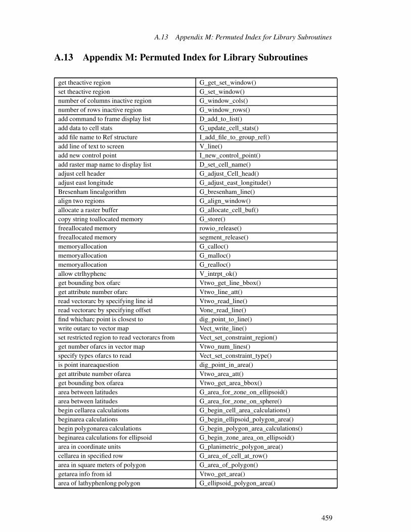
A.13 Appendix M: Permuted Index for Library Subroutines
A.13 Appendix M: Permuted Index for Library Subroutines
get theactive region G_get_set_window()set theactive region G_set_window()number of columns inactive region G_window_cols()number of rows inactive region G_window_rows()add command to frame display list D_add_to_list()add data to cell stats G_update_cell_stats()add file name to Ref structure I_add_file_to_group_ref()add line of text to screen V_line()add new control point I_new_control_point()add raster map name to display list D_set_cell_name()adjust cell header G_adjust_Cell_head()adjust east longitude G_adjust_east_longitude()Bresenham linealgorithm G_bresenham_line()align two regions G_align_window()allocate a raster buffer G_allocate_cell_buf()copy string toallocated memory G_store()freeallocated memory rowio_release()freeallocated memory segment_release()memoryallocation G_calloc()memoryallocation G_malloc()memoryallocation G_realloc()allow ctrlhyphenc V_intrpt_ok()get bounding box ofarc Vtwo_get_line_bbox()get attribute number ofarc Vtwo_line_att()read vectorarc by specifying line id Vtwo_read_line()read vectorarc by specifying offset Vone_read_line()find whicharc point is closest to dig_point_to_line()write outarc to vector map Vect_write_line()set restricted region to read vectorarcs from Vect_set_constraint_region()get number ofarcs in vector map Vtwo_num_lines()specify types ofarcs to read Vect_set_constraint_type()is point inareaquestion dig_point_in_area()get attribute number ofarea Vtwo_area_att()get bounding box ofarea Vtwo_get_area_bbox()area between latitudes G_area_for_zone_on_ellipsoid()area between latitudes G_area_for_zone_on_sphere()begin cellarea calculations G_begin_cell_area_calculations()beginarea calculations G_begin_ellipsoid_polygon_area()begin polygonarea calculations G_begin_polygon_area_calculations()beginarea calculations for ellipsoid G_begin_zone_area_on_ellipsoid()area in coordinate units G_planimetric_polygon_area()cellarea in specified row G_area_of_cell_at_row()area in square meters of polygon G_area_of_polygon()getarea info from id Vtwo_get_area()area of lathyphenlong polygon G_ellipsoid_polygon_area()
459

A Appendix
find whicharea point is in dig_point_to_area()get defining points forarea polygon Vect_get_area_points()get number ofareas in vector map Vtwo_num_areas()earth toarray parenlefteastparenright D_u_to_a_col()earth toarray parenleftnorthparenright D_u_to_a_row()lookup anarray of colors G_lookup_colors()array to screen parenleftcolumnparenright D_a_to_d_col()array to screen parenleftrowparenright D_a_to_d_row()screen toarray parenleftxparenright D_d_to_a_col()screen toarray parenleftyparenright D_d_to_a_row()convert line_pnts structure to xyarrays Vect_copy_pnts_to_xy()convert xyarrays to line_pnts structure Vect_copy_xy_to_pnts()easting toASCII G_format_easting()northing toASCII G_format_northing()resolution toASCII G_format_resolution()ASCII easting to double G_scan_easting()ASCII northing to double G_scan_northing()ASCII resolution to double G_scan_resolution()ask a yesslashno question G_yes()makeaspect colors G_make_aspect_colors()assignslashretrieve current map region D_check_map_window()getattribute number of arc Vtwo_line_att()getattribute number of area Vtwo_area_att()begin area calculations G_begin_ellipsoid_polygon_area()begin area calculations for ellipsoid G_begin_zone_area_on_ellipsoid()begin cell area calculations G_begin_cell_area_calculations()begin distance calculations G_begin_distance_calculations()begin geodesic distance G_begin_geodesic_distance()begin polygon area calculations G_begin_polygon_area_calculations()bottom of screen R_screen_bot()getbounding box of arc Vtwo_get_line_bbox()getbounding box of area Vtwo_get_area_bbox()fill abox R_box_abs()fill abox R_box_rel()get mouse location using abox R_get_location_with_box()get boundingbox of arc Vtwo_get_line_bbox()get boundingbox of area Vtwo_get_area_bbox()Bresenham line algorithm G_bresenham_line()allocate a rasterbuffer G_allocate_cell_buf()zero a rasterbuffer G_zero_cell_buf()begin cell areacalculations G_begin_cell_area_calculations()begin distancecalculations G_begin_distance_calculations()begin areacalculations G_begin_ellipsoid_polygon_area()begin polygon areacalculations G_begin_polygon_area_calculations()begin areacalculations for ellipsoid G_begin_zone_area_on_ellipsoid()initializecalculations for sphere G_begin_zone_area_on_sphere()turns off interactivecapability G_disable_interactive()
460

A.13 Appendix M: Permuted Index for Library Subroutines
querycartographic projection G_database_projection_name()querycartographic projection G_projection()querycartographic zone G_zone()convert string to lowercase G_tolcase()convert string to uppercase G_toucase()get acategory color G_get_color()set acategory color G_set_color()read rastercategory file G_read_cats()read vectorcategory file G_read_vector_cats()write rastercategory file G_write_cats()write vectorcategory file G_write_vector_cats()get acategory label G_get_cat()set acategory label G_set_cat()get title fromcategory structure G_get_cats_title()initializecategory structure G_init_cats()set title incategory structure G_set_cats_title()freecategory structure memory G_free_cats()begincell area calculations G_begin_cell_area_calculations()cell area in specified row G_area_of_cell_at_row()adjustcell header G_adjust_Cell_head()random query ofcell stats G_find_cell_stat()freecell stats G_free_cell_stats()initializecell stats G_init_cell_stats()retrieve sortedcell stats G_next_cell_stat()resetslashrewindcell stats G_rewind_cell_stats()add data tocell stats G_update_cell_stats()change ctrlhyphenc message V_intrpt_msg()change error handling G_set_error_routine()change raster map title G_put_cell_title()change to hardware color D_lookup_colors()return interruptchar G_intr_char()printable version of controlcharacter G_unctrl()check for legal database file names G_legal_filename()create a protectedchild process G_fork()choose font R_font()clear frame display lists D_clear_window()clears information about current frame D_clear_window()clip coordinates to window D_clip()set textclipping frame R_set_window()setclipping window D_set_clip_window()setclipping window to map window D_set_clip_window_to_map_window()close a raster file G_close_cell()close a vector map Vect_close()draw aclosed polygon R_polygon_abs()draw aclosed polygon R_polygon_rel()find which arc point isclosest to dig_point_to_line()change to hardwarecolor D_lookup_colors()
461

A Appendix
get a categorycolor G_get_color()set a categorycolor G_set_color()selectcolor R_color()define singlecolor R_reset_color()selectcolor R_RGB_color()select standardcolor R_standard_color()select rastercolor for line D_color()color name to number D_translate_color()makecolor ramp G_make_ramp_colors()getcolor range G_get_color_range()initializecolor structure G_init_colors()freecolor structure memory G_free_colors()read map layercolor table G_read_colors()write map layercolor table G_write_colors()select fixedcolor table R_color_table_fixed()select floatingcolor table R_color_table_float()reset rastercolor value D_reset_color()makecolor wave G_make_wav e_colors()verify a range ofcolors D_check_colormap_size()setcolors G_add_color_rule()lookup an array ofcolors G_lookup_colors()make aspectcolors G_make_aspect_colors()make greencommayellowcommaredcolors G_make_gyr_colors()make histogramhyphenstretched greycolors G_make_histogram_eq_colors()make rainbowcolors G_make_rainbow_colors()make randomcolors G_make_random_colors()make redcommayellowcommagreencolors G_make_ryg_colors()define multiplecolors R_reset_colors()establish rastercolors for graphics D_set_colors()setcolors in driver D_reset_colors()array to screenparenleftcolumnparenright D_a_to_d_col()easting tocolumn G_easting_to_col()column to easting G_col_to_easting()number ofcolumns in active region G_window_cols()run a shell levelcommand G_system()parsecommand line G_parser()command line helpslashusage message G_usage()addcommand to frame display list D_add_to_list()print percentcomplete messages G_percent()concatenate strings G_strcat()configure raster overlay mode D_set_overlay_mode()configure rowio structure rowio_setup()radius ofconformal tangent sphere G_radius_of_conformal_tangent_sphere()define screenconstant V_const()unset any vector readconstraints Vect_remove_constraints()print warning message andcontinue G_warning()printable version ofcontrol character G_unctrl()
462

A.13 Appendix M: Permuted Index for Library Subroutines
add newcontrol point I_new_control_point()read groupcontrol points I_get_control_points()write groupcontrol points I_put_control_points()conversion to meters G_database_units_to_meters_factor()initializeconversions D_do_conversions()convert line_pnts structure to xy arrays Vect_copy_pnts_to_xy()convert string to lower case G_tolcase()convert string to upper case G_toucase()convert xy arrays to line_pnts structure Vect_copy_xy_to_pnts()area incoordinate units G_planimetric_polygon_area()retrieve current framecoordinates D_get_screen_window()plot line between latloncoordinates G_plot_line()clipcoordinates to window D_clip()copy Ref lists I_transfer_group_ref_file()copy string to allocated memory G_store()copy strings G_strcpy()copy strings G_strncpy()copy vector header struct data Vect_copy_head_data()create a lock lock_file()create a protected child process G_fork()create new graphics frame D_new_window()create new initialized line points structure Vect_new_line_struct()allowctrlhyphenc V_intrpt_ok()changectrlhyphenc message V_intrpt_msg()get a line of inputparenleftdetectctrlhyphenzparenright
G_gets()
current date and time G_date()clears information aboutcurrent frame D_clear_window()erasecurrent frame D_erase_window()outlinescurrent frame D_show_window()retrievecurrent frame coordinates D_get_screen_window()resetscurrent frame position D_reset_screen_window()identifycurrent graphics frame D_get_cur_wind()setcurrent graphics frame D_set_cur_wind()movecurrent location R_move_abs()movecurrent location R_move_rel()current location directory G_location_path()current location name G_location()assignslashretrievecurrent map region D_check_map_window()current mapset name G_mapset()givecurrent time to frame D_timestamp()meridional radius ofcurvature G_meridional_radius_of_curvature()transverse radius ofcurvature G_transverse_radius_of_curvature()copy vector header structdata Vect_copy_head_data()adddata to cell stats G_update_cell_stats()top leveldatabase directory G_gisdbase()prompt for existingdatabase file G_ask_in_mapset()
463

A Appendix
prompt for newdatabase file G_ask_new()prompt for existingdatabase file G_ask_old()find adatabase file G_find_file()open a newdatabase file G_fopen_new()open a newdatabase file G_open_new()remove adatabase file G_remove()rename adatabase file G_rename()open adatabase file for reading G_fopen_old()open adatabase file for reading G_open_old()open adatabase file for update G_fopen_append()open adatabase file for update G_open_update()check for legaldatabase file names G_legal_filename()read thedatabase region G_get_window()write thedatabase region G_put_window()database units G_database_unit_name()currentdate and time G_date()deallocate line points structure Vect_destroy_line_struct()set number ofdecimal places V_float_accuracy()read thedefault region G_get_default_window()define multiple colors R_reset_colors()define screen constant V_const()define screen question V_ques()define single color R_reset_color()getdefining points for area polygon Vect_get_area_points()initialize screendescription V_clear()get filedescriptor rowio_fileno()get a line of inputparenleftdetectctrlhyphenzparenright
G_gets()
top level programdirectory G_gisbase()top level databasedirectory G_gisdbase()userquoterights homedirectory G_home()current locationdirectory G_location_path()force pending updates todisk rowio_flush()flush pending updates todisk segment_flush()add command to framedisplay list D_add_to_list()add raster map name todisplay list D_set_cell_name()clear framedisplay lists D_clear_window()begin geodesicdistance G_begin_geodesic_distance()geodesicdistance G_geodesic_distance()geodesicdistance G_geodesic_distance_lon_to_lon()begindistance calculations G_begin_distance_calculations()distance in meters G_distance()set geodesicdistance latone G_set_geodesic_distance_lat()set geodesicdistance lattwo G_set_geodesic_distance_lat()finddistance of point to line dig_check_dist()does group existquestion I_find_group()draw a series ofdots R_polydots_abs()
464

A.13 Appendix M: Permuted Index for Library Subroutines
draw a series ofdots R_polydots_rel()ASCII easting todouble G_scan_easting()ASCII northing todouble G_scan_northing()ASCII resolution todouble G_scan_resolution()draw a closed polygon R_polygon_abs()draw a closed polygon R_polygon_rel()draw a raster R_raster()draw a raster R_RGB_raster()draw a series of dots R_polydots_abs()draw a series of dots R_polydots_rel()draw an open polygon R_polyline_abs()draw an open polygon R_polyline_rel()draw line R_cont_abs()draw line R_cont_rel()set colors indriver D_reset_colors()earth to array parenlefteastparenright D_u_to_a_col()earth to array parenleftnorthparenright D_u_to_a_row()earth to screen parenlefteastparenright D_u_to_d_col()earth to screen parenleftnorthparenright D_u_to_d_row()screen toearth parenleftxparenright D_d_to_u_col()screen toearth parenleftyparenright D_d_to_u_row()earth to arrayparenlefteastparenright D_u_to_a_col()earth to screenparenlefteastparenright D_u_to_d_col()returnseast larger than west G_adjust_easting()adjusteast longitude G_adjust_east_longitude()column toeasting G_col_to_easting()easting to ASCII G_format_easting()easting to column G_easting_to_col()ASCIIeasting to double G_scan_easting()shortest way betweeneastings G_shortest_way()xcommay toeastcommanorth G_plot_where_en()eastcommanorth to xcommay G_plot_where_xy()screen leftedge R_screen_left()screen rightedge R_screen_rite()begin area calculations forellipsoid G_begin_zone_area_on_ellipsoid()getellipsoid by name G_get_ellipsoid_by_name()getellipsoid parameters G_get_ellipsoid_parameters()returnellopsoid name G_ellipsoid_name()query GRASSenvironment variable G_ _getenv()query GRASSenvironment variable G_getenv()set GRASSenvironment variable G_ _setenv()set GRASSenvironment variable G_setenv()erase current frame D_erase_window()erase screen R_erase()sleep onerrorquestion G_sleep_on_error()changeerror handling G_set_error_routine()reset normalerror handling G_unset_error_routine()
465

A Appendix
printerror message and exit G_fatal_error()establish raster colors for graphics D_set_colors()does groupexistquestion I_find_group()prompt forexisting database file G_ask_in_mapset()prompt forexisting database file G_ask_old()prompt for anexisting group I_ask_group_old()prompt forexisting raster file G_ask_cell_in_mapset()prompt forexisting raster file G_ask_cell_old()open anexisting raster file G_open_cell_old()prompt forexisting site list file G_ask_sites_in_mapset()prompt forexisting site list file G_ask_sites_old()open anexisting site list file G_fopen_sites_old()prompt for anexisting vector file G_ask_vector_in_mapset()prompt for anexisting vector file G_ask_vector_old()open anexisting vector file G_fopen_vector_old()openexisting vector map Vect_open_old()print error message andexit G_fatal_error()get textextents R_get_text_box()plotfparenlefteastoneparenright tofparenlefteasttwoparenright
G_plot_fx()
plot fparenlefteastoneparenrighttofparenlefteasttwoparenright
G_plot_fx()
prompt for existing rasterfile G_ask_cell_in_mapset()prompt for new rasterfile G_ask_cell_new()prompt for existing rasterfile G_ask_cell_old()prompt for existing databasefile G_ask_in_mapset()prompt for new databasefile G_ask_new()prompt for existing databasefile G_ask_old()prompt for existing site listfile G_ask_sites_in_mapset()prompt for new site listfile G_ask_sites_new()prompt for existing site listfile G_ask_sites_old()prompt for an existing vectorfile G_ask_vector_in_mapset()prompt for a new vectorfile G_ask_vector_new()prompt for an existing vectorfile G_ask_vector_old()close a rasterfile G_close_cell()find a rasterfile G_find_cell()find a databasefile G_find_file()find a vectorfile G_find_vector()find a vectorfile G_find_vector()open a new databasefile G_fopen_new()open a new site listfile G_fopen_sites_new()open an existing site listfile G_fopen_sites_old()open a new vectorfile G_fopen_vector_new()open an existing vectorfile G_fopen_vector_old()read a rasterfile G_get_map_row()read site listfile G_get_site()reclassfilequestion G_is_reclass()
466

A.13 Appendix M: Permuted Index for Library Subroutines
open an existing rasterfile G_open_cell_old()open a new databasefile G_open_new()write site listfile G_put_site()read raster categoryfile G_read_cats()read raster historyfile G_read_history()read vector categoryfile G_read_vector_cats()remove a databasefile G_remove()rename a databasefile G_rename()unopen a rasterfile G_unopen_cell()write raster categoryfile G_write_cats()write raster historyfile G_write_history()write raster rangefile G_write_range()write vector categoryfile G_write_vector_cats()read group REFfile I_get_group_ref()read subgroup REFfile I_get_subgroup_ref()write group REFfile I_put_group_ref()write subgroup REFfile I_put_subgroup_ref()format a segmentfile segment_format()get value from segmentfile segment_get()read row from segmentfile segment_get_row()put value to segmentfile segment_put()write row to segmentfile segment_put_row()getfile descriptor rowio_fileno()open a databasefile for reading G_fopen_old()open a databasefile for reading G_open_old()open a databasefile for update G_fopen_append()open a databasefile for update G_open_update()prompt for any validfile name G_ask_any()fully qualifiedfile name G_fully_qualified_name()returns a temporaryfile name G_tempfile()addfile name to Ref structure I_add_file_to_group_ref()check for legal databasefile names G_legal_filename()open a new rasterfile parenleftrandomparenright G_open_cell_new_random()write a rasterfile parenleftrandomparenright G_put_map_row_random()open a new rasterfileparenleftsequentialparenright
G_open_cell_new()
write a rasterfile parenleftsequentialparenright G_put_map_row()open a new rasterfileparenleftuncompressedparenright
G_open_cell_new_uncompressed()
read a rasterfile parenleftwithoutmaskingparenright
G_get_map_row_nomask()
fill a box R_box_abs()fill a box R_box_rel()plotfilled polygon with n vertices G_plot_polygon()find a database file G_find_file()find a raster file G_find_cell()find a vector file G_find_vector()
467

A Appendix
find a vector file G_find_vector()find distance of point to line dig_check_dist()find which arc point is closest to dig_point_to_line()find which area point is in dig_point_to_area()selectfixed color table R_color_table_fixed()returnFlag structure G_define_flag()selectfloating color table R_color_table_float()flush graphics R_flush()flush pending updates to disk segment_flush()choosefont R_font()force pending updates to disk rowio_flush()forget a row rowio_forget()format a segment file segment_format()clears information about currentframe D_clear_window()erase currentframe D_erase_window()identify current graphicsframe D_get_cur_wind()create new graphicsframe D_new_window()remove aframe D_remove_window()set current graphicsframe D_set_cur_wind()initializeslashcreate aframe D_setup()outlines currentframe D_show_window()give current time toframe D_timestamp()set text clippingframe R_set_window()retrieve currentframe coordinates D_get_screen_window()add command toframe display list D_add_to_list()clearframe display lists D_clear_window()resets currentframe position D_reset_screen_window()graphicsframe setup D_setup()free allocated memory rowio_release()free allocated memory segment_release()free category structure memory G_free_cats()free cell stats G_free_cell_stats()free color structure memory G_free_colors()free Ref structure I_free_group_ref()fully qualified file name G_fully_qualified_name()begingeodesic distance G_begin_geodesic_distance()geodesic distance G_geodesic_distance()geodesic distance G_geodesic_distance_lon_to_lon()setgeodesic distance latone G_set_geodesic_distance_lat()setgeodesic distance lattwo G_set_geodesic_distance_lat()initializegis library G_gisinit()give current time to frame D_timestamp()prepare for rastergraphics D_cell_draw_setup()establish raster colors forgraphics D_set_colors()terminategraphics R_close_driver()flushgraphics R_flush()initializegraphics R_open_driver()
468

A.13 Appendix M: Permuted Index for Library Subroutines
initializegraphics R_set_RGB_color()synchronizegraphics R_stabilize()identify currentgraphics frame D_get_cur_wind()create newgraphics frame D_new_window()set currentgraphics frame D_set_cur_wind()graphics frame setup D_setup()queryGRASS environment variable G_ _getenv()queryGRASS environment variable G_getenv()setGRASS environment variable G_ _setenv()setGRASS environment variable G_setenv()makegreencommayellowcommared colors G_make_gyr_colors()make histogramhyphenstretchedgrey colors G_make_histogram_eq_colors()make lineargrey scale G_make_grey_scale_colors()prompt for newgroup I_ask_group_new()prompt for an existinggroup I_ask_group_old()readgroup control points I_get_control_points()writegroup control points I_put_control_points()doesgroup existquestion I_find_group()prompt for any validgroup name I_ask_group_any()readgroup REF file I_get_group_ref()writegroup REF file I_put_group_ref()change errorhandling G_set_error_routine()reset normal errorhandling G_unset_error_routine()change tohardware color D_lookup_colors()adjust cellheader G_adjust_Cell_head()read the rasterheader G_get_cellhd()write the rasterheader G_put_cellhd()printheader info to stdout Vect_print_header()copy vectorheader struct data Vect_copy_head_data()command linehelpslashusage message G_usage()makehistogramhyphenstretched grey colors G_make_histogram_eq_colors()read rasterhistory file G_read_history()write rasterhistory file G_write_history()initializehistory structure G_short_history()getHit RETURN msg G_get_ask_return_msg()setHit RETURN msg G_set_ask_return_msg()userquoterightshome directory G_home()get area info fromid Vtwo_get_area()read vector arc by specifying lineid Vtwo_read_line()identify current graphics frame D_get_cur_wind()get areainfo from id Vtwo_get_area()print headerinfo to stdout Vect_print_header()read targetinformation I_get_target()write targetinformation I_put_target()clearsinformation about current frame D_clear_window()initialize calculations for sphere G_begin_zone_area_on_sphere()initialize category structure G_init_cats()
469

A Appendix
initialize cell stats G_init_cell_stats()initialize color structure G_init_colors()initialize conversions D_do_conversions()initialize gis library G_gisinit()initialize graphics R_open_driver()initialize graphics R_set_RGB_color()initialize history structure G_short_history()initialize plotting routines G_setup_plot()initialize range structure G_init_range()initialize Ref structure I_init_group_ref()initialize screen description V_clear()initialize segment structure segment_init()initializeslashcreate a frame D_setup()create newinitialized line points structure Vect_new_line_struct()get a line ofinput parenleftdetectctrlhyphenzparenright
G_gets()
interact with the user V_call()turns offinteractive capability G_disable_interactive()returninterrupt char G_intr_char()get a categorylabel G_get_cat()set a categorylabel G_set_cat()returns eastlarger than west G_adjust_easting()set geodesic distancelatone G_set_geodesic_distance_lat()set geodesic distancelattwo G_set_geodesic_distance_lat()area betweenlatitudes G_area_for_zone_on_ellipsoid()area betweenlatitudes G_area_for_zone_on_sphere()plot line betweenlatlon coordinates G_plot_line()area oflathyphenlong polygon G_ellipsoid_polygon_area()read maplayer color table G_read_colors()write maplayer color table G_write_colors()removeleadingslashtraining white G_strip()screenleft edge R_screen_left()check forlegal database file names G_legal_filename()run a shelllevel command G_system()toplevel database directory G_gisdbase()specifylevel for opening map Vect_set_open_level()get openlevel of vector map Vect_level()toplevel module directory G_gisbase()lowlevel raster plotting D_raster()initialize gislibrary G_gisinit()select raster color forline D_color()find distance of point toline dig_check_dist()parse commandline G_parser()drawline R_cont_abs()drawline R_cont_rel()get mouse location using aline R_get_location_with_line()read next vectorline Vect_read_next_line()
470

A.13 Appendix M: Permuted Index for Library Subroutines
Bresenhamline algorithm G_bresenham_line()plotline between latlon coordinates G_plot_line()commandline helpslashusage message G_usage()read vector arc by specifyingline id Vtwo_read_line()get aline of input parenleftdetectctrlhyphenzparenright
G_gets()
addline of text to screen V_line()create new initializedline points structure Vect_new_line_struct()deallocateline points structure Vect_destroy_line_struct()line to xcommay D_cont_abs()line to xcommay D_cont_rel()makelinear grey scale G_make_grey_scale_colors()convert xy arrays toline_pnts structure Vect_copy_xy_to_pnts()convertline_pnts structure to xy arrays Vect_copy_pnts_to_xy()add command to frame displaylist D_add_to_list()add raster map name to displaylist D_set_cell_name()prompt for existing sitelist file G_ask_sites_in_mapset()prompt for new sitelist file G_ask_sites_new()prompt for existing sitelist file G_ask_sites_old()open a new sitelist file G_fopen_sites_new()open an existing sitelist file G_fopen_sites_old()read sitelist file G_get_site()write sitelist file G_put_site()clear frame displaylists D_clear_window()copy Reflists I_transfer_group_ref_file()move currentlocation R_move_abs()move currentlocation R_move_rel()currentlocation directory G_location_path()currentlocation name G_location()location title G_myname()get mouselocation using a box R_get_location_with_box()get mouselocation using a line R_get_location_with_line()get mouselocation using pointer R_get_location_with_pointer()create alock lock_file()remove alock unlock_file()adjust eastlongitude G_adjust_east_longitude()lookup an array of colors G_lookup_colors()low lev el raster plotting D_raster()convert string tolower case G_tolcase()get number of areas in vectormap Vtwo_num_areas()get number of arcs in vectormap Vtwo_num_lines()close a vectormap Vect_close()get open level of vectormap Vect_level()open new vectormap Vect_open_new()open existing vectormap Vect_open_old()specify level for openingmap Vect_set_open_level()write out arc to vectormap Vect_write_line()
471

A Appendix
rewind vectormap for rehyphenreading Vect_rewind()readmap layer color table G_read_colors()writemap layer color table G_write_colors()retrieve rastermap name D_get_cell_name()add rastermap name to display list D_set_cell_name()assignslashretrieve currentmap region D_check_map_window()get rastermap title G_get_cell_title()change rastermap title G_put_cell_title()set clipping window tomap window D_set_clip_window_to_map_window()currentmapset name G_mapset()read a raster fileparenleftwithoutmaskingparenright
G_get_map_row_nomask()
get range min andmax G_get_range_min_max()free category structurememory G_free_cats()free color structurememory G_free_colors()copy string to allocatedmemory G_store()free allocatedmemory rowio_release()free allocatedmemory segment_release()memory allocation G_calloc()memory allocation G_malloc()memory allocation G_realloc()pophyphenupmenu D_popup()meridional radius of curvature G_meridional_radius_of_curvature()command line helpslashusagemessage G_usage()change ctrlhyphencmessage V_intrpt_msg()print warningmessage and continue G_warning()print errormessage and exit G_fatal_error()print percent completemessages G_percent()conversion tometers G_database_units_to_meters_factor()distance inmeters G_distance()area in squaremeters of polygon G_area_of_polygon()get rangemin and max G_get_range_min_max()configure raster overlaymode D_set_overlay_mode()getmouse location using a box R_get_location_with_box()getmouse location using a line R_get_location_with_line()getmouse location using pointer R_get_location_with_pointer()move current location R_move_abs()move current location R_move_rel()move to pixel D_move_abs()move to pixel D_move_rel()get Hit RETURNmsg G_get_ask_return_msg()set Hit RETURNmsg G_set_ask_return_msg()definemultiple colors R_reset_colors()plot filled polygon withn vertices G_plot_polygon()retrieve raster mapname D_get_cell_name()prompt for any valid filename G_ask_any()return ellopsoidname G_ellipsoid_name()
472

A.13 Appendix M: Permuted Index for Library Subroutines
fully qualified filename G_fully_qualified_name()get ellipsoid byname G_get_ellipsoid_by_name()current locationname G_location()current mapsetname G_mapset()return programname G_program_name()returns a temporary filename G_tempfile()userquoterightsname G_whoami()prompt for any valid groupname I_ask_group_any()add raster mapname to display list D_set_cell_name()colorname to number D_translate_color()add filename to Ref structure I_add_file_to_group_ref()check for legal database filenames G_legal_filename()readnext vector line Vect_read_next_line()resetnormal error handling G_unset_error_routine()earth to arrayparenleftnorthparenright D_u_to_a_row()earth to screenparenleftnorthparenright D_u_to_d_row()row tonorthing G_row_to_northing()northing to ASCII G_format_northing()ASCIInorthing to double G_scan_northing()northing to row G_northing_to_row()color name tonumber D_translate_color()get attributenumber of arc Vtwo_line_att()getnumber of arcs in vector map Vtwo_num_lines()get attributenumber of area Vtwo_area_att()getnumber of areas in vector map Vtwo_num_areas()number of columns in active region G_window_cols()setnumber of decimal places V_float_accuracy()number of rows in active region G_window_rows()read vector arc by specifyingoffset Vone_read_line()open a database file for reading G_fopen_old()open a database file for reading G_open_old()open a database file for update G_fopen_append()open a database file for update G_open_update()open a new database file G_fopen_new()open a new database file G_open_new()open a new raster file parenleftrandomparenright G_open_cell_new_random()open a new raster fileparenleftsequentialparenright
G_open_cell_new()
open a new raster fileparenleftuncompressedparenright
G_open_cell_new_uncompressed()
open a new site list file G_fopen_sites_new()open a new vector file G_fopen_vector_new()open an existing raster file G_open_cell_old()open an existing site list file G_fopen_sites_old()open an existing vector file G_fopen_vector_old()open existing vector map Vect_open_old()getopen level of vector map Vect_level()
473

A Appendix
open new vector map Vect_open_new()draw anopen polygon R_polyline_abs()draw anopen polygon R_polyline_rel()specify level foropening map Vect_set_open_level()returnsOption structure G_define_option()outlines current frame D_show_window()configure rasteroverlay mode D_set_overlay_mode()get ellipsoidparameters G_get_ellipsoid_parameters()parse command line G_parser()forcepending updates to disk rowio_flush()flushpending updates to disk segment_flush()printpercent complete messages G_percent()move topixel D_move_abs()move topixel D_move_rel()set number of decimalplaces V_float_accuracy()plot fparenlefteastoneparenright tofparenlefteasttwoparenright
G_plot_fx()
plot filled polygon with n vertices G_plot_polygon()plot line between latlon coordinates G_plot_line()low lev el rasterplotting D_raster()initializeplotting routines G_setup_plot()add new controlpoint I_new_control_point()ispoint in areaquestion dig_point_in_area()find which arcpoint is closest to dig_point_to_line()find which areapoint is in dig_point_to_area()find distance ofpoint to line dig_check_dist()get mouse location usingpointer R_get_location_with_pointer()read group controlpoints I_get_control_points()write group controlpoints I_put_control_points()get definingpoints for area polygon Vect_get_area_points()create new initialized linepoints structure Vect_new_line_struct()deallocate linepoints structure Vect_destroy_line_struct()pole in polygon G_pole_in_polygon()area in square meters ofpolygon G_area_of_polygon()area of lathyphenlongpolygon G_ellipsoid_polygon_area()pole inpolygon G_pole_in_polygon()draw a closedpolygon R_polygon_abs()draw a closedpolygon R_polygon_rel()draw an openpolygon R_polyline_abs()draw an openpolygon R_polyline_rel()get defining points for areapolygon Vect_get_area_points()beginpolygon area calculations G_begin_polygon_area_calculations()plot filledpolygon with n vertices G_plot_polygon()pophyphenup menu D_popup()resets current frameposition D_reset_screen_window()prepare for raster graphics D_cell_draw_setup()print error message and exit G_fatal_error()
474

A.13 Appendix M: Permuted Index for Library Subroutines
print header info to stdout Vect_print_header()print percent complete messages G_percent()print warning message and continue G_warning()printable version of control character G_unctrl()create a protected childprocess G_fork()top levelprogram directory G_gisbase()returnprogram name G_program_name()query cartographicprojection G_database_projection_name()query cartographicprojection G_projection()prompt for a new vector file G_ask_vector_new()prompt for an existing group I_ask_group_old()prompt for an existing vector file G_ask_vector_in_mapset()prompt for an existing vector file G_ask_vector_old()prompt for any valid file name G_ask_any()prompt for any valid group name I_ask_group_any()prompt for existing database file G_ask_in_mapset()prompt for existing database file G_ask_old()prompt for existing raster file G_ask_cell_in_mapset()prompt for existing raster file G_ask_cell_old()prompt for existing site list file G_ask_sites_in_mapset()prompt for existing site list file G_ask_sites_old()prompt for new database file G_ask_new()prompt for new group I_ask_group_new()prompt for new raster file G_ask_cell_new()prompt for new site list file G_ask_sites_new()create aprotected child process G_fork()put value to segment file segment_put()fullyqualified file name G_fully_qualified_name()query cartographic projection G_database_projection_name()query cartographic projection G_projection()query cartographic zone G_zone()query GRASS environment variable G_ _getenv()query GRASS environment variable G_getenv()randomquery of cell stats G_find_cell_stat()ask a yesslashnoquestion G_yes()define screenquestion V_ques()radius of conformal tangent sphere G_radius_of_conformal_tangent_sphere()meridionalradius of curvature G_meridional_radius_of_curvature()transverseradius of curvature G_transverse_radius_of_curvature()makerainbow colors G_make_rainbow_colors()make colorramp G_make_ramp_colors()open a new raster fileparenleftrandomparenright G_open_cell_new_random()write a raster fileparenleftrandomparenright G_put_map_row_random()makerandom colors G_make_random_colors()random query of cell stats G_find_cell_stat()get colorrange G_get_color_range()read rasterrange G_read_range()
475

A Appendix
write rasterrange file G_write_range()getrange min and max G_get_range_min_max()verify arange of colors D_check_colormap_size()initializerange structure G_init_range()updaterange structure G_row_update_range()updaterange structure G_update_range()draw araster R_raster()draw araster R_RGB_raster()allocate araster buffer G_allocate_cell_buf()zero araster buffer G_zero_cell_buf()readraster category file G_read_cats()writeraster category file G_write_cats()selectraster color for line D_color()resetraster color value D_reset_color()establishraster colors for graphics D_set_colors()prompt for existingraster file G_ask_cell_in_mapset()prompt for newraster file G_ask_cell_new()prompt for existingraster file G_ask_cell_old()close araster file G_close_cell()find araster file G_find_cell()read araster file G_get_map_row()open an existingraster file G_open_cell_old()unopen araster file G_unopen_cell()open a newraster file parenleftrandomparenright G_open_cell_new_random()write araster file parenleftrandomparenright G_put_map_row_random()open a newraster fileparenleftsequentialparenright
G_open_cell_new()
write araster file parenleftsequentialparenright G_put_map_row()open a newraster fileparenleftuncompressedparenright
G_open_cell_new_uncompressed()
read araster file parenleftwithoutmaskingparenright
G_get_map_row_nomask()
prepare forraster graphics D_cell_draw_setup()read theraster header G_get_cellhd()write theraster header G_put_cellhd()readraster history file G_read_history()writeraster history file G_write_history()retrieveraster map name D_get_cell_name()addraster map name to display list D_set_cell_name()getraster map title G_get_cell_title()changeraster map title G_put_cell_title()configureraster overlay mode D_set_overlay_mode()low lev elraster plotting D_raster()readraster range G_read_range()writeraster range file G_write_range()render araster row D_draw_cell()specify types of arcs toread Vect_set_constraint_type()
476

A.13 Appendix M: Permuted Index for Library Subroutines
read a raster file G_get_map_row()read a raster file parenleftwithoutmaskingparenright
G_get_map_row_nomask()
read a row rowio_get()unset any vectorread constraints Vect_remove_constraints()read group control points I_get_control_points()read group REF file I_get_group_ref()read map layer color table G_read_colors()read next vector line Vect_read_next_line()read raster category file G_read_cats()read raster history file G_read_history()read raster range G_read_range()read row from segment file segment_get_row()read site list file G_get_site()read subgroup REF file I_get_subgroup_ref()read target information I_get_target()read the database region G_get_window()read the default region G_get_default_window()read the raster header G_get_cellhd()read vector arc by specifying line id Vtwo_read_line()read vector arc by specifying offset Vone_read_line()set restricted region toread vector arcs from Vect_set_constraint_region()read vector category file G_read_vector_cats()open a database file forreading G_fopen_old()open a database file forreading G_open_old()reclass filequestion G_is_reclass()makeredcommayellowcommagreen colors G_make_ryg_colors()read groupREF file I_get_group_ref()read subgroupREF file I_get_subgroup_ref()write groupREF file I_put_group_ref()write subgroupREF file I_put_subgroup_ref()copyRef lists I_transfer_group_ref_file()add file name toRef structure I_add_file_to_group_ref()freeRef structure I_free_group_ref()initializeRef structure I_init_group_ref()assignslashretrieve current mapregion D_check_map_window()read the defaultregion G_get_default_window()get the activeregion G_get_set_window()read the databaseregion G_get_window()write the databaseregion G_put_window()set the activeregion G_set_window()number of columns in activeregion G_window_cols()number of rows in activeregion G_window_rows()set restrictedregion to read vector arcs from Vect_set_constraint_region()align tworegions G_align_window()remove a database file G_remove()remove a frame D_remove_window()
477

A Appendix
remove a lock unlock_file()remove leadingslashtraining white G_strip()remove unnecessary white G_squeeze()rename a database file G_rename()render a raster row D_draw_cell()rewind vector map forrehyphenreading Vect_rewind()reset normal error handling G_unset_error_routine()reset raster color value D_reset_color()resetslashrewind cell stats G_rewind_cell_stats()resets current frame position D_reset_screen_window()resolution to ASCII G_format_resolution()ASCIIresolution to double G_scan_resolution()setrestricted region to read vector arcs from Vect_set_constraint_region()retrieve current frame coordinates D_get_screen_window()retrieve raster map name D_get_cell_name()retrieve sorted cell stats G_next_cell_stat()return ellopsoid name G_ellipsoid_name()return Flag structure G_define_flag()return interrupt char G_intr_char()get HitRETURN msg G_get_ask_return_msg()set HitRETURN msg G_set_ask_return_msg()return module name G_program_name()returns a temporary file name G_tempfile()returns east larger than west G_adjust_easting()returns Option structure G_define_option()rewind vector map for rehyphenreading Vect_rewind()initialize plottingroutines G_setup_plot()array to screenparenleftrowparenright D_a_to_d_row()render a rasterrow D_draw_cell()cell area in specifiedrow G_area_of_cell_at_row()northing torow G_northing_to_row()forget arow rowio_forget()read arow rowio_get()write arow rowio_put()readrow from segment file segment_get_row()row to northing G_row_to_northing()writerow to segment file segment_put_row()configurerowio structure rowio_setup()number ofrows in active region G_window_rows()run a shell level command G_system()make linear greyscale G_make_grey_scale_colors()erasescreen R_erase()bottom ofscreen R_screen_bot()top ofscreen R_screen_top()add line of text toscreen V_line()array toscreen parenleftcolumnparenright D_a_to_d_col()definescreen constant V_const()
478

A.13 Appendix M: Permuted Index for Library Subroutines
initializescreen description V_clear()earth toscreen parenlefteastparenright D_u_to_d_col()screen left edge R_screen_left()earth toscreen parenleftnorthparenright D_u_to_d_row()definescreen question V_ques()screen right edge graveR_screen_rite()array toscreen parenleftrowparenright D_a_to_d_row()screen to array parenleftxparenright D_d_to_a_col()screen to array parenleftyparenright D_d_to_a_row()screen to earth parenleftxparenright D_d_to_u_col()screen to earth parenleftyparenright D_d_to_u_row()format asegment file segment_format()get value fromsegment file segment_get()read row fromsegment file segment_get_row()put value tosegment file segment_put()write row tosegment file segment_put_row()initializesegment structure segment_init()select color R_color()select color R_RGB_color()select fixed color table R_color_table_fixed()select floating color table R_color_table_float()select raster color for line D_color()select standard color R_standard_color()open a new rasterfileparenleftsequentialparenright
G_open_cell_new()
write a raster fileparenleftsequentialparenright G_put_map_row()draw aseries of dots R_polydots_abs()draw aseries of dots R_polydots_rel()set a category color G_set_color()set a category label G_set_cat()set clipping window D_set_clip_window()set clipping window to map window D_set_clip_window_to_map_window()set colors G_add_color_rule()set colors in driver D_reset_colors()set current graphics frame D_set_cur_wind()set geodesic distance latone G_set_geodesic_distance_lat()set geodesic distance lattwo G_set_geodesic_distance_lat()set GRASS environment variable G_ _setenv()set GRASS environment variable G_setenv()set Hit RETURN msg G_set_ask_return_msg()set number of decimal places V_float_accuracy()set restricted region to read vector arcs from Vect_set_constraint_region()set text clipping frame R_set_window()set text size R_text_size()set the active region G_set_window()set title in category structure G_set_cats_title()graphics framesetup D_setup()
479

A Appendix
run ashell level command G_system()shortest way between eastings G_shortest_way()definesingle color R_reset_color()prompt for existingsite list file G_ask_sites_in_mapset()prompt for newsite list file G_ask_sites_new()prompt for existingsite list file G_ask_sites_old()open a newsite list file G_fopen_sites_new()open an existingsite list file G_fopen_sites_old()readsite list file G_get_site()writesite list file G_put_site()set textsize R_text_size()sleep on errorquestion G_sleep_on_error()retrievesorted cell stats G_next_cell_stat()remove unnecessary white G_squeeze()remove leadingslashtraining white G_strip()deallocate line points structure Vect_destroy_line_struct()cell area inspecified row G_area_of_cell_at_row()specify level for opening map Vect_set_open_level()specify types of arcs to read Vect_set_constraint_type()read vector arc byspecifying line id Vtwo_read_line()read vector arc byspecifying offset Vone_read_line()initialize calculations forsphere G_begin_zone_area_on_sphere()radius of conformal tangentsphere G_radius_of_conformal_tangent_sphere()area insquare meters of polygon G_area_of_polygon()selectstandard color R_standard_color()random query of cellstats G_find_cell_stat()free cellstats G_free_cell_stats()initialize cellstats G_init_cell_stats()retrieve sorted cellstats G_next_cell_stat()resetslashrewind cellstats G_rewind_cell_stats()add data to cellstats G_update_cell_stats()print header info tostdout Vect_print_header()copystring to allocated memory G_store()convertstring to lower case G_tolcase()convertstring to upper case G_toucase()concatenatestrings G_strcat()copystrings G_strcpy()copystrings G_strncpy()copy vector headerstruct data Vect_copy_head_data()return Flagstructure G_define_flag()returns Optionstructure G_define_option()get title from categorystructure G_get_cats_title()initialize categorystructure G_init_cats()initialize colorstructure G_init_colors()initialize rangestructure G_init_range()update rangestructure G_row_update_range()set title in categorystructure G_set_cats_title()
480

A.13 Appendix M: Permuted Index for Library Subroutines
initialize historystructure G_short_history()update rangestructure G_update_range()add file name to Refstructure I_add_file_to_group_ref()free Refstructure I_free_group_ref()initialize Refstructure I_init_group_ref()configure rowiostructure rowio_setup()initialize segmentstructure segment_init()convert xy arrays to line_pntsstructure Vect_copy_xy_to_pnts()create new initialized line pointsstructure Vect_new_line_struct()free categorystructure memory G_free_cats()free colorstructure memory G_free_colors()
481

A Appendix
482

B Newindex
(See next page.)
483

Index
*CC_spheroid_name(int n), 305
C_get_spheroid_by_nbr(int n), 306CC_datum_description(int n), 299CC_datum_ellipsoid(int n), 299CC_datum_name(int n), 298CC_datum_shift(const char *name, double *dx,
double *dy, double *dz), 298CC_datum_shift_BursaWolf(double Sphi, dou-
ble Slam, double Sh, double Sa, dou-ble Se2, double *Dphi, double *Dlam,double *Dh, double Da, double De2,double dx, double dy, double dz, dou-ble Rx, double Ry, double Rz, doubleScale), 301
CC_datum_shift_CC(double Sphi, double Slam,double Sh, double Sa, double Se2, dou-ble *Dphi, double *Dlam, double *Dh,double Da, double De2, double dx,double dy, double dz), 300
CC_datum_shift_Molodensky(doubleSphi, dou-ble Slam, double Sh, double Sa, dou-ble Se2, double rSf, double *Dphi, dou-ble *Dlam, double *Dh, double Da,double De2, double rDf, double dx,double dy, double dz), 301
CC_datum_to_datum_shift_BW(intSdatum, dou-ble Sphi, double Slam, double Sh, intDdatum, double *Dphi, double *Dlam,double *Dh), 302
CC_datum_to_datum_shift_CC(intSdatum, dou-ble Sphi, double Slam, double Sh, intDdatum, double *Dphi, double *Dlam,double *Dh), 301
CC_datum_to_datum_shift_M(intSdatum, dou-ble Sphi, double Slam, double Sh, intDdatum, double *Dphi, double *Dlam,double *Dh), 301
CC_geo2ll(double a, double e2, double x, dou-ble y, double z, double *lat, double*lon, double *h, int n, double stop_delta),304
CC_geo2lld(double a, double e2, double x, dou-ble y, double z, double *lat, double*lon, double *h), 304
CC_get_datum_by_name(const char *name), 299CC_get_datum_by_nbr(int n), 299
CC_get_datum_parameters(const char *name, char*ellps, double *dx, double *dy, dou-ble *dz), 298
CC_get_spheroid(const char *name, double *a,double *e2), 305
CC_get_spheroid_by_name(const char *name,double *a, double *e2, double *f), 305
CC_lat_format(double lat, char *buf), 302CC_lat_parts(double lat, int *deg, int *min, dou-
ble *sec, char *hemisphere), 303CC_lat_scan(char *string, double *lat), 304CC_ll2geo(double a, double e2, double lat, dou-
ble lon, double h, double *x, double*y, double *z), 303
CC_ll2tm(double lat, double lon, double *east-ing, double *northing, int *zone), 307
CC_ll2u(double lat, double lon, double *east-ing, double *northing, int *zone), 308
CC_lld2geo(double a, double e2, double lat, dou-ble lon, double h, double *x, double*y, double *z), 303
CC_lon_format(double lon, char *buf), 302CC_lon_parts(double lon, int *deg, int *min, dou-
ble *sec, char *hemisphere), 303CC_lon_scan(char *string, double *lon), 304CC_tm2ll(double easting, double *lat, double
*lon), 307CC_tm2ll_north(double northing), 306CC_tm2ll_spheroid(char *name), 306CC_tm2ll_spheroid_parameters(double a, dou-
ble e2), 306CC_tm2ll_zone(int zone), 306CC_u2ll(double easting, double *lat, double *lon),
308CC_u2ll_north(double northing), 308CC_u2ll_spheroid(char *name), 307CC_u2ll_spheroid_parameters(doublea, double
e2), 307CC_u2ll_zone(int zone), 307
D_a_to_d_col (double column), 261D_a_to_d_row (double row), 261D_add_to_list (char *string), 258D_cell_draw_setup (int top, int bottom, int left,
int right), 263D_check_colormap_size (CELL min, CELL max,
int *ncolors), 262
484

Index
D_check_map_window(struct Cell_head *region),257
D_clear_window ( ), 258, 259D_clip (double s, double n, double w, double
e, double *x, double *y, double *c_x,double *c_y), 265
D_color (CELL cat, struct Colors *colors), 263D_color_of_type (void *value, struct Colors *col-
ors, RASTER_MAP_TYPE data_type),140
D_cont_abs (int x, int y), 268D_cont_rel (int x, int y), 268D_d_color (DCELL *value, struct Colors *col-
ors), 141D_d_raster (DCELL *dcell, int ncols, int nrows,
struct Colors *colors), 140D_d_to_a_col (double x), 262D_d_to_a_row (double y), 262D_d_to_u_col (double x), 261D_d_to_u_row (double y), 261D_do_conversions (struct Cell_head *region, int
top, int bottom, int left, int right), 260D_draw_cell (int row, CELL *raster, struct Col-
ors *colors), 263D_draw_cell_of_type(int A_row, DCELL *xar-
ray, struct Colors *colors, RASTER_MAP_TYPEmap_type), 142
D_draw_d_cell (int A_row, DCELL *xarray, structColors *colors), 142
D_draw_f_cell (int A_row, FCELL *xarray, structColors *colors), 142
D_erase_window ( ), 258D_f_color (FCELL *value, struct Colors *col-
ors), 140D_f_raster (FCELL *fcell, int ncols, int nrows,
struct Colors *colors), 140D_get_cell_name (char *name), 259D_get_cur_wind (char *name), 257D_get_dig_name (char *name), 259D_get_screen_window (int *top, int *bottom,
int *left, int *right), 257D_get_site_name (char *name), 259D_lookup_c_raster_colors (CELL *cell, int *col-
ornum, int n, struct Colors *colors),141
D_lookup_colors (CELL *data, int n, struct Col-ors *colors), 262
D_lookup_d_raster_colors (DCELL *dcell, int*colornum, int n, struct Colors *col-ors), 141
D_lookup_f_raster_colors (FCELL *fcell, int *col-ornum, int n, struct Colors *colors),141
D_lookup_raster_colors (void *rast, int *color-num, int n, struct Colors *colors, RASTER_MAP_TYPEdata_type), 141
D_move_abs (int x, int y), 268D_move_rel (int x, int y), 268D_new_window (char *name, int top, int bot-
tom, int left, int right), 256D_popup (int bcolor, int tcolor, int dcolor, int
top, int left, int size, char *options[]),265
D_raster (CELL *raster, int n, int repeat, structColors *colors), 264
D_raster_of_type (void *rast, int ncols, int nrows,struct Colors *colors, RASTER_MAP_TYPEdata_type), 140
D_remove_window ( ), 258D_reset_color (CELL data, int r, int g, int b),
262D_reset_colors (struct Colors *colors), 266D_reset_screen_window (int top, int bottom, int
left, int right), 257D_set_cell_name (char *name), 258D_set_clip_window (int top, int bottom, int left,
int right), 267D_set_clip_window_to_map_window ( ), 268D_set_colors (struct Colors *colors), 263D_set_cur_wind (char *name), 257D_set_dig_name (char *name), 259D_set_overlay_mode (int flag), 264D_set_site_name (char *name), 259D_setup (int clear), 255, 267D_show_window (int color), 257D_timestamp ( ), 258D_translate_color (char *name), 266D_u_to_a_col (double east), 260D_u_to_a_row (double north), 260D_u_to_d_col (double east), 261D_u_to_d_row (double north), 261datetime_change_from_to(DateTime *dt; int from,
to; int round), 352datetime_change_timezone (DateTime *dt; int
minutes), 360datetime_change_to_utc (DateTime *dt), 360datetime_check_day (DateTime *dt, int day), 356datetime_check_fracsec (DateTime *dt, int frac-
sec), 356datetime_check_hour (DateTime *dt, int hour),
356datetime_check_increment (DateTime *src, *incr),
358datetime_check_minute (DateTime *dt, int minute),
356datetime_check_month (DateTime *dt, int month),
356
485

Index
datetime_check_second (DateTime *dt, doublesecond), 356
datetime_check_timezone (DateTime *dt, int min-utes), 360
datetime_check_type (DateTime *dt), 352datetime_check_year (DateTime *dt, int year),
355datetime_clear_error (), 362datetime_copy (DateTime *dst, *src), 353datetime_days_in_month (int month, year), 361datetime_days_in_year (int year, ad), 361datetime_decompose_timezone(int tz, int *hour,
int *minute), 361datetime_difference (DateTime *a, *b, *result),
358datetime_error (int code, char *msg), 362datetime_format (DateTime *dt, char *string),
351datetime_get_day (DateTime *dt, int *day), 355datetime_get_error_code (), 362datetime_get_error_msg (), 362datetime_get_fracsec (DateTime *dt, int *frac-
sec), 355datetime_get_hour (DateTime *dt, int *hour),
355datetime_get_increment_type (DateTime *src; int
*mode, *from, *to, *fracsec), 359datetime_get_local_time (DateTime *dt), 361datetime_get_local_timezone(int *minutes), 361datetime_get_minute (DateTime *dt, int *minute),
355datetime_get_month (DateTime *dt, int *month),
354datetime_get_second (DateTime *dt, double *sec-
ond), 355datetime_get_timezone (DateTime *dt, int *min-
utes), 360datetime_get_type (DateTime *dt; int *mode,
*from, *to, *fracsec), 352datetime_get_year (DateTime *dt, int *year), 354datetime_increment (DateTime *src, *incr), 357datetime_invert_sign (DateTime *dt), 357datetime_is_absolute (DateTime *dt), 353datetime_is_leap_year (int year, ad), 361datetime_is_positive (DateTime *dt), 357datetime_is_relative (DateTime *dt), 353datetime_is_same (DateTime *dt1, *dt2), 354datetime_is_valid_increment (DateTime *src, *incr),
358datetime_is_valid_timezone (int minutes), 360datetime_is_valid_type (DateTime *dt), 352datetime_scan (DateTime *dt, char *string), 351datetime_set_day (DateTime *dt, int day), 354
datetime_set_fracsec (DateTime *dt, int fracsec),355
datetime_set_hour (DateTime *dt, int hour), 355datetime_set_increment_type (DateTime *src, *incr),
359datetime_set_minute (DateTime *dt, int minute),
355datetime_set_month (DateTime *dt, int month),
354datetime_set_negative (DateTime *dt), 357datetime_set_positive (DateTime *dt), 357datetime_set_second (DateTime *dt, double sec-
ond), 355datetime_set_timezone (DateTime *dt, int min-
utes), 360datetime_set_type (DateTime *dt; int mode, from,
to, fracsec), 351datetime_set_year (DateTime *dt, int year), 354datetime_unset_timezone (DateTime *dt), 360Dcell(), 135dig_check_dist (struct Map_info *Map, intn, dou-
ble x, double y, double *d), 230dig_point_in_area (struct Map_info *Map, dou-
ble x, double y, P_AREA *pa), 230dig_point_to_area (struct Map_info *Map, dou-
ble x, double y), 230dig_point_to_line (struct Map_info *Map, dou-
ble x, double y, char type), 230
ENDIAN, 206
G3d_adjustRegion (G3D_Region *region), 342G3d_adjustRegionRes (G3D_Region *region),
342G3d_allocTiles (void *map, int nofTiles), 331G3d_allocTilesType (void *map, int nofTiles,
int type), 331G3d_autolockOff (void *map), 329G3d_autolockOn (void *map), 329G3d_beginCycle (void *map), 329G3d_cacheSizeEncode (int cacheCode, int n),
330G3d_changePrecision (void *map, int precision,
char *nameOut), 345G3d_changeType (void *map, char *nameOut),
345G3d_closeCell (void *map), 323G3d_compareFiles (char *f1, char *mapset1, char
*f2, char *mapset2), 345G3d_computeClippedTileDimensions (void *map,
int tileIndex, int *rows, int *cols, int*depths, int *xRedundant, int *yRe-dundant, int *zRedundant), 335
486

Index
G3d_coord2tileCoord (void *map, int x, int y,int z, int *xTile, int *yTile, int *zTile,int *xOffs, int *yOffs, int *zOffs), 334
G3d_coord2tileIndex (void *map, int x, int y,int z, int *tileIndex, int *offset), 335
G3d_coordInRange (void *map, int x, int y, intz), 335
G3d_customResampleFun (void *map, int row,int col, int depth, char *value, int type),341
G3d_endCycle (void *map), 329G3d_extract2dRegion(G3D_Region *region3d,
struct Cell_head *region2d), 342G3d_fatalError (char (*msg)(char *)), 321G3d_filename (char *path, *elementName, *map-
Name, *mapset), 344G3d_fileTypeMap (void *map), 333G3d_flushTile (void *map, int tileIndex), 327G3d_flushTileCube (void *map, int xMin, int
yMin, int zMin, int xMax, int yMax,int zMax), 328
G3d_flushTilesInCube (void *map, int xMin, intyMin, int zMin, int xMax, int yMax,int zMax), 328
G3d_free (void *ptr), 331G3d_freeTiles (char *tiles), 331G3d_g3dType2cellType (int g3dType), 343G3d_getAllignedVolume (void *map, double orig-
inNorth, double originWest, double orig-inBottom, double lengthNorth, dou-ble lengthWest, double lengthBottom,int nx, int ny, int nz, char *volume-Buf, int type), 330
G3d_getBlock (void *map, int x0, int y0, int z0,int nx, int ny, int nz, char *block, inttype, 345
G3d_getCacheLimit (int nBytes), 317G3d_getCacheSize (), 318G3d_getCompressionMode (int *doCompress,
int *doLzw, int *doRle, int *precision),319
G3d_getCoordsMap (void *map, int *rows, int*cols, int *depths), 332
G3d_getDouble (void *map, int x, int y, int z),324
G3d_getDoubleRegion (void *map, int x, int y,int z), 325
G3d_getFileType (int type), 320G3d_getFloat (void *map, int x, int y, int z), 324G3d_getFloatRegion (void *map, int x, int y, int
z), 325G3d_getNearestNeighborFunPtr (void (**nnFunPtr)
()), 342
G3d_getNofTilesMap (void *map, int *nx, int*ny, int *nz), 333
G3d_getRegionMap (void *map, int *north, int*south, int *east, int *west, int *top,int *bottom), 332
G3d_getRegionStructMap (void *map, G3D_Region*region), 333
G3d_getRegionValue (void *map, double north,double east, double top, char *value,int type), 343
G3d_getResamplingFun (void *map, void (**re-sampleFun) ()), 341
G3d_getStandard3dInputParams (int *useType-Default, *type, *useLzwDefault, *doLzw,int *useRleDefault, *doRle, *usePre-cisionDefault, *precision, int *useDi-mensionDefault, *tileX, *tileY, *tileZ,344
G3d_getTileDimension (int *tileX, int *tileY, int*tileZ), 319
G3d_getTileDimensionsMap (void *map, int *x,int *y, int *z), 333
G3d_getTilePtr (void *map, int tileIndex), 326G3d_getValue (), 313G3d_getValue (void *map, int x, int y, int z,
char *value, int type), 324G3d_getValueRegion (void *map, int x, int y,
int z, char*value, int type), 325G3d_getVolume (void *map, double originNorth,
double originWest, double originBot-tom, double vxNorth, double vxWest,double vxBottom, double vyNorth, dou-ble vyWest, double vyBottom, dou-ble vzNorth, double vzWest, doublevzBottom, int nx, int ny, int nz, char*volumeBuf, int type), 330
G3d_getWindow (G3D_Region *window), 340G3d_incorporate2dRegion(struct Cell_head *re-
gion2d, G3D_Region *region3d), 342G3d_initDefaults (), 343G3d_isMasked (int x, int y, int z), 339G3d_isNullValueNum (void *n, int type), 332G3d_isValidLocation (void *map, double north,
double west, double bottom), 335G3d_location2coord (void *map, double north,
double west, double bottom, int *x,*y, *z), 335
G3d_lockTile (void *map, int tileIndex), 328G3d_makeMapsetMapDirectory (char *mapName),
344G3d_malloc (int nBytes), 331G3d_maskDouble (int x, int y, int z, double *value),
339G3d_maskFile (), 339
487

Index
G3d_maskFileExists (), 338G3d_maskFloat (int x, int y, int z, float *value),
339G3d_maskIsOff (void *map), 338G3d_maskIsOn (void *map), 338G3d_maskMapExists (), 339G3d_maskNum (int x, int y, int z, void *value,
int type), 339G3d_maskOff (void *map), 338G3d_maskOn (void *map), 338G3d_maskReopen (int cache), 338G3d_maskTile (void *map, int tileIndex, char
*tile, int type), 339G3d_minUnlocked (void *map, int minUnlocked),
329G3d_nearestNeighbor (void *map, int row, int
col, int depth, char *value, int type),341
G3d_openCellNew (char *name, int type, intcache, G3D_Region *region), 322
G3d_openCellNewParam (char *name, int type-Intern, int cache, G3D_Region *region,int type, int doLzw, int doRle, int pre-cision, int tileX, int tileY, int tileZ),322
G3d_openCellOld (char *name, char *mapset,G3D_Region *window, int type, intcache), 321
G3d_printError (char (*msg)(char *)), 321G3d_printHeader (void *map), 334G3d_putDouble (void *map, int x, int y, int z,
char *value), 326G3d_putFloat (void *map, int x, int y, int z, char
*value), 325G3d_putValue (), 313G3d_putValue (void *map, int x, int y, int z,
char *value, int type), 325G3d_range_load (void *map), 336G3d_range_min_max(void *map, double *min,
double *max), 336G3d_range_write (void *map), 336G3d_readCats (char *name, char *mapset, struct
Categories *pcats, 337G3d_readColors (char *name, char *mapset, struct
Colors *colors), 337G3d_readRegionMap (char *name, char *mapset,
G3D_Region *region), 343G3d_readTile (), 313G3d_readTile (void *map, char *tileIndex, int
tile, int type), 323G3d_readTileDouble (void *map, char *tileIn-
dex, int tile), 323G3d_readTileFloat (void *map, char *tileIndex,
int tile), 323
G3d_readWindow (G3D_Region *window, char*windowName), 340
G3d_realloc (void *ptr, int nBytes), 331G3d_regionCopy (G3D_Region *regionDest, G3D_Region
*regionSrc), 342G3d_removeColor (char *name), 336G3d_removeTile (void *map, inttileIndex), 327G3d_retile (void *map, char *nameOut, int tileX,
int tileY, int tileZ), 344G3d_setCacheLimit (int nBytes), 317G3d_setCacheSize (int nTiles), 318G3d_setCompressionMode (int doCompress, int
doLzw, int doRle, int precision), 319G3d_setErrorFun (void (*fun)(char *)), 321G3d_setFileType (int type), 320G3d_setNullTile (void *map, int tile), 332G3d_setNullTileType (void *map, int tile, int
type), 332G3d_setNullValue (void *c, int nofElts, int type),
332G3d_setResamplingFun (void *map, void (*re-
sampleFun)()), 341G3d_setStandard3dInputParams (), 343G3d_setTileDimension (int tileX, int tileY, int
tileZ), 319G3d_setUnit (unit) char *unit;, 320G3d_setWindow (G3D_Region *window), 340G3d_setWindowMap (void *map, G3D_Region
*window), 340G3d_skipError (char (*msg)(char *)), 321G3d_tile2tileIndex (void *map, int xTile, int yTile,
int zTile), 334G3d_tileCoordOrigin (void *map, int xTile, int
yTile, int zTile, int *x, int *y, int *z),334
G3d_tileIndex2tile (void *map, int tileIndex, int*xTile, int *yTile, int *zTile), 334
G3d_tileIndexInRange (void *map, int tileIndex),335
G3d_tileIndexOrigin (void *map, int tileIndex,int *x, int *y, int *z), 334
G3d_tileInRange (void *map, int x, int y, int z),335
G3d_tileLoad (void *map, int tileIndex), 327G3d_tilePrecisionMap (void *map), 333G3d_tileTypeMap (void *map), 333G3d_tileUseCacheMap (void *map), 333G3d_unlockAll (void *map), 328G3d_unlockTile (void *map, int tileIndex), 328G3d_useWindowParams (), 341G3d_windowPtr (), 340G3d_writeAscii (void *map, char *fname), 345G3d_writeCats (char *name, struct Categories
*cats), 337
488

Index
G3d_writeColors (char *name, char *mapset, structColors *colors), 337
G3d_writeTile (), 313G3d_writeTile (void *map, char *tileIndex, int
tile, int type), 323G3d_writeTileDouble (void *map, char *tileIn-
dex, int tile), 324G3d_writeTileFloat (void *map, char *tileIndex,
int tile), 324G3d_writeWindow (G3D_Region *window, char
*windowName), 341G_ _getenv (char *name), 83G_ _setenv (char *name, char *value), 83G_add_c_raster_color_rule (CELL *v1, int r1,
int g1, int b1, CELL *v2, int r2, intg2, int b2, struct Colors *colors), 138
G_add_color_rule (CELL cat1, int r1, int g1, intb1, CELL cat2, int r2, int g2, int b2,struct Colors *colors), 118
G_add_d_raster_color_rule (DCELL *v1, int r1,int g1, int b1, DCELL *v2, int r2, intg2, int b2, struct Colors *colors), 138
G_add_f_raster_color_rule (FCELL *v1, int r1,int g1, int b1, FCELL *v2, int r2, intg2, int b2, struct Colors *colors), 138
G_add_raster_color_rule (void *v1, int r1, intg1, int b1, void *v2, int r2, int g2, intb2, struct Colors *colors, RASTER_MAP_TYPEmap_type), 137
G_adjust_Cell_head (struct Cell_Head *cellhd,int rflag, int cflag), 113
G_adjust_east_longitude (double east, double west),103
G_adjust_easting (double east, struct Cell_head*region), 103
G_align_window (struct Cell_head *region, structCell_head *ref), 95
G_alloc_fmatrix(int rows, int cols), 92G_alloc_fvector(int n), 91G_alloc_matrix(int rows, int cols), 91G_alloc_site_xyz (size_t num), 176G_alloc_vector(int n), 91G_allocate_c_raster_buf(), 130G_allocate_cell_buf (void), 109G_allocate_d_raster_buf(), 130G_allocate_f_raster_buf(), 130G_allocate_null_buf(), 128G_allocate_raster_buf(RASTER_MAP_TYPEdata_type),
130G_area_for_zone_on_ellipsoid(double north, dou-
ble south), 100G_area_for_zone_on_sphere (double north, dou-
ble south), 100G_area_of_cell_at_row (int row), 99
G_area_of_polygon (double *x, double *y, intn), 101
G_ask_any (char *prompt, char *name, char *el-ement, char *label, int warn), 85
G_ask_cell_in_mapset (char *prompt, char *name),106
G_ask_cell_new (char *prompt, char *name),106
G_ask_cell_old (char *prompt, char *name), 106G_ask_datum_name(char *datum), 310G_ask_in_mapset (char *prompt, char *name,
char *element, char *label), 85G_ask_new (char *prompt, char *name, char
*element, char *label), 85G_ask_old (char *prompt, char *name, char *el-
ement, char *label), 85G_ask_sites_in_mapset (char *prompt, char *name),
172G_ask_sites_new (char *prompt, char *name),
172G_ask_sites_old (char *prompt, char *name),
172G_ask_vector_in_mapset (char *prompt, char *name),
162G_ask_vector_new (char *prompt, char *name),
162G_ask_vector_old (char *prompt, char *name),
162G_begin_cell_area_calculations (void), 99G_begin_distance_calculations (void), 102G_begin_ellipsoid_polygon_area (double a, dou-
ble e2), 101G_begin_geodesic_distance (double a, double
e2), 102G_begin_polygon_area_calculations (void), 101G_begin_zone_area_on_ellipsoid (double a, dou-
ble e2, double s), 100G_begin_zone_area_on_sphere (double r, dou-
ble s), 100G_bresenham_line (int x1, int y1, int x2, int y2,
int (*point)( ) ), 183G_calloc (int n, int size), 91G_chop (char *s), 202G_close_cell (int fd), 112G_close_cell(), 134G_col_to_easting (double col, struct Cell_head
*region), 95G_construct_default_range (struct Range *r), 146G_copy_raster_cats (struct Categories *pcats_to,
struct Categories*pcats_from), 155G_database_datum_name(), 309G_database_projection_name (int proj), 96G_database_unit_name (int plural), 96G_database_units_to_meters_factor (void), 97
489

Index
G_date ( ), 210G_define_flag ( ), 188G_define_option ( ), 188G_disable_interactive ( ), 189G_distance (double x1, y1, x2, y2), 102G_ellipsoid_description(int n), 309G_ellipsoid_name (int n), 104, 308G_ellipsoid_name(int n), 309G_ellipsoid_polygon_area (double *lon, double
*lat, int n), 101G_fatal_error (char *message, ...), 80G_find_cell (char *name, char *mapset), 107G_find_cell_stat (CELL cat, long *count, struct
Cell_stats *s), 124G_find_cell_stat(), 148G_find_file (char *element, char *name, char
*mapset), 87G_find_vector (char *name, char *mapset), 163G_find_vector2 (char *name, char *mapset), 163G_fopen_append (char *element, char *name),
89G_fopen_new (char *element, char *name), 89G_fopen_old (char *element, char *name, char
*mapset), 88G_fopen_vector_new (char *name), 164G_fopen_vector_old (char *name, char *mapset),
164G_fork ( ), 205G_format_easting (double east, char *buf, int
projection), 98G_format_northing (double north, char *buf, int
projection), 98G_format_resolution (double resolution, char *buf,
int projection), 98G_format_timestamp (struct TimeStamp *ts, char
*buf), 170, 216G_free(void *buf), 90G_free_cats (struct Categories *cats), 116G_free_cell_stats (struct Cell_stats *s), 124G_free_colors (struct Colors *colors), 119G_free_fmatrix(float **m), 92G_free_matrix(double **m), 92G_free_raster_cats (struct Categories *pcats), 160G_free_site_xyz (SITE_XYZ *xyz), 176G_free_vector(double *v), 92G_fully_qualified_name(char *name, char *mapset),
86G_geodesic_distance (double lon1, double lat1,
double lon2, double lat2), 102G_geodesic_distance_lon_to_lon (double lon1,
double lon2), 103G_get_ask_return_msg (void), 86G_get_c_raster_cat (CELL *val, struct Categories
*pcats), 155
G_get_c_raster_color (CELL *v, int *r, int *g,int *b, struct Colors *colors), 138
G_get_c_raster_row (int fd, CELL buf, int row),133
G_get_c_raster_row_nomask(int fd, CELL buf,int row), 133
G_get_cat (CELL n, struct Categories *cats),115
G_get_cats_title (Categories *cats), 116G_get_cell_title (char *name, char *mapset), 115G_get_cellhd (char *name, char *mapset, struct
Cell_Head *cellhd), 113G_get_color (CELL cat, int *red, int *green, int
*blue, struct Colors *colors), 118G_get_color(), 144G_get_color_range, 119G_get_colors_min_max(), 144G_get_d_raster_cat (DCELL *val, struct Cate-
gories *pcats), 155G_get_d_raster_color (DCELL *v, int *r, int *g,
int *b, struct Colors *colors), 139G_get_d_raster_row (int fd, DCELL *dcell, int
row), 133G_get_d_raster_row_nomask(int fd, DECLL *dcell,
int row), 133G_get_datum_parameters(double*a, double *e2,
double *f, double *dx, double *dy, dou-ble *dz), 310
G_get_datum_parameters7(double*a, double *e2,double *f, double *dx, double *dy, dou-ble *dz, double *rx, double *ry, dou-ble *rz, double *m), 310
G_get_default_color (int *r, int *g, int *b, structColors *colors), 143
G_get_default_window (struct Cell_head *region),93
G_get_ellipsoid_by_name (char *name, double*a, double *e2), 104, 308
G_get_ellipsoid_parameters (double *a, double*e2), 104, 309
G_get_f_raster_cat (FCELL *val, struct Cate-gories *pcats), 155
G_get_f_raster_color (FCELL *v, int *r, int *g,int *b, struct Colors *colors), 138
G_get_f_raster_row (int fd, FCELL fcell, int row),132
G_get_f_raster_row_nomask(int fd, FCELL *fcell,int row), 133
G_get_fp_range_min_max(FPRange *r, DCELL*min, DCELL *max), 147
G_get_ith_c_raster_cat (struct Categories *pcats,int i, CELL *rast1, CELL *rast2), 156
490

Index
G_get_ith_d_raster_cat (struct Categories *pcats,int i, DCELL *rast1, DCELL *rast2),157
G_get_ith_f_raster_cat (struct Categories *pcats,int i, FCELL *rast1, FCELL *rast2),157
G_get_ith_raster_cat (struct Categories *pcats,int i, void *rast1, void *rast2, RASTER_MAP_TYPEdata_type), 156
G_get_map_row (int fd, CELL *cell, int row),110
G_get_map_row(), 135G_get_map_row_nomask (int fd, CELL *cell,
int row), 110G_get_next_marked_c_raster_cat(structCategories
*pcats, CELL *rast1, CELL *rast2,long *stats), 157
G_get_next_marked_d_raster_cat(structCategories*pcats, DCELL *rast1, DCELL *rast2,long *stats), 158
G_get_next_marked_f_raster_cat(structCategories*pcats, FCELL *rast1, FCELL *rast2,long *stats), 158
G_get_next_marked_raster_cat(structCategories*pcats, void *rast1, void *rast2, long*stats, RASTER_MAP_TYPE data_type),157
G_get_null_value_color (int *r, int *g, int *b,struct Colors *colors), 142
G_get_null_value_row (int fd, char *flags, introw), 128
G_get_range_min_max(struct Range *range, CELL*min, CELL *max), 123
G_get_range_min_max(), 145G_get_raster_cat (void *val, struct Categories
*pcats, RASTER_MAP_TYPE data_type),155
G_get_raster_cats_title (struct Categories *pcats),157
G_get_raster_color (void *v, int *r, int *g, int*b, struct Colors *colors, RASTER_MAP_TYPEdata_type), 138
G_get_raster_row (int fd, void *rast, int row,RASTER_MAP_TYPE data_type), 132
G_get_raster_row_colors(int fd, int row, structColors *colors, unsigned char *red, un-signed char *grn, unsigned char *blu,unsigned char *nul), 143
G_get_raster_row_nomask(int fd, FCELL *fcell,int row, RASTER_MAP_TYPE map_type),132
G_get_raster_value_c (void *p, RASTER_MAP_TYPEdata_type), 131
G_get_raster_value_d (void *p, RASTER_MAP_TYPEdata_type), 132
G_get_raster_value_f (void *p, RASTER_MAP_TYPEdata_type), 132
G_get_set_window (struct Cell_head *region),95
G_get_spheroid_by_name(const char *name, dou-ble *a, double *e2, double *f), 309
G_get_stats_for_null_value(int*count, struct Cell_stats*s), 148
G_get_timestamps (struct TimeStamp *ts, Date-Time *dt1, DateTime *dt2, int *count),169, 215
G_get_window (struct Cell_head *region), 93G_getenv (char *name), 83G_gets (char *buf), 210G_gisbase (void), 82G_gisdbase (void), 83G_gisinit (char *program_name), 80G_home ( ), 210G_incr_void_ptr (void *ptr, int size), 130G_index (str, delim), 203G_init_cats (CELL n, char *title, struct Cate-
gories *cats), 116G_init_cell_stats (struct Cell_stats *s), 123G_init_cell_stats(), 148G_init_colors (struct Colors *colors), 118G_init_fp_range (FPRange *r), 147G_init_range (struct Range *range), 123G_init_range(), 145G_init_raster_cats (char *title, struct Categories
*pcats), 159G_init_raster_range (FPRange *r, RASTER_MAP_TYPE
map_type), 146G_init_timestamp (struct TimeStamp *ts), 169,
215G_insert_c_null_values (CELL *cell, char *flags,
int count), 127G_insert_d_null_values (DCELL *dcell, char *flags,
int count), 127G_insert_f_null_values (FCELL *fcell, char *flags,
int count), 127G_insert_null_values (void *rast, char *flags, int
count, RASTER_MAP_TYPE data_type),126
G_intr_char ( ), 210G_is_c_null_value (CELL *cell), 127G_is_d_null_value (DCELL *dcell), 128G_is_f_null_value (FCELL *fcell), 128G_is_little_endian(), 206G_is_null_value (void *rast, RASTER_MAP_TYPE
data_type), 127G_is_reclass (char *name, char *mapset, char
r_name, char **r_mapset), 114
491

Index
G_is_reclassed_to (char *name, char *mapset,int *nrmaps, char ***rmaps), 114
G_legal_filename (char *name), 88G_location (void), 82G_location_path (void), 83G_lookup_c_raster_colors (CELL *cell, char *r,
char *g, char *b, char *set, int n, structColors *colors), 137
G_lookup_colors (CELL *raster, unsigned char*red, unsigned char *green, unsignedchar *blue, set, int n, struct Colors *col-ors), 117
G_lookup_colors(), 144G_lookup_d_raster_colors (DCELL *dcell, char
*r, char *g, char *b, char *set, int n,struct Colors *colors), 137
G_lookup_f_raster_colors (FCELL *fcell, char*r, char *g, char *b, char *set, int n,struct Colors *colors), 137
G_lookup_raster_colors (void *rast, char *r, char*g, char *b, char *set, int n, structColors *colors, RASTER_MAP_TYPEcell_type), 137
G_make_aspect_colors (struct Colors *colors,CELL min, CELL max), 120
G_make_grey_scale_colors (struct Colors *col-ors, CELL min, CELL max), 120
G_make_gyr_colors (struct Colors *colors, CELLmin, CELL max), 121
G_make_histogram_eq_colors (struct Colors *col-ors, struct Cell_stats *s), 121
G_make_rainbow_colors (struct Colors *colors,CELL min, CELL max), 120
G_make_ramp_colors (struct Colors *colors, CELLmin, CELL max), 120
G_make_random_colors (struct Colors *colors,CELL min, CELL max), 120
G_make_ryg_colors (struct Colors *colors, CELLmin, CELL max), 121
G_make_wave_colors (struct Colors *colors, CELLmin, CELL max), 120
G_malloc (int size), 91G_mapset (void), 82G_mark_c_raster_cats (CELL *rast_row, int ncols,
struct Categories *pcats), 158G_mark_colors_as_fp (struct Colors *colors), 139G_mark_d_raster_cats (DCELL *rast_row, int
ncols, struct Categories *pcats), 159G_mark_f_raster_cats (FCELL *rast_row, int ncols,
struct Categories *pcats), 159G_mark_raster_cats (void *rast_row, int ncols,
struct Categories *pcats, RASTER_MAP_TYPEdata_type), 158
G_maskfd(void), 128
G_matrix_add (mat_struct *mt1, mat_struct *mt2),382
G_matrix_copy (const mat_struct *A), 383G_matrix_free (mat_struct *mt), 384G_matrix_get_element (mat_struct *mt, int row-
val, int colval), 384G_matrix_init (int rows, int cols, int ldim), 381G_matrix_inverse (mat_struct *mt), 384G_matrix_LU_solve (const mat_struct *mt1, mat_struct
**xmat0, const mat_struct *bmat, mat_typemtype), 383
G_matrix_print (mat_struct *mt), 383G_matrix_product (mat_struct *mt1, mat_struct
*mt2), 383G_matrix_scale (mat_struct *mt1, const double
c), 383G_matrix_set(mat_struct *A, int rows, int cols,
int ldim), 382G_matrix_set_element (mat_struct *mt, int row-
val, int colval, double val), 384G_matrix_subtract (mat_struct *mt1, mat_struct
*mt2), 383G_matrix_transpose (mat_struct *mt), 383G_matvect_extract_vector (mat_struct *mt, vtype
vt, int indx), 385G_matvect_get_column (mat_struct *mt, int col),
384G_matvect_get_row (mat_struct *mt, int row),
385G_matvect_retrieve_matrix (vec_struct *vc), 385G_meridional_radius_of_curvature(double lon,
double a, double e2), 104G_myname (void), 82G_next_cell_stat (CELL *cat, long *count, struct
Cell_stats *s), 124G_next_cell_stat(), 148G_northing_to_row (double north, struct Cell_head
*region), 96G_number_of_raster_cats (pcats), 156G_open_cell_new (char *name), 108G_open_cell_new_random (char *name), 108G_open_cell_new_uncompressed (char *name,
109G_open_cell_old (char *name, char *mapset),
107G_open_cell_old(), 135G_open_fp_map_new (char *name), 129G_open_new (char *element, char *name), 89G_open_old (char *element, char *name, char
*mapset), 88G_open_raster_new[_uncompressed](char*name,
RASTER_MAP_TYPE map_type), 129G_open_update (char *element, char *name),
88
492

Index
G_parser (int argc, char *argv[ ]), 188G_percent (int n, int total, int incr), 211G_plot_area (double **xs, double **ys, int *npts,
int rings), 184G_plot_fx (double (*f)( ), double east1, double
east2), 185G_plot_line (double east1, double north1, dou-
ble east2, double north2), 184G_plot_polygon (double *east, double *north,
int n), 184G_plot_where_en (int x, int y, double *east, dou-
ble *north), 184G_plot_where_xy (double *east, double *north,
int *x, int *y), 185G_pole_in_polygon (double *x, double *y, int
n), 105G_program_name ( ), 211G_projection (void), 96G_put_c_raster_row (int fd, CELL buf), 134G_put_cell_title (char *name, char *title), 115G_put_cellhd (char *name, struct Cell_Head *cellhd),
113G_put_d_raster_row (int fd, DCELL *dcell), 134G_put_f_raster_row (int fd, FCELL *fcell), 134G_put_map_row (int fd, CELL *buf), 111G_put_map_row(), 135G_put_map_row_random (int fd, CELL *buf,
int row, int col, int ncells), 111G_put_raster_row (int fd, void *rast, RASTER_MAP_TYPE
data_type), 133G_put_window (struct Cell_head *region), 93G_quant_add_rule (struct Quant *q, DCELL dmin,
DCELL dmax, CELL cmin, CELL cmax),150
G_quant_free (struct Quant *q), 149G_quant_get_cell_value (struct Quant *q, DCELL
value), 152G_quant_get_limits (struct Quant *q, DCELL
*dmin, DCELL *dmax, CELL *cmin,CELL *cmax), 151
G_quant_get_negative_infinite_rule (struct Quant*q, DCELL *dmin, CELL *c), 151
G_quant_get_positive_infinite_rule (struct Quant*q, DCELL *dmax, CELL *c), 150
G_quant_get_rule (struct Quant *q, int n, DCELL*dmin, DCELL *dmax, CELL *cmin,CELL *cmax), 151
G_quant_init (struct Quant *q), 149G_quant_nrules (struct Quant *q), 151G_quant_organize_fp_lookup(struct Quant *quant),
150G_quant_perform_d (struct Quant *q, DCELL
*dcell, CELL *cell, int n), 152
G_quant_perform_f (struct Quant *q, FCELL*fcell, CELL *cell, int n), 152
G_quant_set_negative_infinite_rule (struct Quant*q, DCELL dmin, CELL c), 151
G_quant_set_positive_infinite_rule (struct Quant*q, DCELL dmax, CELL c), 150
G_quant_truncate (struct Quant *q), 149, 150G_quantize_fp_map (char *name, CELL cmin,
CELL cmax), 152G_quantize_fp_map_range(char *name, DCELL
dmin, DCELL dmax, CELL cmin, CELLcmax), 153
G_radius_of_conformal_tangent_sphere (doublelon, double a, double e2), 105
G_raster_cmp (void *p, *q, RASTER_MAP_TYPEdata_type), 131
G_raster_cpy (void *p, void *q, int n, RASTER_MAP_TYPEdata_type), 131
G_raster_map_is_fp(char*name, char *mapset),129
G_raster_map_type(char*name, char *mapset),129
G_raster_size (RASTER_MAP_TYPE data_type),130
G_read_cats (char *name, char *mapset, structCategories *cats), 114
G_read_colors (char *name, char *mapset, structColors *colors), 117
G_read_colors(), 143G_read_fp_range (struct FPRange *r, char *name,
char *mapset), 146G_read_grid3_timestamp(char *name,char *mapset,
struct TimeStamp *ts), 217G_read_history (char *name, char *mapset, struct
History *history), 121G_read_quant (char *name, char *mapset, struct
Quant *q), 149G_read_range (char *name, char *mapset, struct
Range *range), 122G_read_range(), 145G_read_raster_cats (char *name, *mapset, struct
Categories *pcats), 154G_read_raster_range (void *r, char *name, char
*mapset, RASTER_MAP_TYPEmap_type),146
G_read_raster_timestamp (char *name, char *mapset,struct TimeStamp *ts), 169, 215
G_read_vector_cats (char *name, name *mapset,struct Categories *cats), 165
G_read_vector_timestamp(char *name, char *mapset,struct TimeStamp *ts), 169, 215
G_readsites_xyz (FILE *fdsite, int type, int in-dex, int size, struct Cell_head *region,SITE_XYZ *xyz), 176
493

Index
G_realloc (void *ptr, int size), 91G_remove (char *element, char *name), 90G_remove_grid3_timestamp (char *name), 217G_remove_raster_timestamp(char *name), 170,
216G_remove_vector_timestamp(char *name), 170,
217G_rename (char *element, char *old, char *new),
90G_rewind_cell_stats (struct Cell_stats *s), 124G_rewind_raster_cats (struct Categories *pcats),
159G_rindex (str, delim), 204G_row_to_northing(double row, struct Cell_head
*region), 95G_row_update_range (CELL *cell, int n, struct
Range *range), 123G_scan_easting (char *buf, double *easting, int
projection), 98G_scan_northing (char *buf, double *northing,
int projection), 99G_scan_resolution (char *buf, double *resolu-
tion, int projection), 99G_scan_timestamp (struct TimeStamp *ts, char
*buf), 170, 216G_set_ask_return_msg (char *msg), 86G_set_c_null_value (CELL *cell, int count), 126G_set_c_raster_cat (CELL *rast1, CELL *rast2,
struct Categories *pcats), 156G_set_c_raster_color (CELL *v, int r, int g, int
b, struct Colors *colors), 139G_set_cat (CELL n, char *label, struct Cate-
gories *cats), 116G_set_cats_title (char *title, struct Categories
*cats), 116G_set_color (CELL cat, int red, int green, int
blue, struct Colors *colors), 119G_set_d_null_value (DCELL *dcell, int count),
126G_set_d_raster_cat (DCELL *rast1, DCELL *rast2,
struct Categories *pcats), 156G_set_d_raster_color (DCELL *v, int r, int g,
int b, struct Colors *colors), 139G_set_default_color (int r, int g, int b, struct
Colors *colors), 143G_set_error_routine (int (*handler)( )), 81G_set_f_null_value (FCELL *fcell, int count),
126G_set_f_raster_cat (FCELL *rast1, FCELL *rast2,
struct Categories *pcats), 156G_set_f_raster_color (FCELL *v, int r, int g, int
b, struct Colors *colors), 139G_set_fp_type (RASTER_MAP_TYPE type), 129G_set_geodesic_distance_lat1 (double lat1), 103
G_set_geodesic_distance_lat2 (double lat2), 103G_set_null_value (void *rast, int count, RASTER_MAP_TYPE
data_type), 126G_set_null_value_color (int r, int g, int b, struct
Colors *colors), 142G_set_quant_rules (int fd, struct Quant *q), 149G_set_raster_cat (void *rast1, void *rast2, struct
Categories *pcats, RASTER_MAP_TYPEdata_type), 155
G_set_raster_cats_fmt (char *fmt, float m1, a1,m2, a2, struct Categories*pcats), 159
G_set_raster_cats_title (char *title, struct Cate-gories *pcats), 159
G_set_raster_color (void *v, int r, int g, int b,struct Colors *colors, RASTER_MAP_TYPEdata_type), 139
G_set_raster_value_c (void *p, CELL val, RASTER_MAP_TYPEdata_type), 131
G_set_raster_value_d (void *p, DCELL val, RASTER_MAP_TYPEdata_type), 131
G_set_raster_value_f (void *p, FCELL val, RASTER_MAP_TYPEdata_type), 131
G_set_timestamp, 168G_set_timestamp (struct TimeStamp *ts, Date-
Time *dt), 169G_set_timestamp (struct TimeStamp *ts, Date-
Time *dt) , 215G_set_timestamp_range, 169G_set_timestamp_range (struct TimeStamp *ts,
DateTime *dt1, DateTime *dt2), 169G_set_timestamp_range (struct TimeStamp *ts,
DateTime *dt1, DateTime *dt2) , 215G_set_window (struct Cell_head *region), 94G_setenv (char *name, char *value), 83G_setup_plot (double t, double b, double l, dou-
ble r, nt (*Move)( ), int (*Cont)( )),183
G_short_history (char *name, char *type, structHistory *history), 122
G_shortest_way (double *east1, double *east2),104
G_site_c_cmp (void *a, void *b), 175G_site_d_cmp (void *a, void *b), 175G_site_describe (FILE *fd, RASTER_MAP_TYPE
n, int *c, int *s, int *d), 173G_site_format (Site *s, char *fs, int id), 174G_site_free_struct (Site *site), 173G_site_get (FILE *fd, Site *s), 174G_site_get_head (FILE *fd, Site_head *head),
175G_site_in_region (Site *site, struct Cell_head
*region), 175G_site_new_struct (RASTER_MAP_TYPE c, int
n, int s, int d), 173
494

Index
G_site_put (FILE *fd, Site *s), 174G_site_put_head (FILE *fd, Site_head *head),
175G_site_s_cmp (void *a, void *b), 175G_sites_open_new (char *name), 172G_sites_open_old (char *name, char *mapset),
173G_sleep_on_error (int flag), 81G_sock_accept (int fd), 207G_sock_bind (char *name), 207G_sock_connect (char *name), 208G_sock_exists (char *name), 207G_sock_get_fname (char *name), 206G_sock_listen (int fd, unsigned int queue), 207G_squeeze (char *s), 202G_store (char *s), 202G_strcasecmp(char *a, char *b, 204G_strcat (char *dst, char *src), 201G_strchg (char *bug, char character, char new),
202G_strcpy (char *dst, char *src), 201G_strdup(char *string), 204G_strip (char *s), 202G_strncpy (char *dst, char *src, int n), 201G_strstr(char *mainString, char *subString), 204G_suppress_warnings (int flag), 81G_system (command), 206G_tempfile ( ), 185G_tolcase (char *s), 202G_toucase (char *s), 203G_transverse_radius_of_curvature (double lon,
double a, double e2), 105G_trim_decimal (char *buf), 203G_unctrl (unsigned char c), 203G_unmark_raster_cats (struct Categories *pcats),
157G_unopen_cell (int fd), 112G_unset_error_routine (void), 81G_update_cell_stats (CELL *data, int n, struct
Cell_stats *s), 124G_update_cell_stats(), 148G_update_d_range (FPRange *r, DCELL *dcell,
int n), 147G_update_f_range (FPRange *r, FCELL *fcell,
int n), 147G_update_range (CELL cat, struct Range *range),
123G_update_range(), 145G_usage ( ), 188G_vector_copy (const vec_struct *vc1, int comp_flag),
386G_vector_init (int cells, int ldim, vtype vt), 385G_vector_norm_euclid (vec_struct *vc), 386
G_vector_norm_maxval (vec_struct *vc, int vflag),386
G_vector_set (vec_struct *A, int cells, int ldim,vtype vt, int vindx), 385
G_warning (char *message, ...), 80G_whoami ( ), 211G_window_cols (void), 94G_window_rows (void), 94G_write_cats (char *name, struct Categories *cats),
115G_write_colors (char *name, char *mapset, struct
Colors *colors), 117G_write_colors(), 143G_write_fp_range (FPRange *r), 147G_write_grid3_timestamp (char *name, struct
TimeStamp *ts), 217G_write_history (char *name, struct History *his-
tory), 121G_write_quant (char *name, char *mapset, struct
Quant *q), 148G_write_range (char *name, struct Range *range),
122G_write_range(), 146G_write_raster_cats (char *name, struct Cate-
gories *pcats), 160G_write_raster_timestamp (char *name, struct
TimeStamp *ts), 170, 216G_write_vector_cats (char *name, struct Cate-
gories *cats), 165G_write_vector_timestamp (char *name, struct
TimeStamp *ts), 170, 216G_yes (char *question, int default), 211G_zero_cell_buf (CELL *buf), 109G_zero_raster_row (void *rast, RASTER_MAP_TYPE
data_type), 134G_zone (void), 97GIS_ERROR_LOG, 80GK_add_key (float pos, unsigned long fmask,
int force_replace, float precis), 375GK_clear_keys( ), 376GK_delete_key (float pos, float precis, int jus-
tone), 376GK_do_framestep (int step, int render), 376GK_move_key (float oldpos, float precis, float
newpos), 376GK_set_interpmode (int mode), 377GK_set_numsteps (int newsteps), 377GK_set_tension (float tens), 377GK_show_path (int flag), 377GK_showtension_stop( ), 377GK_update_frames( ), 378GP_get_site_list (int *numsites), 375GS_draw_X (int id, float *pt), 367GS_dv3norm(double dv1[3]), 367
495

Index
GS_geodistance (double *from, double *to, char*units), 368
GS_get_distance_alongsurf (int hs, int use_exag,float x1, float y1, float x2, float y2,float *dist), 368
GS_get_fov( ), 368GS_get_modelposition (float *siz, float pos[3]),
369GS_get_selected_point_on_surface (int sx, int
sy, int *id, float *x, float *y, float *z),369
GS_get_val_at_xy (int id, char *att, char *val-str, float x, float y), 369
GS_get_zextents (int id, float *min, float *max,float *mid), 370
GS_get_zrange (float *min, float *max, int doexag),370
GS_get_zrange_nz (float *min, float *max), 370GS_look_here (int sx, int sy), 370GS_set_draw (int where), 371GS_set_twist (int t), 372GS_setlight_ambient (int num, float red, float
green, float blue), 372GS_setlight_color (int num, float red, float green,
float blue), 372GS_v3cross (float v1[3], float v2[3], float v3[3]),
373GS_v3mult (float v1[3], float k), 373GS_v3norm (float v1[3]), 373GS_v3normalize (float v1[3], float v2[3]), 373GS_v3sub (float v1[3], float v2[3]), 373GV_get_vect_list (int *numvects), 374GV_select_surf (int hv, int hs), 374
I_add_file_to_group_ref (char *name, char *mapset,struct Ref *ref), 236
I_ask_group_any (char *prompt, char *group),234
I_ask_group_new (char *prompt, char *group),234
I_ask_group_old (char *prompt, char *group),234
I_find_group (char *group), 235I_free_group_ref (struct Ref *ref), 237I_get_control_points (char *group, struct Con-
trol_Points *cp), 237I_get_group_ref (char *group, struct Ref *ref),
235I_get_subgroup_ref (char *group, char *subgroup,
struct Ref *ref), 235I_get_target (char *group, char *location, char
*mapset), 237I_init_group_ref (struct Ref *ref), 236
I_new_control_point (struct Control_Points *cp,double e1, double n1, double e2, dou-ble n2, int status), 238
I_put_control_points (char *group, struct Con-trol_Points *cp), 238
I_put_group_ref (char *group, struct Ref *ref),235
I_put_subgroup_ref (char *group, char *subgroup,struct Ref *ref), 236
I_put_target (char *group, char *location, char*mapset), 237
I_transfer_group_ref_file (struct Ref *src, int n,struct Ref *dst), 236
lock_file (char *file, int pid), 269
pj_do_proj(double *x, double *y, struct pj_info*info_in, struct pj_info *info_out), 292
pj_do_transform(int count, double *x, double*y, double *h, struct pj_info *info_in,struct pj_info *info_out), 292
pj_get_kv(struct pj_info *info, struct Key_Value*in_proj_keys, struct Key_Value *in_units_keys),292
pj_get_string(struct pj_info *info, char *str), 292pj_zero_proj (struct pj_info *info), 292
R_box_abs (int x1, int y1, int x2, int y2), 247R_box_rel (int dx, int dy), 247R_close_driver ( ), 244R_color (int color), 245R_color_table_fixed ( ), 244R_color_table_float ( ), 245R_cont_abs (int x, int y), 247R_cont_rel (int dx, int dy), 247R_erase ( ), 248R_flush ( ), 248R_font (char *font), 251R_get_location_with_box (int x, int y, int *nx,
int *ny, int *button), 253R_get_location_with_line (int x, int y, int *nx,
int *ny, int *button), 253R_get_location_with_pointer (int *nx, int *ny,
int *button), 252R_get_text_box (char *text, int *top, int *bot-
tom, int *left, int *right), 251R_move_abs (int x, int y), 246R_move_rel (int dx, int dy), 247R_open_driver ( ), 244R_polydots_abs (int *x, int *y, int num), 248R_polydots_rel (int *x, int *y, int num), 248R_polygon_abs (int *x, int *y,int num), 249R_polygon_rel (int *x, int *y, int num), 249R_polyline_abs (int *x, int *y, int num), 249R_polyline_rel (int *x, int *y, int num), 249
496

Index
R_raster (int num, int nrows, int withzero, int*raster), 249
R_reset_color (unsigned char red, unsigned chargreen, unsigned char blu, int num),245
R_reset_colors (int min, int max, unsigned char*red, unsigned char *green, unsignedchar *blue), 245
R_RGB_color (int red, int green, int blue), 245R_RGB_raster (int num, int nrows, unsigned char
*red, unsigned char *green, unsignedchar *blue, int withzero), 250
R_screen_bot ( ), 246R_screen_left ( ), 246R_screen_rite ( ), 246R_screen_top ( ), 246R_set_RGB_color (unsigned char red[256], un-
signed char green[256], unsigned charblue[256]), 250
R_set_window (int top, int bottom, int left, intright), 250
R_stabilize ( ), 248R_standard_color (int color), 245R_text (char *text), 251R_text_size (int width, int height), 251rowio_fileno (ROWIO *r), 273rowio_forget (ROWIO *r, int n), 273rowio_get (ROWIO *r, int n), 272rowio_put (ROWIO *r, char *buf, int n), 273rowio_release (ROWIO *r), 273rowio_setup (ROWIO *r, int fd, int nrows, int
len, int (*getrow)( ), int (*putrow)( )),272
segment_flush (SEGMENT *seg), 278segment_format (int fd, int nrows, int ncols, int
srows, int scols, int len), 276segment_get (SEGMENT *seg, char *value, int
row, int col), 277segment_get_row (SEGMENT *seg, char *buf,
int row), 278segment_init (SEGMENT *seg, int fd, int nsegs),
276segment_put (SEGMENT *seg, char *value, int
row, int col), 277segment_put_row (SEGMENT *seg, char *buf,
int row), 277segment_release (SEGMENT *seg), 278
unlock_file (char *file), 269
V1_read_line (struct Map_info *Map, struct line_pnts*Points, long offset), 225
V2_area_att (struct Map_info *Map, int area),228
V2_get_area (struct Map_info *Map, int n, P_AREA**pa), 229
V2_get_area_bbox (struct Map_info *Map, intarea, double *n, double *s, double *e,double *w), 229
V2_get_line_bbox (struct Map_info *Map, intline, double *n, double *s, double *e,double *w), 229
V2_line_att (struct Map_info *Map, int line),228
V2_num_areas (struct Map_info *Map), 228V2_num_islands (struct Map_info *Map), 228V2_num_lines (struct Map_info *Map), 228V2_read_line (struct Map_info *Map, struct line_pnts
*Points, int line), 225V_call (), 283V_clear (), 281V_const (Ctype *value, char type, int row, int
col, int len), 282V_float_accuracy (int num), 283V_intrpt_msg (char *text), 283V_intrpt_ok (), 283V_line (int num, char *text), 282V_ques (Ctype *value, char type, int row, int
col, int len) , 282Vect_close (struct Map_info *Map), 223Vect_copy_head_data (struct dig_head *from, struct
dig_head *to), 226Vect_copy_pnts_to_xy(struct line_pnts *Points,
double *x, double *y, int *n), 226Vect_copy_xy_to_pnts (struct line_pnts *Points,
double *x, double *y, int n), 225Vect_destroy_line_struct (struct line_pnts *Points),
225Vect_get_area_points (struct Map_info *Map, int
area, struct line_pnts *Points), 227Vect_get_isle_points (struct Map_info *Map, int
isle, struct line_pnts *Points), 227Vect_get_point_in_area (struct Map_info *Map,
int area, double *X, double *Y), 226Vect_get_point_in_poly (struct line_pnts *Points,
double *X, double *Y), 227Vect_get_point_in_poly_isl (struct line_pnts *APoints,
struct line_pnts **IPoints, int n_isles,double *X, double *Y), 227
Vect_level (struct Map_info *Map), 229Vect_new_line_struct (void), 225Vect_open_new (struct Map_info *Map, char *name),
223Vect_open_old (struct Map_info *Map, char *name,
char *mapset), 222Vect_point_in_islands (struct Map_info *Map,
int area, double x, double y), 227Vect_print_header (struct Map_info *Map), 229
497

Index
Vect_read_next_line (struct Map_info *Map, structline_pnts *Points), 223
Vect_remove_constraints (struct Map_info *Map),224
Vect_rewind (struct Map_info *Map), 224Vect_set_constraint_region(struct Map_info *Map,
double n, double s, double e, doublew), 224
Vect_set_constraint_type (struct Map_info *Map,int type), 224
Vect_set_open_level (int level), 223Vect_write_line (struct Map_info *Map, int type,
struct line_pnts *Points), 224
498

C GNU Free Documentation License
Version 1.1, March 2000
http://www.gnu.org/copyleft/fdl.html
Copyright (C) 2000 Free Software Foundation, Inc.
59 Temple Place, Suite 330, Boston, MA 02111-1307 USA
Everyone is permitted to copy and distribute Verbatim copies of this license document, butchanging it is not allowed.
0. PREAMBLE
The purpose of this License is to make a manual, textbook, or other written document "free"in the sense of freedom: to assure everyone the effective freedom to copy and redistributeit, with or without modifying it, either commercially or noncommercially. Secondarily, thisLicense preserves for the author and publisher a way to get credit for their work, while notbeing considered responsible for modifications made by others.
This License is a kind of "copyleft", which means that derivative works of the document mustthemselves be free in the same sense. It complements the GNU General Public License, whichis a copyleft license designed for free software.
We have designed this License in order to use it for manuals for free software, because freesoftware needs free documentation: a free program should come with manuals providing thesame freedoms that the software does. But this License is not limited to software manuals; itcan be used for any textual work, regardless of subject matter or whether it is published as aprinted book. We recommend this License principally for works whose purpose is instructionor reference.
1. APPLICABILITY AND DEFINITIONS
This License applies to any manual or other work that contains a notice placed by the copyrightholder saying it can be distributed under the terms of this License. The "Document", below,refers to any such manual or work. Any member of the public is a licensee, and is addressed as"you".
A "Modified Version" of the Document means any work containing the Document or a portionof it, either copied Verbatim, or with modifications and/or translated into another language.
499

C GNU Free Documentation License
A "Secondary Section" is a named appendix or a front-matter section of the Document that dealsexclusively with the relationship of the publishers or authors of the Document to the Document’soverall subject (or to related matters) and contains nothing that could fall directly within thatoverall subject. (For example, if the Document is in part a textbook of mathematics, a SecondarySection may not explain any mathematics.) The relationship could be a matter of historicalconnection with the subject or with related matters, or of legal, commercial, philosophical,ethical or political position regarding them.
The "Invariant Sections" are certain Secondary Sections whose titles are designated, as beingthose of Invariant Sections, in the notice that says that the Document is released under thisLicense.
The "Cover Texts" are certain short passages of text that are listed, as Front-Cover Texts orBack-Cover Texts, in the notice that says that the Document is released under this License.
A "Transparent" copy of the Document means a machine-readable copy, represented in a for-mat whose specification is available to the general public, whose contents can be viewed andedited directly and straightforwardly with generic text editors or (for images composed of pix-els) generic paint programs or (for drawings) some widely available drawing editor, and thatis suitable for input to text formatters or for automatic translation to a variety of formats suit-able for input to text formatters. A copy made in an otherwise Transparent file format whosemarkup has been designed to thwart or discourage subsequent modification by readers is notTransparent. A copy that is not "Transparent" is called "Opaque".
Examples of suitable formats for Transparent copies include plain ASCII without markup, Tex-info input format, LaTeX input format, SGML or XML using a publicly available DTD, andstandard-conforming simple HTML designed for human modification. Opaque formats includePostScript, PDF, proprietary formats that can be read and edited only by proprietary word pro-cessors, SGML or XML for which the DTD and/or processing tools are not generally available,and the machine-generated HTML produced by some word processors for output purposes only.
The "Title Page" means, for a printed book, the title page itself, plus such following pages asare needed to hold, legibly, the material this License requires to appear in the title page. Forworks in formats which do not have any title page as such, "Title Page" means the text near themost prominent appearance of the work’s title, preceding the beginning of the body of the text.
2. VERBATIM COPYING
You may copy and distribute the Document in any medium, either commercially or noncom-mercially, provided that this License, the copyright notices, and the license notice saying thisLicense applies to the Document are reproduced in all copies, and that you add no other con-ditions whatsoever to those of this License. You may not use technical measures to obstruct orcontrol the reading or further copying of the copies you make or distribute. However, you mayaccept compensation in exchange for copies. If you distribute a large enough number of copiesyou must also follow the conditions in section 3.
You may also lend copies, under the same conditions stated above, and you may publicly displaycopies.
500

3. COPYING IN QUANTITY
If you publish printed copies of the Document numbering more than 100, and the Document’slicense notice requires Cover Texts, you must enclose the copies in covers that carry, clearlyand legibly, all these Cover Texts: Front-Cover Texts on the front cover, and Back-Cover Textson the back cover. Both covers must also clearly and legibly identify you as the publisherof these copies. The front cover must present the full title with all words of the title equallyprominent and visible. You may add other material on the covers in addition. Copying withchanges limited to the covers, as long as they preserve the title of the Document and satisfythese conditions, can be treated as Verbatim copying in other respects.
If the required texts for either cover are too voluminous to fit legibly, you should put the firstones listed (as many as fit reasonably) on the actual cover, and continue the rest onto adjacentpages.
If you publish or distribute Opaque copies of the Document numbering more than 100, youmust either include a machine-readable Transparent copy along with each Opaque copy, orstate in or with each Opaque copy a publicly-accessible computer-network location containing acomplete Transparent copy of the Document, free of added material, which the general network-using public has access to download anonymously at no charge using public-standard networkprotocols. If you use the latter option, you must take reasonably prudent steps, when you begindistribution of Opaque copies in quantity, to ensure that this Transparent copy will remain thusaccessible at the stated location until at least one year after the last time you distribute an Opaquecopy (directly or through your agents or retailers) of that edition to the public.
It is requested, but not required, that you contact the authors of the Document well beforeredistributing any large number of copies, to give them a chance to provide you with an updatedversion of the Document.
4. MODIFICATIONS You may copy and distribute a Modified Version of the Documentunder the conditions of sections 2 and 3 above, provided that you release the Modified Versionunder precisely this License, with the Modified Version filling the role of the Document, thuslicensing distribution and modification of the Modified Version to whoever possesses a copy ofit. In addition, you must do these things in the Modified Version:
� A. Use in the Title Page (and on the covers, if any) a title distinct from that of the Docu-ment, and from those of previous versions (which should, if there were any, be listed inthe History section of the Document). You may use the same title as a previous version ifthe original publisher of that version gives permission.
� B. List on the Title Page, as authors, one or more persons or entities responsible forauthorship of the modifications in the Modified Version, together with at least five of theprincipal authors of the Document (all of its principal authors, if it has less than five).
� C. State on the Title page the name of the publisher of the Modified Version, as thepublisher.
� D. Preserve all the copyright notices of the Document.
501

C GNU Free Documentation License
� E. Add an appropriate copyright notice for your modifications adjacent to the other copy-right notices.
� F. Include, immediately after the copyright notices, a license notice giving the publicpermission to use the Modified Version under the terms of this License, in the form shownin the Addendum below.
� G. Preserve in that license notice the full lists of Invariant Sections and required CoverTexts given in the Document’s license notice.
� H. Include an unaltered copy of this License.
� I. Preserve the section entitled "History", and its title, and add to it an item stating at leastthe title, year, new authors, and publisher of the Modified Version as given on the TitlePage. If there is no section entitled "History" in the Document, create one stating the title,year, authors, and publisher of the Document as given on its Title Page, then add an itemdescribing the Modified Version as stated in the previous sentence.
� J. Preserve the network location, if any, given in the Document for public access to aTransparent copy of the Document, and likewise the network locations given in the Doc-ument for previous versions it was based on. These may be placed in the "History"section. You may omit a network location for a work that was published at least fouryears before the Document itself, or if the original publisher of the version it refers togives permission.
� K. In any section entitled "Acknowledgements" or "Dedications", preserve the section’stitle, and preserve in the section all the substance and tone of each of the contributoracknowledgements and/or dedications given therein.
� L. Preserve all the Invariant Sections of the Document, unaltered in their text and in theirtitles. Section numbers or the equivalent are not considered part of the section titles.
� M. Delete any section entitled "Endorsements". Such a section may not be included inthe Modified Version.
� N. Do not retitle any existing section as "Endorsements" or to conflict in title with anyInvariant Section.
If the Modified Version includes new front-matter sections or appendices that qualify as Sec-ondary Sections and contain no material copied from the Document, you may at your optiondesignate some or all of these sections as invariant. To do this, add their titles to the list ofInvariant Sections in the Modified Version’s license notice. These titles must be distinct fromany other section titles.
You may add a section entitled "Endorsements", provided it contains nothing but endorsementsof your Modified Version by various parties–for example, statements of peer review or that thetext has been approved by an organization as the authoritative definition of a standard.
You may add a passage of up to five words as a Front-Cover Text, and a passage of up to 25words as a Back-Cover Text, to the end of the list of Cover Texts in the Modified Version. Onlyone passage of Front-Cover Text and one of Back-Cover Text may be added by (or through
502

arrangements made by) any one entity. If the Document already includes a cover text for thesame cover, previously added by you or by arrangement made by the same entity you are actingon behalf of, you may not add another; but you may replace the old one, on explicit permissionfrom the previous publisher that added the old one.
The author(s) and publisher(s) of the Document do not by this License give permission to usetheir names for publicity for or to assert or imply endorsement of any Modified Version.
5. COMBINING DOCUMENTS
You may combine the Document with other documents released under this License, under theterms defined in section 4 above for modified versions, provided that you include in the combi-nation all of the Invariant Sections of all of the original documents, unmodified, and list themall as Invariant Sections of your combined work in its license notice.
The combined work need only contain one copy of this License, and multiple identical InvariantSections may be replaced with a single copy. If there are multiple Invariant Sections with thesame name but different contents, make the title of each such section unique by adding at theend of it, in parentheses, the name of the original author or publisher of that section if known,or else a unique number. Make the same adjustment to the section titles in the list of InvariantSections in the license notice of the combined work.
In the combination, you must combine any sections entitled "History" in the various originaldocuments, forming one section entitled "History"; likewise combine any sections entitled "Ac-knowledgements", and any sections entitled "Dedications". You must delete all sections entitled"Endorsements."
6. COLLECTIONS OF DOCUMENTS
You may make a collection consisting of the Document and other documents released underthis License, and replace the individual copies of this License in the various documents with asingle copy that is included in the collection, provided that you follow the rules of this Licensefor Verbatim copying of each of the documents in all other respects.
You may extract a single document from such a collection, and distribute it individually underthis License, provided you insert a copy of this License into the extracted document, and followthis License in all other respects regarding Verbatim copying of that document.
7. AGGREGATION WITH INDEPENDENT WORKS
A compilation of the Document or its derivatives with other separate and independent docu-ments or works, in or on a volume of a storage or distribution medium, does not as a wholecount as a Modified Version of the Document, provided no compilation copyright is claimed forthe compilation. Such a compilation is called an "aggregate", and this License does not applyto the other self-contained works thus compiled with the Document, on account of their beingthus compiled, if they are not themselves derivative works of the Document.
If the Cover Text requirement of section 3 is applicable to these copies of the Document, thenif the Document is less than one quarter of the entire aggregate, the Document’s Cover Texts
503

C GNU Free Documentation License
may be placed on covers that surround only the Document within the aggregate. Otherwise theymust appear on covers around the whole aggregate.
8. TRANSLATION
Translation is considered a kind of modification, so you may distribute translations of the Doc-ument under the terms of section 4. Replacing Invariant Sections with translations requiresspecial permission from their copyright holders, but you may include translations of some or allInvariant Sections in addition to the original versions of these Invariant Sections. You may in-clude a translation of this License provided that you also include the original English version ofthis License. In case of a disagreement between the translation and the original English versionof this License, the original English version will prevail.
9. TERMINATION
You may not copy, modify, sublicense, or distribute the Document except as expressly providedfor under this License. Any other attempt to copy, modify, sublicense or distribute the Docu-ment is void, and will automatically terminate your rights under this License. However, partieswho have received copies, or rights, from you under this License will not have their licensesterminated so long as such parties remain in full compliance.
10. FUTURE REVISIONS OF THIS LICENSE
The Free Software Foundation may publish new, revised versions of the GNU Free Documenta-tion License from time to time. Such new versions will be similar in spirit to the present version,but may differ in detail to address new problems or concerns. See http://www.gnu.org/copyleft/.
Each version of the License is given a distinguishing version number. If the Document speci-fies that a particular numbered version of this License "or any later version" applies to it, youhave the option of following the terms and conditions either of that specified version or of anylater version that has been published (not as a draft) by the Free Software Foundation. If theDocument does not specify a version number of this License, you may choose any version everpublished (not as a draft) by the Free Software Foundation.
FSF & GNU inquiries & questions to [email protected].
504


![⃝§[huff darrel] mentire con le statistiche](https://static.fdocuments.net/doc/165x107/568ca8cf1a28ab186d9ae01e/huff-darrel-mentire-con-le-statistiche.jpg)