Granite State Geologist
27
Page 1 of 27 Granite State Geologist June 2019 – Issue No. 105 Granite State Geologist The Newsletter of the Geological Society of New Hampshire, Summer Edition – June 2019 – Issue No. 105 Newsletter Editor: [email protected] Website: http://www.gsnh.org/ In this issue: ● Summer field trip announcement ● What is your board doing? ● Chuck Ratté and the Fisk Quarry fossils ● April dinner meeting recap ● Classroom grant report ● NASA’s Opportunity Mars rover finishes marathon ● GPS Week Number Rollover ● Hormones and pharmaceuticals in groundwater ● Spring legislative committee report ● Upcoming Events and much more! MESSAGE FROM THE PRESIDENT I’m very excited to be able to go to this year’s GSNH Field Trip on August 24 th . I’ve missed several in recent years that have conflicted with my blueberry business. But being one of the trip leaders makes your schedule a lot more important when choosing the date. (You might want to run next year’s field trip if this year’s date is a bad one for you!) This year we’ll be looking at the rocks of the Pawtuckaway Ring led by Charlie Kerwin who has been mapping that area for years. My part takes us to look at some of the four dams that made Pawtuckaway Lake. I will share how their presence formed the lake and how their changing operations have affected the lake and downstream flows. So save the date. More info will be sent by email. Tom Fargo has identified several key pieces of water quality legislation. A reduction in the AGQS for arsenic to 0.5 ppb has a lot of support. Adding fluoride to drinking water is likely to be prohibited, and a commission on PFAS will be focused on three towns. See Tom’s posting of geo-related legislation. The Board continues to make improvements in coordinating and managing the Society. We are developing a centralized repository that protects Society information while allowing access by Board members. Also, this is Jenny Lambert’s first edition of the newsletter! Congratulations! I’m looking forward to many more. It’s not too soon to be lining up your plans to present or attend this year’s NEIGC trip focusing on southern and central Vermont. The trip will be held Friday October 11th - Sunday October 13 and hosted by Norwich University. Downloadable certificates for continuing education hours are now posted on the website, but it looks like you need to make your own in advance and bring it with you to be signed. The stock of GSNH tee-shirts is dwindling, so get one now while there are some left. The Board is discussing what might be the next offering. Look for something maybe coming out by the end of the year. We will be meeting at Makris for the next dinner meeting October 17. See you there! 2018-2020 GSNH Officers: President – Wayne Ives NHDES [email protected] Vice President - Council – Tom Fargo NHDES [email protected] Vice President – Society – Doug Allen - Haley and Aldrich [email protected] Secretary – Shane Csiki - NHGS [email protected] Treasurer – Abby Fopiano - NHDES [email protected] Past-President – Julie Spencer AECOM [email protected] Member-at-Large – Sharon Lewandowski – NHDES [email protected] Member-at-Large – Bill Abrahams- Dematte AECOM [email protected] Member-at-Large – Jennifer Lambert – Nobis Group [email protected] Membership - Doug Allen Haley and Aldrich [email protected] Education and Outreach Tina Cotton – [email protected] Lee Wilder – [email protected] Joe Schmidl - [email protected] Elections / Nominations Abby Fopiano - [email protected] Thor Smith - [email protected] Website [email protected] Abby Fopiano - [email protected] Newsletter Editor Jennifer Lambert – Nobis Group [email protected]
Transcript of Granite State Geologist

Page 1 of 27 Granite State Geologist June 2019 – Issue No. 105
Granite State Geologist The Newsletter of the Geological Society of New Hampshire,
Summer Edition – June 2019 – Issue No. 105
Newsletter Editor: [email protected] Website: http://www.gsnh.org/
In this issue: ● Summer field trip announcement ● What is your board doing? ● Chuck Ratté and the Fisk Quarry fossils ● April dinner meeting recap ● Classroom grant report ● NASA’s Opportunity Mars rover finishes marathon ● GPS Week Number Rollover ● Hormones and pharmaceuticals in groundwater ● Spring legislative committee report ● Upcoming Events and much more!
MESSAGE FROM THE PRESIDENT I’m very excited to be able to go to this year’s GSNH Field Trip on August 24th. I’ve missed several in recent years that have conflicted with my blueberry business. But being one of the trip leaders makes your schedule a lot more important when choosing the date. (You might want to run next year’s field trip if this year’s date is a bad one for you!) This year we’ll be looking at the rocks of the Pawtuckaway Ring led by Charlie Kerwin who has been mapping that area for years. My part takes us to look at some of the four dams that made Pawtuckaway Lake. I will share how their presence formed the lake and how their changing operations have affected the lake and downstream flows. So save the date. More info will be sent by email.
Tom Fargo has identified several key pieces of water quality legislation. A reduction in the AGQS for arsenic to 0.5 ppb has a lot of support. Adding fluoride to drinking water is likely to be prohibited, and a commission on PFAS will be focused on three towns. See Tom’s posting of geo-related legislation.
The Board continues to make improvements in coordinating and managing the Society. We are developing a centralized repository that protects Society information while allowing access by Board members. Also, this is Jenny Lambert’s first edition of the newsletter! Congratulations! I’m looking forward to many more.
It’s not too soon to be lining up your plans to present or attend this year’s NEIGC trip focusing on southern and central Vermont. The trip will be held Friday October 11th - Sunday October 13 and hosted by Norwich University. Downloadable certificates for continuing education hours are now posted on the website, but it looks like you need to make your own in advance and bring it with you to be signed.
The stock of GSNH tee-shirts is dwindling, so get one now while there are some left. The Board is discussing what might be the next offering. Look for something maybe coming out by the end of the year. We will be meeting at Makris for the next dinner meeting October 17. See you there!
2018-2020 GSNH Officers:
President – Wayne Ives
NHDES
Vice President - Council – Tom Fargo
NHDES
Vice President – Society – Doug
Allen - Haley and Aldrich
Secretary – Shane Csiki - NHGS
Treasurer – Abby Fopiano - NHDES
Past-President – Julie Spencer
AECOM
Member-at-Large – Sharon
Lewandowski – NHDES
Member-at-Large – Bill Abrahams-
Dematte AECOM
Member-at-Large – Jennifer Lambert
– Nobis Group
Membership - Doug Allen
Haley and Aldrich
Education and Outreach
Tina Cotton – [email protected]
Lee Wilder – [email protected]
Joe Schmidl - [email protected]
Elections / Nominations
Abby Fopiano -
Thor Smith - [email protected]
Website [email protected]
Abby Fopiano - [email protected]
Newsletter Editor
Jennifer Lambert – Nobis Group

Page 2 of 27 Granite State Geologist June 2019 – Issue No. 105
SUMMER FIELD TRIP – PAWTUCKAWAY STATE PARK
The GSNH summer field trip will take place on August 24! Keep your schedule open for a visit to Pawtuckaway State Park. The trip leaders will be the GSNH president, Wayne Ives, and Charlie Kerwin. To reserve a spot for the summer field trip, contact Abby Fopiano: [email protected] Information on the GSNH 2019 Summer Field Trip will be posted to the GSNH website: http://www.gsnh.org/field-trips.html
What is your Board Doing? Submitted by Shane Csiki, Secretary
The most recent Board of Directors meeting (June 15, 2019) was held at the Kimball Lake Historic Cabins in Hopkinton. This edition of the newsletter marks the first with Jenny Lambert as its new editor. Jenny has gotten right to work and has been very efficient in preparing for this first edition under her editorship. Sharon Lewandowski and Lee Wilder have already worked out logistics for the first two dinner meetings in the upcoming year. The next dinner meetings will be October 17, 2019 and January 16, 2019. Both meetings will be held at the Makris Lobster and Steak House in Concord. The Board is finalizing plans for speakers. The summer field trip will be held at Pawtuckaway State Park. Board members are working on the logistics of this trip and more information will be forthcoming on the GSNH website. Speaking of the GSNH website, Abby Fopiano will be working in the future to upload older editions of the Granite State Geologist to the GSNH website so that they are available to the geological community at large. Stay tuned. The next GSNH Board meeting will be held on September 12, 2019, at the Department of Environmental Services offices in Concord, starting at 6:00 PM. All GSNH members are welcome to attend.
Chuck Ratté and the Fisk Quarry Fossils by Jenny Lambert
Charles (Chuck) Ratté was the Vermont State Geologist from 1976 to 1991. He was instrumental in preserving the Fisk Quarry Preserve and the Goodsell Ridge Preserve on Isle La Motte. The Fisk Quarry Preserve contains limestone with fossil remnants of the 450-460 million-year-old Chazy Fossil Reef, which has been described as Earth’s oldest biologically diverse reef. Both preserves are now owned and protected by the Isle La Motte Preservation Trust and has been designated as a National Natural Landmark by the US Department of the Interior. On June 15, 2019 the Isle La Motte Preservation Trust held a Gathering of Remembrance in honor of Chuck’s contribution to the establishment of these preserves at Fisk Farm (3849 West Shore Road, Isle La Motte, Vermont), which adjoins the Fisk Quarry Preserve.

Page 3 of 27 Granite State Geologist June 2019 – Issue No. 105
April Dinner Meeting Recap
by Jenny Lambert The April dinner meeting was held at the Puritan Backroom. We had 57 attendees, including 48 members! Just as a reminder, it does help our meeting planning when you send in reservations early. Our presenter, Charlie Darling discussed the geomorphology and biology of the area around the Dalton Highway, which is a gravel road connecting Fairbanks in the south to the Prudhoe Bay oil fields on the Arctic Ocean. Charlie had attended a Summer Session/Lifelong Learning field excursion by The University of Alaska Fairbanks, which included coring, field research, and visiting the CRREL (Cold Regions Research and Engineering Laboratory) Permafrost tunnel, Toolik Field Station, and the oil facilities at Prudhoe Bay. He had many beautiful photographs of his trip, including the mountains of the Brooks Range; local lichen, flowers, and other flora; and features such as pingoes, ice-cored mounds, and patterned ground.
Charlie Darling during his presentation and receiving his appreciation gift from Wayne Ives at the April 18, 2019 GSNH dinner meeting.
We had five raffle prizes and winners: 1st: Clear quartz crystal, Hayes Mine: Rich Mechaber 2nd: Massive graphite, President Franklin Pierce Mine: Armand Juneau 3rd: Stalactite, Kentucky: Adam Blankenbicker 4th: Brachiopod fossils: Tina Cotton 5th: Cluster prehnite crystals: Bettina Eames
Classroom Grant Report Submitted by Lee Wilder
The GSNH Education Committee recently awarded Suzanne Laskowsky, a fourth-grade teacher at the Deerfield (NH) Community School, a Classroom Enhancement Grant to purchase supplies for her 4th grade Earth Science Unit. Congratulations to Suzanne! Do you know of a teacher who would find a grant helpful? See: http://www.gsnh.org/outreach-activities.html

Page 4 of 27 Granite State Geologist June 2019 – Issue No. 105
NASA’s Opportunity Mars Rover Finishes Marathon, Clocks in at Just Over 11 Years
From NASA: https://www.nasa.gov/press/2015/march/nasas-opportunity-mars-rover-finishes-marathon-clocks-in-at-just-over-11-years/ There was no tape draped across a finish line, but NASA is celebrating a win. The agency’s Mars Exploration Rover Opportunity completed its first Red Planet marathon Tuesday -- 26.219 miles (42.195 kilometers) – with a finish time of roughly 11 years and two months.
This map shows the southward path driven by Opportunity from late December 2014 until it passed marathon distance on March 24, 2015, during the 3,968th Martian day, or sol, of the rover's work on Mars. Credits: NASA/JPL-Caltech/Univ. of Arizona
"This is the first time any human enterprise has exceeded the distance of a marathon on the surface of another world," said John Callas, Opportunity project manager at NASA's Jet Propulsion Laboratory (JPL) in Pasadena, California. "A first time happens only once." The rover team at JPL plans a marathon-length relay run at the laboratory next week to celebrate. The long-lived rover surpassed the marathon mark during a drive of 153 feet (46.5 meters). Last year, Opportunity became the long-distance champion of all off-Earth vehicles when it topped the previous record set by the former Soviet Union's Lunokhod 2 moon rover. "This mission isn't about setting distance records, of course; it's about making scientific discoveries on Mars and inspiring future explorers to achieve even more," said Steve Squyres, Opportunity principal investigator at Cornell University in Ithaca, New York. "Still, running a marathon on Mars feels pretty cool."

Page 5 of 27 Granite State Geologist June 2019 – Issue No. 105
Opportunity's original three-month prime mission in 2004 yielded evidence of environments with liquid water soaking the ground and flowing on planet’s surface. As the rover continued to operate far beyond expectations for its lifespan, scientists chose the rim of Endeavour Crater as a long-term destination. Since 2011, examinations of Endeavour's rim have provided information about ancient wet conditions less acidic, and more favorable for microbial life, than the environment that left clues found earlier in the mission. JPL manages the Mars rover projects for NASA's Science Mission Directorate in Washington. The Mars Exploration Rover Project, NASA's newer Curiosity Mars rover, and three active NASA Mars orbiters are part of NASA's Mars Exploration Program, which seeks to characterize and understand Mars as a dynamic system, including its present and past environment, climate cycles, geology and biological potential. In parallel, NASA is developing the human spaceflight capabilities needed for its journey to Mars.
This map shows the rover's entire traverse from landing to that point. Credits: NASA/JPL-Caltech/MSSS/NMMNHS
For more information about Opportunity, visit http://www.nasa.gov/rovers Follow the project on social media at: http://twitter.com/MarsRovers and http://www.facebook.com/mars.rovers

Page 6 of 27 Granite State Geologist June 2019 – Issue No. 105
Maine Geologist to Update Lancaster Quadrangle Map this Summer
by Edith Tucker, May 9, 2019 From: http://www.newhampshirelakesandmountains.com/Articles-Winnisquam-Echo-c-2019-05-09-164436.113119-Maine-geologist-to-update-Lancaster-Quadrangle-map-this-summer.html LANCASTER — Woodrow "Woody" Thompson, Ph.D., a semi-retired geologist from Maine, has recently embarked on a summer updating the Lancaster Quadrangle, which will find him working in the three towns of Lancaster, Whitefield and Jefferson.
Woody Thompson "I'm working for the New Hampshire Geological Survey, doing field work for the Department of Environmental Services, a natural resource agency for which I have no regulatory responsibilities," Thompson explained. "I will be mapping bedrock and rock formations along with surficial geology, including sand, gravel and clay, but not topsoil. "I expect to be able to have the map digitized by around Labor Day," he said. "LiDAR technology — aerial laser imaging of the land surface — has the advantage of seeing through the trees, often providing us an idea of what the land surface looked like soon after glaciers melted away. I start my work by driving slowly on all the existing roads, making careful observations of earth materials, bedrock exposure, rock debris, and 'glacial till' that can be sandy or hard pan."

Page 7 of 27 Granite State Geologist June 2019 – Issue No. 105
Thompson explained that one of the area's most distinctive features in the valley is water-laid sediments from water pouring off the melting glaciers. Ice dams caught and blocked some of this captured water, making large temporary lakes. "I drive a Subaru Forester with Maine license plates," he pointed out. "I've notified local police departments and other law enforcement that I'll be driving around and stopping to look at the earth's surface. I don't want anyone to think I'm a burglar!" Come mid-July, Thompson and Bates College Professor J. Dykstra Eusden, also of Maine and Randolph in the summer, will collaborate on giving an on-site field trip at Weeks State Park from 1 p.m. to 4 p.m. on July 18 and then an 7 p.m. evening talk. Both events are sponsored by the Weeks State Park Association, as are all the Thursday evening slide-talks throughout the summer weeks.
Sinkhole Opens up on Bronkham Hill in Dorset, England by Joe Bauwens May 10, 2019
From: http://sciencythoughts.blogspot.com/2019/05/sinkhole-opens-up-on-bronkham-hill-in.html A large sinkhole has opened up on Bronkham Hill near Dorchester in Dorset, England. The hole was first observed in February 2019, when it was the size of a dinner plate, prompting Dorset Council to call in a team of geologists, who concluded that the visible hole was located above a much larger void, and had the potential to open up to be about 30 m across and 15 m deep. This conclusion led to the closure of a coastal path which passed the hole. Since that time the hole has widened to the predicted size, and a safety barrier placed around it, though it is thought unlikely that the hole will grow any more, and the path has now been re-opened.
The Bronkham Hill sinkhole on 8 May 2019. Dorset Council.
Sinkholes are generally caused by water eroding soft limestone or unconsolidated deposits from beneath, causing a hole that works its way upwards and eventually opening spectacularly at the surface. Where there are unconsolidated deposits at the surface they can infill from the sides, apparently swallowing objects at the surface, including people, without trace.

Page 8 of 27 Granite State Geologist June 2019 – Issue No. 105
(Top) Map of South Dorset showing the location of Bronkham Hill. Google Maps. (Bottom) North south
cross-section and relief map of the same area. Holiday (2018).
Bronkham Hill forms a part of the South Dorset Ridgeway, a line of hills caused by a series of faults in the geology of the area (seen on the left in the cross-section above) which expose different rock layers at the surface, leading to different rates of erosion, and therefore different ground levels (hills and valleys). At Bronkham the hill is comprised largely of Cretaceous chalk (the white layer overlaying the green on the left in the cross-section), a soft, permeable limestone absent from the coastal exposures of the region, where harder Jurassic limestones make up the cliffs of the Jurassic Coast. This chalk is easily eroded by (slightly acidic) rainwater, opening up voids in the hillside, which form sinkholes. The area is also home to numerous ancient buried holes, formed by meltwater from glaciers filtering through the rock during the Pleistocene, which can lead to the rapid appearance of large sinkholes as holes formed by modern processes link up with these more ancient voids.

Page 9 of 27 Granite State Geologist June 2019 – Issue No. 105
Old sinkholes on Bronkham Hill. Nigel Mykura/BBC.
GPS Week Number Rollover by Jenny Lambert
If you use an older GPS, you may have noticed that the dates (and possibly the locations) have gone a bit haywire. That might have been caused by the GPS week rollover on April 6, which is similar to the old “Y2K” issue with computer clocks. The GPS satellites transmit date and time data to individual units, accurate down to the nanosecond. However, back in 1980, when the GPS system first began to track time, the system used a counter that could only roll forward to a maximum of 1024 weeks, or about 19.7 years. At this point, the counter rolled over to zero, and the GPS time started again. The first rollover was in August 1999, and the second was April 2019. Fortunately, the GPS week number counter has been increased to 13 bits rather than the previous 10 bits, so the next rollover event has been pushed back to 157 years instead of 20 years. The GPS manufacturers have been preparing for this, and the reset should not impact any GPS that is less than 10 years old or that has received software updates. The manufacturers state that this problem should not affect most units. Manufacturer statements and help: Garmin: https://support.garmin.com/ms-MY/?faq=zWQY6Z2kFiAuY9kDnDBgZ6 TomTom: https://discussions.tomtom.com/en/discussion/1108335/gps-week-number-roll-over/p1 Magellan: https://www.magellangps.com/support/gps-week-rollover Lowrance: https://www.lowrance.com/news-videos/gps-week-rollover/ NovAtel: https://www.novatel.com/2019-gps-week-rollover/ For more information, see the US DHS website: https://www.dhs.gov/cisa/gps-week-number-roll-over Note that some devices may have restarted their count later (when the manufacturer compiled their firmware), so affected receivers may start having problems after the April 6 date.

Page 10 of 27 Granite State Geologist June 2019 – Issue No. 105
Shrinking Moon May Be Generating Moonquakes
From NASA: https://www.nasa.gov/press-release/goddard/2019/moonquakes
The Moon is shrinking as its interior cools, getting more than about 150 feet (50 meters) skinnier over the last several hundred million years. Just as a grape wrinkles as it shrinks down to a raisin, the Moon gets wrinkles as it shrinks. Unlike the flexible skin on a grape, the Moon’s surface crust is brittle, so it breaks as the Moon shrinks, forming “thrust faults” where one section of crust is pushed up over a neighboring part. “Our analysis gives the first evidence that these faults are still active and likely producing moonquakes today as the Moon continues to gradually cool and shrink,” said Thomas Watters, senior scientist in the Center for Earth and Planetary Studies at the Smithsonian’s National Air and Space Museum in Washington. “Some of these quakes can be fairly strong, around five on the Richter scale.”
This is a view of the Taurus-Littrow valley taken by NASA’s Lunar Reconnaissance Orbiter spacecraft. The valley was explored in 1972 by the Apollo 17 mission astronauts Eugene Cernan and Harrison Schmitt. They had to zig-zag their lunar rover up and over the cliff face of the Lee-Lincoln fault scarp that cuts across this valley. Credits: [NASA/GSFC/Arizona State University]

Page 11 of 27 Granite State Geologist June 2019 – Issue No. 105
These fault scarps resemble small stair-step shaped cliffs when seen from the lunar surface, typically tens of yards (meters) high and extending for a few miles (several kilometers). Astronauts Eugene Cernan and Harrison Schmitt had to zig-zag their lunar rover up and over the cliff face of the Lee-Lincoln fault scarp during the Apollo 17 mission that landed in the Taurus-Littrow valley in 1972.
This prominent lunar lobate thrust fault scarp is one of thousands discovered in Lunar Reconnaissance Orbiter Camera (LROC) images. The fault scarp or cliff is like a stair-step in the lunar landscape (left-pointing white arrows) formed when the near-surface crust is pushed together, breaks, and is thrust upward along a fault as the Moon contracts. Boulder fields, patches of relatively high bright soil or regolith, are found on the scarp face and back scarp terrain (high side of the scarp, right-pointing arrows). Image LROC NAC frame M190844037LR. Credits: NASA/GSFC/Arizona State University/Smithsonian
Watters is lead author of a study that analyzed data from four seismometers placed on the Moon by the Apollo astronauts using an algorithm, or mathematical program, developed to pinpoint quake locations detected by a sparse seismic network. The algorithm gave a better estimate of moonquake

Page 12 of 27 Granite State Geologist June 2019 – Issue No. 105
locations. Seismometers are instruments that measure the shaking produced by quakes, recording the arrival time and strength of various quake waves to get a location estimate, called an epicenter. The study was published May 13 in Nature Geoscience. Astronauts placed the instruments on the lunar surface during the Apollo 11, 12, 14, 15, and 16 missions. The Apollo 11 seismometer operated only for three weeks, but the four remaining recorded 28 shallow moonquakes – the type expected to be produced by these faults – from 1969 to 1977. The quakes ranged from about 2 to around 5 on the Richter scale. Using the revised location estimates from the new algorithm, the team found that eight of the 28 shallow quakes were within 30 kilometers (18.6 miles) of faults visible in lunar images. This is close enough to tentatively attribute the quakes to the faults, since modeling by the team shows that this is the distance over which strong shaking is expected to occur, given the size of these fault scarps. Additionally, the new analysis found that six of the eight quakes happened when the Moon was at or near its apogee, the farthest point from Earth in its orbit. This is where additional tidal stress from Earth’s gravity causes a peak in the total stress, making slip-events along these faults more likely. “We think it’s very likely that these eight quakes were produced by faults slipping as stress built up when the lunar crust was compressed by global contraction and tidal forces, indicating that the Apollo seismometers recorded the shrinking Moon and the Moon is still tectonically active,” said Watters. The researchers ran 10,000 simulations to calculate the chance of a coincidence producing that many quakes near the faults at the time of greatest stress. They found it is less than 4 percent. Additionally, while other events, such as meteoroid impacts, can produce quakes, they produce a different seismic signature than quakes made by fault slip events.
Other evidence that these faults are active comes from highly detailed images of the Moon by NASA’s Lunar Reconnaissance Orbiter (LRO) spacecraft. The Lunar Reconnaissance Orbiter Camera (LROC) has imaged over 3,500 of the fault scarps. Some of these images show landslides or boulders at the bottom of relatively bright patches on the slopes of fault scarps or nearby terrain. Weathering from solar and space radiation gradually darkens material on the lunar surface, so brighter areas indicate regions that are freshly exposed to space, as expected if a recent moonquake sent material sliding down a cliff. Examples of fresh boulder fields are found on the slopes of a fault scarp in the Vitello cluster and examples of possible bright features are associated with faults that occur near craters Gemma Frisius C and Mouchez L. Other LROC fault images show tracks from boulder falls, which would be expected if the fault slipped and the resulting quake sent boulders rolling down the cliff slope. These tracks are evidence of a recent quake because they should be erased relatively quickly, in geologic time scales, by the constant rain of micrometeoroid impacts on the Moon. Boulder tracks near faults in Schrödinger basin have been attributed to recent boulder falls induced by seismic shaking.
Additionally, one of the revised moonquake epicenters is just 13 kilometers (8 miles) from the Lee-Lincoln scarp traversed by the Apollo 17 astronauts. The astronauts also examined boulders and boulder tracks on the slope of North Massif near the landing site. A large landslide on South Massif that covered the southern segment of the Lee-Lincoln scarp is further evidence of possible moonquakes generated by fault slip events. “It’s really remarkable to see how data from nearly 50 years ago and from the LRO mission has been combined to advance our understanding of the Moon while suggesting where future missions intent on studying the Moon’s interior processes should go,” said LRO Project Scientist John Keller of NASA’s Goddard Space Flight Center in Greenbelt, Maryland. Since LRO has been photographing the lunar surface since 2009, the team would like to compare pictures of specific fault regions from different times to see if there is any evidence of recent moonquake activity. Additionally, “Establishing a new network of seismometers on the lunar surface should be a priority for human exploration of the Moon, both to learn more about the Moon’s interior

Page 13 of 27 Granite State Geologist June 2019 – Issue No. 105
and to determine how much of a hazard moonquakes present,” said co-author Renee Weber, a planetary seismologist at NASA's Marshall Space Flight Center in Huntsville, Alabama.
The Taurus-Littrow valley is the location of the Apollo 17 landing site (asterisk). Cutting across the valley, just above the landing site, is the Lee-Lincoln fault scarp. Movement on the fault was the likely source of numerous moonquakes that triggered events in the valley. 1) Large landslides on of slopes of South Massif draped relatively bright rocks and dust (regolith) on and over the Lee-Lincoln scarp. 2) Boulders rolled down the slopes of North Massif leaving tracks or narrow troughs in the regolith on the slopes of North Massif. 3) Landslides on southeastern slopes of the Sculptured Hills. Credits: NASA/GSFC/Arizona State University/Smithsonian

Page 14 of 27 Granite State Geologist June 2019 – Issue No. 105
The Moon isn’t the only world in our solar system experiencing some shrinkage with age. Mercury has enormous thrust faults -- up to about 600 miles (1,000 kilometers) long and over a mile (3 kilometers) high -- that are significantly larger relative to its size than those on the Moon, indicating it shrank much more than the Moon. Since rocky worlds expand when they heat up and contract as they cool, Mercury’s large faults reveal that is was likely hot enough to be completely molten after its formation. Scientists trying to reconstruct the Moon’s origin wonder whether the same happened to the Moon, or if instead it was only partially molten, perhaps with a magma ocean over a more slowly heating deep interior. The relatively small size of the Moon’s fault scarps is in line with the more subtle contraction expected from a partially molten scenario.
NASA will send the first woman, and next man, to the Moon by 2024. These American astronauts will take a human landing system from the Gateway in lunar orbit, and land on the lunar South Pole. The agency will establish sustainable missions by 2028, then we’ll take what we learn on the Moon, and go to Mars. This research was funded by NASA’s LRO project, with additional support from the Natural Sciences and Engineering Research Council of Canada. LRO is managed by NASA Goddard for the Science Mission Directorate at NASA Headquarters in Washington. The LROC is managed at Arizona State University in Tempe. Bill Steigerwald / Nancy Jones NASA Goddard Space Flight Center, Greenbelt, Maryland 301-286-8955 / 301-286-0039 [email protected] / [email protected]
NH Geological Survey Streams Crossings Update
Submitted by Shane Csiki of the NHGS
The New Hampshire Geological Survey’s (NHGS) Flood and Geologic Hazards Program is responsible for coordinating the data collection for culvert assessments throughout New Hampshire, and has been for most of the past decade. This work, in large part a result of the aftermath of the mid-2000s floods in New Hampshire, is governed by 5 state entities working in close collaboration. These partners include NHGS and the Wetlands Bureau at NHDES, NH Department of Transportation, NH Fish & Game Department, NH Homeland Security and Emergency Management and the Technology Transfer Center (T2) at UNH. In addition to the program’s role in quality control of collected data statewide, and in training collectors, NHGS regularly hosts summer interns who collect culvert data. This summer continues that trend, and NHGS is privileged to once again have hired four capable interns, focused on continuing to add culvert data to the statewide database. They include Brenden Bowen (undergraduate at Thomas Edison University), Zac Harvell (undergraduate at University of New Hampshire), Jacob Hogue (Master’s student at Antioch University New England) and Casey Keeley (recent graduate of Boston College). Together, they are collecting data at culverts in the Concord area, as well as in Eaton, Nelson, Thornton, Wilmot, and Windsor. In the second half of the summer, our interns will be assisting us with work toward a culvert failure hydraulic modeling project. If you happen to be in any of these areas, and see our interns at a road culvert, please stop by and say hello!

Page 15 of 27 Granite State Geologist June 2019 – Issue No. 105
Local culvert under evaluation. Submitted by Shane Csiki.
Complex Geology Contributed to Deepwater Horizon Disaster, New Study Finds
May 8, 2019. From ScienceDaily: https://www.sciencedaily.com/releases/2019/05/190508093714.htm
A study from The University of Texas at Austin is the first published in a scientific journal to take an in-depth look at the challenging geologic conditions faced by the crew of the Deepwater Horizon drilling rig and the role those conditions played in the 2010 disaster.
The well blowout killed 11 people and spewed oil for three months, spilling about 4 million barrels of oil into the Gulf of Mexico before crews successfully capped the well. Researchers and investigators since then have focused mostly on the engineering decisions and mistakes that led to the blowout and the ecological impacts of the oil spill that became one of the country's worst environmental catastrophes. But researchers from the UT Jackson School of Geosciences, aided by thousands of pages of documents made public during lawsuits and legal proceedings, have pieced together how the geologic conditions more than 2 miles under the Gulf floor made drilling difficult and drove engineering decisions that contributed to the well's failure and the ensuing blowout.

Page 16 of 27 Granite State Geologist June 2019 – Issue No. 105
Platform supply vessels battle the remnants of the offshore oil rig Deepwater Horizon. From Wikipedia; originally supplied by the US Coast Guard
The study, published May 7 in Scientific Reports, documents, among other things, a significant and steep drop in pore pressure inside the rock near the bottom of the well that influenced the decisions that contributed to the blowout. "The paper tells the geological story behind the catastrophe," said Will Pinkston, who authored the paper while earning a master's degree at the Jackson School. "It is high impact science, and I'm excited to reach a wider audience of people who don't think about these issues every day." The engineering and geosciences challenges posed by drilling wells miles under the surface of the earth are enormously complex. One of the most critical is to maintain the pressure within the well so that it is higher than the pressure within the fluid inside the rock but lower than the stress at which the rock fails. If pressure inside the well is too high, it will fracture the well wall and drive drilling fluids into the rock. If the well pressure is lower than the rock's fluid pressure, fluids from inside the surrounding rock will flow into the well and potentially cause a blowout. To successfully drill, crews use drilling "mud," a slurry that can be mixed to varying weights and consistency, which is circulated throughout the well to help stabilize the hole and control pressure. Crews then line the exposed well with cement and steel casing to seal off exposed rock.

Page 17 of 27 Granite State Geologist June 2019 – Issue No. 105
In the case of the Transocean Deepwater Horizon drilling rig, which was operated by the BP energy company at the time of the accident, the pore pressure was very high throughout the well, but then dropped abruptly by about 1,200 pounds per square inch near the bottom. Most of the pore pressure drop occurred in the 100 feet above the reservoir target of 18,000 feet below sea level. BP planned to temporarily abandon the oil well, the initial well in the Macondo prospect, until it could be produced at a later date, by plugging the base with steel and cement. However, the sharp drop in pore pressure, and an associated decline in stress, drastically narrowed the range of options to seal off the well. This led to the decision to use a controversial low-density foam cement that failed to set properly. This was a key cause of the Macondo well blowout. "The bottom line is that the geological conditions led to a decision to use a specialized cement that failed," said Peter Flemings, a Jackson School professor and study author. "This decision was a root cause of the ultimate blowout." Flemings was a member of the Deepwater Horizon well integrity team assembled by then-U.S. Energy Secretary Steven Chu to help respond to the disaster. Beyond describing the pressure and stress conditions in the well, the paper maps geologic conditions across the entire subterranean basin to show that the pressure drop is not a unique event in that area. "Macondo isn't a one-dimensional problem," Pinkston said. "We found evidence of large-scale fluid connectivity across the basin, and this would have been hard to predict." Although the paper does not pinpoint any single reason for the catastrophe, Flemings said it offers important information for the larger drilling community. "One of the significant things about this paper is to get all the data on the table so that the general community can understand the decisions that were made," Flemings said. "I broadly believe that if engineers and geoscientists are more aware of how pressure and stress and engineering decisions couple, better decisions will be made." The study was funded by Flemings and the UT GeoFluids consortium. Data from the consortium and the University of Texas Institute for Geophysics Gulf Basin Depositional Synthesis project were used in this study. BP is one of the companies that supports the consortium.
Story Source:
Materials provided by University of Texas at Austin.
Journal Reference:
F. William M. Pinkston, Peter B. Flemings. Overpressure at the Macondo Well and its impact on the Deepwater Horizon blowout. Scientific Reports, 2019; 9 (1) DOI: 10.1038/s41598-019-42496-0
Hormones and Pharmaceuticals in Groundwater Used as Drinking Water
From Environmental Science & Technology: https://pubs.acs.org/doi/10.1021/acs.est.8b05592 Summary by Jenny Lambert The U.S. Geological Survey (USGS) has completed a large-scale systematic assessment of hormone and pharmaceutical presence in groundwater used for drinking water across the United States. The study included data for 21 hormones and 103 pharmaceuticals and included samples from 1091 sites

Page 18 of 27 Granite State Geologist June 2019 – Issue No. 105
in 18 Principal Aquifers, which represented groundwater supplies used by an estimated 80 million people. Because most relevant human-health benchmark values were not available until 2015, previous investigations generally were not able to provide full human health risk context.
A few takeaways from the study:
• Hormone concentrations were generally low compared to human health benchmarks; one hormone exceeded its human health benchmark at one site. However, the analysis performed did not take into account potential harmful effects of much lower doses, nor did it take into account potential synergistic effects of compound mixes.
• Compounds were more likely to be detected if they had high solubility, low logKOC, and/or low logKOW. These results are consistent with previous study findings that compounds with a high affinity for water and lower tendency to sorb to soil, sediment or rock are more likely to occur in groundwater.
• Depth information was available for 1,011 wells. These were divided into shallow (<23 m), medium (23 – 76 m) and deep (≥ 76 m) wells. The shallower the wells, the more frequent detection, with hormones/pharmaceuticals detected in 13% of shallow wells, 8.8% of medium wells, and 5.4% of deep wells. Wells with “younger” water based on 3H dating also tended to have higher detections, correlating with the shallow groundwater results.
• The study compared results from sand and gravel aquifers and different rock types. The detection frequency was highest (16%) for crystalline rocks compared to other rock types (0 to 7.9%).
• The study compared results based on land use (urban, undeveloped, agricultural, or mixed); however, other factors such as well depth appeared to be more important to compound occurrence than land use.
• Domestic supply well data were relatively limited in this study, but the hormones/pharmaceuticals were detected more in domestic wells than in public water supply wells.
Citation: Bexfield, L.M., Toccalino, P.L., Belitz, K., Foreman, W.T., and Furlong, E.T. 2019. Hormones and pharmaceuticals in groundwater used as a source of drinking water across the United States. Environmental Science and Technology, DOI: 10.1021/acs.est.8b05592.

Page 19 of 27 Granite State Geologist June 2019 – Issue No. 105
NH Geological Survey LiDAR Update
From NHGS: https://www.des.nh.gov/media/pr/2019/20190605-elevation-data.htm Concord, NH - The New Hampshire Geological Survey (NHGS) at the New Hampshire Department of Environmental Services (NHDES) announced today that statewide coverage (= 9,350 square miles) high resolution elevation data (LiDAR) for all of New Hampshire is complete. The project, which began nine years ago, includes data from the last of eight individual acquisition projects that are now publicly available and complete the statewide LiDAR mosaic. A host of funding partners have contributed to this effort, including the State of New Hampshire, U.S. Geological Survey, Federal Emergency Management Agency, and the Natural Resources Conservation Service and the Forest Service within the U.S. Department of Agriculture. LiDAR is shorthand for Light Detection and Ranging, an airborne laser scanning technology for mapping the earth's surface in unprecedented detail, even beneath the forest. LiDAR bounces pulses of laser light off the ground and measures the down-and-back travel time to determine a highly accurate elevation for each reflected pulse, tens of thousands of times each second, while a pilot holds a steady course. The landscape that emerges from the processed LiDAR data reveals amazing detail of landforms large and small, sometimes so subtle that you could walk right over or past them and never realize they were there. Vertical accuracies of the resulting elevations are reported in inches rather than feet, far superior to the elevation contours on the series of existing U.S. Geological survey topographic quadrangle maps. Probably the most important use of the LiDAR data is the topographic base for updating flood hazards maps. Public safety officials also value the increase in accuracy that is possible when predicting the impacts of sea level rise on coastal communities. There are potential benefits in forest management and soils and wetlands mapping as well. Rick Chormann, State Geologist and Director of the NHGS, reports that LiDAR has completely revolutionized geologic mapping in the state: "So much of our modern New Hampshire landscape is concealed by tree cover that finding bedrock outcrops and identifying glacial landforms in the field is a significant challenge. But the bare-earth LiDAR landscape reveals almost unimaginable details that we would never otherwise be able to see and map." To download the LiDAR data as archived in NH GRANIT, please visit http://lidar.unh.edu/map/. In addition, and in order to invite the public to take a closer look, NHGS worked to develop the NH Stone Wall Mapper with funding support from the NH Charitable Foundation and technical assistance from UNH GRANIT. You can explore all of the resources associated with this project at http://ww.granit.unh.edu/resourcelibrary/specialtopics/stonewalls/. For more information, please contact Rick Chormann, State Geologist and Director, NH Geological Survey, at [email protected] or (603) 271-1975.
Page 20 of 27 Granite State Geologist June 2019 – Issue No. 105
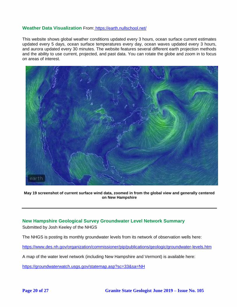
Weather Data Visualization From: https://earth.nullschool.net/
This website shows global weather conditions updated every 3 hours, ocean surface current estimates updated every 5 days, ocean surface temperatures every day, ocean waves updated every 3 hours, and aurora updated every 30 minutes. The website features several different earth projection methods and the ability to use current, projected, and past data. You can rotate the globe and zoom in to focus on areas of interest.
May 19 screenshot of current surface wind data, zoomed in from the global view and generally centered
on New Hampshire
New Hampshire Geological Survey Groundwater Level Network Summary
Submitted by Josh Keeley of the NHGS The NHGS is posting its monthly groundwater levels from its network of observation wells here: https://www.des.nh.gov/organization/commissioner/pip/publications/geologic/groundwater-levels.htm A map of the water level network (including New Hampshire and Vermont) is available here: https://groundwaterwatch.usgs.gov/statemap.asp?sc=33&sa=NH
Page 21 of 27 Granite State Geologist June 2019 – Issue No. 105
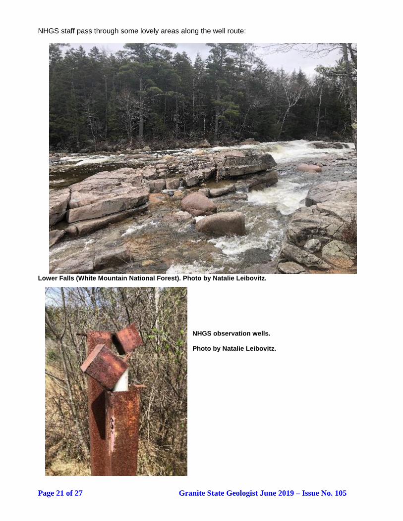
NHGS staff pass through some lovely areas along the well route:
Lower Falls (White Mountain National Forest). Photo by Natalie Leibovitz. NHGS observation wells. Photo by Natalie Leibovitz.

Page 22 of 27 Granite State Geologist June 2019 – Issue No. 105
GSNH T-SHIRTS STILL AVAILABLE!
The GSNH t-shirts have been a popular item. We have about a dozen each in sizes small, medium and large. Ask Julie Spencer about buying a t-shirt at the next dinner meeting! T-shirts are $18 each.
Bill Abrahams-Dematte is modeling the GSNH t-shirt (front and back). From Julie Spencer.
DATES TO REMEMBER
June 22-23, 2019 – Gilsum Rock Swamp and Mineral Show, Gilsum Elementary School, Route 10. Show hours are from 8:00 AM to 6:00 PM Saturday and 8:00 AM to 4:00 PM Sunday. For more information, contact Robert Mitchell at 603-357-9636 or [email protected]. July 13-14, 2019 – 58th Annual Western Main Gem, Mineral, and Jewelry Show, Telstar High School, 284 Walkers Mills Rd (Rte. 26), Bethel, ME: https://www.bethelmaine.com/events/details/58th-annual-western-maine-gem-mineral-and-jewelry-show-11811 July 19-20, 2019 – 19th Annual Seek the Peak Hike-a-Thon supporting the Mount Washington Observatory. Registration on July 19 at Mount Washington Observatory Weather Discovery Center; hiking (including a guided hike) on July 20 starting at the AMC’s Pinkham Notch Visitor Center and at the base of the Ammonoosuc Ravine Trailhead: https://secure.qgiv.com/event/seekthepeak2019/ July 27-28, 2019 – 40th Annual Champlain Valley Gem, Mineral, and Fossil Show, Champlain Valley Exposition, 105 Pearl Street, Essex Junction, VT: http://www.burlingtongemandmineralclub.org/show.html August 9-11, 2019 – East Coast Gem, Mineral, and Fossil Show, Eastern States Exposition, West Springfield, MA: https://www.easternstatesexposition.com/events/2019/east-coast-gem-mineral-and-fossil-show(2) August 24, 2019 – GSNH Field Trip, Pawtuckaway State Park. See details on page 2. August 24-25, 2019 – Capital Mineral Club Show, Everett Arena, Concord, NH.

Page 23 of 27 Granite State Geologist June 2019 – Issue No. 105
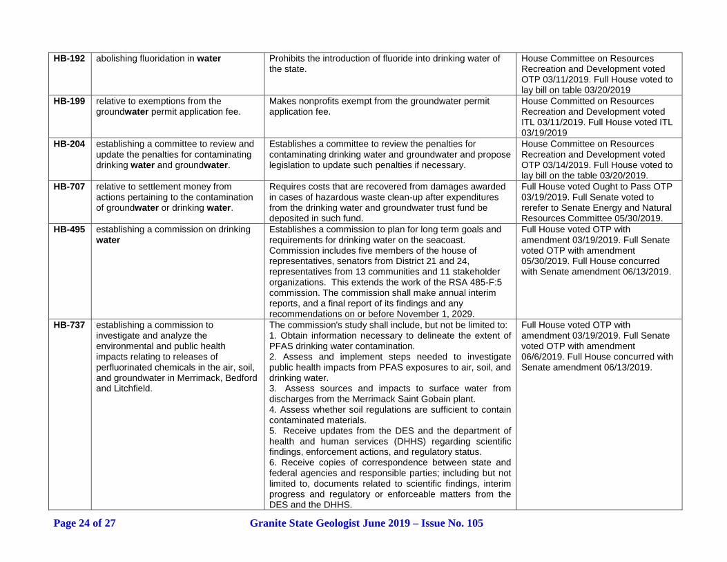
SPRING LEGISLATIVE COMMITTEE REPORT by Tom Fargo
Below is a list of 2019 NH General Court (House and Senate) Bills that are potentially relevant to members of the Geological Society of New Hampshire. This table lists bills identified by keyword searches completed in January 2019. Bill descriptions have been abridged.
Bill Number
Title Bill Description Legislative Action – Bill Status
Key Word “Environ”
HB-261 requiring the commissioner of the department of environmental services to revise rules relative to arsenic contamination in drinking water.
The commissioner shall initiate rulemaking within 120 days of the effective date of this paragraph to revise the ambient groundwater quality standard for arsenic not to exceed 0.5 parts per billion.
Full House voted Ought to Pass (OTP) w/amendment 03/19/2019. Senate voted OTP w/amendment 05/23/2019. Full House concurred with Senate amendment 06/13/2019.
SB-202 FN-A
establishing a stormwater management and flood resilience fund within the department of environmental services
Establishes a stormwater management and flood resilience fund, which shall be kept distinct and separate from all other funds. The department of environmental services (DES) shall use the money from the stormwater management and flood resilience fund to give grants to public and non-profit organizations, and other regional organizations for the monitoring, treatment of, and outreach regarding stormwater pollution and flood resilience.
Senate voted OTP 03/14/2019. Full Senate voted to lay bill on the table 03/14/2019.
HB-352 FN-A
appropriating funds to the department of environmental services for the purpose of funding eligible wastewater projects under the state aid grant program.
Appropriates funds to the DES for the purpose of funding eligible wastewater projects under the state aid grant program. This bill makes general fund appropriations of $3,652,347 for FY 2020 and $3,781,024 for FY 2021 to the DES to fund eligible and completed wastewater projects under the state aid program. (RSA 486).
House Finance Committee voted 03/14/2019 to retain in committee.
HB-682 FN
establishing a water resources fund in the department of environmental services.
Renames the wetlands and shoreland review fund as the
water resources fund; clarifies that certain application and
permit fees are non-refundable; and repeals the terrain
alteration fund.
Full House voted OTP w/amendment 04/04/2019. Senate voted OTP 05/15/2019. Bill was the laid on the table.
HB-679 authorizing the department of environmental services to lease land associated with state-owned impoundments.
Directs the DES to establish a leasing program for land associated with state-owned impoundments. The lease program for land associated with state-owned impoundments and the lease program specifically for Lake Francis shall be exempt from the procedure in RSA 4:40 regarding the disposal of state property.
House Public Works and Highways Committee voted 02/14/2019 Inexpedient to Legislate (ITL). Full House voted ITL 02/14/2019
Key Word “Water”
Page 24 of 27 Granite State Geologist June 2019 – Issue No. 105
HB-192 abolishing fluoridation in water Prohibits the introduction of fluoride into drinking water of the state.
House Committee on Resources Recreation and Development voted OTP 03/11/2019. Full House voted to lay bill on table 03/20/2019
HB-199 relative to exemptions from the groundwater permit application fee.
Makes nonprofits exempt from the groundwater permit application fee.
House Committed on Resources Recreation and Development voted ITL 03/11/2019. Full House voted ITL 03/19/2019
HB-204 establishing a committee to review and update the penalties for contaminating drinking water and groundwater.
Establishes a committee to review the penalties for contaminating drinking water and groundwater and propose legislation to update such penalties if necessary.
House Committee on Resources Recreation and Development voted OTP 03/14/2019. Full House voted to lay bill on the table 03/20/2019.
HB-707 relative to settlement money from actions pertaining to the contamination of groundwater or drinking water.
Requires costs that are recovered from damages awarded in cases of hazardous waste clean-up after expenditures from the drinking water and groundwater trust fund be deposited in such fund.
Full House voted Ought to Pass OTP 03/19/2019. Full Senate voted to rerefer to Senate Energy and Natural Resources Committee 05/30/2019.
HB-495 establishing a commission on drinking water
Establishes a commission to plan for long term goals and requirements for drinking water on the seacoast. Commission includes five members of the house of representatives, senators from District 21 and 24, representatives from 13 communities and 11 stakeholder organizations. This extends the work of the RSA 485-F:5 commission. The commission shall make annual interim reports, and a final report of its findings and any recommendations on or before November 1, 2029.
Full House voted OTP with amendment 03/19/2019. Full Senate voted OTP with amendment 05/30/2019. Full House concurred with Senate amendment 06/13/2019.
HB-737 establishing a commission to investigate and analyze the environmental and public health impacts relating to releases of perfluorinated chemicals in the air, soil, and groundwater in Merrimack, Bedford and Litchfield.
The commission's study shall include, but not be limited to: 1. Obtain information necessary to delineate the extent of PFAS drinking water contamination. 2. Assess and implement steps needed to investigate public health impacts from PFAS exposures to air, soil, and drinking water. 3. Assess sources and impacts to surface water from discharges from the Merrimack Saint Gobain plant. 4. Assess whether soil regulations are sufficient to contain contaminated materials. 5. Receive updates from the DES and the department of health and human services (DHHS) regarding scientific findings, enforcement actions, and regulatory status. 6. Receive copies of correspondence between state and federal agencies and responsible parties; including but not limited to, documents related to scientific findings, interim progress and regulatory or enforceable matters from the DES and the DHHS.
Full House voted OTP with amendment 03/19/2019. Full Senate voted OTP with amendment 06/6/2019. Full House concurred with Senate amendment 06/13/2019.
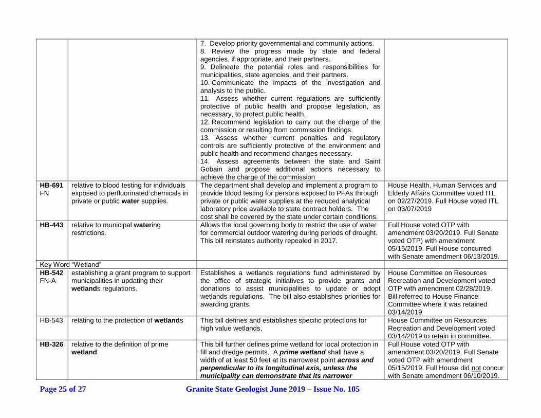
Page 25 of 27 Granite State Geologist June 2019 – Issue No. 105
7. Develop priority governmental and community actions. 8. Review the progress made by state and federal agencies, if appropriate, and their partners. 9. Delineate the potential roles and responsibilities for municipalities, state agencies, and their partners. 10. Communicate the impacts of the investigation and analysis to the public. 11. Assess whether current regulations are sufficiently protective of public health and propose legislation, as necessary, to protect public health. 12. Recommend legislation to carry out the charge of the commission or resulting from commission findings. 13. Assess whether current penalties and regulatory controls are sufficiently protective of the environment and public health and recommend changes necessary. 14. Assess agreements between the state and Saint Gobain and propose additional actions necessary to achieve the charge of the commission
HB-691 FN
relative to blood testing for individuals exposed to perfluorinated chemicals in private or public water supplies.
The department shall develop and implement a program to provide blood testing for persons exposed to PFAs through private or public water supplies at the reduced analytical laboratory price available to state contract holders. The cost shall be covered by the state under certain conditions.
House Health, Human Services and Elderly Affairs Committee voted ITL on 02/27/2019. Full House voted ITL on 03/07/2019
HB-443 relative to municipal watering restrictions.
Allows the local governing body to restrict the use of water for commercial outdoor watering during periods of drought. This bill reinstates authority repealed in 2017.
Full House voted OTP with amendment 03/20/2019. Full Senate voted OTP) with amendment 05/15/2019. Full House concurred with Senate amendment 06/13/2019.
Key Word “Wetland”
HB-542 FN-A
establishing a grant program to support municipalities in updating their wetlands regulations.
Establishes a wetlands regulations fund administered by the office of strategic initiatives to provide grants and donations to assist municipalities to update or adopt wetlands regulations. The bill also establishes priorities for awarding grants.
House Committee on Resources Recreation and Development voted OTP with amendment 02/28/2019. Bill referred to House Finance Committee where it was retained 03/14/2019
HB-543 relating to the protection of wetlands This bill defines and establishes specific protections for high value wetlands,
House Committee on Resources Recreation and Development voted 03/14/2019 to retain in committee.
HB-326 relative to the definition of prime wetland
This bill further defines prime wetland for local protection in fill and dredge permits. A prime wetland shall have a width of at least 50 feet at its narrowest point across and perpendicular to its longitudinal axis, unless the municipality can demonstrate that its narrower
Full House voted OTP with amendment 03/20/2019. Full Senate voted OTP with amendment 05/15/2019. Full House did not concur with Senate amendment 06/10/2019.
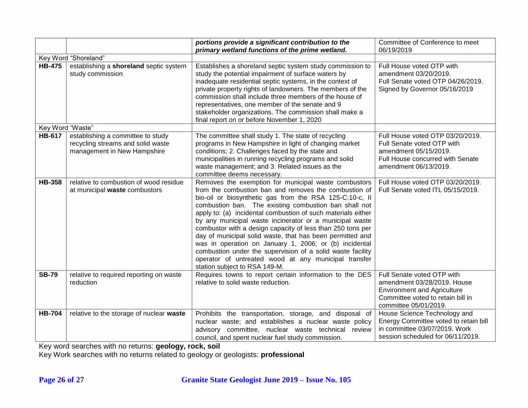
Page 26 of 27 Granite State Geologist June 2019 – Issue No. 105
portions provide a significant contribution to the primary wetland functions of the prime wetland.
Committee of Conference to meet 06/19/2019
Key Word “Shoreland”
HB-475 establishing a shoreland septic system study commission
Establishes a shoreland septic system study commission to study the potential impairment of surface waters by inadequate residential septic systems, in the context of private property rights of landowners. The members of the commission shall include three members of the house of representatives, one member of the senate and 9 stakeholder organizations. The commission shall make a final report on or before November 1, 2020
Full House voted OTP with amendment 03/20/2019. Full Senate voted OTP 04/26/2019. Signed by Governor 05/16/2019
Key Word “Waste”
HB-617 establishing a committee to study recycling streams and solid waste management in New Hampshire
The committee shall study 1. The state of recycling programs in New Hampshire in light of changing market conditions; 2. Challenges faced by the state and municipalities in running recycling programs and solid waste management; and 3. Related issues as the committee deems necessary.
Full House voted OTP 03/20/2019. Full Senate voted OTP with amendment 05/15/2019. Full House concurred with Senate amendment 06/13/2019.
HB-358 relative to combustion of wood residue at municipal waste combustors
Removes the exemption for municipal waste combustors from the combustion ban and removes the combustion of bio-oil or biosynthetic gas from the RSA 125-C:10-c, II combustion ban. The existing combustion ban shall not apply to: (a) incidental combustion of such materials either by any municipal waste incinerator or a municipal waste combustor with a design capacity of less than 250 tons per day of municipal solid waste, that has been permitted and was in operation on January 1, 2006; or (b) incidental combustion under the supervision of a solid waste facility operator of untreated wood at any municipal transfer station subject to RSA 149-M.
Full House voted OTP 03/20/2019. Full Senate voted ITL 05/15/2019.
SB-79 relative to required reporting on waste reduction
Requires towns to report certain information to the DES relative to solid waste reduction.
Full Senate voted OTP with amendment 03/28/2019. House Environment and Agriculture Committee voted to retain bill in committee 05/01/2019.
HB-704 relative to the storage of nuclear waste Prohibits the transportation, storage, and disposal of
nuclear waste; and establishes a nuclear waste policy
advisory committee, nuclear waste technical review
council, and spent nuclear fuel study commission.
House Science Technology and Energy Committee voted to retain bill in committee 03/07/2019. Work session scheduled for 06/11/2019.
Key word searches with no returns: geology, rock, soil Key Work searches with no returns related to geology or geologists: professional

Page 27 of 27 Granite State Geologist June 2019 – Issue No. 105
Geological Society of New Hampshire
PO Box 401, Concord, NH 03302
Name: (Please print clearly)
E-mail: _____________________________________
Renewing Members: Only update this section if you have changes to your contact information (including email) or educational history.
New applicants: please complete this section.
Preferred address/email to receive GSNH Communication: ___Home or ___Business Home Address: Business Address: (Employer):
Home Telephone: Office Telephone: _______________
New Hampshire PG # (if applicable)
Education: Degrees received or in progress:
Year Degree Major College or University
I volunteer to help with one of the following committees or tasks:
__ Membership Committee
__ Legislative Committee
__ Giving a talk at a meeting
Membership Category:
__ Regulations Committee __ Education Committee __ Events Committee
__Communications Committee
(Newsletter or Website, circle preference)
__ Other:
Regular Member (Annual Dues $20.00)
Student Member (Annual Dues $10.00)…Please complete Education section above.
Make checks payable to "Geological Society of New Hampshire." Note that GSNH dues are not deductible as a charitable contribution, but may be deductible as a business expense. Please return this completed application form with any necessary corrections and a check for the appropriate dues to the GSNH at the address above. The Society’s membership year runs from January 1 to December 31.
Signature: ___________________________________Date: _________________________
MEMBERSHIP & RENEWAL APPLICATION