Grand Canyon National Park Fire Management Plan March 2012 · Grand Canyon National Park Fire...
330
Transcript of Grand Canyon National Park Fire Management Plan March 2012 · Grand Canyon National Park Fire...

National Park Service U.S. Department of the Interior
Grand Canyon National Park Arizona
Grand Canyon National Park Fire Management Plan March 2012


Grand Canyon National Park Fire Management Plan National Park Service U.S. Department of the Interior Grand Canyon National Park PO Box 129 Grand Canyon, Arizona 86023

CONTENTS
Chapter 1 Introduction .............................................................................................................................................1 1.1 Reasons for the Fire Management Plan ........................................................................................................1
1.1.1 History .......................................................................................................................................................1 1.2 General Description of the Park .....................................................................................................................2 1.3 Management Environment ............................................................................................................................3
1.3.1 Land Ownership, Significant Resources, Mission and Management Direction....................................4 1.3.2 Overview of Physical and Biotic Characteristics of the Park .................................................................6 1.3.3 Role of Fire in the Park ......................................................................................................................... 13
1.4 Environmental Compliance ......................................................................................................................... 17 Chapter 2 Policy, Land Management Planning, and Partnerships ...................................................................... 18
2.1 Fire Policy ...................................................................................................................................................... 18 2.1.1 Laws ........................................................................................................................................................ 18 2.1.2 Executive Orders and Presidential Proclamations ............................................................................... 18 2.1.3 Regulations ............................................................................................................................................ 18 2.1.4 Policy ...................................................................................................................................................... 18 2.1.5 National Fire Plan .................................................................................................................................. 19
2.2 Park/Resource Management Planning ........................................................................................................ 19 2.2.1 General Management Plan ................................................................................................................... 20 2.2.2 Resource Management Plan ................................................................................................................. 20 2.2.3 Backcountry Management Plan ........................................................................................................... 20 2.2.4 Planning Process to Develop this Fire Management Plan .................................................................. 20
2.3 Partnerships .................................................................................................................................................. 20 Chapter 3 Park-Wide and Fire Management Unit Characteristics ...................................................................... 23
3.1 Park-Wide (General) Management Considerations ................................................................................... 23 3.1.1 Fire Management Goals and Objectives .............................................................................................. 25 3.1.2 Wildland Fire Management Actions .................................................................................................... 33
3.2 Fire Management Unit Specific Characteristics .......................................................................................... 34 Spruce-Fir Forests ............................................................................................................................................ 34 Mixed-Conifer Forests .................................................................................................................................... 35 Ponderosa Pine Forests .................................................................................................................................. 36 Piñon-Juniper Woodlands.............................................................................................................................. 38 Fire Management Units ................................................................................................................................. 39
Chapter 4 Wildland Fire Operational Guidance ................................................................................................... 58 4.1 Safety ............................................................................................................................................................ 58
4.1.1 Firefighter Safety................................................................................................................................... 58 4.1.2 Public Safety .......................................................................................................................................... 61
4.2 Preparedness ................................................................................................................................................. 62 4.2.1 Coordination and Dispatching ............................................................................................................. 63 4.2.2 Preparedness Activities ......................................................................................................................... 65
4.3 Management of Unplanned Ignitions ........................................................................................................ 70 A. Preparing for Unplanned Ignitions .......................................................................................................... 71 B. Expected Fire Behavior .............................................................................................................................. 74 C. Initial Response Procedure ........................................................................................................................ 74 2. Minimum Impact Tactics ............................................................................................................................ 75 D. Transition to Extended Response and Large Fire .................................................................................... 76 3. Minimum Impact Tactics ............................................................................................................................ 77
4.4 Burned Area Emergency Response ............................................................................................................. 78 4.4.1 Minimum Impact Tactics ....................................................................................................................... 79 4.4.2 Burned Area Emergency Response ...................................................................................................... 79 4.4.3 Emergency Stabilization ....................................................................................................................... 80 4.4.4 Burned Area Rehabilitation .................................................................................................................. 81
4.5 Management of Planned Fuels Treatments ............................................................................................... 81 4.5.1 Fuels Planning and Documentation ..................................................................................................... 81 4.5.2 General Fuels Management Implementation Procedures .................................................................. 83

4.5.3 Prescribed Fire Treatments ................................................................................................................... 86 Minimum Impact Tactics ................................................................................................................................ 87 4.5.4 Non‐Fire Fuel Treatments ..................................................................................................................... 88
4.6 Prevention, Mitigation, and Education ...................................................................................................... 91 4.6.1 Prevention/Mitigation ........................................................................................................................... 91 4.6.2 Communications/Education .................................................................................................................. 91
4.7 Air Quality/Smoke Management ................................................................................................................. 93 4.8 Data & Records Management ..................................................................................................................... 94 4.9 Organizational & Budgetary Parameters ................................................................................................... 96
Description of the Fire Organization ............................................................................................................ 96 Roles and Functions ........................................................................................................................................ 96
Chapter 5 Adaptive Management Strategy ......................................................................................................... 99 5.1 Monitoring .................................................................................................................................................... 99 5.2 Program Objectives .................................................................................................................................... 101 5.3 Evaluation ................................................................................................................................................... 101
Incident Reviews ........................................................................................................................................... 103 Annual Reviews ............................................................................................................................................ 104 Five-Year Reviews ......................................................................................................................................... 104
5.4 Fire Research ............................................................................................................................................... 105 Tables Table 1.1 Fire Sensitive Cultural Site Types by FMUs ........................................................................................... 11 Table 1.2 Special Status Wildlife by GRCA Habitat .............................................................................................. 12 Table 1.3 National Fire Plan Fire Regime Classes ................................................................................................. 14 Table 1.4 Historic Fire Regime Descriptions for Major Vegetation Types Above the Rim ................................ 15 Table 3.1 Management Objectives in GRCA General Management and Fire Management Plans .................. 27 Table 3.2 Management Objectives in GRCA Resource and Fire Management Plans ........................................ 31 Table 3.3 Ponderosa Forests Desired Conditions ................................................................................................. 38 Table 3.4 FMU Summary Highlights ...................................................................................................................... 56 Table 4.1 Hazardous-Fuel Reduction Techniques for Mechanized/Manual Fuel Reduction Projects ............... 89 Table 4.2 Step-Up Plan ........................................................................................................................................... 93 Table 5.1 Monitoring Elements Measured for Each Fire Management Strategy ............................................ 100 Table 5.2 NPS Fire Monitoring Handbook Monitoring Levels and Potential Variables .................................. 101 Table 5.3 Adaptive Management Considerations During Fire Program Implementation .............................. 102 Maps Map 1.1 Grand Canyon National Park and Vicinity ................................................................................................3 Map 1.2 GRCA Management Zones .........................................................................................................................4 Map 3.1 Fire Management Units ........................................................................................................................... 40 Map 3.2 Fire Management Units, Heart of the Canyon ...................................................................................... 41 Figures Figure 1.1 Major Vegetation Types Affected by GRCA Fire Management ...........................................................7 Figure 1.2 Acres burned by Fire Type 1980-2010, Grand Canyon National Park ............................................... 16 Figure 3.1 Wildland Fire Flow Chart ..................................................................................................................... 24 Figure 5.1 Adaptive Management Process ........................................................................................................... 99

National Park Service 2012 Grand Canyon National Park Fire Management Plan
Chapter 1 1 Introduction
CHAPTER 1 INTRODUCTION
The management of wildland fire is a critical element in the protection of life, property, cultural and natural resources, as well as the in the implementation of National Park Service (NPS) policies for preservation of natural ecosystems. Lightning-caused fire is one of the most important environmental factors that influence natural ecosystems at Grand Canyon National Park (GRCA). This Fire Management Plan (FMP) is a detailed plan of action for all wildland fire activities, including preparedness, initial response, suppression, the management of wildfires, fire prevention, fire monitoring, and fuels management activities including prescribed fire.
The FMP defines the relationship with other land management planning documents as well as with departmental and agency policies. The goals of the Fire Management Program are identified in the FMP. In addition, the plan describes in detail fire management strategies by Fire Management Unit (FMU). General implementation procedures, operational components of the program, public safety, and the public information and education program are described in the FMP. Organizational and budgetary parameters are defined. The FMP also discusses the current standards and procedures for project, program, and FMP reviews. Monitoring and evaluation processes and fire research directly related to GRCA are identified. Because the FMP relates directly to natural and cultural resource management plans and helps achieve resource management objectives, the plan describes resources and features that require special treatment and articulates actions to prevent or mitigate negative impacts to these resources.
The FMP is operational in nature and has been written so that it can used by GRCA staff, as well as the park’s primary cooperators in northern Arizona. To the greatest extent possible, the actions described within the plan are coordinated with the public, neighboring land owners, and land management agencies.
Mission
GRCA is recognized as a place of significance and universal value because of its cultural and natural resources, ecosystem processes, scenic qualities and values, natural quiet and solitude, spiritual and inspirational qualities, and recreational opportunities. It is the Fire Management Program’s mission to manage fire to preserve, enhance and (where necessary) restore these values.
1.1 Reasons for the Fire Management Plan Each park with burnable vegetation must have an approved FMP that will address the need for adequate funding and staffing to support its fire management program. Parks having an approved FMP and accompanying National Environmental Policy Act compliance may utilize wildland fire to achieve resource benefits in predetermined fire management units. Parks lacking an approved FMP may not use resource benefits as a primary consideration influencing the selection of a suppression strategy, but they must consider the resource impacts of suppression alternatives in their decisions.
1.1.1 History
GRCA fire management planning has evolved over the past three decades. As explained in the park’s 1997 Resource Management Plan, “Fire research initiated in the 1970s identified more clearly the adverse effects caused by suppression, and in 1978 a [fire] management plan was developed and approved allowing, for the first time, fires to burn under an established set of conditions…” (NPS

National Park Service 2012 Grand Canyon National Park Fire Management Plan
Chapter 1 2 Introduction
1997). The GRCA FMP was approved in 1992, then reformatted and approved in 2005, and revised annually through 2009.
The FMP has been refined through annual revisions as fire behavior and effects knowledge has grown. The Fire Management Program undergoes annual review, and has adjusted to reflect experience gained from management actions that achieved desired objectives and those that did not. Over the past two decades, fire managers have been able to increase the opportunities to manage unplanned wildfires for multiple objectives. In addition, the park introduced aerial ignition for prescribed fires in 1998 and, within constraints of existing planning documents, implemented prescribed fires under a wider range of environmental conditions to more fully meet fuel-reduction objectives. It is also important to note that fire management strategies proposed in this FMP are based on the best science currently available. However, the GRCA Fire Management Program recognizes that uncertainties exist. For this reason, adaptive management will be a cornerstone of this FMP. Adaptive management is a system of management practices based on clearly identified outcomes, monitoring to determine if management actions are meeting outcomes, and, if outcomes are not met, facilitation of management changes that will best ensure outcomes are met or re-evaluated. This process and how it will be implemented will be discussed in greater detail in Chapter 5.
As new information becomes available and as conditions change on the ground, this FMP will be updated through the annual review process and the 5-year comprehensive review process within the scope and authority of environmental decision documents.
1.2 General Description of the Park GRCA is located on the Colorado Plateau’s southwestern edge in northern Arizona. The park consists of over 1.2 million acres in Mohave and Coconino Counties. The region is characterized by raised plains and basins; the canyon as a major feature cut up to one mile deep. Park elevations range from just over 1,000 feet at the river’s western end (Lake Mead National Recreation Area boundary) to over 9,160 feet near the North Rim Entrance Station. The relatively flat terrain of both rims is broken by some of the world’s most changeable and severe topography.
The park shares boundaries with three Native American tribes (Navajo, Havasupai, and Hualapai), other NPS units (Lake Mead and Glen Canyon National Recreation Areas), the Arizona Strip Office of the Bureau of Land Management, and the Kaibab National Forest (Map 1.1).

National Park Service 2012 Grand Canyon National Park Fire Management Plan
Chapter 1 3 Introduction
Map 1.1 Grand Canyon National Park and Vicinity
1.3 Management Environment The specific purpose of this FMP is to provide a plan that recognizes goals and objectives listed in Chapter 3, and is consistent with NPS fire management policies and all associated regulations and laws including
• Director’s Order (DO) 18 Wildland Fire Management • DO-12 Conservation Planning, Environmental Impact Analysis and Decision-making • DO-28 Cultural Resource Management • DO-41 Wilderness Preservation and Management • DO-60 Aviation Management • DO-77 Natural Resource Protection • NPS Management Policies 2006 • Endangered Species Act • National Historic Preservation Act • Clean Air Act • Wilderness Act

National Park Service 2012 Grand Canyon National Park Fire Management Plan
Chapter 1 4 Introduction
1.3.1 Land Ownership, Significant Resources, Mission and Management Direction
Wilderness
GRCA’s Final Wilderness Recommendation (NPS 1993) includes 1,109,257 acres as recommended wilderness, and 29,490 acres potential wilderness in the park’s Congressionally authorized boundary (as stated in the Grand Canyon National Park Enlargement Act of 1975, as amended) (Map 1.2). The authorized boundary encompasses 1,218,375 acres. Of this, 1,188,885 acres are owned by the U.S. Government and managed by the NPS as Grand Canyon National Park. Potential wilderness areas include the Colorado River Corridor and various private and Navajo Nation in-holdings.
Approximately 79,298 acres have not been recommended for wilderness status. Excluded areas include North and South Rim developed areas, major road corridors (600-feet wide), specified unpaved road corridors (300-feet wide), the Cross-Canyon Corridor (Bright Angel, South Kaibab, and North Kaibab Trails and associated development), and specific sites in proposed wilderness areas (incorporated into paragraphs below).
Map 1.2 GRCA Management Zones

National Park Service 2012 Grand Canyon National Park Fire Management Plan
Chapter 1 5 Introduction
World Heritage Site
As a world heritage site, Grand Canyon is recognized as a place of universal value, containing superlative natural and cultural features that should be preserved as part of all peoples heritage.
Cultural/Religious Areas
Twelve American Indian groups, represented by eight tribal governments, have close or sacred cultural ties to the Grand Canyon, with some considering the canyon their original homeland and place of origin: Havasupai, Hopi, Hualapai, Navajo, Kaibab Band of Paiute Indians, Paiute Indian Tribe of Utah (representing the Shivwits Paiute), Las Vegas Paiute, Moapa Band of Paiute Indians, San Juan Southern Paiute, Yavapai-Apache (representing the White Mountain, San Carlos, Yavapai, and Tonto Nations), and the Pueblo of Zuni.
Management Direction of Adjacent Lands
The adjacent lands to GRCA are identified on the Vicinity Map (Map 1.1). They are listed below with a brief summary of their wildland fire management direction
• Lake Mead National Recreation Area: Lake Mead manages wildfire for multiple objectives, conducts prescribed fires, and manual thinning projects.
• Hualapai Indian Reservation: The Hualapai Tribe is represented by the Bureau of Indian Affairs, Truxton Canon Agency for their wildland fire program. Truxton Canon Agency manages wildfire for protection objectives only, conducts prescribed fires, along with mechanical and manual thinning.
• Havasupai Indian Reservation: The Havasupai Tribe is also represented by the Bureau of Indian Affairs, Truxton Canon Agency for their wildland fire program. Truxton Canon Agency manages wildfire for protection objectives only, conducts prescribed fires, along with mechanical and manual thinning.
• Kaibab National Forest: The Kaibab manages wildfire for multiple objectives, conducts prescribed fires, as well as mechanical and manual thinning projects.
• Navajo Indian Reservation: The Navajo Tribe is represented by the Bureau of Indian Affairs, Navajo Region for their wildland fire program. The Bureau of Indian Affairs manages wildfire for protection objectives only, conducts prescribed fires, as well as mechanical and manual thinning.
• Bureau of Land Management, Phoenix District Office: The Phoenix District Office manages wildfire for multiple objectives on a somewhat limited basis, conducts prescribed fires, as well as mechanical and manual thinning.
• Bureau of Land Management, Arizona Strip District Office: Arizona Strip District Office manages wildfire for multiple objectives, conducts prescribed fires, along with manual and mechanical thinning projects.
• AZ State Forestry Division, Flagstaff District: Flagstaff District manages wildfire for protection objectives only, does not conduct prescribed fires, and engages on a limited basis in manual and mechanical thinning projects.
• Glen Canyon National Recreation Area: Glen Canyon manages wildfire for protection objectives only, does not conduct prescribed fire, and mechanical or manual thinning programs.
National Park Service 2012 Grand Canyon National Park Fire Management Plan
Chapter 1 6 Introduction
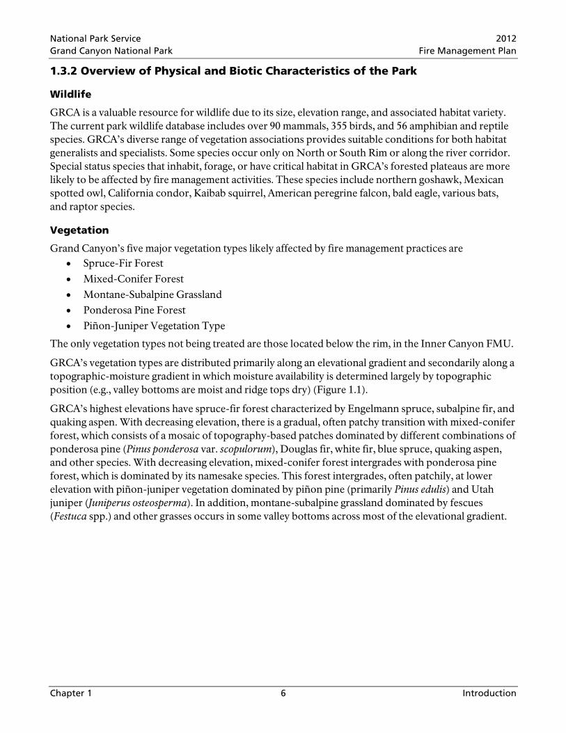
1.3.2 Overview of Physical and Biotic Characteristics of the Park
Wildlife
GRCA is a valuable resource for wildlife due to its size, elevation range, and associated habitat variety. The current park wildlife database includes over 90 mammals, 355 birds, and 56 amphibian and reptile species. GRCA’s diverse range of vegetation associations provides suitable conditions for both habitat generalists and specialists. Some species occur only on North or South Rim or along the river corridor. Special status species that inhabit, forage, or have critical habitat in GRCA’s forested plateaus are more likely to be affected by fire management activities. These species include northern goshawk, Mexican spotted owl, California condor, Kaibab squirrel, American peregrine falcon, bald eagle, various bats, and raptor species.
Vegetation
Grand Canyon’s five major vegetation types likely affected by fire management practices are • Spruce-Fir Forest • Mixed-Conifer Forest • Montane-Subalpine Grassland • Ponderosa Pine Forest • Piñon-Juniper Vegetation Type
The only vegetation types not being treated are those located below the rim, in the Inner Canyon FMU.
GRCA’s vegetation types are distributed primarily along an elevational gradient and secondarily along a topographic-moisture gradient in which moisture availability is determined largely by topographic position (e.g., valley bottoms are moist and ridge tops dry) (Figure 1.1).
GRCA’s highest elevations have spruce-fir forest characterized by Engelmann spruce, subalpine fir, and quaking aspen. With decreasing elevation, there is a gradual, often patchy transition with mixed-conifer forest, which consists of a mosaic of topography-based patches dominated by different combinations of ponderosa pine (Pinus ponderosa var. scopulorum), Douglas fir, white fir, blue spruce, quaking aspen, and other species. With decreasing elevation, mixed-conifer forest intergrades with ponderosa pine forest, which is dominated by its namesake species. This forest intergrades, often patchily, at lower elevation with piñon-juniper vegetation dominated by piñon pine (primarily Pinus edulis) and Utah juniper (Juniperus osteosperma). In addition, montane-subalpine grassland dominated by fescues (Festuca spp.) and other grasses occurs in some valley bottoms across most of the elevational gradient.

National Park Service 2012 Grand Canyon National Park Fire Management Plan
Chapter 1 7 Introduction
Figure 1.1 Major Vegetation Types Affected by GRCA Fire Management, Distributed Along Elevation Gradients and Topography-based Moisture Availability
Dominant tree species for specific sites are listed in brackets (BS = blue spruce, DF = Douglas fir, ES = Engelmann spruce, PiP = piñon pine, PP = ponderosa pine, QA = quaking aspen, SF = subalpine fir, UJ = Utah juniper, and WF = white fir)
Soils
At least 62 soil-family complexes have been identified by the U.S. Department of Agriculture National Resources Conservation Service in GRCA (USDA NRCS 2006). Soil-family complexes are soil types grouped on physical and chemical properties and other characteristics affecting management. Typically, soils are further grouped into orders based on soil formation, plant growth, and other pertinent properties. In GRCA, soils can be grouped into six orders including alfisols, aridisols, entisols, mollisols, inceptisols, and vertisols. The most common soil orders in GRCA FMUs are alfisols, aridisols, and entisols. Alfisols comprise 12%, aridisols 33%, and entisols 48% of FMU soils.
Entisols and inceptisols are very young soils with little to no subsurface horizon development; other characteristics, such as moisture and porosity, can vary widely. Aridisols are relatively high in calcium carbonate and other salts and have some subsurface horizon development such as accumulations of clays, silica, and/or salts. They are dry most of the year. Alfisols and mollisols are more well-developed soils with clay and organic material subhorizon accumulation. They tend to have greater water holding
Elev
atio
n (m
)
Topographic – Moisture Gradient
Moist DryIntermediate
Ponderosa Pine Forest
Mixed Conifer Forest
Spruce-Fir Forest
[PP, PiP, UJ]
[BS, QA]
[open PP, DF][WF, DF, ES, QA]
[PP with PP understory]
[open PP]
[WF, DF, PP, ES, QA]
[PP, QA]
[PP with WF understory]
[ES, SF, QA]
Piñon-Juniper[dense PiP, UJ]
[open UJ]
[PP, DF, WF, QA]
[dominated by UJ]
[dominated by PiP]
2800
2400
2000
1600
Montane-SubalpineGrassland
Elev
atio
n (f)
5249
6561
7874
9186
National Park Service 2012 Grand Canyon National Park Fire Management Plan
Chapter 1 8 Introduction
capacity and aggregate soil structure than other soil types found in the project area (Merrill 2006). These soils are generally more productive and support more plant growth.
Soil orders are divided into suborders based on soil formation and plant growth properties. Characteristics of GRCA soil suborders including the percent organic matter, slope, runoff class, and surface soil textures. These characteristics are pertinent to soil erosion potential and productivity. Soil suborder characteristics vary widely. More specific data regarding soil types is not available due to GRCA’s large size and inaccessibility. However, all major soil suborders include soil types that have potential for very high surface runoff.
GRCA soils are little affected by human activity except in developed areas such as Grand Canyon Village on South Rim and Bright Angel Point on North Rim, and along roadways. Logging, grazing, and farming have not occurred in GRCA in at least 75 years. Thus, current GRCA soil conditions are within or close to their natural state.
Aquatic Resources
The major GRCA surface water feature is the Colorado River, which flows 1,450 miles from the Rocky Mountains in Colorado to the Gulf of California. Approximately 277 miles flow in GRCA boundaries. Prior to dam construction, river flows varied widely seasonally and annually, and the river transported large volumes of sediments into and through the canyon. Flows measured at Lees Ferry ranged from 5.6 to 24.0 acre-feet per year (NPS 1984).
The Colorado River is dammed both up and downstream. Downstream, Hoover Dam created Lake Mead, which backs up to the park’s western end. Upstream, Glen Canyon Dam has regulated flow since 1966, significantly changing river temperature, moderating seasonal flows, and reducing sediment input.
A perennial stream flows year-round; intermittent streams flow seasonally; and ephemeral streams flow in response to rainfall or snowmelt. There are a number of side canyon perennial streams that drain to the Colorado River; most are spring fed and intermittent or ephemeral upstream of the springs. There are no perennial streams in any proposed treatment area.
After the Colorado River, the next largest perennial stream is the Little Colorado River, which enters the Colorado River near Chuar Butte near Desert View. There are 21 other perennial streams. The U.S. Geological Survey maintains gauging stations on some of these streams (Table 3-20, NPS 2010).
There are numerous intermittent and ephemeral drainages and washes. The U.S. Geological Survey maintains gages on a few of these streams (Table 3-21, NPS 2010).
Two locations have short stream reaches composed of treated sewage effluent: an unnamed tributary of Coconino Wash on South Rim and Transept Canyon on North Rim (NPS 1984).
Current flow, turbidity, sediment transport, and temperature conditions on the Colorado River are different than historical conditions due to the dam, as stated above. Flows are regulated, and extremely high flows have been eliminated. Turbidity and sediment transport are reduced. Temperatures are generally lower, especially during summer and fall. Flow in Bright Angel Creek has been slightly reduced due to water use for domestic purposes on North and South Rims. Other perennial streams are closer to historic conditions.
A number of stock tanks and ephemeral ponds exist in the park. Stock tanks are being allowed to infill with sediments.
National Park Service 2012 Grand Canyon National Park Fire Management Plan
Chapter 1 9 Introduction
Air Quality
GRCA is a Federally mandated Class I Area under the Clean Air Act, a status requiring the most stringent protection against air pollution increases and further degradation of air quality-related values, as well as restoration of natural visibility conditions. Fire creates smoke that may have undesirable effects on air quality, including impacts on both visibility and human health.
Wildfires managed for resource benefit objectives and prescribed fires, are intended to restore and maintain a historic range of forest structure to the extent possible. With restoration of pre-Euro-American forest-fuel regimes, smoke from these fires should mimic natural smoke production. The modern airshed has many pollution sources not present during pre-Euro-American settlement. Today, millions of people visit Grand Canyon to enjoy the scenery. Views are diminished by air pollution from many sources.
The primary Federal statute that regulates GRCA air quality is the Clean Air Act. One of the Act’s purposes is “to preserve, protect, and enhance the air quality in national parks” and other areas of special national or regional natural, recreational, scenic or historic value. The Clean Air Act, as amended in 1990, also requires the Environmental Protection Agency to set National Ambient Air Quality Standards to protect public health and welfare. These standards apply regardless of air pollution source, although source is considered in determining what, if any, remedial actions are needed when standards are violated.
The Environmental Protection Agency set policies to deal with wildland fire smoke management in 1998 through its Interim Air Quality Policy on Wildland and Prescribed Fires (EPA 1998). In its policy, the Environmental Protection Agency balances fire’s role in restoring and maintaining forest ecosystems with the need to protect human health through adherence to the National Ambient Air Quality Standards. When these standards are violated by smoke, the policy calls for actions to reduce immediate impacts on public health, and steps to mitigate future impacts up to and including Federal enforcement of smoke management plans.
State authority for managing air quality in Arizona derives from the Clean Air Act and state statutes. Establishing and administering air quality standards as noted above is just one of the state’s responsibilities. Arizona Department of Environmental Quality Air Quality Division implements a statewide smoke management program that works toward reducing smoke impacts due to controlled burning of agricultural, rangeland, and forest fuels. All private, state, and Federally managed lands in Arizona are under Arizona Department of Environmental Quality jurisdiction in matters relating to air pollution from prescribed burning. GRCA’s Fire Management Program operates under regulations set by Arizona Department of Environmental Quality (Arizona Administrative Code, Title 18, Chapter 2, Article 15). GRCA is responsible to Arizona Department of Environmental Quality for registering projects; submitting burn plans, burn day requests, and burn accomplishment reports; using Emission Reduction Techniques and Smoke Management Techniques to reduce total emissions; and monitoring weather and smoke conditions. All fires not under full suppression must have an approved burn plan that carries the same responsibilities as permits issued to other air pollution sources. Actions set forth in burn plans are legally binding conditions and requirements of the permit. If the plan and reporting requirements are not followed, the state may require containment or mop-up of any active burns. It may also require, at the Arizona Department of Environmental Quality Director's discretion, a five-day moratorium on ignitions by the park. Violations are subject to a civil penalty of not more than $10,000 per day per violation (Arizona Administrative Code R18-2-1513 (D)).

National Park Service 2012 Grand Canyon National Park Fire Management Plan
Chapter 1 10 Introduction
1990 Clean Air Act amendments authorized the Environmental Protection Agency to establish visibility transport regions as a way to reduce regional haze. Congress specifically mandated creation of a Grand Canyon Visibility Transport Commission to advise the Environmental Protection Agency on strategies for protecting visual air quality at national parks and wilderness areas on the Colorado Plateau. The Commission’s final report, Recommendations for Improving Western Vistas (GCVTC 1996), included the following recommendation relating to wildland fire
The Commission recognizes that fire plays a significant role in visibility on the Plateau. In fact, land managers propose aggressive prescribed fire programs aimed at correcting the buildup of biomass due to decades of fire suppression. Therefore, prescribed fire and wildfire levels are projected to increase significantly during the studied period. The Commission recommends the implementation of programs to minimize emissions and visibility impacts from prescribed fire, as well as to educate the public.
The NPS has a responsibility to protect air quality under both the 1916 Organic Act and the Clean Air Act. NPS Management Policies 2006, provides direction to NPS units.
Burning of wildland vegetation causes varying quantities and types of emissions, depending in part on the types (i.e., vegetation, live vs. dead), amounts, and moisture contents of fuel burned, and combustion temperature. More than 90% of the smoke mass emitted from wildland fires consists of carbon dioxide and water. Emissions of greatest concern to fire managers are particulate matter, carbon monoxide, and volatile organic compounds. Carbon monoxide is a health concern near the fire line and fire professionals are looking at ways to minimize fire fighters exposure. Volatile organic compounds are important in ozone formation, and with expected new standards volatile organic compounds will become of increasing future concern. Particulate matter is important due to both visibility and human health concerns.
Particulate matter is the most important pollutant category for fire managers. In addition to human health effects, particulates reduce visibility. Particles vary in size and chemical composition, depending on fire intensity and fuel character. Proportionately larger particles are produced as fires increase in intensity (longer flame lengths), compared to low-intensity and smoldering combustion fires. Amount of smoke produced depends on total fuel consumed. In humans, particles less than about 10 micrometers in diameter are able to traverse the upper airways (nose and mouth) and enter lower airways starting with the trachea. As particle size decreases further, particles are able to penetrate to deeper airway parts prior to deposition. Studies have linked breathing particulate matter to a series of health problems including coughing and difficult or painful breathing, aggravated asthma, chronic bronchitis, and decreased lung function (Dockery et al. 1993 cited in Hardy et al. 2001, EPA 2006, Core & Peterson 2001).
Cultural and Historical Resources
GRCA cultural resources reflect the region’s long history of human presence and reveal the changing human relationship with landscape. Archeologists generally divide the nearly 12,000 years of human history in the American Southwest into four broad periods—Paleoindian, Archaic, Formative, and Historic—all of which are represented in Grand Canyon (Coder 2000). This history is represented by archaeological sites, ethnographic resources, historic structures, and cultural landscapes.
Several American Indian tribes in the region have expressed or claimed cultural affiliation to Grand Canyon—the Havasupai, Hopi, Hualapai, Navajo, Kaibab Band of Paiute Indians, Paiute Indian Tribe of
National Park Service 2012 Grand Canyon National Park Fire Management Plan
Chapter 1 11 Introduction
Utah (representing the Shivwits Paiute), Las Vegas Paiute, Moapa Band of Paiute Indians, San Juan Southern Paiute, Yavapai-Apache (representing the White Mountain, San Carlos, Yavapai, and Tonto Nations), and the Pueblo of Zuni.
The park’s List of Classified Structures includes 880 structures, 336 buildings are listed on the National Register of Historic Places, and 40 buildings are classified as National Register eligible. The vast majority of historic buildings and structures are concentrated in GRCA’s National Historic Landmark Districts. The buildings listed on the National Register of Historic Places are primarily associated with tourism, park administration and operations, and mining enterprises. Cultural landscapes are settings humans have created in the natural world, expressions of human manipulation, and adaptation of the land.
Elements or Values at Risk
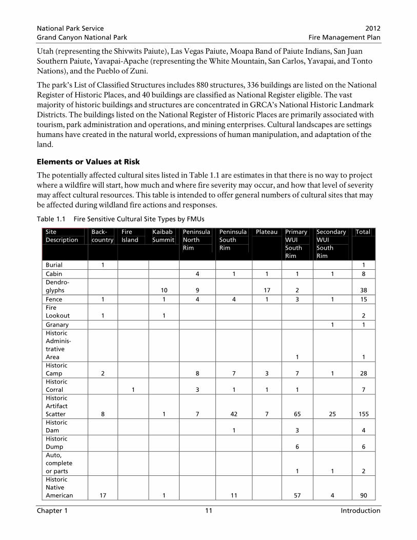
The potentially affected cultural sites listed in Table 1.1 are estimates in that there is no way to project where a wildfire will start, how much and where fire severity may occur, and how that level of severity may affect cultural resources. This table is intended to offer general numbers of cultural sites that may be affected during wildland fire actions and responses.
Table 1.1 Fire Sensitive Cultural Site Types by FMUs
Site Description
Back- country
Fire Island
Kaibab Summit
Peninsula North Rim
Peninsula South Rim
Plateau Primary WUI South Rim
Secondary WUI South Rim
Total
Burial 1 1 Cabin 4 1 1 1 1 8 Dendro-glyphs 10 9 17 2 38 Fence 1 1 4 4 1 3 1 15 Fire Lookout 1 1 2 Granary 1 1 Historic Adminis-trative Area 1 1 Historic Camp 2 8 7 3 7 1 28 Historic Corral 1 3 1 1 1 7 Historic Artifact Scatter 8 1 7 42 7 65 25 155 Historic Dam 1 3 4 Historic Dump 6 6 Auto, complete or parts 1 1 2 Historic Native American 17 1 11 57 4 90
National Park Service 2012 Grand Canyon National Park Fire Management Plan
Chapter 1 12 Introduction
Site Description
Back- country
Fire Island
Kaibab Summit
Peninsula North Rim
Peninsula South Rim
Plateau Primary WUI South Rim
Secondary WUI South Rim
Total
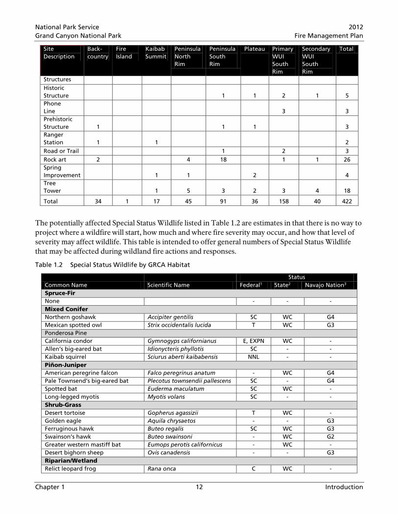
Structures Historic Structure 1 1 2 1 5 Phone Line 3 3 Prehistoric Structure 1 1 1 3 Ranger Station 1 1 2 Road or Trail 1 2 3 Rock art 2 4 18 1 1 26 Spring Improvement 1 1 2 4 Tree Tower 1 5 3 2 3 4 18
Total 34 1 17 45 91 36 158 40 422
The potentially affected Special Status Wildlife listed in Table 1.2 are estimates in that there is no way to project where a wildfire will start, how much and where fire severity may occur, and how that level of severity may affect wildlife. This table is intended to offer general numbers of Special Status Wildlife that may be affected during wildland fire actions and responses.
Table 1.2 Special Status Wildlife by GRCA Habitat
Common Name Scientific Name Status
Federal1 State2 Navajo Nation3 Spruce-Fir None - - - Mixed Conifer Northern goshawk Accipiter gentilis SC WC G4 Mexican spotted owl Strix occidentalis lucida T WC G3 Ponderosa Pine California condor Gymnogyps californianus E, EXPN WC - Allen’s big-eared bat Idionycteris phyllotis SC - - Kaibab squirrel Sciurus aberti kaibabensis NNL - - Piñon-Juniper American peregrine falcon Falco peregrinus anatum - WC G4 Pale Townsend’s big-eared bat Plecotus townsendii pallescens SC - G4 Spotted bat Euderma maculatum SC WC - Long-legged myotis Myotis volans SC - - Shrub-Grass Desert tortoise Gopherus agassizii T WC - Golden eagle Aquila chrysaetos - - G3 Ferruginous hawk Buteo regalis SC WC G3 Swainson’s hawk Buteo swainsoni - WC G2 Greater western mastiff bat Eumops perotis californicus - WC - Desert bighorn sheep Ovis canadensis - - G3 Riparian/Wetland Relict leopard frog Rana onca C WC -
National Park Service 2012 Grand Canyon National Park Fire Management Plan
Chapter 1 13 Introduction
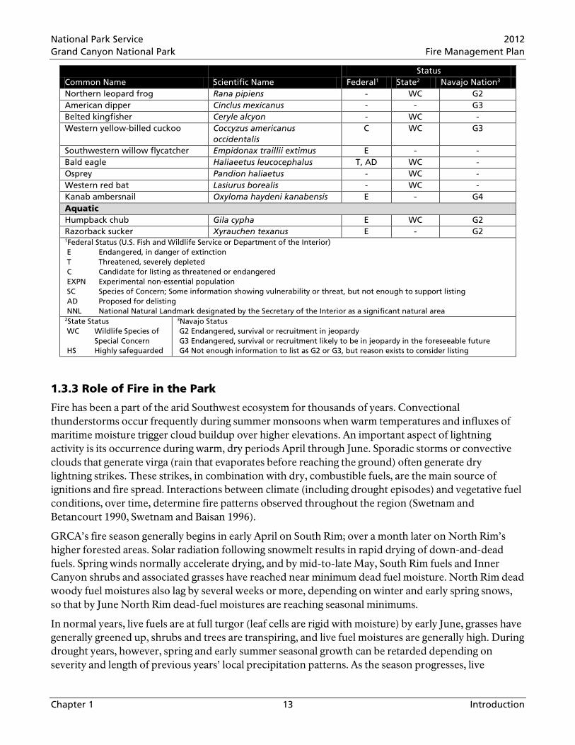
Common Name Scientific Name Status
Federal1 State2 Navajo Nation3 Northern leopard frog Rana pipiens - WC G2 American dipper Cinclus mexicanus - - G3 Belted kingfisher Ceryle alcyon - WC - Western yellow-billed cuckoo Coccyzus americanus
occidentalis C WC G3
Southwestern willow flycatcher Empidonax traillii extimus E - - Bald eagle Haliaeetus leucocephalus T, AD WC - Osprey Pandion haliaetus - WC - Western red bat Lasiurus borealis - WC - Kanab ambersnail Oxyloma haydeni kanabensis E - G4 Aquatic Humpback chub Gila cypha E WC G2 Razorback sucker Xyrauchen texanus E - G2 1Federal Status (U.S. Fish and Wildlife Service or Department of the Interior) E Endangered, in danger of extinction T Threatened, severely depleted C Candidate for listing as threatened or endangered EXPN Experimental non-essential population SC Species of Concern; Some information showing vulnerability or threat, but not enough to support listing AD Proposed for delisting NNL National Natural Landmark designated by the Secretary of the Interior as a significant natural area 2State Status WC Wildlife Species of
Special Concern HS Highly safeguarded
3Navajo Status G2 Endangered, survival or recruitment in jeopardy G3 Endangered, survival or recruitment likely to be in jeopardy in the foreseeable future G4 Not enough information to list as G2 or G3, but reason exists to consider listing
1.3.3 Role of Fire in the Park
Fire has been a part of the arid Southwest ecosystem for thousands of years. Convectional thunderstorms occur frequently during summer monsoons when warm temperatures and influxes of maritime moisture trigger cloud buildup over higher elevations. An important aspect of lightning activity is its occurrence during warm, dry periods April through June. Sporadic storms or convective clouds that generate virga (rain that evaporates before reaching the ground) often generate dry lightning strikes. These strikes, in combination with dry, combustible fuels, are the main source of ignitions and fire spread. Interactions between climate (including drought episodes) and vegetative fuel conditions, over time, determine fire patterns observed throughout the region (Swetnam and Betancourt 1990, Swetnam and Baisan 1996).
GRCA’s fire season generally begins in early April on South Rim; over a month later on North Rim’s higher forested areas. Solar radiation following snowmelt results in rapid drying of down-and-dead fuels. Spring winds normally accelerate drying, and by mid-to-late May, South Rim fuels and Inner Canyon shrubs and associated grasses have reached near minimum dead fuel moisture. North Rim dead woody fuel moistures also lag by several weeks or more, depending on winter and early spring snows, so that by June North Rim dead-fuel moistures are reaching seasonal minimums.
In normal years, live fuels are at full turgor (leaf cells are rigid with moisture) by early June, grasses have generally greened up, shrubs and trees are transpiring, and live fuel moistures are generally high. During drought years, however, spring and early summer seasonal growth can be retarded depending on severity and length of previous years’ local precipitation patterns. As the season progresses, live

National Park Service 2012 Grand Canyon National Park Fire Management Plan
Chapter 1 14 Introduction
vegetation is stressed and becomes more highly flammable. Dead-fuel moistures are at minimum and can become totally available for combustion.
Late summer and fall, following a normal pattern of summer rainstorms, are often characterized by a secondary fire season. Human-caused fire ignitions may become problematic depending on summer moisture amount and distribution. Dead woody fuels lose moisture gained during summer rains, but at slower rates than in late spring due to decreasing day lengths, cooling temperatures, and increased humidity recovery at night. By late summer, warm-season grasses are normally curing or cured while cool-season grasses remain green or are greening. Fire severity is normally lower during fall.
Fires occurring at GRCA in the last few thousand years altered vegetation structure, composition, function, and distribution, and left detectable landscape patterns as evidence. These fire patterns are collectively called the fire regime. A fire regime describes fire frequency, intensity, timing, and distribution for a particular vegetation type. Historic fire regimes refer to past fire patterns. Historic fire frequency and timing can be inferred from observable fire scars in the wood of old trees, especially ponderosa pine.
It is standard practice to describe historic fire regimes in terms of an average fire return interval and a single type of fire severity. For example, the ponderosa pine type in the Southwest is often described as having a historic fire regime of frequent (mean fire return interval of five years), and low-severity fire. This approach does not recognize variation in the interval between fires, severity, or spatial complexity. Even in ponderosa pine, where fires are widely thought to have been frequent historically, there was likely interval variation between fires in any given landscape location. Fire return may have varied from one to 15 years. Understanding the full pattern is important in characterizing fire-vegetation interactions because even these small interval variations can have substantial effects on vegetation.
The National Fire Plan (DOI/USDA 2000) identifies five broad fire regime categories based on fire frequency and severity. These categories are shown in Table 1.3 for a generic description of all vegetation types and Table 1.4 for GRCA vegetation types. These five categories only partially explain the complexity of the fire regimes in the forest types at GRCA. Many of the GRCA forest types may burn with a mix of frequencies and severities and can’t always be placed in just one fire regime class. For example, the high elevation forests on the North Rim may experience low severity fires every few decades while also experiencing high severity fires every 200 years or so. Each of the vegetation types listed in Table 1.4 only explain dominant fire regime categories.
Table 1.3 National Fire Plan Fire Regime Classes
National Fire Plan Fire Regime Class
Frequency Severity
I 0-35 years low II 0-35 years high III 35-100+ years mixed IV 35-100+ years high V >100 years high

National Park Service 2012 Grand Canyon National Park Fire Management Plan
Chapter 1 15 Introduction
Table 1.4 Historic Fire Regime Descriptions for Major Vegetation Types Above the Rim
Vegetation Type
Historic Fire Regime Characteristics
Fire Regime Class
Fire Frequency and Severity Class
Spruce-Fir Forest Highly diverse forest structure with fire-initiated groups of trees and scattered fire relicts
III 35-100+ years Less frequent Mixed severity
Mixed-Conifer Forest
Highly diverse forest structure from widespread surface fires and patchy crown fires; topographic influences
III 35-100 years Less frequent Mixed severity
Ponderosa Pine Forest
Open pine forests or woodlands maintained by frequent fire
I 0-35 years Frequent Low severity
Piñon-Juniper Woodlands
Forest structure of uneven-sized trees developed during long fire-free periods intermixed with relatively small fire-initiated patches from infrequent crown fire.
III or V
35-100+ years Less frequent and Mixed severity Or > 100 years Infrequent and High severity
Long-term Suppression Effects
Measuring the difference between natural frequency of wildland fires and number of years fire has been suppressed or excluded provides an indication of how far plant communities in a particular vegetation type have deviated from natural conditions. In other words, number of fire return intervals missed can estimate how much plant community composition and structure have shifted from what would have been observed had fires been allowed to burn naturally.
Fires have largely been excluded (suppressed) in GRCA since the late 1870s. In areas of decades-long fire exclusion, vegetation types with short fire intervals have missed several fires and show large deviation or departure from natural conditions. Vegetation types most affected are ponderosa and mixed-conifer forests. When fires are regularly suppressed, natural fire regime is disrupted. This has resulted in changes not only to ecosystem structure (e.g. plant density, species composition, and biomass distribution) but also to ecosystem function (e.g. nutrient cycling, forest floor shading, and soil moisture retention).
Vegetation changes caused by past fire suppression activity have increased dead and live fuel loading, causing higher fire intensities. Tree and shrub density in many areas has created a potentially hazardous arrangement of close standing, burnable vegetation, or ladder fuel. Ladder fuel helps fires ascend taller forest trees, increasing risk of higher intensity crown fires. Under these fuel conditions, if subjected to crown fire, large forest landscapes can be impacted, forested vegetation may be converted to shrub communities, watershed and soil processes can be impacted, and other ecosystem values altered.
Existing Situation
Between 1980 and 2010, more than 158,500 park acres burned. The majority (86%) was prescribed fire (69,452 acres) and naturally-ignited fires managed for multiple objectives (67,552 acres). Wildfires managed with only suppression objectives accounted for 14% of the total (21,502 acres). Figure 1.2 displays annual acres burned by fire type since 1980.

National Park Service 2012 Grand Canyon National Park Fire Management Plan
Chapter 1 16 Introduction
After more than 30 years of proactive fire management, progress toward restoring natural fire regimes to the park is measurable, but far from fully achieved. This amount of managed fire has been insufficient to remedy decades of landscape-scale fire exclusion. In many areas, multiple fire treatments will be needed to restore desired ecological conditions.
Figure 1.2 Acres burned by Fire Type 1980-2010, Grand Canyon National Park
Wildland-Urban Interface
The Wildland-Urban Interface (WUI) occurs where homes and infrastucture intermingle with wildland vegetation, and has been noted as a topic of special concern under Federal fire policy. Communities at risk from wildland fire have been identified by local, state, and Federal fire management agencies. Much of the management funding appropriated by Congress is intended to reduce wildland fire threats to these communities.
Risk and damage caused by wildland fire are not limited to buildings. Wildland fires can create a public safety risk. Public health can be impacted by long-lasting and/or dense smoke. Natural resources, including wildlife, soil, water quality, and vegetation can be degraded for decades or require millions of dollars to rehabilitate. Local economies, especially those tourism-dependent, can experience financial loss when wildland fire causes road and area closures, as well as post-fire recreational opportunity loss.
Public and firefighter safety are the first priority in Federal fire policy. Implementation of a fuels management program on a sustained landscape level has been consistently identified as needed to
0
5000
10000
15000
20000
25000
Acre
s
Wildfire - Suppression ObjectivesWildfire - Multiple ObjectivesPrescribed Fire

National Park Service 2012 Grand Canyon National Park Fire Management Plan
Chapter 1 17 Introduction
reduce wildland fire intensity in unnaturally dense fuels, and decrease as fully as possible, the number of firefighters who die every year fighting fires.
GRCA fire managers recognize the need to treat hazardous fuels immediately adjacent to homes and other structures, and forests and woodlands adjacent to WUI areas. For this plan, two WUI categories are identified as separate fire management units,
1) Primary WUI treatments reduce fuels around values at risk including roads and utilities to allow firefighters defensible space to manage fires in the WUI. The Primary WUI includes areas surrounding Grand Canyon Village and Desert View on South Rim, and Bright Angel Developed Area on North Rim
2) Secondary WUI treatments reduce fuels in areas surrounding Primary WUI to slow or stop approaching wildland fires
1.4 Environmental Compliance The Fire Management Plan Final Environmental Impact Statement/Assessment of Effect (FMP FEIS/AEF) and associated Record of Decision are supporting compliance documents for this FMP. On October 23, 2008 The NPS published a Notice of Availability in the Federal Register which released the Grand Canyon National Park Draft Environmental Impact Statement (DEIS) and Assessment of Effect for the FMP (NPS 2008a) for public review and comment. The release of the DEIS initiated a formal 90-day public comment period, ending January 21, 2009. In August of 2009, the NPS published a Notice of Availability to announce the FMP FEIS/AEF for public review. The FEIS release initiated a 30 day no-action period, ending September 6, 2009. A Record of Decision for the FMP FEIS/AEF was approved on January 12, 2010.
Pursuant to Section 7 of the Endangered Species Act, a Biological Assessment was submitted to the U.S. Fish and Wildlife Service on May 27, 2009 for formal consultation. Consultation was finalized with the Biological Opinion rendered by the U.S. Fish and Wildlife Service on November 10, 2009. Key points in the Biological Opinion included, but were not limited to the use of adaptive management, clarity on Mexican spotted owl habitat, and the 30% cap on moderate/high and high severity fire in the Mexican spotted owl restricted habitat and the mixed-conifer forest type.
In compliance with Section 106 of the National Historic Preservation Act consultation with the State Historic Preservation Office, and the Advisory Council on Historic Preservation regarding undertakings that may affect historic properties was initiated in September 2003. In June of 2008 a letter was sent to the Advisory Council on Historic Preservation regarding the Draft Programmatic Agreement. In September of 2008, GRCA received a letter from the Advisory Council on Historic Preservation stating that they did not believe that their participation in the consultation to develop the Programmatic Agreement was needed. After the affected American Indian tribes provided a signatory the State Historic Preservation Office signed the Programmatic Agreement on July 20, 2009.


National Park Service 2012 Grand Canyon National Park Fire Management Plan
Chapter 2 18 Policy
CHAPTER 2 POLICY, LAND MANAGEMENT PLANNING, AND PARTNERSHIPS
2.1 Fire Policy Many laws, regulations, policies, and directives direct the Fire Management Program. These are summarized in Figure 1-2 of the FMP FEIS/AEF (NPS 2010), and detailed in Chapter 1 and Appendix A of the FMP FEIS/AEF. Some of the laws, orders, and regulations are listed below.
2.1.1 Laws
Laws are acts passed by the U.S. Congress and approved by the President. All laws must be consistent with the U.S. Constitution. Federal laws have supremacy over state and local laws.
• Act of August 25, 1916 (NPS Organic Act), P.L. 64-235, 16 U.S.C. Section 1 et seq. as amended
• National Environmental Policy Act of 1969 as amended , P.L. 91-90, 42 U.S.C. 4321-4347, January 1, 1970, as amended by P.L. 94-52, July 3, 1975, and P.L. 94-83, August 9, 1975
• Wilderness Act 1964 • National Historic Preservation Act of 1966 • Endangered Species Act of 1973
2.1.2 Executive Orders and Presidential Proclamations
Executive Orders are directives from the President to Executive Branch departments and agencies. President Proclamations are decrees made by the President under the Constitution and other authorities.
• Antiquities Act • Executive Order 11990 Protection of Wetlands
2.1.3 Regulations
Regulations are rules for complying with a Federal law developed by the authorized department or agency. Regulations also include codification of agency policy.
• 36 Code of Federal Regulations Part 1-199 contains general and specific regulations for national park management and use
• 40 Code of Federal Regulations Parts 1500 – 1508 Council on Environmental Quality Regulations for Implementing National Environmental Policy Act Procedural Provisions, Article 15 Forest and Range Management Burns
• State of Arizona Department of Environmental Quality Regulations for Wildland Fire Management (Arizona Administrative Code: Title 18, Environmental Quality; Chapter 2, Department of Environmental Quality, Air Pollution Control, Appendix D)
2.1.4 Policy
The most recent guidance for Federal wildland fire management (Department of the Interior and U.S. Department of Agriculture) was approved in 2009 (NPS 2009a). Changes include clarification of fire terminology, guidance to manage unplanned fires for multiple objectives, emphasis on the need to conduct fire management planning that is intergovernmental in scope and at a landscape scale, and that every wildland fire will be assessed following a decision-support process that examines the full range of potential responses.
National Park Service 2012 Grand Canyon National Park Fire Management Plan
Chapter 2 19 Policy
Policies are guiding principles or procedures that set the framework and provide direction for management decisions. Policies may prescribe the process by which decisions are made, how an action is accomplished, or results achieved. The NPS has a three-leveled Directives System to express policy and provide instructions for implementation, which is
• Level 1: NPS Management Policies provide a framework for making management decisions, and are approved by the Director after review by the Washington Office of Policy and the National Leadership Council. Adherence is mandatory. Other management policies relevant to fire are
o Federal Wildland Fire Management Policy (The Interagency Federal Wildland Fire Policy Review Working Group revised the Federal Wildland Fire Management Policy in 2001)
o Managing Impacts of Wildfires on Communities and the Environment, and Protecting People and Sustaining Resources in Fire Adapted Ecosystems—A Cohesive Strategy (2001; DOI/USDA) (www.fs.fed.us/publications/2000/cohesive_strategy10132000.pdf)
• Level 2: NPS Director’s Orders are instructions for implementing management policy, and may articulate new or revised policy; provide specific instructions; outline requirements or standards for NPS functions, programs, and activities; are approved by the Director after review by the Washington Office of Policy and the National Leadership Council. Adherence is mandatory. FMP FEIS/AEF-related Director’s Orders include
o DO-12 Conservation Planning and Environmental Impact Analysis o DO-18 Wildland Fire Management and Reference Manual 18 o DO-41 Wilderness Preservation and Management o Directors Orders are available at home.nps.gov/applications/npspolicy/DOrders.cfm
• Level 3: Handbooks, reference manuals, and other professional materials FMP FEIS/AEF-related materials include
o DO-12 Handbook, Conservation Planning, Environmental Impact Analysis, and Decision Making
o National Wilderness Steering Committee Guidance White Paper Number 3: Minimum Requirements Decision Process, November 2006.
o Minimum Impact Suppression Tactics, Incident Response Pocket Guide, National Wildfire Coordinating Group
2.1.5 National Fire Plan
The National Fire Plan (NFP) was developed in August 2000, following a landmark wildland fire season, with the intent of actively responding to severe wildland fires and their impacts on communities while ensuring sufficient firefighting capacity. The NFP addresses five key points: firefighting, rehabilitation, hazardous fuels reduction, community assistance, and accountability.
2.2 Park/Resource Management Planning The FMP is a resource management, risk mitigation, and fire strategy implementation document intended to facilitate accomplishment of park management goals and objectives identified in GRCA’s General Management Plan (NPS 1995) and Resource Management Plan (NPS 1997).

National Park Service 2012 Grand Canyon National Park Fire Management Plan
Chapter 2 20 Policy
2.2.1 General Management Plan
The 1995 GRCA General Management Plan outlines a vision for managing park resources and visitor experiences; the Resource Management Plan and FMP are tiered off the General Management Plan.
Objectives define what must be achieved to a large degree for the action to be considered a success. The FMP objectives are grounded in the park’s enabling legislation, mandates, purpose, and significance, as well as the General Management Plan and other management documents. General Management Plan management objectives were developed with the presumption that specific objectives would be developed for the FMP. The FMP objectives were developed by an interdisciplinary team to meet or support General Management Plan objectives. A full list of FMP goals and objectives are located in Chapter 3 (Section 3.1.1). The relationship between the objectives in the General Management Plan and the FMP is shown in Table 3-1.
2.2.2 Resource Management Plan
In the GRCA Resource Management Plan (NPS 1997), “restoration of a natural fire regime” was listed as one of 11 Overarching Issues facing GRCA. Overarching issues were defined as, “…broad-spectrum issues that affect more than one resource.” When the FMP goals and objectives were developed, a review of the Resource Management Plan goals and objectives took place to ensure that all FMP goals and objectives supported those objectives in the Resource Management Plan. The relationship between the objectives in the Resource Management Plan and the FMP are listed in Table 3-2.
2.2.3 Backcountry Management Plan
The GRCA Backcountry Management Plan (NPS 1988) defines backcountry as most of the Inner Canyon, plus a large portion of North Rim and remote South Rim areas. The 1988 Backcountry Management Plan does not address fire management practices. The Backcountry Management Plan is scheduled for review, and backcountry and wilderness management will be addressed within the next five years through a separate planning and National Environmental Policy Act process.
2.2.4 Planning Process to Develop this Fire Management Plan
This FMP provides overall guidance for implementing the approved alternative in the 2010 FEIS/AEF FMP. This plan also describes the management decisions and actions analyzed in the FEIS/AEF. This FMP will replace the 2005 FMP as the Grand Canyon National Park Fire Management Plan.
During 2010 and 2011, fire management staff gathered the necessary information from the FMP FEIS/AEF, the Biological Opinion (NPS 2009c), and the State Historic Preservation Office Programmatic Agreement (NPS 2009b). After completing this draft FMP, it was sent to the Intermountain Regional Office for review. All comments from the Regional Office were reviewed and addressed. This draft FMP was then formatted and edited and sent to the Superintendent’s Office for final review and approval.
2.3 Partnerships The Fire and Aviation Program at GRCA uses internal interdisciplinary partnerships, and consults with external partners like the U.S. Fish and Wildlife Service and Arizona Department of Environmental Quality. The Fire and Aviation Program is also a member of many cooperative partnerships that involve aviation safety and policy, fire policy, fire program budgeting, education, and research.

National Park Service 2012 Grand Canyon National Park Fire Management Plan
Chapter 2 21 Policy
Specific partnerships are listed below.
Planning
Many parties participate to create a management plan that satisfies park goals and objectives, NPS policies, and local concerns. The FMP FEIS/AEF (NPS 2010) was the result of work by the five broad groups listed below. The FMP will reflect this cooperative effort.
• Interdisciplinary Team: NPS staff responsible for FEIS/AEF development • Internal review (includes expertise from NPS Intermountain Region Office Staff)
• Consulting agencies (includes expertise from the U.S. Forest Service, Arizona Department of Environmental Quality, U.S. Fish and Wildlife Service, and the Arizona State Historic Preservation Office)
• Associated tribes • Interested public
Every project plan goes through an internal interdisciplinary review that contains staff members from the Division of Science and Resource Management, and the Office of Planning and Compliance. The review ensures that the projects are planned within the scope of the current consultations and to ensure resource concerns are identified and/or mitigated.
Operations
• GRCA and the Kaibab National Forest (KNF) have worked collaboratively to create three key interagency partnerships to improve interagency relationships, enhance program efficiency, and improve program safety. These partnerships include
o The North Zone Fire Management Organization, an interagency fire management staff that manages fire programs for both North Rim of GRCA and North Kaibab Ranger Station.
o The Williams Interagency Fire Dispatch Center manages all fire-related dispatch responsibilities for both GRCA and KNF. Center employees are funded by both GRCA and KNF.
o The Interagency Aviation Officer assists with aviation program management at GRCA and the Williams District of the KNF. Oversight of these two programs includes three light helicopters, one fixed-wing aircraft, and two helirappel modules.
• GRCA’s South District and the KNF’s Tusayan District operate under an interagency agreement that provides shared tactical resources and logistical support.
• The National Fire Danger Rating Operating Plan, Preparedness Plan, Helitack Coordination Plan, Type III – V Delegation of Authority, and Incident Organizer are all interagency documents with the KNF.
• GRCA is also a long standing member of the Northern Arizona Area Board. Member agencies include the Bureau of Indian Affairs; Hopi, Navajo, Hualapai, and Havasupai Tribes; Arizona Division of Forestry; Coconino and Kaibab National Forests; and GRCA. The board coordinates fire and aviation activities across northern Arizona.
GRCA supports the Flagstaff Area National Monuments (Sunset Crater, Wupatki, and Walnut Canyon National Monuments) wildland fire program through an inter-park agreement. Flagstaff Area National Monuments’ wildland fire program is also supported by the Coconino National Forest through an interagency agreement.
National Park Service 2012 Grand Canyon National Park Fire Management Plan
Chapter 2 22 Policy
The Fire and Aviation Program also assists and receives assistance from other NPS fire programs. The GRCA fire program has assisted, and will continue to assist, other fire programs during operational activities on planned and unplanned fires and providing expertise in planning, fireline leadership, and firefighter/equipment support. Other NPS fire programs are counted on to provide support in fireline leadership, incident planning, logistics, and firefighter/equipment support.
The GRCA fire program has developed cooperative and beneficial partnerships with wildland divisions within the Summit, Highlands, Pinewood, Flagstaff, and Tusayan Fire Departments in and around Flagstaff and Tusayan, Arizona. Firefighter support from these departments is depended on for wildfires and prescribed fire projects. GRCA also supports these departments with logistical support through rural fire-assistance grants.


National Park Service 2012 Grand Canyon National Park Fire Management Plan
Chapter 3 23 Park-Wide and FMU Characteristics
CHAPTER 3 PARK-WIDE AND FIRE MANAGEMENT UNIT CHARACTERISTICS
3.1 Park-Wide (General) Management Considerations Wildland fire will be managed to enhance resource protection, diminish risk and consequences of undesirable wildland fires, sustain naturally occurring vegetative communities, and to return and maintain fire as an essential part of ecosystem processes. Goals and objectives were developed in the GRCA FMP FEIS/AEF (NPS 2010) based on review and analysis of policy, documented research on the natural role of fire in maintaining park ecosystems, and public comments.
A community-based approach to wildland fire issues will involve close collaboration and cooperation with neighboring agencies which have a vested interest in areas of wildland fire issues.
NPS DO-18 (NPS 2008b) identifies mission goals for the NPS Wildland Fire Management Program, these goals are as follows
A. Protect Values Through Effective Risk Management: Protect life, communities, and resources from adverse effects of wildland fire without compromising safety.
B. Restore and Maintain Fire-adapted Ecosystems: Maintain and restore fire-adapted ecosystems using appropriate tools and techniques in a manner that will provide sustainable, environmental, and social benefits.
C. Science Based Management: General and park-specific science and research guides the wildland fire program.
D. Integrate Wildland Fire with Other NPS Programs: Fire management programs are responsive to Service-wide and park priorities and are integrated with other NPS programs.
E. External Audiences Understand and Support Wildland Fire Programs: NPS fire management will communicate and coordinate with interagency organizations and other stakeholders to pursue common goals, programs, and projects.
F. Build and Promote Organizational Effectiveness: Fire management programs achieve desired outcomes by building program capacity, leadership, and effective management practices.
A full range of management actions including, but not limited to, direct perimeter control, indirect perimeter control, contain/confine strategies, and monitoring may be utilized and will vary depending upon Fire Management Units (FMU). Considerations for management actions may be based on FMU specific considerations, current and expected fire behavior, values at risk, other local, regional, or national fire activity, and any social/political concerns that may arise. Refer to specific FMU considerations in section 3.2 of this plan.
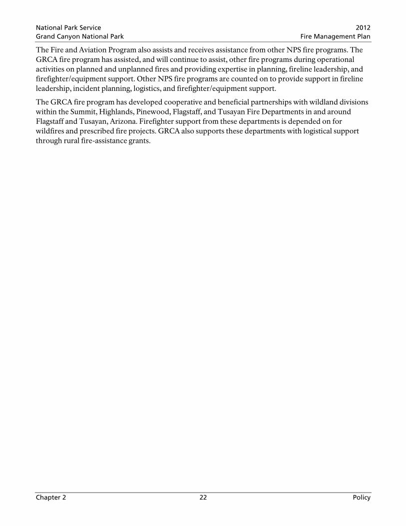
Figure 3.1 depicts, in general, the process to be taken given an ignition, regardless of source. Management actions depend on the provisions in the GRCA General Management Plan (NPS 1995) and this FMP. This chart is generally applicable to most ignitions; however, specific exceptions may exist.
National Park Service 2012 Grand Canyon National Park Fire Management Plan
Chapter 3 24 Park-Wide and FMU Characteristics
Figure 3.1 Wildland Fire Flow Chart
(Guidance for Implementation of Federal Wildland Fire Management Policy, Appendix B, USDA/DOI 2009a)
Park-Wide Fire Management Considerations
Detailed guidelines for incident management within GRCA should be attached to the Agency Administrator Delegation of Authority within the Transition Plan Package. To summarize, all tactical decisions will include the following considerations
• Public and personnel safety • Minimum Impact Suppression Techniques or Minimum Impact Management Techniques • Protection protocols for cultural and biological resources • Assignment of a Resource Advisor • Briefings of assigned personnel
There may be management concerns connected with the accomplishment of management and tactical objectives and listed values to be protected. The following serve as mitigating guides for all wildland fire management operations within all FMUs as applicable
• Equipment use Heavy equipment use requires written approval from the Superintendent; authority is delegated to the Incident Commander on an incident-by-incident basis.
• Air Quality All project plans, including all decision support documents and other operational documents involving wildland fire, must be approved under guidelines specified in the regulations and policies identified by Arizona Department of Environmental Quality.
• Sensitive areas and/or species Maps identifying sensitive wilderness resources are annually updated and maintained by Science and Resource Management Staff. These maps are used by Resource Advisors during wildland fire incidents to identify where retardant cannot be used unless human life is at stake, locate fire-

National Park Service 2012 Grand Canyon National Park Fire Management Plan
Chapter 3 25 Park-Wide and FMU Characteristics
sensitive cultural resources or sensitive plant and animal populations, and identify where fire camps or helispots should not be located. Specific burn plans and other project plans shall be submitted to an interdisciplinary team from Fire and Aviation and Science and Resource Management for review and comment.
• Cultural and Biological Resources Annual work plans from Fire and Aviation will be submitted to the Division of Science and Resource Management and used in the preparation of the annual report to the Arizona State Historic Preservation Office and U.S. Fish and Wildlife Service, to schedule and complete field surveys, and to obtain clearance as required on a project basis.
• Minimum Impact Suppression Techniques Fire management tactics can have short- and long-term effects on the landscape. Minimum-impact suppression techniques will be used for all approved actions under all fire management strategies as long as it does not compromise public and firefighter safety.
• Wilderness (See Chapter 1 (Section 1.3.1), GCNP FMP FEIS/AEF, Volume One, Sections 3.6 – 3.6.3 and Volume Two, Appendix A.5.1 – A.5.3) GRCA fire managers complete an annual Minimum Requirement Analysis to address strategic and tactical options for prescribed fire and wildfire activities in wilderness. These annual assessments define the minimum activity necessary to conduct an operation with hand tools or some combination of hand and motorized equipment including aircraft.
3.1.1 Fire Management Goals and Objectives
An interdisciplinary team of fire and resource managers identified goals and objectives for the Fire Management Program during the development of the FMP EIS/AEF.
Goal 1 Protect human health and safety and private and public property
Objectives
• Conduct wildland fire management activities with the most current risk assessment and mitigation techniques available to ensure firefighter and public safety is the highest priority.
• Use non-fire fuel treatments in areas where wildland fire use is not practical due to safety or smoke concerns. Even in these areas, however, fire will be used in the future as fully as possible to maintain desired conditions once restored through non-fire fuel treatments.
• Minimize smoke impacts on human health. • Provide fire management workforce with training, equipment, operating procedures, safety
measures, and information needed to manage risks and perform activities safely.
Goal 2 Restore and maintain park ecosystems in a natural, resilient condition
Objectives
• Maintain ecosystems that are within the range of desired conditions through natural processes within policy constraints.
• Restore ecosystems that are not within the range of natural variability to desired conditions and maintain them through natural processes within policy constraints.
• Set priorities for treatment activities based on site-specific information including departure from natural fire return intervals, desired conditions, and other relevant factors.
National Park Service 2012 Grand Canyon National Park Fire Management Plan
Chapter 3 26 Park-Wide and FMU Characteristics
Goal 3 Protect the park’s natural, cultural, and social values
Objectives
• Manage the ecosystem and natural processes, these are the primary objectives that will lead to healthy critical habitat for listed threatened, endangered, and sensitive species.
• Use fire management tools and techniques to maintain, restore, and protect cultural resources while minimizing adverse impacts from fire and fire management activities.
• Conduct fire management activities in proposed wilderness in a manner that will not diminish suitability for designation or result in changes to the current wilderness proposal (See GRCA FMP FEIS/AEF, Volume Two, Appendix A.5 – A.5.7).
• Use minimum-impact management techniques to reduce impacts to wilderness values, cultural and soil resources, and to limit spread of invasive plant species.
• Minimize smoke impacts on air quality values including visibility (See GRCA FMP FEIS/AEF, Volume Two, Appendix A.8).
Goal 4 Promote a science-based program that relies on current and best-available information
Objectives
• Conduct research that will help understand natural fire regimes, refine prescriptions, provide data for fire behavior models, and effectively implement the Fire Management Program.
• Monitor and evaluate fire management activities (managed wildland fires, prescribed burns, fuel reduction treatments) to assess effects on natural and cultural resources and social values.
• Update fire return interval departures, desired conditions (See GRCA FMP FEIS/AEF, Sections 2.4.1 – 2.4.4.3), fire treatment priorities, and prescriptions as relevant data become available.
Goal 5 Educate, inform, consult, and collaborate with tribes, stakeholders, and the public
Objectives
• Maintain government-to-government and informal relationships with Native American tribes to exchange knowledge about fire management and traditional cultural practices.
• Develop and implement a proactive process that disseminates current and accurate information to the public, park employees, media representatives, and cooperators that encourages support of the Fire Management Program.
• Conduct wildland fire prevention, education, and other activities in communities within and adjoining the park. Work in collaboration with local communities, county, state, and Federal fire agencies with fire-management interests.
• Develop interpretive displays and educational programs, working with the Division of Interpretation, to foster understanding and acceptance of the Fire Management Program.
Tables 3.1 and 3.2 summarize the relationship of the FMP’s objectives to General Management Plan and Resource Management Plan objectives. These tables are referred to in the GRCA FMP FEIS/AEF, Chapter 2, Section 2.2.1 and Section 2.2.2.

National Park Service 2012 Grand Canyon National Park Fire Management Plan
Chapter 3 27 Park-Wide and FMU Characteristics
Table 3.1 Management Objectives in GRCA General Management and Fire Management Plans
Resource General Management Plan Management Objectives
Fire Management Plan Management Objectives
Natural and Cultural Resources Water Quality and Soils
• Preserve natural spring and stream flows and water quality
• Monitor and evaluate fire management activities (managed wildland fires, prescribed burns, and fuel reduction treatments) to assess effects on natural and cultural resources and social values
Air Quality • Preserve, protect, and improve air quality and related values such as visibility
• Minimize smoke impacts on air quality values including visibility • Use non-fire fuel treatments in areas where use of fire is not practical
due to safety or smoke concerns. Even in these areas, however, fire will be used as fully as possible to maintain desired conditions once restored
• Minimize smoke impacts on human health Natural Soundscape • Protect natural quiet and solitude, and mitigate or
eliminate effects of activities causing excessive or unnecessary noise in, over, or adjacent to the park
• Monitor and evaluate fire management activities (managed wildland fires, prescribed burns, and fuel reduction treatments) to assess effects on natural and cultural resources and social values
Caves and Paleontological Resources
• Preserve, protect, and interpret natural and scenic resources and values, and ecological processes
• Preserve, manage, and interpret cultural resources for the benefit of present and future generations
• Monitor and evaluate fire management activities (managed wildland fires, prescribed burns, and fuel reduction treatments) to assess effects on natural and cultural resources and social values
Vegetation • Preserve and protect the park’s genetic integrity and species composition, consistent with natural ecosystem processes
• To the maximum extent possible, restore altered ecosystems to natural conditions and ensure preservation of native components through active management of nonnative components and processes
• Ecosystems within the range of desired conditions (see Chapter 2 of FEIS) will be maintained through natural processes within policy constraints
• Ecosystems not within the range of natural variability will be restored to desired conditions (see Chapter 2 of FEIS) and subsequently maintained through natural processes within policy constraints
• Set priorities for treatment activities based on site-specific information including departure from natural fire return intervals, desired conditions, and other relevant factors
Terrestrial Wildlife • Preserve and protect park genetic integrity and species composition, consistent with natural ecosystem processes
• Monitor and evaluate fire management activities (managed wildland fires, prescribed burns, and fuel reduction treatments) to assess effects on natural and cultural resources and social values
Aquatic Resources • Preserve and protect park genetic integrity and species composition, consistent with natural ecosystem processes
• To the maximum extent possible, restore altered eco-systems to their natural conditions and ensure preservation of native components through active management of nonnative components and processes
• Monitor and evaluate fire management activities (managed wildland fires, prescribed burns, and fuel reduction treatments) to assess effects on natural and cultural resources and social values
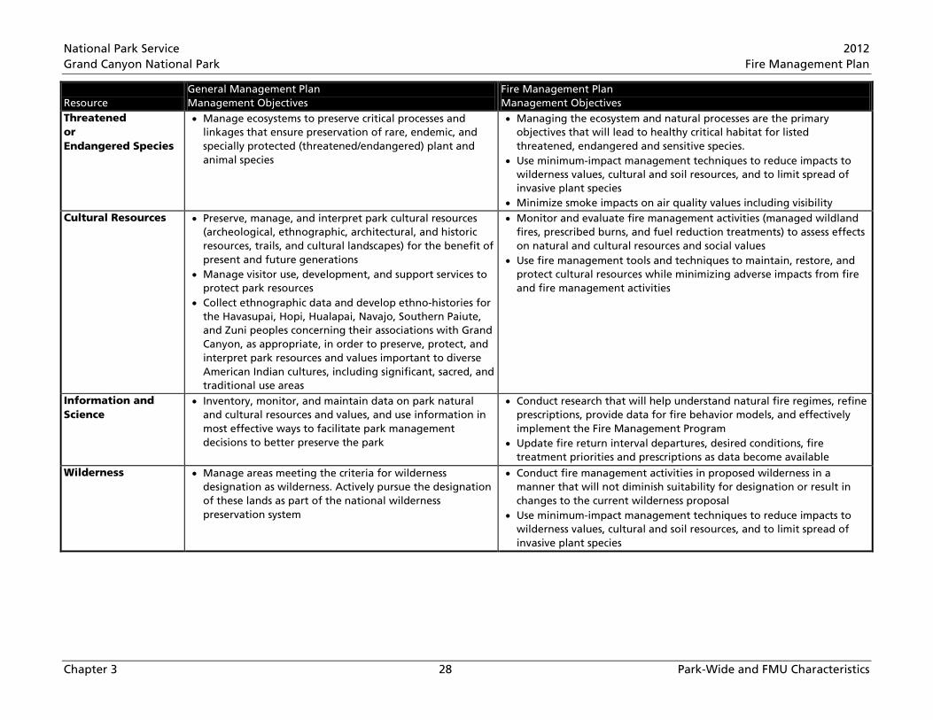
National Park Service 2012 Grand Canyon National Park Fire Management Plan
Chapter 3 28 Park-Wide and FMU Characteristics
Resource General Management Plan Management Objectives
Fire Management Plan Management Objectives
Threatened or Endangered Species
• Manage ecosystems to preserve critical processes and linkages that ensure preservation of rare, endemic, and specially protected (threatened/endangered) plant and animal species
• Managing the ecosystem and natural processes are the primary objectives that will lead to healthy critical habitat for listed threatened, endangered and sensitive species.
• Use minimum-impact management techniques to reduce impacts to wilderness values, cultural and soil resources, and to limit spread of invasive plant species
• Minimize smoke impacts on air quality values including visibility Cultural Resources • Preserve, manage, and interpret park cultural resources
(archeological, ethnographic, architectural, and historic resources, trails, and cultural landscapes) for the benefit of present and future generations
• Manage visitor use, development, and support services to protect park resources
• Collect ethnographic data and develop ethno-histories for the Havasupai, Hopi, Hualapai, Navajo, Southern Paiute, and Zuni peoples concerning their associations with Grand Canyon, as appropriate, in order to preserve, protect, and interpret park resources and values important to diverse American Indian cultures, including significant, sacred, and traditional use areas
• Monitor and evaluate fire management activities (managed wildland fires, prescribed burns, and fuel reduction treatments) to assess effects on natural and cultural resources and social values
• Use fire management tools and techniques to maintain, restore, and protect cultural resources while minimizing adverse impacts from fire and fire management activities
Information and Science
• Inventory, monitor, and maintain data on park natural and cultural resources and values, and use information in most effective ways to facilitate park management decisions to better preserve the park
• Conduct research that will help understand natural fire regimes, refine prescriptions, provide data for fire behavior models, and effectively implement the Fire Management Program
• Update fire return interval departures, desired conditions, fire treatment priorities and prescriptions as data become available
Wilderness • Manage areas meeting the criteria for wilderness designation as wilderness. Actively pursue the designation of these lands as part of the national wilderness preservation system
• Conduct fire management activities in proposed wilderness in a manner that will not diminish suitability for designation or result in changes to the current wilderness proposal
• Use minimum-impact management techniques to reduce impacts to wilderness values, cultural and soil resources, and to limit spread of invasive plant species
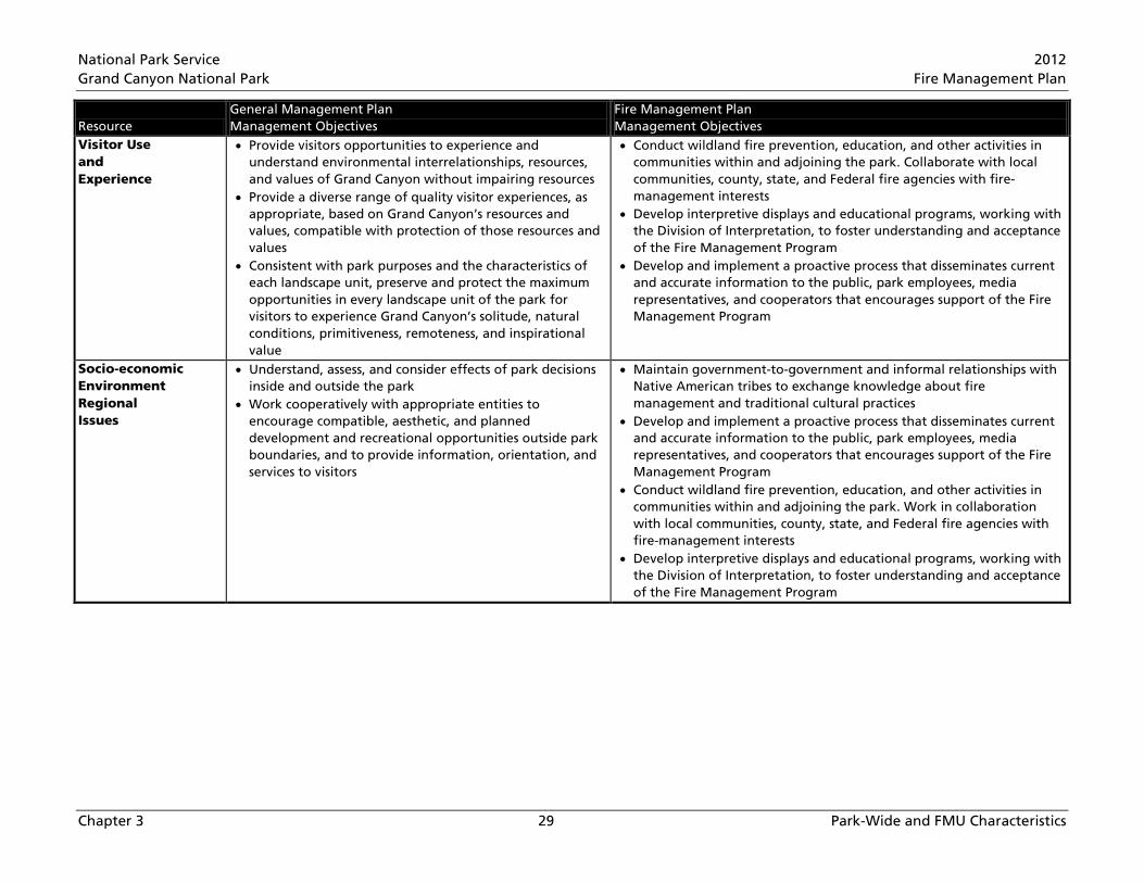
National Park Service 2012 Grand Canyon National Park Fire Management Plan
Chapter 3 29 Park-Wide and FMU Characteristics
Resource General Management Plan Management Objectives
Fire Management Plan Management Objectives
Visitor Use and Experience
• Provide visitors opportunities to experience and understand environmental interrelationships, resources, and values of Grand Canyon without impairing resources
• Provide a diverse range of quality visitor experiences, as appropriate, based on Grand Canyon’s resources and values, compatible with protection of those resources and values
• Consistent with park purposes and the characteristics of each landscape unit, preserve and protect the maximum opportunities in every landscape unit of the park for visitors to experience Grand Canyon’s solitude, natural conditions, primitiveness, remoteness, and inspirational value
• Conduct wildland fire prevention, education, and other activities in communities within and adjoining the park. Collaborate with local communities, county, state, and Federal fire agencies with fire-management interests
• Develop interpretive displays and educational programs, working with the Division of Interpretation, to foster understanding and acceptance of the Fire Management Program
• Develop and implement a proactive process that disseminates current and accurate information to the public, park employees, media representatives, and cooperators that encourages support of the Fire Management Program
Socio-economic Environment Regional Issues
• Understand, assess, and consider effects of park decisions inside and outside the park
• Work cooperatively with appropriate entities to encourage compatible, aesthetic, and planned development and recreational opportunities outside park boundaries, and to provide information, orientation, and services to visitors
• Maintain government-to-government and informal relationships with Native American tribes to exchange knowledge about fire management and traditional cultural practices
• Develop and implement a proactive process that disseminates current and accurate information to the public, park employees, media representatives, and cooperators that encourages support of the Fire Management Program
• Conduct wildland fire prevention, education, and other activities in communities within and adjoining the park. Work in collaboration with local communities, county, state, and Federal fire agencies with fire-management interests
• Develop interpretive displays and educational programs, working with the Division of Interpretation, to foster understanding and acceptance of the Fire Management Program

National Park Service 2012 Grand Canyon National Park Fire Management Plan
Chapter 3 30 Park-Wide and FMU Characteristics
Resource General Management Plan Management Objectives
Fire Management Plan Management Objectives
Park Operations • Manage and monitor visitor use and park resources in undeveloped areas to preserve and protect natural and cultural resources and ecosystem processes, and to preserve and maintain a wilderness experience or, where an area is not proposed for wilderness, a primitive experience
• Manage visitor use, development, and support services to protect park resources and values
• Establish indicators and standards for desired visitor experiences and resource conditions, monitor indicator condition on a regular basis, and take action to meet standards if not met
• Provide a variety of primitive recreational opportunities consistent with wilderness and NPS policies on accessibility. In deciding which opportunities to provide in undeveloped areas, consider recreational opportunities available outside the park, as well as those available in park developed areas
• Conduct administrative activities, including research, search-and-rescue, emergencies, and fire management consistent with NPS policies regarding wilderness management and use of minimum tool in wilderness areas
• Conduct fire management activities in proposed wilderness in a manner that will not diminish suitability for designation or result in changes to the current wilderness proposal
• Use minimum-impact management techniques to reduce impacts to wilderness values, cultural and soil resources, and to limit spread of invasive plant species
• Conduct wildland fire management activities with the most current risk assessment and mitigation techniques available to ensure firefighter and public safety is the highest priority
• Provide fire management workforce with training, equipment, operating procedures, safety measures, and information needed to manage risks and perform activities safely
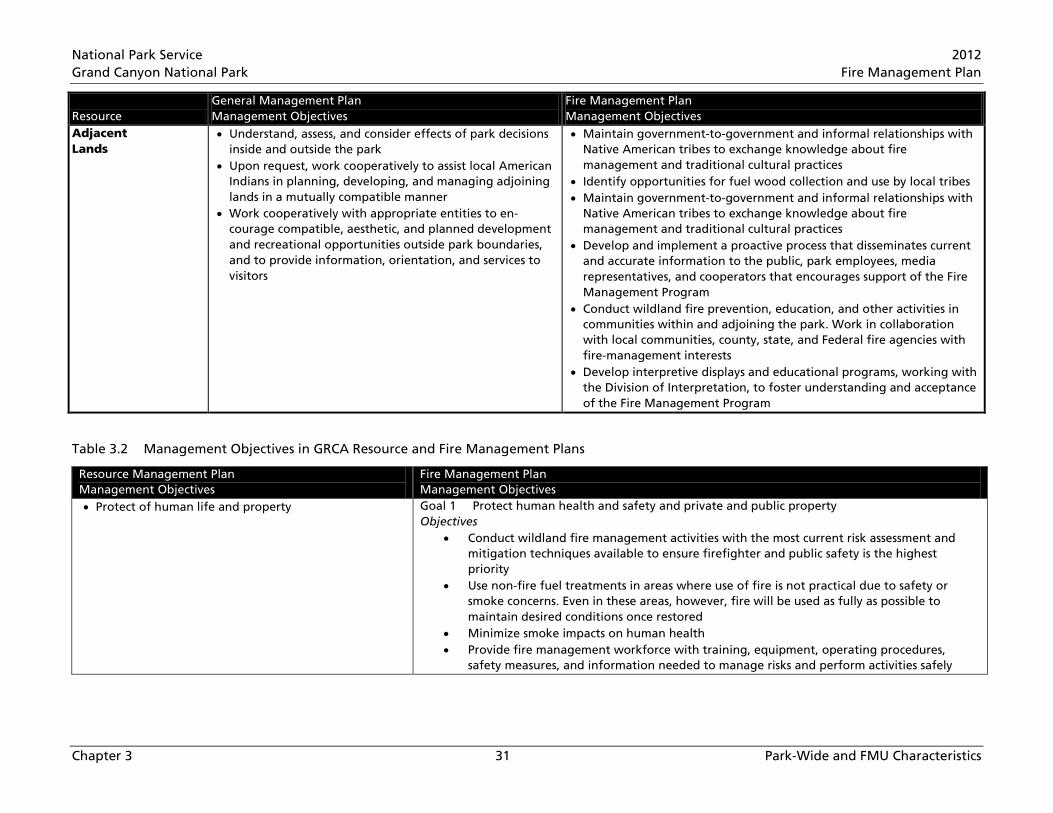
National Park Service 2012 Grand Canyon National Park Fire Management Plan
Chapter 3 31 Park-Wide and FMU Characteristics
Resource General Management Plan Management Objectives
Fire Management Plan Management Objectives
Adjacent Lands
• Understand, assess, and consider effects of park decisions inside and outside the park
• Upon request, work cooperatively to assist local American Indians in planning, developing, and managing adjoining lands in a mutually compatible manner
• Work cooperatively with appropriate entities to en-courage compatible, aesthetic, and planned development and recreational opportunities outside park boundaries, and to provide information, orientation, and services to visitors
• Maintain government-to-government and informal relationships with Native American tribes to exchange knowledge about fire management and traditional cultural practices
• Identify opportunities for fuel wood collection and use by local tribes • Maintain government-to-government and informal relationships with
Native American tribes to exchange knowledge about fire management and traditional cultural practices
• Develop and implement a proactive process that disseminates current and accurate information to the public, park employees, media representatives, and cooperators that encourages support of the Fire Management Program
• Conduct wildland fire prevention, education, and other activities in communities within and adjoining the park. Work in collaboration with local communities, county, state, and Federal fire agencies with fire-management interests
• Develop interpretive displays and educational programs, working with the Division of Interpretation, to foster understanding and acceptance of the Fire Management Program
Table 3.2 Management Objectives in GRCA Resource and Fire Management Plans
Resource Management Plan Management Objectives
Fire Management Plan Management Objectives
• Protect of human life and property Goal 1 Protect human health and safety and private and public property Objectives
• Conduct wildland fire management activities with the most current risk assessment and mitigation techniques available to ensure firefighter and public safety is the highest priority
• Use non-fire fuel treatments in areas where use of fire is not practical due to safety or smoke concerns. Even in these areas, however, fire will be used as fully as possible to maintain desired conditions once restored
• Minimize smoke impacts on human health • Provide fire management workforce with training, equipment, operating procedures,
safety measures, and information needed to manage risks and perform activities safely

National Park Service 2012 Grand Canyon National Park Fire Management Plan
Chapter 3 32 Park-Wide and FMU Characteristics
Resource Management Plan Management Objectives
Fire Management Plan Management Objectives
• Restore fuel loads and ecosystem structure within the natural range of variability in vegetative communities
• Restore fire as a natural process through prescribed burning for fuel reduction to levels that allow additional acreage to be designated as prescribed natural fire. (Note: the term “prescribed natural fire” has been updated to wildfire for multiple objectives)
• Restore forest habitat • Reintroduce and maintain fire’s natural role in park
ecosystems to maximum extent possible
Goal 2 Restore and maintain park ecosystems in natural, resilient condition Objectives
• Ecosystems within the range of desired conditions (see Chapter 2 of FEIS) will be maintained through natural processes within policy constraints
• Ecosystems not within the range of natural variability will be restored to desired conditions (see Chapter 2 of FEIS) and subsequently maintained through natural processes within policy constraints
• Set priorities for treatment activities based on site-specific information including departure from natural fire return intervals, desired conditions, and other relevant factors
• Interpret and educate about the natural fire regime’s importance
Goal 5 Educate, inform, consult, and collaborate with tribes, stakeholders, and the public Objectives
• Maintain government-to-government and informal relationships with Native American tribes to exchange knowledge about fire management and traditional cultural practices
• Develop and implement a proactive process that disseminates current and accurate information to the public, park employees, media representatives, and cooperators that encourages support of the Fire Management Program
• Conduct wildland fire prevention, education, and other activities in communities within and adjoining the park. Work in collaboration with local communities, county, state, and Federal fire agencies with fire management interests
• Develop interpretive displays and educational programs, working with the Division of Interpretation, to foster understanding and acceptance of the Fire Management Program
• Monitor for pre- and post-burn evaluations; compare results with burning conditions, fire behavior, and whether burn objectives were achieved
• Mitigate and protect, inventory, document • Foster research
Goal 4 Promote a science-based program that relies on current and best-available information Objectives
• Conduct research that will help understand natural fire regimes, refine prescriptions, provide data for fire behavior models, and effectively implement the Fire Management Program
• Monitor and evaluate fire management activities (managed wildland fires, prescribed burns, and fuel reduction treatments) to assess effects on natural and cultural resources and social values
• Update fire return interval departures, desired conditions, fire treatment priorities, and prescriptions as relevant data become available
National Park Service 2012 Grand Canyon National Park Fire Management Plan
Chapter 3 33 Park-Wide and FMU Characteristics
3.1.2 Wildland Fire Management Actions
This section describes strategies for wildfires, prescribed fire, and non-fire applications. It is followed by descriptions and management directions for each FMU identified for the park. All strategies and designated FMUs identified below are in compliance with the Guidance for Implementation of Federal Wildland Fire Management Policy (NPS 2009a) and the NPS Management Policy Reference Manual 18 (RM-18) (NPS 2008c).
Strategies Used to Achieve Desired Ecosystem Conditions
Strategies available to fire managers to move forests closer to or achieve desired ecosystem conditions include use of fire and/or non-fire fuel treatments. These approaches are narrowed to different tactical operation types. Wildland fire strategies include managing prescribed and wildfires. Strategies involving non-fire fuel treatments include manual treatments and/or mechanical treatments (See GRCA FMP FEIS/AEF, Volume One, Sections 2.6 – 2.6.3). Additional strategies like the use of herbicides or bioagents were not addressed in the GRCA FMP FIES, but the use of herbicides was addressed in the GRCA Exotic Species Management Environmental Assessment (NPS 2009d)
Fire Management Strategies to be Employed
Two kinds of wildland fire (and their management strategies) are to be managed within GRCA: unplanned wildfires (natural or human-caused) and planned wildland fire (prescribed fire). The program does not favor one strategy over another without a thorough analysis of specific area and resource information, objectives, values to be protected, safety, risk, complexity, and other FMU considerations. These strategies are discussed in detail in Chapter 4.
Response to Wildfire
Any fire in wildlands, other than a prescribed or structural fire, is called a wildfire. Lightning ignites most park wildfires, though humans are also a cause. Fire managers are responsible for developing and implementing a response to each wildfire. Responses include, but are not limited to, suppressing, confining, containing, and/or monitoring the fire, or a mix of these responses. The response for each wildfire may change as environmental, fuel, and/or social conditions change. Wildfires can be managed for multiple objectives and can use all types of responses. Initial action on human-caused wildfire will be to suppress the fire at the lowest cost with the fewest negative consequences with respect to firefighter and public safety.
Fire Management Program Common Elements
• All human-caused fires will receive an initial response to suppress the fire at the lowest cost with the fewest negative consequences with respect to firefighter and public safety.
• Collaboration with neighboring agencies and private land owners will remain a vital element for success of the Fire Management Program.
• Non-fire fuel treatments may occur in proposed wilderness to protect values at risk.
• Thinning and reduction of dead-and-down fuels and some live fuels may occur on prescribed fire unit boundaries to reduce risk of high-intensity fire along those boundaries. The specifications for these activities should be developed prior to implementation and maintained for future use or evaluation.

National Park Service 2012 Grand Canyon National Park Fire Management Plan
Chapter 3 34 Park-Wide and FMU Characteristics
• Thinning and reduction of dead-and-down fuels and some live fuels along roads, trails, and fire line may occur during wildfire incident management.
• Seasonality o South Rim prescribed fires could be implemented any month to meet prescription
parameters; o North Rim prescribed fires are not likely to be implemented December, January, or
February due to weather constraints.
3.2 Fire Management Unit Specific Characteristics Plant communities were the basis for developing the eight FMUs, but six other factors helped refine the FMU boundaries. It’s important to understand the physical descriptions and the desired conditions of each vegetation type that were utilized in the development of FMUs.
The Fire Management Program focuses on forests above the rim for vegetation types most likely fire affected (spruce-fir, mixed-conifer, ponderosa, piñon-juniper). Other park vegetation types have a low fire occurrence.
Spruce-Fir Forests
Existing Condition
Spruce-fir forest, dominated by Engelmann spruce and subalpine fir is the least common coniferous forest in GRCA and the Southwest, covering less than 0.5% of Arizona and less than 2% of New Mexico (Moir and Ludwig 1979, Alexander 1987). Investigation at GRCA (White and Vankat 1993, Fulé et al. 2003a) indicate mean canopy cover of about 50%, with individual stands 20-85%. Densities average 950 trees/hectare (ha) for trees greater than 2.5 centimeters (cm) diameter, and 1400 trees/ha for trees greater than one meter height, and mean basal area is 28-41 m2/ha. Generally, Engelmann spruce is most abundant. Compared to values reconstructed for 1880, today’s forests are denser and have greater basal area. Overall, fire management activities of the last two decades have had little effect on GRCA’s spruce-fir forest.
Current Fire Regime
Current forest stand structure will contribute to a mixed fire regime ranging from surface fires in spruce fir stands with full canopies and reduced younger-aged understory stems, to passive and sustained crown fire under appropriate weather conditions. Older spruce-fir stands with declining or missing crowns and dense younger-aged understory will have surface and passive crown fire. Additional post-fire mortality may occur in these stands because current fuel loading will increase fire residence time (which girdles tree boles).
Desired Conditions
Maintain a diverse vegetative landscape with patches of variable tree densities by managing and monitoring natural ecosystem processes (fire, insects and disease, drought, etc).
Desired conditions include • Manage fire processes according to the current NPS policy • Restore topographic heterogeneity of vegetation types and maintain a mixed-severity fire regime
National Park Service 2012 Grand Canyon National Park Fire Management Plan
Chapter 3 35 Park-Wide and FMU Characteristics
• Return stand-replacing fire event characteristics to the range described in reference conditions • Allow processes that provide structural complexity • Manage fuel loads at levels consistent with reference conditions • Collaborate with adjacent agencies in managing cross-boundary fires • Monitor post-fire vegetation response to provide information for adaptive management process
Mixed-Conifer Forests
Existing Condition
Southwestern mixed-conifer landscape patterns are largely heterogeneous (Moir 1993, White and Vankat 1993, Fulé et al. 2003b). It is probable they were even more heterogeneous prior to Euro-American influence (Fulé et al. 2003b). Vankat et al. (2005) describe topographically determined variability in GRCA mixed-conifer as
• Relatively dry sites, such as ridge tops and south- and west-facing slopes, have stands dominated by ponderosa pine and Douglas fir
• More mesic sites, such as north- and east-facing slopes, have stands dominated by various combinations of ponderosa pine, Douglas fir, white fir, and quaking aspen
• Relatively moist, forested valley bottoms have stands dominated by blue spruce and ponderosa pine, often with white fir and quaking aspen. Some sites have spruce-fir stands dominated by Engelmann spruce and subalpine fir
Contemporary forest conditions for mixed-conifer ecosystems show structural change that includes increased conifer seedling survival, (especially white fir), conifer invasion into meadows, decreased aspen abundance, increased canopy closure, and forest floor litter and deadwood accumulations. Overall forest condition is one of more dense stands. Tree canopy cover is at least 25%, but can near 100% (NPS 2000). From historic reconstruction, total densities ranged from 150 to 337 trees/ha, about 16-24% as dense as current forest conditions; basal area ranged from about 10 to 18 m2/ha, about 36-46% as dense as current forest conditions (Fulé et al 2003a). Averages in GRCA studies have ranged from about 946 to 1,300 trees/ha greater than 2.5 cm dbh (Fulé et al. 2003a, Fulé et al. 2004).
Current Fire Regime
For fire processes, current forest stand structure will contribute to a bimodal fire regime of primarily surface fire in stands with full canopies and reduced younger-aged understory stems, to passive and sustained crown fire under appropriate weather conditions. Older aged stands with declining or missing tree crowns and dense younger aged understory will have surface and passive crown fire. Post-burn mortality may increase in these stands because current fuel loading will increase fire residence time (which girdles tree boles).
Some dense mixed-conifer will not support running crown fire due to decadent tree crowns. Passive crown fire may increase in dense mixed-conifer pockets due to fuel ladders. Higher dead-and-down fuel loading will cause additional post-fire mortality through tree-bole girdling, but this may be species specific. Large diameter Douglas fir may resist post-fire mortality from tree girdling better than other species. In some mixed-conifer stands, resulting fire effects will mimic historic fire effects through fire-initiated stands.

National Park Service 2012 Grand Canyon National Park Fire Management Plan
Chapter 3 36 Park-Wide and FMU Characteristics
Desired Conditions
The NPS seeks to maintain a climate-adapted, mixed-conifer structure and associated function by managing natural ecosystem processes (fire, insects and disease, drought, etc).
Management actions are specifically intended to reduce tree density by smaller size classes and tree species, reduce total fuel loading as measured across the landscape, and maintain 46-60 trees per hectare of 16-plus inch (40.6 cm) dbh size classes (NPS 2000). Specific consideration was given to maintaining mixed-conifer forest structure as suitable habitat for Mexican spotted owls. Although desired future conditions are not presented in the same manner as the Mexican spotted owl Recovery Plan target conditions, it is believed that maintaining 46–60 trees/ha greater than 16 inches diameter across the landscape, and limiting moderate/high and high severity fire to 30% of the mixed-conifer forest type will insure Recovery Plan threshold conditions are met. Limited fire effects plot data indicate that the 70% of mixed-conifer habitat that will burn in low and moderate/low severity ranges will achieve, after two years, Recovery Plan target threshold levels, and a portion of acreage burned in the moderate/high severity range will have structural characteristics similar to target threshold levels. The Recovery Plan calls for specific structural target thresholds on 35% of the planning area.
Desired conditions include • Manage fire processes according to the current NPS policy • Maintain a mixed-severity fire regime • Restore topographic heterogeneity of vegetation types
• Manage fuel loads to best influence mixed-severity fire regime and limit high-severity burned patch size
• Collaborate with adjacent agencies in managing cross-boundary fires • Monitor post-fire vegetation response to provide information for adaptive management process • Specific desired stand structure conditions may include
o Tree densities greater than 31 cm dbh should range from 54 to 105 trees/ha with a few dense stands approaching 254 conifers/ha although scattered patches will lack trees due to the fire-effects mosaic characteristic of a mixed-severity fire regime
o Trees greater than 61 cm dbh should be maintained at 16 to 32 trees/ha although scattered patches will lack trees due to the fire-effects mosaic characteristic of a mixed-severity fire regime
• The majority of effort in mixed-conifer systems should be directed at reducing the large number of small diameter trees established since Euro-American settlement, and reestablishing vegetation and fire regime topographic heterogeneity
Ponderosa Pine Forests
Existing Condition
Ponderosa ecosystem contemporary forest conditions show a structure change including increased pine seedling survival, pine invasion into meadows, canopy closure, and pine litter and deadwood forest floor accumulations (Mast 2003). The overall forest condition is one of more dense stands; however, research on three sites (Powell Plateau and Fire and Rainbow Points) indicated “nearly no change in pine density over…120 years” (Fulé et al 2002a). A South Rim experimental site analyzed by Fulé et al. (2002a) exhibited plots ranging from 783 to 3,693 stems per hectare (ha). In the Grandview area, ponderosa pine stems greater than 2.5 cm averaged 646 per ha while Gambel oak contributed 293 stems

National Park Service 2012 Grand Canyon National Park Fire Management Plan
Chapter 3 37 Park-Wide and FMU Characteristics
per ha (Fulé et al. 2002b), which is a denser stand than represented by historic tree data. This forest structure change has implications for overall stand health. Competition for water and nutrients can reduce older pine vigor, leaving them susceptible to infestations of dwarf mistletoe, insects such as mountain pine beetle, and root rot (Mast 2003).
In areas such as Powell Plateau and Fire Point where historical fire regime has been less disrupted, ponderosa pine densities average 249 and 193 stems/ha respectively (Fulé et al. 2002b). On Swamp Ridge, where historic fire regime has been disrupted, ponderosa pine density averages 156 trees/ha, but white fir has increased to 467 trees/ha.
Current Fire Regime
Since 1998 GRCA has increased annual acres burned through the prescribed fire program. Fire effects plots indicate a long-term trend moving ponderosa pine stands toward desired conditions (Appendix F). Between 1984 and 2009, approximately 88% (52,757 acres) of the ponderosa pine forest in the park burned. Most of the burned ponderosa pine acres burned multiple times within this time period: 22,430 acres burned twice, 3,966 acres burned three times, and 487 acres burned four times. The multiple entry activity in South Rim ponderosa is due almost entirely to GRCA’s active prescribed fire program over the past 20 years. The North Rim ponderosa sites have burned in a combination of prescribed fires and wildfires. Fires in ponderosa pine forests have burned primarily with low and moderate-low severity. Approximately 2% of the ponderosa pine forest that has burned in the park burned with moderate-high to high severity effects.
Desired Conditions
Grand Canyon ponderosa pine management depends on fire. Management goals include reducing tree density (outlined by size class) and ladder fuels, restoring fire as a process (predominantly surface fire with some passive crown fire), and increasing herbaceous ground cover and overall biodiversity levels (Allen et al. 2002).
Desired conditions in ponderosa pine stands include • Fire processes move across the landscape where appropriate • A mosaic of diverse landscapes exists with patches of variable tree densities • Rare stand-replacing fires generally occur in small patches
• A robust and diverse herbaceous understory exists where supported by soils and environmental factors
• Monitor post-fire vegetation response to provide information for adaptive management process
Desired structure conditions outlined in Table 3-3 roughly approximate the amount of ponderosa habitat on South Rim, drier North Rim sites (40%), and higher elevation North Rim sites (50%). These structure conditions are an achievable objective using manual treatments, and prescribed and wildland fire-use fire. Lower limits for desired conditions generally begin at the level of reconstruction studies on North and South Rims, while upper limits are the level of present day relict areas plus 10 to 20%. Added percentage for number of stems/ha at the upper limit is somewhat arbitrary, but reflects the fact that relict areas are generally drier ponderosa sites near the rim.

National Park Service 2012 Grand Canyon National Park Fire Management Plan
Chapter 3 38 Park-Wide and FMU Characteristics
Table 3.3 Ponderosa Forests Desired Conditions
Target Conditions Ponderosa Pine Tree Density (stems/ha), Composition, Size Classes dbh Comments 40% of landscape (South Rim and drier North Rim sites) with ponderosa pine/ha in the following size classes in cm dbh
DBH Ponderosa Pine/Hectare 2.5-15.1 40-70
15.2-40.1 30-40 40.2-91.2 35-50
greater than 91.2 1- 2 Total ponderosa pine stems/ha = 106 to 162
Gambel oak should be well represented on the landscape with 50 to 300 stems/ha contributing a basal area of 1 to 3 m2/ha
50% of the landscape with ponderosa pine/ha (North Rim mesic sites tending toward mixed-conifer transition) in the following size classes in cm dbh
DBH Ponderosa Pine/Hectare 2.5-15.1 40-100
15.2-40.1 40-70 40.2-91.2 40-70
greater than 91.2 2- 3 Total ponderosa pine stems/ha = 122 to 243
10% of the landscape in aggregate patches of dense stands of ponderosa pine and areas with a component of other conifers
DBH Ponderosa Pine/Hectare 2.5-15.1 110-140
15.2-40.1 110-140 40.2-91.2 20 - 50
greater than 91.2 1 - 3 Total ponderosa pine stems/ha = 241 to 333
Piñon-Juniper Woodlands
Existing Condition
Based on 15 fire-effects plots primarily south of Grand Canyon Village, piñon-juniper woodland species characterization is described as 90% piñon-juniper stems with ponderosa as an occasional overstory tree. Absolute canopy cover ranges from 20% to 60%. Understory is sparse with pole trees of the same species as overstory except for an occasional Gambel oak. Understory shrubs are comprised of Mormon tea, banana yucca, snakeweed, serviceberry, cliffrose, Apache plume, sagebrush, and rabbitbrush. Herbaceous plants include bluegrass, paintbrush, blue grama, locoweed, lupine, and squirreltail. Combined cover for brush and herbs is less than 50% (NPS 2000).
Current Fire Regime
Fire regime is dependent on crown closure and understory fine fuel loading. GRCA fire history records indicate fire starts in piñon-juniper woodlands are often single tree lightning strikes followed by monsoon-type moisture, limiting fire spread to a small area. When lightning starts are accompanied by dry fuels, winds, and low precipitation, fire can move rapidly through these woodlands resulting in active crown fire, depending on crown closure and surface fuel loading.

National Park Service 2012 Grand Canyon National Park Fire Management Plan
Chapter 3 39 Park-Wide and FMU Characteristics
Desired Condition
Maintain resilient piñon-juniper vegetative structure and associated function by managing and monitoring natural ecosystem processes (fire, insects and disease, soil fertility, upland hydrologic function, etc).
Desired conditions include • Use manual/mechanical treatments near values at risk to reduce expected fire behavior in WUI • Use prescribed fire to reduce fuel loading from manual/mechanical treatments • Use adaptive management to refine treatment prescriptions • Allow fire as a process in piñon-juniper woodlands
• Use information on natural fire regimes and vegetation dynamics to maintain diverse landscapes with patches of variable tree and understory plant densities and canopy cover
Fire Management Units
Identification of FMUs is critical to effective management of a wildland fire program. An FMU is a land-management area definable by generally unique combinations of
• dominant management objectives and management constraints • political boundaries • values to be protected • topographic features • vegetative communities and fuel types • access • major fire regime groups, vegetative communities, fuel types

National Park Service 2012 Grand Canyon National Park Fire Management Plan
Chapter 3 40 Park-Wide and FMU Characteristics
Map 3.1 Fire Management Units
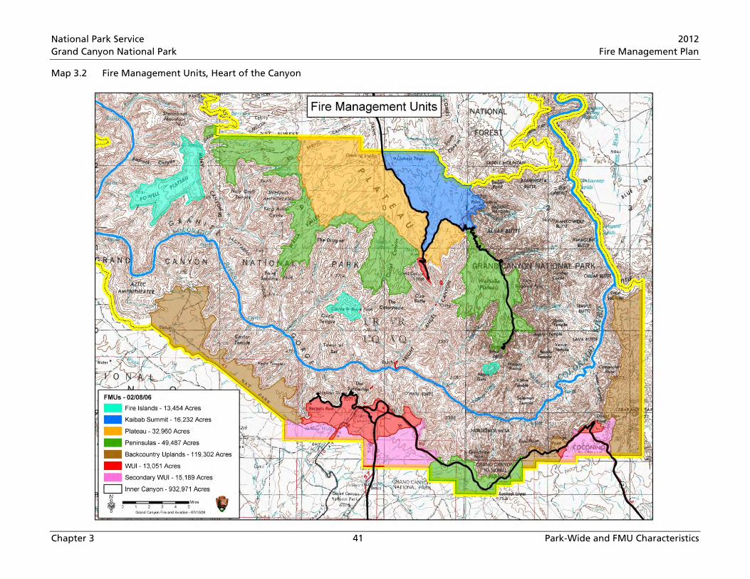
National Park Service 2012 Grand Canyon National Park Fire Management Plan
Chapter 3 41 Park-Wide and FMU Characteristics
Map 3.2 Fire Management Units, Heart of the Canyon
National Park Service 2012 Grand Canyon National Park Fire Management Plan
Chapter 3 42 Park-Wide and FMU Characteristics
Kaibab Summit Physical Description
The Kaibab Summit FMU includes the park’s highest elevations (North Rim’s Kaibab Plateau). This FMU lies east of Arizona State Route 67 and north of the Scenic/Cape Royal Road. Vegetation is typically referred to as spruce-fir forest. However, the unit is a complex mosaic of spruce-fir, with Douglas fir and ponderosa pine in drier locations. Meadows and aspen groves are interspersed throughout.
Unit access is almost exclusively from bordering roads including Route 67, the Scenic Road, and adjacent U.S. Forest Service (USFS) roads on Kaibab National Forest’s North Kaibab District. The road to Point Imperial enters the unit’s southeast corner. The interior is only accessible on foot or from the air.
Kaibab Summit Values to be Protected
Forests of the Kaibab Summit are often cited in literature as some of the least disturbed spruce-fir forests in Arizona. Many travelers consider the Kaibab Plateau’s forests and meadows a prelude and counterpoint to the rugged Grand Canyon ahead.
Specific Kaibab Summit FMU values to be protected include • Safety of firefighters, park employees, and the public • Fire Exclusion Areas (see below) • Boundaries with adjacent landowners including Kaibab National Forest (North Kaibab District) • Fire-dependent ecosystems (entire unit) • Federally listed threatened and endangered species, species of concern, and their habitat • Cultural resources (entire unit) • Air-quality-related values (entire unit) • Proposed wilderness
Kaibab Summit FMU Fire Exclusion Areas for this unit are • North Rim Entrance Station • Lindbergh Hill Remote Automated Weather Station (RAWS) Site • North Rim Fire Lookout
Kaibab Summit FMU Weather Cycles and Extremes
The automated weather station that best represents unit weather is Lindbergh Hill (020220) a permanent RAWS established in 1993 located approximately five miles north of Bright Angel Point at 8,800 feet.
Generally, climate is typical for Southwestern highland areas, and National Weather Service records for Bright Angel Ranger Station (dated 1948-2004) characterize, but may be somewhat warmer and drier than, this FMU. Summer high temperatures are relatively mild, averaging 75°F, but have reached 92°F. Winters are cold with average lows of 30°F, but as cold as -23°F. Annual precipitation averages 26 inches on the North Rim. Low humidity and high summer temperatures result in high evapo-transpiration rates. Summer convective thunderstorms usually occur early July through early September, and often contain lightning. Snow is possible late October into early May. North Rim snowfall averages 137 inches (over 11 feet) and has reached 273 inches (almost 23 feet). Snow accumulations can be deep and persistent.

National Park Service 2012 Grand Canyon National Park Fire Management Plan
Chapter 3 43 Park-Wide and FMU Characteristics
Kaibab Summit FMU Fuels, Fire Behavior, and Effects
Vegetative communities in the Kaibab Summit FMU are mixed-conifer with spruce, fir, and aspen dominating the landscape. Ponderosa pine is present, but widely scattered throughout on ridge tops and south-facing slopes. Herbaceous vegetation is scattered throughout the FMU but not abundant. Fuels are patchy or discontinuous where soils are thin and rocky but more continuous on slopes where soils are deeper. There is significant amount of dead-and-down large woody material. Some dead-and-down is from recent wind events while other materials are decades old. Large dead-and-down material has fallen atop other logs creating clumps of large woody material up to four-feet high.
Forests in the Kaibab Summit FMU are classed as moderate departure from historic fire regime. Even though most of this FMU has not experienced fire in the past 100 years, historic fire regime is highly variable with long-interval high- and mixed-severity fire with 15-30 year intervals (Fulé et al. 2003a). 128 lightning fires and six human caused fires have occurred in this FMU from 1926 to 2010 and only one of those fires grew to over 100 acres.
The National Fire Danger Rating System (NFDRS) Fuel Model that best represents fuels is NFDRS G (closed stands of short-needled conifer with heavy accumulations of dead-and-down fuels). Spruce trees have branches that touch the ground making them susceptible to torching from even low-intensity fires. Susceptibility for torching creates opportunities for long-range spotting. Spruce bark is thin, making trees vulnerable to severe fire effects even with low-intensity fire. Fire effects on spruce-dominated north slopes of the Poplar Fire show that some groups or stands of spruce died from low or moderate intensity fires. Lack of char on trees boles above breast height indicate that fire moved though these groups or stands as surface fire, and that spruce died by damage to the tree at or just above ground level.
Plateau FMU Physical Description
The Plateau FMU consists of the Kaibab Plateau’s southern slope. Topography slopes south down and west across the unit. This regional slope is broken by a number of valleys radiating west and south from highlands near North Entrance Station. Many of these valleys have meadow-covered floors, and include Little Park and The Basin, two of the park’s largest meadows. Forests range from ponderosa pine in drier locations, through mixed-conifer forest including Douglas fir, to spruce-fir forest communities in moister environments. In addition to meadows, aspen stands are interspersed through-out. Access to the Plateau FMU is almost exclusively from roads along its boundaries. Only Arizona State Route 67 on the east is paved; the others (including USFS roads just outside the park’s northern boundary) are dirt. All roads are closed in the winter. Clearing treefall from dirt roads is often not complete until early summer. Access to the Plateau FMU interior is either on foot or from the air.
Plateau FMU Values to be Protected
GRCA forests on the Kaibab Plateau are often cited in literature as some of the least disturbed in Arizona. Many travelers consider the Kaibab Plateau’s forests and meadows a prelude and counterpoint to the rugged Grand Canyon ahead.
Specific Plateau FMU values include • Safety of firefighters, park employees, and the public • Fire Exclusion Areas (see below)
• Boundaries with adjacent landowners, including Kaibab National Forest (North Kaibab District)
National Park Service 2012 Grand Canyon National Park Fire Management Plan
Chapter 3 44 Park-Wide and FMU Characteristics
• Vegetative communities described in desired conditions • Federally listed threatened and endangered species, species of special concern, and their habitat • Cultural resources (entire unit) • Air-quality-related values (entire unit) • Proposed wilderness
Plateau FMU Fire Exclusion Areas are • Adjacent North Rim Developed Area • Kanabownits Fire Lookout • North Rim dynamite cache (Marble Flats) • North Rim Shooting Range
Plateau FMU Weather Cycles and Extremes
The automated weather station best representing Plateau FMU weather is Bright Angel Station (020211) located at the North Rim Helispot at 8,300 feet. The other is Lindbergh Hill (020220), a permanent RAWS established in 1993 located approximately five miles north of Bright Angel Station at 8,800 feet.
Generally, climate is typical for Southwestern highland areas, and National Weather Service records for Bright Angel Ranger Station (dated 1948-2004) characterize the Plateau FMU. Summertime high temperatures are relatively mild, averaging 75°F, but have reached 92°F. Winters are cold, with average lows of 30°F, but get as cold as -23°F. North Rim’s annual precipitation averages 26 inches. Low humidity and high summer temperatures result in high evapo-transpiration rates. Summer convective thunder storms usually occur early July through early September and often contain lightning. Snow is possible late October into early May. North Rim snowfall averages 137 inches (over 11 feet) and has reached 273 inches (almost 23 feet). Snow accumulations can be deep and persistent.
Plateau FMU Fuels, Fire Behavior, and Effects
Plateau FMU vegetative communities are mixed-conifer with areas of nearly pure ponderosa pine on drier (generally south-facing) exposures. Ponderosa pine ecosystems are considered well adapted to recurrent, low-intensity fire with occasional flare-ups and isolated torching where fuels have concentrated or pockets of dense thickets occur. Herbaceous vegetation, once abundant in the understory, has been replaced by thick needle mats and downed woody materials. This decline in herbaceous component has led to two changes in the fuels complex: a reduced ability for surface fires to carry, and an eventual increase in ponderosa pine regeneration. Thus, a more common fuels and fire behavior characteristic in this vegetation type, given present conditions particularly on North Rim, is high-severity fires (Harrington and Sackett 1998).
In mixed-conifer and ponderosa pine systems, current accumulations of organic matter (litter, duff, and coarse organic materials) indicate retarded decomposition and cycling. Further, fire suppression and resulting regime alteration has led to creation of a relatively even-aged ponderosa pine understory. Reduction in overall spread of early fires has caused fuel loading increases.
In this vegetation type, fuels and associated tree densities were likely to have been more open before 1850. Although years of fire suppression reduce herbaceous diversity in mixed-conifer forests due to canopy closure (Covington and Moore 1994), the likelihood of stand-replacement crown fire increases with increased fuel loads and invading fire-intolerant species.
National Park Service 2012 Grand Canyon National Park Fire Management Plan
Chapter 3 45 Park-Wide and FMU Characteristics
Wolf and Mast (1998) found most North Rim fires occurred during monsoon circulation July and August; these results were consistent with park-recorded lightning-ignited fires. 364 lightning fires and 24 human caused fires have occurred in this FMU from 1926 to 2010. Six fires grew to over 100 acres, and of those fires, four fires exceeded 1,000 acres.
The NFDRS Fuel Model that best represents this forest is NFDRS G (closed stands of short-needled conifer with heavy accumulations of dead-and-down fuels). Fire effects information from specific monitoring plot assessments for over five years post-burn is available for various mixed-conifer stands. Monitoring results indicate a wide response range, from no impacts to overstory species densities to profuse aspen regeneration in higher severity (See Appendix F).
Fire behavior is a function of fuels, weather and, to a lesser degree, North Rim topography. Fuels can be continuous from surface to crown, supporting mixed-severity fire regime. Deeper organic duff and litter can increase ground fire residence time. Fire behavior is also governed by mid and overstory density and ladder potential. These dense thickets may support high-intensity surface fire, intermittent or sustained crown fire that can become independent of surface fire spread under extreme burning conditions.
Peninsulas FMU Physical Description
The Peninsulas FMU is composed of broad promontories reaching from the North Rim’s Kaibab Plateau into Grand Canyon, and a section of the South Rim’s Coconino Plateau’s higher elevations. These forested areas are close to and often nearly surrounded by the Grand Canyon. In contrast to the canyon, Peninsulas topography is flat to rolling, with a general slope to the south interrupted by relatively shallow valleys draining into or away from Grand Canyon (North and South Rim respectively).
Access to the Peninsulas FMU is via paved roads, including Cape Royal Road and Desert View Drive. Point Sublime and Swamp Ridge peninsulas are accessed via dirt roads. Old administrative roads on Tiyo Point peninsula are closed. Away from these roads, access is by foot or air, and several helispots.
Peninsulas FMU Values to be Protected
Peninsulas FMU forests are dominated by ponderosa pine stands. In the last decade, managed fire has succeeded in restoring and opening these ponderosa forests to stand densities more closely aligned with reference condition. These forests frame some of Grand Canyon’s most spectacular overlooks, and are the primary focus of many park visits.
Specific Peninsulas FMU values to protect include • Safety of firefighters, park employees, and the public • Fire Exclusion Areas (see below) • Boundaries with adjacent landowners, including Kaibab National Forest (North Kaibab and
Tusayan Districts) • Vegetative communities as described in desired conditions • Federally listed threatened and endangered species, species of special concern, and their habitat • Cultural resources (entire unit) • Air-quality-related values (entire unit) • Proposed wilderness
National Park Service 2012 Grand Canyon National Park Fire Management Plan
Chapter 3 46 Park-Wide and FMU Characteristics
Peninsulas FMU Fire Exclusion Areas are • Nearby North Rim Developed Area • North Rim Forest Restoration Plots • Kanabownits Cabin • Hance Air Quality Station • Greenland Lake Cabin • Historic Grandview Entrance Station
Peninsulas FMU Weather Cycles and Extremes
The fire weather NFDRS station that best represents weather in the Peninsulas FMU on the South Rim is Tusayan (020207). On the North Rim, Bright Angel best represents the weather.
Generally, climate is typical for Southwestern highland areas, with cold winters, windy springs, and very dry early summers. Low humidity and high summer temperatures result in high evapo-transpiration rates. Summer convective thunderstorms usually occur early July through early September, and often contain lightning. Snow is possible mid-October to mid-May.
National Weather Service records for Bright Angel Ranger Station (dated 1948-2004) characterize the North Rim FMU. Summer high temperatures are relatively mild, averaging 75°F, but have reached 92°F. Winters are cold, with average lows of 30°F, but as cold as -23°F. North Rim annual precipitation averages 26 inches. North Rim snowfall averages 137 inches (over 11 feet) and has reached 273 inches (almost 23 feet). Snow accumulations can be deep and persistent. North Rim’s frost-free period averages 101 days.
On the South Rim, National Weather Service records for Grand Canyon Village dated 1903-2004 are typical for this FMU. Annual precipitation averages 16 inches. Total snowfall averages 57 inches. Snow accumulations are usually moderate, less than 12 inches, although deeper accumulations are possible in higher elevations. Spring and early summer months are normally dry, and summer highs average 82°F, but have reached 105°F with relative humidity in single digits. Winter temperatures have dropped to -20° F, but average 1°F. South Rim’s frost-free period averages 148 days. Prevailing winds are typically from the southwest.
Peninsulas FMU Fuels, Fire Behavior, and Effects
Ponderosa pine forests dominate the Peninsulas FMU. Data interpretation from Northern Arizona University’s monitoring plots (Covington et al. 1999) show that the South Rim’s total dead-and-down fuel loadings ranged 1.55 to 6.82 tons per acre. The Monitoring Type Description Sheet for South Rim and North Rim ponderosa pine depict typical total fuel loads (See Appendix F )
The primary overstory tree is ponderosa pine, represented by NFDRS Fuel Model C (open pine with grass understory) for South Rim’s forest and the majority of North Rim sites where past fires occurred, and NFDRS Fuel Model U (western long-needle pine) in areas where past fires have not occurred.
Fire behavior is largely a function of fuels and weather. Untreated area fuels include younger pine thickets under older large tree stands that create continuous fuel ladders from surface fuels to tree crowns, supporting mixed-severity fire regime. Treated area fuels are more open in the understory and create fuel ladder breaks. Fire behavior in previously treated areas would be mostly low-severity fire regime. 826 lightning fires and 130 human-caused fires have occurred in this FMU from 1926 to 2010. 66 fires grew to over 100 acres, and of those fires, 24 fires exceeded 1,000 acres.

National Park Service 2012 Grand Canyon National Park Fire Management Plan
Chapter 3 47 Park-Wide and FMU Characteristics
The oak component in the ponderosa pine forest type is maintained by periodic fire. Presence of multi-aged oak and locust thickets in recent burned areas and wide clones distribution suggest the modern shrubby understory may have been characteristic of pre-settlement forests (Covington et al. 2000).
Fire Islands FMU Physical Description
The Fire Islands FMU consists of four isolated mesas or plateaus, completely surrounded by the Grand Canyon. Little management action (fire suppression or otherwise) has altered the ecosystem processes on these remote areas, thus they are invaluable resources for understanding park pre-Euro-American forests. Their generally flat summits range from a few hundred acres atop Wotans Throne to thousands of acres on Powell Plateau. Forest communities include ponderosa pine on Wotans Throne, Shiva Temple, and higher elevations of Powell Plateau, and piñon-juniper communities on lower reaches of Powell Plateau and Fishtail Mesa. Aside from a single trail to Powell Plateau, access to the Fire Islands FMU is from the air (or technical rock climbing).
Fire Islands FMU Values to be Protected
Fire Islands FMU management actions are focused on preserving the nearly pristine forests in both form and function, so these forests can continue as valuable scientific research areas and ecological benchmarks for other park areas.
Specific Fire Islands FMU values to protect include • Safety of firefighters, park employees, and the public
• Boundaries with adjacent landowners including the Kaibab National Forest (North Kaibab District)
• Vegetative communities described in desired conditions • Federally listed threatened and endangered species, species of concern, and their habitat • Cultural resources (entire unit) • Air-quality-related values (entire unit) • Proposed wilderness
Fire Island Fire Exclusion Areas • There are no fire exclusion areas in the Fire Islands FMU
Fire Islands FMU Weather Cycles and Extremes
Because of their variable elevations, weather cycles in the Fire Islands FMU range from the relatively cool and wet ponderosa pine environments of the Peninsula FMU to the hotter, drier piñon-juniper environments of the Backcountry Uplands FMU. Lightning strikes, especially during late summer’s monsoon season, are probably relatively more frequent than on nearby plateaus. Warm updrafts from the surrounding canyon also create a hotter, drier microclimate along the rim, especially on south- and west-facing cliffs and slopes.
Fire Islands FMU Fuels, Fire Behavior, and Effects
The eastern Fire Island FMU sections (Wotans Throne, Shiva Temple, and the northern two-thirds of Powell Plateau) support ponderosa pine forests similar to the Peninsula FMU. Data interpretation from Northern Arizona University monitoring plots (Covington et al. 1999) show that total dead-and-down fuel loadings on the South Rim ranged 1.55 to 6.82 tons per acre. The Monitoring Type Description
National Park Service 2012 Grand Canyon National Park Fire Management Plan
Chapter 3 48 Park-Wide and FMU Characteristics
Sheet for South and North Rim ponderosa pine depict typical total fuel loads(Appendix F). Fuels in this FMU are best represented by NFDRS Fuel Model C (open pine with grass understory).
Fire behavior is largely a function of fuel and weather. Untreated fuels include younger pine thickets under older large tree stands creating continuous fuel ladders from the surface to tree crowns, supporting a mixed-severity fire regime. Treated area fuels are more open in the understory which creates fuel ladders breaks. Fire behavior in previously treated areas would be predominately low-severity fire regime. 73 lightning fires and zero human caused fires have occurred in this FMU from 1926 to 2010. Six fires grew to over 100 acres, and of those fires, three fires exceeded 1,000 acres.
The oak component in the ponderosa pine forest type is maintained by periodic fire. Presence of multi-aged oak and locust thickets in recent burned areas and wide clone distribution suggest modern shrubby understory may have been characteristic of pre-settlement forests (Covington et al. 2000).
Backcountry Uplands FMU Physical Description
Backcountry Uplands is the park’s lowest elevation forested FMU, and the most fragmented. Vegetation communities include piñon-juniper woodlands, sagebrush meadows, and juniper savannas. A few moist areas contain ponderosa pine stands or stringers (especially near Mount Emma). On the Coconino Plateau (South Rim), Backcountry Uplands reach from Pasture Wash area east to near Hermits Rest, then resume below Buggeln Hill from Moran to Pinal Points. On Marble Platform below Desert View, Backcountry Uplands extend from the park’s southern boundary north to the Little Colorado River Gorge. On the North Rim, the FMU contains all of the Kanab Plateau and Uinkaret Mountains (near Mount Emma).
Backcountry Uplands FMU Values to be Protected
Backcountry Uplands FMU values to be protected include • Safety of firefighters, park employees, and the public • Fire Exclusion Areas (see below) • Boundaries with adjacent landowners, including Kaibab National Forest (Tusayan District),
Bureau of Land Management (Arizona Strip Field Office), Lake Mead National Recreation Area (Grand Canyon-Parashant National Monument), Navajo Nation, and Havasupai Tribe
• Vegetative communities described in desired conditions • Federally listed threatened and endangered species, species of special concern, and their habitat • Cultural resources (entire unit) • Air-quality-related values (entire unit) • Proposed wilderness
Backcountry Uplands FMU Fire Exclusion Areas include • Signal Hill Lookout • Pasture Wash Ranger Station
Backcountry Uplands FMU Weather Cycles and Extremes
The fire weather NFDRS station that best represents weather in the Backcountry Uplands FMU is Tusayan (020207). Generally, climate is typical for Southwestern highland areas with cold winters, windy springs, and very dry early summers. Low humidity and high summer temperatures result in high
National Park Service 2012 Grand Canyon National Park Fire Management Plan
Chapter 3 49 Park-Wide and FMU Characteristics
evapo-transpiration rates. Summer convective thunderstorms usually occur early July through early September, and often contain lightning. Snow is possible mid-October into mid-May.
National Weather Service records for Grand Canyon Village (dated 1903-2004) are typical for higher elevations in the Backcountry Uplands FMU, with lower elevations somewhat warmer and drier, and represented by records from the Tuweep Ranger Station (dated 1948-1985). Annual precipitation ranges 12 inches at Tuweep (TU) to 16 inches at Grand Canyon Village (GCV). Total snowfall averages 7 (TU) to 57 (GCV) inches. Snow accumulations are usually moderate, less than 12 inches. Spring and early summer months are normally dry, and summer highs average 82°F (GCV) to 92°F (TU), but have reached 108°F (TU) with relative humidity in single digits. Winter temperatures have dropped to -20°F (GVC), but average lows are 1°F. The frost-free period is generally like South Rim, 148 days. Prevailing winds are typically from the southwest.
Backcountry Uplands FMU Fuels, Fire Behavior, and Effects
In piñon-juniper woodlands, 90% of overstory stems are of those two trees, with occasional ponderosa pine. Canopy cover can vary from 20–60%, with a generally sparse understory except for Gambel oak in small patches. Brush and herbaceous cover is less than 50%. Pre-burn fuel loads range 6 to 26 tons per acre on park monitoring plots (NPS 2000). Cheatgrass, an invasive exotic plant species may, in some areas, carry fire through sparse shrub cover that previously would not have sustained fire spread. The NFDRS Fuel Model that best represents this forest is NFDRS F (intermediate brush).
Fire behavior in piñon-juniper woodlands can range from creeping surface fire during times of no wind and/or high humidities to high-intensity crown fire with long-range spotting during times of high winds and low humidities. 160 lightning fires and eight human-caused fires have occurred in this FMU from 1926 to 2010. Five fires grew to over 100 acres, and of those fires, two fires exceeded 1,000 acres.
Primary WUI FMU Physical Description
The primary WUI FMU includes eight sections. The largest is on the South Rim and extends from Hermits Rest to Shoshone Point and south to include Grand Canyon Village. A second South Rim section extends from Tusayan Museum to Desert View. On the North Rim, Bright Angel Point and the North Rim developed area are the third largest WUI FMU section. Four smaller sections in the Cross-Canyon Corridor (North Kaibab, South Kaibab, and Bright Angel Trails) surround Roaring Springs developments, Cottonwood Campground, Phantom Ranch, and Indian Garden. The last section is a small area surrounding the Tuweep Ranger Station. The three large rim sections are generally flat to rolling, with piñon-juniper woodlands around Desert View, a mixture of piñon-juniper and ponderosa pine near Grand Canyon Village, and ponderosa pine and mixed-conifer forests on Bright Angel Point. The four Cross-Canyon Corridor units are on the canyon’s floor and support riparian vegetation with desert shrubs around their margins. The Tuweep section supports a sparse piñon-juniper growth.
Access to all but the Cross-Canyon Corridor section is by road (albeit, a 60-mile dirt road to Tuweep); Grand Canyon Village and Bright Angel Point sections include a network of public and administrative roads that provide ready access. The four Cross-Canyon Corridor sections are accessible only by foot, mule, or air, and all have established helispots.
Primary WUI FMU Values to Be Protected
Primary WUI FMU values to be protected include • Safety of firefighters, park employees, and the public
National Park Service 2012 Grand Canyon National Park Fire Management Plan
Chapter 3 50 Park-Wide and FMU Characteristics
• Fire Exclusion Areas (see below)
• Boundaries with adjacent landowners, including Kaibab National Forest (Tusayan District), and BLM and Lake Mead National Recreation Area (Grand Canyon-Parashant National Monument on the Mt. Emma section)
• Air-quality-related values (entire unit) • Cultural resources (entire unit) • Federally listed threatened and endangered species, species of special concern, and their habitat • Proposed wilderness (Mount Emma and Powell Plateau sections) • Fire-dependent ecosystems (entire unit)
Primary WUI FMU Fire Exclusion Areas include • North Rim Developed Area • CC Hill • Tuweep Ranger Station • Grand Canyon Village • Supai Camp • Hermits Rest • Abyss Air Quality Monitoring Site • Yaki Point—South Kaibab Trailhead • Hopi Point telecommunications site • South Rim Shooting Range • Desert View • Tusayan Museum and pueblo ruin • Indian Garden • Phantom Ranch • Cottonwood Campground • Tusayan Ruins and Museum • Roaring Springs residence and pump house
Primary WUI FMU Weather Cycles and Extremes
Weather and climatic conditions in the WUI FMU cover the entire range of conditions found in GRCA from the North Rim’s cool conifer forests to the Inner Canyon’s hot desert. In general, precipitation comes in winter (as snow at higher elevations) and during summer monsoons (whose thunderstorm rain may evaporate before reaching the canyon floor). Conditions in South Rim sections (Grand Canyon Village and Desert View) are similar to those summarized for the Backcountry Uplands FMU. Bright Angel Point experiences weather like that of the Peninsulas FMU. The remaining sections are typified by the Inner Canyon FMU, although the Tuweep section is somewhat cooler and moister than the four Cross-Canyon Corridor sections.
Primary WUI FMU Fuels, Fire Behavior, and Effects
Ponderosa pine forests characterize much of the WUI FMU Bright Angel Peninsula and Grand Canyon Village sections. Piñon-juniper woodland covers most of Desert View and Tuweep sections and drier

National Park Service 2012 Grand Canyon National Park Fire Management Plan
Chapter 3 51 Park-Wide and FMU Characteristics
locations in the Grand Canyon Village section. Desert shrub and riparian vegetation are characteristic of the four small Cross-Canyon Corridor sections.
The Monitoring Type Description Sheet for the South and North Rims show typical total fuel loads (Appendix F). NFDRS Fuel Model C (open pine with grass understory) best represents South Rim’s forest and the majority of North Rim sites where past fires have occurred, and NFDRS Fuel Model U (western long-needle pine) best represent areas where past fires have not occurred.
Fire behavior is largely a function of fuels and weather. Fuels in untreated areas include thickets of younger pine under older stands of large trees which creates continuous fuel ladders from surface fuels to tree crowns, supporting a mixed-severity fire regime. Fuels in treated areas are more open in the understory and create fuel ladder breaks. Fire behavior in previously treated areas would be predominately low severity fire regime. 160 lightning fires and 521 human-caused fires have occurred in this FMU from 1926 to 2010. Eighteen fires grew to over 100 acres, and of those fires, four fires exceeded 1,000 acres.
In piñon-juniper woodlands, 90% of overstory stems are of those two trees, with occasional ponderosa pine. Canopy cover can vary from 20–60%, with a generally sparse understory except for Gambel oak in small patches. Brush and herbaceous cover is less than 50%. Cheatgrass, an invasive exotic plant species may, in some areas, carry fire through sparse shrub cover that previously would not have sustained fire spread. The NFDRS Fuel Model that best represents this forest is NFDRS F (Intermediate brush).
Fire behavior in piñon-juniper woodlands can range from creeping surface fire during times of no wind and/or high humidities to high-intensity crown fire with long range spotting during times of high winds and low humidities.
Secondary WUI FMU Physical Description
The Secondary WUI FMU on the Coconino Plateau (South Rim) is divided into two sections, the first generally south of Grand Canyon Village, the second southwest of Desert View. Both areas slope to the southwest, but this overall slope is broken by shallow valleys sub-parallel to this regional slope. Vegetation is piñon-juniper woodland with stringers of ponderosa pine in moister valley bottoms.
Access to both sections is provided by a network of public and administrative roads (although the administrative roads in the Desert View section are short). Outside the park boundary, USFS roads approach the park, and some connect with park roads. Overall, access is generally good.
Secondary WUI FMU Values to be Protected
The Secondary WUI FMU is managed to promote natural ecosystems in such a way as to provide an additional protection layer to the WUI FMU. Because prevailing winds (especially during fire season) are from the southwest, maintaining lower fuel loads in these fire-adapted forests decreases risk of fires traversing, or originating in, this FMU and threatening the WUI FMU.
Secondary WUI FMU values to be protected include • Safety of firefighters, park employees, and the public • Real property • Boundaries with adjacent landowners including Kaibab National Forest (Tusayan District) • Air-quality-related values (entire unit) • Cultural resources (entire unit)

National Park Service 2012 Grand Canyon National Park Fire Management Plan
Chapter 3 52 Park-Wide and FMU Characteristics
• Federally listed threatened and endangered species, species of special concern, and their habitat • Vegetative communities as described in desired conditions
Secondary WUI FMU Fire Exclusion Areas • There are no fire exclusion areas in the Secondary WUI FMU
Secondary WUI FMU Weather Cycles and Extremes
The fire weather NFDRS station that best represents weather in the Secondary WUI FMU is Tusayan (020207).
Generally, climate is typical for Southwestern highland areas with cold winters, windy springs, and very dry early summers. Low humidity and high summer temperatures result in high evapo-transpiration rates. Summer convective thunderstorms usually occur early July through early September, and often contain lightning. Snow is possible mid-October into mid-May.
National Weather Service records for Grand Canyon Village (dated 1903-2004) are typical for the Secondary WUI FMU, although the Desert View section is a bit warmer and drier. Annual precipitation averages 16 inches. Total snowfall averages 57 inches. Snow accumulations are usually moderate, less than 12 inches, although deeper accumulations are possible in higher elevations. Spring and early summer months are normally dry, and summer highs average 82°F, but have reached 105°F with relative humidity in single digits. Winter temperatures have dropped to -20°F, but average 1°F. The frost-free period is 148 days on South Rim. Prevailing winds are typically from the southwest.
Secondary WUI FMU Fuels, Fire Behavior, and Effects
Ponderosa pine forests characterize much of the Grand Canyon Village section of the Secondary WUI FMU. Piñon-juniper woodland covers most of the Desert View section, and drier locations in the Grand Canyon Village section.
The Monitoring Type Description Sheet for the South and North Rim show typical total fuel loads (Appendix F). NFDRS Fuel Model C (open pine with grass understory) best represents South Rim’s forest and the majority of North Rim sites where past fires have occurred, and NFDRS Fuel Model U (western long-needle pine) best represent areas where past fires have not occurred.
Fire behavior is largely a function of fuels and weather. Fuels in untreated areas include thickets of younger pine under older stands of large trees which creates continuous fuel ladders from surface fuels to tree crowns, supporting a mixed-severity fire regime. Fuels in treated areas are more open in the understory which creates fuel ladder breaks. Fire behavior in previously treated areas would be predominately low-severity fire regime. 170 lightning fires and 89 human caused fires have occurred in this FMU from 1926 to 2010. Sixteen fires grew to over 100 acres, and of those fires, two fires exceeded 1,000 acres.
In piñon-juniper woodlands, 90% of overstory stems are of those two trees, with occasional ponderosa pine. Canopy cover can vary from 20–60%, with a generally sparse understory except for Gambel oak in small patches. Brush and herbaceous cover is less than 50%. Cheatgrass, an invasive exotic plant species may, in some areas, carry fire through sparse shrub cover that previously would not have sustained fire spread. The NFDRS Fuel Model that best represents this forest is NFDRS F (intermediate brush).
Fire behavior in piñon-juniper woodlands can range from creeping surface fire during times of no wind and/or high humidities to high-intensity crown fire with long range spotting during times of high winds and low humidities.

National Park Service 2012 Grand Canyon National Park Fire Management Plan
Chapter 3 53 Park-Wide and FMU Characteristics
Inner Canyon FMU Physical Description
The Inner Canyon FMU covers most of GRCA, and includes all areas below the rim. Terrain is generally rugged, with steep slopes and high cliffs characteristic of Grand Canyon. The Inner Canyon does have some relatively flat areas, including Sanup and Tonto Plateaus and the Esplanade, but even these areas are intricately dissected by tributary canyons and the Colorado River gorge. Bedrock outcroppings are common, especially at lower elevations, and disrupt fuel continuity. Vegetative communities are variable, with upper canyon wall communities similar to forest types on the rim above, but with various desert shrub communities dominating lower elevations. Oases near springs, seeps, and more reliable watercourses support relatively lush riparian communities.
Access to the Inner Canyon FMU is almost entirely by foot or air. Only one road enters the FMU, to Toroweap Overlook, a 70-mile dirt road. Colorado River whitewater limits access (indeed, the river itself is only accessible by road at either end of the park, or across the Hualapai Reservation at Diamond Creek). Boat access to the canyon’s lower 40 miles is possible across upper Lake Mead, but would only be suitable for near-shore activities.
Desert shrublands below piñon-juniper woodlands are composed of a variety of desert shrub species, grasses, and ephemerals. Barren rock frequently outcrops, disrupting fuel continuity. Various riparian shrubs and trees grow near the Colorado River, springs, seeps, and other watercourses, often with a dense understory. These isolated areas are the park’s most biologically diverse environments.
Inner Canyon FMU Values to be Protected
The Inner Canyon is, of course, the prime GRCA visitor attraction. Most view the area from the rims, but a small percentage of visitors enter the Inner Canyon FMU by foot, mule, or raft.
Inner Canyon FMU values to be protected include • Safety of firefighters, park employees, and the public • Fire Exclusion Areas (see below)
• Boundaries with adjacent landowners, including Kaibab National Forest (North Kaibab District), and Bureau of Land Management (Arizona Strip and Kingman Field Offices), Lake Mead National Recreation Area (Grand Canyon-Parashant National Monument), Navajo Nation, Havasupai Indian Reservation, and Hualapai Indian Reservation
• Vegetative communities as described in desired conditions • Federally listed threatened and endangered species, species of special concern, and their habitat • Cultural resources (entire unit) • Air-quality-related values (entire unit) • Proposed wilderness
Fire Exclusion Areas (see below) • Inner Canyon Fire Exclusion Areas • Private inholdings (near Asbestos Canyon and Vulcan’s Throne) • Indian Garden • Phantom Ranch • Cottonwood Campground • Lees Ferry • Muav Saddle Cabin

National Park Service 2012 Grand Canyon National Park Fire Management Plan
Chapter 3 54 Park-Wide and FMU Characteristics
• Tuweep Ranger Station and campground • Roaring Springs residence and pump house
Inner Canyon FMU Weather Cycles and Extremes
Weather conditions vary widely through the Inner Canyon FMU. Higher elevations share conditions with the North or South Rim (described above). Within the Inner Canyon FMU, lower elevation conditions become progressively hotter and drier, reaching desert conditions, represented by National Weather Service records beginning in 1948 from Phantom Ranch. There, annual precipitation is only nine inches. Low humidity and high summer temperatures result in high evapo-transpiration rates. Summer convective thunderstorms usually occur early July through early September, but rainfall and lightning diminish rapidly below the rim. Snow is rare on the canyon floor, and any accumulations at higher elevations tend to melt in a few days.
Spring and early summer months are normally dry. Summer highs rise with decreasing elevation, averaging 104°F, and have reached 120°F at Phantom Ranch. Winter temperatures can be mild at low elevation, averaging 38°F at Phantom Ranch. Although prevailing wind for most of the region is typically southwestern, the canyon tends to channel winds either up- or down-canyon. In the absence of stronger winds, a shallow surface flow commonly drains into the canyon at night. Although daytime updrafts rise from the entire canyon, local updrafts of heated air above sun-warmed cliffs are common in afternoon. Inversions of varying depth and intensity develop frequently late September through mid-March.
Inner Canyon FMU Fuels, Fire Behavior, and Effects
Fire behavior in most of the Inner Canyon is fast moving, low-intensity grass and shrub fires, or fires that involve a single juniper and a small ground fire. Due to many natural fire barriers (rock outcrops, cliffs, etc.) these fires are normally small. No fires in the Inner Canyon FMU and away from forested rim edges have exceeded 100 acres in the past ten years, and this trend is expected to continue. Management actions on Inner Canyon FMU fires are small (2-5 firefighters) and short (2-5 hours), and this trend is expected to continue. Approximately one Inner Canyon fire is suppressed annually as most fires go out naturally. 410 lightning fires and 207 human-caused fires have occurred in this FMU from 1926 to 2010. 26 fires grew to over 100 acres, and of those fires, four fires exceeded 1,000 acres.
Most Inner Canyon naturally started fires are inaccessible, or accessible only by helirappel. Past naturally ignited fires have occurred far from known values at risk. Lack of values at risk and abundance of natural barriers often means risks to firefighters (rappelling from helicopters to suppress fires) is too great, thus most Inner Canyon naturally ignited fires are monitored by air or from the rim, and no other management actions are taken.
Most human-caused Inner Canyon fires occur on Colorado River banks or along trail corridors. These fires often occur in light, flashy fuels surrounded by natural fire-spread barriers. Suppression actions have occurred on these fires, but often only involve mop-up (putting out hot spots with water or grubbing hot spots with hand tools) since many fires stop at natural fuel breaks before firefighters arrive. Access to these fires is by helicopter.
Brush and forest fuels occur in the Inner Canyon FMU, but only along the rim edge. These forest, brush, or grass fuels may occur within 100 feet of the rim, but could also extend more than 1,000 feet below the rim. There is often no fuel break at the rim edge, so fires that start in forest fuels above the rim have potential to drop over the rim and continue to burn until they reach natural barriers. Potential

National Park Service 2012 Grand Canyon National Park Fire Management Plan
Chapter 3 55 Park-Wide and FMU Characteristics
for fire spread below the rim exists for planned and unplanned ignitions. Fire location, fuel continuity below the rim, and natural barrier number and size relate to fire spread. Observed fire behavior is often backing or flanking fire with small uphill fire runs. These uphill runs have occurred in Gamble oak brush. Fire has not entered areas below the rims defined as Mexican spotted owl protected activity center. Ground-based suppression actions cannot be safely accomplished in fuels just below the rim as no escape routes or safety zones exist, and terrain is extremely steep and rugged. Helicopter aerial suppression actions have been successful at times; small helicopters are often unsuccessful, while large helicopters that carry a large amount of water are more effective. When portions of Inner Canyon FMU are included in the Maximum Management Area for a fire, or when fires go below the rim, management action points are defined and real-time decisions are made in discussions with resource advisors to balance impacts from fire with impacts from suppression efforts. A range of actions have been taken on fires determined on a case-by-case basis considering adjacency and impacts to sensitive resources including allowing the fire to progress naturally, aerial suppression efforts, or protection efforts along the rim to stop fire from re-emerging from the canyon.
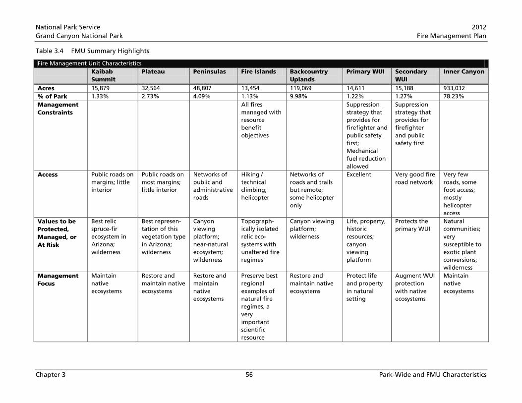
National Park Service 2012 Grand Canyon National Park Fire Management Plan
Chapter 3 56 Park-Wide and FMU Characteristics
Table 3.4 FMU Summary Highlights
Fire Management Unit Characteristics Kaibab
Summit Plateau Peninsulas Fire Islands Backcountry
Uplands Primary WUI Secondary
WUI Inner Canyon
Acres 15,879 32,564 48,807 13,454 119,069 14,611 15,188 933,032 % of Park 1.33% 2.73% 4.09% 1.13% 9.98% 1.22% 1.27% 78.23% Management Constraints
All fires managed with resource benefit objectives
Suppression strategy that provides for firefighter and public safety first; Mechanical fuel reduction allowed
Suppression strategy that provides for firefighter and public safety first
Access Public roads on margins; little interior
Public roads on most margins; little interior
Networks of public and administrative roads
Hiking / technical climbing; helicopter
Networks of roads and trails but remote; some helicopter only
Excellent Very good fire road network
Very few roads, some foot access; mostly helicopter access
Values to be Protected, Managed, or At Risk
Best relic spruce-fir ecosystem in Arizona; wilderness
Best represen-tation of this vegetation type in Arizona; wilderness
Canyon viewing platform; near-natural ecosystem; wilderness
Topograph-ically isolated relic eco-systems with unaltered fire regimes
Canyon viewing platform; wilderness
Life, property, historic resources; canyon viewing platform
Protects the primary WUI
Natural communities; very susceptible to exotic plant conversions; wilderness
Management Focus
Maintain native ecosystems
Restore and maintain native ecosystems
Restore and maintain native ecosystems
Preserve best regional examples of natural fire regimes, a very important scientific resource
Restore and maintain native ecosystems
Protect life and property in natural setting
Augment WUI protection with native ecosystems
Maintain native ecosystems
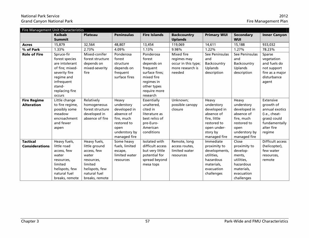
National Park Service 2012 Grand Canyon National Park Fire Management Plan
Chapter 3 57 Park-Wide and FMU Characteristics
Fire Management Unit Characteristics Kaibab
Summit Plateau Peninsulas Fire Islands Backcountry
Uplands Primary WUI Secondary
WUI Inner Canyon
Acres 15,879 32,564 48,807 13,454 119,069 14,611 15,188 933,032 % of Park 1.33% 2.73% 4.09% 1.13% 9.98% 1.22% 1.27% 78.23% Role of Fire Spruce-fir
forest species are intolerant of fire; mixed-severity fire regime and infrequent stand-replacing fire occurs
Mixed-conifer forest structure depends on mixed-severity fire
Ponderosa forest structure depends on frequent surface fires
Ponderosa forest depends on frequent surface fires; mixed fire regimes in other types require more research
Mixed fire regimes may occur in this type; more research is needed
See Peninsulas and Backcountry Uplands description
See Peninsulas and Backcountry Uplands description
Sparse vegetation and fuels do not support fire as a major disturbance agent
Fire Regime Alteration
Little change to fire regime, possibly some meadow encroachment and fewer aspen
Relatively homogeneous forest structure developed in absence of fire
Heavy understory developed in absence of fire, much restored to open understory by managed fire
Essentially unaltered, cited in literature as best relics of pre-Euro-American conditions
Unknown; possible canopy closure
Heavy understory developed in absence of fire, little restored to open under-story by managed fire
Heavy understory developed in absence of fire, much restored to open understory by managed fire
Extensive growth of annual exotics (i.e., cheat-grass) could fundamentally alter fire regime
Tactical Considerations
Heavy fuels, little road access, few water resources, limited helispots, few natural fuel breaks, remote
Heavy fuels, little ground access, few water resources, limited helispots, few natural fuel breaks, remote
Some heavy fuels, limited escape, limited water resources
Isolated with difficult access but very little potential for spread beyond mesa tops
Remote, long access routes, limited water resources
Immediate proximity to developments, utilities, hazardous materials, evacuation challenges
Close proximity to develop-ments, utilities, hazardous materials, evacuation challenges
Difficult access (helicopter), few water resources, remote


National Park Service 2012 Grand Canyon National Park Fire Management Plan
Chapter 4 58 Wildland Fire Operational Guidance
CHAPTER 4 WILDLAND FIRE OPERATIONAL GUIDANCE
4.1 Safety The safety of firefighters and the public is GRCA’s first priority. This FMP and the activities defined within reflect GRCA’s commitment to safety. Additionally, safety is the responsibility of all firefighters, managers, and administrators. Individuals are responsible for their own performance and accountability. Every supervisor, employee, and volunteer is responsible for following safe work practices and procedures, as well as identifying and reporting unsafe conditions. All firefighters, fireline supervisors, fire managers, and agency administrators have the responsibility to ensure compliance with established safe firefighting practices.
All actions defined in this FMP will conform to safety policies defined in current agency and departmental policy, including, but not limited to, the current versions of the documents listed below
• National Interagency Fire Center Interagency Standards for Fire and Aviation Operations, or Red Book, current version (NIFC 2012)
• NPS DO-18 Wildland Fire (NPS 2008b) • NPS RM-18 Chapter 3, Standards for Operations and Safety (NPS 2008c)
4.1.1 Firefighter Safety
Health Screening
GRCA Fire and Aviation Management will ensure all personnel engaged in wildland fire activities meet DOI and NPS health screening/medical surveillance and fitness requirements, found in the Red Book.
The DOI Medical Standards Program ensures that DOI arduous duty wildland firefighters meet the Federal Interagency Wildland Firefighter Medical Qualification Standards in order to safely and efficiently perform the essential functions of a wildland firefighter, without undue risk to themselves or others. The medical standards used by the DOI Medical Standards Program are also intended to ensure consistency and uniformity in the medical evaluation of applicants and incumbents for arduous duty wildland firefighting. Information regarding the Medical Standards Program can be found at www.nifc.gov/medical_standards.
The Federal Interagency Wildland Firefighter Medical Qualification Standards only apply to arduous duty federal wildland firefighters. Non-arduous duty federal wildland firefighters and non-federal wildland firefighters should follow National Wildfire Coordinating Group (NWCG) guidance on medical qualifications and standards.
The medical clearance received has an annual expiration date. Dependent upon an employee’s age and employment type, the employee will be required to obtain a baseline physical (a condition of hire for new permanent employees), an annual physical (a condition of hire for seasonal employees), or a periodic physical.
Per Red Book direction, the law enforcement medical exam for NPS rangers, who are collateral duty wildland firefighters, will suffice for Medical Standards Program clearance. All medical clearance must be entered into the Incident Qualifications and Certification System (IQCS).
National Park Service 2012 Grand Canyon National Park Fire Management Plan
Chapter 4 59 Wildland Fire Operational Guidance
Wellness/Fitness Training and Testing
All fire management personnel will be provided with three hours per week to achieve and maintain the physical fitness levels prescribed in National Interagency Fire Center Interagency Standards for Fire and Aviation Operations, “Employees serving in wildland fire positions that require a fitness rating of arduous as a condition of employment are authorized one hour of duty time each work day for physical fitness conditioning. Employees serving in positions that require a fitness rating of moderate or light may be authorized up to three hours per week.” (NIFC 2012)
All arduous duty employees who participate in wildland fire activities are required to meet specific medical conditions prior to performing the annual Work Capacity Test. The Work Capacity Test is the official method of assessing wildland firefighter fitness levels and is required for all positions requiring fitness levels of arduous, moderate, or light. Information for administering or participating in the Work Capacity Test can be found in the current version of the Red Book. The required equipment to administer the Work Capacity Test, including weighted vests, can be found in the South and North Rim Fire Caches. Once the test has been administered, completed documentation will be provided to the employee and to the Williams Interagency Dispatch Center (WDC) for entry into the IQCS database.
Safety Training
• Ensure compliance with safe fire management practices by all fire employees.
• Require experience, training, physical fitness, and safety practice knowledge for fire operation leaders.
• Require annual wildland fire safety standards training for wildland fire operations personnel. • Require mandatory, annual, hands-on fire shelter deployment training. • Adhere to safety training requirements listed in NPS RM-18. • Ensure each employee has access to the Incident Response Pocket Guide (NWCG 2010), which
provides guidance for safety and operations on all hazard incidents and other projects. • Adopt qualifications standards for Incident Command System (ICS) positions as listed in
NWCG 310-1 Wildland Fire Qualification System Guide (NWCG 2011). • Equip all personnel on wildfires with proper personal protective equipment as described in RM-
18. All personnel will carry a fire shelter on wildfires at all times. • Adhere to special personal protective equipment requirements specific to particular operations
(e.g., power saws and helicopters) by all personnel.
• Ensure all vehicles and drivers engaged in fire management activities meet Government Services Administration and agency standards, as well as state licensing requirements.
• Assign radios to all fire crews and monitors working on wildland fires. Special permission must be obtained from the Incident Commander or the Prescribed Fire Burn Boss for individuals to work alone on actively burning fires.
Job Hazard Analysis
• Address safety concerns in a Job Hazard Analysis in all project plans and for any type of activity or task to be completed (refer to RM-18).
• Review and update Job Hazard Analyses on an annual basis and create new ones as needed. A list of current Job Hazard Analyses developed for Fire and Aviation are located on the GRCA intranet.
National Park Service 2012 Grand Canyon National Park Fire Management Plan
Chapter 4 60 Wildland Fire Operational Guidance
• Provide safety briefing(s) prior to initiating project work. Project leaders, or their designee, will provide the safety briefing.
• Include a safety message in every Incident Action Plan. An Incident Action Plan is written for each operational shift on all multiple-shift wildland fire incidents and prescribed fires.
After Action Review Standards/Process
The Project Leader, Incident Commander, or designee will conduct an After Action Review after each project or incident shift to evaluate safety and effectiveness of work performed, and identify and discuss encountered hazards. The format for conducting an After Action Review can be found in the Incident Response Pocket Guide.
Work/Rest Standards
All GRCA Fire and Aviation activity will adhere to standards for work, rest, length of assignment, days off, and assignment extension guidelines as stated within the Red Book.
Safety Committee Oversight
The Fire and Aviation Program does not operate a separate safety committee and therefore falls under the umbrella of GRCA’s Safety Committee. The Safety Committee has developed two reporting documents that must be completed by the supervisor and employee if an employee is injured while on the job. The Injury/Illness Reporting Checklist and Employee Injury/Incident Investigation forms can be found on GRCA’s intranet.
Serious Accident/Incident Review Procedures
Information on Serious Injury or Death Procedure can be found in Appendix I of this plan.
GRCA will adopt the Wildland Fire Safety and Health Network ground-based safety incident reporting system. Information at safenet.nifc.gov
GRCA will report and investigate all wildland fire incidents resulting in Serious Wildland Fire Accident, Non Serious Wildland Fire Accident, Entrapment, Fire Shelter Deployment, Near-Miss, or Fire Trespass, as defined and required by Red Book directions.
GRCA will conduct Escaped Prescribed Fire Reviews in accordance with Interagency Prescribed Fire Planning and Implementation Procedures Reference Guide (NWCG 2008b), Chapter 7 and 17 of RM-18, and the Red Book.
Fireline Evacuation Process/Procedures/Standards
Each fire project, regardless of complexity, will have a Medical Plan (ICS form 206) prepared. This will remain standard business for all fire activities occurring at GRCA and follows guidance stated in Chapter 7 of the Red Book. The Medical Plan should be well briefed to all project participants and the WDC.
Past practice has placed the care and treatment of minor injuries onto on-scene employees while the evacuation of major injuries or illness will become the responsibility of GRCA Search and Rescue employees. This is intended to expedite the evacuation process while ensuring the project lead, Incident Commander, or Prescribed Fire Burn Boss maintains their span of control. The Incident Commander, Burn Boss, or Project Lead cannot relinquish their responsibility for personnel/public
National Park Service 2012 Grand Canyon National Park Fire Management Plan
Chapter 4 61 Wildland Fire Operational Guidance
safety. If serious injury occurs the appropriate personnel will be requested to facilitate the required level of care. They will become part of the existing organization. There will not be two separate organizations.
Critical Stress Debriefing Procedures
Manage critical incidents by following checklists and processes contained in the NWCG’s Agency Administrator Guide to Critical Incident Management (NWCG 2008a). This guide is located in the hallway cabinet within the Fire and Aviation building.
Right of Refusal of Assignment
All employees are empowered to refuse unsafe assignments and to identify safe alternatives to accomplish the mission. All employees should have access to a current copy of the Incident Response Pocket Guide, which contains directions on how to properly refuse risk.
All personnel are authorized to exercise emergency authority to stop and prevent unsafe acts.
4.1.2 Public Safety
Standards and Procedures for Closures (Roads, Trails, Campgrounds, etc.)
Limited areas of the park or the entire park may be closed (by Superintendent’s Order) when any threat to public or firefighter safety exists from wildland fire or fire management activities. When and if such action occurs, adjacent agencies and authorities will be notified as soon as possible to help manage or evacuate the closure.
Road Visibility Standards
Smoke warning signs on roadways and/or traffic control during wildland and prescribed fires will be set up as conditions warrant and at the direction of the Burn Boss, Incident Commander, Safety Officer, or a Visitor and Resource Protection representative. Implementation of pilot car operations, staffed road closure points, night patrols, and monitoring for low-visibility conditions or congested roadways may become necessary and are acceptable mitigation efforts for any fire management activities.
All employees working on or adjacent to public roadways within the park shall wear Department of Transportation approved high visibility vests. This includes all fire management employees, public safety employees, information personnel, and any escorted or non-escorted visitors or guests.
Emergency Notifications
A current notification list will be maintained in case there is a need to contact potentially affected stakeholders and known smoke sensitive citizens. This list can be utilized for any type of incident and fire or non-fire projects. See Appendix G
Evacuation Plans and Routes
Refer to the GRCA Evacuation Management Plan located in the hallway cabinet within the Fire and Aviation building.

National Park Service 2012 Grand Canyon National Park Fire Management Plan
Chapter 4 62 Wildland Fire Operational Guidance
Post‐Fire Hazards
At the completion of prescribed fire projects, or once conditions of a wildfire allow, fire managers will assess post-fire hazards and mitigate any such hazards prior to allowing fire or non-fire personnel or the public to access the area. Of primary concern are standing snags or green trees that have been weakened by fire or fire management activities.
GRCA employs a Hazard Tree Program Coordinator to identify, assess, and remove hazard trees throughout the park. Hazard trees that are not an immediate threat to firefighter and public safety should be reported to the Hazard Tree Program Coordinator.
4.2 Preparedness Preparedness activities provide detailed procedures and standards for wildland fire operations, including both pre-season and ongoing fire season activities. Preparedness activities also include pre-planned procedures for initial response and incident management.
GRCA Fire and Aviation will ensure preparedness by • maintaining fully qualified personnel commensurate with the authorized funding
• maintaining a cache of supplies, materials, and equipment sufficient to meet normal fire year requirements
• preparing and updating an Interagency Preparedness Plan, (Appendix E), based on preparedness levels derived from the GRCA and KNF Interagency National Fire Danger Rating System (NFDRS) Operating Plan (Appendix E);
• preparing pre-season risk analyses • providing a dispatch system for fire management resources within and adjacent to the park • maintaining detection and initial attack capabilities • maintaining local mobilization guides • maintaining agreements to coordinate interagency operations • maintaining record systems, weather data, and maps
“Preparedness” refers to activities that lead to a safe, efficient, and cost-effective fire management program in support of resource objectives through appropriate planning and coordination. The Interagency Preparedness Plan for GRCA and KNF is revised annually by April 15. Updates and edits to the Preparedness Plan are the responsibility of the Grand Canyon Deputy Fire Management Officer (FMO) and the KNF Deputy Fire Staff Officer.
To ensure readiness, the park will conduct an annual pre-season fire readiness inspection, which will address detection, communication, dispatch, and response and management capabilities. This inspection will be conducted to determine whether the park’s current training levels, equipment inventories, and organizational qualifications and structure meet established standards. The Fire and Aviation Program will utilize the Interagency Preparedness Review Checklists, adapted for park-specific needs, to conduct and document readiness reviews. Refer to RM-18 for more information.
To ensure operational and administrative readiness, Fire and Aviation staff are responsible for completing a list of items captured on the Fiscal Year planning schedule (Appendix E).
National Park Service 2012 Grand Canyon National Park Fire Management Plan
Chapter 4 63 Wildland Fire Operational Guidance
4.2.1 Coordination and Dispatching
Williams Interagency Dispatch Center
The Williams Dispatch Center (WDC) manages fire and aviation communications for KNF and GRCA. WDC is an interagency organization staffed with a USFS funded center manager, a USFS assistant center manager, a USFS dispatcher, and two NPS dispatchers. The center manager is co-supervised by the KNF Deputy Fire Staff and GRCA’s Deputy FMO. WDC is staffed year-round with at least one dispatcher, and during the peak of fire season, up to seven employees. WDC manages eight repeater frequencies, eight radio repeater sites, and nine additional radio frequencies for both the forest and the park.
WDC dispatchers dispatch resources to incidents based on a “Closest Forces” procedure regardless of which jurisdiction the incident is located. (Appendix E)
WDC dispatches and coordinates all wildland fire and all-hazard responses, prepares/submits orders for firefighters and equipment, and tracks order status during all local responses. The center coordinates filling national firefighter and equipment orders with local fire staff. Additional year-round duties for the WDC include management of firefighter qualifications through IQCS, updating firefighter availability through Resource Ordering Status System, updating the Wildland Fire Management Information System, management of weather information and data entry into Weather Information Management System (WIMS), intelligence reporting, flight following/tracking aviation resources, and tracking Arizona Department of Environmental Quality smoke requests, approvals, and accomplishments.
The wildfire detection functions are the responsibility of local fire staff and the WDC Center Manager. The USFS Grandview, Red Butte, Big Springs, Jacob Lake, and Dry Park Lookouts provide ground detection coverage during fire season. Emergency staffing of GRCA lookouts at Kanabowits Spring and North Entrance is also possible during high-severity periods or following weather events that could potentially produce ignitions. Detection operations may also be accomplished by helicopter and fixed-wing aircraft. Historically, air tour company pilots have also provided early smoke detection over their tour flight routes.
North Zone Fire Management Organization
An interagency fire management organization is operating under an interagency agreement to manage the fire programs for the North Kaibab Ranger District of the KNF and the North Rim District of GRCA. The purpose of this organization is to
1. Minimize redundancy between the agencies, 2. Create an interagency organization that would be totally integrated across the administrative
boundary areas of the two units, 3. Meet the intent of the National Fire Plan (DOI/USDA 2000), Federal Fire Policy Review (NIFC
2001), and Fire Program Analysis.
The interagency organization includes an FMO, two Assistant FMOs, a Fire Operations Specialist, a Fuels Technician, five wildland fire engines with staff, Fire Prevention staff, and one dozer.
The KNF funds employee costs of all Forest Service employees within the zone organization including the Zone FMO, Zone Assistant FMO (operations), and provides Forest Service facilities for the interagency organization at the Fredonia office. GRCA funds employee costs for all NPS employees

National Park Service 2012 Grand Canyon National Park Fire Management Plan
Chapter 4 64 Wildland Fire Operational Guidance
within the organization including the Zone Assistant FMO (fuels) and provides NPS facilities at the North Rim for the needs of the interagency organization.
Interagency Aviation Officer
An Interagency Aviation Officer operates under an interagency agreement to manage and provide oversight to the aviation programs for the KNF and GRCA. This position 1. Minimizes redundancy between the agencies, 2. Creates an interagency aviation oversight program that is totally integrated across the
administrative boundary areas of the two units, 3. Meets the intent of the National Fire Plan (DOI/USDA 2000), Federal Fire Policy Review (NIFC
2001), and Fire Program Analysis.
GRCA provides the funding, a duty station, and coordinates with the KNF Fire Staff Officer in administering, assigning workloads, and completing performance standards/evaluation of the aviation officer position.
Agreements/MOUs
The GRCA Fire and Aviation Annual Operating Plan, located electronically on the GRCA intranet, and in hardcopy format in the hallway cabinet within the Fire and Aviation building, contains current copies of all agreements and MOUs. These agreements and MOUs will continue to be updated prior to their expiration dates to ensure that they remain current and active. These agreements cover operational and administrative responsibilities for maintaining intra-and inter agency agreements that provide training, staffing, and operational support.
Additional Agreements Between the KNF and GRCA
A reimbursement or advance of funds agreement has been created in the past and updated annually to develop a funding mechanism to utilize USFS employees during the implementation of fuels projects at GRCA.
The South Rim District and Tusayan District, Service First Agreement was developed to 1. Minimize redundancy between the agencies, 2. Create interagency and management efficiencies that would transition across the administrative
boundary of the two units, 3. Meet the intent of the National Fire Plan (DOI/USDA 2000), Federal Fire Policy Review (NIFC
2001), and Fire Program Analysis.
The agreement covers shared duty officer responsibilities, allows USFS personnel to operate NPS vehicles, allows NPS personnel to operate USFS vehicles, provides USFS access to the South Rim Fire Cache, and includes the sharing of resources for completing project work.
Fire Program Analysis Partnerships
GRCA is split into two Fire Planning Units within Fire Program Analysis. Due to the geographical split between the North Zone and South District, each unit tends to work more with a different set of interagency cooperators during preparedness activities, creating the need for each unit to have partnerships with different agencies. The South District is partnered with the South Zone of KNF, Coconino National Forest, Prescott National Forest, Navajo Bureau of Indian Affairs, and Truxton Canyon Bureau of Indian Affairs as its major partners in the SW NM 007 Colorado Plateau Fire

National Park Service 2012 Grand Canyon National Park Fire Management Plan
Chapter 4 65 Wildland Fire Operational Guidance
Planning Unit. The North Rim is partnered with the North Kaibab Ranger District of the KNF, Lake Mead NPS, and Color Country Bureau of Land Management as its major partners in the SW AZ 005 Arizona Strip Fire Planning Unit. Within these two Fire Planning Units, GRCA has signed charters specifying the park’s commitment and responsibilities for completing annual agreements for coordination and collaboration with our partners. The program is continually evolving and it is essential that GRCA fire managers stay active and current with partnerships, as this helps determine funding allocation.
NPS Park Clusters
The NPS has parks and monuments that experience minimal fire activity but do not receive fire or fuels funding or do not have the staffing to support fire management programs. These fire management programs are considered satellite programs to larger parks that have a staffed fire management program. The fire and fuels programs at Flagstaff Area National Monuments (Sunset Crater Volcano, Wupatki, and Walnut Canyon National Monuments) are satellite programs under the GRCA Fire Management Program. GRCA provides administrative and operational guidance and support to Flagstaff Area National Monuments.
As part of an interagency agreement between Flagstaff Area National Monuments and the Coconino National Forest, the Peaks Ranger District FMO provides administrative and operational oversight for preparedness related activities for all Flagstaff Monuments’ locations. Since Flagstaff Area National Monuments does not fund full-time fire personnel, this agreement is intended to provide Flagstaff Area National Monuments support in training, wildfire response, wildfire reporting, and qualification and certification tracking. Key players in this agreement are the Peaks Ranger District FMO and the Chief Ranger at Flagstaff Area National Monuments. Fuels related activities still remain under the oversight of GRCA Fire and Aviation.
4.2.2 Preparedness Activities
Wildland fire preparedness activities include a wide range of readiness activities and program elements that are essential to dealing with unplanned ignitions and fuels treatments. As mentioned in the beginning of Section 4.2, GRCA Fire and Aviation engages in a number of preparedness activities and program elements aimed at increasing and maintaining operational and administrative efficiency when dealing with unplanned ignitions and fuels treatments. In addition to the previously mentioned items, the following elements are also considered essential preparedness activities.
Annual Delegation of Authority from the Superintendent
Delegations of Authority from the Superintendent to the Chief of Fire and Aviation, Incident Commanders, and Duty Officers are requirements stated in Interagency Standards for Fire and Aviation Operations. FMOs should ensure the following annual delegations are approved for all employees who will be performing one of the duties defined in the delegations prior to engaging in those duties.
• Annual Delegation of Authority from the Superintendent to the Chief of Fire and Aviation.
• Delegation of Authority from the Superintendent to Incident Commanders. GRCA and the KNF have drafted and annually update a Type 3, 4, and 5 Delegation of Authority to be signed by the Superintendent, the KNF Forest Supervisor, and individual Incident Commanders. This delegation is intended to provide coverage to all Incident Commanders who will manage a wildfire on GRCA or the KNF. For Type 1, 2, or Area Command Incidents, an incident-specific Delegation of Authority stating operational authority and any limitations will be prepared.

National Park Service 2012 Grand Canyon National Park Fire Management Plan
Chapter 4 66 Wildland Fire Operational Guidance
• Delegation of Authority from the Superintendent to Duty Officers. Any individual providing Duty Officer coverage will be required, per Interagency Standards for Fire and Aviation Operations, to sign a Delegation of Authority prior to performing duties as a duty officer. GRCA and KNF have also created an Interagency Delegation of Authority to cover duty officers working on either jurisdiction.
• A Delegation of Authority for all off-park burn bosses will be prepared and signed by the agency administrator, per RM-18.
Response Plan
GRCA Fire and Aviation does not operate under a specific response plan. Responses to incidents are based on a “Closest Forces” concept, regardless of jurisdiction, and are dispatched through WDC. WDC is also responsible for ordering all fixed-wing flights, regardless of agency, for responses to incidents**. For more information on incident response, refer to Appendix E, WDC Field Procedures Guide.
** For DOI/NPS aircraft. If USFS funds will be utilized to pay for the flight, requests will go through WDC. If NPS funds will be used for DOI/NPS aircraft, routine flights will be requested through a GRCA Flight Request Form and requires Division Chief and Superintendent approval. Emergency flights and non-routine flights using DOI/NPS aircraft need to be requested through WDC.
Step‐up Plan and Staffing Plan-Preparedness Plan
The Preparedness Plan (Appendix E) provides guidance for fire managers when making critical decisions prior to and during the identified fire season (April 1 through October 31). There may be times when conditions exist outside of the identified fire season. In this case, fire managers will be flexible and adjust to these conditions. Items addressed in the plan are: Pre-season Risk Analysis, Fire Readiness, Preparedness Levels, and the Staffing Plan. The individuals responsible for making preparedness level decisions are the GRCA Chief of Fire and Aviation and the KNF Fire Staff Officer, or their actings, and the WDC Manager. Indices and other conditions will be monitored daily during the fire season as outlined in the GRCA/KNF NFDRS Operating Plan (Appendix E).
Emergency preparedness funding can be requested by park units and authorized by the Intermountain Regional Office during preparedness levels IV and V, or when conditions exceed annually funded staffing capabilities, with required documentation based on the Preparedness Plan. Southwest area preparedness levels provide information for interagency fire staffing levels and should be reviewed regularly during fire season.
Strategic Fire Size‐Up Procedures
All Incident Commanders that respond to a wildfire at GRCA will utilize the GRCA and KNF Incident Organizer (Appendix E) to communicate a fire size-up to WDC. As soon as time permits, the Incident Commander should communicate with the Duty Officer to relay information needed to develop a management strategy. Wildfires located within the Primary WUI and Secondary WUI FMUs will receive a suppression strategy commensurate with firefighter safety. Duty Officers will communicate and coordinate with the Zone or District FMO to determine an appropriate strategy. It is important to note that a management strategy with resource benefit objectives can only be authorized by the Superintendent. To ensure firefighter and public safety, cultural and biological resource protection, or other social/political concerns, FMOs may authorize suppression strategies on all fires without Superintendent approval.
National Park Service 2012 Grand Canyon National Park Fire Management Plan
Chapter 4 67 Wildland Fire Operational Guidance
Minimum Impact Suppression Tactics Guidelines Used in the Park
RM-18 directs that all suppression tactics and support actions be selected commensurate with potential fire behavior and to minimize impacts to park values. Management strategies must be informed and should consider interdisciplinary inputs with respect to conditions on the ground (e.g., availability of resources, current and expected environmental conditions, current and expected fire behavior, and values at risk). Resource specialist should be involved in the development of Course of Action and Objectives to increase the ability and results of Minimum Impact Suppression Tactics on any wildland fire activity.
According to DO-18, Wildland Fire Management, all fire management activities in wilderness, including categories of designated, recommended, potential, proposed, and study area will be conducted in keeping with Minimum Requirement Analysis protocols. Furthermore, NPS Management Policies 2006 (NPS 2006) requires the NPS manage all areas proposed for wilderness designation in a manner that does not jeopardize suitability for future designation. The Wilderness Act also requires agencies “preserve the wilderness character and resources.” Fire management activities may both beneficially and adversely affect wilderness character. Over 90% of GRCA is proposed for wilderness designation (NPS 1993). GRCA Fire and Aviation submits for review and approval Minimum Requirement Analysis documents regarding fire management activities including, but not limited to, prescribed fire planning, prescribed fire preparation, implementation, and wildfire management. The use of vehicles, chainsaws, motorized pumps, aerial ignitions, and helicopter landings will be assessed on a programmatic basis under the minimum requirement decision process to reduce use to the extent possible. These programmatic documents are reviewed annually and updated as necessary. Mitigation measures listed in Appendix J include minimum impact tactics developed by GRCA staff. These mitigation measures will be adhered to during the planning and implementation of wildland fire management operations within the proposed wilderness areas of GRCA.
Fire-Danger Rating Operating Plan
GRCA and KNF have developed an Interagency NFDRS Operating Plan (Appendix E) to support the fire management decision making process within the two agencies’ boundaries. Fire-danger ratings are guides for initiating preparedness activities and selecting the appropriate level of initial response to a reported fire. The purpose of the NFDRS Operating Plan is to analyze and develop danger rating areas to manage the NFDRS for both agencies.
The NFDRS Operating Plan is a tool that assists fire managers in understanding and utilizing fire-danger information in the day-to-day management decisions and in long-term fire preparedness planning. It is a framework for a consistent thought process to apply fire-danger rating within the jurisdictions of the KNF and GRCA.
Location of Job Hazard Analyses for wildland fire and fire aviation operations. Job Hazard Analyses are reviewed and updated on an annual basis and new ones created as needed. A list of current Job Hazard Analyses developed for GRCA Fire and Aviation can be found on the GRCA intranet.
Location of a current copy of the Agency Administrators Guide to Critical Incident Management. Per RM-18 policy, agency administrators will manage critical incidents following checklists and processes contained in the NWCG’s Agency Administrators Guide to Critical Incident Management (NWCG 2008a). This guide can be found in the GRCA programmatic files within the Fire and Aviation building.

National Park Service 2012 Grand Canyon National Park Fire Management Plan
Chapter 4 68 Wildland Fire Operational Guidance
Severity Planning
Severity planning and funding requests are prepared by the FMO during periods when conditions exceed those of the “normal fire year”. The following components are included in overall severity planning.
• Pre-Season Risk Analysis. Per the Interagency Preparedness Plan (Appendix E), a pre-season risk analysis shall be completed by March 15, and based on: temperatures, precipitation levels, Palmer Drought Severity Indices, Energy Release Components, 1000 hour fuel moistures, vegetation fuel moistures, unusual weather events, fires to date, and local criteria. Data gathered during the pre-season risk analysis is required for severity funding request and may helpful in determining if supplemental resources, equipment, staffing, or overhead may be required to support normal staffing.
• Severity Funding Request. The request is prepared based on the pre-season risk analysis and submitted through the Chief of Fire and Aviation and the Superintendent’s Office to the FMO, Intermountain Regional Office. The request will include narration covering:
o the current and potential situation, o mitigating actions and costs, o cooperators’ mitigating actions, and o coordinated funding strategies among GRCA and neighboring agencies.
Resource pre-positioning may occur when preparedness levels IV or V are reached or as indicated in the pre-season risk analysis and severity funding request. Severity funds are typically used to:
o Increase prevention activities. o Temporarily increase firefighting staffing. o Pay for standby (costs incurred while dispatchers or managers determine if additional
personnel or equipment may be needed). o Pre-position initial attack suppression forces. o Provide additional aerial reconnaissance. o Provide for additional aircraft availability.
More information on severity planning or request can be found in RM-18, Chapter 5, Section 4.5.
List of Wildland Fire Qualified Park Personnel, Reviewed and Updated Annually
A list of GRCA employee fire qualifications can be obtained through an IQCS report prepared by the WDC. This report may be useful in determining training opportunities, staffing needs, availability, and qualification deficits. To ensure employees maintain appropriate qualifications for completed tasks and trainings, WDC accepts and enters IQCS responder update forms at the end of each calendar year. Qualified and/or trainee positions performed, trainings instructed or attended, Work Capacity results, Medical Standards Program results, initiated or completed position task books, and locations and positions assigned to any fire/all-risk assignments need to be documented on the update form by the employee and submitted to WDC. The responder update forms can be found on the IQCS website (iqcs.nwcg.gov).
Structure Protection Inventory And Needs
The GRCA Wildfire Risk Analysis (Willis and Coil 2003) was completed in April 2003 and provides both a risk assessment summary and recommendations to reduce the threat and effects of wildland and
National Park Service 2012 Grand Canyon National Park Fire Management Plan
Chapter 4 69 Wildland Fire Operational Guidance
structural fires within GRCA. This document should be considered for revision as it provides valuable information on location and types of structures, hydrants, hazardous material sites, critical fuel storage sites, and structure protection plans. The Wildfire Risk Analysis is located in the GRCA programmatic files within the Fire and Aviation building.
Location Of Procedures For Park Evacuation And Closure
GRCA has an established evacuation plan. The plan can be found in hard copy format in the GRCA programmatic files within the Fire and Aviation building. Fire and Aviation personnel, along with other park employees, are encouraged to attend the annual training/refresher provided by Emergency Services personnel. Under circumstances in which a wildfire forces an evacuation, Fire and Aviation personnel’s primary response will be to manage the wildfires, while others execute the evacuation procedures. During other all-risk incidents which trigger an evacuation, GRCA Fire and Aviation employees may be called on to support or assist with an evacuation.
Location of Current Fire Cache Inventory
The South Rim District fire cache is operated and maintained by the South Rim District FMO and their staff. Pre-season and post-season inventories are completed each year. A hard copy of the inventory can be found in the filing cabinets within the fire cache. The South Rim District FMO and staff also maintain an electronic version of this inventory which is available upon request. A separate mobile and hand-held radio inventory is kept within the radio locker. It is available through the South District FMO, South District Assistant FMO, and Assistant Helibase Manager.
The North Rim fire cache is operated and maintained by the North Zone Operations Specialist. A separate mobile and hand-held radio inventory is kept within the radio locker. It is also available through the North Zone Operations Specialist.
Annual Operating Plan
An electronic version of the Annual Operating Plan (Appendix E) can be found on the GRCA intranet. This Annual Operating Plan is updated annually by management staff and contains agreements, plans, MOUs, and other wildland fire related business. Program managers should ensure their employees have access to this electronic version, or a printed hardcopy.
Transfer of Command Plan
An annually updated Transfer of Command Plan has been created to provide guidance and direction for Incident Management Teams supporting GRCA. An incident-specific Delegation of Authority from the Superintendent to the Incident Commander is required, per Interagency Standards for Fire and Aviation Operations, to accompany this transition plan when being presented to an Incident Management Team. Elements of the Transfer of Command Plan include GRCA/KNF communication frequencies, Minimum Requirement Analysis, Minimum Impact Suppression Tactics guidelines, air quality guidance, Fire Information Plan, Biological Opinion, key park contacts, Superintendent Delegation of Authority, and Resource Advisor Guide. The Transfer of Command Plan is located in the hallway cabinet within the Fire and Aviation Management Office.

National Park Service 2012 Grand Canyon National Park Fire Management Plan
Chapter 4 70 Wildland Fire Operational Guidance
Location of Incident Service and Supply Plan
The GRCA Fire and Aviation Service and Supply Plan is an element of the Annual Operating Plan. The Service and Supply Plan is listed on the Fiscal Year Planning Schedule and is updated or reviewed annually.
Annual Training, Qualifications, and Certification
The purpose of wildland and prescribed fire training is to promote safe and effective individual performance in accomplishing stated goals and objectives.
WDC is responsible for creating and updating employee profiles in IQCS, which archives and tracks training, qualifications, and certifications.
The following objectives and action items are directed in RM-18 for the wildland fire management training, qualifications, and certification program at GRCA
• Provide effective technical, administrative, and logistical support training. A wildland fire training needs analysis will be developed annually for those park employees who participate on wildland fire or all-risk assignments. It will include the type of course or training required, who will attend, and the number of available slots. In-park required refresher courses (firefighter safety, helicopter operations, etc.) and the Basic Firefighter (S-130/190) and Interagency Helicopter Training Courses are presented in-park at least once annually. The park will participate with the Grand Canyon Zone in developing an annual training schedule based on the needs analysis.
• Provide and manage an effective instructor tracking system for the park. Lead instructors for the 200 level, and all instructors at the 300 level and above, are required to complete instructor training.
• Monitor and direct the development of training and experience for key park fire management personnel to meet staffing, incident management, and prescribed fire needs. The qualifications of employees will comply with the current versions of standards set within PMS 310-1 National Interagency Incident Management System Wildland Fire Qualification System Guide. A list of park personnel qualified by NWCG position pneumonic is kept at the WDC with annual updates performed by WDC staff. All employees dispatched or assigned to wildland or prescribed fires will be qualified and certified unless assigned as trainees.
Equipment and Supplies Readiness
Facilities, wildfire equipment, and GRCA fire cache inventory, will be made operationally ready by April 15 annually. The caches and equipment will be inspected and documented for completeness and serviceability by the appropriate District FMO or designee at least once per season. Responsibility for the management of the South Rim District wildland fire cache lies with the South Rim District FMO. The Logistics Coordinator also supports and collaborates with the North Zone’s Fire Operation Specialist, to inventory and supply, or re-supply, the North Rim Fire Cache.
4.3 Management of Unplanned Ignitions Primary guidance for response to wildland fire is found in the current version of Interagency Standards for Fire and Fire Aviation Operations.
Managing fires for multiple objectives promotes concurrent use of all viable on-site management strategies and tactics that support resource management goals and objectives and mitigates threats to

National Park Service 2012 Grand Canyon National Park Fire Management Plan
Chapter 4 71 Wildland Fire Operational Guidance
life, property, and resources. Managing wildfires for multiple objectives allows the use of mitigating actions that serve to increase the defensibility of a wildfire perimeter or flank or for any value at risk. This may include the use of manual/mechanical treatment, specific fire applications, and/or suppression actions. These actions will be used to construct fireline, reduce excessive fuel concentrations, reduce vertical fuel continuity, create fuel breaks or barriers around sensitive sites or resources, create “blacklines” through controlled burnouts, and limit fire spread and behavior.
Although many factors weigh into the decision process for determining the management strategy or strategies for each unplanned ignition, GRCA has two FMUs that have limits or conditions on the management strategy to be employed. Within the Primary and Secondary WUI FMUs, the management strategy for unplanned ignitions is to utilize suppression strategies that provide for firefighter and public safety first. This is due to adverse impacts to residents and visitors that could be created if long-term fire management strategies are employed. Conversely, unplanned ignitions within the remaining FMUs should be strongly considered for management of resource benefit under all current and forecasted environmental conditions. More information on each specific FMU can be found in Chapter 3.
Wildland fire managed with resource benefit objectives refers to the management of wildfires to accomplish specific, pre-stated resource objectives. Management objectives, constraints, and operational actions are developed and documented in an approved Wildland Fire Decision Support System (WFDSS) document.
A. Preparing for Unplanned Ignitions
1. Objectives
To develop goals and objectives for fire management activities, including management of all unplanned ignitions, a team of interdisciplinary park staff identified success measures for the Fire Management Program. Goals and objectives were developed through a collaborative approach utilizing a public and internal scoping process. Goals and objectives are identified in Chapter 3, Section 3.1.1 of this plan and in Chapter 1, Section 1.4 of the GRCA FMP FEIS/AEF.
This FMP, which is tiered off of the General Management Plan (NPS 1995) and the Resource Management Plan (NPS 1997), is a resource, risk, and fire strategies implementation document intended to facilitate accomplishment of park management goals and objectives. The General Management Plan outlines a vision for managing park resources and visitor experiences. The General Management Plan and FMP objectives are compared in Chapter 3, Table 3.1 of this plan. “Restoration of a natural fire regime” was listed as one of 11 Overarching Issues facing GRCA in the Resource Management Plan. The Resource Management Plan and FMP objectives are compared in Chapter 3, Table 3.2.
2. Risk Assessment
Management strategies, constraints, objectives, and course of actions will be based on a multitude of conditions including, but not limited to, past fire history, current and expected environmental conditions, NFDRS indices, fire activity, location, values at risk, FMU objectives and constraints, and other needs determined by or with internal and external cooperators. Normally, specific actions or combinations of actions will be determined on site and relayed to the Duty Officer then to the
National Park Service 2012 Grand Canyon National Park Fire Management Plan
Chapter 4 72 Wildland Fire Operational Guidance
appropriate District or Zone FMO. Selected management strategies will consider public and firefighter safety as the first priority.
To aid in determining risk and appropriate level of management, the NWCG Complexity Analysis and Organizational Needs Assessment should be completed by the interdisciplinary group. The results of this risk and needs assessment can then be captured and imported into the decision support process.
3. Implementation Procedures
Pre-planned incident implementation procedures such as interagency agreements, NFDRS Operating plan, and training and qualifications needs are identified and discussed earlier in this section.
Once a wildfire has been located, on-scene resources will relay size-up information to the WDC and the Duty Officer. The District or Zone Duty Officer will share this information with the Division of Science and Resource Management Duty Officer and the appropriate FMO. This information will be used to support and develop strategies, tactics, and objectives for the incident, and will also be used to brief the Chief of Visitor and Resource Protection, the Superintendent, and any collaborating agencies or partners.
Management strategies, objectives, and planning areas will be determined specific to each incident and will be captured in the decision support document. Although each incident may differ depending on current conditions and management style, past fire records may be useful when identifying or determining constraints, planning areas, and cultural, biological, or social sensitivities. GRCA fire history maps, fire severity maps, vegetation maps, and the Sensitive Resource Map can be obtained from the GIS specialist located on the South Rim. Historical fire records, including maps, Incident Action Plans, and financial documents are located in the South Rim Fire Cache.
Upon receiving notice of an unplanned ignition, the WDC will create the initial report in the WFDSS. Once more information and data is obtained, the Duty Officer, FMO, or Incident Commander can build the remainder of the document. If the incident is expected to be managed for resource benefits, exceeds initial attack, impacts cultural and biological resources, or increases in complexity, an interdisciplinary approach should be taken to build decisions support documents.
Prior to each fire season, strategic objectives and management requirements within the WFDSS program will be reviewed to incorporate any FMP revisions, updates, or edits. The designated WFDSS data managers should complete a review and allow fire management staff and resource specialists the ability to review and provide comments. In addition, if there are any changes to FMUs, significant recent fire history, or any other spatial features that may be applicable to the modeling tools within WFDSS, these should also be updated in the system.
To ensure an effective WFDSS developmental process prior to entering fire season, there are several items that should be addressed in reference to the WFDSS process.
• Identify and establish user roles. Positions should be identified and individuals made aware of their responsibilities and their role in completing a WFDSS document. The main roles that should be identified are: dispatcher, approver, authors, and editors.
• Create accounts in the production and training side for all new users. Production is used only for creating incidents and should not be used for training sessions as all information entered is permanently archived and cannot be deleted.
• Pre-season training is suggested, this ensures the development of strategical and tactical objectives proceeds effectively. Training should target all users, editors, and approvers. Training

National Park Service 2012 Grand Canyon National Park Fire Management Plan
Chapter 4 73 Wildland Fire Operational Guidance
sessions should try to include all inter- and intra-agency partners that have been historically impacted by wildfires.
Tools within the WFDSS program allow managers to access current data from external sources. This information should be used to make informed decisions on management strategies, objectives, courses of actions, and response decisions. The South District primarily uses weather and fuel information from the Tusayan RAWS while the North Zone uses the Bright Angel, Lindberg Hill, and Dry Park RAWS. When conditions warrant, GRCA has access and the ability to establish and operate a portable RAWS. This tool may be helpful for long duration incidents or incidents that require site-specific information that may not be fully captured by one of the available RAWS. A list and location of RAWS within the Grand Canyon Zone can be found in the Interagency NFDRS Operating Plan, Appendix E.
4. Staffing
A copy of GRCA’s current Fire and Aviation staff can be found in Appendix E. District and Zone FMOs are responsible for gathering intelligence from Duty Officers or Incident Commanders in order to begin a decision process for each unplanned ignition. Once this information is gathered, supporting documentation or information should be initially gathered by contacting the Division of Science and Resource Management Duty Officer. Initial concerns or issues can be documented and briefed to the Superintendent or Chief of Fire and Aviation. Determining a response will be conducted in coordination with the Chief of Fire and Aviation and, if necessary, approved by the Superintendent. The Chief of Fire and Aviation will brief the Chief of Visitor and Resource Protection. Based on the management strategy to be employed, the Incident Commander, with support from the Duty Officer and FMO, will request/order the necessary resources and equipment through WDC. An organizational needs assessment may be completed to aid in determining an appropriate level of management and staffing.
When resources are mobilized for an unplanned ignition, it is the responsibility of the Duty Officer to maintain appropriate staffing for new starts as stated within the Interagency Preparedness Plan. If all local resources are exhausted in order to staff an ongoing incident, the Duty Officer will request resources or personnel through the WDC to bring staffing levels back up to required types and amounts.
5. Information
A key component of all wildland fire activities at GRCA is an Information Officer. Dedicated staffing of this position will be dependent on incident complexity and duration. GRCA employs two Public Affairs Officers as well as other employees who are qualified as fire information officers and can assist in preparing and distributing information. An Information Officer should be ordered for any incident that requires full-time staffing or when GRCA employees are not available. Wildland fire activity will almost always result in news releases and, when appropriate, site bulletins, information lines, sign boards, etc. Staffing the Information Officer position creates a timelier and more efficient delivery of fire information to partners, cooperators, stakeholders, visitors, residents, and political entities. See RM-18 and the GRCA Fire Information Plan for additional guidance.
6. Record Keeping
RM-18 requires permanent project records for each incident to be retained at the park. Specific guidance for retention of wildland fire incident records are found at the National Interagency Fire Center incident records management website (www.nwcg.gov/policies/records/index.html). Note in

National Park Service 2012 Grand Canyon National Park Fire Management Plan
Chapter 4 74 Wildland Fire Operational Guidance
particular the Retention Guidance section detailing the specific documents to retain for large fire incident records. As part of the permanent project record, at a minimum, the following information should be retained
• Approved planning document that guided management actions (e.g. WFDSS report). Include all amendments and revisions.
• Monitoring reports and summaries of findings, along with a summary of all monitoring activities including a monitoring schedule (levels 1 and 2 monitoring).
• Revalidation and certification documents. • Funding codes and cost accounting.
• Project maps. Permanently map and archive all fires greater than 10 acres, using GIS whenever possible. Park units without local access to GIS should draw upon regional resources. See RM-18 Information and Technology Management chapter for more information about GIS and data standards.
• Other information as appropriate for the situation, such as photo points.
B. Expected Fire Behavior
Fire behavior experienced at GRCA can run the entire range of attributes depending on fuel types, topography, and environmental conditions. Fire behavior can range from short duration with high rates of spread in light flashy fuels located in the inner canyon, up to long duration with extreme fire behavior characteristics in the mixed-conifer fuel and spruce-fir types on the North Rim. Typical moisture patterns create a fire season that tends to run from May into October. However environmental conditions can drastically alter fire behavior from year to year. Extended drought years, minimal snow pack, and lack of spring moisture can move the park into fire season as early as April and extend fire season into November. Critical thresholds are updated annually within the NFDRS Operating Plan, and on the pocket cards that are a product of that plan. More information on general fire behavior characteristics can be found within specific FMU descriptions in Chapter 3.
C. Initial Response Procedure
The park will employ a range of responses to reports of unplanned fire ignitions. Initial responses may include a variety of strategies including, but not limited to, dispatching resources to locate and size-up fires to monitoring the reported fire from an aerial platform or lookout towers. Firefighter and public safety is the highest priority for all responses. Responses will be dictated by current and expected weather conditions, location of report, time of season, resource availability, values at risk, and other considerations. Each response to a reported fire will receive one or more management strategies approved by the Chief of Fire and Aviation and/or Park Superintendent. Strategies are based on safety, weather, fuels, location, capability to accomplish objectives, and biological, cultural, or political constraints. The following strategies are available for wildfire response in GRCA
• Suppression response: full and aggressive suppression action to minimize acreage burned • Monitoring and holding actions to check or confine spread • Monitoring with pre-planned contingency actions • Monitoring actions • A combination or two or more of the above strategies
National Park Service 2012 Grand Canyon National Park Fire Management Plan
Chapter 4 75 Wildland Fire Operational Guidance
Preplanned Responses Within WFDSS
WFDSS has two choices for “Course of Action” • Follow the pre-planned response • Monitor the incident
When an incident is established in WFDSS, the default choice for the “Course of Action” tab is “follow the pre-planned response”. The pre-planned response at GRCA will be to locate and suppress the fire. If this initial attack course of action is followed and is successful, then a WFDSS document is not required to be taken through the approval process. Once the fire has been called out, that date and time can be entered into WFDSS and the record closed out, thereby requiring no more actions to be taken.
If initial attack is not successful, or different strategies are applied, then a new course of action may be required. If a smoke report is to be monitored by lookouts or aerial resources, or an incident moves to a monitor status, the second of the two choices, “monitor the incident”, may be utilized.
All fires that undergo extended attack or are managed for multiple objectives, including resource benefit, are required to be taken through each tab within WFDSS, creating a document that requires Superintendent approval and a periodic assessment.
1. Information Needed to Set Initial Response Priorities
Incident Commanders will give incident size-up information to the WDC and the Duty Officer using the Interagency Incident Organizer. The information gathered using this organizer is the initial step in gathering data needed for setting initial response priorities. If more information is needed by either the Duty Officer or the WDC, that information will be requested and utilized to support prioritization. Based on the WDC Field Procedures Guide (Appendix E), the following is a prioritized list for dispatching resources
1. Human life 2. Property 3. Natural/Cultural resources 4. New incidents vs. on-going incidents 5. Assist to local cooperators on emergency incidents 6. Assist to national cooperators on emergency incidents
2. Minimum Impact Tactics
Minimum impact tactics will be utilized during all phases of wildfire activities. Mitigation measures listed in Appendix J include minimum impact tactics developed by GRCA staff. GRCA fire managers, resources specialists, resource advisors, and incident management team may recommend and implement additional minimum impact tactics.
3. Incident Documentation and Reporting
Every confirmed wildfire will be entered into the WFDSS database. This system is intended to assist fire managers and analysts in making and documenting strategic and tactical decisions for fire incidents.
Prior to each fire season, the designated data managers should determine if any edits or updates to the FMP need to be incorporated into the WFDSS database.
GRCA fire staff is required to complete a fire report for all natural and human-caused fires that occur in the park and for any incidents that park personnel provide support to. A fire report, completed within

National Park Service 2012 Grand Canyon National Park Fire Management Plan
Chapter 4 76 Wildland Fire Operational Guidance
ten days after the fire is declared out, is entered into the Fire Occurrence Reporting Module of the Wildland Fire Management Information System by fire management (park responses) or dispatch staff (support actions). Data is used to assist national and local funding priorities and staffing levels, and to maintain a national and local historical fire occurrence database. Hazardous fuel reduction projects including prescribed fire, wildfires managed for multiple objectives, and manual/mechanical fuel reduction projects are also reported in the National Fire Plan Operations and Reporting System (NFPORS). This reporting system assists regional and national offices in tracking accomplishments and costs associated with regionally or nationally funded projects. Elements of this reporting system also include restoration, rehabilitation, and community assistance projects.
4. Criteria for Selecting the Initial Response
WDC and the Duty Officer use current and expected environmental conditions and fire behavior to support the level of response. Since there is no predefined response plan, dispatchers and duty officers should rely on information gathered from smoke reports to determine which type and the amount of resources to dispatch. Daily staffing requirement based on preparedness levels stated within the Interagency Preparedness Plan (Appendix E), will help determine the type and amount of resources available. If multiple resources are dispatched and an initial size-up provides sufficient information, responding resources can be released, staged, or allowed to continue to support the incident. Once WDC dispatches resources to a single or multiple incidents, the Duty Officer may move or stage remaining resources to prepare for additional support to on-going incidents, cover areas with values at risk, or cover areas that do not have sufficient or timely initial response coverage. Resources should advise the WDC of their new location if moved by the Duty Officer.
5. Response Times
Response times for resources dispatched from the WDC are expected to occur within five minutes of communications with the WDC. Resources that cannot meet that five minute time frame will be identified as being on a “delayed response”. If circumstances exist in which a resource will need additional response time, that information needs to be shared with the Duty Officer and relayed to the WDC.
6. Management Requirements and Restrictions
Programmatic management requirements and restrictions are addressed in Section 3.1.
D. Transition to Extended Response and Large Fire
1. Criteria for Transition
The NWCG Complexity Analysis and Organizational Needs Assessment should be completed by appropriate interdisciplinary staff, this will aid in determining risk assessment and the possible need to move to an extended response and/or order an Incident Management Team (IMT). There are many factors that may influence the need for an IMT including
• Firefighter and public safety impacted by fire or fire management activities • Current and expected fire behavior expected to increase • Current and expected environmental conditions contribute towards problematic fire behavior • Social/Political concerns are high priority • Course of action requires a large or complex organization
National Park Service 2012 Grand Canyon National Park Fire Management Plan
Chapter 4 77 Wildland Fire Operational Guidance
• Multiple incidents on the same unit • Expecting a long duration incident • Complex or extended logistical support expected
All wildfires where initial actions prove unsuccessful will have an updated decision support document completed guiding extended attack strategies and objectives.
2. Implementation Plan Requirements and Responsibilities
Incidents with long duration expectations require constant time and attention in order to maintain accurate decision support documentation with the required periodic assessments. District and Zone FMOs, or their actings, should remain an integral part of the decision support process and keep local resource specialists involved throughout the planning process. Each FMO will also determine how stakeholders, partners, and cooperators will be kept updated and informed on strategies that may impact those individuals.
3. Minimum Impact Tactics
Minimum impact tactics will be utilized during all phases of wildfire activities. RM-18 Chapter 2 (NPS 2008c) lists minimum impact tactics that would be appropriate for fire management actions. GRCA fire managers, resources specialists, resource advisors, and IMTs may recommend additional minimum impact tactics.
4. Delegation of Authority
Communication between the IMT and park fire management is a necessary part of keeping the decision support document as up to date and as accurate as possible. The assigned Agency Representative will keep the Superintendent current on fire management activities and will brief any changes to the WFDSS document. This is also a key component in keeping resource specialists, resource advisors, public information officers, the Chief Ranger, and internal/external partners and cooperators informed. This information needs to be discussed and included within the Delegation of Authority to an IMT. The Agency Representative, identified in the Delegation of Authority, through their chain of command, will keep the Superintendent’s Office current on incident information. Resource Advisors will assist in keeping resource specialists informed. Resource Advisors work directly for the Incident Commander, who works for the Agency Representative.
The Resource Advisor Guide can be found on the GRCA intranet and within the Transfer of Command Plan. This guide provides direction and guidance on expectations from the Division of Science and Resource Management, guidance on fire management policies, reporting instructions, notification lists, and other helpful information for personnel acting as a Resource Advisor at GRCA. The following roles and responsibilities have been identified for Resource Advisors
• Provide updates and emails to the Division of Science and Resource Management • Post fire maps on a network drive
• Provide a copy of the Incident Action Plan to the Division of Science and Resource Management
• Provide fire updates at Division of Science and Resource Management meetings • Keep in contact with appropriate specialists • Update the Chief of Science and Resource Management

National Park Service 2012 Grand Canyon National Park Fire Management Plan
Chapter 4 78 Wildland Fire Operational Guidance
• Carry a radio and monitor park frequencies
4.4 Burned Area Emergency Response Chapter 19 of RM-18 provides policy and direction for all activities associated with the management of Burned Area Emergency Response (BAER) in the NPS. The BAER program encompasses the immediate actions taken to minimize post-wildfire threats to life and property and to prevent unacceptable resource degradation resulting from a wildfire. BAER consists of two funding activities, Emergency Stabilization (ES) and Burned Area Rehabilitation (BAR). Funds for post-wildfire treatments and activities will only be allocated for actions identified in approved ES or BAR plans. When required, ES and BAR plans will be completed at GRCA and sent to the Intermountain Regional Office for guidance and support. ES plans can be approved up to $500,000 at the regional level while ES plans over $500,000 require approval from the NPS Fire Director. All BAR plans require approval from the NPS Fire Director.
BAER management activities are prescribed as a result of a wildfire when (1) the actions are essential to the protection of human life, personal property, and critical natural and cultural resources, and (2) when they further the accomplishment of the NPS mission. Critical resources are those defined in law, for example, the Endangered Species Act or National Historic Preservation Act. The BAER program consists of the collective actions of ES and BAR as defined below.
The NPS Fire Management BAER Program is dedicated to protecting lives, property, and resources while promoting the restoration and maintenance of healthy ecosystems. The BAER program determines the need to prescribe and implement emergency treatments to meet the following objectives:
• Minimize threats to life or property
• Stabilize and prevent further unacceptable degradation to natural and cultural resources resulting from the effects of a fire
• Repair or improve lands damaged directly by a wildfire • Rehabilitate or establish healthy, stable ecosystems in the burned area
Natural recovery after a wildfire is preferable if immediate stabilization and rehabilitation needs have been met or are assessed to not be necessary. Wildfires managed with resource benefit objectives or prescribed fires are not eligible for ES or BAR funds.
The repair of damage due to fire suppression activity is not the responsibility of the BAER program. Such actions are planned and performed primarily by the suppression incident organization as soon as possible prior to demobilization. However, some actions may need to be conducted by the local unit following containment and IMT demobilization. For fires where the local agency administrator delegates the authority for fire suppression repair to an IMT, the IMT must document fire suppression activity repair actions, including those still needed, to ensure all planned actions are completed during transition back to the local unit.
Per Interagency Standards for Fire and Aviation Operations, the Superintendent will designate an interdisciplinary BAER team to work in coordination with Incident Commander and IMT. The DOI maintains standing BAER teams that may be ordered to assist and support any BAER needs. A team needs to be requested at least 10 days in advance of anticipated containment date.
National Park Service 2012 Grand Canyon National Park Fire Management Plan
Chapter 4 79 Wildland Fire Operational Guidance
GRCA will continue to utilize the least intrusive and least resource damaging methods to manage wildfire, and the least intrusive and least resource damaging BAER actions required to mitigate actual or potential damages caused by wildfire. It is not the intent of the BAER program to stop all erosion or eradicate all non-native species that may appear following wildfire. Erosion following wildfire is an element of natural landscape change, and should not necessarily be viewed as a deleterious effect, especially in natural areas. For example, erosion should be reduced only when it threatens values to be protected, such as the domestic water supply or critical cultural and natural resources, or where it is unnaturally severe due to unnatural changes in fire regimes.
4.4.1 Minimum Impact Tactics
Minimum impact tactics will be utilized during all phases any BAER activities. RM-18, Chapter 2 lists minimum impact tactics that would be appropriate for all BAER planning and implementation considerations. GRCA fire managers, resources specialists, resource advisors, and IMTs may recommend additional minimum impact tactics that have been identified and/or used locally, to any fire or BAER project plan.
4.4.2 Burned Area Emergency Response
Pre-Planning
To prepare for burned area emergency response activities, GRCA fire managers and resource specialists shall plan to take the following actions prior to the fire season. The bullets below will be actions discussed during pre-, mid-, and post-season meetings among managers and specialists from Fire and Aviation, the Division of Science and Resource Management, and the Office of Planning and Compliance. Since precise BAER needs can be better determined during and following incidents, discussing these items will help ensure fire managers and resource specialists contribute to the development of specific plans in a timely manner
• Base BAER goals and objectives on the Fire and Aviation’s goals and objectives, as listed in Chapter 3. Incident specific objectives will be based on management objectives which will reside in the Superintendent’s Delegation of Authority. Objectives will be developed with an interdisciplinary approach and approved by the Superintendent. The FMP will identify resources and values to be protected, fire-related stressors, and anticipated treatment strategies. For example, pre-planning for emergency stabilization may include identifying the locations of critical resources that might be threatened by post-fire events such as flooding, slides, erosion, or debris flows. Pre-planning for burned area rehabilitation may include identifying the types of invasive species that are likely to colonize and persist in burned areas and the likelihood of seed germination during the primary fire season at the park.
• Identify and/or locate the disciplines necessary to prepare ES and BAR plans, as well as individuals to implement the treatments proposed, based on the resources of the park and the values to be protected.
• Identify key internal and external agency contacts.
• Identify in advance implementation personnel, suppliers, equipment, storage facilities, and seed mixes.
• Compile an incident library consisting of the park's General Management Plan, Resource Management Plan, FMP, Vegetation Management Plan, and other resource and land management plans. Park resources should be inventoried and entered into a GIS database that can be made accessible to IMTs, BAER teams, or other interdisciplinary teams brought in to

National Park Service 2012 Grand Canyon National Park Fire Management Plan
Chapter 4 80 Wildland Fire Operational Guidance
assist the park. Some of the potential themes to be entered into GIS that would be useful for ES and BAR activities include the following
o Soils o Vegetation o Topography o Facilities o Roads and trails o Hydrography o Slope instability o Cultural resources o Wildlife o Threatened and endangered species habitat o Non-native plants o Research and monitoring sampling locations o Past fires (fire history to understand post-fire trajectories and impacts) o Disturbance histories o An annotated bibliography or an overview of the effect of fire on each resource concern
Additional rehabilitation and prep standards can be found within the GRCA Resource Advisor Guide. These standards and guidelines are aimed at minimizing the need for BAER while conducting fire management activities.
Per RM-18 policy stated in Chapter 19, Section 6.3, for each BAER project parks must prepare annual and final reports that document funding approvals, expended treatments, and treatment effectiveness as determined through monitoring. The annual reports are due by September 15 of each year until the project expires. The final BAER report is due within 15 days of the fire containment.
At a minimum, the following information must be provided • A summary table of what was actually spent, by treatment or activity specification • A short narrative for each treatment specification or activity, with accounting detail • Treatment effectiveness monitoring data
The report, prepared by the BAER team leader, or park resource specialist when a BAER team is not utilized, will specify procedures for transition of any long-term monitoring and continued maintenance of mitigation actions to normal park programs. The length and format of the report will be commensurate with the scope and complexity of the BAER project. This report will be submitted by the previously mentioned deadlines to the National BAER Coordinator for the NPS, or if one has not been currently designated, to the Chief of Fire and Aviation.
4.4.3 Emergency Stabilization
Emergency Stabilization (ES) is an extension of emergency actions and consists of planned actions taken to minimize threats to life or property resulting from the effects of a wildfire. These actions may also include stabilization, repair, replacement, or construction of physical improvements in order to prevent unacceptable degradation to natural and cultural resources. The objectives of ES are to first determine the need for emergency treatments, and then to prescribe and implement the treatments. Life and property are the first priority. Cultural and natural resources treated through ES should be

National Park Service 2012 Grand Canyon National Park Fire Management Plan
Chapter 4 81 Wildland Fire Operational Guidance
unique and immediately threatened. As necessary, a site-specific ES plan will be written by incident assigned Resource Advisors or resource specialists.
ES treatments are projects requiring immediate action. They are therefore funded for only one year from the containment date of the wildfire. However, ES funding may be used to repair or replace ES structures or treatments for up to three years following containment of a wildfire where failure to do so would imperil resource functionality or result in serious loss of resource values. Monitoring ES treatments for up to three years is also allowable. ES funding cannot be used to continue seeding, plantings, or for invasive plant treatments beyond one year.
4.4.4 Burned Area Rehabilitation
BAR consists of non-emergency efforts undertaken to repair or improve wildfire-damaged lands unlikely to recover naturally, or to repair or replace minor facilities damaged by wildfire. The objectives of BAR are to (1) evaluate actual and potential long-term post-wildfire impacts to critical cultural and natural resources and to identify those areas unlikely to recover naturally from severe wildfire damage; (2) to develop and implement cost-effective plans to emulate historical or pre-wildfire ecosystem structure, function, diversity, and dynamics consistent with approved land management plans, or if that is infeasible, to restore or establish a healthy, stable ecosystem in which native species are well represented; and (3) to repair or replace minor facilities damaged by wildfire. As necessary, a site-specific BAR plan will be written by incident assigned Resource Advisors or resource specialists.
Funding for BAR treatments and activities is provided for no more than three years following containment of a wildfire. All BAR plans are approved at the national office because the funding is interagency and competitive. Parks will submit the plans to the regional director, and the regional office will make a recommendation of approval. BAR plans will be written as separate plans, independent of ES plans. The BAR plan will specify the non-emergency treatments and activities that are to be carried out within three years following containment of a wildfire. BAR plans must be consistent with approved land management plans.
4.5 Management of Planned Fuels Treatments Grand Canyon Fire Management Staff will count on planned fuels treatments to meet the goals and objectives in this Fire Management Plan.
4.5.1 Fuels Planning and Documentation
GRCA’s fuels management program will adhere to fire management policies to achieve resource management and fire management goals as defined in
• Guidance for Implementation of Federal Wildland Fire Management Policy (NIFC 2009) • Managing Impacts of Wildfires on Communities and the Environment, and Protecting People
and Sustaining Resources in Fire Adapted Ecosystems-A Cohesive Strategy (DOI/USDA 2000) • A Collaborative Approach for Reducing Wildland Fire Risks to Communities and the
Environment: 10 Year Comprehensive Strategy Implementation Plan (DOI/USDA 2006) • GRCA FMP FEIS/AEF • GRCA Resource Management Plan • GRCA General Management Plan

National Park Service 2012 Grand Canyon National Park Fire Management Plan
Chapter 4 82 Wildland Fire Operational Guidance
GRCA developed and annually updates a 10-year fuels treatment schedule (Appendix E). This schedule helps managers plan for future needs such as funding requests, resource survey requirements, pre-implementation work, developing implementation plans, etc. Although the 10-year schedule lays out a treatment plan, situations such as funding availability, environmental conditions, and changing priorities determined by the local, regional and national fire management offices may require treatments to shift. Therefore, the fuels treatment schedule will remain dynamic.
Each fuels project will have a treatment plan to guide all project staff for successful implementation of the project. The format of these specific plans will follow current policy. All plans will include maps of the project area.
a. Identify Participants
Fuels treatment plans are reviewed by an established interdisciplinary team consisting of the following positions
• Deputy FMO • South District Assistant FMO/North Zone Fuels Specialist (determined by location of project) • Fire Ecologist • Wildlife Specialist • Cultural Resources Specialist • Physical Science Specialist • Vegetation Specialist
All plans will be submitted to the GRCA Interdisciplinary Team for a 30-day review and comment period. The interdisciplinary team will submit comments to the plan preparer within that time frame. Comments for these plans will be addressed and/or incorporated and concurrence signatures will be gathered from each Interdisciplinary Team member. The plans will then require signatures by the District/Zone FMO, Chief of Fire and Aviation, Chief of Visitor and Resource Protection, Chief of Science and Resource Management, and Deputy Superintendent of Operations. Once these signatures have been gathered, a meeting will be scheduled with the Superintendent to deliver a briefing for approval.
Since all projects or management activities will require compliance-related work, the same individuals listed on the GRCA Interdisciplinary Team for plan concurrence may be included on discussions relating to revision of the fuels treatment schedule. All parties should determine if a schedule adjustment will impact compliance requirements.
b. Identify Candidate Projects
Discussions between fire management staff when updating the 10-year fuels treatment schedule will identify future projects that have not been recently treated by wildfire or past planned treatments and are trending away from defined desired conditions found in Chapter 3. Fire regimes, fuel loading, and defined desired conditions will be considered for planning future prescribed fire projects. Identification of future non-fire treatments will be based on protection of critical infrastructure within the Primary WUI FMU (such as public safety zones, communications sites, water/utilities sites).
National Park Service 2012 Grand Canyon National Park Fire Management Plan
Chapter 4 83 Wildland Fire Operational Guidance
c. Project Prioritization Criteria
Each spring, GRCA will submit annual funding requests for the upcoming fiscal year into the NFPORS database for regional approval. Once projects have been submitted in NFPORS, fire managers must then submit a prioritized list of treatment and activities to the regional fuels specialists. Elements that may weigh into the fuels request prioritization process conducted by GRCA program managers may include the following
• Proximity to values at risk, (i.e., WUI versus Non-WUI) • Type and amount of compliance activities completed or required to be completed • Fire regime • Extent of departure from natural fire processes • Extent of departure from defined desired conditions • Fire versus non-fire treatments • Fuel loading • Project sequence • Coordination with adjacent land managers • Chances of success for completion
d. Updating the Fuels Treatment Plan
The Deputy FMO, North Zone FMO, South District FMO, and Fire Ecologist will update and extend the 10-year fuels treatment schedule annually or as needed when treatments are adjusted. Revisions and updates are submitted for approval to the Chief of Fire and Aviation. Fire regimes, fuel loading, and defined desired conditions will be considered for planning future prescribed fire projects. Identification of future non-fire treatments will be based on protection of critical infrastructure within the Primary WUI FMU (such as public safety zones, communications sites, water/utilities sites).
4.5.2 General Fuels Management Implementation Procedures
a. Guidance
Prescribed fire planning and implementation will be in accordance with RM-18 Chapter 7.
Each fuels treatment project will require an implementation plan (e.g., burn plans and thinning plans). These plans will be developed by program managers or their employees and all prescribed fire plans will have a technical review. If the plan being developed is a burn plan, all policies and regulations stated in the Interagency Prescribed Fire Implementation Guide will be adhered to.
b. Annual Actions
Resource Protection Surveys
Wildlife Biologists and Cultural Resource Specialists assist the Fire Management Program by supervising and coordinating survey and reporting requirements for Section 7 and 106 compliance. Current survey requirements for planned projects include Mexican spotted owl, Northern Goshawk, Sentry Milk Vetch, and cultural resource surveys. Surveys for the Mexican spotted owl require that two annual surveys are completed. Northern goshawk surveys are required during the nesting season one year prior to project implementation. Plant surveys and cultural resource surveys can occur several

National Park Service 2012 Grand Canyon National Park Fire Management Plan
Chapter 4 84 Wildland Fire Operational Guidance
years prior to implementation. Site-specific mitigation measures to protect sensitive resources, like nest sites and combustible cultural resources, will be accomplished prior to implementing the project as a joint effort between GRCA Fire and Aviation and the Division of Science and Resource Management.
Pre-season and/or post-season reports to the U.S. Fish and Wildlife and the Arizona State Historic Preservation Office are annual requirements. Pre-season reports describe future planned projects, current survey needs, and assessment of potential impacts. Post-season reports include accomplishments for wildfire and planned projects, lessons learned and the adaptive management process, fire severity data, detailed information of impacts to resources, and maps of all large fire events. The reports to the State Historic Preservation Office are required in order to fulfill the Programmatic Agreement between GRCA and the State Historic Preservation Office. Reports to U.S. Fish and Wildlife are a requirement of the Biological Opinion for the GRCA FMP FEIS/AEF. Additional information about required content for compliance reports can be found in the Programmatic Agreement with the Arizona State Historic Preservation Office and the Biological Opinion for the GRCA FMP.
The Arizona Department of Environmental Quality requires an annual burn registration of anticipated prescribed fire projects for each calendar year. This documentation can be found in the programmatic files within the Fire Management Office and is discussed in further detail in Section 4.7 of this chapter.
c. Implementation Standards
Activities proposed in the FMP will be planned and implemented in accordance with RM-18, and the Interagency Standards for Fire and Fire Aviation Operations.
The responsibility for implementing the prescribed fire program and meeting all required implementation standards lies with the Chief of Fire and Aviation, South District FMO, and North Zone FMO.
All prescribed fires at GRCA will be implemented under the supervision of a Prescribed Fire Burn Boss who is qualified under requirements of the NWCG Wildland and Prescribed Fire Qualifications System Guide. All prescribed fires will be staffed by certified personnel in positions for which they are qualified. The burn boss will determine the number and types of positions for prescribed fire operations based on an approved burn plan in conjunction with local fire staff.
Prior to implementation of a prescribed fire project (other than pile burns), the Zone or District FMO will host a stakeholder’s meeting. This meeting is intended to provide information to internal and external cooperators and stakeholders of potential impacts or concerns created by the forthcoming project. Information provided will cover goals and objectives, anticipated date and/or duration, project location, and mitigation measures, if any, identified to reduce impacts or concerns to cooperators. In addition to the stakeholder’s meeting, the Prescribed Fire Burn Boss or Zone/District FMO will host a pre-burn meeting with members of the prescribe fire project’s organization to discuss needs and site-specific tactics. A daily site-specific briefing will also be conducted for all project participants. This briefing will follow the briefing checklist found with the project plan or the checklist found on the Incident Response Pocket Guide.
d. Planning & Reporting Requirements
Details outlining planning and reporting requirements, timelines for declarations, and notification list for escaped fires will be detailed within each prescribed fire burn plan and will follow guidance stated in
National Park Service 2012 Grand Canyon National Park Fire Management Plan
Chapter 4 85 Wildland Fire Operational Guidance
RM-18, Interagency Standards for Fire and Aviation Operations, and Interagency Prescribed Fire Implementation Guide.
Below is a list of items to be considered when developing a project plan involving prescribed fire and/or manual/mechanical fuels treatments.
• Develop project objectives that support programmatic goals and objectives and site-specific treatment methods to accomplish objectives.
• Project objectives involving fuel breaks or creation of defensible space may include clearance requirements, canopy spacing to prevent sustained crown fire, thinning requirements and limitations, pruning, limbing, bucking and piling, and debris disposal.
• Reconnaissance and layout of prescribed fire or thinning areas. This activity normally is accomplished in concert with plan development. The area is marked on the ground with the perimeter located and documented Global Positioning Satellite (GPS) unit or equivalent unit to ensure accuracy.
• Identify values to be protected. In consultation with staff from the Division of Science and Resource Management, identify and document values to be protected. Protection objectives will be included in the project burn plan together with mitigation actions to accomplish objectives.
• Job Hazard Analysis preparation. For each planned fuels project, a Job Hazard Analysis will be prepared and attached to the project plan. This analysis is based on on-site hazard identification and mitigating actions to be taken.
Additional prescribed fire implementation actions are outlined in the Interagency Prescribed Fire Planning and Implementation Procedures Reference Guide.
Reports and Documentation Requirements
All documentation from fire and non-fire treatments, including implementation plans, unit logs, weather forecasts, maps, cost forms, monitoring data, photo records, incident action plans, will be collected and filed by the office of the appropriate District or Zone FMO. All documentation requirements listed in the Interagency Prescribed Fire Planning and Implementation Guide will be followed.
Fuels Reporting
NFPORS is the official fuels treatment and activity recording database and is used to both request funding and report accomplishments. Funding is requested on a fiscal year basis. Requests are entered into NFPORS for submission to the Intermountain Regional Fuels Specialist. Efforts will be made to submit and prioritize requests by collaborating between North Zone and South District fire managers. Natural and cultural resource survey activities will also be requested and recorded in NFPORS.
Additional “add-on” funding may be available even if funding was not requested for the current fiscal year. Approval of these requests is on a case-by-case basis and is subject to approval by Intermountain Region Fuels Specialists. The fuels business rules will be reviewed annually to ensure proper procedures are being adhered to.
At the completion of each planned project, NFPORS will be updated to reflect acreage treated and costs. The close-out of each project is the responsibility of the North Zone and South District FMOs. Fire management officers will also identify and report all non-FIREPRO funded projects within the park that can help meet GRCA and Intermountain Region fuel reduction targets.
All accomplished projects will also be entered into the Wildland Fire Management Information System.
National Park Service 2012 Grand Canyon National Park Fire Management Plan
Chapter 4 86 Wildland Fire Operational Guidance
e. Monitoring
Refer to the Wildland and Prescribed Fire Monitoring and Research Plan (Appendix F), for information on the monitoring program at GRCA.
f. Fire History Database
The Fire and Aviation program employs a full-time Geographic Information System (GIS) Specialist whose duties include maintaining a fire history database. The database contains past fires going back to 1920. The GIS Specialist also maintains a burn severity data base on all fires greater than 100 acres since 2000. The severity data provides valuable insight to the vegetative response to a fire one year after the fire event. Fire managers have also been using the data to help determine the type of expected fire behavior in past fire areas. Both databases are updated annually.
4.5.3 Prescribed Fire Treatments
a. Guidance
Prescribed fire planning and implementation will be in accordance with RM-18 Chapter 7, and Interagency Standards for Fire and Fire Aviation Operations, and the Interagency Prescribed Fire Implementation Procedures Reference Guide. DO-18 states the basic principles and strategic guidelines governing the management of wildland fire by the NPS.
Individual project plans will be prepared following the guidelines contained in RM-18 and the Interagency Prescribed Fire Planning and Implementation Procedures Guide.
Prescribed fires are defined as all fires on park lands that are management ignited and have specific objectives. Prescribed fire is planned, scheduled, organized, and implemented according to a rigorous protocol based on policy, the purpose of which is the safe and efficient accomplishment of approved protection and resource objectives.
The overall scope of the prescribed fire program applied to all but the Inner Canyon FMU is • The establishment and maintenance of defensible space around park values to be protected • The reduction of hazardous fuels accumulations • The utilization of fire as a tool to accomplish ecological and protection objectives
The structure and composition of native plant communities have been severely altered over the past century in many upland areas of the park. Restoration of these systems while also protecting life and park resources will require a significant investment in time to achieve. The following sub-sections describe organization, staffing, annual program elements, expected fire effects and administrative requirements of the program.
Prescribed fires are management-ignited fires intentionally lit to meet specific resource and protection objectives when predetermined conditions are met. The goals of the prescribed fire program is to decrease risks to life, safety, property, and resources from future wildfires, hazard fuel reduction, restore fire in fire adapted ecosystems, reintroduce fire as an ecological process, mimic natural fire events, and reduce negative wildfire impacts to historic structures, archeological sites and sensitive natural resources. 30 years of prescribed fire experience at GRCA has taught fire managers that many forested areas will require several treatments to achieve the goals listed above.
National Park Service 2012 Grand Canyon National Park Fire Management Plan
Chapter 4 87 Wildland Fire Operational Guidance
Prescribed fire will be used to accomplish objectives within wildfire exclusion areas. Wildfire exclusion areas are defined as areas within a designated FMU in which all unplanned wildland fires are to be aggressively suppressed because of their proximity to values to be protected. These fire exclusion areas are defined, per FMU, in Chapter 3.
Prescribed Fire Implementation
Prescribed fire has been an integral part of NPS fire management programs since 1968 and is a well-established and accepted practice used by land managers in a fully integrated program to improve forest health and to maintain ecosystems.
Prescribed fire can be applied in strategic locations using special techniques. For example, igniting fires that burn hot enough to create canopy openings creates gaps that protect the remaining forest canopy from unwanted wildland fire or encourage aspen regeneration. Forest openings, typical in forests with mixed severity fire regimes, can break up crown fires near areas where fire managers must protect life, property, and sensitive natural and cultural resources. Other prescribed fires are implemented to reduce dead-and-down fuels and understory vegetation without creating over-story canopy openings as was typically experienced during historic wildfires the ponderosa pine forests.
GRCA fire managers ignited 158 prescribed fires between 1980 and 2010. Acres treated yearly vary from zero to more than 13,000 acres. Prescribed burn units often require multiple entries to meet protection and resource objectives. The first prescribed burn typically reduces understory and mid-story vegetation and consumes ground fuels. A second burn cleans up fuel from burned vegetation and thins new plants sprouted after the first burn. Subsequent burns maintain a fire-influenced forest and reduce fuel accumulations since the last fire. In GRCA, 7 to 15 years typically pass between prescribed burns.
Minimum Impact Tactics
Minimum impact tactics will be utilized during all phases of wildfire activities. RM-18 Chapter 2 (NPS 2008a) lists minimum impact tactics that would be appropriate for fire management actions. Mitigation measures listed in Appendix J also include minimum impact tactics developed by GRCA staff. GRCA fire managers, resources specialists, resource advisors, and IMTs may recommend additional minimum impact tactics.
Coordination
DO-18, 6.2 Interagency Coordination states A. The Superintendent of each park will comply with the current version of the Interagency
Standards for Fire and Fire Aviation Operations B. The Superintendent of each park will comply with the National Interagency Mobilization Guide
in all applicable aspects for wildland fire management. C. The Superintendent of each park will pursue mutual assistance agreements with nearby fire
management units of Federal, state, local, and tribal agencies
NPS Wildland Fire Management Policy RM-18 directs the park to ensure that provisions for interagency and intra-agency pre-burn coordination are implemented, including, when applicable, public involvement and burn day notification to appropriate individuals, agencies, and the public. Specific coordination actions are addressed within each prescribed fire burn plan and in accordance with Element 11 and 12 of the Interagency Prescribed Fire Planning and Implementation Procedures
National Park Service 2012 Grand Canyon National Park Fire Management Plan
Chapter 4 88 Wildland Fire Operational Guidance
Guide (NPS 2008b). When planning for prescribed fire and fuels management projects, coordination efforts may begin years before project implementation.
The following coordination activities should be considered when planning prescribed fire projects • Coordinate planning and mitigation actions with specialists from the Division of Science and
Resource Management according to location, treatment objectives, and protection objectives for each project
• Coordinate planned public safety activities with GRCA law enforcement personnel, local law enforcement agencies
• Coordinate interpretive and public education activities with GRCA Public Affairs Officers, Visitor Center(s), and local media
• Coordinate with affected park neighbors and cooperators • Coordinate with external park regulators as the project dictates
b. Treatment Review
Monitoring
Prescribed fire treatments involve accomplishing resource and protection objectives while providing for safety first. The best means by which objective accomplishment can be measured is through a disciplined and rigorous program of monitoring. Monitoring is used to measure treatment success for vegetation and fuel objectives, promote program improvements and adaptive management, and identify problem areas before they become troublesome. Therefore, each project plan involving the use of prescribed fire will contain monitoring guidance that details the immediate, short-term, and long-term information necessary to adequately quantify fire behavior and fire effects. Evaluating monitoring data is a joint responsibility shared by GRCA Fire and Aviation and the Division of Science and Resource Management as described in the GRCA Wildland and Prescribed Monitoring and Research Plan (2010).
4.5.4 Non‐Fire Fuel Treatments
Techniques available to reduce or remove hazardous fuels in forest systems are, generally, burning or mechanical/manual removal. NPS RM-18, Wildland Fire Management, defines manual treatment as “use of hand-operated power tools and hand tools to cut, clear, or prune herbaceous and woody species.” Manual treatments reduce hazardous fuels, create defensible space and/or reduce crown fire risk in WUI, and pre-treat prescribed and wildfire perimeters. Fire staff will incorporate new and/or experimental mechanical thinning techniques to accomplish fuel reduction projects and move forested areas toward desired conditions. These new techniques will meet requirements of the GRCA FMP FEIS/AEF. Mechanical fuel removal may involve wheeled or tracked vehicles. Table 4.1 below identifies and describes techniques for manual/mechanical hazardous fuel reduction that were created through an interdisciplinary group and approved through the GRCA FMP FEIS/AEF. Mechanical fuel treatments will only occur in areas designated as either Primary WUI or directly adjacent to Arizona State Route 64 and 67.

National Park Service 2012 Grand Canyon National Park Fire Management Plan
Chapter 4 89 Wildland Fire Operational Guidance
Table 4.1 Hazardous-Fuel Reduction Techniques for Mechanized/Manual Fuel Reduction Projects
Techniques for Mechanical Hazard-Fuel Reduction
Description
Mechanized Tree and Shrub Removal (feller-bunchers and forwarding)
Wheeled/tracked equipment with a cutting head severs the stem and lays the tree down. Stems are stacked whole, or mechanically de-limbed and stacked, for transport by self-loading forwarder. Used for live tree removal.
Conventional Tree and Shrub Removal (saws, skidders, and grapplers)
Hand crews walk to each tree and fell/limb tree with a chainsaw. Tracked or rubber-tired tractors with a grapple pick up trees or logs and drag them to areas where they are loaded onto trucks or piled for burning. Used for removal of live and dead trees and shrubs.
Machine Crushing/Shredding Tracked equipment travels to each tree or stump to allow shredder head access to vegetation that needs shredding. Vegetation is crushed under tracks or shredded by flail cutters and left onsite. Various equipment types are used for reduction of live trees, shrubs, and dead-and-down material.
Machine Piling Tracked or rubber-tired tractor grapples or pushes vegetation with front blades into piles; or tracked excavator with bucket and thumb grapples and piles vegetation. Used following tree removal or to prepare dead-and-down material for burning or chipping.
Yarding Cables are suspended from landing and trees or logs are attached to cable and lifted or dragged to natural opening or landing areas. May use fetching arches which reduce surface disturbance. Used to remove freshly cut or dead-and down material from burn units.
Low-Impact Skidding Cut trees are skidded using horses or ATVs. May use fetching arches which reduce surface disturbance. This technique is size-limiting: large trees, live or dead, exceed capability.
Hand Cutting/Piling Hand crews drive or walk to fuel-reduction areas and cut with chainsaws. Hand crews pile in place or carry and drag vegetation to burn sites.
Hand Cutting/Chipping Hand crews drive or walk to fuel reduction areas and cut with chainsaws. Vegetation is transported to a chipper; chipper is towed through unit or staged at approved location. Chips are broadcast two-inches deep, trucked to park areas for use, sold at cost, or given away.
Hand Cutting/Lop and Scatter Hand crews drive or walk to fuel reduction areas and cut with chainsaws. Vegetation is dispersed onsite and cut to maximize soil contact. Depth of material does not exceed 24 inches. Eventually consumed through broadcast burning or natural decomposition.
Limb Removal (trees standing after thinning project complete)
Lower (up to six feet) limbs (living or dead) are cut to remove ground and ladder fuels.
Pile Burning (machine or hand piles)
Piles are allowed to cure, then ignited when fuel and weather conditions are appropriate. Used to remove surface- and ladder-fuel component, reducing risk for broadcast-burning at later date. Pile elimination may occur combined with broadcast burning if appropriate to objectives.
Pile and Leave (area would be broadcast-burned in five years)
Piles stay onsite longer but are removed during broadcast-burn.
Chip and Broadcast (broadcast burn after fuel reduction)
Vegetation chipped at landings or throughout treatment unit. Chip depth, fuel moisture, and ignition pattern considered in burn-prescription to mitigate smoke production and fire-effects concerns.
Chip and Broadcast (leave less than two-inch depth)
Chips dispersed directly from chipper chute and spread to avoid chip accumulations greater than two inches.
Chip and Haul Chips generated into commercial chip van or piled and loaded in trucks for use as fiber or fuel. Chips donated for outside needs or hauled to park sites; may be sold at cost or given away.

National Park Service 2012 Grand Canyon National Park Fire Management Plan
Chapter 4 90 Wildland Fire Operational Guidance
a. Guidance
The planning and implementation of non-fire fuels management projects will be in accordance with RM-18, Chapter 7 Fuels Management.
Thinning standards (accomplished by manual or mechanical means) for WUI are found in National Fire Protection Association (NFPA) Codes, Chapter 4 Assessing Wildland Fire Hazards in the Structure Ignition Zone (www.nfpa.org). Additional guidelines can be found in the 2006 International Wildland-Urban Interface Code available at www.nwcg.gov/pms/docs/PMS310-1-january-2006.pdf
• Thin up to a 12-foot canopy clearance, removing trees up to ten inches dbh • Limb trees four-to-six feet above the ground to reduce ladder fuels • Remove up to 60% of dead-and-down woody debris 3–12 inches dbh • Remove up to 50% of dead-and-down woody debris larger than 12 inches dbh • Flush-cut all stumps as low to the ground as possible
• Slash from thinning operations may be removed, lopped, and scattered for a future broadcast burn; piled and burned in place; or chipped on or offsite
• Modifications to degree of thinning may occur in the Historic Landmark District or adjacent to individually listed National Register of Historic Places
Standards for manual fuel thinning in the immediate vicinity of structures (to establish and maintain defensible space) are found in NFPA Codes, Chapter 4 Assessing Wildland Fire Hazards in the Structure Ignition Zone. Additional guidelines can be found in the 2006 International WUI Code
• Prune all trees within 50 feet of structures and increase the height to live crown to prevent surface fire from transitioning to crown fire
• Cut all overhanging tree limbs and limbs in contact with any roof by a maximum of ten feet; if conditions warrant the entire tree may be removed
• Cut all tree limbs in structural contact back to three-to-six feet from the structure
• Remove 80% of dead material on the ground greater than three inches diameter within 30 feet of structures
• Create ten feet of space between tree crowns within 30 feet of each structure
Additional treatment units not identified in the treatment schedule may also be treated, including residential areas that have or have not been treated in the past. For example, some thinning has occurred in the historic district, but only in areas within 30 feet of structures. Additional thinning may occur inside or outside that 30-foot space to expand defensible space and meet desired conditions throughout the WUI.
b. Planning
All non-fire fuel treatment plans require Superintendent approval and will meet all required elements as stated in RM-18 Chapter 7. GRCA fire managers have adapted and utilized the interagency prescribed fire template for preparing non-fire fuels treatment plans. This is not a requirement as any plan template that addresses the required elements will suffice.
c. Treatment Review
Prior to implementing new non-fire treatments, reviews of any past projects should be considered when preparing and implementing new projects. This use of adaptive management helps incorporate lessons

National Park Service 2012 Grand Canyon National Park Fire Management Plan
Chapter 4 91 Wildland Fire Operational Guidance
learned from past projects, new knowledge, modernization, and the best available science into each future project.
4.6 Prevention, Mitigation, and Education Prevention efforts are directed toward reducing human caused ignitions. GRCA Fire and Aviation does not conduct an exhaustive prevention program due to historic low numbers of human-caused wildfire ignitions. The limited amount of backcountry users in the forested areas of the park and recreational camping, combined with the park’s stringent permitting system, results in a very effective control mechanism for human-caused ignitions. Park law enforcement rangers also provide consistent patrols that aid in wildfire prevention. Fire managers should review Wildland Fire Management Information System reports annually to determine if increased prevention work would help in reducing human-caused ignitions.
Park responsibilities for wildland fire prevention include the following • Wildland fire prevention and education will be integrated into all management functions,
including interpretation, visitor protection, maintenance, and administration
• The need for wildland fire prevention and education training will be assessed, coordinated, and facilitated
• Wildfire prevention and education programs and/or literature will be provided to the public
Public education about the natural role of fire on the landscape and the prevention of unwanted wildfires has become increasingly important as communities make inroads into wildland areas. While it is important to raise awareness of the risks associated with wildland fire, it is also important to promote the overall mission of the NPS Fire Management Program, and to increase public understanding of fire as a natural part of the ecosystem and a forest restoration tool.
4.6.1 Prevention/Mitigation
Per RM-18 and Interagency Standards for Fire and Aviation Operations, NPS units that do not experience more than 26 human-caused fires per 10 year period and do not experience problems with human-caused fires are not required to conduct a wildland fire prevention analysis or have a prevention plan. Based on historical data derived from Wildland Fire Management Information System, from January 1, 2000 through December 31, 2010, GRCA recorded 19 human-caused wildfires. Based on the current data, GRCA will continue to reference the prevention analysis from 2003, and will not develop a dedicated wildfire prevention plan.
4.6.2 Communications/Education
Public information and education are the cornerstones of a successful fire management program. Policy direction provided in DO-18 states that “…the NPS will administer its wildland fire program in a manner that will…educate employees and the public about the scope and effect of wildland fire management, including fuels management, resource protection, prevention, hazard/risk assessment, mitigation and rehabilitation, and fire’s role in ecosystem management.”
GRCA has developed a Fire Information Plan to assist information officers during incidents and non-fire fuel reduction projects, see Appendix G. In addition, NWCG’s Best Practices in Communication Planning can be a good source of information (www.nwcg.gov/teams/wfewt/bp/comm‐planning.pdf).
National Park Service 2012 Grand Canyon National Park Fire Management Plan
Chapter 4 92 Wildland Fire Operational Guidance
A. Program Capabilities
The Chief of Fire and Aviation is responsible for implementing the overall information program as described in this section. Additionally, there are two NPS Intermountain Regional Fire Communications and Education Specialists that support GRCA, amongst other parks, who can be asked to support annual updates to park programs/documents or to provide support during on-going wildfire activity. With the amount of media interest in any activity at GRCA, the park Public Affairs Officers routinely get tasked with other information needs/requests, leaving little to no time available for fire support. A dedicated Information Officer is a critical part of any organization built to manage wildland fires at GRCA. Fire managers should anticipate the need to request an Information Officer from local cooperators or order it through the WDC.
Activities designed to increase support and understanding of the fire program include the following • Incorporate the principles of fire’s role in the Grand Canyon’s ecosystem into interpretive
programs, exhibits, videos, tours/interpretive trails through old burns, and park periodicals (ongoing)
• Educate interagency and intra-agency partners, cooperators, and other stakeholders about the GRCA fire management program (ongoing)
• Coordinate fire-related press releases with the park Public Affairs Office(as required).
• Position roadside signs, post kiosk briefing sheets, and use Park and Tusayan radio stations for announcements during prescribed and wildfires (as required)
• Assign public information personnel to key visitor contact points during fire incidents; coordinate with North Rim and South Rim interpreters to setup public information stations along the high visitor use areas (as required)
• Participate in the daily situation reporting through WDC to Southwest Coordination Center (ongoing)
1. Contact List
A wildland fire notification list can be found in the GRCA Fire Information Plan. This list includes smoke sensitive contacts; local internal and external cooperators; and local, county, and state law enforcement entities. This list should be utilized for any fire management activity that may cause impacts or will draw media attention. The GRCA Fire Information Plan should be referenced for additional contact information.
2. Materials
Materials that may be useful for information dissemination include electronic and hardcopy media releases, both general vicinity and site specific maps, NPS publications and brochures pertaining to wildfire management, and other types of information that may be produced by park staff or incident management staff. The GRCA fire program utilizes electronic highway signs and information kiosks to display fire information to visitors across the park during wildland fire projects. These items can be moved to strategic locations that are determined by the Zone or District FMO, Prescribed Fire Burn Boss, Incident Commander, park Public Affairs Officers, Information Officers, or other individuals employed to disseminate incident information. Reference the GRCA Fire Information Plan for more information.
3. Press kit
Reference the GRCA Fire Information Plan for more information.

National Park Service 2012 Grand Canyon National Park Fire Management Plan
Chapter 4 93 Wildland Fire Operational Guidance
4. Online Resources
Online resources have become a valuable tool for disseminating incident information. Individuals responsible for distributing information should utilize the websites listed below to support information dissemination. Reference the GRCA Fire Information Plan for more information.
• inciweb.org • geomac.usgs.gov • www.firewise.org • www.nifc.gov/fire_info.html
B. Communications Step‐Up Plan
The needs of the public education and fire information program are generally dictated by incidents and projects as they change in scope, complexity, and impacts. A qualified Information Officer will be ordered to handle increasing demands for fire information and assist the park Public Affairs Officers with contact work and recordkeeping. The Fire Information Officer may also establish an incident or project organization to facilitate the timely dissemination of information to the public.
The step-up plan as described in Table 4.2 provides a logical sequence of actions to initiate in response to changing levels of fire danger or to active fire status.
Table 4.2 Step-Up Plan
Pre-Fire Actions Wildland Fire: On-Going • Include interpretive information on website.
• Assist the Division of Interpretation with fire management exhibits, visitor program information, etc.
• Prepare periodic articles for The Guide newspaper on benefits of and hazards of unwanted fire.
• Prepare and distribute flyers with appropriate messages to park concessions and residences.
• Forward to the park Public Affairs Office all draft press releases/media information.
• Use park radio (AM 1610) for announcements, visitor alerts, etc.
In addition to the pre-fire actions listed, consider the following • Place appropriate notification signs along roadways
and rim overlooks, campgrounds, etc.
• Prepare information briefs about ongoing fires and update daily.
• Answer calls, email, and other public inquiries as directed by the FMO.
• Appear as necessary during park visitor programs to deliver briefing and answer questions regarding fire activities.
• Respond to directions of Chief of Fire and Aviation as required.
Incident and project documentation records will also include a record of all contacts made, either by the fire Information Officers, information assistant(s), and/or the staff at WDC. Also included in the records are copies of press releases, public service announcements, park-wide notices, closures, and all other written notifications.
4.7 Air Quality/Smoke Management The GRCA Fire Management Program must meet the requirements of the Clean Air Act when planning and implementing fire management activities. The park is classified under the Clean Air Act as a Class I Area, a status requiring the most stringent protection against air pollution increases and further degradation of air quality related values, as well as restoration of natural visibility conditions. The park also follows guidelines described in the Arizona Department of Environmental Quality’s Final Forest
National Park Service 2012 Grand Canyon National Park Fire Management Plan
Chapter 4 94 Wildland Fire Operational Guidance
and Range Management Burn Rule, Arizona Administrative Code R-18-2, Article 15 (ADEQ 1996). Procedures are intended to respond to the objectives for air quality that minimize undesirable impacts to public health, welfare, and visibility-related values.
In order to support fire management’s adherence to regulations applicable to the Clean Air Act and the Arizona Department of Environmental Quality guidelines, smoke monitoring and education aimed at providing for public, firefighter, and aviator safety will be conducted during all wildland fire incidents. This occurs by several methods, such as, the release of pibals to confirm predicted wind directions and ventilation forecasts, smoke monitoring with particulate monitors (e.g., EBAMS) and/or through visual observations, public notification and media releases, contacting smoke sensitive individuals and all stakeholders, and the use of pilot car operations or road closures during times of heavy smoke impact to roadways. For more information on air quality and smoke management, refer to Chapter 1 of this document, Wildland and Prescribed Fire Monitoring and Research Plan (Appendix F), and GRCA FMP FEIS/AEF, Volume One, Sections 4.4.1, and Volume Two, Appendix A (NPS 2010).
As an annual Arizona Department of Environmental Quality requirement, the South District and North Zone FMOs are responsible for preparing and submitting an Annual Prescribed Burn and Non-Burning Alternatives Registration for each calendar year. This registration summarizes all potential wildland fire activity that is anticipated to occur at GRCA. This completed registration form is to be accompanied with:
• Arizona Department of Environmental Quality’s prescribed burn plan form • Project and general vicinity maps • Smoke trajectory map • Smoke modeling outputs
Project-specific smoke requests will be completed and submitted by 2 p.m. the business day prior to implementation of a prescribed fire project. This form documents the number of acres to be treated and smoke conditions observed at the project site. The approval and accomplishment forms are to be retained within the project record for each prescribed fire plan.
4.8 Data & Records Management GRCA Fire and Aviation personnel will follow the regulations and direction set forth in the current version the Interagency Incident Business Management Guide (NWCG 2009) for all incident business management functions except where specific NPS legal mandates, policies, rules, or regulations direct otherwise.
FMP updates and revisions are accomplished on an annual basis and are the responsibility of the Chief of Fire and Aviation. Updates and revisions will follow the template created by the Intermountain Region and are approved by the Superintendent. Approved FMP updates are required to be submitted to the fire compliance staff at Intermountain Regional office.
Budget request and submission for fuels activities, treatments, and staffing are due each year by March 15 for the following Fiscal Year. District and Zone FMOs, Deputy FMO, and the Fire Ecologist will be responsible for submissions on behalf of their programs. Fuels requests through NFPORS are outlined in Section 4.5.2.d. Funding for preparedness activities and staffing, and for permanent fuels staffing are requested through the Planning Data System. The Chief of Fire and Aviation will be responsible for annual funding requests through the Planning Data System and will obtain the Chief of Visitor and
National Park Service 2012 Grand Canyon National Park Fire Management Plan
Chapter 4 95 Wildland Fire Operational Guidance
Resource Protection’s concurrence and Superintendent approval prior to submitting to the Intermountain Region by May 20. Operation of the National Park System funding requests for management and aviation staffing are the responsibility of the Chief of Fire and Aviation and will be submitted by November 10 of the current Fiscal Year. Operation of the National Park System funding requests are submitted through the Chief of Visitor and Resource Protection for Superintendent approval.
The District and Zone FMOs are responsible for ensuring accuracy and timeliness of fire reports entered in Wildland Fire Management Information System (section 4.3.C.2). Every wildfire, support action, and prescribed fire requires a report. Each prescribed fire will have a separate report for each unit treated (e.g., pile projects will be completed for each project; historically pile burning projects have been reported as one single treatment). Temporary and permanent records related to Wildland Fire Management Information System reports, are retained and archived in compliance with the NWCG’s Incident Management Records (www.nwcg.gov/policies/records/index.html) and are stored on the second floor of the South District Fire Cache. District and Zone FMOs should review the records annually to determine what can be removed and what must be retained.
Purchase and travel charge card holders are required to follow the GRCA Charge Card Documentation Retention Standard Operating Procedure. Charge card holders will receive a statement each month and are responsible for reviewing and reconciling their monthly statements and obtaining their supervisor’s signature within 30 days. All original receipts must be attached to the reconciled and signed statement. The GRCA Fire and Aviation Program Assistant is responsible for maintaining these files in a centrally located area for a period of three years. The files are kept in a secure location in the South District Fire Cache. It is recommended that the employee retain copies of the receipts for their files. Information relating to documentation and retention can be located with the Integrated Charge Card Policy Manual-Interim, Sections 2.8, 3.9, and 4.9. (DOI 2008)
Aviation records management will follow procedures outlined in the GRCA Internal Aviation Management Plan, Chapter 10, Records and Reports (NPS 2011).
The Geographic Information System Specialist (GISS) is responsible for data and records management of GIS layers including fire history (point locations and perimeters for both wildfire and prescribed fire), burn severity, and manual/mechanical fuels treatments. Metadata related to all GIS layers are required to meet standards identified by the Federal Geographic Data Committee (www.fgdc.gov/metadata). In order to facilitate timely and accurate data transfer from field personnel to the GISS, the following procedures will be followed by all individuals collecting data
• The GISS gathers ignition locations for wildfires from WFDSS. Incident Commanders and FMOs need to ensure that accurate information is loaded into WFDSS.
• All wildfires need to have the location of the fire’s origin located and documented. Fires with a perimeter less than five acres can be recorded as a point, fires greater than five acres need to have a mapped perimeter. Fires that exhibit measurable growth should be mapped periodically with regards to safety and cost efficiency, this will be accomplished by practicable means, e.g., aerial perimeter mapping vs. ground perimeter mapping.
• GPS devices should be set to: WGS84, Latitude/Longitude (degrees decimal minutes). • The GISS prefers that individuals provide the actual device that is utilized to map perimeters.
• Perimeters and information related to manual/mechanical treatments including prescribed fire boundary preparation and WUI thinning projects will be provided to the GISS.
National Park Service 2012 Grand Canyon National Park Fire Management Plan
Chapter 4 96 Wildland Fire Operational Guidance
Fire Effects Monitoring records management will follow procedures outlined in the GRCA Wildland and Prescribed Fire Monitoring & Research Plan, F 6, Data Management and Analysis.
IQCS is the database used for tracking NPS wildland firefighter’s qualifications, certifications, and training. The WDC Center Manager is responsible for establishing new accounts and updating and maintaining existing accounts for GRCA personnel. New employees are required to submit IQCS New Responder Forms to have an account established. All active individuals participating in any wildland fire training or incidents will submit an IQCS Responder Update Form at the end of each calendar year to the WDC. This form documents training attended, training instructed, medical clearance, physical fitness completion, and qualified and trainee position performed. This information is required to generate red cards and for availability through Resource Ordering and Status System.
Refer to the Annual Operating Plan, Appendix E, for additional timeline requirements such as annual budget programming, fire readiness reviews, and NFDRS plan updates.
4.9 Organizational & Budgetary Parameters
Description of the Fire Organization
Program direction and management oversight lie with the Chief of Fire and Aviation. The fire management program is divided up into six divisions/groups that accomplish all wildland fire management responsibilities. The six divisions include Aviation, North Zone Fire Operations, South Rim District Fire Operations, Ecology/Monitoring, Dispatch, and Administration. A GRCA Fire and Aviation organization chart is located in Appendix E.
Roles and Functions
Development, evaluation, and implementation of the FMP and overall program responsibility lie with the Chief of Fire and Aviation preceded by, in ascending order, the Chief of Visitor and Resource Protection, the Deputy Superintendent, and the Superintendent. Short- and long-term program and financial planning, along with fiscal responsibility, rests with the Chief of Fire and Aviation.
The responsibilities, roles, and functions of those individuals who report directly to the Chief of Fire and Aviation are summarized below:
Deputy Fire Management Officer
• Williams Interagency Dispatch Center: Shares supervision responsibility with the KNF Deputy Fire Staff Officer over the WDC Manager. These two positions are responsible for development and evaluation of performance elements, training, and employee developmental plan for the center manager.
• Geographical Information System Specialists (GISS): Supervises the GISS position and develops and evaluates performance elements, establishes program of work for GIS needs, and develops and maintains developmental plan for the GISS.
• Fire Ecology and Effects Monitoring: Responsible for ensuring that fire ecology knowledge is gained, trends in fire effects on plant communities are followed through literature review, monitoring program objectives are met through established field data collection techniques, and documentation and analysis of fire effects data are accomplished.

National Park Service 2012 Grand Canyon National Park Fire Management Plan
Chapter 4 97 Wildland Fire Operational Guidance
• Administration: Responsible for budget coordination across program managers and for determining budget priorities in the fourth quarter of the Fiscal Year. The Deputy FMO ensures the program returns balanced accounts to the regional office at the end of each Fiscal Year. Responsible for coordinating, developing, and maintaining programmatic agreements with inter/intra-agency cooperators. Coordinates efforts and needs among Fire and Aviation, the Division of Science and Resource Management, and the Office of Planning and Compliance.
North Zone Fire Management Officer
• Wildfire: Responsible for all aspects of the wildfire management strategies employed on the North Zone, which includes all GRCA land north of the Colorado River.
• Prescribed Fire Planning and Implementation: Responsible for the safe and effective implementation of the prescribed fire section of the park FMP; implementation of the 10-year fuels treatment plan (which includes coordination with outside entities), documentation, protection of sensitive park values, supervision of projects, budget and fiscal matters, and project follow-up activities.
• Organization: Responsible for operational and administrative oversight of the North Zone Interagency Fire Organization, consisting of Grand Canyon’s North Rim and North Kaibab Districts.
South District Fire Management Officer
• Wildfire: Responsible for all aspects of the wildland fire management strategies employed on GRCA lands south of the Colorado River.
• Prescribed Fire Planning and Implementation: Responsible for the safe and effective implementation of the prescribed fire section of the park FMP; implementation of the 10-year fuels treatment plan (which includes coordination with outside entities), documentation, protection of sensitive park values, supervision of projects, budget and fiscal matters, and project follow-up activities.
• Organization: Responsible for operational and administrative oversight of the South District Fire Organization and for supervision of the Logistics Coordinator, who operates the South Rim Fire Cache.
Interagency Unit Aviation Officer
The Aviation Officer is responsible for safe and efficient interagency aviation operations, overseeing aviation contracts, staying current with USFS and NPS aviation policy and procedural changes for the park and KNF, and serves as the highest authority in the park’s aviation chain of command.
South Rim Helibase is adjacent to South Rim fire operations buildings and close to the South Rim Village area. The park awards two exclusive use helicopter contracts, one year-round and the second for 90 days. There is an established North Rim helispot with two landing pads and office space used during emergency medical and fire events. The aviation program also maintains eight landing pads in the canyon used for medical events and inner-canyon logistical support. Maintenance and use of inner canyon helispots in proposed wilderness will be conducted in keeping with minimum requirement analysis protocols.
GRCA also operates a year-round fixed-wing program. The hangar and park aircraft (a Cessna 206) are located at the Grand Canyon airport adjacent to the community of Tusayan. The aircraft is fleet owned and managed by the National Business Center’s Aviation Management Division.
National Park Service 2012 Grand Canyon National Park Fire Management Plan
Chapter 4 98 Wildland Fire Operational Guidance
Duty Officer
Duty Officers will be assigned by Zone and District FMOs. Qualifications for Duty Officers are based on preparedness levels and are identified in the Interagency Preparedness Plan. KNF and GRCA have developed a list of interagency Duty Officer responsibilities to be adhered to when working on the KNF or GRCA and is contained in the Duty Officer Handbook.
Cost Accountability and Budget Tracking
All financial activities will meet NPS requirements as well as Interagency Fire Business Management Standards. In accordance with RM-18, the Interagency Incident Business Management Handbook (NWCG 2009), and any supplemental regional business rules, each program manager within GRCA Fire and Aviation will be responsible for programming and implementing their program’s funding accounts (Deputy FMO, South District and North Zone FMOs, Fire Ecologist, WDC Center Manager, and Unit Aviation Officer). Program managers will program an organization and program of work within their authorized, regionally-allocated, funds at the beginning of each fiscal year. Throughout the year, program managers will be responsible for reconciling their costs within business rules established for their appropriate sub-activity funding sources. The Fire Business Manager or the Fire Program Assistant will provide monthly status of funds throughout the fiscal year to program managers.


National Park Service 2012 Grand Canyon National Park Fire Management Plan
Chapter 5 99 Adaptive Management Strategy
CHAPTER 5 ADAPTIVE MANAGEMENT STRATEGY
Adaptive management is a cornerstone of this FMP. Adaptive management is a system of management practices based on clearly identified outcomes, monitoring to determine if management actions are meeting outcomes, and, if outcomes are not met, facilitation of management changes that will best ensure outcomes are met or re-evaluated. NPS guidance (RM-18) directs NPS units to use the adaptive management process to plan, implement, and evaluate fire management activities. During the adaptive management process evaluation of planning effectiveness, monitoring data, accomplishment of objectives, and operational implementation guides review and revision of project objectives and, when necessary, program adjustment. The general process for adaptive management is outlined in Figure 5.1.
The GRCA Fire Management program employs the adaptive management process to evaluate and adjust both programmatic and individual treatment activities. At the smallest temporal scale (i.e., hours), real-time monitoring data is used to assess whether treatment-level objectives are being met and to adjust the tactical approach to a treatment. During the first five years following treatments, short-term monitoring data is used to evaluate both treatment and programmatic objectives and to adjust future treatment objectives, implementation strategies, and monitoring design. Every five years, programmatic goals, desired conditions, and strategies are evaluated and necessary adjustments are made to the program as a whole.
Figure 5.1 Adaptive Management Process
5.1 Monitoring Monitoring is a key step in the adaptive management process (Section 2.6.4, FMP FEIS/AEF) and is also a fundamental NPS management policy to be fulfilled. NPS Management Policies (Section 4.5) state that
Assess issue • State desired
conditions • Develop objectives • Identify
assumptions
Plan treatments and design monitoring
Implement treatments
and monitoring
Analyze data and
communicate results
Evaluate • Objectives • Assumptions • Treatments • Monitoring • New knowledge
Adjust • Objectives • Treatments • Monitoring • Desired conditions
Adaptive Management
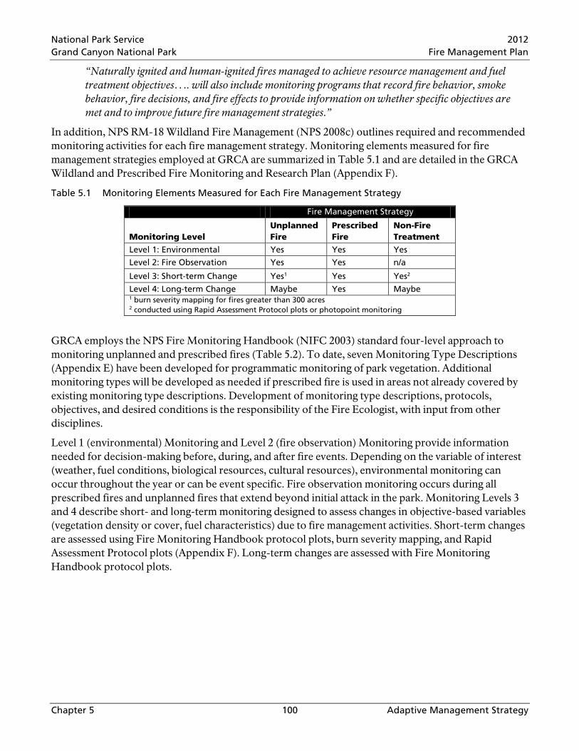
National Park Service 2012 Grand Canyon National Park Fire Management Plan
Chapter 5 100 Adaptive Management Strategy
“Naturally ignited and human-ignited fires managed to achieve resource management and fuel treatment objectives…. will also include monitoring programs that record fire behavior, smoke behavior, fire decisions, and fire effects to provide information on whether specific objectives are met and to improve future fire management strategies.”
In addition, NPS RM-18 Wildland Fire Management (NPS 2008c) outlines required and recommended monitoring activities for each fire management strategy. Monitoring elements measured for fire management strategies employed at GRCA are summarized in Table 5.1 and are detailed in the GRCA Wildland and Prescribed Fire Monitoring and Research Plan (Appendix F).
Table 5.1 Monitoring Elements Measured for Each Fire Management Strategy
Fire Management Strategy
Monitoring Level Unplanned Fire
Prescribed Fire
Non-Fire Treatment
Level 1: Environmental Yes Yes Yes
Level 2: Fire Observation Yes Yes n/a
Level 3: Short-term Change Yes1 Yes Yes2
Level 4: Long-term Change Maybe Yes Maybe 1 burn severity mapping for fires greater than 300 acres 2 conducted using Rapid Assessment Protocol plots or photopoint monitoring
GRCA employs the NPS Fire Monitoring Handbook (NIFC 2003) standard four-level approach to monitoring unplanned and prescribed fires (Table 5.2). To date, seven Monitoring Type Descriptions (Appendix E) have been developed for programmatic monitoring of park vegetation. Additional monitoring types will be developed as needed if prescribed fire is used in areas not already covered by existing monitoring type descriptions. Development of monitoring type descriptions, protocols, objectives, and desired conditions is the responsibility of the Fire Ecologist, with input from other disciplines.
Level 1 (environmental) Monitoring and Level 2 (fire observation) Monitoring provide information needed for decision-making before, during, and after fire events. Depending on the variable of interest (weather, fuel conditions, biological resources, cultural resources), environmental monitoring can occur throughout the year or can be event specific. Fire observation monitoring occurs during all prescribed fires and unplanned fires that extend beyond initial attack in the park. Monitoring Levels 3 and 4 describe short- and long-term monitoring designed to assess changes in objective-based variables (vegetation density or cover, fuel characteristics) due to fire management activities. Short-term changes are assessed using Fire Monitoring Handbook protocol plots, burn severity mapping, and Rapid Assessment Protocol plots (Appendix F). Long-term changes are assessed with Fire Monitoring Handbook protocol plots.

National Park Service 2012 Grand Canyon National Park Fire Management Plan
Chapter 5 101 Adaptive Management Strategy
Table 5.2 NPS Fire Monitoring Handbook Monitoring Levels and Potential Variables
Monitoring Level Monitoring Variables Level 1: Environmental Weather, fire-danger rating, fuel conditions, concerns and values to
be protected, and other biological, geographical, or sociological data.
Level 2: Fire Observation Reconnaissance - fire cause, location, and size; fuel and vegetation description; fire regime and condition class; current and predicted fire behavior; potential for spread; current and forecasted weather; resource or safety threats and constraints; and smoke volume and movement. Fire Conditions - topographic variables, fire weather, fuel model, fire characteristics, smoke characteristics, Resource Advisor concerns.
Level 3: Short-term Change Change in fuel load, vegetation structure, and vegetation composition, or other objective-dependent variables, within two years post-burn.
Level 4: Long-term Change Trends in Level 3 variables over time (five+ years).
GRCA has maintained an active Fire Effects Monitoring Program since 1990. The first formal GRCA Wildland and Prescribed Fire Monitoring and Research Plan (NPS 2000) outlined procedures for event monitoring of active fires in the park, and programmatic monitoring of long-term vegetation and fuel load changes as a result of prescribed burning. In the ten years since the first monitoring plan was formalized, the GRCA Fire Management Program has revised its program strategies, goals, and objectives based on current NPS policy and new scientific information. As a result, a revised GRCA Wildland and Prescribed Fire Monitoring and Research Plan (Monitoring Plan) that describes the details of the current Fire Monitoring Program is incorporated into this FMP (Appendix F). The 2010 Monitoring Plan describes event monitoring conducted during active fires, programmatic objective-based monitoring protocols, project-specific monitoring protocols, and burn severity mapping protocols. The 2010 Monitoring Plan summarizes and incorporates applicable research results from within and outside GRCA and monitoring results from GRCA prescribed fires and wildfires.
5.2 Program Objectives Park-wide fire management goals and objectives were developed by an interdisciplinary team and are outlined in Section 3.1.1. In addition to park-wide objectives, desired conditions have been developed for each forested vegetation type in the park (Section 2.4, FMP FEIS/AEF). The 2010 Monitoring Plan (Appendix F) summarizes the desired conditions for each forested vegetation type in the park and defines specific treatment and monitoring objectives for the monitoring units associated with each vegetation type.
5.3 Evaluation The evaluation process includes both targeted and synoptic program assessment. In some cases evaluation can be quantitative (comparing measured effects with predicted affects), while in other cases a qualitative, or even subjective analysis may be required (for example, trade-offs between visibility impact and fuel reduction). The evaluation process occurs after each treatment as an After Action Review, after each season during the annual review, and once every five years in a comprehensive program review. The evaluation process should result in a concise comparison of desired and achieved program effects.
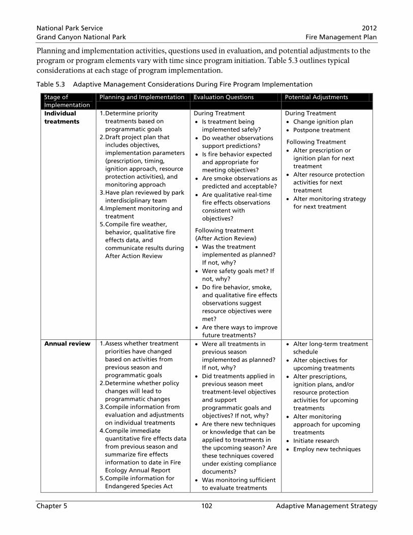
National Park Service 2012 Grand Canyon National Park Fire Management Plan
Chapter 5 102 Adaptive Management Strategy
Planning and implementation activities, questions used in evaluation, and potential adjustments to the program or program elements vary with time since program initiation. Table 5.3 outlines typical considerations at each stage of program implementation.
Table 5.3 Adaptive Management Considerations During Fire Program Implementation
Stage of Implementation
Planning and Implementation Evaluation Questions Potential Adjustments
Individual treatments
1. Determine priority treatments based on programmatic goals
2. Draft project plan that includes objectives, implementation parameters (prescription, timing, ignition approach, resource protection activities), and monitoring approach
3. Have plan reviewed by park interdisciplinary team
4. Implement monitoring and treatment
5. Compile fire weather, behavior, qualitative fire effects data, and communicate results during After Action Review
During Treatment • Is treatment being
implemented safely? • Do weather observations
support predictions? • Is fire behavior expected
and appropriate for meeting objectives?
• Are smoke observations as predicted and acceptable?
• Are qualitative real-time fire effects observations consistent with objectives?
Following treatment (After Action Review) • Was the treatment
implemented as planned? If not, why?
• Were safety goals met? If not, why?
• Do fire behavior, smoke, and qualitative fire effects observations suggest resource objectives were met?
• Are there ways to improve future treatments?
During Treatment • Change ignition plan • Postpone treatment
Following Treatment • Alter prescription or
ignition plan for next treatment
• Alter resource protection activities for next treatment
• Alter monitoring strategy for next treatment
Annual review 1. Assess whether treatment priorities have changed based on activities from previous season and programmatic goals
2. Determine whether policy changes will lead to programmatic changes
3. Compile information from evaluation and adjustments on individual treatments
4. Compile immediate quantitative fire effects data from previous season and summarize fire effects information to date in Fire Ecology Annual Report
5. Compile information for Endangered Species Act
• Were all treatments in previous season implemented as planned? If not, why?
• Did treatments applied in previous season meet treatment-level objectives and support programmatic goals and objectives? If not, why?
• Are there new techniques or knowledge that can be applied to treatments in the upcoming season? Are these techniques covered under existing compliance documents?
• Was monitoring sufficient to evaluate treatments
• Alter long-term treatment schedule
• Alter objectives for upcoming treatments
• Alter prescriptions, ignition plans, and/or resource protection activities for upcoming treatments
• Alter monitoring approach for upcoming treatments
• Initiate research • Employ new techniques
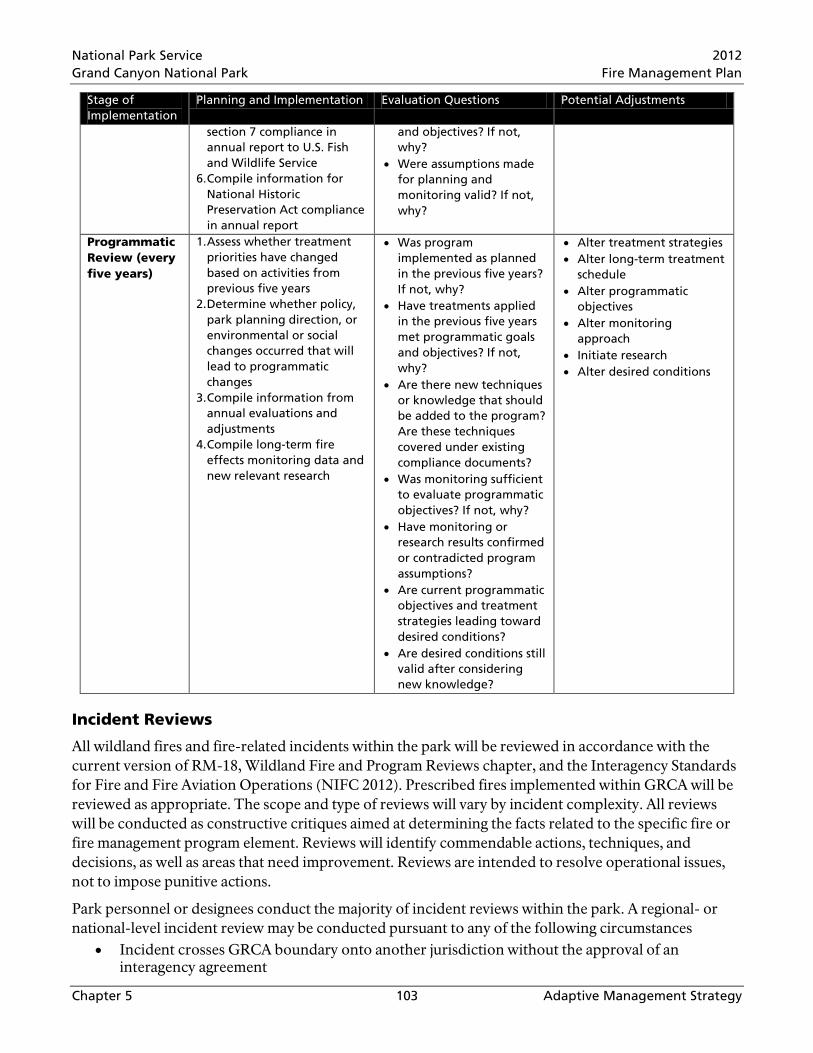
National Park Service 2012 Grand Canyon National Park Fire Management Plan
Chapter 5 103 Adaptive Management Strategy
Stage of Implementation
Planning and Implementation Evaluation Questions Potential Adjustments
section 7 compliance in annual report to U.S. Fish and Wildlife Service
6. Compile information for National Historic Preservation Act compliance in annual report
and objectives? If not, why?
• Were assumptions made for planning and monitoring valid? If not, why?
Programmatic Review (every five years)
1. Assess whether treatment priorities have changed based on activities from previous five years
2. Determine whether policy, park planning direction, or environmental or social changes occurred that will lead to programmatic changes
3. Compile information from annual evaluations and adjustments
4. Compile long-term fire effects monitoring data and new relevant research
• Was program implemented as planned in the previous five years? If not, why?
• Have treatments applied in the previous five years met programmatic goals and objectives? If not, why?
• Are there new techniques or knowledge that should be added to the program? Are these techniques covered under existing compliance documents?
• Was monitoring sufficient to evaluate programmatic objectives? If not, why?
• Have monitoring or research results confirmed or contradicted program assumptions?
• Are current programmatic objectives and treatment strategies leading toward desired conditions?
• Are desired conditions still valid after considering new knowledge?
• Alter treatment strategies • Alter long-term treatment
schedule • Alter programmatic
objectives • Alter monitoring
approach • Initiate research • Alter desired conditions
Incident Reviews
All wildland fires and fire-related incidents within the park will be reviewed in accordance with the current version of RM-18, Wildland Fire and Program Reviews chapter, and the Interagency Standards for Fire and Fire Aviation Operations (NIFC 2012). Prescribed fires implemented within GRCA will be reviewed as appropriate. The scope and type of reviews will vary by incident complexity. All reviews will be conducted as constructive critiques aimed at determining the facts related to the specific fire or fire management program element. Reviews will identify commendable actions, techniques, and decisions, as well as areas that need improvement. Reviews are intended to resolve operational issues, not to impose punitive actions.
Park personnel or designees conduct the majority of incident reviews within the park. A regional- or national-level incident review may be conducted pursuant to any of the following circumstances
• Incident crosses GRCA boundary onto another jurisdiction without the approval of an interagency agreement

National Park Service 2012 Grand Canyon National Park Fire Management Plan
Chapter 5 104 Adaptive Management Strategy
• Incident results in adverse media attention or political interest
• Incident involves serious injuries, fatalities, significant property damage, or an incident with potential. This review is separate from and in addition to any specific accident investigation
• Incident results in controversy involving another agency
For incidents within GRCA lasting no longer than one operational period or low-complexity incidents lasting longer than one operational period, a review will be conducted within three working days following completion of mop-up. The review will be facilitated by the Incident Commander or Burn Boss. Incident personnel involved will participate in the review. Other staff with specialized knowledge or interest in the incident may also participate. Any special concerns or problem areas identified in the review will be forwarded to the responsible program manager. Guidelines found in the current version of RM-18, Wildland Fire and Program Reviews chapter, are used for reviews.
For incidents involving the commitment of a Type I or Type II Incident Management Team, refer to the current version of RM-18, Wildland Fire and Program Reviews chapter, for guidelines. The Chief of Fire and Aviation customarily will conduct the review on behalf of the Superintendent.
Annual Reviews
Annual FMP updates are requirements of NPS RM-18 (NPS 2008c). The annual FMP update is intended to keep the document current with policy and ensure the fire management program includes a process of adaptive management to incorporate new knowledge. The update and review process should assess whether planned actions fall within the scope of existing environmental compliance decision documents, whether program results and effects of actions fall within the range described in environmental compliance documents, whether updates to policy or terminology are needed, and whether planning assumptions have changed since previous updates.
Critical annual FMP updates should include renewal of cooperative agreements, updates of emergency response contact names and numbers, current delegations of authority, and updates for any policy changes. Current regional or national templates should be used to perform the annual update. Any FMP changes, deletions, or amendments require concurrence of the Chief of Fire and Aviation and approval by the Superintendent. Approved amendments will be appended to the FMP prior to the fire season and forwarded to regional and national offices.
Five-Year Reviews
Five-year comprehensive reviews are requirements of NPS RM-18 (NPS 2008c). A comprehensive FMP review will be conducted every five years to determine whether a major revision or new environmental compliance is needed. The comprehensive review should be interdisciplinary and coordinated by the Chief of Fire and Aviation. The review should include a broader consideration of new park planning direction, changing environmental or social conditions, new science, and Fire Monitoring Program adaptive feedback. If no new planning requirements are indicated by the review, results are documented and signed by the Superintendent. If review results indicate significant changes in proposed actions are anticipated, expected effects are not occurring, or changes in park direction have occurred, a new fire management plan and compliance document may be required.

National Park Service 2012 Grand Canyon National Park Fire Management Plan
Chapter 5 105 Adaptive Management Strategy
5.4 Fire Research The mission goals for the NPS Wildland Fire Management Program outlined in Director’s Order 18 include science-based management and integration of Wildland Fire with other NPS programs (NPS 2008b). Both of these goals are achieved, in part, through fire research. In addition, Federal Wildland Fire Management Policy (NIFC 2001) states that “Fire management plans and programs will be based on a foundation of sound science. Research will support ongoing efforts to increase our scientific knowledge of biological, physical, and sociological factors…and must be made available to managers in a timely manner, and must be used in the development of…fire management plans, and implementation plans.”
Conducting research that will help define natural fire regimes, refine prescriptions, provide data for fire behavior models, and effectively implement the Fire Management Program is an objective of this FMP. In addition to understanding the historic and current role of fire in park ecosystems, fire-related research at GRCA aims to acquire the knowledge necessary to improve fire management practices that affect the park’s natural, cultural, and social values.
Much of the completed fire-related research relevant to GRCA is referenced throughout the FMP FEIS/AEF (NPS 2010). Past fire-related research within GRCA includes studies on forest reference conditions, fire regimes, restoration, fire effects to vegetation, fire effects to wildlife, fire effects to soils, fuel and fire behavior, air quality and smoke, and information and education. References for completed fire research, details of current fire research, and lists of future fire research needs can be found in the GRCA Wildland and Prescribed Fire Monitoring and Research Plan (Appendix F).

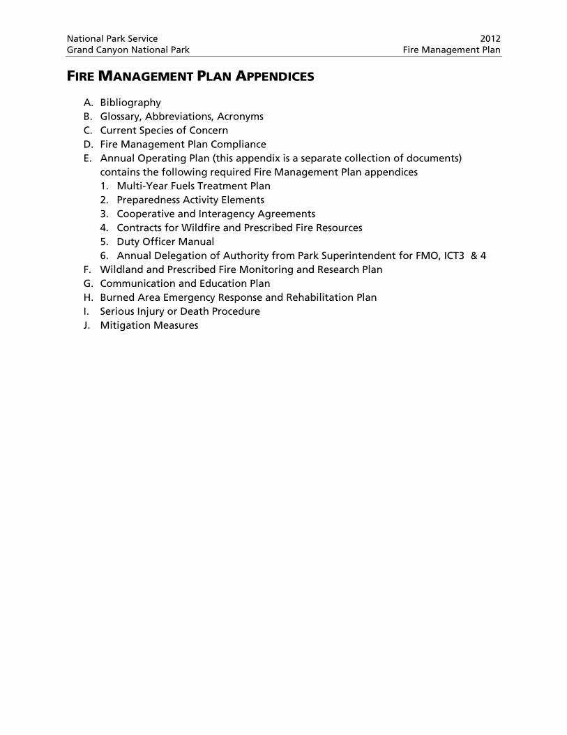
National Park Service 2012 Grand Canyon National Park Fire Management Plan
FIRE MANAGEMENT PLAN APPENDICES
A. Bibliography B. Glossary, Abbreviations, Acronyms C. Current Species of Concern D. Fire Management Plan Compliance E. Annual Operating Plan (this appendix is a separate collection of documents)
contains the following required Fire Management Plan appendices 1. Multi-Year Fuels Treatment Plan 2. Preparedness Activity Elements 3. Cooperative and Interagency Agreements 4. Contracts for Wildfire and Prescribed Fire Resources 5. Duty Officer Manual 6. Annual Delegation of Authority from Park Superintendent for FMO, ICT3 & 4
F. Wildland and Prescribed Fire Monitoring and Research Plan G. Communication and Education Plan H. Burned Area Emergency Response and Rehabilitation Plan I. Serious Injury or Death Procedure J. Mitigation Measures


National Park Service 2012 Grand Canyon National Park Fire Management Plan
Appendix A A-1 Bibliography
APPENDIX A BIBLIOGRAPHY
Alexander, R.R. 1987. Ecology, silviculture, and management of the Engelmann spruce-subalpine fir type in the central and southern Rocky Mountains. U.S. Department of Agriculture, Forest Service, Agricultural Handbook 659, Washington, D.C.
Allen, C. D., M. Savage, D. A. Falk, K. F. Suckling, T. W. Swetnam, T. Schulke, P. B., Stacey, P. Morgan, M. Hoffman, and J. T. Klingel 2002. Restoration of southwestern ponderosa pine ecosystems: a broad perspective. Ecological Applications, 12(5), pp. 1418-1433.
Arizona Department of Environmental Quality (ADEQ). 1996. R18-2, Article 15. Forest And Range Management Burns. Arizona Administrative Code. Online at: www.azdeq.gov/environ/air/smoke/fires.html
Coder, Christopher M. 2000. An Introduction to Grand Canyon Prehistory. Grand Canyon National Park, Arizona: Grand Canyon Association.
Core, John E. and Janice L. Peterson. 2001. Public Health and Exposure to Smoke. In Hardy et al. 2001.
Covington, W.W. and M.M. Moore. 1994. Southwestern ponderosa pine forest structure: Changes since Euro-American settlement. IN Draft Environmental Assessment, Grand Canyon Forest Restoration Research. National Park Service. Science Center, Grand Canyon National Park.
Covington, W.W., P.Z. Fulé, M.M. Moore, H.B. Smith, A.E.M. Waltz, T.A. Heinlein. 1999. Ecological Restoration Marking Guidelines for Ponderosa Pine Restoration Areas. Northern Arizona University, Flagstaff, Arizona.
Covington, W.W., M.M. Moore, P.Z. Fulé, and H.B. Smith. 2000. Grand Canyon Forest Restoration. Research objective 1: Landscape studies of fire regimes and forest structure. Ecological Restoration Institute, College of Ecosystem Science and Management, Northern Arizona University, Flagstaff, Arizona. 196 pp.
Dockery, D.W., C.A. Pope, III, X. Xu., J.D. Spengler, J.H. Ware, M.E. Fay, B.G. Ferris, Jr., and F.E. Speizer. 1993. An association between air pollution and mortality in six U.S. cities. New England Journal of Medicine 329:1753–1759.
Fulé, P.Z., W.W. Covington, M.M. Moore, T.A. Heinlein, and A.E.M. Waltz. 2002a. Natural variability in forests of the Grand Canyon, USA. Journal of Biogeography 29:31-47.
Fulé, P.Z., J.E. Crouse, M. Daniels, J. Springer, T.A. Heinlein, M.M. Moore, W.W. Covington, and G. Verkamp. 2002b. Mixed-severity fire regime in a high-elevation forest: Grand Canyon, Arizona. Final Report to the Joint Fire Science Program, CA-1200-99-009-NAU 04 (Part 1).
Fulé, P.Z., W.W. Covington, H.B. Smith, J.D. Springer, T.A. Heinlein, K.D. Huisinga, M.M. Moore. 2002c. Comparing ecological restoration alternatives: Grand Canyon, Arizona. Ecology & Management 170:19-41.
Fulé, P.Z., J.E. Crouse, T.A. Heinlein, M.M. Moore, W.W. Covington and G. Verkamp. 2003a. Mixed-severity fire regime in a high-elevation forest of Grand Canyon, Arizona, USA. Landscape Ecology 18:465-486.
Fulé, Peter Z., Joseph E. Crouse, Thomas A. Heinlein, Margaret M. Moore, W. Wallace Covington and Greg Verkamp. 2003b. Mixed-severity fire regime in a high-elevation

National Park Service 2012 Grand Canyon National Park Fire Management Plan
Appendix A A-2 Bibliography
forest of Grand Canyon, Arizona, USA. Landscape Ecology. 18: 465–486, Kluwer Academic Publishers.
Fulé, P.Z., J.E. Crouse, A.E. Cocke, M.M. Moore, W.W. Covington. 2004. Changes in canopy fuels and potential fire behavior 1880-2040: Grand Canyon, Arizona. Ecological Modelling 175:231-248.
Grand Canyon Visibility Transport Commission (GCVTC). 1996. Recommendations for Improving Western Vistas: Report of the Grand Canyon Visibility Transport Commission to the United States Environmental Protection Agency.
Hardy, Colin C, Roger D. Ottmar, Janice L. Peterson, John E. Core, Paula Seamon. 2001. Smoke Management Guide for Prescribed and Wildland Fire, 2001 Edition. National Wildfire Coordinating Group, Fire Use Working Team. Online at www.nwcg.gov
Harrington, M.G., and S.S. Sackett. 1998. Past and present fire influences on southwestern ponderosa pine old- growth. IN J.J. Wolf and J.N. Mast. Fire History of Mixed- conifer Forests on the North Rim, Grand Canyon National Park, Arizona. Physical Geography. 19, 1, pp. 1- 4. V.H. Winston & Son, Inc.
Mast, J.N. 2003. Tree Health and Forest Structure. Pages 215-232 IN P. Friederici (ed.). Ecological restoration of southwestern ponderosa pine forests. 2003. Island Press, Washington, D.C. 561 pp.
Merrill, Amy. 2006. Fire effects on soils: report for the Grand Canyon Environmental Impact Statement. Unpublished draft provided by author. On file at Grand Canyon National Park.
Moir, W.H. 1993. Alpine tundra and coniferous forest. IN W.A. Dick-Peddie. New Mexico vegetation: past, present, and future. University of New Mexico Press, Albuquerque, New Mexico.
Moir, W.H. and J.A. Ludwig. 1979. A classification of spruce-fir and mixed conifer habitat types of Arizona and New Mexico. U.S. Department of Agriculture, Forest Service Research Paper RM-207, Rocky Mountain Forest and Range Experiment Station, Fort Collins, Colorado.
Swetnam, T.W. and C.H. Baisan. 1996. Historical fire regime patterns in the southwestern United States since AD 1700. p. 11-32 In C.D. Allen, technical editor. Fire effects in southwestern forests: proceedings of the second La Mesa fire symposium, Los Alamos, New Mexico, March 29-31, 1994. U.S. Department of Agriculture, Forest Service General Technical Report RM-GTR-286, Rocky Mountain Forest and Range Experiment Station, Fort Collins, Colorado.
Swetnam, T.W. and J.L. Betancourt. 1990. Fire-Southern Oscillation relations in the southwestern United States. Science 249:1017-1020.
Vankat, J.L., D.C. Crocker-Bedford, D.R. Bertolette, P. Leatherbury, T. McKinnon, and C.L. Sipe. 2005. Indications of large changes in mixed-conifer forests of Grand Canyon National Park. p. 121-129 In C. van Riper III and D.J. Mattson, editors. The Colorado Plateau II: biophysical, socioeconomic, and cultural research. Proceedings of the 7th Biennial Conference of Research on the Colorado Plateau. University of Arizona Press, Tucson, Arizona.
White, M.A. and J.L. Vankat. 1993. Middle and high elevation coniferous forest communities of the North Rim region of Grand Canyon National Park, Arizona, USA. Vegetation 109:161-174.
National Park Service 2012 Grand Canyon National Park Fire Management Plan
Appendix A A-3 Bibliography
Willis, Darrell and Coil, Jayson. 2003. Grand Canyon National Park Wildfire Risk Analysis. On file at Grand Canyon National Park.
Wolf, J.J. and J.N. Mast. 1998. Fire history of mixed-conifer forests on the North Rim, Grand Canyon National Park, Arizona. Physical Geography 19:1-14.
U.S. GOVERNMENT
National Interagency Fire Center (NIFC)
2001 Review and Update of the 1995 Federal Wildland Fire Management Policy. January 2001. Online at: www.nifc.gov/PIO_bb/Policy/FederalWildlandFireManagementPolicy_2001.pdf
2003 Fire Monitoring Handbook. Fire Management Program Center, National Interagency Fire Center, Boise, Idaho. Online at: www.nps.gov/fire/fire/fir_eco_mon_fmh.cfm
2009 Guidance for Implementation of Federal Wildland Fire Management Policy. February 13, 2009. Online at: www.nifc.gov/policies/policies_documents/GIFWFMP.pdf
2012 Interagency Standards for Fire and Fire Aviation Operations (“Red Book”). NFES 2724. Produced by the National Interagency Fire Center, Boise, ID. January 2012. Online at: www.nifc.gov/policies/pol_ref_redbook_2012.html
National Wildfire Coordinating Group (NWCG)
2008a Agency Administrator's Guide to Critical Incident Management. PMS 926. July 2008. Online at: www.nwcg.gov/pms/pubs/pubs.htm
2008b Interagency Prescribed Fire Planning and Implementation Procedures Guide. July 2008. Online at: www.nwcg.gov/pms/RxFire/rxfire.htm
2009 Interagency Incident Business Management Handbook. NFES 2160. February 2008, Amended May 2009. Online at: www.nwcg.gov/pms/pubs/pubs.htm
2010 Incident Response Pocket Guide. PMS 461, NFES 1077. Sponsored by NWCG Operations and Workforce Development Committee. January 2010. Online at: www.nwcg.gov/pms/pubs/pubs.htm
2011 Wildland Fire Qualification System Guide, National Interagency Incident Management System. PMS 310-1. Prepared by NWCG Operations and Workforce Development Committee. October 2011. Online at: www.nwcg.gov/pms/docs/docs.htm
Department of the Interior And U.S. Department of Agriculture (DOI/USDA)
2000 Managing the Impact of Wildfires on Communities and the Environment, A Report to the President In Response to the Wildfires of 2000. (Known as the National Fire Plan). September 8, 2000. Online at: www.forestsandrangelands.gov/resources/reports/archive.shtml
2006 A Collaborative Approach for Reducing Wildland Fire Risks to Communities and the Environment: 10-Year Strategy Implementation Plan. December 2006. Online at: www.forestsandrangelands.gov/resources/plan/index.shtml
U.S. Department of Agriculture, Natural Resources Conservation Service (USDA NRCS)
2006 soildatamart.nrcs.usda.gov

National Park Service 2012 Grand Canyon National Park Fire Management Plan
Appendix A A-4 Bibliography
U.S. Department of the Interior (DOI)
2008 Integrated Charge Card Program Manual. June 2008. Online at: www.doi.gov/pam/ChargeCardManual608.pdf
U.S. Department of the Interior, National Park Service (NPS)
1984 Water Resources Management Plan. Grand Canyon National Park, Grand Canyon, Arizona.
1988 Backcountry Management Plan. Grand Canyon National Park, Grand Canyon, Arizona. Online at: www.nps.gov/grca/parkmgmt/bmp.htm
1993 Wilderness Recommendation, Grand Canyon National Park, Arizona. Revised. Grand Canyon National Park, Grand Canyon, Arizona. Online at: www.nps.gov/grca/parkmgmt/bmp.htm
1995 General Management Plan and Environmental Impact Statement, Grand Canyon National Park. Denver Service Center. On line at: www.nps.gov/grca/parkmgmt/gmp.htm
1997 Resource Management Plan Grand Canyon National Park. Grand Canyon, Arizona. Online at: www.nps.gov/grca/parkmgmt/bmp.htm
1998 Draft Wilderness Management Plan. Grand Canyon National Park, Grand Canyon, Arizona. Online at: www.nps.gov/grca/parkmgmt/bmp.htm
2000 Fire Effects Monitoring Plan. Grand Canyon National Park, Grand Canyon, Arizona.
2006 National Park Service Management Policies. Washington D.C. On line at: www.nps.gov/policy /MP2006.pdf
2008a Draft Environmental Impact Statement and Assessment of Affect, Fire Management Plan. Grand Canyon National Park, Grand Canyon, Arizona. October 23, 2008. Online at: parkplanning.nps.gov/grca
2008b Director's Order 18: Wildland Fire Management. Effective Date: January 16, 2008. Online at: www.nps.gov/applications/npspolicy/DOrders.cfm
2008c Reference Manual 18: Wildland Fire Management. Release Date: January 1, 2008. Online at: www.nps.gov/fire/download/fir_wil_rm18.pdf
2009a NPS Memo, Guidance for Implementation of Federal Wildland Fire Management Policy, dated April 9, 2009.
2009b Programmatic Agreement between GRCA, and the State Historic Preservation Office, July 20, 2009.
2009c U.S. Fish and Wildlife Service, Biological Opinion on the Final Environmental Impact Statement and Assessment of Affect, Fire Management Plan. Grand Canyon National Park, Grand Canyon, Arizona. November 10, 2009.
2009d Environmental Assessment / Assessment of Effect, Exotic Plant Management Plan. Grand Canyon National Park, Grand Canyon, Arizona. February 2009. Online at: parkplanning.nps.gov/grca
2010 Final Environmental Impact Statement and Assessment of Effect, Fire Management Plan. Grand Canyon National Park, Grand Canyon, Arizona. January 12, 2010. Online at: parkplanning.nps.gov/grca
2011 Internal Aviation Management Plan. Grand Canyon National Park, Grand Canyon, Arizona. March 2011.

National Park Service 2012 Grand Canyon National Park Fire Management Plan
Appendix A A-5 Bibliography
U.S. Environmental Protection Agency (EPA)
1998 Interim Air Quality Policy on Wildland and Prescribed Fires. Office of Air Quality Planning and Standards. April 23, 1998. Online at: www.epa.gov/ttncaaa1/t1/memoranda/firefnl.pdf
2006 Guideline for reporting of daily air quality – air quality index (AQI). EPA-454/R-99-010. U.S. Environmental Protection Agency, Office of Air Quality Planning and Standards, Research Triangle Park, North Carolina. Online at: www.epa.gov/ttn/oarpg/t1/memoranda/rg701.pdf


National Park Service 2012 Grand Canyon National Park Fire Management Plan
Appendix B B-1 Glossary, Abbreviations, Acronyms
APPENDIX B GLOSSARY, ABBREVIATIONS, ACRONYMS
Active Crown Fire Crown fire is actively spreading along the surface and from tree crown to tree crown.
Adaptive Management A system of management practices based on 1) clearly identified outcomes, 2) monitoring to determine if management actions are meeting desired outcomes, and 3) facilitation of management changes that will best ensure predetermined outcomes are met or re-evaluated. Adaptive management recognizes that knowledge about natural resource systems is sometimes uncertain, that management actions may need to change to meet desired outcomes, or that outcomes may need readjusting. Scientific findings and society’s needs may also indicate the need to adapt resource management to new information. (Source: Departmental Manual 516 DM 4.16)
Administrative Record The paper trail documenting an agency’s decision-making process and decision basis. It includes all materials directly or indirectly considered by persons involved in the process, including opinions or information considered but rejected. If the NEPA planning process is challenged, a judge may review these documents to determine that the process and resulting decision were proper. Future managers may also use the administrative record to understand the evolution of issue(s) and how decisions were made.
Appropriate Management Response The response to a wildland fire is based on 1) evaluation of risks to firefighter and public safety, 2) circumstances under which the fire occurs, including weather and fuel conditions, 3) natural and cultural resource management objectives, 4) protection priorities, and 5) values to be protected. The evaluation must also include analysis of the specific fire’s context in overall local, geographic, or national wildland fire situation. Fire management can range from full suppression to monitoring, or a mix of actions.
Appropriate Use Use suitable, proper, or fitting for a particular park, or to a particular park location.
Archeological Resource Any material remains or physical evidence of past human life or activities including the record of effects of human activities on the environment. An archeological resource can reveal scientific or humanistic information through archeological research.
Backcountry Primitive, undeveloped areas.
BAER (Burned Area Emergency Response) A program addressing post-fire rehabilitation and stabilization in or near the burned area with the goals of protecting life, property, water quality, and deteriorated ecosystems from further damage after the fire is out. BAER objectives are to • Determine if an emergency condition exists after the fire • Alleviate emergency conditions to help stabilize soil; control water, sediment and debris
movement; prevent ecosystem impairment; mitigate significant threats to health, safety, life, property, and downstream values at risk
• Monitor implementation and effectiveness of emergency treatments
BAER spending authority granted for each project covers only the most urgent treatments that cannot await normal funding processes. Special funds are authorized for these activities, and costs vary with fire-season severity. On average, BAER expenses have been about 12% of fire suppression cost.
Best Management Practices Practices applying current means and technologies to not only comply with mandatory environmental regulations, but also maintain a superior level of environmental performance.
Burned Area Rehabilitation The full range of post-fire activities that rehabilitate and restore fire damaged lands including protection of public health and safety.
Canopy The part of tree stands represented by tree crowns. Usually refers to the uppermost foliage layer, but can be used to describe lower layers in a multi-storied forest.

National Park Service 2012 Grand Canyon National Park Fire Management Plan
Appendix B B-2 Glossary, Abbreviations, Acronyms
Carrying Capacity The maximum population of a particular species that a particular region can support without hindering future generations’ ability to maintain the same population. Pertaining to visitor use, carrying capacity is the type and use level that can be accommodated while sustaining the desired resource and visitor-experience conditions.
Control Lines An inclusive term of all constructed or natural barriers and treated fire edges used to control a fire.
Critical Habitat Specific areas occupied by a threatened or endangered species which contain physical or biological features essential to species conservation, and which may require special management considerations or protection; specific areas outside the immediate geographical area occupied by the species at the time of its listing, upon a determination by the Secretary of the Interior that such areas are essential for the conservation of the species.
Crown Fire Flames extend into the forest canopy and burn overstory tree crowns.
Cultural Landscape A geographic area, including cultural and natural resources and wildlife or domestic animals therein, associated with a historic event, activity, or person, or exhibiting other cultural or esthetic values. There are four nonmutually exclusive cultural landscape types: historic sites, historic designed landscapes, historic vernacular landscapes, and ethnographic landscapes.
Cultural Resource An aspect of a cultural system valued by or significantly representative of a culture, or that contains significant information about a culture. A cultural resource may be a tangible entity or cultural practice. Tangible cultural resources are categorized as districts, sites, buildings, structures, and objects for the National Register of Historic Places, and as archeological resources, cultural landscapes, structures, museum objects, and ethnographic resources for NPS management purposes.
Defensible Space Space needed by firefighters to adequately defend structures from oncoming wildland fires or stop a structural fire from igniting wildland vegetation. Defensible space is the desired result of planning, siting, landscaping, and constructing facilities to minimize wildfire vulnerability and maximize wildfire protection.
Desired Conditions A park’s natural and cultural resource conditions that the NPS aspires to achieve and maintain over time, and the conditions necessary for visitors to understand, enjoy, and appreciate those resources. These conditions are identified through a park’s planning process.
Developed Area An area managed to provide and maintain facilities (e.g., roads, campgrounds, housing) serving visitors and park management functions. Includes areas where park development or intensive use may have substantially altered the natural environment or the setting for culturally significant resources.
Directives System NPS policy guidance system established in 1996 by Director’s Order 1. The system replaces and updates guidance documents formerly known as NPS Guidelines, Special Directives, and Staff Directives. The system consists of three levels
Level 1 NPS Management Policies Primary policy document for managing national parks.
Level 2 Director’s Orders Operational policies and procedures supplementing Level 1.
Level 3 Reference Manuals and other detailed guidance on how to implement Servicewide policies and procedures.
Economic Impact Changes in economic activity in local community and regional economies. A dollar spent by a park visitor is re-spent by the business that receives it. Some of that dollar is spent outside the local economy and some is paid to local businesses, governments, and households that, in turn, re-spend their incomes. In this way the effect of visitor spending is multiplied in the local economy.
Ecosystem System formed by the interaction of a community of organisms with their physical and biological environment considered as a unit.
National Park Service 2012 Grand Canyon National Park Fire Management Plan
Appendix B B-3 Glossary, Abbreviations, Acronyms
Environmental Assessment A brief NEPA document prepared with public involvement 1) to determine if impacts of a proposed action (or its alternatives) could be significant; 2) to evaluate a proposal that will have no significant impacts, but may have measurable adverse impacts; or 3) to evaluate a proposal either not on the list of categorically excluded actions, or is on the list, but exceptional circumstances apply.
Environmental Impact Statement A detailed NEPA analysis document prepared with extensive public involvement when a proposed action or alternatives have potential for significant impact on the human environment.
Ethnographic Resources Objects and places including sites, structures, landscapes, and natural resources, with traditional cultural meaning and value to associated peoples. Research and consultation with associated people identifies and explains the places and things found culturally meaningful. Ethnographic resources eligible for the National Register of Historic Places are called traditional cultural properties.
Exotic Species Species that occupy or could occupy park lands directly or indirectly as the result of deliberate or accidental human activities. Exotic species are also commonly referred to as nonnative, alien or invasive. Because an exotic species did not evolve in concert with species native to place, exotic species are not a natural component of the natural ecosystem at that place. (NPS Management Policies 2006)
Fire Behavior Fire intensity (how hot or high the flame), spread rate (how fast it moves) and fire type (surface or crown). Fire behavior occurs while the fire is burning. Increased Fire Behavior refers to increased intensity (temperature and flame height), faster moving (higher rates of spread), and more crown than surface fire.
Fire Exclusion Areas All unwanted wildland fires are aggressively suppressed due to proximity to human developments and consequent human safety risk.
Fire Intensity The rate fire produces thermal energy or heat output while burning. The higher the fire intensity, the hotter it is. In addition, the hotter or more intense a fire is, the greater the flamelength. There are no standard definitions for low-, moderate-, or high-intensity.
Fire Management Plan A plan that identifies and integrates all wildland fire management and related activities in the context of approved land/resource management plans and defines a program to manage wildland fires (wildfire, prescribed fire, and wildland fire use). The plan is supplemented by operational plans, including, but not limited to preparedness plans, preplanned dispatch plans, and prevention plans. Fire Management Plans assure that wildland fire management goals and components are coordinated.
Fire Management Unit A land management area defined by objectives, management constraints, topographic features, access, values to be protected, political boundaries, fuel types, and major fire regime groups, etc., that set it apart from an adjacent FMU. A FMU may have dominant management objectives and pre-selected strategies assigned to accomplish these objectives.
Fire Regime Fire frequency, intensity, timing, and distribution for a particular vegetation type. Historic fire regimes refer to past fire patterns. Historic fire frequency and timing can be inferred from fire scars on old trees, especially ponderosa.
Fire Regime Groups Classification of fire regimes into a discrete number of categories based on frequency and severity. The national, coarse-scale classification of fire regime groups commonly used includes five groups
Group I Frequent (0-35 years), low severity Group II Frequent (0-35 years), stand-replacement severity Group III 35-100+ years, mixed severity Group IV 35-100+ years, stand-replacement severity Group V 200+ years, stand-replacement severity
Fire Return Interval Number of years between two successive fire events in a specified area.

National Park Service 2012 Grand Canyon National Park Fire Management Plan
Appendix B B-4 Glossary, Abbreviations, Acronyms
Fire Severity Magnitude of fire effect on the environment including vegetation, soil, watersheds, wildlife habitat, and human life and property.
Fire Type Surface, crown, active crown fire, passive crown fire.
Fire-Use Fire Natural ignitions allowed to burn, and used to achieve resource management objectives; previously known as prescribed natural fire.
Fuels Above-ground organic biomass that can contribute to a wildland fire. Fuels are usually classified by size and whether live or dead, woody or herbaceous.
General Management Plan A plan clearly defining park resource preservation and visitor use direction, and serving as the basic decision-making foundation. GMPs are developed with public involvement.
Handline An inclusive term for all constructed barriers and treated edges used to control a fire that are constructed without mechanical equipment.
Heterogeneity, Spatial Complexity, Patchiness Fire or vegetation pattern variation across an area. A high complexity or heterogeneity refers to high variation in different fire patterns or vegetation conditions. Generally, these would be patchy.
High-Severity Fire Effects Fire-killed above-ground parts of all vegetation, changing forest structure substantially. All foliage and fine materials on vegetation consumed. Most large logs as well as all organic material on the ground consumed. All forest litter and duff consumed, exposing bare mineral soil. Usually results from crown fire or large-scale (greater than 15 trees) group torching.
Historic Property A district, site, building, structure, or object significant in the history of American archeology, architecture, culture, engineering, or politics at the national, state, or local level.
Impact The likely effect of an action or proposed action on specific natural, cultural, or socioeconomic resources. Impacts may be direct, indirect, individual, cumulative, beneficial, or adverse. (Also see Unacceptable Impacts).
Impairment An impact that, in the professional judgment of a responsible NPS manager, would harm integrity of park resources or values and violate the 1916 NPS Organic Act’s mandate that park resources and values remain unimpaired.
Implementation Plan A plan that focuses on how to implement an activity or project to achieve a long-term goal. An implementation plan may direct a specific project or an ongoing activity.
Invasive Plant An aggressive exotic plant known to displace native plant species in otherwise intact native vegetative communities. Invasive plant species are unwanted plants harmful or destructive to humans or other organisms. Not all exotic plants are invasive.
Ladder Fuels Fuels that provide vertical continuity between forest strata, thereby allowing fire to carry from surface fuels to tree crowns or shrubs with relative ease. Ladder fuels help initiate and assure crowning continuation.
Low-Severity Fire Effects Fire non-lethal to dominant vegetation. Fire did not alter dominant-vegetation structure. Scattered small, unburned patches intermix in burn area. Vegetation scorching generally less than 10% or limited to three feet (one meter) high or less. Small organic material on ground scorched, but not entirely consumed. Most foliage and twigs are intact. Mineral soil not exposed. Usually results from low-intensity surface fire; torching extremely rare.
Management-Ignited Prescribed Fire Application of fire to wildland fuels under specified environmental conditions. These conditions confine fire to a predetermined area while producing the intensity required to attain planned resource management objectives.
Management Action Points Geographic points on the ground, or specific points in time, where an escalation or alternative of management actions is warranted. These points are defined and management actions to be taken are clearly described in an approved Wildland Fire Implementation Plan or Prescribed Fire Plan. Timely implementation of actions when the fire reaches the action point is generally critical to successful objective accomplishment.

National Park Service 2012 Grand Canyon National Park Fire Management Plan
Appendix B B-5 Glossary, Abbreviations, Acronyms
Minimum Requirement Analysis A documented NPS process to determine appropriateness of all actions affecting wilderness.
Minimum Tool A use or activity determined to be necessary to accomplish an essential task that makes use of the least intrusive tool, equipment, device, force, regulation, or practice that will achieve the wilderness management objective.
Mitigation Modification of a proposal to lessen intensity of impact on a particular resource.
Mixed-Severity Fire Regime A fire regime in which fire severity varies across a landscape such that the same fire can burn as a high-severity crown fire in some areas of the landscape and as a low-severity surface fire in other areas, depending on fuel conditions. Mixed-severity fires include patchy, mosaic-creating fires and other fires that are intermediate in effects.
Moderate-High Severity Fire Effects Considerable scorching, with partial consumption of foliage and fine materials on above-ground vegetation. Minimal green vegetation remains in overstory. Some overstory tree mortality likely. Consistent patches in burn area have large logs as well as all organic materials consumed to bare mineral soil. Most woody debris consumed. Mineral soil generally exposed but intact. The Moderate/High category may include up to 10%stand-replacing fire with extremely vigorous vegetative regrowth. Usually results from moderate-to high-intensity surface fire with single tree and small-scale group torching.
Moderate-Low Severity Fire Effects - Partial scorching (10-70 percent) of foliage and fine materials on aboveground vegetation. Minimal consumption of foliage and fine materials on aboveground vegetation. Some green vegetation remains in overstory. Limited overstory tree mortality. Few, if any, unburned patches within the burn area. Most fine organic materials partially consumed, with minimal consumption of large logs. Rotten wood scorched to partially burned. Bare mineral soil not exposed. Usually results from low- to moderate-intensity surface fire with isolated single tree torching.
Native American Of or relating to a tribe, people, or culture indigenous to the United States.
Native Species Species that have occurred, now occur, or may occur as a result of natural processes on lands in a place. Native species in a place are evolving in concert with each other. (NPS Management Policies 2006)
NEPA Process Objective analysis of a proposed action to determine degree of impact on natural, physical, and human environment; alternatives and mitigations that reduce impact; and the full and candid presentation of the analysis to, and involvement of, interested and affected public as required of Federal agencies by the National Environmental Policy Act of 1969.
Non-fire Fuel Treatments (mechanical or manual) Hazardous fuel reduction or removal. Mechanical removal involves wheeled- or tracked-vehicle use. Manual removal involves chainsaws, other portable hand-held equipment like gas-powered trimmers and hand tools. Specific laws prohibit use of some mechanical fuel-reduction techniques in specific areas. For example, use of wheeled or tracked vehicles in wilderness is prohibited.
Organic Act 1916 law (and subsequent amendments) that created the National Park Service and assigned it responsibility to manage national parks.
Passive Crown Fire Crown fire where individual trees or tree groups burn through crowns but fire spread from crown to crown is limited. Fire spread occurs primarily on the surface.
Planned Event All fires ignited under guidance of a prescribed fire burn plan.
Preparedness Level Increments of planning and organization readiness commensurate with increasing fire danger.
Preparedness Plan A written plan providing timely recognition of approaching critical fire situations, priority setting, deployment of forces, and other response actions.
Prescribed Fire Any fire ignited by management actions to meet specific objectives. A written, approved prescribed fire plan must exist prior to ignition.

National Park Service 2012 Grand Canyon National Park Fire Management Plan
Appendix B B-6 Glossary, Abbreviations, Acronyms
Prescribed Fire Burn Plan Plan required for each fire application ignited by management. Plans are prepared by qualified personnel, approved by agency administrators, and include conditions criteria under which fire will be conducted (a prescription). Plan content varies among agencies.
Prescription Measurable criteria that define conditions under which a prescribed fire may be ignited, guide selection of appropriate management responses, and indicate other required actions.
Public Involvement (also called public participation) Active public involvement in NPS planning and decision-making processes. Public involvement occurs on a continuum ranging from providing information and building awareness, to decision-making partnering.
Record of Decision Document prepared to substantiate a decision based on an analysis of a range alternatives (e.g., an EIS). When applicable, includes a detailed discussion of rationale and reasons for not adopting all mitigation measures analyzed.
Soundscape (natural) Aggregate of all natural, non-human-caused sounds that occur in parks, plus the physical capacity for transmitting natural sounds.
Stakeholder An individual, group, or other entity with a strong interest in decisions concerning park resources and values. Stakeholders may include recreational user groups, permittees, and concessioners. In the broadest sense, all Americans are stakeholders in national parks.
Stand-Replacement Fire The majority of above-ground, dominant vegetation is either consumed or dies as a result of fire.
Suppression The work of extinguishing or confining a fire beginning with its discovery.
Surface Fire Fire consumes litter, low-growing plants, and dead herbaceous plants accumulated on the surface. Surface fire can ignite snags, and consume shrubs and seedlings. Surface fire does not burn in tree crowns. Flame heights and intensity can vary widely.
Surface Fuel Fuels lying on or near the ground surface consisting of leaf and needle litter, dead branch material, downed logs, bark, tree cones, and low-stature living plants.
Traditional Cultural Property Property associated with cultural practices, beliefs, sense of purpose, or existence of a living community rooted in that community’s history, or important in maintaining cultural identity and development as an ethnically distinctive people. Traditional cultural properties are ethnographic resources eligible for listing in the National Register.
Unacceptable Impacts Impacts that individually or cumulatively would • be inconsistent with a park’s purposes or values, or • impede attainment of a park’s desired future conditions for natural and cultural resources as
identified through the park’s planning process, or • create an unsafe or unhealthful environment for visitors or employees, or • diminish opportunities for current or future generations to enjoy, learn about, or be inspired by
park resources or values, or • unreasonably interfere with
• park programs or activities, or • an appropriate use, or • the atmosphere of peace and tranquility, or the natural soundscape maintained in
wilderness and natural, historic, or commemorative locations within the park. • NPS concessioner or contractor operations or services.
Values At Risk Property, structures, physical improvements, natural and culture resources, community infrastructure, and economic, environmental, and social values that could be damaged or destroyed by a fire.
Unplanned Event All fires not intentionally ignited under guidance of a prescribed fire burn plan. Unplanned events require a management response. These events include, but are not limited to, lightning fires, arson fires, fire begun by other activities like those ignited by sparks from railroad cars.

National Park Service 2012 Grand Canyon National Park Fire Management Plan
Appendix B B-7 Glossary, Abbreviations, Acronyms
Visitor Experience Many different Grand Canyon visitor experiences exist. Visitors create their own experiences using resources they bring combined with resources they find at the park. Some experiences, such as an extended backcountry trip below the rim, require a great deal of management by the visitor. A guided bus tour requires less visitor management. Visitor experience quality depends on visitor knowledge, skills, experience, resources, and on park’s natural resource characteristics people incorporate into their experiences.
Water Bar A ridge of compacted soil, loose rock, or gravel constructed across a disturbed sloping area.
Watershed Entire geographical area drained by a river and its tributaries; an area characterized by all runoff conveyed to the same outlet.
Weather Information Management System Centralized weather data processing system at which daily fire danger ratings are produced.
Weather Percentiles Weather conditions for a given percent of fire season or defined length of time. 97th percentile weather, occurs during 3% of the defined length of time. For fire season, this weather includes very hot temperatures, very low humidities, and high winds. 90th percentile weather occurs during 10% of the defined length of time. For fire seasons, this weather includes hot temperatures, low humidities, and high winds but not as high as 97th percentile winds. 50th percentile weather occurs during 50% of the defined length of time. For fire seasons, this weather is considered mild or average.
Wilderness (designated) Federal land designated by Congress as a component of the National Wilderness Preservation System.
Wilderness (eligible, study, proposed and recommended) Federal lands found to possess wilderness character based on Wilderness Act criteria. The four categories reflect different wilderness review process stages. All categories are managed to preserve wilderness resources and values that make them eligible for wilderness designation.
Wilderness (potential) Federal lands surrounded by or adjacent to lands proposed for wilderness designation but that do not qualify for designation due to temporary, nonconforming uses or incompatible conditions. Potential wilderness is a subset of other wilderness categories and can be eligible, study, proposed, recommended, or designated potential wilderness.
Wildland An area where development is essentially non-existent, except for roads, railroads, powerlines, and similar transportation facilities. Structures, if any, are widely scattered.
Wildland Fire Any non-structural fire that occurs in wildland. Three distinct wildland fire types include wildfire, wildland fire use, and prescribed fire. Wildland fires occur from both natural and human ignition sources, and may contribute to or hinder achievement of park management objectives.
Wildland Fire Use Management of naturally ignited wildland fires (begun by lightning) to accomplish specific resource objectives in a pre-defined area. Objectives can include maintaining healthy environments and supporting ecosystem diversity. Monitoring ensures fire stays in prescribed boundaries and meets objectives. Operational management is described in the Wildland Fire Implementation Plan.
Wildland Fire Implementation Plan A progressively developed assessment and operational management plan documenting analysis and describing appropriate management response for a wildland fire.
Wildland Fire Situation Analysis A decision-making process that evaluates alternative wildfire suppression strategies against selected environmental, social, political, and economic criteria, and provides a record of those decisions.
National Park Service 2012 Grand Canyon National Park Fire Management Plan
Appendix B B-8 Glossary, Abbreviations, Acronyms
Wildland-Urban Interface The line, area, or zone where structures and other human development meet or intermingle with undeveloped wildland or vegetative fuels. WUI is
• Any area where wildland fuels threaten to ignite combustible structures. • Any wildland area where wildland fire ignitions may reach structures in one burning period. • Areas where flammable wildland fuels meet or intermingle with structures and other human
development.
Abbreviations and Acronyms AAR After Action Review
ADEQ Arizona Department of Environmental Quality
ADOT Arizona Department of Transportation
AEF Assessment of Effect
AGFD Arizona Game and Fish Department
AGL Above Ground Level
AMR Appropriate Management Response
AQRV Air Quality-Related Values
ATV All-Terrain Vehicle
BA Biological Assessment
BAER Burned Area Emergency Rehabilitation
BAR Burned Area Rehabilitation
BIA Bureau of Indian Affairs
BLM Bureau of Land Management
BMP Backcountry Management Plan
BO Biological Opinion
CAA Clean Air Act
CBI Composite Burn Index
cfs Cubic Feet per second
CH4 Methane
cm Centimeter
CO Carbon monoxide
CO2 Carbon dioxide
db Decibels
dbA A-weighted decibels
dbh Diameter breast height
DOI Department of the Interior

National Park Service 2012 Grand Canyon National Park Fire Management Plan
Appendix B B-9 Glossary, Abbreviations, Acronyms
DO Director’s Order
dv Deciview
EIS Environmental Impact Statement
EO Executive Order
EPA Environmental Protection Agency
ERT Emission Reduction Techniques
ES Emergency Stabilization
ESA Endangered Species Act
FAA Federal Aviation Administration
FEA Fire Exclusion Area
FEIS Final Environmental Impact Statement
FIREMON Fire Effects Monitoring and Inventory System
FIREPRO Fire Budgeting Program (NPS)
FARSITE Fire-behavior prediction model
FlamMap Fire-behavior prediction model
FMO Fire Management Officer
FMP Fire Management Plan
FMU Fire Management Unit
FOFEM5 First Order Fire Effects Model, Version 5
FPA Fire Program Analysis
FR Federal Register
FTE Full Time Equivalent
GIS Geographic Information System
GMP General Management Plan
GRCA Grand Canyon National Park
GSA Government Services Administration
ha Hectare
HTA Helicopter Training Academy
IAP Incident Action Plan
ICS Incident Command System
IDT Interdisciplinary Team
IMT Incident Management Team

National Park Service 2012 Grand Canyon National Park Fire Management Plan
Appendix B B-10 Glossary, Abbreviations, Acronyms
IQCS Incident Qualifications and Certification System
JFSP Joint Fire Science Project
JHA Job Hazard Analysis
KNF Kaibab National Forest
KSNNL Kaibab Squirrel National Natural Landmark
L90 Ambient Sound Level (dbA)
Lnat Natural Ambient Sound (dbA)
Lmax Maximum A-weighted decibel levels
LAME Lake Mead National Recreation Area
LANDFIRE Fire modeling program
LANDSAT Remote sensing by satellite
m Meter
MAC Group Multi-Agency Coordination Group
MIST Minimum Impact Suppression Tactics
MMA Maximum Manageable Areas
MOA Memorandum of Agreement
MOU Memorandum of Understanding
MRA Minimum-Requirement Analysis
MSO Mexican Spotted Owl
NAAQS National Ambient Air Quality Standards
NBR Normalized Burn Ratio
NBSMP National Burn Severity Mapping Program
NCL National Leadership Council
NEPA National Environmental Policy Act
NFDRS National Fire Danger Rating System
NFFL Northern Forest Fire Laboratory
NFP National Fire Plan
NFPA National Fire Protection Association
NFPORS National Fire Plan Operations and Reporting System
NHPA National Historic Preservation Act
NIFC National Interagency Fire Center
NNL National Natural Landmark
National Park Service 2012 Grand Canyon National Park Fire Management Plan
Appendix B B-11 Glossary, Abbreviations, Acronyms
NOI Notice of Intent
NOx Nitrous oxides
NPS National Park Service
NRHP National Register of Historic Places
NWS National Weather Service
O3 Ozone
ONPS Operation of National Park Service (refers to base funding: ONPS funding)
PA Programmatic Agreement
PAC Protected Activity Center
Pb Lead
PEPC Planning Environments and Public Comment website (NPS)
PM Particulate Matter
PM2.5 Particulate Matter less than 2.5 micrometers
PM10 Particulate Matter less than 10 micrometers
PPE Personal Protective Equipment
ppm/hr Parts per million per hour
RAWS Remote Area Weather Station
RM Reference Manual
RMP Resource Management Plan
RNA Resource Natural Area
ROD Record of Decision
Rx Prescribed Fire
SAFENET Wildland Fire Safety and Health Network
SFRA Special Flight Rules Area
SHPO State Historic Preservation Officer
SMT Smoke Management Technique
SO2 Sulfur dioxide
TCP Traditional Cultural Property
TES Threatened and Endangered Species
TFR Temporary Flight Restriction
USC U.S. Code

National Park Service 2012 Grand Canyon National Park Fire Management Plan
Appendix B B-12 Glossary, Abbreviations, Acronyms
USDA U.S. Department of Agriculture
USDOI U.S. Department of the Interior
USFA U.S. Fire Administration
USFS U.S. Forest Service
USFWS U.S. Fish and Wildlife Service
USGS U.S. Geological Survey
VOC Volatile Organic Compounds
WDC Williams Dispatch Center
WFDSS Wildland Fire Decision Support System
WFLC Wildland Fire Leadership Council
WFMI Wildland Fire Management Information System
WFU Wildland Fire Use
WFURB Wildland Fire Use for Resource Benefits
WUI Wildland-Urban Interface
µg/m3 Micrograms per cubic meter
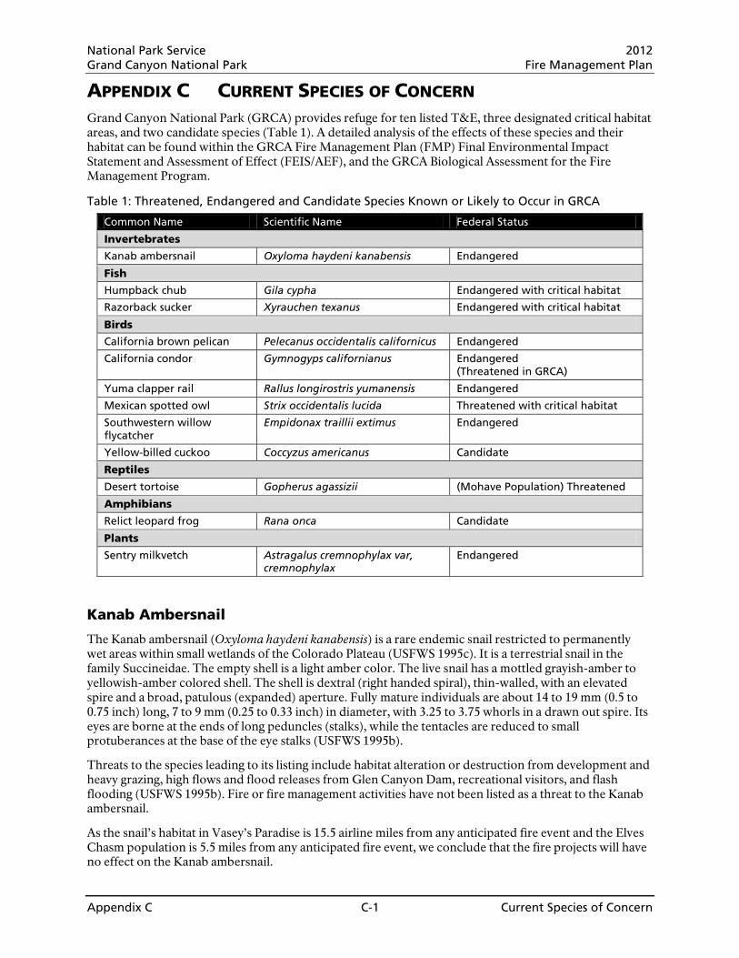
National Park Service 2012 Grand Canyon National Park Fire Management Plan
Appendix C C-1 Current Species of Concern
APPENDIX C CURRENT SPECIES OF CONCERN Grand Canyon National Park (GRCA) provides refuge for ten listed T&E, three designated critical habitat areas, and two candidate species (Table 1). A detailed analysis of the effects of these species and their habitat can be found within the GRCA Fire Management Plan (FMP) Final Environmental Impact Statement and Assessment of Effect (FEIS/AEF), and the GRCA Biological Assessment for the Fire Management Program.
Table 1: Threatened, Endangered and Candidate Species Known or Likely to Occur in GRCA
Common Name Scientific Name Federal Status
Invertebrates
Kanab ambersnail Oxyloma haydeni kanabensis Endangered
Fish
Humpback chub Gila cypha Endangered with critical habitat
Razorback sucker Xyrauchen texanus Endangered with critical habitat
Birds
California brown pelican Pelecanus occidentalis californicus Endangered
California condor Gymnogyps californianus Endangered (Threatened in GRCA)
Yuma clapper rail Rallus longirostris yumanensis Endangered
Mexican spotted owl Strix occidentalis lucida Threatened with critical habitat
Southwestern willow flycatcher
Empidonax traillii extimus Endangered
Yellow-billed cuckoo Coccyzus americanus Candidate
Reptiles
Desert tortoise Gopherus agassizii (Mohave Population) Threatened
Amphibians
Relict leopard frog Rana onca Candidate
Plants
Sentry milkvetch Astragalus cremnophylax var, cremnophylax
Endangered
Kanab Ambersnail
The Kanab ambersnail (Oxyloma haydeni kanabensis) is a rare endemic snail restricted to permanently wet areas within small wetlands of the Colorado Plateau (USFWS 1995c). It is a terrestrial snail in the family Succineidae. The empty shell is a light amber color. The live snail has a mottled grayish-amber to yellowish-amber colored shell. The shell is dextral (right handed spiral), thin-walled, with an elevated spire and a broad, patulous (expanded) aperture. Fully mature individuals are about 14 to 19 mm (0.5 to 0.75 inch) long, 7 to 9 mm (0.25 to 0.33 inch) in diameter, with 3.25 to 3.75 whorls in a drawn out spire. Its eyes are borne at the ends of long peduncles (stalks), while the tentacles are reduced to small protuberances at the base of the eye stalks (USFWS 1995b).
Threats to the species leading to its listing include habitat alteration or destruction from development and heavy grazing, high flows and flood releases from Glen Canyon Dam, recreational visitors, and flash flooding (USFWS 1995b). Fire or fire management activities have not been listed as a threat to the Kanab ambersnail.
As the snail’s habitat in Vasey’s Paradise is 15.5 airline miles from any anticipated fire event and the Elves Chasm population is 5.5 miles from any anticipated fire event, we conclude that the fire projects will have no effect on the Kanab ambersnail.

National Park Service 2012 Grand Canyon National Park Fire Management Plan
Appendix C C-2 Current Species of Concern
Humpback Chub and Humpback Chub Critical Habitat
Humpback chub (Gila cypha) are found in canyon-bound reaches of large rivers (Colorado, Little Colorado, Green, and Yampa) with turbulent flow (AGFD 2001). The humpback chub’s preferred habitat is large, warm turbid rivers, especially canyons with deep, fast water. The humpback chub is endangered due to destruction and modification of habitat through impoundment (e.g., stream inundation, reduced water temperatures, and reduced spring flows resulting from construction of Hoover Dam, Glen Canyon Dam, and Flaming Gorge Dam); introduced competitors and predators; and, hybridization with other Gila species. Flow reductions and low water temperatures may curtail successful spawning and increase competition with other species. Fire and fire management activities have not been cited as a threat to the humpback chub.
A buffer of many surface miles of rock and vegetation occurs between the plateau where fire activities would occur and the river. This drastically reduces the chance of increased siltation reaching the river as a result of any managed burns. Therefore, we conclude that these projects will have no effect on the humpback chub or humpback chub critical habitat.
Razorback Sucker and Critical Habitat
The razorback sucker (Xyrauchen texanus) was listed as endangered in 1991 (56 FR 54967; USFWS 1991). Razorback suckers are found in the Upper and Lower basin of the Colorado River. In GRCA, they are found rarely and sporadically within the Lower Gorge. The largest surviving population exists in Lake Mohave.
The main threats to razorback suckers are predation by nonnative fishes and major changes in the river ecosystem attributed to dams. Fire and fire management activities have not been cited as a threat to the razorback sucker.
A buffer of many surface miles of rock and vegetation occurs between the plateau where fire activities would occur and the river. This drastically reduces the chance of increased siltation reaching the river as a result of any managed burns. Therefore, we conclude that these projects will have no effect on the razorback sucker or razorback sucker critical habitat.
California Brown Pelican
The California brown pelican was listed as endangered in 1970 in all of its historic range. In 1985, the species was delisted in Alabama, Florida, Georgia, and South and North Carolina and northward; it is currently listed in California, Texas, and Louisiana. Its habitat is primarily warm coastal and estuarine environments.
Threats to the species include pesticides and other contaminants, including oil pollution. Additional threats include collisions with stationary or moving structures or objects such as power transmission lines (Shields 2002). There were 17 reports of aircraft strikes by brown and American white pelicans in the United States between January 1991 and May 1998 (Shields 2002, citing Dolbeer et al. 2000). Fire and fire management activities have not been cited as threats to the brown pelican.
The California brown pelican is a rare visitor to the Colorado River corridor during the non-breeding season. The river corridor is 2.5 to 10 airline miles from the nearest fire management projects. The brown pelican has never been sighted near the forested plateaus where the fire management program will be implemented or during the time of year that fire activity will occur. Therefore, we conclude that these projects will have no effect on the California brown pelican.
Yuma Clapper Rail
The Yuma clapper rail was listed as endangered in 1967. Critical habitat has not been designated for the species. The current range of the species includes the Colorado River from the lower Virgin River to Mexico and various locations in the Gila River Drainage.
National Park Service 2012 Grand Canyon National Park Fire Management Plan
Appendix C C-3 Current Species of Concern
The Yuma clapper rail is a secretive species and is not often seen in the wild, however it does have a series of distinctive calls. This bird inhabits freshwater or brackish stream-sides and marshes under 4,500 feet in elevation. It is associated with dense riparian and marsh vegetation, dominated by cattails. The rail requires a wet substrate such as a mudflat, sandbar or slough bottom that supports cattail stands of moderate to high density adjacent to shorelines. Fire and fire management activities have not been cited as threats to the Yuma clapper rail.
Given the clapper rail’s use of marshy habitat, the extreme distances of the habitat from fire management areas, we conclude that the proposed action will have no effect on the Yuma clapper rail.
Mexican Spotted Owl
The Mexican spotted owl (Strix occidentalis lucida) is one of three subspecies of spotted owl occurring in the United States, in addition to the northern spotted owl (S. o. caurina) and the California spotted owl (S. o. occidentalis). The Mexican spotted owl is distinguished from the California and northern subspecies chiefly by geographic distribution and plumage. The Mexican spotted owl is mottled in appearance with irregular white and brown spots on its abdomen, back, and head. The spots of the Mexican spotted owl are larger and more numerous than in the other two subspecies, giving it a lighter appearance (USFWS 2001).
Mexican spotted owls, found on forested plateaus and canyon lands throughout the Southwest United States and Mexico, were originally thought to be dependent on late seral forests (Ganey and Balda 1989a, Gutierrez et al. 1995). In much of species’ range the owl is generally restricted to isolated patches of habitat that include mixed-conifer and pine-oak forests, riparian madrean woodland, and sandstone canyon lands (USFWS 1995c). Zwank et al. (1994) reported that Mexican spotted owls were common in mature forests in New Mexico. Ganey and Balda (1989a, 1989b, and 1994) demonstrated that Mexican spotted owls were most common in mixed-conifer and pine forests in Arizona south of the Grand Canyon. They also reported several sites where the owl was found breeding in rocky canyon habitat with scattered stands of forest vegetation.
The Mexican spotted owl was listed as threatened on March 16th, 1993. Two primary reasons were cited for listing the owl as threatened. The first was historical alteration of habitat as the result of timber management practices, specifically the use of even-aged silviculture, and the threat of these practices continuing. The second was the danger of catastrophic wildfire (USFWS 2001) with the potential to remove large acreage of suitable forest habitat from the southwestern landscape.
At GRCA, all known spotted owl home range territories have been found in the canyon areas of the park (the Inner Canyon Fire Management Unit (FMU)). There are now 41 Protected Activity Centers (PACs), delineated to protect these sites, as directed in the Recovery Plan. If additional owl territories are discovered at the park, they will also be delineated and managed as PACs. Based on habitat modeling of habitat in the canyon, we estimate another 40 potential PACs could be delineated there, if additional owl surveys could be conducted to identify the location of now unknown owls (Willey and Ward 2003). Most of these territories would probably be found in the lower gorge west of Powell Plateau as the majority of side canyons approaching the forested areas of the North and South Rim have been well surveyed with owls detected and PACs established (Map 1).
MSO in the twelve PACs mentioned above in tributary canyons near managed fires could receive direct and indirect effects from smoke, noise and disturbance from management activities. There is also the limited possibility that the five North Rim PACs mentioned above could be encroached upon by fire creeping below the rim.
It is, therefore, our determination that the fire management program may affect/likely to adversely affect the MSO.
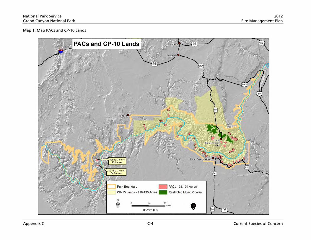
National Park Service 2012 Grand Canyon National Park Fire Management Plan
Appendix C C-4 Current Species of Concern
Map 1: Map PACs and CP-10 Lands

National Park Service 2012 Grand Canyon National Park Fire Management Plan
Appendix C C-5 Current Species of Concern
Mexican Spotted Owl Habitat
The final rule designating critical habitat for MSO became effective on August 23, 2004. At that time, critical habitat units were designated in New Mexico, Arizona, Utah, and Colorado. The purpose of designating critical habitat is to provide habitat that is essential to the conservation of the species and that requires special management.
Critical habitat designations consider the physical and biological features of habitat that are essential to the conservation of the species. In the case of MSO, these “primary constituent elements” (PCEs) of critical habitat include those features that support MSP nesting and roosting, and the habitat of prey species. In fulfillment of the Recovery Plan, maintenance of these PCEs is a driver of Federal activities that are within Critical Habitat Units (CHUs). Because the MSO are found in forest and canyon habitat, primary constituent elements were defined for both types of habitat. These are as follows:
Forest habitat • High basal area of large diameter trees
• Moderate to high canopy closure
• Wide range of tree sizes suggestive of uneven-age stands
• Multi-layered canopy with large overstory trees of various species
• High snag basal area
• High volumes of fallen trees and other woody debris
• High plant species richness, including hardwoods
• Adequate levels of residual plant cover to maintain fruits, seeds, and regeneration to provide for the needs of MSO prey species
Canyon habitat • Cooler and often more humid conditions than the surrounding area
• Clumps or stringers of trees and/or canyon wall containing crevices, ledges, or caves
• High percent of ground litter and woody debris
• Riparian or woody vegetation (although not at all sites)
The total acreage of the Critical Habitat Unit (CHU) CP-10, the unit affected by the fire management program as described in the 2010 FMP FEIS/AEF, is 918,435 acres, with 74 % managed by the National Park Service (Map 1). Though tribal and private lands are included within the boundary of MSO critical habitat, those lands are not legally affected by the designation. Federal land managers are the responsible parties for managing MSO critical habitat. Unit CP–10. This unit is located in northwestern Arizona, and is predominantly within the boundaries of Kaibab National Forest and GRCA. The majority of this unit contains steepwalled canyon habitat, but the unit also contains forested habitat within the North Kaibab Ranger District and GRCA. State, and private lands are not designated as critical habitat.
The Inner Canyon FMU (78% of the park acreage) includes the canyon terrain where 99.5% of MSO detections have been made. These areas are designated as PACs per the Recovery Plan. All but two of the PACs are in CP-10. All PAC acreage is fully below the rim. PAC designations result in 29,505 acres in 39 PACs in CP-10 and are managed as “protected” habitat per the Recovery Plan. If additional owl territories are discovered at the park, they will also be delineated and managed as PACs.
The near-term focus for the park’s MSO management is the protection of PACs as the foremost importance for owl recovery. The critical habitat designation also carries that focus.
The other rare detections occur when MSO have been found foraging on the plateau, near the canyon rim (less ½ mile from the rim). These foraging detections have occurred when MSO that reside in the canyon

National Park Service 2012 Grand Canyon National Park Fire Management Plan
Appendix C C-6 Current Species of Concern
have ventured up to the forested plateau. Following MSO protocols for establishment of PACs, MSO detections on the plateau near the rim have not warranted delineation of PACs.
During consultation with U.S. Fish and Wildlife Service in 2009, GRCA refined its analyses to more accurately evaluate the potential impacts of the fire management program to key areas within the park that are located within CP-10. Specifically, designated critical habitat in the park can be subdivided into protected areas, restricted areas, and other forest and woodland types as defined in the Recovery Plan and critical habitat designation. The restricted habitat area within the park is on the North Rim of Grand Canyon in the mixed-conifer forest type. The area identified as restricted habitat that is in GRCA is 27,100 acres (Table 2).Of this, approximately 68% has burned in unplanned (suppression and resource benefit) fires and prescribed burns 2000 to 2008. The amount of restricted habitat that has not been affected by fire is 32%. Of the acres of restricted habitat that burned since 2000, 16% have burned at moderate high to high severity. Fire severity areas and amounts will be updated annually and reported to U.S. Fish and Wildlife Service. (Map 2 Restricted Mixed Conifer & Map 3 Restricted Mixed Conifer, Fire History, and FMU’s)
Map 4 indicates the extent and severity of these fires on the restricted mixed-conifer of the Plateau and Peninsula FMUs.
Implementation of the GRCA 2010 FMP FEIS/AEF may affect, is likely to adversely affect Mexican spotted owl critical habitat unit CP-10. However, the fire management program contains measures designed to minimize this effect. To summarize:
The FMP FEIS/AEF contains provisions to limit effects to occupied critical habitat. • All planned FMP activities are outside of PACs, thus providing maximum protection for 100% of the
known owl population and protected habitat.
• Most of the park’s acreage in CP-10 is in the Inner Canyon FMU, which will receive the greatest level of protection afforded by the FMP (suppression is a priority). This FMU is where all MSO have been found.
• There are a series of Conservation Measures to reduce fire management effects to MSO.
The proposed management of unoccupied owl habitat will protect occupied habitat, which follows direction of the Recovery Plan and will retain management options for the future. • Prescribed fire in the restricted mixed-conifer habitat of the Plateau FMU will cause short-term (less
than two years) impacts to forest conditions and prey availability. These habitat changes are indirect adverse effects to owls, as they occur in habitat outside of the PACs, in an area where owls have not been detected.
• In the Plateau and Peninsulas FMUs, the effects of prescribed fire, wildfires that can be managed for resource benefit and mechanical treatments will result in long-term beneficial effects to spotted owl habitat by reducing the risk of catastrophic loss of owl habitat while maintaining sufficient primary constituent elements to allow CP-10 to function as spotted owl dispersal habitat.
• No more than 3,783 acres of existing, unburned restricted mixed-conifer habitat in the will be allowed to burn at moderate-high or high severities past 2008. Therefore, analysis of past data suggests that the primary constituent elements will be maintained in at least 70% (18,970 acres) of restricted mixed-conifer habitat to support owl dispersal and provide connectivity to MSO habitat north of the park.
Past monitoring data shows that large tree density, snag density, and ground layer species richness and cover remain unchanged following fire in low and moderate-low severity areas. Small diameter tree density decreases in low and moderate-low severity areas which creates a more even size-class distribution of trees and decreases the risk for higher severity fires in the future. The decrease in small diameter trees also decreases total basal area and canopy cover in these areas. However, total basal area numbers meet the threshold conditions for the percentage of the landscape specified in the

National Park Service 2012 Grand Canyon National Park Fire Management Plan
Appendix C C-7 Current Species of Concern
Recovery Plan (USFWS 1995c) and canopy cover remains above the recommended percentage (USFWS 2004d) in low and moderate-low severity areas.
The past fire activities have created a current environment which will ameliorate effects to MSO critical habitat: • Previous fire work has reduced fuel accumulations and decreased the likelihood of significant adverse
effects from future wildland fires in restricted habitat in the Plateau and Peninsulas FMUs. Thousands of acres of prescribed burning in ponderosa pine habitat adjacent to mixed-conifer habitat has created areas of lower fuels accumulations lessening the chances of high intensity fire movement into restricted areas.
The fire program in the 2010 FMP FEIS/AEF makes a commitment to institute procedures that will improve coordination with U.S. Fish and Wildlife Service, allow more effective analysis of cumulative effects, and provide more clarity on how changes will be made. • Annual reports and meetings with U.S. Fish and Wildlife Service will provide an opportunity for a
structured review of the previous year’s activities and agreement on whether changes are necessary. Reviews would cover:
o Updated tabulations of acres burned by fire type, severity and location
o New information on owl occurrence or research
o Changes to prescriptions (prescribed fire) or wildfire management strategies based on new monitoring and research information
If environmental impacts of implementing the 2010 FMP FEIS/AEF exceed the effects described in the Biological Assessment, Section 7 consultation would be reinitiated with U.S. Fish and Wildlife Service to address those differences. Also, if new information should reveal effects not considered in the Biological Assessment, Section 7 consultation would be reinitiated. This latter point would include effects of suppression fires that are beyond what is anticipated in this documentation.
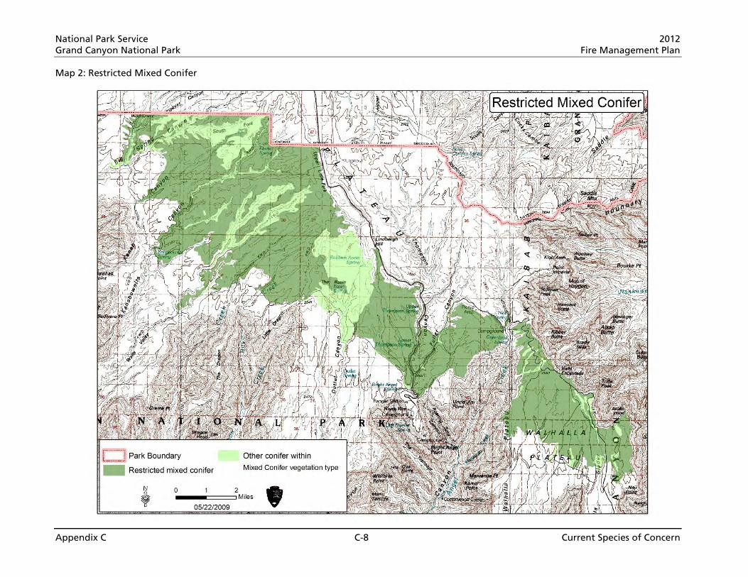
National Park Service 2012 Grand Canyon National Park Fire Management Plan
Appendix C C-8 Current Species of Concern
Map 2: Restricted Mixed Conifer
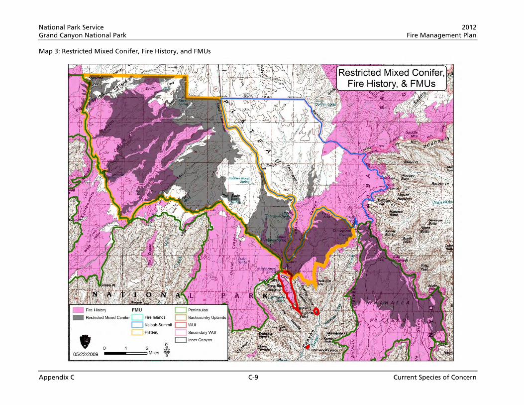
National Park Service 2012 Grand Canyon National Park Fire Management Plan
Appendix C C-9 Current Species of Concern
Map 3: Restricted Mixed Conifer, Fire History, and FMUs
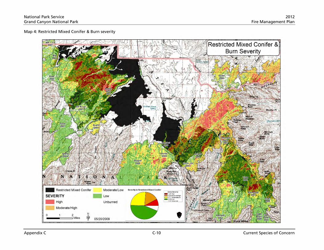
National Park Service 2012 Grand Canyon National Park Fire Management Plan
Appendix C C-10 Current Species of Concern
Map 4: Restricted Mixed Conifer & Burn severity

National Park Service 2012 Grand Canyon National Park Fire Management Plan
Appendix C C-11 Current Species of Concern
Table 2: MSO Burn history analysis of restricted habitat in GRCA.
Critical Habitat Area Acres Proportion of totals Mixed conifer restricted habitat above the rim used for effects analysis
27,100 72% of mixed-conifer habitat in GRCA in CP-10
Mixed conifer restricted habitat acres burned since 2000
18,300 68% of mixed-conifer restricted habitat
Mixed conifer restricted habitat acres not burned
8,800 32% of mixed-conifer restricted habitat
Maximum acres of mixed-conifer restricted habitat allowed to burn at moderate high to high severity based on identified Conservation Measures
8,130 30% of mixed-conifer restricted habitat
Mixed conifer restricted habitat acres that have burned at moderate high to high severity since 2000
4,347 16% of mixed-conifer restricted habitat
Maximum number of mixed-conifer restricted habitat acres that may burn at moderate high to high severity under the proposed action
3,783 14% of mixed-conifer restricted habitat
Southwestern Willow Flycatcher
On March 29, 1995, the southwestern willow flycatcher (Empidonax traillii extimus) was designated as endangered in its entire range, which is known to include Arizona, California, Colorado, New Mexico, Texas, Utah, and Mexico. Critical habitat was first designated in 1997. Following legal challenges, critical habitat was set aside in 2001 and then re-proposed on October 12, 2004. Proposed critical habitat within GRCA was excluded in the final listing as the area was covered under the Lower Colorado River Multi-Species Conservation Plan.
The southwestern willow flycatcher is a small bird, approximately 15 centimeters (cm) (5.75 inches) long. It has a grayish-green back and wings, whitish throat, light grey-olive breast, and pale yellowish belly. Two wingbars are visible; the eye ring is faint or absent. The upper mandible is dark, the lower is light.
The southwestern willow flycatcher occurs in riparian habitats along rivers, streams, or other wetlands, where dense growths of willows (Salix sp.), Baccharis sp., arrowweed (Pluchea sp.), buttonbush (Cephalanthus sp.), tamarisk (Tamarix sp.), Russian olive (Eleagnus sp.) or other plants are present, often with a scattered overstory of cottonwood (Populus sp.) (USFWS 1995a). The southwestern willow flycatcher was listed primarily due to riparian habitat reduction, degradation and elimination as a result of agricultural and urban development. Fire and fire management activities have not been cited as a threat to the southwestern willow flycatcher.
The southwestern willow flycatcher is found in the Colorado River corridor over eight miles from the nearest project site. The species does not occur near the forested plateau where the fire management program will be implemented. In addition, the fire program will adhere to air quality standards set by ADEQ for a Class 1 air-shed and for current health standards. Therefore, the fire management program will have no effect on the southwestern willow flycatcher.
Desert Tortoise
The desert tortoise (Mohave population) was listed at threatened in 1990 and critical habitat was designated in 1994. The Mohave population occurs north and west of the Colorado River. The Sonoran population occurs to the south and east of the Colorado River and within the western edge of GRCA on the south side of the Colorado River; this population is not listed as endangered or threatened. Critical habitat for the Mohave desert tortoise was designated in 1994 and includes areas adjacent to GRCA in Lake Mead National Recreation Area.
National Park Service 2012 Grand Canyon National Park Fire Management Plan
Appendix C C-12 Current Species of Concern
The desert tortoise was listed due to precipitous declines in numbers in many areas. Declines are mainly attributed to direct and indirect human-caused mortality coupled with the inadequacy of existing regulatory mechanisms to protect desert tortoise and their habitat. Threats to the species include roads, grazing, development, mining, and concentrated visitor use. Upper respiratory tract disease is an additional cause of desert tortoise mortality and population decline (USFWS 1994a). Fire and fire management activities have not been cited as threats to the desert tortoise.
As prescribed fire and wildfires managed for resource benefit will occur greater than 50 miles from possible desert tortoise habitat, nor have the possibility of reaching desert tortoise habitat, the fire management program will have no effect on the desert tortoise.
California Condor
California condors are among the largest flying birds in the world. Adults weigh approximately 10 kilograms (22 lbs.) and have a wing span up to 2.9 meters (9.5 ft). Adults are black except for prominent white underwing linings and edges of the upper secondary coverts. The head and neck are mostly naked, and the bare skin is gray, grading into various shades of yellow, red, and orange. The California condor was listed as endangered on March 11, 1967 in a final rule published by the U.S. Fish and Wildlife Service. The Service then established critical habitat for the California condor nine years later on September 24, 1976. Long recognized as a vanishing species, the California condor remains one of the world’s rarest and most imperiled vertebrate species.
No Take of California condors occurred during implementation of the Prescribed Fire Program or Wildland Fire-Use Program from 2003 through 2008, as defined in the Incidental Take Statements provided in the August 22, 2003 and June 11, 2003 Biological Opinions respectively.
The possibility of direct mortality from fire is highly unlikely because of the mobility of condors and the fact that they rarely nest or roost in forested habitat. Attraction by the condor to busy sites may increase the potential for interaction between condors and humans. Hazing of condors by non-permitted personnel or habituation to humans could have negative impacts on condors. Educating firefighters and other personnel about condor concerns (as described in the conservation measures, above) will reduce potential negative impacts from suppression and monitoring activities. Normal mitigation measures in construction projects require crews to stop activity if condors arrive on the site. This mitigation measure will be protocol during manual/mechanical thinning operations. However, it may not be possible for firefighters to cease activity if condors are attracted to fireline construction areas during a fire. Instead, the resource advisor assigned to the fire will be notified of the presence of condors and will arrange for hazing of the condors by permitted personnel. This will reduce the likelihood of negative effects to condors from human interactions.
Fire management activities may increase the potential for condors’ habituation to humans, for collisions between condors and aircraft, for damage to condor habitat, and for disturbance to condors by personnel, aircraft, or smoke. The above-stated conservation measures will reduce the likelihood of these potential effects, but as there is a realistic possibility that any or all may occur, we conclude that these projects may affect, and are likely to adversely affect the California condor.
Yellow-Billed Cuckoo
The yellow-billed cuckoo is a late migrant associated with large tracts of riparian deciduous forest where willow, cottonwood, sycamore, or alder occur. Yellow-billed cuckoos arrive on the breeding grounds beginning in mid- to late May and initiate nesting activity in early to mid-June (southern California) through late August and frequently into September (southeastern Arizona), with the peak occurring in mid-July and early August (Corman and Magill 2000), and may be triggered by an abundance of the cicadas, katydids, caterpillars, or other large prey which form the bulk of the species’ diet (USFWS 2001a). Yellow-billed cuckoos in higher elevations may be found in mesquite and tamarisk. Arizona probably contains the largest remaining yellow-billed cuckoo population among the states west of the Rocky

National Park Service 2012 Grand Canyon National Park Fire Management Plan
Appendix C C-13 Current Species of Concern
Mountains; 168 pairs and 80 single birds were located in Arizona in 1999, based on preliminary results from a State-wide survey which covered 427 km (265 miles) of river and creek bottom. Fire and fire management activities have not been cited as threats to this species.
The yellow-billed cuckoo is found in the Colorado River corridor over four miles from the nearest fire management area. The species does not occur near the forested plateau where the fire management program will be implemented. In addition, the fire program will adhere to air quality standards set by ADEQ for a Class 1 air-shed and for current health standards. Therefore, we conclude that the fire management program will have no effect on the yellow-billed cuckoo.
Relict Leopard Frog
The relict leopard frog was listed as a candidate in July 2002 by the U.S. Fish and Wildlife Service (67 FR 40657). Suitable habitat includes permanent streams, springs, and spring-fed wetlands with relatively open shorelines. This medium-sized frog is 1.75 to 3.5 inches in length and is brown, gray, or greenish in color, with greenish-brown spots. Causes for decline of this species are not entirely clear. Factors contributing to population decline could include alteration of aquatic habitat, including regulation of the Colorado River, and the introduction of exotic species. Exotic species negatively impact the relict leopard frog through predation, competition, and alteration of habitat structure (e.g. tamarisk) (USFWS 2007).
The relict leopard frog is not confirmed to occur in GRCA. Major drainages and seeps and springs in the project area have been surveyed with negative results. In addition, little potential habitat is found on the forested plateau where the fire management program will be implemented. Therefore, we conclude that these projects will have no effect on the relict leopard frog.

National Park Service 2012 Grand Canyon National Park Fire Management Plan
Appendix C C-14 Current Species of Concern
Literature Cited
Arizona Game and Fish Department (AGFD). 2001. Gila Cypha. Unpublished abstract compiled and edited by the Heritage Data Management System, Arizona Game and Fish Department, Phoenix. Available online at www.azgfd.com/wildlife_conservation/edits/hdms_abstracts_fish.html
Corman, T.E., and R.T. Magill. 2000. Western yellow-billed cuckoo in Arizona: 1998 and 1999 survey report. Arizona Game and Fish, Technical Report 150. 49 pp.
Ganey, J. L., and R. P. Balda. 1989a. Distribution and habitat use of Mexican spotted owls in Arizona. Condor 91:355-361.
Ganey, J. L., and R. P. Balda. 1989b. Home range characteristics of spotted owls in northern Arizona. Journal of Wildlife Management 53:1159-1165.
Ganey, J. L., and R. P. Balda 1994. Habitat selection by Mexican spotted owls in northern Arizona. Auk 111:162-169.
Gutierrez, R. J., A. B. Franklin, and W. S. LaHaye. 1995. Spotted Owl. The Birds of North America. No. 179.
Shields, M. 2002. Brown Pelican (Pelicanus occidentalis). In Birds of North American, No. 609 (A. Poole and F. Gill, eds.). The Brids of North America, Inc., Philadelphia, PA. 36 pp.
Willey, D.W. and R.V. Ward. 2003. Mexican spotted owl distribution and habitat within Grand Canyon National Park. Natural Resource Management. George Wright Society Publication. pp. 328-334.
Zwank, P. J., K. W. Kroel, D.M. Levin, G.M. Southward, and R. C. Romme. 1994. Habitat characteristics of Mexican spotted owls in southern New Mexico. Journal of Field Ornithology 65:324-334.
U.S. Fish and Wildlife Service (USFS)
1991 The razorback sucker (Xyrauchen texanus) determined to be an endangered species. U.S. Fish and Wildlife Service. Federal Register (56) 205: 54957 54967. 11pp.
1994a Desert Tortoise (Mojave population) Recovery Plan. U.S. Fish & Wildlife Service, Portland, Oregon. 73 pp.
1995a Final Rule Determining Endangered Status for the Southwestern Willow Flycatcher. U.S. Fish and Wildlife Service. Federal Register, Vol. 60, No. 38. 23 pp.
1995b Kanab ambersnail (Oxyloma haydeni kanabensis) Recovery Plan. U.S. Fish and Wildlife Service, Denver, Colorado. 21 pp .
1995c Recovery plan for the Mexican spotted owl: Vol. I. U.S. Fish and Wildlife Service, Albuquerque, New Mexico. 172 pp.
2001 Final Designation of Critical Habitat for the Mexican Spotted Owl. U.S. Fish and Wildlife Service. Federal Register, Vol. 66, No. 22. 24 pp.
2001a General Species Information – Yellow-billed Cuckoo. September 2001. U.S. Fish and Wildlife Service. 1 page.
2004d Final Designation of Critical Habitat for the Mexican Spotted Owl. U.S. Fish and Wildlife Service. Federal Register, Vol. 69, No. 168. 118 pp.
2007 Review of native species that are candidates for listing as endangered or threatened; Annual notice of findings on resubmitted petition; annual description of progress on listing actions; proposed rule. U.S. Fish and Wildlife Service. Federal Register Vol 72, No 234.
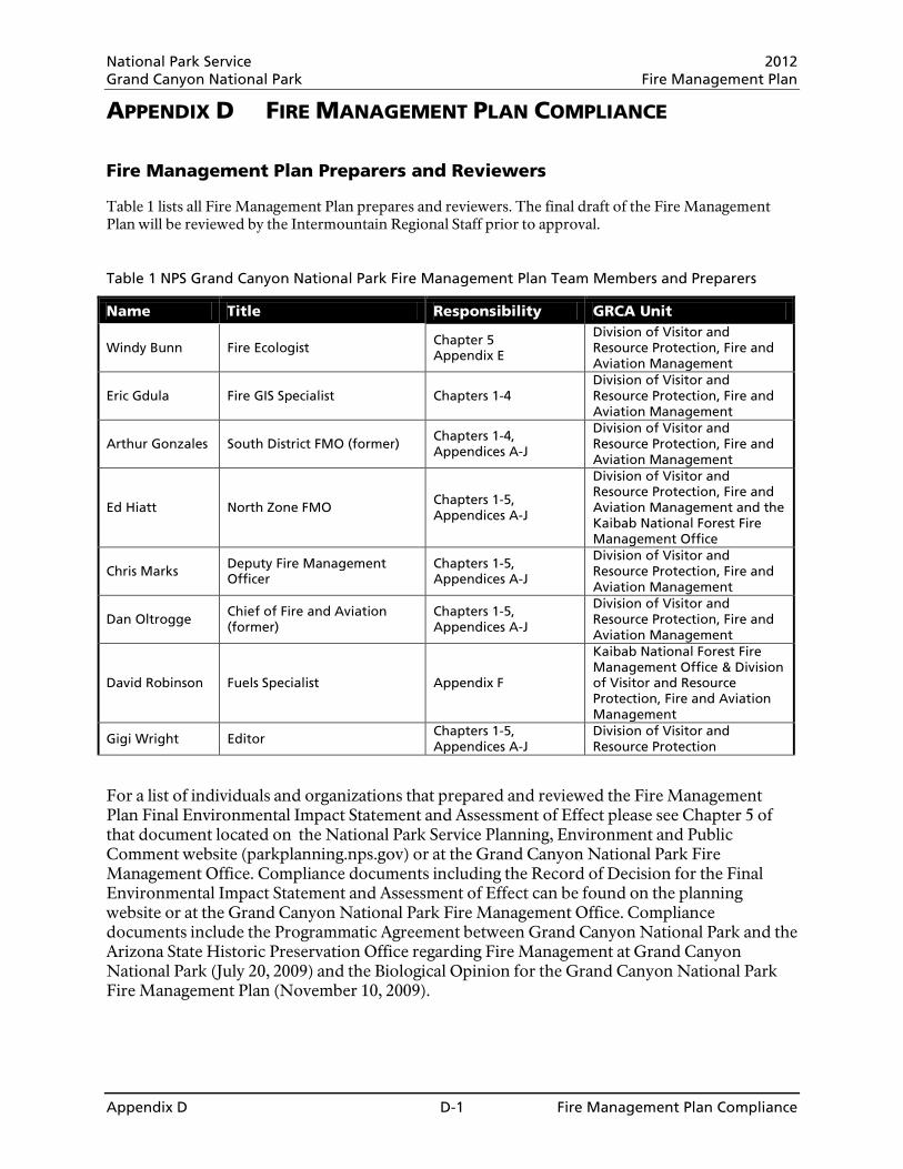
National Park Service 2012 Grand Canyon National Park Fire Management Plan
Appendix D D-1 Fire Management Plan Compliance
APPENDIX D FIRE MANAGEMENT PLAN COMPLIANCE Fire Management Plan Preparers and Reviewers Table 1 lists all Fire Management Plan prepares and reviewers. The final draft of the Fire Management Plan will be reviewed by the Intermountain Regional Staff prior to approval. Table 1 NPS Grand Canyon National Park Fire Management Plan Team Members and Preparers
Name Title Responsibility GRCA Unit
Windy Bunn Fire Ecologist Chapter 5 Appendix E
Division of Visitor and Resource Protection, Fire and Aviation Management
Eric Gdula Fire GIS Specialist Chapters 1-4 Division of Visitor and Resource Protection, Fire and Aviation Management
Arthur Gonzales South District FMO (former) Chapters 1-4, Appendices A-J
Division of Visitor and Resource Protection, Fire and Aviation Management
Ed Hiatt North Zone FMO Chapters 1-5, Appendices A-J
Division of Visitor and Resource Protection, Fire and Aviation Management and the Kaibab National Forest Fire Management Office
Chris Marks Deputy Fire Management Officer
Chapters 1-5, Appendices A-J
Division of Visitor and Resource Protection, Fire and Aviation Management
Dan Oltrogge Chief of Fire and Aviation (former)
Chapters 1-5, Appendices A-J
Division of Visitor and Resource Protection, Fire and Aviation Management
David Robinson Fuels Specialist Appendix F
Kaibab National Forest Fire Management Office & Division of Visitor and Resource Protection, Fire and Aviation Management
Gigi Wright Editor Chapters 1-5, Appendices A-J
Division of Visitor and Resource Protection
For a list of individuals and organizations that prepared and reviewed the Fire Management Plan Final Environmental Impact Statement and Assessment of Effect please see Chapter 5 of that document located on the National Park Service Planning, Environment and Public Comment website (parkplanning.nps.gov) or at the Grand Canyon National Park Fire Management Office. Compliance documents including the Record of Decision for the Final Environmental Impact Statement and Assessment of Effect can be found on the planning website or at the Grand Canyon National Park Fire Management Office. Compliance documents include the Programmatic Agreement between Grand Canyon National Park and the Arizona State Historic Preservation Office regarding Fire Management at Grand Canyon National Park (July 20, 2009) and the Biological Opinion for the Grand Canyon National Park Fire Management Plan (November 10, 2009).

National Park Service 2012 Grand Canyon National Park Fire Management Plan
_________________________________________________________________________________________ Appendix F F- 1 Fire Monitoring Plan
Appendix F:
Grand Canyon National Park Wildland and Prescribed Fire Monitoring & Research Plan
National Park Service 2012 Grand Canyon National Park Fire Management Plan
_________________________________________________________________________________________ Appendix F F- 2 Fire Monitoring Plan
F.1 Introduction ................................................................................................................................ 4
F.2 Fire and Fuel Management ....................................................................................................... 5
F.3 Ecology and Landscape Management ...................................................................................... 8
F.3.1 Spruce-Fir Forest .................................................................................................................. 9 F.3.2 Mixed-Conifer Forest ........................................................................................................... 10 F.3.3 Ponderosa Pine Forest ....................................................................................................... 13 F.3.4 Piñon-Juniper ...................................................................................................................... 15 F.3.5 Montane-Subalpine Grassland ............................................................................................ 17
F.4 Management Goals and Objectives ........................................................................................ 18
F.4.1 Resource Management, Fire Management, and Fire Ecology Goals ................................. 18 F.4.2 Treatment and Monitoring Objectives ................................................................................. 18 F.4.3 Desired Conditions .............................................................................................................. 23
F.5 Monitoring Design .................................................................................................................... 26
F.5.1 Environmental Monitoring ................................................................................................... 26 F.5.2 Fire Observation Monitoring ................................................................................................ 27 F.5.3 Short- and Long-term Vegetation and Fuel Change ........................................................... 29 F.5.4 Burn Severity Mapping ........................................................................................................ 35 F.5.5 Additional Short- and Long-term Resource Monitoring ....................................................... 37
F.6 Data Management and Analysis.............................................................................................. 38
F.6.1 Data Management and Quality Control ............................................................................... 38 F.6.2 Data Analysis ...................................................................................................................... 39 F.6.3 Data Sharing ....................................................................................................................... 39
F.7 Reporting and Adaptive Management ..................................................................................... 40
F.8 Fire Research .......................................................................................................................... 42
F.8.1 Past and Current Research ................................................................................................. 42 F.8.2 Research Needs.................................................................................................................. 42
F.9 Roles and Responsibilities ...................................................................................................... 45
F.9.1 Staff roles and responsibilities ............................................................................................ 45 F.9.2 Work plans and prioritization ............................................................................................... 46
F.10 Consultation, Collaboration and Review ................................................................................. 47
F.10.1 Plan Input ........................................................................................................................ 47 F.10.2 Agency/Interagency Collaboration .................................................................................. 48 F.10.3 Peer review ..................................................................................................................... 48
F.11 References .............................................................................................................................. 49
F.12 Appendices .............................................................................................................................. 53
F.12.1 Monitoring Unit Descriptions (FMH-4s) ........................................................................... 53 F.12.2 Monitoring Schedule ....................................................................................................... 74 F.12.3 Data Sheets .................................................................................................................... 86 F.12.4 Plant List ....................................................................................................................... 121 F.12.5 Monitoring Results ........................................................................................................ 122 F.12.6 Calculations .................................................................................................................. 130 F.12.7 Special Status and Exotic Species of Concern ............................................................ 134
National Park Service 2012 Grand Canyon National Park Fire Management Plan
_________________________________________________________________________________________ Appendix F F- 3 Fire Monitoring Plan
List of Tables and Figures Table F.2.1. Relationship between the eight FMUs and the park’s major vegetation types, fire history,
and monitoring types. ..................................................................................................................... 6
Figure F.3.1. Distribution of vegetation types in GRCA.......................................................................... 8
Table F.3.1. Land area burned between 1984 and 2009 by vegetation type and number of times an area has burned during this time period.. ...................................................................................... 9
Figure F.3.2. Ecological model of spruce-fir forest. .............................................................................. 10
Figure F.3.3. Ecological model of mixed-conifer forest on dry ridgetops and south-facing slopes ...... 11
Figure F.3.4. Ecological model of mixed-conifer forest on mesic sites such as north-facing slopes. .. 12
Figure F.3.5. Ecological model of ponderosa pine forest ..................................................................... 14
Figure F.3.6. Ecological model of piñon-juniper woodlands. ................................................................ 16
Figure F.3.7. Ecological model of montane-subalpine grassland ........................................................ 17
Table F.4.1. First entry burn objectives from the 2000 Plan and the 2010 restoration and maintenance objectives to be implemented with this plan for each monitoring type within GRCA. .................. 19
Table F.4.2. Ponderosa pine forest desired conditions for GRCA. ...................................................... 24
Table F.5.1. NPS four-level approach to fire monitoring and potential variables for each level. ......... 26
Table F.5.2. Monitoring elements measured for each fire management strategy. ............................... 26
Table F.5.3. Overview of GRCA FMH monitoring types....................................................................... 30
Figure F.5.1. Standard plot layout for FMH monitoring plots ............................................................... 31
Table F.5.4. Results of minimum sample size calculations .................................................................. 31
Figure F.5.2. Pilot RAP plot layout. ...................................................................................................... 34
Table F.5.5. Severity classes and associated ecological changes ...................................................... 35
Table F.10.1. Individuals who provided input during monitoring plan development. ........................... 47

National Park Service 2012 Grand Canyon National Park Fire Management Plan
_________________________________________________________________________________________ Appendix F F- 4 Fire Monitoring Plan
F.1 Introduction One of the central goals of the Grand Canyon National Park (GRCA) Fire Management Program is to promote a science-based program that relies on current and best-available information and incorporates adaptive management practices. The GRCA Fire Ecology Program is responsible for providing short- and long-term data on vegetation and fuel change and for generating burn severity mapping data. Working in collaboration with Prescribed Fire Burn Bosses and fire Incident Commanders, the GRCA Fire Ecology Program also provides support for fire observation monitoring in the park. The environmental monitoring and additional short- and long-term resource monitoring that contribute to fire management decisions are the responsibility of the individuals or groups outlined in sections F.5.1 and F.5.5 of this plan. Since 1990 GRCA has maintained an active fire effects monitoring program that allows fire managers to evaluate the effectiveness of the prescribed fire program and adapt future practices to better meet management objectives. The first formal GRCA fire effects monitoring plan (NPS 2000) outlined procedures for monitoring active fires in the park and monitoring long-term vegetation and fuel load changes as a result of prescribed burning. In the time since the first monitoring plan was formalized, the GRCA Fire Management Program has revised its program goals and objectives in the form of a new Fire Management Plan (FMP) based on current Federal Wildland Fire Management Policy (U.S. Government 2001) and National Park Service (NPS) Wildland Fire Management policy (NPS 2008b). Other changes that have occurred since the previous monitoring plan was finalized include (1) 36 fires totaling over 90,000 acres have burned in the park, (2) the park has participated in nine years of burn severity mapping through the Joint NPS-USGS National Burn Severity Mapping Project, (3) over 20 research papers specific to the park have been published relating to reference conditions, fire regimes, vegetation, and fuel, (4) Mexican spotted owl critical habitat has been designated within the park (USFWS 2004), (5) a sentry milk-vetch recovery plan has been finalized (USFWS 2006), (6) new desired conditions have been formulated for the major vegetation types in the park, and (7) a Fire Ecologist position has been established to manage the Fire Ecology Program. As an appendix to the 2010 GRCA FMP, this monitoring plan describes the current and planned framework for collecting, managing, evaluating and integrating fire monitoring information. Fire monitoring is a critical component of fire management and is aimed at providing information on the effectiveness of the Fire Management Program. The primary focus of the GRCA fire monitoring program is the assessment of vegetation and fuel conditions and the determination of how these conditions are affected by fire management activities. However, the program also monitors fire and weather conditions during prescribed and unplanned fires, conducts burn severity assessments under the National Burn Severity Mapping Program, and facilitates the collection of site-specific information used for compliance and consultation requirements under the National Environmental Policy Act, Endangered Species Act, and National Historic Preservation Act. Monitoring programs are intended to continuously inform fire managers about the effects of management activities so that fire management programs can adapt to changing conditions using the best available information. As new information and research results are obtained, relevant changes to the monitoring and/or fire management programs are made. These changes may include new or alternative monitoring techniques, changes in treatment prescriptions, or refinement of management objectives. Integration of fire monitoring data is a shared responsibility between the park's fire management and natural and cultural resource management staff. Changes to the GRCA Fire Ecology Program will be reflected in annual updates to this monitoring plan.
National Park Service 2012 Grand Canyon National Park Fire Management Plan
_________________________________________________________________________________________ Appendix F F- 5 Fire Monitoring Plan
F.2 Fire and Fuel Management The GRCA Fire Management Program uses a variety of strategies to achieve the goals of protecting human safety and property, restoring and maintaining ecosystems, and protecting park values. GRCA has used prescribed fire since 1980 to meet resource management goals and objectives and has managed wildfires to meet resource objectives since 1987. In addition to managing prescribed and unplanned fires, the GRCA Fire Management Program will employ non-fire manual and mechanical fuel treatments to protect human safety and property and cultural and natural resource values. The role of fire management in meeting park stewardship goals and the strategies employed to meet management goals are discussed in detail in section 1.6 and 2.6, respectively, of the GRCA Fire Management Plan EIS/AEF (NPS 2009a). To facilitate fire and fuel management planning, the park is divided into eight Fire Management Units (FMUs) based on fuel characteristics and fire regimes. The eight FMUs have dissimilar levels of development, meteorology, history, and values at risk (including cultural resources and species of concern) that are described in detail in section 2.6.5.2 of the GRCA Fire Management Plan EIS/AEF (NPS 2009a). The FMU division is used for strategic planning and management; however the fire monitoring program is based on vegetation types which cross FMU boundaries. The relationship between the eight FMUs and the park’s major vegetation types, fire history, and monitoring types is summarized in Table F.2.1.

National Park Service 2012 Grand Canyon National Park Fire Management Plan
Appendix F F- 6 Fire Monitoring Plan
Table F.2.1. Relationship between the eight FMUs and the park’s major vegetation types, fire history, and monitoring types. WUI = Wildland Urban Interface.
FMU Acres
(% of Park) Vegetation Types Role of Fire Fire Regime Alteration Management
Focus Monitoring
Focus1
Monitoring Units2
(# plots)
Kaibab Summit 15,879 (1.33%)
Spruce-fir forest with some mixed conifer on drier sites and meadows and aspen groves interspersed
Spruce-fir forest species are intolerant of fire; mixed-severity fire regime and infrequent stand-replacing fire occurs
Little change to fire regime, possibly some meadow encroachment and fewer aspen
Maintain native ecosystems
Levels 1, 2, 3, and 4; Severity Mapping
PIEN (8), PIAB (4)
Plateau 32,564 (2.73%)
Transitions from ponderosa pine to mixed conifer to spruce-fir with elevation; large and small meadows and aspen stands interspersed
Mixed-conifer forest structure depends on mixed-severity fire
Relatively homogeneous forest structure developed in absence of fire
Restore and maintain native ecosystems
Levels 1, 2, 3, and 4; Severity Mapping
PIEN (9), PIAB (4), PIPN (1), GRED (5), GRIN (9)
Peninsulas 48,807 (4.09%)
Predominantly ponderosa pine
Ponderosa forest structure depends on frequent surface fires
Heavy understory developed in absence of fire, much restored to open understory by managed fire
Restore and maintain native ecosystems
Levels 1, 2, 3, and 4; Severity Mapping
PIAB (19), PIPN (29), GRED (1), GRIN (1), PIPO (8)
Fire Islands 13,454 (1.13%)
Ponderosa pine, piñon-juniper
Ponderosa forest structure depends on frequent surface fires; mixed fire regimes in other types require more research
Essentially unaltered, cited in literature as best relics of pre-Euro-American conditions
Preserve best regional examples of natural fire regimes
Levels 1 and 2; Severity Mapping
none
Backcountry Uplands
119,069 (9.98%)
Piñon-juniper woodlands, sagebrush meadows, juniper savannas, some stringers of ponderosa pine
Mixed fire regimes may occur in this type; more research is needed
Unknown; possibly canopy closure
Restore and maintain native ecosystems
Levels 1 and 2; Severity Mapping
none
WUI Developed Areas
14,611 (1.22%)
Piñon-juniper woodlands, ponderosa pine, some mixed conifer and riparian types
See Peninsulas & Backcountry Uplands description
Heavy understory developed in absence of fire, little restored to open understory by managed fire
Protect life and property in a natural setting
Levels 1, 2, 3, and 4; Severity Mapping
PIPO (15), PIED (11)

National Park Service 2012 Grand Canyon National Park Fire Management Plan
Appendix F F- 7 Fire Monitoring Plan
FMU Acres
(% of Park) Vegetation Types Role of Fire Fire Regime Alteration Management
Focus Monitoring
Focus1
Monitoring Units2
(# plots)
Secondary WUI 15,188 (1.27%)
Ponderosa pine, piñon-juniper woodland
See Peninsulas & Backcountry Uplands description
Heavy understory developed in absence of fire, much restored to open understory by managed fire
Augment WUI protection with native ecosystems
Levels 1, 2, 3, and 4; Severity Mapping
PIPO (17), PIED (6)
Inner Canyon 933,032 (78.23%)
Desert shrublands, riparian, some piñon-juniper and forested communities on upper canyon walls
Sparse vegetation and fuel do not support fire as a major disturbance agent
Extensive growth of annual exotics could fundamentally alter fire regime
Maintain native ecosystems
Levels 1 and 2; Severity Mapping
none
1Monitoring focus levels are defined and described in section F.5. 2Monitoring Units are defined and described in section F.5 and appendix F.12.1.
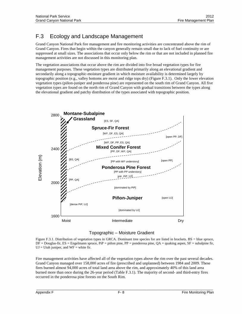
National Park Service 2012 Grand Canyon National Park Fire Management Plan
_________________________________________________________________________________________ Appendix F F- 8 Fire Monitoring Plan
F.3 Ecology and Landscape Management Grand Canyon National Park fire management and fire monitoring activities are concentrated above the rim of Grand Canyon. Fires that begin within the canyon generally remain small due to lack of fuel continuity or are suppressed at small sizes. The associations that occur only below the rim or that are not included in planned fire management activities are not discussed in this monitoring plan.
The vegetation associations that occur above the rim are divided into five broad vegetation types for fire management purposes. These vegetation types are distributed primarily along an elevational gradient and secondarily along a topographic-moisture gradient in which moisture availability is determined largely by topographic position (e.g., valley bottoms are moist and ridge tops dry) (Figure F.3.1). Only the lower elevation vegetation types (piñon-juniper and ponderosa pine) are represented on the south rim of Grand Canyon. All five vegetation types are found on the north rim of Grand Canyon with gradual transitions between the types along the elevational gradient and patchy distribution of the types associated with topographic position.
Elev
atio
n (m
)
Topographic – Moisture Gradient
Moist DryIntermediate
Ponderosa Pine Forest
Mixed Conifer Forest
Spruce-Fir Forest
[PP, PiP, UJ]
[BS, QA]
[open PP, DF][WF, DF, ES, QA]
[PP with PP understory]
[open PP]
[WF, DF, PP, ES, QA]
[PP, QA]
[PP with WF understory]
[ES, SF, QA]
Piñon-Juniper[dense PiP, UJ]
[open UJ]
[PP, DF, WF, QA]
[dominated by UJ]
[dominated by PiP]
2800
2400
2000
1600
Montane-SubalpineGrassland
Figure F.3.1. Distribution of vegetation types in GRCA. Dominant tree species for are listed in brackets. BS = blue spruce, DF = Douglas-fir, ES = Engelmann spruce, PiP = piñon pine, PP = ponderosa pine, QA = quaking aspen, SF = subalpine fir, UJ = Utah juniper, and WF = white fir.
Fire management activities have affected all of the vegetation types above the rim over the past several decades. Grand Canyon managed over 158,000 acres of fire (prescribed and unplanned) between 1984 and 2009. These fires burned almost 94,000 acres of total land area above the rim, and approximately 40% of this land area burned more than once during the 26-year period (Table F.3.1). The majority of second- and third-entry fires occurred in the ponderosa pine forests on the South Rim.
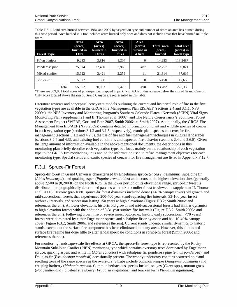
National Park Service 2012 Grand Canyon National Park Fire Management Plan
_________________________________________________________________________________________ Appendix F F- 9 Fire Monitoring Plan
Table F.3.1. Land area burned between 1984 and 2009 by vegetation type and number of times an area has burned during this time period. Area burned in 1 fire includes acres burned only once and does not include areas that have burned multiple times.
Forest Type
Area (acres)
burned in 1 fire
Area (acres)
burned in 2 fires
Area (acres)
burned in 3 fires
Area (acres)
burned in 4 fires
Total area (acres) burned
Total area (acres) in
forest type
Piñon-Juniper 9,233 3,816 1,204 0 14,253 113,248*
Ponderosa pine 25,874 22,430 3,966 487 52,757 59,821
Mixed-conifer 15,623 3,421 2,259 11 21,314 37,616
Spruce-Fir 5,072 386 0 0 5,458 17,653
Total 55,802 30,053 7,429 498 93,782 228,338 *There are 309,881 total acres of piñon-juniper mapped in park, with 63% of this acreage below the rim of Grand Canyon. Only acres located above the rim of Grand Canyon are represented in this table. Literature reviews and conceptual ecosystem models outlining the current and historical role of fire in the five vegetation types are available in the GRCA Fire Management Plan EIS/AEF (sections 2.4 and 3.1.1; NPS 2009a), the NPS Inventory and Monitoring Program’s Southern Colorado Plateau Network (SCPN) Vital Signs Monitoring Plan (supplements I and II, Thomas et al. 2006), and The Nature Conservancy’s Southwest Forest Assessment Project (SWFAP; Gori and Bate 2007, Smith 2006a-c, Smith 2007). Additionally, the GRCA Fire Management Plan EIS/AEF (NPS 2009a) contains detailed information on plant and wildlife species of concern in each vegetation type (sections 3.1.2 and 3.1.5, respectively), exotic plant species concerns for fire management (sections 3.1.3 and 4.2.3), the use of fire and fuel management techniques in cultural landscapes (sections 3.2.4 and 4.3), and existing fuel conditions and expected fire behavior (sections 2.4 and 2.6.5). Given the large amount of information available in the above-mentioned documents, the descriptions in this monitoring plan briefly describe each vegetation type, but focus mainly on the relationship of each vegetation type to the GRCA fire monitoring units and on the information used to refine management objectives for each monitoring type. Special status and exotic species of concern for fire management are listed in Appendix F.12.7.
F.3.1 Spruce-Fir Forest Spruce-fir forest in Grand Canyon is characterized by Engelmann spruce (Picea engelmannii), subalpine fir (Abies lasiocarpa), and quaking aspen (Populus tremuloides) and occurs in the highest elevation sites (generally above 2,500 m (8,200 ft) on the North Rim. In the lower portion of its elevational range, spruce-fir forest is distributed in topographically determined patches with mixed conifer forest (reviewed in supplement II, Thomas et al. 2006). Historic (pre-1880) spruce-fir forest dynamics included dense (>40% canopy cover) old growth and mid-successional forests that experienced 200-400 year stand-replacing fire intervals, 33-100 year insect outbreak intervals, and succession lasting 150 years at high elevations (Figure F.3.2; Smith 2006c and references therein). At lower elevations, historic old growth and mid-successional forests had similar dynamics to high elevation forests with the addition of 8-31 year surface fire intervals (Figure F.3.2; Smith 2006c and references therein). Following crown fire or severe insect outbreaks, historic early successional (<70 years) forests were dominated by either Engelmann spruce and subalpine fir or by aspen and had 10-40% canopy cover (Figure F.3.2; Smith 2006c and references therein). Current stands undergo similar dynamics to historic stands except that the surface fire component has been eliminated in many areas. However, this eliminated surface fire regime has done little to alter landscape-scale conditions in spruce-fir forest (Smith 2006c and references therein).
For monitoring landscape-scale fire effects at GRCA, the spruce-fir forest type is represented by the Rocky Mountain Subalpine Conifer (PIEN) monitoring type which contains overstory trees dominated by Engelmann spruce, quaking aspen, and white fir (Abies concolor) with subalpine fir, ponderosa pine (Pinus ponderosa), and Douglas-fir (Pseudotsuga menziesii) occasionally present. The woody understory contains scattered pole and seedling trees of the same species as the overstory. Shrubs include common juniper (Juniperus communis) and creeping barberry (Mahonia repens). Common herbaceous species include sedges (Carex spp.), mutton grass (Poa fendleriana), blueleaf strawberry (Fragaria virginiana), and bracken fern (Pteridium aquilinum).

National Park Service 2012 Grand Canyon National Park Fire Management Plan
_________________________________________________________________________________________ Appendix F F- 10 Fire Monitoring Plan
Figure F.3.2. Ecological model of spruce-fir forest (adapted from Smith 2006c and supplement II, Thomas et al. 2006). Solid lines and boxes represent states and processes occurring in both historic and current forests, dotted lines indicate historic processes that have been altered. Dominant tree species codes are listed in Figure F.3.1.
Between 1984 and 2009, approximately 31% (5,458 acres) of the spruce-fir forest in the park burned in unplanned wildfires (Table F.3.1). Moderate-high and high severity fire has played a larger role in this vegetation type than in the other vegetation types in the park. More than half of the spruce-fir forest that has burned in the park in recent decades burned with moderate-high to high severity effects (see patch size discussion in Appendix F.12.5 and burn severity mapping overview in section F.5.3.). To date, no prescribed fires have been conducted in this vegetation type in the park.
Seventeen FMH-style forest monitoring plots (section F.5.2) have been installed in the spruce-fir forest type. Five of the 17 plots were installed after the Outlet Fire of 2000 to monitor post-fire regeneration in moderate-high and high severity areas and do not have pre-fire data. Two additional plots that burned in the Outlet Fire have pre- and post-fire data as do three plots that burned in resource benefit wildfires. Monitoring data indicate that unplanned fires in this forest type reduce total surface fuel loading by 45 – 84% (average 60% ± 14) and reduce conifer tree density by 28 – 100% (average 70% ± 21) (Appendix F.12.5). Prior to fire, total fuel loading averaged 66.2 ± 8.1 tons/acre with 44% of the total loading contributed by 1000-hr timelag fuel moisture (TLFM) woody fuel and 46% of the total fuel loading contributed by litter + duff. Immediately after fire, total fuel loading averaged 24.9 ± 6.7 tons/acre with 73% of the total loading contributed by 1000-hr TLFM woody fuel. By five years after fire, total fuel loading increased to 41.6 ± 5.8 tons/acre with 72% of the total loading contributed by 1000-hr TLFM woody fuel.
One prescribed fire (Thompson-North Boundary) is planned for this type in the current FMP. The Thompson-North Boundary prescribed fire is designed primarily as a boundary protection burn to protect sensitive natural resources on the Kaibab National Forest from wildfires originating in the park. Even though most of this vegetation type has not had a fire in the last 100 years, the historic fire regime in this type is highly variable and likely to have moderate/long return intervals (Fulé et al. 2003a). Planned fire management activities are not currently focused on this type.
F.3.2 Mixed-Conifer Forest The mixed-conifer forest type occurs on the north rim of the Grand Canyon at approximately 2,380 - 2,793 m (7,800 – 9,165 ft) elevation. GRCA mixed-conifer forest consists of a mosaic of topographically-determined patches dominated by different combinations of ponderosa pine, white fir, Douglas-fir, Engelmann spruce,

National Park Service 2012 Grand Canyon National Park Fire Management Plan
_________________________________________________________________________________________ Appendix F F- 11 Fire Monitoring Plan
subalpine fir, blue spruce (Picea pungens), and quaking aspen. Studies by Fulé et al. (2003a) and Laughlin et al. (2005) in the Little Park area demonstrate that plots representing ponderosa pine, mixed-conifer, aspen, and spruce-fir forest are highly intermixed in the mid- to high-elevation areas of the park. The patchy nature of the mixed-conifer forest on the North Rim and the intermixing of mixed-conifer with other forest types make characterization and management of the mixed-conifer zone challenging.
Conceptual models based on landscape position can be used to understand the dynamics of mixed-conifer forests in the Southwest (Thomas et al. 2006). Dry ridgetops, south-facing slopes, and lower elevation sites are generally dominated by open (<30% canopy cover) old growth (>160 years) ponderosa pine with occasional other conifer species present (Figure F.3.3). These dry sites were historically maintained by surface fires with occasional small patches (<0.25 acre) of higher severity fire (Fulé et al. 2003a). At current sites where the surface fire regime has been interrupted, forests are either open (<30% canopy cover) old growth (>120 years) ponderosa pine and other conifers with a dense understory of white fir or dense (>30% canopy cover) old growth (>120 years) or mid-successional (80-119 years) ponderosa pine with Douglas fir and white fir (Figure F.3.3). In areas with recent higher severity fire activity, sites range from early successional ponderosa pine and other conifers with >10% canopy cover to grassland and shrubland states with no conifers (Figure F.3.3).
Figure F.3.3. Ecological model of mixed-conifer forest on dry ridgetops and south-facing slopes (adapted from Smith 2006b and supplement II, Thomas et al. 2006). Solid lines and boxes represent states and processes occurring in both historic and current forests, dotted lines indicate historic processes that have been altered, dashed lines and boxes indicate current states and processes without significant historic occurrence. Dominant tree species codes are listed in Figure F.3.1.
Mesic, higher elevation, and/or northerly aspect sites historically supported moderately dense (20-60% canopy cover) old growth (>200 years) forest comprised of a mix of conifer species (Figure F.3.4) and maintained by less frequent surface fires with occasional higher intensity fires (Fulé et al. 2003a). Early successional (<99 years) and mid-successional (100-199 years) mixed-conifer forests were also present in the historic landscape. In the absence of fire, dense (>40% canopy cover) old growth and uncharacteristically dense (>40% canopy cover) mid-successional states occur on the landscape (Figure F.3.4) and increase the probability of higher severity fire patches. Moist drainages within the mixed-conifer zone are generally similar to higher elevation spruce-fir forests (Figure F.3.2).

National Park Service 2012 Grand Canyon National Park Fire Management Plan
_________________________________________________________________________________________ Appendix F F- 12 Fire Monitoring Plan
Figure F.3.4. Ecological model of mixed-conifer forest on mesic sites such as north-facing slopes (adapted from Smith 2006a and supplement II, Thomas et al. 2006). Solid lines and boxes represent states and processes occurring in both historic and current forests, dotted lines indicate historic processes that have been altered, dashed lines and boxes indicate current states and processes without significant historic occurrence. Dominant tree species codes are listed in Figure F.3.1. Between 1984 and 2009, approximately 57% (21,314 acres) of the mapped mixed-conifer forest in the park burned and 5,691 of these acres burned more than once (Table F.3.1). The majority of the burned mixed-conifer acres burned in the Poplar resource benefit wildfire of 2003. Several prescribed fires and wildfires on the northern end of the Walhalla Plateau also burned in this vegetation type over this time period and account for the majority of the multiple-entry acres. The mixed-conifer forest has burned with mixed severity effects in recent decades. Around 20% of the mixed-conifer forest that has burned in the park burned with moderate-high to high severity effects (see patch size discussion in Appendix F.12.5 and burn severity mapping overview in section F.5.3.). The current FMP includes prescribed fires and resource benefit wildfires in this vegetation type. The planned prescribed fires will occur in the higher elevation mixed-conifer forests and will be first-entry fires following decades of active fire suppression in these areas. For landscape-scale fire monitoring purposes, the subset of mixed-conifer forest that is located between 2,380 to 2,650 meters (7,800 to 8,700 feet) elevation and is dominated by ponderosa pine, white fir, and quaking aspen, with the greatest basal area in ponderosa pine and the understory trees dominated by white fir, is defined as the Ponderosa Pine with White Fir Encroachment (PIAB) monitoring type (Appendix F.12.1). Other possible overstory species in this monitoring type include Douglas-fir, blue spruce, and Engelmann spruce, and total canopy cover is generally 30% or greater. The woody understory is composed of mostly white fir (25 to 100%), ponderosa pine, quaking aspen, and Douglas-fir. Common shrub species are creeping barberry, New Mexico locust (Robinia neomexicana), and mountain snowberry (Symphoricarpos oreophilus). Common herbaceous species include sedges, sticky starwort (Pseudostellaria jamesiana), mutton grass, bracken fern, dwarf lousewort (Pedicularis centranthera), goldenrod (Solidago spp.), and common yarrow (Achillea millefolium). This type is transitional between ponderosa pine and mixed-conifer forest and does not represent conditions in the higher elevation mixed-conifer areas.
Twenty-seven FMH-style forest monitoring plots have been installed in the Ponderosa Pine with White Fir Encroachment (PIAB) monitoring type to date. A total of 24 PIAB plots have burned in a first-entry fire and 11 plots have burned a second time since installation. Of these plots, 11 have burned in prescribed fires, 9 in resource benefit wildfires, and 4 in the Outlet Fire of 2000. Seven plots that burned twice burned in resource

National Park Service 2012 Grand Canyon National Park Fire Management Plan
_________________________________________________________________________________________ Appendix F F- 13 Fire Monitoring Plan
benefit wildfires that occurred 8 years apart. Four plots that burned twice burned in prescribed fires that occurred between 3 and 14 years apart. This monitoring type generally falls within the lower elevation portions of the mixed-conifer zone. Since future prescribed fire management activities are focused primarily on the higher elevation portions of the mixed-conifer zone, an additional monitoring type may be developed in the future to capture the expected differences in fire effects between these areas.
Monitoring data indicate that in the lower elevation areas of the mixed-conifer zone (i.e. PIAB monitoring type) change in total fuel loading following first-entry fire ranged from a slight increase in fuel loading (due primarily to fallen logs) to an 83% reduction in fuel loading in individual plots (does not include plots burned in the Outlet Fire of 2000 where total fuel loading was reduced 77-99%). The average reduction in total fuel loading during first-entry fire (excluding Outlet Fire) was 50.1% ± 9.0. All fuel loading components were reduced following fire, and the largest reductions were in litter and duff loading (Appendix F.12.5). Total fuel loading averaged 17.1 ± 3.4 tons/acre immediately following fire (excludes Outlet Fire) with equal distribution of fuel loading between the litter + duff and 1000-hr TLFM components. Five years after fire, total fuel loading had increased to an average of 30.5 ± 5.2 tons/acre. Litter + duff loading remained at around half of pre-burn levels five years after fire, but 1000-hr TLFM increased dramatically from pre-fire levels in some plots leading to landscape-scale average total fuel loading as high as pre-fire values. During second-entry fires in the PIAB monitoring type, change in total fuel loading ranged from an increase in fuel loading (due primarily to fallen logs) to an 88% reduction in fuel loading in individual plots (average reduction in total fuel loading was 34.5% ± 35.6). Small woody fuel loading and litter and duff loading were reduced in second-entry fire, but coarse woody fuel loading was unchanged by second entry fire (Appendix F.12.5). Total fuel loading averaged 17.5 ± 7.6 tons/acre immediately following second-entry fire with 80% of the fuel load contributed by 1000-hr TLFM woody fuel.
Tree density also decreased following fire in the PIAB monitoring type. Pole-sized white fir tree density was reduced by 10 – 100% in individual plots (average decrease of 76% ± 9) and total pole-sized conifer tree density (including white fir) was reduced 12 – 100% in individual plots (average decrease of 71% ± 9). Total pole-sized conifer density averaged 72.5 ± 22.2 trees/acre two years after fire (Appendix F.12.5). Large ponderosa pine tree density decreased by 0 – 100% in individual plots (average of 32% ± 12) and total large conifer tree density (including ponderosa pine) decreased by an average of 41% ± 11. Even though both pole-sized and large tree density decreased following fire, white fir remained the dominant understory tree and ponderosa pine remained the dominant canopy tree.
F.3.3 Ponderosa Pine Forest Ponderosa pine forest occurs on both the north and south rims of Grand Canyon between 1,950 m and 2,600 m (6,400 – 8,530 ft) in elevation. GRCA fire management distinguishes between North Rim and South Rim ponderosa pine forest due to the differences in historic and current conditions between the drier South Rim type and the more mesic North Rim type. South Rim ponderosa pine forests historically had slightly longer fire intervals (Fulé et al. 2003b) and much lower tree density (Fulé et al. 2002a, b) than did North Rim ponderosa pine forests. In addition, Laughlin et al. (2005) describe North Rim ponderosa forests as floristically more similar to Rocky Mountain forests than to typical ponderosa pine forests of the southwest.
Ponderosa pine forests historically had open (<30% canopy cover) stand structures maintained by frequent, low intensity fires and only occasional patches of dense forest (reviewed in Thomas et al. 2006 and Smith 2006b). In the absence of fire, some areas of the park have transitioned to the open old growth ponderosa pine with dense ponderosa pine or white fir understory state (Figure F.3.5.; both South and North Rims) or to the dense (>30% canopy cover) old growth ponderosa pine or ponderosa pine with white fir state (Figure F.3.5.; North Rim, especially at the transition with mixed-conifer). Crown fire patches have occurred in the transition zone between ponderosa pine and mixed-conifer (e.g. the PIAB monitoring type) on the North Rim. These crown fire patches have generated a range of states from early successional (<79 years) ponderosa pine and ponderosa pine with gambel oak to grassland/shrubland with no pine present (Figure F.3.5.).
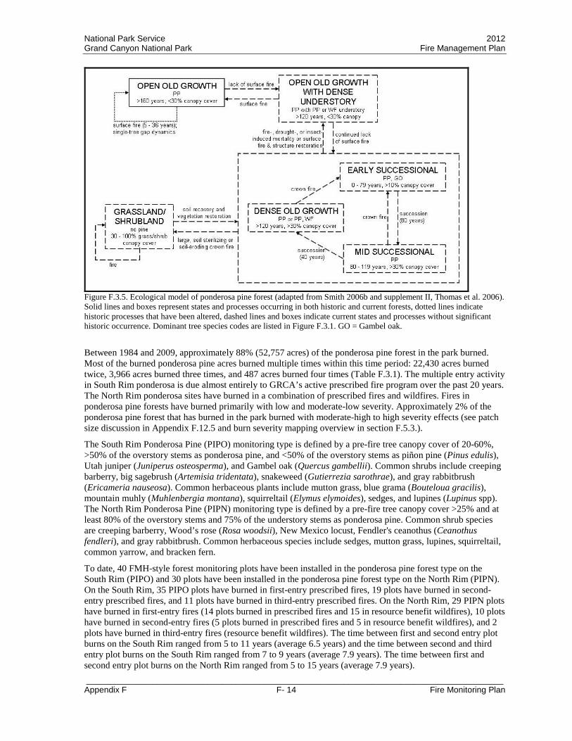
National Park Service 2012 Grand Canyon National Park Fire Management Plan
_________________________________________________________________________________________ Appendix F F- 14 Fire Monitoring Plan
Figure F.3.5. Ecological model of ponderosa pine forest (adapted from Smith 2006b and supplement II, Thomas et al. 2006). Solid lines and boxes represent states and processes occurring in both historic and current forests, dotted lines indicate historic processes that have been altered, dashed lines and boxes indicate current states and processes without significant historic occurrence. Dominant tree species codes are listed in Figure F.3.1. GO = Gambel oak.
Between 1984 and 2009, approximately 88% (52,757 acres) of the ponderosa pine forest in the park burned. Most of the burned ponderosa pine acres burned multiple times within this time period: 22,430 acres burned twice, 3,966 acres burned three times, and 487 acres burned four times (Table F.3.1). The multiple entry activity in South Rim ponderosa is due almost entirely to GRCA’s active prescribed fire program over the past 20 years. The North Rim ponderosa sites have burned in a combination of prescribed fires and wildfires. Fires in ponderosa pine forests have burned primarily with low and moderate-low severity. Approximately 2% of the ponderosa pine forest that has burned in the park burned with moderate-high to high severity effects (see patch size discussion in Appendix F.12.5 and burn severity mapping overview in section F.5.3.).
The South Rim Ponderosa Pine (PIPO) monitoring type is defined by a pre-fire tree canopy cover of 20-60%, >50% of the overstory stems as ponderosa pine, and <50% of the overstory stems as piñon pine (Pinus edulis), Utah juniper (Juniperus osteosperma), and Gambel oak (Quercus gambellii). Common shrubs include creeping barberry, big sagebrush (Artemisia tridentata), snakeweed (Gutierrezia sarothrae), and gray rabbitbrush (Ericameria nauseosa). Common herbaceous plants include mutton grass, blue grama (Bouteloua gracilis), mountain muhly (Muhlenbergia montana), squirreltail (Elymus elymoides), sedges, and lupines (Lupinus spp). The North Rim Ponderosa Pine (PIPN) monitoring type is defined by a pre-fire tree canopy cover >25% and at least 80% of the overstory stems and 75% of the understory stems as ponderosa pine. Common shrub species are creeping barberry, Wood’s rose (Rosa woodsii), New Mexico locust, Fendler's ceanothus (Ceanothus fendleri), and gray rabbitbrush. Common herbaceous species include sedges, mutton grass, lupines, squirreltail, common yarrow, and bracken fern.
To date, 40 FMH-style forest monitoring plots have been installed in the ponderosa pine forest type on the South Rim (PIPO) and 30 plots have been installed in the ponderosa pine forest type on the North Rim (PIPN). On the South Rim, 35 PIPO plots have burned in first-entry prescribed fires, 19 plots have burned in second-entry prescribed fires, and 11 plots have burned in third-entry prescribed fires. On the North Rim, 29 PIPN plots have burned in first-entry fires (14 plots burned in prescribed fires and 15 in resource benefit wildfires), 10 plots have burned in second-entry fires (5 plots burned in prescribed fires and 5 in resource benefit wildfires), and 2 plots have burned in third-entry fires (resource benefit wildfires). The time between first and second entry plot burns on the South Rim ranged from 5 to 11 years (average 6.5 years) and the time between second and third entry plot burns on the South Rim ranged from 7 to 9 years (average 7.9 years). The time between first and second entry plot burns on the North Rim ranged from 5 to 15 years (average 7.9 years).

National Park Service 2012 Grand Canyon National Park Fire Management Plan
_________________________________________________________________________________________ Appendix F F- 15 Fire Monitoring Plan
Monitoring data show that pre-fire total fuel loading values are approximately twice as high in North Rim ponderosa pine forests (31.4 ± 3.6 tons acre) than in South Rim ponderosa pine forests (15.4 ± 1.5 tons acre) (Appendix F.12.5). Litter + duff loading is the largest component of surface fuel loading in both South and North Rim ponderosa pine forests and litter + duff loading also undergoes the largest reductions during fire. On the South Rim, total fuel loading was reduced by 6 – 85% in individual PIPO plots (average 48% ± 6) during first-entry fires. Total fuel loading measured immediately after second-entry fire did not differ from values measured before second-entry fire. However, during third-entry fires, total fuel loading was reduced by 3 – 86% from values measured before third-entry fire in individual PIPO plots (average 38% ± 10). PIPO plots are burned an average of every 6.5 years in prescribed fires on the South Rim and are measured 5 years and ten years after each fire if they are not burned again before the measurements occur. Monitoring data indicate that total fuel loading measured five years after first and second entry fire did not differ from fuel loading measured immediately following these fires. This indicates that prescribed fire treatments successfully reduce fuel loading in South Rim ponderosa pine for at least five years and potentially longer. To date, 10-year post-fire measurements have been taken on only three PIPO plots prior to the plots burning again, so no statistical assessment of fuel accumulation between five and ten years after fire can occur.
On the North Rim, monitoring data show that during first-entry fires change in total fuel loading ranged from slight increases (due to large woody debris falling after fire) to reductions of 96% in individual PIPN plots (average 57% ± 6). Total fuel loading was 3 – 90% lower in individual PIPN plots (average 54% ± 12) immediately following second-entry fires than prior to second-entry fires. Monitoring data indicate that total fuel loading measured five years after first-entry fire was similar to fuel loading measured immediately following these fires. However, second-entry fires in North Rim ponderosa pine forest burned an average of 7.9 years after first-entry fires and an unknown amount of fuel accumulation could have occurred between five and eight years after the first fire. To date, 10-year post-fire measurements have been taken on only two PIPN plots prior to the plots burning again and only two PIPN plots have burned in third-entry fires, so no statistical assessment of fuel changes can occur for these time periods.
Pre-fire pole-sized ponderosa pine density was slightly higher in North Rim ponderosa pine forests (131.2 ± 42.6 trees/acre) than in South Rim ponderosa pine forests (106.7 ± 33.6 trees/acre) and pre-fire large ponderosa pine density was over twice as high in North Rim ponderosa pine forests (45.6 ± 3.2 trees/acre) than in South Rim ponderosa pine forests (20.2 ± 2.4 trees/acre) (Appendix F.12.5). Pole-sized ponderosa pine density decreased 0 – 100% in individual PIPO plots (average 30% ± 8) following first-entry fire and 0 – 30% in individual PIPO plots (average 7% ± 4) following second-entry fire. Large ponderosa pine density was unchanged following both first- and second-entry fire in South Rim ponderosa pine plots. On the North Rim, pole-sized ponderosa pine density decreased 0 – 100% (average 61% ± 9) and large ponderosa pine density decreased 0 – 100% (average 12% ± 7) in individual PIPN plots following first-entry fire (Appendix F. 12.5). Since tree density values are assessed two and five years following fire, there is currently not enough data to assess the effects of second-entry fire on tree density in North Rim ponderosa pine forests.
Current and future fire management in both South and North Rim ponderosa pine forests is designed to continue moving these forests toward the desired conditions (section F.4.3.). Fire management activities to date have been successful in reducing pole-sized (1 – 6 inches dbh) tree density in the ponderosa pine forests. However, after burning twice, average pole-sized ponderosa pine density in South Rim plots is 420% greater than the desired condition and average total ponderosa pine density is 285% greater than the desired condition. Pole-sized trees currently comprise approximately half of the tree density in South Rim ponderosa pine forests, and future restoration treatments will be targeted at this size class. On the North Rim, average pole-sized ponderosa pine density is 156% greater than the desired condition and average total ponderosa pine density is 162% greater than the desired condition, with tree density evenly distributed among size classes. Future restoration and maintenance treatments on the North Rim will include reductions in both pole-sized and mid-sized trees. The current FMP includes management of ponderosa pine forests using a combination of prescribed fires and wildfires on both rims of Grand Canyon.
F.3.4 Piñon-Juniper Piñon-juniper vegetation types dominated by piñon pine and Utah juniper occur below 2,290 m (7,500 ft) and extend into the canyon in many areas. Piñon-juniper types are limited to the southern tips of the plateaus that extend into the canyon on the North Rim, but are the most dominant vegetation type on the South Rim. Various

National Park Service 2012 Grand Canyon National Park Fire Management Plan
_________________________________________________________________________________________ Appendix F F- 16 Fire Monitoring Plan
piñon-juniper associations also occur within the canyon, but fire management activities are not planned for these areas.
Limited research and high historic and current variability in piñon-juniper vegetation types (Romme et al. 2009) has led to uncertainty about the role of fire in these types. Grand Canyon plateau areas are best described as persistent piñon-juniper woodlands (Romme et al. 2009) with some wooded shrublands on the plateau and in the inner canyon. Current information suggests that in piñon-juniper woodlands fire historically occurred as single-tree events or in small patches with occasional higher-intensity events that killed all trees within the fire area (Huffman et al. 2008, Romme et al. 2009). Spreading surface fires were not common in this type and small trees were not regularly thinned by fire as in adjacent ponderosa pine forests (Huffman et al. 2008, Romme et al. 2009). Very long fire rotations on the order of centuries are thought to occur in this vegetation type and current vegetation structure is thought to be similar to historic conditions (Figure F.3.6; Gori and Bate 2007, Huffman et al. 2008, Romme et al. 2009).
Figure F.3.6. Ecological model of piñon-juniper woodlands (adapted from Gori and Bate 2007). Solid lines and boxes represent states and processes occurring in both historic and current forests. Dominant tree species codes are listed in Figure F.3.1.
Approximately 13% (14,253 acres) of the piñon-juniper above the rim burned between 1984 and 2009, and 5,020 of those acres have burned multiple times within this time period (Table F.3.1). The multiple entry activity is due almost entirely to GRCA’s active prescribed fire program over the past 20 years. Fires in piñon-juniper have burned primarily with low and moderate-low severity. Less than 1% of the piñon-juniper that has burned in the park burned with moderate-high to high severity effects (see patch size discussion in Appendix F.12.5 and burn severity mapping overview in section F.5.3.).
The Great Basin Conifer Woodland (PIED) monitoring type (Appendix F.12.1) was used until 2000 to monitor the effects of fire management in the piñon-juniper woodlands near Grand Canyon Village on the South Rim. However, this monitoring type was suspended due to data quality concerns and variation in the fire treatments in this monitoring type. Seventeen FMH-style forest monitoring plots were installed in piñon-juniper woodlands prior to the monitoring type suspension. Of these plots, 14 burned in first-entry prescribed burns. The majority of the 14 burned plots occur in areas that burned a second time, but no post-fire monitoring was conducted. Monitoring data indicate that prescribed fires in this vegetation type reduce total surface fuel loading by 5 – 51% in individual PIED plots (average 25% ± 6) immediately following fire. Prior to fire, total fuel loading averaged 17.5 ± 2.3 tons/acre with 65% of the total loading contributed by litter + duff. Immediately after fire, total fuel loading averaged 12.9 ± 1.9 tons/acre with 63% of the total loading contributed by litter + duff. Total conifer tree density shows slight increases (due to small trees moving into the >1 inch size class) to 40% reductions in individual PIED plots (average 13% ± 7) five years after fire (Appendix F.12.5).
Generally, the piñon-juniper woodlands near Grand Canyon Village do not carry continuous surface fire and
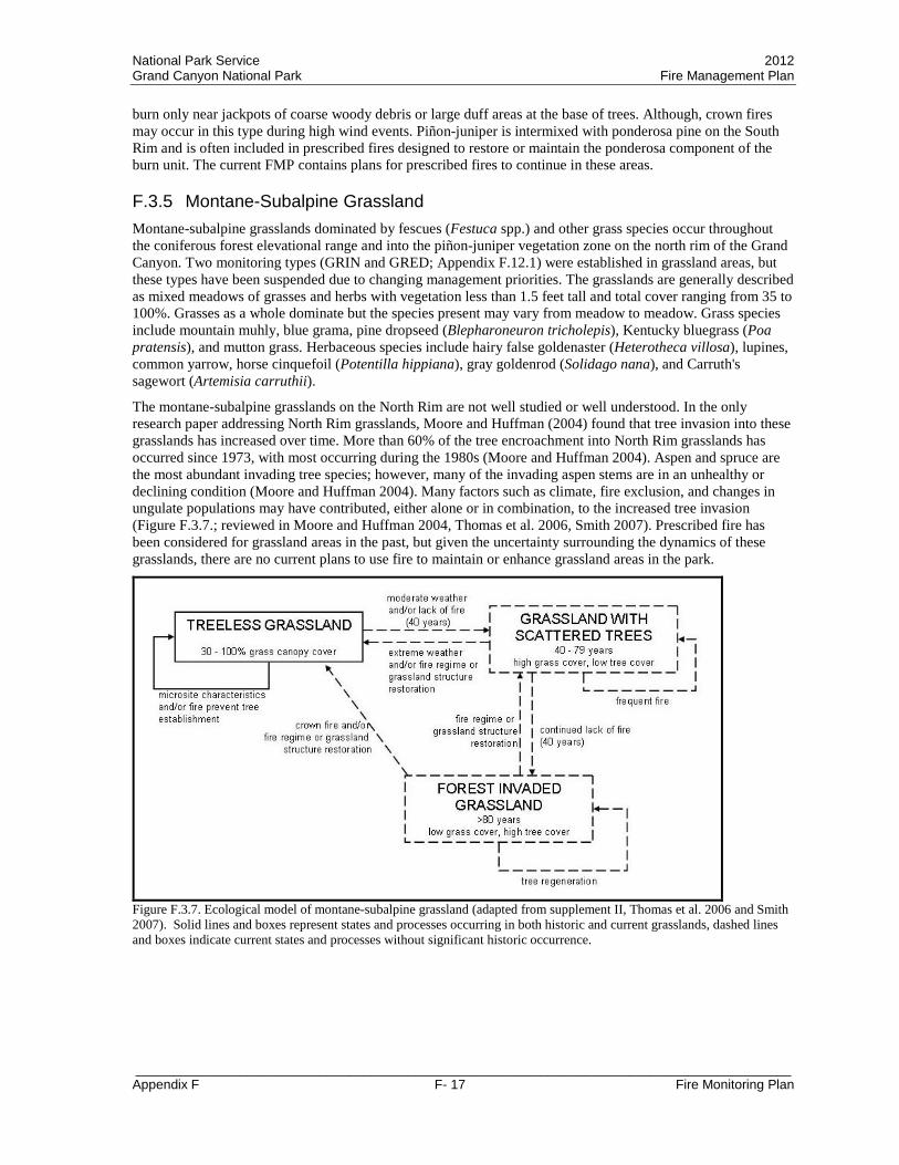
National Park Service 2012 Grand Canyon National Park Fire Management Plan
_________________________________________________________________________________________ Appendix F F- 17 Fire Monitoring Plan
burn only near jackpots of coarse woody debris or large duff areas at the base of trees. Although, crown fires may occur in this type during high wind events. Piñon-juniper is intermixed with ponderosa pine on the South Rim and is often included in prescribed fires designed to restore or maintain the ponderosa component of the burn unit. The current FMP contains plans for prescribed fires to continue in these areas.
F.3.5 Montane-Subalpine Grassland Montane-subalpine grasslands dominated by fescues (Festuca spp.) and other grass species occur throughout the coniferous forest elevational range and into the piñon-juniper vegetation zone on the north rim of the Grand Canyon. Two monitoring types (GRIN and GRED; Appendix F.12.1) were established in grassland areas, but these types have been suspended due to changing management priorities. The grasslands are generally described as mixed meadows of grasses and herbs with vegetation less than 1.5 feet tall and total cover ranging from 35 to 100%. Grasses as a whole dominate but the species present may vary from meadow to meadow. Grass species include mountain muhly, blue grama, pine dropseed (Blepharoneuron tricholepis), Kentucky bluegrass (Poa pratensis), and mutton grass. Herbaceous species include hairy false goldenaster (Heterotheca villosa), lupines, common yarrow, horse cinquefoil (Potentilla hippiana), gray goldenrod (Solidago nana), and Carruth's sagewort (Artemisia carruthii).
The montane-subalpine grasslands on the North Rim are not well studied or well understood. In the only research paper addressing North Rim grasslands, Moore and Huffman (2004) found that tree invasion into these grasslands has increased over time. More than 60% of the tree encroachment into North Rim grasslands has occurred since 1973, with most occurring during the 1980s (Moore and Huffman 2004). Aspen and spruce are the most abundant invading tree species; however, many of the invading aspen stems are in an unhealthy or declining condition (Moore and Huffman 2004). Many factors such as climate, fire exclusion, and changes in ungulate populations may have contributed, either alone or in combination, to the increased tree invasion (Figure F.3.7.; reviewed in Moore and Huffman 2004, Thomas et al. 2006, Smith 2007). Prescribed fire has been considered for grassland areas in the past, but given the uncertainty surrounding the dynamics of these grasslands, there are no current plans to use fire to maintain or enhance grassland areas in the park.
Figure F.3.7. Ecological model of montane-subalpine grassland (adapted from supplement II, Thomas et al. 2006 and Smith 2007). Solid lines and boxes represent states and processes occurring in both historic and current grasslands, dashed lines and boxes indicate current states and processes without significant historic occurrence.

National Park Service 2012 Grand Canyon National Park Fire Management Plan
_________________________________________________________________________________________ Appendix F F- 18 Fire Monitoring Plan
F.4 Management Goals and Objectives This fire monitoring plan is an appendix to the GRCA Fire Management Plan, which is tiered to the GRCA Resource Management (NPS 1997) and General Management (NPS 1995) plans. The purpose of a fire monitoring plan is to outline specific procedures used to evaluate the goals and objectives of a fire management plan and higher level park resource and general management plans. The overall goal of the fire monitoring program is to provide information to fire and resource managers that allows them to evaluate whether park and fire management objectives are being met and, if necessary, to make program adjustments. F.4.1 Resource Management, Fire Management, and Fire Ecology Goals Park-wide General Management Plan and Resource Management Plan goals and objectives relating to fire management are summarized in section 1.6 of the GRCA Fire Management Plan EIS/AEF (NPS 2009a). GRCA Fire Management Program goals and objectives are described in section 1.4 of the Fire Management Plan EIS/AEF (NPS 2009a).
The goals and objectives of the GRCA Fire Ecology Program are:
Goal 1 – Support a science-based fire management program.
Objectives: • Establish and implement a peer-reviewed sampling design, data collection protocol, and data
management protocol for vegetation communities to be treated with fire or non-fire fuel treatments. • Record fire behavior and weather information during all prescribed fires. • Document and analyze short- and long-term fire effects to vegetation and fuel. • Provide information for adaptive management decisions related to treatment and management
objectives, management strategies, and desired conditions. • Review the fire monitoring plan annually and make changes to reflect new information gained. • Identify research needs and facilitate research on natural fire regimes as well as fire effects to natural
and cultural resources (see section F.8.2).
Goal 2 - Promote a safe and effective fire monitoring program.
Objectives: • Provide personnel with the equipment and information needed to manage risks and perform monitoring
and fire activities safely. • Provide training opportunities for crew members in the form of both formal classes and in-park and
out-of-park fire assignments.
Goal 3 - Facilitate communication within the park, the region and the NPS, between agencies, with the public, and with the scientific community.
Objectives: • Annually analyze, report, and interpret fire monitoring data for fire and resource managers and
interpretive staff. • Present monitoring data at conferences and/or as journal publications, as appropriate. • Participate in cross-training activities with other fire management personnel and personnel from other
divisions within the park, in other parks within the region, within the NPS, and with other agencies. F.4.2 Treatment and Monitoring Objectives Treatment objectives The previous version of this monitoring plan (2000 Plan; NPS 2000) identified prescribed fire project objectives for first entry burns in the South and North Rim Ponderosa Pine (PIPO and PIPN), Ponderosa Pine with White Fir Encroachment (PIAB), and the Great Basin Conifer Woodland (PIED) monitoring types. A Monitoring Type Description Sheet (FMH-4) for the Rocky Mountain Subalpine Conifer (PIEN) monitoring type was drafted in 1993 and revised in 1997, but was not included in the 2000 Plan. Burn objectives were included in the 1997 version of the PIEN FMH-4. The two grassland monitoring types (GRIN and GRED) were established in 2001 after the 2000 Plan was finalized; however no treatment objectives were established for the grassland

National Park Service 2012 Grand Canyon National Park Fire Management Plan
_________________________________________________________________________________________ Appendix F F- 19 Fire Monitoring Plan
monitoring types. Because of the amount of new information available since the 2000 Plan was finalized, the landscape-scale treatment objectives for each monitoring type were reevaluated for this plan and adjustments were made where needed. The process of evaluating and adjusting the landscape-scale treatment objectives was a collaborative effort between the Fire Ecologist and the individuals listed in section F.10.1 of this plan. One outcome of the evaluation and adjustment process for the landscape-scale objectives was a move from defining objectives based on the number of prescribed fire treatments completed (i.e. first entry vs. second entry vs. third entry objectives) to defining objectives based on the overall goal of applying treatments to an area (i.e. restoring vs. maintaining the vegetation type). Details of the first entry burn objectives from the 2000 Plan and the restoration and maintenance objectives to be implemented with this plan are summarized in table F.4.1. Monitoring objectives and additional information related to the revised treatment objectives are in Appendix F.12.1. Treatment objectives for individual prescribed fire units and non-fire fuel treatment projects will be outlined in specific burn or treatment plans. Objectives for specific treatment units are expected to support the achievement of the landscape-scale objectives and the desired conditions for each vegetation type, but the objectives for specific treatment units may vary from those listed in table F.4.1. depending on the condition of the unit and the other values present in the treatment unit. Table F.4.1. First entry burn objectives from the 2000 Plan and the 2010 restoration and maintenance objectives to be implemented with this plan for each monitoring type within GRCA.
Monitoring Unit (Code)
Treatment Objectives from 2000 Monitoring Plan 2010 Revisions to Treatment Objectives
First Entry Burn Restoration Maintenance
South Rim Ponderosa Pine (FPIPO1D09)
1. Reduce total fuel load by at least 30% on average, as measured over the landscape immediately post-burn (fuel reduction efforts will continue until the Desired Future Condition of 0.2-9.3 tons/acre is achieved).
2. Limit crown scorch to 30% on Pinus ponderosa with dbh greater than or equal to 16” (40 cm).
3. Reduce Pinus ponderosa poles with dbh of 1-6 inches (2.5-15 cm) to average 0-200 trees/acre (0-494 trees/ha).
4. Achieve and maintain a five-year post-burn density of 19-25 trees/acre of Pinus ponderosa in the 16”+ size class.
1. Reduce total fuel load to an average of 0.2 - 9.3 tons/acre, as measured over the landscape immediately after fire.
2. Maintain a landscape in which higher severity fire (determined through burn severity mapping) occurs in patches smaller than 5 acres and across no more than 5% of the monitoring type over any ten year period.
3. Reduce Pinus ponderosa pole-sized (1-6 inches, 2.5-15 cm, dbh) tree density to an average of 40 – 200 trees/ha (16 – 81 trees/acre), as measured over the landscape two years after fire.
4. Maintain Pinus ponderosa overstory (>16 inches, 40.6 cm, dbh) tree density at an average greater than 35 trees/ha (14 trees/acre), as measured over the landscape five years after fire.
1. Maintain average total fuel load between 0.2 and 9.3 tons/acre across the landscape.
2. Maintain a landscape in which higher severity fire occurs in patches smaller than 5 acres and across no more than 5% of the monitoring type over any ten year period.
3. Maintain average total (all trees greater than 1 inch, 2.5 cm, dbh) Pinus ponderosa tree density at 106 - 333 trees/ha (43 - 135 trees/acre) across the landscape.

National Park Service 2012 Grand Canyon National Park Fire Management Plan
_________________________________________________________________________________________ Appendix F F- 20 Fire Monitoring Plan
Monitoring Unit (Code)
Treatment Objectives from 2000 Monitoring Plan 2010 Revisions to Treatment Objectives
First Entry Burn Restoration Maintenance
North Rim Ponderosa Pine (FPIPN1D09)
1. Reduce total fuel load by at least 30% on average, as measured over the landscape immediately post-burn (fuel reduction efforts will continue until the Desired Future Condition of 0.2-9.3 tons/acre is achieved).
2. Limit crown scorch to 30% on Pinus ponderosa with dbh greater than or equal to 16” (40 cm).
3. Reduce Pinus ponderosa poles with dbh of 1-6 inches (2.5-15 cm) to average 0-200 trees/acre (0-494 trees/ha).
4. Achieve and maintain a five-year post-burn density of 40-56 trees/acre of Pinus ponderosa in the 16”+ size class
1. Reduce total fuel load to an average of 0.2 - 15.7 tons/acre, as measured over the landscape immediately after fire.
2. Maintain a landscape in which higher severity fire (determined through burn severity mapping) occurs in patches smaller than 5 acres and across no more than 5% of the monitoring type over any ten year period.
3. Reduce pole-sized (1-6 inches, 2.5-15 cm, dbh) conifer tree density to an average of 40 – 200 trees/ha (16 – 81 trees/acre), as measured over the landscape two years after fire.
4. Maintain overstory (>16 inches, 40.6 cm, dbh) conifer tree density at an average greater than 42 trees/ha (17 trees/acre), as measured over the landscape five years after fire.
Allow unplanned fire to maintain ponderosa pine forests on the North Rim. If unplanned fires are regularly suppressed and movement toward desired conditions is not occurring then reintroduce prescribed fire to:
1. Maintain average total fuel load between 0.2 and 15.7 tons/acre across the landscape.
2. Maintain average pole-sized (1-6 inches, 2.5-15 cm, dbh) conifer tree density below 200 trees/ha (81 trees/acre) across the landscape.
3. Maintain a landscape in which higher severity fire occurs in patches smaller than 5 acres and across no more than 5% of the monitoring type over any ten year period.

National Park Service 2012 Grand Canyon National Park Fire Management Plan
_________________________________________________________________________________________ Appendix F F- 21 Fire Monitoring Plan
Monitoring Unit (Code)
Treatment Objectives from 2000 Monitoring Plan 2010 Revisions to Treatment Objectives
First Entry Burn Restoration Maintenance
Ponderosa Pine with White Fir Encroachment (FPIAB1D09)
1. Reduce total fuel load by at least 30% on average, as measured across the landscape immediately post-burn (fuel reduction efforts will continue until the Desired Future condition of 0.2 to 20 tons/acre (average) is achieved).
2. Limit crown scorch to 30% on Pinus ponderosa with dbh greater than or equal to 16” (40 cm).
3. Reduce Abies concolor poles in 1-6” (2.5-15 cm) size class by 20-70% to average less than 100 trees/ac (247 trees/ha).
4. Achieve and maintain a five-year post-burn density of 19-25 trees/acre of Pinus ponderosa in the 16”+ size class
1. Reduce total fuel load to an average of 1.7 - 19.0 tons/acre, as measured over the landscape immediately after fire.
2. Maintain a landscape in which higher severity fire (determined through burn severity mapping) occurs in patches smaller than 10 acres and across no more than 15% of the monitoring type over any ten year period.
3. Reduce pole-sized (1-6 inches, 2.5-15 cm, dbh) conifer tree density to an average of 40 – 247 trees/ha (16 – 100 trees/acre), as measured over the landscape two years after fire.
4. Maintain overstory (>16 inches, 40.6 cm, dbh) conifer tree density at an average greater than 49 trees/ha (20 trees/acre), as measured over the landscape five years after fire.
Allow unplanned fire to maintain these forests on the North Rim. If unplanned fires are regularly suppressed and movement toward desired conditions is not occurring then reintroduce prescribed fire to:
1. Maintain average total fuel load between 1.7 and 19.0 tons/acre across the landscape.
2. Maintain average pole-sized (1-6 inches, 2.5-15 cm, dbh) conifer tree density below 247 trees/ha (100 trees/acre) across the landscape.
3. Maintain a landscape in which higher severity fire occurs in patches smaller than 10 acres and across no more than 15% of the monitoring type over any ten year period.
Rocky Mountain Montane Conifer Forests (mixed-conifer) – no established monitoring type
None established 1. Maintain a landscape in which higher severity fire (determined through burn severity mapping) occurs across no more than 30% of the monitoring type.
Quantitative objectives will be established as restoration activities progress. Management goals in this type are outlined in the desired conditions for mixed-conifer forest.

National Park Service 2012 Grand Canyon National Park Fire Management Plan
_________________________________________________________________________________________ Appendix F F- 22 Fire Monitoring Plan
Monitoring Unit (Code)
Treatment Objectives from 2000 Monitoring Plan 2010 Revisions to Treatment Objectives
First Entry Burn Restoration Maintenance
Rocky Mountain Subalpine Conifer (FPIEN1D10)
No objectives listed in 2000 Monitoring Plan. The FMH-4 from 1997 lists the following:
1. Reduce total fuel loading by 40-80% immediately post-burn
2. Thin white fir < 6" dbh by 40-60% within 2 years post-burn
3. Limit overstory Engelmann spruce tree scorch to < 30 feet
4. Limit overstory Engelmann spruce mortality to 20% within 5 years post-burn
No restoration targets are needed in this monitoring type because these areas are thought to be within the natural fire regime.
Quantitative objectives were not identified for this monitoring type because prescribed fires are not the management focus in these areas. Management goals in this type are outlined in the desired conditions for spruce-fir forest.
Great Basin Conifer Woodland (FPIED1D02)
1. Reduce total average fuel load (including all woody material, litter, and duff) so as not to exceed 20 tons/acre (49 tons/ha).
2. Limit overstory mortality of all species to an average of 20% within 5 years post-burn
No restoration targets are needed because this monitoring type is thought to be within its natural fire regime.
Quantitative objectives were not identified for this monitoring type. Management goals in this type are outlined in the desired conditions for piñon-juniper vegetation.
Grassland Interior (BGRIN1D01) None established
None established; no prescribed fire activities are currently targeted at this monitoring type
None established; no prescribed fire activities are currently targeted at this monitoring type
Grassland Edge (FGRED1D02) None established
None established; no prescribed fire activities are currently targeted at this monitoring type
None established; no prescribed fire activities are currently targeted at this monitoring type
Monitoring objectives Monitoring activities are conducted by staff from GRCA Branch of Fire and Aviation, GRCA Science and Resource Management Division, and GRCA Office of Planning and Compliance. Details of each type of monitoring and responsible parties are in section F.5. The following objectives are the responsibility of the staff associated with the applicable monitoring activity (section F.5). Environmental monitoring
1. Monitor weather and fire danger rating as outlined in the annually updated Grand Canyon National Park and Kaibab National Forest National Fire Danger Rating System Operating Plan (NPS 2010b).
2. Coordinate with GRCA Science and Resource Management Division and Office of Planning and Compliance staff to complete compliance for planned fire and non-fire fuel treatment activities as described in the Fire Management Plan Record of Decision (NPS 2010a), Biological Opinion (FWS 2009), and Programmatic Agreement with the State Historic Preservation Officer (NPS 2009b).
Fire observation monitoring 1. Record information on weather and fire conditions for prescribed fires and unplanned fires that extend
beyond initial attack in the park. 2. Record information on resource concerns and mitigation measures outlined in the Fire Management

National Park Service 2012 Grand Canyon National Park Fire Management Plan
_________________________________________________________________________________________ Appendix F F- 23 Fire Monitoring Plan
Plan Record of Decision (NPS 2010a), Biological Opinion (FWS 2009), and Programmatic Agreement with the State Historic Preservation Officer (NPS 2009b).
Short- and long-term vegetation and fuel monitoring 1. Provide high quality data that can be used by fire and resource managers to evaluate and refine
treatment objectives and desired conditions. 2. Install enough permanent plots in each monitoring type to reach the specified confidence that sample
means are within the specified percentage of the true population mean for primary and secondary monitoring variables. Note: confidence and precision levels are specified in Appendix F.12.1.
Burn severity mapping
1. Obtain differenced Normalized Burn Ratio (dNBR) satellite imagery each year for all fires >300 acres in size that occurred in the park in the previous year.
2. Validate assigned burn severity classes with field data during the year following fire events >300 acres in size.
F.4.3 Desired Conditions Spruce-Fir Forest Maintenance of a diverse landscape with patches of variable tree densities through management and monitoring of natural ecosystem processes (fire, insects and disease, drought). Desired conditions include:
• Fire processes managed according to the current NPS policy • Topographic heterogeneity of vegetation types restored and a mixed-severity fire regime maintained • Stand-replacing fire event characteristics returned to the range described in reference conditions (NPS
2009a section 2.4.1 and section F.3.1 of this document). • Processes that provide structural complexity allowed • Fuel loads managed at levels consistent with reference conditions (NPS 2009a section 2.4.1) • Cross-boundary fires managed through collaboration with adjacent agencies • Post-fire vegetation response monitored to provide information for the adaptive management process
Mixed-Conifer Forest Maintenance of a climate-adapted, mixed-conifer structure and associated function through management and monitoring of natural ecosystem processes (fire, insects and disease, drought). Desired conditions include:
• Fire processes managed according to the current NPS policy • Mixed-severity fire regime maintained • Topographic heterogeneity of vegetation types restored • Fuel loads managed to retain mixed-severity fire regime and limit high-severity burned patch size • Cross-boundary fires managed through collaboration with adjacent agencies • Post-fire vegetation response monitored to provide information for the adaptive management process
Additional specific desired stand structure conditions may include: Tree densities greater than 31 cm dbh should range from 54 to 105 trees/ha with a few dense stands approaching 254 conifers/ha. Scattered patches will lack trees due to the fire-effects mosaic characteristic of a mixed-severity fire regime. Trees greater than 61 cm dbh should be maintained at 16 to 32 trees/ha. Scattered patches will lack trees due to the fire-effects mosaic characteristic of a mixed-severity fire regime. The large number of small diameter trees established since Euro-American settlement should be reduced, and vegetation and fire regime topographic heterogeneity should be reestablished.
Ponderosa Pine Forest

National Park Service 2012 Grand Canyon National Park Fire Management Plan
_________________________________________________________________________________________ Appendix F F- 24 Fire Monitoring Plan
Ponderosa pine forests depend upon fire to maintain their ecological integrity. Desired conditions include reduced tree density and ladder fuel, restoration of fire as a process (predominantly surface fire with some passive crown fire), and increased herbaceous ground cover and overall biodiversity levels (Allen et al. 2002). Desired conditions in ponderosa pine stands include:
• Fire processes allowed to move across the landscape, where appropriate • A mosaic of diverse landscapes with patches of variable tree densities • Rare stand-replacing fires generally occur in small patches • A robust and diverse herbaceous understory where supported by soils and environmental factors • Post-fire vegetation response monitored to provide information for the adaptive management process
Desired structure conditions for ponderosa pine are outlined in Table F.4.2. Lower limits for desired conditions generally begin at the level of reconstruction studies on North and South Rims, while upper limits are the level of present day relict areas plus 10 to 20%. Added percentage for number of stems/ha at the upper limit is somewhat arbitrary, but reflects the fact that relict areas are generally drier ponderosa sites near the rim. Table F.4.2. Ponderosa pine forest desired conditions for GRCA. Tree Density (stems/ha), Composition, Size Classes (dbh) 40% of the landscape (South Rim and drier North Rim sites) with ponderosa pine density in the following size classes. Gambel oak should be well-represented on the landscape with 50 to 300 stems/ha contributing a basal area of 1 to 3 m2/ha.
Ponderosa pine dbh (cm) Ponderosa pine density (trees/ha) 2.5 - 15.1 40 - 70
15.2 - 40.1 30 - 40 40.2 - 91.2 35 - 50
> 91.2 1 - 2 Total (all size classes) 106 - 162
50% of the landscape (North Rim mesic sites tending toward mixed-conifer transition) with ponderosa pine density in the following size classes
Ponderosa pine dbh (cm) Ponderosa pine density (trees/ha) 2.5 - 15.1 40 - 100
15.2 - 40.1 40 - 70 40.2 - 91.2 40 - 70
> 91.2 2 - 3 Total (all size classes) 122 - 243
10% of the landscape in aggregate patches of dense stands of ponderosa pine and areas with a component of other conifers
Ponderosa pine dbh (cm) Ponderosa pine density (trees/ha) 2.5 - 15.1 110 - 140
15.2 - 40.1 110 - 140 40.2 - 91.2 20 - 50
> 91.2 1 - 3 Total (all size classes) 241 - 333
Montane-Subalpine Grassland Desired conditions will be developed for the grasslands if fire is reconsidered as a management option for this vegetation type in the future. Piñon-Juniper Communities Maintenance of resilient piñon-juniper structure and associated function by through management and monitoring of natural ecosystem processes (fire, insects and disease, soil fertility, upland hydrologic function).

National Park Service 2012 Grand Canyon National Park Fire Management Plan
_________________________________________________________________________________________ Appendix F F- 25 Fire Monitoring Plan
Desired conditions include:
• Expected fire behavior in the WUI reduced by manual/mechanical treatments near values at risk • Fuel loading from manual/mechanical treatments reduced by prescribed fire • Adaptive management used to refine treatment prescriptions • Fire allowed as a process in piñon-juniper woodlands • Information on natural fire regimes and vegetation dynamics used to maintain diverse landscapes with
patches of variable tree and understory plant densities and canopy cover

National Park Service 2012 Grand Canyon National Park Fire Management Plan
_________________________________________________________________________________________ Appendix F F- 26 Fire Monitoring Plan
F.5 Monitoring Design GRCA employs the NPS Fire Monitoring Handbook (NPS 2003) standard four-level approach to fire monitoring (Table F.5.1). The remainder of this section provides details on how and when each monitoring variable is collected. Following the outline of required and recommended monitoring activities in NPS Reference Manual 18: Wildland Fire Management (NPS 2008b), each GRCA fire management strategy has a defined monitoring approach. Monitoring elements measured for each fire management strategy are summarized in Table F.5.2. Table F.5.1. NPS four-level approach to fire monitoring and potential variables for each level.
Monitoring Level Monitoring Variables
Level 1: Environmental Weather, fire danger rating, fuel conditions, concerns and values to be protected, and other biological, geographical, or sociological data
Level 2: Fire Observation Reconnaissance - fire cause, fire location and size, fuel and vegetation description, fire regime and condition class, current and predicted fire behavior, potential for spread, current and forecasted weather, resource or safety threats and constraints, and smoke volume and movement
Fire Conditions - topographic variables, fire weather, fuel model, fire characteristics, smoke characteristics, Resource Advisor concerns
Level 3: Short-term Change Change in fuel load, vegetation structure, and vegetation composition, or other objective-dependent variables, within 2 years post-burn
Level 4: Long-term Change Trends in Level 3 variables over time (5+ years)
Table F.5.2. Monitoring elements measured for each fire management strategy. Fire Management Strategy
Monitoring Level Unplanned Fire
Prescribed Fire
Non-Fire Treatment
Level 1: Environmental Yes Yes Yes Level 2: Fire Observation Yes Yes n/a Level 3: Short-term Change Yes1 Yes Yes2 Level 4: Long-term Change Maybe Yes Maybe 1 burn severity mapping for fires >300 acres 2 conducted using Rapid Assessment Protocol plots or photopoint monitoring
F.5.1 Environmental Monitoring Level 1 environmental monitoring provides the information needed for decision-making before and during fire events. Depending on the variable of interest, environmental monitoring can occur throughout the year. Environmental monitoring at GRCA is conducted by staff from both the Fire and Aviation Branch and the Science and Resource Management Division. Weather and Fire Danger Rating Weather and fire danger rating are monitored by the Williams Interagency Dispatch Center as outlined in the annually updated Grand Canyon National Park and Kaibab National Forest National Fire Danger Rating System (NFDRS) Operating Plan (NPS 2010b). The monitoring outlined in the NFDRS Operating Plan is designed to assist with planning and operational decisions relative to fire danger, preparedness, resource needs, personnel briefing, situational awareness, and implementing fire restrictions. The NFDRS Operating Plan describes the six remote automatic weather station (RAWS) units used for fire management planning in GRCA and the Kaibab National Forest. In addition, the NFDRS Operating Plan outlines the process for calculating and communicating the daily burning index (BI), energy release component (ERC), and adjective fire danger rating. The NFDRS Operating Plan also describes the process for preparing annual fire danger pocket cards.

National Park Service 2012 Grand Canyon National Park Fire Management Plan
_________________________________________________________________________________________ Appendix F F- 27 Fire Monitoring Plan
Fuel Conditions Fuel conditions are monitored by the Fire Management Program operations sections (South Rim District and North Zone) throughout the fire season (generally April to November). Sampling procedures generally follow those outlined in the Southwest Area Fuel Moisture Monitoring Program: Standard Methods and Procedures (SWCC 2004). Litter, 1-hr, 10-hr, 100-hr, and sound 1000-hr timelag fuel moisture (TLFM) class fuels are collected on both rims. Live fuel moisture samples are collected based on the dominant species at the sampling site. On the South Rim, dominant species may include ponderosa pine, piñon pine, Utah juniper, and Gambel oak. On the North Rim, dominant species may include white fir, subalpine fir, Douglas-fir, Engelmann spruce, blue spruce, and ponderosa pine. Duff samples are also collected on the North Rim. Sensitive natural resources Background monitoring of sensitive natural resources is the responsibility of the GRCA Science and Resource Management Division. Pre-treatment project specific monitoring to identify sensitive natural resources in prescribed fire and non-fire fuel treatment units is coordinated by the GRCA Science and Resource Management Division in collaboration with the GRCA Fire and Aviation Branch. Required pre-project monitoring activities are identified in the Record of Decision (ROD) for the Fire Management Plan (NPS 2010a) and in the Biological Opinion (BO) for the Fire Management Plan (FWS 2009). Sensitive natural resources that occur within project units will be identified prior to project implementation and mitigation measures consistent with the ROD and the BO will be implemented as outlined in those documents. Cultural-archeological resources Identification and background monitoring of cultural-archeological resources is the responsibility of the GRCA Science and Resource Management Division. Pre-treatment project specific monitoring to identify cultural-archeological resources in prescribed fire and non-fire fuel treatment units is coordinated by the GRCA Science and Resource Management Division in collaboration with the GRCA Fire and Aviation Branch. Required pre-project monitoring activities are identified in the Record of Decision (ROD) for the Fire Management Plan (NPS 2010a) and in the Programmatic Agreement (PA) with the State Historic Preservation Officer (SHPO) for the Fire Management Plan (NPS 2009b). Sensitive cultural-archeological resources that occur within project units will be identified prior to project implementation and mitigation measures consistent with the ROD and the PA will be implemented as outlined in those documents. F.5.2 Fire Observation Monitoring Level 2 fire observations provide the information needed for decision-making during and after fire events. Fire observation monitoring occurs during active fires within the park. Fire observation monitoring, which includes reconnaissance and fire conditions monitoring, occurs to some extent on all fires in GRCA; however, every element may not be recorded on each fire. This section outlines standard procedures for monitoring prescribed fires in GRCA. These procedures may also be applicable to monitoring unplanned fire events. Fire behavior and weather observations are collected during each operational period on prescribed fires using the GRCA fire monitoring forms (Appendix F.12.3), forms FMH-1, -2, and -3 from the NPS Fire Monitoring Handbook (NPS 2003), or the forms found in the Interagency Fire Use Module Handbook. When smoke production begins to noticeably impact the Grand Canyon Class I airshed, smoke observations are recommended. The fire observation information requested may differ between Prescribed Fire Burn Bosses, and the following guidelines are intended to provide monitors with information on how the requested information is typically collected at GRCA. For additional information on the variables collected during fire observation monitoring, see the NPS Fire Monitoring Handbook (NPS 2003). Weather Three weather observations are preferred prior to requesting a spot weather forecast, although the forecast can be obtained with only one observation. Weather observations are recorded from a variety of locations (valley bottoms, ridgetops, southwest slopes, etc) and generally are taken one hour apart the afternoon preceding the prescribed fire or prior to ignition on the day of the prescribed fire. Cloud types can be important to fire weather forecasters, so monitors should attempt to identify cloud types and cloud cover. A spot weather forecast is requested using the GRCA modified Spot Forecast Request form (Appendix F.12.3). The spot weather forecast

National Park Service 2012 Grand Canyon National Park Fire Management Plan
_________________________________________________________________________________________ Appendix F F- 28 Fire Monitoring Plan
is included in the daily monitoring report with other fire observation monitoring forms. The Prescribed Fire Burn Boss decides how often weather observations are taken and reported throughout the burn period. Monitors should be familiar with the fire prescription, indicate when critical levels are reached (low fuel moistures, gusty winds), and inform the Prescribed Fire Burn Boss if weather observations fall outside of desired conditions. The GRCA Weather Observation form (Appendix F.12.3) is used to record burn-day weather observations. Fire Behavior In general, monitors take a fire behavior observation around the same time and location as a weather observation; however, there is no set number of required fire behavior observations. Monitors attempt to capture an accurate representation of the range of fire behavior and fire types. For instance, if fire is burning in heavy fuel, creeping in litter, and smoldering in duff, separate observations are made for each fuel type. Additionally, if fire is backing, heading, and/or flanking, individual observations to capture different fire types are made. On prescribed fires, monitors should be familiar with the prescribed fire plan prescription and inform the Prescribed Fire Burn Boss if fire behavior is not in prescription. Monitors record fire behavior observations on the GRCA Fire Behavior Observations form (Appendix F.12.3). Smoke Smoke observations are taken on most fires within the park. A pilot balloon (pibal) can be released before a prescribed fire to indicate where smoke will travel in relation to sensitive areas (highways, canyon, villages, and trails). Monitors record pibal information on the Winds Aloft Computation form (Appendix F.12.3), calculate wind speed and direction using the National Weather Service Pibal Plotting Program, and relay this information to the Prescribed Fire Burn Boss. Smoke observations are best recorded from a site removed from the fire with a good perspective of the entire smoke column and smoke impacts to the canyon or heavy visitor use areas. During prescribed fires, monitors should consult with the Prescribed Fire Burn Boss and read the prescribed fire plan to understand smoke issues for the fire. The GRCA Smoke Observations form (Appendix F.12.3) is used to monitor smoke during prescribed fires. If smoke is making a consistent impact on sensitive areas, photo points can be established where photos are taken repeatedly from the same location, in the same direction, and at approximately the same time of day. If time permits, monitors may take two sets of photos: one in the morning to capture nighttime subsidence and inversion impacts and one in the afternoon to capture the height of smoke production. Observations from these locations are documented on the GRCA Smoke Observations form, and descriptions of the photo point locations are written on a photographic log form. A brief summary of smoke impacts and photos should be sent via email on a daily basis to air quality specialists identified by GRCA fire managers. DataRAM or E-BAM air quality sampling devices are used when smoke production has the potential to affect sensitive areas, or as requested by GRCA fire managers or air quality specialists. GRCA currently owns two functioning DataRAM 2000 devices. These devices are outdated and provide trend data only (i.e. the exact particulate measurements are generally unreliable). When it is important to obtain accurate particulate measurements, a DataRAM-4 or E-BAM should be borrowed from Arizona Department of Environmental Quality (ADEQ) or the Boise Fire Cache. Pre-established deployment sites with weather shelters are set up at Cottonwood Ranger Station, Phantom Ranch, Tusayan, and the Hance burn unit on the South Rim. Monitors use one of these sites or set up a new site in the North Rim developed area or Grand Canyon Village where the sampling device has electrical power, shelter from the elements, and relative security. Resource Concerns Resource concerns for prescribed fires are addressed in the prescribed fire plan for a particular project unit. Resource concerns for unplanned fire events are identified by resource specialists from the GRCA Science and Resource Management Division. Monitoring and mitigation measures outlined in the Fire Management Plan ROD (NPS 2010a), BO (FWS 2009), and PA (NPS 2009b) will be followed during each fire event. Resource Advisors should be assigned to prescribed fires and unplanned fires that exceed initial attack to ensure that the monitoring and mitigation measures are implemented. Implementation of mitigation measures includes identification of rehabilitation needs.
National Park Service 2012 Grand Canyon National Park Fire Management Plan
_________________________________________________________________________________________ Appendix F F- 29 Fire Monitoring Plan
Photographs Photographs provide some of the best documentation of fire observations. Digital photographs are filed on the Fire & Aviation (O:\) drive under a folder with the fire name and date. Monitors should take photographs to match fire behavior observations (i.e. not photograph big flames only but rather document the range of fire conditions). Comparable photos over time are very useful for documenting fire conditions and effects. If possible, monitors should establish photo points and photograph the area days and/or weeks after the fire to document fire effects. Reports At the end of the monitoring period, all weather, fire behavior, and smoke observations from the fire are collected into a legible package. In addition to forms with the raw data, a narrative summary is written. This report includes a description of who monitored the fire, monitor activities during the monitoring period, a summary of observed fire behavior, a summary of observed weather, and any other pertinent information. Digital images to illustrate weather, smoke, and fire behavior are included, if possible. A Daily Fire Monitoring Report (example in Appendix F.12.3) can be used to summarize monitoring information for each day. Ideally, this form would be completed on the day of the observations. During multi-day fires, events can run together and narratives may become less detailed and less informative. Monitoring forms and notes generated by the assigned Resource Advisor should be compiled at the end of each fire event. Resource Advisor information should be given to the Prescribed Fire Burn Boss (or Incident Commander), the appropriate specialists in the GRCA Science and Resource Management Division, and the GRCA Office of Planning and Compliance. This information will be used to develop rehabilitation plans, if needed, and to generate the required annual reports to USFWS and Arizona SHPO (section F.7). F.5.3 Short- and Long-term Vegetation and Fuel Change Monitoring short- and long-term changes in vegetation and fuel characteristics is an essential part of the adaptive management process. The goals of the short- and long-term vegetation and fuel monitoring program are to provide managers with feedback on (1) whether progress is being made toward achieving the desired conditions for a monitoring type and (2) whether project objectives have been achieved. In order to adequately address both of these goals, the GRCA monitoring program design for vegetation and fuel incorporates both landscape- and project-level monitoring. Landscape-level short- and long-term change monitoring began in GRCA in 1990 with the installation of the first permanent NPS Fire Monitoring Handbook (FMH) plots. Project-level monitoring is a new addition to the GRCA monitoring program. The first pilot Rapid Assessment Protocol (RAP) plots for project monitoring were installed in scheduled prescribed fire units during the 2008 field season. Landscape-Level Monitoring To monitor landscape-level short- and long-term vegetation and fuel changes, GRCA fire management personnel defined seven monitoring types representing the major vegetation types where prescribed fire has been either used or planned for use as a management tool. Between 1990 and 2009, 159 permanent FMH plots were installed in these seven monitoring types. Of these plots, 114 are currently monitored on the recommended post-fire schedule and are used to assess the landscape-level objectives of the fire management program (see section F.3 and Appendix F.12.5 of this plan for analysis of these plots). Two grassland monitoring types (GRED and GRIN) containing 16 total plots are currently inactive due to changes in priorities in the grasslands. One monitoring type (PIED) containing 17 plots was suspended in 2000 due to data quality concerns and variation in the applied treatments. Twelve plots installed early in the monitoring program were removed from the monitoring schedule in the late 1990s due to inconsistencies with the monitoring type descriptions. Monitoring Units Landscape-Level Monitoring Standard NPS FMH-4 Monitoring Type Descriptions specifying monitoring objectives and desired conditions have been completed for four currently monitored forest types and one suspended forest type (Appendix F.12.1). In addition, protocols, but not desired conditions or management objectives, have been completed for the two inactive grassland monitoring types (Appendix F.12.1). Suspended and inactive types will no longer be
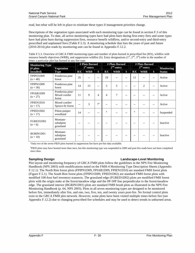
National Park Service 2012 Grand Canyon National Park Fire Management Plan
_________________________________________________________________________________________ Appendix F F- 30 Fire Monitoring Plan
read, but rebar will be left in place to reinitiate these types if management priorities change. Descriptions of the vegetation types associated with each monitoring type can be found in section F.3 of this monitoring plan. To date, all active monitoring types have had plots burn during first-entry fires and some types have had plots burn during suppression fires, resource benefit wildfires, and/or second-entry and third-entry prescribed and unplanned fires (Table F.5.3). A monitoring schedule that lists the years of past and future (2010-2014) plot reads by monitoring unit can be found in Appendix F.12.2. Table F.5.3. Overview of GRCA FMH monitoring types and number of plots burned in prescribed fire (RX), wildfire with resource benefit objectives (WRB), and suppression wildfire (S). Entry designations (1st, 2nd, 3rd) refer to the number of times a particular plot has burned in any fire type.
Monitoring Type (# plots installed)
Vegetation Type
# Plots Burned 1st-entry
# Plots Burned 2nd-entry
# Plots Burned 3rd-entry Monitoring
Status RX WRB S RX WRB S RX WRB S FPIPO1D09 (n = 40)
Ponderosa pine forest 35 -- -- 19 -- -- 11 -- -- Active
FPIPN1D09 (n = 30)
Ponderosa pine forest 14 15 -- 5 5 -- -- 2 -- Active
FPIAB1D09 (n = 27)
Ponderosa pine/ Mixed conifer forest
11 9 4 4 7 -- -- -- -- Active
FPIEN1D10 (n = 17)
Mixed conifer/ Spruce-fir forest -- 3 7a -- -- -- -- -- -- Active
FPIED1D02 (n = 17)
Piñon-juniper woodland 14 -- -- b -- -- b -- -- Suspended
FGRED1D02 (n = 6)
Montane-subalpine grassland
-- -- -- -- -- -- -- -- -- Inactive
BGRIN1D01 (n = 10)
Montane-subalpine grassland
-- -- -- -- -- -- -- -- -- Inactive
aOnly two of the seven PIEN plots burned in suppression fire have pre-fire data available. bPIED plots may have burned more than once, but this monitoring type was suspended in 2000 and post-fire reads have not been completed since then.
Sampling Design Landscape-Level Monitoring Plot layout and monitoring frequency of GRCA FMH plots follow the guidelines in the NPS Fire Monitoring Handbook (NPS 2003) with modifications noted on the FMH-4 Monitoring Type Description Sheets (Appendix F.12.1). The North Rim forest plots (FPIPN1D09, FPIAB1D09, FPIEN1D10) are standard FMH forest plots (Figure F.5.1). The South Rim forest plots (FPIPO1D09, FPIED1D02) are standard FMH forest plots with modified 100-foot fuel inventory transects. The grassland edge (FGRED1D02) plots are modified FMH forest plots with the origin stake at the forest/meadow edge and the 0P-50P line perpendicular to the forest/meadow edge. The grassland interior (BGRIN1D01) plots are standard FMH brush plots as illustrated in the NPS Fire Monitoring Handbook (p. 64, NPS 2003). Plots in all seven monitoring types are designed to be monitored before fire, immediately after fire, and one, two, five, ten, and twenty years post-fire. No formal control plots exist in the GRCA FMH plot network. However, some plots have been visited multiple times before fire (see Appendix F.12.2) due to changing prescribed fire schedules and may be used to detect trends in unburned areas.

National Park Service 2012 Grand Canyon National Park Fire Management Plan
_________________________________________________________________________________________ Appendix F F- 31 Fire Monitoring Plan
Figure F.5.1. Standard plot layout for FMH monitoring plots (adapted from NPS 2003). Red, yellow, and blue circles represent rebar locations. Modifications are noted on the FMH-4 Monitoring Type Description Sheets (Appendix F.12.1). FMH monitoring plots are distributed within monitoring types that contain many prescribed fire units. The FMH plots are designed to monitor trends in vegetation at a landscape level, and not to detect change in individual prescribed fire units. Due to the large area burned in both prescribed fires and wildfires each year in GRCA, new monitoring plot locations are randomly chosen from areas scheduled to burn within the next three years rather than the five years recommended in the NPS Fire Monitoring Handbook (NPS 2003). Prior to 2000, GRCA FMH plots were randomly located using the grid map method described in the NPS Fire Monitoring Handbook (p. 59-61, NPS 2003) and the rejection criteria for each monitoring type (Appendix F.12.1). Now, with a large number of plots already installed and a relatively small unburned area available in some monitoring types, new plot installation points are randomly assigned using GIS to identify areas that have not previously burned, occur within the appropriate vegetation type, and are unlikely to contain any of the rejection criteria elements (Appendix F.12.1). The GRCA Fire Monitoring Program has installed enough plots to assess minimum plot numbers for post-fire assessments, and both pre- and post-fire minimum plot estimates are provided in Table F.5.4. For the three primary variables of interest (large tree density, total fuel loading, and pole-sized tree density), the expectation is that fire will result in a decrease in average values during the monitoring period of interest. Therefore, minimum sample size calculations using one-tailed t-values are appropriate for these variables, but calculations using two-tailed t-values are also provided in Table F.5.4 as a conservative estimate. Minimum sample size calculations are based on the equations given in Appendix D of the NPS Fire Monitoring Handbook (NPS 2003). The monitoring objective for the large tree density and total fuel loading management objective variables is a monitoring design that provides 80% confidence that variable estimates are within 20% of the population mean. For the pole-sized tree density management objective, the monitoring objective is a monitoring design that provides 80% confidence that variable estimates are within 25% of the population mean. The GRCA Fire Monitoring Program has installed enough plots in all active monitoring types to adequately evaluate the large tree density and total fuel loading objective variables (Table F.5.4). However, additional plots may be needed in the North Rim Ponderosa Pine and Ponderosa Pine with White Fir Encroachment monitoring types to adequately evaluate the pole-sized tree density objective variable after fire (Table F.5.4) since post-fire pole-sized tree density values are more variable than pre-fire values. This increase in variability after fire is likely due to the fact that these two North Rim monitoring types are (and will likely continue to be) managed using both prescribed fire and unplanned fire (see Table F.5.3) to meet restoration and maintenance objectives. Table F.5.4. Results of minimum sample size calculations by monitoring type and management objective variable for both
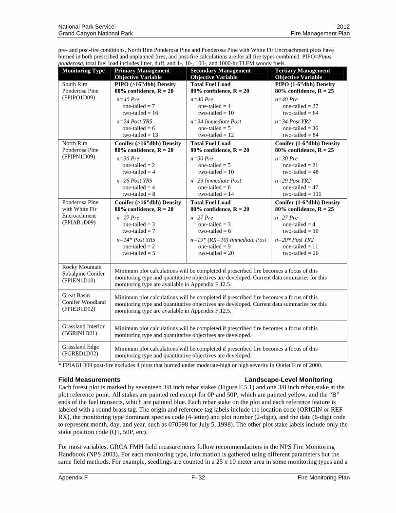
National Park Service 2012 Grand Canyon National Park Fire Management Plan
_________________________________________________________________________________________ Appendix F F- 32 Fire Monitoring Plan
pre- and post-fire conditions. North Rim Ponderosa Pine and Ponderosa Pine with White Fir Encroachment plots have burned in both prescribed and unplanned fires, and post-fire calculations are for all fire types combined. PIPO=Pinus ponderosa, total fuel load includes litter, duff, and 1-, 10-, 100-, and 1000-hr TLFM woody fuels.
Monitoring Type Primary Management Objective Variable
Secondary Management Objective Variable
Tertiary Management Objective Variable
South Rim Ponderosa Pine (FPIPO1D09)
PIPO (>16”dbh) Density 80% confidence, R = 20 n=40 Pre
one-tailed = 7 two-tailed = 16
Total Fuel Load 80% confidence, R = 20 n=40 Pre
one-tailed = 4 two-tailed = 10
PIPO (1-6”dbh) Density 80% confidence, R = 25 n=40 Pre
one-tailed = 27 two-tailed = 64
n=24 Post YR5 one-tailed = 6 two-tailed = 13
n=34 Immediate Post one-tailed = 5 two-tailed = 12
n=34 Post YR2 one-tailed = 36 two-tailed = 84
North Rim Ponderosa Pine (FPIPN1D09)
Conifer (>16”dbh) Density 80% confidence, R = 20 n=30 Pre
one-tailed = 2 two-tailed = 4
Total Fuel Load 80% confidence, R = 20 n=30 Pre
one-tailed = 5 two-tailed = 10
Conifer (1-6”dbh) Density 80% confidence, R = 25 n=30 Pre
one-tailed = 21 two-tailed = 48
n=26 Post YR5 one-tailed = 4 two-tailed = 8
n=29 Immediate Post one-tailed = 6 two-tailed = 14
n=29 Post YR2 one-tailed = 47 two-tailed = 111
Ponderosa Pine with White Fir Encroachment (FPIAB1D09)
Conifer (>16”dbh) Density 80% confidence, R = 20 n=27 Pre
one-tailed = 3 two-tailed = 7
Total Fuel Load 80% confidence, R = 20 n=27 Pre
one-tailed = 3 two-tailed = 6
Conifer (1-6”dbh) Density 80% confidence, R = 25 n=27 Pre
one-tailed = 4 two-tailed = 10
n=14* Post YR5 one-tailed = 2 two-tailed = 5
n=19* (RX=10) Immediate Post one-tailed = 9 two-tailed = 20
n=20* Post YR2 one-tailed = 11 two-tailed = 26
Rocky Mountain Subalpine Conifer (FPIEN1D10)
Minimum plot calculations will be completed if prescribed fire becomes a focus of this monitoring type and quantitative objectives are developed. Current data summaries for this monitoring type are available in Appendix F.12.5.
Great Basin Conifer Woodland (FPIED1D02)
Minimum plot calculations will be completed if prescribed fire becomes a focus of this monitoring type and quantitative objectives are developed. Current data summaries for this monitoring type are available in Appendix F.12.5.
Grassland Interior (BGRIN1D01)
Minimum plot calculations will be completed if prescribed fire becomes a focus of this monitoring type and quantitative objectives are developed.
Grassland Edge (FGRED1D02)
Minimum plot calculations will be completed if prescribed fire becomes a focus of this monitoring type and quantitative objectives are developed.
* FPIAB1D09 post-fire excludes 4 plots that burned under moderate-high or high severity in Outlet Fire of 2000. Field Measurements Landscape-Level Monitoring Each forest plot is marked by seventeen 3/8 inch rebar stakes (Figure F.5.1) and one 3/8 inch rebar stake at the plot reference point. All stakes are painted red except for 0P and 50P, which are painted yellow, and the “B” ends of the fuel transects, which are painted blue. Each rebar stake on the plot and each reference feature is labeled with a round brass tag. The origin and reference tag labels include the location code (ORIGIN or REF RX), the monitoring type dominant species code (4-letter) and plot number (2-digit), and the date (6-digit code to represent month, day, and year, such as 070598 for July 5, 1998). The other plot stake labels include only the stake position code (Q1, 50P, etc). For most variables, GRCA FMH field measurements follow recommendations in the NPS Fire Monitoring Handbook (NPS 2003). For each monitoring type, information is gathered using different parameters but the same field methods. For example, seedlings are counted in a 25 x 10 meter area in some monitoring types and a
National Park Service 2012 Grand Canyon National Park Fire Management Plan
_________________________________________________________________________________________ Appendix F F- 33 Fire Monitoring Plan
5 x 10 meter area in others. Specific parameters for each monitoring type are noted in the Monitoring Type Description Sheets (FMH-4s) located in Appendix F.12.1. For each forest plot, information is gathered on overstory trees, pole-sized trees, seedling trees, surface fuel, herbaceous species, and shrubs. Some of the measurements taken are not tied to formal objectives (Table F.4.1), but these measurements assist the fire management program in assessing the general condition of the forest community and identifying resource concerns (e.g. exotic species invasion) and research needs. Eight photographs are taken of each plot using the protocols outlined in the NPS Fire Monitoring Handbook (NPS 2003). Photographs are taken from each end of the three 50 m transects (starting from Q1, 50P, Q2, Q3, 0P, and Q4; Figure F.5.1) facing into the plot and from each end of the center 20 m transect (starting at P1 and P2; Figure F.5.1) facing into the plot. Repeat photographs are taken with the aid of printed copies from the previous photographs of a particular plot in order to capture comparable scenes. Plot monitoring generally proceeds phenologically from the warmest to coolest ecosystems in the park. Plot reads begin on the South Rim and then proceed from the lowest to highest elevation North Rim forest types. If reinitiated, the meadows on the North Rim should be sampled from late July to early September. There are numerous forms used for FMH plot monitoring available in the NPS Fire Monitoring Handbook (NPS 2003). To lessen confusion and reduce recording and data entry errors, many of the FMH data sheets have been customized to include methods specific to GRCA, reminders for some methods, and crosswalks with the FFI database. Modified data sheets are available in Appendix F.12.3. Project-Level Monitoring Project-level monitoring is a new addition to the GRCA Fire Ecology Program and, as such, is in the beginning stages of pilot sampling. Project-level monitoring is designed to provide information on whether short-term management objectives have been met for a particular fire or manual/mechanical treatment. With the 2010 Fire Management Plan, GRCA will begin manual/mechanical treatments in the Primary WUI FMU, will begin implementing prescribed fire in the higher elevation mixed-conifer and spruce-fir vegetation types, and will continue maintenance fires in the ponderosa pine forests. High elevation forests make up a relatively small area on the North Rim and are of high resource concern, so monitoring and evaluation through the adaptive management process is currently planned on a unit-by-unit basis. Unit-by-unit monitoring may also occur in manual/mechanical treatment units and multi-entry ponderosa pine forests. Since project-level monitoring will require a greater number of plots in each unit than the landscape-level monitoring, new Rapid Assessment Protocol (RAP) plots are being developed to accommodate this need. Monitoring Units Project-Level Monitoring For project-level monitoring, the monitoring unit is the prescribed fire or manual/mechanical treatment unit described in the approved project implementation plan. Similar to landscape-level monitoring, monitoring within an individual project unit may be stratified by vegetation type. Vegetation types could be used to stratify monitoring plots if current conditions, desired conditions, and project objectives differ by vegetation type within an individual monitoring/treatment unit. Sampling Design Project-Level Monitoring Plot layout and monitoring frequency of GRCA RAP plots were developed by the Fire Ecologist and Lead Fire Effects Monitor in consultation with the NPS Fire Ecology Program contract statistician (Dr. Ken Gerow, University of Wyoming) and other fire ecology programs within the NPS. Data from current FMH plots in equivalent vegetation types were used to determine plot size and the minimum number of plots to install in each monitoring unit. Since the project-level monitoring is still in the early stages of development, protocol evaluation is ongoing and adjustments may be required in the future. Pilot RAP plots are circular plots with a 10 m radius sample area and one or two 50 ft fuel transects (Figure F.5.2). New plot installation points are randomly assigned within a treatment unit using GIS to identify areas that are unlikely to contain any of the rejection criteria elements. RAP plots are designed to efficiently answer three to five management questions about fire effects to vegetation and fuel. For this reason, monitoring frequency depends on the management objectives in the monitoring unit. All variables of interest are measured prior to the planned treatment and surface fuel loading and post-fire severity variables are measured

National Park Service 2012 Grand Canyon National Park Fire Management Plan
_________________________________________________________________________________________ Appendix F F- 34 Fire Monitoring Plan
immediately following treatment. FMH data to date indicates that large tree and pole-sized tree density values differ between post-fire year 1, post-fire year 2, and post-fire year 5 measurements for all monitoring types except South Rim Ponderosa Pine. At this time, pilot RAP plots are scheduled for measurement during post-fire year 2 to assess tree and understory species variables. This measurement schedule may need reevaluation in the future as pilot data become available.
Figure F.5.2. Pilot RAP plot layout. Rebar are located at 0P, 50P, and 50P-B (optional). Field Measurements Project-Level Monitoring Measurement variables for RAP plots may differ for each monitoring unit, but measurement protocols are designed to stay consistent across monitoring units. To date, protocols have been developed for plot establishment and photography, overstory tree measurement, pole-sized tree measurement, seedling tree measurement, herbaceous and shrub measurement, fuel transect measurement, and post-fire severity measurement. These protocols include optional elements that can be added or subtracted based on the data needs in a particular project unit. Additional protocols may be developed in the future if new management objectives or questions arise. Plots are located using randomly assigned UTM coordinates. Each plot is marked by 3/8 inch rebar stakes placed at the ends of the 50 ft fuel transect(s) (Figure F.5.2). The 0P stake is located at the random UTM coordinate and a random azimuth is used to locate the 50P stake. If a second fuel transect is installed, it is installed at a 90 degree angle clockwise on the compass from the first fuel transect and the end stake is labeled 50P-B. The rebar stakes are labeled with a round brass tag that include the treatment unit abbreviation, plot number, date, and stake position code. Plot photographs are taken from each end of the fuel transect(s). The 50P stake serves as the center point for the 10 m radius sample area of the plot. Field data sheets are available in Appendix F.12.3. Measurements of overstory trees, pole-sized trees, herbaceous species, shrub species, and non-native plant species are conducted in the 10 m radius sample area. Seedling tree measurements are conducted in a 5 m radius sample area centered on 50P. Definitions of overstory, pole-sized, and seedling trees follow the standard NPS FMH protocols (NPS 2003). Surface fuel and post-fire severity are measured along the 50 ft fuel transect(s) following standard NPS FMH protocols (NPS 2003).
Overstory trees: Measurements of individual overstory tree diameter and condition variables follow the NPS FMH protocols (NPS 2003). Crown base height (optional) is measured at the lowest point of the continuous crown and tree height (optional) is measured at the highest point on the tree for overstory trees. No identification tags are installed on the trees, but an azimuth measured from 50P is recorded for each tree.
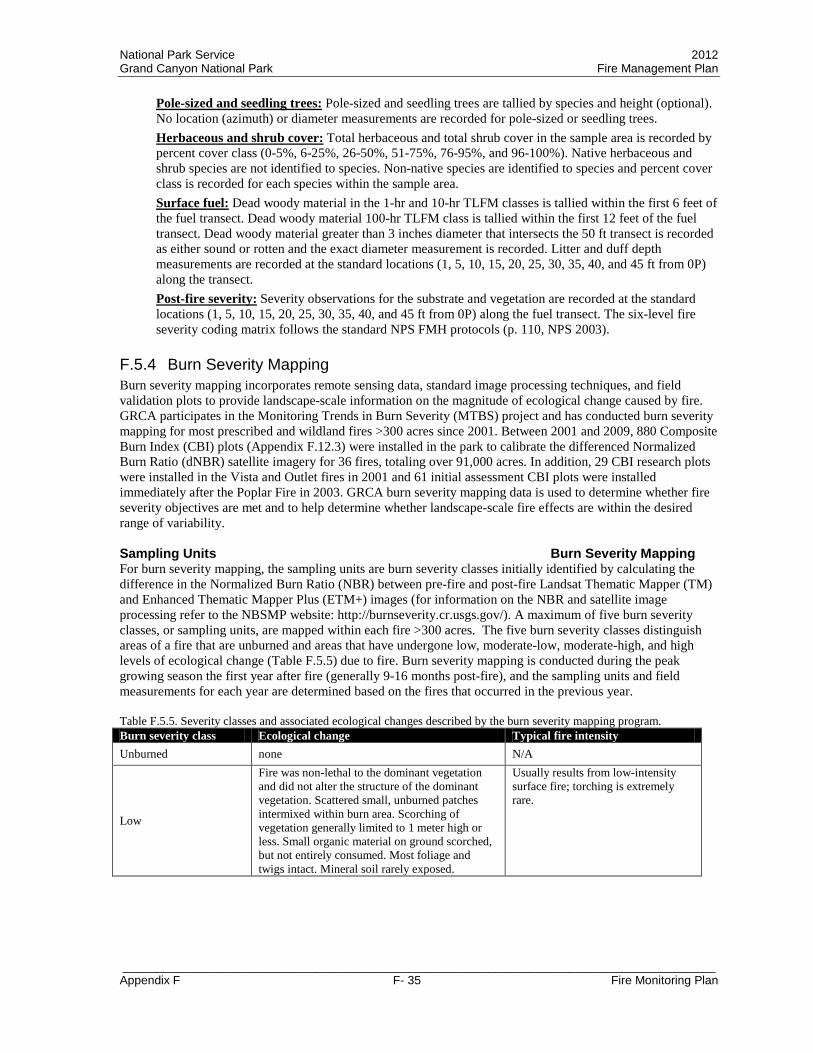
National Park Service 2012 Grand Canyon National Park Fire Management Plan
_________________________________________________________________________________________ Appendix F F- 35 Fire Monitoring Plan
Pole-sized and seedling trees: Pole-sized and seedling trees are tallied by species and height (optional). No location (azimuth) or diameter measurements are recorded for pole-sized or seedling trees. Herbaceous and shrub cover: Total herbaceous and total shrub cover in the sample area is recorded by percent cover class (0-5%, 6-25%, 26-50%, 51-75%, 76-95%, and 96-100%). Native herbaceous and shrub species are not identified to species. Non-native species are identified to species and percent cover class is recorded for each species within the sample area. Surface fuel: Dead woody material in the 1-hr and 10-hr TLFM classes is tallied within the first 6 feet of the fuel transect. Dead woody material 100-hr TLFM class is tallied within the first 12 feet of the fuel transect. Dead woody material greater than 3 inches diameter that intersects the 50 ft transect is recorded as either sound or rotten and the exact diameter measurement is recorded. Litter and duff depth measurements are recorded at the standard locations (1, 5, 10, 15, 20, 25, 30, 35, 40, and 45 ft from 0P) along the transect. Post-fire severity: Severity observations for the substrate and vegetation are recorded at the standard locations (1, 5, 10, 15, 20, 25, 30, 35, 40, and 45 ft from 0P) along the fuel transect. The six-level fire severity coding matrix follows the standard NPS FMH protocols (p. 110, NPS 2003).
F.5.4 Burn Severity Mapping Burn severity mapping incorporates remote sensing data, standard image processing techniques, and field validation plots to provide landscape-scale information on the magnitude of ecological change caused by fire. GRCA participates in the Monitoring Trends in Burn Severity (MTBS) project and has conducted burn severity mapping for most prescribed and wildland fires >300 acres since 2001. Between 2001 and 2009, 880 Composite Burn Index (CBI) plots (Appendix F.12.3) were installed in the park to calibrate the differenced Normalized Burn Ratio (dNBR) satellite imagery for 36 fires, totaling over 91,000 acres. In addition, 29 CBI research plots were installed in the Vista and Outlet fires in 2001 and 61 initial assessment CBI plots were installed immediately after the Poplar Fire in 2003. GRCA burn severity mapping data is used to determine whether fire severity objectives are met and to help determine whether landscape-scale fire effects are within the desired range of variability. Sampling Units Burn Severity Mapping For burn severity mapping, the sampling units are burn severity classes initially identified by calculating the difference in the Normalized Burn Ratio (NBR) between pre-fire and post-fire Landsat Thematic Mapper (TM) and Enhanced Thematic Mapper Plus (ETM+) images (for information on the NBR and satellite image processing refer to the NBSMP website: http://burnseverity.cr.usgs.gov/). A maximum of five burn severity classes, or sampling units, are mapped within each fire >300 acres. The five burn severity classes distinguish areas of a fire that are unburned and areas that have undergone low, moderate-low, moderate-high, and high levels of ecological change (Table F.5.5) due to fire. Burn severity mapping is conducted during the peak growing season the first year after fire (generally 9-16 months post-fire), and the sampling units and field measurements for each year are determined based on the fires that occurred in the previous year. Table F.5.5. Severity classes and associated ecological changes described by the burn severity mapping program. Burn severity class Ecological change Typical fire intensity Unburned none N/A
Low
Fire was non-lethal to the dominant vegetation and did not alter the structure of the dominant vegetation. Scattered small, unburned patches intermixed within burn area. Scorching of vegetation generally limited to 1 meter high or less. Small organic material on ground scorched, but not entirely consumed. Most foliage and twigs intact. Mineral soil rarely exposed.
Usually results from low-intensity surface fire; torching is extremely rare.

National Park Service 2012 Grand Canyon National Park Fire Management Plan
_________________________________________________________________________________________ Appendix F F- 36 Fire Monitoring Plan
Burn severity class Ecological change Typical fire intensity
Moderate-Low
Partial scorching, with minimal consumption, of foliage and fine materials on aboveground vegetation. Most green vegetation remains in overstory. Limited overstory tree mortality. Few, if any, unburned patches within the burn area. Most fine organic materials partially consumed, with minimal consumption of large logs. Rotten wood scorched to partially burned. Mineral soil intermittently exposed.
Usually results from low- to moderate-intensity surface fire with isolated single tree torching.
Moderate-High
Considerable scorching, with partial consumption, of foliage and fine materials on aboveground vegetation. Minimal green vegetation remains in overstory. Some overstory tree mortality likely. Consistent patches within burn area have large logs as well as all organic materials consumed to bare mineral soil. Most woody debris consumed. Mineral soil generally exposed but intact. May include up to 10% stand-replacing fire with extremely vigorous vegetative regrowth.
Usually results from moderate- to high-intensity surface fire with single tree and small-scale group torching.
High
Fire killed aboveground parts of all vegetation, resulting in stand-replacement and changing the forest structure substantially. All foliage and fine materials on vegetation consumed. Most large logs as well as all organic material on the ground consumed. All forest litter and duff consumed, exposing bare mineral soil.
Usually results from crown fire or large-scale group torching.
Sampling Design and Field Measurements Burn Severity Mapping The goal of field sampling in the burn severity mapping framework is to validate the severity classes initially identified by the difference in pre- and post-fire NBR (dNBR) calculation and to assist with refining the range of dNBR values that represent each severity class for a particular fire. From nine years of experience in mapping burn severity at GRCA, we know that the range of dNBR values representing a severity class can differ between fires, especially if the fires occur in areas that have burned in the recent past. For this reason, we conduct field validation for each severity class in every fire analyzed under the burn severity mapping program in GRCA. Field validation is conducted using the Composite Burn Index (CBI) plots described in the FIREMON Landscape Assessment protocol (Key and Benson 2006). The number of 30-meter diameter CBI plots installed per fire depends on fire size and complexity. Since the primary purpose of these plots is to refine the severity classes identified from the dNBR values, the plots are not randomly placed within the fire. Instead, the locations of the CBI plots are strategically chosen to provide representative samples of each dNBR-identified severity class and are typically installed in the center of 60 × 60 meter blocks that are homogeneous in terms of burn severity. In addition, CBI plot locations may be targeted in areas representing the upper and lower dNBR values for a severity classes in order to help refine the range of dNBR values that correspond to a severity class. Using the CBI plot framework, monitors quantify burn severity as a function of the degree of surface fuel consumption, soil alteration, and fire effects to overstory, midstory, and understory vegetation. Under this protocol, 21 indices of fire severity are evaluated and rated on a scale of 0 to 3, from no effect to highest severity (see plot data sheet in Appendix F.12.3). The average rating of these indices is used as the plot CBI value. In addition to the severity ratings, digital photographs are taken from two different angles to visually document fire severity and notes on community type, percent mortality of trees, and percent ground area covered by dead and down trees from the fire are recorded. It is important to note that the GRCA CBI data sheet differs slightly from the current FIREMON version. GRCA first initiated burn severity mapping in 2001 and has an interest in maintaining a consistent dataset over time. Therefore, updates to the national CBI data sheet since 2001 have not been incorporated into the park’s CBI protocols.

National Park Service 2012 Grand Canyon National Park Fire Management Plan
_________________________________________________________________________________________ Appendix F F- 37 Fire Monitoring Plan
F.5.5 Additional Short- and Long-term Resource Monitoring In addition to short- and long-term change in vegetation and fuel, GRCA managers are interested in understanding fire-related changes to other natural, cultural, and social resources. Some of this information can be gained through research collaborations, while other information will need to be generated by short- and long-term monitoring. Monitoring values outside those discussed in the previous sections (F.5.3 and F.5.4) is not a standard responsibility of the GRCA Fire Ecology Program. The additional monitoring discussed in this section will be conducted using either park base funds or project funds attained specifically for the monitoring described. Cultural-Archeological Resource Monitoring The Programmatic Agreement (PA) with the SHPO for the Fire Management Plan (NPS 2009b) describes post-fire monitoring requirements for cultural-archeological resources. This monitoring is not a component of the GRCA Fire Ecology Program and will be conducted using either park base funds or project funds attained specifically for the monitoring. Monitoring requirements in the PA include monitoring of the degree of success of mitigation treatments for preserving National Register eligible properties, which includes monitoring of fire-sensitive cultural resources receiving treatments and sites within moderate and high severity areas. In addition, the PA requires monitoring of protected fire-sensitive sites following treatment to insure effectiveness of treatments and the physical removal of protection devices and monitoring of a sample of sites not considered fire-sensitive in at least one project burn area annually. Wilderness Character Monitoring More than 94% of Grand Canyon National Park is proposed Wilderness or proposed potential Wilderness. Park managers are interested in understanding how wilderness character in the park is changing over time and how stewardship actions affect trends in wilderness character. Wilderness character monitoring is conducted in part by compiling existing datasets generated for other purposes and interpreting them in the context of wilderness character (Landres et al. 2008). The GRCA Wilderness Coordinator is responsible for conducting wilderness character monitoring, but datasets generated for the GRCA Fire Management Program may be useful for assessing whether wilderness character and its four qualities are improving, stable, or degrading over time. Information from the fire management program that may be included in on-going wilderness character monitoring includes the number of actions taken to manage fire, the percent of natural fire starts that receive a suppression response, the departure from natural fire regime, the type and amount of motorized equipment and vehicles used for emergency and non-emergency actions, the type and extent of management restrictions on recreation, and the extent and magnitude of intrusions on the natural soundscape. The information from fire management is compiled with the information from all other park management activities to assess the overall trends in wilderness character in the park over time.
National Park Service 2012 Grand Canyon National Park Fire Management Plan
_________________________________________________________________________________________ Appendix F F- 38 Fire Monitoring Plan
F.6 Data Management and Analysis F.6.1 Data Management and Quality Control Environmental Monitoring Data The Williams Interagency Dispatch Center manages fire weather and fire danger rating data and is responsible for quality control of that data. The Fire Management Program operations sections (South Rim District and North Zone) are responsible for data management and quality control of fuel moisture monitoring data. GRCA Science and Resource Management Division staff are responsible for managing data on sensitive natural and cultural-archaeological resources.
Fire Observation Monitoring Data The assigned lead Fire Effects Monitor (FEMO) is responsible for data management and quality control of burn-day fire observation data. Fire observation data can be collected with the standardized forms (Appendix F.12.3) on either hardcopy sheets or with Personal Digital Assistants (PDAs). Fire observation data from prescribed fires are not managed in a comprehensive electronic database; however, data from individual fires are typically managed in Microsoft Excel files. Prescribed fire observation data collected on hardcopy sheets are entered into Microsoft Excel and posted on the Fire & Aviation (O:\) drive of the HQ – GRCA Primary File & Print Server. Prescribed fire observation data collected with PDAs and fire observation digital photographs are uploaded to the Fire & Aviation (O:\) drive. A copy of each completed fire observation data form is given to the Prescribed Fire Burn Boss and filed in the appropriate fire binder in the Fire and Aviation Office on the South Rim. In addition, the GRCA Fire Effects Monitoring Crew maintains backup copies of all burn-day fire observation data collected in the park by crewmembers. Air quality monitoring data collected with a DataRAM during a fire are downloaded to a laptop computer. DataRAM monitoring data are transferred to the Arizona Department of Environmental Quality (ADEQ) and the GRCA Air Quality Specialist for analysis, interpretation, and management. Air quality monitoring data collected with an E-BAM are satellite-linked to the Interagency Real Time Smoke Monitoring website (http://www.satguard.com/usfs/default.asp) and managed there.
The assigned lead Resource Advisor (READ) is responsible for data management and quality control of natural and cultural resource observation data during fires. The assigned lead READ is also responsible for management of data collected during fires to fulfill year-end reporting requirements.
Short- and Long-term Vegetation and Fuel Change Monitoring Data FMH and RAP plot data are managed in the FEAT-FIREMON Integrated (FFI) software system (http://frames.nbii.gov/ffi). The Fire Ecologist is responsible for ensuring that data quality checks are taking place for the vegetation and fuel monitoring program. The Fire Ecologist is also responsible for monitoring design and interpretation, ensuring plot visits are scheduled at the appropriate time of year, and ensuring monitoring crews are properly trained. The Fire Ecologist may delegate these responsibilities to the Lead or Assistant Lead Fire Effects Monitor. All personnel are responsible for recording and entering monitoring information accurately and minimizing impacts to the plots during monitoring activities. Hardcopy data for the vegetation and fuel monitoring program are entered into the appropriate database and checked for errors by the Fire Effects Monitoring Crew. Error checking is performed by comparing each paper data sheet, in its entirety, with the data entered in the database. The error checking process is performed by two people, with one person reading the data line-by-line and the other person verifying the accuracy of the database. After large data entry and quality checking sessions, the database is backed up on an external USB drive. Once all hardcopy data from the season are entered and quality checks performed, the data sheets are filed in the appropriate plot binder in the Fire Effects Office on the South Rim. Backup copies of the hardcopy data sheets are stored in the GRCA Fire Cache on the South Rim. The complete electronic database is stored and backed up on the Fire & Aviation (O:\) drive.
Plot and reference photographs taken prior to the 2005 field season are stored as a combination of slides, digital CDs, digital scans, and/or hardcopy prints in the GRCA Fire Effects Office on the South Rim. Since 2006, plot and reference photographs have been taken with digital cameras and printed for field reference. Digital photographs are stored in a database on the Fire Effects Monitoring Crew computer and are backed up on an external hard drive.

National Park Service 2012 Grand Canyon National Park Fire Management Plan
_________________________________________________________________________________________ Appendix F F- 39 Fire Monitoring Plan
The GIS coverage of the vegetation and fuel monitoring plot locations is updated annually by the Fire Effects Monitoring Crew or the Fire Geographic Information System (GIS) Specialist. The plot location coverage is included in the park GIS files and is backed up on external hard drives by the Fire GIS Specialist.
Burn Severity Mapping Data Burn severity mapping data management and quality control is the joint responsibility of the Fire GIS Specialist and the Lead Fire Effects Monitor. Field data for burn severity mapping are collected on PDAs, downloaded to the Fire Effects Monitoring Crew computer, and transferred to the Fire GIS Specialist for analysis and backup. CBI field data collected in conjunction with burn severity mapping are currently managed in Microsoft Excel files and are scheduled for conversion to FFI by national-level contractors. Digital field data, plot location points, and plot photographs are maintained by the Fire GIS Specialist and the Fire Effects Monitoring Crew and backed up on external hard drives.
Additional Short- and Long-term Resource Monitoring Data Data collected for additional resource monitoring projects is the responsibility of the lead investigator/ resource specialist assigned to the project.
F.6.2 Data Analysis Trends in environmental monitoring data are assessed prior to planned prescribed fire by the specialists responsible for collecting the data. Long-term trend analysis occurs for weather, fire danger rating, and fuel moisture variables. Analysis of natural and cultural-archaeological resource variables is conducted by staff from the GRCA Science and Resource Management Division. The Fire Ecologist and Lead Fire Effects Monitor analyze vegetation and fuel monitoring data for all major management objectives annually in conjunction with the preparation of the GRCA Fire Ecology Annual Report. Analysis may be performed on variables not included in management objectives at the request of fire or natural resources staff or external park partners. Prior to analysis, data are tested for normal distribution. If data are normally distributed, analyses are performed using either the parametric tests available in FFI (F-test and Dunnett’s multiple comparison procedure) or appropriate tests available in external statistics software packages. If data are not normally distributed, the non-parametric tests available in FFI (Friedman’s chi-square and non-parametric multiple comparisons based on Friedman’s Rank Sums) or equivalent tests available in external statistics software packages are used for analysis. The Fire GIS Specialist analyzes CBI field data for burn severity mapping. Based on the final CBI plot value, plots are categorized as unburned, low, moderate-low, moderate-high, and high severity. The data from the plots within each severity class are used to finalize the numerical cut-off points between severity classes on the dNBR image. F.6.3 Data Sharing Data relevant to fire management are collected by other divisions in the park, by other programs in the NPS (e.g. the Southern Colorado Plateau Inventory and Monitoring Program), and by outside researchers (government and university). In addition, data collected by the Fire Ecology Program may be relevant to addressing other resource management questions in the park. There is currently no formal mechanism to combine these data and use them in an integrated format to inform fire or resource management. However, intermittent data sharing has occurred between the GRCA Fire Ecology Program and other programs within and outside the park. Data from the vegetation and fuel monitoring program is available in the FFI database program by December 31 of each year and can be queried by interested parties at that time.

National Park Service 2012 Grand Canyon National Park Fire Management Plan
_________________________________________________________________________________________ Appendix F F- 40 Fire Monitoring Plan
F.7 Reporting and Adaptive Management Monitoring data provide the basis for adaptive management and communication of monitoring results is a key step in the process to determine whether treatments are meeting objectives or whether they need modification. Monitoring data are incorporated into GRCA fire planning documents and used to evaluate and, if necessary, refine monitoring designs, treatment strategies, and/or monitoring and treatment objectives. Monitoring data may also raise additional questions about the effects of fire management on the GRCA landscape and highlight the need for research projects. The data analysis and communication step of adaptive management occurs on a number of time scales. Information may be available within the day (fire weather and behavior observations), at the completion of the treatment (overall treatment effectiveness or initial fire effects), or a year or more after treatment (burn severity, long-term effects on target or non-target vegetation). The evaluation step in adaptive management includes both targeted and synoptic assessment of the program. In some cases, this evaluation can be quantitative (comparing measured effects with predicted effects), while in other cases, a qualitative, or even subjective analysis may be required (for example, trade-offs between visibility impact and fuel reduction). The evaluation process occurs after each treatment in the form of After Action Reviews, after each season during the annual review, and once every five years in a comprehensive program review. Based on the program evaluation, opportunities for improvement may become apparent. Monitoring and evaluation of different resources may occur on different time scales (ranging from days to a few years), so the adjustment phase may be ongoing, rather than a specific action. Overall, the adjustment phase is most likely to occur daily for tactical issues on a given fire, post-fire for immediate resource concerns, annually as part of the Fire Management Plan annual review, and as needed in the development or revision of prescribed fire plans. Additional details on the Fire Management Program’s adaptive management process can be found in section 2.6.4 of the GRCA Fire Management Plan EIS/AEF (NPS 2009a). Annual Reports Monitoring accomplishments and results from vegetation and fuel monitoring data analysis are reported each year in the GRCA Fire Ecology Annual Report. This report includes a summary of monitoring activities from the year, results from data analysis, interpretation of data in the context of adaptive management, and discussion of the degree to which treatment objectives are being met. The annual report is shared with fire management staff, resource management staff, and upper division managers at the park as well as with regional office staff and interested parties outside of the NPS. It is also posted on the internal Wildland Fire Fuels, Science, and Ecology intranet site (InsideNPS) by national office staff. The information presented in the annual report will help guide the annual review of the monitoring plan. An annual report to USFWS is required as part of the Biological Opinion (BO) for the Fire Management Plan (FWS 2009). The report is completed each year by the GRCA Science and Resource Management Division, Office of Planning and Compliance, and Branch of Fire and Aviation staff. The BO annual report outlines calendar year's actions in relation to listed species, documents effects to species and their habitat from fire management activities, documents the implementation and effectiveness of the terms and conditions of the biological opinion, and outlines rehabilitation efforts. Two annual reports are required as part of the Programmatic Agreement (PA) with the State Historic Preservation Officer (SHPO) for the Fire Management Plan (NPS 2009b). These reports are completed each year by the GRCA Science and Resource Management Division, Office of Planning and Compliance, and Branch of Fire and Aviation staff. The pre fire season project planning report outlines plans to survey planned project units, the status of cultural inventories in the units, and the Assessments of Effect for the coming year. The post fire season report includes a summary of all fire activity for the year, summary of protection measures employed and their effectiveness, and the results of inventory and monitoring conducted during the year’s incidents. Reports are provided to appropriate internal and external stakeholders to aid in the evaluation of program activities. In addition to these annual reports, reporting occurs via conversation, phone, and email on a routine

National Park Service 2012 Grand Canyon National Park Fire Management Plan
_________________________________________________________________________________________ Appendix F F- 41 Fire Monitoring Plan
basis between the Fire Ecologist, Lead Fire Effects Monitor, other GRCA Fire and Aviation staff, GRCA Science and Resource Management Division staff, and GRCA Office of Planning and Compliance staff. External publications and presentations Monitoring results may be presented at conferences and other special meetings or submitted for publication in appropriate journals. Results that both support and contradict published literature are of special interest.

National Park Service 2012 Grand Canyon National Park Fire Management Plan
_________________________________________________________________________________________ Appendix F F- 42 Fire Monitoring Plan
F.8 Fire Research The Mission Goals for the NPS Wildland Fire Management Program outlined in Director’s Order DO-18 include science-based management and integration of Wildland Fire with other NPS programs (NPS 2008a). Both of these goals are achieved, in part, through fire research. In addition, Federal Wildland Fire Management Policy (U.S. Government 2001) states that “Fire management plans and programs will be based on a foundation of sound science. Research will support ongoing efforts to increase our scientific knowledge of biological, physical, and sociological factors…and must be made available to managers in a timely manner, and must be used in the development of…fire management plans, and implementation plans.” Conducting research that will help define natural fire regimes, refine prescriptions, provide data for fire behavior models, and effectively implement the Fire Management Program is an objective of the GRCA FMP. In addition to understanding the historic and current role of fire in park ecosystems, fire-related research at GRCA aims to acquire the knowledge necessary to improve fire management practices that affect the park’s natural, cultural, and social values. F.8.1 Past and Current Research Much of the completed fire-related research relevant to GRCA is referenced throughout the Fire Management Plan EIS/AEF (NPS 2009a). Past fire-related research within GRCA includes studies on:
• forest reference conditions (Schumutz et al. 1967, Covington et al. 2000, Fulé et al. 2000, Rowlands and Brian 2001, Fulé et al. 2002ab, Mast and Wolf 2004, Mast and Wolf 2006),
• fire regimes (Bennett 1976, Duhnkrack 1982, Wolf and Mast 1998, Covington et al. 2000, Fulé et al. 2003ab, Meigs 2004, Baker 2006, Fulé et al. 2006ab, Haire and McGarigal 2009),
• restoration (Fulé et al. 2002ab, Fulé et al. 2004ab, Fulé et al. 2006ab), • fire effects to vegetation (Bennett 1976, Harrington and Hawksworth 1988, White and Vankat 1993,
Kaufmann 2000, Gildar et al. 2004, Laughlin et al. 2004, Huisinga et al. 2005, Laughlin et al. 2005, Laughlin and Grace 2006, Fulé and Laughlin 2007, Laughlin and Fulé 2008, Haire and McGarigal 2008, Kim et al. 2009)
• fire effects to wildlife (Bennett 1976, Muleady-Mecham 2003) • fire effects to soils (Bennett 1976) • fuel and fire behavior (Fulé et al. 2004ab) • air quality and smoke (Stearns 1988) • information and education (Baas et al. 1985, Muleady-Mecham 2003)
GRCA Fire Management Program personnel are currently working with university researchers to investigate the short- and long-term implications of fire severity on forest vegetation through three on-going research collaborations. The first of these collaborations aims to produce a comparable set of burn severity mapping values for examining past and future fires and a park-wide map of fire severity in all fires within the park from 1984 to the present. Building on this map, the second project aims to determine the present-day differences in vegetation recovery in areas burned under different burn severities at different time intervals before the present. The third project will then model expected future forest conditions after different severity fires and under various management strategies. These projects will allow fire managers to better understand how higher severity fire patches affect forest regeneration, the potential for different severity fires in the future, and the longevity of fire treatments. F.8.2 Research Needs Future fire research needs were compiled during an interdisciplinary meeting held on February 25, 2009 between GRCA Fire and Aviation, GRCA Science and Resource Management, and Southern Colorado Plateau Network Inventory and Monitoring personnel. Fire research needs related to vegetation, wildlife, cultural resources, air quality, hydrology, fuel management, and social and economic values were identified during this meeting. Research needs are currently not prioritized by discipline or by overall priority. The Fire Ecologist will facilitate the prioritization process with input from fire and resource management staff. Research needs will be disseminated to the research community through the Colorado Plateau Cooperative Ecosystem Studies Unit (CESU), the GRCA Research Coordinator, the Southwest Fire Science Consortium, and other partners.

National Park Service 2012 Grand Canyon National Park Fire Management Plan
_________________________________________________________________________________________ Appendix F F- 43 Fire Monitoring Plan
Vegetation and Fuel
• Determine fire regime, reference conditions, and effects of fire on piñon-juniper vegetation types. • Determine the effectiveness of multiple entry fires and temporal spacing of fire for fuel reduction. • Investigate the effects of fire management activities, the influence of the spatial scale of fire patches,
and post-fire succession on exotic plant species invasion. • Model expected range of variation in mixed-conifer and spruce-fir forest structure in climates
experienced now and predicted for the future. • Model expected range of variation in fire regimes and fire behavior in climates experienced now and
predicted for the future. • Investigate patch age structure at the landscape scale to better define mixed-severity fire regime. • Determine the effectiveness of post-fire rehabilitation techniques, refine rehabilitation methodologies,
and develop a GRCA post-fire rehabilitation handbook. • Mine existing data to determine the dominant understory plant species in each vegetation type and
develop seed collection and storage protocols for these plants to fulfill the need for an in-park seed source for post-fire rehabilitation efforts.
• Develop a map of Bromus spp. (cheatgrass, red brome, and ripgut brome) locations in forested areas from existing data, determine threshold levels that would trigger control actions, and prepare an action plan that includes control measures and recommended fire management activities.
• Determine effects of burning in different seasons on fuel reduction, vegetation response, and exotic plant species invasion.
• Understand non-fire causes of canopy tree mortality in spruce-fir and mixed-conifer vegetation types and how this mortality affects fire management options.
• Mine existing data on the current status of invasive and rare plant species in burn units to inform prescribed fire plan objectives.
• Investigate the effects of prescribed fire size on fuel and vegetation. • Understand meadow encroachment on the North Rim and whether fire affects this process.
Wildlife
• Understand Mexican spotted owl behavioral responses to fire and smoke. • Investigate the effects of burn severity on Mexican spotted owl habitat components. • Investigate the influence of spatial scale of fire patches and succession on bird communities. • Determine effects of burning in different seasons on wildlife habitat and populations. • Understand fire effects to small mammals in higher elevation forests.
Cultural Resources, Social and Economic Values
• Build a predictive model for locating archaeological sites in areas without survey. Determine a survey strategy by vegetation type or fire management unit for locating archaeological sites.
• Determine the effectiveness of mitigation measure treatments for cultural resources. • Understand fire effects to cultural resources using post-fire archeological surveys. • Understand the response of ethnographically important plants to fire. • Understand tribal perspectives on managing fire effects to cultural resources. • Determine the cost effectiveness of prescribed fires of varying size. • Survey visitor understanding and opinions on fire management activities, fire management goals and
benefits, and change in fire policy implementation. • Understand effects of planned and unplanned fire management activities to visitor experience
(closures, viewshed, soundscape, visibility). • Examine whether wilderness stewardship mitigations are effective at meeting the goals of both
wilderness management and fire management.
Air Resources • Investigate smoke impacts in the Bodaway/Gap area. • Investigate smoke penetration into the canyon and model the venting process. • Understand the effects of prescribed fire size on air quality.

National Park Service 2012 Grand Canyon National Park Fire Management Plan
_________________________________________________________________________________________ Appendix F F- 44 Fire Monitoring Plan
• Mine existing data on weather, fire conditions, and air quality parameters to understand their interactions.
• Determine the effectiveness of health hazard warnings related to air quality standards. Water Resources
• Investigate changes in potential for debris flows and flash floods following fire. • Determine fire effects to water quality in canyons. • Understand fire effects to seeps, springs, sinkhole ponds, and wetlands.

National Park Service 2012 Grand Canyon National Park Fire Management Plan
_________________________________________________________________________________________ Appendix F F- 45 Fire Monitoring Plan
F.9 Roles and Responsibilities The Fire Ecology Program at GRCA is organized in the Division of Visitor and Resource Protection, Branch of Fire and Aviation. The Deputy Fire Management Officer supervises the Fire Ecologist and the Fire Geographic Information System (GIS) Specialist and has program oversight responsibilities. The Fire Ecologist oversees the Fire Effects Monitoring Crew, which consists of a permanent Lead Monitor, a permanent Assistant Lead Monitor, and seasonal crewmembers. F.9.1 Staff roles and responsibilities The roles and responsibilities of the Fire Management Officer and Deputy Fire Management Officer are described in Section 3.9.1. of the GRCA Fire Management Plan EIS/AEF (NPS 2009a). The responsibilities of the Fire Ecology and Fire GIS program staff are as follows: Fire Ecologist The Fire Ecologist serves as the program expert in fire ecology and coordinates with other resource managers to collect scientific information regarding long- and short-term effects of fire and fuel management activities. The Fire Ecologist is responsible for the development and implementation of the monitoring plan, which includes assessment and modification of the monitoring design and analysis of data. The Fire Ecologist is also responsible for ensuring that data management and quality control procedures are in place and for overseeing the hiring, training, and supervising of the Fire Effects Monitoring Crew. The role of the Fire Ecologist in the adaptive management process is to report monitoring results to fire and resource managers, conduct literature reviews and interpret results, identify fire- and fuel-related research needs, and coordinate research efforts. The Fire Ecologist assists with the development of quantifiable objectives for prescribed fire and non-fire fuel treatment plans and reviews fire management, prescribed fire, and non-fire fuel treatment plans. In addition, the Fire Ecologist coordinates with regional and national fire ecologists, the Inventory and Monitoring Program, and other resource management monitoring programs, and acts as a liaison with park natural and cultural resource programs. The Fire Ecologist has budget and fiscal responsibility for the Fire Monitoring Program. Fire GIS Specialist The Fire GIS Specialist provides a variety of support products to the Fire Management Program, such as geospatial expertise, data layers, and maps. In support of the Fire Monitoring Plan, the Fire GIS Specialist manages the burn severity mapping program and fire history database. The Fire GIS Specialist requests, maintains, and analyzes burn severity satellite imagery through the Monitoring Trends in Burn Severity program. The Fire GIS Specialist also coordinates location and installation of Composite Burn Index field plots, and maintains and analyzes burn severity data. In addition, the Fire GIS Specialist facilitates research on burn severity and spatial aspects of fire management. Lead Fire Effects Monitor The Lead Fire Effects Monitor oversees collection and storage of monitoring data needed to determine the effectiveness of the Fire Management Program in meeting objectives. The Lead Fire Effects Monitor is responsible for hiring and training the Assistant Lead Fire Effects Monitor and seasonal crewmembers, directing and overseeing the daily operations of the Fire Effects Monitoring Crew in the field and office, setting the monitoring schedule, and ensuring data quality. In addition, the Lead Fire Effects Monitor collaborates with the Fire Ecologist on planning and annual reporting documents. The Lead Fire Effects Monitor also assists with the implementation and monitoring of fire treatments as needed and as available. Assistant Lead Fire Effects Monitor The Assistant Lead Fire Effects Monitor performs and coordinates field and office duties associated with the collection and storage of fire effects monitoring data in order to determine effectiveness of the Fire Management Program in meeting objectives. The Assistant Lead Fire Effects Monitor is responsible for leading the crew in the absence of the Lead Fire Effects Monitor (see Lead Fire Effects Monitor duties).

National Park Service 2012 Grand Canyon National Park Fire Management Plan
_________________________________________________________________________________________ Appendix F F- 46 Fire Monitoring Plan
F.9.2 Work plans and prioritization The Deputy Fire Management Officer develops annual work plans and priorities for the Fire Ecologist and Fire GIS Specialist. The Fire Ecologist and Lead Fire Effects Monitor develop annual work plans and priorities for the Fire Effects Monitoring Crew prior to the arrival of the seasonal crewmembers.

National Park Service 2012 Grand Canyon National Park Fire Management Plan
_________________________________________________________________________________________ Appendix F F- 47 Fire Monitoring Plan
F.10 Consultation, Collaboration and Review This monitoring and research plan was compiled in consultation with many stakeholders. The implementation of this plan and future reviews will continue to involve collaborations with these and other interested parties. F.10.1 Plan Input Several meetings were held to solicit input into this monitoring plan. Fire Research was the focus of an interdisciplinary meeting conducted on February 25, 2009. Goals and Objectives and Monitoring Unit Descriptions were revised during meetings held on March 10 and 23, 2009 and February 16, 2010. The following individuals contributed to these and other sections through meetings and informal conversation:
Table F.10.1. Individuals who provided input during monitoring plan development. V&RP=Visitor and Resource Protection. Name Division/Association Title Section Input Carl Bowman GRCA, Science & Resource
Management Division Air Quality Specialist (former)
Fire Research
Li Brannfors GRCA, V&RP, Branch of Fire & Aviation
Lead Fire Effects Monitor
Goals and Objectives, Monitoring Design, Data Management, Appendices
Jim DeCoster NPS, Southern Colorado Plateau Inventory and Monitoring Network
Plant Ecologist Fire Research
Ken Gerow University of Wyoming, Department of Statistics
Professor Monitoring Design (project-level monitoring plot size and sample size)
Eric Gdula GRCA, V&RP Division, Branch of Fire & Aviation
Fire GIS Specialist Monitoring Design (burn severity), Data Management, Fire Research
Arthur Gonzales GRCA, V&RP, Branch of Fire & Aviation
South District Fire Management Officer
Goals and Objectives, Monitoring Unit Descriptions Appendix
Ed Hiatt GRCA, V&RP, Branch of Fire & Aviation
North Zone Fire Management Officer
Goals and Objectives, Monitoring Unit Descriptions Appendix
Amy Horn GRCA, Science & Resource Management Division
Archaeology Program Manager (former)
Fire Research
Mike Kearsley GRCA, Science & Resource Management Division
Vegetation Mapping Program Coordinator
Fire Research
Lori Makarick GRCA, Science & Resource Management Division
Vegetation Program Manager
Fire Research
Christopher Marks GRCA, V&RP, Branch of Fire & Aviation
Deputy Fire Management Officer
Goals and Objectives, Monitoring Unit Descriptions Appendix, Fire Research
Steve Mietz GRCA, Science & Resource Management Division
Deputy Chief Natural Resources Management(former)
Fire Research
Kathryn Parker GRCA, Science & Resource Management Division
Climate Change Coordinator (former)
Fire Research
Jasper Peach GRCA, V&RP, Branch of Fire & Aviation
Assistant Lead Fire Effects Monitor
Monitoring Design, Data Management
Dan Pearson GRCA, V&RP, Branch of Fire & Aviation
South District AFMO Goals and Objectives, Monitoring Unit Descriptions Appendix
Steven Rice GRCA, Science & Resource Management Division
Hydrologist Fire Research
Dave Robinson GRCA, V&RP, Branch of Fire & Aviation
North Zone AFMO-Fuels
Goals and Objectives, Monitoring Unit Descriptions Appendix
Jane Rodgers GRCA, Science & Resource Management Division
Deputy Chief Socio-Cultural Resources Management
Fire Research
Carmen Sipe GRCA, Science & Resource Management Division
Fire Wildlife Biologist (former)
Goals and Objectives, Fire Research, Monitoring Unit Descriptions Appendix
Lisa Thomas NPS, Southern Colorado Plateau Inventory and Monitoring Network
Program Manager Fire Research
R.V. Ward GRCA, Science & Resource Management Division
Wildlife Program Manager
Fire Research

National Park Service 2012 Grand Canyon National Park Fire Management Plan
_________________________________________________________________________________________ Appendix F F- 48 Fire Monitoring Plan
F.10.2 Agency/Interagency Collaboration The GRCA Fire Management Program will collaborate closely with the GRCA Science and Resource Management Division in the implementation of this plan. In addition, the Fire Management Program will collaborate with the GRCA Air Quality Specialist in implementing smoke and air quality monitoring and with the Vegetation Program Manager to assess the effects of fire management activities on invasive plant species.
The GRCA Fire Ecologist will also collaborate with the Southern Colorado Plateau Network (SCPN) Inventory and Monitoring Program to identify areas where monitoring data can be shared. The SCPN is currently in the early stages of installing long-term monitoring plots in the mixed-conifer forests of the North Rim and is evaluating the potential for installing long-term plots in one of the piñon-juniper communities within the park. GRCA Science and Resource Management staff, with support from GRCA Fire Management staff, work with U.S. Fish and Wildlife Service, Arizona State Historic Preservation Officer, and affiliated Indian Tribes to keep these stakeholders informed of fire management activities and monitoring and research results. F.10.3 Peer review Peer/technical review for this plan was provided by both internal (Grand Canyon National Park) and external reviewers. Grand Canyon National Park reviewers include:
Name Title Visitor and Resource Protection Division, Branch of Fire & Aviation Christopher Marks Deputy Fire Management Officer Li Brannfors Lead Fire Effects Monitor Science & Resource Management Division Jane Rodgers Deputy Chief Socio-Cultural Resources Management
Ian Hough Archaeology Program Manager (acting) Linda Jalbert Planner / Wilderness Coordinator Lori Makarick Vegetation Program Manager Steven Rice Hydrologist R.V. Ward Wildlife Program Manager
External peer reviewers include:
Jim DeCoster, Plant Ecologist, National Park Service Southern Colorado Plateau Network Peter Fulé, Associate Professor, School of Forestry and Associate Director for Ecological Research,
Ecological Restoration Institute, Northern Arizona University Cody Wienk, Regional Fire Ecologist, National Park Service Midwest Region
National Park Service 2012 Grand Canyon National Park Fire Management Plan
_________________________________________________________________________________________ Appendix F F- 49 Fire Monitoring Plan
F.11 References Allen, C. D., M. Savage, D. A. Falk, K. F. Suckling, T. W. Swetnam, T. Schulke, P. B., Stacey, P. Morgan, M.
Hoffman, and J. T. Klingel. 2002. Ecological restoration of southwestern ponderosa pine ecosystems: a broad perspective. Ecological Applications 12: 1418-1433.
Baas, J. M., G. E. Haas, D. M. Ross, R. J. Loomis. 1985. A pilot study of visitor knowledge and support for prescribed burning at Grand Canyon National Park. Proceedings of the symposium and workshop on wilderness fire. USDA Forest Service, Intermountain Forest and Range Experiment Station, General Technical Report INT-182, Ogden, UT.
Baker, W. L. 2006. Fire history in ponderosa pine landscapes of Grand Canyon National Park: is it reliable enough for management and restoration? International Journal of Wildland Fire 15:433-437.
Bennett, P. S. 1976. The fire ecology of the ponderosa pine ecosystems of the North Rim forests, Grand Canyon National Park. Unpublished report. Grand Canyon National Park, AZ.
Brown, J.K. 1974. Handbook for inventorying downed woody material. General Technical Report INT-16. U.S. Department of Agriculture, Forest Service.
Covington, W.W., M.M. Moore, P.Z. Fulé, and H.B. Smith. 2000. Grand Canyon Forest Restoration. Research objective 1: Landscape studies of fire regimes and forest structure. Ecological Restoration Institute, Northern Arizona University, Flagstaff, Arizona.
Duhnkrack, J.A. 1982. Fire regime analysis of ponderosa pine forest at the Grandview Monocline on the South Rim of Grand Canyon National Park, Arizona. Problem Series, Huxley College of Environmental Studies, Western Washington University, Bellingham, WA.
Ffolliott, P.F., W.P. Clary, and J.R. Davis. 1968. Some characteristics of the forest floor under ponderosa pine in Arizona. Research Note RM-127. U.S. Department of Agriculture, Forest Service.
Fulé, P. Z., J. E. Crouse, T. A. Heinlein, M. M. Moore, W. W. Covington and G. Verkamp. 2003a. Mixed-severity fire regime in a high-elevation forest of Grand Canyon, Arizona, USA. Landscape Ecology. 18:465–486.
Fulé, P.Z, and D.C. Laughlin. 2007. Wildland fire effects on forest structure over an altitudinal gradient, Grand Canyon National Park, USA. Journal of Applied Ecology 44:136-146.
Fulé, P.Z., A.E. Cocke, T.A. Heinlein, and W.W. Covington. 2004a. Effects of an intense prescribed forest fire: is it ecological restoration? Restoration Ecology 12:220-230.
Fulé, P.Z., J.E. Crouse, A.E. Cocke, M.M. Moore, and W.W. Covington. 2004b. Changes in canopy fuels and potential fire behavior 1880-2040: Grand Canyon, Arizona. Ecological Modelling 175:231-248.
Fulé, P.Z., T.A. Heinlein, and W.W. Covington. 2006b. Fire histories in ponderosa pine forests of Grand Canyon are well supported: reply to Baker. International Journal of Wildland Fire 15:439–445.
Fulé, P.Z., T.A. Heinlein, W.W. Covington, and M.M. Moore. 2000. Continuing fire regimes in remote forests of Grand Canyon National Park. In: D.N. Cole, S.F. McCool, W.T. Borrie, and F. O'Loughlin, compilers. Proceedings: wilderness science in a time of change conference, volume 5: wilderness ecosystems, threats, and management, May 23-27, 1999, Missoula, Montana. U.S. Department of Agriculture, Forest Service Proceedings RMRS-P-15-VOL-5, Rocky Mountain Research Station, Ogden, UT.
Fulé, P.Z., T.A. Heinlein, W.W. Covington, and M.M. Moore. 2003b. Assessing fire regimes on Grand Canyon landscapes with fire-scar and fire-record data. International Journal of Wildland Fire 12:129-145.
Fulé, P.Z., W.W. Covington, H.B. Smith, J.D. Springer, T.A. Heinlein, K.D. Huisinga, and M.M. Moore. 2002b. Comparing ecological restoration alternatives: Grand Canyon, Arizona. Forest Ecology & Management 170:19-41.
Fulé, P.Z., W.W. Covington, M.M. Moore, T.A. Heinlein, and A.E.M. Waltz. 2002a. Natural variability in forests of the Grand Canyon, USA. Journal of Biogeography 29:31-47.
Fulé, P.Z., W.W. Covington, M.T. Stoddard, and D. Bertolette. 2006a. Minimal-impact restoration treatments have limited effects on forest structure and fuels at Grand Canyon, USA. Restoration Ecology 14:357–368.

National Park Service 2012 Grand Canyon National Park Fire Management Plan
_________________________________________________________________________________________ Appendix F F- 50 Fire Monitoring Plan
Gildar, C.N., P.Z. Fule, W.W. Covington. 2004. Plant community variability in ponderosa pine forest has implications for reference conditions. Natural Areas Journal 24:101–111.
Gori, Dave and Joanna Bate. 2007. Historical Range of Variation and State and Transition Modeling of Historical and Current Landscape Conditions for Pinyon-Juniper of the Southwestern U.S. Prepared for the U.S.D.A. Forest Service, Southwestern Region by The Nature Conservancy, Tucson, AZ.
Haire, S.L. and K. McGarigal. 2008. Inhabitants of landscape scars: succession of woody plants after large, severe forest fires in Arizona and New Mexico. The Soutwestern Naturalist 53: 146-161.
Haire, S.L. and K. McGarigal. 2009. Changes in fire severity across gradients of climate, fire size, and topography: a landscape ecological perspective. Fire Ecology 5: 86-103.
Harrington, M.G. and F.G. Hawksworth. 1988. Interactions of fire and dwarf mistletoe and mortality of southwestern ponderosa pine. Effects of fire management of southwestern natural resources: proceedings of the symposium. USDA Forest Service, Rocky Mountain Forest and Range Experiment Station, Fort Collins, CO.
Huffman, D.W., P.Z. Fulé, K.M. Pearson, and J.E. Crouse. 2008. Fire history of pinyon-juniper woodlands at upper ecotones with ponderosa pine forests in Arizona and New Mexico. Canadian Journal of Forest Research 38: 2097-2108.
Huisinga, K.D., D.C. Laughlin, P.Z. Fulé, J.D. Springer, and C.M. McGlone. 2005. Effects of an intense prescribed fire on understory vegetation in a mixed-conifer forest. Journal of the Torrey Botanical Society 132:590-601.
Kaufman, G.A. 2000. Effects of prescribed burning on mortality of presettlement ponderosa pines in Grand Canyon National Park. MS Thesis. Northern Arizona University, Flagstaff, AZ.
Key, C.H. and N.C. Benson. 2006. Landscape Assessment: Ground measure of severity, the Composite Burn Index; and Remote sensing of severity, the Normalized Burn Ratio. In Lutes, D.C., R.E. Keane, J.F. Caratti, C.H. Key, N.C. Benson, S. Sutherland, and L.J. Gangi. FIREMON: Fire Effects Monitoring and Inventory System. USDA Forest Service, Rocky Mountain Research Station, Ogden, UT. Gen. Tech. Rep. RMRS-GTR-164-CD: LA 1-51.
Kim, Y., Z. Yang, W.B. Cohen, D. Pflugmacher, C.L. Lauver, and J.L. Vankat. 2009. Distinguishing between live and dead standing tree biomass on the North Rim of Grand Canyon National Park, USA using small-footprint lidar data. Remote Sensing of Environment 113: 2499-2510.
Landres, P., Barns, C., Dennis, J.G., Devine, T., Geissler, P., McCasland, C.S., Merigliano, L., Seastrand, J., and Swain, R. 2008. Keeping it wild: an interagency strategy to monitor trends in wilderness character across the National Wilderness Preservation System. USDA Forest Service, Rocky Mountain Research Station, Fort Collins, CO. Gen. Tech. Rep. RMRS-GTR-212.
Laughlin, D.C. and J.B. Grace. 2006. A multivariate model of plant species richness in forested systems: old-growth montane forests with a long history of fire. Oikos 114:60-70.
Laughlin, D.C. and P.Z. Fulé. 2008. Wildland fire effects on understory plant communities in two fire-prone forests. Canadian Journal of Forest Research 38:133-142.
Laughlin, D.C., J.D. Bakker, and P.Z. Fulé. 2005. Understory plant community structure in lower montane and subalpine forests, Grand Canyon National Park, USA. Journal of Biogeography 32:2083–2102.
Laughlin, D.C., J.D. Bakker, M.T. Stoddard, M.L. Daniels, J.D. Springer, C.N. Gildar, A.M. Green, and W.W. Covington. 2004. Toward reference conditions: wildfire effects on flora in an old-growth ponderosa pine forest. Forest Ecology and Management 199:137-152.
Loomis, R.M. 1977. Jack pine and aspen forest floors in northeastern Minnesota. Research Note NC-222. U.S. Department of Agriculture, Forest Service.
Mast, J.N. and J.J. Wolf. 2004. Ecotonal changes and altered tree spatial patterns in lower mixed-conifer forests, Grand Canyon National Park, Arizona, U.S.A. Landscape Ecology 19:167-180.
Mast, J.N. and J.J. Wolf. 2006. Spatial patch patterns and altered forest structure in middle elevation versus upper ecotonal mixed-conifer forests, Grand Canyon National Park, Arizona, USA. Forest Ecology and Management 236:241-250.

National Park Service 2012 Grand Canyon National Park Fire Management Plan
_________________________________________________________________________________________ Appendix F F- 51 Fire Monitoring Plan
Meigs, G.W. 2004. Recent patterns of large fire events on Kaibab Plateau, Arizona, USA. Undergraduate Honors Thesis. Cornell University, Ithaca, NY.
Merkle, J. 1954. An analysis of the spruce-fir community on the Kaibab Plateau, Arizona. Ecology 35: 316-322. Moore, M.M. and D.W. Huffman. 2004. Tree Encroachment on Meadows of the North Rim, Grand Canyon
National Park, Arizona, U.S.A. Arctic, Antarctic, and Alpine Research 36: 474-483. Muleady-Mecham, N.E. 2003. The natural history of fire in Grand Canyon National Park. PhD Dissertation.
Northern Arizona University, Flagstaff, AZ. Romme, W.H. + 14 others. 2009. Historical and modern disturbance regimes, stand structures, and landscape
dynamics in piñon–juniper vegetation of the western United States. Rangeland Ecology and Management 62: 203-222.
Rowlands, P.G. and N.J. Brian. 2001. Fishtail Mesa: a vegetation resurvey of a relict area in Grand Canyon National Park, Arizona. Western North American Naturalist 61:159-181.
Sackett, S.S. 1980. Woody fuel particle size and specific gravity of southwestern tree species. Research Note RM-389. U.S. Department of Agriculture, Forest Service, Rocky Mountain Forest and Range Experiment Station, Fort Collins, CO.
Schmutz, E.M., C.C. Michaels, and B.I. Judd. 1967. Boysag Point: a relict area on the North Rim of Grand Canyon in Arizona. Journal of Range Management 20:363-369.
Smith, Ed. 2006a. Historical Range of Variation and State and Transition Modeling of Historical and Current Landscape Conditions for Mixed Conifer of the Southwestern U.S. Prepared for the U.S.D.A. Forest Service, Southwestern Region by The Nature Conservancy, Tucson, AZ.
Smith, Ed. 2006b. Historical Range of Variation and State and Transition Modeling of Historical and Current Landscape Conditions for Ponderosa Pine of the Southwestern U.S. Prepared for the U.S.D.A. Forest Service, Southwestern Region by The Nature Conservancy, Tucson, AZ.
Smith, Ed. 2006c. Historical Range of Variation and State and Transition Modeling of Historical and Current Landscape Conditions for Spruce-Fir of the Southwestern U.S. Prepared for the U.S.D.A. Forest Service, Southwestern Region by The Nature Conservancy, Tucson, AZ.
Smith, Ed. 2007. Historical Range of Variation and State and Transition Modeling of Historical and Current Landscape Conditions for Montane Grassland of the Southwestern U.S. Prepared for the U.S.D.A. Forest Service, Southwestern Region by The Nature Conservancy, Tucson, AZ.
Stearns, L.P. 1988. Meterological studies for smoke management in Grand Canyon National Park. Unpublished report. USDOI, National Park Service, Air Quality Division. Interagency Agreement 492-082-03.
SWCC (Southwest Coordination Center). 2004. Southwest Area Fuel Moisture Monitoring Program: Standard Methods and Procedures. Southwest Coordination Center, Albuquerque, NM.
Sydoriak, W. 1991. FMH Software Manual. National Park Service, Western Regional Office. Oakland, CA. Thomas, L.P., M.N. Hendrie (editor), C.L. Lauver, S.A. Monroe, N.J. Tancreto, S.L. Garman, and M.E. Miller.
2006. Vital Signs Monitoring Plan for the Southern Colorado Plateau Network. Natural Resource Report NPS/SCPN/NRR-2006/002. National Park Service, Fort Collins, CO.
van Wagtendonk, J. W., J. M. Benedict, and W.M. Sydoriak. 1996. Physical properties of woody fuel particles of Sierra Nevada conifers. International Journal of Wildland Fire 6: 117-123.
van Wagtendonk, J. W., J. M. Benedict, and W.M. Sydoriak. 1998. Fuel bed characteristics of Sierra Nevada conifers. Western Journal of Applied Forestry 13: 73-84.
White, M.A. and J.L. Vankat. 1993. Middle and high elevation coniferous forest communities of the North Rim region of Grand Canyon National Park, Arizona, USA. Vegetatio 109:161-174.
Wolf, J.J. and J.N. Mast. 1998. Fire history of mixed-conifer forests on the North Rim, Grand Canyon National Park, Arizona. Physical Geography 19:1-14.

National Park Service 2012 Grand Canyon National Park Fire Management Plan
_________________________________________________________________________________________ Appendix F F- 52 Fire Monitoring Plan
U.S. GOVERNMENT 2001 Review and update of the 1995 Federal Wildland Fire Management Policy. Bureau of Land
Management Office of Fire and Aviation, National Interagency Fire Center, Boise, ID. 78 pp. U.S. DEPARTMENT OF AGRICULTURE (USDA) 1974 Wood handbook: Wood as an engineering material. Agriculture Handbook 72 (revised). 414 pp. U.S. DEPARTMENT OF THE INTERIOR (USDOI) Fish and Wildlife Service (USFWS) 2004 Endangered and Threatened Wildlife and Plants: Final Designation of Critical Habitat for the Mexican
Spotted Owl: Final Rule. Federal Register 69(168):53182-53297. 2006 Sentry Milk-vetch (Astragalus cremnophylax Barneby var. cremnophylax Barneby) Recovery Plan.
U.S. Fish and Wildlife Service, Albuquerque, New Mexico. i-vi +44 pp. 2009 Biological Opinion for the Grand Canyon National Park Fire Management Plan. Arizona Ecological
Services Field Office, Phoenix, AZ. 50 pp. National Park Service (NPS) 1995 General Management Plan, Grand Canyon National Park. Denver Service Center, Denver, CO. 67 pp. 1997 Resource Management Plan. Grand Canyon National Park, Grand Canyon, AZ. 190 pp. 2000 Fire Effects Monitoring Plan. Grand Canyon National Park, Grand Canyon, AZ. 24 pp. 2003 Fire Monitoring Handbook. Fire Management Program Center, National Interagency Fire Center,
Boise, ID. 274 pp. 2006 Management Policies. National Park Service, Washington, D.C. 168 pp. 2008a Director's Order #18: Wildland Fire Management. Effective Date: January 16, 2008. 2008b Reference Manual 18: Wildland Fire Management. Release Date: January 1, 2008. 2009a Fire Management Plan Environmental Impact Statement and Assessment of Effect. Grand Canyon
National Park, Grand Canyon, AZ. 677 pp. 2009b Programmatic Agreement by and among The National Park Service, Grand Canyon National Park and
The Arizona State Historic Preservation Officer regarding Fire Management Plan at Grand Canyon National Park. Grand Canyon National Park, Grand Canyon, AZ. 10 pp.
2009c Exotic Plant Management Plan Environmental Assessment and Assessment of Effect. Grand Canyon National Park, Grand Canyon, AZ. 182 pp.
2010a Record of Decision Fire Management Plan Environmental Impact Statement and Assessment of Effect. Grand Canyon National Park, Grand Canyon, AZ. 29 pp.
2010b Grand Canyon National Park and Kaibab National Forest National Fire Danger Rating System 2010 Operating Plan. Grand Canyon National Park, Grand Canyon, AZ. 20 pp.
National Park Service 2012 Grand Canyon National Park Fire Management Plan
_________________________________________________________________________________________ Appendix F F- 53 Fire Monitoring Plan
F.12 Appendices F.12.1 Monitoring Unit Descriptions (FMH-4s) F.12.2 Monitoring Schedule F.12.3 Data Sheets F.12.4 Plant List F.12.5 Monitoring Results F.12.6 Calculations F.12.7 Special Status and Exotic Species of Concern
National Park Service 2012 Grand Canyon National Park Fire Management Plan _________________________________________________________________________________________
_________________________________________________________________________________________ Appendix F F- 54 Fire Monitoring Plan
F.12.1 Monitoring Unit Descriptions (FMH-4s) Appendix
South Rim Ponderosa Pine (FPIPO1D09) North Rim Ponderosa Pine (FPIPN1D09) Ponderosa Pine with White Fir Encroachment (FPIAB1D09) Rocky Mountain Subalpine Conifer Forest (FPIEN1D10) Great Basin Conifer Woodland (FPIED1D02) Grassland Edge (FGRED1D02) Grassland Interior (BGRIN1D01)

National Park Service 2012 Grand Canyon National Park Fire Management Plan _________________________________________________________________________________________
Park: GRCA
_________________________________________________________________________________________ Appendix F F- 55 Fire Monitoring Plan
FMH-4 MONITORING TYPE DESCRIPTION SHEET
Monitoring Type Code: FPIPO1D09 Monitoring Type Name: South Rim Ponderosa Pine
Date Described: 02/16/10; previous descriptions in: 2000, 1999, 1997, 1992, 1991
Preparer(s): J. Schroeder, J. Duhnkrack, Kuenzi, D. Kaplan (1991-1992 versions); T. Opperman and K. Kerr (1997-2000 versions); W. Bunn, L. Brannfors, C. Marks, A. Gonzales, D. Robinson (2010 update) Desired Conditions: South Rim ponderosa pine desired conditions include open stands with relatively few, large overstory trees, dominated by an herbaceous understory. This forest type should be maintained by low-intensity surface fires with higher severity fire occurring only rarely and in small patches. Desired forest structure includes uneven-aged stands with small, even-aged clumps intermixed. Surface fuel loads should be maintained at low levels and canopy should be patchy to support low-intensity surface fire and minimize crown fire. A robust and diverse herbaceous understory should exist where supported by soils and environmental factors. Burn Prescription (including other treatments): Units will be burned during the growing, transition, and dormant seasons with head, flanking, and backing fires as needed to meet burn objectives. The following values present a maximum range of conditions that may be used to accomplish objectives. However, certain combinations of the maximum values and certain combinations of the minimum values may not produce desired effects. Optimal values that relate to on-the-ground fire effects and resistance to control will be developed for individual burn units. Prescription element ranges and treatment objectives were developed using past experience, BEHAVE program, and FOFEM program.
Fire Prescription Elements RH = 10-80% Live Fuel Moisture = n/a Dry Bulb = 40-90 F Average Flame Length = 1-10 feet Average Mid-flame Winds = 0-15mph gust 30mph Average Rate of Spread = 1-40 chains/hour 10-hour TLFM = 3-15% 1000-hour TLFM = 5-25%
Management Objective(s):
Restoration
1. Reduce total fuel load to an average of 0.2 - 9.3 tons/acre, as measured over the landscape immediately after fire.
2. Maintain a landscape in which higher severity fire (determined through burn severity mapping) occurs in patches smaller than 5 acres and across no more than 5% of the monitoring type over any ten year period.
3. Reduce Pinus ponderosa pole-sized (1-6 inches, 2.5-15 cm, dbh) tree density to an average of 40 – 200 trees/ha (16 – 81 trees/acre), as measured over the landscape two years after fire.
4. Maintain Pinus ponderosa overstory (>16 inches, 40.6 cm, dbh) tree density at an average greater than 35 trees/ha (14 trees/acre), as measured over the landscape five years after fire.
Maintenance
1. Maintain average total fuel load between 0.2 and 9.3 tons/acre across the landscape. 2. Maintain a landscape in which higher severity fire occurs in patches smaller than 5 acres and across no
more than 5% of the monitoring type over any ten year period. 3. Maintain average total (all trees greater than 1 inch, 2.5 cm, dbh) Pinus ponderosa tree density at 106 -
333 trees/ha (43 - 135 trees/acre) across the landscape.
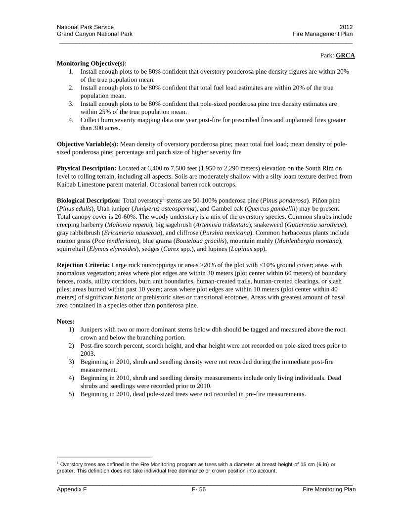
National Park Service 2012 Grand Canyon National Park Fire Management Plan _________________________________________________________________________________________
Park: GRCA
_________________________________________________________________________________________ Appendix F F- 56 Fire Monitoring Plan
Monitoring Objective(s): 1. Install enough plots to be 80% confident that overstory ponderosa pine density figures are within 20%
of the true population mean. 2. Install enough plots to be 80% confident that total fuel load estimates are within 20% of the true
population mean. 3. Install enough plots to be 80% confident that pole-sized ponderosa pine tree density estimates are
within 25% of the true population mean. 4. Collect burn severity mapping data one year post-fire for prescribed fires and unplanned fires greater
than 300 acres. Objective Variable(s): Mean density of overstory ponderosa pine; mean total fuel load; mean density of pole-sized ponderosa pine; percentage and patch size of higher severity fire Physical Description: Located at 6,400 to 7,500 feet (1,950 to 2,290 meters) elevation on the South Rim on level to rolling terrain, including all aspects. Soils are moderately shallow with a silty loam texture derived from Kaibab Limestone parent material. Occasional barren rock outcrops. Biological Description: Total overstory1 stems are 50-100% ponderosa pine (Pinus ponderosa). Piñon pine (Pinus edulis), Utah juniper (Juniperus osteosperma), and Gambel oak (Quercus gambellii) may be present. Total canopy cover is 20-60%. The woody understory is a mix of the overstory species. Common shrubs include creeping barberry (Mahonia repens), big sagebrush (Artemisia tridentata), snakeweed (Gutierrezia sarothrae), gray rabbitbrush (Ericameria nauseosa), and cliffrose (Purshia mexicana). Common herbaceous plants include mutton grass (Poa fendleriana), blue grama (Bouteloua gracilis), mountain muhly (Muhlenbergia montana), squirreltail (Elymus elymoides), sedges (Carex spp.), and lupines (Lupinus spp). Rejection Criteria: Large rock outcroppings or areas >20% of the plot with <10% ground cover; areas with anomalous vegetation; areas where plot edges are within 30 meters (plot center within 60 meters) of boundary fences, roads, utility corridors, burn unit boundaries, human-created trails, human-created clearings, or slash piles; areas burned within past 10 years; areas where plot edges are within 10 meters (plot center within 40 meters) of significant historic or prehistoric sites or transitional ecotones. Areas with greatest amount of basal area contained in a species other than ponderosa pine. Notes:
1) Junipers with two or more dominant stems below dbh should be tagged and measured above the root crown and below the branching portion.
2) Post-fire scorch percent, scorch height, and char height were not recorded on pole-sized trees prior to 2003.
3) Beginning in 2010, shrub and seedling density were not recorded during the immediate post-fire measurement.
4) Beginning in 2010, shrub and seedling density measurements include only living individuals. Dead shrubs and seedlings were recorded prior to 2010.
5) Beginning in 2010, dead pole-sized trees were not recorded in pre-fire measurements.
1 Overstory trees are defined in the Fire Monitoring program as trees with a diameter at breast height of 15 cm (6 in) or greater. This definition does not take individual tree dominance or crown position into account.

National Park Service 2012 Grand Canyon National Park Fire Management Plan _________________________________________________________________________________________
Park: GRCA
_________________________________________________________________________________________ Appendix F F- 57 Fire Monitoring Plan
FMH-4 PLOT PROTOCOLS (FPIPO1D09) (Opt) = Optional
GENERAL PROTOCOLS YES (Y)
NO (N)
YES (Y)
NO (N)
Preburn
Control Treatment Plots (Opt) N Herb Height (Opt) Y
Herbaceous Density (Opt) N Abbreviated Tags (Opt) Y
OP/Origin Buried (Opt) N Herb. Fuel Load (Opt) N
Voucher Specimens (Opt) Y Brush Fuel Load (Opt) N
Count Dead Branches of Living Plants as Dead (Opt) N
Width Sample Area Species Not Intercepted But Seen in Vicinity of Herbaceous Transect(s): 10 m
Length/Width Sample Area for Shrubs: 2 × 50 m Stakes Installed: All
Herbaceous Frame Dimensions: n/a
Herbaceous Data Collected at: Q4-Q1 and Q3-Q2
Burn Duff Moisture (Opt) N Flame Depth (Opt) N
Postburn 100 Pt. Burn Severity (Opt) N Herb. Fuel Load (Opt) N
Herbaceous/Shrub Data (Opt): FMH – 15/ 16/ 17/ 18 Do not collect
FOREST PLOT PROTOCOLS YES (Y)
NO (N)
YES (Y)
NO (N)
Overstory (>15 cm)
Live Tree Damage (Opt) Y Live Crown Position (Opt) Y
Dead Tree Damage (Opt) N Dead Crown Position (Opt) Y
Record DBH Year-1 (Opt) Y
Length/Width of Sample Area: 50 × 20 m Quarters Sampled: Q1 ▪ Q2 ▪ Q3 ▪ Q4
Pole-size (≥2.5 ≤15)
Height (Opt) Y Poles Tagged (Opt) Y
Record DBH Year-1 (Opt) Y Dead Pole Height (Opt) N
Length/Width of Sample Area: 25 × 20 m Quarters Sampled: Q1 ▪ Q2
Seedling (<2.5 cm)
Height (Opt) Y Seedlings Mapped (Opt) N
Dead Seedlings (Opt) N Dead Seedling Height (Opt) N
Length/Width of Sample Area: 25 × 10 m Quarters Sampled: Q1
Fuel Load Sampling Plane Lengths (ft): 6 1 hr ▪ 6 10 hr ▪ 12 100 hr ▪ 100 1,000 hr-s ▪ 100 1,000 hr-r
Herbaceous Cover Data Collected at: Do not collect
Postburn Char Height (Opt) Y Poles in Assessment (Opt) Y
Collect Severity Along: Fuels Transects
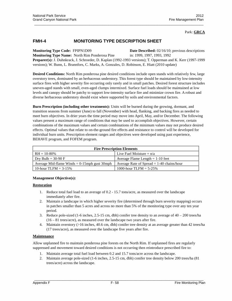
National Park Service 2012 Grand Canyon National Park Fire Management Plan _________________________________________________________________________________________
Park: GRCA
_________________________________________________________________________________________ Appendix F F- 58 Fire Monitoring Plan
FMH-4 MONITORING TYPE DESCRIPTION SHEET Monitoring Type Code: FPIPN1D09 Monitoring Type Name: North Rim Ponderosa Pine
Date Described: 02/16/10; previous descriptions in: 1999, 1997, 1993, 1992
Preparer(s): J. Duhnkrack, J. Schroeder, D. Kaplan (1992-1993 versions); T. Opperman and K. Kerr (1997-1999 versions); W. Bunn, L. Brannfors, C. Marks, A. Gonzales, D. Robinson, E. Hiatt (2010 update) Desired Conditions: North Rim ponderosa pine desired conditions include open stands with relatively few, large overstory trees, dominated by an herbaceous understory. This forest type should be maintained by low-intensity surface fires with higher severity fire occurring only rarely and in small patches. Desired forest structure includes uneven-aged stands with small, even-aged clumps intermixed. Surface fuel loads should be maintained at low levels and canopy should be patchy to support low-intensity surface fire and minimize crown fire. A robust and diverse herbaceous understory should exist where supported by soils and environmental factors. Burn Prescription (including other treatments): Units will be burned during the growing, dormant, and transition seasons from summer (June) to fall (November) with head, flanking, and backing fires as needed to meet burn objectives. In drier years the time period may move into April, May, and/or December. The following values present a maximum range of conditions that may be used to accomplish objectives. However, certain combinations of the maximum values and certain combinations of the minimum values may not produce desired effects. Optimal values that relate to on-the-ground fire effects and resistance to control will be developed for individual burn units. Prescription element ranges and objectives were developed using past experience, BEHAVE program, and FOFEM program.
Fire Prescription Elements RH = 10-80% Live Fuel Moisture = n/a Dry Bulb = 30-90 F Average Flame Length = 1-10 feet Average Mid-flame Winds = 0-15mph gust 30mph Average Rate of Spread = 1-40 chains/hour 10-hour TLFM = 3-15% 1000-hour TLFM = 5-25%
Management Objective(s):
Restoration
1. Reduce total fuel load to an average of 0.2 - 15.7 tons/acre, as measured over the landscape immediately after fire.
2. Maintain a landscape in which higher severity fire (determined through burn severity mapping) occurs in patches smaller than 5 acres and across no more than 5% of the monitoring type over any ten year period.
3. Reduce pole-sized (1-6 inches, 2.5-15 cm, dbh) conifer tree density to an average of 40 – 200 trees/ha (16 – 81 trees/acre), as measured over the landscape two years after fire.
4. Maintain overstory (>16 inches, 40.6 cm, dbh) conifer tree density at an average greater than 42 trees/ha (17 trees/acre), as measured over the landscape five years after fire.
Maintenance
Allow unplanned fire to maintain ponderosa pine forests on the North Rim. If unplanned fires are regularly suppressed and movement toward desired conditions is not occurring then reintroduce prescribed fire to:
1. Maintain average total fuel load between 0.2 and 15.7 tons/acre across the landscape. 2. Maintain average pole-sized (1-6 inches, 2.5-15 cm, dbh) conifer tree density below 200 trees/ha (81
trees/acre) across the landscape.

National Park Service 2012 Grand Canyon National Park Fire Management Plan _________________________________________________________________________________________
Park: GRCA
_________________________________________________________________________________________ Appendix F F- 59 Fire Monitoring Plan
3. Maintain a landscape in which higher severity fire occurs in patches smaller than 5 acres and across no more than 5% of the monitoring type over any ten year period.
Monitoring Objective(s):
1. Install enough plots to be 80% confident that overstory conifer tree density figures are within 20% of the true population mean.
2. Install enough plots to be 80% confident that total fuel load estimates are within 20% of the true population mean.
3. Install enough plots to be 80% confident that pole-sized conifer tree density estimates are within 25% of the true population mean.
4. Collect burn severity mapping data one year post-fire for all prescribed fires and all unplanned fires greater than 300 acres.
Objective Variable(s): Mean density of overstory conifer trees; mean total fuel load; mean density of pole-sized conifer trees; percentage and patch size of higher severity fire Physical Description: Located at 7,350 to 8,530 feet (2,240 to 2,600 meters) elevation on the North Rim with slopes from 0% to 60%, including all aspects. Soils can be shallow and slightly cobbly with a loamy texture or moderately deep with loamy texture depending on elevation and aspect. All soils are derived from Kaibab Limestone parent material. Biological Description: Ponderosa pine (Pinus ponderosa) dominates the overstory1, comprising at least 80% of overstory stems. Other possible overstory species include occasional white fir (Abies concolor), quaking aspen (Populus tremuloides), Douglas-fir (Pseudotsuga menziesii), and Engelmann spruce (Picea engelmannii). Total canopy cover is at least 25%. The tree understory is composed of mostly (75% or more) P. ponderosa poles. Common shrub species are creeping barberry (Mahonia repens), Wood’s rose (Rosa woodsii), New Mexico locust (Robinia neomexicana), Fendler's ceanothus (Ceanothus fendleri), and gray rabbitbrush (Ericameria nauseosa). Common herbaceous species include sedges (Carex spp.), mutton grass (Poa fendleriana), lupines (Lupinus spp.), squirreltail (Elymus elymoides), common yarrow (Achillea millefolium), and bracken fern (Pteridium aquilinum). Rejection Criteria: Large rock outcroppings or barren areas >20% of the plot; areas with anomalous vegetation; areas where plot edges are within 30 meters (plot center within 60 meters) of boundary fences, roads, utility corridors, burn unit boundaries, human-created trails, human-created clearings, or slash piles; areas where plot edges are within 10 meters (plot center within 40 meters) of significant historic or prehistoric sites or transitional ecotones; areas burned in the last 10 years; areas with >20% overstory cover of trees other than ponderosa pine; areas with pole densities including >25% species other than ponderosa pine; and areas with >50% cover of New Mexico locust (Robinia neomexicana). Notes:
1) Post-fire scorch percent, scorch height, and char height were not recorded on pole-sized trees prior to 2003.
2) Beginning in 2010, shrub and seedling density were not recorded during the immediate post-fire measurement.
3) Beginning in 2010, shrub and seedling density measurements include only living individuals. Dead shrubs and seedlings were recorded prior to 2010.
4) Beginning in 2010, dead pole-sized trees were not recorded in pre-fire measurements.
1 Overstory trees are defined in the Fire Monitoring program as trees with a diameter at breast height of 15 cm (6 in) or greater. This definition does not take individual tree dominance or crown position into account.

National Park Service 2012 Grand Canyon National Park Fire Management Plan _________________________________________________________________________________________
Park: GRCA
_________________________________________________________________________________________ Appendix F F- 60 Fire Monitoring Plan
FMH-4 PLOT PROTOCOLS (FPIPN1D09) (Opt) = Optional
GENERAL PROTOCOLS YES (Y)
NO (N)
YES (Y)
NO (N)
Preburn
Control Treatment Plots (Opt) N Herb Height (Opt) Y
Herbaceous Density (Opt) N Abbreviated Tags (Opt) Y
OP/Origin Buried (Opt) N Herb. Fuel Load (Opt) N
Voucher Specimens (Opt) Y Brush Fuel Load (Opt) N
Count Dead Branches of Living Plants as Dead (Opt) N
Width Sample Area Species Not Intercepted But Seen in Vicinity of Herbaceous Transect(s): 10 m
Length/Width Sample Area for Shrubs: 2 × 50 m Stakes Installed: All
Herbaceous Frame Dimensions: n/a
Herbaceous Data Collected at: Q4-Q1 and Q3-Q2
Burn Duff Moisture (Opt) N Flame Depth (Opt) N
Postburn 100 Pt. Burn Severity (Opt) N Herb. Fuel Load (Opt) N
Herbaceous/Shrub Data (Opt): FMH – 15/ 16/ 17/ 18 Do not collect
FOREST PLOT PROTOCOLS YES (Y)
NO (N)
YES (Y)
NO (N)
Overstory (>15 cm)
Live Tree Damage (Opt) Y Live Crown Position (Opt) Y
Dead Tree Damage (Opt) N Dead Crown Position (Opt) Y
Record DBH Year-1 (Opt) Y
Length/Width of Sample Area: 50 × 20 m Quarters Sampled: Q1 ▪ Q2 ▪ Q3 ▪ Q4
Pole-size (≥2.5 ≤15)
Height (Opt) Y Poles Tagged (Opt) Y
Record DBH Year-1 (Opt) Y Dead Pole Height (Opt) N
Length/Width of Sample Area: 25 × 20 m Quarters Sampled: Q1 ▪ Q2
Seedling (<2.5 cm)
Height (Opt) Y Seedlings Mapped (Opt) N
Dead Seedlings (Opt) N Dead Seedling Height (Opt) N
Length/Width of Sample Area: 25 × 10 m Quarters Sampled: Q1
Fuel Load Sampling Plane Lengths (ft): 6 1 hr ▪ 6 10 hr ▪ 12 100 hr ▪ 50 1,000 hr-s ▪ 50 1,000 hr-r
Herbaceous Cover Data Collected at: Do not collect
Postburn Char Height (Opt) Y Poles in Assessment (Opt) Y
Collect Severity Along: Fuels Transects

National Park Service 2012 Grand Canyon National Park Fire Management Plan _________________________________________________________________________________________
Park: GRCA
_________________________________________________________________________________________ Appendix F F- 61 Fire Monitoring Plan
FMH-4 MONITORING TYPE DESCRIPTION SHEET Monitoring Type Code: FPIAB1D09 Date Described: 02/16/10; previous description: 1999Monitoring Type Name: Ponderosa Pine with White Fir Encroachment Preparer(s): T. Opperman and K. Kerr (1999 version); W. Bunn, L. Brannfors, C. Marks, A. Gonzales, D. Robinson, E. Hiatt (2010 update) Desired Conditions: This monitoring type should serve as a transitional zone between the lower elevation North Rim ponderosa pine forests and higher elevation mixed-conifer forests. Pinus ponderosa should dominate these stands but occasionally other conifer species and pockets of Populus tremuloides will be present. Fuel loads and pole-sized tree densities should be slightly higher than the North Rim Ponderosa Pine (PIPN) monitoring type. Low-intensity surface fires should be the primary disturbance factor with occasional patches of higher severity fire. The lower elevation portions of this monitoring type currently include areas that were historically ponderosa pine forest and now have encroachment from more mesic conifer species. The higher elevation portions of this monitoring type currently include Rocky Mountain Montane Conifer Forests (mixed-conifer) where desired conditions include restoration of topographic heterogeneity and maintenance of a mixed-severity fire regime. Fuel loads in these higher elevation portions should support a mixed-severity fire regime while limiting the patch size of higher severity burned areas. In the future, it may be desirable to create a separate Rocky Mountain Montane Mixed-Conifer Forest monitoring type to account for differences in desired conditions and management actions in the historic transition zone versus the encroachment zone of the current monitoring type. Burn Prescription (including other treatments): Units will be burned during the growing and dormant seasons from summer (June) to fall (November) with head, flanking, and backing fires as needed to meet burn objectives. In drier years the time period may move into April, May, and/or December. The following values present a range of conditions that may be used to accomplish objectives. However, certain combinations of the maximum values and certain combinations of the minimum values may not produce desired effects. Optimal values that relate to on-the-ground fire effects and resistance to control will be developed for individual burn units. Prescription element ranges and objectives were developed using past experience, BEHAVE program, and FOFEM program.
Fire Prescription Elements RH = 10-80% Live Woody Fuel Moisture = 60-250% Dry Bulb = 30-90 F Average Flame Length = 0.5 – 30 feet Average Mid-flame Winds = 0-15mph gust 30mph Average Rate of Spread = 1-40 chains/hour 10-hour TLFM = 3-15% 1000-hour TLFM = 5-25%
Management Objective(s):
Restoration
1. Reduce total fuel load to an average of 1.7 - 19.0 tons/acre, as measured over the landscape immediately after fire.
2. Maintain a landscape in which higher severity fire (determined through burn severity mapping) occurs in patches smaller than 10 acres and across no more than 15% of the monitoring type over any ten year period.
3. Reduce pole-sized (1-6 inches, 2.5-15 cm, dbh) conifer tree density to an average of 40 – 247 trees/ha (16 – 100 trees/acre), as measured over the landscape two years after fire.
4. Maintain overstory (>16 inches, 40.6 cm, dbh) conifer tree density at an average greater than 49 trees/ha (20 trees/acre), as measured over the landscape five years after fire.

National Park Service 2012 Grand Canyon National Park Fire Management Plan _________________________________________________________________________________________
Park: GRCA
_________________________________________________________________________________________ Appendix F F- 62 Fire Monitoring Plan
Maintenance
Allow unplanned fire to maintain these forests on the North Rim. If unplanned fires are regularly suppressed and movement toward desired conditions is not occurring then reintroduce prescribed fire to:
1. Maintain average total fuel load between 1.7 and 19.0 tons/acre across the landscape. 2. Maintain average pole-sized (1-6 inches, 2.5-15 cm, dbh) conifer tree density below 247 trees/ha (100
trees/acre) across the landscape. 3. Maintain a landscape in which higher severity fire occurs in patches smaller than 10 acres and across no
more than 15% of the monitoring type over any ten year period. Monitoring Objective(s):
1. Install enough plots to be 80% confident that overstory conifer density figures are within 20% of the true population mean.
2. Install enough plots to be 80% confident that total fuel load estimates are within 20% of the true population mean.
3. Install enough plots to be 80% confident that pole-sized conifer density estimates are within 25% of the true population mean.
4. Collect burn severity mapping data one year post-fire for all prescribed fires and all unplanned fires greater than 300 acres.
Objective Variable(s): Mean density of overstory conifer trees; mean total fuel load; mean density of pole-sized conifer trees; percentage and patch size of higher severity fire Physical Description: Located at 7,800 to 8,700 feet (2,380 to 2,650 meters) elevation on the North Rim with slopes from 0% to 60%, including all aspects. Soils are moderately shallow on ridgetops with moderately deep silty loams occurring in drainage bottoms. Most soils are derived from Kaibab Limestone parent material although some soils derived from the Coconino Sandstone or Toroweap Formation may be present. Biological Description: Total canopy cover is at least 25% but can near 100%. This type is a ponderosa pine to mixed-conifer transitional forest dominated by ponderosa pine (Pinus ponderosa), white fir (Abies concolor), and quaking aspen (Populus tremuloides) with the greatest basal area in P. ponderosa even though there may be more overstory1 A. concolor stems per acre. Other possible overstory species include Douglas-fir (Pseudotsuga menziesii), blue spruce (Picea pungens), and Engelmann spruce (Picea engelmannii). The pre-burn understory is composed of mostly Abies concolor (25 to 100%), Pinus ponderosa, Populus tremuloides, and Pseudotsuga menziesii. Common shrub species are creeping barberry (Mahonia repens), New Mexico locust (Robinia neomexicana), and mountain snowberry (Symphoricarpos oreophilus). Common herbaceous species include sedges (Carex spp.), sticky starwort (Pseudostellaria jamesiana), mutton grass (Poa fendleriana), bracken fern (Pteridium aquilinum), dwarf lousewort (Pedicularis centranthera), goldenrod (Solidago spp.), and common yarrow (Achillea millefolium). Rejection Criteria: Large rock outcroppings or barren areas >20% of the plot; areas with anomalous vegetation; areas where plot edges are within 30 meters (plot center within 60 meters) of boundary fences, roads, utility corridors, burn unit boundaries, human-created trails, human-created clearings, or slash piles; areas where plot edges are within 10 meters (plot center within 40 meters) of significant historic or prehistoric sites or transitional ecotones; areas burned in the last 10 years; areas where the majority of basal area is not in ponderosa pine; areas with pole densities that do not include white fir as a major component. Notes:
1 Overstory trees are defined in the Fire Monitoring program as trees with a diameter at breast height of 15 cm (6 in) or greater. This definition does not take individual tree dominance or crown position into account.

National Park Service 2012 Grand Canyon National Park Fire Management Plan _________________________________________________________________________________________
Park: GRCA
_________________________________________________________________________________________ Appendix F F- 63 Fire Monitoring Plan
1) Post-fire scorch percent, scorch height, and char height were not recorded on pole-sized trees prior to 2003.
2) Beginning in 2010, shrub and seedling density were not recorded during the immediate post-fire measurement.
3) Beginning in 2010, shrub and seedling density measurements include only living individuals. Dead shrubs and seedlings were recorded prior to 2010.
4) Beginning in 2010, dead pole-sized trees were not recorded in pre-fire measurements.

National Park Service 2012 Grand Canyon National Park Fire Management Plan _________________________________________________________________________________________
Park: GRCA
_________________________________________________________________________________________ Appendix F F- 64 Fire Monitoring Plan
FMH-4 PLOT PROTOCOLS (FPIAB1D09) (Opt) = Optional
GENERAL PROTOCOLS YES (Y)
NO (N)
YES (Y)
NO (N)
Preburn
Control Treatment Plots (Opt) N Herb Height (Opt) Y
Herbaceous Density (Opt) N Abbreviated Tags (Opt) Y
OP/Origin Buried (Opt) N Herb. Fuel Load (Opt) N
Voucher Specimens (Opt) Y Brush Fuel Load (Opt) N
Count Dead Branches of Living Plants as Dead (Opt) N
Width Sample Area Species Not Intercepted But Seen in Vicinity of Herbaceous Transect(s): 10 m
Length/Width Sample Area for Shrubs: 2 × 50 m Stakes Installed: All
Herbaceous Frame Dimensions: n/a
Herbaceous Data Collected at: Q4-Q1 and Q3-Q2
Burn Duff Moisture (Opt) N Flame Depth (Opt) N
Postburn 100 Pt. Burn Severity (Opt) N Herb. Fuel Load (Opt) N
Herbaceous/Shrub Data (Opt): FMH – 15/ 16/ 17/ 18 Do not collect
FOREST PLOT PROTOCOLS YES (Y)
NO (N)
YES (Y)
NO (N)
Overstory (>15 cm)
Live Tree Damage (Opt) Y Live Crown Position (Opt) Y
Dead Tree Damage (Opt) N Dead Crown Position (Opt) Y
Record DBH Year-1 (Opt) Y
Length/Width of Sample Area: 50 × 20 m Quarters Sampled: Q1 ▪ Q2 ▪ Q3 ▪ Q4
Pole-size (≥2.5 ≤15)
Height (Opt) Y Poles Tagged (Opt) Y
Record DBH Year-1 (Opt) Y Dead Pole Height (Opt) N
Length/Width of Sample Area: 25 × 20 m Quarters Sampled: Q1 ▪ Q2
Seedling (<2.5 cm)
Height (Opt) Y Seedlings Mapped (Opt) N
Dead Seedlings (Opt) N Dead Seedling Height (Opt) N
Length/Width of Sample Area: 5 × 10 m Quarters Sampled: Q1
Fuel Load Sampling Plane Lengths (ft): 6 1 hr ▪ 6 10 hr ▪ 12 100 hr ▪ 50 1,000 hr-s ▪ 50 1,000 hr-r
Herbaceous Cover Data Collected at: Do not collect
Postburn Char Height (Opt) Y Poles in Assessment (Opt) Y
Collect Severity Along: Fuels Transects

National Park Service 2012 Grand Canyon National Park Fire Management Plan _________________________________________________________________________________________
Park: GRCA
_________________________________________________________________________________________ Appendix F F- 65 Fire Monitoring Plan
FMH-4 MONITORING TYPE DESCRIPTION SHEET Monitoring Type Code: FPIEN1D10 Monitoring Type Name: Rocky Mountain
Subalpine Conifer Forest
Date Described: 04/01/09; previous description in: 1997, 1993, 1992
Preparer(s): J. Duhnkrack, J. Schroeder, D. Kaplan (1992-1993 version); K. Kerr and T. Opperman (1997 version); W. Bunn and L. Brannfors (2009 update) Desired Conditions: Desired conditions in this monitoring type include maintaining a diverse landscape with patches of variable tree densities and a mixed-severity fire regime. In the higher elevation portions of this monitoring type, desired conditions include allowing for stand-replacing fire characteristics to occur within the range typical of reference conditions. The lower elevation portions of this monitoring type currently include Rocky Mountain Montane Conifer Forests (mixed-conifer) where desired conditions include restoration of topographic heterogeneity and maintenance of a mixed-severity fire regime. Fuel loads in these lower elevation portions should support a mixed-severity fire regime while limiting the patch size of higher severity burned areas. In the future, it may be desirable to create a separate Rocky Mountain Montane Mixed-Conifer Forest monitoring type to account for differences in desired conditions and management actions in the high and low elevation portions of the current monitoring type. Burn Prescription (including other treatments): Prescribed fire treatments are not currently targeted at the higher elevation portions of this monitoring type. However, lower elevation plots within this type are interspersed in the mixed-conifer vegetation type and may be burned during prescribed fires. Prescriptions elements for the mixed-conifer are currently under development. Portions of the PIEN monitoring type are also found in drainage bottoms and north aspects in higher elevation areas of the ponderosa pine vegetation type and may be burned under the prescription elements listed for the FPIAB1D09 and FPIPN1D09 monitoring types. Management Objective(s): Quantitative objectives have not been identified for the higher elevation portion of this monitoring type because prescribed fires are not the management focus in these areas. The desired landscape patchiness and mixed-severity fire regime characteristics are expected to be maintained through unplanned events at the landscape scale and through intermittent burning during prescribed fires targeted at the mixed-conifer vegetation type. Quantitative objectives for the mixed-conifer vegetation type are currently under development.
Monitoring Objective(s): Monitoring objectives will be established after quantitative management objectives are finalized. Objective Variable(s): Objective variables will be established after quantitative management objectives are finalized. Physical Description: Located at 8,200 to 9,165 feet (2,500 to 2,793 meters) elevation on the North Rim on slopes ranging from 0% to > 60%. Generally occurs on north and northeast aspects at lower elevations and all aspects at higher elevations. Soils are moderately shallow and gravelly with sandy loam texture or deep and well developed with loamy texture. Soils are derived from the Coconino Sandstone, Toroweap Formation, or Kaibab Limestone. Biological Description: The canopy is dominated by Engelmann spruce (Picea engelmannii), quaking aspen (Populus tremuloides), and/or white fir (Abies concolor) with subalpine fir (Abies lasiocarpa), ponderosa pine (Pinus ponderosa), and Douglas-fir (Pseudotsuga menziesii) occasionally present. Dominant species in this type vary with elevation and topographic position. Total canopy cover is generally 50% or greater. The woody

National Park Service 2012 Grand Canyon National Park Fire Management Plan _________________________________________________________________________________________
Park: GRCA
_________________________________________________________________________________________ Appendix F F- 66 Fire Monitoring Plan
understory contains scattered pole and seedling trees of the same species as the overstory. Shrubs include common juniper (Juniperus communis) and creeping barberry (Mahonia repens). Common herbaceous species include sedges (Carex spp.), mutton grass (Poa fendleriana), blueleaf strawberry (Fragaria virginiana), and bracken fern (Pteridium aquilinum). Rejection Criteria: Large rock outcroppings or barren areas >20% of plot; areas with anomalous vegetation, areas where plot edges are within 30 meters (plot center within 60 meters) of boundary fences, roads, utility corridors, burn unit boundaries, human-created trails, human-created clearings, or slash piles; recently burned areas; areas where plot edges are within 10 meters (plot center within 40 meters) of significant historic or prehistoric sites or transitional ecotones; areas void of Picea engelmannii, Populus tremuloides, or Abies concolor; areas with >20% Pinus ponderosa. Notes:
1) Post-fire scorch percent, scorch height, and char height were not recorded on pole-sized trees prior to 2003.
2) Beginning in 2010, shrub and seedling density were not recorded during the immediate post-fire measurement.
3) Beginning in 2010, shrub and seedling density measurements include only living individuals. Dead shrubs and seedlings were recorded prior to 2010.
4) Beginning in 2010, dead pole-sized trees were not recorded in pre-fire measurements.

National Park Service 2012 Grand Canyon National Park Fire Management Plan _________________________________________________________________________________________
Park: GRCA
_________________________________________________________________________________________ Appendix F F- 67 Fire Monitoring Plan
FMH-4 PLOT PROTOCOLS (FPIEN1D10) (Opt) = Optional
GENERAL PROTOCOLS YES (Y)
NO (N)
YES (Y)
NO (N)
Preburn
Control Treatment Plots (Opt) N Herb Height (Opt) Y
Herbaceous Density (Opt) N Abbreviated Tags (Opt) Y
OP/Origin Buried (Opt) N Herb. Fuel Load (Opt) N
Voucher Specimens (Opt) Y Brush Fuel Load (Opt) N
Count Dead Branches of Living Plants as Dead (Opt) N
Width Sample Area Species Not Intercepted But Seen in Vicinity of Herbaceous Transect(s): 10 m
Length/Width Sample Area for Shrubs: 2 × 50 m Stakes Installed: All
Herbaceous Frame Dimensions: n/a
Herbaceous Data Collected at: Q4-Q1 and Q3-Q2
Burn Duff Moisture (Opt) N Flame Depth (Opt) N
Postburn 100 Pt. Burn Severity (Opt) N Herb. Fuel Load (Opt) N
Herbaceous/Shrub Data (Opt): FMH – 15/ 16/ 17/ 18 Do not collect
FOREST PLOT PROTOCOLS YES (Y)
NO (N)
YES (Y)
NO (N)
Overstory (>15 cm)
Live Tree Damage (Opt) Y Live Crown Position (Opt) Y
Dead Tree Damage (Opt) N Dead Crown Position (Opt) Y
Record DBH Year-1 (Opt) Y
Length/Width of Sample Area: 50 × 20 m Quarters Sampled: Q1 ▪ Q2 ▪ Q3 ▪ Q4
Pole-size (≥2.5 ≤15)
Height (Opt) Y Poles Tagged (Opt) Y
Record DBH Year-1 (Opt) Y Dead Pole Height (Opt) N
Length/Width of Sample Area: 25 × 20 m Quarters Sampled: Q1 ▪ Q2
Seedling (<2.5 cm)
Height (Opt) Y Seedlings Mapped (Opt) N
Dead Seedlings (Opt) N Dead Seedling Height (Opt) N
Length/Width of Sample Area: 5 × 10 m Quarters Sampled: Q1
Fuel Load Sampling Plane Lengths (ft): 6 1 hr ▪ 6 10 hr ▪ 12 100 hr ▪ 50 1,000 hr-s ▪ 50 1,000 hr-r
Herbaceous Cover Data Collected at: Do not collect
Postburn Char Height (Opt) Y Poles in Assessment (Opt) Y
Collect Severity Along: Fuels Transects
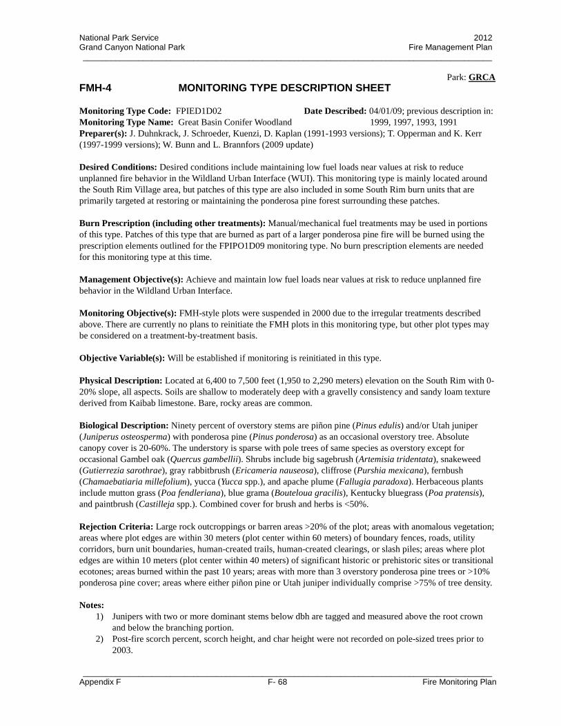
National Park Service 2012 Grand Canyon National Park Fire Management Plan _________________________________________________________________________________________
Park: GRCA
_________________________________________________________________________________________ Appendix F F- 68 Fire Monitoring Plan
FMH-4 MONITORING TYPE DESCRIPTION SHEET Monitoring Type Code: FPIED1D02 Monitoring Type Name: Great Basin Conifer Woodland
Date Described: 04/01/09; previous description in: 1999, 1997, 1993, 1991
Preparer(s): J. Duhnkrack, J. Schroeder, Kuenzi, D. Kaplan (1991-1993 versions); T. Opperman and K. Kerr (1997-1999 versions); W. Bunn and L. Brannfors (2009 update) Desired Conditions: Desired conditions include maintaining low fuel loads near values at risk to reduce unplanned fire behavior in the Wildland Urban Interface (WUI). This monitoring type is mainly located around the South Rim Village area, but patches of this type are also included in some South Rim burn units that are primarily targeted at restoring or maintaining the ponderosa pine forest surrounding these patches. Burn Prescription (including other treatments): Manual/mechanical fuel treatments may be used in portions of this type. Patches of this type that are burned as part of a larger ponderosa pine fire will be burned using the prescription elements outlined for the FPIPO1D09 monitoring type. No burn prescription elements are needed for this monitoring type at this time. Management Objective(s): Achieve and maintain low fuel loads near values at risk to reduce unplanned fire behavior in the Wildland Urban Interface. Monitoring Objective(s): FMH-style plots were suspended in 2000 due to the irregular treatments described above. There are currently no plans to reinitiate the FMH plots in this monitoring type, but other plot types may be considered on a treatment-by-treatment basis. Objective Variable(s): Will be established if monitoring is reinitiated in this type. Physical Description: Located at 6,400 to 7,500 feet (1,950 to 2,290 meters) elevation on the South Rim with 0-20% slope, all aspects. Soils are shallow to moderately deep with a gravelly consistency and sandy loam texture derived from Kaibab limestone. Bare, rocky areas are common. Biological Description: Ninety percent of overstory stems are piñon pine (Pinus edulis) and/or Utah juniper (Juniperus osteosperma) with ponderosa pine (Pinus ponderosa) as an occasional overstory tree. Absolute canopy cover is 20-60%. The understory is sparse with pole trees of same species as overstory except for occasional Gambel oak (Quercus gambellii). Shrubs include big sagebrush (Artemisia tridentata), snakeweed (Gutierrezia sarothrae), gray rabbitbrush (Ericameria nauseosa), cliffrose (Purshia mexicana), fernbush (Chamaebatiaria millefolium), yucca (Yucca spp.), and apache plume (Fallugia paradoxa). Herbaceous plants include mutton grass (Poa fendleriana), blue grama (Bouteloua gracilis), Kentucky bluegrass (Poa pratensis), and paintbrush (Castilleja spp.). Combined cover for brush and herbs is <50%. Rejection Criteria: Large rock outcroppings or barren areas >20% of the plot; areas with anomalous vegetation; areas where plot edges are within 30 meters (plot center within 60 meters) of boundary fences, roads, utility corridors, burn unit boundaries, human-created trails, human-created clearings, or slash piles; areas where plot edges are within 10 meters (plot center within 40 meters) of significant historic or prehistoric sites or transitional ecotones; areas burned within the past 10 years; areas with more than 3 overstory ponderosa pine trees or >10% ponderosa pine cover; areas where either piñon pine or Utah juniper individually comprise >75% of tree density. Notes:
1) Junipers with two or more dominant stems below dbh are tagged and measured above the root crown and below the branching portion.
2) Post-fire scorch percent, scorch height, and char height were not recorded on pole-sized trees prior to 2003.

National Park Service 2012 Grand Canyon National Park Fire Management Plan _________________________________________________________________________________________
Park: GRCA
_________________________________________________________________________________________ Appendix F F- 69 Fire Monitoring Plan
FMH-4 PLOT PROTOCOLS (FPIED1D02) (Opt) = Optional
GENERAL PROTOCOLS YES (Y)
NO (N)
YES (Y)
NO (N)
Preburn
Control Treatment Plots (Opt) N Herb Height (Opt) Y
Herbaceous Density (Opt) N Abbreviated Tags (Opt) Y
OP/Origin Buried (Opt) N Herb. Fuel Load (Opt) N
Voucher Specimens (Opt) Y Brush Fuel Load (Opt) N
Count Dead Branches of Living Plants as Dead (Opt) N
Width Sample Area Species Not Intercepted But Seen in Vicinity of Herbaceous Transect(s): 10 m
Length/Width Sample Area for Shrubs: 2 × 50 m Stakes Installed: All
Herbaceous Frame Dimensions: n/a
Herbaceous Data Collected at: Q4-Q1 and Q3-Q2
Burn Duff Moisture (Opt) N Flame Depth (Opt) N
Postburn 100 Pt. Burn Severity (Opt) N Herb. Fuel Load (Opt) N
Herbaceous/Shrub Data (Opt): FMH – 15/ 16/ 17/ 18
FOREST PLOT PROTOCOLS YES (Y)
NO (N)
YES (Y)
NO (N)
Overstory (>15 cm)
Live Tree Damage (Opt) Y Live Crown Position (Opt) Y
Dead Tree Damage (Opt) N Dead Crown Position (Opt) Y
Record DBH Year-1 (Opt) Y
Length/Width of Sample Area: 50 × 20 m Quarters Sampled: Q1 ▪ Q2 ▪ Q3 ▪ Q4
Pole-size (≥2.5 ≤15)
Height (Opt) Y Poles Tagged (Opt) Y
Record DBH Year-1 (Opt) Y Dead Pole Height (Opt) Y
Length/Width of Sample Area: 25 × 20 m Quarters Sampled: Q1 ▪ Q2
Seedling (<2.5 cm)
Height (Opt) Y Seedlings Mapped (Opt) N
Dead Seedlings (Opt) Y Dead Seedling Height (Opt) Y
Length/Width of Sample Area: 25 × 10 m Quarters Sampled: Q1
Fuel Load Sampling Plane Lengths (ft): 6 1 hr ▪ 6 10 hr ▪ 12 100 hr ▪ 100 1,000 hr-s ▪ 100 1,000 hr-r
Herbaceous Cover Data Collected at: Do not collect
Postburn Char Height (Opt) Y Poles in Assessment (Opt) Y
Collect Severity Along: Fuels Transects

National Park Service 2012 Grand Canyon National Park Fire Management Plan _________________________________________________________________________________________
Park: GRCA
_________________________________________________________________________________________ Appendix F F- 70 Fire Monitoring Plan
FMH-4 MONITORING TYPE DESCRIPTION SHEET Monitoring Type Code: FGRED1D02 Monitoring Type Name: Grassland Edge
Date Described: 04/01/09; previous description: 2001
Preparer(s): L. Brannfors and K. Leonard (2001 version); W. Bunn and L. Brannfors (2009 update) Desired Conditions: Desired conditions will be established if fire management activities are reconsidered for these areas in the future. Burn Prescription (including other treatments): Prescription elements will be established if prescribed fire activities are reconsidered for these areas in the future. Management Objective(s): Management objectives will be established if fire management activities are reconsidered for these areas in the future. Monitoring Objective(s): Monitoring objectives will be established if fire management activities are reconsidered for these areas in the future. Objective Variable(s): Objective variables will be established if monitoring activities are reconsidered for these areas in the future. Physical Description: Located at 8,200 to 9,100 feet (2,500 to 2,770 meters) elevation on the North Rim on the edges of meadows with nearly level to moderately sloping terrain of all aspects. Soils are moderately shallow and gravelly with sandy loam texture or deep and well developed with loamy texture. Soils are derived from the Coconino Sandstone, Toroweap Formation, or Kaibab Limestone. Biological Description: This type was designed to measure tree encroachment into meadows and plots are located with half of the plot inside the forest and half of the plot inside the meadow. The forested side of the plots can contain Engelmann spruce (Picea engelmannii), quaking aspen (Populus tremuloides), white fir (Abies concolor), subalpine fir (Abies lasiocarpa), ponderosa pine (Pinus ponderosa), and Douglas-fir (Pseudotsuga menziesii) in any combination of dominance. The meadow side of the plot should be similar to the BGRIN1D01 monitoring type, but may include more shrubs and some pole-sized and seedling trees. Rejection Criteria: Large rock outcroppings or barren areas >20% of the plot; areas with anomalous vegetation; areas where plot edges are within 30 meters (plot center within 60 meters) of boundary fences, roads, utility corridors, burn unit boundaries, human-created trails, human-created clearings, or slash piles; areas where plot edges are within 10 meters (plot center within 40 meters) of significant historic or prehistoric sites or transitional ecotones; areas burned within the past 10 years; areas greater than 25 meters from a meadow or forest edge. Notes:
1) At each PLP that is selected for plot installation, place the Origin stake at the forest/meadow edge. Run the 0P-50P line perpendicular to the forest/meadow edge so that P1-P2 runs along the edge with Q1 and Q2 in the forest and Q3 and Q4 in the meadow (0P in meadow, 50P in forest).
2) Measure fuels along two 50 ft. transects, 1A-1B and 4A-4B. 1A is placed at the 10 m mark and 4A at the 40 m mark along the center line (0P-50P).
3) These plots should be read in August or early September.
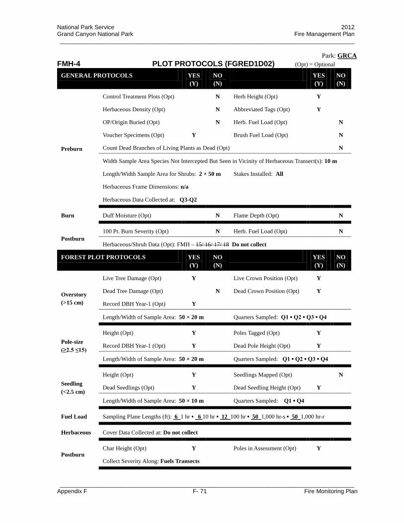
National Park Service 2012 Grand Canyon National Park Fire Management Plan _________________________________________________________________________________________
Park: GRCA
_________________________________________________________________________________________ Appendix F F- 71 Fire Monitoring Plan
FMH-4 PLOT PROTOCOLS (FGRED1D02) (Opt) = Optional
GENERAL PROTOCOLS YES (Y)
NO (N)
YES (Y)
NO (N)
Preburn
Control Treatment Plots (Opt) N Herb Height (Opt) Y
Herbaceous Density (Opt) N Abbreviated Tags (Opt) Y
OP/Origin Buried (Opt) N Herb. Fuel Load (Opt) N
Voucher Specimens (Opt) Y Brush Fuel Load (Opt) N
Count Dead Branches of Living Plants as Dead (Opt) N
Width Sample Area Species Not Intercepted But Seen in Vicinity of Herbaceous Transect(s): 10 m
Length/Width Sample Area for Shrubs: 2 × 50 m Stakes Installed: All
Herbaceous Frame Dimensions: n/a
Herbaceous Data Collected at: Q3-Q2
Burn Duff Moisture (Opt) N Flame Depth (Opt) N
Postburn 100 Pt. Burn Severity (Opt) N Herb. Fuel Load (Opt) N
Herbaceous/Shrub Data (Opt): FMH – 15/ 16/ 17/ 18 Do not collect
FOREST PLOT PROTOCOLS YES (Y)
NO (N)
YES (Y)
NO (N)
Overstory (>15 cm)
Live Tree Damage (Opt) Y Live Crown Position (Opt) Y
Dead Tree Damage (Opt) N Dead Crown Position (Opt) Y
Record DBH Year-1 (Opt) Y
Length/Width of Sample Area: 50 × 20 m Quarters Sampled: Q1 ▪ Q2 ▪ Q3 ▪ Q4
Pole-size (≥2.5 ≤15)
Height (Opt) Y Poles Tagged (Opt) Y
Record DBH Year-1 (Opt) Y Dead Pole Height (Opt) Y
Length/Width of Sample Area: 50 × 20 m Quarters Sampled: Q1 ▪ Q2 ▪ Q3 ▪ Q4
Seedling (<2.5 cm)
Height (Opt) Y Seedlings Mapped (Opt) N
Dead Seedlings (Opt) Y Dead Seedling Height (Opt) Y
Length/Width of Sample Area: 50 × 10 m Quarters Sampled: Q1 ▪ Q4
Fuel Load Sampling Plane Lengths (ft): 6 1 hr ▪ 6 10 hr ▪ 12 100 hr ▪ 50 1,000 hr-s ▪ 50 1,000 hr-r
Herbaceous Cover Data Collected at: Do not collect
Postburn Char Height (Opt) Y Poles in Assessment (Opt) Y
Collect Severity Along: Fuels Transects
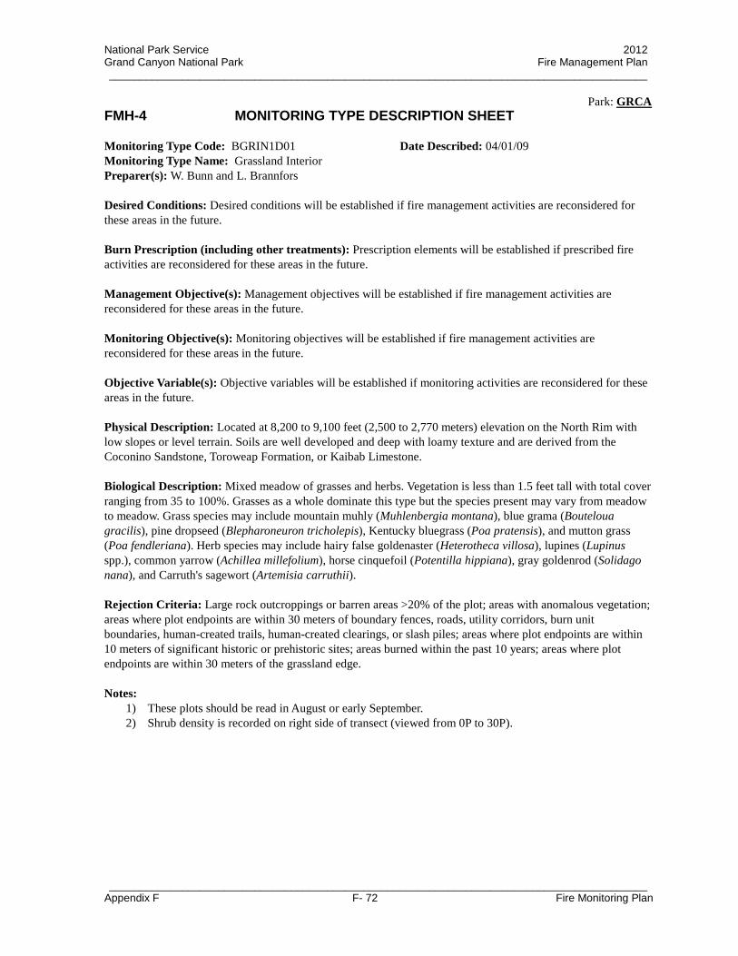
National Park Service 2012 Grand Canyon National Park Fire Management Plan _________________________________________________________________________________________
Park: GRCA
_________________________________________________________________________________________ Appendix F F- 72 Fire Monitoring Plan
FMH-4 MONITORING TYPE DESCRIPTION SHEET Monitoring Type Code: BGRIN1D01 Monitoring Type Name: Grassland Interior
Date Described: 04/01/09
Preparer(s): W. Bunn and L. Brannfors Desired Conditions: Desired conditions will be established if fire management activities are reconsidered for these areas in the future. Burn Prescription (including other treatments): Prescription elements will be established if prescribed fire activities are reconsidered for these areas in the future. Management Objective(s): Management objectives will be established if fire management activities are reconsidered for these areas in the future. Monitoring Objective(s): Monitoring objectives will be established if fire management activities are reconsidered for these areas in the future. Objective Variable(s): Objective variables will be established if monitoring activities are reconsidered for these areas in the future. Physical Description: Located at 8,200 to 9,100 feet (2,500 to 2,770 meters) elevation on the North Rim with low slopes or level terrain. Soils are well developed and deep with loamy texture and are derived from the Coconino Sandstone, Toroweap Formation, or Kaibab Limestone. Biological Description: Mixed meadow of grasses and herbs. Vegetation is less than 1.5 feet tall with total cover ranging from 35 to 100%. Grasses as a whole dominate this type but the species present may vary from meadow to meadow. Grass species may include mountain muhly (Muhlenbergia montana), blue grama (Bouteloua gracilis), pine dropseed (Blepharoneuron tricholepis), Kentucky bluegrass (Poa pratensis), and mutton grass (Poa fendleriana). Herb species may include hairy false goldenaster (Heterotheca villosa), lupines (Lupinus spp.), common yarrow (Achillea millefolium), horse cinquefoil (Potentilla hippiana), gray goldenrod (Solidago nana), and Carruth's sagewort (Artemisia carruthii). Rejection Criteria: Large rock outcroppings or barren areas >20% of the plot; areas with anomalous vegetation; areas where plot endpoints are within 30 meters of boundary fences, roads, utility corridors, burn unit boundaries, human-created trails, human-created clearings, or slash piles; areas where plot endpoints are within 10 meters of significant historic or prehistoric sites; areas burned within the past 10 years; areas where plot endpoints are within 30 meters of the grassland edge. Notes:
1) These plots should be read in August or early September. 2) Shrub density is recorded on right side of transect (viewed from 0P to 30P).
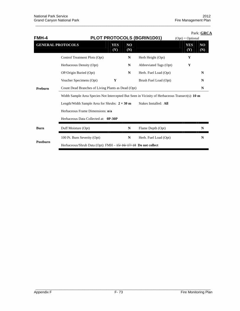
National Park Service 2012 Grand Canyon National Park Fire Management Plan _________________________________________________________________________________________
Park: GRCA
_________________________________________________________________________________________ Appendix F F- 73 Fire Monitoring Plan
FMH-4 PLOT PROTOCOLS (BGRIN1D01) (Opt) = Optional
GENERAL PROTOCOLS YES (Y)
NO (N)
YES (Y)
NO (N)
Preburn
Control Treatment Plots (Opt) N Herb Height (Opt) Y
Herbaceous Density (Opt) N Abbreviated Tags (Opt) Y
OP/Origin Buried (Opt) N Herb. Fuel Load (Opt) N
Voucher Specimens (Opt) Y Brush Fuel Load (Opt) N
Count Dead Branches of Living Plants as Dead (Opt) N
Width Sample Area Species Not Intercepted But Seen in Vicinity of Herbaceous Transect(s): 10 m
Length/Width Sample Area for Shrubs: 2 × 30 m Stakes Installed: All
Herbaceous Frame Dimensions: n/a
Herbaceous Data Collected at: 0P-30P
Burn Duff Moisture (Opt) N Flame Depth (Opt) N
Postburn 100 Pt. Burn Severity (Opt) N Herb. Fuel Load (Opt) N
Herbaceous/Shrub Data (Opt): FMH – 15/ 16/ 17/ 18 Do not collect

National Park Service 2012 Grand Canyon National Park Fire Management Plan
Appendix F F- 74 Fire Monitoring Plan
F.12.2 Monitoring Schedule Appendix
South Rim Ponderosa Pine (PIPO) North Rim Ponderosa Pine (PIPN) Ponderosa Pine with White Fir Encroachment (PIAB) Rocky Mountain Subalpine Conifer Forest (PIEN) Great Basin Conifer Woodland (PIED) Grassland Interior (GRIN) Grassland Edge (GRED)
NOTE: Columns in the following tables are labeled with the plot visit identifier. Visit identifiers correspond to the number of fire occurrences since the plot was first installed and the number of years since a fire occurrence as follows:
PR01: pre-burn read that was not burned and was remeasured closer to burn PR02: pre-burn read that was not burned and was remeasured closer to burn PR03: pre-burn read that was not burned and was remeasured closer to burn PRE: pre-burn read that is used for data analysis 01Post: immediate post-burn read after the first fire 01YR01: post-burn read one year after the first fire 01YR02: post-burn read two years after the first fire 01YR05: post-burn read five years after the first fire 01YR10: post-burn read ten years after the first fire 01YR20: post-burn read ten years after the first fire
02Post: immediate post-burn read after the second fire 02YR01: post-burn read one year after the second fire 02YR02: post-burn read two years after the second fire 02YR05: post-burn read five years after the second fire 03Post: immediate post-burn read after the third fire 03YR01: post-burn read one year after the third fire 03YR02: post-burn read two years after the third fire 03YR05: post-burn read five years after the third fire
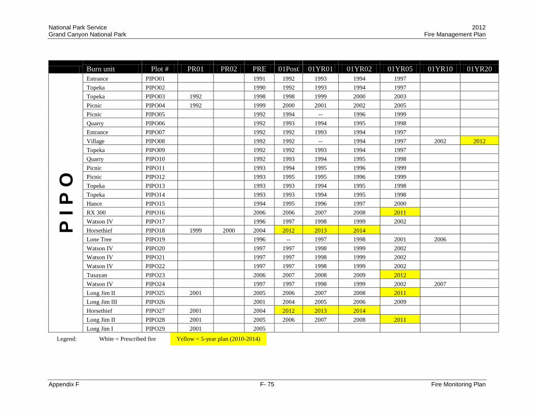
National Park Service 2012 Grand Canyon National Park Fire Management Plan
Appendix F F- 75 Fire Monitoring Plan
Burn unit Plot # PR01 PR02 PRE 01Post 01YR01 01YR02 01YR05 01YR10 01YR20 P
I P O
Entrance PIPO01 1991 1992 1993 1994 1997 Topeka PIPO02 1990 1992 1993 1994 1997 Topeka PIPO03 1992 1998 1998 1999 2000 2003 Picnic PIPO04 1992 1999 2000 2001 2002 2005 Picnic PIPO05 1992 1994 -- 1996 1999 Quarry PIPO06 1992 1993 1994 1995 1998 Entrance PIPO07 1992 1992 1993 1994 1997 Village PIPO08 1992 1992 -- 1994 1997 2002 2012 Topeka PIPO09 1992 1992 1993 1994 1997 Quarry PIPO10 1992 1993 1994 1995 1998 Picnic PIPO11 1993 1994 1995 1996 1999 Picnic PIPO12 1993 1995 1995 1996 1999 Topeka PIPO13 1993 1993 1994 1995 1998 Topeka PIPO14 1993 1993 1994 1995 1998 Hance PIPO15 1994 1995 1996 1997 2000 RX 300 PIPO16 2006 2006 2007 2008 2011 Watson IV PIPO17 1996 1997 1998 1999 2002 Horsethief PIPO18 1999 2000 2004 2012 2013 2014 Lone Tree PIPO19 1996 -- 1997 1998 2001 2006 Watson IV PIPO20 1997 1997 1998 1999 2002 Watson IV PIPO21 1997 1997 1998 1999 2002 Watson IV PIPO22 1997 1997 1998 1999 2002 Tusayan PIPO23 2006 2007 2008 2009 2012 Watson IV PIPO24 1997 1997 1998 1999 2002 2007 Long Jim II PIPO25 2001 2005 2006 2007 2008 2011 Long Jim III PIPO26 2001 2004 2005 2006 2009 Horsethief PIPO27 2001 2004 2012 2013 2014 Long Jim II PIPO28 2001 2005 2006 2007 2008 2011 Long Jim I PIPO29 2001 2005
Legend: White = Prescribed fire Yellow = 5-year plan (2010-2014)

National Park Service 2012 Grand Canyon National Park Fire Management Plan
Appendix F F- 76 Fire Monitoring Plan
Burn unit Plot # PR01 PR02 PRE 01Post 01YR01 01YR02 01YR05 01YR10 01YR20 P
I P O
Long Jim I PIPO30 2001 2005 2005 2006 2007 2010 Long Jim III PIPO31 2001 2004 2005 2006 2009 Long Jim II PIPO32 2002 2006 2006 2007 2008 2011 Long Jim I PIPO33 2002 2005 2006 2007 2010 Horsethief PIPO34 2002 2007 2012 2013 2014 Long Jim II PIPO35 2002 2006 2007 2008 2011 Long Jim I PIPO36 2002 2005 2006 2007 2010 Long Jim III PIPO37 2004 2004 2005 2006 2009 Grandview PIPO38 2007 2007 2008 2009 2012 Moqui PIPO39 2008 2010 2011 2012 Hearst PIPO40 2009 2009 2010 2011 2014
Total complete: 40 10 1 40 34 32 34 24 3 0 Legend: White = Prescribed fire Yellow = 5-year plan (2010-2014)

National Park Service 2012 Grand Canyon National Park Fire Management Plan
Appendix F F- 77 Fire Monitoring Plan
Burn unit Plot # 02Post 02YR01 02YR02 02YR05 03Post 03YR01 03YR02 03YR05 P
I P O
Entrance PIPO01 2000 2001 2002 2005 2007 2008 2009 2012 Topeka PIPO02 1998 1999 2000 2003 2005 2006 2007 2010 Topeka PIPO03 2005 2006 2007 2010 Picnic PIPO04 2009 2010 2011 2014 Picnic PIPO05 2000 2001 2002 2005 2009 2010 2011 2014 Quarry PIPO06 2000 2001 2002 2005 2009 2010 2011 2014 Entrance PIPO07 2000 2001 2002 2005 2007 2008 2009 2012 Village PIPO08 Topeka PIPO09 1998 1999 2000 2003 2005 2006 2007 2010 Quarry PIPO10 2000 2001 2002 2005 2009 2010 2011 2014 Picnic PIPO11 2000 2001 2002 2005 2009 2010 2011 2014 Picnic PIPO12 2000 2001 2002 2005 2009 2010 2011 2014 Topeka PIPO13 1998 1999 2000 2003 2005 2006 2007 2010 Topeka PIPO14 1998 1999 2000 2003 2005 2006 2007 2010 Hance PIPO15 2002 2003 2004 2007 2010 2011 2012 RX 300 PIPO16 Watson IV PIPO17 2002 2003 2004 2007 2011 2012 2013 Horsethief PIPO18 Lone Tree PIPO19 2007 2008 2009 2012 Watson IV PIPO20 2002 2003 2004 2007 2011 2012 2013 Watson IV PIPO21 2002 2003 2004 2007 2011 2012 2013 Watson IV PIPO22 2002 2003 2004 2007 2011 2012 2013 Tusayan PIPO23 Watson IV PIPO24 2011 2012 2013 Long Jim II PIPO25 Long Jim III PIPO26 2014 Horsethief PIPO27 Long Jim II PIPO28 Long Jim I PIPO29
Legend: White = Prescribed fire Yellow = 5-year plan (2010-2014)
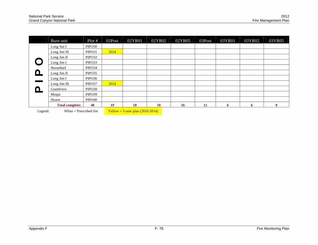
National Park Service 2012 Grand Canyon National Park Fire Management Plan
Appendix F F- 78 Fire Monitoring Plan
Burn unit Plot # 02Post 02YR01 02YR02 02YR05 03Post 03YR01 03YR02 03YR05 P
I P O
Long Jim I PIPO30 Long Jim III PIPO31 2014 Long Jim II PIPO32 Long Jim I PIPO33 Horsethief PIPO34 Long Jim II PIPO35 Long Jim I PIPO36 Long Jim III PIPO37 2014 Grandview PIPO38 Moqui PIPO39 Hearst PIPO40
Total complete: 40 19 18 18 16 11 6 6 0 Legend: White = Prescribed fire Yellow = 5-year plan (2010-2014)
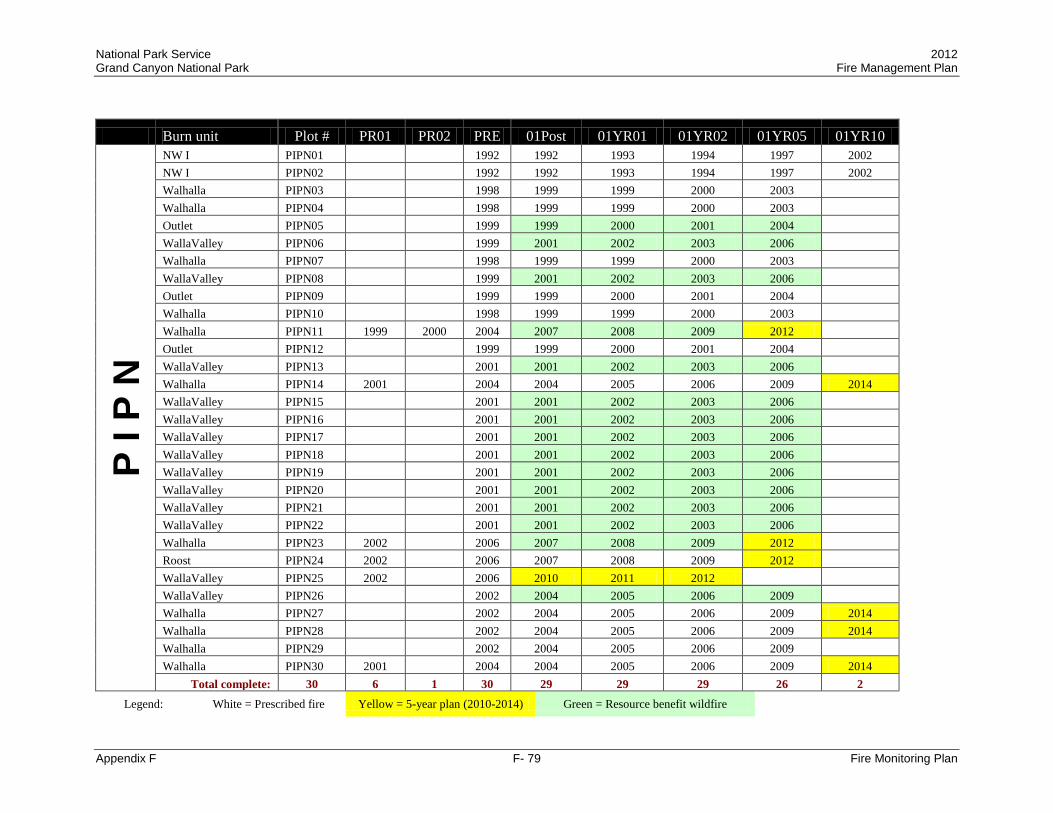
National Park Service 2012 Grand Canyon National Park Fire Management Plan
Appendix F F- 79 Fire Monitoring Plan
Burn unit Plot # PR01 PR02 PRE 01Post 01YR01 01YR02 01YR05 01YR10 P
I P N
NW I PIPN01 1992 1992 1993 1994 1997 2002 NW I PIPN02 1992 1992 1993 1994 1997 2002 Walhalla PIPN03 1998 1999 1999 2000 2003 Walhalla PIPN04 1998 1999 1999 2000 2003 Outlet PIPN05 1999 1999 2000 2001 2004 WallaValley PIPN06 1999 2001 2002 2003 2006 Walhalla PIPN07 1998 1999 1999 2000 2003 WallaValley PIPN08 1999 2001 2002 2003 2006 Outlet PIPN09 1999 1999 2000 2001 2004 Walhalla PIPN10 1998 1999 1999 2000 2003 Walhalla PIPN11 1999 2000 2004 2007 2008 2009 2012 Outlet PIPN12 1999 1999 2000 2001 2004 WallaValley PIPN13 2001 2001 2002 2003 2006 Walhalla PIPN14 2001 2004 2004 2005 2006 2009 2014 WallaValley PIPN15 2001 2001 2002 2003 2006 WallaValley PIPN16 2001 2001 2002 2003 2006 WallaValley PIPN17 2001 2001 2002 2003 2006 WallaValley PIPN18 2001 2001 2002 2003 2006 WallaValley PIPN19 2001 2001 2002 2003 2006 WallaValley PIPN20 2001 2001 2002 2003 2006 WallaValley PIPN21 2001 2001 2002 2003 2006 WallaValley PIPN22 2001 2001 2002 2003 2006 Walhalla PIPN23 2002 2006 2007 2008 2009 2012 Roost PIPN24 2002 2006 2007 2008 2009 2012 WallaValley PIPN25 2002 2006 2010 2011 2012 WallaValley PIPN26 2002 2004 2005 2006 2009 Walhalla PIPN27 2002 2004 2005 2006 2009 2014 Walhalla PIPN28 2002 2004 2005 2006 2009 2014 Walhalla PIPN29 2002 2004 2005 2006 2009 Walhalla PIPN30 2001 2004 2004 2005 2006 2009 2014
Total complete: 30 6 1 30 29 29 29 26 2 Legend: White = Prescribed fire Yellow = 5-year plan (2010-2014) Green = Resource benefit wildfire
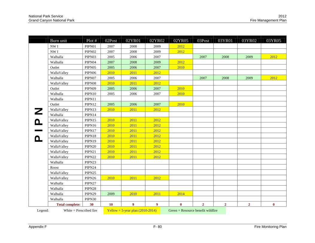
National Park Service 2012 Grand Canyon National Park Fire Management Plan
Appendix F F- 80 Fire Monitoring Plan
Burn unit Plot # 02Post 02YR01 02YR02 02YR05 03Post 03YR01 03YR02 03YR05 P
I P N
NW I PIPN01 2007 2008 2009 2012 NW I PIPN02 2007 2008 2009 2012 Walhalla PIPN03 2005 2006 2007 2007 2008 2009 2012 Walhalla PIPN04 2007 2008 2009 2012 Outlet PIPN05 2005 2006 2007 2010 WallaValley PIPN06 2010 2011 2012 Walhalla PIPN07 2005 2006 2007 2007 2008 2009 2012 WallaValley PIPN08 2010 2011 2012 Outlet PIPN09 2005 2006 2007 2010 Walhalla PIPN10 2005 2006 2007 2010 Walhalla PIPN11 Outlet PIPN12 2005 2006 2007 2010 WallaValley PIPN13 2010 2011 2012 Walhalla PIPN14 WallaValley PIPN15 2010 2011 2012 WallaValley PIPN16 2010 2011 2012 WallaValley PIPN17 2010 2011 2012 WallaValley PIPN18 2010 2011 2012 WallaValley PIPN19 2010 2011 2012 WallaValley PIPN20 2010 2011 2012 WallaValley PIPN21 2010 2011 2012 WallaValley PIPN22 2010 2011 2012 Walhalla PIPN23 Roost PIPN24 WallaValley PIPN25 WallaValley PIPN26 2010 2011 2012 Walhalla PIPN27 Walhalla PIPN28 Walhalla PIPN29 2009 2010 2011 2014 Walhalla PIPN30
Total complete: 30 10 9 9 0 2 2 2 0 Legend: White = Prescribed fire Yellow = 5-year plan (2010-2014) Green = Resource benefit wildfire

National Park Service 2012 Grand Canyon National Park Fire Management Plan
Appendix F F- 81 Fire Monitoring Plan
Burn unit Plot # PR01 PR02 PR03 PRE 01Post 01YR01 01YR02 01YR05 01YR10 P
I A B
Uncle Jim PIAB01 2006 2007 2008 2009 2012 Outlet PIAB02 1993 1997 -- 1999 2000 2003 Vista IV PIAB03 1993 1999 2000 2001 2002 2005 2010 Vista IV PIAB04 1993 1999 2000 2001 2002 2005 2010 Vista IV PIAB05 1993 1999 2000 2001 2002 2005 2010 NW V PIAB06 1993 2004 2007 2008 2009 2012 NW III PIAB07 1993 1993 1994 1995 1998 2003 Outlet PIAB08 1993 1998 1999 2000 2003 2008 Vista IV PIAB09 1993 1999 2000 2001 2002 2005 2010 Outlet PIAB10 1993 1998 1999 2000 2003 2008 Outlet PIAB11 1993 1997 2000 2003 2004 2005 2006 2009 2014 Outlet PIAB12 1993 1997 1997 1998 1999 Walhalla PIAB13 1996 1999 2001 2002 2003 2006 Walhalla PIAB14 1996 1999 2004 2007 2008 2009 2012 Walhalla PIAB15 1996 1999 2001 2002 2003 2006 Walhalla PIAB16 1996 1999 2001 2002 2003 2006 Walhalla PIAB17 1996 1999 2001 2002 2003 2006 Walhalla PIAB18 1996 1999 2001 2002 2003 2006 Walhalla PIAB19 1996 1999 2001 2002 2003 2006 Walhalla PIAB20 1996 1999 2001 2002 2003 2006 Uncle Jim PIAB21 2006 2007 2008 2009 2012 Outlet PIAB22 1996 1997 1998 1999 2002 2007 Outlet PIAB23 1996 1999 2005 NW V PIAB24 2006 2007 2008 2009 2012 NW III PIAB25 1993 1993 1994 1995 1998 2003 Range PIAB26 2008 2010 2011 2012 Roost PIAB27 2001 2007
Total complete: 27 18 3 1 27 23 24 24 18 5 Legend: White = Prescribed fire Yellow = 5-year plan (2010-2014) Green = Resource benefit wildfire Red = Suppression wildfire

National Park Service 2012 Grand Canyon National Park Fire Management Plan
Appendix F F- 82 Fire Monitoring Plan
Burn unit Plot # 02Post 02YR01 02YR02 02YR05 02YR10 03Post 03YR01 03YR02
P I A
B
Uncle Jim PIAB01 Outlet PIAB02 2004 2005 2006 2009 2014 Vista IV PIAB03 Vista IV PIAB04 Vista IV PIAB05 NW V PIAB06 NW III PIAB07 2007 2008 2009 2012 Outlet PIAB08 Vista IV PIAB09 Outlet PIAB10 Outlet PIAB11 Outlet PIAB12 2000 2001 2002 2005 2010 Walhalla PIAB13 2009 2010 2011 2014 Walhalla PIAB14 Walhalla PIAB15 2009 2010 2011 2014 Walhalla PIAB16 2009 2010 2011 2014 Walhalla PIAB17 2009 2010 2011 2014 Walhalla PIAB18 2009 2010 2011 2014 Walhalla PIAB19 2009 2010 2011 2014 Walhalla PIAB20 2009 2010 2011 2014 Uncle Jim PIAB21 Outlet PIAB22 Outlet PIAB23 NW V PIAB24 NW III PIAB25 2007 2008 2009 2012 Range PIAB26 Roost PIAB27
Total complete: 27 11 4 4 2 0 Legend: White = Prescribed fire Yellow = 5-year plan (2010-2014) Green = Resource benefit wildfire

National Park Service 2012 Grand Canyon National Park Fire Management Plan
Appendix F F- 83 Fire Monitoring Plan
Burn unit Plot # PR01 PR02 PR03 PRE 01Post 01YR01 01YR02 01YR05 01YR10 P
I E
N
Nankoweap PIEN01 1993 2000 2001 2002 2005 2010 Boundary PIEN02 1994 2003 2007 2011 2012 2013 Nankoweap PIEN03 1993 2000 2001 2002 2005 2010 Boundary PIEN04 1994 2003 2007 2011 2012 2013 Imperial PIEN05 -- 2000 2001 2002 2005 2010 Imperial PIEN06 -- 2000 2001 2002 2005 2010 Imperial PIEN07 -- 2000 2001 2002 2005 2010 Thompson PIEN08 -- 2000 2001 2002 2005 2010 Imperial PIEN09 -- 2000 2001 2002 2005 2010 Roost PIEN10 2001 2008 2011 2012 2013 Roost PIEN11 2001 -- -- -- 2008 2013 Boundary PIEN12 2001 2003 2004 2005 2008 2013 Thompson PIEN13 2002 2008 2010 2011 2012 Roost PIEN14 2002 2007 2012 2013 2014 Uncle Jim PIEN15 2002 2004 2005 2006 2009 2014 Roost PIEN16 2002 2006 Roost PIEN17 2002 2007 2011 2012 2013
Total complete: 17 7 2 0 12 9 9 9 10 0 Legend: White = Prescribed fire Yellow = 5-year plan (2010-2014) Green = Resource benefit wildfire Red = Suppression wildfire

National Park Service 2012 Grand Canyon National Park Fire Management Plan
Appendix F F- 84 Fire Monitoring Plan
Burn unit Plot # PR01 PR02 PRE 01Post 01YR01 01YR02 01YR05
P I E
D
Entrance PIED01 1991 1992 1993 1994 1997 Picnic PIED02 1994 1995 1995 1996 1999 Entrance PIED03 1991 Entrance PIED04 1991 1992 1993 1994 1997 Entrance PIED05 1991 1992 1993 1994 1997 Topeka PIED06 1998 Picnic PIED07 1994 1994 1995 1996 1999 Topeka PIED08 1992 1992 1993 1994 1997 Quarry PIED09 1992 1993 1994 1995 1998 Quarry PIED10 1990 1993 1994 1995 1998 Quarry PIED11 1993 1993 1994 1995 1998 Entrance PIED12 1991 1992 -- 1994 1997 Topeka PIED13 1993 1993 1994 1995 1998 Topeka PIED14 1993 1993 1994 1995 -- Topeka PIED15 1993 1993 1994 1995 1998 Shoshone SHOS01 1999 -- 2000 2001 2004 Shoshone SHOS02 -- 1999 2000 2001 2004
Total complete: 17 16 14 14 15 14 Legend: White = Prescribed fire

National Park Service 2012 Grand Canyon National Park Fire Management Plan
Appendix F F- 85 Fire Monitoring Plan
Burn unit Plot # PR01 PR02 PRE 01Post 01YR01 01YR02 01YR05 01YR10
G R
I N
Roost GRIN01 2001 Roost GRIN02 2001 Roost GRIN03 2001 Outlet GRIN04 2001 Roost GRIN05 2001 Roost GRIN06 2002 Roost GRIN07 2002 Roost GRIN08 2002 Roost GRIN09 2002 Outlet GRIN10 2002
Total complete: 10 10
GR
ED Roost GRED01 2001
Outlet GRED02 2001 Roost GRED03 2001 Roost GRED04 2001 Roost GRED05 2001 Roost GRED06 2001
Total complete: 6 6
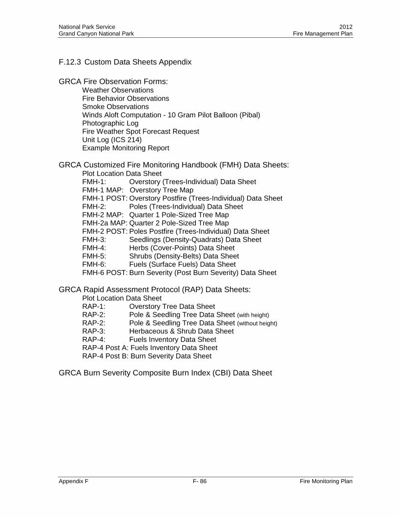
National Park Service 2012 Grand Canyon National Park Fire Management Plan
Appendix F F- 86 Fire Monitoring Plan
F.12.3 Custom Data Sheets Appendix GRCA Fire Observation Forms:
Weather Observations Fire Behavior Observations Smoke Observations Winds Aloft Computation - 10 Gram Pilot Balloon (Pibal) Photographic Log Fire Weather Spot Forecast Request Unit Log (ICS 214) Example Monitoring Report
GRCA Customized Fire Monitoring Handbook (FMH) Data Sheets:
Plot Location Data Sheet FMH-1: Overstory (Trees-Individual) Data Sheet FMH-1 MAP: Overstory Tree Map FMH-1 POST: Overstory Postfire (Trees-Individual) Data Sheet FMH-2: Poles (Trees-Individual) Data Sheet FMH-2 MAP: Quarter 1 Pole-Sized Tree Map FMH-2a MAP: Quarter 2 Pole-Sized Tree Map FMH-2 POST: Poles Postfire (Trees-Individual) Data Sheet FMH-3: Seedlings (Density-Quadrats) Data Sheet FMH-4: Herbs (Cover-Points) Data Sheet FMH-5: Shrubs (Density-Belts) Data Sheet FMH-6: Fuels (Surface Fuels) Data Sheet FMH-6 POST: Burn Severity (Post Burn Severity) Data Sheet
GRCA Rapid Assessment Protocol (RAP) Data Sheets:
Plot Location Data Sheet RAP-1: Overstory Tree Data Sheet RAP-2: Pole & Seedling Tree Data Sheet (with height) RAP-2: Pole & Seedling Tree Data Sheet (without height) RAP-3: Herbaceous & Shrub Data Sheet RAP-4: Fuels Inventory Data Sheet RAP-4 Post A: Fuels Inventory Data Sheet RAP-4 Post B: Burn Severity Data Sheet
GRCA Burn Severity Composite Burn Index (CBI) Data Sheet

WEATHER OBSERVATIONSPage ___ of ___
DATE: FIRE NAME:
OBSERVERS:
TIME LOCATION ELEVATION ASPECT SLOPE (%)
DRY BULB
WET BULB RH DP
WIND SPEED
(GUSTS)
WIND DIR.
% CLOUD COVER
% SHADING
FINE DEAD FUEL
MOISTURE
PROB. OF IGNITION
COMMENTS (PRECIP, FIRE BEHAVIOR, SMOKE, ETC.)
PRESCRIPTION:
MAX TEMP MIN RHTIME TIME
MIN TEMP MAX RHTIME TIME
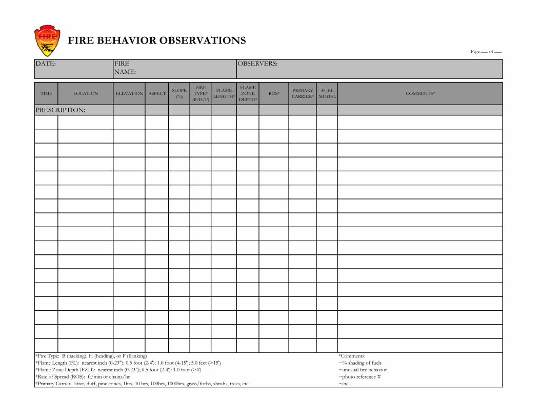
FIRE BEHAVIOR OBSERVATIONSPage ___ of ___
DATE: FIRE NAME:
OBSERVERS:
TIME LOCATION ELEVATION ASPECT SLOPE (%)
FIRE TYPE*
(B/H/F)
FLAME LENGTH*
FLAME ZONE
DEPTH*ROS* PRIMARY
CARRIER*FUEL
MODEL COMMENTS*
PRESCRIPTION:
*Fire Type: B (backing), H (heading), or F (flanking) *Comments:*Flame Length (FL): nearest inch (0-23"); 0.5 foot (2-4'); 1.0 foot (4-15'); 5.0 feet (>15') ~% shading of fuels*Flame Zone Depth (FZD): nearest inch (0-23"); 0.5 foot (2-4'): 1.0 foot (>4') ~unusual fire behavior*Rate of Spread (ROS): ft/min or chains/hr ~photo reference #*Primary Carrier: litter, duff, pine cones, 1hrs, 10 hrs, 100hrs, 1000hrs, grass/forbs, shrubs, trees, etc. ~etc.

SMOKE OBSERVATIONSPage ___ of ___
DATE: FIRE NAME: OBSERVERS:
HAINES INDEX:
FORECASTED TRANSPORT
WINDS:
SMOKE SENSITIVE
AREAS:
TIME LOCATION & ELEVATION
WIND SPEED & DIRECTION
SMOKE COLUMN OR INVERSION
ELEVATION ABOVE GROUND LEVEL
SMOKE COLUMN
DIRECTION
PLUME TYPE 1-5 (BELOW) COLOR VOLUME OTHER OBSERVATIONS*
PLUME TYPES 1 2 3 4 5
RISING STRAIGHT UP, MAY HAVE CUMULUS
TOP
RISING HIGH, THEN SHEARED
BY WIND
RISING LOW, WIND
INFLUENCED
NOT RISING; LITTLE
WIND OR INVERSION
FLOWING OVER STEEP CLIFF OR
EDGE; OR COLLAPSED
COLUMN
*Observations include visibiliy, inversion status, visibility to sighted distance, impacts to smoke sensitive areas/resources, forward & back scatter, complaints, etc.

WINDS ALOFT COMPUTATION FORM - 10 Gram Pilot Balloon (Pibal)Page ___ of ___
DATE: FIRE NAME: OBSERVERS:
TEMP: ELEVATION: SURFACE WIND:RH: LOCATION: WEATHER:
TIME (Min)
HEIGHT (Ft./AGL)*
CLINOMETER ANGLE (Deg.)
COMPASS AZIMUTH (Deg.)
WIND DIRECTION COMMENTS
:30
1:00 500'**
1:30
2:00 1000'
2:30
3:00 1500'
3:30
4:00 2000'
4:30
5:00 2500'
5:30
6:00 3000'
6:30
7:00 3500'
7:30
8:00 4000'
* AGL - Above Ground Level** - Pibal rises 500' per minute

PHOTOGRAPHIC LOGPage ___ of ___
DATE: FIRE NAME:
OBSERVERS:
FILM: DIGITAL
PHOTO # TIME AZIMUTH DESCRIPTION/LOCATION*
*Make maps of photo points if necessary

WS FORM D-1 U.S. DEPARTMENT OF COMMERCE (12-86) FIRE WEATHER SPOT FORECAST REQUEST NOAA Pres. By WSOM D-41 NATIONAL WEATHER SERVICE I – REQUESTING AGENCY WILL FURNISH:
3. REQUEST MADE 1. NAME OF FIRE OR OTHER PROJECT 2. CONTROL AGENCY TIME
DATE
4. LOCATION (By ¼ Sec-Sec-Twp-Range) 5. DRAINAGE NAME 6. EXPOSURE (NE, E, SE, etc.)
8. ELEVATION* 7. SIZE OF PROJECT (Acres) TOP
BOTTOM 9. FUEL TYPE 10. PROJECT ON:
GROUND CROWNING
11. WEATHER CONDITIONS AT PROJECT OR FROM NEARBY STATIONS WIND DIR.VEL. TEMP.
PLACE ELE-VATION
OB TIME 20 FT EYE LEVEL DRY WET RH DP
REMARKS (Indicate rain, thunderstorms, etc. Also wind conditions and 10ths of cloud cover)
12. SEND FORECAST TO:
PLACE VIA ATTN:
II-FIRE WEATHER FORECASTER WILL FURNISH: 13. FORECAST AND OUTLOOK: (SPECIFY Wind – 20 foot or Eye Level) TIME AND DATE:______________________________________________ Synopsis:
Wind
Burn Period Sky Cover Temperature Humidity
Eye-Level 20-Foot
Indices
Today (sunrise to dusk) This Afternoon (noon until dusk) This evening (1600 until dusk) Tonight (sunset until sunrise)
Mostly Sunny/Clear Fair Partly Cloudy Mostly Cloudy Cloudy Variable Clouds
_____ o F High Low Range
_______% Maximum Minim m u Range
Upslope Downslope Direction:_______ Velocity________ Gusts___________
Upslope Downslope Direction:_______ Velocity________ Gusts__________
Haines: LAL: BI: CI:
Today (sunrise to dusk) This Afternoon (noon until dusk) This evening (1600 until dusk) Tonight (sunset until sunrise)
Mostly Sunny/Clear Fair Partly Cloudy Mostly Cloudy Cloudy Variable Clouds
_____ o F High Low Range
_______% Maximum Minimum Range
Upslope Downslope Direction:_______ Velocity________ Gusts___________
Upslope Downslope Direction:_______ Velocity________ Gusts__________
Haines: LAL: BI: CI:
Outlook For (Date): ________________
Mostly Sunny/Clear Fair Partly Cloudy Mostly Cloudy Cloudy Variable Clouds
_____ o F High Low Range
_______% Maximum Minimum Range
Upslope Downslope Direction:_______ Velocity________ Gusts___________
Upslope Downslope Direction:_______ Velocity________ Gusts__________
Haines: LAL: BI: CI:
NAME OF FIRE WEATHER FORECASTER
FIRE WEATHER OFFICE
III – REQUESTING AGENCY WILL COMPLETE UPON RECEIPT OF FORECAST IV – FORECAST RECEIVED:
TIME DATE NAME

1. INCIDENT NAME 2. DATE PREPARED 3. TIME PREPARED
UNIT LOG
4. UNIT NAME/DESIGNATORS 5. UNIT LEADER (NAME AND POSITION) 6. OPERATIONAL PERIOD
7. PERSONNEL ROSTER ASSIGNED
NAME ICS POSITION HOME BASE
8. ACTIVITY LOG
TIME MAJOR EVENTS
9. PREPARED BY:
ICS 214

EXAMPLE MONITORING REPORT August 4, 2009
Fire Name: Aspen Dates: August 4, 2009 Acres: 2123 Monitors: Koenig, Geldert, Gillespie Observation Location(s): Roosevelt Pnt., Atoko Gap, Blowhole, West Flank Fuel Model/Vegetation Type: Ponderosa Pine, White Fir, Aspen (Model 9)
Operational Summary After a 0700 briefing personnel arrived at their assigned locations on the fire site.
Division A began monitoring the west side of the fire by initiating weather and fire behavior observations. A lookout was also put in place for the division. A Task Force on Division B began to snag the road, reducing the amount of hazard snags. Resources
positioned themselves to prepare for a burnout operation along Highway 67, which was later cancelled due to unfavorable conditions. Lookouts were posted at Roosevelt Point to watch for spots and take hourly weather observations. In the afternoon, crews on Division B began to prep the highway for future burnouts. Personnel began to be released at 1900, marking the end of a safe day on the fireline.
Fire Weather Observations
WEATHER FORECASTED OBSERVED* Min RH 16% 17 Max TEMP 82 80 Winds
20’ – LIGHT BECOMING SW 5-10 IN AFTERNOON
EYE LEVEL – 1-5 GUSTS TO 12 PREDOMINATE SW
Sky weather PARTLY CLOUDY WITH
SLIGHT CHANCE OF THUNDERSTORMS
PARTLY CLOUDY THEN BECOMING MOSTLY CLOUDY IN THE
AFTERNOON
Fire Behavior
Division A observed active fire behavior for the majority of the day. In the morning, short sections of the fire’s edge had open flame, but by early afternoon the majority of the western flank was active. Backing and flanking fire moved on an average of ½ ch/hr, but also was observed moving up to 4 ch/hr. Flame lengths varied, but in litter averaged between 4-8”. The flame zone depths in the litter were as small as 3-4” and as large as 6-18”. The main fire carrier was pine litter, also the heavy fuels carried and burned hot. The fire backed well into areas of grass fuels as well. Isolated torching, mainly of white fire, did occur throughout the day. Consumption of the litter was noted to be approximately 50% on average. Division B fire behavior was characterized mainly by smoldering in heavy fuels. No torching was observed, and larger flame lengths was the result of jackpots mixed in with pockets of New Mexican Locust. There was a significant decrease in fire behavior today compared to previous days. Prepared by: K. Koenig, M. J. Geldert, H. Gillespie Date: 8/4/09

PLOT LOCATION DATA
Plot ID Today’s Date ___/___/___ Installation Date ___/___/___ Burn Unit Recorders Declination 11.5o E NAD 83 Zone 12 UTMe UTMn +/- m Slope(%) Aspect Elevation Transect Azimuth (from 0P50P) Date of Last Known Fire Fire History of the Plot Deviations from protocols? If yes, describe:
VERY SPECIFIC DIRECTIONS TO PLOT ORIGIN Did you remember: Which road(s) to drive on and mileages to get to the plot? Which side of the road is the reference stake on? What significant feature is the reference stake near or by? Did you get GPS coordinates for the origin and ref. stake? Did you get an accurate azimuth from the reference stake to the plot origin? Did more than one person compass and chain? Are the directions easy enough for a firefighter to follow and comprehend? Was a picture of the reference stake area taken? Is there a GIS map of the plot? Did you draw a hand drawn map? Does your hand drawn map STAND (Scale, Title, Author, North Arrow, Date)?

FMH-1 OVERSTORY (TREES – INDIVIDUAL) Page__ of __
Plot ID: ____________________ B / C (circle one) Date ___/___/___ Burn Unit ____________________ Recorders _________________________________ Burn Status: PRE POST mo ____ yrl yr2 yr5 yr10 yr20 (circle one) HGT = Total height measured from ground to tree top (may be dead), in meters. Crown Ratio = Visual estimate of the ratio of the crown length and volume to total tree length. CBH = Live Crown Base Height measured from ground to bottom of lowest continuous live crown, in meters. Area Sampled: all 4 Quarters for all monitoring types.
Crown Crown QTR TAG SPP STATUS DBH HGT(m) CBH(m) Ratio Class DAMAGE COMMENTS ___ ___ ____ L D _____ _____ ____ ____ _____ _______________ _______ ___ ___ ____ L D _____ _____ ____ ____ _____ _______________ _______ ___ ___ ____ L D _____ _____ ____ ____ _____ _______________ _______ ___ ___ ____ L D _____ _____ ____ ____ _____ _______________ _______ ___ ___ ____ L D _____ _____ ____ ____ _____ _______________ _______ ___ ___ ____ L D _____ _____ ____ ____ _____ _______________ _______ ___ ___ ____ L D _____ _____ ____ ____ _____ _______________ _______ ___ ___ ____ L D _____ _____ ____ ____ _____ _______________ _______ ___ ___ ____ L D _____ _____ ____ ____ _____ _______________ _______ ___ ___ ____ L D _____ _____ ____ ____ _____ _______________ _______ ___ ___ ____ L D _____ _____ ____ ____ _____ _______________ _______ ___ ___ ____ L D _____ _____ ____ ____ _____ _______________ _______ ___ ___ ____ L D _____ _____ ____ ____ _____ _______________ _______ ___ ___ ____ L D _____ _____ ____ ____ _____ _______________ _______ ___ ___ ____ L D _____ _____ ____ ____ _____ _______________ _______ ___ ___ ____ L D _____ _____ ____ ____ _____ _______________ _______ ___ ___ ____ L D _____ _____ ____ ____ _____ _______________ _______ ___ ___ ____ L D _____ _____ ____ ____ _____ _______________ _______ ___ ___ ____ L D _____ _____ ____ ____ _____ _______________ _______ ___ ___ ____ L D _____ _____ ____ ____ _____ _______________ _______ ___ ___ ____ L D _____ _____ ____ ____ _____ _______________ _______ ___ ___ ____ L D _____ _____ ____ ____ _____ _______________ _______ ___ ___ ____ L D _____ _____ ____ ____ _____ _______________ _______ ___ ___ ____ L D _____ _____ ____ ____ _____ _______________ _______ ___ ___ ____ L D _____ _____ ____ ____ _____ _______________ _______ ___ ___ ____ L D _____ _____ ____ ____ _____ _______________ _______ ___ ___ ____ L D _____ _____ ____ ____ _____ _______________ _______ ___ ___ ____ L D _____ _____ ____ ____ _____ _______________ _______ ___ ___ ____ L D _____ _____ ____ ____ _____ _______________ _______ ___ ___ ____ L D _____ _____ ____ ____ _____ _______________ _______ ___ ___ ____ L D _____ _____ ____ ____ _____ _______________ _______
Crown Ratio codes: 1 = 0 – 10% 4 = 31 – 40% 7 = 61 – 70% 10 = 91 – 100% 2 = 11 – 20% 5 = 41 – 50% 8 = 71 – 80% 3 = 21 - 30% 6 = 51 – 60% 9 = 81 – 90%
Crown Class codes: (See back of FMH 1 MAP – Overstory Tree Map for illustration) *only used postburn D = Dominant C = Codominant I = Intermediate SC = Subcanopy O = Open Growth RS = Recent Snag LBS = Loose Bark Snag CS = Clean Snag BAD = Broken Above DBH BBD*= Broken Below DBH DD*= Dead & Down CUS*= Cut Stump

Crown Crown QTR TAG SPP STATUS DBH HGT(m) CBH(m) Ratio Class DAMAGE COMMENTS ___ ___ ____ L D _____ _____ ____ ____ _____ _______________ _______ ___ ___ ____ L D _____ _____ ____ ____ _____ _______________ _______ ___ ___ ____ L D _____ _____ ____ ____ _____ _______________ _______ ___ ___ ____ L D _____ _____ ____ ____ _____ _______________ _______ ___ ___ ____ L D _____ _____ ____ ____ _____ _______________ _______ ___ ___ ____ L D _____ _____ ____ ____ _____ _______________ _______ ___ ___ ____ L D _____ _____ ____ ____ _____ _______________ _______ ___ ___ ____ L D _____ _____ ____ ____ _____ _______________ _______ ___ ___ ____ L D _____ _____ ____ ____ _____ _______________ _______ ___ ___ ____ L D _____ _____ ____ ____ _____ _______________ _______ ___ ___ ____ L D _____ _____ ____ ____ _____ _______________ _______ ___ ___ ____ L D _____ _____ ____ ____ _____ _______________ _______ ___ ___ ____ L D _____ _____ ____ ____ _____ _______________ _______ ___ ___ ____ L D _____ _____ ____ ____ _____ _______________ _______ ___ ___ ____ L D _____ _____ ____ ____ _____ _______________ _______ ___ ___ ____ L D _____ _____ ____ ____ _____ _______________ _______ ___ ___ ____ L D _____ _____ ____ ____ _____ _______________ _______ ___ ___ ____ L D _____ _____ ____ ____ _____ _______________ _______ ___ ___ ____ L D _____ _____ ____ ____ _____ _______________ _______ ___ ___ ____ L D _____ _____ ____ ____ _____ _______________ _______ ___ ___ ____ L D _____ _____ ____ ____ _____ _______________ _______ ___ ___ ____ L D _____ _____ ____ ____ _____ _______________ _______ ___ ___ ____ L D _____ _____ ____ ____ _____ _______________ _______ ___ ___ ____ L D _____ _____ ____ ____ _____ _______________ _______ ___ ___ ____ L D _____ _____ ____ ____ _____ _______________ _______ ___ ___ ____ L D _____ _____ ____ ____ _____ _______________ _______ ___ ___ ____ L D _____ _____ ____ ____ _____ _______________ _______ ___ ___ ____ L D _____ _____ ____ ____ _____ _______________ _______ ___ ___ ____ L D _____ _____ ____ ____ _____ _______________ _______ ___ ___ ____ L D _____ _____ ____ ____ _____ _______________ _______
Damage codes: ABGR abnormal growth pattern FIRE fire scar or cambial damage MOSS moss BIRD bird (woodpecker holes) FORK forked top OZON ozone BLIG blight FRST frost crack ROOT large roots exposed BROK broken top GALL galls ROTT rot, fungus other than conk BROM witches broom HOLW hollowed out SPAR unusually sparse foliage BURL burl INSE insects or their sign SPRT sprouting from base CONK conk, large shelf fungus LEAN tree is leaning TWIN twinned tree-below DBH CROK crooked or twisted bole LICH Lichen UMAN human-caused damage DTOP dead top LIGT lightning scar WOND wound-cracks, etc. EPIC sprouting from bole or limbs MAMM mammal-caused damage EPIP epiphytes MISL mistletoe present
An overstory tree is ≥ 15.1cm. For new installations, tags should be 1 - 100. Re-nail incorrect tags. Place nails angled down so tags hang away from tree and make sure all TAGS FACE THE ORIGIN. If tree is FORKED BELOW DBH, TAG ALL OVERSTORY-SIZED STEMS. But don’t tag obvious branches!! Make sure DBH tape is level and tight. DBH is 4.5 feet (137 cm) along bole, not from ground level. DBH perpendicular to bole, and if on a slope, stand at the middle of the slope. ROUND DOWN to the nearest tenth of a centimeter. DBH dead trees the first time they are tagged. Thereafter, copy DBH on dead trees from previous read, updating if large change. Copy CROWN CLASS and DAMAGE codes from previous reads. UPDATE if necessary. Use special protocols for junipers (DRC if multi-stemmed). Write note for DBH-ing unusual trees.

FMH-1 MAP
Plot ID _________________ B / C (circle one) Date ___/___/___Burn Unit ________________ Recorders _____________________________Burn Status: PRE POST mo___ yr1 yr2 yr5 yr10 yr20 (circle one)
Q 3 Q 420m 0m
0m
Q 2 Q 1
P2
50m
30m
35m
40m
45m
25m
5 0 P
Q1
10m15m 5m
Q2
OVERSTORY TREE MAP
OR
4A
3A
2A
1A
15m 10m 5mO P
5m
10m
15m
20m50m
0m
P1
25m
5m
10m
15m
20m
45m
Q4
30m
35m
40m
20m
Q3

FMH-1 POST OVERSTORY POSTFIRE (TREES - INDIVIDUAL) Page__ of __
Plot ID: _________________ B / C (circle one) Date ___/___/___ Burn Unit__________________ Recorders ________________________________ Burn Status: PRE POST mo ___ yr1 yr2 yr5 yr10 yr20 (circle one) For each overstory tree record: quarter in which tree is located (QTR); (TAG) #; species (SPP); tree status (STATUS): alive (L) or dead standing (D); total tree height (HGT) in meters; Crown Ratio Code (Crown Ratio) and Live Crown Base Height (CBH) (see notes on back); max char height in meters (CHAR); max scorch height in meters (SCHGT); % crown scorched (SC%); DAMAGE: USE ONLY THE FOLLOWING CHOICES ON POST READS: CNSM - completely consumed/down; BBD - broken below DBH; RSPT – resprout; CUS - cut stump
USE THIS FORM ONLY FOR IMMEDIATE POST READ. DON’T USE FMH- 1 FOR IMMEDIATE POST!!
QTR TAG SPP STATUS HGT CBH Crown CHAR SCHGT SC% DAMAGE (m) (m) Ratio (m) (m) ____ ____ ____ L D _____ _____ _____ _____ _____ _____ ________ ____ ____ ____ L D _____ _____ _____ _____ _____ _____ ________ ____ ____ ____ L D _____ _____ _____ _____ _____ _____ ________ ____ ____ ____ L D _____ _____ _____ _____ _____ _____ ________ ____ ____ ____ L D _____ _____ _____ _____ _____ _____ ________ ____ ____ ____ L D _____ _____ _____ _____ _____ _____ ________ ____ ____ ____ L D _____ _____ _____ _____ _____ _____ ________ ____ ____ ____ L D _____ _____ _____ _____ _____ _____ ________ ____ ____ ____ L D _____ _____ _____ _____ _____ _____ ________ ____ ____ ____ L D _____ _____ _____ _____ _____ _____ ________ ____ ____ ____ L D _____ _____ _____ _____ _____ _____ ________ ____ ____ ____ L D _____ _____ _____ _____ _____ _____ ________ ____ ____ ____ L D _____ _____ _____ _____ _____ _____ ________ ____ ____ ____ L D _____ _____ _____ _____ _____ _____ ________ ____ ____ ____ L D _____ _____ _____ _____ _____ _____ ________ ____ ____ ____ L D _____ _____ _____ _____ _____ _____ ________ ____ ____ ____ L D _____ _____ _____ _____ _____ _____ ________ ____ ____ ____ L D _____ _____ _____ _____ _____ _____ ________ ____ ____ ____ L D _____ _____ _____ _____ _____ _____ ________ ____ ____ ____ L D _____ _____ _____ _____ _____ _____ ________ ____ ____ ____ L D _____ _____ _____ _____ _____ _____ ________ ____ ____ ____ L D _____ _____ _____ _____ _____ _____ ________ ____ ____ ____ L D _____ _____ _____ _____ _____ _____ ________ ____ ____ ____ L D _____ _____ _____ _____ _____ _____ ________ ____ ____ ____ L D _____ _____ _____ _____ _____ _____ ________ ____ ____ ____ L D _____ _____ _____ _____ _____ _____ ________ ____ ____ ____ L D _____ _____ _____ _____ _____ _____ ________ ____ ____ ____ L D _____ _____ _____ _____ _____ _____ ________ ____ ____ ____ L D _____ _____ _____ _____ _____ _____ ________ ____ ____ ____ L D _____ _____ _____ _____ _____ _____ ________ ____ ____ ____ L D _____ _____ _____ _____ _____ _____ ________ ____ ____ ____ L D _____ _____ _____ _____ _____ _____ ________

QTR TAG SPP STATUS HGT CBH Crown CHAR SCHGT SC% DAMAGE (m) (m) Ratio (m) (m) ____ ____ ____ L D _____ _____ _____ _____ _____ _____ ________ ____ ____ ____ L D _____ _____ _____ _____ _____ _____ ________ ____ ____ ____ L D _____ _____ _____ _____ _____ _____ ________ ____ ____ ____ L D _____ _____ _____ _____ _____ _____ ________ ____ ____ ____ L D _____ _____ _____ _____ _____ _____ ________ ____ ____ ____ L D _____ _____ _____ _____ _____ _____ ________ ____ ____ ____ L D _____ _____ _____ _____ _____ _____ ________ ____ ____ ____ L D _____ _____ _____ _____ _____ _____ ________ ____ ____ ____ L D _____ _____ _____ _____ _____ _____ ________ ____ ____ ____ L D _____ _____ _____ _____ _____ _____ ________ ____ ____ ____ L D _____ _____ _____ _____ _____ _____ ________ ____ ____ ____ L D _____ _____ _____ _____ _____ _____ ________ ____ ____ ____ L D _____ _____ _____ _____ _____ _____ ________ ____ ____ ____ L D _____ _____ _____ _____ _____ _____ ________ ____ ____ ____ L D _____ _____ _____ _____ _____ _____ ________ ____ ____ ____ L D _____ _____ _____ _____ _____ _____ ________ ____ ____ ____ L D _____ _____ _____ _____ _____ _____ ________ ____ ____ ____ L D _____ _____ _____ _____ _____ _____ ________ ____ ____ ____ L D _____ _____ _____ _____ _____ _____ ________ ____ ____ ____ L D _____ _____ _____ _____ _____ _____ ________ ____ ____ ____ L D _____ _____ _____ _____ _____ _____ ________ ____ ____ ____ L D _____ _____ _____ _____ _____ _____ ________ ____ ____ ____ L D _____ _____ _____ _____ _____ _____ ________ ____ ____ ____ L D _____ _____ _____ _____ _____ _____ ________ ____ ____ ____ L D _____ _____ _____ _____ _____ _____ ________ ____ ____ ____ L D _____ _____ _____ _____ _____ _____ ________ ____ ____ ____ L D _____ _____ _____ _____ _____ _____ ________ ____ ____ ____ L D _____ _____ _____ _____ _____ _____ ________ ____ ____ ____ L D _____ _____ _____ _____ _____ _____ ________ ____ ____ ____ L D _____ _____ _____ _____ _____ _____ ________ ____ ____ ____ L D _____ _____ _____ _____ _____ _____ ________ ____ ____ ____ L D _____ _____ _____ _____ _____ _____ ________ ____ ____ ____ L D _____ _____ _____ _____ _____ _____ ________ ____ ____ ____ L D _____ _____ _____ _____ _____ _____ ________ ____ ____ ____ L D _____ _____ _____ _____ _____ _____ ________ ____ ____ ____ L D _____ _____ _____ _____ _____ _____ ________ ____ ____ ____ L D _____ _____ _____ _____ _____ _____ ________ ____ ____ ____ L D _____ _____ _____ _____ _____ _____ ________ ____ ____ ____ L D _____ _____ _____ _____ _____ _____ ________ ____ ____ ____ L D _____ _____ _____ _____ _____ _____ ________ Record MAXIMUM SCORCH AND CHAR HEIGHT, not average PREVIOUSLY DEAD TREES = 0 SCHGT, 0 SC% CONSUMED/DOWN = 0 SCHGT, 0 SC%, 0 CHAR 100% TORCHED TREE = 100% SCORCH CBH = Crown Base Height (measured from the ground to the bottom of lowest live crown, in meters) Crown Ratio = classified into 10 percent classes. For example: 1 = 0-10%, 2 = 11-20%, etc. Visual estimate of the ratio of crown length to
total tree height (account for crown health and fullness/volume as well)
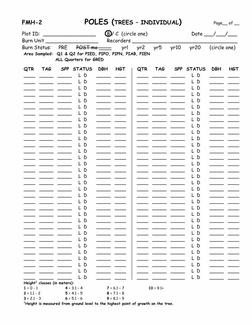
FMH-2 POLES (TREES – INDIVIDUAL) Page__ of __
Plot ID: _________________ B / C (circle one) Date ___/___/___ Burn Unit _________________ Recorders __________________________________ Burn Status: PRE POST mo ____ yrl yr2 yr5 yr10 yr20 (circle one) Area Sampled: Q1 & Q2 for PIED, PIPO, PIPN, PIAB, PIEN ALL Quarters for GRED
QTR TAG SPP STATUS DBH HGT QTR TAG SPP STATUS DBH HGT ____ _____ _____ L D _____ ____ ____ _____ _____ L D _____ ____ ____ _____ _____ L D _____ ____ ____ _____ _____ L D _____ ____ ____ _____ _____ L D _____ ____ ____ _____ _____ L D _____ ____ ____ _____ _____ L D _____ ____ ____ _____ _____ L D _____ ____ ____ _____ _____ L D _____ ____ ____ _____ _____ L D _____ ____ ____ _____ _____ L D _____ ____ ____ _____ _____ L D _____ ____ ____ _____ _____ L D _____ ____ ____ _____ _____ L D _____ ____ ____ _____ _____ L D _____ ____ ____ _____ _____ L D _____ ____ ____ _____ _____ L D _____ ____ ____ _____ _____ L D _____ ____ ____ _____ _____ L D _____ ____ ____ _____ _____ L D _____ ____ ____ _____ _____ L D _____ ____ ____ _____ _____ L D _____ ____ ____ _____ _____ L D _____ ____ ____ _____ _____ L D _____ ____ ____ _____ _____ L D _____ ____ ____ _____ _____ L D _____ ____ ____ _____ _____ L D _____ ____ ____ _____ _____ L D _____ ____ ____ _____ _____ L D _____ ____ ____ _____ _____ L D _____ ____ ____ _____ _____ L D _____ ____ ____ _____ _____ L D _____ ____ ____ _____ _____ L D _____ ____ ____ _____ _____ L D _____ ____ ____ _____ _____ L D _____ ____ ____ _____ _____ L D _____ ____ ____ _____ _____ L D _____ ____ ____ _____ _____ L D _____ ____ ____ _____ _____ L D _____ ____ ____ _____ _____ L D _____ ____ ____ _____ _____ L D _____ ____ ____ _____ _____ L D _____ ____ ____ _____ _____ L D _____ ____ ____ _____ _____ L D _____ ____ ____ _____ _____ L D _____ ____ ____ _____ _____ L D _____ ____ ____ _____ _____ L D _____ ____ ____ _____ _____ L D _____ ____ ____ _____ _____ L D _____ ____ ____ _____ _____ L D _____ ____ ____ _____ _____ L D _____ ____ ____ _____ _____ L D _____ ____ ____ _____ _____ L D _____ ____ ____ _____ _____ L D _____ ____ ____ _____ _____ L D _____ ____ ____ _____ _____ L D _____ ____ ____ _____ _____ L D _____ ____ ____ _____ _____ L D _____ ____ ____ _____ _____ L D _____ ____ ____ _____ _____ L D _____ ____ ____ _____ _____ L D _____ ____ ____ _____ _____ L D _____ ____ ____ _____ _____ L D _____ ____ ____ _____ _____ L D _____ ____ ____ _____ _____ L D _____ ____ ____ _____ _____ L D _____ ____ Height1 classes (in meters): 1 = 0 - 1 4 = 3.1 – 4 7 = 6.1 – 7 10 = 9.1+ 2 = 1.1 - 2 5 = 4.1 - 5 8 = 7.1 – 8 3 = 2.1 - 3 6 = 5.1 - 6 9 = 8.1 – 9 1Height is measured from ground level to the highest point of growth on the tree.

QTR TAG SPP STATUS DBH HGT QTR TAG SPP STATUS DBH HGT ____ _____ _____ L D _____ ____ ____ _____ _____ L D _____ ____ ____ _____ _____ L D _____ ____ ____ _____ _____ L D _____ ____ ____ _____ _____ L D _____ ____ ____ _____ _____ L D _____ ____ ____ _____ _____ L D _____ ____ ____ _____ _____ L D _____ ____ ____ _____ _____ L D _____ ____ ____ _____ _____ L D _____ ____ ____ _____ _____ L D _____ ____ ____ _____ _____ L D _____ ____ ____ _____ _____ L D _____ ____ ____ _____ _____ L D _____ ____ ____ _____ _____ L D _____ ____ ____ _____ _____ L D _____ ____ ____ _____ _____ L D _____ ____ ____ _____ _____ L D _____ ____ ____ _____ _____ L D _____ ____ ____ _____ _____ L D _____ ____ ____ _____ _____ L D _____ ____ ____ _____ _____ L D _____ ____ ____ _____ _____ L D _____ ____ ____ _____ _____ L D _____ ____ ____ _____ _____ L D _____ ____ ____ _____ _____ L D _____ ____ ____ _____ _____ L D _____ ____ ____ _____ _____ L D _____ ____ ____ _____ _____ L D _____ ____ ____ _____ _____ L D _____ ____ ____ _____ _____ L D _____ ____ ____ _____ _____ L D _____ ____ ____ _____ _____ L D _____ ____ ____ _____ _____ L D _____ ____ ____ _____ _____ L D _____ ____ ____ _____ _____ L D _____ ____ ____ _____ _____ L D _____ ____ ____ _____ _____ L D _____ ____ ____ _____ _____ L D _____ ____ ____ _____ _____ L D _____ ____ ____ _____ _____ L D _____ ____ ____ _____ _____ L D _____ ____ ____ _____ _____ L D _____ ____ ____ _____ _____ L D _____ ____ ____ _____ _____ L D _____ ____ ____ _____ _____ L D _____ ____ ____ _____ _____ L D _____ ____ ____ _____ _____ L D _____ ____ ____ _____ _____ L D _____ ____ ____ _____ _____ L D _____ ____ ____ _____ _____ L D _____ ____ ____ _____ _____ L D _____ ____ ____ _____ _____ L D _____ ____ ____ _____ _____ L D _____ ____ ____ _____ _____ L D _____ ____ ____ _____ _____ L D _____ ____ ____ _____ _____ L D _____ ____ ____ _____ _____ L D _____ ____ ____ _____ _____ L D _____ ____ ____ _____ _____ L D _____ ____ ____ _____ _____ L D _____ ____ ____ _____ _____ L D _____ ____ A pole is ≥ 2.5 cm and ≤ 15.0 cm. Pre-burn: ONLY SAMPLE & TAG LIVE POLES. Do not sample or tag dead poles on pre-burn reads. Post-burn: Sample all previously tagged poles, even if they are now standing dead. Continue sampling poles until they have fallen to the ground. For new installations tags should be numbered P101 – P200. Re-nail incorrect tags. Place nails angled down so tags hang away from tree and make sure all TAGS FACE THE ORIGIN. If tree is too small to tag at DBH, tag at base and make note. If tree is FORKED BELOW DBH, TAG ALL POLE-SIZED STEMS. But don’t tag obvious branches!! Make sure DBH tape is level and tight. DBH is 4.5 feet (137 cm) along bole, not from ground level. DBH perpendicular to bole, and if on a slope stand at the middle of the slope. ROUND DOWN to the nearest tenth of a centimeter for DBH. COPY DBH ON DEAD TREES from previous read, updating if large change. COPY HEIGHT codes from previous reads. UPDATE if necessary. Use special protocols for junipers (DRC if multi-stemmed). Write note for DBHing unusual trees.
Height1 classes (in meters): 1 = 0 - 1 4 = 3.1 – 4 7 = 6.1 – 7 10 = 9.1+ 2 = 1.1 - 2 5 = 4.1 - 5 8 = 7.1 – 8 3 = 2.1 - 3 6 = 5.1 - 6 9 = 8.1 – 9 1Height is measured from ground level to the highest point of growth on the tree.

FMH-2 MAP QUARTER 1 POLE-SIZED TREE MAPPlot ID ______________________ B / C (circle one) Date ___/___/___Burn Unit _____________________ Recorders ____________________________Burn Status: PRE POST mo___ yr1 yr2 yr5 yr10 yr20 (circle one)
50m 50m
25m 25m
ORIGIN10m
30m
P1
Q1
5m
5m0m
30m
0m
45m
40m
35m
5 0 P
3 A
4 A
Q1
10m
35m
40m
45m

FMH-2a MAP QUARTER 2 POLE-SIZED TREE MAPPlot ID ______________________ B / C (circle one) Date ___/___/___Burn Unit _____________________ Recorders ____________________________Burn Status: PRE POST mo___ yr1 yr2 yr5 yr10 yr20 (circle one)
ORIGIN
25m 25m
50m 50m
3 A
30m 30m
35m 35m
5 0 P
20m 15m 10m
4 A
40m 40m
10mP2
Q2
45m 45m
Q2
20m 15m

FMH-2 POST POLES POSTFIRE (TREES – INDIVIDUAL) Page__ of __
Plot ID: _________________ B / C (circle one) Date ___/___/___ Burn Unit__________________ Recorders ________________________________ Burn Status: PRE POST mo ___ yr1 yr2 yr5 yr10 yr20 (circle one) For each pole tree record: quarter in which tree is located (QTR); (TAG) #; species (SPP); tree status (STATUS): alive (L) or dead standing (D); max char height in meters (CHAR); max scorch height in meters (SCHGT); % crown scorched (SC%); DAMAGE: USE ONLY THE FOLLOWING CHOICES ON POST READS: CNSM - completely consumed/down; BBD - broken below DBH; RSPT – resprout; CUS - cut stump
USE THIS FORM ONLY FOR IMMEDIATE POST READ. DON’T USE FMH- 2 FOR IMMEDIATE POST!! QTR TAG SPP STATUS CHAR SCHGT SC% DAMAGE QTR TAG SPP STATUS CHAR SCHGT SC% DAMAGE (m) (m) (m) (m) ___ ___ ___ L D ____ ____ ___ _____ ___ ___ ___ L D ____ ____ ___ _____ ___ ___ ___ L D ____ ____ ___ _____ ___ ___ ___ L D ____ ____ ___ _____ ___ ___ ___ L D ____ ____ ___ _____ ___ ___ ___ L D ____ ____ ___ _____ ___ ___ ___ L D ____ ____ ___ _____ ___ ___ ___ L D ____ ____ ___ _____ ___ ___ ___ L D ____ ____ ___ _____ ___ ___ ___ L D ____ ____ ___ _____ ___ ___ ___ L D ____ ____ ___ _____ ___ ___ ___ L D ____ ____ ___ _____ ___ ___ ___ L D ____ ____ ___ _____ ___ ___ ___ L D ____ ____ ___ _____ ___ ___ ___ L D ____ ____ ___ _____ ___ ___ ___ L D ____ ____ ___ _____ ___ ___ ___ L D ____ ____ ___ _____ ___ ___ ___ L D ____ ____ ___ _____ ___ ___ ___ L D ____ ____ ___ _____ ___ ___ ___ L D ____ ____ ___ _____ ___ ___ ___ L D ____ ____ ___ _____ ___ ___ ___ L D ____ ____ ___ _____ ___ ___ ___ L D ____ ____ ___ _____ ___ ___ ___ L D ____ ____ ___ _____ ___ ___ ___ L D ____ ____ ___ _____ ___ ___ ___ L D ____ ____ ___ _____ ___ ___ ___ L D ____ ____ ___ _____ ___ ___ ___ L D ____ ____ ___ _____ ___ ___ ___ L D ____ ____ ___ _____ ___ ___ ___ L D ____ ____ ___ _____ ___ ___ ___ L D ____ ____ ___ _____ ___ ___ ___ L D ____ ____ ___ _____ ___ ___ ___ L D ____ ____ ___ _____ ___ ___ ___ L D ____ ____ ___ _____ ___ ___ ___ L D ____ ____ ___ _____ ___ ___ ___ L D ____ ____ ___ _____ ___ ___ ___ L D ____ ____ ___ _____ ___ ___ ___ L D ____ ____ ___ _____ ___ ___ ___ L D ____ ____ ___ _____ ___ ___ ___ L D ____ ____ ___ _____ ___ ___ ___ L D ____ ____ ___ _____ ___ ___ ___ L D ____ ____ ___ _____ ___ ___ ___ L D ____ ____ ___ _____ ___ ___ ___ L D ____ ____ ___ _____ ___ ___ ___ L D ____ ____ ___ _____ ___ ___ ___ L D ____ ____ ___ _____ ___ ___ ___ L D ____ ____ ___ _____ ___ ___ ___ L D ____ ____ ___ _____ ___ ___ ___ L D ____ ____ ___ _____ ___ ___ ___ L D ____ ____ ___ _____ ___ ___ ___ L D ____ ____ ___ _____ ___ ___ ___ L D ____ ____ ___ _____ ___ ___ ___ L D ____ ____ ___ _____ ___ ___ ___ L D ____ ____ ___ _____ ___ ___ ___ L D ____ ____ ___ _____ ___ ___ ___ L D ____ ____ ___ _____ ___ ___ ___ L D ____ ____ ___ _____ ___ ___ ___ L D ____ ____ ___ _____ ___ ___ ___ L D ____ ____ ___ _____ ___ ___ ___ L D ____ ____ ___ _____ ___ ___ ___ L D ____ ____ ___ _____ ___ ___ ___ L D ____ ____ ___ _____ ___ ___ ___ L D ____ ____ ___ _____ ___ ___ ___ L D ____ ____ ___ _____ ___ ___ ___ L D ____ ____ ___ _____ ___ ___ ___ L D ____ ____ ___ _____ ___ ___ ___ L D ____ ____ ___ _____ ___ ___ ___ L D ____ ____ ___ _____ ___ ___ ___ L D ____ ____ ___ _____ ___ ___ ___ L D ____ ____ ___ _____ Record MAXIMUM SCORCH AND CHAR HEIGHT, not average PREVIOUSLY DEAD TREES = 0 SCHGT, 0 SC% CONSUMED/DOWN = 0 SCHGT, 0 SC%, 0 CHAR 100% TORCHED TREES = 100% SCORCH

FMH-3 SEEDLINGS (DENSITY – QUADRATS) Page___of___
Plot ID_____________________ B / C (circle one) Date ___/___/___ Burn Unit ___________________ Recorders ________________________________ Burn Status: PRE POST mo ____ yrl yr2 yr5 yr10 yr20 (circle one) Record: species (ITEM CODE), height in meters (HGT), and # of trees by class (COUNT). Only count LIVE seedlings. Seedlings are less than 2.5 cm in diameter. Area Sampled: 10X25 in Quarter 1 for PIED, PIPO, PIPN. Area Sampled: 5X10 in Quarter 1 from P1-OR line for PIAB, PIEN. Area Sampled: 10X25 in Quarters 1 & 4 for GRED.
ITEM ITEM CODE STATUS HGT tally COUNT CODE STATUS HGT tally COUNT ____ L ____ __________ _____ ____ L ____ __________ _____ ____ L ____ __________ _____ ____ L ____ __________ _____ ____ L ____ __________ _____ ____ L ____ __________ _____ ____ L ____ __________ _____ ____ L ____ __________ _____ ____ L ____ __________ _____ ____ L ____ __________ _____ ____ L ____ __________ _____ ____ L ____ __________ _____ ____ L ____ __________ _____ ____ L ____ __________ _____ ____ L ____ __________ _____ ____ L ____ __________ _____ ____ L ____ __________ _____ ____ L ____ __________ _____ ____ L ____ __________ _____ ____ L ____ __________ _____ ____ L ____ __________ _____ ____ L ____ __________ _____ ____ L ____ __________ _____ ____ L ____ __________ _____ ____ L ____ __________ _____ ____ L ____ __________ _____ ____ L ____ __________ _____ ____ L ____ __________ _____ ____ L ____ __________ _____ ____ L ____ __________ _____ ____ L ____ __________ _____ ____ L ____ __________ _____ ____ L ____ __________ _____ ____ L ____ __________ _____ ____ L ____ __________ _____ ____ L ____ __________ _____ ____ L ____ __________ _____ ____ L ____ __________ _____ ____ L ____ __________ _____ ____ L ____ __________ _____ ____ L ____ __________ _____ ____ L ____ __________ _____ ____ L ____ __________ _____ ____ L ____ __________ _____ ____ L ____ __________ _____ ____ L ____ __________ _____ ____ L ____ __________ _____ ____ L ____ __________ _____ ____ L ____ __________ _____ ____ L ____ __________ _____ ____ L ____ __________ _____ ____ L ____ __________ _____ ____ L ____ __________ _____ ____ L ____ __________ _____ ____ L ____ __________ _____ ____ L ____ __________ _____
Height1 classes (in meters): 0.6 = 0 – 0.6 3 = 2.1 - 3 6 = 5.1 – 6 9 = 8.1 – 9 1 = 0.7 – 1 4 = 3.1 – 4 7 = 6.1 – 7 10 = 9.1+ 2 = 1.1 - 2 5 = 4.1 – 5 8 = 7.1 – 8 1Height is measured from ground level to the highest point of growth on the tree.
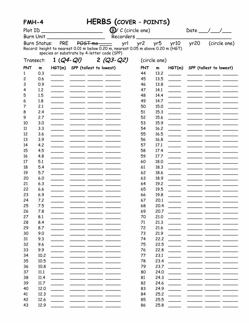
FMH-4 HERBS (COVER – POINTS) Plot ID ____________________ B / C (circle one) Date ___/___/___ Burn Unit ___________________ Recorders _______________________________ Burn Status: PRE POST mo ____ yrl yr2 yr5 yr10 yr20 (circle one) Record: height to nearest 0.01 m below 0.20 m, nearest 0.05 m above 0.20 m (HGT)
species or substrate by 4-letter code (SPP)
Transect: 1 (Q4- Ql) 2 (Q3- Q2) (circle one) PNT m HGT(m) SPP (tallest to lowest) PNT m HGT(m) SPP (tallest to lowest) 1 0.3 _____ ______ ______ ______ 44 13.2 _____ ______ ______ ______ 2 0.6 _____ ______ ______ ______ 45 13.5 _____ ______ ______ ______ 3 0.9 _____ ______ ______ ______ 46 13.8 _____ ______ ______ ______ 4 1.2 _____ ______ ______ ______ 47 14.1 _____ ______ ______ ______ 5 1.5 _____ ______ ______ ______ 48 14.4 _____ ______ ______ ______ 6 1.8 _____ ______ ______ ______ 49 14.7 _____ ______ ______ ______ 7 2.1 _____ ______ ______ ______ 50 15.0 _____ ______ ______ ______ 8 2.4 _____ ______ ______ ______ 51 15.3 _____ ______ ______ ______ 9 2.7 _____ ______ ______ ______ 52 15.6 _____ ______ ______ ______ 10 3.0 _____ ______ ______ ______ 53 15.9 _____ ______ ______ ______ 11 3.3 _____ ______ ______ ______ 54 16.2 _____ ______ ______ ______ 12 3.6 _____ ______ ______ ______ 55 16.5 _____ ______ ______ ______ 13 3.9 _____ ______ ______ ______ 56 16.8 _____ ______ ______ ______ 14 4.2 _____ ______ ______ ______ 57 17.1 _____ ______ ______ ______ 15 4.5 _____ ______ ______ ______ 58 17.4 _____ ______ ______ ______ 16 4.8 _____ ______ ______ ______ 59 17.7 _____ ______ ______ ______ 17 5.1 _____ ______ ______ ______ 60 18.0 _____ ______ ______ ______ 18 5.4 _____ ______ ______ ______ 61 18.3 _____ ______ ______ ______ 19 5.7 _____ ______ ______ ______ 62 18.6 _____ ______ ______ ______ 20 6.0 _____ ______ ______ ______ 63 18.9 _____ ______ ______ ______ 21 6.3 _____ ______ ______ ______ 64 19.2 _____ ______ ______ ______ 22 6.6 _____ ______ ______ ______ 65 19.5 _____ ______ ______ ______ 23 6.9 _____ ______ ______ ______ 66 19.8 _____ ______ ______ ______ 24 7.2 _____ ______ ______ ______ 67 20.1 _____ ______ ______ ______ 25 7.5 _____ ______ ______ ______ 68 20.4 _____ ______ ______ ______ 26 7.8 _____ ______ ______ ______ 69 20.7 _____ ______ ______ ______ 27 8.1 _____ ______ ______ ______ 70 21.0 _____ ______ ______ ______ 28 8.4 _____ ______ ______ ______ 71 21.3 _____ ______ ______ ______ 29 8.7 _____ ______ ______ ______ 72 21.6 _____ ______ ______ ______ 30 9.0 _____ ______ ______ ______ 73 21.9 _____ ______ ______ ______ 31 9.3 _____ ______ ______ ______ 74 22.2 _____ ______ ______ ______ 32 9.6 _____ ______ ______ ______ 75 22.5 _____ ______ ______ ______ 33 9.9 _____ ______ ______ ______ 76 22.8 _____ ______ ______ ______ 34 10.2 _____ ______ ______ ______ 77 23.1 _____ ______ ______ ______ 35 10.5 _____ ______ ______ ______ 78 23.4 _____ ______ ______ ______ 36 10.8 _____ ______ ______ ______ 79 23.7 _____ ______ ______ ______ 37 11.1 _____ ______ ______ ______ 80 24.0 _____ ______ ______ ______ 38 11.4 _____ ______ ______ ______ 81 24.3 _____ ______ ______ ______ 39 11.7 _____ ______ ______ ______ 82 24.6 _____ ______ ______ ______ 40 12.0 _____ ______ ______ ______ 83 24.9 _____ ______ ______ ______ 41 12.3 _____ ______ ______ ______ 84 25.2 _____ ______ ______ ______ 42 12.6 _____ ______ ______ ______ 85 25.5 _____ ______ ______ ______ 43 12.9 _____ ______ ______ ______ 86 25.8 _____ ______ ______ ______
PNT m HGT,m SPP (tallest to lowest) PNT m HGT,m SPP (tallest to lowest) 87 26.1 _____ ______ ______ ______ 127 38.1 _____ ______ ______ ______ 88 26.4 _____ ______ ______ ______ 128 38.4 _____ ______ ______ ______ 89 26.7 _____ ______ ______ ______ 129 38.7 _____ ______ ______ ______ 90 27.0 _____ ______ ______ ______ 130 39.0 _____ ______ ______ ______ 91 27.3 _____ ______ ______ ______ 131 39.3 _____ ______ ______ ______ 92 27.6 _____ ______ ______ ______ 132 39.6 _____ ______ ______ ______ 93 27.9 _____ ______ ______ ______ 133 39.9 _____ ______ ______ ______ 94 28.2 _____ ______ ______ ______ 134 40.2 _____ ______ ______ ______ 95 28.5 _____ ______ ______ ______ 135 40.5 _____ ______ ______ ______ 96 28.8 _____ ______ ______ ______ 136 40.8 _____ ______ ______ ______ 97 29.1 _____ ______ ______ ______ 137 41.1 _____ ______ ______ ______ 98 29.4 _____ ______ ______ ______ 138 41.4 _____ ______ ______ ______ 99 29.7 _____ ______ ______ ______ 139 41.7 _____ ______ ______ ______ 100 30.0 _____ ______ ______ ______ 140 42.0 _____ ______ ______ ______ 101 30.3 _____ ______ ______ ______ 141 42.3 _____ ______ ______ ______ 102 30.6 _____ ______ ______ ______ 142 42.6 _____ ______ ______ ______ 103 30.9 _____ ______ ______ ______ 143 42.9 _____ ______ ______ ______ 104 31.2 _____ ______ ______ ______ 144 43.2 _____ ______ ______ ______ 105 31.5 _____ ______ ______ ______ 145 43.5 _____ ______ ______ ______ 106 31.8 _____ ______ ______ ______ 146 43.8 _____ ______ ______ ______ 107 32.1 _____ ______ ______ ______ 147 44.1 _____ ______ ______ ______ 108 32.4 _____ ______ ______ ______ 148 44.4 _____ ______ ______ ______ 109 32.7 _____ ______ ______ ______ 149 44.7 _____ ______ ______ ______ 110 33.0 _____ ______ ______ ______ 150 45.0 _____ ______ ______ ______ 111 33.3 _____ ______ ______ ______ 151 45.3 _____ ______ ______ ______ 112 33.6 _____ ______ ______ ______ 152 45.6 _____ ______ ______ ______ 113 33.9 _____ ______ ______ ______ 153 45.9 _____ ______ ______ ______ 114 34.2 _____ ______ ______ ______ 154 46.2 _____ ______ ______ ______ 115 34.5 _____ ______ ______ ______ 155 46.5 _____ ______ ______ ______ 116 34.8 _____ ______ ______ ______ 156 46.8 _____ ______ ______ ______ 117 35.1 _____ ______ ______ ______ 157 47.1 _____ ______ ______ ______ 118 35.4 _____ ______ ______ ______ 158 47.4 _____ ______ ______ ______ 119 35.7 _____ ______ ______ ______ 159 47.7 _____ ______ ______ ______ 120 36.0 _____ ______ ______ ______ 160 48.0 _____ ______ ______ ______ 121 36.3 _____ ______ ______ ______ 161 48.3 _____ ______ ______ ______ 122 36.6 _____ ______ ______ ______ 162 48.6 _____ ______ ______ ______ 123 36.9 _____ ______ ______ ______ 163 48.9 _____ ______ ______ ______ 124 37.2 _____ ______ ______ ______ 164 49.2 _____ ______ ______ ______ 125 37.5 _____ ______ ______ ______ 165 49.5 _____ ______ ______ ______ 126 37.8 _____ ______ ______ ______ 166 49.8 _____ ______ ______ ______ Species observed within 5m of either side of the transect but not intercepted (COVER – SPECIES COMPOSITION): ____________________________________________________________________________________________________________________________________________________________________________________________________________________________________________________________________________________________________________________________________________________________________________________________________________________________________ Drop range pole plumb every 30 centimeters (0.30 m). Record each species just once. Record only vegetation under 2 meters in height. Do NOT record any trees which are over 2 m tall. Record height for tallest veg. spp touching. Record species for all hits regardless of where veg. is rooted. “D” after code for all dead shrubs or trees.; record dead herbs, forbs, or grasses as you would live veg. If pole does not intercept veg. record substrate: BARE, BOLE, DUFF, LITT, ROCK, ROOT, SCAT, WOOD (only wood on ground—not elevated).
FMH-5 SHRUBS (DENSITY – BELTS)
Plot ID ___________________ B / C (circle one) Date ___/___/___ Burn Unit __________________ Recorders ________________________________ Burn Status: PRE POST mo ____ yrl yr2 yr5 yr10 yr20 (circle one) Belt sampling width 2 m on "inside" edge of transect (side toward origin) Only count LIVE shrubs. Record: SUBBELT (see below), species (ITEM CODE), AGE (see below), and # of shrubs by class (COUNT). Count all living brush or cactus having 5O% of base rooted in the belt Record AGE code: I = Immature/seedling M = Mature/adult Record SUBBELT code: 1: 0-5 3: 10.1-15 5: 20.1-25 7: 30.1-35 9: 40.1-45
2: 5.1-10 4: 15.1-20 6: 25.1-30 8: 35.1-40 10: 45.1-50
Transect 1 (Q4-Ql) Transect 2 (Q3-Q2) SUB- ITEM SUB- ITEM BELT CODE STATUS AGE tally COUNT BELT CODE STATUS AGE tally COUNT ___ ____ L ___ _____ ____ ___ ____ L ____ _____ ____ ___ ____ L ___ _____ ____ ___ ____ L ____ _____ ____ ___ ____ L ___ _____ ____ ___ ____ L ____ _____ ____ ___ ____ L ___ _____ ____ ___ ____ L ____ _____ ____ ___ ____ L ___ _____ ____ ___ ____ L ____ _____ ____ ___ ____ L ___ _____ ____ ___ ____ L ____ _____ ____ ___ ____ L ___ _____ ____ ___ ____ L ____ _____ ____ ___ ____ L ___ _____ ____ ___ ____ L ____ _____ ____ ___ ____ L ___ _____ ____ ___ ____ L ____ _____ ____ ___ ____ L ___ _____ ____ ___ ____ L ____ _____ ____ ___ ____ L ___ _____ ____ ___ ____ L ____ _____ ____ ___ ____ L ___ _____ ____ ___ ____ L ____ _____ ____ ___ ____ L ___ _____ ____ ___ ____ L ____ _____ ____ ___ ____ L ___ _____ ____ ___ ____ L ____ _____ ____ ___ ____ L ___ _____ ____ ___ ____ L ____ _____ ____ ___ ____ L ___ _____ ____ ___ ____ L ____ _____ ____ ___ ____ L ___ _____ ____ ___ ____ L ____ _____ ____ ___ ____ L ___ _____ ____ ___ ____ L ____ _____ ____ ___ ____ L ___ _____ ____ ___ ____ L ____ _____ ____ ___ ____ L ___ _____ ____ ___ ____ L ____ _____ ____ ___ ____ L ___ _____ ____ ___ ____ L ____ _____ ____ ___ ____ L ___ _____ ____ ___ ____ L ____ _____ ____ ___ ____ L ___ _____ ____ ___ ____ L ____ _____ ____ ___ ____ L ___ _____ ____ ___ ____ L ____ _____ ____ ___ ____ L ___ _____ ____ ___ ____ L ____ _____ ____ ___ ____ L ___ _____ ____ ___ ____ L ____ _____ ____ ___ ____ L ___ _____ ____ ___ ____ L ____ _____ ____

Record SUBBELT code: 1: 0-5 3: 10.1-15 5: 20.1-25 7: 30.1-35 9: 40.1-45 2: 5.1-10 4: 15.1-20 6: 25.1-30 8: 35.1-40 10: 45.1-50
Transect 1 (Q4-Ql) Transect 2 (Q3-Q2) SUB- ITEM SUB- ITEM BELT CODE STATUS AGE tally COUNT BELT CODE STATUS AGE tally COUNT ___ ____ L ___ _____ ____ ___ ____ L ____ _____ ____ ___ ____ L ___ _____ ____ ___ ____ L ____ _____ ____ ___ ____ L ___ _____ ____ ___ ____ L ____ _____ ____ ___ ____ L ___ _____ ____ ___ ____ L ____ _____ ____ ___ ____ L ___ _____ ____ ___ ____ L ____ _____ ____ ___ ____ L ___ _____ ____ ___ ____ L ____ _____ ____ ___ ____ L ___ _____ ____ ___ ____ L ____ _____ ____ ___ ____ L ___ _____ ____ ___ ____ L ____ _____ ____ ___ ____ L ___ _____ ____ ___ ____ L ____ _____ ____ ___ ____ L ___ _____ ____ ___ ____ L ____ _____ ____ ___ ____ L ___ _____ ____ ___ ____ L ____ _____ ____ ___ ____ L ___ _____ ____ ___ ____ L ____ _____ ____ ___ ____ L ___ _____ ____ ___ ____ L ____ _____ ____ ___ ____ L ___ _____ ____ ___ ____ L ____ _____ ____ ___ ____ L ___ _____ ____ ___ ____ L ____ _____ ____ ___ ____ L ___ _____ ____ ___ ____ L ____ _____ ____ ___ ____ L ___ _____ ____ ___ ____ L ____ _____ ____ ___ ____ L ___ _____ ____ ___ ____ L ____ _____ ____ ___ ____ L ___ _____ ____ ___ ____ L ____ _____ ____ ___ ____ L ___ _____ ____ ___ ____ L ____ _____ ____ ___ ____ L ___ _____ ____ ___ ____ L ____ _____ ____ ___ ____ L ___ _____ ____ ___ ____ L ____ _____ ____ ___ ____ L ___ _____ ____ ___ ____ L ____ _____ ____ ___ ____ L ___ _____ ____ ___ ____ L ____ _____ ____ ___ ____ L ___ _____ ____ ___ ____ L ____ _____ ____ Common Shrub SpeciesAmelanchier utahensis Utah Serviceberry Arctostaphylus pungens Pointleaf Manzanita Artemisia tridentata Big Sage Ceanothus fendleri Buckbrush Chamaebatiaria millefolium Fernbush Echinocereus triglochidiatus Claretcup Cactus Ericameria nauseosa Rabbitbrush Escobaria vivipara Arizona Beehive Cactus Fallugia paradoxa Apache Plume Gutierrezia sarothrae Snakeweed Juniperus communis Common Juniper Lonicera arizonica Arizona honeysuckle Mahonia repens Barberry/Oregon Grape
Opuntia spp. Prickly Pear Purshia stansburiana Cliffrose Purshia tridentata Antelope Brush Ribes spp. Currant/Gooseberry Robinia neomexicana New Mexican Locust Rosa woodsii Arizona Rose Rubus idaeus American Red Raspberry Sambucus racemosa Red Elderberry Sorbus dumosa Arizona Mountain-ash Symphoricarpos oreophilus Snowberry Tetradymia canescens Horsebrush Yucca angustissima Fine-leaf Yucca Yucca baccata Banana Yucca

FMH-6 FUELS (SURFACE FUELS)
Plot ID ___________________ B / C (circle one) Date ___/___/___ Burn Unit __________________ Recorders _________________________________ Burn Status: PRE POST mo ____ yrl yr2 yr5 yr10 yr20 (circle one) PIED, PIPO - 1 00 foot transects Transect lengths, in feet: 1 hr-6' 10 hr-6’ 100 hr-12’ 1000 hr S-100' 1000 hr R-100’ PIPN, PIAB, PIEN, GRED - 50 foot transects Transect lengths, in feet: 1 hr-6' 10 hr-6’ 100 hr-12’ 1000 hr S-50' 1000 hr R-50’
1hr hits 0 - ¼“
10hr hits ¼" – 1”
100hr hits 1” – 3”
1000hr hits S(3) 3”+ nearest 0.5”
1000hr hits R(4) 3”+ nearest 0.5”
Litter and Duff Depths, nearest 0.1”
Sam
p Lo
c.
L D Sa
mp
Loc.
L D
Transect 1 Azimuth____o Slope____%
1 25
5 30
10 35
15 40
20 45
Transect 2 Azimuth____o Slope____%
1 25
5 30
10 35
15 40
20 45
Transect 3 Azimuth____o Slope____%
1 25
5 30
10 35
15 40
20 45
Transect 4 Azimuth____o Slope____%
1 25
5 30
10 35
15 40
20 45
Measure all dead and down wood along vertical 6 foot plane over the transect. Litter is considered the top, unconsolidated layer; Duff is the fibrous, consolidated, decomposed layer above mineral soil. Take 1000 hr measurements perpendicular to long length. Reconstruct flattened but intact rotten 1000 hrs to best estimate diameter of original, cylindrical log. If a rock is encountered enter 0 litt, 0 duff. If a log is encountered offset, looking from A to B, offset 1’ right, 2’ R, 3’ R. If still unreadable then 1’ left, 2’ L etc… Record slopes in % (45 degrees = 100%). Average litt/duff over a 20 X 20 cm area.

FMH-6 POST BURN SEVERITY (POST BURN SEVERITY)
Plot ID: _________________ B / C (circle one) Date ___/___/___ Burn Unit__________________ Recorders ________________________________ Burn Status: PRE POST mo ___ yrl yr2 yr5 yr10 yr20 (circle one) Post fire burn severity ratings are made at the Brown’s transects litter & duff measurement points using the Coding Matrix at the bottom of this form. Each observation is from a 20 cm x 20 cm area. SUBSTRATE
Point Tape
1 2 3 4 5 6 7 8 9 10 1’ 5’ 10’ 15’ 20’ 25’ 30’ 35’ 40’ 45’
Transect 1 S S S S S S S S S S
Transect 2 S S S S S S S S S S
Transect 3 S S S S S S S S S S
Transect 4 S S S S S S S S S S
VEGETATION
Point Tape
1 2 3 4 5 6 7 8 9 10 1’ 5’ 10’ 15’ 20’ 25’ 30’ 35’ 40’ 45’
Transect 1 V V V V V V V V V V
Transect 2 V V V V V V V V V V
Transect 3 V V V V V V V V V V
Transect 4 V V V V V V V V V V
Burn Severity Coding Matrix
Unburned (5)
Scorched (4)
Lightly Burned (3)
Moderately Burned (2)
Heavily Burned (1)
(0)
Substrate (litt/duff) (S)
Not burned Litter partially blackened; duff nearly unchanged; wood/leaf structures unchanged
Litter charred to partially consumed; upper duff layer may be charred but the duff layer is not altered over the entire depth; surface appears black; woody debris is partially burned; logs are scorched or blackened but not charred; rotten wood is scorched to partially burned
Litter mostly to entirely consumed, leaving coarse light colored ash; duff deeply charred, but underlying mineral soil is not visibly altered; woody debris is mostly consumed; logs are deeply charred; burned-out stump holes are common
Litter and duff completely consumed, leaving fine white ash; mineral soil visibly altered, often reddish; sound logs are deeply charred, and rotten logs are completely consumed. This code generally applies to less than 10% of natural or slash burned areas
NOT APPLICABLE (INORGANIC PREBURN)
Vegetation (understory/ brush/herbs) (V)
Not burned Foliage scorched and attached to supporting twigs
Foliage & smaller twigs partially to completely consumed; branches mostly intact
Foliage, twigs and small stems consumed; some branches still present
All plant parts consumed leaving some or no major stems/trunks; any left are deeply charred
NOT APPLICABLE (NONE PRESENT PREBURN)

PLOT LOCATION DATA SHEET
Plot ID Today’s Date ___/___/___ Installation Date ___/___/___ Treatment Unit _________________________ Treatment Type _________________________ Vegetation Type _________________________________________________________________ Recorders _______________________________________________________________________ Declination 11.5o E NAD83 UTM Zone 12 N UTMe UTMn +/- Slope(%) Aspect (degrees) Elevation (ft) Transect Azimuth (from 0P50P) Date of Last Known Treatment Treatment History of the Plot Deviations from protocols? If yes, describe:

RAP-1 OVERSTORY TREE DATA SHEET Page__ of __
Plot ID ______________________ Rx / WFU / Thin (circle one) Date ___/___/___ Treatment Unit ________________ Recorders _______________________________________ Treatment Status: PRE POST (mo ____) yrl yr2 yr5 yr10 yr20 OTHER _______ Overstory are ≥ 15.1 cm in diameter. Area Sampled: 10 meter radius from 50P. Azimuth CROWN (UV1) TAG SPP STATUS DBH HGT(m) CBH(m) CLASS DAMAGE COMMENTS ______ _____ _____ L D _____ _____ _____ _____ _________________ __________ ______ _____ _____ L D _____ _____ _____ _____ _________________ __________ ______ _____ _____ L D _____ _____ _____ _____ _________________ __________ ______ _____ _____ L D _____ _____ _____ _____ _________________ __________ ______ _____ _____ L D _____ _____ _____ _____ _________________ __________ ______ _____ _____ L D _____ _____ _____ _____ _________________ __________ ______ _____ _____ L D _____ _____ _____ _____ _________________ __________ ______ _____ _____ L D _____ _____ _____ _____ _________________ __________ ______ _____ _____ L D _____ _____ _____ _____ _________________ __________ ______ _____ _____ L D _____ _____ _____ _____ _________________ __________ ______ _____ _____ L D _____ _____ _____ _____ _________________ __________ ______ _____ _____ L D _____ _____ _____ _____ _________________ __________ ______ _____ _____ L D _____ _____ _____ _____ _________________ __________ ______ _____ _____ L D _____ _____ _____ _____ _________________ __________ ______ _____ _____ L D _____ _____ _____ _____ _________________ __________ ______ _____ _____ L D _____ _____ _____ _____ _________________ __________ ______ _____ _____ L D _____ _____ _____ _____ _________________ __________ ______ _____ _____ L D _____ _____ _____ _____ _________________ __________ ______ _____ _____ L D _____ _____ _____ _____ _________________ __________ ______ _____ _____ L D _____ _____ _____ _____ _________________ __________ ______ _____ _____ L D _____ _____ _____ _____ _________________ __________ ______ _____ _____ L D _____ _____ _____ _____ _________________ __________ ______ _____ _____ L D _____ _____ _____ _____ _________________ __________ ______ _____ _____ L D _____ _____ _____ _____ _________________ __________ Crown Position Class codes: D = Dominant C = Codominant I = Intermediate SC = Subcanopy O = Open Growth RS = Recent Snag LBS = Loose Bark Snag CS = Clean Snag BAD = Broken Above DBH
Damage Codes: ABGR abnormal growth pattern FIRE fire scar or cambial damage MOSS moss BIRD bird (woodpecker holes) FORK forked top OZON ozone BLIG blight FRST frost crack ROOT large roots exposed BROK broken top GALL galls ROTT rot, fungus other than conk BROM witches broom HOLW hollowed out SPAR unusually sparse foliage BURL burl INSE insects or their sign SPRT sprouting from base CONK conk, large shelf fungus LEAN tree is leaning TWIN twinned tree-below DBH CROK crooked or twisted bole LICH Lichen UMAN human-caused damage DTOP dead top LIGT lightning scar WOND wound-cracks, etc. EPIC sprouting from bole or limbs MAMM mammal-caused damage EPIP epiphytes MISL mistletoe present Measure azimuth (AZ) in degrees, standing at 50P, starting from 0P50P line and working clockwise For new installations, tags should be 1 - 100. If tree is FORKED BELOW DBH, COUNT ALL OVERSTORY-SIZED STEMS. But don’t count obvious branches!! Make sure DBH tape is level and tight. DBH is 4.5 feet (137 cm) along bole, not from ground level. DBH perpendicular to bole, and if on a slope, stand at the middle of the slope. ROUND DOWN to the nearest tenth of a centimeter. DBH dead trees the first time they are tagged. Thereafter, copy DBH on dead trees from previous read, updating if large change. Copy crown and damage codes from previous reads. UPDATE if necessary. Write note for DBH-ing unusual trees (use special protocols for junipers).

RAP-2 POLE & SEEDLING TREE DATA SHEET Page___of___
Plot ID ______________________ Rx / WFU / Thin (circle one) Date ___/___/___ Treatment Unit ________________ Recorders _______________________________________ Treatment Status: PRE POST (mo ____) yrl yr2 yr5 yr10 yr20 OTHER ______ Record: species (ITEM CODE), alive (STATUS), height by code (HGT), and # of trees by class (TALLY & COUNT). Record only live Poles & Seedlings. Poles are 2.5 – 15.0 cm in diameter. Seedlings are less than 2.5 cm in diameter. Area Sampled: 10 meter radius from 50P for Poles. Area Sampled: 5 meter radius from 50P for Seedlings.
POLES SEEDLING ITEM ITEM CODE STATUS HGT TALLY COUNT CODE STATUS HGT TALLY COUNT ______ L _____ ___________ _______ ______ L _____ ___________ _______ ______ L _____ ___________ _______ ______ L _____ ___________ _______ ______ L _____ ___________ _______ ______ L _____ ___________ _______ ______ L _____ ___________ _______ ______ L _____ ___________ _______ ______ L _____ ___________ _______ ______ L _____ ___________ _______ ______ L _____ ___________ _______ ______ L _____ ___________ _______ ______ L _____ ___________ _______ ______ L _____ ___________ _______ ______ L _____ ___________ _______ ______ L _____ ___________ _______ ______ L _____ ___________ _______ ______ L _____ ___________ _______ ______ L _____ ___________ _______ ______ L _____ ___________ _______ ______ L _____ ___________ _______ ______ L _____ ___________ _______ ______ L _____ ___________ _______ ______ L _____ ___________ _______ ______ L _____ ___________ _______ ______ L _____ ___________ _______ ______ L _____ ___________ _______ ______ L _____ ___________ _______ ______ L _____ ___________ _______ ______ L _____ ___________ _______ ______ L _____ ___________ _______ ______ L _____ ___________ _______ ______ L _____ ___________ _______ ______ L _____ ___________ _______ ______ L _____ ___________ _______ ______ L _____ ___________ _______ ______ L _____ ___________ _______ ______ L _____ ___________ _______ ______ L _____ ___________ _______ ______ L _____ ___________ _______ ______ L _____ ___________ _______ ______ L _____ ___________ _______ ______ L _____ ___________ _______ ______ L _____ ___________ _______ ______ L _____ ___________ _______ ______ L _____ ___________ _______ ______ L _____ ___________ _______ ______ L _____ ___________ _______ ______ L _____ ___________ _______ ______ L _____ ___________ _______ ______ L _____ ___________ _______ ______ L _____ ___________ _______ ______ L _____ ___________ _______ ______ L _____ ___________ _______ ______ L _____ ___________ _______ ______ L _____ ___________ _______
Height1 classes (in meters): 1 = 0 - 1 4 = 3.1 – 4 7 = 6.1 – 7 10 = 9.1+ 2 = 1.1 – 2 5 = 4.1 - 5 8 = 7.1 – 8 3 = 2.1 - 3 6 = 5.1 - 6 9 = 8.1 – 9 1Height is measured from ground level to the highest point of growth on the tree.

RAP-2 POLE & SEEDLING TREE DATA SHEET Page___of___
Plot ID ______________________ Rx / WFU / Thin (circle one) Date ___/___/___ Treatment Unit ________________ Recorders _______________________________________ Treatment Status: PRE POST (mo ____) yrl yr2 yr5 yr10 yr20 OTHER ______ Record: species (ITEM CODE), alive (STATUS), and # of trees by class (TALLY & COUNT). Record only live Poles & Seedlings. Poles are 2.5 – 15.0 cm in diameter. Seedlings are less than 2.5 cm in diameter. Area Sampled: 10 meter radius from 50P for Poles. Area Sampled: 5 meter radius from 50P for Seedlings.
POLES SEEDLINGS ITEM ITEM CODE STATUS TALLY COUNT CODE STATUS TALLY COUNT _______ L _____________ ________ ________ L _____________ ________ _______ L _____________ ________ ________ L _____________ ________ _______ L _____________ ________ ________ L _____________ ________ _______ L _____________ ________ ________ L _____________ ________ _______ L _____________ ________ ________ L _____________ ________ _______ L _____________ ________ ________ L _____________ ________ _______ L _____________ ________ ________ L _____________ ________ _______ L _____________ ________ ________ L _____________ ________ _______ L _____________ ________ ________ L _____________ ________ _______ L _____________ ________ ________ L _____________ ________ _______ L _____________ ________ ________ L _____________ ________ _______ L _____________ ________ ________ L _____________ ________ _______ L _____________ ________ ________ L _____________ ________ _______ L _____________ ________ ________ L _____________ ________ _______ L _____________ ________ ________ L _____________ ________ _______ L _____________ ________ ________ L _____________ ________ _______ L _____________ ________ ________ L _____________ ________ _______ L _____________ ________ ________ L _____________ ________ _______ L _____________ ________ ________ L _____________ ________ _______ L _____________ ________ ________ L _____________ ________ _______ L _____________ ________ ________ L _____________ ________ _______ L _____________ ________ ________ L _____________ ________ _______ L _____________ ________ ________ L _____________ ________ _______ L _____________ ________ ________ L _____________ ________ _______ L _____________ ________ ________ L _____________ ________ _______ L _____________ ________ ________ L _____________ ________ _______ L _____________ ________ ________ L _____________ ________ _______ L _____________ ________ ________ L _____________ ________

RAP-3 HERBACEOUS & SHRUB DATA SHEET
Plot ID ______________________ Rx / WFU / Thin (circle one) Date ___/___/___ Treatment Unit ________________ Recorders _______________________________________ Treatment Status: PRE POST (mo ____) yrl yr2 yr5 yr10 yr20 OTHER ______ Area Sampled: 10 meter radius from 50P for all observed herbaceous, shrub, & non-native species Percent Cover Estimators: 1% = 1 X 3 meters 5% = 3 X 5 meters 10% = 5 X 6 meters
PERCENT COVER 0-5% 6-25% 26-50% 51-75% 76-95% 96-100% (2.5) (15) (37.5) (62.5) (85) (97.5)
HERBS _____ _____ _____ _____ _____ _____ SHRUBS _____ _____ _____ _____ _____ _____
NON-NATIVES SPP 0-5% 6-25% 26-50% 51-75% 76-95% 96-100% (2.5) (15) (37.5) (62.5) (85) (97.5)
______ _____ _____ _____ _____ _____ _____ ______ _____ _____ _____ _____ _____ _____ ______ _____ _____ _____ _____ _____ _____ ______ _____ _____ _____ _____ _____ _____ Comments: __________________________________________________________________________________________________________________________________________________________________________________________________________________
Lump all herbaceous and all shrubs for total % cover; separate non-natives by species (non-natives ARE included in lumped % ground cover for herbs & shrubs). % Cover = measure, in percentage, the proportion of ground covered by vegetation within the sample area (Total % cover CAN EXCEED 100%).
RAP-4 FUELS INVENTORY DATA SHEET
Transect lengths, in feet: 1 hr-6' 10 hr-6’ 100 hr-12’ 1000 hr S-50' 1000 hr R-50’
1hr hits 0 -¼“
10hr hits ¼" –1”
100hr hits 1” – 3”
1000hr hits S (3) 3”+ nearest 0.5”
1000hr hits R (4) 3”+ nearest 0.5”
Litter and Duff Depths, nearest 0.1”
Samp Loc
L
D
Samp Loc
L
D
Transect 1 Azimuth____ o Slope____%
1 25
5 30
10 35
15 40
20 45
Transect 2 Azimuth____ o Slope____ %
1 25
5 30
10 35
15 40
20 45
Measure all dead and down wood along vertical 6 foot plane over the transect. Do NOT count any dead and down wood more than 50% buried in substrate layer. Litter is considered the top, unconsolidated layer; Duff is the fibrous, consolidated, decomposed layer above mineral soil. Take 1000 hr measurements perpendicular to long length. Reconstruct flattened but intact rotten 1000 hrs to best estimate diameter of original, cylindrical log. If a rock is encountered enter 0 litt, 0 duff. If a log is encountered offset, looking from A to B, 1’ right, 2’ R, 3’ R. If still unreadable then 1’ left, 2’ L etc… Record slopes in % (45 degrees = 100%). Average litt/duff over a 20 X 20 cm area.
RAP-4 POST A FUELS INVENTORY DATA SHEET
Plot ID ______________________ Rx / WFU / Thin (circle one) Date ___/___/___ Treatment Unit ________________ Recorders _______________________________________ Treatment Status: PRE POST (mo ____) yrl yr2 yr5 yr10 yr20 OTHER ______
Transect lengths, in feet: 1 hr-6' 10 hr-6’ 100 hr-12’ 1000 hr S-50' 1000 hr R-50’
1hr hits 0 -¼“
10hr hits ¼" –1”
100hr hits 1” – 3”
1000hr hits S(3) 3”+ nearest 0.5”
1000hr hits R(4) 3”+ nearest 0.5”
Litter and Duff Depths, nearest 0.1”
Samp Loc
L
D
Samp Loc
L
D
Transect 1 Azimuth____o Slope____%
1 25
5 30
10 35
15 40
20 45
Transect 2 Azimuth____o Slope____%
1 25
5 30
10 35
15 40
20 45
Measure all dead and down wood along vertical 6 foot plane over the transect. Do NOT count any dead and down wood more than 50% buried in substrate layer. Litter is considered the top, unconsolidated layer; Duff is the fibrous, consolidated, decomposed layer above mineral soil. Take 1000 hr measurements perpendicular to long length. Reconstruct flattened but intact rotten 1000 hrs to best estimate diameter of original, cylindrical log. If a rock is encountered enter 0 litt, 0 duff. If a log is encountered offset, looking from A to B, 1’ right, 2’ R, 3’ R. If still unreadable then 1’ left, 2’ L etc… Record slopes in % (45 degrees = 100%). Average litt/duff over a 20 X 20 cm area.

RAP-4 POST B BURN SEVERITY DATA SHEET
Plot ID ______________________ Rx / WFU / Thin (circle one) Date ___/___/___ Treatment Unit ________________ Recorders _______________________________________ Treatment Status: PRE POST (mo ____) yrl yr2 yr5 yr10 yr20 OTHER ______
Postfire burn severity ratings are made at the Brown’s transects duff measurement points using the Coding Matrix at the bottom of this form. Each observation is from a 20 cm x 20 cm area.
VEGETATION
Point Tape
Sample Point 1 2 3 4 5 6 7 8 9 10 1’ 5’ 10’ 15’ 20’ 25’ 30’ 35’ 40’ 45’
Transect 1 V V V V V V V V V V
Transect 2 V V V V V V V V V V
SUBSTRATE
Point Tape
Sample Point 1 2 3 4 5 6 7 8 9 10 1’ 5’ 10’ 15’ 20’ 25’ 30’ 35’ 40’ 45’
Transect 1 S S S S S S S S S S
Transect 2 S S S S S S S S S S
Burn Severity Coding Matrix
Unburned (5)
Scorched (4)
Lightly Burned (3)
Moderately Burned (2)
Heavily Burned (1)
(0)
Substrate (litt/duff)
NOT BURNED
Litter partially blackened; duff nearly unchanged; wood/leaf structures unchanged
Litter charred to partially consumed; upper duff layer may be charred but the duff layer is not altered over the entire depth; surface appears black; woody debris is partially burned; logs are scorched or blackened but not charred; rotten wood is scorched to partially burned
Litter mostly to entirely consumed, leaving coarse light colored ash; duff deeply charred, but underlying mineral soil is not visibly altered; woody debris is mostly consumed; logs are deeply charred; burned-out stump holes are common
Litter and duff completely consumed, leaving fine white ash; mineral soil visibly altered, often reddish; sound logs are deeply charred, and rotten logs are completely consumed. This code generally applies to less than 10% of natural or slash burned areas
INORGANIC PREBURN
Vegetation (understory/ brush/herbs)
NOT BURNED
Foliage scorched and attached to supporting twigs
Foliage & smaller twigs partially to completely consumed; branches mostly intact
Foliage, twigs and small stems consumed; some branches still present
All plant parts consumed leaving some or no major stems/trunks; any left are deeply charred
NONE PRESENT PREBURN
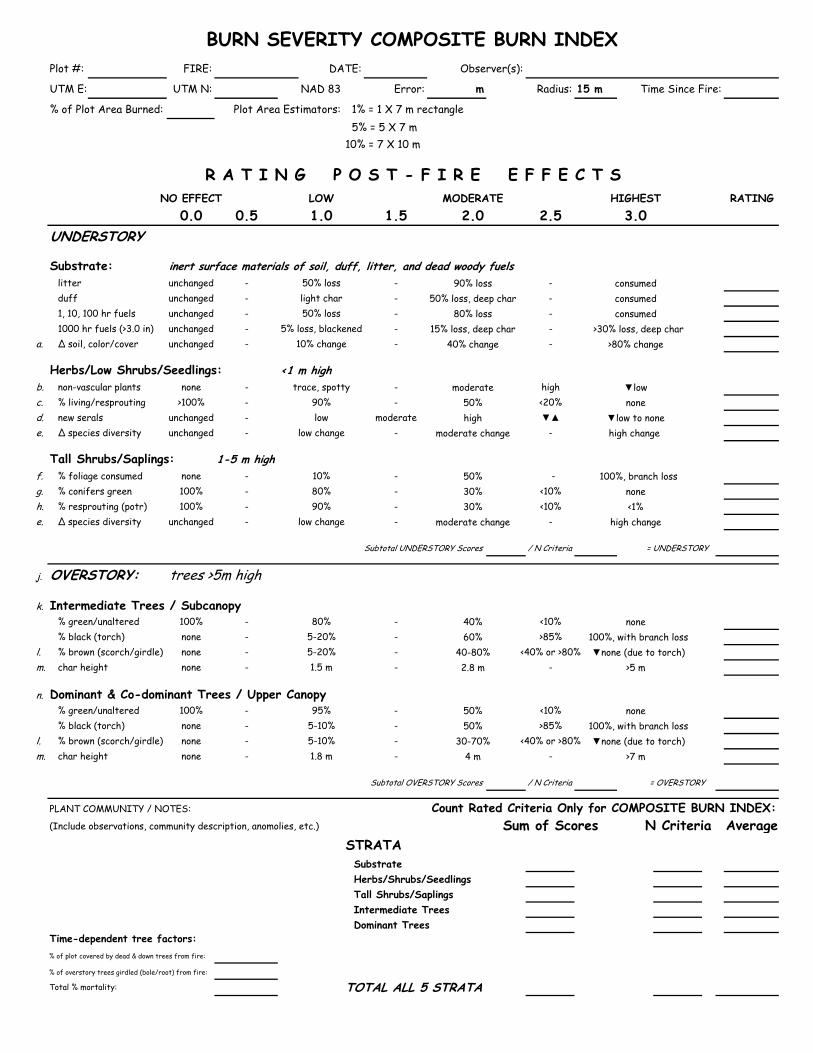
BURN SEVERITY COMPOSITE BURN INDEXPlot #: FIRE: DATE: Observer(s):
UTM E: UTM N: NAD 83 Error: m Radius: 15 m Time Since Fire:
% of Plot Area Burned: Plot Area Estimators: 1% = 1 X 7 m rectangle 5% = 5 X 7 m10% = 7 X 10 m
R A T I N G P O S T - F I R E E F F E C T SNO EFFECT LOW MODERATE HIGHEST RATING
0.0 0.5 1.0 1.5 2.0 2.5 3.0UNDERSTORY
Substrate: inert surface materials of soil, duff, litter, and dead woody fuels litter unchanged - 50% loss - 90% loss - consumed duff unchanged - light char - 50% loss, deep char - consumed 1, 10, 100 hr fuels unchanged - 50% loss - 80% loss - consumed 1000 hr fuels (>3.0 in) unchanged - 5% loss, blackened - 15% loss, deep char - >30% loss, deep char
a. ∆ soil, color/cover unchanged - 10% change - 40% change - >80% change
Herbs/Low Shrubs/Seedlings: <1 m highb. non-vascular plants none - trace, spotty - moderate high ▼lowc. % living/resprouting >100% - 90% - 50% <20% noned. new serals unchanged - low moderate high ▼▲ ▼low to nonee. ∆ species diversity unchanged - low change - moderate change - high change
Tall Shrubs/Saplings: 1-5 m highf. % foliage consumed none - 10% - 50% - 100%, branch lossg. % conifers green 100% - 80% - 30% <10% noneh. % resprouting (potr) 100% - 90% - 30% <10% <1%e. ∆ species diversity unchanged - low change - moderate change - high change
Subtotal UNDERSTORY Scores / N Criteria = UNDERSTORY
j. OVERSTORY: trees >5m high
k. Intermediate Trees / Subcanopy % green/unaltered 100% - 80% - 40% <10% none % black (torch) none - 5-20% - 60% >85% 100%, with branch loss
l. % brown (scorch/girdle) none - 5-20% - 40-80% <40% or >80% ▼none (due to torch)m. char height none - 1.5 m - 2.8 m - >5 m
n. Dominant & Co-dominant Trees / Upper Canopy % green/unaltered 100% - 95% - 50% <10% none % black (torch) none - 5-10% - 50% >85% 100%, with branch loss
l. % brown (scorch/girdle) none - 5-10% - 30-70% <40% or >80% ▼none (due to torch)m. char height none - 1.8 m - 4 m - >7 m
Subtotal OVERSTORY Scores / N Criteria = OVERSTORY
PLANT COMMUNITY / NOTES: Count Rated Criteria Only for COMPOSITE BURN INDEX:(Include observations, community description, anomolies, etc.) Sum of Scores N Criteria Average
STRATA Substrate Herbs/Shrubs/Seedlings Tall Shrubs/Saplings Intermediate Trees Dominant Trees
Time-dependent tree factors:% of plot covered by dead & down trees from fire:
% of overstory trees girdled (bole/root) from fire:
Total % mortality: TOTAL ALL 5 STRATA

a. Increased cover of exposed mineral soil, and change from native color, general lightening with loss of organics. At high end, may approach 10% reddish.b. Increased cover of non-vascular plants. Examples that may be indicators of burn severity include moss, fungi, bryophytes, lycopodium.c. Percent of unburned and resprouting plants (plants that burned but survived from living roots and stems) relative to estimated pre-fire vegetation plot-wide.
Do not include new serals. d. Potential dominance of new serals, within 2-3 years post-fire, averaged for plot. Frequency may be more recognizable at first with cover increasing over time. e. Change in number and/or relative abundance of species anticipated within 2-3 years post-fire, relative to estimated pre-fire community composition of plot. f. Percent crown foliage (needles, leaves) consumed by fire, relative to estimated pre-fire crown volume; consumption of outer branching on shrubs and saplings is
evident at high levels.g. Percent of conifer sapling crown that is NOT impacted by fire through scorching, torching, heating, or girdling.h. Percent of pre-fire shrubs and deciduous saplings that are unburned, or burned but resprouting. Include aspen suckers or other similar tree-to-shrub responses.j. Overstory crown foliage condition of whole plot, relative to estimated pre-fire crown volume. Except char height, which is the average upper height of char on tree bk. Trees of intermediate stature occupying space between saplings and upper tree canopy; crowns receive little direct sunlight from above. This strata, if present, may
in itself be of stratified heights, with crown tops extending into the upper canopy. Actual size of these trees is relative to height of upper canopy, and may vary from community to community.
l. Percent of tree canopy scorched or killed by heating or girdling without direct flame contact. Brown + Green + Black = 100%m. The average plot-wide height of charred bark on overstory tree boles, which is caused by ground fire. Do not include trees where it is difficult to determine whether
char is from ground fire or canopy fire (e.g., trees torched by crown fire). If all trees are charred from base-to-crown, then this criteria is not applicable. Average c height pertains to whole plot, including unburned tree boles.
n. Dominant and co-dominant trees occupy the upper canopy, receiving direct sunlight from above. These tree crowns form the general level of the upper canopy and some crowns may extend above this general level.
USGS NRMSC, Glacier Field Station, Key, Benson, Reeberg, & Brannfors 2001

National Park Service 2012 Grand Canyon National Park Fire Management Plan
Appendix F F- 121 Fire Monitoring Plan
F.12.4 Plant List and Voucher Collection Appendix The Fire Ecology Program at GRCA uses the FFI database to store the list of plants identified on monitoring plots. The plant list is updated yearly as new plants are identified in plots. To verify nativity and assure consistent naming standards within the park, the plant list is cross-referenced with GRCA plant list maintained by the Vegetation Management Program in the Science & Resource Management Division. The Fire Effects Monitoring Crew maintains the plant voucher collection. Voucher collections are located in herbarium cabinets in both the South Rim and North Rim Fire Effects Offices. Materials needed to collect, identify, press, and mount voucher specimens are also available on both the South and North Rims. High-quality specimens have been deposited in the park’s herbarium in previous years. This practice will continue if the monitoring crew encounters high-quality specimens that are underrepresented in the park herbarium.
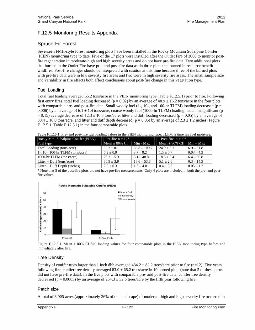
National Park Service 2012 Grand Canyon National Park Fire Management Plan
Appendix F F- 122 Fire Monitoring Plan
F.12.5 Monitoring Results Appendix
Spruce-Fir Forest Seventeen FMH-style forest monitoring plots have been installed in the Rocky Mountain Subalpine Conifer (PIEN) monitoring type to date. Five of the 17 plots were installed after the Outlet Fire of 2000 to monitor post-fire regeneration in moderate-high and high severity areas and do not have pre-fire data. Two additional plots that burned in the Outlet Fire have pre- and post-fire data as do three plots that burned in resource benefit wildfires. Post-fire changes should be interpreted with caution at this time because three of the burned plots with pre-fire data were in low severity fire areas and two were in high severity fire areas. The small sample size and variability in fire effects both affect conclusions about post-fire change in this vegetation type. Fuel Loading Total fuel loading averaged 66.2 tons/acre in the PIEN monitoring type (Table F.12.5.1) prior to fire. Following first entry fires, total fuel loading decreased (p = 0.02) by an average of 48.9 ± 16.2 tons/acre in the four plots with comparable pre- and post-fire data. Small woody fuel (1-, 10-, and 100-hr TLFM) loading decreased (p = 0.006) by an average of 6.1 ± 1.4 tons/acre, coarse woody fuel (1000-hr TLFM) loading had an insignificant (p = 0.15) average decrease of 12.3 ± 10.3 tons/acre, litter and duff loading decreased (p = 0.05) by an average of 30.4 ± 16.0 tons/acre, and litter and duff depth decreased (p = 0.05) by an average of 2.3 ± 1.2 inches (Figure F.12.5.1, Table F.12.5.1) in the four comparable plots. Table F.12.5.1. Pre- and post-fire fuel loading values in the PIEN monitoring type. TLFM is time lag fuel moisture. Rocky Mtn. Subalpine Conifer (PIEN) Pre-fire n = 12* Post-fire n = 9* Fuel type Mean ± 80% CI Min - Max Mean ± 80% CI Min – Max Total Loading (tons/acre) 66.2 ± 8.1 33.8 – 109.7 24.9 ± 6.7 6.9 – 51.8 1-, 10-, 100-hr TLFM (tons/acre) 6.2 ± 0.9 3.7 – 9.2 1.5 ± 0.7 0.03 – 4.3 1000-hr TLFM (tons/acre) 29.2 ± 5.3 3.1 – 48.8 18.3 ± 6.4 6.4 – 50.8 Litter + Duff (tons/acre) 30.9 ± 3.9 18.6 – 53.8 5.1 ± 2.6 0.3 – 14.3 Litter + Duff Depth (inches) 2.5 ± 0.3 1.6 – 4.0 0.4 ± 0.2 0.05 – 1.2 * Note that 5 of the post-fire plots did not have pre-fire measurements. Only 4 plots are included in both the pre- and post-fire values.
Rocky Mountain Subalpine Conifer (PIEN)
0
10
20
30
40
50
60
Pre (n=4) 01Post (n=4)
Fuel
load
ing
(tons
/acr
e) ±
80%
CI
Litter + DuffSmall WoodyCoarse Woody
Figure F.12.5.1. Mean ± 80% CI fuel loading values for four comparable plots in the PIEN monitoring type before and immediately after fire. Tree Density Density of conifer trees larger than 1 inch dbh averaged 434.2 ± 82.2 trees/acre prior to fire (n=12). Five years following fire, conifer tree density averaged 83.0 ± 68.2 trees/acre in 10 burned plots (note that 5 of these plots did not have pre-fire data). In the five plots with comparable pre- and post-fire data, conifer tree density decreased (p = 0.0003) by an average of 254.3 ± 32.6 trees/acre by the fifth year following fire. Patch size A total of 3,005 acres (approximately 26% of the landscape) of moderate-high and high severity fire occurred in
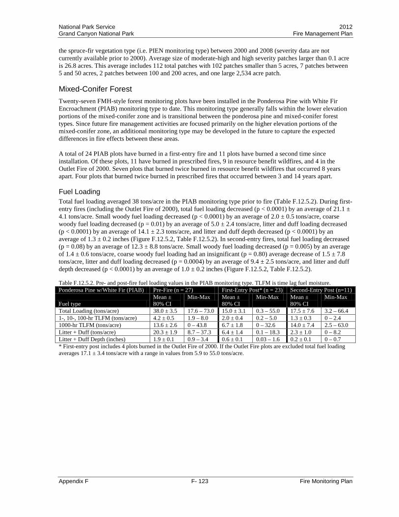
National Park Service 2012 Grand Canyon National Park Fire Management Plan
Appendix F F- 123 Fire Monitoring Plan
the spruce-fir vegetation type (i.e. PIEN monitoring type) between 2000 and 2008 (severity data are not currently available prior to 2000). Average size of moderate-high and high severity patches larger than 0.1 acre is 26.8 acres. This average includes 112 total patches with 102 patches smaller than 5 acres, 7 patches between 5 and 50 acres, 2 patches between 100 and 200 acres, and one large 2,534 acre patch. Mixed-Conifer Forest Twenty-seven FMH-style forest monitoring plots have been installed in the Ponderosa Pine with White Fir Encroachment (PIAB) monitoring type to date. This monitoring type generally falls within the lower elevation portions of the mixed-conifer zone and is transitional between the ponderosa pine and mixed-conifer forest types. Since future fire management activities are focused primarily on the higher elevation portions of the mixed-conifer zone, an additional monitoring type may be developed in the future to capture the expected differences in fire effects between these areas. A total of 24 PIAB plots have burned in a first-entry fire and 11 plots have burned a second time since installation. Of these plots, 11 have burned in prescribed fires, 9 in resource benefit wildfires, and 4 in the Outlet Fire of 2000. Seven plots that burned twice burned in resource benefit wildfires that occurred 8 years apart. Four plots that burned twice burned in prescribed fires that occurred between 3 and 14 years apart. Fuel Loading Total fuel loading averaged 38 tons/acre in the PIAB monitoring type prior to fire (Table F.12.5.2). During first-entry fires (including the Outlet Fire of 2000), total fuel loading decreased (p < 0.0001) by an average of 21.1 ± 4.1 tons/acre. Small woody fuel loading decreased (p < 0.0001) by an average of 2.0 ± 0.5 tons/acre, coarse woody fuel loading decreased (p = 0.01) by an average of 5.0 ± 2.4 tons/acre, litter and duff loading decreased (p < 0.0001) by an average of 14.1 ± 2.3 tons/acre, and litter and duff depth decreased (p < 0.0001) by an average of 1.3 ± 0.2 inches (Figure F.12.5.2, Table F.12.5.2). In second-entry fires, total fuel loading decreased (p = 0.08) by an average of 12.3 ± 8.8 tons/acre. Small woody fuel loading decreased (p = 0.005) by an average of 1.4 ± 0.6 tons/acre, coarse woody fuel loading had an insignificant (p = 0.80) average decrease of 1.5 ± 7.8 tons/acre, litter and duff loading decreased (p = 0.0004) by an average of 9.4 ± 2.5 tons/acre, and litter and duff depth decreased (p < 0.0001) by an average of 1.0 ± 0.2 inches (Figure F.12.5.2, Table F.12.5.2). Table F.12.5.2. Pre- and post-fire fuel loading values in the PIAB monitoring type. TLFM is time lag fuel moisture. Ponderosa Pine w/White Fir (PIAB) Pre-Fire (n = 27) First-Entry Post* (n = 23) Second-Entry Post (n=11)
Fuel type Mean ± 80% CI
Min-Max Mean ± 80% CI
Min-Max Mean ± 80% CI
Min-Max
Total Loading (tons/acre) 38.0 ± 3.5 17.6 – 73.0 15.0 ± 3.1 0.3 – 55.0 17.5 ± 7.6 3.2 – 66.4 1-, 10-, 100-hr TLFM (tons/acre) 4.2 ± 0.5 1.9 – 8.0 2.0 ± 0.4 0.2 – 5.0 1.3 ± 0.3 0 – 2.4 1000-hr TLFM (tons/acre) 13.6 ± 2.6 0 – 43.8 6.7 ± 1.8 0 – 32.6 14.0 ± 7.4 2.5 – 63.0 Litter + Duff (tons/acre) 20.3 ± 1.9 8.7 – 37.3 6.4 ± 1.4 0.1 – 18.3 2.3 ± 1.0 0 – 8.2 Litter + Duff Depth (inches) 1.9 ± 0.1 0.9 – 3.4 0.6 ± 0.1 0.03 – 1.6 0.2 ± 0.1 0 – 0.7 * First-entry post includes 4 plots burned in the Outlet Fire of 2000. If the Outlet Fire plots are excluded total fuel loading averages 17.1 ± 3.4 tons/acre with a range in values from 5.9 to 55.0 tons/acre.

National Park Service 2012 Grand Canyon National Park Fire Management Plan
Appendix F F- 124 Fire Monitoring Plan
Ponderosa Pine with White Fir (PIAB)
0
5
10
15
20
25
Pre (n=23) 01Post (n=23) 02Pre (n=11) 02Post (n=11)
Fuel
load
ing
(tons
/acr
e) ±
80%
CI
Litter + DuffSmall WoodyCoarse Woody
First-Entry Second-Entry
Figure F.12.5.2. Mean ± 80% CI fuel loading values for first- and second-entry fires in the PIAB monitoring type. 02Pre includes one plot measured two years after the first fire, eight plots measured five years after the first fire, and two plots measured ten years after the first fire. Tree Density Prior to fire, total (greater than 1 inch dbh) conifer density averaged 432 trees/acre in the PIAB monitoring type with an average of 290 trees/acre in the pole-sized tree (1 – 6 inch dbh) class and an average of 38 trees/acre in the large (greater than 16 inches dbh) tree size class (Table F.12.5.3). On average, 75% of the pole-sized trees in individual PIAB plots were white fir and 74% of the large trees were ponderosa pine prior to fire.
By the second year after fire (including the Outlet Fire of 2000) pole-sized white fir density decreased (p < 0.0001) by an average of 192.6 ± 47.3 trees/acre and conifer (including white fir) pole-sized tree density decreased (p < 0.0001) by an average of 222.7 ± 49.4 trees/acre (Table F.12.5.3; Figure F.12.5.3). Six plots had no remaining pole-sized trees two years after fire. White fir comprised 63% of the pole-sized trees in plots that had pole-sized trees after fire.
Tree density measurements taken five years after fire (including the Outlet Fire of 2000) indicate that large ponderosa pine tree density decreased (p = 0.004) by an average of 9.2 ± 3.6 trees/acre and total large conifer (including ponderosa pine) tree density decreased (p = 0.0006) by an average of 19.3 ± 6.1 trees/acre from pre-fire values (Table F.12.5.3; Figure F.12.5.3). Two plots had no remaining large trees five years after fire. Ponderosa pine comprised 79% of the large trees in plots that had large trees after fire. Table F.12.5.3. Pre- and post-fire tree density values in the PIAB monitoring type. Pole trees are 1-6 inches dbh, large trees are greater than 16 inches dbh, total trees are all trees greater than 1 inch dbh. Pre-fire (n = 27) First-Entry Post * Ponderosa Pine w/White Fir (PIAB) Mean ± 80% CI Min–Max Mean ± 80% CI Min–Max Pole tree density (trees/acre): Year 2 (n = 24)
White fir only 234.8 ± 44.4 0 – 713 49.6 ± 19.4 0 – 267 All conifers 290.0 ± 42.1 16 – 729 72.5 ± 22.2 0 – 283
Large tree density (trees/acre): Year 5 (n = 18) Ponderosa pine only 26.5 ± 2.9 8 – 61 16.4 ± 3.4 0 – 36 All conifers 37.6 ± 3.9 16 – 77 21.1 ± 3.9 0 – 40
Total tree density (trees/acre): Year 5 (n = 18) All conifers 431.5 ± 46.1 77 – 947 108.2 ± 30.0 0 – 352
* First-entry post includes 4 plots burned in the Outlet Fire of 2000. If the Outlet Fire plots are excluded total pole-sized conifer density averages 86.6 ± 24.8 trees/acre, large conifer density averages 26.3 ± 3.0 trees/acre, and total conifer density averages 137.1 ± 32.0 trees/acre.
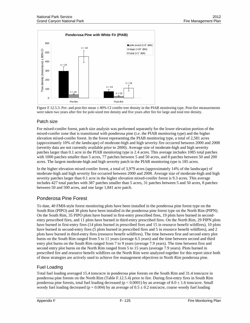
National Park Service 2012 Grand Canyon National Park Fire Management Plan
Appendix F F- 125 Fire Monitoring Plan
Ponderosa Pine with White Fir (PIAB)
0
100
200
300
400
500
600
Pre-fire Post-fire
Tree
den
sity
(tre
es/a
cre)
± 8
0% C
Ipole-sized (1-6" dbh)large (>16" dbh)total (>1" dbh)
n = 24
n = 24
n = 18
n = 18
n = 18
n = 18
Figure F.12.5.3. Pre- and post-fire mean ± 80% CI conifer tree density in the PIAB monitoring type. Post-fire measurements were taken two years after fire for pole-sized tree density and five years after fire for large and total tree density. Patch size For mixed-conifer forest, patch size analysis was performed separately for the lower elevation portion of the mixed-conifer zone that is transitional with ponderosa pine (i.e. the PIAB monitoring type) and the higher elevation mixed-conifer forest. In the forest representing the PIAB monitoring type, a total of 2,581 acres (approximately 10% of the landscape) of moderate-high and high severity fire occurred between 2000 and 2008 (severity data are not currently available prior to 2000). Average size of moderate-high and high severity patches larger than 0.1 acre in the PIAB monitoring type is 2.4 acres. This average includes 1085 total patches with 1000 patches smaller than 5 acres, 77 patches between 5 and 50 acres, and 8 patches between 50 and 200 acres. The largest moderate-high and high severity patch in the PIAB monitoring type is 185 acres.
In the higher elevation mixed-conifer forest, a total of 3,979 acres (approximately 14% of the landscape) of moderate-high and high severity fire occurred between 2000 and 2008. Average size of moderate-high and high severity patches larger than 0.1 acre in the higher elevation mixed-conifer forest is 9.3 acres. This average includes 427 total patches with 387 patches smaller than 5 acres, 31 patches between 5 and 50 acres, 8 patches between 50 and 500 acres, and one large 1,841 acre patch. Ponderosa Pine Forest To date, 40 FMH-style forest monitoring plots have been installed in the ponderosa pine forest type on the South Rim (PIPO) and 30 plots have been installed in the ponderosa pine forest type on the North Rim (PIPN). On the South Rim, 35 PIPO plots have burned in first-entry prescribed fires, 19 plots have burned in second-entry prescribed fires, and 11 plots have burned in third-entry prescribed fires. On the North Rim, 29 PIPN plots have burned in first-entry fires (14 plots burned in prescribed fires and 15 in resource benefit wildfires), 10 plots have burned in second-entry fires (5 plots burned in prescribed fires and 5 in resource benefit wildfires), and 2 plots have burned in third-entry fires (resource benefit wildfires). The time between first and second entry plot burns on the South Rim ranged from 5 to 11 years (average 6.5 years) and the time between second and third entry plot burns on the South Rim ranged from 7 to 9 years (average 7.9 years). The time between first and second entry plot burns on the North Rim ranged from 5 to 15 years (average 7.9 years). Plots burned in prescribed fire and resource benefit wildfires on the North Rim were analyzed together for this report since both of these strategies are actively used to achieve fire management objectives in North Rim ponderosa pine. Fuel Loading Total fuel loading averaged 15.4 tons/acre in ponderosa pine forests on the South Rim and 31.4 tons/acre in ponderosa pine forests on the North Rim (Table F.12.5.4) prior to fire. During first-entry fires in South Rim ponderosa pine forests, total fuel loading decreased (p < 0.0001) by an average of 8.0 ± 1.6 tons/acre. Small woody fuel loading decreased (p = 0.004) by an average of 0.5 ± 0.2 tons/acre, coarse woody fuel loading
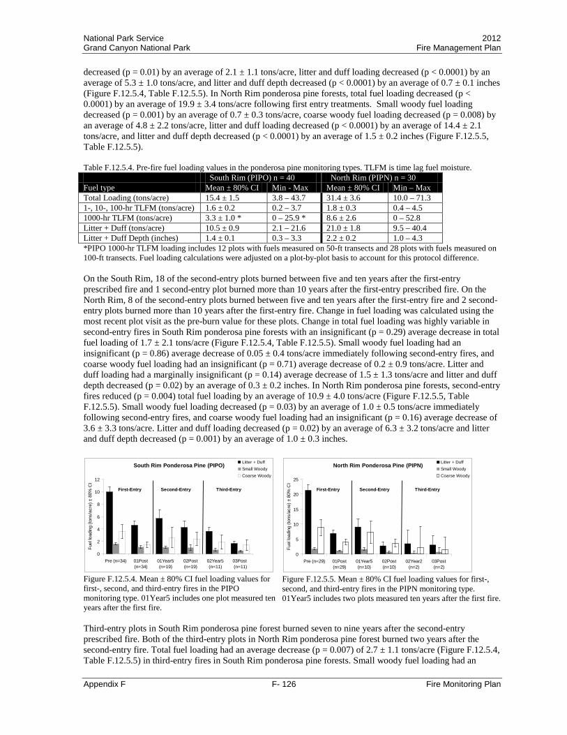
National Park Service 2012 Grand Canyon National Park Fire Management Plan
Appendix F F- 126 Fire Monitoring Plan
decreased (p = 0.01) by an average of 2.1 ± 1.1 tons/acre, litter and duff loading decreased (p < 0.0001) by an average of 5.3 ± 1.0 tons/acre, and litter and duff depth decreased (p < 0.0001) by an average of 0.7 ± 0.1 inches (Figure F.12.5.4, Table F.12.5.5). In North Rim ponderosa pine forests, total fuel loading decreased (p < 0.0001) by an average of 19.9 ± 3.4 tons/acre following first entry treatments. Small woody fuel loading decreased (p = 0.001) by an average of 0.7 ± 0.3 tons/acre, coarse woody fuel loading decreased (p = 0.008) by an average of 4.8 ± 2.2 tons/acre, litter and duff loading decreased (p < 0.0001) by an average of 14.4 ± 2.1 tons/acre, and litter and duff depth decreased (p < 0.0001) by an average of 1.5 ± 0.2 inches (Figure F.12.5.5, Table F.12.5.5). Table F.12.5.4. Pre-fire fuel loading values in the ponderosa pine monitoring types. TLFM is time lag fuel moisture. South Rim (PIPO) n = 40 North Rim (PIPN) n = 30 Fuel type Mean ± 80% CI Min - Max Mean ± 80% CI Min – Max Total Loading (tons/acre) 15.4 ± 1.5 3.8 – 43.7 31.4 ± 3.6 10.0 – 71.3 1-, 10-, 100-hr TLFM (tons/acre) 1.6 ± 0.2 0.2 – 3.7 1.8 ± 0.3 0.4 – 4.5 1000-hr TLFM (tons/acre) 3.3 ± 1.0 * 0 – 25.9 * 8.6 ± 2.6 0 – 52.8 Litter + Duff (tons/acre) 10.5 ± 0.9 2.1 – 21.6 21.0 ± 1.8 9.5 – 40.4 Litter + Duff Depth (inches) 1.4 ± 0.1 0.3 – 3.3 2.2 ± 0.2 1.0 – 4.3 *PIPO 1000-hr TLFM loading includes 12 plots with fuels measured on 50-ft transects and 28 plots with fuels measured on 100-ft transects. Fuel loading calculations were adjusted on a plot-by-plot basis to account for this protocol difference. On the South Rim, 18 of the second-entry plots burned between five and ten years after the first-entry prescribed fire and 1 second-entry plot burned more than 10 years after the first-entry prescribed fire. On the North Rim, 8 of the second-entry plots burned between five and ten years after the first-entry fire and 2 second-entry plots burned more than 10 years after the first-entry fire. Change in fuel loading was calculated using the most recent plot visit as the pre-burn value for these plots. Change in total fuel loading was highly variable in second-entry fires in South Rim ponderosa pine forests with an insignificant (p = 0.29) average decrease in total fuel loading of 1.7 ± 2.1 tons/acre (Figure F.12.5.4, Table F.12.5.5). Small woody fuel loading had an insignificant (p = 0.86) average decrease of 0.05 ± 0.4 tons/acre immediately following second-entry fires, and coarse woody fuel loading had an insignificant (p = 0.71) average decrease of 0.2 ± 0.9 tons/acre. Litter and duff loading had a marginally insignificant (p = 0.14) average decrease of 1.5 ± 1.3 tons/acre and litter and duff depth decreased (p = 0.02) by an average of 0.3 ± 0.2 inches. In North Rim ponderosa pine forests, second-entry fires reduced (p = 0.004) total fuel loading by an average of 10.9 ± 4.0 tons/acre (Figure F.12.5.5, Table F.12.5.5). Small woody fuel loading decreased (p = 0.03) by an average of 1.0 ± 0.5 tons/acre immediately following second-entry fires, and coarse woody fuel loading had an insignificant (p = 0.16) average decrease of 3.6 ± 3.3 tons/acre. Litter and duff loading decreased (p = 0.02) by an average of 6.3 ± 3.2 tons/acre and litter and duff depth decreased (p = 0.001) by an average of 1.0 ± 0.3 inches.
South Rim Ponderosa Pine (PIPO)
0
2
4
6
8
10
12
Pre (n=34) 01Post(n=34)
01Year5(n=19)
02Post(n=19)
02Year5(n=11)
03Post (n=11)
Fuel
load
ing
(tons
/acr
e) ±
80%
CI
Litter + DuffSmall WoodyCoarse Woody
First-Entry Second-Entry Third-Entry
Figure F.12.5.4. Mean ± 80% CI fuel loading values for first-, second, and third-entry fires in the PIPO monitoring type. 01Year5 includes one plot measured ten years after the first fire.
North Rim Ponderosa Pine (PIPN)
0
5
10
15
20
25
Pre (n=29) 01Post(n=29)
01Year5(n=10)
02Post(n=10)
02Year2(n=2)
03Post(n=2)
Fuel
load
ing
(tons
/acr
e) ±
80%
CI
Litter + DuffSmall WoodyCoarse Woody
First-Entry Second-Entry Third-Entry
Figure F.12.5.5. Mean ± 80% CI fuel loading values for first-, second, and third-entry fires in the PIPN monitoring type. 01Year5 includes two plots measured ten years after the first fire.
Third-entry plots in South Rim ponderosa pine forest burned seven to nine years after the second-entry prescribed fire. Both of the third-entry plots in North Rim ponderosa pine forest burned two years after the second-entry fire. Total fuel loading had an average decrease (p = 0.007) of 2.7 ± 1.1 tons/acre (Figure F.12.5.4, Table F.12.5.5) in third-entry fires in South Rim ponderosa pine forests. Small woody fuel loading had an
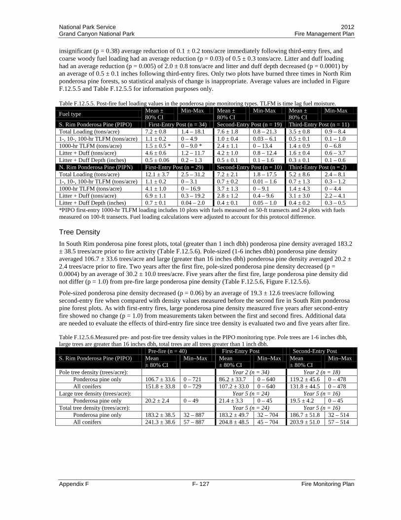
National Park Service 2012 Grand Canyon National Park Fire Management Plan
Appendix F F- 127 Fire Monitoring Plan
insignificant (p = 0.38) average reduction of 0.1 ± 0.2 tons/acre immediately following third-entry fires, and coarse woody fuel loading had an average reduction (p = 0.03) of 0.5 ± 0.3 tons/acre. Litter and duff loading had an average reduction (p = 0.005) of 2.0 ± 0.8 tons/acre and litter and duff depth decreased (p = 0.0001) by an average of 0.5 ± 0.1 inches following third-entry fires. Only two plots have burned three times in North Rim ponderosa pine forests, so statistical analysis of change is inappropriate. Average values are included in Figure F.12.5.5 and Table F.12.5.5 for information purposes only. Table F.12.5.5. Post-fire fuel loading values in the ponderosa pine monitoring types. TLFM is time lag fuel moisture.
Fuel type Mean ± 80% CI
Min-Max Mean ± 80% CI
Min-Max Mean ± 80% CI
Min-Max
S. Rim Ponderosa Pine (PIPO) First-Entry Post (n = 34) Second-Entry Post (n = 19) Third-Entry Post (n = 11) Total Loading (tons/acre) 7.2 ± 0.8 1.4 – 18.1 7.6 ± 1.8 0.8 – 21.3 3.5 ± 0.8 0.9 – 8.4 1-, 10-, 100-hr TLFM (tons/acre) 1.1 ± 0.2 0 – 4.9 1.0 ± 0.4 0.03 – 6.1 0.5 ± 0.1 0.1 – 1.0 1000-hr TLFM (tons/acre) 1.5 ± 0.5 * 0 – 9.0 * 2.4 ± 1.1 0 – 13.4 1.4 ± 0.9 0 – 6.8 Litter + Duff (tons/acre) 4.6 ± 0.6 1.2 – 11.7 4.2 ± 1.0 0.8 – 12.4 1.6 ± 0.4 0.6 – 3.7 Litter + Duff Depth (inches) 0.5 ± 0.06 0.2 – 1.3 0.5 ± 0.1 0.1 – 1.6 0.3 ± 0.1 0.1 – 0.6 N. Rim Ponderosa Pine (PIPN) First-Entry Post (n = 29) Second-Entry Post (n = 10) Third-Entry Post (n = 2) Total Loading (tons/acre) 12.1 ± 3.7 2.5 – 31.2 7.2 ± 2.1 1.8 – 17.5 5.2 ± 8.6 2.4 – 8.1 1-, 10-, 100-hr TLFM (tons/acre) 1.1 ± 0.2 0 – 3.1 0.7 ± 0.2 0.01 – 1.6 0.7 ± 1.3 0.3 – 1.2 1000-hr TLFM (tons/acre) 4.1 ± 1.0 0 – 16.9 3.7 ± 1.3 0 – 9.1 1.4 ± 4.3 0 – 4.4 Litter + Duff (tons/acre) 6.9 ± 1.1 0.3 – 19.2 2.8 ± 1.2 0.4 – 9.6 3.1 ± 3.0 2.2 – 4.1 Litter + Duff Depth (inches) 0.7 ± 0.1 0.04 – 2.0 0.4 ± 0.1 0.05 – 1.0 0.4 ± 0.2 0.3 – 0.5 *PIPO first-entry 1000-hr TLFM loading includes 10 plots with fuels measured on 50-ft transects and 24 plots with fuels measured on 100-ft transects. Fuel loading calculations were adjusted to account for this protocol difference. Tree Density In South Rim ponderosa pine forest plots, total (greater than 1 inch dbh) ponderosa pine density averaged 183.2 ± 38.5 trees/acre prior to fire activity (Table F.12.5.6). Pole-sized (1-6 inches dbh) ponderosa pine density averaged 106.7 ± 33.6 trees/acre and large (greater than 16 inches dbh) ponderosa pine density averaged 20.2 ± 2.4 trees/acre prior to fire. Two years after the first fire, pole-sized ponderosa pine density decreased (p = 0.0004) by an average of 30.2 ± 10.0 trees/acre. Five years after the first fire, large ponderosa pine density did not differ (p = 1.0) from pre-fire large ponderosa pine density (Table F.12.5.6, Figure F.12.5.6).
Pole-sized ponderosa pine density decreased (p = 0.06) by an average of 19.3 ± 12.6 trees/acre following second-entry fire when compared with density values measured before the second fire in South Rim ponderosa pine forest plots. As with first-entry fires, large ponderosa pine density measured five years after second-entry fire showed no change (p = 1.0) from measurements taken between the first and second fires. Additional data are needed to evaluate the effects of third-entry fire since tree density is evaluated two and five years after fire. Table F.12.5.6.Measured pre- and post-fire tree density values in the PIPO monitoring type. Pole trees are 1-6 inches dbh, large trees are greater than 16 inches dbh, total trees are all trees greater than 1 inch dbh. Pre-fire (n = 40) First-Entry Post Second-Entry Post S. Rim Ponderosa Pine (PIPO) Mean
± 80% CI Min–Max Mean
± 80% CI Min–Max Mean
± 80% CI Min–Max
Pole tree density (trees/acre): Year 2 (n = 34) Year 2 (n = 18) Ponderosa pine only 106.7 ± 33.6 0 – 721 86.2 ± 33.7 0 – 640 119.2 ± 45.6 0 – 478 All conifers 151.8 ± 33.8 0 – 729 107.2 ± 33.0 0 – 640 131.8 ± 44.5 0 – 478
Large tree density (trees/acre): Year 5 (n = 24) Year 5 (n = 16) Ponderosa pine only 20.2 ± 2.4 0 – 49 21.4 ± 3.3 0 – 45 19.5 ± 4.2 0 – 45
Total tree density (trees/acre): Year 5 (n = 24) Year 5 (n = 16) Ponderosa pine only 183.2 ± 38.5 32 – 887 183.2 ± 49.7 32 – 704 186.7 ± 51.8 32 – 514 All conifers 241.3 ± 38.6 57 – 887 204.8 ± 48.5 45 – 704 203.9 ± 51.0 57 – 514
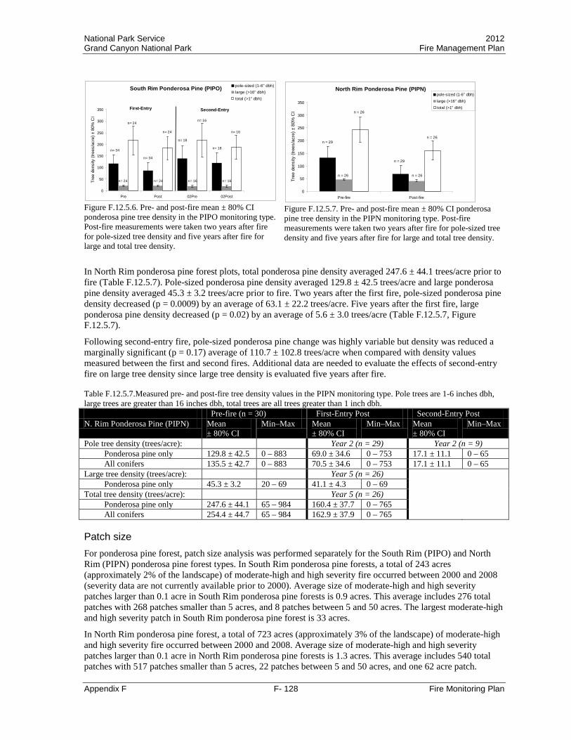
National Park Service 2012 Grand Canyon National Park Fire Management Plan
Appendix F F- 128 Fire Monitoring Plan
South Rim Ponderosa Pine (PIPO)
0
50
100
150
200
250
300
350
Pre Post 02Pre 02Post
Tree
den
sity
(tre
es/a
cre)
± 8
0% C
Ipole-sized (1-6" dbh)large (>16" dbh)total (>1" dbh)
n= 34
n= 16n= 24
n= 24
n= 18
n= 18
First-Entry Second-Entry
n= 34
n= 24
n= 24
n= 16
n= 16
n= 16
Figure F.12.5.6. Pre- and post-fire mean ± 80% CI ponderosa pine tree density in the PIPO monitoring type. Post-fire measurements were taken two years after fire for pole-sized tree density and five years after fire for large and total tree density.
North Rim Ponderosa Pine (PIPN)
0
50
100
150
200
250
300
350
Pre-fire Post-fire
Tree
den
sity
(tre
es/a
cre)
± 8
0% C
I
pole-sized (1-6" dbh)large (>16" dbh)total (>1" dbh)
n = 29
n = 29
n = 26
n = 26
n = 26
n = 26
Figure F.12.5.7. Pre- and post-fire mean ± 80% CI ponderosa pine tree density in the PIPN monitoring type. Post-fire measurements were taken two years after fire for pole-sized tree density and five years after fire for large and total tree density.
In North Rim ponderosa pine forest plots, total ponderosa pine density averaged 247.6 ± 44.1 trees/acre prior to fire (Table F.12.5.7). Pole-sized ponderosa pine density averaged 129.8 ± 42.5 trees/acre and large ponderosa pine density averaged 45.3 ± 3.2 trees/acre prior to fire. Two years after the first fire, pole-sized ponderosa pine density decreased (p = 0.0009) by an average of 63.1 ± 22.2 trees/acre. Five years after the first fire, large ponderosa pine density decreased (p = 0.02) by an average of 5.6 ± 3.0 trees/acre (Table F.12.5.7, Figure F.12.5.7).
Following second-entry fire, pole-sized ponderosa pine change was highly variable but density was reduced a marginally significant (p = 0.17) average of 110.7 ± 102.8 trees/acre when compared with density values measured between the first and second fires. Additional data are needed to evaluate the effects of second-entry fire on large tree density since large tree density is evaluated five years after fire. Table F.12.5.7.Measured pre- and post-fire tree density values in the PIPN monitoring type. Pole trees are 1-6 inches dbh, large trees are greater than 16 inches dbh, total trees are all trees greater than 1 inch dbh. Pre-fire (n = 30) First-Entry Post Second-Entry Post N. Rim Ponderosa Pine (PIPN) Mean
± 80% CI Min–Max Mean
± 80% CI Min–Max Mean
± 80% CI Min–Max
Pole tree density (trees/acre): Year 2 (n = 29) Year 2 (n = 9) Ponderosa pine only 129.8 ± 42.5 0 – 883 69.0 ± 34.6 0 – 753 17.1 ± 11.1 0 – 65 All conifers 135.5 ± 42.7 0 – 883 70.5 ± 34.6 0 – 753 17.1 ± 11.1 0 – 65
Large tree density (trees/acre): Year 5 (n = 26) Ponderosa pine only 45.3 ± 3.2 20 – 69 41.1 ± 4.3 0 – 69
Total tree density (trees/acre): Year 5 (n = 26) Ponderosa pine only 247.6 ± 44.1 65 – 984 160.4 ± 37.7 0 – 765 All conifers 254.4 ± 44.7 65 – 984 162.9 ± 37.9 0 – 765
Patch size For ponderosa pine forest, patch size analysis was performed separately for the South Rim (PIPO) and North Rim (PIPN) ponderosa pine forest types. In South Rim ponderosa pine forests, a total of 243 acres (approximately 2% of the landscape) of moderate-high and high severity fire occurred between 2000 and 2008 (severity data are not currently available prior to 2000). Average size of moderate-high and high severity patches larger than 0.1 acre in South Rim ponderosa pine forests is 0.9 acres. This average includes 276 total patches with 268 patches smaller than 5 acres, and 8 patches between 5 and 50 acres. The largest moderate-high and high severity patch in South Rim ponderosa pine forest is 33 acres.
In North Rim ponderosa pine forest, a total of 723 acres (approximately 3% of the landscape) of moderate-high and high severity fire occurred between 2000 and 2008. Average size of moderate-high and high severity patches larger than 0.1 acre in North Rim ponderosa pine forests is 1.3 acres. This average includes 540 total patches with 517 patches smaller than 5 acres, 22 patches between 5 and 50 acres, and one 62 acre patch.
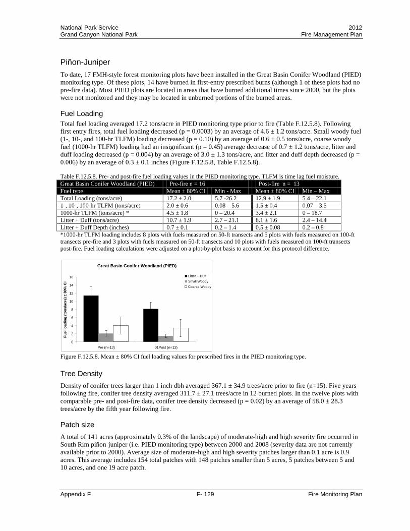
National Park Service 2012 Grand Canyon National Park Fire Management Plan
Appendix F F- 129 Fire Monitoring Plan
Piñon-Juniper To date, 17 FMH-style forest monitoring plots have been installed in the Great Basin Conifer Woodland (PIED) monitoring type. Of these plots, 14 have burned in first-entry prescribed burns (although 1 of these plots had no pre-fire data). Most PIED plots are located in areas that have burned additional times since 2000, but the plots were not monitored and they may be located in unburned portions of the burned areas. Fuel Loading Total fuel loading averaged 17.2 tons/acre in PIED monitoring type prior to fire (Table F.12.5.8). Following first entry fires, total fuel loading decreased (p = 0.0003) by an average of 4.6 ± 1.2 tons/acre. Small woody fuel (1-, 10-, and 100-hr TLFM) loading decreased (p = 0.10) by an average of 0.6 ± 0.5 tons/acre, coarse woody fuel (1000-hr TLFM) loading had an insignificant (p = 0.45) average decrease of 0.7 ± 1.2 tons/acre, litter and duff loading decreased (p = 0.004) by an average of 3.0 ± 1.3 tons/acre, and litter and duff depth decreased (p = 0.006) by an average of 0.3 ± 0.1 inches (Figure F.12.5.8, Table F.12.5.8). Table F.12.5.8. Pre- and post-fire fuel loading values in the PIED monitoring type. TLFM is time lag fuel moisture. Great Basin Conifer Woodland (PIED) Pre-fire n = 16 Post-fire n = 13 Fuel type Mean ± 80% CI Min - Max Mean ± 80% CI Min – Max Total Loading (tons/acre) 17.2 ± 2.0 5.7 -26.2 12.9 ± 1.9 5.4 – 22.1 1-, 10-, 100-hr TLFM (tons/acre) 2.0 ± 0.6 0.08 – 5.6 1.5 ± 0.4 0.07 – 3.5 1000-hr TLFM (tons/acre) * 4.5 ± 1.8 0 – 20.4 3.4 ± 2.1 0 – 18.7 Litter + Duff (tons/acre) 10.7 ± 1.9 2.7 – 21.1 8.1 ± 1.6 2.4 – 14.4 Litter + Duff Depth (inches) 0.7 ± 0.1 0.2 – 1.4 0.5 ± 0.08 0.2 – 0.8 *1000-hr TLFM loading includes 8 plots with fuels measured on 50-ft transects and 5 plots with fuels measured on 100-ft transects pre-fire and 3 plots with fuels measured on 50-ft transects and 10 plots with fuels measured on 100-ft transects post-fire. Fuel loading calculations were adjusted on a plot-by-plot basis to account for this protocol difference.
Great Basin Conifer Woodland (PIED)
0
2
4
6
8
10
12
14
16
Pre (n=13) 01Post (n=13)
Fuel
load
ing
(tons
/acr
e) ±
80%
CI
Litter + DuffSmall WoodyCoarse Woody
Figure F.12.5.8. Mean ± 80% CI fuel loading values for prescribed fires in the PIED monitoring type. Tree Density Density of conifer trees larger than 1 inch dbh averaged 367.1 ± 34.9 trees/acre prior to fire (n=15). Five years following fire, conifer tree density averaged 311.7 ± 27.1 trees/acre in 12 burned plots. In the twelve plots with comparable pre- and post-fire data, conifer tree density decreased (p = 0.02) by an average of 58.0 ± 28.3 trees/acre by the fifth year following fire. Patch size A total of 141 acres (approximately 0.3% of the landscape) of moderate-high and high severity fire occurred in South Rim piñon-juniper (i.e. PIED monitoring type) between 2000 and 2008 (severity data are not currently available prior to 2000). Average size of moderate-high and high severity patches larger than 0.1 acre is 0.9 acres. This average includes 154 total patches with 148 patches smaller than 5 acres, 5 patches between 5 and 10 acres, and one 19 acre patch.
National Park Service 2012 Grand Canyon National Park Fire Management Plan
Appendix F F- 130 Fire Monitoring Plan
F.12.6 Calculations Appendix Grand Canyon Custom Fuel Constants The Fire Ecology Program at GRCA uses the FFI database to calculate fuel loading values for fine and coarse woody debris as well as forest floor duff and litter. A series of fuel constants are needed to calculate fuel loading values from field data. Default constants are available in the FFI program; however, these constants are most appropriate for Northern Rocky Mountain areas. In order to calculate fuel loading values for Grand Canyon, custom fuel constants were entered in the FFI database. Fine woody debris (FWD), coarse woody debris (CWD), and duff/litter (DL) constants have been established for each forest monitoring type in Grand Canyon. As more information becomes available in the future, it may be appropriate to change these custom fuel constants or to calculate custom fuel constants for each plot rather than for the monitoring types. The intent of this appendix is to provide background information on how the custom fuel constants were calculated in order to allow for future changes, if needed.
The equations for calculating fine woody debris fuel loading involve nine fuel constants: quadratic mean diameter (QMD) for 1-hr, 10-hr, and 100-hr time lag fuel moisture (TLFM) size classes, nonhorizontal correction factor (NHC) for 1-hr, 10-hr, and 100-hr TLFM size classes, and specific gravity (SG) for 1-hr, 10-hr, and 100-hr TLFM size classes. The equations for calculating coarse woody debris fuel loading involve five fuel constants: specific gravity for coarse wood decay classes 1 through 5 (SGTh1-SGTh5). The equations for calculating litter and duff fuel loading involve constants for litter and duff bulk density (LittBD, DuffBD). More information on these constants and equations is available in Brown (1974).
Two sets of information were used to create custom fuel constants for Grand Canyon (1) fuel constant values obtained from the literature for each of the ten tree species encountered on the forested rims of the park (Table F.12.6.1 and Table F.12.6.2) and (2) the proportional abundance of each species in each monitoring type (Table F.12.6.3). When available, fuel constants generated from Arizona or the Southwestern region were used. In some cases, regional constants were not available and species (or genera) specific constants from other regions were used. Species-specific fuel constants
Fine woody debris QMD and SG constants were obtained from Sackett (1980) for Abies lasiocarpa, Picea engelmannii, Picea pungens, Pinus ponderosa, Populus tremuloides, Pseudotsuga menziesii, and Quercus gambellii. Abies concolor fine woody debris QMD and SG constants were obtained from van Wagtendonk et al. (1996). Fine woody debris QMD and SG constants for Juniperus occidentalis and Pinus monophylla (van Wagtendonk et al. 1996) were used for Juniperus osteosperma and Pinus edulis, respectively. NHC constants for A. concolor, P. ponderosa, and P. menziesii were obtained from van Wagtendonk et al. (1996). NHC constants for A. concolor, J. occidentalis, and P. monophylla (van Wagtendonk et al. 1996) were used for A. lasiocarpa, J. osteosperma, and P. edulis, respectively. The default NHC value from Brown (1974) was used for all other tree species.
For coarse woody debris, decay classes 1-3 were considered sound logs and were assigned the same species-specific constant for specific gravity. Sound log specific gravity constants for A. concolor, P. ponderosa, and P. menziesii were obtained from van Wagtendonk et al. (1996). Sound log specific gravity constants obtained from USDA (1974) were used for A. lasiocarpa (white fir value), J. osteosperma (bigberry juniper value), spruce (P. engelmannii and P. pungens), P. tremuloides (bigtooth aspen value), and Quercus gambellii (white oak value). Decay classes 4-5 were considered rotten logs and were assigned a value of 0.3 for all species (Brown 1974, Sackett 1980, van Wagtendonk et al. 1996).
Litter and duff bulk density values were obtained from van Wagtendonk et al. (1998) for A. concolor and P. menziesii. Litter and duff bulk density constants for A. concolor, J. occidentalis, and P. monophylla (van Wagtendonk et al. 1998) were used for A. lasiocarpa, J. osteosperma, and P. edulis, respectively. P. ponderosa litter and duff bulk densities were obtained from Ffolliott et al. (1968) and P. tremuloides litter and duff bulk densities were obtained from Loomis (1977). Litter and duff bulk density constants for P. engelmannii, P. pungens, and Q. gambellii were obtained from the FMH software version 3.10 (Sydoriak 1991), but no published references were found to support these values.

National Park Service 2012 Grand Canyon National Park Fire Management Plan
Appendix F F- 131 Fire Monitoring Plan
Table F.12.6.1. Fine woody debris fuel constants for ten GRCA tree species.
Quadratic Mean Diameter (sq. inches) Nonhorizontal Correction Factor Specific Gravity
Scientific Name QMD1 QMD10 QMD100 NHC1 NHC10 NHC100 SG1 SG10 SG100
Abies concolor 0.01 0.20 1.79 1.03 1.02 1.02 0.53 0.54 0.57
Abies lasiocarpa 0.02 0.23 2.41 1.03 1.02 1.02 0.40 0.47 0.43
Juniperus osteosperma 0.01 0.25 2.16 1.03 1.04 1.04 0.67 0.65 0.62
Picea engelmannii 0.01 0.35 2.24 1.13 1.13 1.13 0.48 0.52 0.52
Picea pungens 0.01 0.35 2.24 1.13 1.13 1.13 0.48 0.52 0.52
Pinus edulis 0.01 0.22 1.79 1.02 1.01 1.01 0.65 0.64 0.62
Pinus ponderosa 0.04 0.24 2.97 1.02 1.03 1.02 0.46 0.46 0.39
Populus tremuloides 0.03 0.32 3.47 1.13 1.13 1.13 0.42 0.40 0.39
Pseudotsuga menziesii 0.01 0.37 3.14 1.03 1.02 1.03 0.53 0.53 0.57
Quercus gambellii 0.02 0.36 2.87 1.13 1.13 1.13 0.58 0.55 0.64 Table F.12.6.2. Coarse woody debris, litter, and duff fuel constants for ten GRCA tree species.
Specific Gravity Bulk Density (lbs/cu ft)
Scientific Name SGTh1 SGTh2 SGTh3 SGTh4 SGTh5 Litter Duff
Abies concolor 0.32 0.32 0.32 0.30 0.30 4.90 11.40
Abies lasiocarpa 0.38 0.38 0.38 0.30 0.30 4.90 11.40
Juniperus osteosperma 0.44 0.44 0.44 0.30 0.30 4.40 11.10
Picea engelmannii 0.35 0.35 0.35 0.30 0.30 1.10 7.20
Picea pungens 0.35 0.35 0.35 0.30 0.30 1.10 7.20
Pinus edulis 0.44 0.44 0.44 0.30 0.30 9.10 14.60
Pinus ponderosa 0.40 0.40 0.40 0.30 0.30 0.99 9.24
Populus tremuloides 0.41 0.41 0.41 0.30 0.30 0.94 6.00
Pseudotsuga menziesii 0.35 0.35 0.35 0.30 0.30 6.30 9.50
Quercus gambellii 0.62 0.62 0.62 0.30 0.30 0.9 6.0

National Park Service 2012 Grand Canyon National Park Fire Management Plan
Appendix F F- 132 Fire Monitoring Plan
Monitoring type tree abundance and fuel constants The proportional abundance of each tree species in each monitoring type was calculated using pre-fire basal area of all live trees 2.5 cm dbh and above. Total basal area of each species within a plot was divided by the sum of basal area for all species in a plot to generate a proportional abundance (or % basal area) for each species in each plot. These % basal area values were averaged within monitoring types to generate the monitoring type proportional abundance for each species (Table F.12.6.3). Table F.12.6.3. Proportional abundance of GRCA tree species used to calculate monitoring type fuel constants.
Scientific Name Average % Basal Area Scientific Name Average % Basal Area PIPO: South Rim Ponderosa Pine (n = 38)
PIPN: North Rim Ponderosa Pine (n = 30)
Juniperus osteosperma 7.1 Abies concolor 0.4 Pinus edulis 3.7 Pinus ponderosa 99.4 Pinus ponderosa 86.1 Populus tremuloides 0.1 Quercus gambellii 3.1 Pseudotsuga menziesii 0.1 PIAB: Ponderosa Pine w/White Fir Encroachment (n = 26)
PIEN: Rocky Mountain Subalpine Conifer Forest (n = 12)
Abies concolor 31.8 Abies concolor 24.7 Abies lasiocarpa 0.1 Abies lasiocarpa 10.2 Picea engelmannii 2.3 Picea engelmannii 28.1 Pinus ponderosa 58.1 Pinus ponderosa 5 Populus tremuloides 5.1 Populus tremuloides 20.9 Pseudotsuga menziesii 2.6 Pseudotsuga menziesii 11.1 PIED: Great Basin Conifer Woodland (n = 15)
Juniperus osteosperma 41.2 Pinus edulis 47.5 Pinus ponderosa 10.8 Quercus gambellii 0.5 Proportional fuel constants were calculated by multiplying the proportional abundance of each species in Table F.12.6.3 by the species-specific constants in Table F.12.6.1 and Table F.12.6.2. These proportional constants were then added together to generate the monitoring type fuel constants (Table F.12.6.4 and Table F.12.6.5). For example, the following process was used to calculate the QMD1 constant for the PIPO monitoring type:
Species QMD1 *
Average % Basal Area
= Proportional QMD1
Juniperus osteosperma 0.01 * (7.1 / 100) = 0.0009 Pinus edulis 0.01 * (3.7 / 100) = 0.0005 Pinus ponderosa 0.04 * (86.1 / 100) = 0.0325 Quercus gambellii 0.02 * (3.1 / 100) = 0.0007
Monitoring Type QMD1 = 0.0346

National Park Service 2012 Grand Canyon National Park Fire Management Plan
Appendix F F- 133 Fire Monitoring Plan
Table F.12.6.4. Fine woody debris fuel constants for GRCA monitoring types.
Quadratic Mean Diameter (sq. inches) Nonhorizontal Correction Factor Specific Gravity
Monitoring Type QMD1 QMD10 QMD100 NHC1 NHC10 NHC100 SG1 SG10 SG100
PIPO 0.0346 0.2406 2.863 1.02 1.03 1.02 0.488 0.486 0.424
PIPN 0.0377 0.2367 2.963 1.02 1.03 1.02 0.463 0.464 0.393
PIAB 0.028 0.2368 2.606 1.03 1.03 1.03 0.484 0.488 0.456
PIEN 0.0181 0.2914 2.539 1.08 1.07 1.08 0.476 0.494 0.495
PIED 0.0159 0.234 2.075 1.02 1.02 1.02 0.638 0.625 0.595
Table F.12.6.5. Coarse woody debris, litter, and duff fuel constants for GRCA monitoring types.
Specific Gravity Bulk Density (lbs/cu ft)
Monitoring Type SGTh1 SGTh2 SGTh3 SGTh4 SGTh5 Litter Duff
PIPO 0.411 0.411 0.411 0.3 0.3 1.53 9.47
PIPN 0.3996 0.3996 0.3996 0.3 0.3 1.01 9.25
PIAB 0.373 0.373 0.373 0.3 0.3 2.38 9.72
PIEN 0.361 0.361 0.361 0.3 0.3 2.96 8.77
PIED 0.437 0.437 0.437 0.3 0.3 6.25 12.54
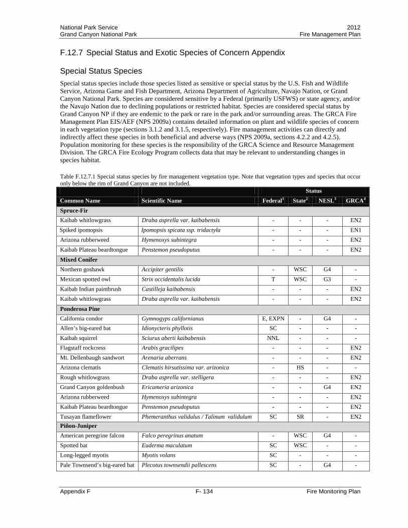
National Park Service 2012 Grand Canyon National Park Fire Management Plan
Appendix F F- 134 Fire Monitoring Plan
F.12.7 Special Status and Exotic Species of Concern Appendix Special Status Species Special status species include those species listed as sensitive or special status by the U.S. Fish and Wildlife Service, Arizona Game and Fish Department, Arizona Department of Agriculture, Navajo Nation, or Grand Canyon National Park. Species are considered sensitive by a Federal (primarily USFWS) or state agency, and/or the Navajo Nation due to declining populations or restricted habitat. Species are considered special status by Grand Canyon NP if they are endemic to the park or rare in the park and/or surrounding areas. The GRCA Fire Management Plan EIS/AEF (NPS 2009a) contains detailed information on plant and wildlife species of concern in each vegetation type (sections 3.1.2 and 3.1.5, respectively). Fire management activities can directly and indirectly affect these species in both beneficial and adverse ways (NPS 2009a, sections 4.2.2 and 4.2.5). Population monitoring for these species is the responsibility of the GRCA Science and Resource Management Division. The GRCA Fire Ecology Program collects data that may be relevant to understanding changes in species habitat. Table F.12.7.1 Special status species by fire management vegetation type. Note that vegetation types and species that occur only below the rim of Grand Canyon are not included. Status Common Name Scientific Name Federal1 State2 NESL3 GRCA4 Spruce-Fir Kaibab whitlowgrass Draba asprella var. kaibabensis - - - EN2
Spiked ipomopsis Ipomopsis spicata ssp. tridactyla - - - EN1 Arizona rubberweed Hymenoxys subintegra - - - EN2 Kaibab Plateau beardtongue Penstemon pseudoputus - - - EN2
Mixed Conifer Northern goshawk Accipiter gentilis - WSC G4 - Mexican spotted owl Strix occidentalis lucida T WSC G3 - Kaibab Indian paintbrush Castilleja kaibabensis - - - EN2 Kaibab whitlowgrass Draba asprella var. kaibabensis - - - EN2
Ponderosa Pine California condor Gymnogyps californianus E, EXPN - G4 - Allen’s big-eared bat Idionycteris phyllotis SC - - - Kaibab squirrel Sciurus aberti kaibabensis NNL - - - Flagstaff rockcress Arabis gracilipes - - - EN2 Mt. Dellenbaugh sandwort Arenaria aberrans - - - EN2 Arizona clematis Clematis hirsutissima var. arizonica - HS - - Rough whitlowgrass Draba asprella var. stelligera - - - EN2 Grand Canyon goldenbush Ericameria arizonica - - G4 EN2 Arizona rubberweed Hymenoxys subintegra - - - EN2 Kaibab Plateau beardtongue Penstemon pseudoputus - - - EN2 Tusayan flameflower Phemeranthus validulus / Talinum validulum SC SR - EN2 Piñon-Juniper American peregrine falcon Falco peregrinus anatum - WSC G4 - Spotted bat Euderma maculatum SC WSC - - Long-legged myotis Myotis volans SC - - - Pale Townsend’s big-eared bat Plecotus townsendii pallescens SC - G4 -

National Park Service 2012 Grand Canyon National Park Fire Management Plan
Appendix F F- 135 Fire Monitoring Plan
Status Common Name Scientific Name Federal1 State2 NESL3 GRCA4 Kaibab agave Agave utahensis ssp. kaibabensis - SR - EN2 Flagstaff rockcress Arabis gracilipes - - - EN2 Mt. Dellenbaugh sandwort Arenaria aberrans - - - EN2 Sentry milk-vetch Astragalus cremnophylax var. cremnophylax E HS - EN1 North Rim (Cape Final) astragalus (not yet named) Astragalus spp. - - - EN1
Grand Canyon goldenbush Ericameria arizonica - - G4 - Tusayan flameflower Phemeranthus validulus / Talinum validulum SC SR - EN2
Grand Canyon rose Rosa stellata ssp. abyssa - SR - EN2 1Federal Status (USFWS or Department of the Interior)
E Endangered, in danger of extinction SC Species of Concern; Some information showing vulnerability or threat, but not enough to support listing
T Threatened, severely depleted
C Candidate for listing as threatened or endangered NNL National Natural Landmark designated by the Secretary of the Interior as a significant natural area
EXPN Experimental non-essential population 2State Status 3Navajo Nation Status
(NESL = Navajo Endangered Species List) 4Grand Canyon NP Status
WSC Wildlife Species of Special Concern
G2 Endangered, survival or recruitment in jeopardy
EN1 Endemic to Grand Canyon NP. Only known to occur in Grand Canyon NP.
HS Highly safeguarded G3 Endangered, survival or recruitment likely to be in jeopardy in the foreseeable future
EN2 Endemic to the Grand Canyon NP region. Very limited in overall distribution.
SR Salvage restricted G4 Not enough information to list as G2 or G3, but reason exists to consider listing
Exotic Species NPS Management Policies (NPS 2006) define that in the removal of exotic species “high priority will be given to managing exotic species that have, or potentially could have, a substantial impact on park resources, and that can reasonably be expected to be successfully controlled. Lower priority will be given to exotic species that have almost no impact on park resources or that probably cannot be successfully controlled.” The GRCA Exotic Plant Management Plan EA/AEF (NPS 2009c) outlines priority exotic species for management in the park. High and medium priority species from the GRCA Exotic Plant Management Plan and species found on the Arizona Noxious Plant List that occur in the South Rim and North Rim areas of the park are summarized in Table F.12.7.2. Fire management activities can directly and indirectly affect these species (NPS 2009a, sections 4.2.3). Population monitoring for these species is the responsibility of the GRCA Science and Resource Management Division. The GRCA Fire Ecology Program collects data that may be relevant to understanding changes in species distribution and abundance following fire. To date, three species from the medium and high priority exotic plant list and the Arizona Noxious Plant List have been recorded in fire monitoring plots. Hordeum jubatum was recorded in one PIPN plot during the post-fire year 2 visit in 2003, but was not recorded in the post-fire year 5 visit in 2006. Cirsium vulgare was recorded in two PIPO plots in 1991 and 1992 prior to fire. Cirsium vulgare was also recorded in one of the plots during the post-fire year 1 visit in 1993. However, Cirsium vulgare has not been recorded in either of the plots during the eight plot visits that have occurred for each plot since 1993. Convolvulus arvensis was recorded in one PIAB plot prior to fire in 1993, but has not been recorded in the five plot visits that have occurred since 1993. Analysis of trends in low priority and non-priority exotic plants is incomplete at this time.

National Park Service 2012 Grand Canyon National Park Fire Management Plan
Appendix F F- 136 Fire Monitoring Plan
Table F.12.7.2 High and medium priority species from the GRCA Exotic Plant Management Plan and species found on the Arizona Noxious Plant List that occur in the South Rim and North Rim areas of the park. Scientific Name Common Name Scientific Name Common Name High Priority Species Acroptilon repens Russian knapweed Cynoglossum officinale Houndstongue Aegilops cylindrical Jointed goatgrass Elaeagnus angustifolia Russian olive Brassica tournefortii Sahara mustard Elymus repens Quackgrass Bromus inermis Smooth brome Hordeum jubatum Foxtail barley Cardaria draba Whitetop, hoary cress Linaria dalmatica Dalmatian toadflax Carduus nutans Musk thistle Nepeta cataria Catnip Centaurea biebersteinii Spotted knapweed Onopordum acanthium Scotch thistle Centaurea diffusa Diffuse knapweed Salvia aethiopis Mediterranean sage Centaurea solstitialis Yellow starthistle Tamarix ramosissima Tamarisk Chondrilla juncea Rush skeletonweed Tribulus terrestris Puncturevine Cirsium arvense Canada thistle Ulmus pumila Siberian elm Conium maculatum Poison hemlock
Medium Priority Species Alcea rosea Hollyhock Sisymbrium irio London rocket Cirsium vulgare Bull thistle Solanum elaeagnifolium Silverleaf nightshade Marrubium vulgare Horehound Sorghum halepense Johnsongrass Sisymbrium altissimum Tumble mustard Vinca minor Periwinkle
Arizona Noxious Plant List Species Acroptilon repens Russian knapweed Cirsium arvense Canada thistle Aegilops cylindrical Jointed goatgrass Convolvulus arvensis Field bindweed Cardaria draba Whitetop, hoary cress Elymus repens Quackgrass Centaurea biebersteinii Spotted knapweed Linaria dalmatica Dalmatian toadflax Centaurea diffusa Diffuse knapweed Onopordum acanthium Scotch thistle Centaurea solstitialis Yellow starthistle Portulaca oleracea Little hogweed Chondrilla juncea Rush skeletonweed Tribulus terrestris Puncturevine


National Park Service 2012 Grand Canyon National Park Fire Management Plan
Appendix G G-1 Communication and Education Plan
APPENDIX G COMMUNICATION AND EDUCATION PLAN Grand Canyon National Park (GRCA) is dedicated to providing high-quality fire information and education for identified target audiences (see list below). The Fire Information and Education (FI&E) Program at the park will emphasize the major goals of the Fire Management Plan to increase public awareness and support. While this document provides the general direction for the FI&E Program, there is one other important reference for fire information work. Specific operational procedures (checklists, fax numbers, email lists, community contacts, incident timelines etc.) are outlined in the GRCA Fire Information Plan stored in the office of the Chief of Fire and Aviation. Contents
I. Goals/Objectives II. Key Messages III. Target Audiences IV. Communication Methods
Goals/Objectives Goal #1 Educate, inform, consult, and collaborate with tribes, stakeholders, and the public Objectives • Maintain government-to-government and informal relationships with Native American tribes
to exchange knowledge about fire management and traditional cultural practices.
• Develop and implement a proactive process that disseminates current and accurate information to the public, park employees, media representatives, and cooperators that encourages support of the Fire Management Program.
• Conduct wildland fire prevention, education, and other activities in communities within and adjoining the park. Work in collaboration with local communities, county, state, and Federal fire agencies with fire-management interests.
• Develop interpretive displays and educational programs, working with the Division of Interpretation, to foster understanding and acceptance of the Fire Management Program.
Key Messages The FI&E Program will provide target audiences with accurate information about fire management from both the national and local perspective. The Wildland Fire Education Working Team of the National Wildfire Coordinating Group released the first national, interagency key messages in 2004. For the first time, all five federal land management agencies are using the same key messages to provide clear and consistent communication facilitating better public understanding. These key messages are broad and leave room for individual agency missions and identity:

National Park Service 2012 Grand Canyon National Park Fire Management Plan
Appendix G G-2 Communication and Education Plan
• Fire is an essential, natural process.
• Society’s influence has altered historic fire cycles, leading to a dangerous build-up of vegetation in our wildlands.
• Land management agencies are committed to a balanced fire program that will reduce risks and realize benefits of fire.
• Improving the health of the land and reducing risks to communities requires partnerships among federal and state agencies, tribal governments, fire departments, communities, and landowners.
• Public education needs to be part of fire management programs.
Target Audiences The park has identified six target audiences for fire information and education messages:
• Park Visitors (including in-park visitors, internet visitors, and special groups)
• Park Employees (including National Park Service, concessions, and volunteers)
• Local Communities of Tusayan, Flagstaff, Page, Kanab, and Fredonia (including residents, businesses near the parks, civic groups, and clubs)
• Students/Teachers (including K-12 students, college students, and teachers)
• Professional Peers (including other federal, state, and county agencies, professional associations, and academics)
• Media (including print, television, radio, and film) While media is a valuable communication method, it is listed as a target audience due to the amount of time and energy that goes into facilitating interviews, film projects, etc.
Communication Methods The following methods will be used to communicate with the six target audiences listed above. There are both personal and non-personal methods which will facilitate reaching the greatest number of people. The park will continue to improve and expand this list.
Personal
• Interpretive Programs – Park staff will integrate fire messages into hikes, walks, campfire programs, and special off-site presentations.
• Education Programs – Park staff will incorporate fire ecology concepts into standards-based education programs, student field research experiences, and in-class programs.
• Roving – During fire operations, park employees will be stationed in high-use visitor areas, including trails, to answer questions about the current activity and/or explain the fire and fuels management program.
• Conference Presentations – Fire staff will give peer presentations at conferences about current fire research, planning, or operations. These presentations will share

National Park Service 2012 Grand Canyon National Park Fire Management Plan
Appendix G G-3 Communication and Education Plan
information, generate feedback, and ultimately improve the parks’ fire and fuels management program.
• Special Events – The parks will, when possible, participate in local events to promote the fire and fuels program. For example, park employees can staff booths at local fairs or host community meetings.
• Public Meetings – As needed, the parks will conduct special public meetings related to a specific fire event, planning effort, or to share general program information.
• Media Interviews – A GRCA Public Affairs Officer or Fire Information Officer will complete in-person or phone interviews for print, radio, and television outlets.
Non-Personal
• Press Releases / Updates – The Fire Information Officer or GRCA Public Affairs Officer will use email, fax, and bulletin boards to distribute press releases / updates for all target audiences as needed.
• Publications – The parks will include fire and fuels information in regular park publications (like the park newspaper). Park staff will research, write, and design additional handouts specifically about fire and fuels management such as newspapers, student materials, and brochures.
• Recorded Phone Message – The Fire Information Officer will maintain the recorded “Fire Information” message on the main park answering system.

National Park Service 2012 Grand Canyon National Park Fire Management Plan
Appendix H H-1 BAER And Rehabilitation Plan
APPENDIX H BURNED AREA EMERGENCY RESPONSE AND REHABILITATION PLAN
This Burned Area Emergency Response Plan (BAER) has been prepared in accordance with Department of the Interior policy. This plan provides emergency stabilization recommendations for all lands burned within the Grand Canyon National Park (GRCA) and downstream or adjacent impact areas including: Kaibab National Forest, Arizona Strip Bureau of Land Management, Lake Mead National Recreation Area, Glen Canyon National Recreation Area, the Navajo Nation, Havasupai Nation, and Hualapai Nation. The primary objectives of the Fire Burned Area Emergency Response Plan are: • To prescribe cost effective post-fire stabilization measures necessary to protect human life,
property, and critical cultural and natural resources. • To promptly stabilize and prevent further degradation to affected resources on lands within the fire
perimeter, downstream impact areas or adjacent impact areas, and mitigate damages caused by fire suppression operations in accordance with approved land management plans and policies, and all relevant federal, state, and local laws and regulations.
GRCA does not develop a burned area rehabilitation plan for each fire, but if fire effects are severe or resource damage from management activities are extensive, the fire management team along with GRCA resource advisors may develop a rehabilitation plan. BAER teams may also be ordered to the fire to assist with writing and implementing a rehabilitation plan. These plans may be fairly simple and require only GRCA staff to accomplish or can be complex and take several years to accomplish. Some specific stabilization and rehabilitation treatments for areas impacted by fire are listed as mitigations in the 2010 Fire Management Plan Final Environmental Impact Statement and Assessment of Effect and the Record of Decision. These mitigations include: • Procure certified weed-seed-free mulching materials and native plant seed used in fire rehabilitation
operations. • Assist with implementing the 2009 Exotic Plant Management Plan. This plan provides a framework
for implementing prevention, early detection and rapid response, control, education, research, and restoration activities for invasive species found on park lands.
• Procure certified weed-seed-free mulching materials and native plant seed used in fire rehabilitation operations.
• Rehabilitate affected sites (e.g., control lines, staging areas, and helispots) as soon as possible following disturbance. Develop BAER plans as appropriate.
• Rehabilitate disturbed sites (control lines, staging areas, and helispots) where and when safe to do so, by pulling soil, duff, litter, woody debris, and rocks back onto the line to bring it up to grade and blend with the surrounding area.
• Rehabilitate fire line construction according to the GRCA Resource Advisor Handbook. • Retain snags, particularly large snags (over 24 inches dbh), to provide wildlife habitat. Generally,
snags will not be cut during fire management activities unless they present a threat to human life, safety, property, or a valued resource.
National Park Service 2012 Grand Canyon National Park Fire Management Plan
Appendix H H-2 BAER And Rehabilitation Plan
• GRCA will minimize cutting of trees and snags larger than 18 inches dbh, and no trees or snags larger than 24 inches dbh will be cut unless absolutely necessary for safety reasons.
• Survey any fire-retardant chemical application areas to the extent possible and remove contaminated carcasses before they become condor food sources.
• Control lines, helispots, fire camps, staging areas, and other ground-disturbing activities will not occur in identified cultural resources.
• Any road and helispot maintenance activities will avoid adverse cultural resources impacts. • Locate control lines, helispots, fire camps, and other soil-disturbing fire management activities to
minimize damage to biological resources. • Protect aquatic habitat, riparian and wetland areas, meadows, and other sensitive resource areas by
defining and avoiding these areas, especially with wheeled vehicles and fire retardant application. Avoidance zones will be identified in fire planning documents and maps, and may be flagged on the ground if deemed necessary by resource advisors or management staff.
• Restrict foot and wheeled traffic to a minimum in burned areas. • Install stabilizing structures such as water bars, check dams, straw bales, wattles, or other measures
such as seed-free mulch or fine woody debris to reduce sediment transport, if sensitive areas require additional protection.
• Procure certified weed-seed-free mulching materials and native plant seed for use in fire rehabilitation adhere to regulations of the Arizona Department of Environmental Quality.
Incident specific rehabilitation and stabilization plans should include: • An analysis of fire damages throughout the lands impacted by the fire. • Overall watershed changes caused by the fire. • Inventory suppression impacts for potential damage to cultural sites as well as initiating a cultural
resource damage assessment. • Evaluation and assessment of fire damages and suppression impacts to vegetative resources,
including threatened and endangered (T&E) species, and identified values at risk associated with vegetative losses.
• Assessment of T&E species and initiation of emergency Section 7 consultations with U.S. Fish and Wildlife Service.
• Inventory of fire damaged buildings and developed specifications for their stabilization and closure. • Individual emergency stabilization treatments specifications including effectiveness monitoring • Photo documentation of rehabilitation and stabilization projects (pre & post) • Burned Area Emergency Response Plan maps. • Additional environmental compliance that was not part of the Fire Management FIES/AEF An example of a burned area response plan is attached. This format may be adjusted to include specific needs or concerns specific to the fire area or specific to GRCA.
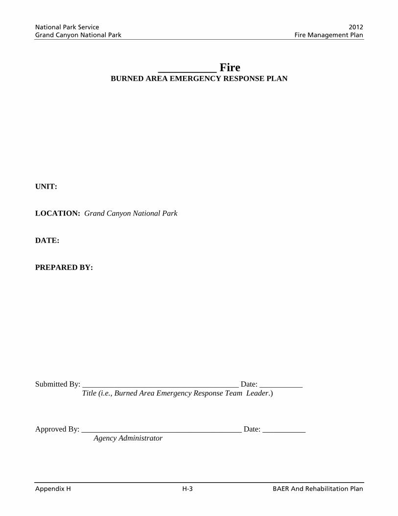
National Park Service 2012 Grand Canyon National Park Fire Management Plan
Appendix H H-3 BAER And Rehabilitation Plan
__________ Fire BURNED AREA EMERGENCY RESPONSE PLAN
UNIT: LOCATION: Grand Canyon National Park DATE: PREPARED BY:
Submitted By: ________________________________________ Date: ___________
Title (i.e., Burned Area Emergency Response Team Leader.)
Approved By: _________________________________________ Date: ___________ Agency Administrator

National Park Service 2012 Grand Canyon National Park Fire Management Plan
Appendix H H-4 BAER And Rehabilitation Plan
TABLE OF CONTENTS PART A - FIRE LOCATION AND BACKGROUND INFORMATION ........................................... 5 PART B - NATURE OF PLAN ............................................................................................................... 5 PART C - EMERGENCY STABILIZATION ASSESSMENT ........................................................... 5 PART D - TEAM ORGANIZATION, MEMBERS, AND RESOURCE ADVISORS ....................... 6 PART E - SUMMARY OF ACTIVITIES AND COSTS ...................................................................... 7 PART H - CONSULTATIONS................................................................................................................ 9 APPENDIX I - BURNED AREA ASSESSMENT REPORTS ............................................................. 9 APPENDIX II - ENVIRONMENTAL COMPLIANCE ..................................................................... 10 APPENDIX III - MAPS.......................................................................................................................... 13 APPENDIX IV - PHOTO DOCUMENTATION ................................................................................. 13 APPENDIX V - SUPPORT DOCUMENTS ......................................................................................... 13
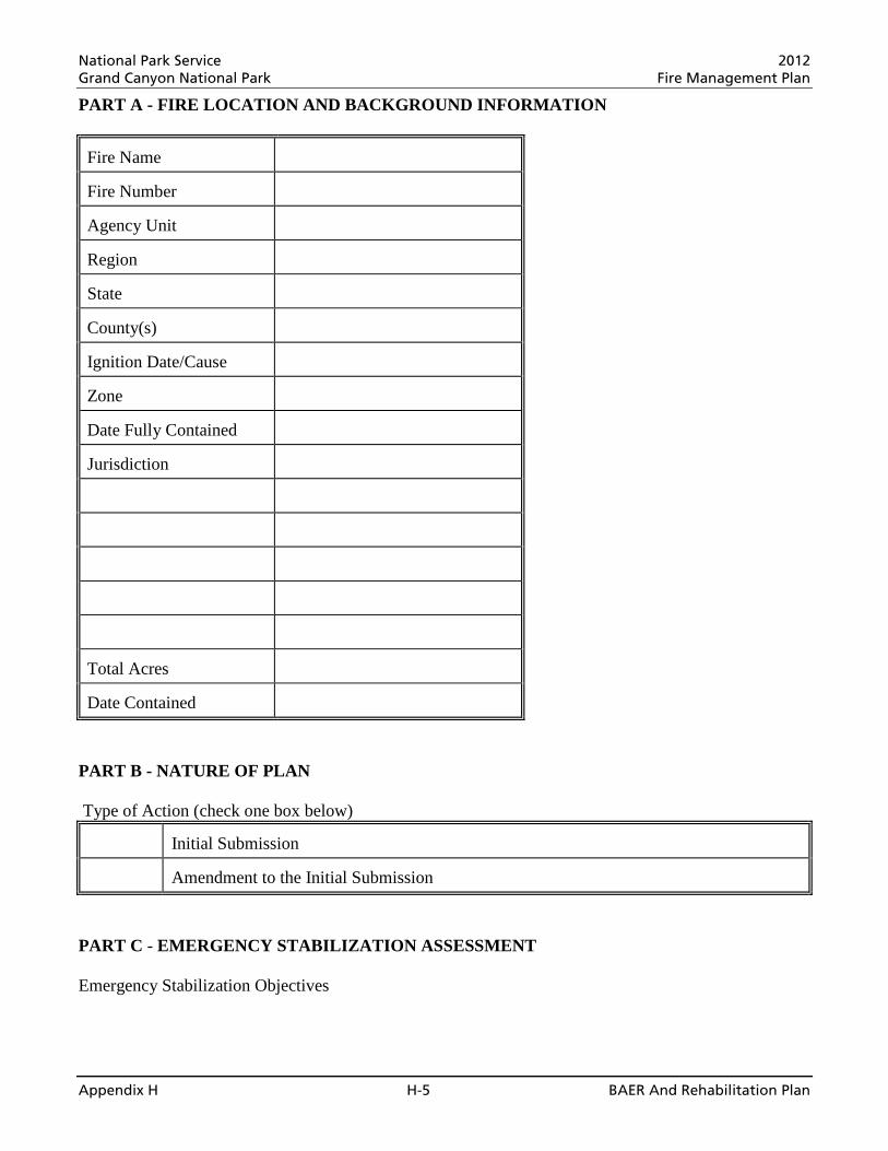
National Park Service 2012 Grand Canyon National Park Fire Management Plan
Appendix H H-5 BAER And Rehabilitation Plan
PART A - FIRE LOCATION AND BACKGROUND INFORMATION Fire Name
Fire Number
Agency Unit
Region
State
County(s)
Ignition Date/Cause
Zone
Date Fully Contained
Jurisdiction
Total Acres
Date Contained
PART B - NATURE OF PLAN Type of Action (check one box below)
Initial Submission
Amendment to the Initial Submission
PART C - EMERGENCY STABILIZATION ASSESSMENT Emergency Stabilization Objectives

National Park Service 2012 Grand Canyon National Park Fire Management Plan
Appendix H H-6 BAER And Rehabilitation Plan
PART D - TEAM ORGANIZATION, MEMBERS, AND RESOURCE ADVISORS I. Burned Area Emergency Response Team Members: (List of technical specialists used to develop the plan)
Position
Team Member (Agency)
Team Leader
Public Information
Operations
NEPA Compliance & Planning
Hydrologist
Soil Scientist
Geologist
Cultural Resources/Archeologist
Vegetation Specialist
Wildlife Biologist
GIS Specialist
Documentation/Computer Specialist
Photographer
Other Technical Specialists
III. Resource Advisors: (Note: Resource Advisors are individuals who assisted the burned area emergency response team with the preparation of the plan. See Part H for a full list of agencies and individuals who were consulted or otherwise contributed to the development of the plan.
Name
Affiliation

National Park Service 2012 Grand Canyon National Park Fire Management Plan
Appendix H H-7 BAER And Rehabilitation Plan
PART E - SUMMARY OF ACTIVITIES AND COSTS The summary of activities and cost table below identifies emergency stabilization costs charged or proposed for funding. EMERGENCY STABILIZATION ACTIVITIES COST SUMMARY TABLE
Spec #
Title
Unit
Unit Cost
# of Units
Work Agent
Cost
National Park Service 2012 Grand Canyon National Park Fire Management Plan
Appendix H H-8 BAER And Rehabilitation Plan
Spec #
Title
Unit
Unit Cost
# of Units
Work Agent
Cost
TOTAL COST
Work Agent: CA=Coop Agreement, FA=Force Account, G=Grantee, P=Permitee, SC=Service Contract, TSP=Timber Sales Purchaser, V=Volunteer
PART F - INDIVIDUAL SPECIFICATION TREATMENT/ACTIVITY NAME
PART E SPECIFICATION #
NFPORS TREATMENT CATEGORY*
FISCAL YEAR(S) (list each year):
NFPORS TREATMENT TYPE *
WUI? Y / N
IMPACTED COMMUNITIES AT RISK
IMPACTED T&E SPECIES
* See NFPORS Restoration & Rehabilitation module - Edit Treatment screen for applicable entries. WORK TO BE DONE (describe or attach exact specifications of work to be done):
Number and Describe Each Task: A. General Description: B. Location/(Suitable) Sites: C. Design/Construction Specifications: 1. 2. 3. D. Purpose of Treatment Specifications: E. Treatment Effectiveness Monitoring Proposed:
LABOR, MATERIALS AND OTHER COST:
PERSONNEL SERVICES: (Grade @ Cost/Hours X # Hours X # Fiscal Years = Cost/Item): Do not include contract personnel costs here (see contractor services below). COST / ITEM
TOTAL PERSONNEL SERVICE COST
EQUIPMENT PURCHASE, LEASE AND/OR RENT (Item @ Cost/Hour X # of Hours X #Fiscal Years = Cost/Item): Note: Purchases require written justification that demonstrates cost benefits over leasing or renting. COST / ITEM
TOTAL EQUIPMENT PURCHASE, LEASE OR RENTAL COST
MATERIALS AND SUPPLIES (Item @ Cost/Each X Quantity X #Fiscal Years = Cost/Item): COST / ITEM
TOTAL MATERIALS AND SUPPLY COST TRAVEL COST (Personnel or Equipment @ Rate X Round Trips X #Fiscal Years = Cost/Item): COST / ITEM TOTAL TRAVEL COST CONTRACT COST (Labor or Equipment @ Cost/Hour X #Hours X #Fiscal Years = Cost/Item): COST / ITEM
TOTAL CONTRACT COST

National Park Service 2012 Grand Canyon National Park Fire Management Plan
Appendix H H-9 BAER And Rehabilitation Plan
SPECIFICATION COST SUMMARY
FISCAL YEAR
PLANNED INITIATION DATE (M/D/YYYY)
PLANNED COMPLETION DATE (M/D/YYYY)
WORK AGENT UNITS UNIT
COST
PLANNED ACCOMPLISHMENTS
PLANNED COST
FY__ FY__ FY__ FY__
TOTAL Work Agent: C=Coop Agreement, F=Force Account, G=Grantee, P=Permittees, S=Service Contract, T=Timber Sales Purchaser, V=Volunteer SOURCE OF COST ESTIMATE 1. Estimate obtained from 2-3 independent contractual sources. 2. Documented cost figures from similar project work obtained from local agency sources. 3. Estimate supported by cost guides from independent sources or other federal agencies 4. Estimates based upon government wage rates and material cost. 5. No cost estimate required - cost charged to Fire Suppression Account
P = Personnel Services, E = Equipment M = Materials/Supplies, T = Travel, C = Contract, F = Suppression RELEVANT DETAILS, MAPS AND DOCUMENTATION INCLUDED IN THIS REPORT:
List Relevant Documentation and Cross-Reference Location within the Accomplishment Report.
TOTAL COST BY JURSIDICTION
JURISDICTION UNITS TREATED COST TOTAL COST
PART G - POST-EMERGENCY STABILIZATION REQUIREMENT The following are post-emergency stabilization, implementation, operation, maintenance, monitoring, and evaluation actions after three years from the control of the fire to ensure the effectiveness of initial investments. Estimated annual cost and funding source is indicated. PART H - CONSULTATIONS U.S. Fish and Wildlife Service State Historic Preservation Office Tribes APPENDIX I - BURNED AREA ASSESSMENT REPORTS • Soil & Watershed Damage Assessment Report • Vegetation Damage Assessment Report • Forest Damage Assessment Report • Wildlife Damage Assessment Report • Cultural Damage Assessment Report • Faculty Assessment Report • Etc.
National Park Service 2012 Grand Canyon National Park Fire Management Plan
Appendix H H-10 BAER And Rehabilitation Plan
FIRE RESOURCE DAMAGE ASSESSMENT REPORT I. Objectives II. Issues III. Observations
A. Background Information B. Reconnaissance Method C. Findings
IV. Recommendations A. Management (specification related) B. Specification Monitoring (specification related) C. Management (non-specification related)
V. Consultations VI. References APPENDIX II - ENVIRONMENTAL COMPLIANCE Federal, State, and Private Lands Environmental Compliance Responsibilities
All projects proposed in the Fire Burned Area Emergency Response Plan that are prescribed, funded, or implemented by Federal agencies on Federal, State, or private lands are subject to compliance with the National Environmental Policy Act (NEPA) in accordance with the guidelines provided by the Council on Environmental Quality (CEQ) Regulations (40 CFR 1500-1508); Department of the Interior and. This Appendix documents the burned area emergency response team considerations of NEPA compliance requirements for prescribed emergency stabilization and monitoring actions described in this plan for all jurisdictions affected by the _________ Fire. Related Plans and Cumulative Impact Analysis
________ Fire Burned Area Emergency Response Plan (approval date). The _________ Fire Burned Area Emergency Response Plan was reviewed and it was determined that actions proposed in the ________ Fire Burned Area Emergency Response Plan within the boundary of the _________ Fire are consistent with the management objectives established in the Comprehensive Conservation Plan. The Comprehensive Conservation Plan NEPA compliance process specifically addresses: $ List specific issues (Duplicate for all plans reviewed) Cumulative Impact Analysis Cumulative effects are the environmental impacts resulting from the incremental impacts of a proposed action when added to other past, present, and reasonably foreseeable future actions, both Federal and non-Federal. Cumulative impacts can result from individually minor, but collectively significant actions taking place over a period of time. The emergency stabilization treatments for areas affected by the _________ Fire, as proposed in the _________ Fire Burned Area Emergency Response Plan, do not result in an intensity of impact (i.e. major ground disturbance, etc.) that would cumulatively constitute a

National Park Service 2012 Grand Canyon National Park Fire Management Plan
Appendix H H-11 BAER And Rehabilitation Plan
significant impact on the quality of the environment. The treatments are consistent with the above jurisdictional management plans and associated environmental compliance documents and categorical exclusions listed below. Applicable and Relevant Categorical Exclusions The individual actions proposed in this plan for ________ are Categorically Excluded from further environmental analysis as provided for in the specify relevant departmental and agency Categorical Exclusions. All applicable and relevant Department and Agency Categorical Exclusions are listed below. Categorical Exclusion decisions were made with consideration given to the results of required emergency consultations completed by the Burned area emergency response team and documented below. Applicable Department Categorical Exclusions List Applicable ZZZZZ Categorical Exclusions List Statement of Compliance for the __________ Fire Burned Area Emergency Response Plan. This section documents consideration given to the requirements of specific environmental laws in the development of the _________ Fire Burned Area Emergency Response Plan. Specific consultations initiated or completed during development and implementation of this plan are also documented. The following executive orders and legislative acts have been reviewed as they apply to the ________ Fire Burned Area Emergency Response Plan: • National Historic Preservation Art (NHPA). • Executive Order ll988. Floodplain Management. • Executive Order 11990. Protection of Wetlands. • Executive Order 12372. Intergovernmental Review. • Executive Order 12892. Federal Actions to Address Environmental Justice in Minority and Low-
income Populations. • Endangered Species Act. • Secretarial Order 3127. Federal Contaminated • Clean Water Act. • Clean Air Act. CONSULTATIONS
• List partners and neighbors consulted

National Park Service 2012 Grand Canyon National Park Fire Management Plan
Appendix H H-12 BAER And Rehabilitation Plan
NEPA Checklist: If any of the following exception applies, the Burned Area Emergency Response Plan cannot be Categorically Excluded and an Environmental Assessment (EA) is required. (Yes) (No) ( ) ( ) Adversely affect Public Health and Safety ( ) ( ) Adversely affect historic or cultural resources, wilderness, wild and scenic rivers aquifers,
prime farmlands, wetlands, floodplains, ecologically critical areas, or Natural Landmarks. ( ) ( ) Have highly controversial environmental effects. ( ) ( ) Have highly uncertain environmental effects or involve unique or unknown environmental
risks. ( ) ( ) Establish a precedent resulting in significant environmental effects. ( ) ( ) Relates to other actions with individually insignificant but cumulatively significant
environmental effects. ( ) ( ) Adversely effects properties listed or eligible for listing in the National Register of Historic
Places ( ) ( ) Adversely affect a species listed or proposed to be listed as Threatened or Endangered. ( ) ( ) Threaten to violate any laws or requirements imposed for the "protection of the environment"
such as Executive Order 1 1 988 (Floodplain Management) or Executive Order 1 1 990 (Protection of Wetlands).
National Historic Preservation Act Ground Disturbance: ( ) None ( ) Ground disturbance did occur and an archeologist survey, required under section 110 of the
NHPA will be prepared. A report will be prepared under contract as specified by the Burned Area Emergency Response Plan.
A NHPA Clearance Form: ( ) Is required because the project may have affected a site that is eligible or on the national register.
The clearance form is attached. SHPO has been consulted under Section 106 (see Cultural Resource Assessment, Appendix I).
( ) Is not required because the Burned Area Emergency Response Plan has no potential to affect cultural resources (initial of cultural resource specialist).
Other Requirements (Yes) (No) ( ) ( ) Does the Burned Area Emergency Response Plan have potential to affect any Native
American uses? If so, consultation with affiliated tribes is needed. ( ) ( ) Are any toxic chemicals, including pesticides or treated wood, proposed for use? If so,
local agency integrated pest management specialists must be consulted. I have reviewed the proposals in the _________ Fire Burned Area Emergency Response Plan in accordance with the criteria above and have determined that the proposed actions would not involve any significant environmental effect. Therefore it is categorically excluded from further environmental (NEPA) review and documentation. Burned area emergency response team technical specialists have completed necessary coordination and consultation to insure compliance with the National Historic

National Park Service 2012 Grand Canyon National Park Fire Management Plan
Appendix H H-13 BAER And Rehabilitation Plan
Preservation Act, Endangered Species Act, Clean Water Act and other Federal, State and local environment review requirements. Burned Area Emergency Response Team Environmental Protection Specialist Date Project Leader, XXXXX Date APPENDIX III - MAPS • Fire Perimeter • Jurisdiction Map • Suppression Impacts • Soils • Burn Severity • Vegetation Communities • Vegetation Mortality • Threatened and Endangered Species Areas • Invasive Species • Wind Erosion Risk Map APPENDIX IV - PHOTO DOCUMENTATION APPENDIX V - SUPPORT DOCUMENTS


National Park Service 2012 Grand Canyon National Park Fire Management Plan
Appendix I I-1 Serious Injury or Death Procedure
APPENDIX I SERIOUS INJURY OR DEATH PROCEDURE Grand Canyon National Park’s Fire and Aviation program works on high risk projects that could result in firefighter injury or a fatality. All safety guidelines, like the 10 standard fire orders and LCES (Lookouts - Communications - Escape Routes - Safety Zones), will be followed on all fires and projects, but accidents may still occur. This plan will help address the communication process in the event of a serious injury or death on a fire or project. This plan was created to assist fire managers and supervisors when an employee dies on the job or is seriously injured on the job. The plan consists of three elements: definitions, responsibilities of each involved in or with the accident/fatality, and step-by-step procedures which must be followed by management personnel.
Definitions Serious Accident/Injury
• An unplanned event or series of events that resulted in death, injury, occupational illness, or damage to or loss of equipment or property.
• For wildland fire operations, a serious accident/injury involves any of the following: • One or more fatalities. • Three or more personnel who are in-patient hospitalized as a direct result of or in
support of wildland fire operations. • Property or equipment damage of $250,000 or more. • Consequences that the Designated Agency Safety and Health Official (DASHO)
judges to warrant Serious Accident Investigation. (For wildland fire related serious accidents the NPS DASHO is the Division Chief, Fire and Aviation Management.)
Responsibilities Incident Commander/Project Leader
The Incident Commander or Project Leader has the overall responsibility for securing the accident/injury/fatality site and notifying the Fire Management Officer and Chief Ranger. Search and Rescue shift will be notified through park dispatch with a request for the ranger staff to assume control of the incident.
Search and Rescue (SAR) Shift
The lead SAR shift ranger will assume control of the incident from the Incident Commander or Project Leader, and be responsible to keep the site secure as well as transport the injured or deceased.
Fire Management Officer
The Grand Canyon Fire Management Officer will notify the Intermountain Region Fire Management Officer, the Wildland Fire Safety and Prevention Specialist at Fire Management Program Center in Boise, ID, and the park Superintendent. The Fire Management Officer will appoint a family liaison and prepare to deal with all administrative needs. The Fire Management Officer will also support information and communication needs.
National Park Service 2012 Grand Canyon National Park Fire Management Plan
Appendix I I-2 Serious Injury or Death Procedure
Chief Ranger For a wildland fire related serious accident, the Chief Ranger will contact the Wildland Fire Safety and Prevention Specialist at the Fire Management Program Center in Boise to order a Serious Accident Investigation Team (SAIT). The Wildland Fire Safety and Prevention Specialist will prepare a delegation of authority for the team from the DASHO. The Chief Ranger will prepare for the incoming SAIT and make Grand Canyon staff available to assist with any related investigations. The Chief Ranger will also order qualified personnel to provide Critical Incident Stress Management. Further information regarding serious incident notification can be found on the NPS Law Enforcement, Security, and Emergency Services web page on Inside NPS. Non-wildland fire serious incidents may also be reported by calling the NPS EICC at 540-999-3412 or 888-246-4335, or by emailing [email protected].
Initial Response Step-by-Step Procedures
1. Secure the scene.
2. Stabilize injured employees.
3. Account for all other employees.
4. Call park Dispatch and mobilize SAR shift to take control of the incident.
5. Secure the casualty site so no evidence is disturbed.
6. Notify the Fire Management Officer.
7. Notify the Chief Ranger.
8. Assist SAR shift rangers with extrication of injured or deceased.
9. Gather and document incident information (who, when, what, where).
10. Assist SAR shift rangers with securing and protecting the scene of the incident.
11. Notify park Superintendent.
12. Notify Intermountain Region Fire Staff and FMPC Safety Staff.
13. Notify park Safety Officer, Public Affairs Officer, Human Resources Officer.
14. Appoint a family liaison.
15. Mobilize Critical Incident Stress Debrief staff.
16. Mobilize a SAIT team.
17. Notify the Shenandoah ICC at 540-999-3422 so that Shenandoah ICC can make notification to the DOI Emergency reporting system 877-246-1373 and the NPS DASHO 202-513-7218.
18. Notify appropriate Occupational Safety & Health Administration Area (OSHA) Office directly by dialing OSHA hotline 800-321-6742 .
19. Start the administrative process.

National Park Service 2012 Grand Canyon National Park Fire Management Plan
Appendix I I-3 Serious Injury or Death Procedure
References NWCG PMS 926, Agency Administrator’s Guide to Critical Incident Management, July 2008 www.nwcg.gov/pms/pubs/pms926.doc Area Command / Incident Commanders – Information Officer Break Out, March 10, 2010 - Critical Incident Communication Plans /Dutch Creek. Bureau of Land Management Employee Casualty Guide for Managers and Supervisors www.blm.gov/nhp/efoia/nhrmc/2000/IB/HRIB2000-108.pdf Bureau of Land Management CSO, Serious Injury or Fatality Response Plan, Branch of Fire and Aviation. August 1, 2009. National Park Service. Occupational Safety and Health Program. Reference Manual 50B. September 2008. www.nps.gov/policy/RM50Bdoclist.htm

National Park Service 2012 Grand Canyon National Park Fire Management Plan
Appendix J J-1 Mitigation Measures
APPENDIX J MITIGATION MEASURES
Mitigation measures were created during the development of the 2010 Fire Management Plan Final Environmental Impact Statement and Assessment of Effect to meet the plan’s goals and objectives and reduce impacts to social, cultural, and natural resources. All of the mitigation measures have been collected into a Letter of Authorization and each mitigation measure has been assigned to a responsible party. The attached Letter of Authorization lists all of the mitigation measures and shows the responsible party that must ensure that the mitigation measure is followed. The Letter of Authorization is attached to this appendix.
National Park Service U.S. Department of the Interior
Grand Canyon NP Office of Planning and Compliance
Date: 6/10/2010
Letter of Authorization To: Bill Wright, Chief, Visitor and Resource Protection Martha Hahn, Chief, Science and Resource Management
Through: Mary Killeen, Chief, Office of Planning and Compliance
From: Jill Beshears, Environmental Protection Specialist, Office of Planning and Compliance
Subject: NEPA and Section 106 Clearance: Fire Management Plan (PEPC: 10959)
The Office of Planning and Compliance has reviewed the proposed project/action and completed its environmental assessment through a Record of Decision for the Final Environmental Impact Statement, Biological Opinion (Section 7) and Programmatic Agreement (Section 106) documentation.
The proposed project therefore, is now cleared for all NEPA and Section 106 compliance requirements.
Individual burn plan reviews shall continue based on agreements between the fire program, Office of Planning and Compliance and the Superintendent’s Office.
The monitoring and implementation plan for the Fire Management Plan shall be completed and included on the fire management website as well as forwarded to Office of Planning and Compliance to be included on the Planning Environment and Public Comment (PEPC) website.
For the proposed project actions to be within compliance requirements during project implementation, the following mitigations must be implemented. As the project leader, it will be your responsibility to ensure that these mitigation measures are followed and that these measures are incorporated into any contracts for this project. Mitigation measures shall not be cut due to budget or time constraints without further review. If, for any reason, mitigations measures cannot be accomplished you must contact the Office of Planning and Compliance before proceeding with the project. The parties identified in this letter include the Superintendent (SUPT), Public Affairs Officer (PAO), Office of Planning and Compliance (OPAC), Fire and Aviation (F), Visitor and Resource Protection (VRP), Science and Resource Management (SRM), and Interpretation (INTERP). Vegetation Invasive Species Mitigating Measures/Monitoring The Exotic Plant Management Plan (Finding of No Significant Impact, July 2009) provides a framework for implementing prevention, early detection and rapid response, control, education, research and restoration activities for invasive species on park lands. The Fire Management Program can contribute to prevention and control of invasive species in the following ways
• Locate control lines, helispots, fire camps, and other soil-disturbing fire management activities to minimize damage to biological resources (F)
• Inspect helispots, staging areas, incident command posts/base camps, etc., periodically, to minimize exotic species introduction (F)
• Use Minimum Impact Suppression Techniques to reduce disturbances to soil and vegetation (F)

• Clean fire vehicles, equipment, and clothing in compliance with parkwide policy as determined by the Exotic Plant Management Plan (F)
• Procure certified weed-seed-free mulching materials and native plant seed used in fire rehabilitation operations (F/SRM)
Vegetation Special Status Plant Species Mitigating Measures/Monitoring • Locate control lines, helispots, fire camps, and other soil-disturbing fire management activities to
minimize damage to biological resources (F) • Protect aquatic habitat, riparian and wetland areas, meadows, and other sensitive resource areas by
defining and avoiding these areas (F) • Establish trigger points (geographic locations that, when reached by fire, trigger an action to mitigate)
if sensitive biological areas are located in Maximum Manageable Areas (MMA) that require some mitigation during wildland fire use fires. Implement mitigation plans when fire reaches the trigger point (F/SRM)
• Rehabilitate affected sites (control lines, staging areas, and helispots) as soon as possible after disturbance. Develop Burned Area Emergency Response (BAER) plans as appropriate (F/SRM)
• Assist with implementing the Exotic Plant Management Plan (Finding of No Significant Impact, July 2009). This plan provides a framework for implementing prevention, early detection and rapid response, control, education, research, and restoration activities for invasive species found on park lands (F/SRM)
• Inspect helispots, staging areas, incident command posts/base camps, etc., periodically and minimize exotic species introduction (F)
• Use Minimum Impact Suppression Techniques to reduce disturbances to soil and vegetation (F) • Clean fire vehicles, equipment, and clothing in compliance with parkwide policy (F) • Procure certified weed-seed-free mulching materials and native plant seed used in fire rehabilitation
operations (F/SRM) • Prohibit prescribed fires and fire-related activities from encroaching on any known sentry milk-vetch
(Astragalus cremnophylax var. cremnophylax) population (F/SRM) • Evaluate potential for fire to enter sentry milk-vetch habitat in unsurveyed areas of potential habitat,
defined in U.S. Fish Wildlife Service (USFWS) 2006 Sentry Milk-vetch Recovery Plan (SRM) Vegetation Exotic Plant Species Mitigating Measures/Monitoring • Locate control lines, helispots, fire camps, and other soil-disturbing fire management activities to
minimize damage to biological resources (F) • Rehabilitate affected sites (e.g., control lines, staging areas, and helispots) as soon as possible
following disturbance. Develop BAER plans as appropriate (F/SRM) • Inspect helispots, staging areas, incident command posts/base camps, etc., periodically and minimize
exotic species introduction (F) • Use Minimum Impact Suppression Techniques to reduce disturbances to soil and vegetation (F) • Clean fire vehicles, equipment, and clothing in compliance with parkwide policy (F) • Procure certified weed-seed-free mulching materials and native plant seed used in fire rehabilitation
(F/SRM) • Ensure the GRCA Exotic Plant Management Program and Fire Management Program work together to
prevent and/or manage invasive exotic plant populations efficiently and effectively. Where implementation of these programs overlap, track dates and dual treatment prescriptions (e.g. hand pull and prescribed burn), and map locations (F/SRM)
In addition to these specific mitigation measures, Fire and Vegetation Program staff will develop a phased approach to address species known to have large ecological effects (such as cheatgrass [Bromus tectorum] and other brome species), but are difficult to manage due to widespread park distribution. Park managers are directed to focus management actions on those species that could pose substantial impacts to park resources, that can reasonably be expected to be successfully controlled, and for which undertaking the action is prudent and feasible. Cheatgrass is currently listed as low priority for direct management action because treatment feasibility of this and other brome species across the entire park is low. However, due

to concerns about potential effects of this species on ecosystem integrity, fire and Vegetation Programs are initiating proactive steps to minimize factors that would contribute to future expansion of this species. During 2010, staff will develop a map layer using Geographic Information System (GIS) (datum NAD83) that displays current cheatgrass distribution based on recent vegetation work, and which will be considered baseline distribution. The most up-to-date cheatgrass distribution information will be obtained using 1,502 vegetation plots and 696 observation points installed as part of the 2007 vegetation mapping project, and data from the park’s 148 fire monitoring plots, and research collaborations. In addition, fire ecology program staff will analyze existing data from fire effects monitoring plots to determine whether cheatgrass distribution or abundance changed pre- and post-fire measurement. This strategy will provide an overall landscape assessment. After preliminary data are compiled, Fire and Vegetation Program staff will work to compare each vegetation type’s current conditions to desired future conditions. Staff will set a threshold for invasive species composition pre-burn represented as percent cover of individual species, with focus on the highest priority species that pose a significant threat to ecosystems, such as cheatgrass. If preliminary data suggest threshold value has been reached, management actions may be taken to reduce highest-priority species cover prior to burning, and to continue treating the species after the burn. Fire Monitoring Program staff will continue to provide information on invasive species, including cheatgrass, to Vegetation Management Program staff through landscape-scale fire monitoring plots; however, monitoring specific burn units to quantify invasive species is not currently planned. Fire and Vegetation Program staff will seek research funds to answer specific questions relating to invasive species management (e.g. does burn severity determine how and to what extent invasive plants enter and persist?). An adaptive management process will determine whether invasive plant control strategies, burn strategies (such as burn season), monitoring protocols, and/or threshold values should be adjusted to achieve desired results. To fully implement this program beyond the evaluation phase, additional resources and compliance will be necessary because extensive cheatgrass control actions are not included in the Vegetation Program’s current budget, and Fire Program monitoring funds are limited. • Collect exotic plant data. Data will be user-friendly and available to managers to track growth or
reduction of exotic plant populations before and after fuel or fire treatment and/or incident (F/SRM) • Consider mechanical treatment work during winter plant dormant season and/or times when snow
pack will minimize impacts to soil and vegetation (F) • Use qualified personnel to periodically inspect, map or document, and remove exotic plants from
treatment areas, slash loading sites, and/or skid trails created and/or disturbed by mechanical equipment during treatment. If removal is not feasible, at a minimum work with GRCA Vegetation Program staff to document and map extent of exotic species encroachment (F/SRM)
Wildlife Mitigating Measures/Monitoring • Manage fire incidents using natural barriers to fire spread when safe and feasible (F) • Employ Minimum Impact Suppression Techniques in fire management techniques (F) • Protect aquatic habitat, riparian and wetland areas, meadows, and other sensitive resource areas
during suppression fires by defining and avoiding these areas (F) • Restrict fire retardant use during fire management operations where possible (F) • Retain snags, particularly large snags (over 24 inches dbh), to provide wildlife habitat. Generally,
snags will not be cut during fire management activities unless they present a threat to human life, safety, property, or a valued resource (F)
• Lop and scatter debris from cut vegetation (slash) to a depth of no more than 12 inches and burn during subsequent prescribed fire, or pile and burn (F)
• During prescribed burning, drip torch fuel will not be applied directly to large, down, woody debris greater than ten inches diameter (F)
• Establish trigger points (geographic locations that, if reached by fire, trigger action to mitigate) if sensitive biological areas are located in MMA that require some mitigation during wildland fire-use fires. Implement mitigation plans when fire reaches trigger points (F/SRM)

• Rehabilitate disturbed sites (control lines, staging areas, and helispots) where and when safe to do so, by pulling soil, duff, litter, woody debris, and rocks back onto the line to bring it up to grade and blend with the surrounding area (F)
• Practice best management practices for smoke mitigation and emission reduction techniques to reduce health risks and visibility impacts to Class I airshed (F)
• Implement best management practices for exotic species spread reduction and control during fire management operations (F)
• Use resource advisors on fire management projects and incidents (F/SRM) • Use resource specialists in preparation of contract fire management activities (scope of work,
mitigation measures) as well as contract work implementation on the ground (F/SRM) • Implement management response strategies to affect least disturbance possible in known occupied
territories during breeding season (F/SRM) • Assess the amount of moderate/high and high severity fire through composite burn index monitoring
after each managed fire in the mixed-conifer vegetation type above the rim. Use the adaptive management process to adjust burn prescription, ignition pattern, burn seasonality, and/or pre-treatment to ensure no more than 30% of the mixed-conifer vegetation type and Mexican spotted owl mixed-conifer restricted habitat burns with moderate/high and high severity. This includes high and moderate/high fire severity from past fires (2000 to present) (FEIS Table 4-15a), and all fires that will occur within the scope of this planning document (F)
• When burning in the mixed-conifer vegetation type, fire prescriptions or objectives should create a mosaic of openings spread through this vegetation type (F)
Wildlife Special Status Wildlife Species Mitigating Measures/Monitoring • Manage fire incidents using natural barriers to fire spread when safe and feasible (F) • Employ Minimum Impact Suppression Techniques in fire management techniques (F) • Protect aquatic habitat, riparian, and wetland areas, meadows, and other sensitive resource areas
during suppression fires by defining and avoiding these areas (F) • Restrict fire retardant use during fire management operations where possible (F) • Retain snags, particularly large snags (over 24 inches dbh), to provide wildlife habitat. Generally,
snags will not be cut during fire management activities unless they present a threat to human life, safety, property, or a valued resource (F)
• Lop and scatter debris from cut vegetation (slash) to a depth of no more than 12 inches and burn during a subsequent prescribed fire, or pile and burn (F)
• During prescribed burning, drip torch fuel will not be applied directly to large, down, woody debris greater than ten inches diameter (F)
• Establish trigger points (geographic locations that, if reached by fire, trigger action to mitigate) if sensitive biological areas are located in MMA that require some mitigation during wildland fire-use fires. Implement mitigation plans when fire reaches trigger points (F/SRM)
• Rehabilitate disturbed sites (control lines, staging areas, and helispots) where and when safe to do so by pulling soil, duff, litter, woody debris, and rocks back onto the line to bring it up to grade and blend with the surrounding area (F)
• Implement best management practices for smoke mitigation and emission reduction techniques to reduce health risks and visibility impacts to Class I airshed (F)
• Implement best management practices for exotic species spread reduction and control during fire management operations (F)
• Use resource advisors on fire management projects and incidents (F/SRM) • Use resource advisors in preparation of contract fire management activities (scope of work,
mitigation measures) as well as implementation of contract work on the ground (F/SRM) • Implement management response strategies to affect the least disturbance possible in known
occupied territories during breeding season (F/SRM) Wildlife Special Status Wildlife Species Mitigating Measures/Monitoring MSO and MSO Critical Habitat Mitigation Measures GRCA will be seeking relief from the U.S. Fish and Wildlife Service on MSO survey requirements. If relief is granted, survey requirements listed in the following mitigation measures would not occur.

• To the maximum extent possible, aircraft will remain at least 1,200 feet (400 meters) from the boundary of any designated Protected Area Center (PAC) (F)
• Locate areas associated with fire related activities, such as dip sites or drop points, at least 437 yards (400 meters) from the boundary of any designated PAC (F)
• Notify a GRCA Wildlife Biologist or Resource Advisor if MSO are discovered during any projects (F) • Survey known PACs that can be surveyed from the rim, and adjacent to prescribed fire or active fire-
use areas (SRM) • Survey all MSO habitats within 0.5 miles of project perimeters prior to project implementation in
accordance with formal MSO Survey Protocol (SRM) • Inform all field personnel who implement any portion of the proposed action about MSO regulations
and protective measures. A wildlife biologist will present a program regarding fire management in Threatened and Endangered Species habitat to all personnel involved in the fire use program (SRM)
• Advise the Resource Advisor immediately if a MSO is encountered during any project. The Resource Advisor will maintain a record of MSO encountered during suppression activity and will include location, date, time of observation, and general condition of each owl (SRM)
• Consult GRCA Wildlife Biologists early in the decision-making process for prescribed, wildland fire-use and suppression fires (F)
• Adhere to recommendations in September 2, 1997, USFWS memorandum, Clarification of Recommendations in the Recovery Plan for Mexican Spotted Owl in Regard to Prescribed Natural Fire (F/SRM)
• Ensure all pertinent information from the reasonable and prudent measures from the Biological Opinion issued by the USFWS for the proposed FMP is included in Wildland Fire Implementation Plan for all wildland fire-use actions (SRM)
• Document all actions, report incidental take, and monitor effects of proposed action on habitat. Report findings to USFWS (SRM)
• Ensure, to the extent funding allows, sufficient monitoring of fire effects on key MSO-habitat components is conducted after each wildland fire-use event. Monitoring may require additional plots beyond those previously established for the existing fire effects program. Intent is to adequately determine event effects on key habitat components (F/SRM)
• Integrate data from reports to USFWS on fire activity, into adaptive management processes (F/SRM) • Minimize cutting of trees and snags larger than 18 inches dbh, and no trees or snags larger than 24
inches dbh will be cut unless absolutely necessary for safety reasons(F) The following mitigations measures are a result of the Final Biological Opinion (received November 10, 2009) with the U.S. Fish and Wildlife Service • Minimize effects to MSO PACs (F) • Ensure no more than one PAC is affected to the extent described in the Final Biological Opinion (in
the Amount and Extent of Take section) for the life of the program (F) • Where physically practicable, and in a manner that does not compromise human safety in any way,
delineate and keep wildland fire and suppression activities out of 100-acre core areas for any PAC affected by wildland fire or suppression activities (F)
• All fire actions in and near (within 0.5 mile) PACs will occur, to the maximum extent possible, using minimum impact suppression methods (F)
• Areas of disturbance created for fire actions will be located outside MSO PACs, whenever possible (F) • Personnel education/information programs and well-defined operational procedures will be
implemented (F/SRM) • All field personnel will be informed that intentional killing, disturbance, or harassment of threatened
species is a violation of the Endangered Species Act and could result in prosecution. A wildlife biologist will present a program regarding fire management in threatened and endangered species habitat to all Fire Program personnel (SRM)
• Review, with fire and natural resources staff, actions after each year of activity and prior to the next MSO breeding season. Review will take into account prior effects of fire activities in the project area (F/SRM)

• Ensure all pertinent information from reasonable and prudent measures of the Final Biological Opinion are included in burn or treatment plans for all fire management actions and in wildfire suppression decision documents (F/SRM)
• Coordinate with USFWS’s Flagstaff office during decision process for wildland fire management and suppression actions in MSO habitat (OPAC)
• Fire activities will be carried out in a manner to reduce potential for MSO take through habitat loss outside of PACs (F)
• A Resource Advisor will be available for all fire activities associated with MSO habitat. Resource Advisors will be provided adequate information from qualified park biologists with knowledge of MSO and its habitat. The Resource Advisor will possess maps of all MSO habitat and PACs in the project area. GRCA Section 7 Coordinator will coordinate MSO concerns and serve as advisor to the Incident Commander/Incident Management Team. The Resource Advisor will be on the ground and report to the Section 7 Coordinator and park biologist, who will report to the USFWS. The Section 7 Coordinator and/or park biologist will be responsible for coordination with the USFWS Flagstaff Suboffice and will monitor fire management and suppression activities to ensure protective measures endorsed by the Incident Commander/Incident Management Team are implemented (F/SRM)
• MSO habitat disturbed during fire suppression activities associated with fire actions such as fire lines, crew camps, and staging areas, will be rehabilitated, including obliteration of fire lines to reduce erosion, protect disturbed areas from invasive species, and to prevent their use by vehicles or hikers. Such rehabilitation/obliteration will be inspected as necessary following the event to ensure effectiveness (F)
• To ensure all MSO habitats have been correctly identified in the project area, the park will work with the USFWS Flagstaff office to closely re-examine all available data regarding MSO habitat extent in the project area. Any MSO habitat not previously identified will be added to MSO habitat databases and maps so it can be managed appropriately. This re-examination (and any necessary re-adjustment) will be led by knowledgeable and qualified personnel (F/SRM/OPAC)
• Document all actions, report incidental take and owl occurrences, and monitor effects of proposed action on MSO habitat. Findings will be reported to USFWS by January 31 each year and will, with USFWS involvement, be incorporated into the adaptive management program (F/SRM/OPAC)
• If a MSO is encountered during the fire, the Resource Advisor will be advised immediately. The Resource Advisor will assess potential harm to the owl and advise the Incident Commander /Incident Management Team of methods to prevent harm. The Resource Advisor will maintain a record of any MSO encountered during suppression activities. Information will include (for each owl) the location, date, and time of observation and general condition of the owl (F/SRM)
• By January 31 of each year, the park will submit a report to USFWS detailing that calendar year's actions. Report will document areas and acreage burned, fire type (prescribed fire, wildland fire-use, wildfire), name(s) of any PAC(s) subjected to fire activity, MSO habitat amount subjected to fire activity, extent of fire actions, prescriptions applied to the action, extent of effects to MSO key habitat components and Primary Constituent Elements of critical habitat, photographs depicting effects, implementation and effectiveness of terms and conditions of the biological opinion, information about MSO monitored or encountered, any rehabilitation completed, quantification of any incidental take as defined in the biological opinion, and any recommendations for actions in upcoming year(s). A map will include each fire event that occurred. GRCA will keep and maintain a map depicting cumulative fire information for the project area (F/SRM/OPAC)
• By March 1 of each year, prior to any implementation of prescribed or wildland fire use that year, GRCA will meet with the USFWS Flagstaff office to review the annual report and discuss the upcoming year's plans relative to the previous year's actions and cumulative actions. If the observed proportion of fire events in high to moderate-to-high severity categories are greater than that expected in the Effects of the Action section of the biological opinion, prescriptions will be adjusted to ensure fire severity of future events is reduced (OPAC)
• Continue monitoring existing MSO PACs (SRM) • Ensure sufficient monitoring of effects of fire on key habitat components of MSO habitat and primary
constituent elements of MSO critical habitat is conducted after each fire event. Such monitoring may require additional plots beyond those previously established for the existing fire effects program.

Intent of monitoring is to determine effects of the fire event on the key habitat components of MSO habitat and primary constituent elements of critical habitat (F)
• Conduct fire severity monitoring in MSO restricted habitat as soon as possible after each fire event to ensure the most accurate classification of burn severity is applied to the fire (F)
• Work with USFWS to develop and fund a research project to study foraging, dispersal, and other habitat use of MSO on the Kaibab Plateau (SRM)
Wildlife Special Status Wildlife Species Mitigating Measures/Monitoring California Condor and Habitat Mitigation Measures • Cover all water dip tanks when not in use (F) • Keep camp areas free of trash (F) • Provide all fire personnel literature or instruction regarding condor concerns (SRM) • Record and report immediately any condor presence in the project area to the Resource Advisor or a
GRCA wildlife biologist (F/SRM) • Avoid any condors that arrive at any area of human activity associated with fire management
activities. Notify assigned Resource Advisor or a GRCA wildlife biologist; only permitted personnel will haze birds from the area (F/SRM)
• Survey any fire-retardant chemical application areas to the extent possible and remove contaminated carcasses before they become condor food sources (F/SRM)
• Minimize aircraft use along the rim to the greatest extent possible (F) • Keep aircraft at least 437 yards (400 meters) from condors in the air or on the ground unless safety
concerns override this restriction. This restriction does not apply to North Rim Helispot (F) • Aircraft will give up airspace to the extent possible if airborne condors approach aircraft, as long as
this action does not jeopardize safety (F) • Prescribed fire projects will not occur within 0.5 miles of active condor nesting sites (F) • Crews will stop activity on thinning projects if condors arrive onsite (F) The following mitigations measures are a result of the Final Biological Opinion with U.S. Fish and Wildlife Service GRCA will avoid impacting nesting condors. • Wildland fire-use projects will not occur within 0.5 mile of active condor nesting sites (February 1 to
September 30). These dates may be modified based on the most current information regarding condor nesting and coordination with the GRCA wildlife biologist and USFWS (F)
• Manage fires so smoke will not inundate condor nests. This may include delaying prescribed fire ignition and suppressing all or portions of managed fires if weather and wind conditions may result in heavy and/or persistent smoke at active condor nests (F)
• Aircraft associated with fire activities will stay at least one mile from active (February 1 to September 30) condor nest locations and vicinities except when human safety would be compromised. Dates may be modified based on the most current information regarding condor nesting and coordination with the GRCA wildlife biologist and USFWS (F)
Wildlife Special Status Wildlife Species Mitigating Measures/Monitoring Bald Eagle Habitat Mitigation Measures • A 1,200-foot (400 meter) no-flight perimeter will be established around all active roost locations
November 1 to April 1 (F) Wildlife Special Status Wildlife Species Mitigating Measures/Monitoring Northern Goshawk Species and Habitat Mitigation Measures Northern goshawk is not listed under the Endangered Species Act, but is a state species of concern. Mitigation measures for this species include • Unless previously agreed by Fire and Wildlife Program staffs, no more than 60% of the entire home
range of a northern goshawk pair may be burned by prescribed fire during a single year (F) • Surveys must be completed in potential goshawk habitat one season prior to burning (F/SRM) • In general, burn unit preparations, such as thinning and removal of dead-and-down fuels, using
chainsaws and vehicles within 0.25 miles of northern goshawk nest trees will be prohibited in active nesting areas. These activities will be allowed in known goshawk territories and potential goshawk

habitat after surveys have determined the areas are inactive or unoccupied. Such operations may be allowed in active territories if agreed to by Fire and Wildlife Program staffs (F/SRM)
• Measures to mitigate disturbance to nesting goshawks will be undertaken at the direction of the GRCA Wildlife Biologist and Fire Management staff. Allowing fire within active 40-acre nesting areas may be considered if fire can be implemented at low intensity (F/SRM)
Wildlife Special Status Wildlife Species Mitigating Measures/Monitoring MSO Habitat Mitigation Measures • Assess amount of moderate/high and high severity fire through composite burn index monitoring
after each managed fire in the mixed-conifer vegetation type above the rim. Use adaptive management process to adjust burn prescription, ignition pattern, burn seasonality, and/or pre-treatment to ensure no more than 30% of the mixed-conifer vegetation type and MSO mixed-conifer restricted habitat burns with moderate/high and high severity. This includes high and moderate/high fire severity from past fires (2000 to present) (FEIS Table 4-15a), and all fires that will occur within the scope of this planning document (F/SRM)
Cultural Resources Mitigating Measures/Monitoring • During any planned fire management activity, project area cultural resource locations will be
determined and adverse impacts avoided. Cultural resources will be identified through database and paper-record searches and field inventories or verifications. As needed, project and site-specific mitigation measures will be developed, implemented, and designed to minimize adverse impacts (SRM)
• Prior to project work, fire staff will be trained (yearly or as needed) in cultural resource identification and laws and policy regarding management and protection (SRM)
• Control lines, helispots, fire camps, staging areas, and other ground-disturbing activities will not occur in identified cultural resources (F)
• Fire will be excluded from National Register eligible fire-sensitive archeological sites or features. Exclusion measures may include line construction, site or feature fuel reduction, and application of fire shelter material, foam, or water (F)
• During aerial ignition operations, National Register eligible fire-sensitive sites will be marked to be seen from the air and avoided. Marking will be removed after implementation (F)
• Post-fire assessments will be completed for all National Register eligible fire-sensitive sites. Post-fire assessments at additional sites will be completed as needed to assess effects of high intensity fire or specific management actions (SRM)
• As needed, emergency stabilization and restoration will be implemented following BAER standards (F/SRM)
• During prescribed fire projects and wildland fire-use and suppression incidents, a cultural resource specialist may be assigned as a resource advisor to prevent adverse cultural resources impacts (F/SRM)
• During manual/mechanical thinning projects, no slash will be dragged through or piled in an archeological site, and to the greatest degree possible, no trees will be felled on archeological features or sensitive cultural sites (F)
• Manual/mechanical thinning in view of National Historic Landmark and Individually Listed Historic Buildings will be consistent with the Secretary of the Interior's 1996 Standards for Treatment of Historic Properties with Guidelines for the Treatment of Cultural Landscapes. Work in these areas will be coordinated with the Historical Architect or appropriate Cultural Resource Specialist (F/SRM)
• Manual/mechanical thinning in identified cultural landscapes will be consistent with treatment recommendations in relevant cultural landscape reports and the Secretary of the Interior's 1996 Standards for Treatment of Historic Properties with Guidelines for the Treatment of Cultural Landscapes. Work in these areas will be coordinated with a Historical Landscape Architect or appropriate cultural resource specialist (F/SRM)
• Any road and helispot maintenance activities will avoid adverse cultural resources impacts (F) • A fuel assessment and reduction program will be developed and implemented for National Register
eligible cultural resources (F/SRM)

• Fire modeling data will be included with prescribed fire plans to allow cultural resource specialists to better assess proposed project affects (F/SRM)
• Tribal consultation will be conducted yearly with affiliated tribes to determine potential effects from fire management activities on resources of concern to the tribes. Efforts will be made to ensure tribal concerns are incorporated into prescribed burn plans, and tribes are afforded ample opportunities to comment. The Branch of Fire and Aviation will initiate and coordinate consultation through the park’s Tribal Liaison (F/SRM)
• To the greatest degree possible, collaborate with interested tribes in fire projects. An example could include allowing designated tribal representatives to monitor resource effects, and pre-project access to ethnobotanical resources (F/SRM)
• A Programmatic Agreement was developed with the State Historic Preservation Officer (SHPO) in consultation with affiliated tribes and interested parties to address potential cultural resources impacts and how they can be mitigated. All planned fire management activities will comply with National Historic Preservation Act (NHPA) Section 106 and implementing regulations as defined in the terms of the signed Programmatic Agreement (F/SRM)
The following mitigations measures are a result of the Final Programmatic Agreement (PA) with the State Historic Preservation Officer (SHPO) to minimize and/or to avoid impacts to cultural resources.
• During any unplanned wildland fire activities, if available, a resource advisor (archeologist or
archaeologist technical specialist) will be assigned to all extended attacks on wildland fire. The resource advisor will brief fire personnel on the identification, distribution, and sensitivity of cultural resource sites. A resource advisor will accompany crews in the field, flag sensitive features to be avoided, help to mitigate potential impacts from logistics and operations. (F/SRM)
• In the event that eligible properties cannot be protected through avoidance or by established treatment methods, the park shall consult with SHPO on adverse effects and site specific mitigation procedures. Additionally, the park shall consult with tribes on mitigation procedures for eligible Traditional Cultural Properties. (SRM/OPAC)
• For all planned events, control lines, helispots, fire camps, staging areas, and other ground-disturbing activities will not occur in identified cultural resources. This will be implemented to the greatest degree possible for unplanned events. (F)
• As needed, emergency stabilization and restoration will be implemented following the Secretary of Interior Standard Standards and Guidelines for Archeology and Historic Preservation. (SRM)
• Manual/mechanical thinning in view of a National Historic Landmark District, Individually Listed Historic Buildings, and in identified cultural landscapes will be consistent with treatments recommended in the Secretary of the Interior's Standards. Work in these areas will be coordinated with the appropriate cultural resource specialist and will be presented in the annual work plan. (F/SRM)
• To the greatest degree possible, the park will collaborate with interested tribes in fire projects planning and implementation. Tribal consultation will be conducted yearly with affiliated tribes to determine potential effects from fire management activities on resources of concern to the tribes. Efforts will be made to ensure tribal concerns are incorporated into prescribed burn plans, and tribes are afforded ample opportunities to comment. (F/SRM)
Monitoring • Prioritize sites for monitoring, and provide monitoring reports to SHPO on an annual basis.
Monitoring allows archeologists and fire management personnel to determine the degree of success of mitigation treatments for preserving National Register eligible properties. Post-fire monitoring will minimally include fire-sensitive cultural resources receiving treatments and sites within moderate and high fire severity areas. (SRM)
• Monitor 100% of protected fire-sensitive sites following treatment to insure effectiveness of treatments and the physical removal of protection devices. Monitor a sample of sites not considered fire-sensitive in at least one project burn area annually. Monitor burns if concerns exist about protection of certain sites. (SRM)
• Incorporate the results of post-fire monitoring into program management for the long-term management of historic properties within the fire management areas. (F/SRM)
Reporting
• Pre Fire Season Project Planning - Each year, prepare a document for SHPO and Tribal information that outlines how the park plans to survey prescribed fire project areas (including areas proposed for mechanical/manual thinning), the status of associated inventories, and Assessments of Effect for the coming year. On or about March 1st of each year the NPS will provide a draft of the document and the concurring parties to this agreement have 30 days to review and comment on the document. (F/SRM)
Reports to the concurring parties (SHPO and Tribes) will include the following: 1. Description of project area, including anticipated fire activity and proposed fire
management activities; 2. Relevant historical documentation/background research/cultural resource inventories
which may include- a. The research design and inventory plan; b. The results of cultural resource inventories, including any deviation from the
research design and the reason for the changes; c. All field observations; d. Analyses and results; illustrated as appropriate with tables, charts, and
graphs; e. Evaluation of the investigation in terms of how well the needs dictated by
the planning process were served; f. Recommendations for updating the relevant historic contexts and planning
goals and priorities, and generation of new or revised information needs; g. References to related on-going or proposed treatment activities, such as
structural documentation, stabilization, etc.; and h. Information on the location of original data in the form of field notes,
photographs, and other materials.
• Post Fire Season Reports- prepare an annual report for each calendar year that describes wildland fire activity (Prescribed Fire, Wildland Fire Use, Suppression Incidents, and Thinning) and progress toward completing the terms of the PA to each of the concurring parties after the close of the fire season, with reasonable time for report writing. Each year the SHPO and the Tribes shall have the opportunity to comment on the draft annual report when it becomes available. The draft report shall be available approximately each January, the SHPO and tribes shall have 30 days to comment on the draft report. This annual report to the SHPO and Tribes will include the following (F/SRM):
1. Summary of all wildland fire activity including fire name, type, size, duration, and each location;
2. Resource advisor and archeologists' participation in wildland fire incidents; 3. Summary of protection measures employed and their effectiveness; 4. Results of any inventory during the incident and post-fire monitoring activity; 5. Schedules for completion of ongoing tasks.
• Follow the Cultural resource survey strategies outlined in Appendix A of the Programmatic
Agreement. (F/SRM) Air Quality Mitigating Measures/Monitoring Fire and smoke are natural components of GRCA ecosystems. However, determining how much wildland fire smoke is natural and how much anthropogenic (the result of human actions, including past management decisions) is not straightforward. The Western Regional Air Partnership developed guidance on making this determination (Policy for Categorizing Fire Emissions, Western Regional Air Partnership, Nov. 15, 2001, at http://wrapair.org/forums/fejf/documents/nbtt/FirePolicy.pdf) which can be summarized as • Suppression fire smoke is natural (as part of fire suppression, all practicable measures are being taken

• to reduce smoke production) • Wildland fire use fire smoke is natural (because of the natural ignition of these fires) • Prescribed fire smoke from fires used to maintain a naturally functioning ecosystem is natural • Prescribed fire smoke from fires used to restore an ecosystem is anthropogenic
While the guidelines provide a framework for differentiating natural and anthropogenic smoke, they also call for smoke management to reduce emissions from all wildland fires. A variety of measures can be taken to reduce or manage smoke produced by wildland fires. Some measures apply during the planning phase, for example, when defining the prescription window for a prescribed fire. Other measures apply during the fire itself. No single measure is applicable to all fires, but all fires can be managed using some of these measures. In preparing prescribed fire burn plans and wildland fire implementation plans, appropriate computer smoke-dispersion models will be run to predict smoke impacts at critical receptor locations. These critical receptors include population centers and developments nearby and in GRCA including Grand Canyon Village, Tusayan, Desert View, the Cross-Canyon Corridor (Kaibab and Bright Angel Trails), North Rim developed area, Kaibab Lodge, Supai, and Tuweep. • Plans for any fire that result in predicted exceedences of National Ambient Air Quality Standards or
unhealthy conditions under the Air Quality Index will be refined until such impacts are not expected at critical receptor locations. Since current models do not model nocturnal smoke drainage well, computer model outputs will be treated with caution and results interpreted in light of previous experience
• Grand Canyon staff will coordinate closely with the Interagency Smoke Coordinator regarding any burning upslope of any critical receptor site to mitigate impacts of nocturnal smoke drainage (F)
Timing can affect smoke dispersal and transport. To take advantage of windows when smoke impacts can be reduced, the following actions will be taken when appropriate • Burning ahead of cold fronts and/or precipitation, or anticipating effects of predicted precipitation to
reduce smoke production and improve dispersion when consistent with other program goals (especially safety and risk management) (F)
• Burning between March 15 and September 15 for optimal smoke dispersion, unless other project goals necessitate burns earlier or later, especially to mitigate wildlife impacts early in the year or manage wildland fire-use fires that burn into fall (F)
• Ignite prescribed fires under good-to-excellent ventilation conditions (F) • Suspend ignitions for projects that do not use mass ignition techniques under poor smoke dispersion
conditions unless continued ignition is necessary to protect human health and safety or for effective management of an ongoing fire (F)
• Complete, whenever possible, daily ignitions by 3:00 p.m. to maximize burning during optimum mid-day dispersion hours, and avoid trapping smoke in inversions or diurnal wind flow patterns (F)
Reducing fuel burned reduces smoke produced. Fuel reduction is often a primary goal of wildland fire. When consistent with program goals, these fuel reduction mitigation measures will be used when possible • Dispose of slash by methods other than burning, if feasible, including transfer of thinning slash to the
Bureau of Indian Affairs for distribution to neighboring tribes, or mulch slash for use in vegetation management and other projects (F)
• Since large logs and snags are important wildlife habitat, they will not be specifically targeted for burning. Critical snags may also be lined to prevent their burning (F)
• Burn before deciduous litter fall when possible (F) • Although fuels are often too moist to meet ecosystem goals, some prescribed fires may be conducted
before green-up to reduce available fuels, but only when consistent with project goals including minimal impact to wildlife and ethnobotanical resources (F)

The same fuel burned differently will produce different amounts of smoke. Generally, piles produce the least and smoldering the most for a given fuel amount. Consistent with program and project goals, the following mitigation measures will be taken to encourage cleaner fuel burning. • When consistent with other program goals, mass ignition techniques such as aerial ignition by
helicopter will be used to produce shorter fire duration. Aerial ignition is commonly employed for prescribed fire ignition and wildland fire-use management, and GRCA has this equipment onsite (F)
• Pile burning produces fewer emissions than broadcast burning and will be considered on thinning projects such as WUI and boundary fuel reduction where non-burning alternatives are not feasible. Piles will be constructed by hand to reduce soil content, and burning will be conducted when other smoke impacts are not present (F)
• Burning fuels with an air curtain destructor will be considered when non-burning options are not available and slash transport to the burner is practicable (such as thinning projects in developed areas and along existing roads) (F)
• Extinguishing or mopping-up of smoldering fuels can be used when a decision is made to not fully suppress a fire. However, fuel consumption is generally a goal of wildland fire in Grand Canyon, and mop-up may damage cultural resources and/or wildlife habitat (F)
• Chunking of piles and other consolidations of burning material will be used to enhance flaming and fuel consumption and minimize smoke production when consistent with other resource goals (F)
Effective communications do not reduce smoke, but help increase public acceptance of smoke impacts. In case of unhealthy conditions, prompt notification is essential to protect public health. • To aid public understanding of fire management plans and actions, park staff will ensure fire
management information is available for the public (visitors, residents, contractors, etc.) (PAO) • Provide neighboring jurisdictions (land managers, communities, and tribal governments) with
information and updates as needed before particular projects or incidents relevant to them (PAO) • Make information available to interpretive staff, guides, and others whose jobs include frequent
public contact to explain the need for fire in park ecosystems and the nature of fire and smoke management (F/PAO)
• During fire operations, disseminate public information on fire and its impacts (beneficial and adverse) (PAO)
• When notified unhealthy conditions are present, promptly notify all people in the affected area (visitors, employees, contractors, etc.). The NPS will follow the most current Environmental Protection Agency guidelines for public notification at http://airnow.gov/index.cfm?action=aqibroch.aqi#2 (PAO)
Smoke from any kind of wildland fire can adversely impact air quality. The following mitigation measures will be taken when monitoring shows such adverse impacts have reached potentially unacceptable levels • When visibility is Very Poor (daily average in the worst 10th percentile for the month) for three or
more consecutive days, fire managers should either a) take fire management actions to reduce smoke impacts or b) obtain written concurrence from park management that fire benefits to other park resources outweigh visibility impacts. Documentation for either action will be forwarded to the Interagency Smoke Coordinator and the park Air Quality Specialist (F)
• When monitoring in sensitive receptor sites indicates the Air Quality Index is 100 or more (Unhealthy to Sensitive Individuals), when notified begin immediate notification of people in the affected area (FEIS Table 4-38). Fire managers should also begin assessing options to reduce smoke production and implementing actions as soon as practicable (F/SRM/PAO)
• When monitoring in sensitive receptor sites indicates the Air Quality Index is 150 or more (Unhealthy), protection of public health will become park management’s highest priority (FEIS Table 4.54). Public notification in the affected area will be immediate and aggressive. Area closures may be made by the Superintendent, and smoke production from contributing fires should be reduced as quickly as possible (F/SRM/PAO)
Soils and Watersheds Mitigating Measures/Monitoring • Locate control lines, helispots, fire camps, and other soil-disturbing fire management activities to
minimize damage to biological resources (F)

• Protect aquatic habitat, riparian and wetland areas, meadows, and other sensitive resource areas by defining and avoiding these areas, especially with wheeled vehicles and fire retardant application. Water drops are preferred over fire retardant under all circumstances except for protection of life and safety. Avoidance zones will be identified in fire planning documents and maps, and may be flagged on the ground if deemed necessary by resource advisors or management staff (F)
• Rehabilitate affected sites (e.g., control lines, staging areas, helispots) as soon as possible following disturbance. Develop BAER plans as appropriate (F/SRM)
• Monitor wildland fires to provide information necessary for adaptive management. Efforts will include monitoring fire behavior while fires are ongoing and providing feedback to fire managers. Long-term monitoring will be conducted through the existing fire effects program. Remote-sensing will monitor burn severity (F)
• Rehabilitate fire line construction according to the GRCA 2006 Resource Advisor Handbook Examples include pulling soil, duff, litter, woody debris, and rocks back onto the line to bring it up to grade and blend with the surrounding area (F)
• Instruct crews to avoid biological soil crust during fire management activities (SRM) • Prohibit non-emergency wheeled or tracked equipment off-road when moisture causes easily
compacted and rutted soils (F) • Conduct fueling and servicing only in designated areas with appropriate spill-control measures to
prevent pollutants, such as fuels and lubricants, from impacting soil and drainages (F) • Restrict foot and wheeled traffic to a minimum in burned areas (F) • Install stabilizing structures such as water bars, check dams, straw bales, wattles, or other measures
such as seed-free mulch or fine woody debris to reduce sediment transport, if sensitive areas require additional protection (F/SRM)
Soundscape Mitigating Measures/Monitoring • Incorporate best available noise abatement technology in fire-related equipment acquisition (F) • Implement best management practices to reduce noise from fire management activities and
equipment (F) Wilderness Character Mitigating Measures/Monitoring • According to DO-18, Wildland Fire Management, all fire management activities in wilderness,
including categories of designated, recommended, potential, proposed, and study area will be conducted in keeping with minimum requirement analysis protocols. The Branch of Fire and Aviation will submit for review and approval minimum requirement analysis documents regarding fire management activities including, but not limited to fuels sampling; fire effects monitoring; fire weather observation; air quality monitoring; cultural and natural resource surveys and monitoring; prescribed fire planning, preparation, and implementation; fire use; and resource rehabilitation. Use of vehicles, chainsaws, motorized pumps, aerial ignitions, and helicopter landings will be assessed on a programmatic basis under the minimum requirement decision process to reduce use to the extent possible. Programmatic documents will be reviewed annually and updated as needed (F)
• Locate control lines, helispots, fire camps, and other soil-disturbing fire management activities to minimize damage to resources (F)
• Protect aquatic habitat, riparian and wetland areas, meadows, and other sensitive resource areas by defining and avoiding these areas, especially with wheeled vehicles (F)
• Rehabilitate affected sites (e.g., control lines, staging areas, and helispots) as soon as possible following disturbance. Develop BAER plans as appropriate. (F/SRM)
• Inspect helispots, staging areas, incident command posts/base camps, etc., periodically to minimize exotic species introduction (F/SRM)
• Use Minimum Impact Suppression Techniques to minimize disturbances to soil, vegetation, and wilderness character (F)
• Clean, prior to returning from an out-of-park incident, fire vehicles, equipment, clothing in compliance with park policy (F)
• Procure certified weed-seed-free mulching materials and native plant seed for use in fire rehabilitation adhere to regulations of the Arizona Department of Environmental Quality (ADEQ) Final Forest and Range Management Burn Rule and any other provisions (if any) of permits issued for

specific burns to minimize undesirable impacts to public health, public welfare, and visibility-related values (F/SRM)
• Implement as many Emission Reduction Techniques as feasible, subject to the economic, technical, legal, and safety implications of the techniques, and burn management objectives to reduce smoke produced by prescribed fires (F)
• Implement as many smoke management techniques (as prescribed by the state in FEIS Appendix A, Attachment C) as practicable to manage smoke produced during any desired fire (F)
• Explore new technologies and methods to reduce use of mechanized/motorized tools and transport for monitoring and other onsite fire management activities. These technologies will be included in the minimum requirement process (F)
Visitor Experience Mitigating Measures/Monitoring • Close trails and roads providing access to fuel reduction projects, and wildland or prescribed fires if
projects and/or fires present unacceptably hazardous conditions to visitors, as determined by the Incident Commander or Superintendent (SUPT)
• Close portions or entire park by Superintendent’s order if any threat exists to public or firefighter safety from wildland fire or fire management activities. When and if such action occurs, adjacent agencies, neighboring communities, and authorities will be notified as soon as possible (SUPT)
• Institute smoke warning signs or roadway traffic control during fire operations as warranted at direction of the Burn Boss, Incident Commander, Safety Officer, or visitor protection representative (F/VRP)
• Adhere to regulations of the Arizona Department of Environmental Quality Final Forest and Range Management Burn Rule and any other provisions of permits issued by the Department for specific burns to minimize undesirable impacts to public health, public welfare, and visibility-related values (F)
• Implement as many Emission Reduction Techniques (as prescribed in FEIS Appendix A, Attachment C) as feasible to reduce smoke produced by prescribed fires, subject to economic, technical, legal, and safety implications of the techniques, and burn management objectives (F)
• Implement as many Smoke-Management Techniques (as prescribed in FEIS Appendix A, Attachment C) as practicable to manage smoke produced during any prescribed or wildland fire-use fire (F)
• Rehabilitate affected sites (e.g., control lines, staging areas, and helispots) as soon as possible following disturbance. Develop BAER plans as appropriate (F/SRM)
• Avoid, to the extent possible, prescribed burns on or immediately before major holidays (F) • Provide information to visitors about closures and optimal view locations during fires
(PAO/INTERP) • Develop fire interpretation and educational programs designed to address the fire management
program (including smoke, aircraft noise, temporary closures, manual/mechanical treatments, prevention of invasive exotic plant species, and other resource topics) (F/INTERP)
• Develop and implement treatment prescriptions that create defensible space around structures and within cultural landscapes (F/SRM)
• Update evacuation plan by addressing communications with people of various cultures (and languages) and directing them to safe places. Evacuation plans exist and have been practiced, but additional attention may be needed to communicate with people during disasters. Provide preparedness provisions and encourage communication and cooperation with adjacent public agencies and communities (VRP)
• Schedule, to the extent possible, WUI treatment to minimize impacts on visitors and residents (F) Socioeconomics Mitigating Measures/Monitoring • Close trails and roads providing access to fuel reduction projects, and wildland or prescribed fires if
fires and/or projects present unacceptably hazardous conditions to visitors Close portions or entire park by Superintendent’s order when a threat to public or firefighter safety exists from wildland fire or fire management activities. Notify adjacent agencies, neighboring communities, and authorities as soon as possible (SUPT)
• Institute smoke warning signs or traffic control on roads during fire operations as conditions warrant at the direction of the Burn Boss, Incident Commander, Safety Officer, or visitor protection representative (VRP/F)

• Adhere to ADEQ Final Forest and Range Management Burn Rule regulations and any other provisions (if any) of permits issued by ADEQ for specific burns to minimize undesirable impacts to public health, public welfare, and visibility-related values (F)
• Implement as many Emission Reduction Techniques (as prescribed in FEIS Appendix A, Attachment C) as feasible to reduce smoke produced by prescribed fires, subject to economic, technical, legal, and safety implications of the techniques and burn management objectives (F)
• Implement, to manage smoke produced during any desired fire, as many Smoke Management Techniques (as prescribed in FEIS Appendix A, Attachment C) as practicable (F)
• Provide information to visitors about closures and optimal view locations during fires (PAO/INTERP) • Develop and implement treatment prescriptions that create defensible space around structures and
in cultural landscapes (F/SRM) • Update evacuation plans by addressing communications with people of various cultures (and
languages) and how to direct them to safe places. Evacuation plans exist and have been practiced, but communicating with people during disasters may need additional attention. Provide preparedness provisions and encourage communication and cooperation with adjacent public agencies and communities (VRP)
Bill Wright and Martha Hahn confirmed (via email) their responsibilities for the mitigation measures as designated in this document. E-mail from Bill Wright received on 6.11.10 E-mail from Martha Hahn received on 6.21.10