GPS Mapping Irrigation Systems for Better Communication ... · PDF fileGPS Mapping Irrigation...
14
1 GPS Mapping Irrigation Systems for Better Communication and Management Author: Jacob A. Young, Registered Landscape Architect Affiliations ASLA & APA, [email protected] Abstract: GIS and GPS technologies are still fairly new and are not widely used in the irrigation industry. These technologies can provide detailed mapping solutions, which many related industries have already begun to benefit from. Current research from recent surveys of landscape professionals shows their current solution to mapping irrigation systems is inadequate and there is an apparent need for better application of technology. Applying GIS and GPS technologies when designing, building and mapping irrigation systems will aid in the management of irrigation systems and promote water conservation. Key Words: irrigation mapping, irrigation management, water conservation, GPS, GIS, irrigation “as builts”, irrigation documentation, and landscape mapping. Introduction: Beautiful landscapes and green open spaces are a valuable asset in a world where growth and resource management are an ever growing concern. Knowledge of the newest and most advanced technology is often the key to success in any field, especially the irrigation and landscape maintenance fields in today’s economy. The combination of educated management, skilled employees and using advanced tools make it possible to do better irrigation construction, maintenance, and communication. Geographic Information Systems (GIS) and Global Positioning Systems (GPS) technologies are creating new methodologies and tools for documenting, mapping and managing today’s landscapes more effectively than ever. Routine maintenance and conservation become more straightforward and easy to achieve in a timely and cost-effective manner. Related industries have been harnessing the power of GIS and GPS for a number of years and their examples provide valuable insight to the irrigation industry.
Transcript of GPS Mapping Irrigation Systems for Better Communication ... · PDF fileGPS Mapping Irrigation...

1
GPS Mapping Irrigation Systems for
Better Communication and Management
Author: Jacob A. Young, Registered Landscape Architect
Affiliations ASLA & APA, [email protected]
Abstract: GIS and GPS technologies are still fairly new and are not widely used in the irrigation
industry. These technologies can provide detailed mapping solutions, which many related industries
have already begun to benefit from. Current research from recent surveys of landscape
professionals shows their current solution to mapping irrigation systems is inadequate and there is
an apparent need for better application of technology. Applying GIS and GPS technologies when
designing, building and mapping irrigation systems will aid in the management of irrigation systems
and promote water conservation.
Key Words: irrigation mapping, irrigation management, water conservation, GPS, GIS,
irrigation “as builts”, irrigation documentation, and landscape mapping.
Introduction:
Beautiful landscapes and green open spaces are a valuable asset in a world where growth and
resource management are an ever growing concern. Knowledge of the newest and most advanced
technology is often the key to success in any field, especially the irrigation and landscape
maintenance fields in today’s economy. The combination of educated management, skilled
employees and using advanced tools make it possible to do better irrigation construction,
maintenance, and communication.
Geographic Information Systems (GIS) and Global Positioning Systems (GPS) technologies are
creating new methodologies and tools for documenting, mapping and managing today’s landscapes
more effectively than ever. Routine maintenance and conservation become more straightforward
and easy to achieve in a timely and cost-effective manner. Related industries have been harnessing
the power of GIS and GPS for a number of years and their examples provide valuable insight to the
irrigation industry.

2
Looking under the hood at GIS/GPS Technology:
Geographic Information Systems is essentially computer modeling of the earth’s surface. Various map types, boundaries, built improvements (roads, water lines, etc) and limitless other elements of our environment can be modeled with this technology. A GIS map is an interactive computer generated image consisting of: layers, features/surfaces, values, locations, data, map projection and map display.
Layers are essentially single maps or specific data layered on top of each other (such as rivers, cities, and political boundaries).
Features represent the data layers and are made up of points, lines and polygons. A surface often consists of elevation data such as topography or an aerial image. With features or surfaces each point, line, polygon or raster square has values or data assigned to them. What makes GIS different than historic maps is that various components of any map can be combined, separated or even analyzed with the click of a button.
A projection represents the manner in which the data is draped over the earth’s surface or projected. GIS has become the vehicle for understanding complex systems such as city infrastructure, large plant ecosystems, and thousands of other systems (Ormsby, 2010).
The source of GPS signals is a network of satellites orbiting the globe twice a day. Through triangulation, satellites send signals to a GPS receiver which then determines the location of the user. With three satellites a 2D latitude and longitude point is determined, but with four satellites a 3D
Figure 1 Diagram of GIS Layers (GIS, 2011).
3
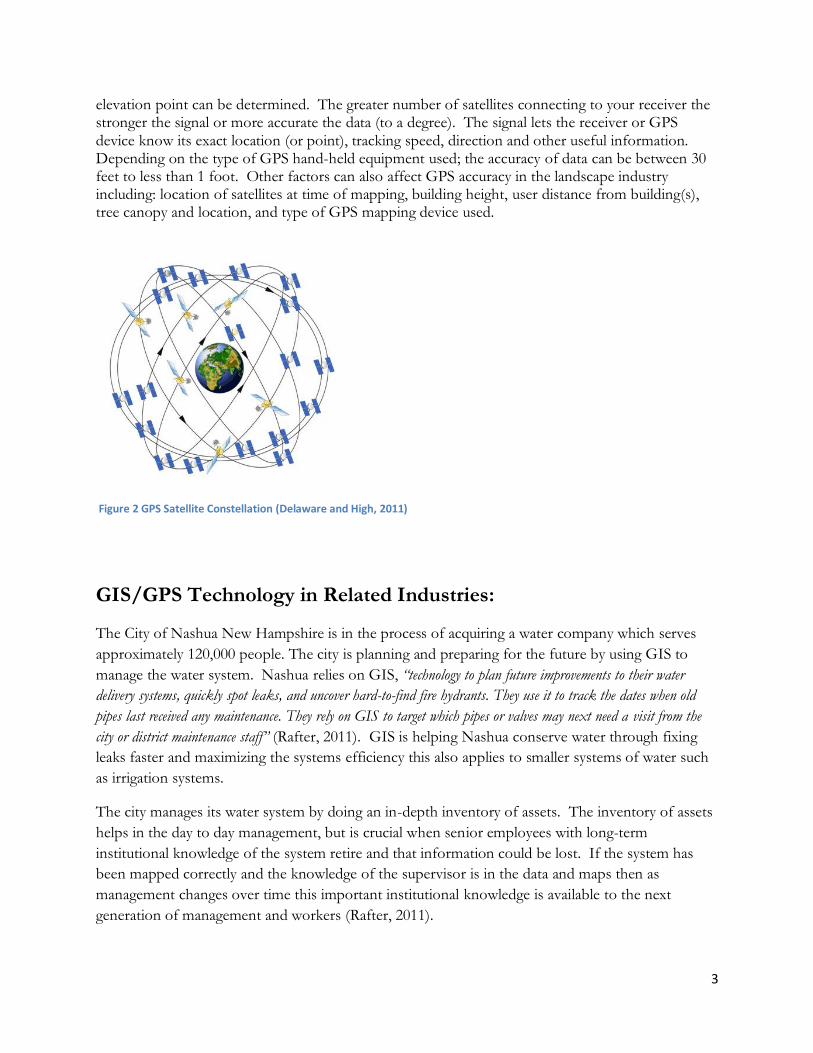
elevation point can be determined. The greater number of satellites connecting to your receiver the stronger the signal or more accurate the data (to a degree). The signal lets the receiver or GPS device know its exact location (or point), tracking speed, direction and other useful information. Depending on the type of GPS hand-held equipment used; the accuracy of data can be between 30 feet to less than 1 foot. Other factors can also affect GPS accuracy in the landscape industry including: location of satellites at time of mapping, building height, user distance from building(s), tree canopy and location, and type of GPS mapping device used.
GIS/GPS Technology in Related Industries:
The City of Nashua New Hampshire is in the process of acquiring a water company which serves
approximately 120,000 people. The city is planning and preparing for the future by using GIS to
manage the water system. Nashua relies on GIS, “technology to plan future improvements to their water
delivery systems, quickly spot leaks, and uncover hard-to-find fire hydrants. They use it to track the dates when old
pipes last received any maintenance. They rely on GIS to target which pipes or valves may next need a visit from the
city or district maintenance staff” (Rafter, 2011). GIS is helping Nashua conserve water through fixing
leaks faster and maximizing the systems efficiency this also applies to smaller systems of water such
as irrigation systems.
The city manages its water system by doing an in-depth inventory of assets. The inventory of assets
helps in the day to day management, but is crucial when senior employees with long-term
institutional knowledge of the system retire and that information could be lost. If the system has
been mapped correctly and the knowledge of the supervisor is in the data and maps then as
management changes over time this important institutional knowledge is available to the next
generation of management and workers (Rafter, 2011).
Figure 2 GPS Satellite Constellation (Delaware and High, 2011)

4
“Better maintenance is another important benefit of GIS technology, Brennan says. GIS allows utilities to better track past maintenance work. It also allows them to be more proactive when it comes to maintaining the health of their systems. Staffers may discover that water pipes are breaking across the city. Through the use of GIS and computerized maintenance management systems, staffers can target areas of the water system that should be repaired next to avoid future breaks. It’s usually cheaper to maintain a pipe then it is to repair one that’s already broken” (Rafter, 2011).
GIS technology allows professionals to see the system as a whole or zoom in on specific details. This same approach of managing large water districts or water providers is beneficial to irrigation maintenance companies, property managers, and agencies which are responsible for managing irrigation systems and water. Knowing where your irrigation lines and parts are located is the first step in managing a system proactively. Similarly institutional information of irrigation systems and property can be mapped and made available for all those involved in the long-term maintenance (Rafter, 2011).
Maricopa County Arizona has a population of more than four million. The growth patterns have
largely been sprawling development and the county maintains more than 650 miles of road. The
county was over burdened with tracking and managing the cleaning and sweeping of streets.
“To lower costs and improve business processes, the county decided to install GPS units on sweeper trucks that
broadcast data when brooms are lowered for sweeping… As the sweeper truck drives down the street, the rotating
brushes sweep road debris into the vacuum and off the street. Information is transmitted at 30-second intervals,
providing the speed and location of the sweeper. The automated process replaces manual inspection and provides
verification of work completed against work invoiced, ensures that speed limits are enforced, and provides support in
litigation.” (Akuoko 2011).
Figure 3 Water Provider Systems Mapped (Rafter, 2011)

5
The GPS/GIS technology is now allowing the county to track: sweeping vehicles assigned to routes,
identification of driver on vehicle per day, speed threshold, virtual inspection, and comparison of
bills assessed (Akuoko, 2011).
“The objective of this program is to provide the tools necessary to effectively manage the sweeping contract with 100
percent accountability while reducing inspection costs” (Akuoko, 2011). The collection of GIS data while
running sweeping vehicles makes it possible for the county managers to analyze and improve the
maintenance of a large network of streets. Likewise mapping and tracking large irrigation
systems can also assist in creating greater accountability and effectiveness.
Surveying the Field of Irrigation Mapping:
Irrigation mapping is the documentation or creation of “as built” diagrams or drawings of previously
installed irrigation systems. In 2010 a survey was conducted of 37 irrigation/landscape professionals
relating to irrigation mapping or documentation. The survey is the beginning of understanding how
companies and organizations are documenting and mapping irrigation systems. The survey was
conducted in December of 2010 (Benson, 2010). At this point in time limited research data is
available in how irrigation professionals as a whole document previously installed irrigation systems.
Figure 4 Map of Streets Swept (Akuoko, 2011)
6
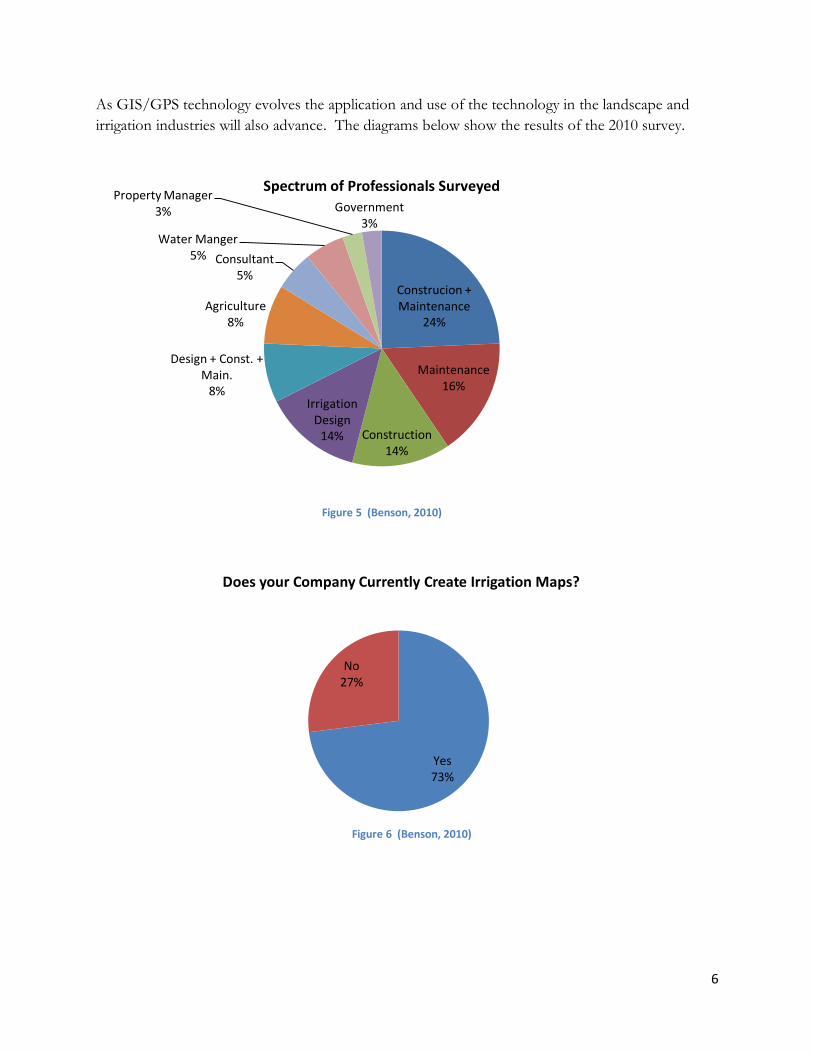
As GIS/GPS technology evolves the application and use of the technology in the landscape and
irrigation industries will also advance. The diagrams below show the results of the 2010 survey.
Construcion + Maintenance
24%
Maintenance 16%
Construction 14%
Irrigation Design
14%
Design + Const. + Main.
8%
Agriculture 8%
Consultant 5%
Water Manger 5%
Property Manager 3% Government
3%
Spectrum of Professionals Surveyed
Figure 5 (Benson, 2010)
Yes 73%
No 27%
Does your Company Currently Create Irrigation Maps?
Figure 6 (Benson, 2010)

7
Hand Drawn 47%
Aerial Image & Computer
Drawn 29%
CAD 18%
Surveying 6%
Methods Used To Create Irrigation Maps
The majority of the group (73%) regularly creates irrigation maps as part of their work, but only
62% are required to create irrigation maps per mandate or specification. Most organizations
involved with irrigation understand that it is essential to have maps or as builts of irrigation systems
to communicate the tasks of maintenance and repairs with employees.
The study shows that the majority of landscape professionals still use old methods for creating
irrigation maps such as hand drawing or measuring in the field and then drawing on CAD. The
problems with hand drawn irrigation plans is that often they are not drawn to scale, parts shown on
plan do not show or correspond to the site, they are hard to read because of handwriting, and
overall less effective.
The methodologies for creating irrigation maps will improve and advance in the coming decade as
irrigation professionals have more educational opportunities and technology advances. From the
1980s to the 1990s the architecture and design industry underwent a major change as the technology
of CAD (computer aided drafting/design) developed and became the prevailing method for
designing buildings. Likewise technology advancement can assist irrigation professionals in
managing the systems and water through accurate mapping.
Yes 62%
No 38%
Are You Required To Create "As Built" Drawings?
Figure 7 (Benson, 2010)
Figure 8 (Benson, 2010)

8
Figure 9 shows that less than half of the survey group was currently using GPS technology. This
number will increase as technology and understanding increases. Figure 10 shows that many
irrigation/landscape professionals are using common day to day applications of GPS. These
applications include finding addresses, mapping points with basic recreational GPS devices. Only a
few are using professional GPS equipment. With professional equipment you can collect GPS data
for creating specific maps (such as irrigation valves, lines, trees and etc). The data is then imported
into a GIS type program and a useable map is generated. Recreational GPS devices mostly track
basic points, distances, and speed. Professional GPS equipment has higher accuracy and greater
durability.
A group of 10 irrigation/landscape companies were surveyed in 2011. These irrigation/landscape
companies have started using GPS technology for less than six months to map and document
irrigation systems and landscapes. Prior to 2011 the majority of the companies involved in the study
used hand measuring or survey equipment to get field measurements. Most of the map creation was
done by hand, while some of the companies were using CAD for drawing (Benson, 2011).
Yes 46%
No 54%
Do You Currently Use GPS Technology?
Figure 9 (Benson, 2010)
Wayfinding 31%
Wayfinding & Recreational
25%
Professional 19%
Other 13%
Recreational Only 6%
Vehicle Tracking
6%
Type of GPS Equipment Used
Figure 10 (Benson, 2010)

9
The companies selected were spread out geographically including the following regions: Alberta,
California, Texas, Utah, Ohio, Washington DC, Florida and elsewhere. In the irrigation industry
work practices can vary according to climate and region. GPS mapping for irrigation systems was
relevant and valuable no matter the geographic location.
The question was asked “What are the strongest advantages of GPS mapping irrigation systems?”
The provided answers included: Water Conservation, Measuring Tool for Bidding, Communication
Maps for Workers and Others, Irrigation System Management, and Additional Source for Increased
Revenue. The greatest of value offered from irrigation maps is the communication tool
between employees, managers and customers which provides a more effective service
(figure 11).
Maps for Communicating with Workers & Others
80%
As Built Drawings for Specification
Requirements 10%
Measurement Tool for Bidding
10%
What is the Strongest Advantage of GPS Mapping Irrigation Systems?
Figure 11 (Benson, 2011)

10
Historically GIS/GPS mapping has been done by professionals with higher education degrees in
Geographic Information Systems or professionals who have received months of training. This
advanced education was necessary to understand the science, run the applications and analyze the
data. Technology used to create GIS maps for professional work is becoming more user friendly
(even for non GIS professionals). As shown in figure 12 trained foreman and technicians are
doing the GPS mapping (not GIS professionals or upper management). Depending of the
needs of each individual company, and the importance of their GIS maps, the employee’s
knowledge level and training time will differ. This is an important achievement for the
irrigation/landscape industry to bring the cost level down and allow more organizations to offer this
service.
Basic Steps to Irrigation Mapping:
There are many strategies to mapping and documenting irrigation systems. There are also various
options for software such as generic GPS mapping or more industry specific. Some basic steps for
irrigation mapping may include:
1. Prepare hand-held GPS for field. While it’s not necessary, you may want to load aerial
images, base map, setting parameters or projections.
Technician 50%
Foreman 40%
Manager 10%
Crew Member 0%
Owner/ President 0%
What Level of Employee is Trusted for GPS Mapping Irrigation Systems?
Figure 12 (Benson, 2011)

11
2. Stand over parts and equipment in the field and take points or collect data. Common parts
mapped include: controllers, backflow, shut of valve, remote control valves, main lines,
lateral, spigots and other misc. landscape items (such as fire hydrants, trees, and electrical
boxes). It is recommended to add information regarding part sizes, manufacturer,
model number, and condition of parts (if it needs repairs or maintenance). This
information will be valuable when doing repairs or maintenance is needed later on.
Mapping in areas with buildings or extensive tree canopy can be challenging, you may have
to move away from buildings/trees and take the points (to be adjusted on the desktop).
While mapping you can turn on valves to map water coverage, to better understand the
efficiency of the irrigation system and learn what is needed to improve water conservation.
3. The last part to irrigation mapping is loading the data onto the computer and creating maps.
Maps can be large and complex or simple in nature. It is beneficial to have a site
background such as a drawing of the site (if it’s new) or an aerial image (if available).
Quality map creation usually requires some basic editing (correcting exact location of
part) or cleaning up maps to be readable. GPS technology is not perfect and like other
professional work it requires adaptation at times.
Figure 13 shows one valve and its spray heads which were GPS mapped. This one valve and heads
took approximately 5-7 minutes to map in the field. Measuring the distances in the field and
drawing the same valve and heads in CAD or by hand would take two to three times longer. When
mapping much larger or complex systems; such as 20-100 valves, multiple main lines, multiple
clocks, and multiple points of connection is when GPS mapping becomes an incredibly valuable
time saver.
Conclusion:
GIS and GPS technology is invaluable and is ever growing in its simplicity to use. The technology
has been proven in related industries such as large water system providers and infrastructure
management as shown in the examples from New Hampshire and Arizona. Currently the majority
of irrigation companies are creating irrigation maps, but many are doing it with obsolete
technologies or methodologies. Irrigation mapping techniques will improve as technology evolves
and irrigation professionals are trained how to use them.
In the past GIS/GPS mapping methods required advanced education and a few weeks or months of
training to learn how to collect data and create maps. Now irrigation mapping is becoming user
friendly with easy to use systems and GPS technology designed for technicians. Irrigation
professionals should consider GPS mapping systems to improve service performance for
their customers and manage irrigation systems for water conservation.

12
The advantages of GPS mapping irrigation systems include:
Accurate location of irrigation parts and system mapped
Ability to find previously mapped parts and system (i.e. buried valve boxes)
Ability to map or track parts that need maintenance or repair
Maps can be customized according to points, features and layers (such as valves, lines, etc)
Areas or parts can be mapped for bidding purposes
Photos of parts can be geo-tagged (to add location of where the photo was taken on-site)
Coverage of water distribution by heads can be mapped to show efficiency
Maps and data of irrigation systems can be created for communicating work procedures to
employees
Figure 13 Irrigation Head & Valve Map (Young, 2011)

13
Irrigation maps hold the greatest value for irrigation professionals in offering better
communication among employees, managers, and customers. If irrigation systems are mapped and
documented it will offer organizations faster repairs, documentation of repairs, planning for
improvements and create an overall better understanding of the systems. The GPS mapping and
GIS management of irrigation systems will conserve water through more timely repairs and the
ability to plan for improvements. As landscape and irrigation professionals learn and use this
technology it will enhance their service to customers and assist them in creating beautiful landscapes
that are sustainable and lasting.
Figure 14 Irrigation Valve Coverage Map (Benson, 2011)

14
References:
Akuoko, K. 2011. Better Street Sweeping Management. ArcNews Spring 2011. Also available
at http://www.esri.com/news/arcnews/spring11articles/better-street-sweeping-
management.html
Benson, J. 2010. Data provided by Jim Benson Public Works Director of a gps technology
company. Mr. Benson can be reached at 435-753-1881.
Benson, J. 2011. Data provided by Jim Benson Public Works Director of a gps technology
company. Mr. Benson can be reached at 435-753-1881.
Delaware and High, 2011. Graphic diagram is available on the internet September 2011 at the
following web address http://www.delawareandlehigh.org/blog/category/on-the-trail/
GIS, 2011. Graphic diagram is available on the internet September 2011 at the following web
address http://www.gis.hctx.net/images/GIS%20layers.gif
Ormsby, T. J., Napoleon, Burke, Groessl and Bowden 2010. Chapter 1. pp. 2-11. Getting To
Know ArcGIS. ESRI Press, 380 New York Street, Redlands, CA.
Rafter, D. 2011. Mapping The Future. Water Efficiency The Journal For Water Resource
Management. May-June 2011. Also available at http://www.waterefficiency.net/may-
2011/mapping-the-future-1.aspx
Young, J. 2011. Image shows part of map created by the author using GIS/GPS technology.