Government of the District of Columbia · 2017-02-01 · AASHTO manual on “A Policy on Geometric...
12
Government of the District of Columbia Department of Transportation 1 Scope of Work | District Department of Transportation | 55 M Street, SE, Suite 400, Washington, DC 20003 Rehabilitation of Eastern Avenue, NE SCOPE OF WORK (SOW) PROJECT NAME: Rehabilitation of Eastern Avenue, NE PROJECT LIMITS: Proposed Project work limit is on Eastern Avenue, NE beginning at New Hampshire Avenue, NE and ending at Whittier Street, NW. DESIGN STANDARDS: All Design work shall comply with current design practices and code requirements of District of Columbia(DC), Department of Transportation (DDOT), FHWA and as well as the following: AASHTO manual on “A Policy on Geometric Design of Highways and Streets”, Latest Edition AASHTO Standard Specifications for Structural Supports for Highway Signs, Luminaries and Traffic Signals, latest edition DC Standards and Specifications for Soil Erosion and Sediment Control, 2013 of Highways and Structures 2013 DC Streetlight Policy and Design Guidelines, 2013 DC Work Zone Safety and Mobility Policy. DDOE Storm water Management Guidebook, 2013 DDOT Complete Streets Policy DDOT Design and Engineering Manual 2009 DDOT Environmental policy and Process Manual latest Edition. DDOT Green Infrastructure Standards, 2014 DDOT Standard Specification of Highways and Structures, 2013 DDOT Standard Specification Soil Erosion and Sediment Control, 2003 DDOT Standard Specification Storm water Management DDOT Storm water Management Guidebook DDOT Standard Drawings, 2009 DDOT Temporary Traffic Control Manual Guidelines and Standards FHWA Final Rule on Work Zone Safety and Mobility
Transcript of Government of the District of Columbia · 2017-02-01 · AASHTO manual on “A Policy on Geometric...
Government of the District of Columbia
Department of Transportation
1 Scope of Work | District Department of Transportation | 55 M Street, SE, Suite 400, Washington, DC 20003
Rehabilitation of Eastern Avenue, NE
SCOPE OF WORK (SOW)
PROJECT NAME:
Rehabilitation of Eastern Avenue, NE
PROJECT LIMITS:
Proposed Project work limit is on Eastern Avenue, NE beginning at New Hampshire Avenue,
NE and ending at Whittier Street, NW.
DESIGN STANDARDS:
All Design work shall comply with current design practices and code requirements of District of
Columbia(DC), Department of Transportation (DDOT), FHWA and as well as the following:
AASHTO manual on “A Policy on Geometric Design of Highways and Streets”, Latest
Edition
AASHTO Standard Specifications for Structural Supports for Highway Signs,
Luminaries and Traffic Signals, latest edition
DC Standards and Specifications for Soil Erosion and Sediment Control, 2013 of
Highways and Structures 2013
DC Streetlight Policy and Design Guidelines, 2013
DC Work Zone Safety and Mobility Policy.
DDOE Storm water Management Guidebook, 2013
DDOT Complete Streets Policy
DDOT Design and Engineering Manual 2009
DDOT Environmental policy and Process Manual latest Edition.
DDOT Green Infrastructure Standards, 2014
DDOT Standard Specification of Highways and Structures, 2013
DDOT Standard Specification Soil Erosion and Sediment Control, 2003
DDOT Standard Specification Storm water Management
DDOT Storm water Management Guidebook
DDOT Standard Drawings, 2009
DDOT Temporary Traffic Control Manual Guidelines and Standards
FHWA Final Rule on Work Zone Safety and Mobility
Government of the District of Columbia
Department of Transportation
2 Scope of Work | District Department of Transportation | 55 M Street, SE, Suite 400, Washington, DC 20003
MUTCD, Latest edition.
All Safety practices and requirements must meet the MUTCD, Latest edition
NACTO, Urban Bikeway Design Guide
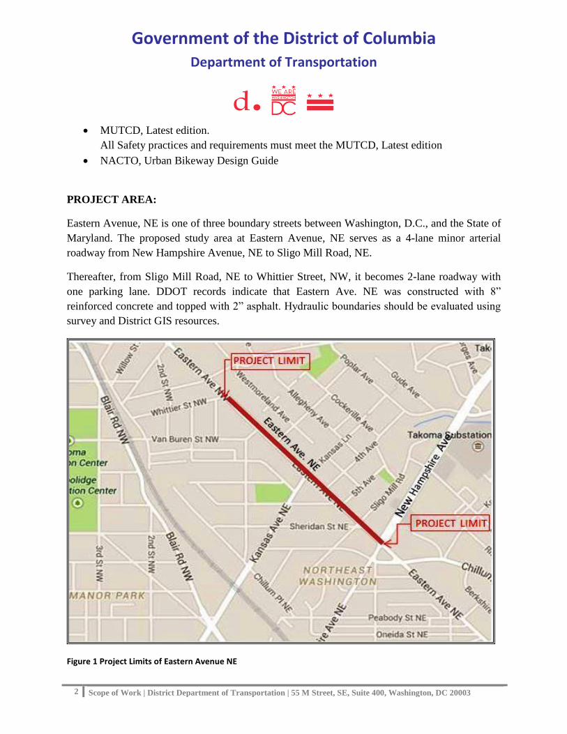
PROJECT AREA:
Eastern Avenue, NE is one of three boundary streets between Washington, D.C., and the State of
Maryland. The proposed study area at Eastern Avenue, NE serves as a 4-lane minor arterial
roadway from New Hampshire Avenue, NE to Sligo Mill Road, NE.
Thereafter, from Sligo Mill Road, NE to Whittier Street, NW, it becomes 2-lane roadway with
one parking lane. DDOT records indicate that Eastern Ave. NE was constructed with 8”
reinforced concrete and topped with 2” asphalt. Hydraulic boundaries should be evaluated using
survey and District GIS resources.
Figure 1 Project Limits of Eastern Avenue NE

Government of the District of Columbia
Department of Transportation
3 Scope of Work | District Department of Transportation | 55 M Street, SE, Suite 400, Washington, DC 20003
PROJECT SCHEDULE:
Final design and recommendations shall be completed and delivered within nine (9) months
from the Notice to Proceed (NTP) date. This includes interim submissions of 30%, 65%, 90%,
100%, and a final PS&E submission.
All submissions shall include plans, hydraulic reports, specifications, and cost estimates for
review, and shall also be provided to permitting agencies. Construction schedule shall be
prepared and included with the plans starting from 90% submittal.
PURPOSE OF THE PROJECT:
Purpose of this project is rehabilitation or reconstruction of Eastern Avenue, NE; Replace
deteriorated sidewalk, curb, gutter including intersection design to improve pedestrian safety;
access and visibility at all intersections; Replace deteriorated catch basins and manholes; and
introduce public realm improvements along Eastern Avenue from New Hampshire Avenue NE
to Whittier Street, NW.
This study will also include the following details: subsurface utility engineering (SUE), curb
extensions, improvement of crosswalk striping, upgrading curb ramps and bus stops to meet
ADA standards, adding bus pads, adding permeable landing strips between curb and tree boxes.
The project will also include but not limited to the following:
--- Upgrading of the existing deteriorated roadway to a new smoother roadway riding surface.
--- Upgrading from existing DC standard catch basins to larger capacity Water Quality Catch
Basins to help protect and ensure the future of our environment.
--- Installation of new curbs, gutter and sidewalk for pedestrian safety and the reduction of
pedestrian and motorist conflicts.
---- Replacement for dead or diseased trees posing safety risk with new healthy and vibrant trees
to enhance the look and feel of the residential community.
--- Improvement and Installation of signage and pavement markings; replacement of faded
roadway signs.
--- Constructing ADA compliant Bus Stops and related ADA ramps and bus pads to current
Standards.
--- Constructing retaining wall as needed.
--- Upgrading the esthetic quality and performance of all street lights and traffic lights as needed.
Government of the District of Columbia
Department of Transportation
4 Scope of Work | District Department of Transportation | 55 M Street, SE, Suite 400, Washington, DC 20003
The selected design firm shall include surveying, existing condition analysis, conceptual layout
for geometric improvements, developing recommendations for drainage improvements based on
the site conditions, project schedule, and funding availability.
PROJECT OBJECTIVES:
The goal is to analyze the existing condition of the pavement and streetscapes of the study area;
to determine the best/most practical solution to address rehabilitation or reconstruction of asphalt
overlay on concrete pavement; replace deteriorated catch basins, manholes, curb and ramps.
A) Street rehabilitation by milling/resurfacing or reconstructing the existing deteriorated
pavement gutter, and sidewalks where appropriate..
B) Modifying the deteriorated catch basins and manholes and providing new curbs, ramps
and bus pads in order to improve reliability and preserve safety and mobility.
C) Traffic and pedestrian safety, access, visibility by improving the streetscape along the
Eastern Avenue NE.
D) Green Infra-structure Standards by planting trees, developing potential landscaping.
Implementation plans will use DDOT Context Sensitive Design Guidelines.
PROJECT SCOPE OF SERVICE:
The design process shall include the following tasks,
1. Project Management
2. Project Interagency Coordination
3. Public Involvement
4. Collection and Consolidation of Data
5. Streetscape
6. Pavement Investigation and Design
7. Quantity Computations and design Calculations
8. Context Sensitive Design /Solutions
9. Design Deliverables
10. Permits
Government of the District of Columbia
Department of Transportation
5 Scope of Work | District Department of Transportation | 55 M Street, SE, Suite 400, Washington, DC 20003
1- Project Management
a. Progress Meetings: The consultant shall attend a kick-off meeting and progress meetings
with the DDOT Project Manager and participating agencies for each design submission.
The consultant or its representative attending the meetings shall be key personnel and
design engineers knowledgeable of the project and its design. Coordination meetings
will also be held with project stakeholders. Attending agency meetings and community
presentations will be part of this task.
b. Meeting Minutes: The consultant shall provide a draft of meeting minutes to DDOT and
the attendees at the meeting by close of business within five (5) days after the meeting.
Attendees and DDOT personnel will return comments for revision for the consultant to
finalize. Once the DDOT Project Manager approves the minutes, the consultant shall
distribute an electronic copy of the minutes to each attendee within 3 calendar days
following DDOT’s approval to distribute.
c. Monthly Progress Reports: Along with invoices, the consultant shall prepare and
submit monthly progress reports to the DDOT project manager. Each report shall outline
the task accomplishments, meetings held, status of deliverables, expected activities for
the next period, issues for resolution and the responsible party, problems and their
disposition from the previous period, updated schedule, and financial status.
d. Monthly Invoices: The consultant shall provide monthly invoices to the DDOT project
manager for approval and timely payment. A format of DDOT invoices will be given to
you after NTO has been issued.
2- Project Interagency Coordination:
The Consultant shall work with the project manager and coordinate with various offices, utility
companies (DC Water, WMATA, Washington Gas, Pepco and others) and other Local and
Federal Agencies regarding their requirements for review and approval of required permits and
include them in the project as directed by the project manager. It is the Consultant’s
responsibility to coordinate with various utility companies and other consultants, and receive
their responses in a timely manner as prescribed in the project schedule and to make any changes
resulting from the reviews and coordination with various utility companies and other consultants.
The Consultant shall keep the DDOT Project Manager informed of all dealings with various
offices, agencies, stakeholders, utility companies and delays. The consultant shall also coordinate
with other ongoing projects in the project area.

Government of the District of Columbia
Department of Transportation
6 Scope of Work | District Department of Transportation | 55 M Street, SE, Suite 400, Washington, DC 20003
3- Public Involvement:
The consultant shall develop a meaningful community participation process that will consist of
Two (2) public meetings and up to maximum four (4) community meetings with community
including, but not limited to, residents, commercial property owners, and affected representatives
from Advisory Neighborhood Commissions. The purpose of the meeting will be to obtain input
for development of concept designs. The consultant shall participate in a planning work session
meeting with DDOT at the beginning of the project to complete the draft scope of work,
schedule milestones, discuss the public involvement process and refine the project deliverables.
The consultant shall prepare meeting agenda and handouts, as well as visual aids and illustrative
images, charts, and other tools to convey ideas to the public. This planning meeting shall occur
during the first two weeks of the project. The initial public meeting shall occur after the 30%
design is completed. Public meetings shall also be held after the 65% and 90% designs are
completed.
4- Collection and Consolidation of Data:
The consultant shall conduct field reconnaissance of the corridor area, noting existing land uses,
existing roadway geometric and traffic conditions, traffic flow patterns, transit facilities and
services, pedestrian facilities, as well as opportunities and constraints pertaining to access from
intersecting local streets and driveways.
In addition, the consultant shall also perform existing utility investigation, drainage analysis,
environmental and right-of-way investigation to support the development of the proposed
alternatives. See task description below.
a. Survey & Existing Utility Investigation: Perform field survey required for mapping
within the established project limits to the assigned specific roadway improvement design
project as well as other engineering tasks as may be required, including but not limited to:
• Topography - Perform field survey required for mapping within the established project
limits. Locate existing streets, trees, walls, steps, and street level utility appurtenances
including manholes, ROW lines, building restriction lines, existing topography structures
and other physical and legal features within the limits of the project.
• Topographical Map – Generate a topographical map to show property ties, stations,
elevations and controls.
Government of the District of Columbia
Department of Transportation
7 Scope of Work | District Department of Transportation | 55 M Street, SE, Suite 400, Washington, DC 20003
• Cross Sections – Develop cross sections at 50 ft. intervals for the existing streets along
center lines, quarter points, flow lines, tops of curbs, edges of sidewalks, and steps,
providing full coverage of the area within the limits of the project.
• Horizontal Control - Furnish horizontal control in the State Plane Coordinate System of
the State of Maryland unless otherwise directed.
• Traverse points - Perform a series of conventional horizontal control (the State Plane
Coordinate System of the State of Maryland) and vertical control (DC Datum) traverses
for each street and highway project unless directed otherwise by the Project Manager.
The traverse will consist of permanent points set in stable material that will not be
disturbed during the course of construction. Tie each traverse point to a minimum of
three permanent structures to assist in future recovery.
• Global Positioning System - Use GPS equipment to transfer controls to a project to a
project street/highway that is not within 2000 ft. of an existing control.
• Survey Permission - Permits to perform field survey are not required, except from the
National Park Service. Notify in writing the Project Manager and the adjoining property
owners and communities prior to commencing the survey work.
• Survey limits - The width of the survey limits for each street will be from ROW line to
ROW line where it can be easily determined. In areas where a ROW line can only be
determined by performing a boundary survey, the survey limits for the street will be from
the back of the existing sidewalk to the back of existing sidewalk. The project limits on
the side streets will be a maximum of 50 feet from the curb returns on all side streets for
tie-in, drainage, street light and other modifications. If additional information is required
beyond the ROW line, the District will seek permission from the private property owner
(in writing) prior to commencement of any work.
• Final Plans - Incorporate all information into the final contract plans including the
subsurface utility engineering (SUE) information and cross section drawings.
b. Environmental Investigation: As part of this project, the consultant shall conduct
appropriate studies, consult with appropriate Federal and Local Agencies, collect new
and relevant data, and review existing databases/records to identify environmental and
socioeconomic effects associated with the proposed alternatives. Data on physical
features, biological resources, traffic, land use, historic/archaeological resources, utility
constraints, water resources, and water quality shall be collected, analyzed and submitted
to DDOT using latest Environmental Forms I and II. The information gathered from this

Government of the District of Columbia
Department of Transportation
8 Scope of Work | District Department of Transportation | 55 M Street, SE, Suite 400, Washington, DC 20003
research as well as appropriate mitigation solutions or avoidance strategies shall be
included in the final report submitted to DDOT.
c. Right-of-Way Investigation: Under this task, the consultant shall perform survey work
and right of way determination for any properties affected by potential street
rehabilitation or reconstruction.
5- Streetscape:
Under this task the consultant shall perform but not limited to the following tasks:
a. Pedestrian Safety:
1. Road Configuration: Proposed work includes but not limited to removal and
reconstruction of existing deteriorated curbs, gutter and sidewalk, milling and resurfacing
or reconstructing the pavement. Construct ADA complaint bus stops and curb extensions
as needed and bus pads to improve pedestrian visibility, crossing distance and
intersection geometry. Curbs gutter and handicap ramps will be repaired or reconstructed
and verified by field inspection in accordance with design practices and code
requirements listed herein. Installation of new, repair of existing or relocation of fencing
at tree boxes or yards to widen sidewalk areas included in work. Drainage system will be
improved by repair/replacement of deteriorated catch basins. Soil Erosion and sediment
control plans must be provided and plans reviewed and approved by DDOE.
2. Access and Visibility: Add high visibility “Zebra” crosswalk striping at all intersections
along Eastern Avenue, NE to enhance pedestrian safety and crosswalk visibility; upgrade
curb ramp to ADA standards at all corners of New Hampshire Ave NE and Eastern
Avenue NE and wherever applicable.
3. Subsurface Utility Engineering (SUE): Underground utilities will be verified in
accordance with the District of Columbia Department of Transportation (DDOT) Scope
of Work - Non-Project Specific Subsurface Utility Engineering and Utility Coordination
Services. The following quality levels and limits will apply to this project:
a. Quality Level A: If authorized - five (5) locations (assumed) within the project.
The exact number of locations will be determined during the project.
b. Quality Level B: If authorized – 660 linear feet (assumed) within the project. The
exact lengths and locations will be determined during the project.
Government of the District of Columbia
Department of Transportation
9 Scope of Work | District Department of Transportation | 55 M Street, SE, Suite 400, Washington, DC 20003
c. Quality Level C: Update underground utilities for the entire 1.0 mile project. Side
roads as included in survey limits are also included.
d. Quality Level D: Not requested.
4. Utility Relocation: Undergrounding of existing overhead PEPCO lines is NOT
anticipated in this project. The consultant will provide coordination services for
consolidating, visually improving and minimizing of overhead power and communication
lines. Power connections to traffic signals and street lights are included in this work.
Relocation/replacement of DC water Hydrants and Valves shall be on an as-needed basis.
b. Public Realm:
Landscaping: Proposed work includes but not limited to determination of areas for landscaping
treatment. Tree replacement in empty tree pits along the Eastern Avenue NE shall be included in
the work. Opportunities to introduce trees and planting beds in the corridor shall be identified
and included as budget allows. Soil volume shall be provided for street trees per the DDOT
Green Infrastructure (GI) Standards. Acceptable methods include, but are not limited to bio-
retention, impervious surface removal, permeable pavement, street trees, swales and infiltration
facilities as budget allows. The project must comply with requirements of current DDOE, SWM
and SESC regulations, SWGB and DC standard specifications.
6- Pavement Investigation and Design:
DDOT records indicate that Eastern Ave. NE was constructed with 8” reinforced concrete
pavement topped with 2” asphalt. The road has been deteriorated due to traffic and weather
related factors. This task includes but not limited to repair and upgrade pavement on Eastern
Avenue NE, full width by milling, resurfacing or reconstructing as needed to provide a new
smoother roadway riding surface. It also includes upgrading with new pavement markings. The
design plans shall adhere to the MEP design process as per SWGB-Appendix B and DEM –
Green Infrastructure standards to retain stromwater.
7- Quantity Computations and Design Calculations:
Prepare and submit to the DDOT project manager/engineer Design Quantity Computations that
neatly, legibly, and orderly detail the processes and logical steps used to determine quantities for
each pay item. Quantity computations for each pay item shall also indicate any quantities of

Government of the District of Columbia
Department of Transportation
10 Scope of Work | District Department of Transportation | 55 M Street, SE, Suite 400, Washington, DC 20003
incidental items that are included in the specific pay item. All design and calculations shall be
signed and sealed by a licensed professional engineer of the District of Columbia.
8- Context Sensitive Design/Solutions:
The Context Sensitive Designs (CSD) and/or Context Sensitive Solutions (CSS) will be a key
component of final design of Eastern Avenue, NE. The plan submission will not include specific
material selections or structure types pending the CSD/CSS workshop(s) to follow the 30% Plan
submission. Plans will indicate generic surface types and structural “envelopes” for but not
limited to the following components:
• Curb and gutter: Develop CSD/CSS range of potential curb and gutter solutions. Cost
factors will be developed to include a range of solutions.
• Sidewalk: Develop CSD/CSS range of potential sidewalk solutions. Cost factors will be
developed to include a range of solutions.
• Retaining Walls: Develop CSD/CSS range of potential retaining wall solutions. Cost
factors will be developed to include a range of solutions.
• Lighting: Develop CSD/CSS range of potential traffic control lighting solutions. Cost
factors will be developed to include a range of solutions.
• Landscaping: Develop CSD/CSS range of potential landscaping (tree preservation,
planting plan, street amenities) solutions. Cost factors will be developed to include a
range of solutions.
9- Design Deliverables:
All submissions will be as per the District of Columbia Department of transportation, Design and
Engineering Manual, Latest Edition.
10- Permits:
The design is anticipated to be advanced as a Categorical Exclusion under National
Environmental Policy Act (NEPA) in the CEQ regulation (Section 1508.4). The designer shall
prepare the draft DDOT Environmental Form I (at 30% plans) and Environmental Form II (at
65% plans) complete with location maps, photos, and cost estimates. The designer shall apply for
a building permit at DCRA to include application for SWM and SESC permits as required. All
design submittals to DDOE include plans MEP worksheet, Narrative and specifications. The
designer shall pay all permit fees associated with SWM and SESC, and building permits

Government of the District of Columbia
Department of Transportation
11 Scope of Work | District Department of Transportation | 55 M Street, SE, Suite 400, Washington, DC 20003
including initial and final plan review fees, meeting fees, and pay any other fees incurred during
the plan review process.
Voluntary installation of stormwater retention facilities (retrofit projects) shall be permitted with
an approved storm water management plan to facilitate post-construction certification for Storm
water Retention Credits (SRC).
For projects that disturb one acre or more (or as part of a common plan of development that is
more than one acre), the designer shall file a Notice of Intent (NOI) with the US EPA to obtain
EPA NPDES Construction General Permit Coverage:
http://water.epa.gov/polwaste/npdes/stormwater/EPAs-Electronic-Construction-General-Permit-
Notice-of-Intent-eNOI-Home-Page.cfm
A Storm water Pollution Prevention Plan (SWPPP) is required to be completed before
submitting the NOI.
GLOSSARY:
AASHTO - American Association of State Highway Transportation officials
ADA - Americans with Disabilities Act
CEQ - Council on Environmental Quality
CSD/CSS - Context Sensitive Design / Context Sensitive Solution
DC- District of Columbia
DDOT - District Department of Transportation
EPA- Environmental Policy Act
FHWA - Federal Highway Administration
GI- Green Infrastructure
MEP Maximum Extent Practicable
The project must retain 1.2 in. of Storm water within disturbance area to the MEP.
NEPA - National Environmental Policy Act
NOI- Notice of Intent
NTP - Notice to proceed

Government of the District of Columbia
Department of Transportation
12 Scope of Work | District Department of Transportation | 55 M Street, SE, Suite 400, Washington, DC 20003
NPDES- National Pollutant Discharge Elimination System
PEPCO - Potomac Electric Power Company
RSA - Road Safety Audit
SAP - Small Area Plan
SESC- Soil Erosion and Sediment Control
SWRC- Storm water Retention Credits
SUE - Subsurface Utility Engineering
SWGB- Storm water Management Guidebook
SWPPP- Storm water Pollution Prevention Plan
WMATA - Washington Metropolitan Area Transit Authority