Gothenburg Workshop: Speculations Concerning Urban Form ...
82
Gothenburg Workshop: Speculations Concerning Urban Form & Structure Yale Urban Design Workshop Chalmers Spatial Morphology Group
Transcript of Gothenburg Workshop: Speculations Concerning Urban Form ...

Gothenburg Workshop:Speculations Concerning Urban Form & Structure
Yale Urban Design WorkshopChalmers Spatial Morphology Group

How do we represent urban form, space, and structure?Urban maps and diagrams

Giambattista Nolli, Pianta di Roma, 1748Spatial continuity of urban fabric
Giovanni Battista Piranesi, Campo Marzio, 1762Spatial disjunction of urban figure

Charles Booth, Poverty Map of London, 1889Mapping urban life
Kevin Lynch, Image of the City, 1962Mapping the perception of urban form
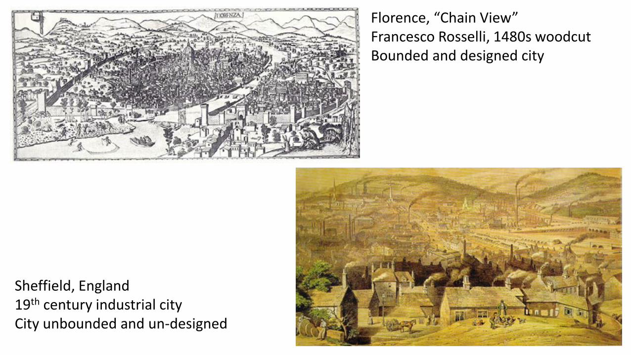
Florence, “Chain View”Francesco Rosselli, 1480s woodcutBounded and designed city
Sheffield, England19th century industrial cityCity unbounded and un-designed

London 1851 balloon viewIn search of a metropolitan vantage point
London space syntax map, BartlettDegree centrality of urban streetsIn search of methodology

Eugène Hénard, 1905Urban circulation diagrams:The tyranny of the center
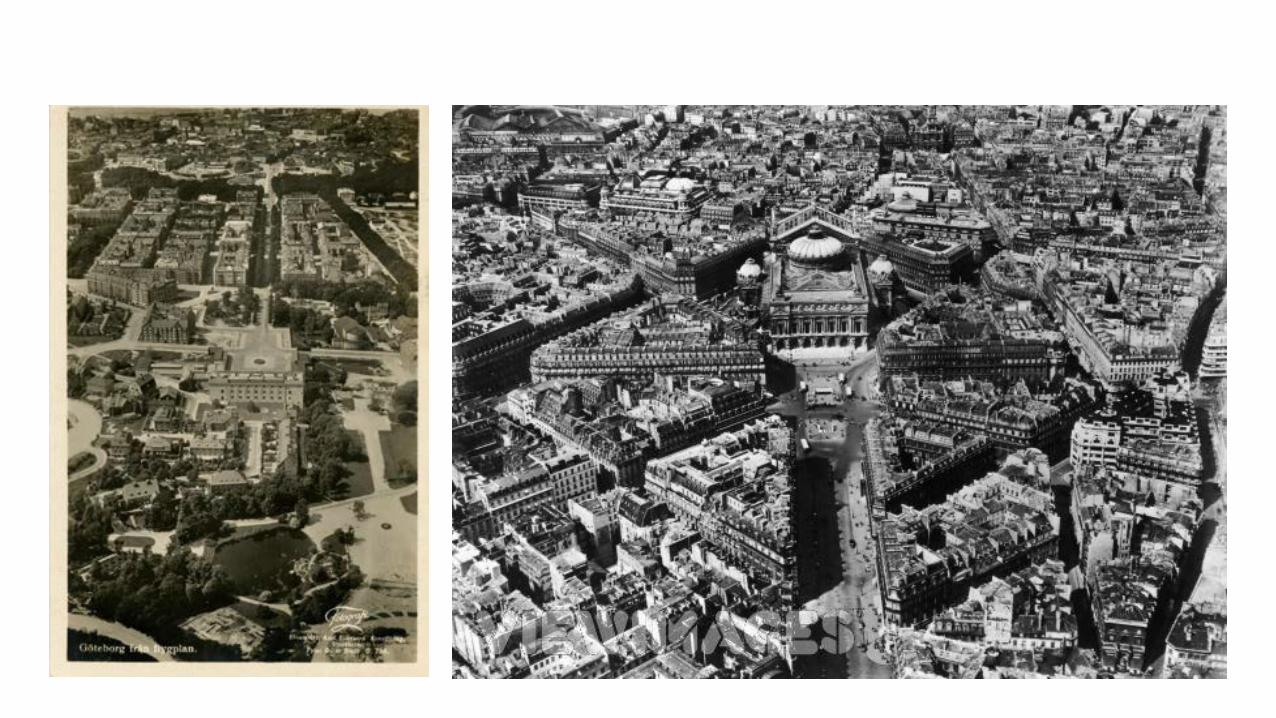
Le Corbusier, Ville radieuse, 1935East-west axis of Paris

Eugène Hénard, East-west crossing of Paris, 1904The diagram negotiated
Le Corbusier, Plan Voisin, 1925The diagram realized

Urban morphology: fabric and public space
Edward Bacon, The Design of Cities, 1957 (after Giovanni Fanelli) Sequence of public spaces in Renaissance Florence
Saverio Muratore, Studi per un’ operante storia urbana di Venezia, 1959Charateristic Venetian urban fabric

Aldo Rossi, The Analagous City, 1976The city as layered collective memory
Colin Rowe and Fred KoetterCollage City, 1979Composite buildings
Giancarlo de CarloUrbino diagram, 1966

Robert Venturi, Denise Scott-Brown, andSteven Izenour, Learning from Las Vegas, 1972Spatial and semiotic analysis of the Strip
Rem Koolhaas and Madelon Vrisendorp,The City of the Captive Globe, 1978The utopia of the Manhattan grid

Christopher Alexander, village structure algorithmNotes on the Synthesis of Form, 1964
Rob Krier, Urban Space, 1979Urban morphology and typology as
a combinatorial system

Leon Krier,Polycentric city of quartiers

Leon Krier,Polycentric city of quartiers
Clarence Perry, 1929Neighborhood unit

Clarence Perry, 1929Neighborhood unit
Bergsjön, 1963-Site plan (YSoA)
New UrbanismSeaside and Celebration
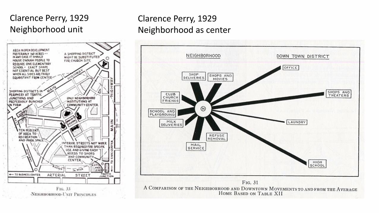
Clarence Perry, 1929Neighborhood unit
Clarence Perry, 1929Neighborhood as center

Clarence Perry, 1929Traditional neighborhood unit
Global neighborhood

Clarence Perry, 1929Traditional neighborhood unit

River City diagramExpansion of the center
Frihamnen as space of convergence


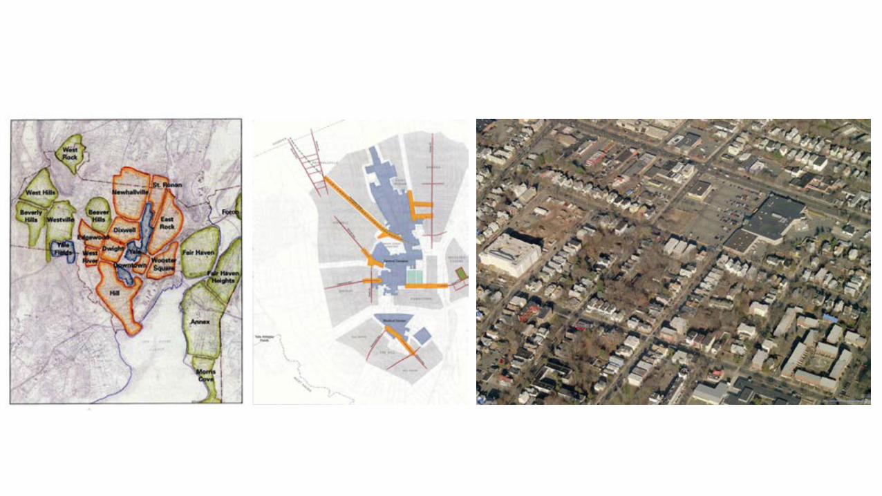
Yale University campusNew Haven, Connecticut

Yale University campus“Ladder” diagram Campus urban structure Campus map

Thames River estuary, ConnecticutRegional picture
Avery Copp House Museum c. 1800Groton, ConnecticutIndividual non-profit institution

Thames River Heritage ParkYale Urban Design Workshop, 2016Concept sketch Analytic diagram Final plan
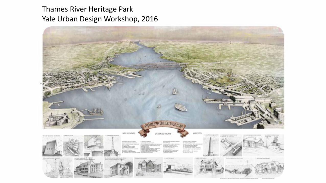
Thames River Heritage ParkYale Urban Design Workshop, 2016


Thames River Heritage Park“Cool,” analytic diagram
Thames River Heritage Park“Hot,” thick and rhetorical representation

Drawing Architecture StudioDashilar district, BeijingHot and thick representation
Bartlett SchoolSpace Syntax map of skateboard parks in LondonCool and anaylitic representation

Anecdotal/narrative diagram

Structural diagram

How do we understand Gothenburg?Patterns of historical developmentBeyond the centered, concentric city –
a new “theory of Gothenburg form”Gaps in the system

Gothenburg 1644Compact, fortified cityCardo and decumanus
formed by canals

Gothenburg 1815Expansion along river to the westHaga as first suburban “neighborhood”

Gothenburg 1871 Plan for ExpansionRationalization of growth according to techniques of modern urbanism

Gothenburg 1888Industrial growth beyond historic center and new infrastructural typologiesPersistent street and block-based parcelization

Gothenburg 1931Development of shipbuilding; removal of canals

Gothenburg Port with Rail and Road Connections

Gothenburg satellite photoSuburbanization; pre and post-war project-based development;
limited-access highways; industrial and institutional campuses


A tale of two cities

Haga: characteristic urban neighborhood linked by shared interstitial public space

Haga lining spaces: Järntorget, Linnegatan, Haga Nygata, Hagaparken, Nya Allén, Vasagatan

Järntorget: relative location from periphery to metropolitan center

Vasagatan and Avenyn: high degree centrality/connectivity/urban iconicity

Vasagatan and Lindholmsallen: Connectivity, redundancy, fine-grained fabric, interstitial landscapeMissed connections, minimal overlap, industrial fabric, interstitial pavement

“Mind the Gap!”

Lindholmsallen: boulevard at the edge, connected to the world, but not next door

Stenpiren: infrastructure as (dis)connector

Gustav Adolfs Torg and Brunnsparken: adjacency without spatial or social engagement

Bergsjön: spatial and social isolation


Frihamnen: isolation by landform, use, typology and infrastructure

Frihamnen as shared space of convergence

Frihamnen as shared space of convergence

Frihamnen as HYBRID shared space of convergence

Frihamnen as HYBRID shared space of convergence


How do we guide, but not constrain, intelligent urban development?Project vs. PlaceInfrastructure vs. Mobility and AccessPark vs. Park SystemFigure vs. GroundBlock vs. StreetFragment vs. Microcosm

The illusion of a unified urban landscape:a skyline reflecting discreet enclave-based development

The illusion of a unified urban landscape:corporate enclaves competing for urban space

Modern urbanism as a project of unified, smooth and frictionless urban space and power

The re-medievalization of contemporary cities through project-based development

Places and infrastructure that connect

Stenpiren: the challenges of intermodality

Bridge as sign of disconnection Bridge as place and event

Infrastructure as barrier Street as high centrality public realm


Landscape as figure vs.Landscape as ground
O.M. Ungers, et. Al., 1977Berlin as green archipelago

Figure vs. GroundBlock vs. Street