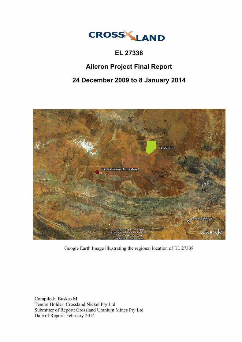
Google Earth Image illustrating the regional location of...
9
EL 27338 Aileron Project Final Report 24 December 2009 to 8 January 2014 Google Earth Image illustrating the regional location of EL 27338 Compiled: Buskas M Tenure Holder: Crossland Nickel Pty Ltd Submitter of Report: Crossland Uranium Mines Pty Ltd Date of Report: February 2014
Transcript of Google Earth Image illustrating the regional location of...
EL 27338
Aileron Project Final Report
24 December 2009 to 8 January 2014
Google Earth Image illustrating the regional location of EL 27338
Compiled: Buskas M Tenure Holder: Crossland Nickel Pty Ltd Submitter of Report: Crossland Uranium Mines Pty Ltd Date of Report: February 2014

EL27338: Aileron: Final Report 24 December 2009 – 8 January 2014
Keywords
Titleholder Crossland Nickel Pty Ltd
Operator Crossland Strategic Metals Ltd
Titles/Tenements EL 27338
Mine/Project Name Aileron
Report title including type of report and reporting period including a date
EL 27338 Aileron Project Annual Report24 December 2009 to 8 January 2014
Personal author(s) Buskas M.
Corporate author(s) Crossland Strategic Metals Ltd
Target Commodity or Commodities Uranium ./ Rare Earths
Date of report February 2014
Datum/Zone GDA94/Zone 53
250 000 K mapsheet Napperby (SF309)
100 000 K mapsheet Aileron (5552)
Contact details Postal GPO Box 2437 Darwin NT 0800
Fax 08 8981 5911
Phone 08 8941 1364
Email for further technical details [email protected]
Email for expenditure [email protected]

EL27338: Aileron: Final Report 24 December 2009 – 8 January 2014
Table of Contents
Keywords .................................................................................................................................... 2
Summary ..................................................................................................................................... 4
1 Introduction ........................................................................................................................ 5
2 Location, Description and Access ...................................................................................... 5
3 Tenure ................................................................................................................................. 5
4 Previous Exploration .......................................................................................................... 5
5 Geology and Structure ........................................................................................................ 6
6 Exploration Activities ......................................................................................................... 7
7 Conclusion ..........................................................................................................................7
Figures in Text
Figure 1. Tenement Location Map ........................................................................................ 6 Figure 2. Stream Sample Locations ...................................................................................... 8
Appendices
Appendix 1. Surface Geochemical Data and Assays Appendix 2 . Wilfley Table Processing Data Appendix 3 . Sample Processing Data Appendix 4. TEMPEST EM Data
8 References .......................................................................................................................... 9
This document and its content are the copyright of Crossland Strategic Metals Limited and their Joint Venture Partners for the Charley Creek Project. The document has been prepared for submission to the Northern Territory Department of Mines and Energy as part of the tenement reporting requirements as per the Mineral Titles Act (NT). Any information included in the report that originates from other sources is listed in the “References” section at the end of the document. All relevant authorisations and consents have been obtained. Crossland Strategic Metals Limited authorise the department to copy and distribute the report and associated data.

EL27338: Aileron: Final Report 24 December 2009 – 8 January 2014
4
Summary The Aileron tenement, EL 27338, is located approximately 108 km north of Alice Springs along the Stuart Highway and 25 km south of the Aileron Roadhouse. EL27338 was granted to Crossland Nickel Pty Ltd on 24 December 2009 for a period of 6 years. Crossland Strategic Metals Ltd is the project operator.
Preliminary work consisted of data compilation, interpretation and assessment of available historical mineral exploration, geological and geophysical data. An airborne EM survey was completed in 2009.
During 2011 field work within the tenement consisted of geological mapping, field reconnaissance and collection of 20 stream sediment samples.
The tenement lies within the 1860 – 1700 Ma Aileron Province of the Arunta Region. The regional geology comprises the Lander Rock Formation (LRF), a widespread package of variously metamorphosed clastic sediments. Granitic rocks intrude the LRF. The Ngalia basin lies immediately to the west. The Nolans Bore REE deposit is located in the Reynold Range immediately northwest of the Aileron roadhouse.
Apart from the Nolans Bore discovery, previous exploration in the region has focused mainly on gold and uranium with a lesser emphasis on base metals. Crossland’s principal commodity interest in the region is uranium and rare earths.
The EL was surrendered on 8 January 2014.

EL27338: Aileron: Final Report 24 December 2009 – 8 January 2014
5
1 Introduction Crossland first commenced on-ground exploration activities in the Alice Springs region in 2006, initially assessing the nickel potential of the Mount Hay complex, just south of the Tanami Highway on Amburla Station, west northwest of Alice Springs. This location was one of several chosen for exploration by utilising confidential concepts of target identification developed by Paradigm Geoscience. Since that time Crossland has considerably expanded its property holding in this region with an emphasis placed firstly on uranium exploration followed more recently by the discovery of widespread rare earth occurrences. The Aileron license is also considered prospective for uranium-rare earths given the discovery of Nolans Bore REE deposit just northwest of the Aileron roadhouse.
Field work within the tenement consisted of geological mapping, field reconnaissance and collection of 20 stream sediment samples. A TEMPEST Airborne Survey was completed as part of preliminary exploration, prior to granting.
2 Location, Description and Access The Aileron tenement, EL 27338, is located approximately 108 km north of Alice Springs along the Stuart Highway and 25 km south of the Aileron Roadhouse. It is located wholly within Aileron Station, NT Portion 703.
The Burt Plain is the principal physiographic feature. The Hann Range in the extreme north represents the easternmost extension of the Ngalia Basin. The highest point of the Hann Range is Mount Ewart (802 m) just to the east of the Stuart Highway
The Stuart Highway traverses the tenement and access is gained via various station tracks.
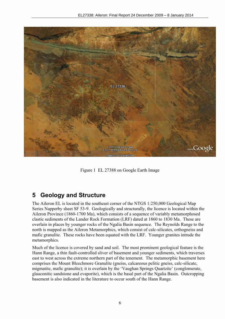
3 Tenure EL 27338 was granted for a six-year term on 24 December 2009. The title originally covered an area of 81 sub-blocks (256.32 km²). On 16 March 2012 the second annual review was completed by the Department of Resources. The tenement was reduced by 21 blocks. The EL was surrendered on 8 January 2014. The EL is was owned by Crossland Nickel Pty Ltd and the project operator was Crossland Strategic Metals Ltd (Figure 1)
4 Previous Exploration Recorded exploration activities date back to the 1970s with much of the activity taking place within the metamorphic terrane of the Reynolds Range, located approximately 50 km to the north of Crossland’s tenement. Exploration had concentrated mainly on gold and uranium with a lesser emphasis on base metals and diamonds. In 1979 Otter exploration followed up a radiometric anomaly within its EL just to the north of Pine Hills homestead. Uranium-REE bearing monazite within a garnet gneiss phase was located on-ground and subsequently assessed. PNC discovered several significant radiometric anomalies during its regional airborne survey of the area in 1994. Follow-up ground investigations discovered the important REE-bearing apatite deposits of Nolans Bore. Other work by several companies assessed the nearby Ngalia Basin for calcrete-bearing uranium deposits given that there are suitable U-source rocks within the nearby metamorphic-granitic terrane.
EL27338: Aileron: Final Report 24 December 2009 – 8 January 2014
6
Figure 1 EL 27388 on Google Earth Image
5 Geology and Structure The Aileron EL is located in the southeast corner of the NTGS 1:250,000 Geological Map Series Napperby sheet SF 53-9. Geologically and structurally, the licence is located within the Aileron Province (1860-1700 Ma), which consists of a sequence of variably metamorphosed clastic sediments of the Lander Rock Formation (LRF) dated at 1860 to 1830 Ma. These are overlain in places by younger rocks of the Ngalia Basin sequence. The Reynolds Range to the north is mapped as the Aileron Metamorphics, which consist of calc-silicates, orthogneiss and mafic granulite. These rocks have been equated with the LRF. Younger granites intrude the metamorphics.
Much of the licence is covered by sand and soil. The most prominent geological feature is the Hann Range, a thin fault-controlled sliver of basement and younger sediments, which traverses east to west across the extreme northern part of the tenement. The metamorphic basement here comprises the Mount Bleechmore Granulite (gneiss, calcareous pelitic gneiss, calc-silicate, migmatite, mafic granulite); it is overlain by the ‘Vaughan Springs Quartzite’ (conglomerate, glauconitic sandstone and evaporite), which is the basal part of the Ngalia Basin. Outcropping basement is also indicated in the literature to occur south of the Hann Range.

EL27338: Aileron: Final Report 24 December 2009 – 8 January 2014
7
6 Exploration Activities Following literature research, data compilation, and interpretation carried out in 2010; Crossland’s 2011 field exploration programme consisted of geological mapping, field reconnaissance and collection of 20 stream sediment samples. Stream samples were collected on a regional scale to test for rare earths elements. For sample locations see Figure 2.
Field work was completed by a Crossland contract geologist and field assistant between 15 May 2011 and 22 May 2011. At each sample site approximately 20 kilograms of stream sediment was collected. Before being sent to Australian Laboratory Services (ALS) in Alice Springs for analysis, samples were taken to Crossland’s processing facility near Alice Springs.
Each sample was dried, weighed and sieved (20 mm screen size). Once sieved, each sample was run across #9A Wilfley Table (Motive Traction Pty Ltd). The coarsest material was discarded; fine material (Heavy Mineral Concentrate) was retained and passed through a CARPO Magnetic Separator Model: M1278 SY22 manufactured by Warman Equipment.
Both the magnetic and non-magnetic fractions were retained. All magnetic samples were sent to ALS and analysed by methods ME-MS81h and ME-XRF12. Non magnetic fractions were sent to Diamond Recovery Services Pty Ltd of Welshpool WA for tetrabromoethane (TBE) heavy liquid separation. The TBE sinks (heavy fraction) were then sent to ALS for processing methods ME-MS81h and ME-XRF12. For Methods ME-MS81h a prepared sample is added to lithium metaborate flux, mixed well and fused in a furnace at 1000°C. The resulting melt is then cooled and dissolved in HCl solution. This solution is then analyzed by inductively coupled plasma - mass spectrometry. For methods XRF12 calcined or ignited sample is added to Lithium Borate Flux, mixed well and fused in an auto fluxer between 1050 - 1100°C. A flat molten glass disc is prepared from the resulting melt. This disc is then analyzed by X-ray fluorescence spectrometry. All Sample data including assay results, processing data tables and location data can be found within Appendix 1,2, and 3 (Non-magnetic samples are numbered as per normal convention, magnetic fractions are denoted with the letter M, B, or C).
Prior to granting of the EL; as part of their preliminary exploration activities; Crossland contracted Fugro Airborne Surveys to conduct a TEMPEST EM Survey. Locations of lines within EL 27338 are illustrated in Figure 2.
7 Conclusion
Due to economic factors Crossland was forced to re-evaluate its position on EL 27338 andelected to forgo any on-ground exploration within the final years of the licence. EL 27338 wassurrendered on 8 January 2014.

EL27338: Aileron: Final Report 24 December 2009 – 8 January 2014
8
Figure 2. Stream Sample Locations

EL27338: Aileron: Final Report 24 December 2009 – 8 January 2014
9
8 References Beyer EE et al (2010) : Regional Geology and Prospectivity of the Aileron Province in the Alcoota 1:250,000 Mapsheet Area in AGES 2010, Annual Geoscience Exploration Seminar, Record of Abstracts, NTGS, Darwin 2010. Buskas MM., (2011) : EL 27338 Aileron Project Annual Report 24 December 2010 to 23 December 2011, NTGS, Open File Report Evans TG., (1972) : Explanatory Notes on the Napperby Geological Sheet. 1:250,000 Geological Series. Bureau of Mineral Resources, Canberra. Melville PM., (2010) : EL 27338 Aileron Project Annual Report 24 December 2009 to 23 December 2010, NTGS, Open File Report