GOOGLE EARTH ENTERPRISE CASE STUDY With the adoption of Google
2
With the adoption of Google Earth Enterprise, StatoilHydro delivers a visualization and productivity solution Business StatoilHydro is an international integrated energy company, based in Norway. The company is the leading operator on the Norwegian continental shelf (NCS) and has operations in 40 countries. Oil and gas will continue to be a major source of energy for many years yet. StatoilHydro is trying to recover these valuable resources in the most efficient and responsible way possible – in parallel with our research into renewable energy sources. A constant focus on innovation means that the company is now able to recover oil and gas that were considered out of reach only a few years ago. Within oil and energy, StatoilHydro develops new technology both internally – through an operational organization and research centers in Bergen, Trondheim, and Porsgrunn – and in cooperation with other oil companies, suppliers, research institutions, and universities. StatoilHydro’s technology development is greatly focused on exploration and increased oil recovery – in addition to efficient production and technical solutions for demanding oil and gas field developments. And to an increasing extent, StatoilHydro is working on developing technology within renewable energy. Challenge The acquisition and use of high resolution imagery, digital elevation models (DEM) and spatial vector data has become of greater value to StatoilHydro’s exploration workflow. Within the StatoilHydro Research Centre in Bergen, Norway, there was a great need for easy access to and nearly instantaneous 3D viewing capabilities of our spatial datasets. It was also important to our researchers that the solution have the capability to expand into an interpretation tool rather than a purely visualization tool. After consideration of several possible vehicles for the efficient and effective delivery of spatial data to staff throughout StatoilHydro, Google Earth Enterprise was chosen for its simple client interface, familiarity of our staff with the client software, and its potential for “outside-of-the-box” utilization. Solution Google provided on-site installation and support of Google Earth Enterprise software and training of staff in the Bergen Research Centre. This led to the successful creation of a viewable database or globe that contains imagery, terrain, and vector data that is relevant and applicable to StatoilHydro’s local and international interests. Though StatoilHydro’s database is viewed using the standard Google Earth client, it is secured and only accessible from within the StatoilHydro network. This allows StatoilHydro personnel to have access to StatoilHydro-relevant spatial data within seconds. Results The impact of Google Earth Enterprise solution has been seen throughout the Bergen Research Centre and numerous business units within Global Exploration. “It has transformed every part of the work process. In fact I have never seen a piece of software implemented so thoroughly, rapidly, and completely,” says Ole J. Martinsen, Vice President for Exploration Research. With more than 100 researchers, geologists, and geophysicists actively using the system, it has evolved from a visualization tool to an integration and application tool in less than a year. Workflows are being “It has transformed every part of the work process.” Ole J. Martinsen Vice President for Exploration Research GOOGLE EARTH ENTERPRISE CASE STUDY For more information, visit https://earth.google.com ABOUT GOOGLE EARTH ENTERPRISE Explore geographic information with the power of Google Earth Enterprise, a 3D visualization of the earth that integrates, organizes and publishes your enterprise’s location data. Google Earth Enterprise allows you to put the power of Google Earth inside your organization. Combine enterprise data with ASP-delivered Google Earth data. Or, host your own complete dataset. Now with support for 2D browser-based access using the Google Maps API, your valuable geospatial data can be integrated into web-based applications or viewed by any user, regardless of their client software.
Transcript of GOOGLE EARTH ENTERPRISE CASE STUDY With the adoption of Google
With the adoption of Google Earth Enterprise, StatoilHydro delivers a visualization and productivity solution
Business
StatoilHydro is an international integrated energy company, based in Norway. The company is the leading operator on the Norwegian continental shelf (NCS) and has operations in 40 countries. Oil and gas will continue to be a major source of energy for many years yet. StatoilHydro is trying to recover these valuable resources in the most efficient and responsible way possible – in parallel with our research into renewable energy sources. A constant focus on innovation means that the company is now able to recover oil and gas that were considered out of reach only a few years ago. Within oil and energy, StatoilHydro develops new technology both internally – through an operational organization and research centers in Bergen, Trondheim, and Porsgrunn – and in cooperation with other oil companies, suppliers, research institutions, and universities. StatoilHydro’s technology development is greatly focused on exploration and increased oil recovery – in addition to efficient production and technical solutions for demanding oil and gas field developments. And to an increasing extent, StatoilHydro is working on developing technology within renewable energy.
Challenge
The acquisition and use of high resolution imagery, digital elevation models (DEM) and spatial vector data has become of greater value to StatoilHydro’s exploration workflow. Within the StatoilHydro Research Centre in Bergen, Norway, there was a great need for easy access to and nearly instantaneous 3D viewing capabilities of our spatial datasets. It was also important to our researchers that the solution have the capability to expand into an interpretation tool rather than a purely visualization tool. After consideration of several possible vehicles for the efficient and effective delivery of spatial data to staff throughout StatoilHydro, Google Earth Enterprise was chosen for its simple client interface, familiarity of our staff with the client software, and its potential for “outside-of-the-box” utilization.
Solution
Google provided on-site installation and support of Google Earth Enterprise software and training of staff in the Bergen Research Centre. This led to the successful creation of a viewable database or globe that contains imagery, terrain, and vector data that is relevant and applicable to StatoilHydro’s local and international interests. Though StatoilHydro’s database is viewed using the standard Google Earth client, it is secured and only accessible from within the StatoilHydro network. This allows StatoilHydro personnel to have access to StatoilHydro-relevant spatial data within seconds.
Results
The impact of Google Earth Enterprise solution has been seen throughout the Bergen Research Centre and numerous business units within Global Exploration. “It has transformed every part of the work process. In fact I have never seen a piece of software implemented so thoroughly, rapidly, and completely,” says Ole J. Martinsen, Vice President for Exploration Research. With more than 100 researchers, geologists, and geophysicists actively using the system, it has evolved from a visualization tool to an integration and application tool in less than a year. Workflows are being
“It has transformed every part of the work process.”
Ole J. MartinsenVice President for
Exploration Research
GOOGLE EARTH ENTERPRISE CASE STUDY
For more information, visithttps://earth.google.com
ABOUT GOOGLE EARTH ENTERPRISE
Explore geographic information with the power of Google Earth Enterprise, a 3D visualization of the earth that integrates, organizes and publishes your enterprise’s location data. Google Earth Enterprise allows you to put the power of Google Earth inside your organization. Combine enterprise data with ASP-delivered Google Earth data. Or, host your own complete dataset. Now with support for 2D browser-based access using the Google Maps API, your valuable geospatial data can be integrated into web-based applications or viewed by any user, regardless of their client software.
© Copyright 2008. Google is a trademark of Google Inc. All other company and product names may be trademarks of the respective companies with which they are associated. SS45-0802
established to automate the integration of StatoilHydro’s repository of GIS data into the system, and standalone GUI applications are being created to interface with StatoilHydro’s flyable database for more dynamic interaction with and interpretation of the datasets. Some of the applications of our solution include:
Field campaign planning and tracking Prior to beginning a field campaign, members use StatoilHydro’s flyable database to familiarize themselves with the terrain and geology. Much work can be done before a field campaign begins in order to efficiently plan routes and strategies that can save time, effort and money in the field. During the campaign, waypoints, tracks, helicopter routes, field data, field photos, and others are stored and viewed on top of our database to better analyze the data on-the-fly and to share with other teams in the field and back in the StatoilHydro offices. From this information, decisions can be made in advance and also easily updated in the field to enhance efficiency.
On-shore seismic planning Geophysicists, geologists, and researchers can work together in a virtual environment to plan seismic acquisition routes using StatoilHydro’s flyable database. Overlays of geological maps, field data, high resolution imagery, and terrain are combined for a realistic view of the terrain, lithology, and structures.
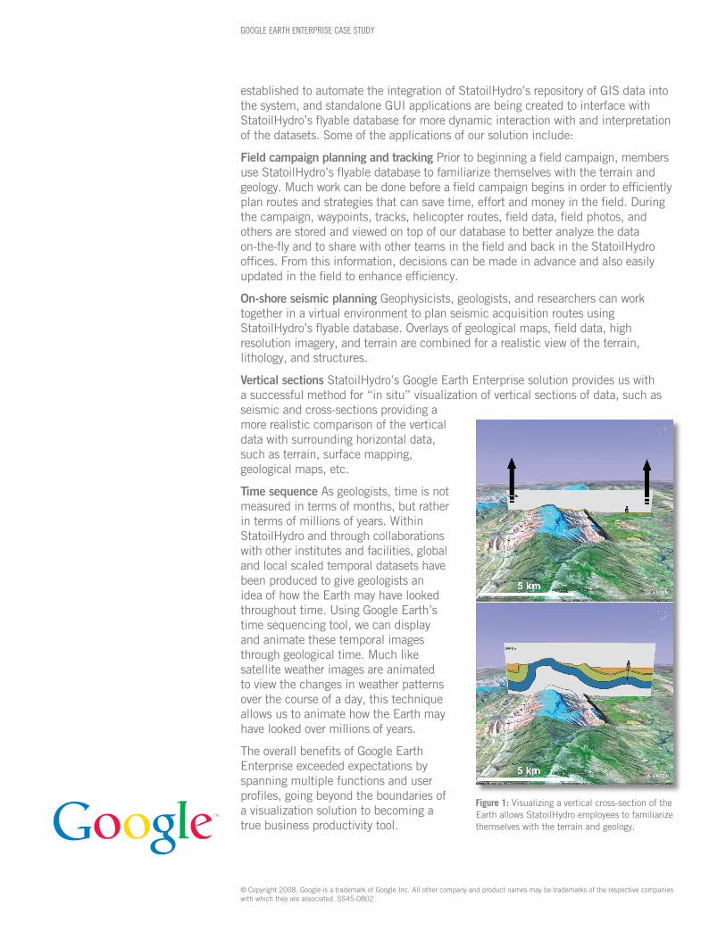
Vertical sections StatoilHydro’s Google Earth Enterprise solution provides us with a successful method for “in situ” visualization of vertical sections of data, such as seismic and cross-sections providing a more realistic comparison of the vertical data with surrounding horizontal data, such as terrain, surface mapping, geological maps, etc.
Time sequence As geologists, time is not measured in terms of months, but rather in terms of millions of years. Within StatoilHydro and through collaborations with other institutes and facilities, global and local scaled temporal datasets have been produced to give geologists an idea of how the Earth may have looked throughout time. Using Google Earth’s time sequencing tool, we can display and animate these temporal images through geological time. Much like satellite weather images are animated to view the changes in weather patterns over the course of a day, this technique allows us to animate how the Earth may have looked over millions of years.
The overall benefits of Google Earth Enterprise exceeded expectations by spanning multiple functions and user profiles, going beyond the boundaries of a visualization solution to becoming a true business productivity tool.
GOOGLE EARTH ENTERPRISE CASE STUDY
Figure 1: Visualizing a vertical cross-section of the Earth allows StatoilHydro employees to familiarize themselves with the terrain and geology.