GNSS measurements in Ulaanbaatar and its vicinity
30
GNSS measurements in Ulaanbaatar and its vicinity Erdenezul Danzansan Institute of Astronomy and Geophysics MAS, Ulaanbaatar, Mongolia [email protected] Andrei Miroshnichenko Institute of the Earth’s Crust SB RAS, Irkutsk, Russia United Nations/Russian Federation Workshop on the Applications of Global Navigation Satellite System, Krasnoyarsk, Russian Federation,18 – 22 May 2015
Transcript of GNSS measurements in Ulaanbaatar and its vicinity

GNSS measurements in Ulaanbaatar and its vicinity
Erdenezul Danzansan Institute of Astronomy and Geophysics MAS, Ulaanbaatar, Mongolia
Andrei Miroshnichenko Institute of the Earth’s Crust SB RAS, Irkutsk, Russia
United Nations/Russian Federation Workshop on the Applications of Global Navigation Satellite System, Krasnoyarsk, Russian Federation,18 – 22 May 2015

Outline
• A brief introduction seismicity of Mongolia • Recent seismic activity around Ulaanbaatar area, capital of Mongolia • The active faults related to this activity • The research that are currently going on
• Analysis and preliminary result of GNSS measurement • Summary

1905, (M=8.0)
1957, Ms=8.1 1931, (M=8.0)
1905 (M=8.4)
0 400 km
Seismicity of Mongolia
30 earthquakes with M≥7 including 4 with M ≥8 rate of occurrence of earthquakes per one day ~ 50

The Gobi-Altay earthquake
1957, Ms=8.1
0 400 km
In 1957, Gobi_Altay earthquake (M~8.1) occurred in south Mongolia, and produced a 250 km long surface rupture along the left-lateral, strike-slip, trending Gobi-Altay Fault. The largest displacement was around 8-10 m of horizontal and 3-4 m vertical of offset

Casualties
Approximately 30 people lost their lives 3 villages were completely wiped out and 5 villages suffered severe damage.
Several tens thousand cattle's died

Surface rupture of the Gobi-Altay earthquake

Ulaanbaatar
Recent seismic activity of Ulaanbaatar

2000 2001 2002 2003 2004 2005 2006 2007 2008 2009 2010 2011 2012 2013 2014 2015 UB 201 241 206 228 254 472 318 347 364 498 760 397 821 2161 1126 328
0
500
1000
1500
2000
2500
Num
ber
of e
arth
quak
es
Cumulative number of earthquakes occurred between 2000 and 2015

Time in years
Cum
ulat
ive
num
bers
of e
arth
quak
es
Seismic activity around Ulaanbaatar city increasing in last years and rate is changing several times during that period.
2005 - 472
2009-478
2010- 760
2012-861
2013-2161
2014-1126
2015-388
Seismic storm starts -2005

Ulaanbaatar
The active faults related to this activity

May 15 11
If large event occur - it will be not only for Ulaanbaatar city, it will be
nation wide hazard.
Ulaanbaatar is the capital city where is living 2/3 of the population of
Mongolia.
Number of buildings are increasing rapidly.
Several earthquakes has been felt in last few years.
Seismic hazard of Ulaanbaatar city

GPS derived velocities with respect to Eurasia

GPS-derived velocities with respect to Eurasia (Lukhnev A. et al, 2010).
Previous study

Strain rates derived within the Baikal-Mongolian GPS network
(Lukhnev A. et al, 2010)
Blue outlined areas - elongation Red outlined areas - shortening

The aim of this study is to estimate the surface velocity field and strain rate in the vicinity of Ulaanbaatar and eastern part of Mongolia.
Stage 1. To install regional and local GNSS networks around Ulaanbaatar as well as in the eastern part of Mongolia.
Stage 2. To carry out GNSS campaigns at the testing areas.
Stage 3. To process the measurements.
Stage 4. To implement the results for geodynamic models.
The research that are currently going on:

Three polygons are established: - East (8 sites) - Ulaanbaatar (12 sites) - Emeelt (10 sites)
Configurations of GNSS polygons and quantities of permanent and temporary sites are determined with regard to the geological and geomorphological structure of the areas, locations and orientations of active faults, and paleo-and- recent seismicity indicators.
The research that are currently going on:

GNSS equipments
Measurements were taken by dual-frequency Trimble 5700 GPS receivers with Zephyr TRM antennas and starting from 2012, measurements at all the sites are taken by Trimble NetR9 multi-channel GNSS-receivers with ChokeRing antennas.

Measurement recording cycles lasted for 72 hours as minimum at East and Ulaanbaatar polygons, and for at least two (2) hours at Emeelt polygon. Software:
� GAMIT (King & Bock, 2000), � GLOBK (Herring et al., 1990), � FONDA (Dong et al., 1998),
Calculated with:
� ITRF2008 � IGS stations (ARTU, BADG, BJFS, CHUM, FAIR, GRAZ, IISC, IRKT, KHAJ, KIT3, KOKB,
KUNM, LHAZ, MAG0, NRIL, NVSK, ONSA, PETP, PETS, POL2, SELE, SHAO, TIDB, TIXI, TSKB, ULAB, URUM, USUD, WUHN, XIAN, YAKT)
Analyses of the measurement data yielded preliminary results for Ulaanbaatar polygon.
Analysis and preliminary result of GNSS measurement

SITE Long. (deg) Lat. (deg) Rate E (mm/yr) Rate N (mm/yr) ± dE ± dN ULAB 107.052 47.865 23.47 –6.97 0.18 0.17 ASGT 113.651 46.331 26.06 –6.66 0.36 0.3 BDRU 112.865 48.503 24.23 –9.08 0.38 0.34 BNTG 111.733 46.698 27.37 –10.3 0.33 0.32 HDUR 107.373 45.232 26.32 –8.86 0.35 0.33 HTBU 109.172 43.091 29.88 –11.25 0.36 0.32 BTSH 109.329 46.218 25.81 –7.18 0.34 0.33 BORU 109.173 43.091 27.95 –7.38 0.39 0.35 TSCH 107.374 45.232 27.53 –7.14 0.33 0.3 URGN 117.100 46.777 28.16 –11 0.42 0.36 TERJ 107.430 47.886 26.62 –14.03 0.49 0.52 HUAN 107.240 47.986 29.02 –13.97 0.53 0.58 WNDY 107.173 47.590 30.79 –14.55 0.34 0.36 GUNJ 107.111 48.019 32.53 –8.26 0.50 0.53 ZNMD 107.035 47.715 28.77 –13.72 0.36 0.38 GUNT 106.744 48.082 30.57 –18.79 0.35 0.38 FERM 106.702 47.727 30.96 –16.11 0.37 0.39 YLMT 106.613 47.502 29.70 –16.44 0.34 0.36 LTUG 106.487 47.674 28.83 –14.77 0.36 0.37 HUST 106.222 47.800 26.38 –18.02 0.61 0.65 EML0 106.607 47.905 16.92 –20.02 4.05 4.50 EML4 106.601 47.911 32.04 –11.89 3.77 4.09 EML5 106.611 47.908 31.06 –7.30 3.90 4.21 EML6 106.600 47.902 23.24 –15.65 3.96 4.62 EML7 106.612 47.903 27.85 –14.36 0.36 0.37 EML8 106.573 47.909 22.69 –6.45 3.57 3.95 EML9 106.612 47.919 17.49 –0.54 4.09 4.87
Horizontal velocity of the GNSS network “East”, “Ulaanbaatar” and “Emeelt” in ITRF2008 system and the accuracy of the measurements

The sites at the polygons under study were shifted at velocities from 30 mm/yr (TERJ) to 36 mm/yr (GUNT), and strain rates were variable within the range from 3*10-8 to 6.5*10-7 yr-1.
Preliminary results of the “Ulaanbaatar” polygon

Horizontal deformation on “Ulaanbaatar” GNSS network

The sites at the polygons were shifted at velocities from 17.5 mm/yr (EML9) to 32 mm/yr (EML5) and direction of the vectors varies from 92 to 140 degrees. Such variations associated that points in the polygon "Emeelt" substantially disposed within the seismogenic structure. Accordingly, the relative deformation, manifested at the site, are characterized by considerable variation both in strain rate and types.
Preliminary results of the “Emeelt” polygon

Horizontal deformation on “Emeelt” network

Horizontal velocities of the networks
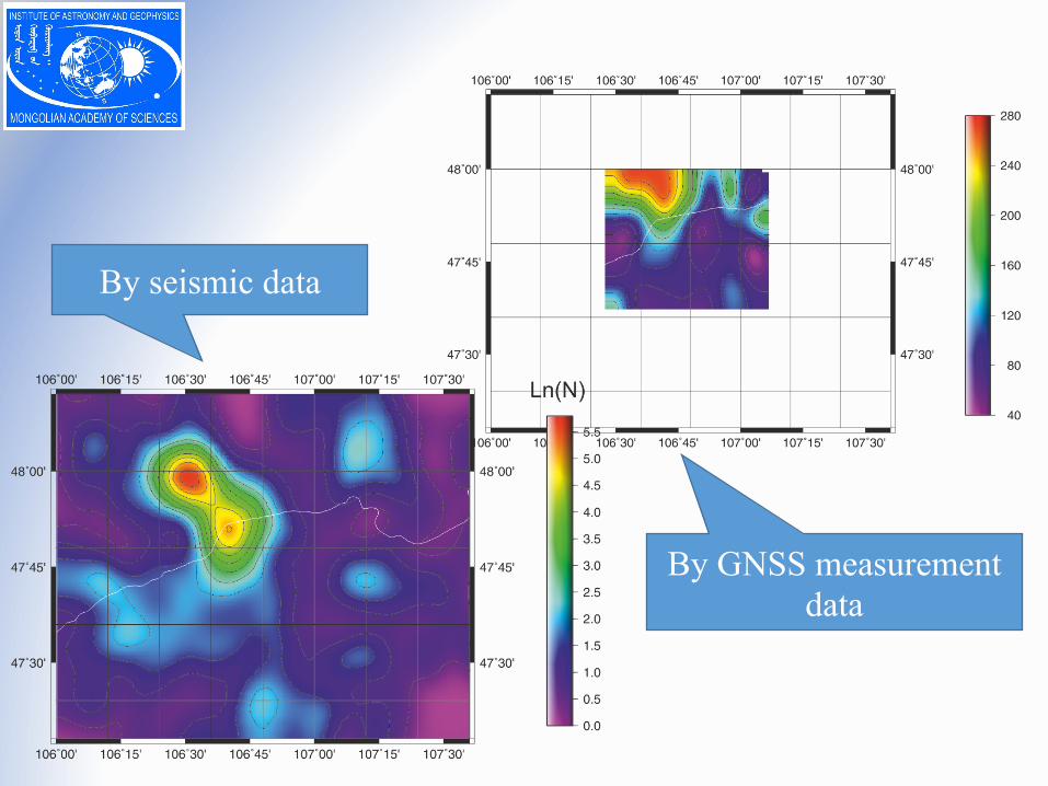
By seismic data
By GNSS measurement data

Seismic + GNSS data

An assignment of the second stage of our program was designing and planning for network of permanent GNSS stations in Ulaanbaatar regions based on the results of first stage.
Now within the second stage, we did installation of permanent stations around Ulaanbaatar region. The structure of database was developed which received from GNSS monitoring. Software development of automatic calculation, monitoring the velocity of relative deformations for earthquake prediction is beginning.
Permanent GNSS station – UG05
Trimble NetR9 reciever
Solar panel
Permanent GNSS stations– for geodynamic application

Permanent GNSS stations installed by IAG
Ulaanbaatar

Summary
ü The geodynamic networks have been designed and established in the territory of the eastern Mongolia and in the vicinity of Ulaanbaatar. Regular observations were conducted at 25 GNSS sites from 2010 to 2015.
ü By results of measurements in 2010-2014, the preliminary sizes of modern horizontal velocities on points of the East, Ulaanbaatar and Emeelt polygons have been allowing to estimate that deformations of a terrestrial surface in the central and east regions of Mongolia.
ü The method of research of geodynamic parameters fulfilled in tectonic active regions of Mongolia, and numerical values of modern deformations received by means from these methods. It will be used at an assessment of environmental, social and economic risks of development of Mongolia and Baikal regions.
ü The results of measurements at the Ulaanbaatar testing area will be implemented for assessment of deformation of the Earth's surface in Ulaanbaatar and its vicinity.

Thank you for your attention