GLOSSARY OF TERMS AND ACRONYMS - USDA · GLOSSARY OF TERMS AND ACRONYMS ACRONYM or Term WHAT IT...
26
Section I – Page 1 of 26 USDA- NRCS-Wyoming September 11, 2002 Technical Guide Notice WY-XXX GLOSSARY OF TERMS AND ACRONYMS ACRONYM or Term WHAT IT STANDS FOR OR DEFINITION AC Area Conservationist ACP Agricultural Conservation Program (Program no longer in existence) ACS Alternative Conservation System - A conservation system for treating sheet, rill wind, and ephemeral gully erosion on highly erodible land (HEL) that is documented in the FOTG and which achieves a substantial reduction from existing soil loss rates. Adverse Impacts The result of applying a practice to address one problem, but in doing so creates another problem. Agricultural land Land that is intensively used and managed for the production of food and fiber. Examples are cropland, hayland and pastures, including native pastures and rangeland, orchards, vineyards, areas which support wetland crops, other lands used to produce or support the production of livestock, and small tree farms. Agroecology A science term used to describe an integrated or systems way of thinking about agriculture. The study of interrelationships of agriculture (the farmer or rancher) with its environment (resources, social issues, and economic considerations, and legal requirements). Alternatives A set of one or more options provided to the client to solve resource problems or address opportunities and achieve proper management of the resources. Alternative Conservation A conservation system for treating sheet, rill, wind and ephemeral gully erosion on highly erodible land that is documented in the FOTG and which achieves a substantial reduction in soil loss rates. This term applies only to conservation plans and conservation systems developed to carry out the provisions of the Food Security Act of 1985, as amended by the Food, Agriculture, Conservation and Trade Act of
Transcript of GLOSSARY OF TERMS AND ACRONYMS - USDA · GLOSSARY OF TERMS AND ACRONYMS ACRONYM or Term WHAT IT...

Section I –Page 1 of 26
USDA- NRCS-WyomingSeptember 11, 2002
Technical Guide Notice WY-XXX
GLOSSARY OF TERMS AND ACRONYMS
ACRONYM or Term WHAT IT STANDS FOR OR DEFINITION
AC Area Conservationist
ACP Agricultural Conservation Program (Program no longer in existence)
ACS Alternative Conservation System - A conservation system for treatingsheet, rill wind, and ephemeral gully erosion on highly erodible land(HEL) that is documented in the FOTG and which achieves asubstantial reduction from existing soil loss rates.
Adverse Impacts The result of applying a practice to address one problem, but in doingso creates another problem.
Agricultural land Land that is intensively used and managed for the production of foodand fiber. Examples are cropland, hayland and pastures, includingnative pastures and rangeland, orchards, vineyards, areas whichsupport wetland crops, other lands used to produce or support theproduction of livestock, and small tree farms.
Agroecology A science term used to describe an integrated or systems way ofthinking about agriculture. The study of interrelationships ofagriculture (the farmer or rancher) with its environment (resources,social issues, and economic considerations, and legal requirements).
Alternatives A set of one or more options provided to the client to solve resourceproblems or address opportunities and achieve proper management ofthe resources.
Alternative Conservation A conservation system for treating sheet, rill, wind and ephemeralgully erosion on highly erodible land that is documented in the FOTGand which achieves a substantial reduction in soil loss rates. This termapplies only to conservation plans and conservation systems developedto carry out the provisions of the Food Security Act of 1985, asamended by the Food, Agriculture, Conservation and Trade Act of

Section IPage 2 of 26
ACRONYM WHAT IT STANDS FOR OR DEFINITIONor TERM
USDA- NRCS-WyomingSeptember 11, 2002
Technical Guide Notice WY-XXX
1990, and the Federal Agricultural Improvement and Reform Act of1996.
Alternative System A conservation management system, meeting resource quality criteria,that is presented to a client during the planning process as one ofmultiple alternatives to address resource problems/opportunities.When a client decides which of the offered alternative systems will beimplemented, the selected alternative becomes the planned system.
AMTA Agricultural Market Transition Act (1966)
AO Area Offices
AO All Offices
APHIS Animal and Plant Health Inspection Service
Application Installing planned conservation practices, management measures, andmanagement systems on the land.
ASA American Society of Agronomy
ASAE American Society of Agricultural Engineers
ASCE American Society of Civil Engineers
ASCS Agricultural Stabilization and Conservation Service. Now known asthe Farm Service Agency (FSA).
Assistance Notes Notes maintained by planners in the case file for each individual clientreceiving planning and implementation assistance. The notes are to bea concise, factual, and chronological narrative of significantconservation activities, and may summarize progress in planning andimplementation. These notes can fall into several categories: business comment, correspondence, historical, legal/location,objective, plan note, resource problem/opportunity, and technicalassistance.
ASTC Assistant State Conservationist
Section IPage 3 of 26
ACRONYM WHAT IT STANDS FOR OR DEFINITIONor TERM
USDA- NRCS-WyomingSeptember 11, 2002
Technical Guide Notice WY-XXX
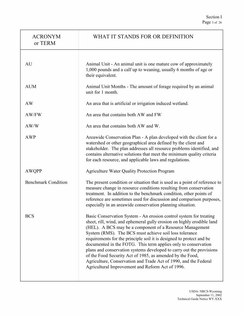
AU Animal Unit - An animal unit is one mature cow of approximately1,000 pounds and a calf up to weaning, usually 6 months of age ortheir equivalent.
AUM Animal Unit Months - The amount of forage required by an animalunit for 1 month.
AW An area that is artificial or irrigation induced wetland.
AW/FW An area that contains both AW and FW
AW/W An area that contains both AW and W.
AWP Areawide Conservation Plan - A plan developed with the client for awatershed or other geographical area defined by the client andstakeholder. The plan addresses all resource problems identified, andcontains alternative solutions that meet the minimum quality criteriafor each resource, and applicable laws and regulations.
AWQPP Agriculture Water Quality Protection Program
Benchmark Condition The present condition or situation that is used as a point of reference tomeasure change in resource conditions resulting from conservationtreatment. In addition to the benchmark condition, other points ofreference are sometimes used for discussion and comparison purposes,especially in an areawide conservation planning situation.
BCS Basic Conservation System - An erosion control system for treatingsheet, rill, wind, and ephemeral gully erosion on highly erodible land(HEL). A BCS may be a component of a Resource ManagementSystem (RMS). The BCS must achieve soil loss tolerancerequirements for the principle soil it is designed to protect and bedocumented in the FOTG. This term applies only to conservationplans and conservation systems developed to carry out the provisionsof the Food Security Act of 1985, as amended by the Food,Agriculture, Conservation and Trade Act of 1990, and the FederalAgricultural Improvement and Reform Act of 1996.
Section IPage 4 of 26
ACRONYM WHAT IT STANDS FOR OR DEFINITIONor TERM
USDA- NRCS-WyomingSeptember 11, 2002
Technical Guide Notice WY-XXX
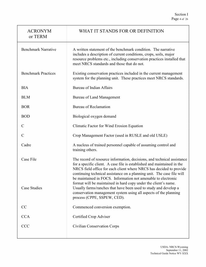
Benchmark Narrative A written statement of the benchmark condition. The narrativeincludes a description of current conditions, crops, soils, majorresource problems etc., including conservation practices installed thatmeet NRCS standards and those that do not.
Benchmark Practices Existing conservation practices included in the current managementsystem for the planning unit. These practices meet NRCS standards.
BIA Bureau of Indian Affairs
BLM Bureau of Land Management
BOR Bureau of Reclamation
BOD Biological oxygen demand
C Climatic Factor for Wind Erosion Equation
C Crop Management Factor (used in RUSLE and old USLE)
Cadre A nucleus of trained personnel capable of assuming control andtraining others.
Case File The record of resource information, decisions, and technical assistancefor a specific client. A case file is established and maintained in theNRCS field office for each client where NRCS has decided to providecontinuing technical assistance on a planning unit. The case file willbe maintained in FOCS. Information not amenable to electronicformat will be maintained in hard copy under the client’s name.
Case Studies Usually farms/ranches that have been used to study and develop aconservation management system using all aspects of the planningprocess (CPPE, SSPEW, CED).
CC Commenced conversion exemption.
CCA Certified Crop Adviser
CCC Civilian Conservation Corps
Section IPage 5 of 26
ACRONYM WHAT IT STANDS FOR OR DEFINITIONor TERM
USDA- NRCS-WyomingSeptember 11, 2002
Technical Guide Notice WY-XXX
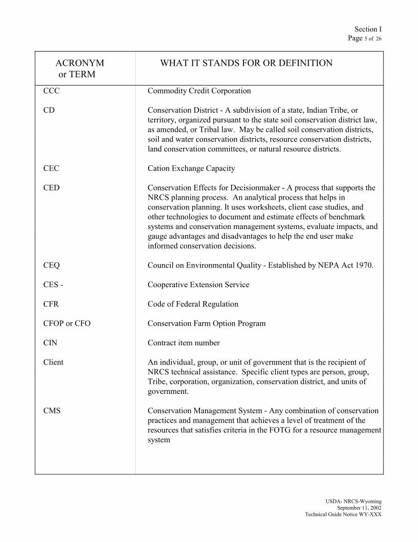
CCC Commodity Credit Corporation
CD Conservation District - A subdivision of a state, Indian Tribe, orterritory, organized pursuant to the state soil conservation district law,as amended, or Tribal law. May be called soil conservation districts,soil and water conservation districts, resource conservation districts,land conservation committees, or natural resource districts.
CEC Cation Exchange Capacity
CED Conservation Effects for Decisionmaker - A process that supports theNRCS planning process. An analytical process that helps inconservation planning. It uses worksheets, client case studies, andother technologies to document and estimate effects of benchmarksystems and conservation management systems, evaluate impacts, andgauge advantages and disadvantages to help the end user makeinformed conservation decisions.
CEQ Council on Environmental Quality - Established by NEPA Act 1970.
CES - Cooperative Extension Service
CFR Code of Federal Regulation
CFOP or CFO Conservation Farm Option Program
CIN Contract item number
Client An individual, group, or unit of government that is the recipient ofNRCS technical assistance. Specific client types are person, group,Tribe, corporation, organization, conservation district, and units ofgovernment.
CMS Conservation Management System - Any combination of conservationpractices and management that achieves a level of treatment of theresources that satisfies criteria in the FOTG for a resource managementsystem
Section IPage 6 of 26
ACRONYM WHAT IT STANDS FOR OR DEFINITIONor TERM
USDA- NRCS-WyomingSeptember 11, 2002
Technical Guide Notice WY-XXX
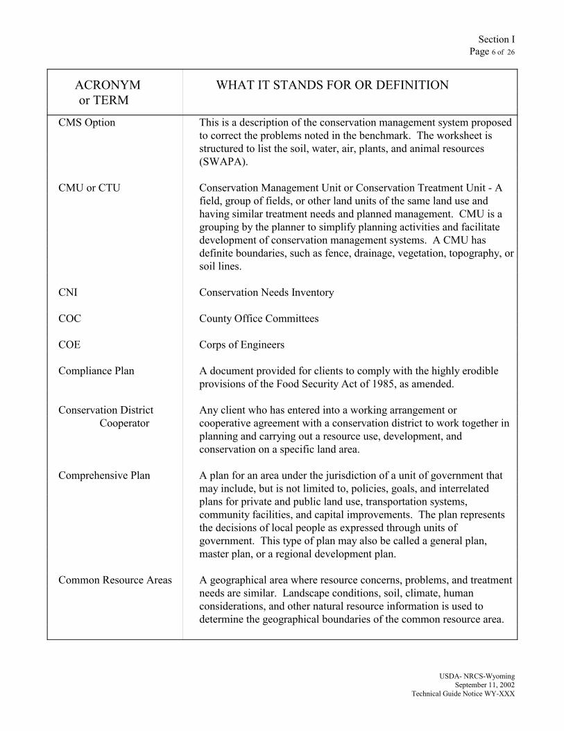
CMS Option This is a description of the conservation management system proposedto correct the problems noted in the benchmark. The worksheet isstructured to list the soil, water, air, plants, and animal resources(SWAPA).
CMU or CTU Conservation Management Unit or Conservation Treatment Unit - Afield, group of fields, or other land units of the same land use andhaving similar treatment needs and planned management. CMU is agrouping by the planner to simplify planning activities and facilitatedevelopment of conservation management systems. A CMU hasdefinite boundaries, such as fence, drainage, vegetation, topography, orsoil lines.
CNI Conservation Needs Inventory
COC County Office Committees
COE Corps of Engineers
Compliance Plan A document provided for clients to comply with the highly erodibleprovisions of the Food Security Act of 1985, as amended.
Conservation District Any client who has entered into a working arrangement or Cooperator cooperative agreement with a conservation district to work together in
planning and carrying out a resource use, development, andconservation on a specific land area.
Comprehensive Plan A plan for an area under the jurisdiction of a unit of government thatmay include, but is not limited to, policies, goals, and interrelatedplans for private and public land use, transportation systems,community facilities, and capital improvements. The plan representsthe decisions of local people as expressed through units ofgovernment. This type of plan may also be called a general plan,master plan, or a regional development plan.
Common Resource Areas A geographical area where resource concerns, problems, and treatmentneeds are similar. Landscape conditions, soil, climate, humanconsiderations, and other natural resource information is used todetermine the geographical boundaries of the common resource area.

Section IPage 7 of 26
ACRONYM WHAT IT STANDS FOR OR DEFINITIONor TERM
USDA- NRCS-WyomingSeptember 11, 2002
Technical Guide Notice WY-XXX
Conservation Plan A record of the client’s decisions and supporting information, fortreatment of a unit of land or water, that meets FOTG quality criteriafor each natural resource (soil, water, air, plants, animals) and takesinto account economic and social considerations. The plan describesthe schedule of operations and activities needed to solve identifiednatural resource problems, and takes advantage of opportunities, at aconservation management system level.
Conservation Planning The activity of NRCS and others in using the NRCS planning processintended to result in a conservation plan or areawide conservation plan(Reference General Manual 180, Part 409).
Conservation Practice A specific treatment, such as a structural or vegetative measure, ormanagement technique commonly used to meet a specific need inplanning and carrying out soil and water conservation programs forwhich standards have been developed. Conservation practices are inthe FOTG, Section IV, which is based on the National Handbook ofConservation Practices (NHCP).
Conservation treatment Any and all conservation practices, management measures, and worksof improvement that have the purpose of solving or reducing theseverity of natural resource use problems or taking advantage ofresource opportunities.
CPPE Conservation Practices Physical Effects matrix - The matrix in theFOTG, Section V, that gives the physical effects of each conservationpractice on soil, water, air, plants, and animals.
CR Civil Rights
CR / CRs Cultural Resources - Reference General Manual 420, Part 401 and 601.
CRA Common Resource Area - Provides information benefiting theplanning process by providing common benchmark and CMS optionsfor the area where the planning unit is located.
CREP Conservation Reserve Enhancement Program
CRM Coordinated Resource Management
Section IPage 8 of 26
ACRONYM WHAT IT STANDS FOR OR DEFINITIONor TERM
USDA- NRCS-WyomingSeptember 11, 2002
Technical Guide Notice WY-XXX
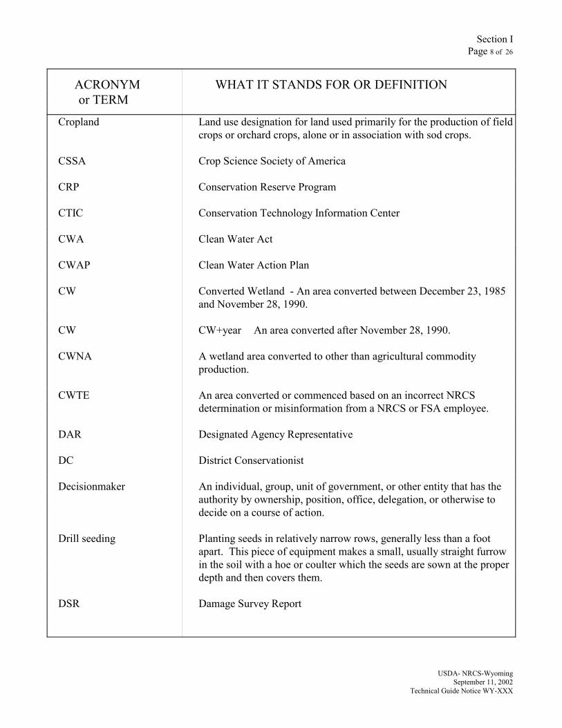
Cropland Land use designation for land used primarily for the production of fieldcrops or orchard crops, alone or in association with sod crops.
CSSA Crop Science Society of America
CRP Conservation Reserve Program
CTIC Conservation Technology Information Center
CWA Clean Water Act
CWAP Clean Water Action Plan
CW Converted Wetland - An area converted between December 23, 1985and November 28, 1990.
CW CW+year An area converted after November 28, 1990.
CWNA A wetland area converted to other than agricultural commodityproduction.
CWTE An area converted or commenced based on an incorrect NRCSdetermination or misinformation from a NRCS or FSA employee.
DAR Designated Agency Representative
DC District Conservationist
Decisionmaker An individual, group, unit of government, or other entity that has theauthority by ownership, position, office, delegation, or otherwise todecide on a course of action.
Drill seeding Planting seeds in relatively narrow rows, generally less than a footapart. This piece of equipment makes a small, usually straight furrowin the soil with a hoe or coulter which the seeds are sown at the properdepth and then covers them.
DSR Damage Survey Report
Section IPage 9 of 26
ACRONYM WHAT IT STANDS FOR OR DEFINITIONor TERM
USDA- NRCS-WyomingSeptember 11, 2002
Technical Guide Notice WY-XXX
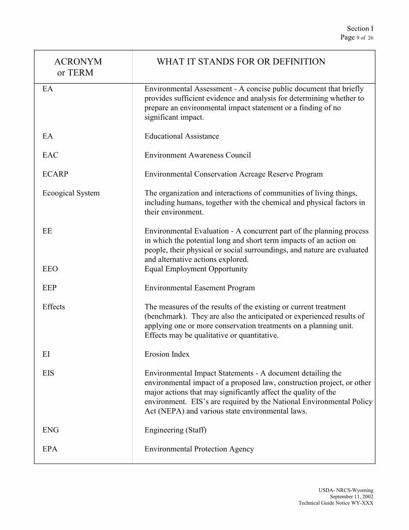
EA Environmental Assessment - A concise public document that brieflyprovides sufficient evidence and analysis for determining whether toprepare an environmental impact statement or a finding of nosignificant impact.
EA Educational Assistance
EAC Environment Awareness Council
ECARP Environmental Conservation Acreage Reserve Program
Ecoogical System The organization and interactions of communities of living things,including humans, together with the chemical and physical factors intheir environment.
EE Environmental Evaluation - A concurrent part of the planning processin which the potential long and short term impacts of an action onpeople, their physical or social surroundings, and nature are evaluatedand alternative actions explored.
EEO Equal Employment Opportunity
EEP Environmental Easement Program
Effects The measures of the results of the existing or current treatment(benchmark). They are also the anticipated or experienced results ofapplying one or more conservation treatments on a planning unit.Effects may be qualitative or quantitative.
EI Erosion Index
EIS Environmental Impact Statements - A document detailing theenvironmental impact of a proposed law, construction project, or othermajor actions that may significantly affect the quality of theenvironment. EIS’s are required by the National Environmental PolicyAct (NEPA) and various state environmental laws.
ENG Engineering (Staff)
EPA Environmental Protection Agency
Section IPage 10 of 26
ACRONYM WHAT IT STANDS FOR OR DEFINITIONor TERM
USDA- NRCS-WyomingSeptember 11, 2002
Technical Guide Notice WY-XXX
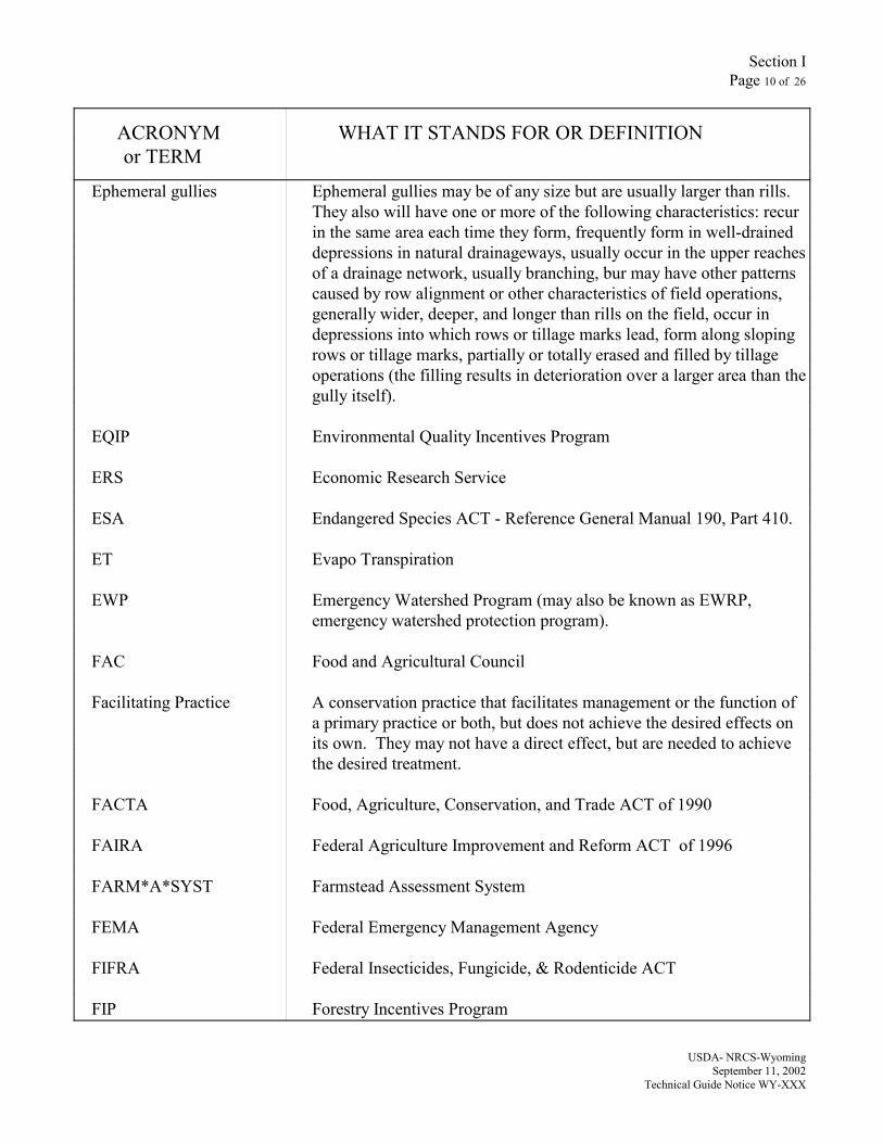
Ephemeral gullies Ephemeral gullies may be of any size but are usually larger than rills.They also will have one or more of the following characteristics: recurin the same area each time they form, frequently form in well-draineddepressions in natural drainageways, usually occur in the upper reachesof a drainage network, usually branching, bur may have other patternscaused by row alignment or other characteristics of field operations,generally wider, deeper, and longer than rills on the field, occur indepressions into which rows or tillage marks lead, form along slopingrows or tillage marks, partially or totally erased and filled by tillageoperations (the filling results in deterioration over a larger area than thegully itself).
EQIP Environmental Quality Incentives Program
ERS Economic Research Service
ESA Endangered Species ACT - Reference General Manual 190, Part 410.
ET Evapo Transpiration
EWP Emergency Watershed Program (may also be known as EWRP,emergency watershed protection program).
FAC Food and Agricultural Council
Facilitating Practice A conservation practice that facilitates management or the function ofa primary practice or both, but does not achieve the desired effects onits own. They may not have a direct effect, but are needed to achievethe desired treatment.
FACTA Food, Agriculture, Conservation, and Trade ACT of 1990
FAIRA Federal Agriculture Improvement and Reform ACT of 1996
FARM*A*SYST Farmstead Assessment System
FEMA Federal Emergency Management Agency
FIFRA Federal Insecticides, Fungicide, & Rodenticide ACT
FIP Forestry Incentives Program
Section IPage 11 of 26
ACRONYM WHAT IT STANDS FOR OR DEFINITIONor TERM
USDA- NRCS-WyomingSeptember 11, 2002
Technical Guide Notice WY-XXX
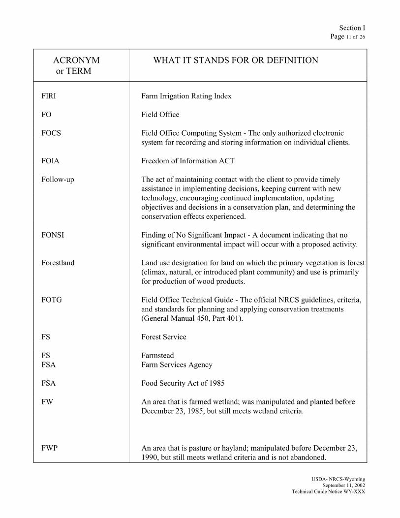
FIRI Farm Irrigation Rating Index
FO Field Office
FOCS Field Office Computing System - The only authorized electronicsystem for recording and storing information on individual clients.
FOIA Freedom of Information ACT
Follow-up The act of maintaining contact with the client to provide timelyassistance in implementing decisions, keeping current with newtechnology, encouraging continued implementation, updatingobjectives and decisions in a conservation plan, and determining theconservation effects experienced.
FONSI Finding of No Significant Impact - A document indicating that nosignificant environmental impact will occur with a proposed activity.
Forestland Land use designation for land on which the primary vegetation is forest(climax, natural, or introduced plant community) and use is primarilyfor production of wood products.
FOTG Field Office Technical Guide - The official NRCS guidelines, criteria,and standards for planning and applying conservation treatments(General Manual 450, Part 401).
FS Forest Service
FS FarmsteadFSA Farm Services Agency
FSA Food Security Act of 1985
FW An area that is farmed wetland; was manipulated and planted beforeDecember 23, 1985, but still meets wetland criteria.
FWP An area that is pasture or hayland; manipulated before December 23,1990, but still meets wetland criteria and is not abandoned.
Section IPage 12 of 26
ACRONYM WHAT IT STANDS FOR OR DEFINITIONor TERM
USDA- NRCS-WyomingSeptember 11, 2002
Technical Guide Notice WY-XXX
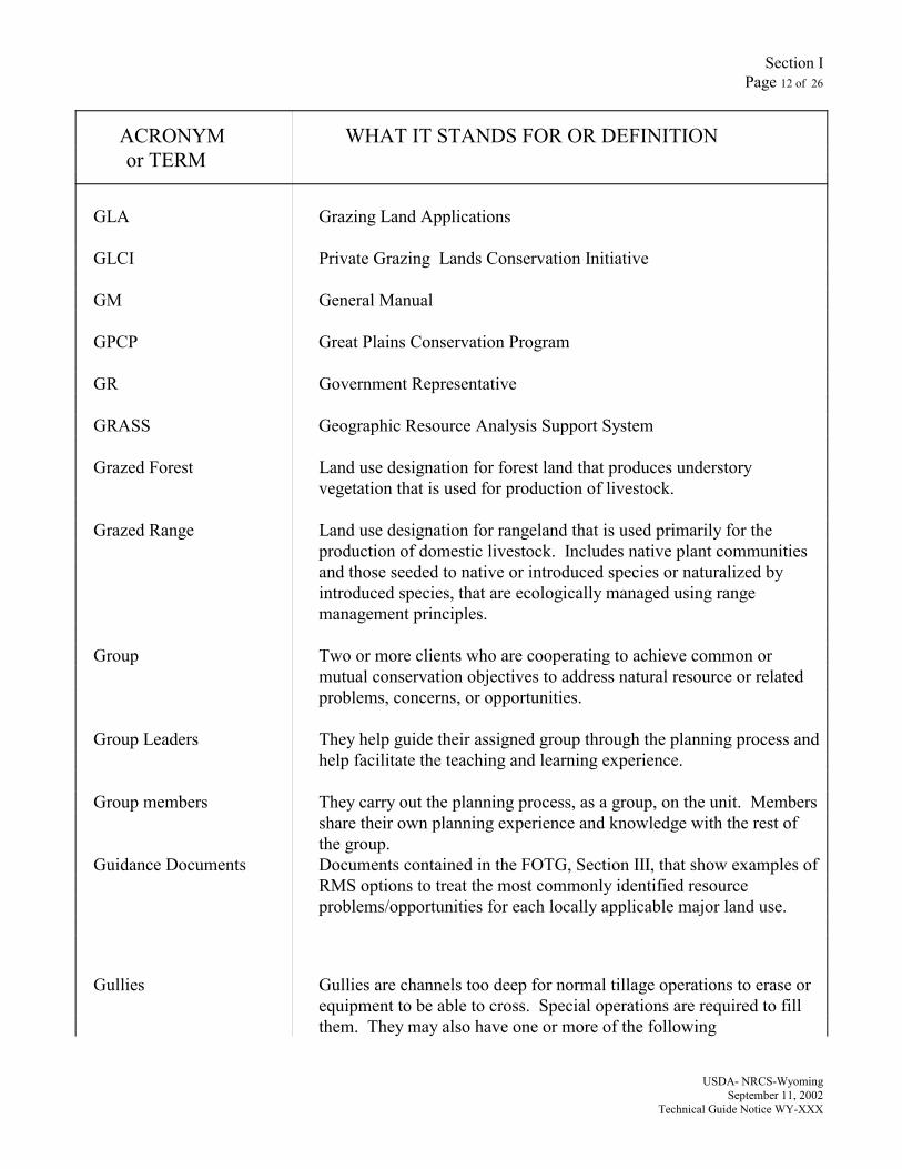
GLA Grazing Land Applications
GLCI Private Grazing Lands Conservation Initiative
GM General Manual
GPCP Great Plains Conservation Program
GR Government Representative
GRASS Geographic Resource Analysis Support System
Grazed Forest Land use designation for forest land that produces understoryvegetation that is used for production of livestock.
Grazed Range Land use designation for rangeland that is used primarily for theproduction of domestic livestock. Includes native plant communitiesand those seeded to native or introduced species or naturalized byintroduced species, that are ecologically managed using rangemanagement principles.
Group Two or more clients who are cooperating to achieve common ormutual conservation objectives to address natural resource or relatedproblems, concerns, or opportunities.
Group Leaders They help guide their assigned group through the planning process andhelp facilitate the teaching and learning experience.
Group members They carry out the planning process, as a group, on the unit. Membersshare their own planning experience and knowledge with the rest ofthe group.
Guidance Documents Documents contained in the FOTG, Section III, that show examples ofRMS options to treat the most commonly identified resourceproblems/opportunities for each locally applicable major land use.
Gullies Gullies are channels too deep for normal tillage operations to erase orequipment to be able to cross. Special operations are required to fillthem. They may also have one or more of the following

Section IPage 13 of 26
ACRONYM WHAT IT STANDS FOR OR DEFINITIONor TERM
USDA- NRCS-WyomingSeptember 11, 2002
Technical Guide Notice WY-XXX
characteristics: may grow or enlarge from year to year by head cuttingor lateral widening, may occur in depressions and naturaldrainageways, may begin as ephemeral gully that was not treated, andmay become partially stabilized by grass, weeds, or woody vegetation.
Hayland Land use designation for land on which perennial plants are managedfor hay production. (Annual plants planted for hay and forage crops inshort-term rotation are cropland.)
HQ or Headquarters Land use designation for land used for dwellings, barns, pens, corrals,or other facilities used in connection with farm and ranch operations.
HEL / HE Highly Erodible Land
HELC Highly Erodible Land Conservation Provision of the 1985 Act, asamended.
Holistic Of or pertaining to the whole, with considerations for all the parts ofthe whole and their relationships among and between each other.
Horizon A layer of soil or soil material approximately parallel to the landsurface and differing from adjacent layers in physical, chemical, andbiological properties or characteristics such as color, structure, texture,consistence, kinds and numbers of organisms present, degree of acidityor alkalinity.
HRC High Residue Crop
HUA Hydrologic Unit Area
Human Considerations The potential sociological, economic, and cultural resource factors thatshould be considered in the natural resources conservation planningprocess.
I Wind Erodibility Index - An estimate of soil loss in tons per acre peryear.
I&E Inventory and evaluation
Section IPage 14 of 26
ACRONYM WHAT IT STANDS FOR OR DEFINITIONor TERM
USDA- NRCS-WyomingSeptember 11, 2002
Technical Guide Notice WY-XXX
Impact The difference that exists between the effects of the benchmark and theeffects of the proposed alternative. The effects are outcomes or results.They may be expressed in monetary, physical or narrative terms.Impacts are used as a basis for making informed conservationdecisions.
Indicator The description or measurement of a resource concern that, whenobserved periodically, indicates or demonstrates trends. Directlylinked to indicators are target values which identify a specificquantitative or qualitative estimate for the desired state of the resourceconcern.
Instructors Provide the classroom instruction and the instruction in the fieldrelative to their particular site and land use on the farm/ranch.
IPM Integrated Pest Management
ISIS Information System Integrated Support
IT Information technology
ITC Information Technology Center
IWM Irrigation Water Management
K The soil Erodibility factor established for a particular soil (used inRUSLE and old USLE). A relative index of the susceptibility of bare,cultivated soil to particle detachment, removal, and transportation byrain.
Land Unit Any area of land that is of concern to NRCS in the planning process.
Land Use A term used by NRCS to identify the intent of the client with regard tothe purpose to which a land unit is to be put. The two designations ofland use are the official NRCS designation, and the client land usedesignation agreed to by the client and planner.
Section IPage 15 of 26
ACRONYM WHAT IT STANDS FOR OR DEFINITIONor TERM
USDA- NRCS-WyomingSeptember 11, 2002
Technical Guide Notice WY-XXX
Landowner The person who owns or holds title to the parcel of land.
LEPA Low Energy Precision Application (irrigation)
LESA Land Evaluation and Site Assessment - A system developed by USDA-NRCS to determine the quality of land for agricultural uses andto assess sites or land areas for their agricultural viability.
LISA Low Input Sustainable Agriculture
LRC Low Residue Crop
LRF Limited Resource Farmers
LTA Long Term Agreement
Ls Length and steepness factor (used in RUSLE and old USLE)
LTC Long Term Contracting
Map Unit A collection of areas defined and named the same in terms of their soilcomponents or miscellaneous areas, or both.
Mined Land use designation for land on which the soil has been disturbed bythe mining of minerals.
MIW A converted wetland, farmed wetland, or farmed wetland pasture onwhich functions and values were lost and are compensated for throughwetland restoration, enhancement or creation.
MLRA Major Land Resource Area
MO Major Land Resource Area Office
MOU Memorandum of Understanding
MUIR Map Unit Interpretation Record
MUR Map Unit Record
Section IPage 16 of 26
ACRONYM WHAT IT STANDS FOR OR DEFINITIONor TERM
USDA- NRCS-WyomingSeptember 11, 2002
Technical Guide Notice WY-XXX
MW An area determined to be minimal effect.
MWM An area determined to be minimal effect with mitigation.
NACD National Association of Conservation Districts
NAD National Appeals Division
NAL National Agricultural Library
NASCA National Association of State Conservation Agencies
NASDA National Association of State Departments of Agriculture
NASIS National Soils Information System
NASS National Agricultural Statistical Service
Native or Naturalized Forest land that is used primarily for the production of forage for Pasture grazing by livestock rather than for the production of wood products.
Overstory trees are removed or managed to promote the native orintroduced understory vegetation occurring on the site. Thisvegetation is managed for its forage value through the use of grazingmanagement principles.
Natural Area Land use designation for land and water used primarily for thepreservation, protection, and observation of the existing resources.Some of these may be officially designated by legislation or otherauthorities.
Natural Resource Any naturally occurring resource needed by an organism, population,or ecological system. NRCS applies this term to soil, water, air,plants, and animals.
NED National Economic Development
NEDC National Employee Development Center
NEDS National Employee Development Staff
NEH National Engineering Handbook

Section IPage 17 of 26
ACRONYM WHAT IT STANDS FOR OR DEFINITIONor TERM
USDA- NRCS-WyomingSeptember 11, 2002
Technical Guide Notice WY-XXX
NEM National Engineering Manual
NEPA National Environmental Policy Act - The 1970 Act that requiresFederal agencies to consider the effects on the environment ofproposed Federal actions. This Act established the requirement forconducting environmental evaluations and for the preparation ofenvironmental assessments and environmental impact statements.
NFC National Finance Center
NFSAM National Food Security Act Manual
NHCP National Handbook of Conservation Practices
NHEL Non-highly Erodible Land
NHPA National Historic Preservation Act
NIMS National Information Management System
NLEAP Nitrate Leaching Environmental Analysis Program
NOAA National Oceanic and Atmospheric Administration
NPRTT Northern Plains Resource Technical Team
NPPH National Planning Procedures Handbook
NPS National Park Service
NRCS Natural Resources Conservation Service
NRI National Resource Inventory
NW An area that does not contain a wetland.
NWS National Weather ServiceOA Operating Agreement
Section IPage 18 of 26
ACRONYM WHAT IT STANDS FOR OR DEFINITIONor TERM
USDA- NRCS-WyomingSeptember 11, 2002
Technical Guide Notice WY-XXX
Offsite Locations outside the area on which conservation treatment is beingconsidered. Also refers to areas outside the planning unit that shouldbe considered for potential impacts.
OGC Office of General Council
OIG Office of Inspector General
OJT On the Job Training
OMB Office of Management and Budget
Onsite Locations within the area on which conservation treatment is beingconsidered.
OPM Office of Personnel Management
OSHA Occupational Safety and Health Administration
PA Privacy Act
PAS Public Affairs Specialist
PASIS Programs Activities Support Information System
Pastureland Land use designation for grazing lands comprised of introduced ordomesticated native forage species that are used primarily for theproduction of domestic livestock. They receive periodic renovationand/or cultural treatments, such as tillage, fertilization, mowing, weedcontrol, and may be irrigated.
PC An area that is prior converted cropland, which was drained, filled, ormanipulated before December 23, 1985; was cropped prior toDecember 23, 1985; was not abandoned; and does not meet FWcriteria.
PC/NW An are that contains both PC and NW.
PEAS Plant Evaluation Automation System
Section IPage 19 of 26
ACRONYM WHAT IT STANDS FOR OR DEFINITIONor TERM
USDA- NRCS-WyomingSeptember 11, 2002
Technical Guide Notice WY-XXX
PFC. Production Flexibility Contract
pH Soil pH is an expression of the degree of acidity or alkalinity of a soil.
PHE Potentially Highly Erodible
PIP Productivity Improvement Program
Photomosaic
Plan Map A photograph or sketch of a land area developed during the planningprocess that shows property boundaries, land boundaries, physicalfeatures, location of planned and applied practices, and other featuresthat are useful to the client in plan implementation.
Planner A person qualified by training and experience, who effectively assiststhe client in completing the planning process.
Planning process The nine-step process NRCS uses to help clients plan and applyconservation treatments or make land use and treatment decisions.
Planter A machine used to open up the soil to plant tubers, cuttings or seeds atspecific intervals in relatively wide rows (20” to 40”) apart. This pieceof equipment makes straight furrow in the soil with a opener and thencovers them.
PLS Pure Live Seed
PMC Plant Materials Center
PMCM Plant Materials Center Manager
PMS Plant Materials Specialist
Practice narrative A brief non-technical description of the planned practice.
Primary practice A conservation practice that treats the main resource problemidentified.
PRISM Property Resources and Information System ManagementPRZM Pesticide Rootzone Model
Section IPage 20 of 26
ACRONYM WHAT IT STANDS FOR OR DEFINITIONor TERM
USDA- NRCS-WyomingSeptember 11, 2002
Technical Guide Notice WY-XXX
PSU Primary Sample Unit
Progressive Planning A continuing process based on the client making decisions in stages onthe use and treatment of the planning unit with the potential that allneeded decisions will be made at some time in the future.
Quality Criteria A quantitative or qualitative statement of treatment level required toachieve a Conservation Management System for identified resourceconsiderations for a particular land area. Established in accordancewith local, state and Federal programs and regulations in considerationof ecological, economic, or social effects.
R Rainfall Factor (used in RUSLE and old USLE)
RAMP Rural Abandoned Mine Program
Rangeland A kind of land on which the historic climax vegetation waspredominantly grasses, grass-like plants, forbs, or shrubs. Rangelandsinclude natural grasslands, savannas, most deserts, tundra, alpine plantcommunities, coastal marshes, and wet meadows.
RB River Basin
RC Resource Conservationist
RCA Resources Conservation Act (1977)
RC&D Resource Conservation and Development
RECD Rural Economic and Community Development
Recreation Land use designation for land and water used and managed forrecreational purposes.
REAP Rural Environmental Assistance Program
Resource Problem The condition related to one or more resources that does not meet theminimum acceptable condition levels as established by resourcecriteria shown in the FOTG, Section III.
Section IPage 21 of 26
ACRONYM WHAT IT STANDS FOR OR DEFINITIONor TERM
USDA- NRCS-WyomingSeptember 11, 2002
Technical Guide Notice WY-XXX
RMA Risk Management Agency
RMS Range Management Specialist
RMS Resource Management System - A prescribed combination ofconservation practices and management identified by land or wateruses that, when implemented, prevents resource degradation andpermits sustained use by meeting criteria established in the FOTG fortreatment of soil, water, air, plants, and animal resources.
RTAG Regional Technical Advisory Group
RTT Resource Technical Team
RUSLE Revised Universal Soil Loss Equation
RWEQ Revised Wind Erosion Equation
RZWQM Root Zone Water Quality Model
SA State Agronomist
SAR Sodium Adsorption Ratio - A measure of the activities of sodiumrelative to calcium and magnesium in the soil solution.
SC Soil Conservationist
SCA State Conservation Agronomist
SCD Soil Conservation District
SCE State Conservation Engineer
SCS Soil Conservation Service, which was created by the Soil ConservationAct of 1935. Now known as the Natural Resources ConservationService (NRCS).
SEB State Emergency Board
Section IPage 22 of 26
ACRONYM WHAT IT STANDS FOR OR DEFINITIONor TERM
USDA- NRCS-WyomingSeptember 11, 2002
Technical Guide Notice WY-XXX
SES Soil Erosion Service - This agency was established in 1933 in theDepartment of Interior to accelerate process of soil conservation.
SGe Small Grain Equivalent (residue)
SHPO State Historic Preservation Officer
SIR Soil Interpretation Record
SNOTEL Snow Pack Telemetry - This is the automated snow survey datacollection system.
SO State Office
Soil Description A listing of soil properties, both site and profile, specific to ageographical location.
Soil Profile A vertical section of the soil from the surface through all of itshorizons, including C horizons.
SPISP Soil Pesticide Interaction Screening Procedure
SRC State Resource Conservationist
SRM Society for Range Management
SRMS State Range Management Specialist
SRPG Soil Rating for Plant Growth
SS Soil Scientist
SSS State Soil Scientist
SMART Simple Model to Asses Range Technology
SPUR Simulation of Production and Utilization of Rangeland
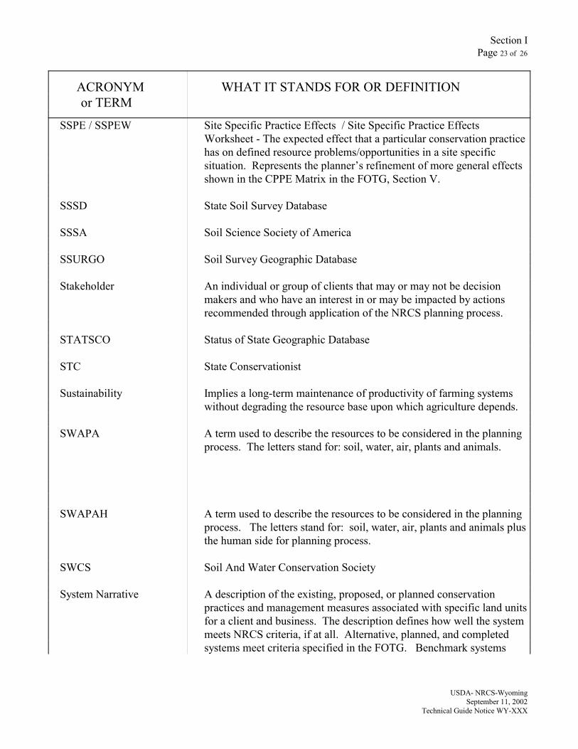
Section IPage 23 of 26
ACRONYM WHAT IT STANDS FOR OR DEFINITIONor TERM
USDA- NRCS-WyomingSeptember 11, 2002
Technical Guide Notice WY-XXX
SSPE / SSPEW Site Specific Practice Effects / Site Specific Practice EffectsWorksheet - The expected effect that a particular conservation practicehas on defined resource problems/opportunities in a site specificsituation. Represents the planner’s refinement of more general effectsshown in the CPPE Matrix in the FOTG, Section V.
SSSD State Soil Survey Database
SSSA Soil Science Society of America
SSURGO Soil Survey Geographic Database
Stakeholder An individual or group of clients that may or may not be decisionmakers and who have an interest in or may be impacted by actionsrecommended through application of the NRCS planning process.
STATSCO Status of State Geographic Database
STC State Conservationist
Sustainability Implies a long-term maintenance of productivity of farming systemswithout degrading the resource base upon which agriculture depends.
SWAPA A term used to describe the resources to be considered in the planningprocess. The letters stand for: soil, water, air, plants and animals.
SWAPAH A term used to describe the resources to be considered in the planningprocess. The letters stand for: soil, water, air, plants and animals plusthe human side for planning process.
SWCS Soil And Water Conservation Society
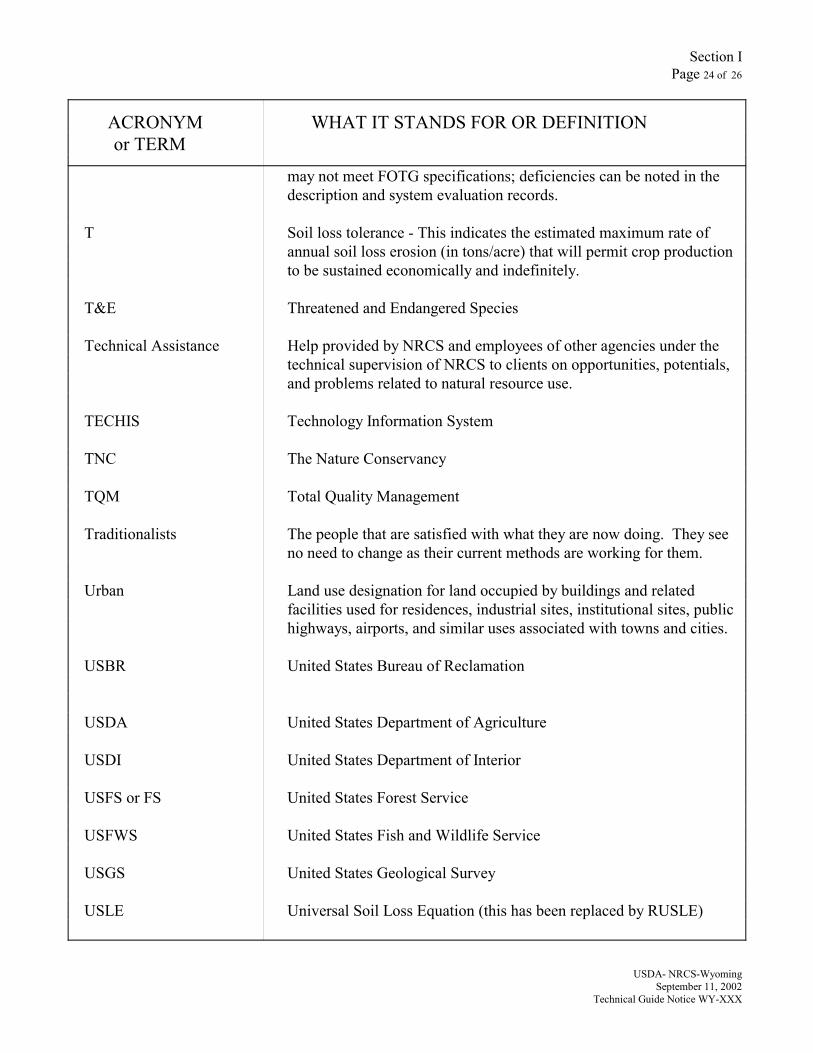
System Narrative A description of the existing, proposed, or planned conservationpractices and management measures associated with specific land unitsfor a client and business. The description defines how well the systemmeets NRCS criteria, if at all. Alternative, planned, and completedsystems meet criteria specified in the FOTG. Benchmark systems
Section IPage 24 of 26
ACRONYM WHAT IT STANDS FOR OR DEFINITIONor TERM
USDA- NRCS-WyomingSeptember 11, 2002
Technical Guide Notice WY-XXX
may not meet FOTG specifications; deficiencies can be noted in thedescription and system evaluation records.
T Soil loss tolerance - This indicates the estimated maximum rate ofannual soil loss erosion (in tons/acre) that will permit crop productionto be sustained economically and indefinitely.
T&E Threatened and Endangered Species
Technical Assistance Help provided by NRCS and employees of other agencies under thetechnical supervision of NRCS to clients on opportunities, potentials,and problems related to natural resource use.
TECHIS Technology Information System
TNC The Nature Conservancy
TQM Total Quality Management
Traditionalists The people that are satisfied with what they are now doing. They seeno need to change as their current methods are working for them.
Urban Land use designation for land occupied by buildings and relatedfacilities used for residences, industrial sites, institutional sites, publichighways, airports, and similar uses associated with towns and cities.
USBR United States Bureau of Reclamation
USDA United States Department of Agriculture
USDI United States Department of Interior
USFS or FS United States Forest Service
USFWS United States Fish and Wildlife Service
USGS United States Geological Survey
USLE Universal Soil Loss Equation (this has been replaced by RUSLE)
Section IPage 25 of 26
ACRONYM WHAT IT STANDS FOR OR DEFINITIONor TERM
USDA- NRCS-WyomingSeptember 11, 2002
Technical Guide Notice WY-XXX
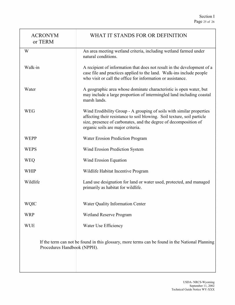
W An area meeting wetland criteria, including wetland farmed undernatural conditions.
Walk-in A recipient of information that does not result in the development of acase file and practices applied to the land. Walk-ins include peoplewho visit or call the office for information or assistance.
Water A geographic area whose dominate characteristic is open water, butmay include a large proportion of intermingled land including coastalmarsh lands.
WEG Wind Erodibility Group - A grouping of soils with similar propertiesaffecting their resistance to soil blowing. Soil texture, soil particlesize, presence of carbonates, and the degree of decomposition oforganic soils are major criteria.
WEPP Water Erosion Prediction Program
WEPS Wind Erosion Prediction System
WEQ Wind Erosion Equation
WHIP Wildlife Habitat Incentive Program
Wildlife Land use designation for land or water used, protected, and managedprimarily as habitat for wildlife.
WQIC Water Quality Information Center
WRP Wetland Reserve Program
WUE Water Use Efficiency
If the term can not be found in this glossary, more terms can be found in the National PlanningProcedures Handbook (NPPH).
Section IPage 26 of 26
ACRONYM WHAT IT STANDS FOR OR DEFINITIONor TERM
USDA- NRCS-WyomingSeptember 11, 2002
Technical Guide Notice WY-XXX