Global geomatics standards supporting sustainable geospatial data infrastructures Olaf Østensen...
24
Global geomatics standards supporting Global geomatics standards supporting sustainable geospatial data sustainable geospatial data infrastructures infrastructures Olaf Østensen Olaf Østensen Chairman of ISO/TC 211 Chairman of ISO/TC 211 Chairman of Joint Steering Group on Chairman of Joint Steering Group on Spatial Standardization and related Spatial Standardization and related Interoperability Interoperability e-mail: [email protected] e-mail: [email protected] International Organization for International Organization for Standardization Standardization Technical Committee 211 Technical Committee 211 GSDI 5 GSDI 5 Cartagena de Indias, Colombia Cartagena de Indias, Colombia May 21-25, 2001 May 21-25, 2001
-
Upload
preston-howard -
Category
Documents
-
view
227 -
download
2
Transcript of Global geomatics standards supporting sustainable geospatial data infrastructures Olaf Østensen...

Global geomatics standards supporting Global geomatics standards supporting sustainable geospatial data sustainable geospatial data
infrastructuresinfrastructures Olaf ØstensenOlaf Østensen
Chairman of ISO/TC 211Chairman of ISO/TC 211Chairman of Joint Steering Group on Spatial Chairman of Joint Steering Group on Spatial Standardization and related InteroperabilityStandardization and related Interoperability
e-mail: [email protected]: [email protected]
International Organization for International Organization for StandardizationStandardization
Technical Committee 211Technical Committee 211
GSDI 5GSDI 5Cartagena de Indias, ColombiaCartagena de Indias, Colombia
May 21-25, 2001May 21-25, 2001

The Market is changing ...The Market is changing ...
Business support market increasing Business support market increasing new customers, new new customers, new demandsdemandsInteroperability requiredInteroperability requiredIntegration of GI and other information necessaryIntegration of GI and other information necessaryGIS technology becomes invisible to end userGIS technology becomes invisible to end user
1999 2000 2001 2002 20030
0,2
0,4
0,6
0,8
1,0
bil
lio
n U
SD
GIS
BSS
LBMS
1,2

Nokia prognosis for 3G mobile Nokia prognosis for 3G mobile communicationcommunication
Monthly income pr. user in euro (1 euro = 1 USD approx.)
2000 2001 2002 2003 2004 2005 2006 2007 2008 2009 2010 2011
0
10
20
30
40
50
60
70
80
90
100
Location based services
Commercials
Entertainment
Information servicesPayment transactions
Music and video
Internet surfingDownload from internetChat on internetMultimedia messages
Text messages
Vide conferencing
Normal speech
Fixed subscription fees
Div. telekom.
Photo messages

GSDIGSDI
““A Global Geospatial Data Infrastructure encompasses A Global Geospatial Data Infrastructure encompasses the politics, organisational remits, data, technologies, the politics, organisational remits, data, technologies, standardsstandards, delivery mechanisms and financial and , delivery mechanisms and financial and human resources necessary to ensure that those human resources necessary to ensure that those working at the global or regional scale are not impeded in working at the global or regional scale are not impeded in meeting their objectives”meeting their objectives”
David Rhind, GSDI conference, Chapel Hill, NCDavid Rhind, GSDI conference, Chapel Hill, NC
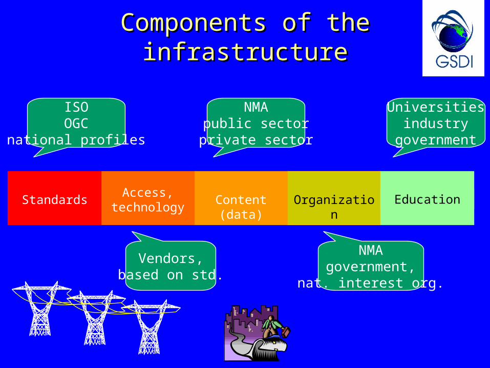
OrganizationContent (data)Access,
technologyStandards Education
ISOOGC
national profiles
Vendors,based on std.
NMApublic sectorprivate sector
Universitiesindustry
government
NMAgovernment,
nat. interest org.
Components of the infrastructureComponents of the infrastructure

The geomatics standards developersThe geomatics standards developersJoint Steering Group on Spatial Standardization and related Joint Steering Group on Spatial Standardization and related
InteroperabilityInteroperability
JSG JSG Scope and purposeScope and purpose
The purpose of the steering group will be to share The purpose of the steering group will be to share information in order to manage coordination activities information in order to manage coordination activities better, and not to assign or manage specific spatial better, and not to assign or manage specific spatial standards projects. The intent is to foster the rapid standards projects. The intent is to foster the rapid insertion of spatial technology into mainstreaminsertion of spatial technology into mainstream information technology while also working to optimize information technology while also working to optimize standards development resources. standards development resources.
Current membersCurrent members::ISO Central SecretariatISO Central SecretariatISO/TC 211ISO/TC 211OGC OGC SEDRISSEDRISISO/IEC JTC 1ISO/IEC JTC 1
InvitedInvited members members::DGIWGDGIWG, , IETFIETF, , ISO/TC 184 /SC ISO/TC 184 /SC 44. . ISO/TC 204ISO/TC 204, , OMGOMG, , POSCPOSC, , SAE InternationalSAE International, , SISOSISO, , W3CW3C, , WAP forumWAP forum

AG Registry
AG Web Mapping
Adv.G-Strat
WG 2Antony Cooper
South Africa
WG 3Robert Walker
UK
WG 4Morten Borrebæk
Norway
WG 5Doug O’Brien
Canada
WG 1Chris Dabrowski
USA
ISO/TC 211 organizationISO/TC 211 organization
Framework Framework and and
reference reference modelmodel
Geospatial Geospatial models models
and and operatorsoperators
Geospatial Geospatial data data
admini-admini-strationstration
Geospatial Geospatial servicesservices
Profiles Profiles and and
functional functional standardsstandards
MHT
SWG-QC
ChairmanOlaf Østensen
Norway
Otherprojects
AG LBS

What is ISO/TC 211?What is ISO/TC 211?
•Standardization in the field of digital geographic information.Standardization in the field of digital geographic information.
•This work aims to establish a structured set of standards for This work aims to establish a structured set of standards for information concerning objects or phenomena that are directly or information concerning objects or phenomena that are directly or indirectly associated with a location relative to the Earth.indirectly associated with a location relative to the Earth.
•These standards may specify, for geographic information, These standards may specify, for geographic information, methods, tools and services for data management (including methods, tools and services for data management (including definition and description), acquiring, processing, analyzing, definition and description), acquiring, processing, analyzing, accessing, presenting and transferring such data in digital/electronic accessing, presenting and transferring such data in digital/electronic form between different users, systems and locations.form between different users, systems and locations.
•This work shall link to appropriate standards for information This work shall link to appropriate standards for information technology and data where possible, and provide a framework for technology and data where possible, and provide a framework for the development of sector-specific applications using geographic the development of sector-specific applications using geographic data.data.

Who are we ? ...member listWho are we ? ...member listActive members (P-members), 33 countriesActive members (P-members), 33 countries
AustraliaAustralia
AustriaAustria
BelgiumBelgium
CanadaCanada
ChinaChina
Czech Rep.Czech Rep.
DenmarkDenmark
FinlandFinland
FranceFrance
GermanyGermany
HungaryHungary
Isl. Rep. of IranIsl. Rep. of Iran
ItalyItaly
JamaicaJamaica
JapanJapan
Republic of KoreaRepublic of Korea
MalaysiaMalaysia
MoroccoMorocco
New ZealandNew Zealand
NorwayNorway
PortugalPortugal
Russian FederationRussian Federation
Saudi ArabiaSaudi Arabia
South AfricaSouth Africa
SpainSpain
SwedenSweden
SwitzerlandSwitzerland
TanzaniaTanzania
ThailandThailand
TurkeyTurkey
United KingdomUnited Kingdom
United States of United States of AmericaAmerica
YugoslaviaYugoslavia

Member listMember listObserving members (15 O-members), 4 corresponding membersObserving members (15 O-members), 4 corresponding members
Bahrain (corr.)Bahrain (corr.)
Brunei Darussalam Brunei Darussalam (corr.)(corr.)
ColombiaColombia
CubaCuba
Estonia (corr.)Estonia (corr.)
GreeceGreece
Hong Kong (corr.)Hong Kong (corr.)
IcelandIceland
IndiaIndia
MauritiusMauritius
NetherlandsNetherlands
OmanOman
PakistanPakistan
PolandPoland
SlovakiaSlovakia
SloveniaSlovenia
UkraineUkraine
UruguayUruguay
ZimbabweZimbabwe

External liaisonsExternal liaisons IHB, International Hydrographic Bureau IHB, International Hydrographic Bureau Digital Geographic Information Working GroupDigital Geographic Information Working Group ICA, International Cartographic AssociationICA, International Cartographic Association UN Economic Commission for Europe, Statistical DivisionUN Economic Commission for Europe, Statistical Division FIG, International Federation of SurveyorsFIG, International Federation of Surveyors EPSG, European Petroleum Survey GroupEPSG, European Petroleum Survey Group IAG, International Association of GeodesyIAG, International Association of Geodesy ISPRS, International Society for Photogrammetry and Remote Sensing ISPRS, International Society for Photogrammetry and Remote Sensing OGC, Open GIS Consortium, IncorporatedOGC, Open GIS Consortium, Incorporated The Permanent Committee on GIS Infrastructure for Asia and the PacificThe Permanent Committee on GIS Infrastructure for Asia and the Pacific Joint Research Centre, European CommissionJoint Research Centre, European Commission ISCGM, International Steering Committee for Global MappingISCGM, International Steering Committee for Global Mapping CEOS, Committee on Earth Observation SatellitesCEOS, Committee on Earth Observation Satellites WMO, World Metereological OrganizationWMO, World Metereological Organization IEEE Geoscience and Remote Sensing SocietyIEEE Geoscience and Remote Sensing Society ICAO, International Civil Aviation OrganizationICAO, International Civil Aviation Organization GSDI, Global Spatial Data InfrastructureGSDI, Global Spatial Data Infrastructure

Some objectives ...Some objectives ...
increase the understanding and usage of increase the understanding and usage of geographic informationgeographic information
increase the availability, access, integration, increase the availability, access, integration, and sharing of geographic informationand sharing of geographic information
ease the establishment of geospatial ease the establishment of geospatial infrastructures on local, regional and infrastructures on local, regional and global levelglobal level
contribute to a unified approach to addressing contribute to a unified approach to addressing global ecological and humanitarian problemsglobal ecological and humanitarian problems

Interoperability ...Interoperability ... the ability to find information and processing tools, when they are the ability to find information and processing tools, when they are
needed, no matter where they are physically locatedneeded, no matter where they are physically located the ability to understand and employ the discovered information the ability to understand and employ the discovered information
and tools, no matter what platform supports them, whether local and tools, no matter what platform supports them, whether local or remoteor remote
the ability to evolve one’s processing environment along the the ability to evolve one’s processing environment along the commercial mainstream without being constrained to a single commercial mainstream without being constrained to a single vendor’s offeringsvendor’s offerings
the ability to participate in a healthy marketplace, where goods the ability to participate in a healthy marketplace, where goods and services are responsive to the needs of consumersand services are responsive to the needs of consumers
InteroperablInteroperablee
Web TechnologyWeb Technology

OverviewOverview
ISO 19101 - Reference modelISO 19101 - Reference modelISO 19102 - OverviewISO 19102 - OverviewISO 19103 - Conceptual schema languageISO 19103 - Conceptual schema languageISO 19104 - TerminologyISO 19104 - TerminologyISO 19105 - Conformance and testingISO 19105 - Conformance and testingISO 19106 - ProfilesISO 19106 - ProfilesISO 19107 - Spatial schemaISO 19107 - Spatial schemaISO 19108 - Temporal schemaISO 19108 - Temporal schemaISO 19109 - Rules for application schemaISO 19109 - Rules for application schemaISO 19110 - Feature cataloguing methodologyISO 19110 - Feature cataloguing methodologyISO 19111 - Spatial referencing by coordinatesISO 19111 - Spatial referencing by coordinatesISO 19112 - Spatial referencing by geographicISO 19112 - Spatial referencing by geographic
identifiersidentifiersISO 19113 - Quality principlesISO 19113 - Quality principlesISO 19114 - Quality evaluation proceduresISO 19114 - Quality evaluation procedures
ISO 19115 - MetadataISO 19115 - MetadataISO 19116 - Positioning servicesISO 19116 - Positioning servicesISO 19117 - PortrayalISO 19117 - PortrayalISO 19118 - EncodingISO 19118 - EncodingISO 19119 - ServicesISO 19119 - ServicesISO/TR 19120 - Functional standardsISO/TR 19120 - Functional standards + new rev+ new revISO/TR 19121 Imagery and gridded dataISO/TR 19121 Imagery and gridded dataISO/TR 19122 - Qualifications and certificationISO/TR 19122 - Qualifications and certification
of personnelof personnelISO 19123 - Schema for coverage geometry andISO 19123 - Schema for coverage geometry and
functionsfunctionsISO 19124 - Imagery and gridded dataISO 19124 - Imagery and gridded data
componentscomponentsISO 19125-1 - Simple feature access – CommonISO 19125-1 - Simple feature access – Common
architecturearchitectureISO 19125-2 - SFA - SQL option ISO 19125-2 - SFA - SQL option ISO 19125-3 - SFA – COM/OLEISO 19125-3 - SFA – COM/OLEISO 19126 - ISO 19126 - Profile - FACC Data DictionaryProfile - FACC Data DictionaryISO 19127 - ISO 19127 - Geodetic codes and parametersGeodetic codes and parametersISO 19128 – Web map server interfaceISO 19128 – Web map server interfaceISO 19129 - Sensor and data model forISO 19129 - Sensor and data model for imagery and gridded data imagery and gridded dataISO 19130 - Imagery, gridded and coverageISO 19130 - Imagery, gridded and coverage data framework data framework

Published standards and reports Published standards and reports
ISO 19105:2000 Geographic information - Conformance and testingISO 19105:2000 Geographic information - Conformance and testing ISO/TR 19120 Geographic information - Functional standardsISO/TR 19120 Geographic information - Functional standards ISO/TR 19121:2000 Geographic information - Imagery and gridded dataISO/TR 19121:2000 Geographic information - Imagery and gridded data
International Standards and Technical ReportsInternational Standards and Technical Reports
Draft International StandardsDraft International Standards (or, text to be submitted soon) (or, text to be submitted soon) ISO/DIS 19101 - Reference model ISO/DIS 19101 - Reference model ISO/DIS 19107– Spatial schemaISO/DIS 19107– Spatial schema ISO/DIS 19108 - Temporal schemaISO/DIS 19108 - Temporal schema ISO/DIS 19111 - Spatial ISO/DIS 19111 - Spatial
referencing by coordinates referencing by coordinates ISO/DIS 19112 - Spatial referencing ISO/DIS 19112 - Spatial referencing
by geographic identifiersby geographic identifiers ISO/DIS 19113 – Quality principlesISO/DIS 19113 – Quality principles
ISO/DIS 19114 - Quality evaluation ISO/DIS 19114 - Quality evaluation proceduresprocedures
ISO/DIS 19115 - MetadataISO/DIS 19115 - Metadata ISO/DIS 19118 - Encoding ISO/DIS 19118 - Encoding ISO/DIS 19125 - Simple feature accessISO/DIS 19125 - Simple feature access
Part 1: Common architecturePart 1: Common architecturePart 2: SQL optionPart 2: SQL option

Agreement ISO/TC 211 - OGCAgreement ISO/TC 211 - OGC
common objectivescommon objectives similar work programmessimilar work programmes complementary approachcomplementary approach joining resources gives strengthjoining resources gives strength avoiding inconsistent standards - avoiding inconsistent standards - de de
jurejure / / de facto / de facto / industrialindustrial … … and moreand more
AgreementAgreement
… … has led to establishment of a cooperative has led to establishment of a cooperative agreement between Open GIS Consortium and agreement between Open GIS Consortium and ISO/TC 211, others may follow … ISO/TC 211, others may follow …
Why cooperation ?Why cooperation ?

ISO/TC 211 on Internet - the WWW ISO/TC 211 on Internet - the WWW serverserver
You will find updated information on ISO/TC 211 on You will find updated information on ISO/TC 211 on the following World Wide Web-server :the following World Wide Web-server :
http://www.statkart.no/isotc211/http://www.statkart.no/isotc211/soon: www.isotc211.orgsoon: www.isotc211.orgWWWWWW
SecretariatSecretariatOrganizationOrganizationCalendarCalendarAbout...About...ResolutionsResolutions
Document listDocument listScope and work programmeScope and work programmeMail to secretariatMail to secretariatNews and informationNews and informationPresentations (slides)Presentations (slides)
containingcontaining :

Impact of standardsImpact of standards
OrganizationContent (data)Access,
technology
Standards
Education
Standards
ISO 19116 - Positioning servicesISO 19116 - Positioning servicesISO 19117 – PortrayalISO 19117 – PortrayalISO 19118 – EncodingISO 19118 – EncodingISO 19119 – ServicesISO 19119 – ServicesISO 19125-1 - Simple feature access – Common architectureISO 19125-1 - Simple feature access – Common architectureISO 19125-2 – SFA – SQL optionISO 19125-2 – SFA – SQL optionISO 19125-3 – SFA – COM/OLEISO 19125-3 – SFA – COM/OLEISO 19128 - Web Map Server InterfaceISO 19128 - Web Map Server Interface
ISO/TR 19122ISO/TR 19122- Qualifications and- Qualifications and
certification of personnelcertification of personnel
Access and servicesAccess and services
DocumentationDocumentationISO 19107 - Spatial schemaISO 19107 - Spatial schemaISO 19108 - Temporal schemaISO 19108 - Temporal schemaISO 19109 - Rules for application schemaISO 19109 - Rules for application schemaISO 19110 - Feature cataloguing methodologyISO 19110 - Feature cataloguing methodologyISO 19111 - Spatial referencing by coordinatesISO 19111 - Spatial referencing by coordinatesISO 19112 - Spatial referencing by geographic identifiersISO 19112 - Spatial referencing by geographic identifiersISO 19113 - Quality principlesISO 19113 - Quality principlesISO 19114 - Quality evaluation proceduresISO 19114 - Quality evaluation proceduresISO 19115 – MetadataISO 19115 – MetadataISO 19123 - Schema for coverage geometry and functionsISO 19123 - Schema for coverage geometry and functions

Standards alone cannot guarantee Standards alone cannot guarantee sustainable development, but …sustainable development, but …
Combined view
Internet
Directorate for natural resourcesNorwegian Geological SurveyNorwegian Institute for Surveying of Forestry and AgricultureNorwegian Mapping AuthorityPublic Road Administration
when standards are when standards are used, as in this used, as in this
Norwegian example, Norwegian example, to enable an to enable an
integrated view of a integrated view of a large set of social large set of social
and environmental and environmental factors, then factors, then
standards are standards are supporting supporting sustainable sustainable
developmentdevelopment
OGC web map server interface = ISO 19128OGC web map server interface = ISO 19128

frameworkframework– service architectureservice architecture– basic “abstract” specificationsbasic “abstract” specifications– ISO 19101, ISO 19119 etc.ISO 19101, ISO 19119 etc.
catalogue servicescatalogue services– OGC catalog servicesOGC catalog services– metadata catalogue, ISO 19115metadata catalogue, ISO 19115
basic accessbasic access– advanced access, ISO 19107-9advanced access, ISO 19107-9– simple feature access, ISO 19125simple feature access, ISO 19125
““web map server” interface, OGC/ISO 19128web map server” interface, OGC/ISO 19128 data content descriptionsdata content descriptions
– ISO 19103, 19109, 19110ISO 19103, 19109, 19110
Example - specifications for a Example - specifications for a Norwegian geospatial data infrastructureNorwegian geospatial data infrastructure
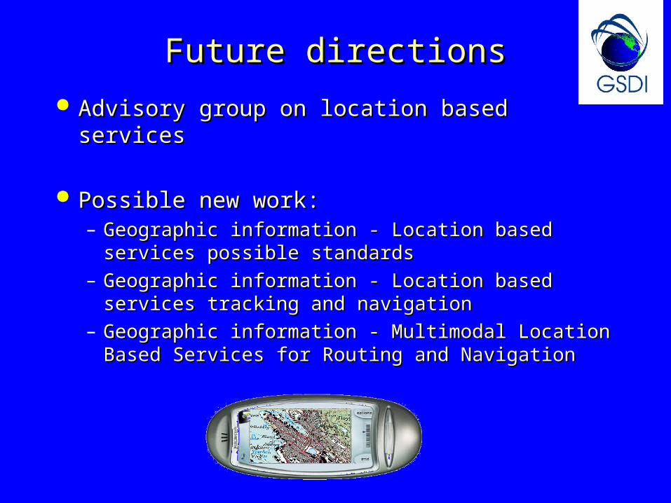
Future directionsFuture directions
Advisory group on location based servicesAdvisory group on location based services
Possible new work:Possible new work:– Geographic information - Location based services Geographic information - Location based services
possible standardspossible standards
– Geographic information - Location based services Geographic information - Location based services tracking andtracking and navigationnavigation
– Geographic information - Multimodal Location Based Geographic information - Multimodal Location Based Services for Routing and NavigationServices for Routing and Navigation

Future organizationFuture organization
to address needs of informations communities:to address needs of informations communities: establish Advisory groups on specific establish Advisory groups on specific
information communitiesinformation communities– for cadastral and land management?for cadastral and land management?– for environment and health?for environment and health?– for public sector?for public sector?– for military?for military?
when necessary work programmewhen necessary work programmeis developed: form subcommittees?is developed: form subcommittees?

ConclusionConclusionThe goal of ISO/TC 211 is to develop a family of international The goal of ISO/TC 211 is to develop a family of international standards that will standards that will support the support the understanding and usage of geographic informationunderstanding and usage of geographic information increase the availability, access, integration, and sharing of increase the availability, access, integration, and sharing of
geographic information, enablegeographic information, enable inter-operability of geospatially inter-operability of geospatially enabled computer systemsenabled computer systems
and ease the establishment of geospatial infrastructures on and ease the establishment of geospatial infrastructures on local, regional and global levellocal, regional and global level
address emerging technologiesaddress emerging technologies address information communitiesaddress information communities

Thank you !Thank you !
ISO/TC 211 ...ISO/TC 211 ...… building the foundation of the geospatial … building the foundation of the geospatial infrastructure, brick by brick ...infrastructure, brick by brick ...